Embed Size (px)
Citation preview
BulletinSmart Metropolitan Regional Development
- Economic and Spatial Design Strategies
Editorial Team
ASFA SIDDIQUI ~ GORA MBOUP ~ SUDESHNA GHOSH ~ ELINA ALATALO
Newsletter presenting ongoing research of groups participating into project to bepublished as a book year 2018 by Springer-Nature. For private circulation only.
3 / 3 Year 2017, 1st of September
By Authors: Jignesh G. Bhatt, Omkar K. Jani, Krupesh A. Chauhan, Leena Garg,Bhasker Vijaykumar Bhatt, T M Vinod Kumar, Mohd. Firoz C., Namratha Radha-krishnan, H. B. Singh, Prabh Bedi, Neha Goel Tripathi, Asfa Siddiqui, Pramod Ku-
mar, Ashok Kumar, Amit Chatterjee- Binayak Choudhary, Premjeet Dasgupta,Gaurav Vaidya, Sujata Govada, Timothy Rodgers
Presented in this Bulletin
AHMEDABAD-GANDHINAGAR ~ BANGALORE ~ CHANDIGARHHONG KONG ~ JAIPUR ~ KOZHIKODE ~ NEW DELHI ~ SURAT
2
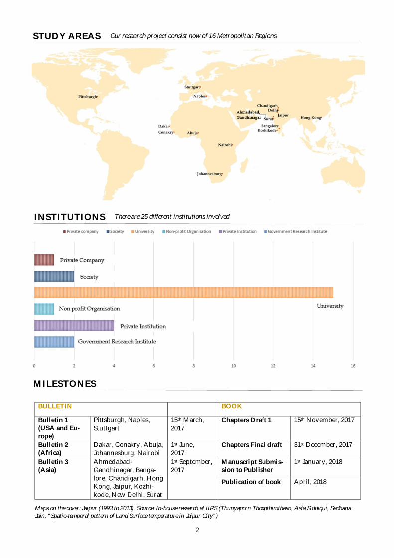
Ourresearchprojectconsistnowof16MetropolitanRegionsSTUDY AREAS
MILESTONES
There are 25 different institutions involvedINSTITUTIONS
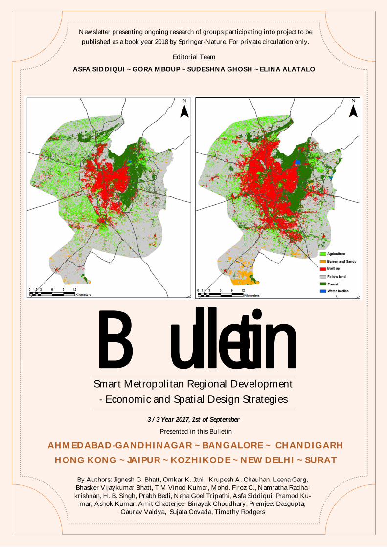
Maps on the cover: Jaipur (1993 to 2013). Source: In-house research at IIRS (Thunyaporn Thoopthimthean, Asfa Siddiqui, SadhanaJain, “Spatio-temporal pattern of Land Surface temperature in Jaipur City”)
BULLETIN BOOK
Bulletin 1(USA and Eu-rope)
Pittsburgh, Naples,Stuttgart
15th March,2017
Chapters Draft 1 15th November, 2017
Bulletin 2(Africa)
Dakar, Conakry, Abuja,Johannesburg, Nairobi
1st June,2017
Chapters Final draft 31st December, 2017
Bulletin 3(Asia)
Ahmedabad-Gandhinagar, Banga-lore, Chandigarh, HongKong, Jaipur, Kozhi-kode, New Delhi, Surat
1st September,2017
Manuscript Submis-sion to Publisher
1st January, 2018
Publication of book April, 2018
3
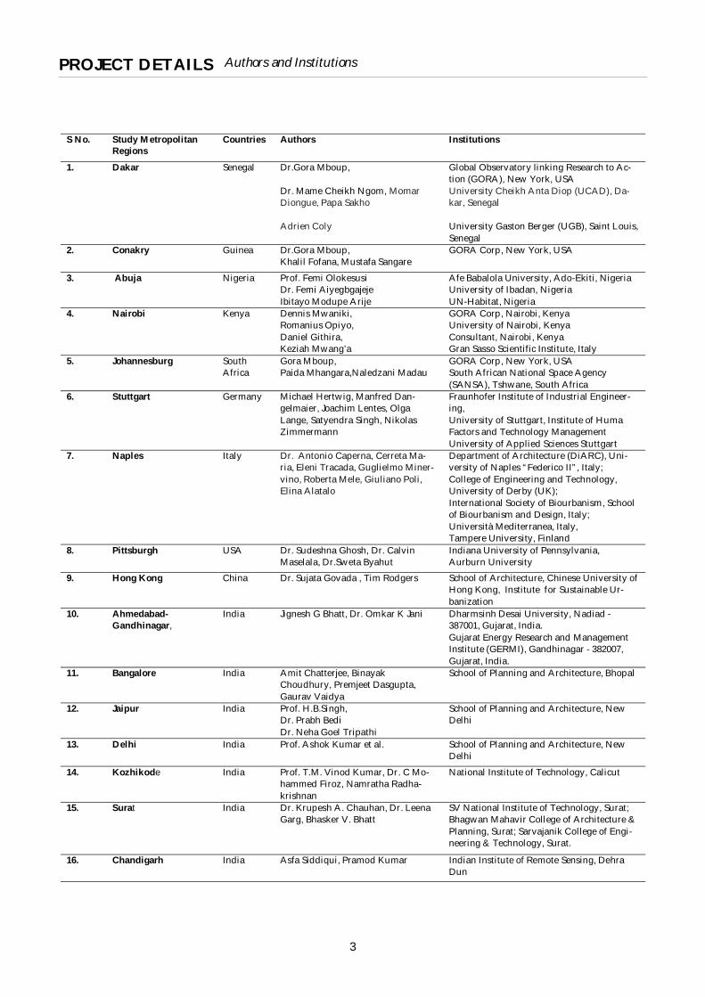
Authors and InstitutionsPROJECT DETAILS
S No. Study MetropolitanRegions
Countries Authors Institutions
1. Dakar Senegal Dr.Gora Mboup,
Dr. Mame Cheikh Ngom, MomarDiongue, Papa Sakho
Adrien Coly
Global Observatory linking Research to Ac-tion (GORA), New York, USAUniversity Cheikh Anta Diop (UCAD), Da-kar, Senegal
University Gaston Berger (UGB), Saint Louis,Senegal
2. Conakry Guinea Dr.Gora Mboup,Khalil Fofana, Mustafa Sangare
GORA Corp, New York, USA
3. Abuja Nigeria Prof. Femi OlokesusiDr. Femi AiyegbgajejeIbitayo Modupe Arije
Afe Babalola University, Ado-Ekiti, NigeriaUniversity of Ibadan, NigeriaUN-Habitat, Nigeria
4. Nairobi Kenya Dennis Mwaniki,Romanius Opiyo,Daniel Githira,Keziah Mwang’a
GORA Corp, Nairobi, KenyaUniversity of Nairobi, KenyaConsultant, Nairobi, KenyaGran Sasso Scientific Institute, Italy
5. Johannesburg SouthAfrica
Gora Mboup,Paida Mhangara,Naledzani Madau
GORA Corp, New York, USASouth African National Space Agency(SANSA), Tshwane, South Africa
6. Stuttgart Germany Michael Hertwig, Manfred Dan-gelmaier, Joachim Lentes, OlgaLange, Satyendra Singh, NikolasZimmermann
Fraunhofer Institute of Industrial Engineer-ing,University of Stuttgart, Institute of HumaFactors and Technology ManagementUniversity of Applied Sciences Stuttgart
7. Naples Italy Dr. Antonio Caperna, Cerreta Ma-ria, Eleni Tracada, Guglielmo Miner-vino, Roberta Mele, Giuliano Poli,Elina Alatalo
Department of Architecture (DiARC), Uni-versity of Naples “Federico II”, Italy;College of Engineering and Technology,University of Derby (UK);International Society of Biourbanism, Schoolof Biourbanism and Design, Italy;Università Mediterranea, Italy,Tampere University, Finland
8. Pittsburgh USA Dr. Sudeshna Ghosh, Dr. CalvinMaselala, Dr.Sweta Byahut
Indiana University of Pennsylvania,Aurburn University
9. Hong Kong China Dr. Sujata Govada , Tim Rodgers School of Architecture, Chinese University ofHong Kong, Institute for Sustainable Ur-banization
10. Ahmedabad-Gandhinagar,
India Jignesh G Bhatt, Dr. Omkar K Jani Dharmsinh Desai University, Nadiad -387001, Gujarat, India.Gujarat Energy Research and ManagementInstitute (GERMI), Gandhinagar - 382007,Gujarat, India.
11. Bangalore India Amit Chatterjee, BinayakChoudhury, Premjeet Dasgupta,Gaurav Vaidya
School of Planning and Architecture, Bhopal
12. Jaipur India Prof. H.B.Singh,Dr. Prabh BediDr. Neha Goel Tripathi
School of Planning and Architecture, NewDelhi
13. Delhi India Prof. Ashok Kumar et al. School of Planning and Architecture, NewDelhi
14. Kozhikode India Prof. T.M. Vinod Kumar, Dr. C Mo-hammed Firoz, Namratha Radha-krishnan
National Institute of Technology, Calicut
15. Surat India Dr. Krupesh A. Chauhan, Dr. LeenaGarg, Bhasker V. Bhatt
SV National Institute of Technology, Surat;Bhagwan Mahavir College of Architecture &Planning, Surat; Sarvajanik College of Engi-neering & Technology, Surat.
16. Chandigarh India Asfa Siddiqui, Pramod Kumar Indian Institute of Remote Sensing, DehraDun
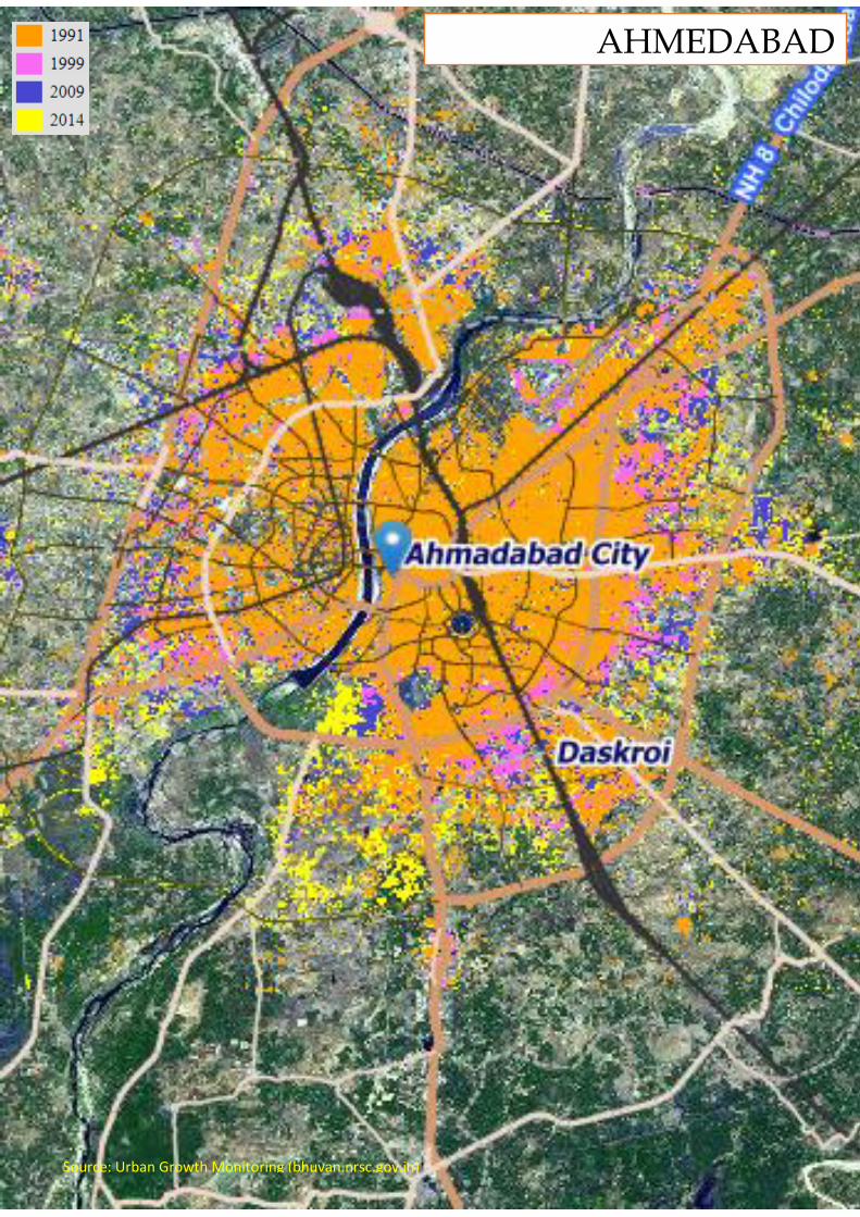
AHMEDABAD
Source: Urban Growth Monitoring (bhuvan.nrsc.gov.in)
IntroductionReliable electricity supply is essential and vital fordevelopment of any region or city. Therefore, smartgrids – as energy backbones, are observed beingessential and mandatory at the core of smart citydevelopments globally.
(Bhatt et al. 2014) have presented detailed technicalreview and identified critical applications andparameters of smart grid. In (Bhatt and Jani 2015), e-governance of rooftop based solar photo voltaicrooftop system has been covered with special focuson Gandhinagar solar city project. Next, in (Bhatt andJani 2017), smart grid pilots along with interestingapplications have been discussed including variousinitiatives of UGVCL and GERMI.
This work presents interesting details of forthcominginitiatives of utility, government and citizens’participation with interesting facts, figures andphotographic illustrations. Development of Narodaarea in the smart metropolitan region ofAhmedabad-Gandhinagar twin city remains at thefocus.
Study area and its regional contextAhmedabad:Recently, in July 2017, the Historic City ofAhmadabad or Old Ahmadabad, has been declaredas India's first UNESCO World Heritage City. Earlierin 2010, Ahmedabad was ranked third in Forbes's listof fastest growing cities of the decade. In 2012, TheTimes of India chose Ahmedabad as India's best cityto live in. Ahmedabad has been selected as one of thehundred Indian cities to be developed as a smart cityunder Government of India's flagship Smart CitiesMission. In 2010, Forbes magazine rated Ahmedabadas the fastest-growing city in India, and listed it asthird fastest-growing in the world after the Chinesecities of Chengdu and Chongqing. In 2011, it wasrated India's best megacity to live in by leadingmarket research firm IMRB. According to theNational Crime Records Bureau (NCRB) report of2003, Ahmedabad has the lowest crime rate of the 35Indian cities with a population of more than onemillion.
Ahmedabad has emerged as an important economicand industrial hub in India. It is the second largestproducer of cotton in India, and its stock exchange isthe country's second oldest. The effects ofliberalization of the Indian economy have energizedthe city's economy towards tertiary sector activitiessuch as commerce, communication, housing,construction, etc.
Ahmedabad is the fifth most populous city andseventh most populous urban agglomeration inIndia. According to the 2011 census, the populationof Ahmedabad city was 5,577,967, while that of itsurban agglomeration was 6,361,084.
Ahmedabad also known as ‘Amdavad’ is the largestcity and former capital of Gujarat state, India. With apopulation of more than 6.3 million and an extendedpopulation of 7.8 million, it is the sixth largest cityand seventh largest metropolitan area of India.Ahmedabad is located on the banks of the SabarmatiRiver, 30 km (19 mi) from the state capitalGandhinagar, which is its twin city.
Gandhinagar:Gandhinagar is the capital of the state ofGujarat in Western India. Gandhinagar is locatedapproximately 23 km north of Ahmedabad, on thewest central point of the Industrial corridorbetween Delhi, the political capital of India,and Mumbai, the financial capital of India.
Gandhinagar, Gujarat's new capital city, lies on thewest bank of the Sabarmati River, about 545 km (338miles) north of Mumbai, the financial capitalof India and 901 km (560 miles) southeast of Delhi,the political capital. There is a provision of parks,extensive planting and a recreational area along theriver giving the city a green garden-city atmosphere.
Naroda:Naroda is a fast growing Area in Ahmedabad,northeast of central Ahmedabad, Gujarat, India.With the establishment of the Naroda Industrial Areain the 1980s, the town flourished; it was incorporatedinto Ahmedabad in 1996. Being eight km fromAhmedabad International Airport and located on the
AHMEDABAD-GANDHINAGARGUJARAT, INDIA
Jignesh G. Bhatt- Omkar K. Jani
TOWARDS SUSTAINABLE GROWTH BY ENERGY RELIABILITY
SP Ring Road, Naroda is situated on the emergingGandhinagar-Ahmedabad-Vadodara (GAV)corridor.
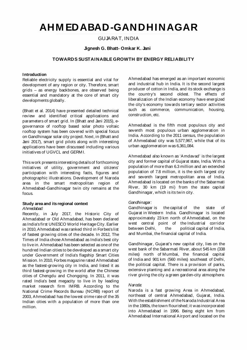
Naroda has over the last two years transformed froma neglected industrial area to desirable location forhomes. The Naroda GIDC industrial park hostsnational and multinational corporations. Severalmajor township projects are being developed alongthe Ahmedabad-Vadodara expressway with Narodabeing at the center of the development. In the recentVibrant Gujarat summit, 24 projects worth more thanRs 1,000 crore were slated to be developed in this partof city and along the Ahmedabad-Vadodaraexpressway including hospitals, hotels and clubs,educational institutions, NRI residential colonies,business parks, etc. Fig. 1 depicts Naroda as region ofour research study interest in the Ahmedabad-Gandhinagar smart twin city in geographic layout. Inthe satellite map of Fig. 2, Naroda’s strategicpresence surrounded by diversified types oflocations could be referred.
Importance and role of the regionAhmedabad-Gandhinagar twin city have beenalready selected as potential smart city in phase-Iunder PM Narendra Modi’s flagship Smart CitiesMission. As the smart grid is the energy backbone ofthis upcoming smart city, well established andsuccessful smart grid pilot has been conducted atNaroda area at the junction of the twin city by
UGVCL. This project has been funded byGovernment of India funding under R-APDRP.
Rise in the new economyThe gross domestic product of Ahmedabad wasestimated at US$64 billion in 2014. The RBI rankedAhmedabad as the seventh largest deposit centre andseventh largest credit centre nationwide as of June2012. In the 19th century, the textile and garmentsindustry received strong capital investment.
On 30 May 1861 Ranchhodlal Chhotalal founded thefirst Indian textile mill, the Ahmedabad Spinningand Weaving Company Limited, followed by theestablishment of a series of textile mills. The textileindustry further expanded rapidly during the FirstWorld War, and benefited from the influence ofMahatma Gandhi's Swadeshi movement, whichpromoted the purchase of Indian-made goods.Ahmedabad was known as the "Manchester of theEast" for its textile industry. The city is the largestsupplier of denim and one of the largest exporters ofgemstones and jewellery in India. The automobileindustry is also important to the city; after Tata'sNano project, Ford and Suzuki are planning toestablish plants near Ahmedabad while thegroundbreaking ceremony for Peugeot has alreadybeen performed. The Ahmedabad Stock Exchange,located in the Ambavadi area of the city, is India'ssecond oldest stock exchange. The informationtechnology industry has developed significantly inAhmedabad, with companies such as Tata
Left: Region of interest: Naroda area in Ahmedabad-Gandhinagar Smart Twin City.Up: Satellite map of Naroda area. (Source: Bhuvan)
Consultancy Services opening offices in the city. ANASSCOM survey in 2002 on the "Super Nine IndianDestinations" for IT-enabled services rankedAhmedabad fifth among the top nine mostcompetitive cities in the country. The city'seducational and industrial institutions have attractedstudents and young skilled workers from the rest ofIndia.
The state-government-owned Gujarat StateElectricity Corporation Limited (GSECL) has set up athermal power station in Gandhinagar; at the stretchtowards Pethapur. Software Technology Parks ofIndia (STPI) was established at Infocity,Gandhinagar. Gujarat International Finance Tec-City(GIFT-City) is an under-construction central businessdistrict between Ahmedabad and Gandhinagar inthe Indian state of Gujarat. It will be built on 359hectares (886 acres) of land. Its main purpose is toprovide high quality physical infrastructure(electricity, water, gas, district cooling, roads,telecoms and broadband), so that finance and techfirms can relocate their operations there fromMumbai, Bangalore, Gurgaon etc. whereinfrastructure is either inadequate or very expensive.It will have a special economic zone (SEZ),international education zone, integrated townships,an entertainment zone, hotels, a convention centre,an international techno park, units, shopping malls,stock exchanges and service units.
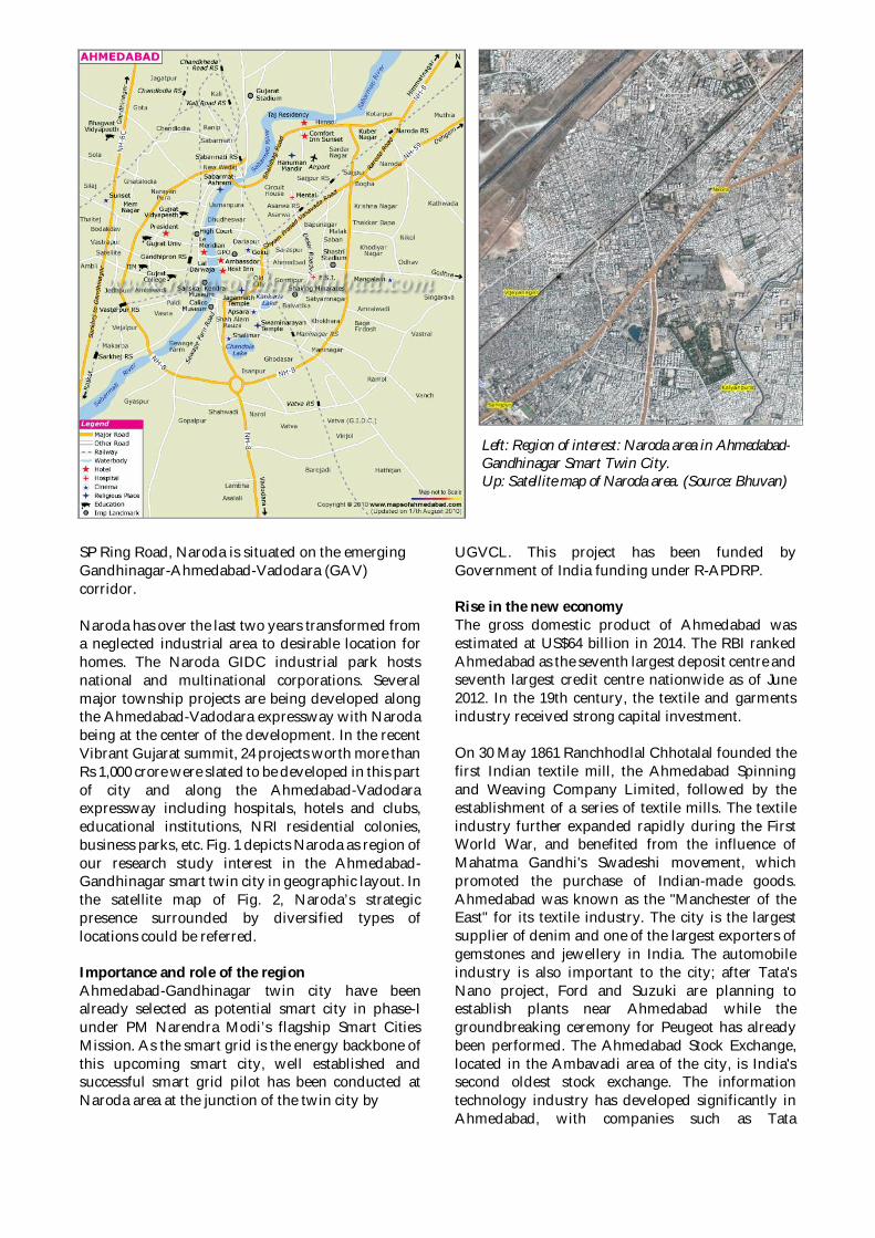
Need and scopeAs the cities are becoming smart, citizen andgovernance support applications are rising inquantities and complexities. This has direct impacton overall electrical energy requirements.Production, transmission and distribution ofelectricity is getting expensive. Higher dependencieson fossil fuel based thermal power stations as well aslow penetration of renewables has been resulting inrising costs. Bad habits, lack of discipline of citizens,heavy wastages, etc. are also important factors.Therefore, it is an urgent need of today to transformall smart city homes into smart homes with smartHANs and relevant solutions, which would resultinto effective and optimal utilization of electricity.
Present situationNaroda is ready with successful pilot of smart gridwith smart meters already installed and NAN-WANconnectivity already tested. Meters are fetchingsampled data and proper interpretation and analysisare efficiently being carried out at UGVCL head end.Citizens in the area have been found satisfactorywith the setup and ready to participate at next levelof development.
Fig.3: Automated Metering Infrastructure (AMI)
SWOC analysisStrengths:- Preliminary level of foundation work completed- Pilot has been successful- Participant citizens are cooperative
Weaknesses:- Connectivity and ICT infrastructure
Opportunities:- The work itself- Motivation and support from central and state
governments- Training of citizens for upcoming changes- Possible employments and commercial
opportunities for everyone
Challenges:- Costing and revenue sharing, subsidies, refunds,
investment payback, etc.- Security of data and access
Proposed methodology(1) Start of work and literature review(2) Finalization of feasible technological solution(3) Data collection-I(4) Preparation and proposing a model(5) Review and modification of proposed model(6) Implementation of model in selected location(7) Data collection-II
(8) Validation of anticipated benefits(9) Report submission and publications
(10) End of work
Data acquisition approachAvailable data:Consumers and their current consumptioncapacities, ratings of appliances, smart meterspecifications, networking information
Data to be collected:Consumption patterns, consumer habits, weathersensitive changes, application/events specificmodifications, experiences and case studies
Data collection method:Literature review, survey, questionnaire, field visitsand study
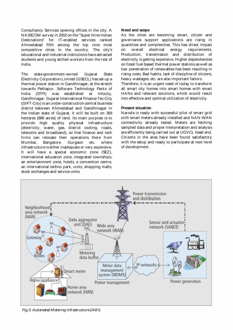
Feasible e-application domains(1) Advanced Metering Infrastructure (AMI)(2) Monitoring and automation of substations(3) Home Automation Network (HAN)(4) Power network monitoring(5) Demand Response (DR)(6) Integration of renewables(7) Supervisory Control And Data Acquisition
(SCADA) system(8) Plug-in Hybrid Electric Vehicles (PHEV)
Fig.4: IoTs and AMI
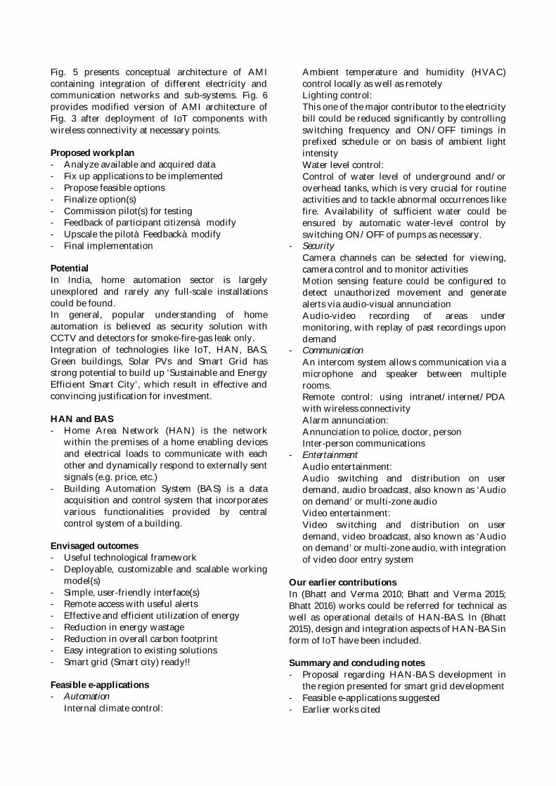
Fig. 5 presents conceptual architecture of AMIcontaining integration of different electricity andcommunication networks and sub-systems. Fig. 6provides modified version of AMI architecture ofFig. 3 after deployment of IoT components withwireless connectivity at necessary points.
Proposed workplan- Analyze available and acquired data- Fix up applications to be implemented- Propose feasible options- Finalize option(s)- Commission pilot(s) for testing- Feedback of participant citizensà modify- Upscale the pilotàFeedbackàmodify- Final implementation
PotentialIn India, home automation sector is largelyunexplored and rarely any full-scale installationscould be found.In general, popular understanding of homeautomation is believed as security solution withCCTV and detectors for smoke-fire-gas leak only.Integration of technologies like IoT, HAN, BAS,Green buildings, Solar PVs and Smart Grid hasstrong potential to build up ‘Sustainable and EnergyEfficient Smart City’, which result in effective andconvincing justification for investment.
HAN and BAS- Home Area Network (HAN) is the network
within the premises of a home enabling devicesand electrical loads to communicate with eachother and dynamically respond to externally sentsignals (e.g. price, etc.)
- Building Automation System (BAS) is a dataacquisition and control system that incorporatesvarious functionalities provided by centralcontrol system of a building.
Envisaged outcomes- Useful technological framework- Deployable, customizable and scalable working
model(s)- Simple, user-friendly interface(s)- Remote access with useful alerts- Effective and efficient utilization of energy- Reduction in energy wastage- Reduction in overall carbon footprint- Easy integration to existing solutions- Smart grid (Smart city) ready!!
Feasible e-applications- Automation
Internal climate control:
Ambient temperature and humidity (HVAC)control locally as well as remotelyLighting control:This one of the major contributor to the electricitybill could be reduced significantly by controllingswitching frequency and ON/OFF timings inprefixed schedule or on basis of ambient lightintensityWater level control:Control of water level of underground and/oroverhead tanks, which is very crucial for routineactivities and to tackle abnormal occurrences likefire. Availability of sufficient water could beensured by automatic water-level control byswitching ON/OFF of pumps as necessary.
- SecurityCamera channels can be selected for viewing,camera control and to monitor activitiesMotion sensing feature could be configured todetect unauthorized movement and generatealerts via audio-visual annunciationAudio-video recording of areas undermonitoring, with replay of past recordings upondemand
- CommunicationAn intercom system allows communication via amicrophone and speaker between multiplerooms.Remote control: using intranet/internet/PDAwith wireless connectivityAlarm annunciation:Annunciation to police, doctor, personInter-person communications
- EntertainmentAudio entertainment:Audio switching and distribution on userdemand, audio broadcast, also known as ‘Audioon demand’ or multi-zone audioVideo entertainment:Video switching and distribution on userdemand, video broadcast, also known as ‘Audioon demand’ or multi-zone audio, with integrationof video door entry system
Our earlier contributionsIn (Bhatt and Verma 2010; Bhatt and Verma 2015;Bhatt 2016) works could be referred for technical aswell as operational details of HAN-BAS. In (Bhatt2015), design and integration aspects of HAN-BAS inform of IoT have been included.
Summary and concluding notes- Proposal regarding HAN-BAS development in
the region presented for smart grid development- Feasible e-applications suggested- Earlier works cited
- Ubiquitous and effective usage of differenttechnologies including IoT and WSN
- Significant optimization in overall energyconsumption and efficient utilization
- Advancements like demand response could bemade possible
ReferencesBhatt J (2015) Wireless Sensor Networks for
Instrumentation: Recent Trends in Researchand Applications Development. J Res TechnolManag 24–29.
Bhatt J, Jani O (2015) E-Governance for PhotoVoltaic Powergrid: Solar City Gandhinagar,Gujarat, India. In: Kumar TMV (ed) E-Governance of Smart Cities. Springer, pp 177–230
Bhatt J, Jani O (2017) Smart Grid: Energy Backboneof Smart City and e-Democracy. In: KumarTMV (ed) E-Democracy for Smart Cities.Springer, pp 319–366
Bhatt J, Shah V, Jani O (2014) An InstrumentationEngineer’s Review on Smart Grid: CriticalApplications and Parameters. Renew SustainEnergy Rev 40:1217–1239.
Bhatt J, Verma H (2015) Design and Development ofWired Building Automation Systems. EnergyBuild. doi: 10.1016/j.enbuild.2015.02.054
Bhatt JG (2016) Building Automation Systems:Recent Trends, Design and Development.Handb. Res. Emerg. Technol. Electr. PowerPlanning, Anal. Optim. pp 235–264
Bhatt JG, Verma H (2010) RS-485 / MODBUS basedIntelligent Building Automation System usingLabVIEW. 4th Int. Conf. Comput. Appl. Electr.Eng. Adv. IIT Roorkee, Roorkee, India, p 5
Additional readinghttps://en.wikipedia.org/wiki/Ahmedabadhttp://ahmedabadcity.gov.in/portal/index.jsphttps://en.wikipedia.org/wiki/Gandhinagarhttps://en.wikipedia.org/wiki/Naroda
List of acronymsAcronym Full formAMI Advanced Metering
InfrastructureBAS Building Automation
SystemCCTV Close Circuit Tele VisionGAV Gandhinagar-Ahmedabad-
VadodaraGERMI Gujarat Energy Research
and Management Institute
GIDC Gujarat IndustrialDevelopment Corporation
GIFT Gujarat InternationalFinance-Tec city
GSEL Gujarat State ElectricityCorporation Limited
HAN Home Area NetworkHVAC Humidity Ventilation and
Air ConditioningICT Information and
Communication TechnologyIMRB Indian Market Research
BureauIoT Internet of ThingsNAN Neighborhood Area
NetworkNASSCOM National Association of
Software and ServicesCompanies
NCRB National Crime RecordBureau
PDA Personalized DigitalAssistant
PM Prime MinisterPV Photo VoltaicR-APDRP Restructured Accelerated
PowerRBI Reserve Bank of IndiaSEZ Special Economic ZoneSTPI Software Technology Parks
of IndiaUGVCL Uttar Gujarat Vij Company
LimitedUNESCO United Nations Educational,
Scientific and CulturalOrganization
WAN Wide Area Network
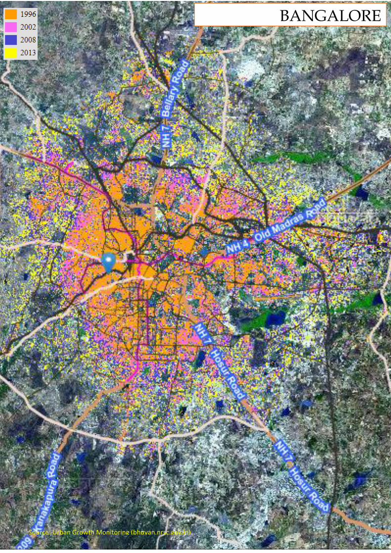
BANGALORE
Source: Urban Growth Monitoring (bhuvan.nrsc.gov.in)
Introduction
Historically, all over the world, urbanization and economic growth have gone hand in hand. We are living in the century of the metropolis with more than half of the population living in the metropolitan region (Angotti, 2013). In the decade 2001-2011, the pattern of India’s urbanization underwent an important shift, which was characterized by an increase in the number of metropolitan cities/Urban Agglomerations (UAs) from 35 to 52 and increase in the percentage share of population from 37.8 to 42.3 per cent. Many large Indian cities, especially the large metropolises and metropolitan regions are facing problems with respect to their growth, composition, spatial spread, congestion, environmental factors, housing, infrastructure availability as well as accessibility. Bangalore (also known as Bengaluru), the so-called ‘Silicon valley of India’ is no exception to these trends. In the year 2015, Government of India launched Smart City Mission and major thrust is to “develop sustainable and inclusive development and create compact and replicable model” (Ministry of Urban Development, 2015:5). The Mission will cover 100 cities over the five year time period, including Bangalore. The present study will form an analysis of the economic and spatial strategies undertaken by national and local authorities for a Smart Bangalore Metropolitan Regional Development. It will develop through two sections: Section 1 – Situational Analysis of Bangalore in Time and
Space: retrospect and prospect and; Section 2– Methodology to analyze Spatial and Economic Transformations for a Smart Bangalore Metropolitan Region.
Section 1 – Situational Analysis of Bangalore in Time and Space: retrospect and prospect
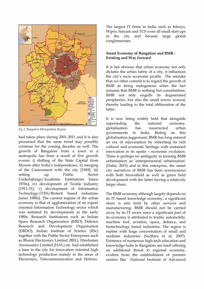
Bangalore Metropolitan Region (BMR) with an area of 8005 km2, and a population of 11.69 million is divided into 3 districts namely – Bangalore Urban, Bangalore Rural and Ramanagra (See Fig-1). The Bangalore Metropolitan Region (BMR) is a planning region recognized under the Bangalore Metropolitan Region Act, 1985. BMR has only one Corporation namely the Bruhat Bangalore Mahanagar Palika i.e. BBMP and 10 Urban Local Bodies (ULBs). Bangalore covers a space of 10% of the geographical area and has a population share of almost 72% of Bangalore Metropolitan Region (BMR). Population influx in Bangalore is an obvious result of the continuous flow of migrants to Bangalore from surrounding areas and other regions. Nearly half (45 percent) of the population had been categorized as migrants (BDA, 2015).
Demographic Change Bangalore city population grew at a high rate, and the population of Bangalore increased from 5.7 million to 8.4 million during the decade 2001-2011. A significant rise in growth rate (4.95%)
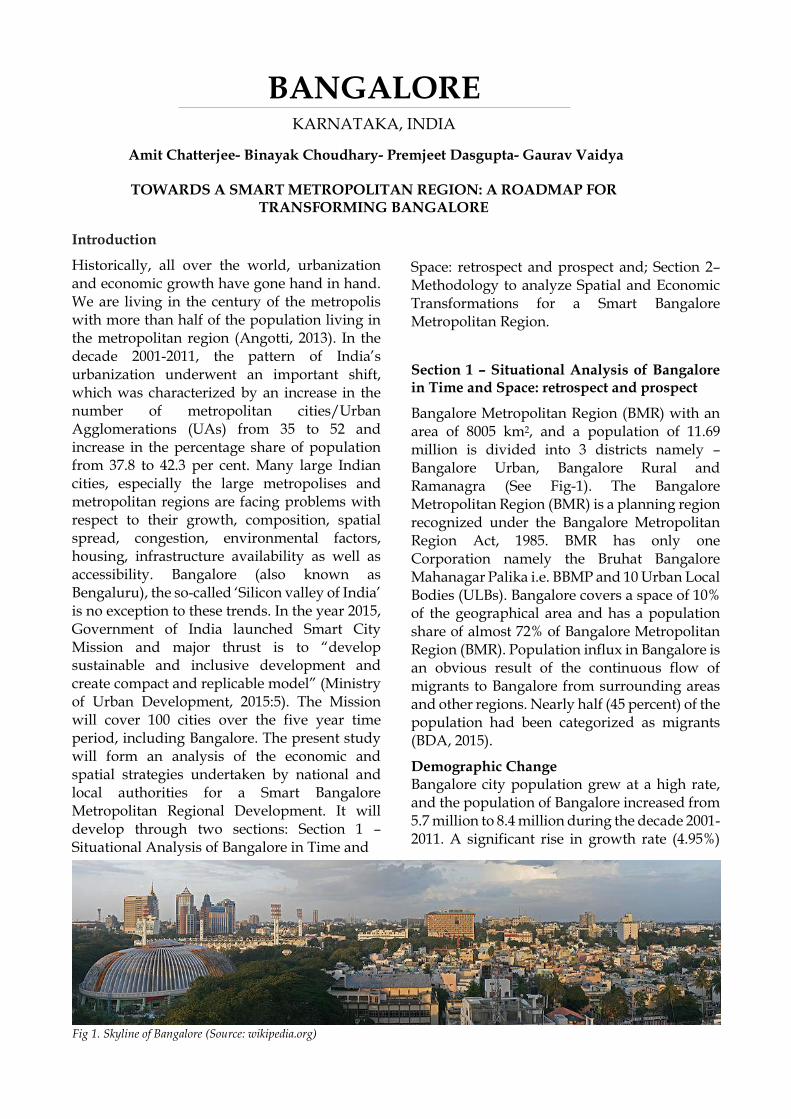
BANGALORE KARNATAKA, INDIA
Amit Chatterjee- Binayak Choudhary- Premjeet Dasgupta- Gaurav Vaidya
TOWARDS A SMART METROPOLITAN REGION: A ROADMAP FOR TRANSFORMING BANGALORE
Fig 1. Skyline of Bangalore (Source: wikipedia.org)
had taken place during 2001-2011 and it is also presumed that the same trend may possibly continue for the coming decades as well. The growth of Bangalore from a town to a metropolis has been a result of five growth events: i) shifting of the State Capital from Mysore after India’s independence, ii) merging of the Cantonment with the city [1949], iii) setting up Public Sector Undertakings/Academic Institutions [since 1970s], iv) development of Textile Industry [1911-31], v) development of Information Technology/ITES/Biotech based industries [since 1980s]. The current regime of the urban economy is that of agglomeration of an export oriented Information Technology sector which was initiated by developments in the early 1980s. Research Institutions such as Indian Space Research Organization (ISRO), Defence Research and Development Organisation (DRDO), Indian Institute of Science (IISc) together with the Public Sector Enterprises such as Bharat Electronics Limited (BEL), Hindustan Aeronautics Limited (HAL) etc. had established a base in the city for innovation oriented high technology production mainly in the areas of Electronics, Telecommunication and Defence.
The largest IT firms in India such as Infosys, Wipro, Satyam and TCS were all small start ups in the city and became large global conglomerates.
Smart Economy of Bangalore and BMR : Existing and Way forward It is but obvious that urban economy not only dictates the urban fabric of a city, it influences the city’s socio economic profile. The mistake that we often commit is to regard the growth of BMR as being endogenous when the fact remains that BMR is nothing but conurbations. BMR not only engulfs its degenerated peripheries, but also the small towns around, thereby leading to the total obliteration of the latter. It is now being widely held that alongside superseding the national economy, globalisation has resurrected urban governments in India. Riding on this globalisation juggernaut, BMR has long entered an era of rejuvenation by inheriting its rich cultural and economic heritage with sustained innovation in its spatio – economic evolution. There is perhaps no ambiguity in terming BMR urbanisation as ‘entrepreneurial urbanisation’ (Datta, 2015) and in this enterprise, the smart city narratives of BMR has been synonymous with both brownfield as well as green field development with the latter having a relatively larger share. The BMR economy although largely depends on its IT based knowledge economy, a significant share is also held by other services and manufacturing. BMR should not be carried away by its IT sector since a significant part of its economy is attributed to textile, automobile, machine tool, aviation, space, defence, and biotechnology based industries. The region is replete with huge concentration of small and medium industries (Sudhira et al, 2007). Existence of numerous high-tech education and knowledge hubs in Bangalore are itself offering an additional thrust to regional economy, evident from the establishment of premier centres like National Institute of Advanced
Fig 2: Bangalore Metropolitan Region
Studies (NIAS), Tata Institute for Fundamental Research (TIFR), Jawaharlal Nehru Centre for Advanced Scientific Research (JNCASR), National Aerospace Laboratories (NAL), Indian Institute of Management (IIM), Institute for Social and Economic Change (ISEC), Indian Institute of Information Technology (IIIT) and several professional engineering and medical colleges at undergraduate and graduate levels (BMRDA, 2015). 89 percent of BMR areas falling under rural areas signify the contribution of rural economy through agro based products and handlooms. Besides all these, BMR is bustling with services ranging from education, health care, to hospitality, banking and transport logistics services. Launching a new business can be a daunting experience in the face of uncertainty of securing funding and sufficient skills. It is here where BMR should not only secure and promote its stature as India’s IT hub, it must also incubate its intellectual capital in order to sustain and upgrade its being the investment destination for entrepreneurial capital. BMR must draft its regulatory frameworks to host an ecosystem that does not blindly replicate the popular incubator and accelerator models but customises it to develop local versions. Apart from incentivising the potential investors, BMR may explore the feasibility of crowdfunding to supplement its initiatives. Urban finance shall be a formidable task for BMR administration, {both Bengaluru Municipal Corporation (BMC) and Bengaluru Metropolitan Regional Development Authority (BMRDA)} in making its economy smarter. The municipal fiscal health should be strong enough to build the credit worthiness of BMC to access international funding for effecting transformational change and towards achieving this, BMC should explore non conventional fiscal tools to replenish its coffer. BMR appears desperate to go more digital to improve quality of life of the citizenry. While doing so, BMR banks on all the stakeholders in order to co-create tomorrow's urban services with corporate sectors and the civil society (Janagraha). Although BMR strives to steer its economy on technology-driven urbanism, it
must take cognizance of the fact that today’s decision-making is compounded by an information overload, BMR also must not downplay the offshoots of pollution, traffic congestion, and mushrooming of informal settlements. Let alone informal settlements, informal economic agents (hawkers, vendors, rovers etc.) should also be adequately addressed to. BMR may go more and more wired, the everything-on-demand Bangaloreans may go for higher speed connectivity, tech gizmos may satiate their appetite, but BMR must ensure that its labour markets and education systems mutually support each other to address the skill gap in order to accommodate ‘youth bulge’ (millennials) and prevent a ‘lost generation’. With technological obsolescence exponentially picking up, BMR will find newer occupations forming a new segment of the labour market with many occupations getting disappeared. BMR must address the concern of this surplus labour force through newer skill formation and through product market and labour market scan. BMR must rope in the corporate sector in this endeavour. The concept of ‘smart economy’ requires new qualitative approaches of the concept of economic growth, focused on the quality of life and on the standard of living. It is a dynamic process (PCAST, 2016) adaptable to contextual situations in which the individual and the community act in time and space for which the foundation is represented by a set of moral, cultural, traditional, political, democratic, leisure precepts (Diana Apostol et. al., 2010). Being a global city, BMR’s strategic vision must become complementary and compatible with internal realities on the one hand and the development trends of the global economy on the other. BMR must promote entrepreneurship both ways: mimetic (technology transfer through FDI and innovative (innovations suitable for local economies). Certainty is a key word, diversity is a key reality and clarity is a key prerequisite. BMR must be able to tie a knot and build a trinity. In this context, the intensity of primary energy (and not secondary energy) is of utmost importance to green the economy and for this, BMR needs collaboration between
ecologists and economists, between the development of well-informed environmental policies and economic decisions. Keeping in view the universality of public goods such as education, culture, health and research, BMR should adopt a different approach to the concept of ‘smart economy’ through an indissoluble bond with the science of marketing, - cyber marketing, neuromarketing, virtual marketing. BMR must promote public private partnership: promote up-skilling and work based training, set up networked economy and ensure liaison and information sharing between business and economic development agencies. Given the fact that we are fast moving to Industry 4 and the third age (retirement) industry is seen as having more development potential (BMR once being the Pensioners’ Paradise), given the fact that rural BMR contributes considerably towards its economy, it is high time that BMR readies itself accordingly. BMR should also take necessary steps to multi skill the rural workforce, skilled and unskilled, to absorb the uncertain structural shocks of BMR economy. BMR must acknowledge that everything that can be digital will be digital. The economy is shifting towards subscription based business models, product life cycles are getting shorter, users are migrating from ‘possession’ to ‘use’ and look for ultra personalization. Information is becoming more and more transparent and businesses are experiencing increasing disintermediation and automation. Processes become data centric and mobile. Businesses are preferring transition to a pull rather than a push approach. Either concentration or fragmentation is being seen to be adopted by service industries. Data monetization, especially of big data analytics and its trading is going to emerge as a big employer. BMC and BMDA should put in place the enabling platforms to smoothen these inevitable transitions. (Deloitte, 2015). But we should never forget what urban sociologist, Robert Park, once remarks, “If the city is the world which man created, it is the
world in which he is henceforth condemned to live.” But unfortunately the creators and the condemned are not necessarily the same, nor do they stand on equal ground. Existing Challenges Bangalore is transitioning from a formerly mononucleated growth pattern to a polycentric pattern, with the fastest growth taking place around multiple peripheral areas (Taubenböck et al., 2009). This pattern of growth, with the city core becoming increasingly saturated, and new urbanization centers developing at the periphery, can be traced to multiple factors. The high land prices in the city center and the lack of large spaces that are available for further urbanization have led to the location of many public sectors, local and multinational companies, and prominent educational institutions at the city periphery (Shaw et al., 2006). As a result, in periphery areas of Bengaluru, loss of agricultural land, water body, and green spaces are faster and it is imperative that urban planning efforts concentrate of city periphery where unplanned growth is taking place at an extremely rapid rate. The partial implementation of decentralization agenda has further added to the current problem resulting in functional, political and economic gaps (BMRDA, 2015). Section 2- Methodology to analyze Spatial and Economic Transformations for a Smart Bangalore Metropolitan Region Smart region can be defined as ‘a cluster of small urban areas which work together in order to frame a diffused smart city, sharing visions, ideas, common goals and resources’. Transition from ‘the urban level of smart city to the territorial level of the smart region’ is the problem that needs to be addressed. The important issue in transitioning from smart city to smart city or from a cluster of smart cities and villages to smart region is not the technology but the capability to collaborate. It is about transcending administrative boundaries in a technological sense and in other ways too. Experimentation to this effect has been carried out in Italy.
In the case of Bangalore there is a strong need to think beyond the city of Bangalore. Peeling away the layers of spatial governance jurisdiction we can see that it is the outermost layer, which is the BMR, which is of utmost importance. If the smart region vision has to be given a spatial context, then it has to be BMR. BMR is an amalgamation of the urban and rural, with the overwhelming presence of Bangalore City at its core. The jurisdictional presence of Bangalore City is reflected in the boundary of the BBMP. However, beyond it there are a large number of smaller towns which are in no way less important. Some of these towns would in fact qualify as regional cities, given the tremendous rise in their population over the last decade or so. All these towns have their own local governments (Town Municipal Councils and City Municipal Councils). If a smart region is to evolve, the need of the hour is to promote cooperation between the entities and also between them and BMC. The cooperation should be directly based on digital platform and smart networking should be explored. The focus on smart-networking between Urban Local Bodies and Rural Local Self Governments will be incomplete if we do not consider networking with industry and businesses. Ultimately it is smart industrial innovation which is at the heart of smart region framework and will drive the smart economy. As such they will require complete policy and administrative support from the smart network of local self governments. In this way smart local government network should complement smart economy. In this context, the role of industry assumes great importance. The legacy businesses have to transfom into digitally oriented enterprises. Bangalore is already the technology capital of India, driven largely by IT. While the IT industry in India is likely to emerge from the current downturn as much stronger riding on the back of technology transformation, it is the need of the hour to support them, and also other industries, by providing facilities for digital innovation and incubation. The role of industry bodies will be of prime importance here, but again, the need is to connect them with the smart
network of local self governments, so that a synergy is achieved in terms of spatial decision-support and parameter-based prioritization without requiring complex interfacing among industry and multiple layers of government agencies. To achieve this, each of the regional cities around BMC have to be developed as smart cities first. Recently Bangalore city has broken into the smart-city club. But it needs to be emphasized that merely promoting Bangalore City as a smart city will be a self-defeating exercise as the irreversible process and the tremendous rate of urbanization means that the region itself is transforming beyond limits of imagination and has to be integrated in the context of a ‘smart region’. After all, a smart Bangalore city which gets promoted in isolation will only distort the market further and lead to lopsided urbanization, costing society dear in terms of crowding, quality of public spaces, travel times, etc. If we look at the underlying concepts of smart city, we see themes like smart energy, smart health, smart living, smart mobility, and smart economy. However, if we have to graduate to smart region paradigm we need to look beyond making cities smart. Thus transformation of BMR into a smart region would mean more than location specific actions within the area. While smart energy interventions could be a thrust in the BMC area, piloting of such interventions could be easier in the smaller City Municipal Councils or Town Municipal Councils in the region. In fact, the population explosion happening in these regional centres outside BMC demands that they should also be considered for smart energy solutions. Smart health also needs to be scaled up to regional level through linkage between health institutions spread across the region, thus benefiting the rural settlements also. The first steps toward smart living at a regional scale would involve promotion of a dispersed settlement strategy dovetailed with transit oriented development and backed by incentives for affordable housing development. Smart mobility would entail smart demand-responsive integrated regional connectivity catering to diverse commuter segments. Smart mobility strategies, with fast and high-capacity regional networks supported by efficient intermodal options, would complement smart
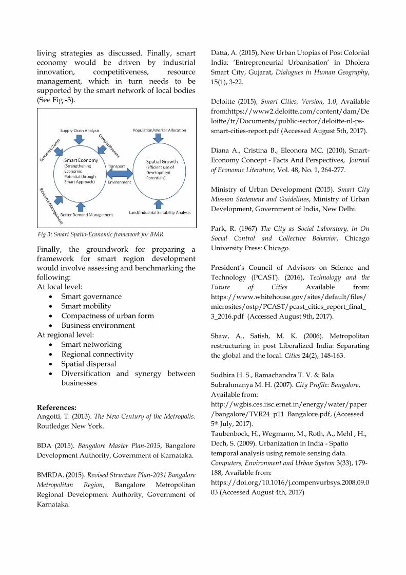
living strategies as discussed. Finally, smart economy would be driven by industrial innovation, competitiveness, resource management, which in turn needs to be supported by the smart network of local bodies (See Fig.-3).
Finally, the groundwork for preparing a framework for smart region development would involve assessing and benchmarking the following: At local level:
Smart governance
Smart mobility
Compactness of urban form
Business environment At regional level:
Smart networking
Regional connectivity
Spatial dispersal
Diversification and synergy between businesses
References: Angotti, T. (2013). The New Century of the Metropolis.
Routledge: New York.
BDA (2015). Bangalore Master Plan-2015, Bangalore
Development Authority, Government of Karnataka.
BMRDA. (2015). Revised Structure Plan-2031 Bangalore
Metropolitan Region, Bangalore Metropolitan
Regional Development Authority, Government of
Karnataka.
Datta, A. (2015), New Urban Utopias of Post Colonial
India: ‘Entrepreneurial Urbanisation’ in Dholera
Smart City, Gujarat, Dialogues in Human Geography,
15(1), 3-22.
Deloitte (2015), Smart Cities, Version, 1.0, Available
from:https://www2.deloitte.com/content/dam/De
loitte/tr/Documents/public-sector/deloitte-nl-ps-
smart-cities-report.pdf (Accessed August 5th, 2017).
Diana A., Cristina B., Eleonora MC. (2010), Smart-
Economy Concept - Facts And Perspectives, Journal
of Economic Literature, Vol. 48, No. 1, 264-277.
Ministry of Urban Development (2015). Smart City
Mission Statement and Guidelines, Ministry of Urban
Development, Government of India, New Delhi.
Park, R. (1967) The City as Social Laboratory, in On
Social Control and Collective Behavior, Chicago
University Press: Chicago.
President’s Council of Advisors on Science and
Technology (PCAST). (2016), Technology and the
Future of Cities Available from:
https://www.whitehouse.gov/sites/default/files/
microsites/ostp/PCAST/pcast_cities_report_final_
3_2016.pdf (Accessed August 9th, 2017).
Shaw, A., Satish, M. K. (2006). Metropolitan
restructuring in post Liberalized India: Separating
the global and the local. Cities 24(2), 148-163.
Sudhira H. S., Ramachandra T. V. & Bala
Subrahmanya M. H. (2007). City Profile: Bangalore,
Available from:
http://wgbis.ces.iisc.ernet.in/energy/water/paper
/bangalore/TVR24_p11_Bangalore.pdf, (Accessed
5th July, 2017).
Taubenbock, H., Wegmann, M., Roth, A., Mehl , H.,
Dech, S. (2009). Urbanization in India - Spatio
temporal analysis using remote sensing data.
Computers, Environment and Urban System 3(33), 179-
188, Available from:
https://doi.org/10.1016/j.compenvurbsys.2008.09.0
03 (Accessed August 4th, 2017)
Fig 3: Smart Spatio-Economic framework for BMR
CHANDIGARH TRICITY
Source: Urban Growth Monitoring (bhuvan.nrsc.gov.in)
Introduction
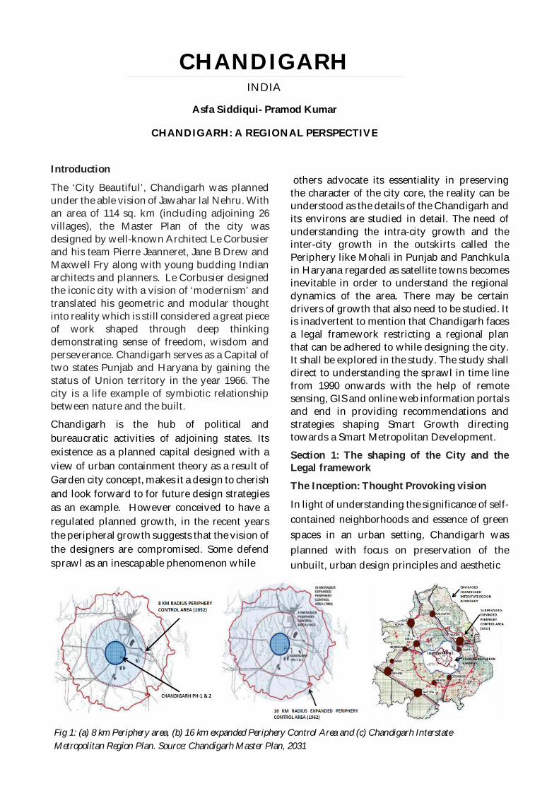
The ‘City Beautiful’, Chandigarh was plannedunder the able vision of Jawahar lal Nehru. Withan area of 114 sq. km (including adjoining 26villages), the Master Plan of the city wasdesigned by well-known Architect Le Corbusierand his team Pierre Jeanneret, Jane B Drew andMaxwell Fry along with young budding Indianarchitects and planners. Le Corbusier designedthe iconic city with a vision of ‘modernism’ andtranslated his geometric and modular thoughtinto reality which is still considered a great pieceof work shaped through deep thinkingdemonstrating sense of freedom, wisdom andperseverance. Chandigarh serves as a Capital oftwo states Punjab and Haryana by gaining thestatus of Union territory in the year 1966. Thecity is a life example of symbiotic relationshipbetween nature and the built.
Chandigarh is the hub of political andbureaucratic activities of adjoining states. Itsexistence as a planned capital designed with aview of urban containment theory as a result ofGarden city concept, makes it a design to cherishand look forward to for future design strategiesas an example. However conceived to have aregulated planned growth, in the recent yearsthe peripheral growth suggests that the vision ofthe designers are compromised. Some defendsprawl as an inescapable phenomenon while
others advocate its essentiality in preservingthe character of the city core, the reality can beunderstood as the details of the Chandigarh andits environs are studied in detail. The need ofunderstanding the intra-city growth and theinter-city growth in the outskirts called thePeriphery like Mohali in Punjab and Panchkulain Haryana regarded as satellite towns becomesinevitable in order to understand the regionaldynamics of the area. There may be certaindrivers of growth that also need to be studied. Itis inadvertent to mention that Chandigarh facesa legal framework restricting a regional planthat can be adhered to while designing the city.It shall be explored in the study. The study shalldirect to understanding the sprawl in time linefrom 1990 onwards with the help of remotesensing, GIS and online web information portalsand end in providing recommendations andstrategies shaping Smart Growth directingtowards a Smart Metropolitan Development.
Section 1: The shaping of the City and theLegal framework
The Inception: Thought Provoking vision
In light of understanding the significance of self-contained neighborhoods and essence of greenspaces in an urban setting, Chandigarh wasplanned with focus on preservation of theunbuilt, urban design principles and aesthetic
CHANDIGARHINDIA
Asfa Siddiqui- Pramod Kumar
CHANDIGARH: A REGIONAL PERSPECTIVE
Fig 1: (a) 8 km Periphery area, (b) 16 km expanded Periphery Control Area and (c) Chandigarh InterstateMetropolitan Region Plan. Source: Chandigarh Master Plan, 2031
appeal. While ‘urban containment’ theory wasinherent in Garden City concept proposed byEbenezer Howard, it was adopted in India bythe first ever planner duo Albert Mayer andMathew Nowicki. But due to administrativehitches and other unforeseen circumstances, thebig project fell into the laps of the lead LeCorbusier (Chalana, 2014).
The design of Chandigarh was more inspiredfrom the original design proposed by Mayer.The improvisations in the plan restricting a grid-iron movement approach and phasing of cityfunctionalities resembling intrinsic body partsinto work, living and leisure, were worthadmiring. The city was decided to be built intwo phases consisting of Sectors 1 to 30 in phase1 efficient to accommodate 1.5 lakh people anda rather dense development accommodating 3.5lakh people in sectors 31 to 47 making it a totalof 5 lakh people.
It was a vision of Le-Corbusier where hisemphasis not only dwelled on the urban coredevelopment but also on the rural-urbantransitional zones in the fringes. His workclearly depicts his passion for preservingagricultural activities and open spaces for aserene site like Chandigarh amidst Shivaliks.The perfect Assimilation of town and countrywas addressed through the design keeping inview the problems faced by an urban setting dueto urban sprawl. This decentralized solutionwas also helpful in driving planned growth andat the same time posed limitations on the adhocgrowth pattern resulting due to poormanagement of land resources and Indian wayof organic city development.
Going back to history and remembering noteson the effectiveness of having a green beltaround the main city core, a peripheral areatermed as ‘Periphery’ was introduced. Thisphilosophy was adopted in various states in theUnited States and the United Kingdom. Same
philosophy reflects in the designing ofLetchworth and Welwyn. The Periphery Zoneconsorted to having a large chunk of agrarianland, 8 kms around the urban core. Thegreenbelt was legally restricted to have anydevelopments under the Punjab New Capital(Periphery) Control Act of 1952 (Chandigarhmaster Plan, 2031).
The essence of 8 km buffer space can only berealized if we understand the basics of regionalplanning. According to Howard, green andopen spaces around the cities paves way for arationalistic self-contained developmentsscenario where the satellite towns shall growand help cores to grow economically andsocially subsequently. But as is said, land is aresource and it is scarce, greenbelts soonerstarting engulfing to the needs of theurbanization dearth.
Demography Profile
Chandigarh’s development scenario is arealization of accommodation that has seen arise from designed limit of 5 lakhs to over 10lakhs as per Census 2011(Census of India, 2011).It is needless to mention that migrationphenomenon cannot be avoided in anysettlement especially in a city like Chandigarhoffering good quality of life, green spaces,regularized legal framework and densitycontrol with a beautiful Shivalik backdrop andSukhna Lake. It is regarded as one of thecleanest and greenest cites in India. However,statistics pertaining to demographics reveal thatthe city is unsafe from the effect of populationexplosion unless roads are paved foraccommodating the additional need. This is thesole reason where public and privatedevelopments have started eating up theperipheral lands in the form of unplannedsettlements. This is the rising demand that isforcing to act against le-Corbusier’s vision ofdevelopment scenario aimed for the CityBeautiful (Weber, 2014).
The Metropolitan region: ChandigarhPeriphery Act and others
While we turn the leaves of historicaldocuments, the growth pace of the urban areaswas negligible enough to have foreseen thescenario where Le-Corbusier’s spirit of agreenbelt can be defeated. The Punjab Newcapital (Periphery) Control Act of 1952 wasrevised in 1962 suggesting a 16 km buffer as aresult of establishment of Army Cantonment,Air Force and new township. However, in 1966when Punjab was reorganized as Punjab andHaryana State, out of the total peripheral areacalled Periphery control Area 1315 sq. km, 1021sq. km went to Punjab and 295 sq. km went toHaryana and 114 sq. km was reserved for capitalcity Union Territory Zone. Basic analysis revealsthat this area also consist of certain area underHimachal Pradesh not mentioned in any legaldocument.
Need was felt to develop the land under theperiphery to avoid unregulated growth.Subsequently, Mohali in Punjab and Panchkulain Haryana were planned to counterface thepressures of development. It was only in 1966that the Periphery no longer remained virgin,mere 16 years later from the conception of agreenbelt buffer thought. Later in 1975 need wasfelt to retain the originality of the idea giving lifeto Chandigarh’s existence. In 1977 an immediateregion called Chandigarh Urban Complex(CUC) covering 330 sq. km (includingChandigarh UT, Mohali and adjoining 27villages along with Panchkula and 23 villages)was declared. A ‘No Development’ Zone Northof the City was identified in the original 8 kmperiphery control area (Refer Fig 1)(Shaw, 2009).
As time progressed, each decade saw need torevise the plan to have an Interstate Planincorporating the regional perspective. In 1984an interstate Regional Plan called Structure Planwas formulated with a vision of 2001 claimingto accommodate a population of 25 lakhs. In1999, a Chandigarh Interstate MetropolitanRegional Plan (CISMeR) was made having a
new Periphery Control Area of 50 km includingHimachal Pradesh, Punjab, Haryana andChandigarh UT. Towns like Mullanpur, Kharar,Dera Bassi and many others emerged as satellitetowns for relieving Chandigarh from thepressure of development. Unfortunately, theRegional Plans failed to be implemented due tolack of legal status and statutory powers andhence remained ineffective since inception.
Section 2: Facets of Smart MetropolitanPlanning and Role of Remote Sensing and GISin shaping the Region
The Need for a Region
Economically, Chandigarh retained a soundbase an edge over other cities being a UnionTerritory. It was bestowed with Central funds tocater to meet the infrastructure upgradation andmaintenance. Le-Corbusier never dreamt ofhaving an industrial setup within the city.However some light industries were planted inChandigarh. Hence, it can be said the area neverdeveloped like an Industrial Area. Butunfortunately, the planner lacked theunderstanding of the essence of such driversthat contribute to all class of people andultimately help in boosting the economy.
Another major fallback was that the city had anintrinsic individual character which when seenthrough the eyes of a visitor is pleasing, butwhen looked upon in a broader perspective,lacks connectivity. With 65% of the total areadedicated to residential and commercial land-use, it is a paradise for people to live but not toflourish. Also, with limited carrying capacity (asper bye-laws) and regulated developmentthought, the idea of expansion was notenvisaged. The city collapses when trying toaccommodate the in-migrants. The wholephilosophy revolves around the dynamics of thecity.
The city lacks economic vibrance, it has no scopeof further development after land allocatedunder Chandigarh Master Plan 2031 is utilized,
the connectivity threads are ineffective and hasno place for in-migrants. It was never ready toaccommodate informal settlements and slums.It was never ready for settlements likeManimajra due to the growth pressure. It isevident that Indian cities have seen organicgrowth pattern. Laws like Periphery ControlAct, 1952 paved ways for no-development zonethat later amends the same for developmentneeds. Transformations of the cityscapefollowing construction activities addressing 10lakh people (double the population Chandigarhwas designed for).
Any change to the original character of the citydefeats the visions of the designer, while nochange makes it difficult for uphold its positionswith grace any further. The development ofPanchkula and Mohali in terms of architecturalimpetus, were effective in easing out themigration pressure but their effectiveness isquestionable in terms of architectural ambience,green buffers, character and quality of life.
It is time to understand the need for a holisticdevelopment as advocated by Lewis Mumfordand Ebenezer Howard. Their philosophy wassimple, to have a balance between built andunbuilt unlike school of thoughts promotingurban sprawl. Such kind of efficient utilizationof land resources coupled with thoughtfulthinking can be regarded as ‘Smart Growth’.
Smart Metropolitan Regional Development
The development of a region focuses onunderstanding the fragments of a region andthen realizing the region as a whole. RegionalDevelopment promotes the thinking of abottom-up and top-down approach both. Froma city perspective it shall focus on building up aSmart Growth, Smart Environment, SmartInfrastructure, Smart Energy and Smart People.From a Regional Perspective it shall focus onBuilding Smart Connectivity and SmartGovernance.
Role of Remote Sensing and GIS in enablingSmart Development
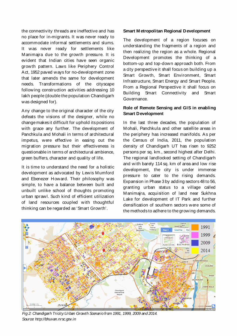
In the last three decades, the population ofMohali, Panchkula and other satellite areas inthe periphery has increased manifolds. As perthe Census of India, 2011, the populationdensity of Chandigarh UT has risen to 9252persons per sq. km., second highest after Delhi.The regional landlocked setting of Chandigarhand with barely 114 sq. km of area and low risedevelopment, the city is under immensepressure to cater to the rising demands.Expansion in Phase 3 by adding sectors 48 to 56,granting urban status to a village calledManimajra, acquisition of land near SukhnaLake for development of IT Park and furtherdensification of southern sectors were some ofthe methods to adhere to the growing demands.
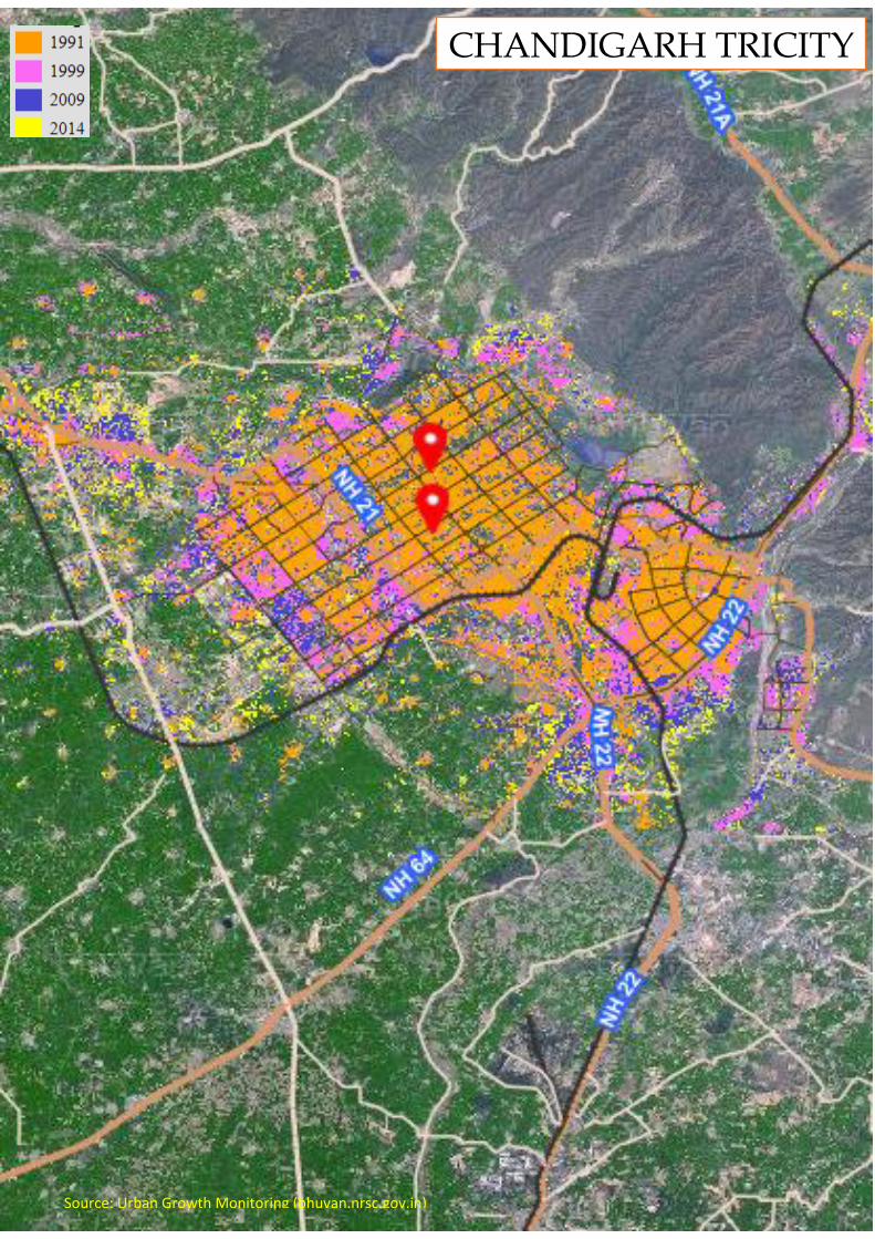
Fig 2: Chandigarh Tricity:Urban Growth Scenario from 1991, 1999, 2009 and 2014.Source: http://bhuvan.nrsc.gov.in
The Chandigarh master Plan 2031 projects apopulation of 16 lakhs accommodated in thesectoral grids 48 to 56 and parts of Sectors 61 and63 (Fig 2).
While the Tricity (Chandigarh, Mohali andPanchkula) had seen their share of planneddevelopment but the process shows signs ofuncoordinated adhoc development scenario inth region. Hence, it is essential to understand thegrowth scenario of the region after 1990 till date.For the purpose of the study a 16 km peripheralarea is taken. The study of sprawl shall beconducted for their time periods to analyze thestatus of growth pace and direction.
Section 4: Recommendations and Discussion
This section deals with providingrecommendations on strategies that can beadopted for translating an urban setup likeChandigarh into a Smart Metropolitan RegionalPlan. The drivers of growth shall help us inunderstanding the growth phenomenonsupported by online web information systemslike Bhuvan-NUIS Thematic Mapping.Chandigarh requires a Regional Plan extendingto the three states keeping in view to restore thevisions of the designers.
Chandigarh has a complex design strategy thatrequires a stringent policy making forincorporating a regional perspective to the city.The entire region is required to develop inholistic manner contributing to the region’sgrwth without tampering the character of thecity: Chandigarh.
References
Chalana, Manish "Chandigarh: City and Periphery,Journal of Planning History, , 2014, Page 62-84
Chandigarh Administration, ‘‘Chandigarh MasterPlan 2031,’’ accessed August 9, 2017,http://chandigarh.gov.in/cmp_2031.htm, 2017
Census of India, Administrative Atlas of India (NewDelhi, India: Office of the Registrar General &Census Commissioner, India, 2011)
Government of Punjab, Greater Mohali AreaDevelopment Authority "Regional Plan 2008-2058."Plan.
Shaw, Annapurna, “Town Planning in Post-Colonial India, 1947-1965: Chandigarh Re-examined”, Urban geography, 2009, pg. 857-878
Town and Country Planning Organization,‘‘Concept Note on Chandigarh and its Region.Ministry of Urban Development, India,’’ accessedAugust 1, 2017,http://tcpomud.gov.in/Divisions/MUTP/Concept_Note_Chandigarh.pdf.
Town and Country Planning Organization, ‘‘Reporton Formulating a Master Plan for Chandigarh,’’Indian Ministry of Urban Development, 2009,accessed August 1, 2017,http://tcpomud.gov.in/Divisions/MUTP/Master_Plan_for_Chandigarh.pdf
Weber, Abigail “Within the Edge: A revisedapproach to urban containment within theChandigarh periphery”, Thesis, Department ofUrban Planning, University of Washington, 2014
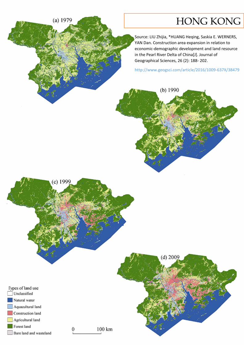
Source: LIU Zhijia, *HUANG Heqing, Saskia E. WERNERS,
YAN Dan. Construction area expansion in relation to
economic-demographic development and land resource
in the Pearl River Delta of China[J]. Journal of
Geographical Sciences, 26 (2): 188- 202.
http://www.geogsci.com/article/2016/1009-637X/38479
HONG KONG
Introduction
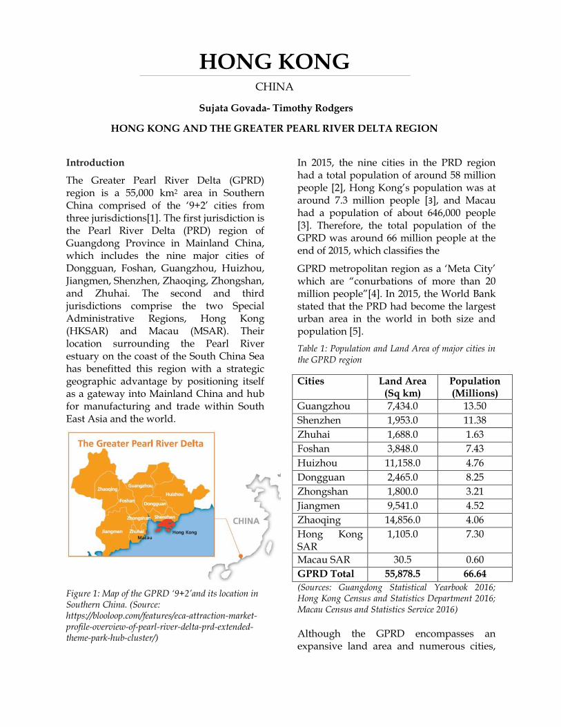
The Greater Pearl River Delta (GPRD) region is a 55,000 km2 area in Southern China comprised of the ‘9+2’ cities from three jurisdictions[1]. The first jurisdiction is the Pearl River Delta (PRD) region of Guangdong Province in Mainland China, which includes the nine major cities of Dongguan, Foshan, Guangzhou, Huizhou, Jiangmen, Shenzhen, Zhaoqing, Zhongshan, and Zhuhai. The second and third jurisdictions comprise the two Special Administrative Regions, Hong Kong (HKSAR) and Macau (MSAR). Their location surrounding the Pearl River estuary on the coast of the South China Sea has benefitted this region with a strategic geographic advantage by positioning itself as a gateway into Mainland China and hub for manufacturing and trade within South East Asia and the world.
Figure 1: Map of the GPRD ‘9+2’and its location in Southern China. (Source: https://blooloop.com/features/eca-attraction-market-profile-overview-of-pearl-river-delta-prd-extended-theme-park-hub-cluster/)
In 2015, the nine cities in the PRD region had a total population of around 58 million people [2], Hong Kong’s population was at around 7.3 million people [3], and Macau had a population of about 646,000 people [3]. Therefore, the total population of the GPRD was around 66 million people at the end of 2015, which classifies the
GPRD metropolitan region as a ‘Meta City’ which are “conurbations of more than 20 million people”[4]. In 2015, the World Bank stated that the PRD had become the largest urban area in the world in both size and population [5].
Table 1: Population and Land Area of major cities in the GPRD region
Cities Land Area (Sq km)
Population (Millions)
Guangzhou 7,434.0 13.50
Shenzhen 1,953.0 11.38
Zhuhai 1,688.0 1.63
Foshan 3,848.0 7.43
Huizhou 11,158.0 4.76
Dongguan 2,465.0 8.25
Zhongshan 1,800.0 3.21
Jiangmen 9,541.0 4.52
Zhaoqing 14,856.0 4.06
Hong Kong SAR
1,105.0 7.30
Macau SAR 30.5 0.60
GPRD Total 55,878.5 66.64
(Sources: Guangdong Statistical Yearbook 2016; Hong Kong Census and Statistics Department 2016; Macau Census and Statistics Service 2016)
Although the GPRD encompasses an expansive land area and numerous cities,
HONG KONG CHINA
Sujata Govada- Timothy Rodgers
HONG KONG AND THE GREATER PEARL RIVER DELTA REGION
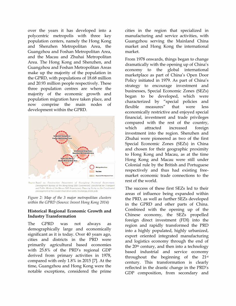
over the years it has developed into a polycentric metropolis with three key population centers, namely the Hong Kong and Shenzhen Metropolitan Area, the Guangzhou and Foshan Metropolitan Area, and the Macau and Zhuhai Metropolitan Area. The Hong Kong and Shenzhen, and Guangzhou and Foshan Metropolitan Areas make up the majority of the population in the GPRD, with populations of 18.68 million and 20.93 million people respectively. These three population centres are where the majority of the economic growth and population migration have taken place, and now comprise the main nodes of development within the GPRD.
Figure 2: Map of the 3 major metropolitan clusters within the GPRD (Source: Invest Hong Kong 2014)
Historical Regional Economic Growth and Industry Transformation
The GPRD was not always as demographically large and economically significant as it is today. Over 40 years ago, cities and districts in the PRD were primarily agricultural based economies with 25.8% of the PRD’s regional GDP derived from primary activities in 1978, compared with only 1.8% in 2015 [7]. At the time, Guangzhou and Hong Kong were the notable exceptions, considered the prime
cities in the region that specialized in manufacturing and service activities, with Guangzhou serving the Mainland China market and Hong Kong the international market.
From 1978 onwards, things began to change dramatically with the opening up of China’s economy to the global international marketplace as part of China’s Open Door Policy initiated in 1979. As part of China’s strategy to encourage investment and businesses, Special Economic Zones (SEZs) began to be developed, which were characterized by “special policies and flexible measures” that were less economically restrictive and enjoyed special financial, investment and trade privileges compared with the rest of the country, which attracted increased foreign investment into the region. Shenzhen and Zhuhai were pioneered as two of the first Special Economic Zones (SEZs) in China and chosen for their geographic proximity to Hong Kong and Macau, as at the time Hong Kong and Macau were still under Colonial rule by the British and Portuguese respectively and thus had existing free-market economic trade connections to the rest of the world.
The success of these first SEZs led to their areas of influence being expanded within the PRD, as well as further SEZs developed in the GPRD and other parts of China. Combined with the opening up of the Chinese economy, the SEZs propelled foreign direct investment (FDI) into the region and rapidly transformed the PRD into a highly populated, highly urbanized, export oriented integrated manufacturing and logistics economy through the end of the 20th century, and then into a technology based industrial and service economy throughout the beginning of the 21st century. This transformation is clearly reflected in the drastic change in the PRD’s GDP composition, from secondary and
tertiary industries making up 45.3% and 28.9% in 1980 to 43.6% and 54.6% in 2015 [8].
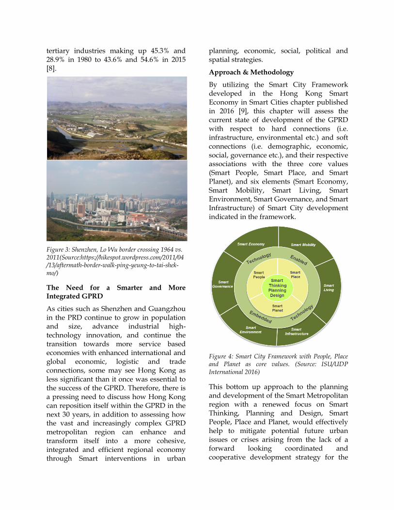
Figure 3: Shenzhen, Lo Wu border crossing 1964 vs. 2011(Source:https://hikespot.wordpress.com/2011/04/13/aftermath-border-walk-ping-yeung-to-tai-shek-mo/)
The Need for a Smarter and More Integrated GPRD
As cities such as Shenzhen and Guangzhou in the PRD continue to grow in population and size, advance industrial high-technology innovation, and continue the transition towards more service based economies with enhanced international and global economic, logistic and trade connections, some may see Hong Kong as less significant than it once was essential to the success of the GPRD. Therefore, there is a pressing need to discuss how Hong Kong can reposition itself within the GPRD in the next 30 years, in addition to assessing how the vast and increasingly complex GPRD metropolitan region can enhance and transform itself into a more cohesive, integrated and efficient regional economy through Smart interventions in urban
planning, economic, social, political and spatial strategies.
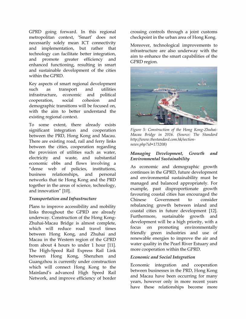
Approach & Methodology
By utilizing the Smart City Framework developed in the Hong Kong Smart Economy in Smart Cities chapter published in 2016 [9], this chapter will assess the current state of development of the GPRD with respect to hard connections (i.e. infrastructure, environmental etc.) and soft connections (i.e. demographic, economic, social, governance etc.), and their respective associations with the three core values (Smart People, Smart Place, and Smart Planet), and six elements (Smart Economy, Smart Mobility, Smart Living, Smart Environment, Smart Governance, and Smart Infrastructure) of Smart City development indicated in the framework.
Figure 4: Smart City Framework with People, Place and Planet as core values. (Source: ISU/UDP International 2016)
This bottom up approach to the planning and development of the Smart Metropolitan region with a renewed focus on Smart Thinking, Planning and Design, Smart People, Place and Planet, would effectively help to mitigate potential future urban issues or crises arising from the lack of a forward looking coordinated and cooperative development strategy for the
GPRD going forward. In this regional metropolitan context, ‘Smart’ does not necessarily solely mean ICT connectivity and implementation, but rather that technology can facilitate better integration, and promote greater efficiency and enhanced functioning, resulting in smart and sustainable development of the cities within the GPRD.
Key aspects of smart regional development such as transport and utilities infrastructure, economic and political cooperation, social cohesion and demographic transitions will be focused on, with the aim to better understand the existing regional context.
To some extent, there already exists significant integration and cooperation between the PRD, Hong Kong and Macau. There are existing road, rail and ferry links between the cities, cooperation regarding the provision of utilities such as water, electricity and waste, and substantial economic ebbs and flows involving a “dense web of policies, institutions, business relationships, and personal networks that tie Hong Kong and the PRD together in the areas of science, technology, and innovation” [10].
Transportation and Infrastructure
Plans to improve accessibility and mobility links throughout the GPRD are already underway. Construction of the Hong Kong-Zhuhai-Macau Bridge is almost complete, which will reduce road travel times between Hong Kong, and Zhuhai and Macau in the Western region of the GPRD from about 4 hours to under 1 hour [11]. The High-Speed Rail Express Rail Link between Hong Kong, Shenzhen and Guangzhou is currently under construction which will connect Hong Kong to the Mainland’s advanced High Speed Rail Network, and improve efficiency of border
crossing controls through a joint customs checkpoint in the urban area of Hong Kong.
Moreover, technological improvements to infrastructure are also underway with the aim to enhance the smart capabilities of the GPRD region.
Figure 5: Construction of the Hong Kong-Zhuhai-Macau Bridge in 2016. (Source: The Standard http://www.thestandard.com.hk/section-news.php?id=173208)
Managing Development, Growth and Environmental Sustainability
As economic and demographic growth continues in the GPRD, future development and environmental sustainability must be managed and balanced appropriately. For example, past disproportionate growth favouring coastal cities has encouraged the Chinese Government to consider rebalancing growth between inland and coastal cities in future development [12]. Furthermore, sustainable growth and development will be a high priority, with a focus on promoting environmentally friendly green industries and use of renewable energies to improve the air and water quality in the Pearl River Estuary and more cooperation within the GPRD.
Economic and Social Integration
Economic integration and cooperation between businesses in the PRD, Hong Kong and Macau have been occurring for many years, however only in more recent years have these relationships become more
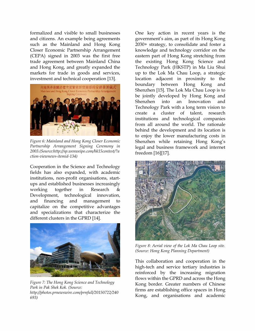
formalized and visible to small businesses and citizens. An example being agreements such as the Mainland and Hong Kong Closer Economic Partnership Arrangement (CEPA) signed in 2003 was the first free trade agreement between Mainland China and Hong Kong, and greatly expanded the markets for trade in goods and services, investment and technical cooperation [13].
Figure 6: Mainland and Hong Kong Closer Economic Partnership Arrangement Signing Ceremony in 2003.(Source:http://sp.wenweipo.com/hk15contest/?action-viewnews-itemid-134)
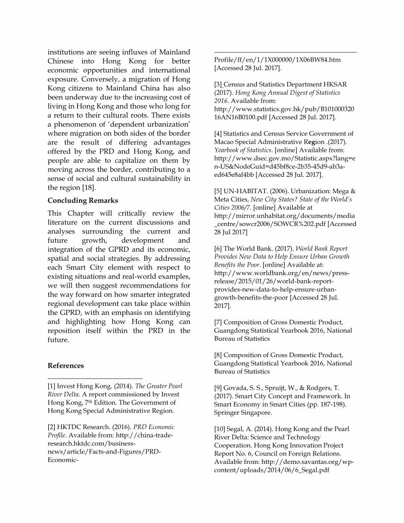
Cooperation in the Science and Technology fields has also expanded, with academic institutions, non-profit organisations, start-ups and established businesses increasingly working together in Research & Development, technological innovation, and financing and management to capitalize on the competitive advantages and specializations that characterize the different clusters in the GPRD [14].
Figure 7: The Hong Kong Science and Technology Park in Pak Shek Kok. (Source: http://photos.prnewswire.com/prnfull/20150722/240693)
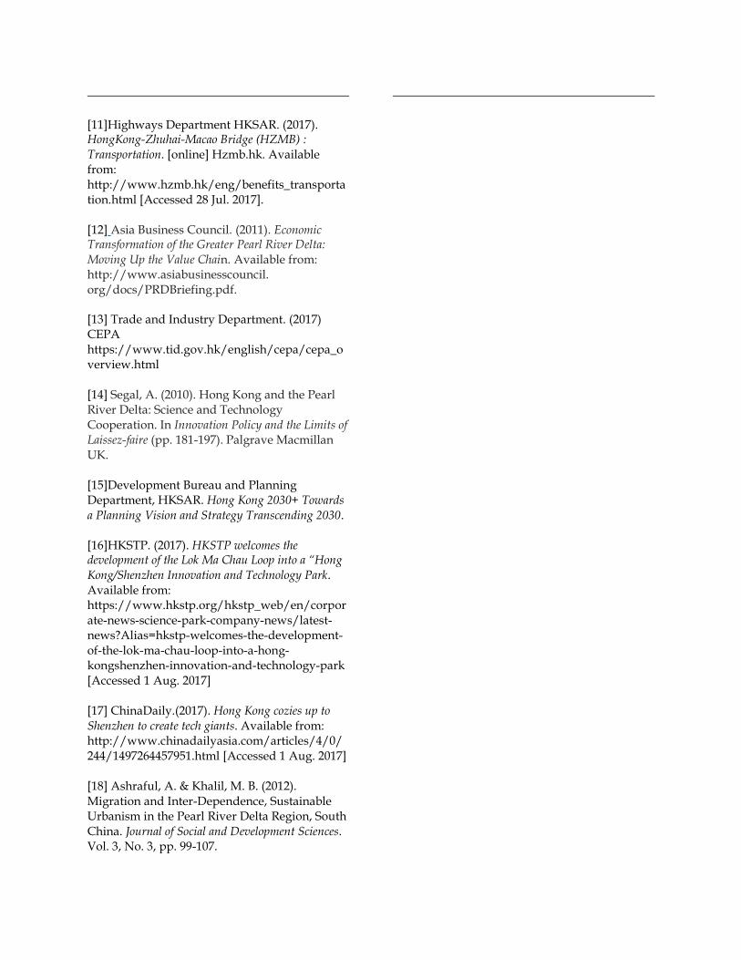
One key action in recent years is the government’s aim, as part of its Hong Kong 2030+ strategy, to consolidate and foster a knowledge and technology corridor on the eastern part of Hong Kong stretching from the existing Hong Kong Science and Technology Park (HKSTP) in Ma Liu Shui up to the Lok Ma Chau Loop, a strategic location adjacent in proximity to the boundary between Hong Kong and Shenzhen [15]. The Lok Ma Chau Loop is to be jointly developed by Hong Kong and Shenzhen into an Innovation and Technology Park with a long term vision to create a cluster of talent, research institutions and technological companies from all around the world. The rationale behind the development and its location is to enjoy the lower manufacturing costs in Shenzhen while retaining Hong Kong’s legal and business framework and internet freedom [16][17].
Figure 8: Aerial view of the Lok Ma Chau Loop site. (Source: Hong Kong Planning Department)
This collaboration and cooperation in the high-tech and service tertiary industries is reinforced by the increasing migration flows within the GPRD and across the Hong Kong border. Greater numbers of Chinese firms are establishing office spaces in Hong Kong, and organisations and academic
institutions are seeing influxes of Mainland Chinese into Hong Kong for better economic opportunities and international exposure. Conversely, a migration of Hong Kong citizens to Mainland China has also been underway due to the increasing cost of living in Hong Kong and those who long for a return to their cultural roots. There exists a phenomenon of ‘dependent urbanization’ where migration on both sides of the border are the result of differing advantages offered by the PRD and Hong Kong, and people are able to capitalize on them by moving across the border, contributing to a sense of social and cultural sustainability in the region [18].
Concluding Remarks
This Chapter will critically review the literature on the current discussions and analyses surrounding the current and future growth, development and integration of the GPRD and its economic, spatial and social strategies. By addressing each Smart City element with respect to existing situations and real-world examples, we will then suggest recommendations for the way forward on how smarter integrated regional development can take place within the GPRD, with an emphasis on identifying and highlighting how Hong Kong can reposition itself within the PRD in the future.
References
[1] Invest Hong Kong. (2014). The Greater Pearl River Delta. A report commissioned by Invest Hong Kong, 7th Edition. The Government of Hong Kong Special Administrative Region. [2] HKTDC Research. (2016). PRD Economic Profile. Available from: http://china-trade-research.hktdc.com/business-news/article/Facts-and-Figures/PRD-Economic-
Profile/ff/en/1/1X000000/1X06BW84.htm [Accessed 28 Jul. 2017]. [3] Census and Statistics Department HKSAR (2017). Hong Kong Annual Digest of Statistics 2016. Available from: http://www.statistics.gov.hk/pub/B10100032016AN16B0100.pdf [Accessed 28 Jul. 2017]. [4] Statistics and Census Service Government of Macao Special Administrative Region .(2017). Yearbook of Statistics. [online] Available from: http://www.dsec.gov.mo/Statistic.aspx?lang=en-US&NodeGuid=d45bf8ce-2b35-45d9-ab3a-ed645e8af4bb [Accessed 28 Jul. 2017]. [5] UN-HABITAT. (2006). Urbanization: Mega & Meta Cities, New City States? State of the World’s Cities 2006/7. [online] Available at http://mirror.unhabitat.org/documents/media_centre/sowcr2006/SOWCR%202.pdf [Accessed 28 Jul 2017] [6] The World Bank. (2017). World Bank Report Provides New Data to Help Ensure Urban Growth Benefits the Poor. [online] Available at: http://www.worldbank.org/en/news/press-release/2015/01/26/world-bank-report-provides-new-data-to-help-ensure-urban-growth-benefits-the-poor [Accessed 28 Jul. 2017]. [7] Composition of Gross Domestic Product, Guangdong Statistical Yearbook 2016, National Bureau of Statistics [8] Composition of Gross Domestic Product, Guangdong Statistical Yearbook 2016, National Bureau of Statistics [9] Govada, S. S., Spruijt, W., & Rodgers, T. (2017). Smart City Concept and Framework. In Smart Economy in Smart Cities (pp. 187-198). Springer Singapore. [10] Segal, A. (2014). Hong Kong and the Pearl River Delta: Science and Technology Cooperation. Hong Kong Innovation Project Report No. 6, Council on Foreign Relations. Available from: http://demo.savantas.org/wp-content/uploads/2014/06/6_Segal.pdf
[11]Highways Department HKSAR. (2017). HongKong-Zhuhai-Macao Bridge (HZMB) : Transportation. [online] Hzmb.hk. Available from: http://www.hzmb.hk/eng/benefits_transportation.html [Accessed 28 Jul. 2017]. [12] Asia Business Council. (2011). Economic Transformation of the Greater Pearl River Delta: Moving Up the Value Chain. Available from: http://www.asiabusinesscouncil. org/docs/PRDBriefing.pdf.
[13] Trade and Industry Department. (2017) CEPA https://www.tid.gov.hk/english/cepa/cepa_overview.html [14] Segal, A. (2010). Hong Kong and the Pearl River Delta: Science and Technology Cooperation. In Innovation Policy and the Limits of Laissez-faire (pp. 181-197). Palgrave Macmillan UK. [15]Development Bureau and Planning Department, HKSAR. Hong Kong 2030+ Towards a Planning Vision and Strategy Transcending 2030. [16]HKSTP. (2017). HKSTP welcomes the development of the Lok Ma Chau Loop into a “Hong Kong/Shenzhen Innovation and Technology Park. Available from: https://www.hkstp.org/hkstp_web/en/corporate-news-science-park-company-news/latest-news?Alias=hkstp-welcomes-the-development-of-the-lok-ma-chau-loop-into-a-hong-kongshenzhen-innovation-and-technology-park [Accessed 1 Aug. 2017] [17] ChinaDaily.(2017). Hong Kong cozies up to Shenzhen to create tech giants. Available from: http://www.chinadailyasia.com/articles/4/0/244/1497264457951.html [Accessed 1 Aug. 2017] [18] Ashraful, A. & Khalil, M. B. (2012). Migration and Inter-Dependence, Sustainable Urbanism in the Pearl River Delta Region, South China. Journal of Social and Development Sciences. Vol. 3, No. 3, pp. 99-107.
JAIPUR
Source: Urban Growth Monitoring (bhuvan.nrsc.gov.in)
Introduction
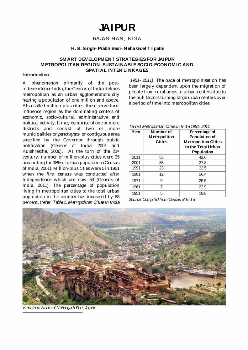
A phenomenon primarily of the post-independence India, the Census of India definesmetropolitan as an urban agglomeration/cityhaving a population of one million and above.Also called million plus cities, these serve theirinfluence region as the dominating centers ofeconomic, socio-cultural, administrative andpolitical activity. It may comprise of one or moredistricts and consist of two or moremunicipalities or panchayats1 or contiguous areaspecified by the Governor through publicnotification (Census of India, 2001 andKulshrestha, 2006). At the turn of the 21st
century, number of million-plus cities were 35accounting for 38% of urban population (Censusof India, 2001). Million-plus cities were 5 in 1951when the first census was conducted afterIndependence which are now 53 (Census ofIndia, 2011). The percentage of populationliving in metropolitan cities to the total urbanpopulation in the country has increased by 68percent. (refer Table 1, Metropolitan Cities in India
1951- 2011). The pace of metropolitisation hasbeen largely dependent upon the migration ofpeople from rural areas to urban centers due tothe pull factors turning large urban centers overa period of time into metropolitan cities.
Table 1 Metropolitan Cities in India 1951- 2011Year Number of
MetropolitanCities
Percentage ofPopulation of
Metropolitan Citiesto the Total Urban
Population2011 53 42.62001 35 37.81991 23 32.51981 12 26.41971 9 25.51961 7 22.91951 5 18.8
Source: Compiled from Census of India
JAIPURRAJASTHAN, INDIA
H. B. Singh- Prabh Bedi- Neha Goel Tripathi
SMART DEVELOPMENT STRATEGIES FOR JAIPURMETROPOLITAN REGION: SUSTAINABLE SOCIO-ECONOMIC AND
SPATIAL INTER LINKAGES
View from North of Nahargarh Fort, Jaipur
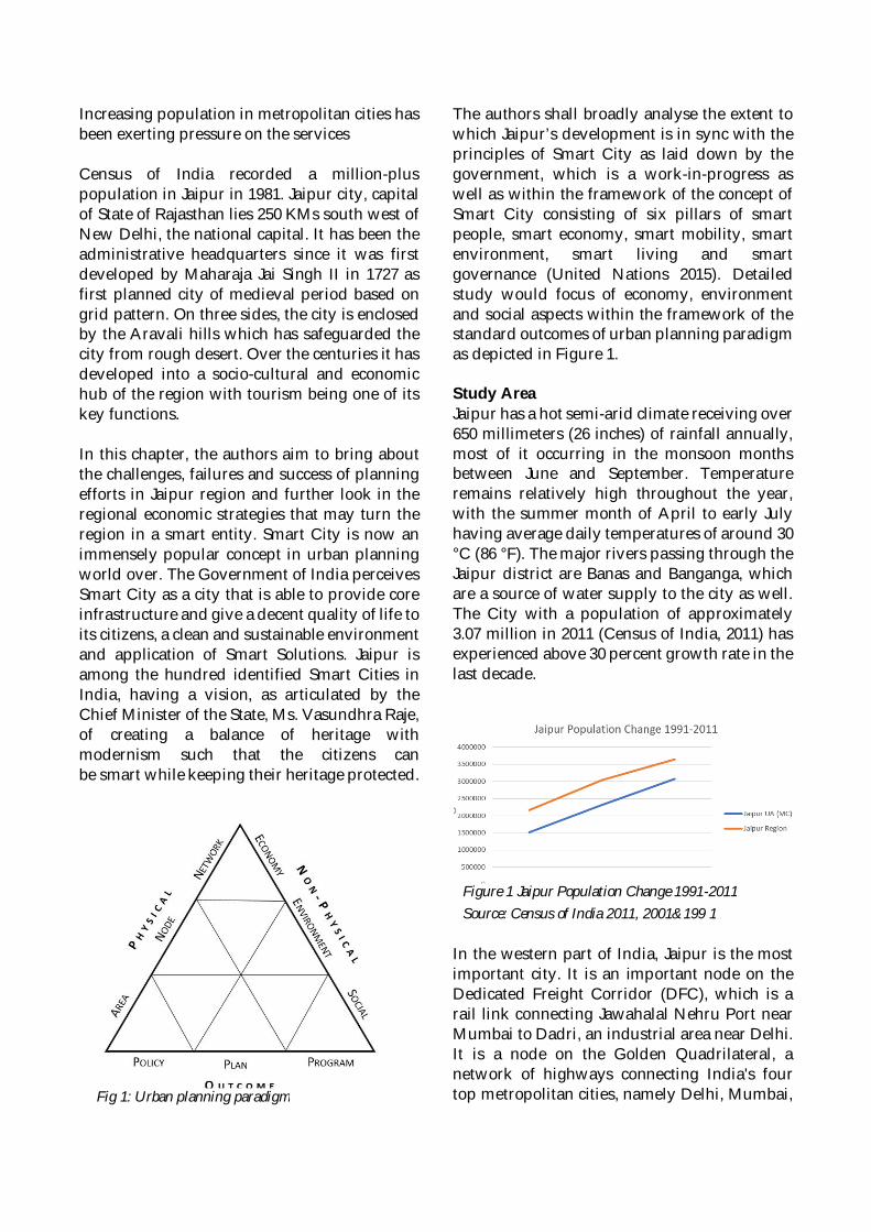
Increasing population in metropolitan cities hasbeen exerting pressure on the services
Census of India recorded a million-pluspopulation in Jaipur in 1981. Jaipur city, capitalof State of Rajasthan lies 250 KMs south west ofNew Delhi, the national capital. It has been theadministrative headquarters since it was firstdeveloped by Maharaja Jai Singh II in 1727 asfirst planned city of medieval period based ongrid pattern. On three sides, the city is enclosedby the Aravali hills which has safeguarded thecity from rough desert. Over the centuries it hasdeveloped into a socio-cultural and economichub of the region with tourism being one of itskey functions.
In this chapter, the authors aim to bring aboutthe challenges, failures and success of planningefforts in Jaipur region and further look in theregional economic strategies that may turn theregion in a smart entity. Smart City is now animmensely popular concept in urban planningworld over. The Government of India perceivesSmart City as a city that is able to provide coreinfrastructure and give a decent quality of life toits citizens, a clean and sustainable environmentand application of Smart Solutions. Jaipur isamong the hundred identified Smart Cities inIndia, having a vision, as articulated by theChief Minister of the State, Ms. Vasundhra Raje,of creating a balance of heritage withmodernism such that the citizens canbe smart while keeping their heritage protected.
The authors shall broadly analyse the extent towhich Jaipur’s development is in sync with theprinciples of Smart City as laid down by thegovernment, which is a work-in-progress aswell as within the framework of the concept ofSmart City consisting of six pillars of smartpeople, smart economy, smart mobility, smartenvironment, smart living and smartgovernance (United Nations 2015). Detailedstudy would focus of economy, environmentand social aspects within the framework of thestandard outcomes of urban planning paradigmas depicted in Figure 1.
Study AreaJaipur has a hot semi-arid climate receiving over650 millimeters (26 inches) of rainfall annually,most of it occurring in the monsoon monthsbetween June and September. Temperatureremains relatively high throughout the year,with the summer month of April to early Julyhaving average daily temperatures of around 30°C (86 °F). The major rivers passing through theJaipur district are Banas and Banganga, whichare a source of water supply to the city as well.The City with a population of approximately3.07 million in 2011 (Census of India, 2011) hasexperienced above 30 percent growth rate in thelast decade.
In the western part of India, Jaipur is the mostimportant city. It is an important node on theDedicated Freight Corridor (DFC), which is arail link connecting Jawahalal Nehru Port nearMumbai to Dadri, an industrial area near Delhi.It is a node on the Golden Quadrilateral, anetwork of highways connecting India's fourtop metropolitan cities, namely Delhi, Mumbai,Fig 1: Urban planning paradigm
Figure 1 Jaipur Population Change 1991-2011Source: Census of India 2011, 2001&199 1
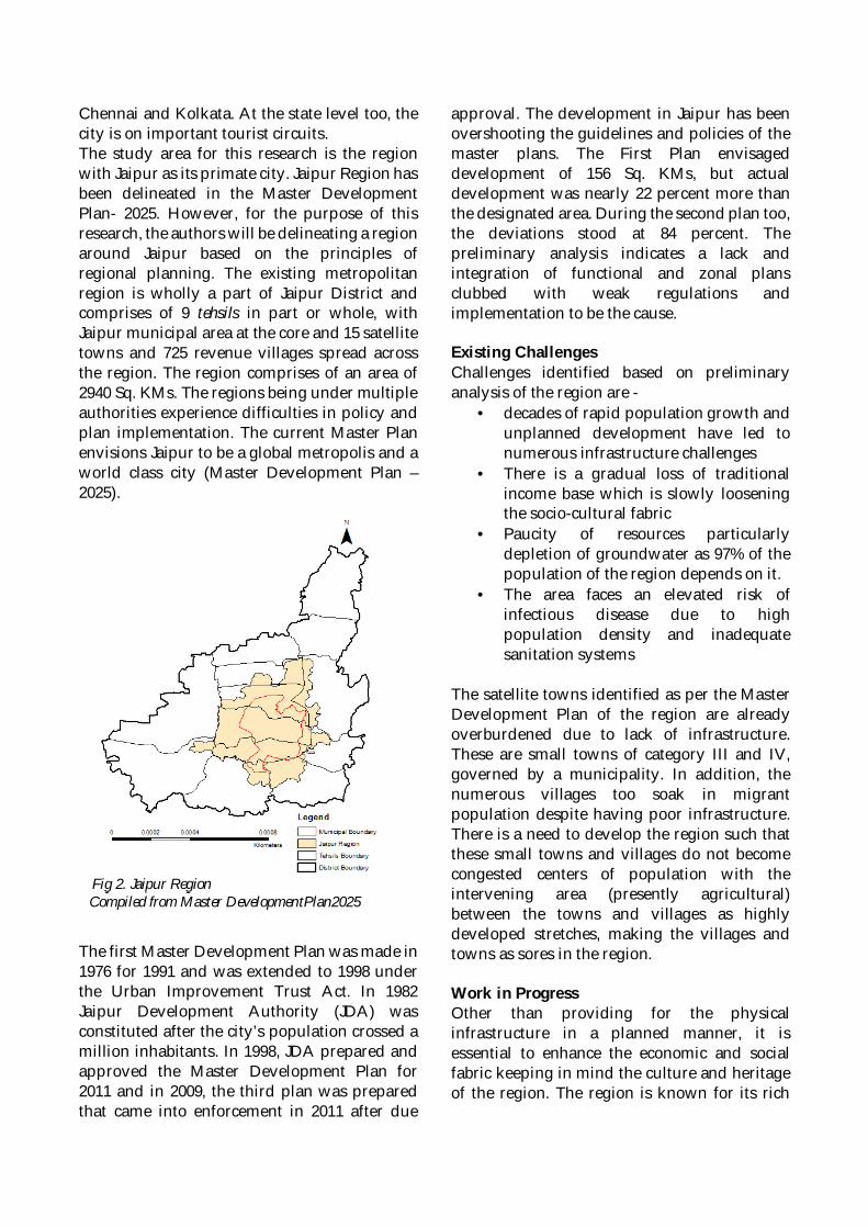
Chennai and Kolkata. At the state level too, thecity is on important tourist circuits.The study area for this research is the regionwith Jaipur as its primate city. Jaipur Region hasbeen delineated in the Master DevelopmentPlan- 2025. However, for the purpose of thisresearch, the authors will be delineating a regionaround Jaipur based on the principles ofregional planning. The existing metropolitanregion is wholly a part of Jaipur District andcomprises of 9 tehsils in part or whole, withJaipur municipal area at the core and 15 satellitetowns and 725 revenue villages spread acrossthe region. The region comprises of an area of2940 Sq. KMs. The regions being under multipleauthorities experience difficulties in policy andplan implementation. The current Master Planenvisions Jaipur to be a global metropolis and aworld class city (Master Development Plan –2025).
The first Master Development Plan was made in1976 for 1991 and was extended to 1998 underthe Urban Improvement Trust Act. In 1982Jaipur Development Authority (JDA) wasconstituted after the city’s population crossed amillion inhabitants. In 1998, JDA prepared andapproved the Master Development Plan for2011 and in 2009, the third plan was preparedthat came into enforcement in 2011 after due
approval. The development in Jaipur has beenovershooting the guidelines and policies of themaster plans. The First Plan envisageddevelopment of 156 Sq. KMs, but actualdevelopment was nearly 22 percent more thanthe designated area. During the second plan too,the deviations stood at 84 percent. Thepreliminary analysis indicates a lack andintegration of functional and zonal plansclubbed with weak regulations andimplementation to be the cause.
Existing ChallengesChallenges identified based on preliminaryanalysis of the region are -
· decades of rapid population growth andunplanned development have led tonumerous infrastructure challenges
· There is a gradual loss of traditionalincome base which is slowly looseningthe socio-cultural fabric
· Paucity of resources particularlydepletion of groundwater as 97% of thepopulation of the region depends on it.
· The area faces an elevated risk ofinfectious disease due to highpopulation density and inadequatesanitation systems
The satellite towns identified as per the MasterDevelopment Plan of the region are alreadyoverburdened due to lack of infrastructure.These are small towns of category III and IV,governed by a municipality. In addition, thenumerous villages too soak in migrantpopulation despite having poor infrastructure.There is a need to develop the region such thatthese small towns and villages do not becomecongested centers of population with theintervening area (presently agricultural)between the towns and villages as highlydeveloped stretches, making the villages andtowns as sores in the region.
Work in ProgressOther than providing for the physicalinfrastructure in a planned manner, it isessential to enhance the economic and socialfabric keeping in mind the culture and heritageof the region. The region is known for its rich
Fig 2. Jaipur RegionCompiled from Master DevelopmentPlan2025
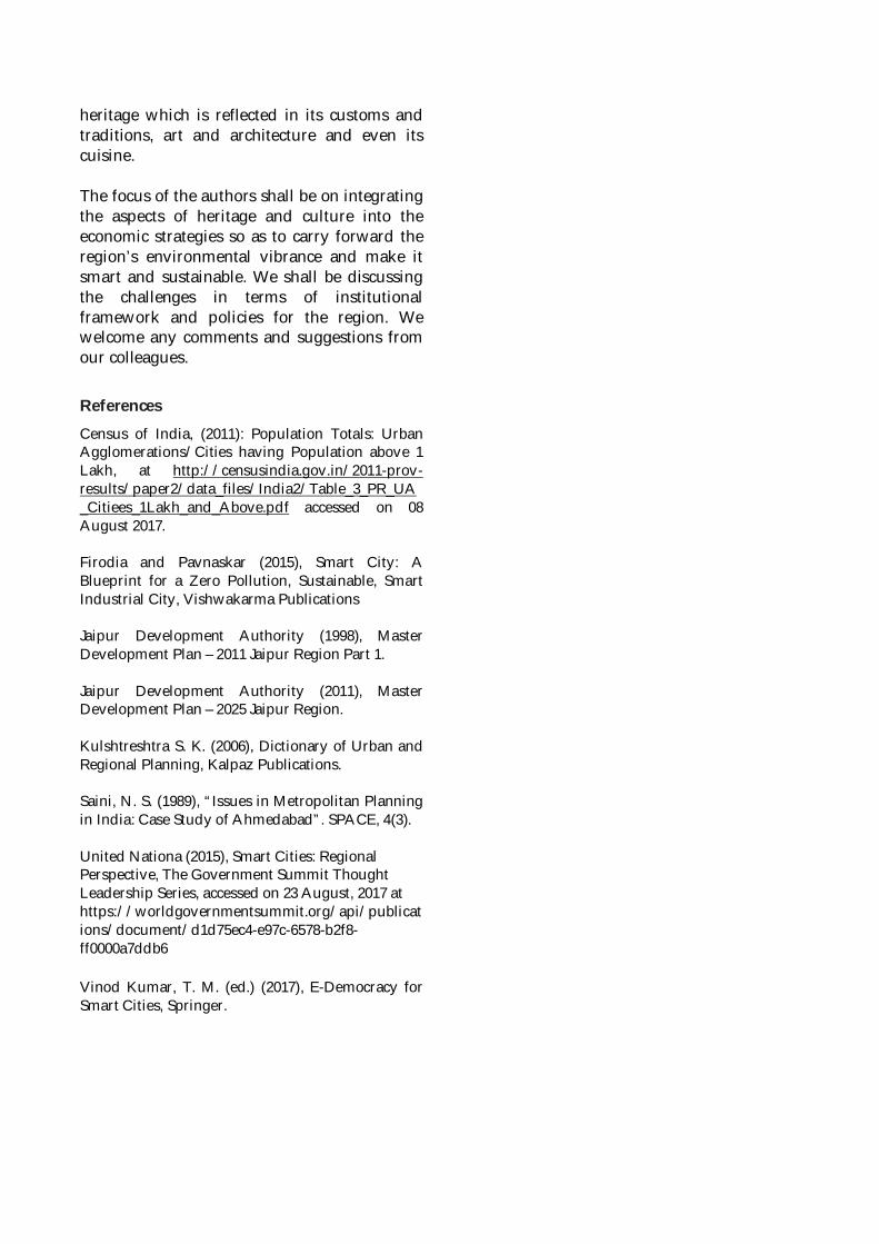
heritage which is reflected in its customs andtraditions, art and architecture and even itscuisine.
The focus of the authors shall be on integratingthe aspects of heritage and culture into theeconomic strategies so as to carry forward theregion’s environmental vibrance and make itsmart and sustainable. We shall be discussingthe challenges in terms of institutionalframework and policies for the region. Wewelcome any comments and suggestions fromour colleagues.
ReferencesCensus of India, (2011): Population Totals: UrbanAgglomerations/Cities having Population above 1Lakh, at http://censusindia.gov.in/2011-prov-results/paper2/data_files/India2/Table_3_PR_UA_Citiees_1Lakh_and_Above.pdf accessed on 08August 2017.
Firodia and Pavnaskar (2015), Smart City: ABlueprint for a Zero Pollution, Sustainable, SmartIndustrial City, Vishwakarma Publications
Jaipur Development Authority (1998), MasterDevelopment Plan – 2011 Jaipur Region Part 1.
Jaipur Development Authority (2011), MasterDevelopment Plan – 2025 Jaipur Region.
Kulshtreshtra S. K. (2006), Dictionary of Urban andRegional Planning, Kalpaz Publications.
Saini, N. S. (1989), “Issues in Metropolitan Planningin India: Case Study of Ahmedabad”. SPACE, 4(3).
United Nationa (2015), Smart Cities: RegionalPerspective, The Government Summit ThoughtLeadership Series, accessed on 23 August, 2017 athttps://worldgovernmentsummit.org/api/publications/document/d1d75ec4-e97c-6578-b2f8-ff0000a7ddb6
Vinod Kumar, T. M. (ed.) (2017), E-Democracy forSmart Cities, Springer.
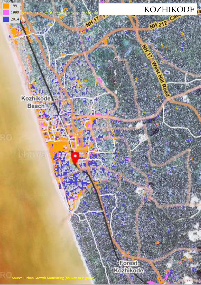
Source: Urban Growth Monitoring (bhuvan.nrsc.gov.in)
KOZHIKODE
Source: Urban Growth Monitoring (bhuvan.nrsc.gov.in)
Source: Urban Growth Monitoring (bhuvan.nrsc.gov.in)
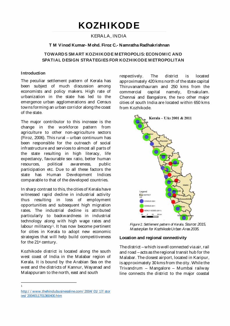
Introduction
The peculiar settlement pattern of Kerala hasbeen subject of much discussion amongeconomists and policy makers. High rate ofurbanization in the state has led to theemergence urban agglomerations and Censustowns forming an urban corridor along the coastof the state.
The major contributor to this increase is thechange in the workforce pattern fromagriculture to other non-agriculture sectors(Firoz, 2006). This rural – urban continuum hasbeen responsible for the outreach of socialinfrastructure and services to almost all parts ofthe state resulting in high literacy, lifeexpectancy, favourable sex ratio, better humanresources, political awareness, publicparticipation etc. Due to all these factors thestate has Human Development Indicescomparable to that of the developed countries.
In sharp contrast to this, the cities of Kerala havewitnessed rapid decline in industrial activitythus resulting in loss of employmentopportunities and subsequent high migrationrates. The industrial decline is attributedparticularly to backwardness in industrialtechnology along with high wage rates andlabour militancy1. It has now become pertinentfor cities in Kerala to adopt new economicstrategies that will help build competitivenessfor the 21st century.
Kozhikode district is located along the southwest coast of India in the Malabar region ofKerala. It is bound by the Arabian Sea on thewest and the districts of Kannur, Wayanad andMalappuram to the north, east and south
1
http://www.thehindubusinessline.com/2004/01/17/stories/2004011701360400.htm
respectively. The district is locatedapproximately 420 kms north of the state capitalThiruvananthauram and 250 kms from thecommercial capital namely, Ernakulam.Chennai and Bangalore, the two other majorcities of south India are located within 650 kmsfrom Kozhikode.
Location and regional connectivity
The district – which is well connected via air, railand road – acts as the regional transit hub for theMalabar. The closest airport, located in Karipur,is approximately 30 kms from the city. While theTrivandrum – Mangalore – Mumbai railwayline connects the district to the major coastal
KOZHIKODEKERALA, INDIA
T M Vinod Kumar- Mohd. Firoz C.- Namratha Radhakrishnan
TOWARDS SMART KOZHIKODE METROPOLIS: ECONOMIC ANDSPATIAL DESIGN STRATEGIES FOR KOZHIKODE METROPOLITAN
Figure 1: Settlement pattern of Kerala. Source: 2015,Masterplan for Kozhikode Urban Area 2035.
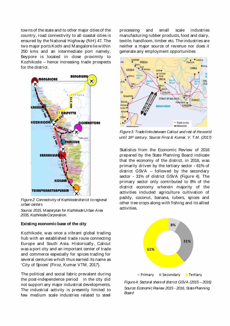
towns of the state and to other major cities of thecountry, road connectivity to all coastal cities isensured by the National Highway (NH) 47. Thetwo major ports Kochi and Mangalore lie within250 kms and an intermediate port namely,Beypore is located in close proximity toKozhikode – hence increasing trade prospectsfor the district.
Existing economic base of the city
Kozhikode, was once a vibrant global tradinghub with an established trade route connectingEurope and South Asia. Historically, Calicutwas a port city and an important center of tradeand commerce especially for spices trading forseveral centuries which thus earned its name as‘City of Spices’ (Firoz, Kumar VTM, 2017).
The political and social fabric prevalent duringthe post-independence period in the city didnot support any major industrial developments.The industrial activity is presently limited tofew medium scale industries related to steel
processing and small scale industriesmanufacturing rubber products, food and dairy,textile, handloom, timber etc. The industries areneither a major source of revenue nor does itgenerate any employment opportunities
Statistics from the Economic Review of 2016prepared by the State Planning Board indicatethat the economy of the district, in 2016, wasprimarily driven by the tertiary sector - 61% ofdistrict GSVA – followed by the secondarysector - 31% of district GSVA (Figure 4). Theprimary sector only contributed to 8% of thedistrict economy wherein majority of theactivities included agriculture cultivation ofpaddy, coconut, banana, tubers, spices andother tree crops along with fishing and its alliedactivities.
Figure 2: Connectivity of Kozhikode district to regionalurban centersSource: 2015, Masterplan for Kozhikode Urban Area2035, Kozhikode Corporation.
Figure 3: Trade links between Calicut and rest of the worlduntil 16th century. Source: Firoz & Kumar, V. T.M. (2017)
Figure 4: Sectoral share of district GSVA (2015 – 2016)Source: Economic Review 2015 - 2016, State PlanningBoard
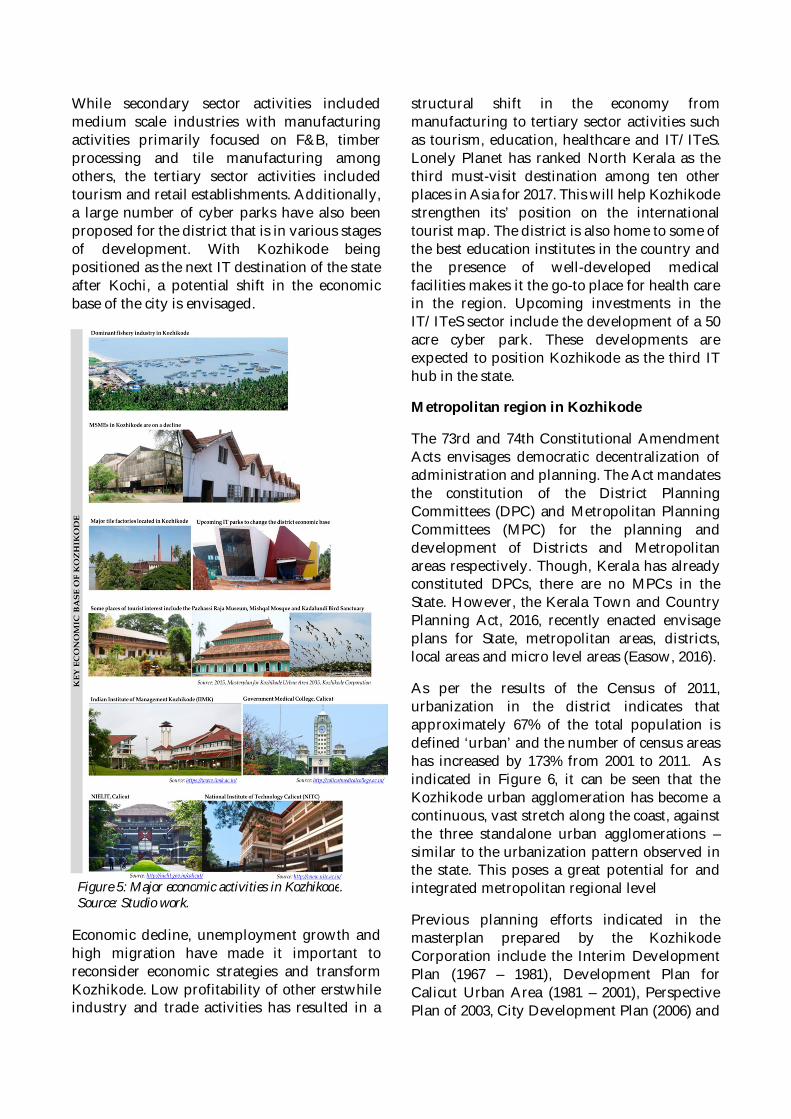
While secondary sector activities includedmedium scale industries with manufacturingactivities primarily focused on F&B, timberprocessing and tile manufacturing amongothers, the tertiary sector activities includedtourism and retail establishments. Additionally,a large number of cyber parks have also beenproposed for the district that is in various stagesof development. With Kozhikode beingpositioned as the next IT destination of the stateafter Kochi, a potential shift in the economicbase of the city is envisaged.
Economic decline, unemployment growth andhigh migration have made it important toreconsider economic strategies and transformKozhikode. Low profitability of other erstwhileindustry and trade activities has resulted in a
structural shift in the economy frommanufacturing to tertiary sector activities suchas tourism, education, healthcare and IT/ITeS.Lonely Planet has ranked North Kerala as thethird must-visit destination among ten otherplaces in Asia for 2017. This will help Kozhikodestrengthen its’ position on the internationaltourist map. The district is also home to some ofthe best education institutes in the country andthe presence of well-developed medicalfacilities makes it the go-to place for health carein the region. Upcoming investments in theIT/ITeS sector include the development of a 50acre cyber park. These developments areexpected to position Kozhikode as the third IThub in the state.
Metropolitan region in Kozhikode
The 73rd and 74th Constitutional AmendmentActs envisages democratic decentralization ofadministration and planning. The Act mandatesthe constitution of the District PlanningCommittees (DPC) and Metropolitan PlanningCommittees (MPC) for the planning anddevelopment of Districts and Metropolitanareas respectively. Though, Kerala has alreadyconstituted DPCs, there are no MPCs in theState. However, the Kerala Town and CountryPlanning Act, 2016, recently enacted envisageplans for State, metropolitan areas, districts,local areas and micro level areas (Easow, 2016).
As per the results of the Census of 2011,urbanization in the district indicates thatapproximately 67% of the total population isdefined ‘urban’ and the number of census areashas increased by 173% from 2001 to 2011. Asindicated in Figure 6, it can be seen that theKozhikode urban agglomeration has become acontinuous, vast stretch along the coast, againstthe three standalone urban agglomerations –similar to the urbanization pattern observed inthe state. This poses a great potential for andintegrated metropolitan regional level
Previous planning efforts indicated in themasterplan prepared by the KozhikodeCorporation include the Interim DevelopmentPlan (1967 – 1981), Development Plan forCalicut Urban Area (1981 – 2001), PerspectivePlan of 2003, City Development Plan (2006) and
Figure 5: Major economic activities in Kozhikode.Source: Studio work.
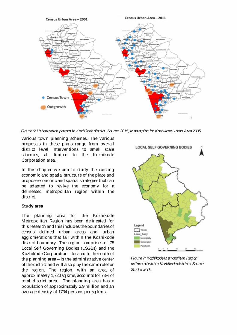
various town planning schemes. The variousproposals in these plans range from overalldistrict level interventions to small scaleschemes, all limited to the KozhikodeCorporation area.
In this chapter we aim to study the existingeconomic and spatial structure of the place andpropose economic and spatial strategies that canbe adapted to revive the economy for adelineated metropolitan region within thedistrict.
Study area
The planning area for the KozhikodeMetropolitan Region has been delineated forthis research and this includes the boundaries ofcensus defined urban areas and urbanagglomerations that fall within the Kozhikodedistrict boundary. The region comprises of 75Local Self Governing Bodies (LSGBs) and theKozhikode Corporation – located to the south ofthe planning area – is the administrative centerof the district and will also play the same role forthe region. The region, with an area ofapproximately 1,720 sq kms, accounts for 73% oftotal district area. The planning area has apopulation of approximately 2.9 million and anaverage density of 1734 persons per sq kms.
Figure 7: Kozhikode Metropolitan Regiondelineated within Kozhikode districts. Source:Studio work.
Figure 6: Urbanization pattern in Kozhikode district. Source: 2015, Masterplan for Kozhikode Urban Area 2035.
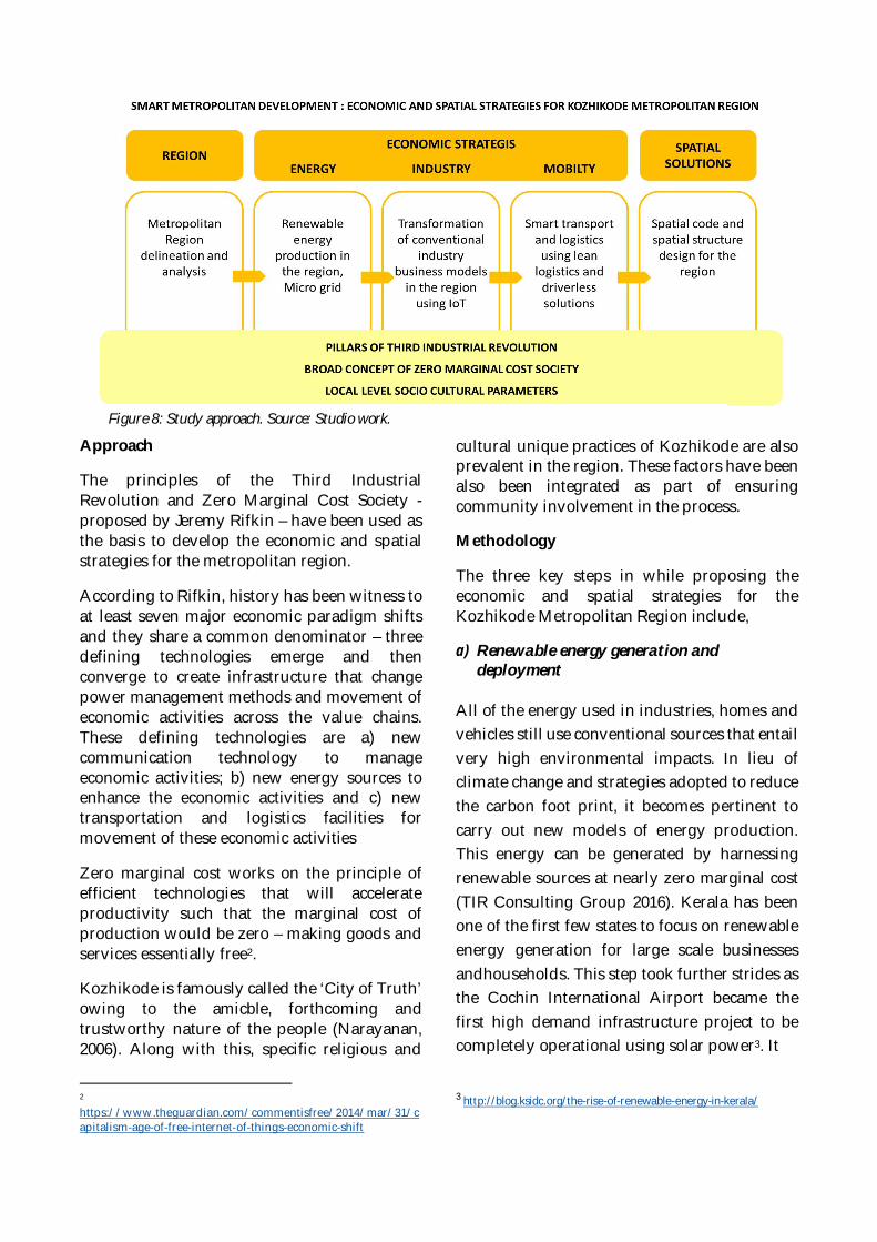
Approach
The principles of the Third IndustrialRevolution and Zero Marginal Cost Society -proposed by Jeremy Rifkin – have been used asthe basis to develop the economic and spatialstrategies for the metropolitan region.
According to Rifkin, history has been witness toat least seven major economic paradigm shiftsand they share a common denominator – threedefining technologies emerge and thenconverge to create infrastructure that changepower management methods and movement ofeconomic activities across the value chains.These defining technologies are a) newcommunication technology to manageeconomic activities; b) new energy sources toenhance the economic activities and c) newtransportation and logistics facilities formovement of these economic activities
Zero marginal cost works on the principle ofefficient technologies that will accelerateproductivity such that the marginal cost ofproduction would be zero – making goods andservices essentially free2.
Kozhikode is famously called the ‘City of Truth’owing to the amicble, forthcoming andtrustworthy nature of the people (Narayanan,2006). Along with this, specific religious and
2
https://www.theguardian.com/commentisfree/2014/mar/31/capitalism-age-of-free-internet-of-things-economic-shift
cultural unique practices of Kozhikode are alsoprevalent in the region. These factors have beenalso been integrated as part of ensuringcommunity involvement in the process.
Methodology
The three key steps in while proposing theeconomic and spatial strategies for theKozhikode Metropolitan Region include,
a) Renewable energy generation anddeployment
All of the energy used in industries, homes andvehicles still use conventional sources that entailvery high environmental impacts. In lieu ofclimate change and strategies adopted to reducethe carbon foot print, it becomes pertinent tocarry out new models of energy production.This energy can be generated by harnessingrenewable sources at nearly zero marginal cost(TIR Consulting Group 2016). Kerala has beenone of the first few states to focus on renewableenergy generation for large scale businessesandhouseholds. This step took further strides asthe Cochin International Airport became thefirst high demand infrastructure project to becompletely operational using solar power3. It
3 http://blog.ksidc.org/the-rise-of-renewable-energy-in-kerala/
Figure 8: Study approach. Source: Studio work.
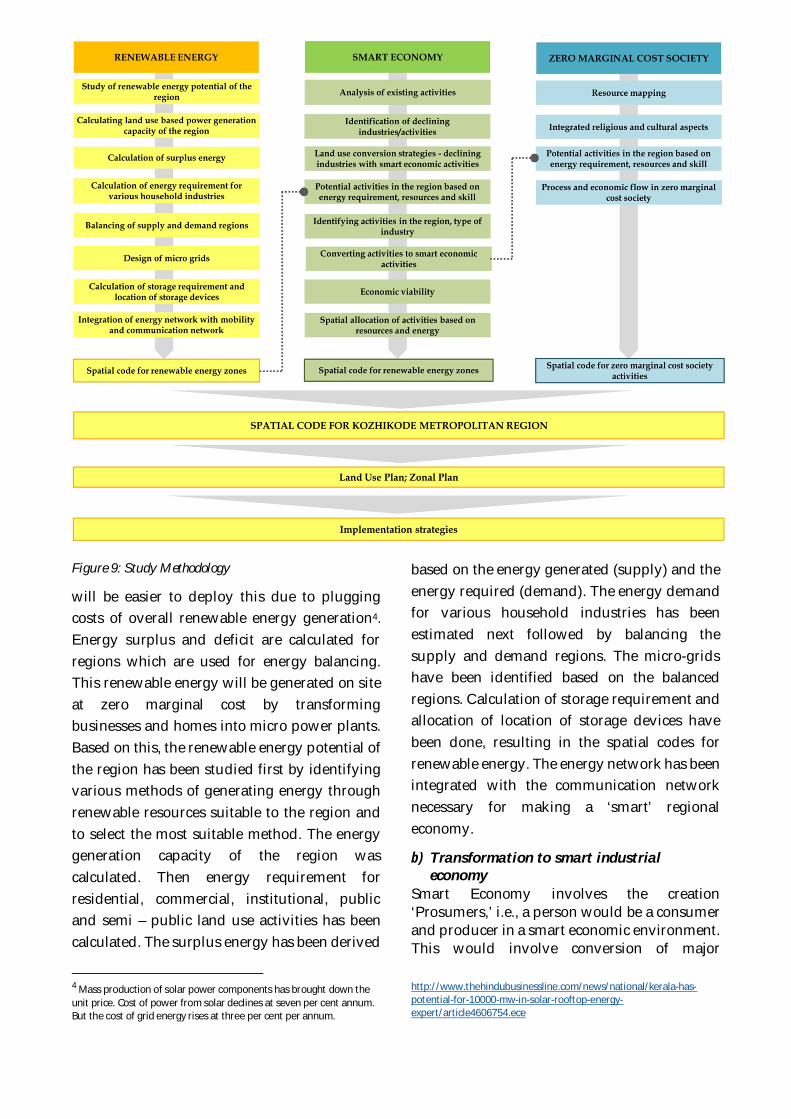
Figure 9: Study Methodology
will be easier to deploy this due to pluggingcosts of overall renewable energy generation4.Energy surplus and deficit are calculated forregions which are used for energy balancing.This renewable energy will be generated on siteat zero marginal cost by transformingbusinesses and homes into micro power plants.Based on this, the renewable energy potential ofthe region has been studied first by identifyingvarious methods of generating energy throughrenewable resources suitable to the region andto select the most suitable method. The energygeneration capacity of the region wascalculated. Then energy requirement forresidential, commercial, institutional, publicand semi – public land use activities has beencalculated. The surplus energy has been derived
4 Mass production of solar power components has brought down theunit price. Cost of power from solar declines at seven per cent annum.But the cost of grid energy rises at three per cent per annum.
based on the energy generated (supply) and theenergy required (demand). The energy demandfor various household industries has beenestimated next followed by balancing thesupply and demand regions. The micro-gridshave been identified based on the balancedregions. Calculation of storage requirement andallocation of location of storage devices havebeen done, resulting in the spatial codes forrenewable energy. The energy network has beenintegrated with the communication networknecessary for making a ‘smart’ regionaleconomy.
b) Transformation to smart industrialeconomy
Smart Economy involves the creation‘Prosumers,’ i.e., a person would be a consumerand producer in a smart economic environment.This would involve conversion of major
http://www.thehindubusinessline.com/news/national/kerala-has-potential-for-10000-mw-in-solar-rooftop-energy-expert/article4606754.ece
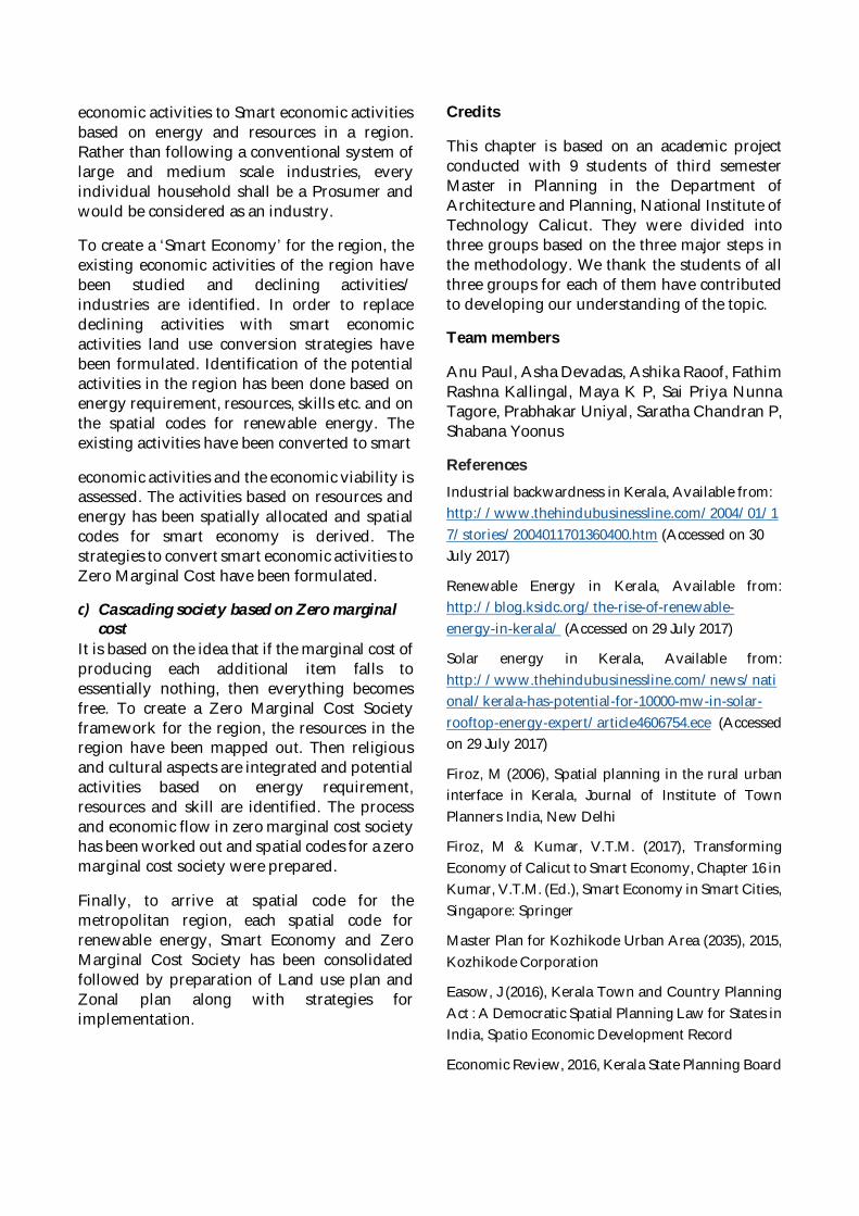
economic activities to Smart economic activitiesbased on energy and resources in a region.Rather than following a conventional system oflarge and medium scale industries, everyindividual household shall be a Prosumer andwould be considered as an industry.
To create a ‘Smart Economy’ for the region, theexisting economic activities of the region havebeen studied and declining activities/industries are identified. In order to replacedeclining activities with smart economicactivities land use conversion strategies havebeen formulated. Identification of the potentialactivities in the region has been done based onenergy requirement, resources, skills etc. and onthe spatial codes for renewable energy. Theexisting activities have been converted to smart
economic activities and the economic viability isassessed. The activities based on resources andenergy has been spatially allocated and spatialcodes for smart economy is derived. Thestrategies to convert smart economic activities toZero Marginal Cost have been formulated.
c) Cascading society based on Zero marginalcost
It is based on the idea that if the marginal cost ofproducing each additional item falls toessentially nothing, then everything becomesfree. To create a Zero Marginal Cost Societyframework for the region, the resources in theregion have been mapped out. Then religiousand cultural aspects are integrated and potentialactivities based on energy requirement,resources and skill are identified. The processand economic flow in zero marginal cost societyhas been worked out and spatial codes for a zeromarginal cost society were prepared.
Finally, to arrive at spatial code for themetropolitan region, each spatial code forrenewable energy, Smart Economy and ZeroMarginal Cost Society has been consolidatedfollowed by preparation of Land use plan andZonal plan along with strategies forimplementation.
Credits
This chapter is based on an academic projectconducted with 9 students of third semesterMaster in Planning in the Department ofArchitecture and Planning, National Institute ofTechnology Calicut. They were divided intothree groups based on the three major steps inthe methodology. We thank the students of allthree groups for each of them have contributedto developing our understanding of the topic.
Team members
Anu Paul, Asha Devadas, Ashika Raoof, FathimRashna Kallingal, Maya K P, Sai Priya NunnaTagore, Prabhakar Uniyal, Saratha Chandran P,Shabana Yoonus
ReferencesIndustrial backwardness in Kerala, Available from:http://www.thehindubusinessline.com/2004/01/17/stories/2004011701360400.htm (Accessed on 30July 2017)
Renewable Energy in Kerala, Available from:http://blog.ksidc.org/the-rise-of-renewable-energy-in-kerala/ (Accessed on 29 July 2017)
Solar energy in Kerala, Available from:http://www.thehindubusinessline.com/news/national/kerala-has-potential-for-10000-mw-in-solar-rooftop-energy-expert/article4606754.ece (Accessedon 29 July 2017)
Firoz, M (2006), Spatial planning in the rural urbaninterface in Kerala, Journal of Institute of TownPlanners India, New Delhi
Firoz, M & Kumar, V.T.M. (2017), TransformingEconomy of Calicut to Smart Economy, Chapter 16 inKumar, V.T.M. (Ed.), Smart Economy in Smart Cities,Singapore: Springer
Master Plan for Kozhikode Urban Area (2035), 2015,Kozhikode Corporation
Easow, J (2016), Kerala Town and Country PlanningAct : A Democratic Spatial Planning Law for States inIndia, Spatio Economic Development Record
Economic Review, 2016, Kerala State Planning Board

The Third Industrial Revolution Strategy Study(2016), TIR Consulting Group, Grand Duchy ofLuxemburg
Census (2011), Census of India, Ministry of HomeAffairs
M. Narayanan (2006), Calicut: The City of TruthRevisited. University of Calicut
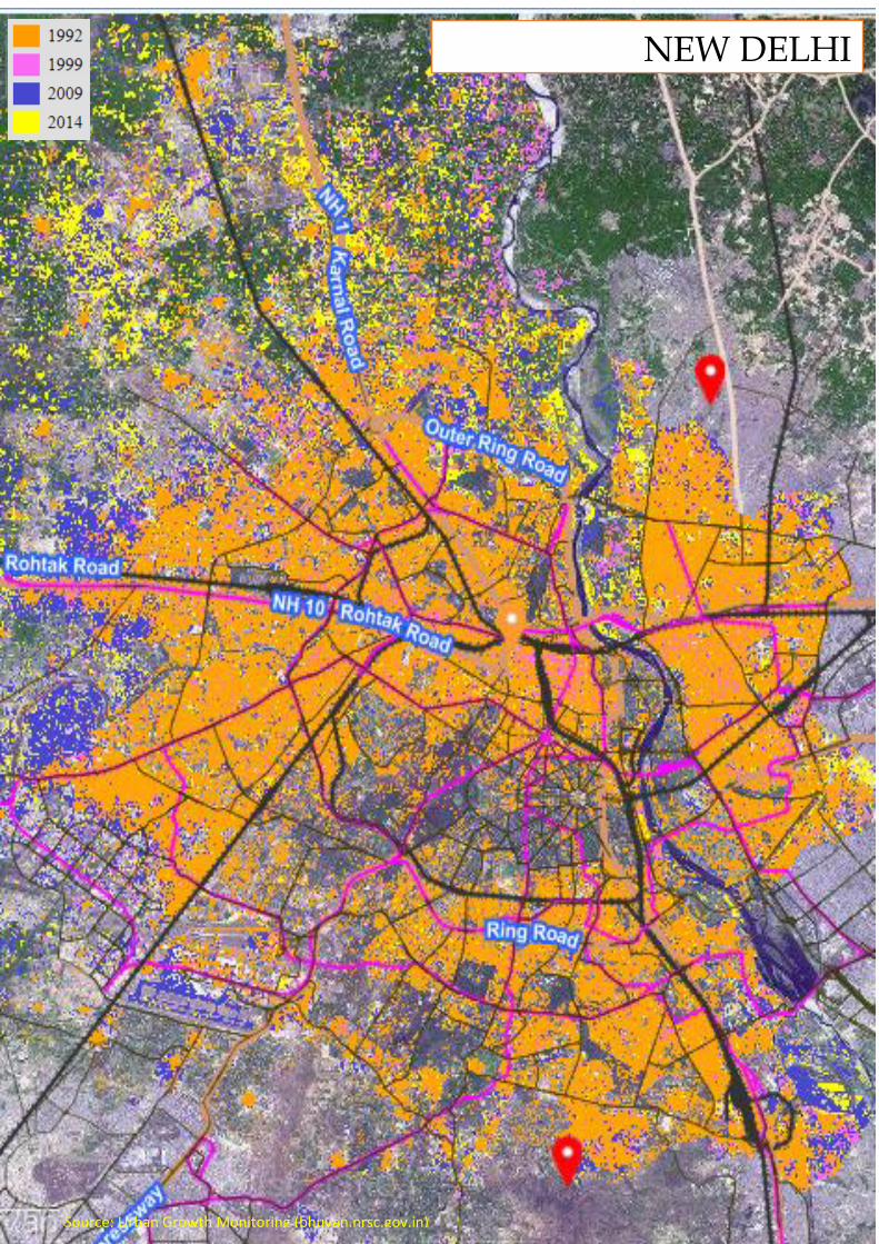
NEW DELHI
Source: Urban Growth Monitoring (bhuvan.nrsc.gov.in)
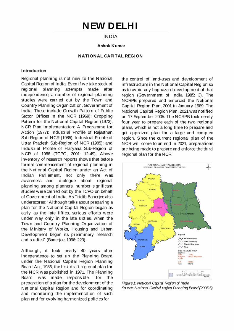
Introduction
Regional planning is not new to the NationalCapital Region of India. Even if we take stock ofregional planning attempts made afterindependence, a number of regional planningstudies were carried out by the Town andCountry Planning Organization, Government ofIndia. These include Growth Pattern of PublicSector Offices in the NCR (1969); CroppingPattern for the National Capital Region (1973);NCR Plan Implementation: A Programme forAction (1977); Industrial Profile of RajasthanSub-Region of NCR (1985); Industrial Profile ofUttar Pradesh Sub-Region of NCR (1985); andIndustrial Profile of Haryana Sub-Region ofNCR of 1986 (TCPO, 2001: 12-49). Aboveinventory of research reports shows that beforeformal commencement of regional planning inthe National Capital Region under an Act ofIndian Parliament, not only there wasawareness and dialogue about regionalplanning among planners, number significantstudies were carried out by the TCPO on behalfof Government of India. As Tridib Banerjee alsounderscores: “Although talks about preparing aplan for the National Capital Region began asearly as the late fifties, serious efforts wereunder way only in the late sixties, when theTown and Country Planning Organization ofthe Ministry of Works, Housing and UrbanDevelopment began its preliminary researchand studies” (Banerjee, 1996: 223).
Although, it took nearly 40 years afterindependence to set up the Planning Boardunder the National Capital Region PlanningBoard Act, 1985, the first draft regional plan forthe NCR was published in 1971. The PlanningBoard was made responsible “for thepreparation of a plan for the development of theNational Capital Region and for coordinatingand monitoring the implementation of suchplan and for evolving harmonized policies for
the control of land-uses and development ofinfrastructure in the National Capital Region soas to avoid any haphazard development of thatregion (Government of India 1985: 3). TheNCRPB prepared and enforced the NationalCapital Region Plan, 2001 in January 1989. TheNational Capital Region Plan, 2021 was notifiedon 17 September 2005. The NCRPB took nearlyfour year to prepare each of the two regionalplans, which is not a long time to prepare andget approved plan for a large and complexregion. Since the current regional plan of theNCR will come to an end in 2021, preparationsare being made to prepare and enforce the thirdregional plan for the NCR.
Figure 1: National Capital Region of IndiaSource: National Capital region Planning Board (2005:5)
NEW DELHIINDIA
Ashok Kumar
NATIONAL CAPITAL REGION
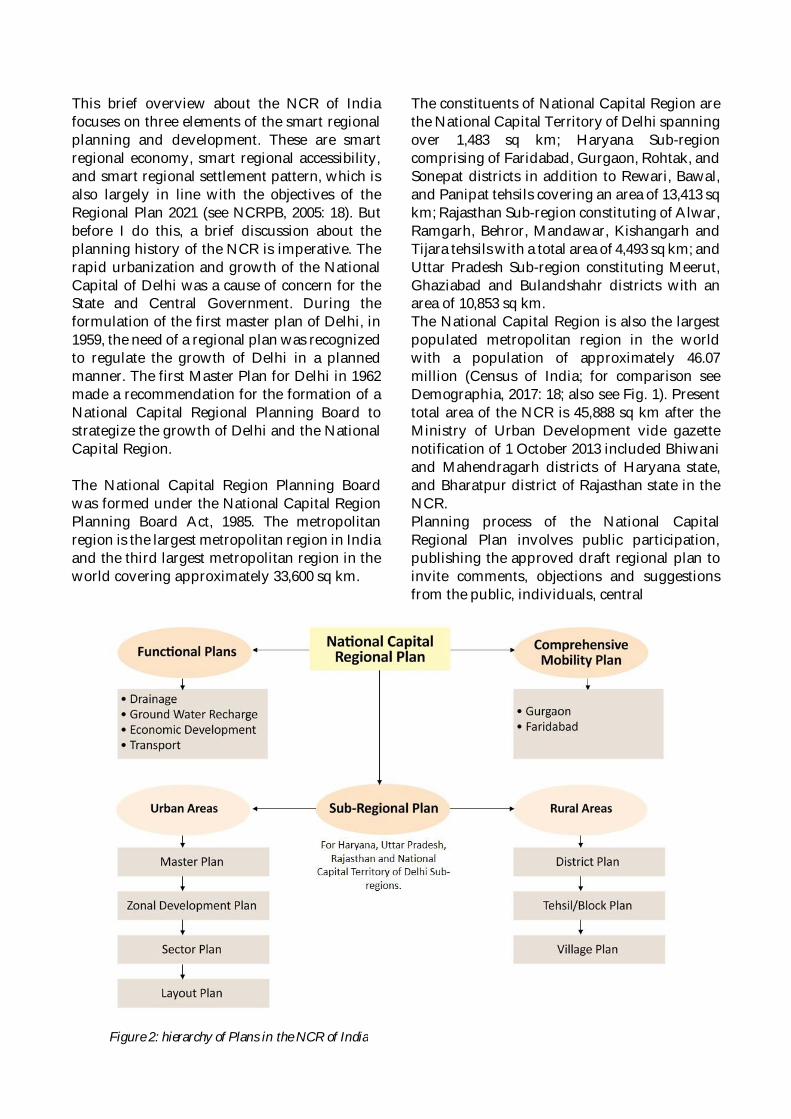
This brief overview about the NCR of Indiafocuses on three elements of the smart regionalplanning and development. These are smartregional economy, smart regional accessibility,and smart regional settlement pattern, which isalso largely in line with the objectives of theRegional Plan 2021 (see NCRPB, 2005: 18). Butbefore I do this, a brief discussion about theplanning history of the NCR is imperative. Therapid urbanization and growth of the NationalCapital of Delhi was a cause of concern for theState and Central Government. During theformulation of the first master plan of Delhi, in1959, the need of a regional plan was recognizedto regulate the growth of Delhi in a plannedmanner. The first Master Plan for Delhi in 1962made a recommendation for the formation of aNational Capital Regional Planning Board tostrategize the growth of Delhi and the NationalCapital Region.
The National Capital Region Planning Boardwas formed under the National Capital RegionPlanning Board Act, 1985. The metropolitanregion is the largest metropolitan region in Indiaand the third largest metropolitan region in theworld covering approximately 33,600 sq km.
The constituents of National Capital Region arethe National Capital Territory of Delhi spanningover 1,483 sq km; Haryana Sub-regioncomprising of Faridabad, Gurgaon, Rohtak, andSonepat districts in addition to Rewari, Bawal,and Panipat tehsils covering an area of 13,413 sqkm; Rajasthan Sub-region constituting of Alwar,Ramgarh, Behror, Mandawar, Kishangarh andTijara tehsils with a total area of 4,493 sq km; andUttar Pradesh Sub-region constituting Meerut,Ghaziabad and Bulandshahr districts with anarea of 10,853 sq km.The National Capital Region is also the largestpopulated metropolitan region in the worldwith a population of approximately 46.07million (Census of India; for comparison seeDemographia, 2017: 18; also see Fig. 1). Presenttotal area of the NCR is 45,888 sq km after theMinistry of Urban Development vide gazettenotification of 1 October 2013 included Bhiwaniand Mahendragarh districts of Haryana state,and Bharatpur district of Rajasthan state in theNCR.Planning process of the National CapitalRegional Plan involves public participation,publishing the approved draft regional plan toinvite comments, objections and suggestionsfrom the public, individuals, central
Figure 2: hierarchy of Plans in the NCR of India
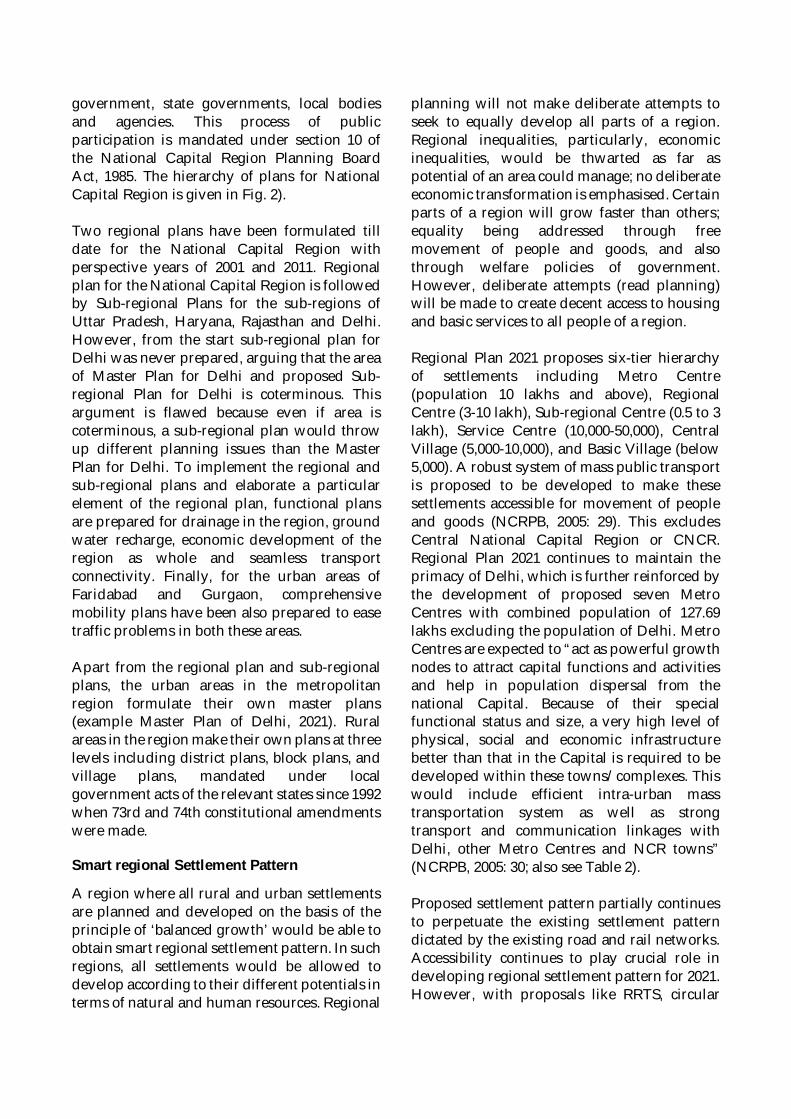
government, state governments, local bodiesand agencies. This process of publicparticipation is mandated under section 10 ofthe National Capital Region Planning BoardAct, 1985. The hierarchy of plans for NationalCapital Region is given in Fig. 2).
Two regional plans have been formulated tilldate for the National Capital Region withperspective years of 2001 and 2011. Regionalplan for the National Capital Region is followedby Sub-regional Plans for the sub-regions ofUttar Pradesh, Haryana, Rajasthan and Delhi.However, from the start sub-regional plan forDelhi was never prepared, arguing that the areaof Master Plan for Delhi and proposed Sub-regional Plan for Delhi is coterminous. Thisargument is flawed because even if area iscoterminous, a sub-regional plan would throwup different planning issues than the MasterPlan for Delhi. To implement the regional andsub-regional plans and elaborate a particularelement of the regional plan, functional plansare prepared for drainage in the region, groundwater recharge, economic development of theregion as whole and seamless transportconnectivity. Finally, for the urban areas ofFaridabad and Gurgaon, comprehensivemobility plans have been also prepared to easetraffic problems in both these areas.
Apart from the regional plan and sub-regionalplans, the urban areas in the metropolitanregion formulate their own master plans(example Master Plan of Delhi, 2021). Ruralareas in the region make their own plans at threelevels including district plans, block plans, andvillage plans, mandated under localgovernment acts of the relevant states since 1992when 73rd and 74th constitutional amendmentswere made.
Smart regional Settlement Pattern
A region where all rural and urban settlementsare planned and developed on the basis of theprinciple of ‘balanced growth’ would be able toobtain smart regional settlement pattern. In suchregions, all settlements would be allowed todevelop according to their different potentials interms of natural and human resources. Regional
planning will not make deliberate attempts toseek to equally develop all parts of a region.Regional inequalities, particularly, economicinequalities, would be thwarted as far aspotential of an area could manage; no deliberateeconomic transformation is emphasised. Certainparts of a region will grow faster than others;equality being addressed through freemovement of people and goods, and alsothrough welfare policies of government.However, deliberate attempts (read planning)will be made to create decent access to housingand basic services to all people of a region.
Regional Plan 2021 proposes six-tier hierarchyof settlements including Metro Centre(population 10 lakhs and above), RegionalCentre (3-10 lakh), Sub-regional Centre (0.5 to 3lakh), Service Centre (10,000-50,000), CentralVillage (5,000-10,000), and Basic Village (below5,000). A robust system of mass public transportis proposed to be developed to make thesesettlements accessible for movement of peopleand goods (NCRPB, 2005: 29). This excludesCentral National Capital Region or CNCR.Regional Plan 2021 continues to maintain theprimacy of Delhi, which is further reinforced bythe development of proposed seven MetroCentres with combined population of 127.69lakhs excluding the population of Delhi. MetroCentres are expected to “act as powerful growthnodes to attract capital functions and activitiesand help in population dispersal from thenational Capital. Because of their specialfunctional status and size, a very high level ofphysical, social and economic infrastructurebetter than that in the Capital is required to bedeveloped within these towns/complexes. Thiswould include efficient intra-urban masstransportation system as well as strongtransport and communication linkages withDelhi, other Metro Centres and NCR towns”(NCRPB, 2005: 30; also see Table 2).
Proposed settlement pattern partially continuesto perpetuate the existing settlement patterndictated by the existing road and rail networks.Accessibility continues to play crucial role indeveloping regional settlement pattern for 2021.However, with proposals like RRTS, circular
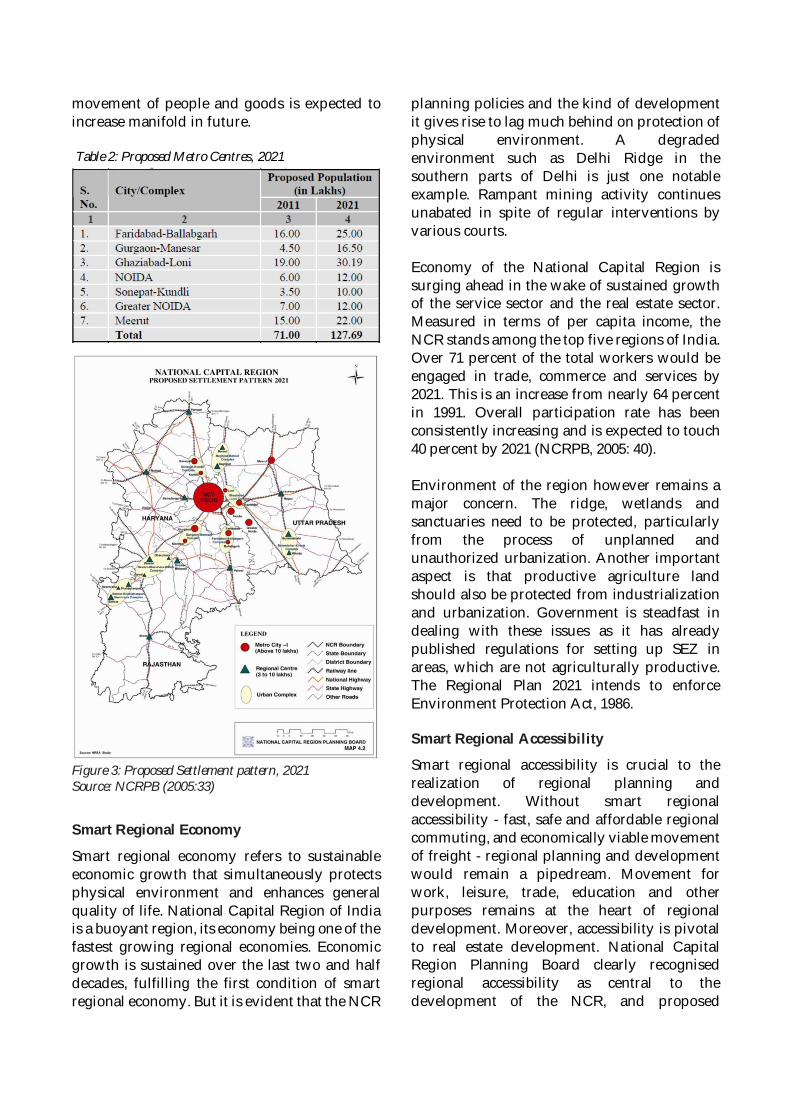
movement of people and goods is expected toincrease manifold in future.
Table 2: Proposed Metro Centres, 2021Source: NCRPB (2005:30)
Figure 3: Proposed Settlement pattern, 2021Source: NCRPB (2005:33)
Smart Regional Economy
Smart regional economy refers to sustainableeconomic growth that simultaneously protectsphysical environment and enhances generalquality of life. National Capital Region of Indiais a buoyant region, its economy being one of thefastest growing regional economies. Economicgrowth is sustained over the last two and halfdecades, fulfilling the first condition of smartregional economy. But it is evident that the NCR
planning policies and the kind of developmentit gives rise to lag much behind on protection ofphysical environment. A degradedenvironment such as Delhi Ridge in thesouthern parts of Delhi is just one notableexample. Rampant mining activity continuesunabated in spite of regular interventions byvarious courts.
Economy of the National Capital Region issurging ahead in the wake of sustained growthof the service sector and the real estate sector.Measured in terms of per capita income, theNCR stands among the top five regions of India.Over 71 percent of the total workers would beengaged in trade, commerce and services by2021. This is an increase from nearly 64 percentin 1991. Overall participation rate has beenconsistently increasing and is expected to touch40 percent by 2021 (NCRPB, 2005: 40).
Environment of the region however remains amajor concern. The ridge, wetlands andsanctuaries need to be protected, particularlyfrom the process of unplanned andunauthorized urbanization. Another importantaspect is that productive agriculture landshould also be protected from industrializationand urbanization. Government is steadfast indealing with these issues as it has alreadypublished regulations for setting up SEZ inareas, which are not agriculturally productive.The Regional Plan 2021 intends to enforceEnvironment Protection Act, 1986.
Smart Regional Accessibility
Smart regional accessibility is crucial to therealization of regional planning anddevelopment. Without smart regionalaccessibility - fast, safe and affordable regionalcommuting, and economically viable movementof freight - regional planning and developmentwould remain a pipedream. Movement forwork, leisure, trade, education and otherpurposes remains at the heart of regionaldevelopment. Moreover, accessibility is pivotalto real estate development. National CapitalRegion Planning Board clearly recognisedregional accessibility as central to thedevelopment of the NCR, and proposed
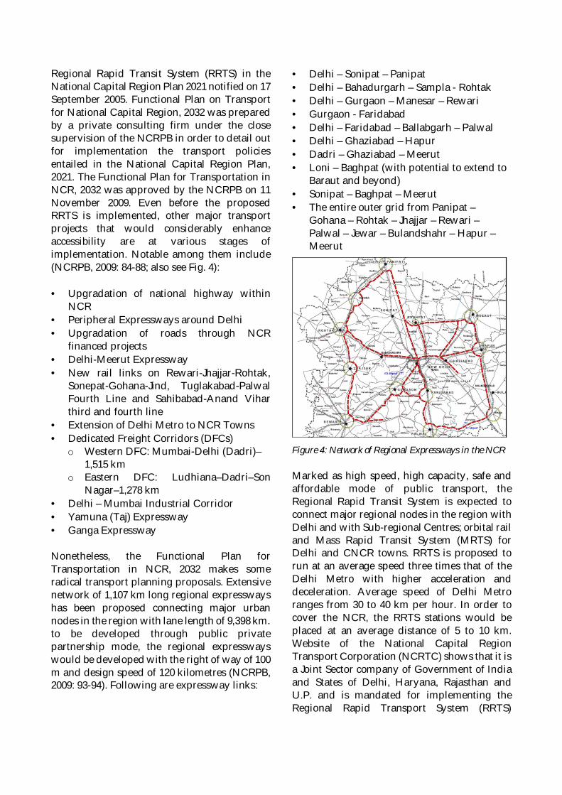
Regional Rapid Transit System (RRTS) in theNational Capital Region Plan 2021 notified on 17September 2005. Functional Plan on Transportfor National Capital Region, 2032 was preparedby a private consulting firm under the closesupervision of the NCRPB in order to detail outfor implementation the transport policiesentailed in the National Capital Region Plan,2021. The Functional Plan for Transportation inNCR, 2032 was approved by the NCRPB on 11November 2009. Even before the proposedRRTS is implemented, other major transportprojects that would considerably enhanceaccessibility are at various stages ofimplementation. Notable among them include(NCRPB, 2009: 84-88; also see Fig. 4):
· Upgradation of national highway withinNCR
· Peripheral Expressways around Delhi· Upgradation of roads through NCR
financed projects· Delhi-Meerut Expressway· New rail links on Rewari-Jhajjar-Rohtak,
Sonepat-Gohana-Jind, Tuglakabad-PalwalFourth Line and Sahibabad-Anand Viharthird and fourth line
· Extension of Delhi Metro to NCR Towns· Dedicated Freight Corridors (DFCs)
o Western DFC: Mumbai-Delhi (Dadri)–1,515 km
o Eastern DFC: Ludhiana–Dadri–SonNagar–1,278 km
· Delhi – Mumbai Industrial Corridor· Yamuna (Taj) Expressway· Ganga Expressway
Nonetheless, the Functional Plan forTransportation in NCR, 2032 makes someradical transport planning proposals. Extensivenetwork of 1,107 km long regional expresswayshas been proposed connecting major urbannodes in the region with lane length of 9,398 km.to be developed through public privatepartnership mode, the regional expresswayswould be developed with the right of way of 100m and design speed of 120 kilometres (NCRPB,2009: 93-94). Following are expressway links:
· Delhi – Sonipat – Panipat· Delhi – Bahadurgarh – Sampla - Rohtak· Delhi – Gurgaon – Manesar – Rewari· Gurgaon - Faridabad· Delhi – Faridabad – Ballabgarh – Palwal· Delhi – Ghaziabad – Hapur· Dadri – Ghaziabad – Meerut· Loni – Baghpat (with potential to extend to
Baraut and beyond)· Sonipat – Baghpat – Meerut· The entire outer grid from Panipat –
Gohana – Rohtak – Jhajjar – Rewari –Palwal – Jewar – Bulandshahr – Hapur –Meerut
Figure 4: Network of Regional Expressways in the NCR
Marked as high speed, high capacity, safe andaffordable mode of public transport, theRegional Rapid Transit System is expected toconnect major regional nodes in the region withDelhi and with Sub-regional Centres; orbital railand Mass Rapid Transit System (MRTS) forDelhi and CNCR towns. RRTS is proposed torun at an average speed three times that of theDelhi Metro with higher acceleration anddeceleration. Average speed of Delhi Metroranges from 30 to 40 km per hour. In order tocover the NCR, the RRTS stations would beplaced at an average distance of 5 to 10 km.Website of the National Capital RegionTransport Corporation (NCRTC) shows that it isa Joint Sector company of Government of Indiaand States of Delhi, Haryana, Rajasthan andU.P. and is mandated for implementing theRegional Rapid Transport System (RRTS)
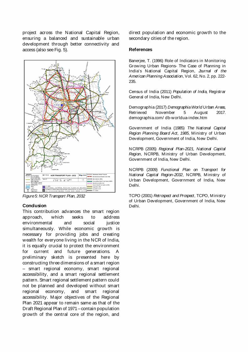
project across the National Capital Region,ensuring a balanced and sustainable urbandevelopment through better connectivity andaccess (also see Fig. 5).
Figure 5: NCR Transport Plan, 2032
ConclusionThis contribution advances the smart regionapproach, which seeks to addressenvironmental and social justicesimultaneously. While economic growth isnecessary for providing jobs and creatingwealth for everyone living in the NCR of India,it is equally crucial to protect the environmentfor current and future generations. Apreliminary sketch is presented here byconstructing three dimensions of a smart region– smart regional economy, smart regionalaccessibility, and a smart regional settlementpattern. Smart regional settlement pattern couldnot be planned and developed without smartregional economy, and smart regionalaccessibility. Major objectives of the RegionalPlan 2021 appear to remain same as that of theDraft Regional Plan of 1971 – contain populationgrowth of the central core of the region, and
direct population and economic growth to thesecondary cities of the region.
References
Banerjee, T. (1996) Role of Indicators in MonitoringGrowing Urban Regions- The Case of Planning inIndia’s National Capital Region, Journal of theAmerican Planning Association, Vol. 62, No. 2, pp. 222-235.
Census of India (2011) Population of India, RegistrarGeneral of India, New Delhi.
Demographia (2017) Demographia World Urban Areas,Retrieved November 5 August 2017.demographia.com/db-worldua-index.htm
Government of India (1985) The National CapitalRegion Planning Board Act, 1985, Ministry of UrbanDevelopment, Government of India, New Delhi.
NCRPB (2005) Regional Plan-2021, National CapitalRegion, NCRPB, Ministry of Urban Development,Government of India, New Delhi.
NCRPB (2009) Functional Plan on Transport forNational Capital Region-2032, NCRPB, Ministry ofUrban Development, Government of India, NewDelhi.
TCPO (2001) Retrospect and Prospect, TCPO, Ministryof Urban Development, Government of India, NewDelhi.
SURAT
Source: Urban Growth Monitoring (bhuvan.nrsc.gov.in)
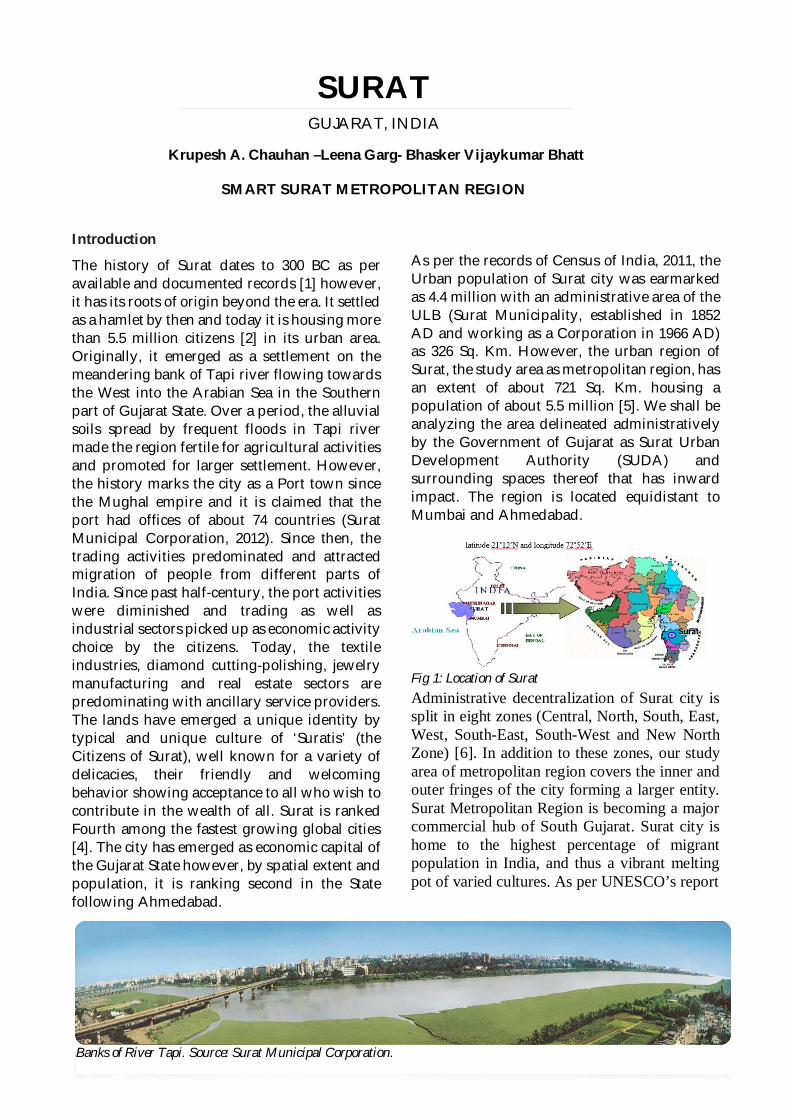
Introduction
The history of Surat dates to 300 BC as peravailable and documented records [1] however,it has its roots of origin beyond the era. It settledas a hamlet by then and today it is housing morethan 5.5 million citizens [2] in its urban area.Originally, it emerged as a settlement on themeandering bank of Tapi river flowing towardsthe West into the Arabian Sea in the Southernpart of Gujarat State. Over a period, the alluvialsoils spread by frequent floods in Tapi rivermade the region fertile for agricultural activitiesand promoted for larger settlement. However,the history marks the city as a Port town sincethe Mughal empire and it is claimed that theport had offices of about 74 countries (SuratMunicipal Corporation, 2012). Since then, thetrading activities predominated and attractedmigration of people from different parts ofIndia. Since past half-century, the port activitieswere diminished and trading as well asindustrial sectors picked up as economic activitychoice by the citizens. Today, the textileindustries, diamond cutting-polishing, jewelrymanufacturing and real estate sectors arepredominating with ancillary service providers.The lands have emerged a unique identity bytypical and unique culture of ‘Suratis’ (theCitizens of Surat), well known for a variety ofdelicacies, their friendly and welcomingbehavior showing acceptance to all who wish tocontribute in the wealth of all. Surat is rankedFourth among the fastest growing global cities[4]. The city has emerged as economic capital ofthe Gujarat State however, by spatial extent andpopulation, it is ranking second in the Statefollowing Ahmedabad.
As per the records of Census of India, 2011, theUrban population of Surat city was earmarkedas 4.4 million with an administrative area of theULB (Surat Municipality, established in 1852AD and working as a Corporation in 1966 AD)as 326 Sq. Km. However, the urban region ofSurat, the study area as metropolitan region, hasan extent of about 721 Sq. Km. housing apopulation of about 5.5 million [5]. We shall beanalyzing the area delineated administrativelyby the Government of Gujarat as Surat UrbanDevelopment Authority (SUDA) andsurrounding spaces thereof that has inwardimpact. The region is located equidistant toMumbai and Ahmedabad.
Administrative decentralization of Surat city issplit in eight zones (Central, North, South, East,West, South-East, South-West and New NorthZone) [6]. In addition to these zones, our studyarea of metropolitan region covers the inner andouter fringes of the city forming a larger entity.Surat Metropolitan Region is becoming a majorcommercial hub of South Gujarat. Surat city ishome to the highest percentage of migrantpopulation in India, and thus a vibrant meltingpot of varied cultures. As per UNESCO’s report
SURATGUJARAT, INDIA
Krupesh A. Chauhan –Leena Garg- Bhasker Vijaykumar Bhatt
SMART SURAT METROPOLITAN REGION
Banks of River Tapi. Source: Surat Municipal Corporation.
Fig 1: Location of Surat
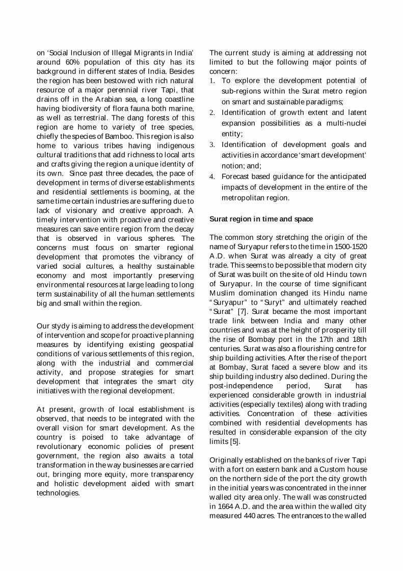
on ‘Social Inclusion of Illegal Migrants in India’around 60% population of this city has itsbackground in different states of India. Besidesthe region has been bestowed with rich naturalresource of a major perennial river Tapi, thatdrains off in the Arabian sea, a long coastlinehaving biodiversity of flora fauna both marine,as well as terrestrial. The dang forests of thisregion are home to variety of tree species,chiefly the species of Bamboo. This region is alsohome to various tribes having indigenouscultural traditions that add richness to local artsand crafts giving the region a unique identity ofits own. Since past three decades, the pace ofdevelopment in terms of diverse establishmentsand residential settlements is booming, at thesame time certain industries are suffering due tolack of visionary and creative approach. Atimely intervention with proactive and creativemeasures can save entire region from the decaythat is observed in various spheres. Theconcerns must focus on smarter regionaldevelopment that promotes the vibrancy ofvaried social cultures, a healthy sustainableeconomy and most importantly preservingenvironmental resources at large leading to longterm sustainability of all the human settlementsbig and small within the region.
Our stydy is aiming to address the developmentof intervention and scope for proactive planningmeasures by identifying existing geospatialconditions of various settlements of this region,along with the industrial and commercialactivity, and propose strategies for smartdevelopment that integrates the smart cityinitiatives with the regional development.
At present, growth of local establishment isobserved, that needs to be integrated with theoverall vision for smart development. As thecountry is poised to take advantage ofrevolutionary economic policies of presentgovernment, the region also awaits a totaltransformation in the way businesses are carriedout, bringing more equity, more transparencyand holistic development aided with smarttechnologies.
The current study is aiming at addressing notlimited to but the following major points ofconcern:1. To explore the development potential of
sub-regions within the Surat metro regionon smart and sustainable paradigms;
2. Identification of growth extent and latentexpansion possibilities as a multi-nucleientity;
3. Identification of development goals andactivities in accordance ‘smart development’notion; and;
4. Forecast based guidance for the anticipatedimpacts of development in the entire of themetropolitan region.
Surat region in time and space
The common story stretching the origin of thename of Suryapur refers to the time in 1500-1520A.D. when Surat was already a city of greattrade. This seems to be possible that modern cityof Surat was built on the site of old Hindu townof Suryapur. In the course of time significantMuslim domination changed its Hindu name“Suryapur” to “Suryt” and ultimately reached“Surat” [7]. Surat became the most importanttrade link between India and many othercountries and was at the height of prosperity tillthe rise of Bombay port in the 17th and 18thcenturies. Surat was also a flourishing centre forship building activities. After the rise of the portat Bombay, Surat faced a severe blow and itsship building industry also declined. During thepost-independence period, Surat hasexperienced considerable growth in industrialactivities (especially textiles) along with tradingactivities. Concentration of these activitiescombined with residential developments hasresulted in considerable expansion of the citylimits [5].
Originally established on the banks of river Tapiwith a fort on eastern bank and a Custom houseon the northern side of the port the city growthin the initial years was concentrated in the innerwalled city area only. The wall was constructedin 1664 A.D. and the area within the walled citymeasured 440 acres. The entrances to the walled
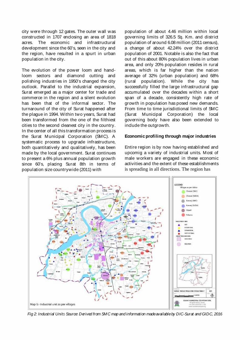
city were through 12 gates. The outer wall wasconstructed in 1707 enclosing an area of 1818acres. The economic and infrastructuraldevelopment since the 60’s, seen in the city andthe region, have resulted in a spurt in urbanpopulation in the city.
The evolution of the power loom and hand-loom sectors and diamond cutting andpolishing industries in 1950’s changed the cityoutlook. Parallel to the industrial expansion,Surat emerged as a major center for trade andcommerce in the region and a silent evolutionhas been that of the informal sector. Theturnaround of the city of Surat happened afterthe plague in 1994. Within two years, Surat hadbeen transformed from the one of the filthiestcities to the second cleanest city in the country.In the center of all this transformation process isthe Surat Municipal Corporation (SMC). Asystematic process to upgrade infrastructure,both quantitatively and qualitatively, has beenmade by the local government. Surat continuesto present a 6% plus annual population growthsince 60’s, placing Surat 8th in terms ofpopulation size countrywide (2011) with
population of about 4.46 million within localgoverning limits of 326.5 Sq. Km. and districtpopulation of around 6.08 million (2011 census),a change of about 42.24% over the districtpopulation of 2001. Notable is also the fact thatout of this about 80% population lives in urbanarea, and only 20% population resides in ruralareas, which is far higher than the nationaverage of 32% (urban population) and 68%(rural population). While the city hassuccessfully filled the large infrastructural gapaccumulated over the decades within a shortspan of a decade, consistently high rate ofgrowth in population has posed new demands.From time to time jurisdictional limits of SMC(Surat Municipal Corporation) the localgoverning body have also been extended toinclude the outgrowth.
Economic profiling through major industries
Entire region is by now having established andupcomig a variety of industrial units. Most ofmale workers are engaged in these economicactivities and the extent of these establishmentsis spreading in all directions. The region has
Fig 2: Industrial Units Source: Derived from SMC map and information made available by DIC-Surat and GIDC, 2016
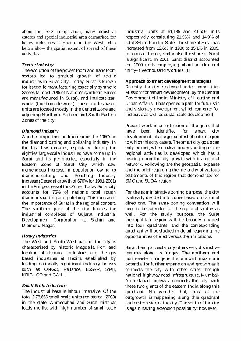
about four SEZ in operation, many industrialestates and special industrial area earmarked forheavy industries – Hazira on the West. Mapbelow show the spatial extent of spread of theseactivities.
Textile IndustryThe evolution of the power loom and handloomsectors led to gradual growth of textileindustries in Surat City. Today Surat is knownfor its textile manufacturing especially syntheticSarees (almost 70% of Nation’s synthetic Sareesare manufactured in Surat), and intricate zariworks (fine brocade work). These textiles basedunits are located mostly in the Central Zone andadjoining Northern, Eastern, and South-EasternZones of the city.
Diamond IndustryAnother important addition since the 1950's isthe diamond cutting and polishing industry. Inthe last few decades, especially during theeighties large-scale industries have come up inSurat and its peripheries, especially in theEastern Zone of Surat City which sawtremendous increase in population owing todiamond-cutting and Polishing Industryincrease (Decadal growth of 670% for 1991-2001)in the Fringe areas of this Zone. Today Surat cityaccounts for 75% of nation’s total roughdiamonds cutting and polishing. This increasedthe importance of Surat in the regional context.The southern part of the city houses theindustrial complexes of Gujarat IndustrialDevelopment Corporation at Sachin andDiamond Nagar.
Heavy IndustriesThe West and South-West part of the city ischaracterised by historic Magdalla Port andlocation of chemical industries and the gasbased industries at Hazira established byleading nationally significant industry housessuch as ONGC, Reliance, ESSAR, Shell,KRIBHCO and GAIL.
Small Scale IndustriesThe industrial base is labour intensive. Of thetotal 2,78,656 small scale units registered (2003)in the state, Ahmedabad and Surat districtsleads the list with high number of small scale
industrial units at 61,185 and 41,509 unitsrespectively constituting 21.96% and 14.9% oftotal SSI units in the State. The share of Surat hasincreased from 12.6% in 1980 to 15.1% in 2005.In terms of factory sector also the share of Suratis significant. In 2001, Surat district accountedfor 1900 units employing about a lakh andthirty- five thousand workers. [8]
Approach to smart development strategiesRecently, the city is selected under ‘smart citiesMission’ for ‘smart development’ by the CentralGovernment of India, Ministry of Housing andUrban Affairs. It has opened a path for futuristicand visionary development which can cater forinclusive as well as sustainable development.
Present work is an extension of the goals thathave been identified for smart citydevelopment, at a larger context of entire regionto which this city caters. The smart city goals canonly be met, when a clear understanding of theregional activities is developed which has abearing upon the city growth with its regionalnetwork. Following are the geospatial expanseand the brief regarding the hierarchy of varioussettlements of this region that demonstrate forSMC and SUDA region.
For the administrative zoning purpose, the cityis already divided into zones based on cardinaldirections. The same zoning convention willneed to be extended for the regional studies aswell. For the study purpose, the Suratmetropolitan region will be broadly dividedinto four quadrants, and the correspondingquadrant will be studied in detail regarding theopportunities offered versus the limitations.
Surat, being a coastal city offers very distinctivefeatures along its fringes. The northern andnorth-eastern fringe is the one with maximumpotential for further expansion and growth as itconnects the city with other cities throughnational highway road infrastructure. Mumbai-Ahmedabad highway connects the city withthese two giants of the eastern India along thisquadrant. No wonder that, most of theoutgrowth is happening along this quadrantand eastern side of the city. The south of the cityis again having extension possibility; however,
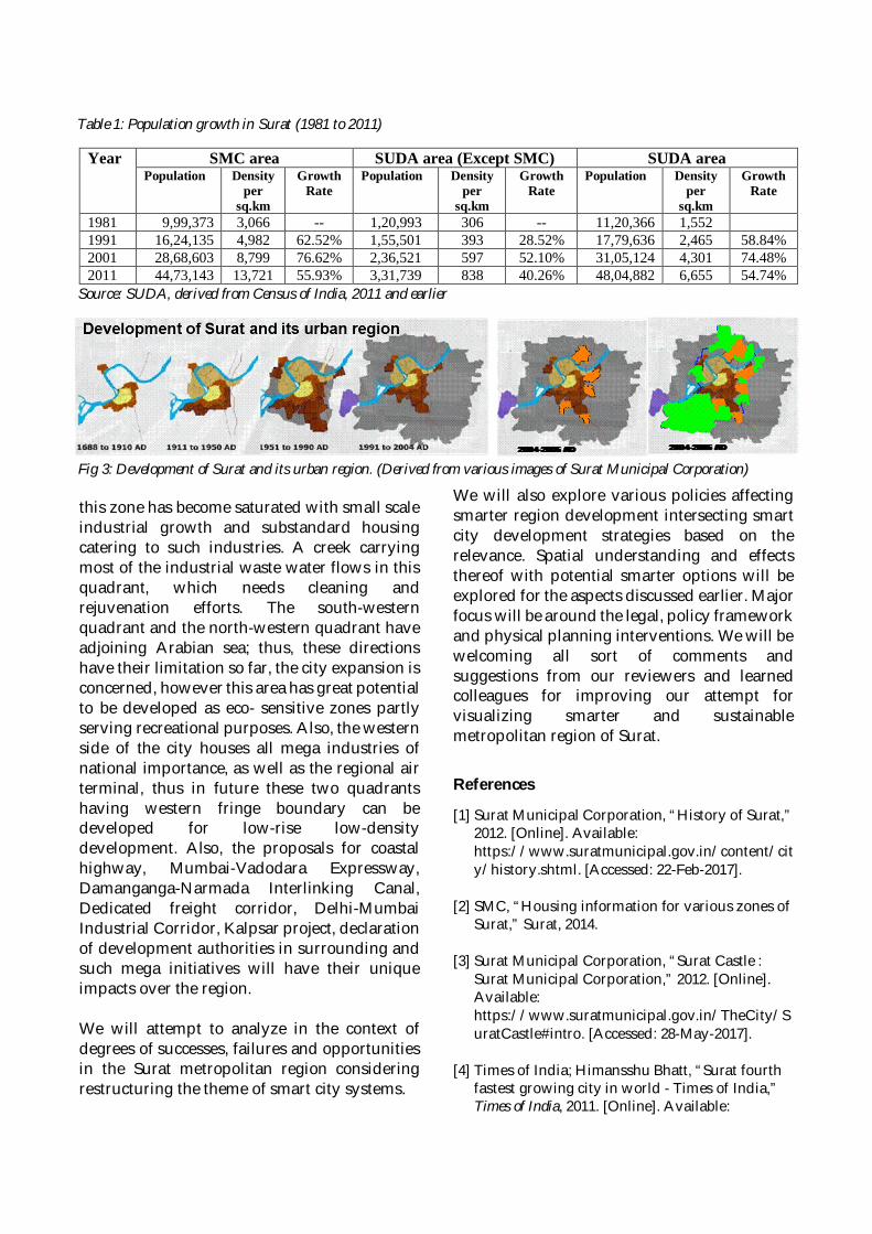
this zone has become saturated with small scaleindustrial growth and substandard housingcatering to such industries. A creek carryingmost of the industrial waste water flows in thisquadrant, which needs cleaning andrejuvenation efforts. The south-westernquadrant and the north-western quadrant haveadjoining Arabian sea; thus, these directionshave their limitation so far, the city expansion isconcerned, however this area has great potentialto be developed as eco- sensitive zones partlyserving recreational purposes. Also, the westernside of the city houses all mega industries ofnational importance, as well as the regional airterminal, thus in future these two quadrantshaving western fringe boundary can bedeveloped for low-rise low-densitydevelopment. Also, the proposals for coastalhighway, Mumbai-Vadodara Expressway,Damanganga-Narmada Interlinking Canal,Dedicated freight corridor, Delhi-MumbaiIndustrial Corridor, Kalpsar project, declarationof development authorities in surrounding andsuch mega initiatives will have their uniqueimpacts over the region.
We will attempt to analyze in the context ofdegrees of successes, failures and opportunitiesin the Surat metropolitan region consideringrestructuring the theme of smart city systems.
We will also explore various policies affectingsmarter region development intersecting smartcity development strategies based on therelevance. Spatial understanding and effectsthereof with potential smarter options will beexplored for the aspects discussed earlier. Majorfocus will be around the legal, policy frameworkand physical planning interventions. We will bewelcoming all sort of comments andsuggestions from our reviewers and learnedcolleagues for improving our attempt forvisualizing smarter and sustainablemetropolitan region of Surat.
References
[1] Surat Municipal Corporation, “History of Surat,”2012. [Online]. Available:https://www.suratmunicipal.gov.in/content/city/history.shtml. [Accessed: 22-Feb-2017].
[2] SMC, “Housing information for various zones ofSurat,” Surat, 2014.
[3] Surat Municipal Corporation, “Surat Castle :Surat Municipal Corporation,” 2012. [Online].Available:https://www.suratmunicipal.gov.in/TheCity/SuratCastle#intro. [Accessed: 28-May-2017].
[4] Times of India; Himansshu Bhatt, “Surat fourthfastest growing city in world - Times of India,”Times of India, 2011. [Online]. Available:
Year SMC area SUDA area (Except SMC) SUDA areaPopulation Density
persq.km
GrowthRate
Population Densityper
sq.km
GrowthRate
Population Densityper
sq.km
GrowthRate
1981 9,99,373 3,066 -- 1,20,993 306 -- 11,20,366 1,5521991 16,24,135 4,982 62.52% 1,55,501 393 28.52% 17,79,636 2,465 58.84%2001 28,68,603 8,799 76.62% 2,36,521 597 52.10% 31,05,124 4,301 74.48%2011 44,73,143 13,721 55.93% 3,31,739 838 40.26% 48,04,882 6,655 54.74%
Table 1: Population growth in Surat (1981 to 2011)
Source: SUDA, derived from Census of India, 2011 and earlier
Fig 3: Development of Surat and its urban region. (Derived from various images of Surat Municipal Corporation)
http://timesofindia.indiatimes.com/city/surat/Surat-fourth-fastest-growing-city-in-world/articleshow/9328885.cms. [Accessed: 23-Feb-2017].
[5] SUDA, “SUDA Revised Development Plan.Pdf,”Surat, 2014.
[6] Surat Municipal Corporation, “Zones:SuratMunicipal Corporation,” 2016. [Online].Available:https://www.suratmunicipal.gov.in/Zones/Functions. [Accessed: 23-Feb-2017].
[7] R. C. D. Plan, “Revised City Development Plan(2008-2013),” Surat, 2013.
[8] GIDC, “GIDC,” GIDC, Government of Gujarat,2016. [Online]. Available:http://117.239.80.70/gis/public.html.[Accessed: 02-Aug-2017].
AUTHORS
AHMEDABAD-GANDHINAGAR - INDIA
Jignesh Bhatt - [email protected]
Prof. Jignesh G. Bhatt is a Senior Assistant Professor in theDepartment of Instrumentation and Control Engineering, atDharmsinh Desai University, Nadiad, Gujarat. He received hisB.E. (Instrumentation and Control Engineering) from GujaratUniversity, India in 1997, and M.Tech. (Electrical Engineering,Specialization: Measurement & Instrumentation) from IITRoorkee, India in 2010. He acquired industrial experience onmanagerial positions during 1997-99, and post-industrialexperience on managerial positions during 1997-1999. Since 2000,he has been serving at the Dharmsinh Desai University (DDU),India as a Sr. Assistant Professor (Instrumentation and ControlEngineering Department). He served as Co-ordinator andPrincipal Investigator for Govt. Sponsored Research and
Community Development Projects, PG Thesis Supervisor, Invited Expert-Session Chair inConferences and Journal Reviewer-Editorial Board Member. His research interests includeAutomation, e-Governance, e-Learning, Instrumentation, Smart City, Smart Grid, Solar City,Solar Energy and Wireless Sensor Networks.
Omkar Jani - [email protected]
Dr. Omkar K. Jani is the Principal Research Scientist in SolarEnergy Division, at the Gujarat Energy Research andManagement Institute, Gandhinagar, Gujarat. He received hisPh.D. in Electrical Engineering from Georgia Institute ofTechnology with specialization in Solar Photovoltaic Science andEngineering, and his post-doctoral fellowship from the Instituteof Energy Conversion, Delaware. His primary goals includeadvisory for various solar-related government and privateinitiatives, developing and undertaking fundamental and appliedresearch, and capacity building. Dr. Jani is a member of the StateAdvisory Committee of the Gujarat Electricity RegulatoryCommission. He is also an advisor to several clean-techcompanies and NGOs.
BANGALORE - INDIA
Amit Chatterjee - [email protected]
An Urban and Regional Planner, Dr. Amit Chatterjee wrote hisdoctoral dissertation on urban sustainability of Greater Mumbaiand its satellite towns. Dr. Amit has a combined experience ofmore than a decade in teaching, research and industry andpresently on the faculty of Planning, School of Planning andArchitecture (SPA), Bhopal as Assistant Professor. Before joiningacademics, Dr. Chatterjee served the industry in variouscapacities. As Principal Investigator, Dr. Chatterjee was involvedin different international collaborative research projects, namely,Co-benefits of Waste Management, Collaborating for Climate,UK-India Capacity Development project for Climate Change andCarbon Management etc. Dr. Amit is currently involved in twoof the research and consultancy projects; ‘Shelter for All’ and
Seven Cluster Development Plans under National Rurban Mission. In academics, his researchinterest is primarily focused on future cities, urban sustainability models and climate change.Besides attending seminars at national and international level, Dr. Chatterjee contributes papers,book chapters to reputed international journals in planning. Dr. Chatterjee edited 11th Issue ofInternational Journal of SPA, Bhopal ‘SPANDREL’ (Masking cities Smart and Competitive) andcurrently working on a book focused on Metropolitan Planning and Development.
Binayak Choudhury - [email protected]
Binayak Choudhury holds a master’s degree in Economics withspecialization in Mathematical Economics and Econometrics. Hegraduated in Regional Planning from Indian Institute ofTechnology, Kharagpur and wrote his doctoral dissertation onRegional Economics. Currently, Prof. Binayak is Professor ofPlanning and Dean (Research and Development) at School ofPlanning and Architecture, Bhopal (SPAB). His research areasinclude urban and regional economics, urban governance andfinance and quantitative techniques in planning. Prof. Binayak ison different committees across various Planning schools of India.He supervises / evaluates dissertation at undergraduate,graduate and doctoral level both at SPAB and other nationalPlanning schools. Prof. Binayak contributes papers tointernational / national journals and conferences and is on the
editorial board / reviewer of national and international journals. Prof. Binayak carries three -decade long experience in urban planning, development and management in various capacitiesacross various institutions in different parts of India.
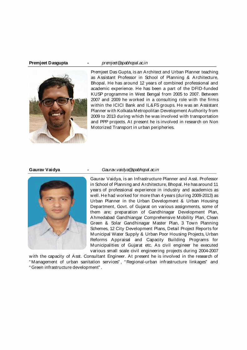
Premjeet Dasgupta - [email protected]
Premjeet Das Gupta, is an Architect and Urban Planner teachingas Assistant Professor in School of Planning & Architecture,Bhopal. He has around 12 years of combined professional andacademic experience. He has been a part of the DFID-fundedKUSP programme in West Bengal from 2005 to 2007. Between2007 and 2009 he worked in a consulting role with the firmswithin the ICICI Bank and IL&FS groups. He was an AssistantPlanner with Kolkata Metropolitan Development Authority from2009 to 2013 during which he was involved with transportationand PPP projects. At present he is involved in research on NonMotorized Transport in urban peripheries.
Gaurav Vaidya - [email protected]
Gaurav Vaidya, is an Infrastructure Planner and Asst. Professorin School of Planning and Architecture, Bhopal. He has around 11years of professional experience in industry and academics aswell. He had worked for more than 4 years (during 2009-2013) asUrban Planner in the Urban Development & Urban HousingDepartment, Govt. of Gujarat on various assignments, some ofthem are; preparation of Gandhinagar Development Plan,Ahmedabad Gandhiangar Comprehensive Mobility Plan, CleanGreen & Solar Gandhinagar Master Plan, 3 Town PlanningSchemes, 12 City Development Plans, Detail Project Reports forMunicipal Water Supply & Urban Poor Housing Projects, UrbanReforms Appraisal and Capacity Building Programs forMunicipalities of Gujarat etc. As civil engineer he executedvarious small scale civil engineering projects during 2004-2007
with the capacity of Asst. Consultant Engineer. At present he is involved in the research of“Management of urban sanitation services”, “Regional-urban infrastructure linkages” and“Green infrastructure development”.
CHANDIGARH - INDIA
Asfa Siddiqui - [email protected]
Asfa Siddiqui is currently working as a Scientist at Indian Instituteof Remote Sensing (Indian Space Research Organization) since2014. She did her Bachelors in Architecture from Govt. College ofArchitecture, Lucknow in 2011 and Masters in Planning withspecialization in Urban Planning from School of Planning andArchitecture, New Delhi in 2013. She worked at NIT Kozhikode(Calicut) prior to joining ISRO. She joined Indian Institute ofRemote Sensing (IIRS), ISRO in January, 2014. Her work focuseson urban and regional areas with emphasis on energy andenvironment.
Pramod Kumar - [email protected]
Pramod Kumar is the Head, of the Urban and Regional StudiesDepartment, at the Indian Institute of Remote Sensing, Dehradun,India. He is also the Group Head of Programme Planning andEvaluation Group of IIRS. He is an alumnus of IIT, Kharagpur,India and joined Indian Space Research Organisation in 1991.Earlier, he has worked as Assistant Engineer at CES, New Delhi.He has been involved in more than 50 national level/ technologydemonstration and research projects using geospatial data andtechniques to evolve solutions for natural resources managementand brought out technical reports and research publications. Hehas published more than 40 papers in journals and conferenceproceedings and many technical reports. He is the recipient ofISRO Team Excellence Awards for two projects. At present, he hasresearch interests in urban water utilities and urban hydrology.
HONG KONG - CHINA
Sujata Govada - [email protected]
Dr. Sujata S. Govada is an award winning qualified urbandesigner, certified town planner and a registered architect inIndia, with over thirty-five years of diverse internationalexperience in Hong Kong, PRC, India, Philippines and the UnitedStates working on design and planning projects. She is theFounding Director of the Institute of Sustainable Urbanisation andthe Founding and Managing Director of UDP International, aboutique global practice. Her expertise and research interestsinclude sustainable urbanization, smart city development, transitand people oriented development, harbourfront planning, newtown development, urban renewal, heritage conservation,affordable housing and community engagement. She is anAdjunct Associate Professor at the School of Architecture, ChineseUniversity of Hong Kong and previously taught in the urban
planning and urban design programmes at The University of Hong Kong. She is a Global Trusteeof the Urban Land Institute (ULI) and the Founding Vice President of the Hong Kong Institute ofUrban Design and Past President of the American Institute of Architects Hong Kong Chapter.
Timothy Rodgers - [email protected]
Timothy Rodgers is a Research Associate at the Institute forSustainable Urbanisation, and Associate of Transport andEconomics at UDP International. He holds a Master’s Degree inTransport Policy and Planning from the University of Hong Kong,and a Bachelor’s Degree in Economics and Geography (UrbanSystems) from McGill University, Canada. His researchexperience at UDP International and ISU includes research andreport writing on current issues such as Smart Cities andAffordable Housing, assisting in the development of a Smart CityFramework with a focus on People, Place and Planet as coreelements, as well as conducting research on project proposals. Hewas the team lead for the Hong Kong chapter of the collaborativeinternational research publication “Smart Economy in SmartCities”, and contributed to the Hong Kong chapter on E-
Engagement of the collaborative international research publication “E-Democracy for SmartCities”.
JAIPUR - INDIA
H. B. Singh - [email protected]
H. B. Singh is a retired professor of Urban and Regional Planningfrom School of Planning and Architecture, New Delhi. Apart fromacademics, he works as a development consultant / advisor to afew MNCs and has led their professional teams. An Architect andTown Planner by qualification from University of Roorkee andSchool of Planning and Architecture, New Delhi, he went on todo an advance course in Urban Management Development fromthe University of Birmingham U.K. He was employed inresponsible positions in the Town and Country planningDepartment of the Government of Uttar Pradesh andGovernment of India, before his stint of 12 years as ChiefArchitect Planner in one of the largest universities - A.B.U. Zaria,Nigeria. After his return, he was selected to the position of the
Principal, Government college of Architecture, Lucknow, through UP Public ServiceCommission. Finally, he joined School of Planning and Architecture New Delhi (An Institutionof National Importance) and retired as Professor and Head, Department of Regional Planningand Centre for Rural Development. He has written a large number of professional articles andco-authored three books, the latest being “Urbanisation in India: Spatial Perspectives”. He hasextensively travelled and delivered lectures in few prestigious American universities. His variedand global experience in academics and profession, in developing and developed countries,various tiers of Governments and MNCs, have provided him with deeper and contextualunderstanding of Urban and Regional Planning concerns.
Prabh Bedi - [email protected]
Dr. Prabh Bedi is a Geographer, Regional Planner and GeospatialTechnology expert. She completed her Post BaccalaureateCertificate in Geographic Information Systems fromPennsylvania State University, USA. She graduated from Schoolof Planning and Architecture, New Delhi (India) with Master ofPlanning (Regional Planning). She completed her Master of Arts(Geography) and Bachelor of Arts (Honours-Geography) fromPanjab University, India. She is associate member, Institute ofTown Planners, India. Having 20 years of experience in planningand geospatial technologies, she’s the founding director ofNipun Planners and Infrastructure Pvt. Ltd., India. She serves asadvisor on environment and micro-planning projects withAllianz Engineering Technology Corp, Cali Colombia. She hasbeen visiting faculty since 2002 at School of Planning and
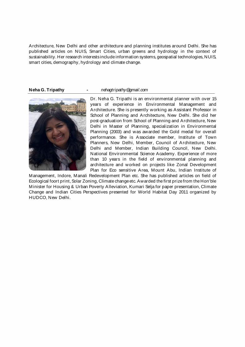
Architecture, New Delhi and other architecture and planning institutes around Delhi. She haspublished articles on NUIS, Smart Cities, urban greens and hydrology in the context ofsustainability. Her research interests include information systems, geospatial technologies, NUIS,smart cities, demography, hydrology and climate change.
Neha G. Tripathy - [email protected]
Dr. Neha G. Tripathi is an environmental planner with over 15years of experience in Environmental Management andArchitecture. She is presently working as Assistant Professor inSchool of Planning and Architecture, New Delhi. She did herpost-graduation from School of Planning and Architecture, NewDelhi in Master of Planning, specialization in EnvironmentalPlanning (2003) and was awarded the Gold medal for overallperformance. She is Associate member, Institute of TownPlanners, New Delhi, Member, Council of Architecture, NewDelhi and Member, Indian Building Council, New Delhi.National Environmental Science Academy. Experience of morethan 10 years in the field of environmental planning andarchitecture and worked on projects like Zonal DevelopmentPlan for Eco sensitive Area, Mount Abu, Indian Institute of
Management, Indore, Manali Redevelopment Plan etc. She has published articles on field ofEcological foort print, Solar Zoning, Climate change etc. Awarded the first prize from the Hon’bleMinister for Housing & Urban Poverty Alleviation, Kumari Selja for paper presentation, ClimateChange and Indian Cities Perspectives presented for World Habitat Day 2011 organized byHUDCO, New Delhi.
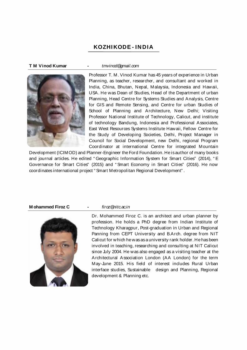
KOZHIKODE - INDIA
T M Vinod Kumar - [email protected]
Professor T. M. Vinod Kumar has 45 years of experience in UrbanPlanning, as teacher, researcher, and consultant and worked inIndia, China, Bhutan, Nepal, Malaysia, Indonesia and Hawaii,USA. He was Dean of Studies, Head of the Department of urbanPlanning, Head Centre for Systems Studies and Analysis, Centrefor GIS and Remote Sensing, and Centre for urban Studies ofSchool of Planning and Architecture, New Delhi; VisitingProfessor National Institute of Technology, Calicut, and instituteof technology Bandung, Indonesia and Professional Associates,East West Resources Systems Institute Hawaii, Fellow Centre forthe Study of Developing Societies, Delhi, Project Manager inCouncil for Social Development, new Delhi, regional ProgramCoordinator at international Centre for integrated Mountain
Development (ICIMOD) and Planner-Engineer the Ford Foundation. He is author of many booksand journal articles. He edited “Geographic Information System for Smart Cities” (2014), “EGovernance for Smart Cities” (2015) and “Smart Economy in Smart Cities” (2016). He nowcoordinates international project “Smart Metropolitan Regional Development”.
Mohammed Firoz C - [email protected]
Dr. Mohammed Firoz C. is an architect and urban planner byprofession. He holds a PhD degree from Indian Institute ofTechnology Kharagpur, Post-graduation in Urban and RegionalPanning from CEPT University and B.Arch. degree from NITCalicut for which he was as a university rank holder. He has beeninvolved in teaching, researching and consulting at NIT Calicutsince July 2004. He was also engaged as a visiting teacher at theArchitectural Association London (AA London) for the termMay-June 2015. His field of interest includes Rural Urbaninterface studies, Sustainable design and Planning, Regionaldevelopment & Planning etc.
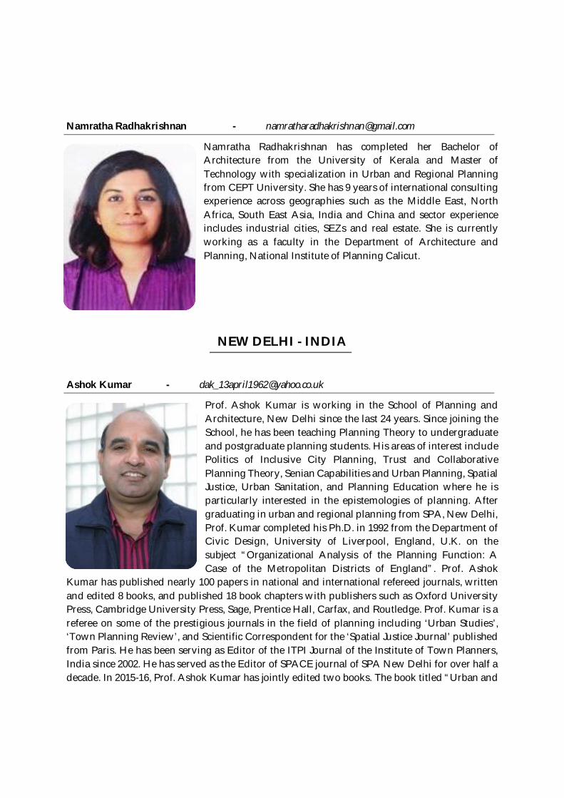
Namratha Radhakrishnan - [email protected]
Namratha Radhakrishnan has completed her Bachelor ofArchitecture from the University of Kerala and Master ofTechnology with specialization in Urban and Regional Planningfrom CEPT University. She has 9 years of international consultingexperience across geographies such as the Middle East, NorthAfrica, South East Asia, India and China and sector experienceincludes industrial cities, SEZs and real estate. She is currentlyworking as a faculty in the Department of Architecture andPlanning, National Institute of Planning Calicut.
NEW DELHI - INDIA
Ashok Kumar - [email protected]
Prof. Ashok Kumar is working in the School of Planning andArchitecture, New Delhi since the last 24 years. Since joining theSchool, he has been teaching Planning Theory to undergraduateand postgraduate planning students. His areas of interest includePolitics of Inclusive City Planning, Trust and CollaborativePlanning Theory, Senian Capabilities and Urban Planning, SpatialJustice, Urban Sanitation, and Planning Education where he isparticularly interested in the epistemologies of planning. Aftergraduating in urban and regional planning from SPA, New Delhi,Prof. Kumar completed his Ph.D. in 1992 from the Department ofCivic Design, University of Liverpool, England, U.K. on thesubject “Organizational Analysis of the Planning Function: ACase of the Metropolitan Districts of England”. Prof. Ashok
Kumar has published nearly 100 papers in national and international refereed journals, writtenand edited 8 books, and published 18 book chapters with publishers such as Oxford UniversityPress, Cambridge University Press, Sage, Prentice Hall, Carfax, and Routledge. Prof. Kumar is areferee on some of the prestigious journals in the field of planning including ‘Urban Studies’,‘Town Planning Review’, and Scientific Correspondent for the ‘Spatial Justice Journal’ publishedfrom Paris. He has been serving as Editor of the ITPI Journal of the Institute of Town Planners,India since 2002. He has served as the Editor of SPACE journal of SPA New Delhi for over half adecade. In 2015-16, Prof. Ashok Kumar has jointly edited two books. The book titled “Urban and
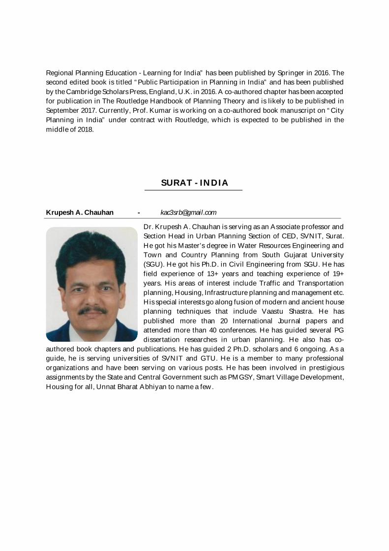
Regional Planning Education - Learning for India” has been published by Springer in 2016. Thesecond edited book is titled “Public Participation in Planning in India” and has been publishedby the Cambridge Scholars Press, England, U.K. in 2016. A co-authored chapter has been acceptedfor publication in The Routledge Handbook of Planning Theory and is likely to be published inSeptember 2017. Currently, Prof. Kumar is working on a co-authored book manuscript on “CityPlanning in India” under contract with Routledge, which is expected to be published in themiddle of 2018.
SURAT - INDIA
Krupesh A. Chauhan - [email protected]
Dr. Krupesh A. Chauhan is serving as an Associate professor andSection Head in Urban Planning Section of CED, SVNIT, Surat.He got his Master’s degree in Water Resources Engineering andTown and Country Planning from South Gujarat University(SGU). He got his Ph.D. in Civil Engineering from SGU. He hasfield experience of 13+ years and teaching experience of 19+years. His areas of interest include Traffic and Transportationplanning, Housing, Infrastructure planning and management etc.His special interests go along fusion of modern and ancient houseplanning techniques that include Vaastu Shastra. He haspublished more than 20 International Journal papers andattended more than 40 conferences. He has guided several PGdissertation researches in urban planning. He also has co-
authored book chapters and publications. He has guided 2 Ph.D. scholars and 6 ongoing. As aguide, he is serving universities of SVNIT and GTU. He is a member to many professionalorganizations and have been serving on various posts. He has been involved in prestigiousassignments by the State and Central Government such as PMGSY, Smart Village Development,Housing for all, Unnat Bharat Abhiyan to name a few.
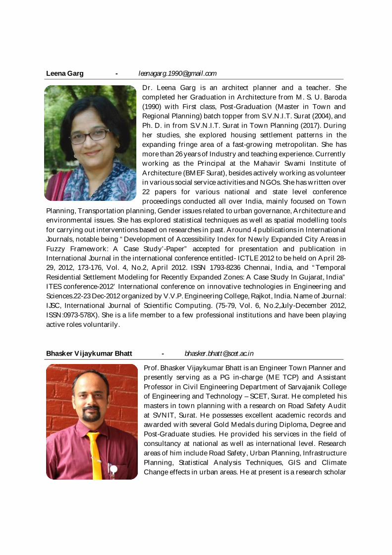
Leena Garg - [email protected]
Dr. Leena Garg is an architect planner and a teacher. Shecompleted her Graduation in Architecture from M. S. U. Baroda(1990) with First class, Post-Graduation (Master in Town andRegional Planning) batch topper from S.V.N.I.T. Surat (2004), andPh. D. in from S.V.N.I.T. Surat in Town Planning (2017). Duringher studies, she explored housing settlement patterns in theexpanding fringe area of a fast-growing metropolitan. She hasmore than 26 years of Industry and teaching experience. Currentlyworking as the Principal at the Mahavir Swami Institute ofArchitecture (BMEF Surat), besides actively working as volunteerin various social service activities and NGOs. She has written over22 papers for various national and state level conferenceproceedings conducted all over India, mainly focused on Town
Planning, Transportation planning, Gender issues related to urban governance, Architecture andenvironmental issues. She has explored statistical techniques as well as spatial modelling toolsfor carrying out interventions based on researches in past. Around 4 publications in InternationalJournals, notable being “Development of Accessibility Index for Newly Expanded City Areas inFuzzy Framework: A Case Study’-Paper” accepted for presentation and publication inInternational Journal in the international conference entitled- ICTLE 2012 to be held on April 28-29, 2012, 173-176, Vol. 4, No.2, April 2012. ISSN 1793-8236 Chennai, India, and “TemporalResidential Settlement Modeling for Recently Expanded Zones: A Case Study In Gujarat, India”ITES conference-2012’ International conference on innovative technologies in Engineering andSciences.22-23 Dec-2012 organized by V.V.P. Engineering College, Rajkot, India. Name of Journal:IJSC, International Journal of Scientific Computing. (75-79, Vol. 6, No.2,July-December 2012,ISSN:0973-578X). She is a life member to a few professional institutions and have been playingactive roles voluntarily.
Bhasker Vijaykumar Bhatt - [email protected]
Prof. Bhasker Vijaykumar Bhatt is an Engineer Town Planner andpresently serving as a PG in-charge (ME TCP) and AssistantProfessor in Civil Engineering Department of Sarvajanik Collegeof Engineering and Technology – SCET, Surat. He completed hismasters in town planning with a research on Road Safety Auditat SVNIT, Surat. He possesses excellent academic records andawarded with several Gold Medals during Diploma, Degree andPost-Graduate studies. He provided his services in the field ofconsultancy at national as well as international level. Researchareas of him include Road Safety, Urban Planning, InfrastructurePlanning, Statistical Analysis Techniques, GIS and ClimateChange effects in urban areas. He at present is a research scholar
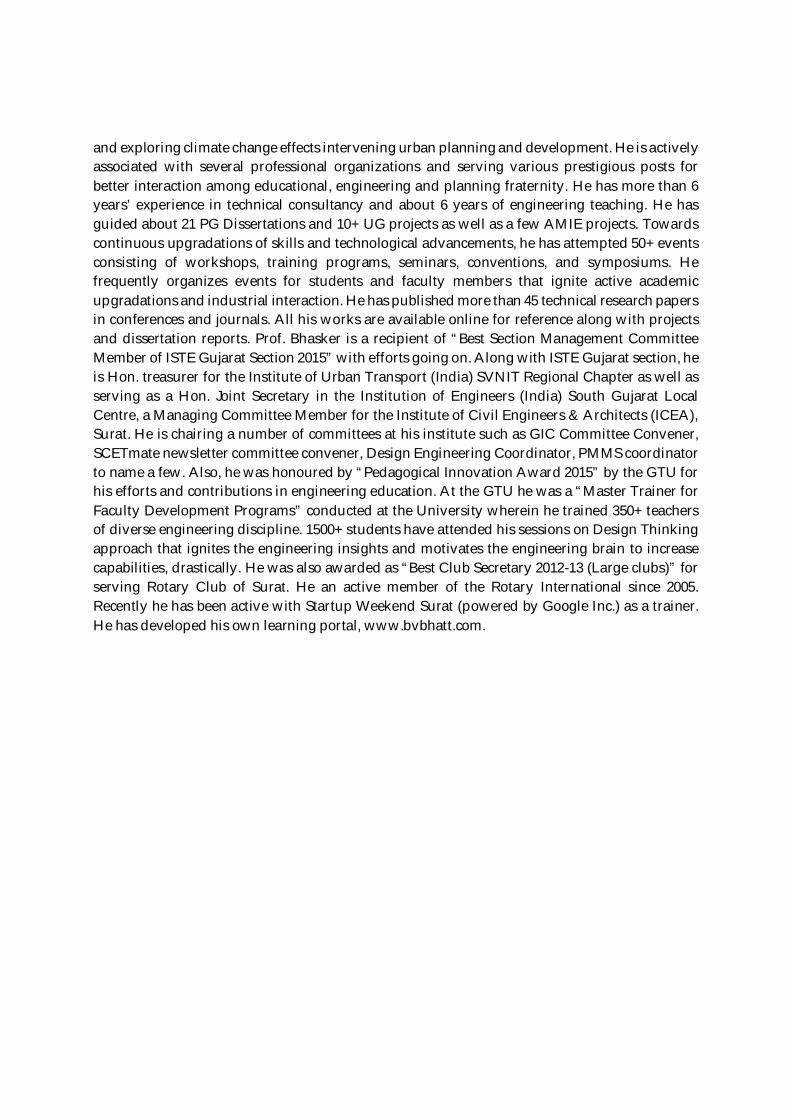
and exploring climate change effects intervening urban planning and development. He is activelyassociated with several professional organizations and serving various prestigious posts forbetter interaction among educational, engineering and planning fraternity. He has more than 6years’ experience in technical consultancy and about 6 years of engineering teaching. He hasguided about 21 PG Dissertations and 10+ UG projects as well as a few AMIE projects. Towardscontinuous upgradations of skills and technological advancements, he has attempted 50+ eventsconsisting of workshops, training programs, seminars, conventions, and symposiums. Hefrequently organizes events for students and faculty members that ignite active academicupgradations and industrial interaction. He has published more than 45 technical research papersin conferences and journals. All his works are available online for reference along with projectsand dissertation reports. Prof. Bhasker is a recipient of “Best Section Management CommitteeMember of ISTE Gujarat Section 2015” with efforts going on. Along with ISTE Gujarat section, heis Hon. treasurer for the Institute of Urban Transport (India) SVNIT Regional Chapter as well asserving as a Hon. Joint Secretary in the Institution of Engineers (India) South Gujarat LocalCentre, a Managing Committee Member for the Institute of Civil Engineers & Architects (ICEA),Surat. He is chairing a number of committees at his institute such as GIC Committee Convener,SCETmate newsletter committee convener, Design Engineering Coordinator, PMMS coordinatorto name a few. Also, he was honoured by “Pedagogical Innovation Award 2015” by the GTU forhis efforts and contributions in engineering education. At the GTU he was a “Master Trainer forFaculty Development Programs” conducted at the University wherein he trained 350+ teachersof diverse engineering discipline. 1500+ students have attended his sessions on Design Thinkingapproach that ignites the engineering insights and motivates the engineering brain to increasecapabilities, drastically. He was also awarded as “Best Club Secretary 2012-13 (Large clubs)” forserving Rotary Club of Surat. He an active member of the Rotary International since 2005.Recently he has been active with Startup Weekend Surat (powered by Google Inc.) as a trainer.He has developed his own learning portal, www.bvbhatt.com.