Embed Size (px)
Citation preview
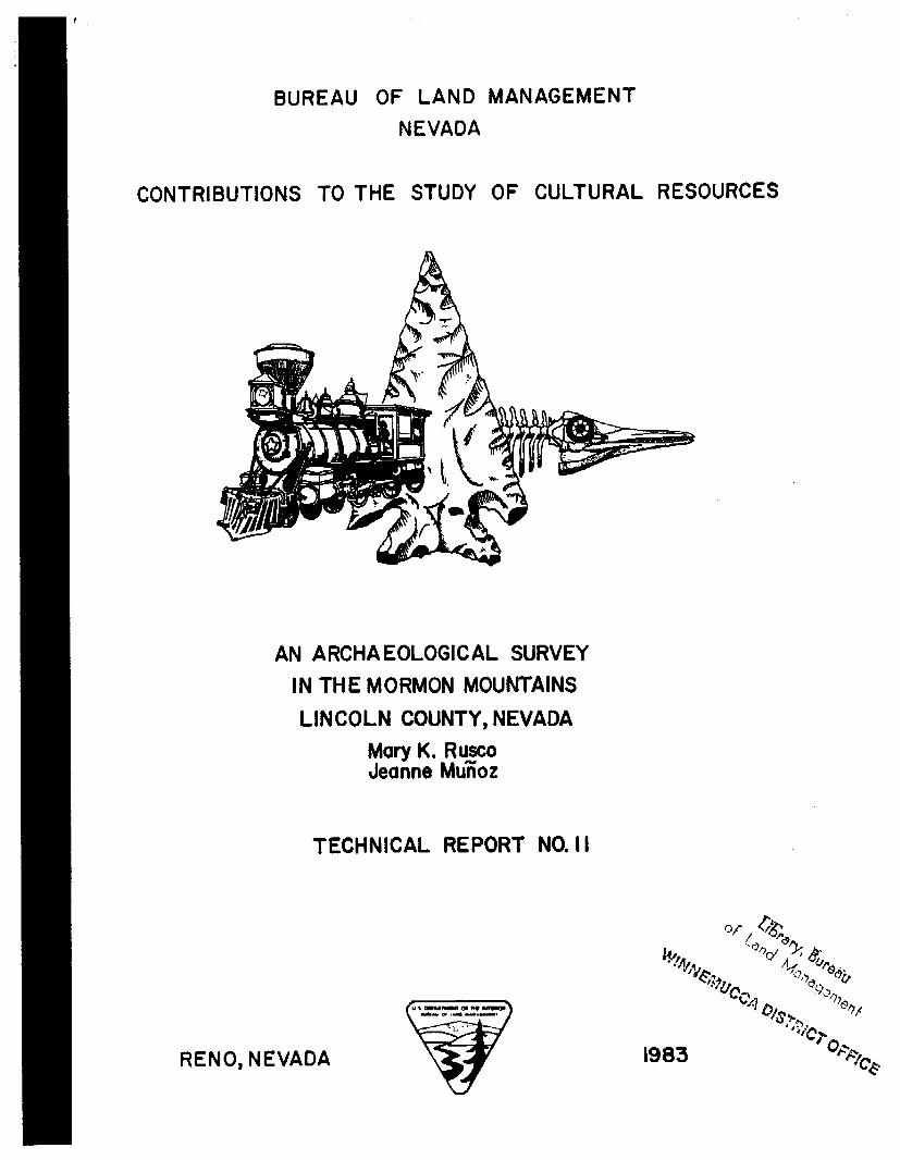
BUREAU OF L A N D MANAGEMENT NEVADA
CONTRIBUTIONS TO T H E STUDY OF CULTURAL RESOURCES
AN ARCHAEOLOGICAL SURVEY IN THE MORMON MOUNTAINS LINCOLN COUNTY, NEVADA
Mary K. Rusco Jeanne MuEot
TECHNICAL REPORT NO. I I
RENO, NEVADA
FOREWARD
"An Archaeological Survey i n the Mormon Mountains, Lincoln County, Nevada" by Mary K. Rusco and Jeanne Muioz presents the r e su l t s o f a BLM cul tural resources contract awarded to Chambers Consultants and Planners, Stanton, California i n 1982. The Bureau requested a sample survey o f a mountainous area located 60 miles northeast o f Las Vegas i n the geologic overthrust region o f Nevada. The overthrust region has experienced a grea t deal o f o i l and gas exploration a c t i v i t y i n recent years. Pas t limited archaeological reconnaissances i n the Mormon Mountains have i ndi cated a potent ia l ly r ich archaeological record. Therefore, the Bureau sought t o gain a more systematic inspection of the region so tha t requirements for archaeological f i e l d surveys pr ior t o fu ture exploration and development projects may be more jud ic i a l ly appl ied.
As revealed by the f i e l d survey, a s t r ik ing fea ture o f the archaeological
This phenomenon no doubt r e f l e c t s
Data gathered from the Mormon
record i n this mountainous region o f southern Nevada i s the r e l a t ive ly l o w frequency o f open, l i t h i c s ca t t e r s compared t o the occurrences of rgckshel ters , caves, rock a r t and roasting p i t f ea tures . the long term role the Mormon Mountains have played i n the adaptive s t r a t eg ie s o f past populations inhabiting the region. Mountain project supplements infomation gathered by other regionally oriented projects recently conducted i n the surrounding lower elevation environmental zones, including the Muddy River Valley. Th is broad data base shal l a i d i n preserving archaeological resources through management
. decisions made from a regional perspective.
Richard C . Hanes Nevada BLM Sta t e Archaeologist Reno
October, 1983

AN ARCHAEOLOGICAL SURVEY I N THE
MORMON MOUNTAINS, LINCOLN COUNTY , NEVADA
by
Mary K. Rusco and Jeanne Mu&z with contributions by
Jonathan 0. Davis, Eileen M. Green, and Ivan Show
Prepared f o r :
UNITED STATES DEPARTMENT OF THE INTERIOR Bureau o f Land Management
Las Vegas District Las Vegas, Nevada 89107
Prepared by:
CHAMBERS CONSULTANTS AND PLANNERS 10557 Beach Boulevard, P . O . Box 356
Stanton, California 90680
1983

T A B L E O F C O N T E N T S
Section
ACKNOWLEDGEMENTS ........................................... 1 INTRODUCTION ........................................ 2 2 .1 2 .2 2.3 2 .4
3 3.1 3 . 2 3 .3
4 4.1 4 . 2 4.3 4.4 4.5
ENVl RONMENTAL BACKGROUND ......................... Water ................................................. Vegetation ........................................... Fauna., ............................................... Geology ..............................................
SAMPLING D E S I G N ..................................... Theory .............................................. Appl icat ion ........................................... Objectives and Background ............................
METHODS .............................................. Location Technology .................................. Sample Un i t Coverage ............................... Collect ion Strategy .................................. Site Mark ing ........................................ Records ..............................................
5 RESULTS .............................................. 5.1 Coverage o f the Project Area ......................... 5.2 The Archaeological Si te Inven to ry ................... s . 3 Prehis tor ic Sites ..................................... 5*4 Histor ic Sites ........................................ 5.5 Dis t r ibu t ion o f Known Sites in the Mormon Mountains . 5 . 5 . 1 Actual and Predicted Site D is t r ibu t ion ............. 5.5.2 Estimating Si te Densi ty and Site Type
Var iab i l i t y in the Mormon Mountains ............. 5.6 Roasting P i t Sites in the Mormon Mountains .......... 5.6.1 Site Taphonomy .................................. 5.6.2 Chronology ........................................ 5.6.3 Roasting Pi ts and Shelters ......................... 5 . 7 Rack A r t in the Mormon Mountains ................... 5.7 .1 Hackber ry Spring Canyon 26LN2418 ................ 5.7.2 Whitmore Mine Road Rock A r t Sites (26LN2S61 a n d
26LN2562) ........................................ 5 . 7 . 3 Lookout Shelter (26LN2508) ......................... 5 . 7 . 4 2 6 L N 2 6 1 1 ........................................... 5 . 7 . 5 Caliche Caves (26LN25SO) ......................... 5 . 7 . 6 Toquop Cave ( 2 6 L N 2 4 6 0 ) .........................
Page
v i
1
11 11 1 1 1 4
17 1 7 18 18 18 18
20 2 0 25 26 2 6 27 3 1
33 44 44 45 46 46 46
53 5 4 5 4 55 5 5
T A B L E O F C O N T E N T S ( C O N T ' D )
Sect ion
5.7.7 Obvious Shelter (26LN2591) ...................... 5.7.8 Double Double Shelter (26LN2597) ................ 5.7.9 Discussion ........................................ 5 . 8 Other Site Types in the Mormon Mountains .......... 5.9 Chronology ........................................... 5.10 His tor ic Sites in t he Mormon Mountains ................ 5.11
Nevada .............................................. 5.12 Summary and Discussion ...............................
Other Recent Archaeological Studies in Southern
6 RECOMMENDATIONS ..................................... 6.1 Which Sites to Save and Which can be Sacr i f iced ....... 6.2 Which Sites to S tudy .................................. 6.3 Mit igat ion o f Adverse Effects on Archaeological
Sites in t he Mormon Mountains ...................... REFERENCES .................................................... APPEND
APPEND
x I: Consultat ion w i th Nat ive Americans of the Mormon Mountain Region .........................
X II: Histor ic Overview of the Mormon Mountains . . . . .
Page
5 5 5 6 56 57 58 59
60 62
6 4 6 4 65
66
6 7
70
73

L I S T O F T A B L E S
Table Page
2-1
5-1 5-2
5-3
5-4
5-5
5-6
5-7
5-8
5-9
5-1 0 5-1 1
5-1 2
5-1 3
5-1 4
5-1 5
Fauna Commonly Present in Biot ic Communities of the
Coverage of Project Area ............................ Cr i te r i a f o r t he Selection o f I n t u i t i v e Sample
Un i t s .............................................. D is t r i bu t i on o f Known Archaeological Sites by
Dis t r i bu t i on o f Known Archaeological Sites by
Sites Recorded Between Sample Un i t s a n d Previously
Predicted Site D is t r i bu t i on and Actual D is t r i bu t i on
D is t r i bu t i on of Roasting Pi ts and Rock Alignments
Si te D is t r i bu t i on in Mountain a n d Piedmont S t r a t a
Frequency of Prehistor ic and His tor ic Si tes in Meadow Valley Wash Compared t o Mountain and Piedmont Strata
Si te Type and Frequency ............................ Results o f Kruskall-Wallis One-way Analysis of Variance ...........................................
D is t r i bu t i on and Frequency of Sample Units Containing One or More of t h e Mormon Mountain Si te Types ....
Frequency and Dis t r i bu t i on o f Sample Un i t s Sample Un i t s Yielding No Sites, 1 Site o r Greater than 1 Si te ..............................................
The Signi f icance o f Association o f Shel ters a n d
Project Area ........................................
Stratum: Random Samples ......................... Stratum: I n t u i t i v e Samples ......................... Recorded Sites ..................................... by Stratum...... ..................................... in Respect to Meadow Valley Wash ................... Compared to t h e Meadow Valley Wash ................
Roasting Pits on the Piedmont ...................... The Significance of Dis t r i bu t i on o f Sites .............
6 22
23
28
2 9
30
3 2
34
34
35 37
39
40
41
41 43
-iv-

I c
1
Figure
L I S T O F I L L U S T R A T I O N S
Page
Frontispiece 1-1
5-1
5-2
5-3
5-4
5-5 Rock A r t Design Elements ............................ 48
Map of Project Area Showing the Location o f Springs,
Map o f the Project Area Showing the Location o f
Map of the Project Area Showing the Location of
Map of the Project Area Showing the Location o f
Map of the Project Area Showing the Location of
Major Peaks and Place Names ......................... vi i
All Random Sample Units ............................ 2 1
All Intuit ive Sample Units ............................ Roasting Pits Recorded in Random Sample Units
Rock A r t Sites 47
24
44 .... .....................................
-V-
ACKNOWLEDGEMENTS
Stanton Rolf, Cont rac t ing Of f icer 's Author ized Representat ive for the Bureau of Land Management (COAR), p rov ided suppor t , enthusiasm, and assistance th roughou t t h e Mormon Mountains Class I I Survey . Consul tant Archaeologist Margaret Lyneis was invo lved th roughout the pro jec t , and h e r object ive cr i t ic ism, intel lectual ins igh t , and enthusiasm are deeply appreciated. Consul tant Stat ist ic ian I van Show deserves c red i t f o r t he basic sampling design, and Consul tant Geologist Jonathan Davis con t r i bu ted t he qeoloqical exper t i se necessary fo r t he success of a s t u d y o f th i s sor t . Paiute
son p rov ided no t on l y h i s knowledge, but sense o f Ethnohis tor ian Ed Johr humor as well.
Ron Reno and A members inc luded Phil Eileen Green and Ke i th part of t h e f ie ldwork.
v i n McLane served as f ie ld crew chiefs, and crew p Baumkratz, Rod Brown, Bob Clerico, Rob Ell is, Myhre r . Eileen Green was crew ch ie f during the last
Needless to say, the su rvey could not have been accomplished w i thout t h e i r hard work, sometimes under very d i f f i c u l t s i tuat ions.
Eileen Green, Ron Reno a n d Lauren Ruf fner assisted in t h e prenarat ion o f the d r a f t i nven to ry records and maps. Eileen Green prepared the t e x t on rock ar t . Ron Reno assisted in the b r i e f evaluat ion of h is to r ic sites. Pat Olsen, Lost C i t y Museum, consul ted on the classi f icat ion of ceramics. To t h a t end she par t i c ipa ted in the f ina l b r i e f f ield session. Var ious colleagues read the Final Draf t , including Richard Hanes and Stanton Rolf, Bureau o f Land Mangement; R ichard Brooks and Rober t Ell is, Museum o f Natura l H is to ry , Un ive rs i t y of Nevada, Las Vegas. We are g ra te fu l for t h e i r comments. Pre l iminary and f ina l d r a f t s were t y p e d by Pam Finch.
The fo l lowing ins t i tu t ions suppl ied background information, inc lud ing s i te records and unpub l ished manuscr ip ts : the Bureau of Land Management, Las Vegas; Special Collections L i b r a r y , Un ive rs i t y of Nevada, Las Vegas; Nevada State Histor ical Society, Carson C i t y and Las Vegas; Records, Archaeological Research Center, Un ive rs i t y o f Nevada, Las Vegas. H e r b e r t Meyers, Moapa Reservation, was generous w i t h h i s time, accompanying the Pr inc ipa l inves t iga tors on a trip t h r o u g h p a r t of the project area.
We wish to ex tend o u r thanks to al l of these ins t i tu t ions and ind iv iduals .
Mary K. Rusco Nevada State Museum, Las Vegas
Jeanne Munoz Chambers Consul tants a n d Planners
-vi-

J
I I I I I
d 4 MAP OF PROJECT AREA SHOWING THE LOCATION OF
SPRINGS, MAJOR PEAKS AND PLACE NAMES
-vi i -
Section 1
INTRODUCTION
This r e p o r t descr ibes the resu l ts o f a Class I I Cul tu ra l Resources Survey per formed by Chambers Consul tants and Planners for the Bureau o f Land Management (BLM), Las Vegas D is t r i c t . The BLM's stated purpose for the su rvey was as follows:
For o i l and gas explorat ion compliance purposes and planning purposes, t h e Las Vegas D i s t r i c t proposes to conduct a Class 1 1 , S t ra t i f i ed Probabi l i ty - (random) Sample o f BLM - administrated lands w i th in the Mormon Mountains po r t i on of t he Oi l and Gas O v e r t h r u s t Belt, w i th in Lincoln County of the Las Vegas D is t r i c t . The Class I I I nven to ry is designed to obtain a meaningful and representat ive sample o f a l l cu l tu ra l resources w i th in the Mormon Mountain area o f t he o v e r t h r u s t be l t w i th in the Las Vegas D is t r i c t (RFP No. YA-553-RFPZ-1036: Section F.2.1).
T h e resu l ts of the s u r v e y a re presented in th i s repor t , preceded hy a descr ip t ion o f t h e environment of the Mormon Mountains, inc lud ing water resources, vegetation, fauna, and geology (Section 2, Environmental Background) .
The su rvey was gu ided by a combined s t ra t i f ied random/ in tu i t i ve or judgmental sampling design (discussed in Section 3 , Sampling Design) devised by Project Stat ist ic ian Ivan Show, in collaboration w i th Co-Principal Inves t iga tor Rusco, Consul tant in Archaeology Margaret M. Lyneis, and Consul tant in Geology Jonathan 0. Davis, and was ca r r i ed o u t in s ix f ie ld sessions between October 30, 1982 and March IS, 1983. The methods used in c a r r y i n g o u t the sampling design a re descr ibed in Section 4.
Section 5 contains t h e resu l ts of the f ie ld reconnaissance, w i th descr ip t ions of t h e sites, quant i ta t i ve and qual i ta t ive manipulation of t he i nven to ry data, and an evaluat ion of the resul ts . A synthesis o f the data f rom t h i s and prev ious cu l tu ra l resource studies in t h e Mormon Mountains area is also presented in Section 5. Perceived pa t te rns and re levant cu l tu ra l processes a re descr ibed and discussed, and cont r ibu t ions to the region's cu l tu ra l h i s ta ry a re pa inted out, all in the context of the Archaeological Element for t h e Nevada H is to r ic Preservat ion Plan ( 1 982) .
Management opt ions and research d i rect ions are suggested in Section 6. The probab i l i t y o f cont inued o i l and gas explorat ions in t h e Mormon Mountains poses real management problems for the Bureau of Land Management, and cu l tu ra l resource management needs are addressed here in the context of more academically or iented research goals.
-1 -

In sum, t h e r e p o r t is a p ro jec t area-specific research design set in t he contex t o f t he Prehis tor ic Southern Nevada S tudy Un i ts o f the Archaeological Element fo r t h e Nevada H is to r ic Preservat ion Plan (1982) and or ien ted toward ELM management considerations.
There a re th ree appendices to th is repor t . The f i r s t is a r e p o r t on the involvement of contemporary Nat ive Americans o f t he Mormon Mountains area in the Class I I Survey proceedings. Appendix I I i s a b r i e f h is tor ica l overv iew of the Mormon Mountains p ro jec t area, and Append ix I l l (bound separately) i s a summary o f t he site i nventory .
A del iberate at tempt has been made th roughou t the work to avoid unnecessary technical language a n d esoteric concepts so tha t t h e end p r o d u c t can be used by b o t h the non-professional and professional for a v a r i e t y of needs.
-2-

!
Section 2
ENVIRONMENTAL BACKGROUND
T h e jagged sky l ine of t he Mormon Mountains is a d i s t i nc t i ve Southern Nevada landmark, located s l i g h t l y o v e r 100 km northeast of Las Vegas, and predominant ly in Lincoln County. T h e range is bounded on the west by Meadow Valley Wash, t h e n o r t h by t h e Tule Desert, the east by t he East Mormon Range, a n d the south by the Mormon Mesa.
In elevation t h e range extends ove r 2,600 rn (8,500 ft) from u n d e r 900 m (3,000 f t ) in the Meadow Valley Wash t o the top of Mormon Peak a t 3 , 3 0 3 m (10,839 ft). The two h ighest peaks a r e Mormon o r Davies Peak and Moapa o r Jack's Peak (3,057 m o r 10,032 f t ) . A nar row val ley ( 2 to 3 km wide and 11 krn long) separates the Mormon a n d East Mormon ranges. Except for this val ley a n d th ree small stretches o f the Meadow Valley Wash, most o f the pro ject area i s mountainous o r consists of dissected piedmont. Well ove r half o f t he area i s above 1,700 m (5,580 f t ) in elevation.
T h e t e r r a i n o f t he pro ject area was descr ibed co lor fu l ly by a cl imber who scaled i t s mountains as an "a r ray o f wi ld rocks...cut by numerous deep canyons a n d gorges; sha rp limestone peaks j u t s k y w a r d and cl i f fs d r o p sheer more than 800 feet" (McLane 1975: 2 ) .
2 . 1 WATER
Al though prec ip i ta t ion in the Mormon Mountains i s mapped a t ove r 8 in., w i t h ove r 1 2 in. a t the h ighest elevations (Nevada Divis ion o f Water Resources 1972) , t he range prov ides l i t t l e surface water much of t he year. Major sp r ings mapped by the USGS a re Davies S p r i n g a t 2,816 m (9,241 f t ) in elevation, Horse S p r i n g a t 2,683 rn (8,804 f t ) , Wiregrass S p r i n g a t 2,636 m ( 8 , 6 5 0 f t ) , and Hackber ry S p r i n g a t 2,532 m (8,309 f t ) , (USCS 7.5' topographic maps o f Rox NE and Moapa Peak NW, Nevada, 1969). Except for Davies, a l l were dry when v is i ted by archaeological f ie ld crews in Nov&nber, but p rov ide water ephemerally as do some seeps and shallow solut ion cavi t ies in the limestone bedrock ( tanks or t ina'as). The la t te r a re r a r e in the Mormon Mountains compared to the M u h o u n t a i n s o r t h e southern p a r t o f t he S p r i n g Range where t h e Aztec sandstone formation has many such cavities. Deep washes suppor t deser t r i pa r ian vegetation as descr ibed by Bradley and Deacon (1967:226) , but are on ly ephemeral sources of water. Meadow Valley Wash i s shown on USGS maps as in termi t tent below the narrows northeast of Vigo, near the center of the Mormon Mountain Range along i t s nor th-south axis. Northeast o f t ha t po int t he wash i s today a year-round water source. Seasonal f looding and occasional major f lash floods plague local ranchers and the Union Pacific Railroad company whose t racks run along the wash.
-3-
T h e eastern slope o f t he mountains i s pa r t i cu la r l y dry and steel stock tanks maintained by ranchers who lease g raz ing r i g h t s f rom the BLM are f requented by b i g h o r n sheep as wel l as by bu r ros , w i ld horses and catt le. Numerous water collection devices (guzz le rs ) built and maintained by the BLM are the main water sources for smaller fauna. Two o f the stock tanks are home for same gold f ish, t he on ly creatures o f t he i r kind who inhab i t t he Mormon Mountains.
Rain and snowfall a re genera l l y light, and most p rec ip i ta t ion is predominant ly between late November and ear l y June. As in the r e s t o f the reg ion , however, t o r ren t i a l ra instorms may occur in the mountains during any season, and t h e resu l t i ng f lash floods have scu lp tu red the deeply dissected piedmont zones.
2 . 2 VEGETATION
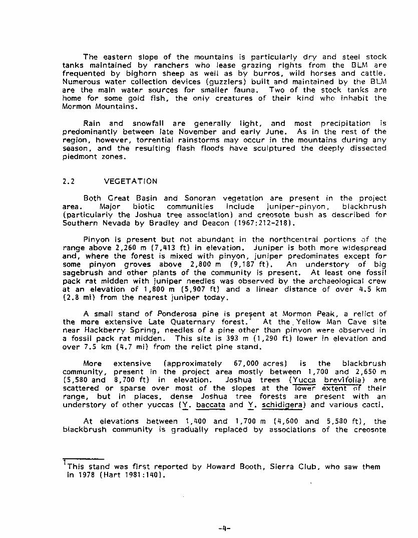
Both Great Basin and Sonoran vegetat ion are present in the pro jec t area. Major b io t ic communities inc lude jun iper-p inyon , blackbrush (pa r t i cu la r l y t he Joshua t ree association) and creosote bush as described f o r Southern Nevada by Brad ley and Deacon ( 1967: 21 2-21 8 ) .
Pinyon i s present but not abundant in the nor thcent ra l portions a i the range above 2,260 m (7 ,413 ftl in elevation. Jun iper is bo th more widespread and, where the forest is mixed w i t h p inyon, j un ipe r predominates except for some p inyon groves above 2,800 m (9 ,187 f t ) . A n u n d e r s t o r y of big sagebrush and o the r p lan ts of t h e community is present. A t least one fossil pack r a t midden w i t h jun iper needles was observed by the archaeological crew a t a n elevat ion of 1,800 m 15,907 f t ) and a l inear distance o f ove r 4.5 km (2.8 mi) f rom the nearest j un ipe r today.
A small s tand o f Ponderosa p ine is preTent a t Mormon Peak, a re l i c t o f t he more extens ive Late Quaternary forest . A t t h e , Yellow Man Cave s i te near Hackber ry Spr ing , needles o f a p ine o the r than p inyon were observed in a fossil pack r a t midden. This s i te is 393 m (1,290 ft) lower in elevation and over 7.5 km C4.7 mi) f rom t h e re l i c t p ine stand.
More extens ive (approximately 67 , 000 acres) i s t he b lackb rush community, p resent in t h e pro jec t area most ly between 1,700 and 2,650 rn (5,580 and 8,700 f t ) in elevation. Joshua t rees (Yucca brev i fo l ia ) a re scattered or sparse over most o f t h e slopes a t the lower ex ten t ot t he i r range, but in places, dense Joshua t ree forests a re present w i t h an unders to ry of o the r yuccas ( Y . baccata and - Y. schidiqera) and var ious cacti.
A t elevations between 1,400 and 1 ,700 rn (4,600 and 5,580 f t ) , the b lackb rush community i s g radua l ly replaced by associations of t he creosote
1
' Th i s s tand was f i r s t repor ted by Howard Booth, S ier ra Club, who saw them in 1978 ( H a r t 1981:140) .
-4-

b u s h community. Sparse and low sh rubs cover most o f t h i s area, the lower co l luv ia l slopes o f t he range. On ly in deep flat-bottomed washes w i t h Holocene a l luv ia l ter races a re ta l l ( ove r 2 m o r 6.5 ft h i g h ) creosote bushes found along w i th wash willow, occasional big sage ( a t h ighe r elevat ions) and o the r sh rubs of t he deser t r i pa r ian community. Along t h e ledges below steep c l i f f s in t h e uplands, these more phreatophy t ic p lants also occur (cf. Brad ley and Deacon 1967: 221 )
The major p reh is to r ic p lan t resource o f the area was apparent ly t h e agave ( A ave utahensis) . Archaeological f ie ld crews found th i s p lan t a t
w i th sur face outcrops of limestone and negat ive ly w i t h Quaternary o r recent alluvium. A good geological map would thus show where in the range t h i s major vegetal resource of the preh is to r ic human populat ion can be expected.
near ly a A- e evations in the project area. I t s presence is un i fo rmly associated
In addi t ion to p len t i fu l agave, abor ig inal populat ions could have collected a va r ie t y of medicinal p lants, including Yerba santa and Thamnosus montana ( tu rpen t ine weed). Deser t almond (P runus sp. ) T i d e s p r e a d in the area, a food resource fo r small mammals t o m i c h may have been harvested by Prehis tor ic human populations, Ephedra spp. o r Ind ian tea is present also in re la t i ve ly large stands. Today, p inyon does not a t t rac t p ine nut ga therers to the area, a l though some large stands a re present and the seed may have been harvested prehis tor ica l ly .
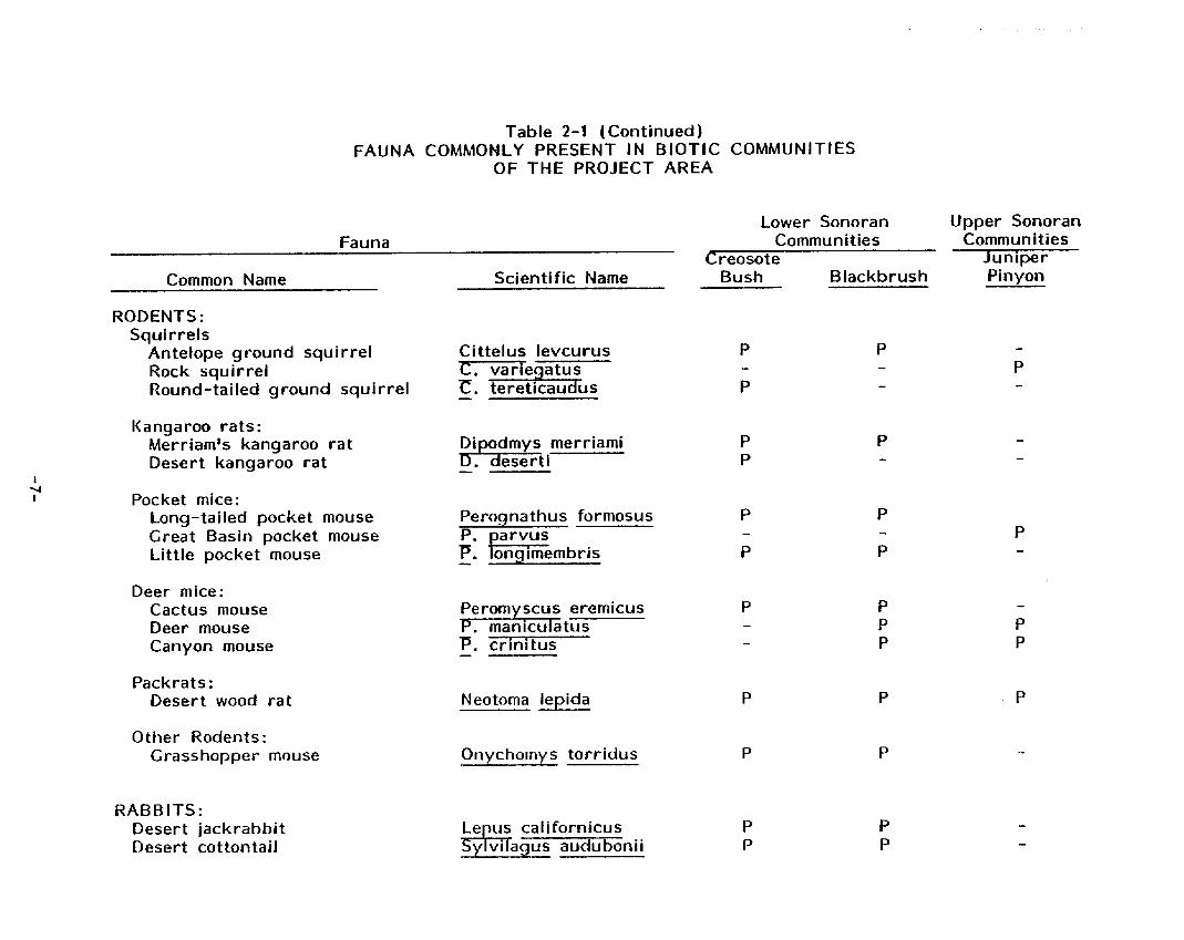
2.3 FAUNA
Brad ley and Deacon (1967) descr ibe the fauna character is t ic o f each o f t he p lan t communities represented in the pro jec t area (Table 2-1). Archaeological f ie ld crews noted occasional jackrabbi ts , cot tontai l rabb i ts , g r o u n d squi r re ls , coyotes, b u r r o s and a t least one deer. Mountain sheep were s igh ted fou r times and recent skulls and o ther skeletal elements were observed. B i r d s inc lud ing raptors , ravens, doves and rock wrens were seen, the la t te r be ing by far t he most numerous. In general, however, the cat t le and wi ld horses appear to be the dominant fauna a t elevations below 1,800 rn (5,906 ft) and up some of the la rge r canyons.
Mountain sheep and deer p rov ide an in te res t ing preh is to r ic d i s t r i bu t i on problem bo th for wi ld l i fe biologists and archaeologists. A know? populat ion of a t least 240 sheep and 50 deer are present in the range today. Management o f t he i r habi ta t i s a concern fo r the Bureau Wildlife Specialists, a n d the large ar t iodacty ls are repor ted ly poached now w i th some regu lar i t y .
Char red and butchered bones o f ar t iodacty l size have been recorded by archaeological crews on the surface of some caves and rockshel ters in the
'Before a "die-off" 3 years ago the sheep h e r d numbered approximately 400 (BLM Wildlife Management Specialist, personal communication) ; see McQuivey (1978:46).
-5-

Table 2-1 FAUNA COMMONLY PRESENT IN BIOTIC COMMUNITIES
OF TflE PROJECT AREA
Lower Sonoran Upper Sonoran Communi ties Commu n it i e s 3 Juniper
Scientific Name Bush B lackbrush Pinyon
Fauna
Common Name
REPTL LES : Lizards:
S ide-blotched I iza rd Desert Whiptail l izard Zebra-tailed lizard Desert Horned l izard Desert lquana Desert Spiny l izard Western Fence l izard Sagebrush I i za rd Leopard l izard Collared lizard Yucca night lizard
P P -
Uta stansburiana Cnemidophorus ti r i s
Phyrnosoma plat rhinos Callrsaurus draconoi 9-a es
Drmosaurus a+- orsa IS Scefoporus ma ister - S. occidcnta -+- IS
f Q, I wislizeni -
P P
I
C. collaris Xantusia viailis -
P
Snakes: SCdew inder Desert rattlesnake Gopher snake Red racer
Crotalus cerastes P P P P
- ? P P
- P P
m e 7 Bi t u-e I an o I eu cu s 1Gt a s ticoph is flage I I u m
Other Reptiles: Gila monster Desert tortoise
P P
Heloderma su soecturn Gopheru s aga s s i z i
..
&I
I c1
n
e
! I
I
ai
a
na
a
la
n
i I
n
n
VI 3
VI
E L c3 rc
VI 3
u .-
-7-

CARNIVORES: Coyote K i t fox Grey fox Badger Bob cat
Table 2-1 (Continued 1 FAUNA COMMONLY PRESENT IN BIOTIC COMMUNITIES
OF THE PROJECT AREA
Lower Sonoran Upper Sonoran Fauna Communities Comm u n it i e s
Creosote Juniper Common Name Scientific Name Bush Blackbrush Pinyon
ARTIODACTYLS: Desert bighorn sheep Mule deer
Canis latrans VulDes rnacrotis Urocyon cinereo Taxidea taxus Y- L nx sufus
Ovis canadensis Dama hemionus -
P P
argenteus - P P
P -
P P

pro ject area (McLane, 1976; Mormon Mountain project f i e ld notes 1982-1983). How old these specimens a re is not known, however.
Mountain sheep r e q u i r e a large amount of water and rel iable water sources accessible f rom t h e i r p r e f e r r e d r o c k y up land habi tat . Ephemeral seeps and tinajas a re present, but n o t numerous in the range today, and the sp r ings a re c u r r e n t l y dry or seasonal. Today mountain sheep re ly on stock tanks and guzzlers.
Presumably water was available to them year r o u n d before ranching and systematic wildl i fe management was introduced, but perhaps the b u r n e d and bu tche red bone on the surface of archaeological sites a r e re la t ive ly recent specimens.
The location of fossi l and act ive pack rat (Neotoma spp.) middens was recorded on s i te records because of t h v o t e n t i a l value for paleoenvironmental data (c f . An Archaeological Element for t he Nevada His tor ic Preservation Plan 1982: 18-20).
2.4 GEOLOGY (By Jonathan 0. Davis, Desert Research Ins t i t u te )
The bedrock geology of t he Mormon Mountains has been b r ie f l y descr ibed by Tschanz and Pampeyan (1970) and paraphrased by McLane (1976). T h e mountain range comprises about a thousand meters o f paleozoic carbonate rock o v e r l y i n g ( w i t h t h r u s t contact) o lder Precambrian igneous and metamorphic rocks, as wel l as some Cambrian shale a n d quar tz i te . The Cambrian and Precambrian rocks a re exposed on ly in two small windows, a t Hackber ry Spring and west of Mormon Peak. T h e bulk of the range i s a broad, deeply dissected dome o f limestone and dolomite. Flanking the mountain mass are piedmonts which slope f a i r l y smoothly down towards Meadow Valley Wash on the west, Mormon Mesa to the south, and the Tu le Desert to the east.
The piedmonts are comprised of late Cenozioc sediments, mostly de r i ved from the erosion of t he Mormon Mountains, and a re in ef fect a palimpsest o f deposits rang ing in age from the Miocene Muddy Creek Formation -- exposed along Meadow Valley Wash and the V i r g i n R ive r and under l y ing Mormon Mesa -- to modern rocky al luvium in t h e bottoms o f recent washes. Due bo th to t h e dry climate of the area and t o the abundant supp ly o f calcium carbonate in the sediment, o lder sedimentary u n i t s a r e typ ica l ly capped by caliche up t o several meters thick, and younger u n i t s a r e typ ica l ly cemented by calcium carbonate. A l though detai led mapping o f the sediments was beyond the scope of t h i s project , several u n i t s can be delineated on aerial photographs, and along major washes (e .g. , Toquop Wash) a sequence of several a l luvial terraces i s present.
The degree o f dissection of t he piedmont sediments served as the basis fo r delineation o f two sampling s t ra ta for t h i s project : St ratum 5 comprises f a i r l y smooth, undissected piedmonts, under la in by caliche, on which s igh t distance i s long, t rave l easy, and soils a r e s t rong ly af fected by the impermeable caliche below; St ratum 4 comprises t h e heavi ly dissected p a r t s o f the piedmont where headward erosion from Meadow Valley Wash has breached
-9-
t h e caliche and the t e r r a i n is a badland o f gu l l ies and div ides, s igh t d istance is comparat ively shor t , t rave l across the g r a i n o f t he drainages is near ly impossible, and soil p ro f i les are shallow but developed upon the sediments of t he piedmont instead of t h e caliche.
In t h e in i t ia l p lann ing o f the project , it was hoped to delineate a s t ra tum inc lud ing those washes w i th ter races v is ib le on aer ia l photographs; however, t h i s was n o t pract ical . T h e idea was tha t the ter races migh t be evidence of an a l luv ia l sedimentary record of t h e late Pleistocene a n d Holocene, and there fore migh t conta in bur ied , s t ra t i f i ed sites. B r ie f examination of these features in the f ie ld, however suggests t h a t t he ter races a r e considerably o lder than this; similar ter races on t he Nevada Tes t Si te to the west contain the Bishop ash, which is about 700,000 years o ld [Hoover e t al. 1981) . Nonetheless, these washes p roved in te res t ing archaeologically fo r another reason.
The ter races along the major washes (e .g. , Toquop Wash) a r e capped by layers o f sediment wh ich are cemented by carbonate, and t h e r isers of the terraces r i se as much as 10 rn ver t i ca l l y , where the modern washes have been erod ing a t t h e i r bases. In several localit ies, rockshel ters ( o r Ilcaliche caves") were found in t h e ter race risers, and some of these p roved to be archaeological sites. T h e mode o f formation of these "caliche caves" seems to invo lve in i t ia l scooping o u t o f an overhang by running water and rocks in the wash, but the location and form o f t h e caves suggests tha t t hey have been modif ied and enlarged by t h e wind. T h e 'ka l iche cavesll p rov ide a form o f shel ter along washes in localit ies where na tu ra l shel ter may otherwise be lacking, and t h e i r location can be f a i r l y well p red ic ted f rom aer ia l photographs.
The bedrock geology of t h e Mormon Mountains p rov ides the basic resource framework for human use of t he area. T h e paleozoic l imestone and dolomite has been subject t o solut ion t h r o u g h geologic time, w i t h two impor tant resul ts : there a re many caves in the rock, which may serve a5 shel ter for humans o r animals; and the rock is very porous, so tha t surface r u n o f f i s quickly d i v e r t e d underg round . L i t t l e is known about t h e ground water hyd ro logy of the Mormon Mountains, but it seems l i ke l y tha t most of t he prec ip i ta t ion received by t h e range q u i c k l y r u n s underground, so tha t streams flow rare ly , and sp r ings a re few. The carbonate bedrock also prov ides sui table soil chemist ry for agave, and the igneous and metamorphic rocks beneath the carbonates have a t t rac ted miners and prospectors during h is to r ic time.
-1 0-

Section 3
SAMPLING DESIGN ( b y I van Show)
3.1 OBJECTIVES AND BACKGROUND
T h e object ive o f t h i s study, f rom the stat ist ical design po in t o f view, was to p roduce a random s t ra t i f i ed sample o f su rvey u n i t s w i th in the Mormon Mountain S tudy Area. T h e major res t r i c t ion on the design was the requi re- ment for sampling 8 percent of t he s t u d y area.
S t ra t i f ied sampling meets bo th research and cu l tu ra l resource management goals ef fect ive ly when the s t ra ta a re def ined on the basis o f ex tan t and s ign i f icant environmental var iables : topography , geomorphology, biogeography, etc. T h e more closely the environmental factors relate to archaeological var iables of in terest , t he more closely the s t ra t i f i ed sample design meets the des i red goals. T h i s re la t ionship permi ts managers to make land use management decisions o n the basis of cu l tu ra l resource informat ion tha t has been organized on t h e same geographical factors tha t determine many of the proposed land uses: slope, access, soils, vegetation, presence o r absence of water. The re la t ionship also permits t h e organizat ion o f archaeological data in a form appropr ia te for i t s appl icat ion to a va r ie t y of c u r r e n t research topics in the southern Great Basin; these genera l ly r e q u i r e informat ion about t h e d i s t r i bu t i on of sites on the landscape.
3 . 2 THEORY
In this section, we formally present the mathematical procedures under l y ing s t ra t i f ied random sampling. Some rationale fo r the choice o f procedures is also g iven. Each term used in t h e discussion is def ined as it arises.
Sample units are t he size and shape of township 1/4-sections (160 acres) as shown on USCS 7.5' topographical maps. The sampling un iverse is a l l such u n i t s lying wi th in t h e Mormon Mountain S tudy Area. In s t ra t i f ied sampling, t he sampling un iverse of N un i t s is d iv ided in to mutual ly exc lus ive and exhaust ive s t ra ta of sizes N,, N2 ..., Nn such tha t
Al l s t ra ta sizes (N.) must be known. A sample is selected randomly independent ly from each strata; these sample sizes are denoted as n, , . . . , nn.
Except f o r some cases o f p u r e l y academic interest , s t ra t i f icat ion
-1 1-

result in increased prec is ion w i t h w h i c h populat ion parameters are estimated. This gain is particularly s t r i k i n g if the sampling u n i v e r s e can be d i v i d e d i n t o s t ra ta that are internally less var iable t h a n t h e ove ra l l population. The purpose of stratified sampling is t he re fo re to minimize or eliminate among- s t ra ta variability,
Two basic methods and optimum allocation.
o f sample size allocation a re avai lable: p r o p c r t i o n a l In p ropor t i ona l al location
i n f
Ni
where n = nf + n2 + ... + n T h i s means t h a t the sample size in each s t ra tum is p ropor t i ona l to the "size of the stratum. The result i s a self-weighting sample w i t h mean
(where subscript I tst" indicates s t ra t i f ied) and variance
where
In optimum al location f o r fixed maximum sample size,
- 1 2-

This means t h a t t he sample size in each s t ra tum i s p ropor t i ona l to the size o f t he s t ra tum weighted by t h e s tandard dev iat ion o f t he straturn. The mean is t h e same as for p ropor t i ona l al location, but t h e var iance is now
The second terms on the right in equations ( 4 ) a n d ( 7 ) are the con t r i bu t i ons of among st rata var iance mentioned above.
A major a l te rna t i ve to p ropor t i ona l or optimum al location and one that: must be mentioned in o r d e r to make o u r rat ionale acceptable is a s imple random sample w i t h mean
3 j n
and var iance
By comparison of equat ions (41 , ( 7 1 , ana ( 9 1 , it can be shown t h a t
(10 )
< T J < v - o p t - Pro Q ran v
except in cases where t he actual al location of the n i departs rad ica l ly f rom p ropor t i ona l or optimum.
The impact of equation (10) i s t h a t we would w ish to use optimum al location in order t o establ ish a no-lose s i tuat ion for sampling precis ion. We must, however, obta in estimates o f N. and S. and, f u r t h e r , must devise a method for randomly choosing ni sarndles in Jach stratum. These problems a r e a l l non t r i v i a l : t h e y are dealt w i t h in the section on appl icat ion. Optimum al location leads to the fo l lowing two rules of conduct :
- 1 3-

1. I f a s t ra tum i s larger, take more samples in t h a t stratum;
2 . If a s t ra tum i s more variable, take more samples in t h a t stratum.
3 . 3 APPLICATION
T h e pro ject area was s t ra t i f i ed f o r t h e purpose of t he sample su rvey . St rat i f icat ion was based on the geological - vegetation zones t h a t a r e bel ieved to have s t r u c t u r e d p reh is to r i c and h i s to r i c land use in t h e region.
Six s t ra ta were defined:
I . Mountains w i t h jun iper-p inyon coverage: w i t h a marg in o f 100-200 rn (325-650 ft) , as mapped by t he USGS on 7 . 5 ' topographic sheets;
2 . Mountains t h a t suppor t t he b lackb rush community: i nc lud ing a t h i g h e r elevations the Yucca brev i fo l ia association;
Y. brev i fo l ia association; 3 . Ernbayed mountains, also w i t h blackbrush community: including t h e
4. Heavi ly dissected piedmont: predominant ly in the nor thwest and western por t ions of t h e pro ject area, sloping to the Meadow Val ley Wash, suppor t i ng t h e creosote b u s h community;
5. Piedmont: in contrast t o s t ra tum 4, t h i s s t ra tum of the piedmont zone o f t h e Mormon Mountains i s somewhat more g e n t l y s loping and less heavi ly dissected; it too suppor t s the creosote bush community; t he basis f o r s t ra t i f icat ion h e r e is tha t t he pro ject geologist postulated var ia t ion in b iot ic associations d u e to soil d i f ferences as well as stratum-specif ic p reh is to r i c land-use due to the dissection o f the ter ra in ; vegetation maps prepared by the Bureau of Land Management show t h i s difference; and
6. Meadow Valley Wash, w i t h a margin o f 200 - 300 m (650 - 980 f t ) . T h i s wash captures the i n te rm i t ten t r u n o f f from a l l washes in the nor thwestern and western slopes o f the Mormon Mountains. T h e wash is a yea r r o u n d surface water Source above the narrows near Vigo. It i s shown as in termi t tent below t h a t po int on t h e USGS 7.5' topographic maps, but had running water during o u r f ield- work. From time t o time Meadow Valley Wash is the scene o f major f lash floods. The wash suppor ts a dense r i pa r ian vegetation and, pa r t i cu la r l y in places where the ra i l road bed serves as a levee, marsh vegetation is present. Prehistor ical ly marshes may also have occu r red in ox bows. The wash is the rou te of the Union Pacific Railroad and the Glendale to Caliente road t h r o u g h the mountainous area.
T h r e e factors were considered f o r the allocation of samples t o s t ra ta: management needs, e f f ic iency o r cost o f sampling, a n d archaeological s i te var iab i l i ty . Since management needs did not otherwise appear to be o f major
-1 4-

concern, t hey were dropped from f u r t h e r considerat ion w i th the concurrence o f t he BLM. Simi lar ly, e f f i c iency /cos t was found to be overwhelmingly outweighed by research considerations; t h i s factor was there fore dropped. To f u r t h e r i l luminate these decisions, consider a p re l im inary review in which a l l factors were considered. T h e h ighest management p r i o r i t y , lowest cost, and greatest expected frequency and va r iab i l i t y of s i te types a l l coincided w i th s t ra tum five, t he piedmont. T h e end resu l t would have been a n inord ina te ly large propor t ion o f t h e sampling e f f o r t expended in tha t stratum, an area of expected low s i te densi ty . The problem was no t so much tha t t h e piedmont would receive so much at tent ion, but tha t o ther areas of equal o r even grea ter in te res t would be propor t ionate ly neglected. Therefore, s t ra tum sample s i tes were allocated accord ing to straturn size and va r iab i l i t y on l y , as out l ined in the section on theory.
Having made the above decision, o u r f i r s t major problem was to obta in estimates o f s t ra tum sizes. Th is was accomplished by repl icated p lan imetry o f USGS 7 . 5 ' topographical maps. The number o f acres measured in each s t ra tum were as follows:
1. 25,590 acres 2. 67,200 acres 3 . 12,270 acres 4. 32,510 acres 5. 47,070 acres 6. 3,060 acres
The other major problem was to obta in estimates o f wi th in-s t ra tum archaeological si te var iab i l i t y . We addressed th i s problem as follows. In a sampling s i tuat ion deal ing w i t h d isc re te ent i t ies occu r r i ng randomly w i th in a c i rcumscr ibed area , the appropr ia te stat ist ical d i s t r i bu t i on descr ib ing the process is cal led Poisson. This d i s t r i bu t i on has the p r o p e r t y tha t t he mean is equal t o t h e variance. Where a set number o f samples taken, therefore, t h e var iance is also re la ted to t h e to ta l number o f d iscrete ent i t ies in the Circumscribed area. We bel ieved tha t we were deal ing w i th j us t such a Poisson process and tha t a good measure o f the within-stratum variability was the f requency o f different types of sites occu r r i ng w i th in the s t ra ta. In addi t ion, equation ( 6 ) above indicates t h a t we need on ly a measure of t he re la t ive f requency o f s i te occurrence, f u r t h e r s impl i fy ing ou r problem. The following table o f coded re la t i ve f requencies was const ructed and the resu l tan t total re la t i ve f requency used as an estimate o f re la t i ve wi th in-s t ra tum archaeological s i te var iab i l i t y .
S t r a turn Si te Var iable 1 2 3 4 5 6'
Caves and shel ters Rock a r t Lithic scat ters It isolated f inds" Roasting p i t s Ceramics ( w i t h scat ters) Pueblos His tor ic (Ang lo)
TOTALS
1 1 1 1 1 1 1 1 1 1 1 1 2 2 2 1 1 1 2 2 2 2 2 2 0 1 0 0 2 0 1 1 0 0 2 2 0 0 0 0 0 1
0 0 1 2 1 1
8 9 6 5 10 10 - - - - - -
-1 5-

In the above table t h e fo l lowing re la t ive f requency codes were used:
0 - absent or near ly so, 1 - p resen t but not abundant 2 - abundant
Maximum sample size ( n ) was set a t 8 percent of the project area o r 94 1 /4-sections. The fol lowing summarizes the informat ion a n d calculat ions used t o obta in the optimum sample size allocation t o s t ra ta based on equat ion (6).
n = 94 N = 187,708
i S. Nisi n Ni I Stratum
9 2s ,589.8 8 204,718.4 12 2 67,206.3 9 604,860.3 37 3 12,268. a 6 73,612 8 4 4 32,507.4 5 162,537.0 10 5 47,072.8 10 470,728.0 29 6 3,063.2 10 3 0 , 6 3 2 . 0 2
= 1,547,088.5
The actual 1 /4-sections sampled were chosen us ing un i fo rm ly d i s t r i b u t e d random numbers; these were chosen until each s t ra tum received i t s p r o p e r allocation. For any sample t o be accepted, it had to be a t least 70 pe rcen t contained w i th in t h e appropr ia te stratum. In addi t ion, a number of samples equal to 20 pe rcen t of the optimum allocation were chosen in each s t ra tum. These were enumerated in the order o f t h e i r choice and used to replace samples t h a t had to be rejected during the f ieldwork.
-1 6-

Section 4
METHODS
Pr io r t o the beg inn ing o f f ie ldwork and during the f i r s t f ie ld session, t he c r i t e r i a for re ject ing random sample u n i t s were def ined in consul tat ion w i t h the COAR and the pro ject stat ist ic ian. They include:
1. Te;p :lopes: It was the i n ten t o f t he Pr incipal Inves t iga tor r c aeoog is t and the COAR tha t a l l random sample u n i t s tha t could
be reached on foot should be inc luded, even when some por t ions o f t h e unit could no t be walked safely along s t ra igh t transects a t 50 m in terva ls , For th i s reason an a r b i t r a r y percent slope was no t establ ished as the safe l imit. Instead the team leader was i ns t ruc ted to determine in the f ield when a sample un i t ' s t e r r a i n could not be t raversed safely.
Sample u n i t s were no t re'ected if there were t ravers ib le slopes,
the un i t ' s t e r r a i n was too steep f o r safe walk ing. ledges o r r i d g e tops -Ti--+ t a t cou b e reached safely, even if p a r t o f
2. lnaccessibi l i t : A sample unit was rejected as inaccessible when it & b e isolated by a substant ia l zone o f unstable rock slides or prec ip i tous slopes r e q u i r i n g rock c l imbing sk i l ls a n d l o r equipment. Quadrats t h a t could not be reached and inspected on foot in time for t h e f ie ld team t o r e t u r n to the i r vehic le o r a f ie ld camp w i th in n ine hours were rejected and replaced by the next a l ternate sample unit.
3 . Covera e: Sample units were rejected if g rea ter than or equal to A t were no t w i th in t h e s t ra tum sampled.
4.1 LOCAT 1 ON TECH NO LOGY
Compasses, color aer ia l photographs and USCS 7 . 5 ' topographic maps were used for or ientat ion in the f ield. A l though section corner markers arc present in on ly a small por t ion o f the pro ject area, a to ta l of 14 section and quar te r section corner markers o r mapped bench marks were found in the f ie ld in o r near 12 sample unit boundaries. In o r d e r to improve the re l iab i l i t y o f mapping quadra t boundar ies and record ing s i te locations wi th in sample un i ts , t he sampling design p rov ided for t he or ientat ion of each sample unit when possible so tha t a n edge o r corner was on o r near a bench mark, a t t h e confluence o f major washes o r near another prominent landform. Field team leaders used range f inders (Ranging Opti-Meter 6201, which can measure re l iab ly distances up to 180 m (600 f t1,to determine the distance of sites or quadra t corners f rom known points.
-1 7-

4.2 SAMPLE UNIT COVERAGE
Sample units were surveyed along approximately s t r a i g h t transects a t 50 rn in terva ls , o r ien ted parallel t o the r i d g e and dra inage system. The on ly except ions were por t ions of some sample un i ts , which were too steep o r otherwise unsafe for f ie ld crews to maintain s t ra igh t t ransects. Such areas were crossed by t h e safest, most expedi t ious way feasible, to reach r i d g e tops, ledges, re la t i ve ly level surfaces and potent ia l ly used caves o r shelters.
4.3 COLLECTION STRATEGY
The collection o f archaeological specimens was avoided except in the case of seven po t te ry sherds collected fo r comparison w i t h analyzed assemblages a t t h e Lost C i t y Museum. Another except ion was the collection o f a small sample from a fossil Neotoma midden f rom Yellow Man Cave in St ra tum 2 to conf i rm t h e f ie ld i d e n t m o f p ine needles (see above, Section 2.3).
4.4 SITE MARKING
Sites were n o t posted o r marked in any way. Detailed d i rect ions to all sites a re in the s i te records, and s i te locations a re p lo t ted on f ield maps and on s i te index maps in cent ra l record reposi tor ies.
4.5 RECORDS
Records o f the s u r v e y inc lude sample unit forms showing the location of t h e unit, k i n d s and numbers of sites recorded, location and or ientat ion o f t ransects, f ield crew, date, and time requ i red for survey. In termounta in Ant iqu i t ies Computer System I IMACS) s i te i nven to ry forms were used to record s i te information. W i t h the concurrence o f the COAR, the BLM s h o r t cu l tu ra l resource form was used t o record sites o f isolated l i t h i c a r t i fac ts . In addi t ion, a l l sites found during t rave l to and from sample u n i t s were also recorded on the shor t forms when time did not permi t the collection of suf f ic ient informat ion for t h e IMACS form.
Color or black and wh i te photographs were taken o f each s i te except f o r some si tes of isolated lithic ar t i facts . Sketch maps were made showing the re la t ionship o f a r t i fac ts and features to s igni f icant landforms in the immediate vicinity. Sketches o r photographs were made of s ign i f icant ar t i facts inc lud ing pro ject i le points, large p o t t e r y sherds, shaped stone tools a n d a sample of g r o u n d o r ba t te red rocks. A l l rock a r t panels were photographed and most were also sketched to scale.
Field observat ions were recorded on one-page forms, l ined note paper and g r a p h paper. These were t ranscr ibed la ter onto IMACS forms and each form was read and edi ted fo r accuracy by one or more of t h e or ig ina l f ie ld crew and by the Co-Principal Invest igator .
-1 8-

Completed IMACS forms and all original field notes are fi led with the sample unit records in the Nevada State Museum. Copies of edited IMACS and Sample Unit records were submitted to the Las Vegas District Office, BLM, the Universi ty of Nevada, Las Vegas, Museum o f Natural History: Nevada State Museum, Carson City and Las Vegas; and the Lost City Museum, Overton.
The small ceramic collection will be curated a t the Nevada State Museurn, Carson City , under terms of the curation agreement between the Museum and the BLM. The Neotoma midden sample from Yellow Man Cave has been submitted to the Las Vegas Distr ict Off ice for analysis by a wildlife biologist.
-1 9-
Section 5
RESULTS
5.1 COVERAGE OF THE PROJECT AREA
The location o f al l random sample u n i t s and t h e boundar ies of s t ra ta are shown on f i g u r e 5-1. In addi t ion, the number o f sample un i t s and the percent coverage f o r each st ratum a re shown in Table 5-1. In general, sample u n i t s a re well d ispersed th roughou t the pro ject area. Un i t s in the smaller s t ra ta a re less well dispersed, however. T h i s is particularly true of Strata 3 and 6 which have on ly 4 and 2 sample u n i t s respect ively: large p a r t s of each s t ra tum were not v i s i t ed by f ie ld teams during the s u r v e y i n g of random sample u n i t s and we could no t be s u r e tha t a l l major s i te types in t he areas were represented in t h e u n i t s surveyed.
To compensate for th is, a series o f i n t u i t i v e sample u n i t s were planned west of Meadow Valley Wash (S t ra ta 4 a n d 6 ) , n o r t h and west of Jakes Pockets (St ratum 3 ) and along t h e p a r t o f Meadow Valley Wash (S t ra tum 6 ) on t h e Rox 7.5' quadrangle. These are por t ions of t he s t ra ta tha t were not sampled by random sample uni ts . Approximately 5 percent o f the i n t u i t i v e sample o r 200 acres were requ i red for this.
Most o f the i n t u i t i v e sample u n i t s were deployed to increase t h e size of t h e i nven to ry of s igni f icant s i te types, t o look f o r representat ives o f r a r e s i te types, a n d to explore areas o f expected high si te densi ty . I n t u i t i v e u n i t s were placed a round those sp r ings t h a t were n o t w i th in random sample u n i t s and i n t u i t i v e u n i t s were dispersed along those p a r t s o f the Meadow Valley Wash t h a t are wi th in the pro ject area. Several i n t u i t i v e u n i t s were placed on saddles a n d d iv ides between major drainages. Road junct ions were inspected f o r h i s to r i c sites. Maps and aer ial photographs were used t o determine the location of mining, rai l road, ranch ing and roast ing pit sites, The last s i te t y p e was often mapped by the USGS as " ru ins " and many are v is ib le on the aerial photographs, Table 5-2 l i s t s c r i t e r i a used for selecting i n t u i t i v e sample uni ts .
The location o f i n t u i t i v e sample units is shown on Figure 5-2. Coverage by the combined i n t u i t i v e and random samples (see Table 5 - 1 ) amounts t o a t least 6 percent of t he heavi ly dissected northwest- facing piedmont (St ratum 4 ) , 7 percent o f t h e embayed mountains on the southwest p a r t o f t he range (S t ra tum 3 1 , 8 and 12 percent of the res t of t he mountains (St rata 1 and 2 respect ive ly) , 12 percent of t he r e s t of t he piedmont (St ratum 5 ) and near ly 25 percent o f t he Meadow Valley Wash (St ratum 6 ) .
-20-

I
i
I
Figure 5-1. MAP OF THE PROJECT AREA SHOWING THE LOCATlON
OF ALL RANDOM SAhZPLE UNITS
Note: Use overlay provided in pocket on ins ide of back cover to identify strata boundaries.
-21-
w u U i2 w
>
0
0
Site Type
Roasting P i t
Table 5-2. CRITERIA FOR THE SELECTION OF I N T U I T I V E SAMPLE UNITS
Roasting Pit, She1 ter
She1 ters, Caves
Rock Alignment
Historic
C r i t e r i a Used to Select I n t u i t i v e Sample U n i t s
Washes w i t h alluvial terraces greater t h a n 10 mi wide, and o f fe r inq p r o x i m i t y to lime- stone gravei ; areas a r o i n c napped "ruins" o r a round roast ing p i t s v is ib le on aer ial photos.
Al luv ia l terraces below limestone c l i f f s or in deep st ra ight -s ided washes with ' 'cal iche" she1 ters
Limestone cliffs, seen during t r a v e l in t h e pro jec t area o r from inspect ion o f maps and aer ial photos
Edges o f b road terraces extending into Meadow Val ley Wash.
In tersect ion o f major d i r t roads o r jeep t r a i l s w i t h the Carp-Elgin road; mapped mines o r - mining claims; named local i t ies, such as the summit of the Carp-Elgin road, ra i l r oad sidings or stations; mapped corra is : sp r ings .
-23-

I t I
I
100 m 9 r i d
Figure 5-2. MAP OF T H E PROJECT AREA SHOWING THE LOCATION OF ALL INTUITIVE SAMPLE UNITS
-2 4-

5.2 THE ARCHAEOLOGICAL SITE INVENTORY
Before completion o f t h i s field s t u d y there were 29 known archaeological sites in the Mormon Mountains, 12 recorded during in-house BLM or contract - suppor ted su rveys of areas subject to impact by const ruct ion pro jects o r seismic explorat ion. Others (17) were f i r s t recorded o r f ie ld checked by a crew from t h e Archaeological Research Center, Un ive rs i t y o f Nevada, Las Vegas, during an archaeological su rvey o f two areas near Hackberry Spr ing (El l is e t al. 1982b).
D u r i n g o u r f ie ld work 117 sites were recorded in random sample un i t s ( inc lud ing 6 t ha t had been prev ious ly recorded) a n d 98 in i n t u i t i v e sample uni ts . An addit ional 24 sites were found during t rave l between sample un i ts . Site numbers were assigned and records compiled f o r the followir,g kinds o r combinations o f cu l tu ra l features o r a r t i fac ts :
Sites o f isolated occurrences o f l i th ic ar t i facts , very srnqll c lustprs o f fewer than 10 specimens in an area o f less than 15 rn' ( 4 9 f t I , o r small isolated features such as hearths;
Larger c lus te rs o f ar t i facts a n d l o r cu l tu ra l features such as roast ing p i ts , rock a r t o r rock alignments;
Shel ters o r caves tha t exh ib i t smoke-blackened in te r io rs , or contain a r t i fac ts , calcined bone o r rocks and o r charcoal stained deposits;
Combinations of caves or shel ters and rock art or roast ing pits (usua l ly w i th in 100 m or 330 f t ) ;
Struc tures , t r a s h scat ters o r ea r th surface modification a t t r i bu tab le t o a post-White contact and pre-1930 context .
Long l inear h is to r ic features such as the Union Pacific Railroad ( fo rmer ly the San Pedro, Los Angeles and Salt Lake Railroad [SP, LA and S L R R ] ) , t he Meadow Valley Wash road and the Carp-Elgin road are clearly s ign i f icant h is to r ic sites. T h e y have not , however, been assigned s i te i nven to ry numbers and are n o t treated- here as, themselves, p a r t o f the s i te inventory . (They are discussed by Munor in the b r i e f h is to r ic overv iew o f the Mormon Mountains p ro jec t area, Appendix 1 1 ) . Here they a re re fe r red to by the i r familiar local names and regarded as p a r t of t he contex t o f ind iv idua l h is to r ic sites ( s t r u c t u r a l remains, mines, o r s tock-ra is ing features) which are inventor ied ind iv idua l l y . In two areas several d iscrete concentrat ions o f s t ruc tu ra l features, t rash scatters, mine shaf ts o r prospects and claim posts are l i nked by p r im i t i ve roads o r vehic le t racks. His tor ic archaeological remains in each of these areas are recorded as a s ingle s i te even though some o f the features are over 200 m (660 ft) apar t and a t locations tha t are no t in terv is i ble .
Final ly, land su rvey markers and min ing claim posts found during o u r reconnaissance have been marked on f ield maps, w i t h the dates, but no t otherwise recorded.
-25-

T h e r e are now 262 recorded archaeological sites in the pro jec t area, of which 233 were recorded during th i s s tudy . Cu l tu ra l features and ar t i fac ts a re a t t r i bu tab le t o var ious pa t te rns of land use during a t least the past two thousand years: some may be older.
5.3 PREHISTORIC SITES:
S ix s i te t ypes were def ined fo r t he Mormon Mountain area on the basis o f apparent ly pa t te rned co-occurrences of speci f ic feature and a r t i f ac t types. These are:
1. 2 . 3 . 4 .
5 .
6 .
7.
5.4
Caves o r Shelters; Caves o r bhe l te rs w i th Roastina Pits: Caves o r Shel ters w i th Rock A;.'t on i n t e r i o r walls; Roast inq P i t Sites s ingle occurrences o r c lus te rs o f roast ing p i t s , some of which h ave other features such as hear ths o r rock alignments nearby; A r t i f ac t Scatters f laked stone, g r o u n d stone a n d / o r ceramics w i t 9 v a r y i n g a r t t j ac t densi ty , inc lud ing some large sites (over 1,000 rn o r 10,800 ft 1 y h e r e on ly f rom 10 to 20 a r t i fac ts were observed by the f ie ld team; Isolated A r t i f ac ts o r Features: s ingle occurrences o r small c lus te rs of a r t i fac ts o r s ing le occurrences of small features such as hear ths o r rock- l ined p i ts ; and
Rock Al iqnments: l inear arrangements of cobbles o r boulders on deser t pavement, some o f which have small scatters of f laked and g r o u n d stone ar t i facts associated.
HISTORIC SITES
Evidence o f human presence af ter White contact includes various combinations o f s t r u c t u r a l remains, a r t i fac ts and land d is turbance a t t r i bu tab le to mining, l ivestock rais ing, local and regional t ranspor tat ion, and government land management. Machine made a r t i f ac ts were found a t 11 p reh is to r ic sites. Some of these associations arc apparent ly fo r tu i tous : for example, re la t i ve ly recent beverage o r food cans in o r near caves, shel ters and roast ing p i ts . Others, inc lud ing a screen, were apparent ly abandoned a f te r digging holes in the site. One roast ing pit site and two shel ter-roast ing pit sites had scat ters of rus ted food and tobacco t i ns and other machine-made metal a r t i fac ts tha t may p r e d a t e the turn of the century .
3These apparent ly isolated occurrences of ar t i facts were grouped u n d e r a s ingle s i te number to avoid the pro l i fe ra t ion o f si te numbers and to show t h e presence of a v e r y low but measurable artifact dens i ty in the area.
-26-
1 J
For purposes o f the pre l iminary tabulat ion of si te types by st ratum (Tables 5-3 a n d 5-4) metal a n d glass t r a s h scatters in prehis tor ic sites a r e no t included in the His tor ic Site type.
5.5 DISTRIBUTION OF KNOWN SITES I N THE MORMON MOUNTAINS
The d i s t r i bu t i on o f known archaeological sites by st ratum in the Mormon Mountains i s shown on Tables 5-3 and 5-4 f o r t he random and i n t u i t i v e samples. Near ly half t he sites recorded during the random sample a re in the lower mountains (St ratum 2 ) w i t h a s i te densi ty of near ly 1 s i te per 100 acres. Only the v e r v small Strata 3 (embayed mountains) and 6 (Meadow Valley Wash) have h ighe r s i te densit ies. In addi t ion t o i t s re la t ive ly high si te densi ty, Stratum 2 exhib i ts the greatest s i te t y p e va r iab i l i t y o f a i l par ts of t he pro ject area, and Strata 1 ( t h e high mountains) and 6 show the least var iab i l i ty .
Roasting pit sites account f o r near ly 40 percent o f al l sites recorded in the random sample and occur in al l s t ra ta except f o r Meadow Valley Wash. Isolated a r t i f ac ts o r features comprise another 30 percent o f t he sites f rom random u n i t s and they occur in al l strata, a l though w i t h v a r y i n g frequency. In contrast , a re la t ive ly r a r e s i te type, shel ters w i th rock a r t on walls, was represented by on ly 1 s i te in Stratum 2. Final ly, 1 si te type, rock al ignments as def ined in Section 5.2 above, was found on ly in the Stratum 6 sample.
In general t h e i n t u i t i v e sample (Table 5-4) yielded a s i te densi ty near ly t h r e e times as large as the random sample. This at tests t o the success of t he random sample s u r v e y in ident i fy ing the character ist ics of areas of high si te densi ty. The i n t u i t i v e sample also y ie lded f i v e addit ional shel ters w i th r o c k a r t , f o u r in Stratum 2 and one in Stratum 3 , as well as two shel ters w i t h design-incised stones; f ive addi t ional r o c k al ignment sites were also found, all in Stratum 6. T h e i n t u i t i v e sample of Meadow Valley Wash also y ie lded sites represent ing th ree types ( l i t h i c scatters, shel ters and h is tor ic si tes) no t present in the two random uni ts . Site t ypes were also added to the i nven to ry o f t h ree o the r strata: an open l i t h i c scatter in Stratum 1 ( the high mountains), and shel ters in Strata 4 a n d 5 ( t h e piedmont s t ra ta ) .
Over 60 percent o f the shel ters a n d caves and s l i gh t l y ove r h a l f o f the open roast ing pit sites were recorded during the i n t u i t i v e sampling o f the pro ject area. T h i s phase of the f ie ld work y ie lded approximately 40 percent o f t he h is tor ic sites and the open a r t i f ac t scatters, also a g rea te r s i te densi ty than present in the random sample. In contrast , less than 25 percent of the sites o f isolated ar t i facts o r features were found in i n t u i t i v e un i t s . The environmental variables tha t appear to be most s t rong ly associated w i th the s i te d i s t r i bu t i on in the Mormon Mountains wi l l be discussed below.
Table 5-5 shows the prev ious ly recorded sites in the Mormon Mountains, except f o r s i x sites in th ree of the random sample un i t s (Table 5-3 above). These were re-v is i ted by o u r f ield teams when they su rveyed the uni ts . The table also shows the d i s t r i bu t i on o f sites recorded during t h i s f ield work between sample uni ts . The prev ious ly recorded and out-of-uni t sites increase
-27-

I/) W
M I
Wl Q) 3
n
r-"
01
d CI
I
0
I
a I
0
I
0
9
Q,
0
CI
I
0
CI L
rn Y
U
51
U
0 a
i
-28-

Table 5-4. DISTRIBUTION OF KNOWN ARCHAEOLOGICAL SITES
BY STRATUM: INTUITIVE SAMPLES
Type Site
She1 ters:
She1 ters with roast ing
Shelters with rock a r t
p i t s :
on walls:
Open, roast ing p i t s :
Open, a r t i f a c t scatters:
Open. iso la ted a r t i f a c t
Open, rock alignment:
H i s t o r i c site {not including t rash scatters in roast ing
fea ture :
1 Count/Row %
3 16.7
0
0 -
2 4 . 4
1 20.0
0
0
2 20.0
-
2
Count/Row x 10 55.6
'1 25.0
4 * 80.0
34 75.6
2 40.0
7 100.0
0
3 30.0
-
3 Count/Row 5,
1 5.6
0 -
1* 20.0
4 8.9
0
0
- -
0
0
4
Count/Row %
1 ' 5.6
0 -
0 -
0
1 20.0
0
-
-
0
0 -
5
Count/Row X
2 1.11
3 75.0
0
4 11.1
0
0
- -
0
1 10.0
6 CQUnt/AOW %
I 5 .6
0
0 -
Q
1 20.0
0 -
5 100.0
4 40.0
A I 1 Count/Col %
18 18.4
4 4.1
5 5.1
4 4 44.9
5 5.1
7 7 . 1
5 5 . 1
10 10.2
p i t s :
A l l Sites: 8 8.2 61 62.2 6 5.1 2 2.0 10 10.2 11 11.2 98 100.0
Acreage sampled i n s t r a t a : 215 2,059 340 79 622 420 3,735
S i t e density (count per 3.72 2.96 1.76 2.53 1.61 2 . 6 1 2.62
Number o f site types i n 4 7 3 2 4 4 8
*Includes one s h e l t e r i n Stratum 2 and one i n Stratum 3 with rock a r t and roasting p i t s ,
100 acres):
sample: - -

I w 0 I
Type S i t e
She1 ters:
Table 5 - 5 . SITES RECORDED BETWEEN SAMPLE UNITS
AND PREVIOUSLY RECORDED SITES*
1 2 3 4
3 3 1 1
-
S h e l t e r s with roast ing p i t s : 0 1 0 0 2 0 3
Shel te r w i t h rock a r t 0 on walls:
0 0 0 0 0 0
Open, roast ing p i t s : 5 9 4 0 4 0 22
Open, lithic s c a t t e r s : 0 0 0 5 0 0 5
Open, isolated artlfact 2 f ea t ure :
0 0 0 1 0 3
Open, rock a 1 i gnmen t : 0 0 0 0 0 0 0
H i s t o r i c site (not including 0 0 0 0 1 1 2 t r a s h scatters in roast ing p i t s :
A l l Si tes : 10 13 5 6 8 I 4 3
*Does not include s ix previously recorded s i t e s i n 3 random sample u n i t s and four previously recorded s i t e s which locat lon i s questionable
t he number o f si tes known f o r al l st rata. They signi f icant ly augment the number o f recorded open roast ing pit sites and shel ters o r caves, but inc lude few o the r s i te types. T h i s i s p a r t l y a t t r i bu tab le t o the focus o n roast ing p i t s in one of the ear l ier f ie ld studies (El l is e t al. 1982b), but is also probablv due to t h e greater v i s ib i l i t y o f shel ters and roast ing p i t s compared to o the r site types. Many roast ing p i t s a r e located along the p r im i t i ve roads and jeep t ra i l s which follow washes in the pro ject area and were t h u s encountered during t rave l between sample uni ts . Caves and overhangs are of ten v is ib le f rom a large distance and the pro ject f ie ld teams occasionally made detours t o inspect some o f these on t h e i r way to sample uni ts. An isolated f laked stone tool and a small h i s to r i c s i te (a General Land Off ice 1934 s u r v e y camp) near sample units were also recorded during t h i s f ie ld season. Previously recorded sites include one isolated feature (a r o c k wal l tentat ive ly ident i f ied as a hunting b l i n d ) , f ou r l i t h i c scatters, another isolated feature ident i f ied as a p reh is to r i c t ra i l , and one h i s to r i c s i te in addi t ion to a shel ter w i t h rock a r t , two shel ters w i t h roast ing p i t s , two o the r shel ters w i t h associated a r t i f ac ts a n d / o r smoke-blackened in ter iors , but no rock a r t o r roast ing p i ts , and 14 open roast ing pit sites. T h e r o c k a r t s i te and f i ve of t h e roast ing pit sites a r e in th ree random sample u n i t s near Hackber ry S p r i n g and a r e inc luded in Table 5-3 instead of Table 5-5.
5 . 5 . 1 Actual and Predicted Si te D is t r i bu t i on
As shown above (Tables 5-3 t h r o u g h 5 - 5 ) , a l l s i te types t h a t have been recorded in the Mormon Mountains were found in the s t ra t i f ied random sample, a l though n o t in a l l s t ra ta where the s i te types were found in the i n t u i t i v e sample o r otherwise recorded. As discussed above, t h e most s t r i k i n g instance of t h i s is the lack o f h is tor ic sites in t h e two random sample u n i t s in the Meadow Valley Wash, Th ree h i s to r i c si tes were recorded during the i n t u i t i v e sampling and one was prev ious l y recorded, so tha t h i s to r i c si tes represent ove r 20 percent of t he Meadow Valley Wash si te i nven to ry t o date. In similar instances in o the r strata, on l y one or two sites have been subsequent ly found suggest ing t h a t t h e types n o t represented in the random sample a re r a r e in those strata.
It would appear t h a t except f o r Stratum 6 (Meadow Valley Wash), the s t ra t i f i ed random sample re l iab ly shows the d i s t r i bu t i on o f sites in the pro ject area.
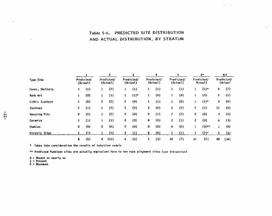
As shown in Section 3 .4 (above), the expected si te d i s t r i bu t i on was used in the allocation o f the sample u n i t s to strata. Predicted a n d actual s i te d i s t r i bu t i on is shown in Table 5-6. Data from random sample u n i t s are used fo r St rata 1 t h r o u g h 5, but the combined i n t u i t i v e and random sample data a r e used f o r St ratum 6, in o rde r to co r rec t the apparent sampling e r r o r .
T h e predict ions of presence and re la t ive f requency o f a r t i f ac t and si te t ypes in the Mormon Mountains shown in Table 5-6 were largely based on taci t knowledge o f regional archaeological s i te locations. Extensive publ ished data from similar t e r r a i n are lacking and, moreover, some o f the s i te records and the r e p o r t of Richard Brooks’ recent s u r v e y a n d test ing project near Hackber ry Spr ing (El l is e t al . 1982b) became available on l y a f t e r the sampling design was completed. In retrospect, however, it i s clear t h a t the
-31 -
wz
I-
a
s;F:
v)
P-
U
P
E
I
"2
Q n
2
U
L
U
YI c
.C
a
t
-32-
i
d is t r i bu t i on o f roast ing p i t s should have been more accurately predic ted on the basis of si te locations mapped by the USCS as " ru ins " and the approximately 70 roast ing pit sites c lear ly v is ib le on aerial photographs, bo th known to t h e Co-Principal Invest igator . The d i s t r i b u t i o n o f o ther s i te types was less obvious. Isolated ar t i facts o r features a re the most f requent ly occu r r i ng sites in many regions, as a re open a r t i f ac t scatters. B o t h s i te types, but pa r t i cu la r l y the former, a re less abundant than was predic ted for the Mormon Mountains. Rock a r t sites were predic ted to be present but n o t abundant in al l s t ra ta on the basis o f a mapped location high in the lower mountains near the Stratum 112 boundary, as well a5 known sites in shel ters and on rock outcrops in var ious parts of southern Nevada. Rock a r t was found predominant ly in Stratum 2.
A high site va r iab i l i t y and high site densi ty were predic ted for Meadow Valley Wash. It was, in fact, the low va r iab i l i t y exh ib i t ed by t h e random sample u n i t s in Stratum 6 t h a t caused us to p lan addi t ional i n t u i t i v e sample u n i t s th roughou t t h e stratum. T h e presence of water, a natura l passageway t h r o u g h r u g g e d t e r r a i n and p rox im i t y to the lower Moapa Valley were the basis for the densi ty and va r iab i l i t y expectat ions. Moreover, one of t h e rock al ignment sites we recorded had been repor ted by the COAR, but not as ye t systematical ly examined a n d recorded I Rolf, personal communication), Because h o r t i c u l t u r e m igh t have been possible in p a r t s o f the Meadow Valley Wash, it seemed reasonable t h a t a Puebloan outpost might be present in Stratum 6, I n i t i a l expectat ions were n o t bo rne out. Even when the resul ts of a near l y 25 percent i n t u i t i v e sample a re included, the s i te i n v e n t o r y for St ratum 6 is nei ther as dense n o r as var iable as predicted. No Puebloan ceramics o r s t ruc tu res and no r o c k a r t were found w i th in the pro ject area, a l though b o t h ceramics a n d r o c k a r t a r e present in Meadow Valley Wash bo th n o r t h and south o f the Mormon Mountains.
reliable. value o f tool
5 . 5 . 2
In spi te o f t he noted discrepancies between expected and actual si te d is t r ibut ion, approximately 65 percent of t he predict ions were reasonably
h{oreover, environmental data were collected tha t can enhance the the random sample s u r v e y data as a cu l tu ra l resource management
Estimating Site Densi ty and Site Type Var iab i l i ty in the Mormon Mountains
From t he prev ious discussion it can b e seen tha t known sites and site types a r e n o t un i fo rm ly d i s t r i b u t e d across the landscape in the Mormon Mountains. If t h i s apparent va r iab i l i t y in si te type and densi ty can be re l ied upon to resemble the actual s i te d i s t r i b u t i o n in the pro ject area, it would be a g r e a t a id in making and implementing cu l tu ra l resource management pol icy. Data f rom the s t ra t i f i ed random sample were, therefore, analyzed to find what k i n d s o f va r iab i l i t y can be expected to occur among st ra ta and what environmental variables o the r than those tha t def ine s t ra tum boundaries a re f requent ly associated w i t h sites.
Meadow Valley Wash: Some clear pa t te rns o f s i te d i s t r i bu t i on emerged from the Mormon Mountain Class II survey, pa r t i cu la r l y in respect to the d i s t i nc t i ve s i te d i s t r i bu t i on in Meadow Valley Wash. T h i s stratum ( 6 ) di f fers
-33-

s t r i k i n g l y from a l l o the r s t ra ta in the d i s t r i b u t i o n o f two si te types: roast ing pit sites, which occur in a l l s t ra ta except Meadow Valley Wash, and rock alignment sites, which occur on l y in Meadow Valley Wash (Table 5 - 7 ) .
Table 5-7. DISTRIBUTION OF ROASTING PITS AND ROCK ALIGNMENTS
I N RESPECT TO MEADOW VALLEY WASH
Site TvDe Mountains. Piedmont Meadow Vallev Wash
Roasting p i t s present Rock al ignments absent
absent present
O the r di f ferences in d i s t r i b u t i o n a re apparent. Because of t he need to reso r t t o data from i n t u i t i v e l y selected sample u n i t s (see Section 5.1) to flesh ou t the si te i n v e n t o r y for Meadow Valley Wash, the use o f stat ist ical tests dependent upon randomness is c lear ly not indicated. Table 5-8 shows the d i s t r i bu t i on of four s i te t ypes between the combined Mountain and Piedmont s t ra ta a n d the Meadow Valley Wash. Di f ferences are s t r i k i n g and no f u r t h e r conf i rmat ion i s really necessary.
Table 5-8. SITE DISTRIBUTION I N MOUNTAIN AND PIEDMONT STRATA COMPARED TO THE MEADOW VALLEY WASH
Mountains Meadow Tota l Piedmont Val ley Wash A rea
Site TvDe Count /Col % Coun t lCo l % Count lCol %
Shelters, caves 14 20.9 1 14.3 1 s 2 0 . 3
A r t i f a c t scatters 7 10.5 1 14.3 8 10.8
Isolated ar t i facts , 35 5 2 . 2 2 28.6 37 5 0 . 0 features
Histor ic 11 16.4 3 42.9 14 18.9 - - .
Totals E Row Percents 67 9 0 . 5 7 9.5 7 4 100.0
NOTE: Data from mountain and piedmont s t ra ta are f rom random sample: data from Meadow Val ley Wash are from grouped random and i n t u i t i v e samples.
For Meadow Valley Wash, the most f requen t l y o c c u r r i n g of the fou r s i te types are h is tor ic sites and isolated ar t i facts or features. !n t he rest of t he pro ject area two p reh is to r i c s i te types, isolates and shelters o r caves, occur most f requent ly . Table 5-9 d isp lays the f requency of p reh is to r i c and h i s to r i c sites.
-34-

Table 5-9. FREQUENCY OF PREHISTORIC AND HISTORIC SITES IN MEADOW VALLEY WASH COMPARED TO MOUNTAIN AND PIEDMONT STRATA
Mountains Meadow Total Piedmont Val ley Wash Area
Site T y p e Count /Col % Count /Col % Count/Col %
Prehistor ic 56 83.6 4 57.1 S O 81 .1
Histor ic 11 16.4 . 3 42.9 1 4 18.9
Total 67 90.5 7 9 . 5 74 100,o
NOTE: Data from mountain and piedmont strata a r e f rom random sample; data f rom Meadow Valley Wash a re f rom g rouped random and i n t u i t i v e samples.
Mountain and Piedmont Strata: Di f ferences among the mountain and Diedmont s t ra ta a re less obvious than the di f ferences observed between Meadow Valley Wash and the r e s t o f t he pro ject area. Stat ist ical analysis of t h e s t ra t i f i ed random sample, however, has shown signi f icant var iat ion, Before present ing the resu l t s o f t h i s analysis, it is necessary to consider the relat ionship between the archaeological s i te d i s t r i bu t i on in the s t ra ta and the samples f rom which we hope to learn about t h a t s i te d i s t r i bu t i on .
As discussed in Section 3 above, the pro ject area was s t ra t i f i ed in an attempt t o reduce t h e within-strata va r iab i l i t y of cer ta in environmental character ist ics, p r imar i l y elevation and topography w i t h associated var ia t ion in annual prec ip i ta t ion and vegetation. These factors a re assumed t o be associated w i t h var iat ion in archaeological s i te d i s t r i bu t i on . The amount and kind o f archaeological va r iab i l i t y expected t o occur w i th in and among st ra ta were then estimated ( I1predicted") . Size o f t he s t ra tum and the estimated va r iab i l i t y were the factors considered in the allocation o f t he number of sample uni ts .
The assumption impl ic i t ly u n d e r l y i n g such a sampling design is t h a t by sampling t rac ts of land we a re also sampling archaeological s i te d i s t r i bu t i on . T h i s is t rue , however, on l y to the ex ten t t ha t sites are e i ther randomly o r un i fo rm ly d i s t r i b u t e d w i th in strata. ( T h i s po int has been raised by Hall (1981) and discussed by Be t t i nge r ( 1 9 8 1 ) . ) In turn, t h i s is t r u e only if all environmental variables s ign i f icant ly associated w i t h s i te d i s t r i bu t i on a 5 randomly o r un i formly d i s t r i bu ted w i th in strata. I h i s has r a r e l y been f o u n d to be the case. I h e success o f the Mormon Mountain i n t u i t i v e scrrvey measured by the si te densi ty in i n t u i t i v e u n i t s near ly th ree times as g rea t as the site densi ty in randomly selected u n i t s shows tha t we can select those p a r t s o f the landscape where sites or cer ta in types of si tes a r e most l i ke l y to occur. If si te d i s t r i bu t i on were random in t h e s t ra ta we could n o t i n t u i t i v e l y select areas o f h ighe r s i te densi ty. For another i l lus t ra t ion, Thomas a n d Be t t i nge r found poly thet ic sets of environmental variables such as slope, p rox im i t y to ephemeral streams or sp r ings and presence o f p inyon trees to accurately p red ic t a cer ta in class o f s i te in t h e Monitor Val ley (Thomas and
-35-

Bet t i nge r 1976:272). These a re t h e k i n d s o f var iables t h a t presumably a r e no t d i s t r i b u t e d randomly a n d that , in fact, w i t h the except ion o f p inyon trees, occur in more than one s t ra tum o r c u t across s t ra tum boundaries. Associated si te types cannot be assumed t o occur randomly w i th in strata, where t h e p red ic t i ve environmental variables are n o t d i s t r i b u t e d randomly.
Lack ing specif ic conf i rmat ion for the Mormon Mountains, t he assumption o f random o r un i fo rm si te d i s t r i b u t i o n w i th in s t ra ta cannot be just i f ied. T h e conceptual leap f rom sampling t h e landscape to formulating s i te d i s t r i b u t i o n expectat ions f rom r a w s i te and s i te t y p e frequencies is t h u s also unjust i f ied. The appropr ia te analyt ic unit is, therefore, t he sample unit no t t h e site. T h i s approach i s discussed by Coombs (1979:76-771, who just i f ied i t s use on the basis of i t s a b i l i t y t o show va r iab i l i t y in si te densi ty.
Si te t y p e and f requency data a re shown in Table 5-11 for each random sam le unit in t h e f i ve mountain and piedmont strata. From these data, + r a t e r t an from si te types a n d frequencies tabulated by st ra tum as in Tables 5-3 t h r o u g h 5-5, we w i l l seek answers to questions raised a t the onset o f our s t u d y :
o I s the re s igni f icant va r iab i l i t y in si te d i s t r i b u t i o n in the Mormon Mountains?
0 I f so, what can we learn from t h i s ?
o How i s it usefu l to cu l tu ra l resource managers?
T h e data presented in Table 5-1 1 were analyzed us ing the KruskaII-Wallis one-way analysis of var iance (Siege1 1956:184-193) on an Apple I I personal computer and a Basic program (Dynacomp 1982) .
Stat ist ical ly s ign i f icant va r iab i l i t y was found in b o t h s i te tvpe and si te densi ty d i s t r i b u t i o n between the g rouped mountain and the g rouped piedmont s t ra ta (Table 5-11). T h e null hypothesis tha t b o t h samples come f r o m populat ions hav ing the same d i s t r i b u t i o n is rejected in b o t h instances. Nei ther t h e analysis o f t he th ree mountain n o r t h e two piedmont s t ra ta showed s ign i f icant di f ferences in respect to s i te t y p e o r s i te densi ty d i s t r i bu t i on . In o the r words, the samples f rom th ree mountain s t ra ta sample similar populat ions as do samples f rom t h e two piedmont strata. T h i s just i f ies the i r g r o u p i n g i n to one mountain s t ra tum a n d one piedmont s t ra tum insofar as the d i s t r i b u t i o n pa t te rns we a re seeking here. In fact, by g r o u p i n g these s t ra ta the p a t t e r n emerges more clear ly. T h i s i s n o t to deny t h a t o the r s i te d i s t r i b u t i o n information may be obscured by g r o u p i n g t h e strata. In fact, the examination of specif ic environmental variables associated w i t h each o f t he recorded site types might suggest s i te d i s t r i bu t i on questions for which t h e st rata as or ig ina l ly def ined here a r e most appropr iate.
Having shown t h a t t he g rouped mountain and g rouped piedmont s t ra ta d i f f e r s ign i f icant ly in respect t o the in ternal va r iab i l i t y of si te densi ty and types, it remains to determine whether o r n o t cer ta in s i te types can be expected to occur w i t h re la t ive ly greater f requency in one stratum.
-36-

f,:cun ta i tis
1 - 1 2 3 5
0 9 10 12 2a 3a 4a
f
2-1 2 3 4 5 6 - ;1 10 11 1 2 1 3 14 15 16 1; 18 19 20 . 21 2: 27 2 5 26 27
29 30 31 32
2 - l a 2a 3a Sa 6a 7a Oa
2 8
3-1 2 3
Table 5-10. S I T E TYPE AND FREQlJEN CY
Frequency site
Sites Types - c 2 2 2 1 3 0 0 0 0 0 0 0 0 0 0 0 0 1 1 0 Q 3 5
0 0 2 3 1 2 2 4 2 2 0 0 2 3 0 0 0 0 1 1 1 1 1 1 4 5 2 2 1 1 0 0 1 3 1 1 2 2 0 0 2 3 0 0 1 1 2 4 1 2 0 0 1 1 1 1 3 0 0 0
0 0 0 0 2 2 0 0 1 2 2 2 2 2
0 0 2 2 1 2
la P, 3 4
Totals 7 2 22 19 6 53 ( 9 sites) (37 sites) ( 2 5 sites) ( 7 sites) (73 sites)
*Subscript = number of sites of that type present in unit where n P = present - = absent
1
-37-

Piedmont
4-1 1 3 4 5 6 8 9 l a 2a
-
5-1 2 3 Y 5 6 7
9 10 11 12 13 14 15 16 17 18 19 20 21 22 26 27 28 29 18
a
Table 5-10. r w E AND
Scatters isolates’
FREQUENCY
Frequency Site Types Sites
0 0 0 0 0 0 0 0 2 2 1 1 1 1 1 1 0 0 0 0
1 1 0 0 0 0 1 1 1 0 0 0 0 1 1 1 3 t 7 0 0 1 1 1 1 1 1 1 1 0 0 3 5 1 1 0 0 0 0 a 0 1 1 1 1 0 0 0 0 3 9 0 0
2a - 0 0
Totals 0 3 6 1 1 4 N739 Number Units Total Sites 34
*Subscript P I present - 0 absent
number of sites of that t ype present In unit where n 1
-38-

Table 5-11. RESULTS OF KRUSKAt l -WALLIS ONE-WAY ANALYSIS OF VARIANCE
SITE TYPE VARIABILITY S ITE DENStTY
Run 1 Run 1
Samples: Mountain Strata 1, 2 a n d 3 Number of observations = 53 Sample 1 = 12 Ranked sums = 265.5 Sample 2 = 37 Ranked sums = 1033.5 Sample 3 = 4 Ranked sums = 132.0 d.f. = 2 Alpha = .05 H (corrected for ties) =2.137 Results: Fai l to reject Ho
Samples: Mountain Strata 1, 2 and 3 Number o f observations = 53 Sample 1 = 12 Ranked sums = 267 .0 Sample 2 = 37 Ranked sums = 1032.5 Sample 3 = 4 Ranked sums = 131.5 d.f. = 2 Alpha = .OS H (corrected for t ies) = 1.989 Results: Fail to reject Ho
Run 2 Run 2
1
v) w Samples: Piedmont Strata 4 and 5 I Number o f observations = 39
Sample 1 = 10 Ranked sums = 185.5 Sample 2 = 29 Ranked sums = 594.5 d.f. = 1 Alpha = .05 H (corrected fo r t ies) = 2 . 7 3 1 Results: Fail to reject Ho
Run 3
Samples: Piedmont Strata 4 and 5 Number o f observations = 39 Sample 1 = 10 Ranked stirns = 183.0 Sample 2 = 29 Ranked sums = 597.0 d.f. = 1 Alpha = .05 H (corrected for t ies) = 0.370 Results: Fail to re ject Ho
Run 3
Samples: Grouped mountain and grouped piedmont s t ra ta Number of observations = 92 Number o f observations = 92 Sarnpie 1 = 53 Ranked sums = 2715.0 Sample 1 = 53 Ranked sums =2746.5 Sample 2 = 39 Ranked sums = 1563.0 Sample 2 = 39 Ranked sums = 1 5 3 1 . 5 d. f . = 1 Alpha = .05 d.f. = 1 Alpha = .05 H (corrected for t ies) = 4.476 H [corrected fo r t ies) = 5,539 Results: Reject Ho
Samples: Grouped mountain and grouped piedmont s t ra ta
Results: Reject tio

A cont ingency table was made showing the number of u n i t s in each st ratum in which each si te t y p e occurs (Table 5 - 1 2 ) . The null hypothes is t h a t d i s t r i b u t i o n is random th roughou t the pro ject area could n o t be rejected on the basis o f c h i square d i s t r i b u t i o n as shown in the table. T h a t is, the d i f ference apparent from inspect ing the tabulated frequencies o f each si te t y p e in the random sample f rom each st ra tum (Table 5-3 above) was no t ref lected by t h e resul ts of analyzing the f requency of u n i t s in which each si te t y p e occurs. It would appear t h a t t h e s t ra ta d i f f e r in f requency of s i te t ypes w i th in sample units but n o t in the f requency w i th which specific s i te t ypes occur o v e r the landscape. T h e g rea te r s i te densi ty in the mountains shown in Table 5-11, f o r example, apparent ly accounts f o r t h e grea te r f requency o f roast ing p i t s found in the mountain strata.
Table 5-12. DISTRIBUTION AND FREQUENCY OF SAMPLE UKlTS CONTAINING ONE OR MORE OF THE MORMON MOUNTAIN S ITE TYPES
Site Types/ S t ra ta Mountains Piedmont Totals m m
Shelters, caves* 9 8 . 4 3 3.6 12 Roasting pit s i tes 22 19.6 6 8.4 28 Scatters, isolates 19 21.0 11 9.0 30 His tor ic 6 7.0 4 3.0 10
fota I s 56 24 77
*Includes caves a n d shel ters w i t h rock a r t a n d / o r roast ing p i t s d20.f. = 3 x = 2.234 Fails to re ject Ho
To test th is , we compared t h e d i s t r i b u t i o n of t r ac ts with no sites, t r a c t s w i t h on l y one si te and t r a c t s w i t h more than one site. Here a s ign i f icant dif- ference between t h e mountains and piedmont emerged. Mountain sample u n i t s w i t h sites e x h i b i t a s t rong tendency t o have two o r more sites in con t ras t to the piedmont where sample u n i t s w i t h sites usual ly had on ly one each (Table 5-13). I f the re a re l i ke l y to b e two o r more roasting pit sites w i th in 8 t o 10 km (5 to 6 mi) in t h e mountains in those locations where roast ing p i t s a re l i k e l y t o occur and if the re i s l i ke l y t o be on ly one roast ing pit s i te per 8 to 10 krn ( 5 t o 6 mi; t he maximum distance between sites in one of o u r 160-acre quadrats) , t he re w i l l be a h ighe r s i te densi ty for roast ing p i t s in the mountains than on the piedmont. In o the r words, t he re are apparent ly the same re la t ive f requency of potent ia l roast ing pit locations in b o t h strata, but in the mountains the re a r e l i ke l y t o be more sites in those places than on t he piedmont.
-40-

Table 5-13. FREQUENCY AND DISTRIBUTION O F SAMPLE UNITS SAMPLE UNITS YIELDING NO SITES, 1 SITE OR GREATER THAN 1 S ITE
Si te Types / St rata Mountains Piedmont Totals m n
Units w i t h no sites 20 23.043 20 16.957 43 Un i t s w i t h 1 s i te 9 13.826 15 10.174 2 2 Un i t s w i t h q rea te r than 24 16.13 4 11.87 27
Totals 5 3 39 92 * Includes caves a n d shel ters w i t h rock a r t a n d / o r roast ing p i ts d.0.f. = 2 3 p h a = . O S x = 13.979 Reject Ho
In o r d e r t o determine what environmental variables o the r than those used t o def ine s t ra ta are associated w i t h s i te d i s t r i bu t i on , it i s necessary to examine the s i te inventory records and t o look a t t he d i s t r i b u t i o n o f quadra ts on the map. It has been observed prev ious ly tha t roast ing p i t s occur on ephemeral stream terraces usual ly near agave patches (cf. El l is e t al . 1982b:55) . T h i s finding was conf i rmed i n t u i t i v e l y during the Mormon Moun- ta in Class I1 survey. We were able to select potential roast ing pit locations w i t h a high degree o f accuracy. Cer ta in dif ferences in the d i s t r i b u t i o n o f roast ing pit sites between mountain a n d piedmont zones emerged. Using the Fisher Exact Probabi l i ty test w i t h the Tocher ra t io (Siege1 1956: 110) we found signi f icant d i f ference between the mountains and piedmont in respect t o the association o f shel ters w i t h roast ing p i t s (Table 5-1 4 ) . Th i s phenomenon has been observed in o the r areas [E l l is e t al. 1982b:56). Specif ic d i s t r i b u t i o n information for o the r s i te t ypes may be found when Mormon Mountain s i te data a re available a t IMACS for an in tens ive computer-assisted search.
Table 5-14. THE SIGNIFICANCE OF ASSOCIATION OF SHELTERS AND ROASTING PITS ON THE PIEDMONT
Site TvDes/ S t r a ta Mountains Piedmont Totals
Shelters 7 0 7 Shelters w i th roast ing p i t s 2 3 5
Totals 9 3 12 Fisher - (Tocher Ratio) Exact Probabi l i ty Probabi l ty o f t h i s case alone .045 Tocher ra t io = 1 . 1 Random number = .5518 Reject Ho
-41 -
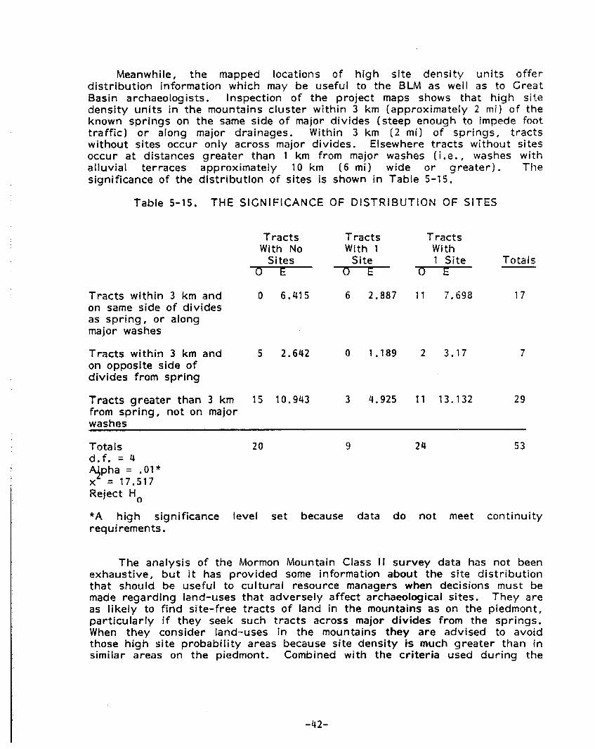
Meanwhile, t h e mapped locations of high s i te dens i t y u n i t s o f fe r d i s t r i b u t i o n informat ion which may be usefu l t o the BLM as well as to Great Basin archaeologists. Inspect ion of t h e pro ject maps shows t h a t high si te densi ty u n i t s in the mountains c lus te r w i th in 3 k m (approximately 2 mi) of t he known sp r ings on t h e same side o f major d iv ides (steep enough t o impede foot t r a f f i c ) o r along major drainages. Within 3 km ( 2 mi) o f spr ings, t r a c t s wi thout sites occur on l y across major div ides. Elsewhere t r a c t s wi thout si tes occur a t distances g rea te r than 1 km from major washes (i.e., washes w i t h al luvial terraces approximately 10 km (6 mi) wide o r g rea te r ) . The signi f icance of t he d i s t r i b u t i o n o f si tes i s shown in Table 5-15 .
Table 5-15. THE SIGNIFICANCE OF DISTRIBUTION OF SITES
T r a c t s T r a c t s T rac ts With No W i t h 1 With
Sites Site 1 Si te Totals ~ 7 s - - € - T l r - T r a c t s w i th in 3 km a n d on same side o f d iv ides as sp r ing , o r along major washes
0 6 .415 6 2.887 11 7.698 1 7
T r a c t s w i t h i n 3 km and 5 2.642 0 1.189 2 3 .17 7 on opposite side o f d iv ides f rom s p r i n g
T r a c t s g rea te r t han 3 km 15 10.943 3 4.925 1 1 13.132 29 f rom spring, not o n major washes
Tota Is d.f. = 4 q p h a = .01* x = 17.517 Reject HO
20 9 24 53
*A high signif icance level set because data do n o t meet con t inu i t y requirements
The analysis o f the Mormon Mountain Class I t survey data has not been exhaustive, but it has p rov ided some information about the si te d i s t r i b u t i o n t h a t should be usefu l to cu l tu ra l resource managers when decisions must be made regard ing land-uses t h a t adversely af fect archaeological sites. T h e y are as l i ke l y t o find si te- f ree t r a c t s of land in the mountains as on the piedmont, pa r t i cu la r l y if they seek such tracts across major divides from the spr ings. When they consider land-uses in the mountains they are advised to avoid those high si te p robab i l i t y areas because si te densi ty is much g rea te r t han in similar areas on t h e piedmont. Combined w i t h the c r i t e r i a used during the
-42-

Class I1 S u r v e y to select i n t u i t i v e u n i t s (see Section 5 . 1 and Table 5 - 2 1 , t h i s becomes a useful management tool. Data were col lected during the pro jec t a n d curated in a way t h a t wi l l pe rm i t more detai led analysis. &cause t h i s could potent ia l ly pe rm i t more re l iable decision-making by t h e BLM, i t would be desirable t o t a p t h i s data source. T h i s wi l l be discussed im Section 6 o f th i s repo r t ,
5 . 6 ROASTING PIT SITES I N THE MORMON MQUNTAINS
Roasting p i ts , including those near caves o r shel ters, account for n e a r l y half t h e sites in t h e random and i n t u i t i v e sample un i t s . F i g u r e 5-3 shows t h e location o f sample u n i t s w i t h roasting p i t s and shel ters . An addit icnal 29 roast ing pit sites have been recorded e i the r p r i o r to o r during t h i s p ro jec t outside o f sample un i t s . In sum, the re a r e 129 open roast ing oit or mzstins p i t / s h e l t e r si tes, 49.6 percen t o f t he known s i te i n v e n t o r y anc! ell o v e r a recent conservat ive estimate of 20 to 30 pe rcen t (B rooks 1 0 8 2 : 2 7 2 ) ,
Most of what is known about t h i s i n te res t i ng food processing feature in southern Nevada is due to t he work o f Brooks and some of his 5tuden:s a n d s t a f f a t t h e Archaeological Research Center , U n i v e r s i t y o f Nevada, Las Vegas. Since 1975 t h r e e reports o f survey and test excavat ions a t roasting pit sites have been w r i t t e n (Brooks e t al. 1975; El l is e t al. 1982a and 1982b). Progress on t h i s con t inu ing research project was sar?mar ized rPcsnt l j l , a n d recommendations were made f o r management and addi t ional study o f t h i s s i te t y p e (Brooks 1982) .
5 .6 .1 Site Taphonomy
Roasting p i t s e x h i b i t considerable morphological var ia t ion. Some a r e large c i r c u l a r mounds over 1 m high a n d 10 m o r more in diameter w i t h centra l c i r c u l a r depressions of ten over 1 rn deep. These a r e rimmed by calcined gravel-to-cobble-sired l imestone rocks w i t h d a r k stained soil including charcoal a n d ash. These striking features can scarcely be missed bv pedestr ians o r even by motor ists who pass nearby . Many h a v e been recorded by USCS s u r v e y o r s as t t r u i n s " a n d are c lear ly v is ib le on aerial photographs avai lable f rom the USCS.
Other roasting pits are less prominent, i nc lud ing low mounds, level o r nea r l y level mounds that lack a cen t ra l depression a n d some marked on ly by a more o r less c i r cu la r scat ter o f calcined limestone. Rocks in one c i r cu la r c lus te r of l imestone recorded during t h i s study (site 7 . 7 2 . 0 3 Ahlil) e x h i b i t no evidence o f thermal al terat ion. This anornolous rock feature may represent a phase in roasting pit const ruct ion a n d use. A l though the re were no roast ing p i t s seen w i t h i n 200 rn o f t h i s feature (classif ied in th i s r e p o r t as an isolated feature) , there were s i x roast ing p i t sites recorded in the Same sample unit. Isolated rock- l ined p i t s or hear ths may also be roast ing pit related features. Final ly, some o f the roas t i ng p i t s have been pa r t i a l l y ob l i terated by road improvement, vehicu lar t r a f f i c a n d the const ruct ion o r maintenance o f guzzlers.
Prehis tor ic a c t i v i t y such as var iat ions in t h e amount o f repeated use o f a roast ing pit may account f o r d i f ferences in the size of the features. The
-43-

!
L- - -1 I
Figure 5-3. AtAP OF THE PROJECT AREA SHOWING THE LOCATION
OF ROASTING PITS RECORDED IN RANDOb.1 SAMPLE UNITS
-44-

1
re lat ive age o f the features and the i r s i tuat ion in respect to washes o r o ther topographic features are also variables tha t may be associated w i th par t i cu la r morphological characterist ics. Clear ly t h e effects o f al luvial deposit ion account for much of the var iat ion observed, such as the depth of the centra l depression tha t is in some features par t ia l l y f i l led by s i l t , and the he igh t of o ther features, par t ia l l y bu r ied by al luvial sediments. Other roast ing p i t s have c lear ly been eroded and some surface scatters o f calcined limestone may be the remains of roast ing pit mounds from which smaller part ic les have been eroded, The ef fects o f t he post-depositional human ac t iv i t y mentioned above are usual ly easily identi f ied, but it i s less easy to recognize other recent effects such as the amount of ar t i fac t col lect ing tha t has taken place. One o f the di f ferences between and among roast ing pit sites is the var iat ion o f the amount and types o f associated ar t i facts .
A t many o f the roast ing pit sites, recorders found one o r more rocks tha t exh ib i t the character ist ic scars of bat te r ing o r pecking on a t least one f l a t surface. These ar t i facts have been found a t roast ing p i ts in other locations in southern Nevada (Ell is, Green and Rolf, personal communication 1 and may be plant processing implements. The term "processing anvil" has been suggested fo r the ar t i fact t ype (Rolf, personal communication).
The study o f taphonomic processes has been u rged by Brooks and h is associates (cf. Ell is e t al . 1982b:55, 56). Fur the r systematic study should make the evaluation o f the feature during surface surveys more rel iable and perhaps resul ts in a feature taxonomy that would re f lect past human ac t i v i t y o r o ther s i te formation processes.
5.6.2 Chronology
Radiocarbon dates available indicate the use o f roast ing p i t s from about 3000 B.P. th rough late prehis tor ic times. There are no radiocarbon dates from any of the roast ing pit sites tested near Hackberry Spr ing, however, and it must be assumed the dates repor ted from 26CKl482 in the Hidden Valley, Muddy Mountains (1355 B.C.4125) and the late A.D. 1440t65 date from 26CK1081 in the D r y Lake Range (El l is e t al. 1982b:Sl) bracket the Mormon Mountain roast ing pi ts.
Other chronological information includes the presence of ceramics and /o r project i le points a t ten sites and, possibly, t he presence o f pre-1900 metal and glass art i facts a t four sites. In view o f the ethnographic data recent ly reviewed by Brooks and h i s associates (El l is e t at. 1982a, 1982b; Brooks 1 9 8 2 ) , roast ing pit sites w i th post-contact ar t i facts tha t predate the turn o f the cen tu ry may be par t i cu la r ly s igni f icant.
None o f the roast ing p i ts sites can be cross-dated w i th sites ear l ier than about 1500 B.P. on the basis o f associated art i facts. Later in th i s repor t , Green discusses rock a r t sites in locations where numerous roast ing sites occur. The frequency of Puebloan s ty le pictographs apparent ly also indicate a date af ter A.D. 500 fo r a t least some of the Prehistor ic use of the project area, if not the roast ing p i t s themselves.
-45-

5.6.3 Roasting Pits and Shelters
One o f the Mormon Mountain s i te types ref lects the apparent association of some occupied o r used rockshel ters w i th roast ing p i ts . These sites occur most f requent ly in broad flat-bottomed washes w i th deep st ra ight -cut banks, and al though these washes c u t across mountain and piedmont strata, s l igh t ly over ha l f are in Stratum 5. Table 5-14 shows tha t two- th i rds o f t he shel ters (Davis' "caliche caves'l) in piedmont s t ra ta are associated w i th roast ing p i t s and near ly 30 percent o f the roast ing pit sites a re roast ing p i t / she l te r complexes, compared t o much smaller frequencies fo r mountain strata.
The association o f shel ters and roast ing p i t s has been observed in the Cali fornia Wash and elsewhere (Brooks, Larson e t ai. 1975: Brooks 1982) . Because of the apparent potential o f some shel ters to y ie ld data on other act iv i t ies tha t may have taken place during use of roast ing p i ts , the roast ing pit/ shel ter complexes mer i t special consideration in cu l tu ra l resource management (see Brooks 1982:274) .
5 . 7 ROCK ART I N THE MORMON MOUNTAINS ( b y Eileen M. Green)
Rock a r t is associated w i th nine sites in the Mormon Mountains Survey pro ject area. E igh t were recorded in pro ject sample un i t s and one was prev ious ly repor ted (26CK2418). The rock a r t includes pictographs (pa inted forms), pet rog lyphs (pecked forms) , a sandstone slab w i t h incised f igures, and a small stone w i th an incised design. A l l are located in caves o r rock alcoves w i th other cu l tu ra l material present o r close by. F igure 5-4 shows the location o f rock a r t sites. Examples o f the design elements are shown in F igure 5-5.
5.7.1 Hackbc r rv Sor ina Canvon 26LN2418
Th is site occurs on the limestone walls of a narrow const r ic t ion in Hackber rv Spr ing Canyon. On the east side is a large rock shel ter w i t h a deep col luvial apron tha t slopes to the canyon floor. Charcoal-darkened soil, flakes and po t te ry are present on the shel ter floor and apron. In the west canyon wall are shallow alcoves w i th s l i gh t smoke blackening and f loors of al luvial gravel w i t h some intermixed f i re cracked rock. The rock a r t panels include pictographs and pet rog lyphs in the rock shelter, as well as in and between two nearby alcoves. Carbonate seep deposits form a flowstone f i lm obscur ing pa r t s o f al l t he panels. A large roast ing pit is located beyond the n o r t h end o f t he canyon passage.
The f i ve rock a r t panels are as follows:
1. The rockshel ter : 2 m above floor level on an i n te r i o r wall near the entrance wal l a re th ree dist inguishable pet rog lyphs and one pictograph. The pet rog lyphs are out l ined ovals enclosing a grid pattern. There is faded r e d pigment on one f igure. The p ic tograph is a black out l ine c i rc le 35 cm in diameter enclosing a r e d do t and small b lack abst ract l ine design,
-46-
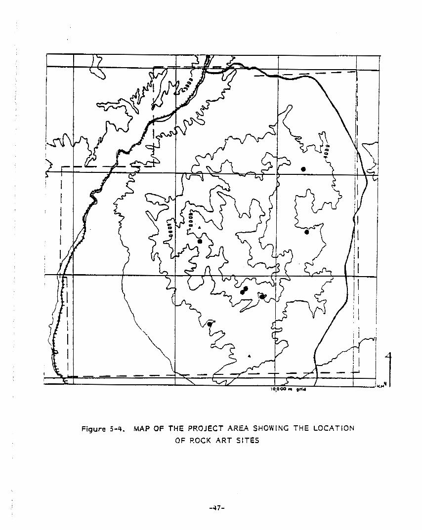
Figure 5-4. MAP OF THE PROJECT AREA SHOWING THE LOCATION
OF ROCK A R T SITES
-47-

E 0
rr)
U
0
cu
0
- 0

/ /
5-52. 26LN2418, Hackberry Spring Canyon: b l a c k pic tographs ; rake i s red.
0 l O c m
5-5d. 26LN2561, Whi trnore Mine Road: red pictographs
-49-

-0s-
ul I cn
m
rt 3 'I m
A
0
P,
CL ..
0 - 0
h) 0
w
..

5-59. 26LN2418, Hackberry Spring Canyon: black, r e d and w h i t e p i c tog raphs .
I/ 9
0 IO 20 30cm
5-5h. 26LN2460, Toquop Cave: r e d pictographs.
-51-

I
r- 0
0
I I I
.. L
Q,
u
-52-
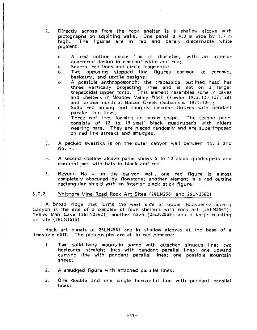
I
2.
3 .
4.
5.
5.7.2
A
Di rec t l y across f rom the r o c k shel ter is a shallow alcove w i t h p ic tographs on adjoining walls. One panel i s 4.3 m wide by 1.7 m high. The f i gu res a r e in r e d a n d bare ly discernable wh i te pigment:
o A r e d out l ine c i rc le 1 m in diameter, w i t h an i n te r i o r qua r te red design in remnant whi te and red;
o Several r e d l ines and c i r c le fragments; o Two opposing stepped l ine f igures common t o ceramic,
basketry, and text i le designs; o A possible anthropornorph; t he trapezoidal out l ined head has
t h ree ver t ica l ly pro ject ing l ines and is set on a l a rge r trapezoidal u p p e r torso. T h i s element resembles Some in caves and shel ters in Meadow Valley Wash (Fowler 1973: 120,127,128) and fa r the r n o r t h a t Balcer Creek (Schaafsma 1971 :104 ) ;
o Solid r e d oblong and rough ly c i r cu la r f i gu res w i t h pendant parallel thin lines;
o Three r e d l ines forming an a r row shape. The second panel consists o f 1 2 to 15 small b lack quadrupeds w i t h r i d e r s wear ing hats. T h e y a re placed randomly and a re superimposed on r e d l ine s t reaks and smudges.
A pecked swastika is on the outer canyon wall between No, 2 and No. 4.
A second shallow alcove panel shows 5 to 10 black quadrupeds a n d mounted men w i t h hats in b lack and red.
Beyond No. 4 on the canyon wall, one r e d f i g u r e is almost completely obscured by flowstone; another element is a r e d out l ine rectangular shield w i t h an i n te r i o r black st ick figure.
Whitmore Mine Road Rock A r t Sites (26LN2561 a n d 26LN2562)
broad r i d g e tha t forms the west side of u p p e r Hackber rv S p r i n g Canyon is the s i te of a complex o f f o u r shel ters w i t h rock a r t (26LN2561), Yellow Man Cave (26LN2562), another cave (26LN2559) a n d a large roast ing pit s i te (26LNl615).
Rock a r t panels a t 26LN2561 are in shallow alcoves a t the base o f a limestone c l i f f . T h e p ic tographs a re a l l in r e d pigment:
1. Two solid-body mountain sheep w i t h attached sinuous line; two hor izontal s t r a i g h t l ines w i t h pendant paral lel lines; one upward c u r v i n g l ine w i t h pendant paral lel lines; one possible mountain sheep;
2. A smudged f i g u r e w i t h attached paral le l lines;
3 . One double a n d one single hor izontal l ine w i t h pendant parallel lines:
-53-

4. Petroglyphs: one bare ly dist inguishable connected c i rc le pat tern; a possible "shield man" consist ing o f three concentr ic c i rc les w i th appendages suggest ing legs, arms, and a horned head.
A heavi ly vegetated col luvial apron is below the rock a r t alcoves. A brown ware sherd scatter in charcoal-stained soil occurs on the surface o f the apron.
Nor th o f t h i s rock a r t site, a steep col luvial slope leads upward to a cave w i th a shallow midden deposit and a surface scatter of flaked stone, Colorado buff ware sherds, g round stone and f iber qu ids (26LN2559).
Yellow Man Cave (26LN2562) is a large cave n o r t h and west , upslope f rom 26LN2561 a n d 26LN1615. The cave contains a shallow midden deposit in the rear behind a rock al ignment o f roof fall boulders. Pictographs are placed on a wall section a t the rear o f t he cave and on a second section toward the front.
The "Yellow Man" element is a sol id yellow painted trapezoidal body w i th sho r t arms and legs pro ject ing a t right angles from the base and shoulders. The horned head is also a trapezoid shape. This element is superimposed over a la rger ind is t inct b lack pictograph. Below this are several d a r k r e d smudges and a black f i gu re which is possibly anthropomorphic, Th i s is the rea r panel.
The f r o n t panel consists o f several small c i rc le and l ine pat terns in da rk orange-yellow and reddish brown, F ive tabular stone fragments on the floor below these f igures are caked wi th pigment o f the same color as t h e pictographs. The yellow color matches a rock layer exposed in t he rear cave wall. On th is panel is a penci l led legend '34 Death Valley C u r l y Beat ty Nev." Th is inscr ip t ion is chisel led on the wall o f the lower cave (26LN2561) . 5.7.3 Lookout Shelter (26LN2508)
T h i s shel ter is on the southwest shoulder of Mormon Peak, and is a two-chambered cave w i t h low boulder alignments extending from i t s two openings. A white marble stone w i th an incised abst ract design is on t he surface w i th obsidian and cher t f lakes, a corrugated gray ware sherd, a gray cher t biface, an obsidian biface midsection , groundstone, yucca seed, b u r n e d and shattered long bone, and a possible human incisor. Three large roast ing p i t s are on the f loor o f the wash below the shelters.
5.7.4 26LN2611
A sandstone slab w i th an incised abstract design was found in a small solut ion cav i ty in the lower p a r t o f a limestone hogback r idge on the west side of t h e val ley between the Mormon and East Mormon Mountains. The slab is sub-tr iangular in plan, the decorated surface approximately 31 x 2 4 cm. The elements include three simple l ine f igures tha t resemble the Creek le t ters
tau and - chi. Above these is a n out l ine lozenge shape w i th f i ve p i t s E, -
-54-

arranged in horizontal rows of 2 , 1 and 3 respectively. A large 'IX" is c u t across the other f igures.
Tinaja Shel ter (26LN2610) is approximately 45 m (150 ft) from the sandstone slab site and s l igh t ly h igher on the slope. The shel ter floor and apron contain cher t and obsidian flakes, a n obsidian side-notched point fragment and po t te ry sherds inc lud ing Pueblo, Colorado buff ware and Paiute brown ware. Level port ions of the adjacent bedrock ledge contain shallow water catchment basins o r tinajas.
Below these sites on an al luvial terrace are two eroded roast ing p i ts (26LN2612).
5.7.5 Caliche Caves (26LN2550)
The rock a r t is in one o f a a series of f i ve rock shelters in the c u t bank o f South Fork Toquop Wash n o r t h and east o f Horse Spr ing and t h e d iv ide separating it from Hackberry Spr ing. The rock shel ter w i th the painted f igures is the largest o f the three along a ledge in the c u t bank, The f igures are amorphous red pigment blotches on cobbles in the conalomerate tha t forms the shel ter walls. A rocky slope extends down from the shelter to the present wash channel. Dark, charcoal-mixed soil and an ar t i fac t scatter o f ground and f laked stone, a small desert side-notched point, bu rned bone, metal ar t i facts and leather scraps are present in and below the west of the Caliche Caves.
5.7.6 Toquop Cave ( 26 LN 2460 1
Th is s i te is a solution cave in the mountain r idge forming the n o r t h end o f a val ley t r i b u t a r y to South Fork Toquop Wash. Pictoqraphs are situated on an i n te r i o r wall a t the cave entrance. Red pigment used fo r t h e designs appears to be re la t ive ly unfaded. The elements a r e small ind iv idual l ine and c i rc le forms:
1. A n inver ted ha l f c i rc le w i th central dot;
2. A n abstract pa t te rn consist ing of a horizontal l ine w i th three pendant paral lel l ines, two small lines above and a fan shaped g roup of s ix l ines radiating from one end;
3 . A black l ine pa t te rn o f no c lear ly discernable shape.
Toquop Cave also contains obsidian and cher t tools, burnea bane, g round stone ar t i facts and f iber quids.
5.7.7 Obvious Shelter (26LN2591)
Three small and one large rock shelter are situated on a ledge midway up a steep limestone slope. One j o c k a r t panel is located on the east wall of the larger rock shelter. A 1 m area is covered by a random pat te rn o f cr iss-crossing narrow carbon-black lines. The other three shelters lack f la t f loor space and show no evidence of habitat ion o r other human use,
-55-

The shel ters face southeast over a deep val ley t rend ing south towards Mormon Mesa. Several roast ing pit complexes, c u t bank shelters, d ispersed l i th ic scatters and isolated ar t i fac t sites were recorded in the val ley.
5.7.8 Double Double S he1 t e r I26LN 2597)
Th is shel ter is located on the steep slope o f a limestone ridge forming the nor thwest side o f the canyon leading t o Whitmore Mine a t i t s junct ion w i th the west-facing piedmont. Red pigment pictographs occupy a .5 x 1.0 m ( 2 x 4 f t l area on the rear wall o f the la rger o f two adjoining alcoves. Design elements consist o f shor t f inger-width l ines forming small ver t ica l l ine abst ract pat terns and scattered sol id patches o f color. Carbonate seep deposits par t ia l ly obscure the elements.
Double Double Shelter faces south approximately 25 m (8.5 f t ) above a steep talus slope w i th in termixed charcoal stained soil, che r t f lakes and po t te ry sherds inc lud ing Logandale Gray. The si te name der ives from the two adjoining alcoves tha t form the shel ter and the two roast ing p i ts a t t he foot o f t he talus. The midden on the floor o f the shel ter has some depth as shown in a pothole tha t does not expose bedrock to a depth o f approximately 30 cm ( 1 2 in]. Ground stone metates and fragments, flakes, a biface fragment and po t te ry sherds occur on the shelter floor and the ex ter io r apron.
5.7.9 Discussion
Nine rock art sites are now known f o r t he Mormon Mountains. Before th is su rvey the only recorded site was the Hackber ry Spr ing Canyon. It i s noted on the USGS topographic sheet as tlPetrogIyphs,ll and was assigned a Nevada State Museum number in 1982. T h e other sites were not recorded until the present Mormon Mountain Survey.
The presence o f an incised stone and a small portable rock siab wi th pet rog lyphs i s remarkable f o r such a heavi ly t ravel led part of the pro ject area. Th is rock a r t t y p e is common in Southern Nevada (Sant in i 1974) and known a t var ious places throughout the State. Painted and pecked elements on shel ter walls of fer few dist inguishable forms. Recognizable design elements include anthropomorphs, stepped lines, hor izontal l ines w i th pendant ver t ica l lines, concentr ic circles, large and small c i rc le o r grid outlines w i th in te r io r l ines o r sol id pat terns and mountain sheep. These are familiar elements in the pe t rog lyph and pic tograph sites in the Muddy-Vi rg in R iver area. One d is t inct ive character ist ic o f the Mormon Mountain rock a r t is the predominance o f painted over pecked or incised elements.
A l though the nine rock a r t sites are no t spectacular compared to la rger sites in southern Nevada, they are s igni f icant in several respects. Considering the sinall number of recognizable design elements, there are enough diagnositc elements to t race af f in i t ies w i th o ther rock art sites, to
-56-

establ ish a re la t ive chronology and to permit speculation about the purpose of rock a r t in southern Nevada.
The I1Yellow Man" is an especially d is t inc t i ve form, occur r ing a5 a petroglyph on the piedmont of the V i rg in Mountains a t Valley o f F i re and in Ar row Canyon. Painted tr iangular-bodied anthropornorphs appear in Meadow Valley Wash, as noted above. The mountain sheep motif, which is of ten i n fe r red to represent big-game hunting magic, appears a t on ly one si te (26LN2561) in the Mormon Mountains, a mountain sheep habi tat . The horse-and-rider pictographs suggest tha t rock a r t product ion cont inued in to h is tor ic Paiute times in southern Nevada. A panel similar to those a t the Hackber ry Spr ing Canyon si te is repeated in the Red Rocks o f the southern Spr ing Mountains. These men-with-hats, e i ther mounted o r standing alone, singly and in groups, appear in bo th pictographs and petroglyphs in the Muddy Mountains, Meadow Valley Wash and southern Spr ing Mountains (Green 1982). Mormon Mountain rock a r t appears to have af f in i t ies w i th sites to the n o r t h and east as well as to the south and southwest.
A loosely def ined chronology i s indicated by the Puebloan sty le and the h is tor ic design motifs in conjunct ion w i th field-classified ceramics, Dates from approximately A.D. 700 in to the nineteenth cen tu ry are indicated by a ceramic t y p e sequence from the ear ly Logandale Gray ware th rough Paiute Brown ware.
Final ly, the Mormon Mountain rock a r t , l ike tha t in much o f southern Nevada, is characterized by s ty l i s t i c d ivers i ty and by i t s occurrence near other cu l tu ra l features such as occupied caves, a r t i fac t scatters and roast ing p i ts . Since the publ icat ion o f Heizer and Baumhoff's major work on rock a r t , most studies have sought to show the re lat ionship o f rock a r t to big game hunting (Thomas 1976; Nissen 19821,
Far southern Nevada, the association o f rock a r t w i th habitat ion a n d food processing sites may place it w i th in the la rger context of subsistence procurement systems involv ing the full range o f resources available in mountainous ter ra in ,
5.8 OTHER PREHISTORIC SITE TYPES I N THE MORMON MOUNTAINS
Other s i te types in the Mormon Mountains include shelters, a r t i fac t scatters, isolated ar t i facts o r features, and rock alignment sites. These site types were b r ie f l y def ined above and the i r d is t r ibu t ion in the project area has also been discussed. Here it i s appropr iate to summarize s i te information f rom the pro ject records to permi t a general evaluation o f the i r signif icance and potential for f u t u r e s tudy.
Shelters and caves w i t h smoke-blackened in ter iors , charcoal, ash, bone, f i re-cracked rocks and ar t i facts o r w i th a t least one o f these indicators o f human use, are present in the mountains, where they usual ly occur in limestone cliffs. They are also present on the piedmont associated w i th rock outcrops o r in conglomerate beds exposed in the deep, s t ra igh t cut-banks Gf some washes. An even la rger number o f caves and shallow alcoves tha t a re present exh ib i t no evidence o f human use. Many o f these, as well as many o f
-57-
the apparent ly used o r occupied features contain modern o r fossil Neotoma middens. Where observed, t he presence o f these middens was r e c o r m p ro jec t maps
T h e association o f r o c k a r t and, in some cases, roast ing p i t s w i t h caves or shel ters has been discussed above.
A r t i f a c t scatters and isolated a r t i f ac ts o r features are present in al l p a r t s o f t h e pro ject area, but t h e y occur less f requen t l y than in some p a r t s o f t he Crept Basin. 9 genera l ly low a r t i f a c t dens i t y characterizes scatters ( f rom l / m to 1/100m o r more). Within scatters, a r t i f ac ts are unevenly d i s t r i b u t e d w i t h c lusters o f a r t i f ac ts present in areas of very low densi ty . Isolated a r t i f ac ts tend to be f laked stone implements. Project i le po ints are re la t ive ly r a r e in the pro ject area compared to o the rs in the Co-Principal Invest igator 's experience. No quan t i t a t i ve data have been marshalled t o suppor t t h i s i n t u i t i v e assessment, however. Ceramics a re associated w i t h some of the scatters. One o r more a r t i f ac ts a r e present a t some roast ing pit o r shel ter si tes and t h e y resemble the scatter o r isolated find si te types in respect t o ar t i fact dens i t y a n d in t ra-s i te d i s t r i bu t i on ,
Inc luded among isolated a r t i f ac ts o r features a re several al ignments of rocks. Some o f these a re small c i r cu la r al ignments less than 1.5 rn in diameter, most o f which are associated w i t h charcoal o r ash mixed soil. One stone-lined pit approximately 1 m in diameter was also recorded. Examples of t h i s rock al ignment t y p e a r e apparent ly associated w i t h roast ing pit sites. O the r isolated r o c k features in the mountains a re two l inear pi les o f rocks tentat ive ly ident i f ied in the f ie ld as possible hunting bl inds.
A d i s t i nc t i ve rock al ignment s i te t ype , found t h u s far on l y in the Meadow Valley Wash st ra tum in t h i s pro ject area, i s a l inear arrangement of cobbles o r small boulders in the deser t pavement on terraces over looking t he Wash f loor. Some o f t h e Meadow Valley Wash al ignments are more o r less closed circ les o r rectangles o f var ious sizes. Flaked stone and occasionally g r o u n d o r pecked stone ar t i facts a re present in and near several of the rock alignment sites. No temporal ly diagnost ic a r t i f ac ts were found near the features.
5.9 CHRONOLOGY
The presence o f temporal ly diagnostic ar t i facts a t some of t h e Mormon Mountain p reh is to r i c si tes permit l imited inferences about chronology. The ear l iest po in t t y p e i s t he Pinto ( f i e l d classif ied) a t one site, followed by Elko series po ints a t two sites ( i nc lud ing a prev ious ly recorded roast ing pit s i te) , Small t r i angu la r corner-notched o r stemmed points were field-classified as Rose S p r i n g a n d / o r Eastgate points and probably represent regional var iants o f the t y p e subsumed u n d e r the name Rosegate by Thomas (1981) . Small t r i angu la r s t r a i g h t o r concave based points were f ield-classified as Cottonwood T r i a n g u l a r a n d small side-notched points as Desert Side-Notched. Ceramic types examined in the f ie ld o r among the small col lect ion made inc lude several Puebloan g r a y wares (Tusayan, Shinarurnp, Moapa a n d Logandale) and Southern Paiute o r Shoshonean ceramics. A time frame encompassing Basketmaker I l l t h r o u g h Pueblo 1 1 , and late prehis tor ic possibly i n to ear ly
-58-

post-contact per iods is indicated. Ceramic data indicate tha t many sites are multi-component (personal communication , Pat Olson , Lost C i t y Museum)
Assuming a general re lat ionship between the frequency of time-markers observed during the Class II su rvey and the in tens i ty o f land-use th rough time, it would appear tha t most use took place a f te r A.D. 500. the presence of a re la t ive ly high frequency of Puebloan s ty le rock a r t elements discussed by Green (above) a f te r Heizer and Baumhoff (1962) is also consistent w i th th is inference.
If the re la t ive f requency of project i le po ints t o other food-procurement o r food-processing-related ar t i facts or features can be assumed to indicate the re la t ive importance o f hunting, it would appear t h a t gather ing o r foraging were more frequent ly-occurr ing act iv i t ies prehistor ical ly in the Mormon Mountains.
Nei ther o f the above assumptions has been suppor ted by regional research. Lacking any specific confirmation, they are appropr iate hypotheses tha t might be tested by archaeological research in the project area. Shelters and roast ing p i t s may be expected to y ie ld addit ional chronological information. Other invest igators have found few project i le points during excavation and surface survey (Green, personal communication: El l is e t al. 1982:75). Faunal a n d perhaps p lant food remains could be recovered during excavation of middens in and below shelters and associated w i th roast ing p i ts . Appropr ia te f ield study could permi t a more rel iable inference about the re la t ive in tens i ty o f land-use in the area th rough time and the re la t ive importance o f hunting to gather ing p lants or foraging for small animals.
5.10 HISTORIC SITES I N THE MORMON MOUNTAINS
His tor ic sites in the Mormon Mountains pro ject area are present near roads, the rai lroad, spr ings a n d mining claims. Represented are features and ar t i facts tha t indicate temporary habitat ion ( ten t platforms, food o r food-container remains), mining o r prospect ing (machine o r hand excavations, o re samples, claim posts, mining tools such as p icks) , hunting (shotgun shel ls), stock-rais ing (water tanks, corrals) and transportat ion ( ra i l road dumps w i th Union Pacific crockery, large food containers, s t ruc tu res inc lud ing fences near the rai lroad, and sections o f the ear ly San Pedro, Los Angeles, and Salt Lake Railroad bed w i t h associated debr is ) .
Seven mining-related sites were recorded during the Class II survey , Most important are the Whitmore Mine and the Paint Mine. Others are a vermicul i te prospect and other small claims and prospects.
The Whitmore Mine is a go ld mine n o r t h of Wiregrass Spr ing in the centra l por t ion o f the range west o f i t s crest. L i t t le information is present ly available. It may have been part o f the holdings of B r i g W. Whitmore, an Overton resident w i th mining interests. Whitmore was pres ident of a mining company in the Gold Butte mining d i s t r i c t during the ear ly 1900's (Las Ve as Age:January 17, 1906:4, col. 4; January 19, 1907:3, col. 3; A p r i l 10 -75 1 09:l
-59-
cols. 5 and 6 ) . Whitmore's connection w i th the mine in the Mormon Mountains, if any, i s unknown to the authors o f th is repor t .
A round and below the mapped si te o f the Whitmore Mine is a large discontinuous scatter o f t rash inc lud ing objects da t ing f rom around the2 turn of the cen tu ry until the present. In th is area o f approximately 2 km are several t en t platforms, hand and rnachine-dug prospects, adits, a road network, mine tai l ings, etc. Three loci contain pu rp le glass, bott les w i th tool-applied l ips, hole-in-top cans and apparent ly on ly round nails, ind icat ing use of those areas between around 1900 and 1918. Other ten t platforms and t rash scatters demonstrate a more o r less regu la r but i n te rmi t ten t use of the mine fo r several decades. B y 1945, when the World War I1 mining boom began to slack in Lincoln County (Roske and Planzo n . d . : 2 2 ) the pr inc ip le land-use was probably recreational.
The Paint Mine is on the s i te o f a prehis tor ic q u a r r y where bath ochre and knappable stone were obtained. No temporal ly diagnostic ar t i facts were observed associated w i th the remains o f the prehis tor ic i ndus t r y . Ext ract ion o f t he jasper fo r pa int apparent ly began sometime before 1922, evidenced by the presence of hole-in-top cans. One ten t platform, t rash scatter is c lear ly post-1922 th rough the ear ly 1940's. Beginning in the late 1920's ore was hauled by t r u c k t o Carp fo r ra i l shipment to Salt Lake C i t y where it was used fo r pa int by a roof ing company (Roske and Planzo n.d. 1.
As Munoz comments in Appendix 1 1 , mining is today of l i t t l e consequence in t h e area. No evidence was found o f substantial mining ac t iv i t y af ter t he 1940's, al though claims have been establ ished as recent ly as 1981 near the Carp-Elgin road. Mineral product ion was never g rea t enough to a t t rac t large numbers of miners o r cause them t o establ ish permanent settlements. Instead, mining camps were apparent ly bo th small and short- l ived, Archaeologically, these sites have much the same k inds o f information to of fer as small a r t i fac t scatters. They are s ingle component and usual ly s ingle purpose sites. Unl ike the i r prehis tor ic counterpar t , the ephemeral mining sites can usual ly be dated w i th some precision, estimates made of household size and composition, and ac t iv i t y areas delineated (cf. Reno n.d.).
5.11 OTHER RECENT ARCHAEOLOGICAL STUDIES IN SOUTHERN NEVADA
Several recent archaeological studies have been re fe r red to above in connection w i th roast ing pit sites and rock art (e.g., Brooks et ai. 1975; El l is e t al. 1982a and 1982b). Another recent study is par t i cu la r ly germane to the Mormon Mountain Class II Survey. Th is is the survey in tha t p a r t of the ove r th rus t , be l t w i th in the V i r g i n Valley Planning Un i t repor ted by Berg in and others (1980). The sampling design developed for the Mormon Mountain project was designed to be comparable insofar as def in i t ion o f strata and size of quadrats a r e concerned. Th is was to permit comparison of resul ts, a goal on ly p a r t l y realized, however, no t because of differences in method, but because of dif ferences in the two s tudy areas and the way they were selected.
-60-

In the Mormon Mountains, t he en t i re range w i th in Lincoln County was selected f o r su rvey . For t h e other study a series o f t racts , most o f them Townships, were selected f o r study. T h r e e of these t rac ts surveyed are in the west and southwest par ts o f the Muddy Mountains w i t h te r ra in similar to the Mormon Mountain s t u d y area. Comparison o f resul ts therefore must focus on these por t ions of the o v e r t h r u s t belt su rvey . Certain differences between t h e archaeological d i s t r i b u t i o n in t h e Mormon and Muddy Mountains a r e apparent. It is clear t h a t t he Mormon Mountain piedmonts e x h i b i t a markedly g rea te r s i te dens i t y and va r iab i l i t y t han the similar t e r r a i n sampled in the Muddy Mountains. Be rg in l e t ai . 1980:Table V, V I I ) repo r t s the record ing of on ly t h r e e a r t i f a c t scatters and t e n isolated specimens in s i x randomly selected 160-acre t racts, compared to o u r finding t h a t t he same si te types occur on bo th piedmont and mountain strata
In contrast , mountainous t e r r a i n in the t w o s t u d y areas i s similar as to s i te densi ty, but not as t o t h e types of sites present. Random and i n t u i t i v e sample u n i t s in the Muddy Mountains (42 un i ts , each 160 acres) y ie lded 50 sites compared to 50 randomly selected 160-acre u n i t s in the Mormon Mountains which yielded 78 sites. The si te per acre densi ty i s thus near ly t h e same. It should be noted, however, t ha t by inc lud ing i n tu i t i ve l y w i t h randomly selected u n i t s in t h e Muddy Mountain data we a re biasing the data in favor o f a h ighe r s i te densi ty than may be representat ive of the Muddy Mountains as a whole. T h e predominant s i te type in t h e Mormon Mountains (open roast ing pit s i tes) i s apparent ly absent, however, in the two randomly surveyed Muddy Mountain t rac ts (Areas 1 a n d 3 , B e r g i n e t ai. 19801, where a r t i f ac t scatters and rock shel ters are the major s i te types. Open rock a r t si tes are present in the su rveyed portions o f t h e Muddy Mountains, but in t h e Mormon Mountains, rock a r t i s s t rong ly associated w i t h shel ter in ter iors , some o f which have no o the r surface indicat ions o f human use.
These resul ts should be t reated w i t h caution, however, because as noted above we a re comparing a s t ra t i f i ed sample o f one whole range w i t h a s t ra t i f ied random sample o f two t rac ts in one p a r t o f t he o the r range. We cannot te l l whether apparent di f ferences between the Mormon Mountains and those portions o f the Muddy Mountains sampled a r e a t t r i bu tab le to "real1' dif ferences o r to bias in t roduced by the l imi t ing o f t he s t ra t i f i ed sample t o t h e n o r t h e r n p a r t o f the Muddy Mountains. In fact, the presence o f roast ing p i t sites in another Muddy Mountaid! t r a c t sampled i n t u i t i v e l y s t rong ly suggests t h a t t h i s may be the case. T h e p r imary value o f the Mormon Mountain s t u d y in relat ion to the Muddy Mountain s t u d y is t ha t the two projects focus on d i f ferent t e r r a i n types and therefore complement each o the r as comparable samples of a wider range o f southern Nevada topographic zones.
A subsequent repo r t , in fact, (E l l is et ai. 1982a) repo r t s a roast ing pit a t q
one si te in Area 1 (26C1481).
-61-

5.12 SUMMARY AND DISCUSSION
T h e archaeological survey o f an 8 percent s t ra t i f i ed random sample of t he Mormon Mountains resul ted in an addi t ion of 215 sites t o the o r ig ina l meager s i te i n v e n t o r y o f t h a t area. Moreover, t he s i t e i n v e n t o r y now includes addi t ional s i te types, co r rec t i ng the bias o f pre-1983 i n v e n t o r y data A 2 percent i n t u i t i v e sample of t he Mormon Mountains permi t ted the explorat ion of ce r ta in areas of expected high site dens i t y n o t adequately sampled by random un i t s , f o r example the Meadow Valley Wash. The main bene f i t of t h e i n t u i t i v e sample, however, was t h e augmentation of t he i n v e n t o r y of cer ta in s ign i f icant s i te types. T h a t is, t he i n t u i t i v e s u r v e y sought t o find addi t ional r o c k shel ters and roast ing p i t si tes instead of adding t o the i n v e n t o r y o f isolated specimens a n d small l i t h i c scatters. Final ly, in the i n t u i t i v e sample it was possible to seek more examples o f ce r ta in r a r e s i te types, speci f ical ly rock a r t and the Meadow Valley Wash rock a1 ignmen ts.
T h e success of t he i n t u i t i v e sample i s shown by a si te dens i t y over 2 . 5 times t h a t of t he random sample o r a l l sites. A much g rea te r representat ion of r a r e sites ( f o u r t o f i v e times as many) and a h i g h e r r a t i o of roast ing pit a n d shel ter si tes to isolated a r t i f ac ts and small a r t i f ac t scat ters in the i n t u i t i v e sample than in the random sample indicate tha t major goals o f the i n t u i t i v e sample were met.
Si te d i s t r i b u t i o n and, pa r t i cu la r l y , s i te densi ty in the mountains and piedmonts were addressed by u s i n g the randomly selected quadra ts as t h e analyt ic unit instead o f u s i n g sites themselves. T h i s analysis fai led t o conf i rm an apparent d i f ference in si te type d i s t r i b u t i o n between mountains a n d piedmonts. T h a t is, 160-acre quadra ts w i t h var ious s i te types ( roas t i ng p i ts , shelters, a r t i f ac t scatters o r h is tor ica l si tes) occur in the same re la t ive f requency in the mountains as in the piedmonts. T h i s is in sp i te of t he manifest ly g rea te r f requency o f roast ing pit sites a n d shel ters compared to isolated specimen and a r t i f a c t scatter sites in the mountains than occurs in the piedmonts ( c f . Table 5.2 above). A comparison of u n i t s according to the number o f sites present in each unit, however, showed a signi f icant ly greater si te dens i t y in mountain than piedmont sample un i t s .
In the mountains, quadrats w i t h sites were found to c luster w i t h i n 3 k m o f sp r ings and on the same side of major d iv ides as the spr ings. Quadrats wi thout sites a r e f a r t h e r f rom s p r i n g s and /o r across major div ides, Sample u n i t s w i t h sites a re along major washes, pa r t i cu la r l y in piedmont s t ra ta where sites were seldom found elsewhere. Final ly, re la t ive ly few sites were found in the no r thwes t po r t i on of t he pro ject area except for immediately along the Meadow Valley Wash ( w i t h i n 400 m or 1,320 ft of the present channel) . In contrast , s i te densi ty in the mountains i s re ia t ive ly high w i th in a 3 km (1.86 m) rad ius o f sp r ings except across major d iv ides from the spr ings. Moreover, margins o f ephemeral spr ing- fed washes have a s i te densi ty mare comparable to the Meadow Valley Wash area than to o the r topographic s i tuat ions in the pro ject area.
The most f requen t l y o c c u r r i n g s i te t y p e in the study area i s the roast ing pit site. T h e co-occurrence o f roast ing p i t s and shel ters is a
-62-

i : I
s ign i f icant finding, pa r t i cu la r l y for major steep-sided drainages low in the piedmonts where roast ing p i t s occur re la t ive ly f a r f rom agave habitats. Also o f i n te res t i s t h e presence of a d i s t i nc t i ve a r t i f a c t type (poss ib ly a food-processing anv i l ) , f lat r o c k slabs t h a t e x h i b i t scars o f bat ter ing. Final ly, t he finding t h a t some roast ing pit sites may have been in use a f t e r White contact confirms t h a t ethnographic accounts o f t h i s s i te type in o the r areas a p p l y t o the Mormon Mountains and, probably , ne ighbor ing areas as well.
The small i n v e n t o r y o f shel ters may b e most valuable for t he i r preservat ion o f paleocological information. They may, however, yield informat ion about the use of associated roast ing p i t s as well. Rock alignments such as those in the Meadow Valley Wash are poor ly understood and informat ion i s u r g e n t l y needed before t h e i r signif icance can be adequately assessed.
The rock art i nven to ry is small, but the complexi ty of the Mormon Mountain rock a r t , i t s apparent persistence i n t o re la t ive ly recent times and i t s associations w i t h habi tat ion as wel l as plant-processing areas pose problems tha t may gu ide important new regional research.
Final ly, in the area where temporary seasonal resource exploi tat ion has been the on ly apparent human land-use ever , h is tor ic si tes o f f e r t he poss ib i l i ty to learn about such ephemeral pa t te rns in the con tex t o f sites that 1 ) can be precisely dated, 2 ) can p rov ide detai led archaeological information about the number and gender of si te occupants, and 3 ) can in form us about t h e l eng th a n d purpose of occupants' sojourn in the mountains.
As mentioned above, no fully comparable s u r v e y has been repor ted f o r mountains in southern Nevada. Data from several recent studies per ta in , however, to the evaluation o f roast ing pit and rock a r t sites and one has yielded re levant s i te d i s t r i b u t i o n data. The completion of major su rveys conducted in connection w i t h MX s i t i ng o r m i l i t a ry operations on the Nevada Test Site wi l l s ign i f icant ly augment the available s i te d i s t r i bu t i on data base. Together these pro jects w i t h the one repo r ted h e r e p rov ide a basis fo r in te l l igent c u l t u r a l resource management a n d wil l, we hope, st imulate more and b e t t e r regional archaeological research.
-63-
Section 6
RECOMMENDAT IONS
The sult o f the M rmon Mountain Class I1 survey r e the basi recommendations fo r cu l tu ra l resource management pol icy making
fa r and
implementation. Essential ly these recommendations seek to gu ide t h e Bureau o f Land Management in making four basic decisions about the cultural resources in the Mormon Mountains:
1 Which sites to save; 2. Which sites to excavate o r collect; 3 . Which sites to sacri f ice if necessary; and 4. What mit igat ing actions should be under taken when s ign i f icant sites
a re threatened.
6 .1 WHICH SITES TO SAVE AND WHICH CAN BE SACRIFICED
T h e quest ion o f which si te to save is one that o f ten confronts cu l tu ra l resource managers when a choice must be made among al ternate locations for some si te-destruct ive land-use. T h e p re fe r red a l ternat ive when cu l tu ra l resources are concerned is one tha t wi l l dest roy no sites, but of ten the choice must be made between al ternate locations tha t wi l l af fect cu l tu ra l resources.
E f fo r ts should be made to save all o f the re la t ive ly ra re , signif icant si te types in the pro ject area. In the Mormon Mountains these site types are :
o Caves or shel ters w i th rock a r t on in te r io r walls; o o Segments of the ear ly rai l road bed w i t h associated s t ruc tu res o r
o Possibly, ear ly s t ruc tu res in Carp, such as the prev ious ly recorded
She1 t e r / roast ing pit complexes;
ar t i fact concentrations; and
school.
Efforts should be made to save a sample o f o ther signif icant, but more f reaucnt lv-occurr inc s i te t w e s . I h ese si te types are:
o Roasting pits; o Caves o r shelters; o A r t i f ac t scatters and isolated ar t i facts and features inc lud ing those
o f the post-White contact period.
-64-

c
It would be no less a loss to the publ ic for a l l examples o f one o f these si te types to be lost than for the loss of t h e more ra re s i te types, It simply i s less l i ke ly to occur and when the choice must be made between one of the ra re and one of the more common sites, there is less r i s k in sacr i f ic ing one o f the lat ter .
6.2 WHICH SITES T O STUDY
One o f the most devastat ing effects on archaeological sites is archaeological research i tsel f . Dest ruct ive archaeological s tudy should be allowed only when the Pr incipal Invest igator can demonstrate tha t adequate suppor t is available for appropr ia te f ie ld work and to c a r r y the pro ject t h rough analysis and repor t ing.
So l i t t l e recent systematic archaeological research has been done in the Mormon Mountains o r in similar t e r ra in that well designed a n d suppor ted research projects should be encouraged a t least until a l l s i te types have been studied. Th is is a high management p r i o r i t y because the resul ts o f such research would prov ide a be t te r basis f o r cu l tu ra l resource management decisions.
The Bureau of Land Management cu l tu ra l resource specialists should establ ish p r io r i t ies far archaeological studies they need in the Mormon Mountains to manaqe the resource most ef fect ively. Hiqh priority studies should b e solicited and g iven such f inancial or other support as feasible w i th in the U is t r i c t ot t ice work proqram.
Several studies are suggested on the basis o f resul ts of the present Class I1
0
0
0
0
0
0
survey :
Compu ter-assisted ana l ys is of specif ic cnvi ronmen t a I v a ria b le5 associated w i th s i te d is t r ibu t ion ;
Sampling and analysis of fossil Neotoma middens in the project area for paleoenvironmental data;
Systematic and complete recording of all known rock a r t sites and f u r t h e r survey in high rock a r t densi ty areas; analysis of pigment samples ;
Addit ional studies of roast ing pit sites o r roasting p i t / she l te r complexes as recommended ear l ier (El l is e t ai. 1982b);
Mapping and s tudy of ear ly rai l road bed remains and associated s t ruc tu res and art i facts, and a sample of the mine/prospect/camp sites;
S tudy ( inc lud ing such excavation as necessary) of one of the rock alignments in Meadow Valley Wash; and
-65-

I
o Mapping and sampling knappable stone sources, such as the oppor tun is t ic quarr ies repor ted here.
How t o evaluate research designs presents problems for land management agencies even when there are archaeologists on s taf f . T h e BLM s ta f f archaeologists are encouraged to seek consultat ion w i t h t he i r colleagues in rev iewing ant iqu i t ies permi t applications, perhaps th rough a n establ ished regional review panel. Cer ta in ly before dest ruct ive research is permit ted in any of the re la t ive ly ra re s i te types, research designs should be careful ly reviewed and the proposing Pr incipal Invest igator should be g iven the benef i t of reviewers' comments.
Final ly, many o f t he sites in the Mormon Mountains are small a n d re la t ive ly f ragi le. Small-scale test excavations, i f not d i rec t l y followed by full excavation, damage and d i s r u p t t he deposits. Test ing of these sites to establ ish the i r signif icance i s not indicated unless they are subject to d i rec t adverse impact and a mit igation program is being planned. Instead, t h e excavation and complete systematic surface collection of a small number o f sites tha t are representat ive o f the known site inventory is p re fe r red . T h e resul ts o f intensive s tudy o f a few sites should be evaluated before more sites a re committed to dest ruct ion by archaeological resezrch. Invest igat ion o f a sample o f the single component minina-related sites o r localit ies could cont r ibu te t o our understanding of prehis tor ic , as wel l as, h is tor ic resource procurement strategies in marginal areas ( a f t e r Reno n.d.). In o rde r for cu l tu ra l resource managers to make appropr ia te decisions about which sites t o save and which to sacri f ice and how best to p lan for mit igation, e f fo r t s should be d i rected now towards encouraging and assist ing research o f the kind descr ibed here.
6 . 3 MITIGATION OF ADVERSE EFFECTS ON ARCHAE0LOCICA.L SITES I N THE MORMON MOUNTAINS
Data collection from sites subject to adverse effects has been the favored mit igat ing activity and wi l l probably remain so. When a s i te is expected to be p a r t l y o r completely destroyed there is l i t t l e just i f icat ion fo r fa i l ing to collect as much information as feasible before the dest ruct ion takes place. N o r is the excavation o f sites tha t are safe from dest ruct ion usual ly desirable. The publ ic in terests a re not necessari ly served best, however, by data collection a t sites under immediate th rea t o f destruct ien. Work a t such sites must o f ten be hast i ly planned and executed,
In such cases a v iable a l ternat ive might be to channel a por t ion of the resources available fo r mit igation to suppor t research a t sites similar to the types impacted by the threatening land-use. A f t e r evaluation o f the impacted sites, mi t igat ing data collection might then be d i rected towards a more carefu l ly conceived, long-range s tudy o f similar si te types in the area.
Before such a mit igat ion plan i s undertaken, it should be subject to careful peer review, and conf l ic ts w i th present conservation goals should be resolved. Moreover, such a mit igation program should be under taken on ly in cases where suf f ic ient time and resources are no t available for well designed and supported s tudy o f the impacted sites.
-66-

REFERENCES CITED
Bergin, K. e t ai. 1980 A Strat i f ied Random Sampling Cul tura l Resource
Port ion of the Over th rus t Bel t Located in the V i r g i n Clark County, Nevada. Archaeological Research Natural His tory , Un ivers i ty o f Nevada, Las Vegas.
Bet t inuer , R. L.
Inventory Within tha t Valley Planning Uni t , Center, Museum of
1981- Sampling and Statist ical Inference in Owens Valley. American An t iqu i t y 46(3) :656-660.
Bradley, W.G. and J .E . Deacon 1967 The Biot ic Communities of Southern Nevada. Nevada State Museum
Anthropoloqical Papers 13 : 201 - 2 9 5 .
Brooks, R.H. 1982 A Food Processing Site Type in Southern Nevada. In An
Archaeological Element fo r the Nevada Histor ic Preservation Plan, N e v a x D iv is ion o f Histor ic Preservation and Archaeology.
Brooks, R.H., D.O. Larson e t ai. 1975 Prehistor ic and Histor ic Research Along the Navajo-McCullough Trans-
mission Line Right-of-way, for the Los Angales Water and Power Company, in Clark and Lincoln Counties, Nevada. Nevada Archaeological Survey, Un ivers i ty of Nevada, Las Vegas.
Coombs, Gary B. 1979 The Archaeology of the Western Mojave. Bureau o f Land Management
Cul tura l Resource Publication. Riverside, Cali tornia.
Dynacornp , 1 nc. 1982 Basic Statist ical Subroutines.
Ell is, R.R. e t ai. 1982a Test Excavations a t the Happy Face Site 26CK1481 (CR-Nv-05-634)
and the Barbecue Site 26CK1482 (CR-Nv-05-635), Hidden Valley Within the Muddy Mountains, C la rk County, Nevada. Archaeological Research Center, Museum of Natural His tory , Un ivers i ty o f Nevada, Las Vegas.
1982b A Cul tura l Resources Survey and Limited Test Excavations in t he Vicini t ies o f Quail Point, Bunkerv i l le Ridge and Hackberry Spr ing, V i rg in and Mormon Mountains, Southern Nevada. Archaeological Research Center, Museum of Natural His tory , Un ivers i ty o f Nevada, Las Vegas.
-67-

Fowler, D.D., ed i tor 1973 The Archaeology o f Etna Cave, Lincoln County, Nevada. Desert
Research Ins t i t u te Publications in the Social Sciences 7.
Green, E. 1982 Rock A r t . In Ell is e t a l . 1982a:84-101.
Hall, M.C. 1981 Land-use Changes in Owens Valley Prehis tory : A Matter of Statist ical
Inference. American An t iqu i t y 46 ( 3 ) : 648-656,
Hart . J. 1981 Hik ing the Great Basin: The High Desert Count ry of California,
Oregon, Nevada and Utah. Sierra Club Books, San F-rancisco.
Heizer, R.F. and M.A. Baurnhoff 1962 Prehistor ic Rock A r t o f Nevada and Eastern Cali fornia. Un ivers i ty of
Calirornia Press, Berkeley.
Hoover, D.L., W.C. Swadley and A.J. Gordon 1981 Correlat ion Character ist ics o f Surf icial Deposits w i th a Descr ipt ion of
Surf ic ia l S t ra t ig raphy in the Nevada Test Site Region. U .S. Geological Survey Open-File Report 81-512.
McLane, A.R. 1976 Mormon Mountains, Nevada: A Potential for Pr imit ive Preservation.
Prepared fo r Charles S. Watson, J r . Nevada Outdoor Recreation Association, Carson Ci ty ,
McQuivey, R. P. 1978 The Desert Bighorn Sheep o f Nevada. Nevada CIepartment o f Wildlife
Bioloaical Bulletin 6.
Nevada Divis ion o f Histor ic Preservation and Archaeology 1982 A n Archaeological Element for the Nevada Histor ic Preservation Plan,
coordinated by Margaret M Lyneis.
Nevada Divis ion o f Water Resources 1972 Average Annual Precipitat ion. State Map S-3. Department o f
Conservation and Natura l Resources Reno, Nevada.
Nissen, K.M. 1982 Images from t h e Past: An Analysis o f S ix Western Great Basin
Petrog lyph Sites. Unpubl ished Ph. D. dissertat ion, Un ivers i ty of California, Berkeley.
-68-

Reno, R. n.d. Temporary Camps and His tor ic Archaeology. Paper presented a t the
1982 Great Basin Anthropological Conference.
Roske, Ralph J. and Marta Planzo n.d. A n Overview o f the H is to ry of Lincoln County. Typescr ip t .
Santini, J . D. 1974 A Prel iminarv Report on the Analysis of Incised Stone from Southern
Nevada. Nevada Archaeologist 2 ( 1 1 : 4-1 5 . Nevada Archaeological Association , Carson Ci ty , Nevada.
Schaafsma, P. 1971 The Rock A r t o f Utah. Papers o f the Peabady Museum of
Archaeoloqy and Ethnology 65 Cambridge, Mass.
Siegel, S.
Thomas, D.H.
1956 Nonparametric Stat ist ics for the Nehavioral Sciences. iMcGraw-Hill.
1981 How to Classify the Projecti le Points from Monitor Valley, Nevada. Journal o f Cali fornia and Great Basin Anthropology 3 ( 1 ) : 7-43,
Thomas, D.H. and R.L. Bet t inger 1976 Prehistor ic Pinon Ecotone Settlements of the Upper Reese R iver
Valley, Central Nevada. American Museum of Natural H is to ry Anthropological Papers 531 3 ) .
Thomas, T. 1976 Petrog lyph D is t r ibu t ion and the Hunt ing Hypothesis in the Central
Great Basin. Tebiwa 18(2) :65-74.
Tschanz, C.M. and E.H. Pampeyan 1970 Geology and Mineral Deposits o f Lincoln County, Nevada. Nevada
Bureau o f Mines and Geoloav Bul le t in 7 3 .
-69-

Appendix 1
CONSULTATION WITH NATIVE AMERICANS OF THE
MORMON MOUNTAIN REGION

Appendix I
CONSULTATION WITH NATIVE AMERICANS OF THE MORMON MOUNTAIN REGION
J
The Nat ive Americans o f Moapa Reservation and o f the Las Vegas Colony were contacted as pa r t of the Class I1 Mormon Mountains survey , the former by telephone, let ter , and in person, the la t ter by telephone and in person.
On November 11, 1982, Co-Principal Invest igator Rusco and Ethnohistorian Johnson met w i th B i l l y Frye, chairperson of the Las Vegas Colony's Tribal Council, to discuss the archaeological survey . Chairperson F r y e expressed in terest in the survey and mentioned several t r i ba l members who might be wi l l ing to assist the staff. Chairperson F rye observed tha t ar t i facts had been found on the colony and tha t Southern Paiute rel igious sites were being obl i terated in the Las Vegas area. Fu r the r attempts to meet w i th T r iba l Chairperson F r y e of the Las Vegas Colony were fut i le, a l though telephone calls and appointments .were made. Attempts to locate a Colony member who al legedly has old photographs o f the Mormon Mountain area were also futi le.
On November 12, 1982, Co-Principal Invest igators Rusco and Munoz and Ethnohistor ian Johnson met w i th Preston Tom, Moapa T r iba l Chairperson. The archaeological survey was described t o him, and he agreed to discuss it wi th the other t r i ba l members a t the next t r iba l meeting. He agreed to forward any concerns about the su rvey area (sacred sites, unique natura l resources, etc.) to the Bureau o f Land Management th rough the Co-Principal Invest igators, in care o f the Nevada State Museum, Las Vegas; none has been received to date ( 3 / 25 / 83 ) ,
Reservation elder Herbe r t Meyers was consulted about h i s knowledge of the resources o f t he Mormon Mountains. He described a cave on the east side of the mountains in which moccasin soles ( la ter identi f ied as the remains of Basketmaker II sandals) had been found, descr ib ing the cave as Ita place where Ind ian people leave things." Meyers agreed w i th Johnson tha t the caves may have been used fo r rel ig ious act iv i t ies by Ind ian doctors, whom he called "wi tch doctors." Meyers spoke also of Indian t ra i ls which narrow gradually as the elevation increases and down which mountain sheep might bound, knock ing a person on the t ra i l in to the chasm below. He stated that there are remains of several such bodies, impossible to re t r ieve from e i ther above or below. Final ly, he mentioned the existence of spr ings in the Mormon Mountains.
Meyers accompanied Rusco, M U ~ O Z , and Johnson to the Mormon Mountains November 14, 1982. He denied knowledge o f Paiute names for topographic features, stat ing tha t those who did know such terms were deceased. He gave the same response to questions about legends connected w i th the area.
-71 -
He pointed ou t the locations of spr ings accurately, told the best routes by which to reach the tops of peaks, ident i f ied mountain sheep t racks, and shared some o f h i s botanical knowledge, adding tha t elders had warned him not to d ivu lge the medicinal use o f par t i cu la r p lants to non-Indians.
The lack o f in-depth response on the p a r t of the Moapa Reservation and Las Vegas Colony Ind ian people should not be misconstrued as lack of in terest in o r concern for the cu l tu ra l resources o f the Mormon Mountains. Contacts w i th the Southern Paiute were l imited by several const ra in ts (t ime, informant resistance, busy schedule of the Nat ive American consultants), and addit ional contacts would sure ly e l ic i t specific concerns. It is ant ic ipated tha t t he i r primary concerns are w i t h water resources (par t i cu la r ly t ha t of Meadow Valley Wash which s k i r t s the Mormon Mountains on the west) , sacred sites such as bur ia l grounds, and p lan t resources (especial ly those used for medicinal purposes).

Appendix II
HISTORIC OVERVIEW OF THE MORMON MOUNTAINS
-73-

Appendix II
HISTORIC OVERVIEW OF THE MORMON MOUNTAINS
The abor ig inal inhabi tants o f t he Mormon Mountains area were t h e Southern Paiute o r Nuwuvi. S ix major bands o f these deser t people occupied por t ions o f southern Cal i fornia , southern Nevada, n o r t h e r n Ar izona, and southern Utah. One of t he l a rge r bands-the Moapits-occupied the Mormon Mountains area.
The Moapits and o the r Southern Paiute were p r imar i l y h u n t e r s and qatherers, r e l y i n g on a cycl ical ha rves t o f available p lants and animals for food and materials for shel ter and clothing. Bands of ten joined together for communal hunting and pa r t i cu la r areas and the i r resources were often shared among a n d between groups. Food ga the r ing and hunting were ca r r i ed out in a l l major b io t ic zones, in as environmental ly harmonious a fashion as possible. Some o f the Paiute, among them, the Moapits, pract iced minimal ag r i cu l tu re . Cer ta in na tu ra l phenomena were he ld in g rea te r reverence than others , especially water resources such as sp r ings and r i ve rs . (Fo r addi t ional detai ls on these people, see Kel ly 1934, 1964; Euler 1966; I n te r -T r iba l Counci l o f Nevada 1976; A l ley 1977 . )
Escalante and h i s p a r t y may have been the f i rs t non-Indians t o see the Mormon Mountains (1776) , and Jedediah Smith t h e f i r s t Anglo American to do so (1826 and 1827). Smith's rou te between the Great Salt Lake and Los Angeles has been debated f o r decades (see Fletcher 1929, Merriarn 1923, Morgan 1 9 5 3 ) , but evidence suggests s t rong ly t h a t he came south t h r o u g h Meadow Valley Wash. There he observed "Pa Ulches" wear ing r a b b i t sk in robes and ra is ing corn and pumpkins.
The f i r s t non-Indians to sett le in the Mormon Mountains area were members of t he g r o u p a f t e r whom those mountains were named. A Mormon explorat ion party camped in the n o r t h e r n po r t i on o f Meadow Valley, near a sp r ing , in 1858. The re t h e y built corrals, dug i r r i g a t i o n di tches, plowed several acres, and planted gra in . Br igham Young recal led them to southern Utah, however, and they l e f t the crops in the care o f t he Moapits upon t h e i r r e t u r n t o the Salt Lake area (Roske and Planzo n.d.:3). Permanent Mormon communities were establ ished in t h e 18601s, including Panaca, Eagle Valley and Clover Val ley in the upper p a r t o f Meadow Valley Wash and Moapa, West Point, S t . Joseph and St. Thomas along the Muddy River . Some o f these sett lers made use of t he Mormon land improvements made in 1858 (Roske and Planzo n.d. :6).
Mining in the reg ion j u s t to t h e n o r t h o f Meadow Valley began in the mid 18601s, and t h e 60 miles square Meadow Valley Min ing D i s t r i c t ( la ter cal led Ely) was founded in 1864. It is speculated tha t mining claims were staked by Mormons in an e f f o r t to keep non-Mormons o u t o f the area, a n d ce r ta in l y the
-74-

Mormons came in tending to stay, as they b rough t horses, cattle, sheep, and the i r families w i th them (Roske and Planzo n.d.:5).
Relations between the local Ind ian people and the incurs ive non-Indians were occasionally strained, as were those between the Mormon sett lers and non-Mormon miners. Most o f the conf l ic t between Mormon and non-Mormon occurred some miles d is tan t from the Mormon Mountains, par t i cu la r ly in Pioche to the nor th , and cont inued for many years. Boom towns formed near mining d is t r ic ts , most o f them to be abandoned w i th in a few shor t years.
Communication and t ranspor tat ion in southeastern Nevada improved during the mining boom o f the late 1860's a n d ear ly 1870's. Post off ices were established a t many locations, four in o r near the pro ject area:
Carp. Settlement a t t h i s location began about 1907, and t h e town was f i r s t named Cl i f fdale a f te r the c l i f f s sur round ing it. Postal operations began June 7 , 1921, under the name Cliffdale, wi th t h e name changed to Carp December 1 , 1925. The f i r s t postmaster was also the operator of the UPRR stat ion a t Carp (Car lson 1 9 7 4 : 7 0 ) ,
The post of f ice a t E lg in began service March 3 , 1913. It %%he rai l road stat ion are about a mile south o f the site of the town o f Elgin, which was sett led in 1882 (Carlson 1974:107) .
The Moapa post of f ice was established Ju l y 22, 1889. .%ion 1974:169).
Rox. The post of f ice a t th is settlement was in operation from 1921 m 9 4 9 ( Carlson 1974: 206) .
The San Pedro, Las Vegas and Salt Lake rai l road, p recursor to the Union Pacific l ine th rough Meadow Valley Wash, was completed in January, 1905. Floods plagued the rai l road, washing the t rack out numerous times, and al ternate routes were considered but rejected. A new "High L lne" was constructed, w i th "10 new tunnels, 24 steel bridges, and a complete reconstruct ion of 74 out o f 86 miles o f t rack between Barclay and Cuelph'l (Ruske and Planro n.d.:20). Ten place names w i t h i n the pro ject area are associated w i th the rai lroad:
Carp is bo th a post of f ice and a stat ion on the main l ine o f a n i o n Pacific Railroad, 38 miles south of Caliente. The town of Carp was f i r s t sett led in 1907, a t which time it was named Cl i f fdale a f te r the sur round ing cliffs. Railroad officials named the stat ion Carp a f te r an employee, and the post office adopted tha t name in 1925 (Carlson 1974: 70) .
Cloud. This rai l road siding was abandoned in 1949. It is four *no r th of Carp, and was or ig ina l ly named S t . George. The name was changed to Rappelje in 1920 a f te r an official o f the Union Pacific, and then t o Cloud in 1928 (Car lson 1974:80).
-75-

The town of Elgin was sett led %;resent post off ice (established (Car lson 1974: 1 0 7 ) .
n 1882 about a mile n o r t h of 1913) a n d ra i l r oad stat ion
Fa r r i e r . T h i s stat ion was on t h e old San Pedro, Los Angeles and m k e C i t y Railroad l ine, a t which time i t was called Guelph, a name which 'lcommemorates e i the r a member of a German royal family, or a member o f t h e Guelph family o r pol i t ical p a r t y in medieval I t a l y t t (Car lson 1974: 1 2 9 ) . A f t e r Union Pacific purchased the SPLA and SLRR, t h e name was changed t o F a r r i e r in honor o f a UPRR of f ic ia l (Roske a n d Planzo n.d.:19, Carlson 1974:112) .
Galt. Gal t is a non-agency stat ion located 10 miles south of Carp o n the UPRR (Carlson 1974:117) . - Ho a T h e UPRR s id ing o f Hoya i s approximately 20 miles n o r t h o f &A. Gravel f o r ra i l road const ruct ion and repa i r was mined from the Hoya Pit, about 2 miles n o r t h of t he stat ion in Meadow Valley Wash. T h e mine i s abandoned (Car lson 1 9 7 4 : 1 3 8 ) .
Leith. Le i th i s another non-agency stat ion on the UPRR. It is =miles south o f E lg in in Meadow Valley Wash (Car lson 19743154) .
Moapa. Moapa i s a ra i l road stat ion and a post off ice. It i s approximately 50 miles northeast o f Las Vegas and about 2 miles no r thwes t o f 1-15, in Muddy Valley (Car lson 1974:169) ,
- Rox. Rox, named desc r ip t i ve l y a f ter t he n a t u r e of t h e su r round ings , i s a ra i i road s id ing a n d pumping stat ion 15 miles n o r t h o f Moapa. It was sett led in 1902, a n d a post o f f ice was in operation the re f rom 1921 to 1949 (Car lson 1974:206)
Vigo i s a Union Pacific s id ing s i tuated between Galt and %;. It i s also the name o f a canyon which extends in to Meadow Val ley Wash and a manganese mining d i s t r i c t in the Mormon Mountains (Car lson 1974: 239 ) .
Catt le and sheep ranching developed during t h i s time, and the large s tockya rd a t Caliente held catt le p r i o r to sh ipp ing by r a i l to the Pacif ic Coast, Utah, and "even east as f a r as the middle westt1 (Roske and Planzo n.d.:30) . T h e p r inc ipa l farm crop was hay, a l though o the r crops were also grown. Cotton, for example was grown in the 1870'5, apparent ly successful ly (Banc ro f t 1981 : 273-274). Catt le ranch ing cont inues to be an impor tant i n d u s t r y in the Mormon Mountains area. The effects o f regu la r l y o c c u r r i n g d r o u g h t s ( 1 to 3 years out of e v e r y decade [Roske and Planzo n.d.:251) have been a t least pa r t i a l l y o f fset by such water management techniques as pitting ( forming small basins o r p i t s in the soil t o catch and ho ld r a i n and r u n o f f water) , r a i n t r a p s ( iisloping, s l i g h t l y concave, water- t ight col lect ing area and a closed reservo i r f o r s to r i ng the collected water," and water t r o u g h w i t h automatic f loat va lve (Valent ine 1971 : 418-1 491 ) , and hauled o r p iped water dispensed in t roughs.
-76-
I
Mining has cont inued near the Mormon Mountains area, in cycles o f re la t ive ly high versus low product ion The Mormon Mountains themselves were not p a r t of any mining d i s t r i c t in 1881 (Angel 1881:483). Gold was la ter mined a t the Whitmore Mine and a vermicul i te prospect i s shown on topographic maps. Jasper was mined in the late 1920's a t Paint hline on the n o r t h side of the Mormon Mountains. The ore was t rucked to Carp then shipped by ra i l to a roof ing cornpanv in Salt Lake C i t y (Ave re t t 1963:78 in Planzo 1 9 7 8 ) . Mining today is of l i t t l e o r no consequence in the Mormon Mountains themselves.
REFERENCES CITED
Alley, John 1977 The Las Veqas Paiutes: A Shor t His tory . Las Vegas: Las Vegas
T r i b e ot Paiute Indians.
Angel, Myron, ed. 1881 History of Nevada. Oakland: Thompson and West.
Averet t , Walter R. 1963 Direc tory o f Southern Nevada Place Names. Pr in ted by the author.
1981 H is to ry o f Nevada, 1540-1888. Reno: Un ivers i ty o f Nevada Press Bancrof t , Huber t Howe
(Repr in t o f 1890 edi t ion) .
Carlson, Helen S. 1974 Nevada Place Names: A Geographical Dict ionary. Reno: Un ivers i ty
o f Nevada Press.
Euler, Robert C. 1966 Southern Paiute Ethnohis tory . Un ivers i ty of Utah Anthropological
Papers Number 7 8 . Salt Lake C i ty : Un ivers i ty o t Utah Press.
Fletcher, F. N . 1929 Ear l y Nevada: The Period o f Explorat ion, 1776-1848. Reno:
A. Carl isle & Company.
In te r -Tr iba l Counci l o f Nevada (I. T.C. ) 1976 Nuwuvi : A Southern Paiute His tory . Reno: In te r -Tr iba l Counci l o f
Nevada.
Kel ly, Isabel T. 1934 Southern Paiute Bands. American Anthropologist 36: 548-561.
1964 Southern Paiute Ethnography Un ivers i ty o f Utah Anthropological Papers Number 69. Sal t Lake C i ty : Un ivers i ty o f Utah Press.
-77-

i
Merriarn, C. H a r t 1923 The Route of Jedediah S. Smith in 1827. California Historical Society
Quarterly 2 : 228-236.
Morgan, Dale L. 1953 Jedediah Smith and the Openinq of the West. Indianapolis:
Bobbs-MerriII Company.
Planto, Marta 1978 Bureau o f Land Management Historical Inventory Record: Paint Mine.
Roske, Ralph J . and Marta Planzo n.d. An Overview o f the History o f Lincoln County. Typescript.
Vallentine, John F. 1971 Range Development and Improvements. Provo: Brigham Young
University Press.
-78-