Embed Size (px)
Citation preview

BURSLEDON, HAMBLE-LE-RICE & HOUND Thursday 23 July 2015 Case Officer Andy Grandfield
SITE: Berry Farm, Hamble Lane, Bursledon, Southampton, SO31
8JD Ref. F/15/76582 Received: 29/05/2015 (28/08/2015) APPLICANT: Barratt Homes
PROPOSAL: Construction of 166 dwellings with associated access off
Hamble Lane, parking, landscaping and open space, and highway works at the junction of Portsmouth Road and Hamble Lane following demolition of existing dwelling and former agricultural buildings/workshop.
AMENDMENTS: None
RECOMMENDATION: Subject to (1) receipt and consideration of satisfactory plans securing minor revisions to the layout and elevations, and additional information on mineral extraction, air quality background data and sustainability; and (2) completion of a section 106 agreement to secure improvements to community infrastructure, public art, off-site highway improvements, affordable housing and a travel plan. PERMIT
CONDITIONS AND REASONS: (1) The development hereby permitted shall be implemented in accordance with the following plans numbered: 041.0003.100 REV P6, 101 REV D, 102 Rev D, 103 Rev E, 104, 121 Rev C, 122 RevC, 18-1822, 18-1822-100 Rev F, 18-1822-101, 18-1822-102 Rev A, 18-1822-103 Rev A, 18-1822-104 Rev B, 18-1822-105 Rev A, 18-1822-106 Rev A, 18-1822-107 Rev A, 18-1822-108 Rev A, 18-1822-109, 18-1822-110 Rev A, 18-1822-111 Rev A, 18-1822-GRE-ASH-001-002,003,004 & 005, 18-1822-GRE-BU-001, 003, 18-1822-GRE-CHE-001-, 002, 003, 004 & 005, 18-1822-GRE-H321-001- 002, 003 & 00 4, 18-1822-GRE-H328- 001- 002, 18-1822-GRE-LEI-001 & 002, 18-1822-GRE-LN-001 & 002, 18-1822-GRE-SS-001, 18-1822-GRE-WAL-001, 002 & 003, 18-1822-GRE-WRO- 001, 002, 003 & 004, 18-1822-HAM-2BC-001 & 002, 18-1822-HAM-321-001, 002, 003 & 004, 18-1822-HAM-328-001 & 002, 18-1822-HAM-
ASH-001, 002, 003, 004, 005 & 006, 18-1822-HAM-C38-001 & 002, 18-1822-HAM-CHE-001 & 002, 18-1822-HAM-WRO-001 & 002, 18-1822-GRE-GAR-001, 18-1822-HAM-SS-001, 18-1822-LIN-2BC-001, 002, 003 & 004, 18-1822-LIN-2BF-001 - 009, 18-1822-LIN-3TH-001, 002, 003 & 004, 18-1822-LIN-ASH-001 & 002, 18-1822-LIN-CHE-001 & 002,18-1822-LIN-H321-001, 002 & 003, 18-1822-LIN-H324-001 & 002, 18-1822-LIN-H328-001 & 002, 18-1822-LIN-HC38-001 & 002 + 18-1822-LIN-HC38W-001 & 002, 18-1822-LIN-KNI-001, 002, 003 & 004, 18-1822-LIN-LEI-001, 002, 003 & 004, 18-1822-LIN-SS-001, 18-1822-NBH-1BM-001 & 002, 18-1822-NBH-2BC-001 & 002, 18-1822-NBH-321- 001-008, 18-1822-NBH-328-001, 002 & 003, 18-1822-NBH-ASH-001, 002, 003 & 004, 18-1822-NBH-C38-001. 002, 003 & 004, 18-1822-NBH-CHE-001, 002 & 003, 18-1822-NBH-KNI-001, 002, 003 & 004, 18-1822-NBH-LEI-001 & 002, 18-1822-NBH-WAL-001, 002, 003 & 004, 18-1822-NEI-2BF- 001-014, 18-1822-NEI-SS-001, 301, 36BZ001, 4, BDWS 19941-10, BDWS19941-03, BSH 18777 03, BSH 19941 11, BSH 19941 13, BSH 19941 14, BSH 19941 15, BSH 19941 116, BSH 19941 17, BSH 19941 18, BSH 19941 19, BSH 19941 40, BSH 19941 4118777 41 Reason: For the avoidance of doubt and in the interests of proper planning. (2) The development hereby permitted must be begun within a period of two years beginning with the date on which this permission is granted. Reason: To comply with Section 91 of the Town and Country Planning Act 1990. (3) Plans and particulars showing the proposals for all the following aspects of the development must be submitted to and approved in writing by the Local Planning Authority before the development is commenced. The development must then accord with these approved details for that phase. Reason: In order that these matters may be considered by the Local Planning Authority. a: The provision to be made for street lighting and/or external lighting and bat sensitive lighting b: Details of rainwater goods. c: Details and location of meter boxes. d: Colour and materials for fascias and soffits. e: Balcony details.. f: Proposed ground levels and relationship to existing levels both within the site and on immediately adjoining land. h: Boundary wall design. i: The levels above ordnance datum of all ground floor levels of buildings, gardens and tops of retaining walls j: The provision of street trees. k: Window details and designs. (4) No construction or demolition work shall start until a Construction Management Plan has been submitted to, and approved in writing by, the Local Planning Authority. Demolition and construction work shall only take place in accordance with the approved Construction Management Plan which shall include: a) a programme and phasing of the demolition and construction work, including roads, landscaping and open space; b) location of temporary site buildings, compounds, construction material and plant storage areas used during demolition and construction;

c) the arrangements for the routing/ turning of lorries and details for construction traffic access to the site; d) the arrangements for deliveries associated with all construction works, loading/ unloading of plant & materials and restoration of any damage to the highway [including vehicle crossovers and grass verges]. e) provision for storage, collection, and disposal of rubbish from the development during construction period; f) measures to prevent mud and dust on the highway during demolition and construction; g) the erection and maintenance of security hoarding including decorative displays and facilities for public viewing, where appropriate; h) temporary lighting; i) measures to control noise, vibration and dust impacts for neighbours; j) no burning of materials from site clearance or development shall take place within or adjoining the site. Reason: To limit the impact the development has on the amenity of the locality (5) Prior to the commencement of development (or in accordance with a timetable to be agreed in writing with the Local Planning Authority), no development shall start until evidence for each house type in the form of design stage SAP data and a BRE water calculator demonstrating Code for Sustainable Homes level 4 standards for energy and water for residential buildings have been submitted to, and approved in writing, by the Local Planning Authority. The development must accord with the requisite standards and a final statement issued by the applicant confirming the standards have been achieved. Reason: To ensure the development meets the national requirements and the non-residential requirements of the adopted Supplementary Planning Document ‘Environmentally Sustainable Development’. (6) Prior to the commencement of the development hereby approved a BREEAM Communities final certificate at Excellent level shall be submitted to and approved in writing by the Local Planning Authority in respect of the development. Reason: To demonstrate the required compliance with BREEAM Communities Excellent standard. (7) Details and samples of all external facing and roofing materials must be submitted to and approved in writing by the Local Planning Authority before each phase of development commences. The development of that phase must then accord with these approved details. Reason: To ensure that the external appearance of any building is satisfactory. (8) Final detailed proposals for the disposal of foul and surface water shall be submitted to and approved in writing by the Local Planning Authority before the commencement of the development hereby permitted. The surface water drainage scheme shall include details of how the water will be filtered to exclude contaminants that may have a detrimental impact upon water quality. The approved details shall be fully implemented before the buildings hereby approved are occupied. Reason: To ensure satisfactory provision of foul and surface water drainage. (9) The development shall not begin until a scheme of work detailing the extent and type of piling proposed within that phase has been submitted to and approved in
writing by the Local Planning Authority. Each phase of development shall not be carried out otherwise than in accordance with the approved details. Reason: To protect the amenity of occupiers of adjoining residential properties (10) Prior to the commencement of development details of the type of construction proposed for the roads and footways within each phase of development including all relevant horizontal cross sections and longitudinal sections showing the existing and proposed levels together with details of street lighting and the method of disposing of surface water and details of the programme of implementation for the making up of the roads and footways must be submitted to and approved by the Local Planning Authority in writing before development of that phase commences. The development shall not be carried out otherwise than in accordance with the approved details. Reason: To ensure that the roads are constructed to a standard which will enable them to be taken over as publicly maintainable highways. (11) The roads and footways must be laid out and made up in accordance with the specification, programme and details approved and in any event shall be so constructed that, by no later than the time any building erected on the land is occupied, there shall be a direct connection from it to an existing highway. The final carriageway and footway surfacing must be completed within six months from the date upon which the erection is commenced of the penultimate dwelling or building within the phase for which permission is hereby permitted. Reason: To ensure that the roads are constructed to a standard which will enable them to be taken over as publicly maintainable highways. (12) Before development commences, details of all crime prevention measures associated with the dwellings and public open space must be submitted to and agreed in writing by the Local Planning Authority. Reason. In the interest of crime prevention. (13) No development shall take place until the applicant has secured the implementation of a programme of archaeological evaluation and mitigation in accordance with a Written Scheme of Investigation that has been submitted to and approved by the Planning Authority. Reason: To assess the extent, nature and date of any archaeological deposits that might be present and mitigate the impact of the development upon these heritage assets. (14) Following completion of archaeological fieldwork a report will be produced in accordance with an approved programme including where appropriate post-excavation assessment, specialist analysis and reports, publication and public engagement. Reason: To contribute to our knowledge and understanding of our past by ensuring that opportunities are taken to capture evidence from the historic environment and to make this publicly available. (15) Prior to the commencement of development a management and maintenance plan for the footpaths, carriageways and public areas that are to be managed by a private management company shall be submitted to and approved in writing by the local planning authority. The management plan shall include details of methods of ensuring allocated parking areas are reserved for the use by occupiers of the
property to which it is allocated. The development must accord with these approved details. Reason: In the interest of highway safety (16) Prior to the commencement of the development hereby permitted a plan for the management, responsibility and maintenance of the sustainable urban drainage (SUDs) features shall be submitted to and approved in writing by the local planning authority. The management plan shall ensure no part of the SUDs features are located within land that forms part of the curtilage of residential properties. The development must accord with these approved details. Reason: To ensure long terms management of the surface water drainage features. (17) Prior to the commencement of development full details of the cycle storage systems shown on the approved plans must be submitted to and approved in writing by the Local Planning Authority and the approved works shall be provided before first occupation of the dwellings to which the associated storage relates. Reason: To ensure cycle storage is available in the interests of properly planned development. (18) Prior to the commencement of development, details of a technology and communication strategy for the provision of broadband, fibre optic and audio visual technology within the development must be submitted to and approved in writing by the Local Planning Authority. The infrastructure must then be provided for use upon first occupation of the buildings hereby permitted and retained thereafter. Reason: To improve the opportunities to work from home and to reduce the proliferation of individual masts, aerials, satellite dishes and wiring on flatted and commercial blocks in the interests of visual amenity. (19) Prior to the commencement of development a translocation and habitat creation, management and monitoring plan will be submitted and approved by Eastleigh Borough Council. The translocation of the slow worms and the habitat creation / management must accord with these details. Reason: To ensure the long term protection of the slow worm population (20) Prior to the commencement of development details of a strategy for swallow, swift, house martin and house sparrow nest boxes to be incorporated into the development shall be submitted to and approved in writing by the local planning authority. The development must accord with these approved details. Reason: To ensure mitigation for the swallow population to be displaced and enhancement for other rare and declining bird species. (21) Prior to the commencement of development a badger survey will be undertaken the details of which, including mitigation measures if badgers are found on site, will be submitted to and approved in writing by the local planning authority. The development must accord with these details. Reason: To ensure no disturbance to badger setts. (22) Prior to commencement of the development the developer shall submit to the Local Planning Authority details of an agreed strategy with CLH Pipeline System the measures to be undertaken to protect the cathodic protection of the pipeline crossing the site including the site terms and conditions together with works consent orders
the development must accord with thise approved details. Reason: In the interest of safety and to protect the on-site apparatus. (23) Prior to the commencement of development a mineral extraction plan for the development, shall be submitted to, and approved by the local planning authority. The plan shall include a statement outlining: i. a method for ensuring that minerals that can be viably recovered through prior extraction, and put to beneficial use, such use to be referred to the Minerals Planning Authority for agreement and such agreement not to be unreasonably refused; ii. details of measures to protect the amenity of residents from dust, noise and vibration during the mineral extraction and transportation process; iii. details of the lorry routing, extent of lorry movements each day and timescales for the extraction process; and iv. a method to record the quantity of recovered mineral (for re-use on or off site). Reason: To ensure suitable prior extraction of materials. (24) No development shall commence until a site meeting has taken place with the site manager, the retained consulting arboriculturalist and a representative from the Local Planning Authority. Work cannot commence until the LPA officer has inspected and approved the tre protection fencing and ground protection. Once approved no access by vehicles or placement of goods, chemicals, fuels, soil or other materials shall take place within the fenced area. The fencing shall be retained in its approved form for the duration of the work. All other aspects of the Arboricultural Implications Assessment and Method Statement will be addressed at this meeting. Reason: To protect trees (25) No work shall commence on any phase of the development until the following has been submitted to and approved in writing by the Local Planning Authority for that phase: (i) A Report of Preliminary Investigation comprising a Desk Study, Conceptual Site Model, and Preliminary Risk Assessment documenting previous and existing land uses of the site and adjacent land in accordance with national guidance and as set out in Contaminated Land Report Nos. 11, CLR11, and BS 10175:2011+A1:2013 Investigation of potentially contaminated sites - Code of Practice; (ii) a Report of a site investigation documenting the ground conditions of the site and incorporating chemical and gas analysis identified as appropriate by the Preliminary Investigation and in accordance with BS 10175:2011+A1:2013, and BS 8576:2013 and unless otherwise agreed with the Local Planning Authority; (iii) A detailed scheme (including a programme for implementation) for remedial works and measures to be undertaken to avoid the risk from contaminants and/or gases when each phase of the site is developed and proposals for future maintenance and monitoring. Such a scheme shall include nomination of a competent person to oversee the implementation of the works and development shall be carried out in accordance with the approved schemes. The development shall not be carried out otherwise than in accordance with the approved details. Reason: To allow risk assessment and effective risk management
solutions in order to minimise the risks of pollution and to ensure the site is satisfactorily decontaminated. (26) The development hereby permitted shall not be occupied/brought into use until there has been submitted to the Local Planning Authority verification by the competent person approved under the provisions of Condition 25 (iii) that any remediation scheme required and approved under the provisions of Condition 25 (iii) has been implemented in full in accordance with the approved details (unless varied with the written permission of the Local Planning Authority in advance of implementation). Unless otherwise agreed in writing with the Local Planning Authority such verification shall comprise: (i) Built drawings of the implemented scheme; (ii)Photographs of the remediation works in progress; (iii) Certificates demonstrating that imported and /or material left in situ is free from contamination. Thereafter the scheme shall be monitored and maintained in accordance with the approved scheme under Condition 25 (iii). Reason: To minimise the risks of pollution and to ensure the site is satisfactorily de-contaminated. (27) No construction or demolition work must take place except between the hours 0800 to 1800 Mondays to Fridays or 0900 to 1300 on Saturdays and not at all on Sundays or Bank Holidays. Reason: To protect the amenities of the occupiers of nearby dwellings. (28)The development must be carried out in accordance with the recommendations set out in chapter 6 of the Berry Farm, Bursledon Bat Activity and Emergence/ Return Survey of Buildings December 2013 published by WYG Planning. Reason: In the interest or protecting bats pre, during and post construction. (29) The approved landscape scheme must be completed within 12 months from the completion of the last building shell in each phase, or by such later date as the Local Planning Authority may determine. Any trees or plants which die, are removed or become seriously damaged or diseased during the first five years must be replaced during the next planting season with others of similar size and species unless the Local Planning Authority gives written consent to any variation. Reason: To ensure that the appearance of the development is satisfactory. (30) The garages shall not be converted to living accommodation without the prior written permission of the Local Planning Authority. Reason: In order to provide adequate on-site car parking. (31) The boundary enclosures shown on the approved drawings must be constructed before the adjacent development is occupied and must be subsequently retained. Reason: To enhance the appearance of the development and/or to provide privacy. (32) Each phase of the development hereby permitted must not be brought into use until the areas shown on the approved plan for that phase for the parking of vehicles
shall have been made available, surfaced and marked out, and the areas must be retained in perpetuity for those dwellings to which each parking bay is allocated. The unallocated parking areas must also be retained as such in perpetuity and in a condition to the satisfaction of the Local Planning Authority, and reserved for those purposes at all times. Reason: In the interests of highway safety/amenity. (33)The development must accord with the Arboricultural Impact Assessment and Method Statement (ref. BDWS19941aia) produced by ACD Arboriculture for Barratt Homes dated 22/05/15. Tree Protection must be addressed as per the Tree Protection Plan (BDWS19941-03) enclosed within the report. Reason: To protect trees on the boundary of the site. (34) Prior to the commencement of development details of the alternative ventilation and enhanced glazing with alternative ventilation as set out in the recommendations contained in chapter 6 of the WYG Noise Assessment July 2015 shall be submitted to, and approved in writing by, the local planning authority. Prior to occupation verification that the development accords with these details shall be submitted to the local planning authority confirm that the recommended noise levels have been achieved. Reason: In the interest of residential amenity.. (35) No burning of materials obtained by site clearance or any other source shall take place during the demolition, construction and fitting out process. Reason: To protect the amenities of the occupiers of nearby properties. (36) Before two years from the final occupation of each phase, a post occupancy evaluation report detailing compliance with BREEAM Communities Excellent must be submitted to and approved in writing by the Local Planning Authority, the parameters of which must be agreed with the Local Planning Authority prior to submission. Reason: To ensure compliance to the required BREEAM Communities standard. Note to Applicant - This permission is also subject to a legal agreement. In accordance with paragraphs 186 and 187 of the National Planning Policy Framework, Eastleigh Borough Council takes a positive approach to the handling of development proposals so as to achieve, whenever possible, a positive outcome and to ensure all proposals are dealt with in a timely manner
This application has been referred to the Bursledon, Hamble-le-Rice and Hound Local Area Committee for determining as it is contrary to the Development Plan and controversial. Introduction 1. This is a full (detailed) planning application which seeks an approval for 166
dwellings (1 to 4 bed) with associated widen of existing access and Hamble Lane, with new right turn lane on Hamble Lane, two pedestrian refuge islands
and a new roundabout at the junction of Portsmouth Road and Hamble Lane. Within the site the scheme proposes parking, landscaping and open space following demolition of existing buildings and felling of trees. New footpath connections would be created west to the right of way (Strawberry Trail) which abuts the western boundary, northwards in to the Cunningham Gardens public open space and a new footpath/cycle path along the boundary with Hamble Lane.
2. The dwellings would comprise of 1 and 2 bed apartments (21% of total
provision), 2 bed bungalows (2%), 2 bed house (24%), 3 bed house (43%) and 4 bed house (10%). A 40% provision of dwellings across a range of styles and size would be provided for affordable housing, pepper-potted around the development.
3. Formal community consultation was undertaken by the applicant via an
exhibition held in May 2015. 4. The application plans comprise the red line application plan showing the site
boundary of the 6.10 ha site, detailed layout, landscaping and access plans. The red line plan includes two areas, firstly the fields, buildings and caravan storage area that make up Berry Farm (application site) and secondly the junction of Portsmouth Road and Hamble Lane at which a new roundabout is proposed.
5. The main housing design principles of this development are;
Design based on perimeter block principles with houses located to face onto the residential streets, Hamble Lane or open space.
A traditional approach to design with the majority being two storey dwellings but an element of three storey dwellings in key locations.
Character areas created through the use of varying materials and boundary treatment.
Shared surface approach to some of the residential roads
Retention and enhancement of landscaping to boundaries with the provision of green infrastructure through the site with a pocket park, lateral park and more significant open space linking to existing public open space (POS) to the north.
Street trees provided along the majority or public roads. 6. The application is also accompanied by the following reports and technical
assessments:-
Design and Access Statement
Planning Statement
Transport Assessment
Travel Plan
Landscape & Visual Impact Assessment
Arboriculture Impact Assessment & Method Statement
Archaeological Desk Based Assessment
Minerals Safeguarding Reports
Economic Benefits Assessment
Sustainability Statement
Building For Life assessment statement
Ground Appraisal, Desk Study & Preliminary Ground Appraisal letter
Light Spillage Assessment
Noise Assessment
Air Quality Assessment
Flood Risk Assessment including drainage strategy
Extended Phase 1 Habitat Survey
Suite of ecological reports - Great Crested Newt Survey - Dormouse Survey report - Bat Roost Assessment - Bat Activity and Emergence Survey - Badger report - Reptile report
Consultation plan and a Statement of Community Involvement 7. Under the Town and Country Planning (Environmental Impact Assessment)
(England) Regulations 2011 the Council has screened the development, confirming that and environmental statement is not required.
8. A Habitats Regulations Assessment has also been carried out concluding that,
with the mitigation proposed and conditions, no significant likely impacts would occur as a result of the development.
The application site and surroundings
9. The application site is designated as being within countryside in the adopted Eastleigh Borough Local Plan (2001-2011). In the Submitted Eastleigh Borough Local Plan (2011 – 2029) the site is designated as countryside, a countryside gap and within a HCC Mineral Safeguarding Site. The site abuts an area of designated public open space (Cunningham Gardens POS) and the Priors Hill Brick Works Site of Importance to Nature Conservation (SINC).
10. The majority of the site is in agricultural use with a dwelling, workshops, barns
and yard to the closer to Hamble Lane, whilst a caravan storage area is centrally located within the site. A paint spraying business operates out of the former agricultural buildings. The boundaries are defined by a mix of native hedging and conifer hedging (southern, part east and northern boundaries). From its northeast corner the site very gradually drops by 1.5m to the southwest corner. The site measures 200m (north – south) and an average of 240m (east – west).
11. The site is located on fields south of Cunningham Gardens and 400m south of
the Portsmouth Road/Hamble Lane junction. 12. To the east of the site are detached dwellings fronting Hamble Lane, and
slightly further east is the Pilands Wood Estate which accommodates housing,

a church and a small parade of shops. To the north is formal public open space whilst passing along the western boundary is a public right of way. To the south the undeveloped agricultural/horticultural land continues to Hound Way approximately 850m away.
Planning History
13. Various permissions related to the agricultural dwelling (1980), agricultural buildings (1980), temporary permission for the storage of caravans (1995, 1997, 2000, 2003, 2009 and 2014)), storage use of building (2001) and retrospective permission for use of building as storage and vehicle paint spraying (2012).
14. In June 2014 outline planning permission (O/14/73948) was refused for the
following primary reason; I. The proposal represents an inappropriate and unjustified residential scheme beyond the defined built up areas which will cause an urbanising impact on the designated countryside diminish the undeveloped area between Bursledon, Hamble and Netley and the separate identities of the settlements as such the proposal is contrary to saved policies 1.CO of the Eastleigh Borough Local Plan Review, emerging policy S9 of the Revised Pre-submission Eastleigh Borough Local Plan and the NPPF paras. 10, 14, 17, 109, 152 and 156. 15. There were 5 other reasons for refusal and these all related to the applicant
not having signed a section 106 planning obligation to provide affordable housing and secure on and off-site improvements to highway infrastructure, community infrastructure, public open space and ecology to mitigate for the impact of the new development.
Consultation Responses 16. Head of Regeneration and Planning Policy 17. Policy - The proposals of this planning application are contrary the adopted
Local Plan and not provided for in the Submitted Local Plan 2011-2029, as the most recent expression of the Council’s position on the location of residential development. Nevertheless, it is acknowledged that there are other material considerations to be considered, in particular that the Council does not currently have a five-year supply of housing land, the position of the Inspector at a previous Local Plan examination that this site should be considered further as a reserve site, the location of the site outside the strategic or local gaps, and the location of the site in relation to the settlement of Bursledon i.e. the site does not extend the urban edge of Bursledon further than its current most southerly extent.
18. Sustainability – The sustainability statement demonstrates the development
could achieve Code Level 4 requirements for energy and water, but has not demonstrated how the other criteria within the Environmental Sustainable Development SPD are to be met. In accordance with the BREEAM
Communities process a BREEAM “C” certificate has been provided but the Council will also require a pre-assessment estimate showing how BREEAM ‘excellent’ standard could be achieved at detailed stage.
19. Landscape – native planting used wherever possible and larger native trees should be planted where space permits. The design of the small ‘square’ needs a little more detailed work, whilst the proposed pumping station requires some additional planting to screen it. Protection needs to be given to prevent parking on public open space and street trees need to conform to guidelines on species and planting specification.
20. Public Art – No comments received.
21. Head of Transportation and Engineering – The development exceeds the EBC/HCC Agency limits, and as such HCC will be responsible for assessment of the development in highway terms. An access to Cunningham Gardens may be preferable, whilst the ghost island may present problems for those turning right of the site. However, there are matters for HCC to advise on. The cycle path to the southeast terminates on the boundary of the site and does not show how it will connect to Hamble Lane. Detailed comments provided on the parking layout, tracking for large vehicles, the needed for a traffic regulation order (TRO) to prevent cars parking in areas that would obstruct free flowing traffic or affect highway safety.
22. Head of Housing and Environmental Health – No objection in principle
subject to clarification on noise mitigation measures, air quality modelling background data and impact of minerals extraction.
23. Noise - The noise modelling carried out indicates that internal noise levels for rooms on the Hamble Lane facade will be more than 20dB higher than the design criteria with windows open, whilst a number of windows along the northern and southern facades modelling shows exceedances with windows open also. This is of particular concern at night and therefore clarification is sought on what alternative ventilation provision is proposed. This can be secured via a condition, however it would be advisable to agree on measures to be used in advance of this.
24. Land Contamination - No objections subject to condition for additional investigative work / remedial scheme as indicated in the submitted assessment.
25. Air Quality – The assessment report considers the developments’ impacts off site and includes mitigation in the form of ‘off-site highways works, involving replacing the existing T junction of Portsmouth Road and Hamble Lane with a roundabout’. Having modelled air quality in 4 locations within the AQMA at Hamble Lane, it concludes for 3 of these locations that the future impact will be beneficial, due to the road improvement scheme. The fourth where an increase is predicted, the impact is described as ‘imperceptible’, (as it is less than 1% of the Air Quality Objective value). Should changes to the road improvements be proposed or made then it will be necessary to ensure that these do not worsen
the air pollution and can be shown to mitigate any impacts from this development.
26. Further information is sought to demonstrate how the impacts of the additional activity associated with mineral extraction, through the extraction process and the HGV movements, has been considered. These activities may require further mitigation. A recent planning appeal for a development in similar circumstances to this one has resulted in refusal by the inspector on the grounds of over optimistic assumptions on pollutant emission reductions from future road traffic. The AQ modelling and assessment here therefore needs to take this into account and ensure that it based on real world assumptions.
27. Tree officer – No objection subject to conditions.
28. Biodiversity Officer – No objection in principle. Further assurances (via conditions) are sought that the Sustainable Urban Drainage system (SuDS) would not undermine the quality of water feeding in to pond within Priors Hill Brickworks Site of Interest for Nature Conservation. Consideration should be given to the replacement of the Leyland Cyprus hedging with something more species rich. Sufficient mitigation is proposed for bats, whilst the mitigation proposals for the “exceptional population” of slow worms found on site requires further discussions and a condition is therefore recommended to explore landscaping, a trapping programme and potential for off-site translocation. Conditions are also recommended to enhance and protect the favorable conditions of the site for swallows and badgers. A contribution towards the Solent Disturbance Mitigation Project is necessary if the applicant wishes to avoid a likely significant effect on the Solent European site.
29. Parks & Opens Space Manager – No objection. Contributions to be secured to deliver a Local Equipped Area of Play (LEAP) on the adjoining POS whilst any Local Areas of Play (LAP) shall be laid out in accordance with guidelines. Dragons teeth / bollards or knee rail fencing is required to help prevent unlawful access to the POS areas.
30. Head of Housing Services – No objection. This delivers 66 affordable units which should be pepper-potted around the development in groups of 10-15 dwellings. The affordable housing dwellings must be built to Lifetime Homes Standards in line with our Affordable Housing SPD and we would also require 1 unit to be built to Wheelchair Accessible Standards (homes that are designed specifically for wheelchair users to live in).
31. Head of Direct Services – No objection to the principle but confirmation
require that bin collection points will be provided for all non-adopted roads.
32. Head of Economic Development – No objection subject to securing Employment and Skills Plan for this site
33. HCC Highways – No objection subject to a section 106 agreement.

34. Although the Transport Assessment (TA) did not provide full information on personal injury accidents, the County have reviewed their data from the end of 2012 to June 2015 and found that 4 new accidents occurred, primarily due to driver error, within the area the TA set out. It is therefore agreed there is no discernible trend that is likely to be exacerbated by the development traffic.
35. A right turn lane for vehicles entering the development achieves visibility splays of 2.4m x 45.6m from the north and 2.4m x 47.2m which is in accordance with Manual for Streets criteria for a 30mph speed limit. This is supported by recorded speeds of 31.3mph Northbound and 32.1mph southbound. The principle of the proposal access is accepted, subject to the works being delivered through an s278 legal agreement.
36. The Transport Assessment estimates 784 daily vehicle trips. 90 trips generated in the AM peak (24 arrivals and 66 departures), 78 trips generated between 16:00 and 17:00 (48 arrivals and 30 departures), and 98 trips generated between 17:00 and 18:00 (62 arrivals and 36 departures). The trip distribution assesses the impact with committed development (Taylor Wimpey appeal site and Hamble Station scheme) and advises 8% of traffic would travel south of the development. The County agree with the trip rates and distribution within the TA.
37. All junctions between the site and Windhover have been assessed and would perform within capacity at peak times, except Windhover which already will operates over capacity on all arms in 2018 with or without the development. To mitigate the impact it will be necessary for the development to provide a contribution (£639,782) towards a major improvement scheme at this junction which would provide a fair and reasonable mitigation measure to off-set the development related impact and ensure that Hampshire County Council can deliver a long term solution scheme. The modelling work for the proposed roundabout at Portsmouth Road junction demonstrates that this would provide significant benefit over the existing situation. Although post mitigation the Hamble Lane South is very near capacity, this is still an improvement on the “Do Nothing” scenario.
38. The Travel plan has yet to be agreed with County the content of which will need to be agreed and secured via a Section 106 Agreement in addition to a bond to secure the cost of the agreed measures. A transport contribution of £639,782 in line with the three tests as set out in the Community Infrastructure Levy (CIL) 122 regulation is required as the additional vehicle trips will at times cause harm by worsening local congestion and proven by the applicant’s TA. The contributions will support the Windhover Roundabout improvement scheme and sustainable access to Hamble Peninsula; measures, as identified through the on-going HCC study
39. HCC Access Officer (Rights of Way) – No objection. 40. HCC Economy, Transport & Environment (Minerals) No objection. The
proposed development at Berry Farm could potentially sterilise a significant amount of gravel which is located in the MCA in south Hampshire. These
resources could be used for local markets and reduce environmental impacts from the transportation of gravel from other areas. The proposed development should be suitably conditioned to require mineral extraction as part of the planning permission
41. HCC Archaeologist – No objection subject to conditions.
42. HCC Children’s Service Department – Forecasts indicate that the surplus places at both primary and secondary age have now been exhausted and that contributions are sought towards improvement of facilities for both age groups. Based on 0.3 primary places per dwelling and 0.21 secondary yield factor, 49.8 primary school places are required by this development and 33.2 secondary places are required.
43. HCC Lead Local Flood Authority – No objection. The proposals for surface water drainage meet the current standards/best practice in relation to surface water drainage. The general principles for the surface water drainage proposals are acceptable, with more details to be sought at design stage on adoption of permeable solutions on the highway and a surface water maintenance regime.
44. Highways Agency – No objection subject to conditions securing mitigation for
what is considered to be an adverse impact on junction 8 of the M27. 45. Crime Prevention Advisor – No comments received. 46. The Ramblers Association – The plans should secure links to the north and
south to improve connectivity to existing rights of way along the western and northern boundaries.
47. Natural England – The site is close to a European designated site (Solent and Southampton Water Special Protection Area (SPA) which is also listed as Solent and Southampton Water Ramsar site and Solent Maritime Special Area of Conservation (SAC). The proposal is not likely to have a significant effect on the interest features for these sites either alone or in combination subject to securing financial contribution towards mitigation measures as recommended by the Solent Disturbance and Mitigation Project. This is also noted at national level as Lincegrove and Hackett’s Marsh SSSI. Standing advice on protected species to be followed and enhancements to biodiversity should be sought wherever possible.
48. Environment Agency – no objection. 49. Southern Water – No objection. Existing infrastructure would need to be
protected during the construction process. There is currently inadequate capacity in the local network to provide foul sewage disposal as such additional off-site sewers or improvements will be required. The applicant will need to ensure the long term maintenance of the Sustainable Urban Drainage System is secured. Conditions are recommended. A water supply to the site can be provided.

50. NHS West Clinical Commissioning Group – No objection. It would be
reasonable to expect that most people who move into the proposed development would gravitate towards Bursledon Surgery. Allowing for the other development in and around the Bursledon area it is anticipated there would still be capacity within the surgery to accommodate this development.
51. Bursledon Surgery – No comments received to date. 52. Hamble-le-Rice PC – Object on grounds of development outside of the urban
edge, physically and visually diminish a strategic gap, loss of agricultural land, adverse impact on the intrinsic character of the landscape, impact on air quality and the development on this site is not contained in any emerging policies nor is it a greenfield allocation for new housing.
53. Bursledon PC – Object on grounds of design, access and the development is
within an Air Quality Management Area (AQMA).
54. Hound PC – No objection subject to the traffic concerns accessing Hamble Lane from the development, especially when turning right, are satisfactorily addressed. It was recommended that the access be constructed using the existing road at Cunningham Gardens.
55. Bursledon Rights of Way and Amenities Preservation Group – No
comments received to date. 56. Eastleigh & Southern Parish Older Persons Forum – No comments
received to date.
57. Fisher German (CLH Pipeline System) – An objection is raised as the proposed housing development will directly affect our clients’ pipelines cathodic protection system. Subject to suitable diversion of the pipelines this objection could be lifted.
58. Fisher German (Esso Pipeline) – The development does not fall within a
zone of interest. 59. Scottish & Southern Electric – No comments received to date.
Third Party Comments 60. Residents within the locality were notified of the proposal to which 110 letters
of objection have been received on the following grounds; Principle
New housing would be better located on brownfield sites
More appropriate sites are available in the Fair Oak area
Cumulative impact with other developments in the area.
Development not within the 5 year plan for this area nor within the submitted Local Plan 2011 - 2029
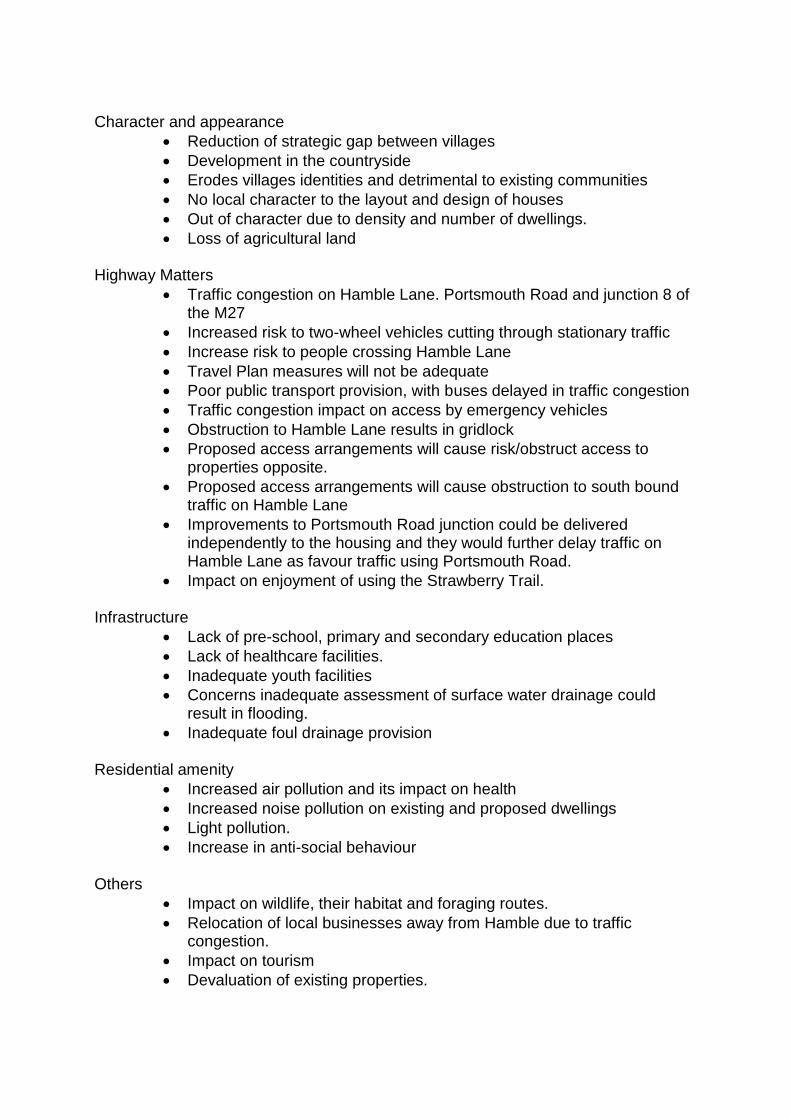
Character and appearance
Reduction of strategic gap between villages
Development in the countryside
Erodes villages identities and detrimental to existing communities
No local character to the layout and design of houses
Out of character due to density and number of dwellings.
Loss of agricultural land Highway Matters
Traffic congestion on Hamble Lane. Portsmouth Road and junction 8 of the M27
Increased risk to two-wheel vehicles cutting through stationary traffic
Increase risk to people crossing Hamble Lane
Travel Plan measures will not be adequate
Poor public transport provision, with buses delayed in traffic congestion
Traffic congestion impact on access by emergency vehicles
Obstruction to Hamble Lane results in gridlock
Proposed access arrangements will cause risk/obstruct access to properties opposite.
Proposed access arrangements will cause obstruction to south bound traffic on Hamble Lane
Improvements to Portsmouth Road junction could be delivered independently to the housing and they would further delay traffic on Hamble Lane as favour traffic using Portsmouth Road.
Impact on enjoyment of using the Strawberry Trail. Infrastructure
Lack of pre-school, primary and secondary education places
Lack of healthcare facilities.
Inadequate youth facilities
Concerns inadequate assessment of surface water drainage could result in flooding.
Inadequate foul drainage provision Residential amenity
Increased air pollution and its impact on health
Increased noise pollution on existing and proposed dwellings
Light pollution.
Increase in anti-social behaviour Others
Impact on wildlife, their habitat and foraging routes.
Relocation of local businesses away from Hamble due to traffic congestion.
Impact on tourism
Devaluation of existing properties.

61. BP has raised concerns on the following grounds;
The third large scale housing development none of which provide any realistic mitigation for the additional traffic congestion they will cause.
Disruption to the flow of traffic on Hamble Lane during the installation of the new road junction and construction of dwellings
Increased volume and traffic delays along Hamble Lane as a direct consequence of the new Hamble Lane/Berry Farm road junction to access the new development.
The new Hamble Lane/Portsmouth Road roundabout would give Woolston bound traffic the right of way, which will drastically impede the northbound traffic heading out of Hamble
62. Mims Davies MP – objects on grounds of:
Development being within the Air Quality Management Area and adding developments to this problem is ill advised and potentially dangerous.
The strained infrastructure in the area cannot take further development which will add to traffic and therefore to air pollution.
Lack of an adopted Local Plan results in submission of applications for unplanned development. The Council must rectify the issue in terms of five year land supply and work proactively with local parish councils so communities can be a part of deciding the future of their areas.
Policy Context: Eastleigh Borough Local Plan Review 2001-2011 (“saved policies”) 63. This site is countryside within the current adopted Local Plan 2001-2011. The
most relevant saved policies are as follows:-
1.CO – countryside protection
18.CO – landscape character
20.CO – landscape improvements
25.NC- Promotion of biodiversity unless benefits of development outweigh the adverse impacts and that the impacts are unavoidable and that mitigation measures are proposed.
30.ES – Requires refusal of noise sensitive development where exposed to unacceptable levels of noise
31.ES – Requires appropriate design, layout and sound insulation where permission is granted in above circumstances.
33.ES – Suitable air quality assessment required if new development appears likely to have a significant impact on air quality.

35.ES – Requires sufficient information to demonstrate that contaminated land can be appropriately remediated for the use proposed and that the risk of pollution to controlled waters is minimised
45.ES – Requires sustainable drainage systems
59.BE requires high standards of good design in new developments, including taking full and proper account of the context of the site.
73.H – Sites of 15 or more dwellings to be of appropriate mix.
74.H – Affordable housing.
92.T – Local Transport Plan proposals include (iii) Windhover roundabout full signalisation; Hamble Lane/Portsmouth Road corridor/junction improvements; (v) Eastleigh Cycle Route Network
100.T – Requires development to be well served by sustainable forms of transport, to provide measures to minimize impact on the network, minimize travel demand, provide a choice of transport mode and submit a transport assessment for large proposals.
101.T - Road Traffic Reduction Act 1997 targets – if exceeded requires the need for the development to be justified; for the development to provide contributions towards sustainable transport.
102.T – Requires new development to provide safe accesses that do not have adverse environmental implications and are to adoptable standard.
146.OS – Requires proposal which would have a detrimental impact on the green network to be refused and contributions from adjoining development proposals to be sought to enhance the environment.
147.OS – Requires on site provision of public open space.
165.TA – Percent for art
168.LB – Archaeological evaluation
190. IN – requires development only to be permitted where adequate services and infrastructure are available or can be provided.
191. IN – requires appropriate proposals to be permitted provided that arrangements have been made to either provide or contribute towards essential infrastructure.
Hampshire Minerals and Waste Plan 2013 64. Policy 15 - Hampshire’s sand and gravel (sharp sand and gravel and soft
sand), silica sand and brick-making clay resources are safeguarded against needless sterilization by non-minerals development, unless ‘prior extraction’ takes place.
65. Safeguarded mineral resources are defined by a Mineral Safeguarding Area illustrated on the Policies Map and the application site lies within a safeguarded area. Development without the prior extraction of mineral resources in the Mineral Safeguarding Area may be permitted if:
a. It can be demonstrated that the sterilization of mineral resources will not occur; or b. It would be inappropriate to extract mineral resources at that location, with regards to the other policies in the Plan; or c. The development would not pose a serious hindrance to mineral development in the vicinity; or
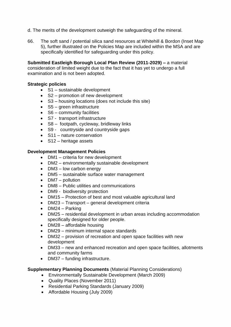
d. The merits of the development outweigh the safeguarding of the mineral.
66. The soft sand / potential silica sand resources at Whitehill & Bordon (Inset Map 5), further illustrated on the Policies Map are included within the MSA and are specifically identified for safeguarding under this policy.
Submitted Eastleigh Borough Local Plan Review (2011-2029) – a material consideration of limited weight due to the fact that it has yet to undergo a full examination and is not been adopted. Strategic policies
S1 – sustainable development
S2 – promotion of new development
S3 – housing locations (does not include this site)
S5 – green infrastructure
S6 – community facilities
S7 - transport infrastructure
S8 – footpath, cycleway, bridleway links
S9 - countryside and countryside gaps
S11 – nature conservation
S12 – heritage assets Development Management Policies
DM1 – criteria for new development
DM2 – environmentally sustainable development
DM3 – low carbon energy
DM5 – sustainable surface water management
DM7 – pollution
DM8 – Public utilities and communications
DM9 - biodiversity protection
DM15 – Protection of best and most valuable agricultural land
DM23 – Transport – general development criteria
DM24 – Parking
DM25 – residential development in urban areas including accommodation specifically designed for older people.
DM28 – affordable housing
DM29 – minimum internal space standards
DM32 – provision of recreation and open space facilities with new development
DM33 – new and enhanced recreation and open space facilities, allotments and community farms
DM37 – funding infrastructure. Supplementary Planning Documents (Material Planning Considerations)
Environmentally Sustainable Development (March 2009)
Quality Places (November 2011)
Residential Parking Standards (January 2009)
Affordable Housing (July 2009)
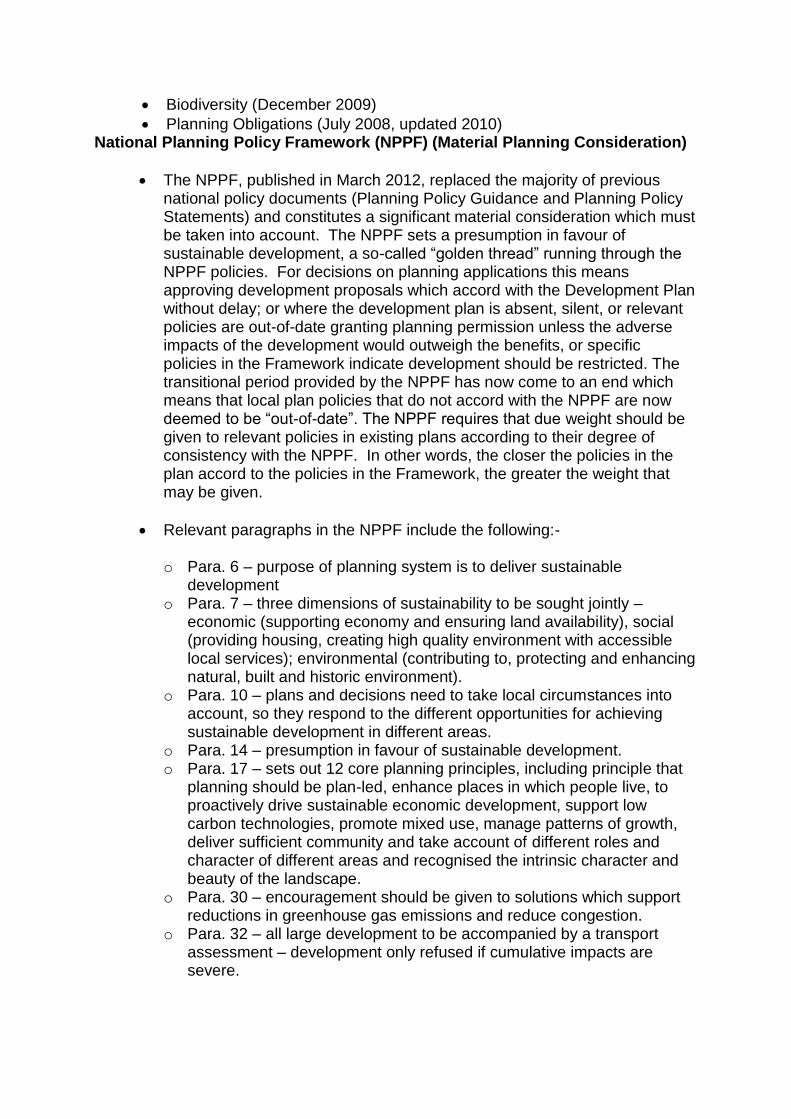
Biodiversity (December 2009)
Planning Obligations (July 2008, updated 2010) National Planning Policy Framework (NPPF) (Material Planning Consideration)
The NPPF, published in March 2012, replaced the majority of previous national policy documents (Planning Policy Guidance and Planning Policy Statements) and constitutes a significant material consideration which must be taken into account. The NPPF sets a presumption in favour of sustainable development, a so-called “golden thread” running through the NPPF policies. For decisions on planning applications this means approving development proposals which accord with the Development Plan without delay; or where the development plan is absent, silent, or relevant policies are out-of-date granting planning permission unless the adverse impacts of the development would outweigh the benefits, or specific policies in the Framework indicate development should be restricted. The transitional period provided by the NPPF has now come to an end which means that local plan policies that do not accord with the NPPF are now deemed to be “out-of-date”. The NPPF requires that due weight should be given to relevant policies in existing plans according to their degree of consistency with the NPPF. In other words, the closer the policies in the plan accord to the policies in the Framework, the greater the weight that may be given.
Relevant paragraphs in the NPPF include the following:-
o Para. 6 – purpose of planning system is to deliver sustainable development
o Para. 7 – three dimensions of sustainability to be sought jointly – economic (supporting economy and ensuring land availability), social (providing housing, creating high quality environment with accessible local services); environmental (contributing to, protecting and enhancing natural, built and historic environment).
o Para. 10 – plans and decisions need to take local circumstances into account, so they respond to the different opportunities for achieving sustainable development in different areas.
o Para. 14 – presumption in favour of sustainable development. o Para. 17 – sets out 12 core planning principles, including principle that
planning should be plan-led, enhance places in which people live, to proactively drive sustainable economic development, support low carbon technologies, promote mixed use, manage patterns of growth, deliver sufficient community and take account of different roles and character of different areas and recognised the intrinsic character and beauty of the landscape.
o Para. 30 – encouragement should be given to solutions which support reductions in greenhouse gas emissions and reduce congestion.
o Para. 32 – all large development to be accompanied by a transport assessment – development only refused if cumulative impacts are severe.
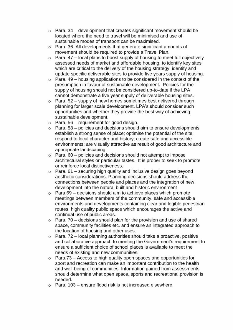
o Para. 34 – development that creates significant movement should be located where the need to travel will be minimised and use of sustainable modes of transport can be maximised.
o Para. 36. All developments that generate significant amounts of movement should be required to provide a Travel Plan.
o Para. 47 – local plans to boost supply of housing to meet full objectively assessed needs of market and affordable housing; to identify key sites which are critical to the delivery of the housing strategy, identify and update specific deliverable sites to provide five years supply of housing.
o Para. 49 – housing applications to be considered in the context of the presumption in favour of sustainable development. Policies for the supply of housing should not be considered up-to-date if the LPA cannot demonstrate a five year supply of deliverable housing sites.
o Para. 52 – supply of new homes sometimes best delivered through planning for larger scale development. LPA’s should consider such opportunities and whether they provide the best way of achieving sustainable development.
o Para. 56 – requirement for good design. o Para. 58 – policies and decisions should aim to ensure developments
establish a strong sense of place; optimise the potential of the site; respond to local character and history; create safe and accessible environments; are visually attractive as result of good architecture and appropriate landscaping.
o Para. 60 – policies and decisions should not attempt to impose architectural styles or particular tastes. It is proper to seek to promote or reinforce local distinctiveness.
o Para. 61 – securing high quality and inclusive design goes beyond aesthetic considerations. Planning decisions should address the connections between people and places and the integration of new development into the natural built and historic environment
o Para 69 – decisions should aim to achieve places which promote meetings between members of the community, safe and accessible environments and developments containing clear and legible pedestrian routes, high quality public space which encourages the active and continual use of public areas.
o Para. 70 – decisions should plan for the provision and use of shared space, community facilities etc. and ensure an integrated approach to the location of housing and other uses.
o Para. 72 – local planning authorities should take a proactive, positive and collaborative approach to meeting the Government’s requirement to ensure a sufficient choice of school places is available to meet the needs of existing and new communities.
o Para.73 – Access to high quality open spaces and opportunities for sport and recreation can make an important contribution to the health and well-being of communities. Information gained from assessments should determine what open space, sports and recreational provision is needed.
o Para. 103 – ensure flood risk is not increased elsewhere.

o Para. 109 – seeks to minimise impacts on biodiversity and protect unacceptable levels of soil, air, water or noise pollution and remediating contaminated land where appropriate.
o Para. 118 - decision should aim to conserve and enhance biodiversity. If significant harm cannot be avoided, mitigated or compensated for, then planning permission should be refused. If development is likely to have an adverse effect on an SSSI, an exception should only be made where the benefits clearly outweigh the impacts. Opportunities to incorporate biodiversity in and around development should be encouraged. Permission should be refused for proposals resulting in the loss or deterioration of irreplaceable habitats, including ancient woodland unless the need for and benefits of development clearly outweigh the loss.
o Para. 120 – Decisions should ensure that sites are suitable for its new use taking into account ground conditions, any pollution from former activities and any pollution to general amenity.
o Para. 121 – ensure site is suitable for its new use in terms of ground conditions, land stability etc.
o Para. 123 – avoid, mitigate and reduce noise which gives rise to significant adverse impacts on health and quality of life.
o Para. 124 – planning policies should sustain compliance with and contribute towards EU limit values or national objectives for pollutants, taking into account AQMAs and the cumulative impacts on air quality from individual sites in local areas. Planning decisions should ensure that any new development in AQMAs is consistent with the local air quality action plan.
o Para. 126 – positive strategy for the conservation and enjoyment of the historic environment.
o Para. 128 – where a site on which development is proposed includes or has the potential to include heritage assets with archaeological interest, local planning authorities should require developers to submit an appropriate desk-based assessment, and where necessary a field evaluation.
o Para 137 – Local Planning Authorities should look for opportunities for new development within the setting of heritage assets to enhance or better reveal their significance. Proposals that preserve those elements of the setting that make a positive contribution to or better reveal the significance of the asset should be treated favourably
o Para. 143 – In preparing local plans, an LPA should identify and include policies for mineral extraction and set out clear policies to encourage prior extraction.
o Para. 144 – In determining applications, the LPA should give great weight to the benefit of mineral extraction.
o Para. 152 – LPAs should seek opportunities to achieve each of the dimensions of sustainable development and net gains across all three.
o Para. 156 – A LPA should set out their strategic priorities within their local plan including the need for homes, jobs and conservation and enhancement of the natural and historic environment, including landscape.
o Para. 182 – Test of soundness of emerging local plans
o Para. 192 – The right information is crucial to good decision-taking, particularly where formal assessments are required (such as EIA/HRA/FRA).
o Para 203 - LPAs should consider whether otherwise unacceptable development could be made acceptable through the use of conditions or planning obligations.
o Para 204 – obligations should only be sought where they are necessary, directly related, related fairly and reasonably in scale and kind to the development.
o Para. 215 – Weight to existing relevant local plan policies according to the degree of consistency with the Framework.
o Para 216 - decision-takers can give weight to relevant policies in emerging plans according to the stage of preparation, the extent to which there are unresolved objections to relevant policies and the degree of consistency to the relevant policies in the emerging plan to the policies in the NPPF.
National Planning Practice Guidance (March 2014)
Transport – supports the provision of Transport Assessments where a Local Planning Authority makes a judgement as to whether a proposal would generate significant amounts of movement.
Design – Good quality design is an integral part of sustainable development. Achieving good design is about creating places, buildings or spaces that work well for everyone, look good, will last well and adapt for the needs of future generations. Good design responds in a practical and creative way to both the function an identity of a place. It puts land, water, drainage, energy, community, economic, infrastructure and other such resources to the best possible use over the long as well as the short term.
Contamination – With outline applications, Local Planning Authorities need to be satisfied that they understand the contaminated condition of the site and that the development proposed is appropriate as a means of remediation and it has sufficient information to be confident that it will be able to grant permission in full at a later stage bearing in mind the need for the necessary remediation to be viable and practicable.
Biodiversity – Local Planning Authorities should take into consideration various publications when taking biodiversity into account and should look for net gains. Sufficient information should be sought through ecological surveys etc.
Water quality – advice given re the EU Water Framework Directive and the requirement to, amongst other things, prevent deterioration of aquatic ecosystems and protect, enhance and restore water bodies to ‘good’ status.

Noise – potential noise impact needs to be addressed and opportunities taken to achieve improvements to the acoustic environment to ensure no unacceptably adverse impact.
Assessment of Proposal 67. Section 38 (6) of the Planning and Compulsory Purchase Act 2004 states : “If
regard is to be had to the development plan for the purpose of any determination to be made under the Planning Acts the determination must be made in accordance with the plan unless material considerations indicate otherwise”. The development plan in this case comprises the saved policies of the Eastleigh Borough Local Plan Review 2001-2011, which carry significant weight where compliant with the requirements of the NPPF. The countryside policies remain valid and are wholly relevant to assessing development proposals in the countryside. With the starting point being the adopted local plan, the principle of housing development on this countryside site is contrary to the development plan and therefore should be refused unless “material considerations indicate otherwise”. The assessment of these material considerations is set out further in the report.
68. The Hampshire Minerals and Waste Plan (adopted October 2013) also forms
part of the development plan and is relevant due to the site falling within a mineral safeguarding area.
69. The Submitted Eastleigh Local Plan 2011-2029 is not part of the development plan for it was not considered in detail by the Local Plan Inspector, who concluded (Feb 2015) that the submitted Local Plan was unsound due to an under provision for planned housing during the plan period. It does however indicate the Council’s preferred direction of travel for development within the borough up to 2029. As a result of its adopted status, only limited weight can be given to the submitted policies.
70. In terms of “other planning considerations”, the National Planning Policy
Framework constitutes a very significant material consideration.
Material Considerations
Five year housing land supply and allocation of housing sites
71. The adopted development plan (2001 – 2011) does not make provision for housing for the period post 2011, therefore the adopted housing policies are considered to be out of date. However, the Council’s position is that the Local Plan is not “absent, silent or relevant policies are out of date” with regards to development in the countryside, for they are compliant with the NPPF, and as such the Council’s lack of adopted policies on housing supply would not automatically trigger the presumption in favour of granting development that is sustainable unless adverse impact significantly outweigh the benefits of the scheme (NPPF para 14).
72. Whilst working towards adoption of a new Local Plan for a period expected to be up to 2036, the Council has produced an interim document – the “Housing Implementation Strategy” to support this position which sets out the Council’s approach to managing the delivery of new housing in the borough over the next 5 years. The NPPF is clear in that Councils are required to have a 5 year supply of housing land, that is, land that can be demonstrated to deliver housing numbers in accordance with an objective assessment of need. Based on the latest published figures, for the period up to December 2014 the Council have a 4.5 year housing land supply and as such fail to meet the expectations of the NPPF on this point. The ability of this development to help address in part the under provision of housing supply does not automatically outweigh the restrictive countryside policies, but as a material consideration must be considered as a benefit that will “boost the supply of housing” (NPPF para 47) with the delivery of 166 new dwellings including 66 affordable units.
73. Also material is the delivery rate of development with some planning appeal
Inspectors having considered the quick delivery of a sustainable site is a material consideration of weight that it indicates making a decision other than in accordance with the adopted Development Plan. The applicant has confirmed they anticipate commencing work early 2016 with 50-55 dwellings being delivered each year, with the site being fully occupied by the end of 2019.
74. Although not designated for housing within the adopted or the submitted local plan, this does not mean the site does not have sustainable elements to support its development. With the Local Plan inspector concluding earlier this year that the submitted Local Plan did not make sufficient provision for the future housing needs of the Borough, the Council are preparing background papers to identify the quantum of additional houses required and will need to identify additional housing sites for development in sustainable locations.
75. Although located within countryside, the site is geographically located within a sustainable distance to local amenities. Lowford village centre is 700m to the northeast where shops and other services can be accessed, whilst closer is a local shop off Chamberlayne Road and slightly further away Tesco can be found. Schools are located within Bursledon and at Hamble, with both primary and secondary facilities located 1.4km from the site. A primary regional bus service utilises bus stops located within walking distance of the site which is also within 1.4km (approximately 17 minute walk, 5 minute cycle) of Hamble Railway Station. The site’s overall proximity to facilities and amenities results in this being a relatively sustainable site for housing.
The landscape and countryside 76. Saved policy 1.CO of the adopted Local Plan seeks to protect the countryside
from inappropriate development unless it necessary for agriculture, outdoor recreational use, public utility developments or extensions to existing education or health facilities. The proposals for housing on a site designated as countryside clearly do not fall within the scope of these “accepted” forms of development. Policy 18.CO seeks to protect the identified landscape character

of an area, more details of which are set out in the Council’s Landscape Character Assessment Area document.
77. The site is not located within a designated strategic gap or local gap (2.CO and
3.CO designated to protect the coalescence of settlements) although its semi-rural nature does contribute to the perception of being outside of the urban edge of Bursledon and Old Netley, especially when walking the public right of way along the western boundary. The proposals map that accompanies the adopted local plan omits the site from the local gap in recognition of the previous local plan inspector’s conclusion that the site was one of six suitable reserve housing sites. The Council did not allocate this a reserve site, finding that three other sites were more suited to meeting the housing needs of the borough at that time.
78. The NPPF recognises the placing of value on the local circumstances (para
10), the need to take account of the different roles and character the countryside takes (para 17) and for LPAs to adopted strategic priorities including the protection of landscapes (para 156). The principle of saved policy 1.CO is wholly consistent with the sustainable development objectives of the NPPF (para 215).
79. The site is flat with few landscape features of note. The Landscape and Visual
Impact Assessment (LVIA) note the hedgerows along the north, south and east boundaries provide a sense of enclosure, with the site as a whole having a weighted landscape sensitivity defined as Medium. The LVIA notes the visual impacts of the development varies from major (viewed from part of Hamble Lane and footpath to the west), to moderate (from Cunningham Gardens, parts of Hamble Lane/footpath to the west) to minor (Hound Road).
80. Located in “Hound Plain” as defined within the Eastleigh Landscape Character
Assessment Area (LCAA), the wider area comprises of a significantly large and generally undeveloped land west of Hamble Lane to the fringes of Netley and Southampton, extending up to Bursledon Road. The predominant characteristic is the landscape openness, interrupted by intermittent hedges and post and wire fences. The land is both arable and pasture, with patches of ‘horsiculture’ particularly around Hound. The LCAA identifies the character of the area as a whole is vulnerable to development.
81. The site’s landscape character would be altered with the skyline changing and views of the woodland obstructed at least in part by new housing. When viewed from the footpath to the west, the rural nature of the site and its contribution to the field pattern of the wider area is more noticeable than when viewed from other vantage points. Developing this site would introduce development further south bringing dwellings closer to (but not within) the more open and sensitive part of the countryside, which is designated as a local gap. Whilst the site’s landscape value can be considered as medium in pure landscape terms, its value as ‘countryside’ to those passing the site or living nearby is likely to be deemed relatively high.

82. The site does make a contribution to the rural character and separation of Netley, Bursledon and Southampton, albeit not as significant a contribution as less developed or more open sites located away from the urban fringes. With dwellings on the east side of Hamble Lane, the feeling of leaving a settlement is not fully experienced until within the more open countryside south of Mallards Road, whilst there is no intervisibility between the settlements from within or close to the site. Furthermore, the partially developed nature of the site already erodes the more open character found elsewhere. It is enclosed on two sides by residential properties, whilst the west boundary is defined by a strong belt of trees which restricts achieving medium to long distance views from the south of the site. With the retention of the conifer hedging along the southern boundary, the loss of the paddocks although noticeable, would have limited impact on the landscape character of the wider area.
83. The proposal is significantly different to that previously refused with the
omission of the disproportionately larger care home, the scale, size and location of which dwarfed proposed and existing dwellings and impacted greatly on the countryside edge. The replacement of this with predominantly two storey dwellings, and an element of three storey apartment blocks within the centre of the site, is more sympathetic to an urban edge development. With the inclusion of significant tree planting within the site and retention and strengthening of hedging along the majority of boundaries, the visual impact is lessened compared to the refused scheme. This is especially so when viewed from the south (Hound Road) and the right of way that passes along the western boundary.
84. It is accepted that the development is contrary to saved policy 1.CO but
officers recognise that the site’s contribution to the character of the local landscape is more limited than other sites, whilst the scale of the development is more in keeping with the existing residential areas compared to the refused scheme. In the light of the above, the development of this site would not set a precedent nor would it conflict with the evidence submitted by the Council at the recent Hamble Station public inquiry.
Minerals
85. Advice on minerals is contained with the adopted Hampshire Minerals and Waste Plan 2013 (in which the site is within a designated Minerals Safeguarding Area) and the NPPF. The prior extraction of minerals, where practicable and commercially feasible is sought in advance of non-mineral development. HCC currently have identified the site is of a size that there could be mineral deposits of a commercial value, thus in accordance with policy 15 of the Hampshire Minerals and Waste Plan 2013 ‘prior extraction’ is recommended.
86. The minerals assessment advises that through prior extraction an estimated 129,700 tons of gravel and sand would be taken by a suitable operator for off-site processing. This would allow for a proportion of the sand and gravel resources to be extracted in advance of housing being built and utilised as aggregate instead of being disposed of to landfill. Full scale extraction of the
site is not considered feasible as it would delay the delivery of housing and run contrary to the drainage strategy and its principle of sustainable urban drainage. Subject to conditions, HCC Minerals and Waste Team have confirmed they do not object to the scheme.
87. Clarification has been sought from the developer as to the methods of extraction, the likely impacts on amenity together with mitigation proposals, as well as details on the resultant traffic movements associated with this. Although these details can be secured through conditions it is important that there is an understanding at this stage of the impacts associated with the extraction of minerals.
Protecting the most valuable agricultural land
88. The site consists of Grade 3 and the land appears to be for a mix of crops and grazing of horses at present. Policy 4.CO of the adopted Local Plan was not saved but the NPPF advises in paragraph 112 that "local authorities should take into account the economic and other benefits of the best and most versatile agricultural land [and that] where significant development of agricultural land is demonstrated to be necessary, local planning authorities should seek to use areas of poorer quality land in preference to that of a higher quality".
89. As grade 3, the value of the site to agriculture is border line and at just over
6ha, its loss is not deemed to be considerable nor would it lead to a significant loss of the most valuable agricultural land. In this instance, the Council are of the opinion that the development would not be contrary to paragraph 112 of the NPPF.
Heritage Asset and Listed Building considerations
90. There are no known archaeological sites within the development area, but the site does have some potential to contain previously unidentified archaeological remains. The lack of archaeological evidence from the site and immediate vicinity should be viewed as much a reflection of the lack of archaeological investigation as a genuine indication of absence of archaeology. The desk based assessment submitted with the planning application does not adequately address the potential for Pleistocene archaeology and the site has potential for limited archaeological considerations. While this potential does not present an overriding concern it should be addressed through a programme of archaeological work secured through suitable conditions attached to any planning consent that might be granted. Overall the heritage assets within the site are adequately protected ensuring compliance with the guidance contained within the paragraph 128 of the NPPF and saved policy 168.LB
Access proposals, traffic impact and sustainable modes of transport 91. The site is served by a single vehicular access point of a bell mouth design
from Hamble Lane. A significant level of the local objection to the proposals relates to traffic generation from the development and the inability of the
existing road network to accommodate this traffic without resulting in further congestion and queuing. The delays experienced currently are anticipated to increase resulting in impacts on businesses, schools, medical facilities and the emergency services.
92. The Transport Assessment (TA) estimates that there will be 90 trips generated
in the AM peak (24 arrivals and 66 departures), 78 trips generated at the network peak between 16:00 and 17:00 (48 arrivals and 30 departures), and 98 trips generated between 17:00 and 18:00 (62 arrivals and 36 departures). The majority of the traffic leaving the site (92%) would turn left up Hamble Lane, with 50% of that traffic heading to the M27. The County as Highways Authority agrees with the evidence set out within the TA.
93. The TA has considered the cumulative traffic impact of the other two non-allocated housing sites (Land West of Hamble Lane and Land at Hamble Station).
94. The data/modelling within the Transport Assessment identifies that there are junctions on the route of Hamble Lane which operate at or near capacity. A detailed assessment of each of junction between the site access and Windhover Roundabout is set out within the TA (to be read in part with the original TA) and in response to increased congestion the applicant proposals both “on-highway” works and contributions towards sustainable transport measures.
95. A key highway improvement proposed is the delivery of a new highway layout at the Portsmouth Road/Hamble Lane junction, which is identified as a pre-requisite to this scheme coming forward. The applicant has proposed a new roundabout located slightly off carriageway on the green verge, the modelling for which has demonstrated significant reduction in queues from Portsmouth Road and Hamble Lane South. Although the Hamble Lane South arm would operate close to it capacity, the TA demonstrates that even without this development the situation at this junction would be significantly worse. HCC as the Highways Authority has previously agreed in principle with this design solution and preliminary design checks undertaken demonstrating the roundabout could be delivered without harm to highway safety. A large part of the grassland would be lost with the roundabout option, and this is regrettable. However, this area is highway land and located adjacent to a busy road and in a built up area, thus its value as undeveloped open space is limited. HCC’s study on the Windhover Roundabout and Hamble Lane transport corridor is reaching its final stages and this will inform the most appropriate highway works within the locality. In advance of the findings being published, and to allow flexibility with highway improvements, the Country has requested that the S106 Agreement either delivers the roundabout or delivers a financial payment of equivalent value to an alternative junction design if study identifies are more suitable approach to traffic control.
96. The improvements to the junction (and the wider Hamble Lane corridor) are policy compliant and sought via saved policy 92.T of the adopted local plan.

97. With regards to other junctions along Hamble Lane north of the site, HCC are satisfied that the modelling information provided within the TA for the Lowford and Tesco roundabout junctions, the B3397 Hamble Lane / Cunningham Gardens / Chamberlayne Road junction and Windhover roundabout are acceptable and reflect the likely impact, without taking in to account the proposed reduction in traffic movements as a result of the Travel Plan. The Taylor Wimpey scheme has sought to deliver improvements to the Jurds Way and Tesco junction, whilst the traffic lights at Cunningham Gardens would operate within capacity. Contributions are sought to undertake improvements at Windhover and junction 8 of the M27 in accordance with an agreed strategy and timescale for implementation.
98. The application includes proposals for alterations to the existing access to Berry Farm, with widening of Hamble Lane to accommodate a right turn lane capable of holding 5no. vehicles entering the development from the north. As the distribution shows, the majority of vehicles are expected to turn left out of the development, and right turn into the site. Speed survey data has been provided and the access has been designed with sufficient visibility splays to meet guidance and standards with the ghost island and turning lane sufficient to meet peak time traffic movements.
99. The turning lane, chevrons and two new pedestrian islands are located opposite the driveways to a number of properties. In support of the access design, the applicant has undertaken a Stage 1 Safety Audit to test the principle of the design which includes tracking diagrams demonstrating how vehicles can access/enter existing drives in an unrestricted manner. HCC have reviewed the access arrangements and confirm they are suitable for this development and would not result in a detrimental impact on highway safety.
100. Consideration has been given to providing access off Cunningham Gardens, thereby using the existing traffic lights on Hamble Lane. The land between Cunningham Gardens and Berry Farm is public open space (POS) with a covenant restricting the use of this land to recreational or POS uses. To provide access across this land would result in a ransom situation, whereby the former land owner could be entitled to a significant percentage of the development value rendering the scheme unviable. The Head of Legal Services is reviewing the covenant and members will be undated verbally at committee on this issue.
101. In terms of sustainable transport, Government policy enshrined in the new
NPPF seeks to ensure that developments are located where the need to travel will be minimised and the use of sustainable transport modes can be maximised and that new developments are designed to give priority to pedestrian and cycle movements. In particular paragraph 32 requires decisions to take account of “the opportunities for sustainable transport modes have been taken up depending on the nature and location of the site”.
102. The site is considered to be in a sustainable location in terms of the proximity
to local facilities and transport infrastructure. The scheme would offer
improvements to pedestrian access along Hamble Lane through the provision of a footpath/cycleway along the eastern edge of the site with two non-signalised crossing points to facilitate access across Hamble Lane. There are continuous footpath connections to essential day-to-day facilities and links are proposed to access the wider footpath network. The site is reasonably well served by public transport.
103. A Travel Plan has been submitted and setting out various measures to reduce the dependency of travelling alone in cars, again in accordance with the principles of sustainable development.
104. The potential for an increase in traffic movements and queuing along Hamble
Lane to impact on air quality is addressed under the section air quality.
105. The Highways Authority and the Council have been satisfied that the significant movements generated by the development could be accommodated adequately on the existing transport network without a severe impact on the road safety and operation of the local transport network. The scheme as submitted is not contrary to saved policies 100.T and 101.T of the adopted Eastleigh Borough Local Plan (2001-2011), emerging policy DM23 of the Revised Pre-Submission Eastleigh Borough Local Plan (2011-2014) and the NPPF (para 32).
Noise and contamination issues 106. The adopted local plan seeks to avoid unacceptable impact from noise or
vibration on noise-sensitive developments including residential development. In situations where the merits of the development outweigh the desirability of locating it away from a location disturbed by noise or vibration, the applicant must demonstrate the design, layout and insulation can meet appropriate standards. Para 123 of the NPPF advises planning decisions should “avoid noise from giving rise to significant adverse impacts on health and quality of life as a result of new development”.
107. The noise survey has assessed noise generated from traffic on Hamble Lane,
concluding that development can be delivered without causing harm to the amenity of future residents through the use of varying standards of acoustic glazing and alternative ventilation. Further details are sought on the ventilation options available, whilst a condition is recommended to implement the recommendations of the noise assessment.
108. The submitted desk based assessment of contamination concludes that risks
to the proposed use are low and can be controlled through conditions. The Head of Housing and Environmental Health has agreed that the principle of development is acceptable subject to a land contamination condition
109. The impact of noise and vibration during the construction period for the
dwellings is not considered to be unacceptable in principle; the final details can be address via a construction impact management plan. The Head of Housing and Environmental Health has requested further information in connection with

the potential for partial extraction of minerals from the site as part of the construction process and will provide comment on this following its receipt.
Air Quality
110. The NPPF states (para 124) that policies should sustain compliance with and contribute towards national objectives for pollutants, taking into account Air Quality Management Areas and the cumulative impacts on air quality from individual sites. The application site falls outside of the Hamble Lane Air Quality Management Area (AQMA) but will impact on it with the majority of traffic generated by this development going north in to the AQMA. The proposed roundabout at Portsmouth Road abuts the southern edge of the AQMA and this has been assessed within the Air Quality Assessment. Local plan saved policies 32.ES and 33.ES and emerging local plan policy DM7 require any impacts upon air quality to be assessed in this regard. There are also a number of European Directives that apply to air quality which the Air Quality Standards Regulations (2010) seeks to transpose and simplify. 111. The application is supported by an air quality assessment that advises the
proposed highway improvements and the Travel Plan will ensure traffic movements associated with the development would not have a harmful impact on air quality, with the three of the receptors within the AQMA demonstrating an improved level of air quality as a result of the mitigation works proposed. Both the construction and operation phases were considered as well as various forms of air quality pollutants, in particular, NO2 and particulates were considered from increased level of traffic and construction. Further clarification is sought on the impacts on air quality as a result of the minerals extraction, both at source and from traffic associated with exporting the minerals off site.
112. Members will be updated at committee on this issue.An inspector in
determining a recent appeal in West Sussex (Ref: APP/D3830/A/14/2226987 - Land at London Road, Hassocks) found no fault with the methodology of the consultants evidence but based on third party witness evidence on diesel engines erred on the side of caution, concluding the drop nationally in background NOx by 2018 may not be as much as forecast and siding with caution felt the “negligible” impact predicted by this development may be greater than expected. She subsequently refused an appeal for 97 dwellings adjacent to an AQMA. Whilst the Head of Housing and Environmental Health raises no objection to this scheme subject to implementation of the highway works, there are similarities with the Berry Farm scheme and further clarification has been sought from the developer on the assumptions made on the background level of reduced NOx levels in 2018.
Trees and Ecology 113. The application is supported by a phase 1 and protected species report plus
surveys and reports on bats, great crest newts, reptiles, dormice and badgers. Following the submission of further information related to the significant population of slow worms on site, the borough’s biodiversity officer has raised no objection to the proposal subject to conditions including reviewing the landscape details proposed to offer a more favourable habitat for reptiles.

114. The hedge along Hamble Lane would be partially removed to facilitate the
improved access points and sight lines. The hedge has some value as ecological habitat and its aesthetic qualities, but is not of sufficient value to require its retention or to prevent development on this site. However, new landscaping is proposed along this frontage as well improved planting throughout the rest of the site, including a large number of trees. The formation of a 15m ecological buffer to the SINC accords with Natural England standing advice and will offer an improvement to the biodiversity value of the site. On balance, and subject to appropriate mitigation (through new planting and enhancement of parts of the remaining hedge) this impact is considered acceptable
115. The site is not subject to a tree preservation order nor does it have a
significant number of trees of any arboricultural quality within it. Three category B trees are proposed to be lost near to the existing farmhouse, whilst there are a number of low quality and ornamental proposed also to be removed. The borough tree officer has advised the loss of these trees is acceptable subject to replacement planting. On balance the development is in accordance with Policy 47.ES of the EBLP Review.
116. A Habitats Regulations Assessment (HRA) has been completed by the Council assessing the impact of the development on the Solent and Southampton Water Special Protection Area/RAMSAR/Site of Special Scientific Interest. The HRA conclude that subject to securing funds to assist with the implementation of the Solent Disturbance Mitigation Projects (SDMP), that there would be no significant effect as a result of recreational disturbance pressure on the SPA/RAMSAR/SSSI. Natural England is of the same opinion. The applicant has agreed to the principle of securing contributions to the SDMP as part of the planning obligation, which subject to completion will mitigate the impact of the development and accord with submitted policy S12 and DM9 and provisions of the NPPF.
117. In accordance with the requirements of saved policy 25.NC and the NPPF
(para 118) the biodiversity value of the application site can be improved via a Landscape & Biodiversity Management Strategy whilst during the construction process an Environmental Construction Management Plan could be secured to minimise impact of works on the site. With planning conditions recommended securing the proposed ecological mitigation measures, in respect to biodiversity enhancements the development is considered to accord with policies 25.NC and 26.NC of the adopted Local Plan and DM9 of the emerging Local Plan.
Drainage and flood risk
118. The application site lies within Flood Zone 1 which is considered to have a low risk of flooding and the submitted Flood Risk Assessment demonstrates that the development would not increase the risk of flooding elsewhere, subject to the implementation and management of a comprehensive Sustainable Urban Drainage System. This includes an attenuation pond in the public open space
to the northwest, permeable paving and swales or French drains within public areas. A strategy is provided setting out the layout of the drainage features however full details of drainage should be secured by condition. The Environment Agency, Southern Water and HCC as Lead Local Water Flood Authority have raised no objection to the development in principle.
119. Southern Water has indicated that there is insufficient capacity in the foul
sewer network in this area and therefore unless new or improved sewerage infrastructure is provided, the system would not be able to cope with the additional sewerage generated by this development. The Flood Risk Assessment identifies an option of discharging foul drainage by gravity to the public sewer beneath Mallards Road which requires approximately 240m length of new off-site foul drainage or alternatively a new pumping station within the south east corner of the site with similar provision of new pipework. Further upgrades would be required to the existing downstream public foul sewer network comprising of a total length of 362m between Mallards Road and the Hungerford Bottom Bursledon Pumping Station. Subject to the implementation these arrangements Southern Water raise no objection in principle and the development accords with saved policy 45.ES and emerging policy DM5.
Layout, design and residential amenity 120. NPPF highlights the importance and continued emphasis that the government
places on good design. Paragraph 17 states that planning should always seek to secure high quality design and a good standard of amenity for all existing and future occupants of the land and buildings. Paragraph 56 goes on to state that the Government attaches great importance to the design of the built environment and that good design is a key aspect of sustainable development, and should contribute positively to making places better for people.
121. Based on the site layout, which includes approximately 1ha of public open
space, the proposed development of 166 units equates to a density of approximately 27 dwellings per hectare, which is considered appropriate in this particular urban edge location.
122. The proposed layout is quite traditional in its form, with the proposed housing
being designed to address the road, creating active frontages and a sense of enclosure to the new streets, together with overlooking of the open space areas. To a degree the layout has been influenced by its constraints including the need for development to front Hamble Lane, face outwards to the countryside, be a minimum of 15m from the SINC on the western boundary and avoid development within the pipeline easement that passes diagonally through the site. Character areas have been created based around the areas the dwellings would abut – Hamble Lane, the green edges, the linear park (easement corridor) and the central neighbourhood, with different materials and boundary treatment proposed to strengthen the theme of each of these areas and offering a sense of place and legibility.
123. The POS is delivered along the western boundary thereby not only buffering the woodland but providing a linear area that feeds in to the Cunningham Gardens POS, with footpath links to be provided between the two areas of POS. A tree lined small pocket park is proposed at the entrance to the site which with high quality landscaping will provide additional amenity for the apartments overlooking it and an attractive feature when entering the site. Minor amendments to the landscaping has been sought to ensure trees of a suitable species are included within public areas.
124. Through a mix of dwellings sizes, including the provision of 3no. bungalows,
visual interest is provided through scale, design and detailing. Careful attention has also been paid to the treatment of side elevations of the proposed units where these will be visible within the street scene and natural surveillance to the public realm. The detailed layout and design of the dwellings ensure that the privacy and outlook of both existing and future residents would be respected and the relevant criteria of the Quality Places SPD and Local Plan policies are met. The private amenity space for all the proposed dwellings meets our minimum standards, whilst the majority of the apartments are proposed with private balconies. Minor revisions to some of the plots and their elevational treatment have been sought and amended plans are expected prior to the committee meeting.
125. All of the dwellings meet the adopted parking standards apart from two flats over garages, whilst the sharing of unallocated spaces for the apartments is acceptable and to standard. Bin and cycle storage is provided for all the properties and collection points are proposed where dwellings are located off an adopted highway.
Sustainability measures 126. The application is accompanied by a sustainability statement which includes a
pro-forma stating how the development could meet the energy and water of code level 4, which the borough’s sustainability officer raises no objection to. However, not all the requirements of the adopted Environmentally Sustainable Development SPD have been included in the submission and further information has been sought from the applicant.
127. The applicant has advised that the development will accord with the
requirements of emerging policy DM2 in that BREEAM Communities 'excellent' would be achieved. Further evidence in the form a pre-assessment certificate has been sought setting out how this would be achieved. Subject to further information being provided, the principles of development are therefore considered to comply with the aims of Saved Policy 34.ES of the adopted Local Plan and the adopted SPD on Environmentally Sustainable Development.
Economic Sustainability
128. In regards to the economic role of development, the NPPF requires “sufficient land of the right type to be available in the right places to build a strong, responsive and competitive economy “.
129. The construction industry is key to economic sustainability and the proposed
development of 166 dwellings would deliver local employment, whilst the new population would support local businesses. The applicant has submitted an economic appraisal stating the development would generate 58 temporary construction jobs per year on average during the construction phase, or 23 FTE construction jobs. In addition a further 87 jobs could be supported per year of construction by the proposed development throughout the UK economy. It also forecasts the net residential expenditure of the development once occupied, would generate up to an additional 23 FTE jobs in the local area.
130. The proposals would align with the Council’s strategic priority of increasing prosperity to the Borough. A New Homes Bonus would also be received for the delivery of new homes, whilst contributions towards local community infrastructure can also be deemed economic benefits attributed to the scheme. These are all benefits to the economic dimension of sustainable development and are all considered benefits in the planning balance. Overall the proposals are considered to be economically sustainable.
Social Sustainability 131. In accordance with saved policy 190.IN of the local plan development is only to
be permitted where adequate services and infrastructure are available or suitable arrangements can be made for their provision. Where facilities exist but will need to be enhanced to meet the needs of the development, contributions are sought towards provision and improvement of infrastructure. A development should also offer a mix of house types and tenures to ensure a balanced and thriving community. To date the applicant has not submitted a draft s106 and so the policy requirements have not been met.
Housing mix, deliverability, affordable housing and infrastructure 132. The application proposes a range of house types, sizes and tenures, including
40% affordable housing, which exceeds the 35% provision sought by Saved Policy 74.H of the adopted Local Plan and Policy DM28 of the Submitted Local Plan. The Council’s adopted Affordable Housing SPD is a material consideration, as is the NPPF which aspires to “deliver a wide choice of high quality homes in inclusive and mixed communities to meet the needs of different people”.
133. The Head of Housing Services supports the principle of delivering affordable
housing application, with the affordable dwellings being pepper-potted across the site. If secured through a planning obligation, the delivery of affordable housing is a benefit of the proposed scheme.

Education
134. In terms of education, the capacity of local schools has been considered in assessing the proposed development and infrastructure requirements, and it is noted that the potential impact on schools has been a particular concern raised by local residents.
135. Hampshire County Council Children’s Services Department has advised there
is no spare capacity at local primary and secondary schools to accommodate this development and that contributions are to be sought to deliver extensions or improvements to existing schools. This is a different policy stance from that adopted with the refused scheme (June 2014) and further clarification is sought from HCC on the projects to which contributions are sought. Subject to clarification on capacity of existing schools and future projects to which contributions should be sought, a section 106 will need to secure financial contributions towards education provision.
Health Provision
136. A number of letters of objections have been received to the development on grounds of inadequate primary care facilities within the immediate area. Numerous objectors have highlighted a long wait for non-urgent appointments, The NHS West Clinical Commission Group has confirmed patients are likely to gravitate to the surgery at the Lowford Centre where there is sufficient capacity to meet the needs of the occupants of the development, as such no contribution is sought for extensions to existing medical facilities.
Community facilities
137. The applicants are also required to make provision for increased capacity at
community buildings, playing fields, areas of off-site public open space etc. within the local area, to meet the increased demand for these facilities arising from the proposed development.
138. The proposal includes reasonable areas of open space meeting the on-site
requirements for a development of this size, the majority of which is located along the western boundary and links with the existing Cunningham Gardens open space. To offer a more comprehensive equipped play area, contributions are sought to improve the existing facilities to the north rather than provide a further small areas of play within the development. Contributions are to be secured through the s106 agreement to provide and maintain the open space, play areas and community facilities in accordance with CIL regulations, the relevant adopted policies and the adopted SPD on Planning Obligations.
Planning Obligations/development benefits 139. In accordance with the guidance contained within the NPPF, Saved Policies
74.H, 101.T, 147.OS and 191.IN of the adopted Eastleigh Borough Local Plan Review (2001-2011), Policies DM32 and DM37 of the Revised Draft Eastleigh

Borough Local Plan 2011-2029, the Council’s ‘Planning Obligations’ SPD and the requirements of Regulation 122 and 123 of the Community Infrastructure Regulations, there is a requirement for developers’ contributions to ensure on and off-site provision for facilities and infrastructure made necessary by the development, or to mitigate against any increased need/pressure on existing facilities. This is in addition to the requisite on-site provision of affordable housing.
140. The applicant has not yet agreed to the following developer contributions and
obligations which the LPA are seeking:
Off-site public open space contributions
On-site public open space/play provision and maintenance
On-site footway link improvements
40% on-site affordable housing
Public art provision
Travel plan provision, bond and monitoring
Transport infrastructure contributions
Delivery of junction improvements at the Portsmouth Road / Hamble Lane junction.
Community Infrastructure
Air Quality Management
BREEAM Communities post occupancy evaluation assessment.
Unallocated parking spaces not to be sold to individual householders
Street tree maintenance
Sustainable drainage
Phasing of the development
Section 106 monitoring. 141. The projects and measures identified above are considered to comply with the
3 tests set out in Regulation 122 of the Community Infrastructure Levy 2010, in that the monies will go towards the projects which are directly related to the development, and are fairly and reasonably related in scale and kind to the proposed development. The contributions would be index-linked to ensure the contributions rise in line with the costs of providing the identified projects/measures. The obligations sought are necessary to make the development acceptable in planning terms and to meet the needs generated by the new residents and the potential impact on existing services and facilities.
Conclusion 142. The starting point when determining this application is the development plan.
Section 38 (6) of the Planning and Compulsory Purchase Act 2004 states : “If regard is to be had to the development plan for the purpose of any determination to be made under the Planning Acts the determination must be made in accordance with the plan unless material considerations indicate otherwise”. Saved policy 1.CO of the Eastleigh Borough Local Plan (2001-2011) remains wholly relevant and up to date with the NPPF, and does not

support housing development within the countryside. As such the development is contrary to the development.
143. The presumption in favour of sustainable development is not considered to be
engaged due to the local plan not being “absent, silent or out of date” in respect of development in the countryside therefore members are asked to determine if there are sufficient materials consideration to approve the development otherwise than in accordance with the development plans.
144. The proposal will clearly have an impact on the countryside, through the loss of farmland which in part is open in its nature. The introduction of 166 dwellings of two and three storey will be more visible than existing development on the site and will reposition the urban edge further south and closer to the local gap.
145. Material to this application is the NPPF’s aim to significantly boost the supply of housing and, in accordance with the NPPF, the adopted Local Plan in respect of housing supply must be considered out of date. The Council is unable to demonstrate a 5 year housing land supply and accept there is a need to deliver more housing, both within the short term (5 years) and long term (up to 2036). The applicant has confirmed the early delivery of housing and the development can demonstrate elements of being economically, socially and environmentally sustainable. The site is within a sustainable location, abutting the urban edge and within walking distance of shops, community facilities and bus stops. It would provide private and 40 % affordable housing which exceeds the policy minimum. It will also provide improvements to the footpath and cycleway along part of Hamble Lane and through the provision of a roundabout at the Portsmouth Road/Hamble Lane junction facilitate highway improvements that have been a long term aim of the local plan. The construction process would deliver a number of employment opportunities whilst once fully occupied the development would establish an increase in the workforce resources within the Hamble peninsular.
146. Some of the improvements proposed simply mitigate the impact of the
development and deliver no net gain e.g. some highway works and air quality management. .
147. In the planning balance, and having regard to all the material considerations, the recommendation is that the impacts the development can be mitigated whilst there are a number of benefits that this scheme would deliver. As such, the application is recommended for permission subject to receipt minor revisions to the layout, some elevations and landscaping details; information on the impact on traffic movements and residential amenity of mineral extraction and completion of a section 106 Legal Agreement.
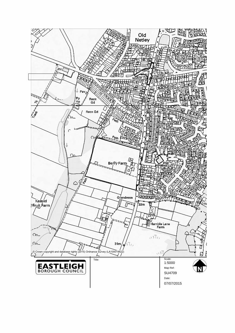
© Crown copyright and database rights (2015) Ordnance Survey (LA100019622)
Scale:
Map Ref:
Date:
1:5000
07/07/2015
SU4709
Title: