Embed Size (px)
Citation preview

STUDY OF INTERENTIONS TO REDUCE SEDIMENTATION Page 1 of 6
BUSHMANS RIVER ESTUARY STUDY S2033-RP-CE-PRDW Report-001-Summary_6pp_R0.docx Printed Document Uncontrolled
BUSHMANS RIVER ESTUARY
STUDY OF INTERVENTIONS TO REDUCE SEDIMENTATION - SUMMARY
Introduction
Residents and associations such as Estuary Care have for decades been expressing their concern over the
progressive marine sedimentation of the Bushmans River Estuary. The concern is that the sedimentation
is reducing the navigability of the channels, resulting in a loss of amenity of the estuary which is widely
used for recreational boating. There are also concerns that if nothing is done, the mouth of the estuary
will effectively close.
PRDW Consulting Port and Coastal Engineers were thus commissioned to investigate the progressive
sedimentation of Bushmans River Estuary and to test intervention options which could return the estuary
to its former more functional state.
Methodology
A two-dimensional (2D) model of the Bushmans River Estuary was set up using the suite of models
developed by the Danish Hydraulics Institute (DHI). The model comprised a coupling between the spectral
wave, 2D hydrodynamic and sand transport models. The model was calibrated to available water level
data measured at the Kenton Marina. The predicted sediment transport was calibrated by comparing the
sediment transport modelled over a one-year period to the annual trends derived from an analysis of
historical data which included bathymetric surveys and aerial imagery. An example of the modelled
current field in the lower reaches of the estuary at the peak of the spring ebb tide is shown in Figure 1.
Figure 1: Instantaneous current field at the peak of the spring ebb tide.

STUDY OF INTERENTIONS TO REDUCE SEDIMENTATION Page 2 of 6
BUSHMANS RIVER ESTUARY STUDY S2033-RP-CE-PRDW Report-001-Summary_6pp_R0.docx Printed Document Uncontrolled
Intervention options
Fourteen intervention options were conceptually designed and then tested in the model. The
intervention options are described in Table 1, and are grouped into the following categories:
Base case – the do nothing test.
Dredging – interventions involving dredging various areas of the river.
Tidal flooding – interventions utilising a collapsible dam to hold back the flood tide and release it
during low tide to induce scouring of the river bed. An additional temporary dam section and
current deflectors are also required.
Blocking of channels – based on the results of initial numerical model tests the temporary closure
of selected channels was tested for their effectiveness of scouring certain areas.
Deflectors – use of deflectors to direct river flow in order to increase current speeds and scour in
certain areas.
Table 1: Intervention options assessed.
Category ID No. Description
Base case DN1 1 Do Nothing option
Dredging
D1 2 Channel Dredging Phase 1: Selected secondary channels
D2 3 Channel Dredging Phase 2: All secondary channels
D3 4 Channel Dredging Phase 3: All secondary and main channels
D4 5 Dredging of Eastern Meander
D5 6 Dredging of Estuary Mouth
Tidal flooding
TF1 7 Tidal Flooding Eastern Channel (1)
TF2 8 Sequential Tidal Flooding
Blocking of
channels
TC1 9 Temporary Closure of Eastern Channel
TC2 10 Temporary Closure of Western Bridge Opening
TC3 11 Temporary Separation of Eastern and Western Channels
Deflectors
DF1 12 Deflector on Flood Delta at Estuary Mouth
DF2 13 Deflector at Western Secondary Channel (south of bridge)
DF3 14 Deflector at Eastern Secondary Channel (north of bridge)
(1) Tidal flooding concept as proposed by local resident, Dennis Laubscher.
Results
Each intervention option was tested in the calibrated model. The performance of each option was
assessed against a set of key performance indicators, which included the change in sediment volume in
the estuary and the changes to the hydrodynamics of the estuary. For the dredging options, the dredged
volume and the infill rate of the dredged areas was also calculated.
The interventions were evaluated using a multi criteria analysis (MCA) method, which allows for the
relative comparison of numerous alternatives using multiple decision making criteria. The results of the
MCA are presented in Table 2, which also indicates the evaluated criteria and the weighting applied to
each criterion. Note the estimated capital costs are also included as a row in the table.
STUDY OF INTERENTIONS TO REDUCE SEDIMENTATION Page 3 of 6
BUSHMANS RIVER ESTUARY STUDY S2033-RP-CE-PRDW Report-001-Summary_6pp_R0.docx Printed Document Uncontrolled
Table 2: Results of multi-criteria analysis. Su
mm
ary Interventions
Base Dredging T. Flooding Blocking channels Deflectors
DN1 D1 D2 D3 D4 D5 TF1 TF2 TC1 TC2 TC3 DF1 DF2 DF3
Total 60% 73% 75% 70% 50% 45% 38% 33% 61% 66% 65% 55% 55% 55%
Rank 7 2 1 3 11 12 13 14 6 4 5 10 9 8
Capital Cost (ZAR Mil.) 0 10 16 35 9 26 46 75 12 3 12 3 2 1
Cri
teri
a sc
ori
ng
Criteria Weighting
Environmental & Statutory Approvals
5% 5% 3% 3% 2% 3% 2% 3% 3% 4% 4% 4% 4% 4% 4%
Achievement of function requirements
40% 2% 29% 33% 37% 4% 7% 12% 22% 13% 13% 18% 1% 1% 1%
Impact on river users and community
5% 4% 2% 2% 2% 3% 3% 1% 1% 2% 3% 2% 3% 3% 3%
Safety Risk 10% 9% 5% 5% 5% 5% 5% 3% 3% 8% 8% 8% 9% 9% 9%
Capital Cost Evaluation 35% 35% 31% 28% 20% 31% 24% 16% 4% 30% 34% 30% 34% 34% 35%
Practical implementation of intervention
5% 5% 4% 4% 4% 4% 4% 3% 2% 4% 5% 4% 4% 4% 4%
Total 100%
The MCA indicated that the preferred intervention would be to dredge the channels. Dredging allows for
a robust, relatively precise modification of the estuary. Another advantage is that the dredged material
is completely removed from the estuary and includes removal of the vegetation on the seabed and along
the channel edges. Furthermore, the modelling has shown that once dredged, the estuary would take
decades to accrete to its current state.
The temporary blocking of channels was the only other category of intervention to score above the do
nothing base case. Temporary blocking of the channels does not provide a comparable level of
navigability to the dredge options. However, there are substantial benefits for certain key secondary
channels. Additionally, the channel blocking options provide for a less intrusive and in some cases a less
costly alternative to dredging.
The remaining interventions scored poorly, predominantly due to either their lack of achievement of the
functional requirements or relatively high capital costs.
Preferred solutions
Based on the results of this study a dredging option (D1, D2 or D3), suiting the available funding, should
be considered as the solution. If funding is constrained, a lower cost alternative which achieves scouring
at the marina is available through the application of TC2 (temporary closure of the western opening of
the R72 bridge through the installation of stop logs between the bridge piers).
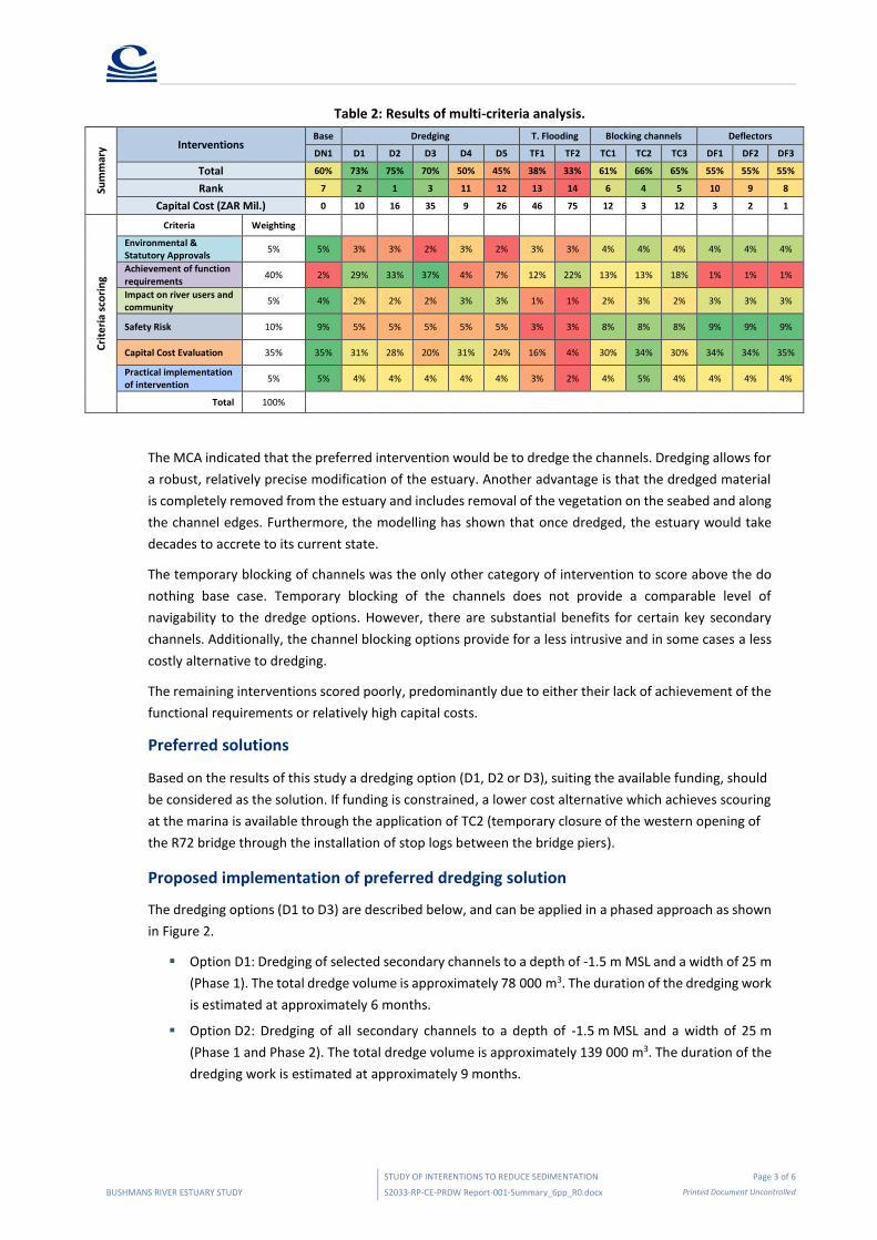
Proposed implementation of preferred dredging solution
The dredging options (D1 to D3) are described below, and can be applied in a phased approach as shown
in Figure 2.
Option D1: Dredging of selected secondary channels to a depth of -1.5 m MSL and a width of 25 m
(Phase 1). The total dredge volume is approximately 78 000 m3. The duration of the dredging work
is estimated at approximately 6 months.
Option D2: Dredging of all secondary channels to a depth of -1.5 m MSL and a width of 25 m
(Phase 1 and Phase 2). The total dredge volume is approximately 139 000 m3. The duration of the
dredging work is estimated at approximately 9 months.
STUDY OF INTERENTIONS TO REDUCE SEDIMENTATION Page 4 of 6
BUSHMANS RIVER ESTUARY STUDY S2033-RP-CE-PRDW Report-001-Summary_6pp_R0.docx Printed Document Uncontrolled
Option D3: Dredging of all main channels to a depth of -2.5 m MSL and a width of 50 m and all
secondary channels to a depth of -1.5 m MSL and a width of 25 m (Phases 1, 2 and 3). The total
dredge volume is approximately 313 000 m3. The duration of the dredging work is estimated at
18 months.
Figure 2: Layout of phased approach to channel dredging.
Figure 3 presents the bathymetry of dredge option D3 after one year of modelled morphology. Also
shown in the figure is the existing bathymetry. Bed levels are shown relative to Mean Sea Level (MSL).

STUDY OF INTERENTIONS TO REDUCE SEDIMENTATION Page 5 of 6
BUSHMANS RIVER ESTUARY STUDY S2033-RP-CE-PRDW Report-001-Summary_6pp_R0.docx Printed Document Uncontrolled
Figure 3: Existing bathymetry (left top and left bottom) and dredged bathymetry (Option D3) after one year of modelled morphology (right top and right bottom). The bed levels are shown relative to Mean Sea Level
(MSL).
The model results indicate that the dredged channels remained open during the modelled year, with slow
infill rates compared to the total dredged volumes implying that the estuary would take decades to
accrete back to its current state.
Dredging options D1 to D3 are likely to encounter sand and some mud. Therefore, the potential plant
currently considered includes a small cutter suction dredger and a barge-mounted long-reach excavator
(see Figure 4).
Existing bathymetry North of R72 bridge
Existing bathymetry South of R72 bridge
Dredged bathymetry after one year of morphology North of R72 bridge
Dredged bathymetry after one year of morphology South of R72 bridge
STUDY OF INTERENTIONS TO REDUCE SEDIMENTATION Page 6 of 6
BUSHMANS RIVER ESTUARY STUDY S2033-RP-CE-PRDW Report-001-Summary_6pp_R0.docx Printed Document Uncontrolled
Figure 4: Small cutter suction dredger (left). Barge-mounted long-reach excavator (right).
The following is currently being considered for the disposal of the dredge spoil:
Organic matter and eel grass – disposed at a land fill.
Sand – disposed at one of the following locations:
The beach to the west of the mouth,
The slack areas in the sand dunes west of the mouth (this may not be possible due to risk of
saltwater contamination of the groundwater);
Middle beach; or
A land fill site.
It is anticipated that the sand will be pumped to the disposal site via a pipeline consisting of floating and
land-based components. Booster pumps will be required at approximately 800 m intervals, therefore
limiting the floating section to this length. At the disposal site, the end of the pipeline will be repositioned
as required to control the discharge of sediment.
Future tasks
It is proposed that a pre-feasibility study for the dredging work be carried out. The main focus areas of
the study should include the following tasks:
Prepare a request for proposal (RFP) for dredging contractors to provide a budget quote and
method statement of how they will execute the dredging;
Review and summarise the responses to the RFP;
Assess the dredger type alternatives;
Assess the power supply alternatives (for dredger and satellite booster pumps);
Assess the contracting strategy – Contractor vs Own, Operate and Maintain; and
Assess the discharge alternatives and management of fines and eel grass.
It has also been proposed that a Basic Assessment for the dredging works be carried out. The specialist
studies currently envisaged to feed into the Basic Assessment are listed below, and may be added to as
requested by the relevant authority:
Dune assessment;
Estuarine assessment;
Heritage assessment;
Noise assessment; and
Waste and Dredge Spoil Disposal Study.


![Untitled-1 []...Sponsorship Dana Usaha A cara Sponsorship Perlengkapan Pubdok Medis Keamanan Konsumsi BPH Rp. Rp. Rp. Rp. Rp Rp Rp Rp Rp Rp Rp Rp Rp. 4000.000,00](https://img.pdfslide.net/doc/110x75/61443310aa0cd638b460b395/untitled-1-sponsorship-dana-usaha-a-cara-sponsorship-perlengkapan-pubdok.jpg)