Embed Size (px)
Citation preview
United States Department of Agriculture Forest Service March 2013
Buttes Forest Health Project Decision Notice and Finding of No Significant Impact Bearlodge Ranger District Black Hills National Forest Crook County, Wyoming

The U.S. Department of Agriculture (USDA) prohibits discrimination in all its programs and activities on the basis of race, color, national origin, age, disability, and where applicable, sex, marital status, familial status, parental status, religion, sexual orientation, genetic information, political beliefs, reprisal, or because all or part of an individual's income is derived from any public assistance program. (Not all prohibited bases apply to all programs.) Persons with disabilities who require alternative means for communication of program information (Braille, large print, audiotape, etc.) should contact USDA’s TARGET Center at (202) 720-2600 (voice and TDD). To file a complaint of discrimination, write to USDA, Director, Office of Civil Rights, 1400 Independence Avenue, S.W., Washington, D.C. 20250-9410, or call (800) 795-3272 (voice) or (202) 720-6382 (TDD). USDA is an equal opportunity provider and employer.

88
8
8
8
8
8
88
8
8
8
8
8
8
8
8
8
88
8
8
8
8
88
8
8
8
8
8
888
88
88
8
8
88 8
88
8
8
8
8
8
8
8 8
8
8
8
8
Figure 1. Buttes Project vicinity
Duling Hill
Hooker Peak
B L A C K
B U T T E S
Fish Mountain
Elkhor
n Divide
Duling
Canyon
Buckle
yCa
nyon
Creek
SilverCreek
Spring
FishCanyon
Adams
Canyon
CR 207(M
oskee Road)
CR 246
(Reynolds Road)
CR 247
(Clark
Road )
WY 5 8 5
876.2B
872.
3882.1
872.3A
882.
1A882.1B
872.4
F
872.3A
872.4D
872 .4C
872.4B
872.4A
Black HillsNational ForestButtes
Project Area
!
!
Sundance
RapidCity
Wyom
ingSou
th Da
kota
!"#$90
±0 105 Miles
0 10.5 Miles
±Creek
Silver
R. 62 W. R. 61 W. T. 51 N.
T. 50 N.
T. 50 N.
T. 49 N.
33 34 35 36 31 32
2 1 65
871211
1516 14 1318 17
2019
242322
21
28 2726 25 30 29
323136
56
353433
4
³
National Forest boundary
Non-NFS land within NF boundary
Main roadOther open road
Drainage8 House or other structure
Buttes Project area boundary
Iron Mtn.
South Fish Mtn.


Contents 1 Introduction ....................................................................................................................................................................... 1
1.1 Project Location ............................................................................................................................................................................. 1 1.2 Purpose of and Need for Action .............................................................................................................................................. 1
2 Decision and Rationale .................................................................................................................................................. 1
2.1 My Decision ...................................................................................................................................................................................... 1 2.2 Rationale for My Decision .......................................................................................................................................................... 2
2.2.1 How the Selected Action Meets the Purpose and Need ....................................................................................... 2 2.2.2 How Environmental Issues Were Considered and Addressed ........................................................................ 5 2.2.4 Environmental Documents Considered in Making the Decision ..................................................................... 5 2.2.5 Applicable Laws, Regulations, and Policies .............................................................................................................. 5
3 Public Involvement ......................................................................................................................................................... 6
4 Alternatives Considered ................................................................................................................................................ 6
5 Finding of No Significant Impact ................................................................................................................................ 6
6 Findings Required by Laws and Regulations......................................................................................................... 8
6 Administrative Review or Appeal Opportunities ............................................................................................. 11
7 Implementation ............................................................................................................................................................. 11
8 Contact Person ............................................................................................................................................................... 12
9 Signature and Date ....................................................................................................................................................... 12


1
1 Introduction
1.1 Project Location The Buttes Forest Health Project area is in Crook County, Wyoming, south of Sundance (figure 1). It includes 7,525 acres of National Forest System (NFS) lands and 3,420 acres of non-NFS lands. Landmarks in the project area include the Black Buttes, Fish Mountain, Duling Canyon, Buckley Canyon, and Silver Creek. Legal description can be found on page 1 of the Buttes Forest Health Project environmental assessment (EA), which is hereby incorporated by reference.
Chapter 3 of the Forest Plan sets management allocations for specific uses of management areas (MAs) within the forest to meet multiple-use objectives. The Buttes Project area includes the following MAs: 5.1 (resource production emphasis) and 5.4 (big game winter range emphasis).
1.2 Purpose of and Need for Action The purpose of the Buttes Forest Health Project is to reduce the risk of mountain pine beetle infestation and maintain a diverse and resilient forest. The project is needed because beetle populations are rapidly increasing and pine forest in the project area is largely at high risk of infestation. The project is also needed to reduce the potential for severe wildfire that could spread to adjacent lands. More information is found on EA page 4.
2 Decision and Rationale
2.1 My Decision I have decided to implement the modified proposed action as described in chapter 2 of the EA. I am authorizing actions summarized in tables 1 and 2, below, and described in detail in attachments 1 and 2.
All planned and connected activities are subject to design criteria and monitoring requirements (attachment 1; EA pages 14-21). These measures represent all practicable means to avoid or minimize environmental harm.
Table 1. Summary of planned vegetation activities
--Some treatment areas overlap--
Activity Acres Activity Acres
Commercial thin 2,207 Fuel reduction 438 POL thin 341 Pine removal from meadow 333 Precommercial thin 2,023 Pine removal from aspen 37 POL/precommercial thin 739 Actual total area treated 4,258 Shelterwood establishment 816 Shelterwood removal 303 Prescribed fire 1,140 Uneven-age individual tree selection
50 Total area treated including fire 5,510
Late succession thin 72 Sanitation (potential) 6,466
Buttes Forest Health Project Decision Notice and Finding of No Significant Impact
2
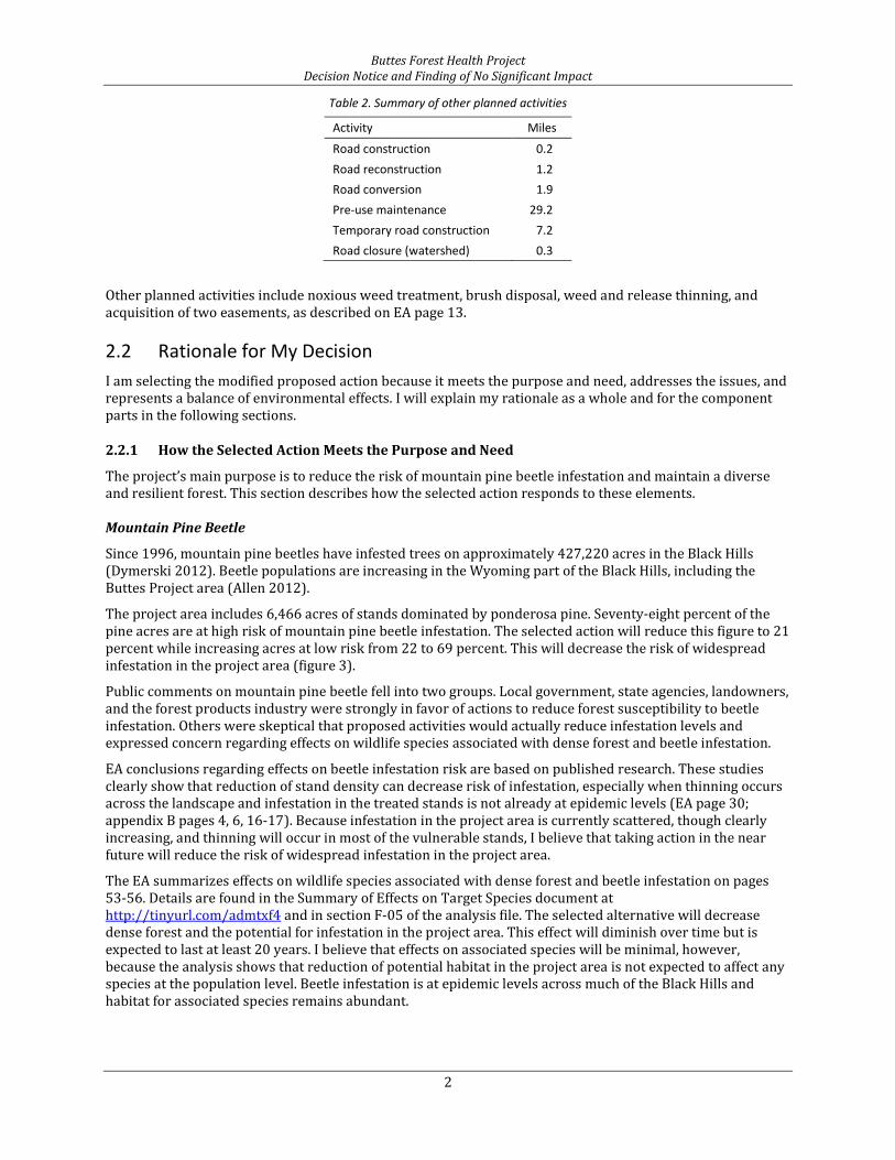
Table 2. Summary of other planned activities
Activity Miles
Road construction 0.2 Road reconstruction 1.2 Road conversion 1.9 Pre-use maintenance 29.2 Temporary road construction 7.2 Road closure (watershed) 0.3
Other planned activities include noxious weed treatment, brush disposal, weed and release thinning, and acquisition of two easements, as described on EA page 13.
2.2 Rationale for My Decision I am selecting the modified proposed action because it meets the purpose and need, addresses the issues, and represents a balance of environmental effects. I will explain my rationale as a whole and for the component parts in the following sections.
2.2.1 How the Selected Action Meets the Purpose and Need
The project’s main purpose is to reduce the risk of mountain pine beetle infestation and maintain a diverse and resilient forest. This section describes how the selected action responds to these elements. Mountain Pine Beetle
Since 1996, mountain pine beetles have infested trees on approximately 427,220 acres in the Black Hills (Dymerski 2012). Beetle populations are increasing in the Wyoming part of the Black Hills, including the Buttes Project area (Allen 2012).
The project area includes 6,466 acres of stands dominated by ponderosa pine. Seventy-eight percent of the pine acres are at high risk of mountain pine beetle infestation. The selected action will reduce this figure to 21 percent while increasing acres at low risk from 22 to 69 percent. This will decrease the risk of widespread infestation in the project area (figure 3).
Public comments on mountain pine beetle fell into two groups. Local government, state agencies, landowners, and the forest products industry were strongly in favor of actions to reduce forest susceptibility to beetle infestation. Others were skeptical that proposed activities would actually reduce infestation levels and expressed concern regarding effects on wildlife species associated with dense forest and beetle infestation.
EA conclusions regarding effects on beetle infestation risk are based on published research. These studies clearly show that reduction of stand density can decrease risk of infestation, especially when thinning occurs across the landscape and infestation in the treated stands is not already at epidemic levels (EA page 30; appendix B pages 4, 6, 16-17). Because infestation in the project area is currently scattered, though clearly increasing, and thinning will occur in most of the vulnerable stands, I believe that taking action in the near future will reduce the risk of widespread infestation in the project area.
The EA summarizes effects on wildlife species associated with dense forest and beetle infestation on pages 53-56. Details are found in the Summary of Effects on Target Species document at http://tinyurl.com/admtxf4 and in section F-05 of the analysis file. The selected alternative will decrease dense forest and the potential for infestation in the project area. This effect will diminish over time but is expected to last at least 20 years. I believe that effects on associated species will be minimal, however, because the analysis shows that reduction of potential habitat in the project area is not expected to affect any species at the population level. Beetle infestation is at epidemic levels across much of the Black Hills and habitat for associated species remains abundant.

Buttes Forest Health Project Decision Notice and Finding of No Significant Impact
3
Figure 2. Effects on mountain pine beetle infestation risk
Forest Diversity and Resilience
Threats to forest diversity and resilience in the Buttes Project area include encroachment of meadows and hardwood stands by pine, lack of diversity in pine forest, limited forage in big game winter range, and long-term absence of fire.
Pine encroachment: Meadows and hardwood trees such as quaking aspen provide habitat diversity, are not susceptible to mountain pine beetle, and can act as fuel breaks. Lack of disturbance allows pine to encroach on meadows and aspen stands. The selected action will reduce encroachment of 333 acres of meadows and 37 acres of aspen. Prescribed burning will further reduce encroachment. Maintaining these vegetation types will contribute to resilience by maintaining breaks in the pine forest, reducing potential fire size, and retaining a reservoir of early successional vegetation communities.
Pine forest diversity: Most pine stands in the project area are dominated by trees 100-140 years old. When large areas of forest are about the same age, gaps in age classes and successional stages may exist. These gaps can persist for decades. It may be difficult to maintain habitat components and ecological processes associated with missing successional stages. The selected action will diversify pine forest by regenerating some stands. It will also reduce the potential for loss of older stands to infestation and stand-replacing fire.
Big game winter range: The western and northern parts of the project area are in management area 5.4 (big game winter range; EA page 3). According to the Wyoming Game and Fish Department, most of the management area 5.4 in the project area is crucial winter range for white-tailed deer. The eastern half of the northern extension of the project area is crucial winter range for mule deer. The selected action will maintain and enhance forage in winter range by reducing pine density and encroachment of meadows and by applying

Buttes Forest Health Project Decision Notice and Finding of No Significant Impact
4
prescribed fire. Rugged topography and untreated areas will continue to provide cover and open road density in winter will remain low.
Long-term absence of fire: Evidence of historic fires is found across the project area. Since the advent of fire suppression, fire has largely been absent from all but the northeastern corner of the project area. Pine forest has become more continuous and ladder fuels that can carry fire into the forest canopy are more common. Consequently, the potential for high-severity fires has increased. Planned prescribed burning is expected to reduce the degree of departure from historical fire regimes in treated areas. Potential for Severe Wildfire
The purpose of the project also includes reducing the potential for severe wildfire that could spread to adjacent lands. Fire hazard is high or very high on 74 percent of the NFS acres in wildland-urban interface and on 60 percent of the NFS acres outside wildland-urban interface. The selected action will reduce these figures to approximately 19 and 7 percent, respectively. This will reduce the potential for widespread crown fire with uncharacteristically severe effects.
Figure 3. Effects on crown fire hazard
Public comments regarding fuel continuity and fire hazard were generally in two camps. Some commenting parties disputed the effectiveness of vegetation management in affecting wildfire, while the majority encouraged rapid and comprehensive action to reduce fire hazard.
Conclusions regarding effects on fire hazard are based on published research. I believe that the selected action, with planned disposal of logging slash, will reduce the potential for crown fire and the likelihood of fire crossing ownership boundaries. Further details and the scientific basis for these conclusions are found in

Buttes Forest Health Project Decision Notice and Finding of No Significant Impact
5
the EA (pages 34-39). The selected alternative will reduce fire hazard as much as I believe can realistically be done at this time without adversely affecting other resources.
As figure 3 displays, the selected action will not reduce fire hazard in every stand. Fire hazard will remain high in scattered stands. I considered actions that would reduce crown fire risk in these stands. Most are on steep slopes with no road access and unstable geology. The planning team examined the feasibility of helicopter yarding and determined that the relatively low value of the timber on these slopes and the distance to suitable helicopter landing sites would result in costs far exceeding revenues. Because the selected action will substantially reduce the size and connectivity of stands with very high fire hazard, I believe treatment of these stands would ultimately have little effect on spread or severity of a potential wildfire. Furthermore, I believe these actions and the associated road construction would cause unnecessary effects on other resources.
2.2.2 How Environmental Issues Were Considered and Addressed
The following environmental issues are described on EA page 6.
Activities resulting in large areas of the same forest type, density, and structure could negatively affect wildlife habitat: Parties commenting on the original proposed action expressed concern that the project could result in large, contiguous areas of low-density pine forest that would not provide habitat diversity. In response I directed the project planning team to examine proposed treatment areas and alter thinning proposals where needed to reduce patch size and increase within-stand variability. The modified proposed action (selected action) incorporates these changes (EA pages 7, 10, 26, and 43).
Untreated stands would continue to pose a risk of beetle infestation and high fire hazard: Based on comments on the original proposed action, I directed the planning team to revisit high-risk stands where no treatment was proposed. This field review resulted in additional treatment acres. Still, approximately 22 percent of pine acres in the project area will remain at high risk of beetle infestation after implementation of the selected action. These untreated stands are mainly in the western part of the project area where rugged topography, lack of roads, and geologic instability combine to make risk-reduction activities difficult or infeasible. Crown fire hazard in some of these same stands will remain very high. The planning team considered a variety of possible actions in these stands ranging from manual thinning to prescribed fire to helicopter logging but all proved to be unrealistically expensive or technically impossible without unacceptable resource effects. The selected action will reduce the size of the largest high-risk forest blocks from 800 to 300 acres and intersperse these blocks with more open, treated forest. My decision also allows sanitation of infested trees in these areas, if necessary. I believe the selection action addresses this issue to the greatest degree possible. Further details are found in section F-06 of the analysis file.
2.2.4 Environmental Documents Considered in Making the Decision
I considered a number of other documents in making my decision. These include the Black Hills National Forest Revised Land and Resource Management Plan as amended by the Phase 2 Amendment and the associated final environmental impact statement and record of decision; annual Black Hills National Forest monitoring reports; and resource reports and other supporting information and analysis.
2.2.5 Applicable Laws, Regulations, and Policies
For a complete discussion of how this decision complies with laws, regulations and policy, see section 6 of this document.

Buttes Forest Health Project Decision Notice and Finding of No Significant Impact
6
3 Public Involvement
The Forest Service solicited comments on the proposed action, potential concerns, and opportunities for managing the Buttes Project area from members of the public, other public agencies, tribal governments, adjacent property owners, interest groups, and natural resource specialists. Various methods were used to request comments, as described below.
• On March 5, 2012, the Forest Service mailed a scoping letter to approximately 148 interested parties, including adjacent property owners, American Indian tribal representatives, elected officials, state and federal agencies, and other organizations. This letter included a description of the project area, an overview of the planning process, a general explanation of the proposed actions, and an invitation to comment. Eleven parties provided feedback via letters, hand delivery, or electronic mail. EA appendix B contains public comments and the agency’s disposition of and response to those comments.
• On March 8, 2012, the Rapid City Journal published a legal notice announcing the project and soliciting public comment.
• On March 9, 2012, the Forest Service submitted a news release to local news media. The release was published by two local newspapers. It introduced the project to the public by providing a description of the project area and an explanation of the proposal. The release also solicited public comment on the project.
• On March 20, 2012, the Forest Service held a public meeting regarding the project. Seven parties attended and provided input.
• On January 15, 2013, the EA was distributed to parties eligible to file an objection (36 CFR 218) and those who had requested a copy.
• On January 19, 2013, the Rapid City Journal published a legal notice of opportunity to object to the project. No objections were received.
• Project information was posted on the Black Hills National Forest web site at http://tinyurl.com/admtxf4 and in the Schedule of Proposed Actions at http://www.fs.fed.us/sopa/components/reports/sopa-110203-2012-04.html.
• Other information sharing, communication, and interaction with interested parties, agencies, and individuals have occurred on a continuing basis during project planning. The project interdisciplinary team considered information shared by these parties in the development of the EA.
4 Alternatives Considered
In accordance with HFRA Section 104(d)(2), only the modified proposed action was analyzed in detail because the project is an authorized hazardous fuels reduction project and is substantially (77 percent) within 1.5 miles of an at-risk community (USDA Forest Service 2012). The analysis in the EA compares the proposed action to the likely results of taking no action.
EA page 22 provides an overview of alternatives considered but eliminated from detailed development and study.
5 Finding of No Significant Impact
Based on my review of the Buttes Forest Health Project EA, I have determined that the selected action is not a major federal action that would significantly affect the quality of the human environment. None of the environmental effects of my decision meet the definitions of significance in context or intensity (40 CFR 1508.27); therefore, an environmental impact statement will not be prepared. I base this conclusion on the following.

Buttes Forest Health Project Decision Notice and Finding of No Significant Impact
7
Context
The significance of effects of my decision has been analyzed in several contexts. My decision is consistent with the requirements of the Forest Plan and Phase 2 Amendment and contributes to meeting the goals of the Plan. None of the effects disclosed in the Buttes Project EA are different from those anticipated in the FEISs for the Forest Plan and Phase 2 Amendment. The analysis considers cumulative effects on the project area and associated watersheds. The EA estimates and discloses site-specific effects within the project area. The contribution of this project to the effects described in the FEISs, the possible cumulative effects, and the site-specific effects on the project area have all been considered in this determination. Intensity
Impacts that may be both beneficial and adverse: The EA considers and discloses both beneficial and adverse effects.
The degree to which the proposed action affects public health or safety: Public health and safety will be minimally affected by planned activities. Design features included in the EA will minimize safety concerns associated with planned timber harvest, fuel treatments, and transportation management actions. The project may benefit public safety by removing dead trees that could fall unexpectedly and improving road conditions.
Unique characteristics of geographic areas, such as proximity to historic or cultural resources, park lands, prime farmlands, wetlands, wild and scenic rivers, or ecologically critical areas: There are no known unique characteristics of the area that will be adversely affected by the project. No prime farmlands, park lands, wild or scenic rivers, or ecologically critical areas occur in the Buttes Project area. No adverse impacts are anticipated within floodplains. No adverse effects to wetlands or cultural resources are expected. No trend toward Federal listing or loss of species viability is expected for sensitive species as a result of the action. For further information see Chapter 3 of the EA and the analysis file.
The degree to which the effects on the quality of the human environment are likely to be highly controversial: The environmental effects of planned activities are known and there is little controversy over the actual effects. Effects are clearly described in Chapter 3 of the EA. (Disagreement over the decision itself does not constitute controversy for the purpose of determining significance under 40 CFR 1508.27.)
The degree to which the possible effects on the human environment are highly uncertain or involve unique or unknown risks: The possible effects of this proposal are known because the actions are similar to other management activities on the National Forest. Effects are not uncertain and there are no unique or unknown risks because specific treatment sites are designated, the analysis considered the maximum possible amount of action, and planned activities are the same as those considered in the Forest Plan FEIS. Timber harvest has occurred in the Black Hills for over 120 years and has occurred previously in the Buttes Project area. Implementation of the proposed activities does not involve any unique or unknown risks.
The degree to which the action may establish a precedent for future actions with significant effects or represent a decision in principle about a future consideration: The selected action does not set a precedent or represent a decision in principle for any future actions.
Whether the action is related to other actions with individually insignificant but cumulatively significant impacts: The analysis considers and discloses the effects of similar and connected actions related to this proposal. These include timber stand improvement activities and road construction and improvements to access areas for timber harvest. The EA also analyzes and discloses cumulative effects, including past, present, and reasonably foreseeable actions, on both private and public lands. For further information see Chapter 3 of the EA and the analysis file.
The degree to which the action may adversely affect districts, sites, highways, structures, or objects listed in or eligible for listing in the National Register of Historic Places or may cause loss or destruction of significant scientific, cultural, or historic resources: A cultural resource inventory report will be submitted for consultation prior to project implementation per Region 2 Agreement #09-MU-11020000-003 (Programmatic Agreement Among the USDA Forest Service, Wyoming Forests, Wyoming State Historic Preservation Officer, and Advisory Council on Historic Preservation Regarding Compliance with the National Historic Preservation Act on the National Forests and Grasslands of Wyoming) or following regular

Buttes Forest Health Project Decision Notice and Finding of No Significant Impact
8
procedures described in the implementing regulations (36 CFR Part 800) for Section 106 of the National Historic Preservation Act.
No adverse effects to eligible historic properties are expected. Regulations at 36 CFR 800.13 will apply to any archaeological remains found during implementation of project activities.
The degree to which the action may adversely affect an endangered or threatened species or its habitat: No effects on threatened or endangered species are expected. See EA sections 3.7 and 3.8.
Whether the action threatens a violation of Federal, State, or local law or requirements imposed for the protection of the environment: All state water quality requirements will be met as well as other federal, state, and local requirements imposed for the protection of the environment. Effects on water quality, floodplains, and wetlands are documented in the EA and analysis file. Design features will be used to protect water quality and to meet standards imposed by the Forest Plan, and Regional Watershed Conservation Practices/ Wyoming Best Management Practices will be applied consistent with requirements of the Clean Water Act. Changes in air quality are expected to be negligible during timber harvest. Prescribed burning will comply with air quality standards, as addressed in more detail in the individual burn plans that will be developed for each burn. No violations of environmental laws or requirements were identified through the environmental effects analysis.
6 Findings Required by Laws and Regulations
The EA was prepared in accordance with the following laws and regulations.
Clean Air Act The Clean Air Act of 1970 and its amendments protect and enhance the nation’s air resources. Federal and state ambient air quality standards are not expected to be exceeded as a result of implementing the selected action (EA pages 77-78). This action is consistent with the Clean Air Act. Clean Water Act The Clean Water Act, as amended, regulates discharge of pollutants to waters of the United States. Section 402 (33 USC 1342) of the Clean Water Act prohibits discharging pollutants into waters of the United States from a point source without first obtaining a permit from US Environmental Protection Agency or a primacy state. The state of Wyoming has primacy to administer the Section 402 permit programs in the state. At present, discharges from nonpoint silvicultural activities, including runoff from logging roads, are exempt from 402 permit requirements by regulation (40 CFR 122.3(e) and 122.27(b)). Wyoming does not currently require Section 402 stormwater permits for discharges from logging roads, but this may change in the future. If requirements change during implementation of this project, any necessary permits for road work associated with this project will be obtained as required by law.
Section 404 (33 USC 1344) of the Clean Water Act prohibits discharging dredged or fill material into waters (including wetlands) of the United States without first obtaining a permit from the US Army Corps of Engineers. Wetlands are regulated in accordance with federal Non-Tidal Wetlands Regulations (Sections 401 and 404). No dredging or filling is part of this action and no such permits are required.
The selected action will meet and conform to the Clean Water Act as amended in 1982. This act establishes a non-degradation policy for all federally proposed projects. The selected action is not likely to degrade water quality below standards set by the state of Wyoming. This will be accomplished through planning, application, and monitoring of state Best Management Practices and other mitigation measures and design features. The project will comply with the Clean Water Act (EA pages 74-76; analysis file section F-07). Endangered Species Act The Endangered Species Act (ESA, 16 USC 1531 et seq.) requires that any action authorized by a federal agency not be likely to jeopardize the continued existence of a threatened or endangered species or result in the destruction or adverse modification of the critical habitat of such species. No threatened, endangered, or proposed wildlife or plant species or their critical habitat are known to occur in the Buttes Project area.

Buttes Forest Health Project Decision Notice and Finding of No Significant Impact
9
Therefore, the analysis concluded that the Buttes Project would have no effect on listed or proposed species and no impact on critical habitat (EA pages 52, 57). National Environmental Policy Act The National Environmental Policy Act (NEPA) requires federal agencies to complete detailed analyses of proposed actions that significantly affect the quality of the human environment. The Act’s requirement to prepare an environmental impact statement is designed to provide decision makers with a detailed accounting of the likely environmental effects of a proposed action prior to adoption and to inform the public of (and encourage their comments on) such effects. The Buttes Project EA analyses the alternatives and displays the environmental effects in conformance with NEPA standards. The procedural requirements of NEPA have been followed. National Forest Management Act The 1982 and 2000 planning rules are no longer in effect. Pursuant to the 2012 planning rule, project decisions must be consistent with the Forest Plan (77FR21162). For the Buttes Project, the scope of analysis for Forest Plan management indicator species (MIS) is determined by its management direction, specifically its standards and guidelines (Forest Plan chapter II) and monitoring direction (chapter IV). The Forest Plan contains no obligation to conduct project-specific monitoring or surveying for MIS (Phase 2 ROD, pages 8 and 20; Forest Plan as amended, page I-11, objective 238). The Forest Plan establishes monitoring and evaluation requirements that do not require population monitoring for MIS, but rather employ habitat capability relationships (Phase 2 ROD, page 20; Forest Plan as amended, page I-11, objective 238). The Buttes Project analyzed the following MIS because habitat for these species is found in the project area: black-backed woodpecker, brown creeper, ruffed grouse, song sparrow, and white-tailed deer.
The planning team reviewed and considered an extensive body of scientific literature during the analysis. In addition, the record shows that all literature cited by the public during the comment period was reviewed and considered by resource specialists. Consistency with the Land and Resource Management Plan, as amended (Forest Plan): NFMA requires me to ensure that permits, contracts, cooperative agreements, and other activities carried out on the Black Hills National Forest are consistent with the Forest Plan. My decision is consistent with this direction in that:
• Planned activities will contribute toward achievement of Forest Plan goals and objectives (EA chapter 1).
• I have reviewed the Black Hills National Forest FY 2009 Monitoring and Evaluation Report and Region 2 Management Indicator Species (MIS) guidance for projects. The effects of planned activities on MIS are consistent with the Forest Plan (EA chapter 3).
• Planned activities are consistent with management area direction (EA chapter 3). • Planned activities comply with Forest Plan standards (EA chapter 3).
Specifically, the selected alternative will contribute toward achievement of the following Forest Plan objectives.
103 (maintain and improve long-term stream health): Existing stream condition is discussed on EA pages 72-74. Direct, indirect, and cumulative effects are discussed on pages 74-76. BMP effectiveness is discussed on page 76. Design features intended to maintain and improve long-term stream health are listed on EA pages 18-20.
201 (manage for aspen): The selected alternative will enhance aspen through pine removal and prescribed burning (EA page 48).
205 (manage for meadows): The selected alternative includes 333 acres of removal of encroaching pine from meadows. This activity will maintain meadow acreage (EA pages 48-49).
211 (provide snags): Design features intended to maintain snag availability are found on EA page 17. Effects are disclosed on pages 49-50.
213 (maintain or enhance riparian areas): The selected alternative includes watershed improvement projects, including road closure, in riparian areas. Effects are discussed on EA page 75.
217 (maintain habitat for game and fish populations): The selected alternative will maintain or improve game habitat as summarized on EA page 54.

Buttes Forest Health Project Decision Notice and Finding of No Significant Impact
10
218 (conserve or enhance habitat for non-game wildlife): Effects on non-game wildlife are summarized on EA pages 52-57.
221 (conserve or enhance habitat for R2 sensitive species and species of local concern): Effects on these species are summarized on EA pages 57-59.
238a (maintain or enhance habitat for ruffed grouse, song sparrow, white-tailed deer, and brown creeper): See objectives 201, 205, 211, 213, 217, 218, and 221 above.
238b (maintain habitat for black-backed woodpecker): See objective 211 above and management area structural stage objectives below.
303 (provide for sustained commodity uses in an environmentally acceptable manner): The selected alternative will produce approximately 17.2 million board feet (3.4 million cubic feet) while creating conditions for increased growth and continuing availability of forest products (EA page 40).
10-01 (reduce fire hazard): See pages 4-5 of this document and EA pages 34-39. 10-07 (reduce acreage of ponderosa pine at medium or high risk for infestation by mountain pine
beetle): See pages 3-4 of this document and EA pages 30-34. 5.1-204 and 5.4-206 (structural stage and tree size): See EA pages 45-48.
The selected action is consistent with all applicable Forest Plan standards and guidelines, as discussed in EA chapter 3 and analysis file section F-10-02. Resource management requirements: NFMA directs the Secretary of Agriculture to establish certain resource management guidelines in the agency directives system. I find that the activities in this project decision comply with NFMA as follows:
• Irreversible resource damage will not occur. The project will not cause irreversible resource damage, such as to soil productivity or watershed condition (analysis file section F-07).
• Adequate restocking is assured (EA appendix A). • No timber harvest for timber production purposes will occur on lands classified as unsuitable for
timber production (EA appendix A). • No created openings will be larger than 40 acres. • Culmination of mean annual increment (CMAI) requirements are met. NFMA generally prohibits
harvest of stands before they reach their maximum growth rate (16 U.S.C. 1604(m)). Exceptions in this law allow harvest of individual trees or parts of stands before this time to thin and improve timber stands and to salvage damaged stands. Further exceptions allow actions to achieve multiple-use objectives other than timber harvest. The public was advised of these exceptions to the law during the notice and comment period for this project. Further details are found in EA appendix A.
National Historic Preservation Act The National Historic Preservation Act (NHPA) provides comprehensive direction to federal agencies to identify, evaluate, treat, protect, and manage historic properties. Implementing regulations that clarify and expand upon the NHPA include 36 CFR 800 (Protection of Historic Properties). The Archaeological Resources Protection Act (ARPA) of 1979, the Native American Graves Protection and Repatriation Act (NAGRPA) of 1990 and Executive Order 13007 (Indian Sacred Sites) also guide Forest Service decision-making as it relates to managing cultural resources. Heritage professionals are directed to assess the effects of Forest Service proposed or authorized actions on cultural resources in consultation with the State Historic Preservation Office, Indian tribes, and other consulting parties. Healthy Forests Restoration Act The Buttes Project was proposed under the authority of the Healthy Forests Restoration Act of 2003 (HFRA, P.L. 108-148). The Black Hills National Forest Supervisor, with the assistance of Rocky Mountain Region Forest Health Management staff, has determined that epidemic mountain pine beetle populations exist in the Buttes Project area and vicinity (Bobzien 2012). Forest conditions in the project area are susceptible to beetle infestation and resulting mortality. This mortality poses a threat to management area goals for wood fiber production and wildlife habitat as well as to public safety and property values on adjacent developed lands. The Buttes Project qualifies for expedited vegetation management under HFRA Section 102(a)(4).

Buttes Forest Health Project Decision Notice and Finding of No Significant Impact
11
The selected action is consistent with applicable portions of HFRA:
• Approved activities are consistent with Black Hills National Forest Land and Resource Management Plan goals, objectives, standards, and guidelines.
• Activities will not occur on lands that are a component of the National Wilderness Preservation System, Wilderness Study Area, or lands on which removal of vegetation is prohibited or restricted by an act of Congress or presidential proclamation.
• Collaboration with local governments was conducted through the scoping process and meetings. • The project’s purpose is to decrease the risk of mountain pine beetle infestation.
Executive Orders Executive Order 11593: Executive Order 11593, Protection and Enhancement of the Cultural Environment, also includes direction about the identification and consideration of historic properties in federal land management decisions. The order, issued May 13, 1971, directs federal agencies to inventory cultural resources under their jurisdiction, to nominate to the NRHP all federally owned properties that meet the criteria, to use due caution until the inventory and nomination processes are completed, and to assure that federal plans and programs contribute to preservation and enhancement of properties not federally owned. This project satisfies the requirements of E.O. 11593 (EA page 82).
Executive Order 11988: This order requires that federal activities generally avoid occupancy and modification of floodplains. The selected alternative will not change floodplain function or value and complies with E.O. 11988 (EA page 74).
Executive Order 11990: Executive Order 11990, Protection of Wetlands, requires that federal activities generally avoid modification or destruction of wetlands. The selected alternative complies with E.O. 11990 and will not negatively affect wetlands (EA page 76).
Executive Order 12898: A specific consideration of equity and fairness in resource decision-making is encompassed in the issue of environmental justice. E.O. 12898 provides that “each federal agency shall make achieving environmental justice part of its mission by identifying and addressing, as appropriate, disproportionately high and adverse human health or environmental effects of its programs, policies, and activities on minority populations and low-income populations.” No adverse effects from the selected alternative have been identified on minority or low-income populations (EA page 83).
Executive Order 13112: This order requires federal agencies to avoid actions that will spread invasive species unless the benefits of the actions clearly outweigh the potential harm and all feasible and prudent measures to minimize risk of harm will be taken. The analysis shows that the selected alternative will comply with this order (EA page 59).
6 Administrative Review or Appeal Opportunities
This analysis was completed under the authority of the Healthy Forests Restoration Act, Title I, Section 104. Projects analyzed under HFRA are exempt from the notice, comment, and appeal procedures set forth at 36 CFR 215. The Buttes Project is subject to 36 CFR 218, which establishes separate review and objection procedures for HFRA projects. The objection process is the sole means of seeking administrative review of a proposed hazardous fuels reduction project on NFS lands. Under this process, the responsible official may not issue a decision concerning an authorized project until the reviewing officer has responded to all objections.
The Rapid City Journal published a legal notice announcing the objection period on January 19, 2013. No objections were filed.
7 Implementation
The Buttes Project selected action as described in this decision notice may be implemented immediately.


Attachment 1
Planned Activities, Design Features, and Monitoring


Buttes Forest Health Project Decision Notice and Finding of No Significant Impact – Attachment 1
1
Attachment 1 Planned Activities, Design Features, and Monitoring Planned Activities
Commercial thin Commercial thin will occur in pine stands where most trees are at least nine inches in diameter at breast height (4.5 feet above the ground) (DBH). Objectives are to reduce beetle infestation risk and fire hazard and increase stand vigor and growth. Well-formed trees will be retained at an average spacing of about 25 feet (50 to 60 square feet of basal area per acre). Merchantable cut trees will be removed and sold as sawtimber.
Post-harvest tree spacing will be fairly even throughout stands on about half the total commercial thin acres. In the remaining stands, variable spacing will result in a more uneven stand structure.
Commercial thin and all other vegetation treatments will be approved by a certified silviculturist. (Forest Plan standard 2408c) Products other than logs (POL) thin Pine trees five to nine inches DBH will be thinned to a 16- to 18-foot spacing and cut trees sold as products other than logs or as biomass. This treatment will allow increased growth of remaining trees and reduce fuel continuity. POL thin may take place alone or in combination with commercial thin. Precommercial thin (PCT) This treatment will occur where trees are less than five inches DBH. Thinning may be conducted by crews using chainsaws or by mechanized cutting and chipping equipment. Objectives are to increase growth and reduce fuels. PCT may take place alone or in combination with commercial thin or shelterwood removal harvest. POL/PCT Combination of POL and PCT where stand conditions are variable. Sanitation Sanitation consists of cutting pine trees infested by mountain pine beetles before the beetles leave to infest healthy trees. To accomplish this, trees need to be cut between late summer and the following spring. Since 2010, mountain pine beetles have infested numerous small patches of forest in the project area. New infestation occurs mainly in late summer and is not evident on a broad scale until the following summer, so the scale of the 2012 infestation is not known at this time. Preliminary information indicates that infestation is continuing to spread in the project area.
The selected action will allow sanitation as necessary in all pine stands. Cut trees will be used commercially if possible. If not, methods such as chipping tree trunks or cutting them into short pieces will be used to reduce beetle survival.
Prior to conducting sanitation outside stands planned for other treatments, project managers will consult resource specialists to ensure that sensitive resources are protected. No new permanent roads will be constructed for sanitation.
While sanitation is allowed in all pine stands, the actual acres treated will probably be a fraction of the total depending on infestation levels and availability of resources. Allowing sanitation as necessary in these stands provides flexibility in response to the unpredictable course of the infestation. Shelterwood establishment This harvest type is part of the shelterwood silvicultural system, in which pine is regenerated to form a new stand. This is an even-age form of stand management, resulting in stands with most trees in one or two age classes.

Buttes Forest Health Project Decision Notice and Finding of No Significant Impact – Attachment 1
2
In the shelterwood establishment step (also known as seedcut), the best-formed mature trees are retained as a seed source while the rest of the trees are cut to provide space for seedlings. This treatment reduces susceptibility to mountain pine beetle infestation by creating young stands of small-diameter trees, which are not generally infested by this type of beetle. Diversifying the landscape-level mix of stand ages also reduces the potential for widespread infestation in future decades.
Stands planned for shelterwood establishment are characterized by fairly large, mature ponderosa pine. Patches of pine seedlings or saplings may be present in the understory. After harvest, there will be about 50 feet between trees (30 square feet of basal area per acre). Conditions immediately after treatment will generally consist of widely spaced mature trees with patches of pine seedlings or saplings.
In Black Hills ponderosa pine, natural regeneration usually results in a new stand of small trees within a decade of treatment. Exposed soil provides a good seedbed for pine, and regeneration may be delayed due to understory competition from grass or shrubs. Conducting shelterwood establishment on frozen or snow-covered ground can result in very little ground disturbance, so where understory competition may be a problem this treatment will be conducted in summer if possible. (Forest Plan standard 2408b, guideline 2412) Shelterwood removal Shelterwood removal (also known as overstory removal) will occur in stands with abundant pine regeneration. Most of the overstory trees will be removed to make all of the site’s resources available to the new stand, with seed trees retained in areas without sufficient regeneration. Overstory trees may also be retained where there are indications of wildlife use or where needed to maintain effectiveness of road closures. Thinning of pine seedlings and saplings (POL and/or PCT) will take place following the commercial treatment. Post-treatment conditions will generally consist of pine seedlings and saplings two to 20 feet tall with occasional patches of widely spaced mature trees.
Removal of the overstory will improve growing conditions for the new stand by reducing competition. The resulting stands will have low susceptibility to mountain pine beetle infestation. Risk of infestation is currently lower in these stands than in dense, mature stands elsewhere in the project area. Shelterwood removal is therefore a lower priority than thinning. Uneven-age individual tree selection Uneven-age management produces stands with a variety of ages and sizes. This treatment will take place in one stand where several age and size classes already exist. Trees will be removed from all size classes as necessary to maintain or enhance an uneven distribution while reducing stocking. Uneven-age management will be applied consistent with Forest Plan standard 2408a and guideline 2410. Late succession thin Thinning to reduce risk of mountain pine beetle infestation will take place in one late succession pine stand. This stand consists of a mix of tree sizes at high density. Large-diameter live trees and snags are present as are small patches of beetle infestation. Thinning of small trees occurred 30 to 40 years ago. Thinning will focus on retention of large-diameter live trees and standing snags while reducing overall stocking in smaller diameter classes. Spacing will vary to maintain late succession characteristics and a natural appearance from Wyoming Highway 585. Fuel reduction Fuel reduction will occur along the national forest boundary adjacent to developed private land. The objective is to reduce fuels in strategic locations for fire suppression. Where funding and terrain allow, this will be accomplished using machinery such as a tracked masticator/chipper. Small pine and dead vegetation will be cut and chipped, with the chips dispersed across the forest floor. Where slopes are too steep for tracked equipment, trees will be cut by hand and the material lopped and scattered on site. If trees are hand-felled adjacent to private property and fuel loading is a concern in that area, slash will be piled and burned to eliminate high levels of surface fuels.
Commercial use of cut trees will occur where possible. Generally, however, fuel reduction is planned in these locations because terrain, land ownership patterns, and highly erosive soils prevent commercial harvest.

Buttes Forest Health Project Decision Notice and Finding of No Significant Impact – Attachment 1
3
Pine removal from meadow Loss of meadows reduces diversity of vegetation and value of wildlife habitat, particularly in winter range. Openings in the forest canopy can also serve as fuel breaks. In the absence of disturbance, pine expands into meadows. This has occurred in various locations across the project area. Encroaching pine will be cut as allowed by Forest Plan guideline 2107. Cut trees will generally be small and slash will be scattered or removed from meadows. Occasional larger trees may be removed commercially if possible. Pine removal from aspen Quaking aspen stands provide diversity and can act as fuel breaks. Over time, pine may expand into aspen stands. The selected action includes cutting of small pine in encroached aspen stands to set back forest succession and perpetuate the hardwood component. Prescribed fire Fire has been absent from most of the project area for decades except in the area burned by the Lantz Fire in 1985 (see EA Figure 3, page 8). Prescribed burning is often conducted after mechanical treatments and can be a practical way to reduce wildfire hazard and increase plant community resilience. Objectives of planned broadcast burning include fuel reduction, nutrient cycling, forage improvement, and increased resistance to wildfire, consistent with Forest Plan guideline 4105.
Sixty-seven percent of the acres planned for burning will be mechanically treated first or were treated within the last 10 years. Prescribed fire will occur without prior mechanical treatment in locations where highly erosive soils and unstable slopes prevent development of access. These areas include South Fish Mountain and the south aspects of Fish Mountain and Duling Hill (see EA Figure 1, page 2, and Figure 4, page 9).
• The south aspect of Fish Mountain (90 acres) is steep and rocky with patchy to sparse pine forest. Burning will keep this slope relatively open, increasing winter range values.
• The south aspect of Duling Hill (341 acres) consists of dense, mature forest broken by one large meadow and several small openings. Historical landslides have been documented in this area and potential is high for ground-disturbing activities such as road construction to cause additional movement. Fuel loading is high and there are patches of beetle infestation. Burning will occur in winter when snow covers adjacent slopes. Winter burning is expected to result in patches of overstory mortality but should reduce the potential for an extremely intense summer wildfire that would be dangerous and difficult to suppress. Most large wildfires in the Black Hills occur when winds are from the south or southwest, and Duling Hill’s location on the south side of the Black Buttes means that a summer fire could easily spread to a larger forested area. Reducing fuel loading and opening the canopy will decrease potential fire intensity.
• South Fish Mountain consists of 192 acres. Mechanical treatment will occur on 65 of these acres and 37 acres are meadow. The remaining 97 acres are mostly on a south aspect and are steep, rocky, and erosive. Patches of beetle infestation exist. Fuel reduction will take place in strategic locations prior to burning but terrain prevents mechanical operations.
In mature, even-age pine stands on ground suitable for timber harvest, mortality limit for trees over nine inches DBH will generally be 10 percent. In pole and uneven-age stands, the 10 percent limit will apply to trees over five inches DBH. A certified silviculturist will review and approve burn plans, including mortality limits, consistent with Forest Plan guideline 4108. Road closure for watershed improvement reasons 0.3 miles National Forest System Road (NFSR) 872.4G is in a drainage that contributes to Silver Creek. A section of the drainage is so narrow that the road is essentially in the creekbed. The selected action will permanently close this section of the road and rehabilitate the stream channel. Areas accessed by this road can be reached using other existing routes.
Buttes Forest Health Project Decision Notice and Finding of No Significant Impact – Attachment 1
4
Specified road construction Existing roads provide access to most of the areas planned for commercial timber harvest. Construction of one new, permanent NFS road may be necessary. Part of the road will be on an old road template but the approach to its junction with the existing NFS road needs to be moved to prevent erosion. The new road will be closed following construction until needed for timber sale or related activities and closed on completion of use. New roads were limited to the minimum number feasible and designed to avoid creation of unnecessary barriers. (Forest Plan standard 1105, guidelines 3202, 9201) Road reconstruction Existing roads in fair to poor condition will be improved or realigned prior to use. Reconstruction will consist mainly of blading, clearing, and adding aggregate surfacing; in some locations, it will be necessary to add drainage structures or put down larger gravel to harden the roadbed or drainage surfaces. Road conversion The project area includes roads that are not part of the authorized national forest road system. Some of these will be needed for planned vegetation management activities and may be needed again in the future. These roads will be added to the authorized system. About 1.4 miles of these roads are in good condition and require only minor improvements before use. Another 0.5 mile require reconstruction. Pre-use maintenance Existing roads in good condition will be bladed to remove surface irregularities and re-establish the road shoulder. Temporary road construction Where topography permits and long-term access is not necessary, temporary roads will be constructed and permanently closed after use. Noxious weed treatment Noxious weed control will occur as necessary. Control usually takes the form of herbicide application, release of biocontrol agents such as Ceutorhynchus litura (a weevil) or Urophora cardui (a stem and shoot gallfly), both effective against Canada thistle, or manual/mechanical removal of weeds. Areas most likely to require treatment include log landings and road margins. Brush disposal Slash resulting from timber harvest and fuel treatment will be disposed of through burning, chipping, or other methods. Slash pile sites will be scarified, seeded, and treated for noxious weed infestation if necessary. Weed and release Non-merchantable cull trees may be cut following commercial treatments depending on site conditions. Cut material will be bucked and scattered. Easements There are no public or administrative easements on roads that provide access to stands 11 and 20 (northwest corner of project area; see map in EA Appendix C). Planned activities are contingent on securing easements from adjacent landowners.

Buttes Forest Health Project Decision Notice and Finding of No Significant Impact – Attachment 1
5
Design Features
This section includes project-specific design features applicable to the selected action. An asterisk (*) following an item indicates that site-specific design features are restricted to the project or resource file to protect sensitive resources (e.g., heritage sites).
The following documents are incorporated by reference and contain standard design features that apply to the selected action.
• 1997 revised Land and Resource Management Plan for the Black Hills National Forest, as amended by the Phase 2 amendment; chapters 2 (standards and guidelines) and 3 (management area direction). Available on the Black Hills National Forest web site at http:/fs.usda.gov/blackhills/.
• Rocky Mountain Region Watershed Conservation Practices handbook (WCPH, FSH 2509.25). Available on the Forest Service web site at http://www.fs.fed.us/im/directives/.
• Black Hills National Forest 2003 noxious weed management plan (USDA Forest Service 2003).
1. Wildlife and Plants
a. Known rare plant occurrences and rare plant habitat will generally be avoided. Road work and construction of prescribed burn control lines in or adjacent to known rare plant sites and suitable habitat will be coordinated with the district botanist. Any ground-disturbing activity in rare plant habitat will be designated in consultation with the district botanist.*
b. Activities are planned on approximately 23 acres that are within one-half mile of a known goshawk nest. Timing restrictions apply. NFSR 872.3 and County Road 246 (Reynolds Road) are within one-half mile of the nest but the timing restriction does not apply because these roads are currently open to motorized vehicles and traffic associated with this project does not constitute a new disturbance.* (Forest Plan standard 3111)
c. Any new goshawk nests found during project implementation will be protected in accordance with Forest Plan direction. Any other raptor nests, sensitive species, or species of local concern sites found during project layout or implementation will be evaluated by a wildlife biologist or botanist on a site-specific basis to determine if special requirements are warranted to protect site integrity. (Forest Plan standards 3101, 3102, 3103, 3115, 3116, 3204, 3207)
d. Ground-disturbing activities and use of heavy equipment will be avoided in meadows and in aspen, paper birch, and mature bur oak stands and inclusions unless no other option is available. If ground-disturbing activities or heavy equipment use cannot be located outside these areas, project administrators will contact district resource specialists prior to implementation to determine if special requirements are warranted to protect site integrity. (Forest Plan guidelines 4111, 9204)
e. Bur oak trees over six inches in diameter will not be cut prior to consultation with the district wildlife biologist or botanist.
f. Turkey roost sites will be retained consistent with Forest Plan guideline 3205.
g. The project area contains scattered individual live ponderosa pine greater than 30 inches DBH. To maintain stand diversity and provide wildlife habitat, these trees will not be cut.
h. Big game screening cover will be retained along at least 20 percent of County Road 247 (Clark Road) on NFS lands. (Forest Plan guideline 3203)
i. Slash resulting from pine removal from meadows will not be piled in meadows.
2. Heritage resources
a. Cultural resources determined eligible to the National Register of Historic Places (NRHP) will be avoided, protected, or treated according to the terms developed in conjunction with the Wyoming State Historic Preservation Office and all tribes listed on the Black Hills National Forest tribal mailing list as described
Buttes Forest Health Project Decision Notice and Finding of No Significant Impact – Attachment 1
6
in 36 CFR 800.6 and 800.7. Resources eligible for nomination to the NRHP will be monitored prior to project implementation and an assessment of the current condition will be documented to determine whether any management actions should be recommended to avoid adverse effects.
b. Heritage resource inventories will be completed in the Area of Potential Effect (APE) prior to implementation per Region 2 Agreement #09-MU-11020000-003 (Programmatic Agreement Among the USDA Forest Service, Wyoming Forests, Wyoming State Historic Preservation Officer, and Advisory Council on Historic Preservation Regarding Compliance with the National Historic Preservation Act on the National Forests and Grasslands of Wyoming) or following procedures described in 36 CFR Part 800, Section 106 of the National Historic Preservation Act.
c. The Forest Service will complete cultural resource evaluations for all sites within the APE using NRHP criteria in order to make a recommendation of eligibility including a determination of effect.
d. An inventory report or reports will be prepared including inventory results, monitoring documentation, NRHP recommendations for unevaluated sites, and mitigation measures to avoid potential effects to historic properties within the project APE. The report will conform to the Secretary of Interior’s Standards and Guidelines for Archaeology and Historic Preservation, Reporting Identification results (48 CFR 44723) and state standards as published on the Wyoming State Historic Preservation web site. The resulting report will be distributed for consultation to the State Historic Preservation Officer (SHPO) and Tribal Historic Preservation Officers (THPOs) that have requested to be on the Black Hills National Forest mailing list for consultation.
e. If cultural resources are discovered or disturbed or if unanticipated effects on historic properties are found during implementation of planned activities, the agency will avoid, minimize, or mitigate any adverse effects and notify the SHPO and THPOs that have requested to be on the Black Hills National Forest mailing list within 48 hours of discovery as required by 36 CFR 800.13.
3. Improvements
a. All Forest Service-authorized improvements, such as fences, utility lines, property corners, and water developments, will be shown as protected improvements on timber sale area maps and prescribed burn maps and protected during all management activities. Fences delineating the boundary of NFS and non-NFS lands are the responsibility of the non-NFS landowner and may not be mapped. Damage to fences accurately located on the surveyed property boundary will be avoided.
4. Noxious weeds
a. If infestations of knapweed or leafy spurge are discovered during project activities, project staff will stop ground-disturbing actions within 100 yards of the infestation and notify staff responsible for the district noxious weed control program before activities are resumed. Information on recognizing and reporting knapweed and spurge will be provided to personnel implementing planned activities.
b. Contracts and permits issued as part of this project will include measures to limit spread of noxious weeds. Heavy equipment used for timber harvest, slash pile disposal, and other activities will be cleaned before entering the timber sale or burn area if the area it previously operated in is unknown or documented to be infested with noxious weeds. Where information is available, noxious weed infestations will be identified by district staff and designated on sale area maps and prescribed burn maps. Noxious weed control activities will take place prior to ground-disturbing and burning activities, when feasible, to reduce weed spread and establishment. (Forest Plan standard 4301)
c. Review of the area for noxious weed infestations will continue during planned activities. If new noxious weed infestations that could be spread by planned activities are found during implementation, action to minimize spread will be taken.
d. Staff responsible for the district noxious weed control program will, in coordination with the project engineer, inspect gravel pits for noxious weed infestation before transport and use of gravel and other material. Infestations will be treated to prevent spread.

Buttes Forest Health Project Decision Notice and Finding of No Significant Impact – Attachment 1
7
e. Fuel management personnel will provide slash pile location data to staff responsible for the district noxious weed control program following pile disposal.
f. Noxious weeds will be controlled as necessary in areas disturbed during project implementation using herbicide, biocontrol agents (insects), and/or manual removal. Chemicals will be applied in ways that minimize risk of water contamination and negative effects on non-target species. (Forest Plan standards 1213, 4304, 4308, guidelines 4302, 4305)
5. Timber harvest
a. Whole-tree yarding will be prohibited in specific locations where there is insufficient space for whole-tree landings without resource damage or where soil organic matter levels are low. This measure applies to the following stands (see map in EA Appendix C).
16 128 166 240 285 17 132 173 245 290 96 133 188 259 304
103 141 193 262 386 108 145 216 279 388 119 152 230 280 469 126 155 232 284 470
b. Planned activities will result in variable stand density in stands listed below to prevent creation of large, contiguous areas of open, mature pine forest, retain a natural appearance in areas visible from main travelways, or meet the adopted scenic integrity objective of moderate or high. (Forest Plan guideline 5611)
17 123 142 206 316 29 125 144 212 331 31 126 145 214 346 45 128 152 216 359 93 131 157 236 371
105 132 173 255 444 108 139 174 280 455 119 140 188 285 121 141 193 290
c. Planned activities in areas that are adjacent to non-NFS lands and visible from a distance will be designed to avoid creation of straight lines and abrupt changes in stand density between cut and uncut areas. This measure applies to the following stands.
48 115 212 273 100 133 214 274 102 139 255 474 103 140 261
d. Layout and marking of timber sale units will comply with forest-wide marking guides in effect at the time of implementation.
e. All vegetation treatments will be approved by a certified silviculturist. (Forest Plan standard 2408c)
6. Pine regeneration
a. Pine regeneration will be protected during all phases of harvest operations in stands or portions of stands treated with shelterwood removal. Any existing pine regeneration present in stands treated with shelterwood establishment will be protected. Methods may include directional felling and skidding, spacing of skid trails at intervals of no less than 100 feet, and placement of log landings in pre-existing openings or areas with minimal pine regeneration. Whole-tree yarding may be used as long as it is not otherwise prohibited (see measure 5a) and damage to existing regeneration would be minimal.
b. To increase the likelihood of successful conifer regeneration, stands planned for shelterwood establishment in areas prone to development of pine-inhibiting vegetation will be logged when the

Buttes Forest Health Project Decision Notice and Finding of No Significant Impact – Attachment 1
8
ground is not snow-covered or frozen, if possible, to maximize the site scarification provided by the skidding operation, provided there are no concerns related to other resources. Cutting will be done in such a way that areas will be restocked with trees within five years after final harvest. (Forest Plan standard 2408b, guideline 2412)
7. Rangeland
a. All pasture gates will be identified on timber sale area maps and kept closed during the grazing season (generally June through October). Any new wire gates will include user-friendly features such as manual gate closers or chains to ensure ease of opening and closing.
b. If log hauling or movement of heavy equipment related to timber harvest causes damage to cattleguards, the timber purchaser will be responsible for repair.
c. Ground-disturbing activities will not occur in long-term range monitoring transects. Logging slash will not be placed in transects.
d. Livestock grazing may be deferred in burned areas to ensure regrowth of forage depending on site-specific conditions. (Forest Plan guideline 4107)
8. Snags and down woody material
a. Snags will be cut only for safety reasons, including when necessary to provide safe passage on roads, skid trails, fire control lines, and at log landings. (Forest Plan standard 2305)
b. In commercial timber harvest units, live, uninfested trees within 10 feet (at ground level) of solid snags at least 20 feet tall, or on which snags meeting this description are leaning, will be retained to protect the snag from wind and reduce the potential that the snag would need to be cut for safety reasons.
c. Where possible, any snags cut as safety hazards will be left on site rather than salvaged or skidded to landings. Timber sale contract provisions will be used to protect snags.
d. To ensure provision of down woody material, existing down logs will be left on site following all commercial timber harvest treatments.
9. Recreation and public safety
a. Appropriate signing or other cautionary measures will be implemented in conjunction with all management activities to ensure public safety. Implementation of these measures is the responsibility of the person initiating the action (e.g., logging contractor or prescribed fire manager).
b. Dust control, if necessary, may be done with water, magnesium chloride, calcium chloride, or equivalent.
10. Travel management
a. While planned activities are taking place, all road closure gates that would normally be closed during big game hunting seasons will be kept closed and locked during these seasons and one week before the seasons except to allow administrative traffic. Gates will be closed again immediately after the administrative traffic passes unless this would cause a hazard.
b. Timber sale units will be laid out to facilitate existing road restrictions (for example, trees near gates and other barriers will be left uncut to maintain obstructions and discourage driving around the gate or barrier).
11. Fuels
a. Most planned vegetation management activities will result in slash, either in piles or scattered across the treated areas. When left in the stand, slash can pose a temporary fire hazard. Within three to five years, however, needles and other fine fuels disintegrate and the slash is no longer as likely to ignite. In the interim, fuel reduction actions will take place if fuel loading exceeds Forest Plan limits. If slash is piled,

Buttes Forest Health Project Decision Notice and Finding of No Significant Impact – Attachment 1
9
crews will burn, chip, or otherwise dispose of piles and rehabilitate the pile sites. Small piles of woody material will be retained at a rate of one per two acres. (Forest Plan standard 3117)
b. Activity fuels will be reduced in treated stands to levels specified in Forest Plan guidelines 4110 and 4112.
12. Soil and water
a. To reduce potential for compaction and/or rutting, the following measure apply on all soil map units: heavy equipment will be operated for land treatments only when soil moisture is below the plastic limit, soil is protected by at least one foot of packed snow, or the top two inches of the soil are frozen (WCPH management measure 13/design criterion b; Forest Plan guideline 1104).
b. Roads, landings, skid trails, and other concentrated use sites will be restricted to designated sites (WCPH management measure 12/design criterion a) and constructed to minimize sediment production. (Forest Plan standards 1113, 1114, guideline 9202)
c. Temporary roads and constructed skid trails will be stabilized, scarified, and/or recontoured prior to seeding to alleviate compaction and prevent erosion. (Forest Plan standard 1106, guideline 4106)
d. To reduce the potential for erosion, skid trails will be waterbarred, seeded, and/or covered with logging slash on soil map units Q0114F (Grizzly-Virkula complex), Q0584F (Vanocker-Citadel complex), and Q0563G and Q0926G (Rock Outcrop-Vanocker complexes). Heavy equipment use on these soil map units will be limited to dry or frozen conditions. These soil map units make up the majority of the project area. (WCPH management measure 9/design criterion e; Forest Plan standards 1113, 1114)
e. To reduce the potential for erosion, road and trail use on soil map units 119 (Nevee silt loam), Q0114F (Grizzly-Virkula complex), Q0512E (Citadel-McCooley complex), Q0540F (McCooley-Tollflat complex), Q0563G and Q0926G (Rock Outcrop-Vanocker complexes), Q0584F (Vanocker-Citadel complex), Q0815E (Crownest-Regnaps complex), Q0854E (Work clay loam), and Q0910E (Corpening-Rock Outcrop complex) will be limited to dry or frozen conditions. These soil map units make up the majority of the project area. (WCPH management measure 9/design criterion b)
f. To prevent damage to the soil by fire, prescribed fire intensity on soil map units Q0114F (Grizzly-Virkula complex) and Q0540C and Q0540F (McCooley-Tollflat complexes) will be limited to moderate levels Affected stands include the following.
137 165 255 300 470 148 174 273 360 156 194 274 369 157 197 287 373 160 243 295 468
g. No log landings or slash piles will be placed on thin soils over bedrock located in central stand 96 or in stand 277.
h. No mechanized activities will occur in seepy areas in stands 273 and 295.
i. Mechanized equipment will cross drainages in stands 103, 132, 152, 173, 188, 197, and 474 only at designated points.
j. Layout of timber sale units in the following stands will be coordinated with the district hydrologist or geologist to prevent effects on potentially or currently unstable slopes.
31 113 172 280 364 468 96 123 216 287 367 469
104 133 261 290 441 470 105 141 273 331 444 108 152 274 346 445
k. Layout of timber sale units in the following stands will avoid areas with bent trees or hummocky terrain to prevent effects on potentially unstable slopes.

Buttes Forest Health Project Decision Notice and Finding of No Significant Impact – Attachment 1
10
93 128 172 240 285 108 132 173 255 287 115 133 188 257 455 121 141 216 273 125 152 230 274
l. Heavy equipment and other motorized vehicles will not enter the water influence zone along perennial or intermittent streams and wetlands (a 100-foot buffer) except to conduct road work at designated locations or as agreed upon by a hydrologist (WCPH management measure 3; Forest Plan standards 1301, 1306, guidelines 9107, 9108). Timber cutting will generally not occur in water influence zones except as agreed upon by a hydrologist. Logs removed from the water influence zone will be yarded using one-end or full suspension. Trees will be felled in a way that protects vegetation in the water influence zone from damage. (WCPH management measure 3/design criterion d) Landings will not be placed in water influence zones. (Forest Plan standard 1306, guidelines 3212, 4111)
m. Buffer strips or barriers will be used to reduce sedimentation. (Forest Plan guideline 1115)
n. Engineering road design specifications and guidelines will be followed to protect highly erodible soils and road surface material. Measures include placement of aggregate on the roadbed, installation of culverts, construction of water diversion structures (especially for grades steeper than 10 percent), and seeding of cut and fill slopes as soon as possible after construction. The guidelines parallel those outlined in the Wyoming Forestry Best Management Practices (Wyoming Department of Environmental Quality 2006).
13. Revegetation of disturbed soils
a. Disturbed soil will be revegetated in a manner that optimizes plant establishment on the site. Revegetation may include planting, seeding, fertilization, and placement of weed-free mulch as necessary. Revegetation will be initiated as soon as possible, generally not to exceed six months, after termination of ground-disturbing activities. All disturbed soils will be revegetated with native species when available using seed mixtures that are free of noxious weeds. On areas needing the immediate establishment of vegetation, non-native, non-aggressive annuals, non-aggressive perennials, or sterile perennials may be used until native perennials become established. (Forest Plan standards 1106, 1110, 4306, guidelines 4106, 9202)
b. Timber sale roads will be seeded after construction but before timber harvest if any part of the gap between construction and harvest would occur between April and October. This may be accomplished under the road contract. If necessary, the road will be seeded again after use is complete. Seeding may be delayed until after completion of harvest if the gap between construction and harvest will be of short duration and if hydrology, soils, engineering, and noxious weed specialists determine after field review that a delay would be acceptable. (Forest Plan standard 1106)
c. Log landing sites will be seeded with an approved seed mix as soon as possible following slash disposal. Pile sites will be ripped to a depth not exceeding six inches, if necessary. If slash is burned, ash and mineral soil will be mixed prior to seeding to improve the seedbed. (Forest Plan standard 1106, guideline 4106) 12c
d. Temporary roads and constructed skid trails will be stabilized, scarified, and/or recontoured prior to seeding. (Forest Plan standard 1111)
e. Lines constructed for control of prescribed fires will be rehabilitated to prevent erosion and weed infestation. Methods may include construction of water bars, replacement of sod and brush, and seeding. (Forest Plan standard 1106) 12e
14. Prescribed Fire
a. In mature, even-age pine stands, mortality limit for trees over nine inches DBH will generally be 10 percent. In pole and uneven-age stands, the 10 percent limit applies to trees over five inches DBH. A certified silviculturist will review and approve burn plans, including mortality limits. (Forest Plan guideline 4108)

Buttes Forest Health Project Decision Notice and Finding of No Significant Impact – Attachment 1
11
b. Prescribed burning generally takes place during the day. Daytime ignition will end early enough to allow fuel consumption and reduce night smoke emissions. Night burning may occur if conditions are in prescription, forecast night smoke dispersal is “good” or better, and there is no population within 10 miles downwind.
c. Burning will take place when duff moisture is less than 75 percent to allow complete combustion, decreasing particulate emissions.
d. Burn implementation will be coordinated with local emergency services.
e. Block size will be limited to allow cessation of burning if smoke concerns occur.
f. Burning will take place when transport wind speed and direction will keep smoke from sensitive receptors and when mixing heights will ensure smoke dispersal.
g. Public notification will occur in areas that may be adversely affected by smoke concentrations.
h. If prescribed burning results in aspen regeneration in locations likely to be grazed by cattle, protective measures such as temporary electric fence may be used to protect regeneration until it is tall enough to resist browsing.
i. Prescribed burn plans will include requirements for pre-treatment and control of known noxious weed infestations within burn blocks and at potential briefing and staging areas.
j. Prescribed burns will be conducted to minimize the residence time on the soil while meeting burn objectives. (WCPH management measure 13/design criterion c)
k. Prescribed fire control lines will be placed so that they do not contribute sediment to streams or affect streambanks or wetlands. The primary firing technique for prescribed fire in water influence zones will be backing fire.
l. Prescribed burn stands will be surveyed for mountain pine beetle infestation following burning. If possible, any infested green trees will be cut and bucked, peeled, chipped, or removed before the next beetle flight. This measure may not apply if infestation has decreased to endemic levels in the project area by the time burning occurs.
Monitoring
The Forest Plan identifies specific items to be monitored, and the Forest Plan monitoring implementation guide (USDA Forest Service 2005e, 2006b) describes monitoring protocols for numerous resources. The guide identifies frequency and methods of data collection, units of measure, sampling design, expected precision and reliability, reporting frequency, data storage location, and costs. The guide is subject to periodic adjustments.
In addition to Forest Plan monitoring items, the interdisciplinary team for the Buttes Project compiled project-specific monitoring items. These items provide emphasis on particular resource monitoring needs in the project area. All items are subject to availability of funding.
Monitoring item Timing of monitoring Party responsible for monitoring
Selection and use of timber haul routes During road package preparation Project engineer, resource specialists, sale administrator
Application of mountain pine beetle sanitation
Annually in late spring or the end of the sanitation season
Timber manager
Mountain pine beetle infestation in prescribed burns
Within six months after the first beetle flight that occurs following the burn
Timber manager, North Zone fire management officer

Buttes Forest Health Project Decision Notice and Finding of No Significant Impact – Attachment 1
12
Monitoring item Timing of monitoring Party responsible for monitoring
Application of Watershed Conservation Practices (WCPs)/Best Management Practices (BMPs)
During road work, timber sale, and prescribed burns
Engineer, timber sale administrator, North Zone fire management officer, hydrologist
Revegetation of disturbed soils Late in the growing season following seeding and prescribed fire
Timber sale administrator, North Zone fire management officer, project engineer
Non-native invasive plants After weed treatment, road construction, timber harvest, and prescribed burns
District noxious weed control program staff
Project implementation Within two years after completion of activities
District planning team
Application of design features at known sensitive and SOLC plant occurrences
During layout and implementation of road work, timber harvest, and prescribed burns
District botanist
Prescribed fire effects Within two years of burn implementation
North Zone fire management officer
Activity fuel levels in treated stands (compliance with guideline 4110)
After timber sale purchaser completes slash work in each cutting unit; after closure of each cutting unit
Timber sale administrator, North Zone fire management officer
Soil compaction at a sample of timber sale landings and harvest units
One and three years after use District/zone hydrologist or soil specialist
Effectiveness of erosion control measures and WCPs/BMPs
One and three years after project implementation
Engineering staff, hydrologist, soil specialist

Attachment 2
Selected Action Maps


!!
!
!!!
! !
P
88
8
8
8
8
8
88
8
8
8
8
8
8
8
8
8
88
8
8
8
8
8
88
8
8
8
8
88
8
88
8
8
8
8
88 8
88
8
8
8
8
8
8
8 8
8
8
8
8
13 2
7
6
9
45
8
15
23
13
10
24
14
26 25
36
18
35
12
19
11
34
27
31
22
30
33
28
34
21
35 36
16
31
17
20
32
29
6
33
1
32
23 54
Selected action - All activities exceptprescribed fire and precommercial thin
±
CR 24 6 (Reynolds R oad)
CR 207 (Moskee Road)
CR 247 (Clark Road)
Hooker Peak
Iron Mtn.
Duling Hill
B L A C K
B U T T E S
Fish Mountain
South Fish Mtn.
E l k h o r n Di v i d e
Duling
Canyon
Buckle
yCan
yon
Adams
Canyon
FishCanyon
876.2B
876.
2C
878.1
A
878.1
878.1C
878.
1
872.3
872.4A
872.4B
877.1
872.
4C
872.4D872.3
872.3A
872.3A
872.3G
872.3D
872.4
F
872.3
882.1
882.
1A882.1B
882.1C
872.5A
Lantz Fire
Roads
VegetationCommercial thin
Fuel reduction
Individual tree selection
Late succession thin
Pine from aspen
Pine from meadow
Shelterwood establishment
Shelterwood removal
Buttes Project boundary
Non-NFS lands within NF boundary
8 House or other structure
Drainage
Other
T. 50 N.
T. 49 N.
T. 51 N.
T. 50 N.
R. 62 W. R. 61 W.
Convert
Temporary
Main
Other existing
P P Prohibit use! ! ! ! ! ! ! Decommission
Construct new
Maintain
Reconstruct
0 10.5 Miles
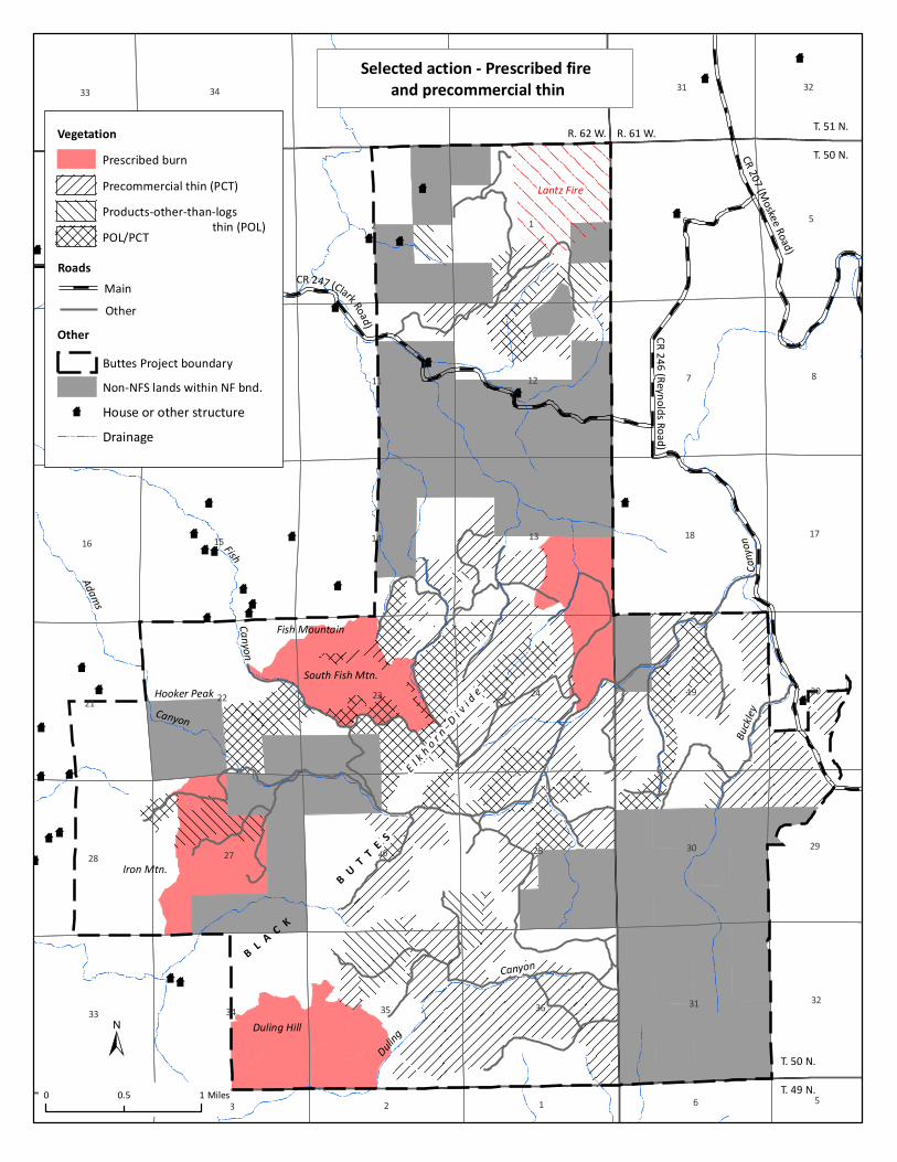
88
8
8
8
8
88
8
8
8
8
8
8
8
8
8
88
8
8
8
8
8
88
8
8
8
8
8
8
8
8
88 8
88
8
8
8
8 8
8
8
8
8
13 2
7
6
9
45
8
15
23
13
10
24
14
26 25
36
18
35
12
19
11
34
27
31
22
30
33
28
34
21
35 36
16
31
17
20
32
29
6
33
1
32
23 54
Selected action - Prescribed fire and precommercial thin
±
CR 24 6 (Reynolds R oad)
CR 207 (Moskee Road)
CR 247 (Clark Road)
Hooker Peak
Iron Mtn.
Duling Hill
B L A C K
B U T T E S
Fish Mountain
South Fish Mtn.
E l k h o r n Di v i d e
Duling
Canyon
Buckle
yCan
yon
Adams
Canyon
FishCanyon
Lantz Fire
Other
T. 50 N.
T. 49 N.
T. 51 N.
T. 50 N.
R. 62 W. R. 61 W.
Prescribed burn
Precommercial thin (PCT)
Products-other-than-logs
POL/PCT thin (POL)
Vegetation
RoadsMain
Other
Buttes Project boundary
Non-NFS lands within NF bnd.
8 House or other structure
Drainage
0 10.5 Miles