Embed Size (px)
Citation preview
by Daniele Perissin
www.sarproz.com
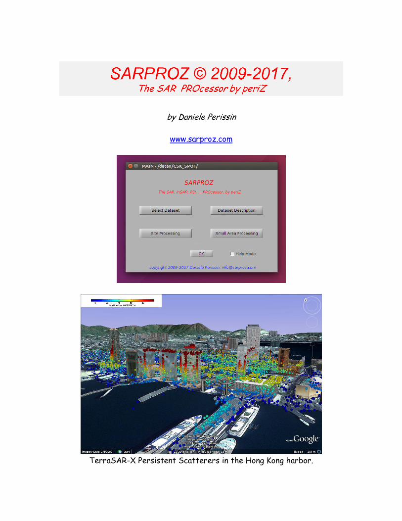
TerraSAR-X Persistent Scatterers in the Hong Kong harbor.
SARPROZ is a very powerful and versatile tool that implements a
wide range of Synthetic Aperture Radar (SAR) processing
techniques.
Main characteristics of SARPROZ:
o User friendly Graphical Interface: no other language knowledge is
required for standard uses
o Based on Matlab: advanced users can very easily develop their own
software extensions. Data and parameters are very easily
imported/exported using Matlab.
o It can be compiled and it runs independently from Matlab on any
platform (Unix, PC, Mac).
o Completely parallelized: SARPROZ can run on multiple CPU cores or
computer clusters automatically.
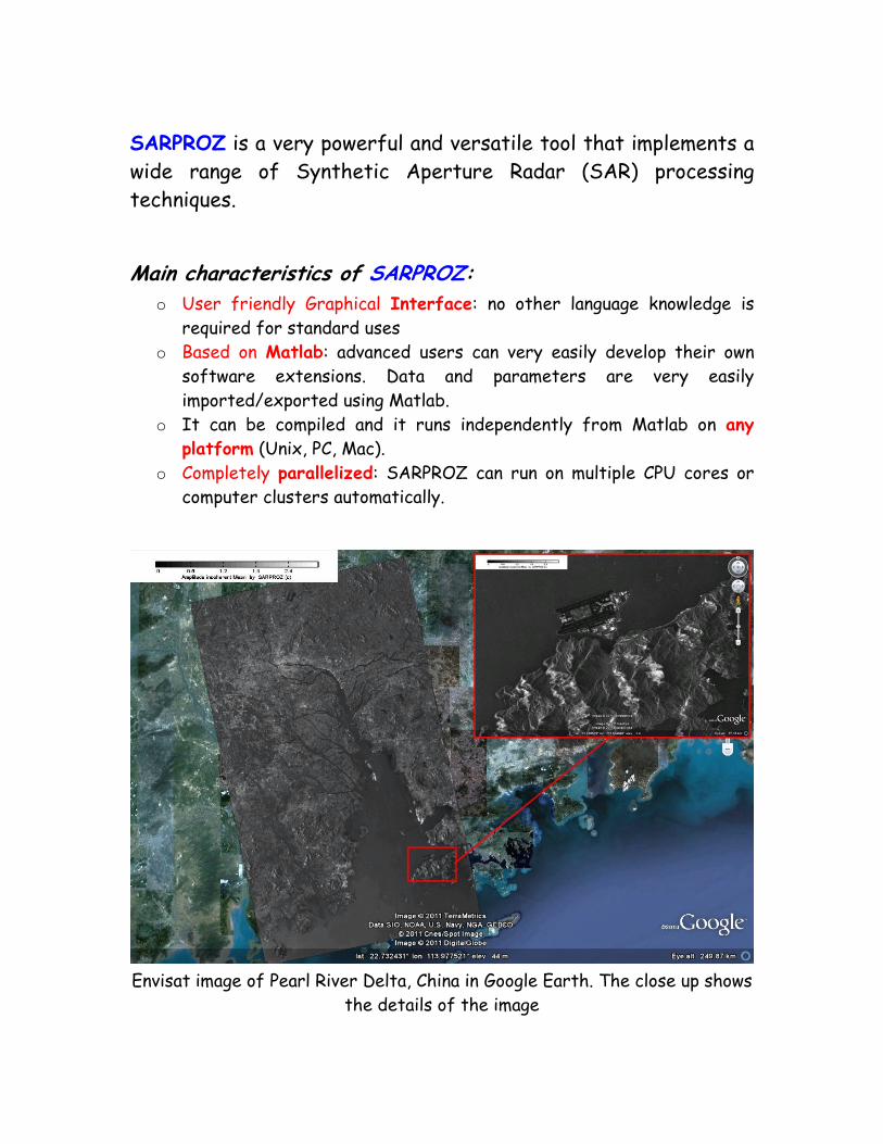
Envisat image of Pearl River Delta, China in Google Earth. The close up shows
the details of the image
Processing options/modules included in SARPROZ:
o Synthetic Aperture Radar (SAR) image processing: SLC coregistration,
SLC equalization and calibration, Reflectivity Map calculation,
extraction of pointwise targets.
o SAR Interferometry (InSAR): orbital data processing, interferogram
calculation, interferogram flattening, interferogram filtering, phase
unwrapping.
o Differential SAR Interferometry (DInSAR): DEM conversion and
resampling, topographic phase removal, residual phase processing,
motion estimation.
o Stacking of Differential Interferograms (SDInSAR): processing of
series of interferograms for atmospheric delay suppression and
motion estimation.
o Persistent Scatterers InSAR (PSI): full-processing chain for ground
average deformation trend, ground elevation and atmospheric delay
estimation.
o Urban Advanced PSI: PS real targets identification and classification
(roofs, poles, dihedrals, trihedrals, fences, floor gratings, …).
o Temporary PSI: estimation of temporary targets (new constructions,
demolitions, short-time structures)
o Multiple scattering centers PSI: estimation of double or multiple
scattering centers per resolution cell in urban sites.
o Non-Linear PSI: estimation of non-linear trends (seasonal polynomial
and non-parametric) in target displacement.
o Quasi-PSI: an advanced technique to estimate ground average
deformation and ground elevation in areas where no PS targets can be
detected.
o Unwrapped-PSI: time series analysis of unwrapped interferograms.
o Multi-Sensor analysis: combination (coherent or un-coherent) of data
acquired by different sensors, with different characteristics
(frequency, polarization, …) under different geometries
o DEM processing based on InSAR/Multi-Temporal InSAR results for
DTM and/or DSM extraction
o Change detection exploiting pairs of images.
o Change detection exploiting image time series.
o Image classification based on results of previous modules.
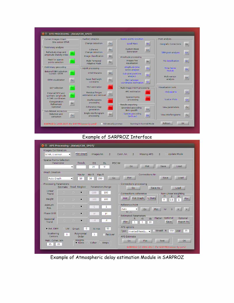
Example of SARPROZ Interface
Example of Atmospheric delay estimation Module in SARPROZ
Auxiliary features of SARPROZ:
o Results/Data visualization and analysis
1. Histograms generation with any of the data/results processed
by the software, for any selection of pixels.
2. Plots generation in 2D, 3D, with colors or densities with any of
the data/results processed by the software, for any selection
of pixels.
3. Images generation with any of the data/results processed by
the software.
o Results/Data exportation in three main forms:
1. Geocoded raster images in different formats.
2. Geocoded point-information, in 2D or 3D, with detailed
information for each point (for GIS or Google Earth).
3. Hierarchical kmz files for a very efficient visualization in
Google Earth.
o Small area analysis with a threefold purpose:
1. Test processing of any of the techniques previously listed to
quickly check the best approach (that depends on available data,
area to analyze, aim of the estimate).
2. Browsing of final results on georeferenced optical layers, with
possibility of displaying in colors any processing results and
selecting point targets for characteristics listing and time
series plotting.
3. Training of neophytes’: new users can learn SAR, InSAR, PSI
thanks to the full-featured analysis over a small area through a
step-by-step processing path.
SARPROZ online documentation: www.sarproz.com
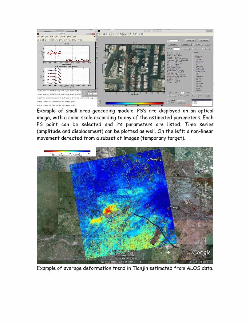
Example of small area geocoding module. PS’s are displayed on an optical
image, with a color scale according to any of the estimated parameters. Each
PS point can be selected and its parameters are listed. Time series
(amplitude and displacement) can be plotted as well. On the left: a non-linear
movement detected from a subset of images (temporary target).
Example of average deformation trend in Tianjin estimated from ALOS data.
Sensors and imaging modes supported by SARPROZ (SLC):
o ERS-1 and ERS-2 (CEOS format)
o ERS-1 and ERS-2 (Envisat format)
o Envisat (stripmap, Scansar)
o Sentinel-1A/B (stripmap, TOPS)
o Cosmo SkyMed (1,2,3,4) (stripmap, spotlight)
o TerraSAR-X (stripmap, spotlight, scansar, staring spotlight)
o Tandem-X
o Tandem-X bistatic pairs
o RadarSAT 1
o RadarSAT 2
o ALOS (ERSDAC)
o ALOS (JAXA)
o ALOS-2
o Kompsat-5
o Gaofen-3
o Multiple polarizations/selection of polarization are supported