Embed Size (px)
Citation preview

March 19, 2012 BY ELECTRONIC DELIVERY Hon. Jaclyn A. Brilling Secretary State of New York Public Service Commission Empire State Plaza Agency Building 3 Albany, New York 12223-1350 Re: Case 09-T-0870 - Application of Niagara Mohawk Power Corporation d/b/a National
Grid for a Certificate of Environmental Compatibility and Public Need for the Reconstruction of Transmission Line 111 from Lockport to Mortimer, New York - Invasive Species Monitoring Plan
Dear Secretary Brilling:
In accordance with Ordering Clause 3 of the Public Service Commission’s Order Approving the Environmental Management and Construction Plan for the Reconstruction of Transmission Line 111, issued on December 19, 2011 (“EM&CP Approval Order”), Niagara Mohawk Power Corporation d/b/a National Grid (“National Grid”) submits the enclosed Invasive Species Monitoring Plan (“ISMP”) it has finalized after consultation with Department of Public Service Staff and the Department of Environmental Conservation (“DEC”). National Grid, in the course of its consultation with Staff and DEC, carefully considered all suggestions and concerns expressed by both agencies. Compared to the enclosed National Grid ISMP, certain elements of the program that DEC favored were considerably more extensive, and consequently more costly to National Grid’s ratepayers. Under the circumstances, National Grid believes the elements of DEC’s plan that go beyond National Grid’s ISMP carry an insufficient likelihood of benefit to outweigh their greater costs and burdens. Specifically, DEC requested that National Grid’s plan include requirements to survey each year for five (5) years post-construction, and to encompass the entire 56 mile transmission line right-of-way in each annual survey. Instead, National Grid’s ISMP omits the second and fourth years of annual surveying and narrows the surveying activities to select locations along the right-of-way. National Grid believes the plan it has crafted strikes the right balance between comprehensiveness and cost, particularly because it involves the monitoring of largely untested control techniques. The enclosed ISMP is completely consistent with the Commission’s goal, stated in the EM&CP Approval Order, to monitor the effectiveness of the measures used during construction to control invasive species since “there is little practical data that exists on this new
175 E. Old Country Road, Hicksville, NY 11801 T: (516) 545-5246F: (516) 545-5029

Article VII issue.” The principal benefit of the resulting monitoring data in the Commission’s view is its usefulness “in future Article VII projects,” presumably including the possibility that the data demonstrates that the invasive species controls and protections National Grid utilized during construction were not justified because they produced no significant reduction in the spread of invasive species. Considering that the mandate for post-construction monitoring of invasives species for this project was introduced only near the very end of the approval process, National Grid should be credited for its willingness and good faith effort to engage in the level of post-construction monitoring specified in its enclosed ISMP. In neither the Joint Proposal signed by National Grid or the EM&CP it developed and submitted for this project did the company agree to any form of post-construction invasives species monitoring. Likewise, the Commission established no such requirements in its Article VII Certificate Order for this project.1 The amount of informational benefit that may come from the additional geographic and temporal scope of the monitoring plan DEC recommends does not outweigh the detriments of singling out National Grid to undertake a costly and burdensome annual monitoring protocol, and singling out National Grid’s ratepayers to bear the costs thereof. The specific elements of the monitoring plan advocated by DEC have no basis in state law or regulation. As a state agency, DEC has the authority to engage in the administrative process that is legally necessary to promulgate regulations that would have generic applicability to activities conducted in linear utility rights-of-way. One of the many benefits of, and reasons for, such a process is to expose DEC’s proposal to the scrutiny of review by all potentially affected stakeholders. Such scrutiny is good public policy. Not only does it alert stakeholders to possible new requirements, but it also gives them, and the agency, the opportunity for an open and thorough examination of all benefits and detriments of the proposed requirements. Bypassing that process increases the risk that theoretical and conceptual ideas lacking in practical merit will become binding legal requirements by escaping the scrutiny and constructive criticism available from a broad spectrum of knowledgeable and interested stakeholders. Very truly yours,
Lisa M. Zafonte Lisa M. Zafonte Senior Counsel Attorney for the Applicant, Niagara Mohawk Power Corporation d/b/a National Grid cc (with enclosure): Anthony Belsito, Esq., DPS
1 National Grid notes that the statement on page 8 of the EM&CP Approval Order that it “agreed to increase its invasive species monitoring from three years to five years in response to DEC’s request” is factually erroneous; National Grid did not agree to any monitoring plan, of any duration.

John Strub, DPS Richard Powell, DPS Larry Eckhaus, Esq., DEC Rudyard Edick, DEC Chris Hogan, DEC Charles Rosenburg, DEC Region 9 Steve Miller, DEC Region 9 Scott Green, National Grid Michael Sherman, National Grid Teri Niedzielski, National Grid Ryan Blothenburg, National Grid Angie Peace, Tetra Tech

INVASIVE SPECIES MONITORING
TownOgden, Gates,
INVASIVE SPECIES MONITORING
LOCKPORT
Towns of Lockport, Royalton, Shelby, Barre, Clarendon, Sweden,Gates, Chili,
Niagara, Orleans, and Monroe
Niagara Mohawk Power Corporation
INVASIVE SPECIES MONITORING
LOCKPORT-MORTIMER LINE 111REBUILD PROJECT
Location
of Lockport, Royalton, Shelby, Barre, Clarendon, Sweden,Chili, Brighton, and
Niagara, Orleans, and MonroeState of New York
Niagara Mohawk Power Corporation(d/b/a National Grid)300 Erie Blvd. WestSyracuse, NY
Prepared by
Tetra Tech, Inc.285 Ellicott
Buffalo, New York
March 2012
INVASIVE SPECIES MONITORING
MORTIMER LINE 111REBUILD PROJECT
Location:
of Lockport, Royalton, Shelby, Barre, Clarendon, Sweden,Brighton, and the Cities
Niagara, Orleans, and MonroeState of New York
Owner:
Niagara Mohawk Power Corporation(d/b/a National Grid)300 Erie Blvd. WestSyracuse, NY 13202
Prepared by:
Tetra Tech, Inc.285 Ellicott Street
Buffalo, New York 14203
March 2012
INVASIVE SPECIES MONITORING
MORTIMER LINE 111REBUILD PROJECT
of Lockport, Royalton, Shelby, Barre, Clarendon, Sweden,ies of Lockport and
Niagara, Orleans, and Monroe CountiesState of New York
Niagara Mohawk Power Corporation(d/b/a National Grid)300 Erie Blvd. West
13202
Tetra Tech, Inc.Street
14203
INVASIVE SPECIES MONITORING PLAN
MORTIMER LINE 111
of Lockport, Royalton, Shelby, Barre, Clarendon, Sweden,Lockport and Rochester
Counties
PLAN
of Lockport, Royalton, Shelby, Barre, Clarendon, Sweden,Rochester

Invasive Species Monitoring PlanLockport-Mortimer Line 111 Rebuild Project ii
TABLE OF CONTENTSSection Page
1.0 INTRODUCTION ................................................................................................................. 11.1 Project Overview ................................................................................................................ 11.2 Purpose and Need ............................................................................................................... 21.3 Invasive Species Procedures Implemented During Construction....................................... 21.4 Invasive Species in New York State................................................................................... 41.5 Invasive Species Identified within the Project ROW ......................................................... 41.6 Invasive Species to Target during Monitoring Events........................................................ 5
2.0 SURVEY AND MONITORING METHODOLOGY........................................................... 62.1 Scope of Invasive Species Baseline Survey and Monitoring.............................................. 62.2 Timing of Monitoring Efforts ............................................................................................. 62.3 Data Collection ................................................................................................................... 6
3.0 REPORTING......................................................................................................................... 8
4.0 INVASIVE SPECIES TREATMENT................................................................................... 9

Invasive Species Monitoring PlanLockport-Mortimer Line 111 Rebuild Project iii
LIST OF ATTACHMENTS
Attachment A – Figures…............................................................................................................A
- Figure 1. Site Location of the Lockport-Mortimer Line 111 Rebuild Project- Figure 2. Invasive Species Baseline Survey and Monitoring Location for the
Lockport-Mortimer Line 111 Rebuild Project
Attachment B – Revised Interim List of Invasive Plant Species in New York State...................B
LIST OF TABLES
Table 1.Invasive Species’ Flowering Seasons……………….…………….……….…………….6

Invasive Species Monitoring PlanLockport-Mortimer Line 111 Rebuild Project 1
1.0 INTRODUCTION
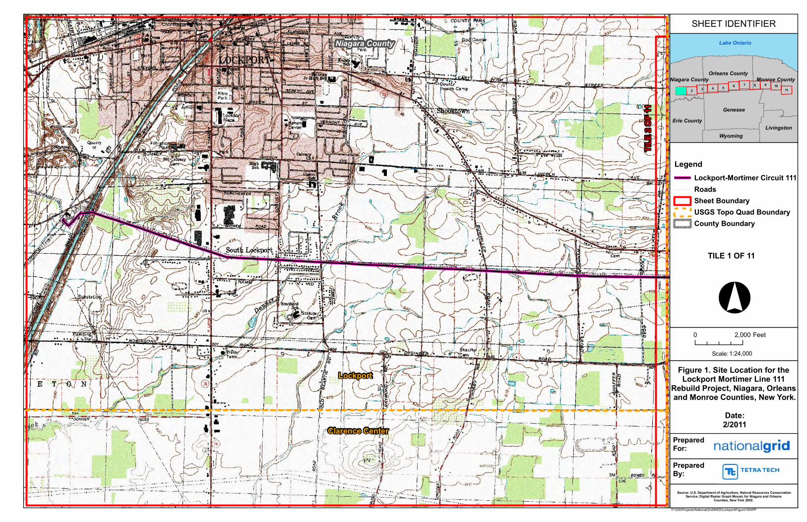
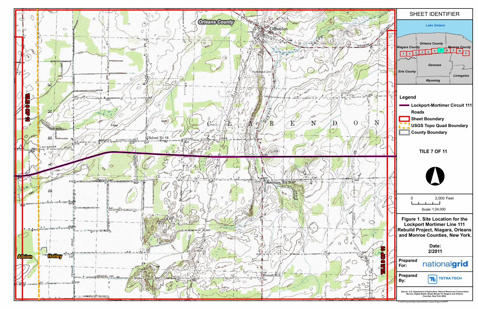
Tetra Tech, Inc. (“Tetra Tech”)has prepared this Invasive Species Monitoring Plan on behalf ofNiagara Mohawk Corporation, doing business as National Grid (“National Grid”), formonitoring invasive species and the effects of construction activities associated with theLockport-Mortimer Line 111 Rebuild Project (the “Project”). The Project is located in theTowns of Lockport, Royalton, Shelby, Barre, Clarendon, Sweden, Ogden, Gates, Chili, Brighton,and the Cities of Lockport and Rochester in Niagara, Orleans, and Monroe Counties, New York.The location of the Lockport-Mortimer Line 111 is depicted in Figure 1, presented in AttachmentA.
1.1 Project Overview
National Grid is rebuilding the majority of its Lockport-Mortimer Line 111 115 kV electrictransmission system between the Lockport Substation in the City of Lockport, New York and theMortimer Substation in the Town of Brighton, New York. The Project covers approximatelyfifty-six (56) miles of single-circuit transmission line between Structure #1E at the LockportSubstation, in the City of Lockport, Niagara County, and Structure #597 at the MortimerSubstation in the Town of Brighton, Monroe County (“Line 111”).1 The length of the existingLine 111 is 13.5 miles in Niagara County, 23.9 miles in Orleans County, and 18.9 miles inMonroe County. The Project is located within the jurisdictions of New York State Departmentof Environmental Conservation (“DEC”) Regions 9 and 8 (Buffalo and Avon, respectively).Thelocation of Line 111 is depicted in Figure 1, presented in Attachment A.
Before Project implementation, Line 111 was supported by 618 structures, 523 of which were theoriginal 1906 three-legged “Aeromotor” (i.e., windmill-style) steel structures. Of the 618structures, 58 wood and steel structures will be reused, including 27 single wood pole structures,three (3) H-Frame wood pole structures, four (4) 3-pole wood structures, three (3) steel poledavit arms structures, 17 steel lattice towers, two (2) riser structures, and two (2) substation take-off structures. These structures will be thoroughly inspected to ensure their suitability forcontinued service. The other 560 existing structures will be replaced. In addition, two (2) newstructures will be installed at the eastern end of the Project, near Crittenden Road, to comply withan aesthetics-based request from the New York State Department of Public Service (“DPS”) toco-locate some selected structures with some existing and adjacent Rochester Gas and Electric(“RG&E”) transmission line structures.
Activities associated with Project construction include vegetation clearing for workspaces andaccess routes, grading of workspaces and access routes as needed for safe construction practices,matting of access roads and workspaces within wetlands, removal of existing structures, andinstallation of new structures.
1NB: No work will be done on the approximately-2,000-foot-long underground portion of Lockport-Mortimer Line111 as a part of the Project.

Invasive Species Monitoring PlanLockport-Mortimer Line 111 Rebuild Project 2
1.2 Purpose and Need
The purpose of this Project is to perform a complete (excepting the approximately-2,000-footunderground section) rebuild of the existing 115 kV Lockport-Mortimer Line 111. The rebuiltLine 111 will continue to operate at 115 kV. The majority of previously existing structuressupporting Line 111 were the original 1906 three-legged “Aeromotor” (i.e.,windmill-style) steelstructures. Line 111 experiences high customer load and was in danger of experiencingreliability issues if this important infrastructure was not re-constructed.
This Project is subject to Article VII of the NYS Public Service Law, as Case No. 09-T-0870,and was issued a Certificate of Environmental Compatibility and Public Need (“CEC&PN”) bythe PSC, on December 17, 2010. An Environmental Management & Construction Plan(“EM&CP”) was developed pursuant to the CEC&PN, and the PSC issued approval of theEM&CP on December 19, 2011. This Invasive Species Monitoring Plan was prepared for theProject pursuant to EM&CP approval Condition 3. Construction on the Project began January 3,2012 and is expected to continue through December 2013.
The purpose of this Invasive Species Monitoring Plan and associated monitoring is to provide thePSC/DPS with practical data to monitor the effectiveness of the Project EM&CP’s invasivespecies procedures and, in particular, equipment cleaning procedures aimed at controlling thepotential spread of invasive plant species from Project reconstruction activities. Monitoring willspan a period of five years, beginning the first growing season after Project completion(estimated summer 2014), and continuing through summer 2018. Monitoring will occur in threeseparate survey events: one year post-construction, three years post-construction, and five yearspost-construction.
1.3 Invasive Species Procedures Implemented During Construction
Invasive species procedures implemented during construction are described in detail in Section7.0 of Appendix F of the Project EM&CP. Procedures implemented include:
a) Train and educate Project contractor(s) and subcontractor(s) on identifying invasive plantspecies and locations and site-specific prescriptions for preventing or controlling theirtransport throughout or off of the Project site.
b) In order to prevent the potential introduction of invasive plant species from other areas orregions to the Project area: Require that vehicles, equipment, and materials (includingswamp mats) be inspected for, and cleaned of, any visible soils, vegetation, and debrisbefore bringing them to the Project area.
c) Train Project contractor(s) and subcontractor(s) on the various cleaning and/ordecontamination methods to be used on the Project, and as prescribed on a site-by-sitebasis, on the Project Plan and Profile (“P&P”) drawings.
d) To prevent or minimize the potential introduction of invasive plant species from theProject area to other areas or regions: Require that vehicles, equipment, and materials

Invasive Species Monitoring PlanLockport-Mortimer Line 111 Rebuild Project 3
(including swamp mats) be inspected for, and cleaned of, any visible soils, vegetation,and debris before leaving the Project ROW.
e) Install appropriate erosion and sediment controls to work sites to help prevent or controlthe potential transport of invasive plant species via soil erosion.
f) Minimize ground disturbances and vegetation removal as much as possible. Thecontractor(s) and subcontractor(s) will be instructed to stay within access paths and workareas that are designated on the P&P drawings.
g) To the extent practicable, avoid moving invasive-plant-infested soils, gravel, rock, andother fill materials to relatively-invasive-plant-free locations. Soil, gravel, rock, andother fill material will come from invasive-plant-free sources on the site, if such sourcesare available. Off-site fill materials also will come from invasive-plant-free sources, ifsuch sources are available.
h) To the extent practicable, stabilize and re-vegetate disturbed sites using soil componentsand mulches obtained from non-invasive plant sources. Utilize seed and other plantmaterials that have been checked and certified as noxious-weed-free and that have a weedcontent of no more than 0.05 percent and a high likelihood of survival.
National Grid contacted DEC Regional Natural Resource Supervisor(s) and the New York StateDepartment of Agriculture and Markets (“Ag & Mkts”) during development of the EM&CP forany Project-area information about known or potential occurrences of invasive plant species thatare included in the DEC’s “Interim List of Invasive Plant Species in New York State” (RevisedList included as Attachment B) and that also may be of special concern to the applicable DECRegional Natural Resource Supervisor(s). Priority invasive species identified during agencyconsultation included Japanese knotweed (Polygonum cuspidatum [Fallopia japonica]), commonreed (Phragmites australis), purple loosestrife (Lythrum salicaria), black swallow-wort(Cyanchum louiseae), and giant hogweed (Heracleum mantegazzianum).
National Grid assigned a tiered ranking to each area of the Project ROW. Tiers were assigned asfollows, with Tier 1 representing areas of lower levels of invasive species abundance and Tier 3representing areas of higher levels of invasive species abundance.
• Tier I – These are spans with no invasive species identified through review ofphotographs taken during the wetland delineation field effort.
• Tier II – These are spans with one non-priority invasive plant species identified throughreview of photographs taken during the wetland delineation field effort.
• Tier III – These are spans with two or more invasive plants, or one or more priorityinvasive species, identified through review of photographs taken during the wetland delineationfield effort.

Invasive Species Monitoring PlanLockport-Mortimer Line 111 Rebuild Project 4
Where equipment and/or matting physically encountered any invasive plant species within a TierI area, such equipment and/or matting was cleaned before exiting the area. Cleaning consisted ofbrushing and/or the use of compressed air or power-blowers.
Where equipment and/or matting physically encountered any invasive plant species within TierII or III areas, the Environmental Monitor may have directed that such equipment and/or mattingwas cleaned before exiting the area. Cleaning consisted of power-washing and cleaning withclean water (no soaps or chemicals) except during freezing condition, where brushing and/or theuse of compressed air or power-blowers was used.
1.4 Invasive Species in New York State
Invasive species are defined by New York State Environmental Conservation Law (“ECL”) 9-1703 (10) as:
“…a species that is: (a) nonnative to the ecosystem under consideration; and (b)whose introduction causes or is likely to cause economic or environmental harmor harm to human health. For the purposes of this paragraph, the harm mustsignificantly outweigh the benefits.”
The DEC has compiled an “Interim List of Invasive Plant Species in New York State” (“List”)which has been revised to include species assessed for invasiveness and ranked “High” or “VeryHigh” and is included as Attachment B. The List does not include all plant species that areinvasive or potentially invasive in New York State; it includes many of those plants species thatare widely recognized as invasive or potentially invasive in New York State.
1.5 Invasive Species Identified within the Project ROW
During development of the Project EM&CP, National Grid identified obvious locations ofinvasive plant species that occur along the existing ROW. Invasive species present within theProject ROW were primarily identified by performing a detailed review of photographs takenduring the wetland delineation and waterbody identification surveys. Invasive species identifiedwithin the ROW include common reed, purple loosestrife, reed canary grass (Phalarisarundinacea), common buckthorn (Rhamnus cathartica), and black swallow-wort. Invasivespecies were identified within 128 of the 145 wetlands delineated within the ROW. Of the 128wetlands with invasive species present, 49 were recorded as having only reed canary grasspresent, 12 had only purple loosestrife present, two were identified with only common reed, andthe remainder were identified as having more than one invasive species present. Nine wetlandscontained three species, the maximum number of species identified within any one wetland.
A detailed baseline field survey of invasive species present within the ROW was not required bythe PSC-issued CEC&PN for the Project and, therefore, no such baseline field survey wasconducted in developing the Project’s EM&CP.

Invasive Species Monitoring PlanLockport-Mortimer Line 111 Rebuild Project 5
1.6 Invasive Species to Target during Monitoring Events
Guidance received from the DEC (via a January 27, 2012 email from Larry Eckhaus) indicatedthat the species of focus during monitoring events conducted pursuant to this Plan should includeJapanese knotweed, common reed, purple loosestrife, reed canary grass, black swallow-wort,giant hogweed, common buckthorn, and didymo (Didymosphenia geminata). Since commonbuckthorn is currently considered to be a desirable ROW species pursuant to National Grid’sPSC-approved Transmission Right-of-Way Management Program (Revised May 2010), thisspecies is not being targeted by this Invasives Species Monitoring Plan.

Invasive Species Monitoring PlanLockport-Mortimer Line 111 Rebuild Project 6
2.0 SURVEY AND MONITORING METHODOLOGY
2.1 Scope of Invasive Species Baseline Survey and Monitoring
Because construction on the Project began on January 3, 2012, a baseline field survey for theentire 56-mile-long ROW is currently not feasible, due to seasonal constraints. Based onguidance received from DEC on January 27, 2012, invasive species surveys should be timed tooptimize identification of invasive species within the survey area. A baseline survey of invasivespecies currently present within the ROW will be conducted in an area where construction-related disturbance is not expected to occur prior to the optimal survey period, and where theEM&CP prescribes invasive species prevention measures, specifically, cleaning stations.
Invasive species baseline survey and monitoring efforts will encompass an approximately 2.3-mile segment of the ROW between Lusk and Redman Roads. This area was selected due to thepresence of DEC wetlands HO-9 and SW-7, a variety of habitats representative of the habitattypes traversed by the Project, and invasive species infestations varying from none to twoinvasive species, including high priority species. Wetland types present within this area includepalustrine emergent (“PEM”), palustrine scrub shrub (“PSS”), and palustrine forested (“PFO”).Upland and agricultural land are also encompassed by this survey area. Visual observations ofexisting invasive species infestations located outside of, and adjacent to, the survey area/ROWwill also be made. The location of the invasive species baseline survey and monitoring area ispresented in Figure 2 of Attachment A.
2.2 Timing of Monitoring Efforts
Monitoring efforts will be timed to maximize the likelihood of invasive species identification,based on the flowering periods for the focus species shown in Table 1 below. Monitoring willoccur in three separate survey events spanning five years following completion of construction,pursuant to the December 19, 2011 EM&CP approval. Based on the estimated schedule forcompletion, monitoring will occur between June 1 and August 1, 2014, 2016, and 2018.
Table 1.Invasive Species’ Flowering Seasons
Species Approximate Flowering SeasonCommon reed Late July to AugustBlack swallow-wort June to JulyJapanese knotweed Late summerGiant hogweed June to JulyPurple loosestrife June to SeptemberReed canary grass May to mid-JuneDidymo N/A
2.3 Data Collection
Invasive species surveys and monitoring will occur within a 2.3-mile section of the Project ROWbetween Lusk and Redman Roads (structures 380 through 406; EM&CP Areas 117 through 122),

Invasive Species Monitoring PlanLockport-Mortimer Line 111 Rebuild Project 7
for a width of approximately 200 feet. The survey will encompass approximately 56 acres.Special attention will be given to invasive species locations identified during development of theEM&CP. The location of the invasive species baseline survey and monitoring area is presentedin Figure 2 of Attachment A.
In addition to locating previously identified invasive species populations, surveyors will“methodically meander” throughout the width of the ROW (approximate 200-foot-width)focusing on areas likely to contain invasive plant species, such as those areas disturbed byProject construction. When any species identified on the “Revised Interim List of Invasive PlantSpecies in New York State” (Attachment B) is observed, biologists will gather biotic and abioticdata on the population, including but not limited to the following:
Species Location – discussed in more detail below Size of infestation (not necessary if polygon will be created; see below)
o 0-10 square feeto 10-100 square feeto 100-1,000 square feeto 1,000-10,000 square feeto >10,000 square feet
Stem Density/Percent areal covero Sparse (1-5% areal cover)o Moderate (5-25% areal cover)o Abundant (>25% areal cover)
General Healtho Pooro Fairo Goodo Vigorous
Habitat Type General comments (e.g. notes on reproductive status of plants)
All invasive species plants or populations will be located using a Trimble Geo XH or XT unit. Ifan infestation consists of a few plants, a GPS data point will be collected. The locations of largerinfestations will be recorded by collecting a sufficient number of GPS points to facilitatepreparation of a GIS polygon for more accurate assessment of infestation size. Mapping ofinvasive species locations documented during each monitoring event will be done usingEnvironmental Systems Resource Institute (ESRI) ArcView 9.3.1.
Biologists will also note Project-specific characteristics of each invasive species location, such asconstruction access type, whether or not grading occurred within the area, whether the locationwas a pull site, work pad, and or other construction-related component, whether seeding wasincluded in restoration activities, and status of restoration, including restored cover type.

Invasive Species Monitoring PlanLockport-Mortimer Line 111 Rebuild Project 8
3.0 REPORTING
National Grid will submit an Invasive Species Baseline Survey Report within (ninety) 90 daysfollowing completion of the summer 2012 baseline field surveys. Invasive Species MonitoringReports will be submitted by December 31 to the DPS and DEC Regions 8 and 9 for each yearthat a monitoring event occurs. Each report will include an introduction, description of methods,results, comparison with previously collected data, discussion, conclusions andrecommendations, photographic documentation, and figures.

Invasive Species Monitoring PlanLockport-Mortimer Line 111 Rebuild Project 9
4.0 INVASIVE SPECIES TREATMENT
National Grid will implement control and treatment only when giant hogweed (Heracleummantegazzianum) is identified within the ROW by contacting DEC pursuant to instructions givenon DEC’s website and by Steve Miller of Region 8 during the Project Pre-Construction Meetingheld on December 20, 2011. National Grid acknowledges the human health risks that any ROWoccurrences of giant hogweed could pose. Should the PSC/DPS require that any other invasiveplant species be controlled or treated on this ROW, National Grid will address such requirementsin conjunction with National Grid’s Transmission Right-of-Way Management Program and/or inaccordance with any applicable PSC order issued for this Project.

Attachment A – Figures
- Figure 1. Site Location of the Lockport-Mortimer Line 111 Rebuild Project- Figure 2. Invasive Species Baseline Survey and Monitoring Location for the Lockport-
Mortimer Line 111 Rebuild Project
TILE
2 O
F 11
Niagara County
Lockport
Clarence Center
P:\GIS\Projects\NationalGrid\MXD\Lockport\Figure1SWPP
SHEET IDENTIFIER
°
LegendLockport-Mortimer Circuit 111RoadsSheet BoundaryUSGS Topo Quad BoundaryCounty Boundary
1:24,000Scale:
Figure 1. Site Location for the Lockport Mortimer Line 111
Rebuild Project, Niagara, Orleans and Monroe Counties, New York.
Date:2/2011
0 2,000 Feet
Source: U.S. Department of Agriculture, Natural Resources ConservationService; Digital Raster Graph Mosaic for Niagara and Orleans
Counties, New York 2002.
Lake Ontario
987654321 1110
Genesee
Monroe County
Erie County
Orleans County
LivingstonWyoming
Niagara County
Prepared By:
Prepared For:
TILE 1 OF 11

TILE 1 O
F 11
TILE
3 O
F 11
Niagara County
Gasport
Wolcottsville
P:\GIS\Projects\NationalGrid\MXD\Lockport\Figure1SWPP
SHEET IDENTIFIER
°
LegendLockport-Mortimer Circuit 111RoadsSheet BoundaryUSGS Topo Quad BoundaryCounty Boundary
1:24,000Scale:
Figure 1. Site Location for the Lockport Mortimer Line 111
Rebuild Project, Niagara, Orleans and Monroe Counties, New York.
Date:2/2011
0 2,000 Feet
Source: U.S. Department of Agriculture, Natural Resources ConservationService; Digital Raster Graph Mosaic for Niagara and Orleans
Counties, New York 2002.
Lake Ontario
987654321 1110
Genesee
Monroe County
Erie County
Orleans County
LivingstonWyoming
Niagara County
Prepared By:
Prepared For:
TILE 2 OF 11

TILE 2 O
F 11
TILE
4 O
F 11
Niagara County Orleans County
Gasport Medina
Wolcottsville Akron
P:\GIS\Projects\NationalGrid\MXD\Lockport\Figure1SWPP
SHEET IDENTIFIER
°
LegendLockport-Mortimer Circuit 111RoadsSheet BoundaryUSGS Topo Quad BoundaryCounty Boundary
1:24,000Scale:
Figure 1. Site Location for the Lockport Mortimer Line 111
Rebuild Project, Niagara, Orleans and Monroe Counties, New York.
Date:2/2011
0 2,000 Feet
Source: U.S. Department of Agriculture, Natural Resources ConservationService; Digital Raster Graph Mosaic for Niagara and Orleans
Counties, New York 2002.
Lake Ontario
987654321 1110
Genesee
Monroe County
Erie County
Orleans County
LivingstonWyoming
Niagara County
Prepared By:
Prepared For:
TILE 3 OF 11

TILE 3 O
F 11
TILE
5 O
F 11
Orleans County
Medina Knowlesville
P:\GIS\Projects\NationalGrid\MXD\Lockport\Figure1SWPP
SHEET IDENTIFIER
°
LegendLockport-Mortimer Circuit 111RoadsSheet BoundaryUSGS Topo Quad BoundaryCounty Boundary
1:24,000Scale:
Figure 1. Site Location for the Lockport Mortimer Line 111
Rebuild Project, Niagara, Orleans and Monroe Counties, New York.
Date:2/2011
0 2,000 Feet
Source: U.S. Department of Agriculture, Natural Resources ConservationService; Digital Raster Graph Mosaic for Niagara and Orleans
Counties, New York 2002.
Lake Ontario
987654321 1110
Genesee
Monroe County
Erie County
Orleans County
LivingstonWyoming
Niagara County
Prepared By:
Prepared For:
TILE 4 OF 11

TILE 4 O
F 11
TILE
6 O
F 11
Orleans County
Knowlesville Albion
P:\GIS\Projects\NationalGrid\MXD\Lockport\Figure1SWPP
SHEET IDENTIFIER
°
LegendLockport-Mortimer Circuit 111RoadsSheet BoundaryUSGS Topo Quad BoundaryCounty Boundary
1:24,000Scale:
Figure 1. Site Location for the Lockport Mortimer Line 111
Rebuild Project, Niagara, Orleans and Monroe Counties, New York.
Date:2/2011
0 2,000 Feet
Source: U.S. Department of Agriculture, Natural Resources ConservationService; Digital Raster Graph Mosaic for Niagara and Orleans
Counties, New York 2002.
Lake Ontario
987654321 1110
Genesee
Monroe County
Erie County
Orleans County
LivingstonWyoming
Niagara County
Prepared By:
Prepared For:
TILE 5 OF 11

TILE 5 O
F 11
TILE
7 O
F 11
Orleans County
Albion
Alb
P:\GIS\Projects\NationalGrid\MXD\Lockport\Figure1SWPP
SHEET IDENTIFIER
°
LegendLockport-Mortimer Circuit 111RoadsSheet BoundaryUSGS Topo Quad BoundaryCounty Boundary
1:24,000Scale:
Figure 1. Site Location for the Lockport Mortimer Line 111
Rebuild Project, Niagara, Orleans and Monroe Counties, New York.
Date:2/2011
0 2,000 Feet
Source: U.S. Department of Agriculture, Natural Resources ConservationService; Digital Raster Graph Mosaic for Niagara and Orleans
Counties, New York 2002.
Lake Ontario
987654321 1110
Genesee
Monroe County
Erie County
Orleans County
LivingstonWyoming
Niagara County
Prepared By:
Prepared For:
TILE 6 OF 11
TILE 6 O
F 11
TILE
8 O
F 11
Orleans County
Albion Holley
P:\GIS\Projects\NationalGrid\MXD\Lockport\Figure1SWPP
SHEET IDENTIFIER
°
LegendLockport-Mortimer Circuit 111RoadsSheet BoundaryUSGS Topo Quad BoundaryCounty Boundary
1:24,000Scale:
Figure 1. Site Location for the Lockport Mortimer Line 111
Rebuild Project, Niagara, Orleans and Monroe Counties, New York.
Date:2/2011
0 2,000 Feet
Source: U.S. Department of Agriculture, Natural Resources ConservationService; Digital Raster Graph Mosaic for Niagara and Orleans
Counties, New York 2002.
Lake Ontario
987654321 1110
Genesee
Monroe County
Erie County
Orleans County
LivingstonWyoming
Niagara County
Prepared By:
Prepared For:
TILE 7 OF 11
'- I ' "
I· I: I t DtO ..:;1
=="-~I=-~-' =
I: I
II
·!l ",I
- - - - 0 -- J
, I t) II ~_/
, II !i
~ Q
. l - - -- - "
~
,ell ;" I L/
" , ,'D I
- ~ -I-"
" r "
\\
T
-, I
o
-CJ - - I ,- -
nationalgrid
['11:] TETRA TECH

TILE 7 O
F 11
TILE
9 O
F 11
Orleans County Monroe County
Holley Brockport
P:\GIS\Projects\NationalGrid\MXD\Lockport\Figure1SWPP
SHEET IDENTIFIER
°
LegendLockport-Mortimer Circuit 111RoadsSheet BoundaryUSGS Topo Quad BoundaryCounty Boundary
1:24,000Scale:
Figure 1. Site Location for the Lockport Mortimer Line 111
Rebuild Project, Niagara, Orleans and Monroe Counties, New York.
Date:2/2011
0 2,000 Feet
Source: U.S. Department of Agriculture, Natural Resources ConservationService; Digital Raster Graph Mosaic for Niagara and Orleans
Counties, New York 2002.
Lake Ontario
987654321 1110
Genesee
Monroe County
Erie County
Orleans County
LivingstonWyoming
Niagara County
Prepared By:
Prepared For:
TILE 8 OF 11

TILE 8 O
F 11
TILE
10
OF
11
Monroe County
Brockport Spencerport
P:\GIS\Projects\NationalGrid\MXD\Lockport\Figure1SWPP
SHEET IDENTIFIER
°
LegendLockport-Mortimer Circuit 111RoadsSheet BoundaryUSGS Topo Quad BoundaryCounty Boundary
1:24,000Scale:
Figure 1. Site Location for the Lockport Mortimer Line 111
Rebuild Project, Niagara, Orleans and Monroe Counties, New York.
Date:2/2011
0 2,000 Feet
Source: U.S. Department of Agriculture, Natural Resources ConservationService; Digital Raster Graph Mosaic for Niagara and Orleans
Counties, New York 2002.
Lake Ontario
987654321 1110
Genesee
Monroe County
Erie County
Orleans County
LivingstonWyoming
Niagara County
Prepared By:
Prepared For:
TILE 9 OF 11

TILE 9 O
F 11
TILE
11
OF
11
Monroe County
Spencerport Rochester West
P:\GIS\Projects\NationalGrid\MXD\Lockport\Figure1SWPP
SHEET IDENTIFIER
°
LegendLockport-Mortimer Circuit 111RoadsSheet BoundaryUSGS Topo Quad BoundaryCounty Boundary
1:24,000Scale:
Figure 1. Site Location for the Lockport Mortimer Line 111
Rebuild Project, Niagara, Orleans and Monroe Counties, New York.
Date:2/2011
0 2,000 Feet
Source: U.S. Department of Agriculture, Natural Resources ConservationService; Digital Raster Graph Mosaic for Niagara and Orleans
Counties, New York 2002.
Lake Ontario
987654321 1110
Genesee
Monroe County
Erie County
Orleans County
LivingstonWyoming
Niagara County
Prepared By:
Prepared For:
TILE 10 OF 11

TILE 10 O
F 11
Monroe County
Rochester West
West Henrietta
P:\GIS\Projects\NationalGrid\MXD\Lockport\Figure1SWPP
SHEET IDENTIFIER
°
LegendLockport-Mortimer Circuit 111RoadsSheet BoundaryUSGS Topo Quad BoundaryCounty Boundary
1:24,000Scale:
Figure 1. Site Location for the Lockport Mortimer Line 111
Rebuild Project, Niagara, Orleans and Monroe Counties, New York.
Date:2/2011
0 2,000 Feet
Source: U.S. Department of Agriculture, Natural Resources ConservationService; Digital Raster Graph Mosaic for Niagara and Orleans
Counties, New York 2002.
Lake Ontario
987654321 1110
Genesee
Monroe County
Erie County
Orleans County
LivingstonWyoming
Niagara County
Prepared By:
Prepared For:
TILE 11 OF 11

!( !( !(
!( !(
PHARPHAR
LYSA, PHAR
PHAR
LYSA, PHAR PHAR, PHAU
See 2aSee 2b
PHAR, PHAU
CYLO
397396395394393392391
390389
388
387
386
385384
383382381380379
W Sw
eden
Rd
Lusk
Rd
Capen Rd
HO-9
HO-9
HO-9
W88W87
W83W84
W86
W85
P:\GIS\Projects\NationalGrid\MXD\Lockport\ForestryMaps
OVERVIEW MAP
°1:6,000Scale:
Figure 2a.Invasive Species Baseline Survey
and Monitoring Location for the Lockport Mortimer Line 111 Rebuild
Project, Niagara, Orleans, and Monroe Counties, New York.
Source: USDA/FSA - Aerial Photography Field Office; USDA-FSA-APFO NAIP MrSID Mosaics for Niagara County 6/5/09, Monroe County 6/5/09 and Orleans
County 6/8/09 and 6/16/09, New York.
3/2012
0 500250 Feet
XXX=Delineated WetlandsXXX=DEC Wetlands
!
!
!!
!
!
!
!
!
! !
! !! !
!!
!
!
!!
!
!
!
!
!
!
!
!
!
!
!
!
!
!
!
!
!
!
!
!
!
!
!
! ! ! !
! !
!
!!
!!!
!
!
!!
!
!
!
!
!
!
!
!
!
!!
!
!
! !
!
! !
!!
!
!
! !
!!
!
!
!
!
!!!!!!!
!!
!
!
! ! ! !!
!!
!
!
!
!
!!
!
! ! !!
!
!!
!!!!! !!
!
!!
!
!
!
!
!
!
!!
!
!
!!!!
!!
!
!
!
!
! ! ! ! ! !
!
!
!
!!!!!!
!!
!!
!!
!
!
!
!
!!
!!
!
!!
!
!
!!
!
!!
!
Orleans County Monroe County
Genesee
Niagara County
Erie County
Lake Ontario
Figure 2
Invasive Species: LYSA=purple loosestrife(Lythrum salicaria)PHAR=reed canarygrass (Phalaris arundinacea)PHAU=common reed(Phragmites australis)CYLO=black swallow-wort(Cynanchum louiseae)
Legend
Structures200ft Survey Area
Streams
DEC Wetland 100-foot Adjacent Areas
Roads
Wetlands
Invasive Species Cleaning Stations!(

!( !(
!(!(
PHAR, PHAULYSA, PHARPHAR, PHAU
See 2aSee 2b
PHAR, PHAU PHAR, PHAU No Invasive Species Identified
SW-7409408407405404403402401400399398397404-3404-2404-1
Capen Rd
Redm
an R
d
Beadle Rd
HO-9HO-9HO-9 SW-7
SW-7
W89W88W90 W91 W92
W93
S24
P:\GIS\Projects\NationalGrid\MXD\Lockport\ForestryMaps
OVERVIEW MAP
°1:6,000Scale:
Figure 2b.Invasive Species Baseline Survey
and Monitoring Location for the Lockport Mortimer Line 111 Rebuild
Project, Niagara, Orleans, and Monroe Counties, New York.
Source: USDA/FSA - Aerial Photography Field Office; USDA-FSA-APFO NAIP MrSID Mosaics for Niagara County 6/5/09, Monroe County 6/5/09 and Orleans
County 6/8/09 and 6/16/09, New York.
3/2012
0 500250 Feet
XXX=Delineated WetlandsXXX=DEC Wetlands
!
!
!!
!
!
!
!
!
! !
! !! !
!!
!
!
!!
!
!
!
!
!
!
!
!
!
!
!
!
!
!
!
!
!
!
!
!
!
!
!
! ! ! !
! !
!
!!
!!!
!
!
!!
!
!
!
!
!
!
!
!
!
!!
!
!
! !
!
! !
!!
!
!
! !
!!
!
!
!
!
!!!!!!!
!!
!
!
! ! ! !!
!!
!
!
!
!
!!
!
! ! !!
!
!!
!!!!! !!
!
!!
!
!
!
!
!
!
!!
!
!
!!!!
!!
!
!
!
!
! ! ! ! ! !
!
!
!
!!!!!!
!!
!!
!!
!
!
!
!
!!
!!
!
!!
!
!
!!
!
!!
!
Orleans County Monroe County
Genesee
Niagara County
Erie County
Lake Ontario
Figure 2
Invasive Species: LYSA=purple loosestrife(Lythrum salicaria)PHAR=reed canarygrass (Phalaris arundinacea)PHAU=common reed(Phragmites australis)CYLO=black swallow-wort(Cynanchum louiseae)
Legend
Structures200ft Survey Area
Streams
DEC Wetland 100-foot Adjacent Areas
Roads
Wetlands
Invasive Species Cleaning Stations!(

Attachment B – Revised Interim List of Invasive Plant Species in New York State

REVISED INTERIM LIST OF INVASIVE PLANT SPECIES IN NEW YORK STATE 23 January 2012
Purpose
This list was not prepared pursuant to ECL 9-1705 (5) (h), the so-called “four-tier system”. The primary purpose of this list to inform New York State agencies so they can incorporate invasive species management into their funding, regulatory and other activities pursuant to ECL 9-1705 (b) and especially ECL 9-1709 (2):
“...[DEC] in cooperation with [DAM] shall have the authority...to... coordinate state agency and public authority actions to do the following: (a) phasing out uses of invasive species; (b) expanding use of native species; (c) promoting private and local government use of native species as alternatives to invasive species; and (d) wherever practical and where consistent with watershed and/or regional invasive species management plans, prohibiting and actively eliminating invasive species at project sites funded or regulated by the state;....”
It is intended to inform regulatory actions pursuant to existing statutory authorities, e.g., protection of waters (ECL Article 15), wetlands (ECL Articles 24 and 25), State Environmental Quality Review (ECL Article 8), biocontrol (ECL Article 11), and pesticides (ECL Article 33). This list is also intended to inform non-regulatory management decisions and actions, such as for planning and priority-setting, prevention, early detection, monitoring, rapid response, control and eradication, restoration, research, and public education. This list does not include all plant species that are invasive or potentially-invasive in New York State. Rather, it includes many of those plant species that are widely-recognized as invasive or potentially-invasive in New York State. ECL 9-1703 (10) defines “invasive species” as:
“...a species that is: (a) nonnative to the ecosystem under consideration; and (b) whose introduction causes or is likely to cause economic or environmental harm or harm to human health. For the purposes of this paragraph, the harm must significantly outweigh any benefits.”
Thus, when complying with the provisions of 9-1709, agency staff use professional judgment in assessing the potential environmental harm (or harm to human health) when considering particular species in particular contexts. Invasive Plants Field and Reference Guide: An Ecological Perspective of Plant Invaders of Forests and Woodlands http://www.fs.fed.us/ne/newtown_square/publications/information_bulletins/NA-TP-05-04.pdf Mistaken Identity? Invasive Plants and their Native Look-alikes: an Identification Guide for the Mid-Atlantic http://www.nybg.org/files/scientists/rnaczi/Mistaken_Identity_Final.pdf
* * *

REVISED INTERIM LIST OF INVASIVE PLANT SPECIES IN NEW YORK STATE
Floating & Submerged Aquatic
Common Name Scientific Name Rank Water thyme Hydrilla verticillata Very High Frog Bit Hydrocharis morsus-ranae Very High Floating Primrose Willow Ludwigia peploides Very High Broadleaf Water-milfoil Myriophyllum heterophyllum Very High Eurasian Water-milfoil Myriophyllum spicatum Very High Water Chestnut Trapa natans Very High Rock Snot (diatom) Didymosphenia geminata Carolina Fanwort Cabomba caroliniana High Brazilian Waterweed Egeria densa High Parrot-feather Myriophyllum aquaticum High Yellow Floating Heart Nymphoides peltata High Curly Pondweed Potamogeton crispus High
Emergent Wetland & Littoral Common Name Scientific Name Rank Japanese Knotweed Fallopia japonica Very High Purple Loosestrife Lythrum salicaria Very High European Common Reed Grass Phragmites australis Very High Tall Glyceria Glyceria maxima High Yellow Iris Iris pseudacorus High Marsh Dewflower Murdannia keisak High Reed Canary-grass Phalaris arundinacea High
Terrestrial – Herbaceous Common Name Scientific Name Rank Garlic Mustard Alliaria petiolata Very High Slender False Brome Brachypodium sylvaticum Very High Oriental Bittersweet Celastrus orbiculatus Very High Black swallow-wort Cynanchum louiseae Very High Pale Swallow-wort Cynanchum rossicum Very High Japanese Stilt Grass Microstegium vimineum Very High Lesser Celandine Ranunculus ficaria Very High Wild Chervil Anthriscus sylvestris High Mugwort Artemisia vulgaris High Small Carpgrass Arthraxon hispidus High Narrowleaf Bittercress Cardamine impatiens High Spotted Knapweed* Centaurea stoebe ssp.
micranthos High
Canada Thistle Cirsium arvense High Chinese Yam Dioscorea polystachya High Cut-leaf Teasel Dipsacus laciniatus High Winter Creeper Euonymus fortunei High

Cypress Spurge Euphorbia cyparissias High Leafy Spurge Euphorbia esula High Giant Hogweed Heracleum mantegazzianum High Japanese Hops Humulus japonicus High Cogon Grass Imperata cylindrica High Broad-leaf Pepper-grass Lepidium latifolium High Chinese Lespedeza Lespedeza cuneata High Garden Loosestrife Lysimachia vulgaris High Chinese Silver Grass Miscanthus sinensis High Wavyleaf Basketgrass Oplismenus hirtellus High Cup-plant Silphium perfoliatum High
Terrestrial - Vines Common Name Scientific Name Rank Japanese Honeysuckle Lonicera japonica Very High Mile-a-minute Weed Persicaria perfoliata Very High Kudzu Pueraria montana Very High Porcelain Berry Ampelopsis brevipedunculata High Japanese Virgin's Bower Clematis terniflora High
Terrestrial – Shrubs & Trees Common Name Scientific Name Rank Norway Maple Acer platanoides Very High Japanese Angelica Tree Aralia elata Very High Japanese Barberry Berberis thunbergii Very High Autumn Olive Elaeagnus umbellata Very High Winged Euonymus Euonymus alatus Very High Amur Honeysuckle Lonicera maackii Very High Morrow's Honeysuckle Lonicera morrowii Very High Uruguayan primrose willow Ludwigia grandiflora Very High Common Buckthorn Rhamnus cathartica Very High Black Locust Robinia pseudoacacia Very High Multiflora Rose Rosa multiflora Very High Wineberry Rubus phoenicolasius Very High Gray Florist's Willow Salix atrocinerea Very High Sycamore Maple Acer pseudoplatanus High Porcelain Berry Ampelopsis brevipedunculata High Smooth Buckthorn Frangula alnus High Border Privet Ligustrum obtusifolium High Amur Cork Tree Phellodendron amurense High Beach vitex Vitex rotundifolia High
* Brown and Black Knapweed have also been known to be problematic in grassland habitats
~ END ~