Embed Size (px)
Citation preview

Supplementary InformationJuly 2018
BYLONG COAL PROJECT
Main Report
1
BYLONG COAL PROJECT
SUPPLEMENTARY INFORMATION
Prepared by:
HANSEN BAILEY
6 / 127 – 129 John Street
SINGLETON NSW 2330
July 2018
For:
WORLEYPARSONS SERVICES PTY LIMITED
Level 17, 141 Walker Street
NORTH SYDNEY NSW 2060

Bylong Coal Project Supplementary Information July 2018 for WorleyParsons Services Pty Limited Page i
Ref: 180712 Bylong Coal Supplementary Information HANSEN BAILEY
TABLE OF CONTENTS
1 INTRODUCTION............................................................................................................ 1
1.1 BACKGROUND .................................................................................................................. 1
1.2 KEPCO’S RESPONSE TO DPE SUPPLEMENTARY INFORMATION REQUEST ........... 2
1.3 DOCUMENT STRUCTURE ................................................................................................ 3
2 REVISED MINE PLAN................................................................................................... 4
2.1 OVERVIEW ......................................................................................................................... 4
2.2 IMPLICATIONS ON PROJECT SCHEDULE ...................................................................... 7
2.3 IMPLICATIONS TO PROJECT WORKFORCE .................................................................. 8
2.4 REVISED OPEN CUT MINE PLAN .................................................................................... 8
2.4.1 Mine Plan Layout and Sequencing ...................................................................... 9
2.4.2 Revised Indicative Production Schedule ........................................................... 14
2.4.3 Revised Open Cut Mining Equipment ............................................................... 15
2.4.4 Blasting .............................................................................................................. 15
2.4.5 Final Landform Establishment and Rehabilitation ............................................. 15
3 ENVIRONMENTAL REVIEW....................................................................................... 20
3.1 NOISE & BLASTING ......................................................................................................... 20
3.1.1 Background ........................................................................................................ 20
3.1.2 Methodology ...................................................................................................... 20
3.1.3 Revision of Impacts ........................................................................................... 21
3.1.4 Revised Mitigation and Management Measures ............................................... 26
3.2 AIR QUALITY & GREENHOUSE GAS ............................................................................. 26
3.2.1 Background ........................................................................................................ 26
3.2.2 Methodology ...................................................................................................... 26
3.2.3 Revision of Impacts ........................................................................................... 27
3.2.4 Revised Management and Mitigation Measures ............................................... 28
3.3 GROUNDWATER ............................................................................................................. 28
3.3.1 Background ........................................................................................................ 28
3.3.2 Methodology ...................................................................................................... 28
3.3.3 Revisions to Impacts ......................................................................................... 28
3.3.4 Revised Mitigation and Management Measures ............................................... 32
3.4 SURFACE WATER ........................................................................................................... 32
3.4.1 Background ........................................................................................................ 32
3.4.2 Methodology ...................................................................................................... 32
3.4.3 Revision of Impacts ........................................................................................... 33
3.4.4 Revised Mitigation and Management Measures ............................................... 34

Bylong Coal Project Supplementary Information July 2018 for WorleyParsons Services Pty Limited Page ii
Ref: 180712 Bylong Coal Supplementary Information HANSEN BAILEY
3.5 SOILS & REHABILITATION ............................................................................................. 34
3.5.1 Background ........................................................................................................ 34
3.5.2 Methodology ...................................................................................................... 34
3.5.3 Revision of Impacts ........................................................................................... 34
3.5.4 Revised Management and Mitigation Measures ............................................... 37
3.6 HISTORIC HERITAGE ..................................................................................................... 37
3.6.1 Background ........................................................................................................ 37
3.6.2 Methodology ...................................................................................................... 37
3.6.3 Revision of Impacts ........................................................................................... 38
3.6.4 Revised Management and Mitigation Measures ............................................... 40
3.7 VISUAL AND LANDSCAPE .............................................................................................. 40
3.7.1 Background ........................................................................................................ 40
3.7.2 Methodology ...................................................................................................... 41
3.7.3 Revision of Impacts ........................................................................................... 41
3.7.4 Revised Management and Mitigation Measures ............................................... 43
3.8 ECONOMICS .................................................................................................................... 43
3.8.1 Background ........................................................................................................ 43
3.8.2 Methodology ...................................................................................................... 43
3.8.3 Revision of Impacts ........................................................................................... 44
3.8.4 Revision of Mitigation and Management Measures .......................................... 44
3.9 OTHER ENVIRONMENTAL CONSIDERATIONS ............................................................ 45
3.9.1 Agriculture .......................................................................................................... 45
3.9.2 Ecology .............................................................................................................. 49
3.9.3 Aboriginal Heritage ............................................................................................ 51
3.9.4 Social ................................................................................................................. 53
3.9.5 Traffic and Transport ......................................................................................... 53
4 RESPONSE TO COMMENTS ..................................................................................... 55
4.1 NSW DEPARTMENT OF INDUSTRY .............................................................................. 55
4.1.1 Water Management ........................................................................................... 55
4.1.2 Agricultural Resources and Rehabilitation ........................................................ 57
4.2 ENVIRONMENT PROTECTION AUTHORITY ................................................................. 59
4.2.1 Low Frequency Noise ........................................................................................ 59
4.2.2 Water ................................................................................................................. 60
4.2.3 Air Quality- Diesel Emissions ............................................................................ 61
4.3 HERITAGE COUNCIL OF NSW ....................................................................................... 62
4.3.1 Recommended Mitigation Measures ................................................................. 63
4.4 IEEFA SUBMISSION ........................................................................................................ 67
4.4.1 Global Coal Supply and Demand ...................................................................... 67
Bylong Coal Project Supplementary Information July 2018 for WorleyParsons Services Pty Limited Page iii
Ref: 180712 Bylong Coal Supplementary Information HANSEN BAILEY
4.4.2 Strategic Importance and New Energy Priorities ............................................... 69
4.4.3 Coal Price Forecasts and Coal Quality ............................................................. 69
4.4.4 Corporate Tax Benefits ...................................................................................... 70
5 ADDITIONAL MANAGEMENT AND MONITORING SUMMARY ............................... 71
6 CONCLUSION ............................................................................................................. 72
7 ABBREVIATIONS ....................................................................................................... 75
8 REFERENCES ............................................................................................................ 78
LIST OF TABLES
Table 1 Revised Indicative Project Schedule ............................................................... 7
Table 2 Indicative Open Cut Mining Production Schedule Comparison .................... 14
Table 3 Indicative Open Cut Equipment Comparison ................................................ 15
Table 4 Predicted Noise Levels for PY 5 ................................................................... 21
Table 5 Revised Summary of Operational Noise Exceedances ................................ 22
Table 6 Predicted Water Take for Revised Mine Plan ............................................... 30
Table 7 Land Available for Agriculture (June 2018) ................................................... 49
Table 8 Revised Disturbance to Vegetation Communities ......................................... 51
LIST OF FIGURES
Figure 1 Revisions to Project Layout ............................................................................. 5
Figure 2 Revised Conceptual Project Layout ................................................................ 6
Figure 3 Comparison of Workforce Requirements ........................................................ 8
Figure 4 Conceptual Open Cut Mine Plan Year 3 ....................................................... 10
Figure 5 Conceptual Open Cut Mine Plan Year 5 ....................................................... 11
Figure 6 Conceptual Open Cut Mine Plan Year 7 ....................................................... 12
Figure 7 Conceptual Open Cut Mine Plan Year 9 ....................................................... 13
Figure 8 Conceptual Final Landform ........................................................................... 16
Figure 9 Conceptual Final Landform with Macro-Relief .............................................. 19
Figure 10 Land Ownership Status ................................................................................. 23
Figure 11 Land Ownership Status (Inset) ...................................................................... 24
Figure 12 Biophysical Strategic Agricultural Land ......................................................... 36
Figure 13 Impacts to Historic Heritage Sites ................................................................. 39

Bylong Coal Project Supplementary Information July 2018 for WorleyParsons Services Pty Limited Page iv
Ref: 180712 Bylong Coal Supplementary Information HANSEN BAILEY
Figure 14 Agricultural Domains ..................................................................................... 46
Figure 15 Equine CIC within the Project Locality .......................................................... 47
Figure 16 Land Available for Agriculture ....................................................................... 48
Figure 17 Vegetation Communities ............................................................................... 50
Figure 18 Aboriginal Heritage Site Impacts ................................................................... 52
LIST OF APPENDICES
Appendix A DPE Revision of Mine Plan Letter
Appendix B Summary of Information Required
Appendix C Key Components of the Bylong Coal Project
Appendix D Summary of Revised Environmental Impacts
Appendix E Updated Noise and Blasting Assessment
Appendix F Updated Air Quality and Greenhouse Gas
Appendix G Review of Groundwater Impacts
Appendix H Updated Surface Water and Flooding Impact Assessment
Appendix I Soils and Rehabilitation Assessment
Appendix J Historic Heritage and Visual and Landscape Assessment
Appendix K Updated Photomontages and Cross Sections
Appendix L Economic Impact Assessment for Revised Mine Plan
Appendix M Response to the Institute for Energy Economics and Financial Analysis'
Submission
Appendix N Additional Management and Monitoring Summary for Revised Mine Plan

Bylong Coal Project Supplementary Information July 2018 for WorleyParsons Services Pty Limited Page 1
Ref: 180712 Bylong Coal Supplementary Information HANSEN BAILEY
1 INTRODUCTION
1.1 BACKGROUND
KEPCO Bylong Australia Pty Limited (KEPCO) owns the Bylong Coal Project (the Project)
which is located within the Mid-Western Regional Council (MWRC) Local Government Area
(LGA) approximately 55 kilometres (km) to the north-east of Mudgee. The Project involves the
construction and operation of a coal mine utilising open cut and underground mining methods
to recover up to approximately 6.5 Million tonnes per annum (Mtpa) of Run of Mine (ROM) coal
for a period of approximately 25 years.
KEPCO submitted an Application for State Significant Development (SSD) Development
Consent under Division 4.1 of Part 4 of the Environmental Planning and Assessment Act 1979
(EP&A Act) on 23 July 2015 to permit the development of the Project (SSD 14_6367). The
Bylong Coal Project Environmental Impact Statement (EIS) (Hansen Bailey, 2015) was placed
on public exhibition between 23 September 2015 and 6 November 2015. KEPCO lodged the
Bylong Coal Project Response to Submissions (RTS) (Hansen Bailey, 2016a) in March 2016
which responded to the various stakeholder submissions received during the public exhibition
of the EIS. The Bylong Coal Project Supplementary Response to Submissions (Supplementary
RTS) (Hansen Bailey, 2016b) was provided to respond to supplementary submissions
received from stakeholders on the RTS. Department of Planning and Environment (DPE)
subsequently finalised its Assessment Report for the Project on 31 March 2017.
On 9 January 2017, the then Minister for Planning requested the Planning Assessment
Commission (PAC) (now known as the Independent Planning Commission (IPC)) to conduct
a Review of the Project. The PAC Review Report was published on the 25 July 2017. The
Bylong Coal Project Response to PAC Review Report (Response to PAC Review Report)
(Hansen Bailey, 2018) was lodged with DPE on 17 January 2018 to respond to the matters
raised.
The PAC Review Report stated that the impacts to Tarwyn Park and Iron Tank requires
re-evaluation (Section 3.3 of the PAC Review Report) by the Heritage Council of NSW
(the Heritage Council) and the Minister for Heritage. The Heritage Council was subsequently
requested by DPE to provide independent comment.
The Heritage Council responded to DPE in February 2018. As a consequence of this advice
(and previous comments raised within the PAC Review Report), DPE on 28 May 2018
requested further information from KEPCO in relation to the potential implications of stepping
the open cut mine off Tarwyn Park. A copy of this letter is included within Appendix A. This
document has been prepared to provide the supplementary information requested by DPE.
Bylong Coal Project Supplementary Information July 2018 for WorleyParsons Services Pty Limited Page 2
Ref: 180712 Bylong Coal Supplementary Information HANSEN BAILEY
This document also provides responses to correspondence from NSW Department of Industry
(DoI) dated 12 February 2018, the NSW Environment Protection Authority (EPA) dated 21 and
23 February 2018 and also comments on the Heritage Council’s response to DPE on
25 February 2018. Further, it provides a response to a submission received by DPE from the
Bylong Valley Protection Alliance (BVPA).
1.2 KEPCO’S RESPONSE TO DPE SUPPLEMENTARY INFORMATION REQUEST
KEPCO is concerned about the belatedness of DPE’s request in the approval process and the
impacts that any further mine plan refinements will have on the timing of determination for the
Project. This request is also of concern given that KEPCO’s previously committed
conservation management regime, DPE’s Recommended Development Consent conditions
and the Response to PAC Review Report have all provided an appropriate basis for managing
the potential impacts of the EIS Mine Plan on the assessed heritage values, including the
potential impacts to the scenic landscape.
KEPCO’s EIS Mine Plan has already abandoned approximately 359 Million tonnes (Mt)
(or 92 percent (%)) of the identified open cut mineable insitu coal resource within
Authorisations A287 and A342 (from approximately 392 Mt down to approximately 33 Mt of
open cut ROM coal reserve). This has resulted in, under the EIS Mine Plan, that the people
of NSW will only receive the benefits of $194 Million (M) (undiscounted) in royalty payments
for the coal recovered from open cut mining as opposed to a potential $2.955 Billion (B)
(undiscounted) in royalty payments for recovering all of the available open cut mineable insitu
coal resource.
KEPCO is very concerned that DPE’s requested further contractions to areas available for
open cut mining on KEPCO owned land will result in a loss of 4.6 Mt of ROM coal recovery
and the associated $12 M (present value) in royalty payments. This does not take into
consideration other economic flow on benefits that the mining of this coal reserve as a result
of the EIS Mine Plan would realise.
However, in light of DPE’s intention to include the requested revisions “in any recommended
conditions of consent” as stated in its letter, KEPCO has prepared a Revised Mine Plan (as
described within Section 2) which has addressed DPE’s specific requests. It should be noted
that KEPCO is still seeking consent for the Mine Plan in the EIS (EIS Mine Plan). However,
given that the DPE’s stated intent is to impose a revised mine plan as consent conditions,
KEPCO has provided this document on the basis of the Revised Mine Plan.
The Revised Mine Plan contracts the open cut mining areas off the Tarwyn Park property and
has focussed on further reducing any perceived visual impacts of and maximising the
integration of the associated final landform with the surrounding topography. This report
provides the “information required” by DPE (in accordance with Attachment 1 of its letter), in
the event that it decides to recommend the Revised Mine Plan for the Project to the determining
authority.

Bylong Coal Project Supplementary Information July 2018 for WorleyParsons Services Pty Limited Page 3
Ref: 180712 Bylong Coal Supplementary Information HANSEN BAILEY
1.3 DOCUMENT STRUCTURE
Appendix B provides a tabulated summary of where the information requested by DPE is
provided within this Report. This Report is structured as follows:
Section 2 provides a brief description of the Revised Mine Plan which would be required
to address DPEs proposed stepping of the open cut mine off Tarwyn Park;
Section 3 summarises the reduction in environmental impacts and socio-economic
benefits of the Project, if the open cut mine plan was to be moved off Tarwyn Park;
Section 4 responds to correspondence received from DPE over the Project (and
Revised Mine Plan where relevant);
Section 5 provides a revised management and monitoring summary to give certainty
with respect to the avoidance, mitigation and management actions to be employed by
KEPCO in addition to its obligations under any conditions of approval;
Section 6 provides a conclusion that demonstrates how the Project (even if open cut
mining is moved off Tarwyn Park) remains in the public interest and should be approved;
and
Sections 7 and 8 list all abbreviations and references relied upon for this report.
Technical specialists have provided additional specialist advice during the preparation of this
report. Where applicable and as referenced, this report should be read in conjunction with the
appendices and the relevant approvals documentation for the Project, which provide additional
authoritative detailed technical information.

Bylong Coal Project Supplementary Information July 2018 for WorleyParsons Services Pty Limited Page 4
Ref: 180712 Bylong Coal Supplementary Information HANSEN BAILEY
2 REVISED MINE PLAN
2.1 OVERVIEW
KEPCO has previously provided justification within its approvals documentation regarding the
criticality of the initial, limited open cut mining operations to the Project. KEPCO has developed
a Revised Mine Plan including the following refinements which are required to appropriately
respond to DPE’s request and its stated intention to impose this mine plan as conditions of
consent:
Reduced Eastern open cut mining area footprint and associated Overburden
Emplacement Area (OEA) to remain on land outside of the Tarwyn Park Farm Complex;
Reduced Western open cut mining area footprint and associated OEA to minimise visual
impact to views of the Upper Bylong Valley from the Tarwyn Park Farm Complex; and
Revisions to the final landform design to assist in it better blending into the surrounding
natural topography so as to further minimise the potential visual impacts on the wider
Bylong Landscape Conservation Area (BLCA).
Figure 1 overlays the open cut mine plan revisions proposed by DPE on the EIS mine plan for
the Project. Figure 2 illustrates the proposed Conceptual Project Layout as per DPE’s request
(the Revised Mine Plan). Key features of the Revised Mine Plan include:
The initial development of two smaller open cut mining areas with associated haul roads
and OEAs, utilising a mining fleet of excavators and trucks and supporting ancillary
equipment (unchanged from the EIS, other than the scale of open cut mining areas);
The two open cut mining areas will be developed with coal extraction and related
activities operating 24 hours a day, 7 days a week over an approximate 9 year period
(one year less than the EIS mine plan);
The void remaining within the Eastern open cut mining area remains consistent with the
EIS mine plan and accordingly will continue to be adequate for the storage of coal
processing reject materials and excess mine water from the longer-term underground
mining activities;
No changes to the maximum extraction rate of up to 6.5 Mtpa of ROM coal, however
there will be a reduction of 4.6 Mt of ROM coal produced over the life of the Project;
A workforce of up to approximately 645 (without a Workforce Accommodation Facility)
during the initial construction phase and a peak of 450 full-time equivalent operations
employees at full production (marginal reduction in peak employees for Revised Mine
Plan); and
No changes to the underground mining operations, related surface facilities or Coal
Handling and Preparation Plant (CHPP).
Appendix C provides a table summary of the revisions made to the Project Description to
address the request from DPE.


Bylong Coal Project Supplementary Information July 2018 for WorleyParsons Services Pty Limited Page 7
Ref: 180712 Bylong Coal Supplementary Information HANSEN BAILEY
The Project with the Revised Mine Plan will require approximately 1,047 hectares (ha) of
surface disturbance (compared to 1,160 ha assessed within the EIS as shown on Figure 1)
which will generally be undertaken within the Revised Project Disturbance Boundary as
illustrated in Figure 2.
The Revised Project Disturbance Boundary comprises the areas required to accommodate the
key surface components of the Revised Mine Plan for the Project with provision for minor
adjustments during final design and development. The disturbance areas will be progressively
rehabilitated as areas become practically available and where feasible will be reinstated to the
pre-mining land use. The Subsidence Study Area (as illustrated in Figure 2) will not change
from that assessed within the EIS.
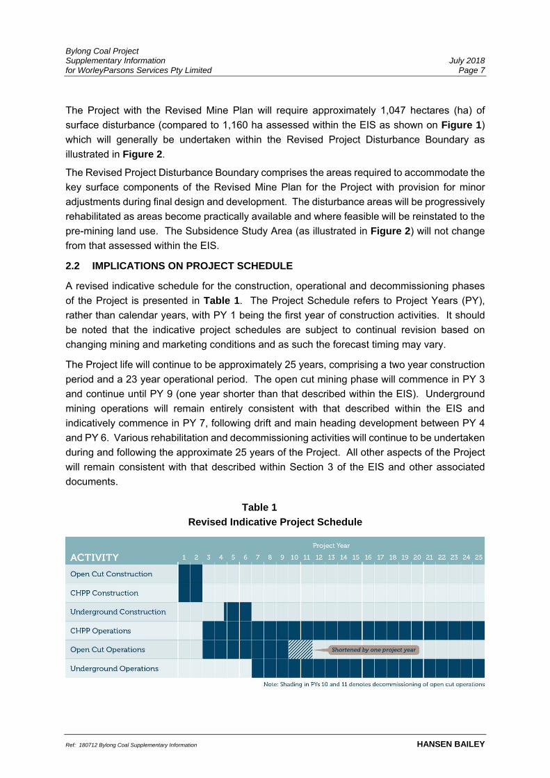
2.2 IMPLICATIONS ON PROJECT SCHEDULE
A revised indicative schedule for the construction, operational and decommissioning phases
of the Project is presented in Table 1. The Project Schedule refers to Project Years (PY),
rather than calendar years, with PY 1 being the first year of construction activities. It should
be noted that the indicative project schedules are subject to continual revision based on
changing mining and marketing conditions and as such the forecast timing may vary.
The Project life will continue to be approximately 25 years, comprising a two year construction
period and a 23 year operational period. The open cut mining phase will commence in PY 3
and continue until PY 9 (one year shorter than that described within the EIS). Underground
mining operations will remain entirely consistent with that described within the EIS and
indicatively commence in PY 7, following drift and main heading development between PY 4
and PY 6. Various rehabilitation and decommissioning activities will continue to be undertaken
during and following the approximate 25 years of the Project. All other aspects of the Project
will remain consistent with that described within Section 3 of the EIS and other associated
documents.
Table 1
Revised Indicative Project Schedule

Bylong Coal Project Supplementary Information July 2018 for WorleyParsons Services Pty Limited Page 8
Ref: 180712 Bylong Coal Supplementary Information HANSEN BAILEY
2.3 IMPLICATIONS TO PROJECT WORKFORCE
Figure 3 illustrates the indicative full-time equivalent (FTE) workforce during the years of open
cut mining operations for the revised Project versus that assessed within the EIS. The peak
workforce demands during the dual operations phase for the revised Project occurs one year
earlier (in PY 8) compared to the EIS and is marginally lower. This is primarily due to the peak
open cut workforce occurring one year earlier and aligning with the underground development
workforce, rather than longwall operations. The composition of the workforce, recruitment
strategy, shift rosters and patterns will generally be consistent with the EIS and other
associated documents.
2.4 REVISED OPEN CUT MINE PLAN
As explained within the EIS, initial conceptual plans to mine the significant coal resource from
seven open cut mining areas were rejected by KEPCO to minimise environmental and social
impacts (i.e. a reduction from seven open cut mining areas to the two as proposed within the
EIS). DPEs requested contractions to the Project mine plan will further reduce the recovery of
the State’s coal resources within the Authorisations held by KEPCO.
The revised open cut mine plan will remove approximately 4.6 Mt of ROM coal from the open
cut coal resource to approximately 28.3 Mt (from approximately 32.9 Mt) of ROM coal. This
will reduce the Project’s overall coal production to approximately 119.8 Mt of ROM coal
(compared to approximately 124.4 Mt of ROM coal) within an operational period of
approximately 23 years of active mining. ROM coal recovered over the mine life will be
processed within the CHPP to produce approximately 87.3 Mt (compared to 90 Mt) of two key
thermal product coal types (16% and 22% ash product) which will be railed to the Port of
Newcastle for export.
Figure 3
Comparison of Workforce Requirements
Note: Annual underground operations workforce
data was compiled and averaged PY 9 - PY 25.
Bylong Coal Project Supplementary Information July 2018 for WorleyParsons Services Pty Limited Page 9
Ref: 180712 Bylong Coal Supplementary Information HANSEN BAILEY
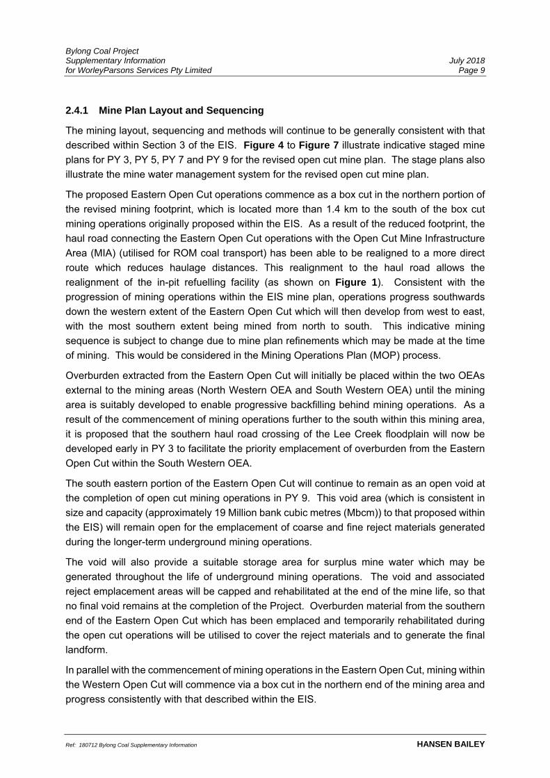
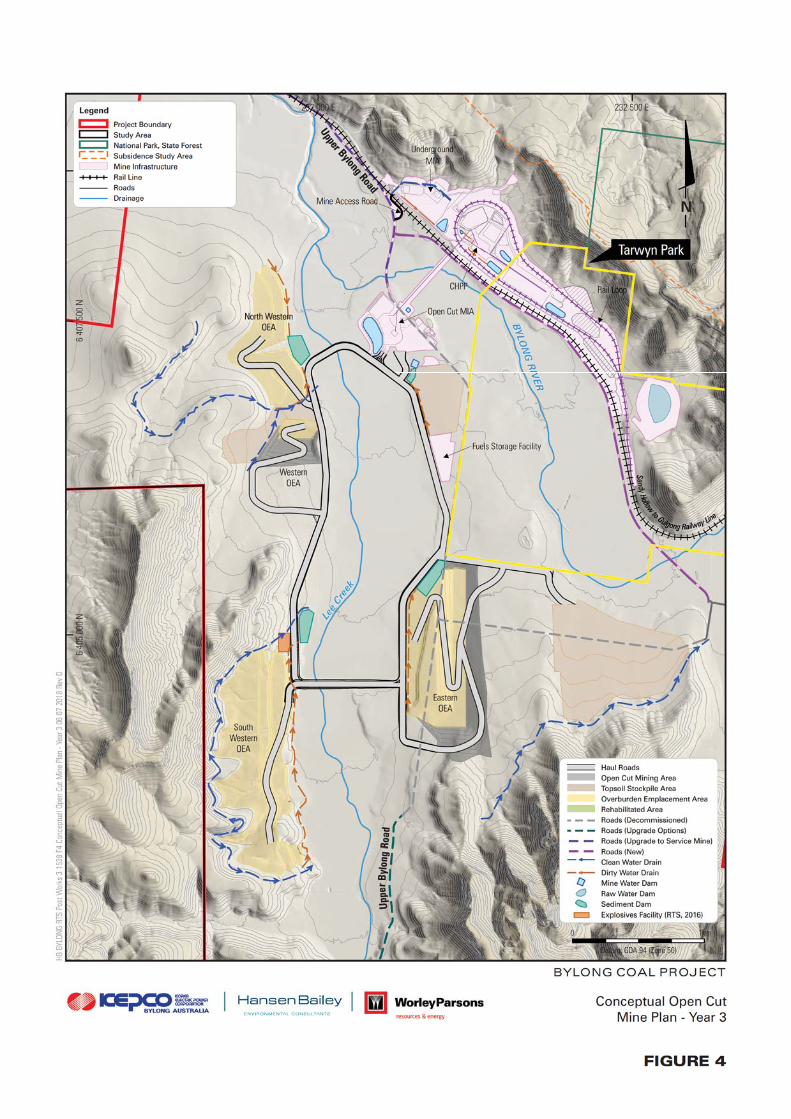
2.4.1 Mine Plan Layout and Sequencing
The mining layout, sequencing and methods will continue to be generally consistent with that
described within Section 3 of the EIS. Figure 4 to Figure 7 illustrate indicative staged mine
plans for PY 3, PY 5, PY 7 and PY 9 for the revised open cut mine plan. The stage plans also
illustrate the mine water management system for the revised open cut mine plan.
The proposed Eastern Open Cut operations commence as a box cut in the northern portion of
the revised mining footprint, which is located more than 1.4 km to the south of the box cut
mining operations originally proposed within the EIS. As a result of the reduced footprint, the
haul road connecting the Eastern Open Cut operations with the Open Cut Mine Infrastructure
Area (MIA) (utilised for ROM coal transport) has been able to be realigned to a more direct
route which reduces haulage distances. This realignment to the haul road allows the
realignment of the in-pit refuelling facility (as shown on Figure 1). Consistent with the
progression of mining operations within the EIS mine plan, operations progress southwards
down the western extent of the Eastern Open Cut which will then develop from west to east,
with the most southern extent being mined from north to south. This indicative mining
sequence is subject to change due to mine plan refinements which may be made at the time
of mining. This would be considered in the Mining Operations Plan (MOP) process.
Overburden extracted from the Eastern Open Cut will initially be placed within the two OEAs
external to the mining areas (North Western OEA and South Western OEA) until the mining
area is suitably developed to enable progressive backfilling behind mining operations. As a
result of the commencement of mining operations further to the south within this mining area,
it is proposed that the southern haul road crossing of the Lee Creek floodplain will now be
developed early in PY 3 to facilitate the priority emplacement of overburden from the Eastern
Open Cut within the South Western OEA.
The south eastern portion of the Eastern Open Cut will continue to remain as an open void at
the completion of open cut mining operations in PY 9. This void area (which is consistent in
size and capacity (approximately 19 Million bank cubic metres (Mbcm)) to that proposed within
the EIS) will remain open for the emplacement of coarse and fine reject materials generated
during the longer-term underground mining operations.
The void will also provide a suitable storage area for surplus mine water which may be
generated throughout the life of underground mining operations. The void and associated
reject emplacement areas will be capped and rehabilitated at the end of the mine life, so that
no final void remains at the completion of the Project. Overburden material from the southern
end of the Eastern Open Cut which has been emplaced and temporarily rehabilitated during
the open cut operations will be utilised to cover the reject materials and to generate the final
landform.
In parallel with the commencement of mining operations in the Eastern Open Cut, mining within
the Western Open Cut will commence via a box cut in the northern end of the mining area and
progress consistently with that described within the EIS.


Bylong Coal Project Supplementary Information July 2018 for WorleyParsons Services Pty Limited Page 14
Ref: 180712 Bylong Coal Supplementary Information HANSEN BAILEY
The south eastern extent of the EIS Western Open Cut mining footprint will not be mined under
the Revised Mine Plan to retain the existing natural wooded ridgeline/spur within this area.
Overburden materials extracted from the Western Open Cut mining area will initially be placed
within the North Western and South Western OEAs until the mining void is suitably developed
to enable progressive backfilling. Once operations have been appropriately progressed and
the OEAs have been shaped, the soil resources collected and stockpiled in advance of mining
will be directly placed onto the shaped OEAs to facilitate the progressive rehabilitation process.
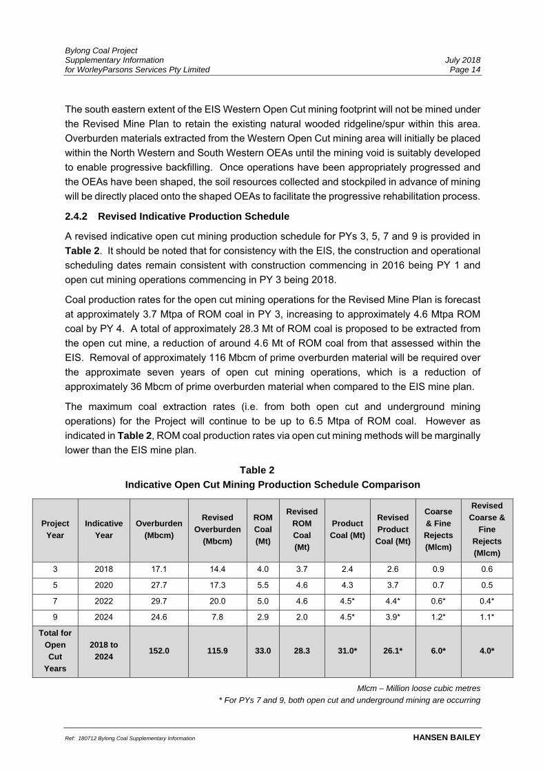
2.4.2 Revised Indicative Production Schedule
A revised indicative open cut mining production schedule for PYs 3, 5, 7 and 9 is provided in
Table 2. It should be noted that for consistency with the EIS, the construction and operational
scheduling dates remain consistent with construction commencing in 2016 being PY 1 and
open cut mining operations commencing in PY 3 being 2018.
Coal production rates for the open cut mining operations for the Revised Mine Plan is forecast
at approximately 3.7 Mtpa of ROM coal in PY 3, increasing to approximately 4.6 Mtpa ROM
coal by PY 4. A total of approximately 28.3 Mt of ROM coal is proposed to be extracted from
the open cut mine, a reduction of around 4.6 Mt of ROM coal from that assessed within the
EIS. Removal of approximately 116 Mbcm of prime overburden material will be required over
the approximate seven years of open cut mining operations, which is a reduction of
approximately 36 Mbcm of prime overburden material when compared to the EIS mine plan.
The maximum coal extraction rates (i.e. from both open cut and underground mining
operations) for the Project will continue to be up to 6.5 Mtpa of ROM coal. However as
indicated in Table 2, ROM coal production rates via open cut mining methods will be marginally
lower than the EIS mine plan.
Table 2
Indicative Open Cut Mining Production Schedule Comparison
Project
Year
Indicative
Year
Overburden
(Mbcm)
Revised
Overburden
(Mbcm)
ROM
Coal
(Mt)
Revised
ROM
Coal
(Mt)
Product
Coal (Mt)
Revised
Product
Coal (Mt)
Coarse
& Fine
Rejects
(Mlcm)
Revised
Coarse &
Fine
Rejects
(Mlcm)
3 2018 17.1 14.4 4.0 3.7 2.4 2.6 0.9 0.6
5 2020 27.7 17.3 5.5 4.6 4.3 3.7 0.7 0.5
7 2022 29.7 20.0 5.0 4.6 4.5* 4.4* 0.6* 0.4*
9 2024 24.6 7.8 2.9 2.0 4.5* 3.9* 1.2* 1.1*
Total for
Open
Cut
Years
2018 to
2024 152.0 115.9 33.0 28.3 31.0* 26.1* 6.0* 4.0*
Mlcm – Million loose cubic metres
* For PYs 7 and 9, both open cut and underground mining are occurring

Bylong Coal Project Supplementary Information July 2018 for WorleyParsons Services Pty Limited Page 15
Ref: 180712 Bylong Coal Supplementary Information HANSEN BAILEY
2.4.3 Revised Open Cut Mining Equipment
An indicative equipment fleet (subject to supply by a mining contractor to be engaged in the
future) for revised open cut mining operations at peak production for the Project is shown in
Table 3. Generally, there is expected to be a minor reduction in fleet required for the Revised
Mine Plan as a result of the reduced mining footprints and production rates.
Other ancillary equipment will continue to be required, including (but not limited to) lighting
plants, generators, water pumps, mobile cranes, delivery trucks and light vehicles.
2.4.4 Blasting
Blasting activities will be undertaken consistent with the methodologies presented in the EIS,
however at a marginally reduced rate. Due to the contracted open cut mining footprint, blasting
activities within the Eastern Open Cut will be located further south and at a greater distance to
the sensitive receptors located north of the open cut operations. Section 3.1 provides a
revised assessment of blasting impacts compared to the EIS and associated approvals
documentation.
2.4.5 Final Landform Establishment and Rehabilitation
KEPCO’s mine planning team has developed a revised Conceptual Final Landform based on
the mine planning principles which were developed throughout the Project’s extensive mine
planning process. In this regard, the Conceptual Final Landform as illustrated within
Figure 8, accommodates similar attributes to the EIS mine plan, albeit with reduced footprints
and improved landform design elements.
Table 3
Indicative Open Cut Equipment Comparison
Equipment Number* Revised Number*
550 t Hydraulic Excavators 2 2
250 t Hydraulic Excavators 2 2
Front End Loaders 3 3
220 t Haul Trucks 10 10
180 t Haul Trucks – Coal 5 4
180 t Haul Trucks – Combi-body 11 10
D11 Dozers 10 10
Graders 3 2
150 t Water Carts 2 2
Blast Hole Drill 3 2
Fuel and Lube Trucks 2 2
*Includes coal and reject materials handling equipment fleet

Bylong Coal Project Supplementary Information July 2018 for WorleyParsons Services Pty Limited Page 17
Ref: 180712 Bylong Coal Supplementary Information HANSEN BAILEY
The North Western OEA and South Western OEA have adopted some additional design
principles from the EIS in order to address concerns in relation to the proposed landform which
have recently been raised by the Heritage Council. The North Western OEA will continue to
occupy the same footprint as that proposed within the EIS. However, the revised landform has
incorporated the existing valley which extends from the northern portion of the Growee Ranges
down to the Lee Creek floodplain on the south-eastern side of the Telstra Hill. The inclusion
of this landscape feature aims to minimise the visual effects of the North Western OEA to views
from Tarwyn Park and to blend the landform in with the natural topography to the maximum
extent possible. Similarly, the South Western OEA has been redesigned with a reduced height
to minimise the area of steeper sloping land on the western side of this landform.
The Eastern OEA generally represents a similar landform to that presented within the EIS
(albeit with reduced footprint to remain off Tarwyn Park). The conceptual design for the
Western OEA will also be developed generally consistent with the EIS mine plan, with
exception of the contracted footprint within the south eastern extent of the Western Open Cut.
Consistent with contemporary environmental assessment requirements, this revised
Conceptual Final Landform design has been developed using standard mine planning design
principles. Schedule 4, Condition 63 of the Recommended Development Consent conditions
prepared by DPE for the Project specifies the requirement for the final landform design to be
developed to “incorporate micro-relief and integrate with the surrounding natural landforms”
and to “minimise the visual impact of final landforms as far as is reasonable and feasible”.
These specifications follow on from KEPCO’s final landform rehabilitation objectives as
described within the EIS and associated approvals documentation.
As part of the Rehabilitation Management Plan (RMP) and MOP to be prepared upon the
receipt of planning approval, KEPCO would be required to develop strategies to address these
committed rehabilitation objectives. This will entail detailed landform modelling which will be
able to accommodate real mine planning data gained through the physical mining activities as
opposed to standard mine planning design assumptions which are utilised at the EIS stage.
The conceptual mine plans, schedules and final landform designs presented within this
document are based on the information and knowledge available at this stage of the Project.
These conceptual plans, schedules and designs will be continuously reviewed as mining
progresses. Progressive rehabilitation of the site will be appropriately focused towards
achieving the overall rehabilitation objectives for the Project, including the establishment of a
safe and stable final landform that integrates into the neighbouring natural environment and
where practical, returns the land to its pre-mining land use post-mining.

Bylong Coal Project Supplementary Information July 2018 for WorleyParsons Services Pty Limited Page 18
Ref: 180712 Bylong Coal Supplementary Information HANSEN BAILEY
Conceptual Macro Relief Landform Design
In light of the concerns raised within the PAC Review Report and subsequent Heritage Council
correspondence in relation to the uniform nature of the Conceptual Final Landform design,
KEPCO’s mine planning team has completed some detailed landform design work to develop
a revised Conceptual Final Landform design which incorporates macro relief (revised
Conceptual Final Landform with Macro Relief) (see Figure 9). The mine planning information
developed for the revised Conceptual Final Landform has been utilised as the basis of the
macro relief design. It is noted that a similar detailed mine planning process will be undertaken
as part of the RMP/MOP process to address the Project’s rehabilitation objectives should the
EIS Mine Plan be approved.
KEPCO’s mine planning team conducted a detailed investigation of the surrounding natural
topography and has incorporated the shape and character of natural topographic features into
the final landform design for the Revised Mine Plan. The key natural topographic features
identified by the mine planning team for use within the final landform design included:
Branching ridgelines;
Ridgelines between 50 metres (m) and 130 m wide;
Ridgelines having gentle grades, then steeper down to the valley floor; and
Ridge side slopes generally >20 degrees.
The revised Conceptual Final Landform with Macro Relief as illustrated in Figure 9
incorporates the following design features:
Branching ridgeline features;
Various ridgeline widths between 60 m and 85 m;
Ridge grades of between 0 to 2.5 degrees, then 2.5 to 7 degrees down to the valleys;
Maximum landform slopes generally less than 10 degrees, with small areas between
10 to 14 degrees (to marry with existing topography); and
Minimum 300 m vertical radius on ridge crests to ensure no sharp crests are developed
where multiple slopes intersect.
In preparing the revised Conceptual Final Landform with Macro Relief, the mine planning team
focussed on the planning schedule and mass centroids developed for the Revised Mine Plan.
The landform design has also considered the required scheduling in order to reduce haulage
distances throughout the life of mining and also the ability to retain areas suitable for the post
mining land use objectives previously stated and areas for the reinstatement of Biophysical
Strategic Agricultural Land (BSAL). This Conceptual Final Landform (with Macro Relief)
should be considered an indicative representation of the intended outcome of the final landform
for the Project. This Conceptual Final Landform (with Macro Relief) is subject to change as
part of the more detailed mine planning work to occur during the initial years of mining
operations for inclusion into the RMP and MOP as required. The principles used here will be
utilised in the following detailed mine planning processes.


Bylong Coal Project Supplementary Information July 2018 for WorleyParsons Services Pty Limited Page 20
Ref: 180712 Bylong Coal Supplementary Information HANSEN BAILEY
3 ENVIRONMENTAL REVIEW
An environmental review of the potential environmental impacts relating to the Revised Mine
Plan has been completed and is presented in this section and supporting technical appendices.
The environmental review includes a comparison of the Revised Mine Plan to the assessed
environmental impacts for the Project EIS Mine Plan presented in the EIS and associated
documents.
A tabulated summary of the revised environmental impacts is provided within Appendix D.
3.1 NOISE & BLASTING
3.1.1 Background
Noise and blasting impacts for the Project have previously been assessed within Noise and
Blasting Impact Assessment (NBIA) (PEL, 2015).
Environmental Resource Management (ERM) (formerly Pacific Environment Limited) was
commissioned to undertake a review of the potential noise and blast impacts for the Revised
Mine Plan in comparison with those previously assessed for the Project within the EIS and
supporting documentation.
The assessment generally confirmed that the Revised Mine Plan would reduce noise impacts
to private receivers located to the north of the Project when compared to the EIS Mine Plan.
Blast impacts to Tarwyn Park Homestead and Stables were also determined to be materially
lower for the Revised Mine Plan.
A copy of the ERM technical report is included within Appendix E with a brief overview of the
assessment provided below.
3.1.2 Methodology
ERM has determined that PY 5 represents the worst-case operation of the open cut mining
operations for which to compare the noise impacts for the Revised Mine Plan against the EIS
assessments. PY 5 represents the highest year of coal and overburden production for the
Revised Mine Plan in the period where operations are undertaken across the two mining areas.
The PY 5 mine plan also includes activities on the North Western OEA which is generally
closest to the sensitive receivers located to the north of the Project.
ERM has revised the equipment locations for the PY 5 to reflect the Revised Mine Plan and
associated mine planning information. The noise modelling has utilised similar methodology
and assumptions to that presented within the EIS. In this regard, the noise modelling has
relied upon on the assumptions from the EIS modelling. Operational noise impacts have been
modelled under each of the meteorological conditions assessed as part of the EIS to ensure a
direct comparison could be made. Appendix E provides further information on the noise
modelling methodology.

Bylong Coal Project Supplementary Information July 2018 for WorleyParsons Services Pty Limited Page 21
Ref: 180712 Bylong Coal Supplementary Information HANSEN BAILEY
ERM has also conducted an updated blast impact assessment for the Revised Mine Plan
based on the increased minimum blast distances to sensitive features. The blast impact
assessment methodology and relevant criteria for the Revised Mine Plan is consistent with the
NBIA. Appendix E provides further information on the blast impact assessment methodology.
3.1.3 Revision of Impacts
Since the preparation of the EIS, KEPCO has acquired and reached agreement to purchase
several properties which were previously assessed to experience noise impacts as a result of
the Project. Figure 10 and Figure 11 illustrates the status of landownership within and
surrounding the Project Boundary.
Table 4 presents a summary of the worst-case noise levels and assessment results for
neighbouring private receivers which exceed the Project Specific Noise Level (PSNL)
(i.e. 35 dB(A)) for the Revised Mine Plan. Table 5 presents a revised summary of operational
noise exceedances for the Revised Mine Plan. Noise impact to private receivers to the north
have on average reduced by approximately 1 decibel (dB) as a result of the Revised Mine
Plan. A full assessment of operational noise levels to receivers is provided in Appendix E.
Table 4
Predicted Noise Levels for PY 5
Landowner ID Landowner Predicted Noise Level (LAeq, 15 min dB(A))
Day Evening/Night
56 Locaway Pty Ltd - 37
57A Locaway Pty Ltd - 36
57C Locaway Pty Ltd - 36
58 I & C Tindale 37 38
60 Jarvet Pty
Limited
39 40
151* PR Grieve - 38
158* PR Grieve - 37
Dashed result indicates no exceedance of PSNL predicted under that scenario
Green shading – Negligible operational noise impacts predicted
Blue shading – Moderate operational noise impacts predicted
* KEPCO has reached the relevant agreement to purchase this property

Bylong Coal Project Supplementary Information July 2018 for WorleyParsons Services Pty Limited Page 22
Ref: 180712 Bylong Coal Supplementary Information HANSEN BAILEY
Table 5
Revised Summary of Operational Noise Exceedances
Noise Exceedance
Management Approach
in accordance with
VLAMP
No. Affected
Private
Receivers
Landowner
IDs
Negligible noise impacts
(1-2 dB exceedance)
Noise mitigation at noise
source 4
561, 57A1,
57C1, 1582*
Moderate Noise Impacts
(3-5 dB exceedance)
Noise mitigation, including
mitigation at residence 3 58, 60, 1512*
Significant Noise Impacts
(>5 dB exceedance) Acquisition - -
Additional significantly
affected land (exceedance
of amenity criteria on >25%
of land)
Acquisition - -
Total 7 residences
4 landowners
1. Receivers 56, 57A and 57C owned by same landowner
2. Receivers 151 and 158 owned by same landowner
* KEPCO has reached the relevant agreement to purchase this property


Bylong Coal Project Supplementary Information July 2018 for WorleyParsons Services Pty Limited Page 25
Ref: 180712 Bylong Coal Supplementary Information HANSEN BAILEY
ERM has determined that one private receiver (receiver 60) previously predicted to experience
significant noise impacts from the Project, has now been assessed to reduce to moderate
noise impacts for the Revised Mine Plan. Receiver 58 which was previously predicted to
experience moderate noise impacts as a result of the Project will continue to receive moderate
noise impacts during the early years of the Project for the Revised Mine Plan. The three
receivers (located on one property) will continue to experience negligible noise impacts
throughout the early stages of the open cut mine life. KEPCO has reached agreement over
the purchase of receivers 151 and 158 upon the granting of Development Consent for the
Project. Receiver 158 has reduced from moderate noise impact to negligible noise impacts as
a result of the Revised Mine Plan.
ERM confirmed that a review of the predicted low frequency spectrum at each private receiver
did not identify a low frequency noise impact (in accordance with the methodology previously
accepted by EPA and methodology specified in the Noise Policy for Industry (EPA, 2017)) at
any receiver.
Upon the completion of open cut mining operations (which is now one year earlier than the
EIS), noise impacts to private receivers will be significantly lower for the underground mining
phase (which is not affected by the Revised Mine Plan) and will remain consistent with that
previously assessed for the Project.
Given that the Revised Mine Plan entails a contraction to the mining footprint (and associated
blasting activities) rather than extension, blast impacts to sensitive receivers will be equal to or
lower than those assessed within the EIS. Accordingly, blasting activities associated with the
Revised Mine Plan are not predicted to result in blast impacts in excess of the relevant criteria
for private receivers. Private receivers located to the north of the Eastern Open Cut mining
area are likely to experience reduced blasting impacts for the Revised Mine Plan.
Appendix E provides a full assessment of blast impacts to private receivers (and sensitive
features) within and surrounding the Project.
Tarwyn Park Homestead and Stables will be located more than approximately 1.4 km from the
nearest blasting activities associated with the Revised Mine Plan. In comparison, blasting
activities were assessed within the EIS to be undertaken within 190 m and
107 m of the Homestead and Stables respectively. Due to this significant change in the
distance from blasting, the overpressure and vibration impacts to these items will be
considerably lower when compared to the EIS, to levels lower than the relevant guideline limits.
The reduced footprint of the Eastern Open Cut mining area for the Revised Mine Plan results
in the former Catholic Church and Cemetery of Our Lady of Sacred Heart (former Upper Bylong
Catholic Church and Cemetery) remaining insitu. Blasting activities under the Revised Mine
Plan will be more than 1 km from the former Upper Bylong Catholic Church grounds. ERM
has predicted that blasting activities will comply with the relevant guideline criteria set for the
avoidance of structural damage at the former Upper Bylong Catholic Church grounds.

Bylong Coal Project Supplementary Information July 2018 for WorleyParsons Services Pty Limited Page 26
Ref: 180712 Bylong Coal Supplementary Information HANSEN BAILEY
The Aboriginal Heritage sites to be avoided by the Revised Mine Plan (three artefact scatters
and an isolated find) are not expected to be significantly impacted as a result of blasting
activities.
3.1.4 Revised Mitigation and Management Measures
The noise and blast management and mitigation measures previously identified within the EIS
and associated approvals documents continue to be relevant for the Revised Mine Plan.
KEPCO will consult with the landholders where noise impacts as a result of the Revised Mine
Plan have reduced to a lower impact category in accordance with the VLAMP.
Blast impacts (whilst predicted to comply with the relevant guideline criteria) associated with
the former Upper Bylong Catholic Church and Cemetery (previously proposed to be removed)
will be managed within the Blast Management Plan to be prepared prior to the commencement
of operations.
3.2 AIR QUALITY & GREENHOUSE GAS
3.2.1 Background
A relevant Air Quality and Greenhouse Gas Assessment has been undertaken by ERM for the
Revised Mine Plan to determine the likely reductions in air quality and greenhouse gas (GHG)
impacts from those identified within the EIS.
The assessment confirmed that air quality and greenhouse gas emissions would reduce from
those assessed within the EIS and associated approvals documents.
A copy of this technical assessment is presented in Appendix F with an overview of the key
findings provided below.
3.2.2 Methodology
The EIS Air Quality and Greenhouse Gas Impact Assessment (AQGHGIA) determined that
the Project would not result in any exceedances of the relevant air quality criteria and any
neighbouring private receivers. As noted above, KEPCO has acquired additional properties
surrounding the Project.
To demonstrate that air quality impacts will be equal to or less than those assessed within the
EIS (and associated approvals documents), an emissions inventory has been prepared for the
worst case operational year (PY 5) for comparison to the emissions calculated for the EIS.
Whilst there is more material moved in PY 6 and PY 8, this activity is mainly limited to the
Eastern Open Cut mining area. To ensure a representative assessment of both the Eastern
and Western Open Cut mining areas working simultaneously, PY 5 has been determined to
contain the highest activity as well as the highest volume of topsoil removal of all mining years.
PY 5 was also modelled and presented under the EIS mine plan and enables a direct
comparison with the Revised Mine Plan.
Bylong Coal Project Supplementary Information July 2018 for WorleyParsons Services Pty Limited Page 27
Ref: 180712 Bylong Coal Supplementary Information HANSEN BAILEY
The key activities from the EIS mine plan have been utilised within the revised emissions
inventory. The same assumptions with respect to silt and moisture content were applied to the
emission inventory as presented in the EIS. The diesel emissions have also been
conservatively calculated based on all equipment being compliant with Tier 2 emission
standards.
The methodology for calculating PM10 emissions from hauling activities was consistent with
the revised methodology adopted in Section 4.8.5 of the RTS (Hansen Bailey, 2016a) in
response to stakeholder comments. PM2.5 emission from diesel are assumed to remain the
same, as presented in Section 2.1 of the Supplementary RTS (Appendix E) (Hansen Bailey,
2016b).
GHG emissions (expressed as carbon dioxide equivalent (CO2-e)) have been revised based
on the reduced mining activities associated with the Revised Mine Plan. The emissions were
calculated utilising the formulas presented within the AQGHGIA. KEPCO provided the revised
consumables for the Revised Mine Plan based on a prorate basis to forecast production rates
(where relevant).
3.2.3 Revision of Impacts
The emission inventory for PY 5 of the Revised Mine Plan is provided in Appendix F. There
is a substantial reduction in mining activity for PY 5 of the Revised Mine Plan compared to that
modelled for the EIS.
Overall, the Revised Mine Plan shows a 41% reduction in total suspended particulate (TSP)
emissions and 40% reduction to both PM10 and PM2.5 emissions when compared to the values
presented in the EIS. These drastically reduced emissions for PY 5 are due to the following:
Reduced overburden handling from approximately 22.8 Mbcm to approximately
17.3 Mbcm (a 23.9% reduction);
Reduced open cut ROM coal production rate from approximately 5.5 Mtpa to
approximately 4.6 Mtpa (a 15.9% reduction);
Reduced wind erosion areas (mainly associated with the Eastern OEA on Tarwyn Park
area) (a 28.7% reduction); and
Marginally shorter haulage routes as they are no longer routing around the Eastern OEA,
increased in pit overburden emplacement and overall less travel due to reduced amount
of materials being removed.
The EIS mine plan predicted no private residences to experience ground level concentrations
of PM10 PM2.5 or TSP above the relevant impact assessment criteria. The improved air quality
results of the Revised Mine Plan in conjunction with there being less activity surrounding the
closest receivers would reduce the predicted contribution of the Project compared to the EIS
mine plan even further.

Bylong Coal Project Supplementary Information July 2018 for WorleyParsons Services Pty Limited Page 28
Ref: 180712 Bylong Coal Supplementary Information HANSEN BAILEY
Scope 1 GHG emissions were estimated to drop by 3.9% for the Revised Mine Plan when
compared to those assessed within the EIS. The estimated GHG emissions for the Revised
Mine Plan represents only 0.02% of Australia’s commitment to GHG emissions under the Paris
Agreement (i.e. 431 Mt CO2-e by 2030).
The Revised Mine Plan will also result in a 1.4% and 2.7% reduction in calculated scope 2 and
scope 3 emissions, respectively, when compared to those assessed for the EIS.
3.2.4 Revised Management and Mitigation Measures
The air quality and GHG management and mitigation measures previously identified within the
EIS and associated approvals documents continue to be relevant for the Revised Mine Plan.
3.3 GROUNDWATER
3.3.1 Background
Australasian Groundwater and Environmental Consultants Pty Ltd (AGE) completed a
Groundwater Impact Assessment for the Revised Mine Plan.
The assessment found that the Revised Mine Plan would result in reduced groundwater inflows
to the open cut mining areas as well as marginally reduced drawdown within the neighbouring
alluvial aquifer compared to those previously assessed for the EIS Mine Plan. Groundwater
inflows to the underground mining areas will not change from those previously assessed for
the EIS Mine Plan.
An overview of this technical assessment is provided below with a full copy included within
Appendix G.
3.3.2 Methodology
To ensure a direct comparison of the operational impacts between the Revised Mine Plan and
the Project previously assessed, the groundwater model prepared for the Supplementary RTS
was utilised. The Revised Mine Plan was adjusted within the groundwater model and run to
determine the impacts to the regional groundwater regime for comparison to the impacts
assessed within the Supplementary RTS.
The Supplementary RTS was also utilised to assess whether there were any changes between
the post mining recoveries between the Revised Mine Plan and the EIS Mine Plan.
The predictive uncertainty assessment conducted for the Supplementary RTS was not
repeated as this is influenced by the variability in model parameters and as these parameters
remain unchanged there is no change expected.
3.3.3 Revisions to Impacts
Revised Groundwater Takes
The reduced footprint of open cut mining has resulted in a reduction of groundwater inflows to
the open cut from a peak of 106 Megalitres per year (ML/year) in PY 5 reported within the
Supplementary RTS groundwater modelling by AGE (2016) down to 76 ML/year in PY 7.
Bylong Coal Project Supplementary Information July 2018 for WorleyParsons Services Pty Limited Page 29
Ref: 180712 Bylong Coal Supplementary Information HANSEN BAILEY
This represents an approximate 30% reduction in groundwater inflows to the open cut mining
area. The cumulative volume of groundwater intercepted during open cut mining reduces by
approximately 163 Megalitres (ML), primarily due to the reduced open cut footprints.
In light of no changes proposed to the underground mining, there is no changes to the
previously predicted groundwater inflows to the underground as a result of the Revised Mine
Plan for the open cut. Therefore, the predicted peak annual take of groundwater from the
Permian as a result of the Project continues to remain consistent with that identified for the
underground within the Supplementary RTS (i.e. 4,099 ML in PY 23).
The changes in the groundwater flows were extracted from the updated numerical model to
determine how the Revised Mine Plan will influence the indirect interception of groundwater.
The results showed a net increase into the alluvium from the Permian bedrock by
approximately 100 ML during the initial eight years of the Project. This is expected to be the
result of slightly reduced rates of depressurisation within the Permian bedrock for the Revised
Mine Plan, allowing steeper hydraulic gradients to promote greater flow of Permian
groundwater into the base of the alluvium.
Table 6 provides a summary of the predicted average, maximum and cumulative (total) water
takes in the alluvial and Permian (and Triassic) hard rock aquifers as a result of the Revised
Mine Plan. Appendix G includes a detailed table of water budgets extracted from the updated
numerical model for the Revised Mine Plan as well as water licencing requirements. The
results indicate similar impacts to those reported within the Supplementary RTS, with slight
reductions to mine inflows and Permian flow losses as a result of the reduced open cut mining
footprint.
Revised Groundwater Drawdown & Baseflow Impacts
The Revised Mine Plan shows a reduction in the predicted maximum drawdown due to the
reduced open cut mining footprint when compared to the previously predicted drawdown in the
Supplementary RTS. It indicates typically between 0.1 m and 0.2 m less drawdown occurring
within the alluvial aquifer. The Revised Mine Plan results show there will be no adverse impacts
on the neighbouring private landholder’s bores within the alluvium and therefore remains
consistent with what was presented in the Supplementary RTS.
In light of the reduced drawdown within the alluvial aquifer, there is also predicted to be a
reduced take of baseflow from the surface water system. That is, the alluvial groundwater
which feeds the base of the creek as baseflow is reduced by up to 920 ML/year (PY 9) for the
Revised Mine Plan in comparison with up to 994 ML/year (PY 9) as reported within the
Supplementary RTS. These predicted baseflow losses are predominately an incidental effect
of the water takes from the borefield and are generally located on land owned by KEPCO.
However, the modelling demonstrates that the baseflows on KEPCO owned land never
reaches zero (and therefore baseflow does not dry up at any time).

Bylong Coal Project Supplementary Information July 2018 for WorleyParsons Services Pty Limited Page 30
Ref: 180712 Bylong Coal Supplementary Information HANSEN BAILEY
Table 6
Predicted Water Take for Revised Mine Plan
Geological
Unit
Source of
Water Take
Average Maximum Cumulative
Take over
Project Life ML/Year ML/year Year
Permian (and
Triassic) hard
rock
Mine Inflow 1,445 4,099 PY 23 36,112
Alluvial
Reduced
Permian flow -5 55 PY 12 -123
Borefield
pumping 763 1,189 PY 6 19,081
Agricultural
pumping
(capped)
714 714 All 17,850
Total 2,917 72,920
The creeks within the Bylong River catchment are ephemeral in nature and only flow
intermittently following substantial rainfall events. Accordingly, these streams do not flow for
the majority of time. However, they exist as a chain of ponds along the drainage alignment,
which are windows to the alluvial water table, but with no continuous baseflow.
The baseflow losses on land not owned by KEPCO are negligible with up to 1.6 ML/year
predicted during PY 9. It is important to note that within the model, the peak in baseflow losses
(PY 9) coincides with the peak in borefield demand, a conservative coincidence that
exacerbates the alluvial drawdown and the loss of baseflow predicted by the model. This
specific scenario is considered improbable.
Notwithstanding this, an appropriate framework for which to manage the potential impacts on
neighbouring water users is provided within the Draft Water Management Plan which has been
prepared for the Project.
Further information in relation to the impacts of the Project on baseflows is provided within
Appendix G.
Revised Water Licencing
KEPCO currently hold 3,045 units (equivalent to 3,045 ML) of groundwater allocation within
the Bylong River Water Source under the Water Sharing Plan for the Hunter Unregulated and
Alluvial Water Sources 2009 (Hunter Unregulated WSP). The predicted water takes from this
water source as a result of the Revised Mine Plan are significantly lower than the current
licence entitlements. With water requirements remaining virtually unchanged from previous
estimates presented in the Supplementary RTS, the impacts on the alluvium remain generally
unchanged for the Revised Mine Plan.

Bylong Coal Project Supplementary Information July 2018 for WorleyParsons Services Pty Limited Page 31
Ref: 180712 Bylong Coal Supplementary Information HANSEN BAILEY
The modelled peak water take of 4,099 ML/year which is predicted to occur from Permian (and
Triassic) hard rock aquifers of the Sydney Basin - North Coast Water Source of the Water
Sharing Plan for the North Coast Fractured and Porous Rock Groundwater Sources 2016
(North Coast WSP). This is entirely consistent with the peak water take from the hard rock
aquifers presented in the Supplementary RTS.
KEPCO holds a water access licence (WAL) for 411 units from the North Coast WSP as a
result of land acquisitions. KEPCO also lodged an application for 2,093 units of water
allocation within the Permian and Triassic under the Water Act 1912 for the Project in
November 2015. DoI has previously indicated to KEPCO that this Water Act 1912 licence
application is valid and will be transferred as a licence under the North Coast WSP. Assuming
these allocations are held, KEPCO will have sufficient water licences to account for the
predicted water takes from the Permian and Triassic hard rock aquifers for at least the first
19 years of the Project. This provides a considerable period of time for KEPCO to obtain the
remaining allocations.
In light of concerns raised by the PAC Review Report, KEPCO has engaged a water broker
and is currently actively seeking to purchase water licences under the North Coast WSP to
obtain water allocations for the remaining 1,596 units required to account for the peak predicted
takes for the Project at PY 23.
As of 18 June 2018, the NSW Water Register indicates there are 182 WALs for groundwater
within the Sydney Basin – North Coast Water Source of the North Coast WSP with a total
share component of 64,673.5 units (AGE 2018). With the number of licenses within this water
source and quantity available, KEPCO is confident that the additional water allocations will be
obtainable prior to it being required in PY 20 and are well prepared to secure this allocation.
Revised Post Mining Assessment
The recovery of groundwater levels within and surrounding the Project for the Revised Mine
Plan were compared to that previously assessed within the EIS Groundwater Impact
Assessment (AGE, 2015). Groundwater levels were found to mound approximately 2 m higher
below the Eastern OEA for the Revised Mine Plan when compared to the EIS Mine Plan.
Whilst there are some minor differences in the post mining groundwater levels, the conclusion
from the EIS that there will be no significant residual drawdown post mining remains valid for
the Revised Mine Plan.
As previously assessed within the EIS Groundwater Impact Assessment (AGE, 2015), the
groundwater system will slowly recover over a period of approximately 100 years post mining
to a point where there will be no net water take from the alluvium aquifer. The updated
Supplementary RTS model for the Revised Mine Plan shows no changes in these findings and
therefore remains consistent with the previous predictions.
The impacts of the Revised Mine Plan on the post mining water quality is also consistent with
that assessed within the EIS Groundwater Impact Assessment. The beneficial use of the
alluvial groundwater will not be affected as a result of the Revised Mine Plan.

Bylong Coal Project Supplementary Information July 2018 for WorleyParsons Services Pty Limited Page 32
Ref: 180712 Bylong Coal Supplementary Information HANSEN BAILEY
3.3.4 Revised Mitigation and Management Measures
The groundwater management and mitigation measures previously identified within the EIS
and associated approvals documents continue to be relevant for the Revised Mine Plan. Whilst
the Draft Water Management Plan which was prepared for inclusion within the Response to
PAC Review Report will continue to be appropriate for the Revised Mine Plan, the finer details
of this document will be reviewed and updated upon the receipt of Development Consent for
the Project.
KEPCO is in ongoing discussions with DoI over the issuance of the water licence application
previously lodged in November 2015. The latest correspondence from DoI is discussed in
Section 4.1. As mentioned earlier, KEPCO has also engaged a water broker to assist in
securing WALs for the North Coast WSP on the open market to meet the predicted water takes
from this water source.
3.4 SURFACE WATER
3.4.1 Background
WRM Water and Environment (WRM) has prepared a Surface Water Impact Assessment for
the Revised Mine Plan which is provided in Appendix H. The following sections provide an
overview of this assessment.
The assessment has confirmed that surface water impacts for the Revised Mine Plan are
generally consistent with those previously assessed for the EIS Mine Plan.
3.4.2 Methodology
The Surface Water Impact Assessment reviews the potential impacts of the Revised Mine Plan
in comparison with the surface water impacts identified within the EIS and supporting
documentation. It also provides the results of an updated mine water balance for the Revised
Mine Plan.
The Bylong Operational Simulation Model (OPSIM) developed for the EIS and associated
approvals documents has been updated to reflect the changes to the mine water management
system and open cut mine layout for the Revised Mine Plan.
In order to develop representative results showing the changes in catchment areas, production
profiles and site water demands, four representative years were selected to reflect the average
conditions over the mine phases, including PY 3, PY 7, PY 9 and PY 10+ (for the underground
mining phase). Consistent with the EIS, construction activities associated with the Project
have not been included in the revised water balance modelling assessment. To allow for a
direct comparison of impacts resulting from the Revised Mine Plan, the updated modelling
results have been compared against all results and information presented in the EIS and
associated approvals documents wherever appropriate.
Bylong Coal Project Supplementary Information July 2018 for WorleyParsons Services Pty Limited Page 33
Ref: 180712 Bylong Coal Supplementary Information HANSEN BAILEY
3.4.3 Revision of Impacts
Revised Mine Water Balance
The water balance completed throughout the approvals process has demonstrated that the
water management system can adequately retain all mine water onsite throughout the life of
the Project. The water balance modelling for the Revised Mine Plan has demonstrated that
this assessment finding continues to be the case. This is not surprising given that the void
remaining at the completion of open cut mining operations is entirely consistent with that
proposed for the EIS Mine Plan and there being no changes to the groundwater inflows within
the underground mining area.
The water balance model confirms that during the open cut only operations, the accumulation
of water is manageable and there is a low risk of significant volumes of water accumulating in
the open cut mining areas. Consistent with the previous water balance modelling, once the
underground operations commence, a significant increase in groundwater inflows is predicted,
which increases the risk of water accumulating within the water management system. The
void remaining within the Eastern open cut, along with the goaf storage available within the
underground mine will sufficiently accommodate the predicted surplus mine water generated
for the project for the very wet conditions 1st percentile scenario. The water balance
contingency measures to consider in the unlikely event that further measures are required to
manage surplus mine water as outlined within the Response to PAC Review report continue
to be appropriate for the Revised Mine Plan.
The water balance modelling results show a slight reduction in simulated overflows from the
sediment dams following rainfall events. This is the result of marginally reduced catchment
areas along with the increased design capacity of the sediment dams (as requested by EPA).
The water balance modelling for the Revised Mine Plan indicates that there is a 1% probability
that the annual volume requirement from the borefield water supply could equal or exceed
1,340 ML/year during the Project. This is generally consistent with the water balance modelling
predictions in the Response to PAC Review Report. KEPCO’s water licenses will more than
account for this worst-case predicted external water supply demand.
Revised Catchment Impacts
The maximum undisturbed catchment that is proposed to be captured under the Revised Mine
Plan has been calculated to be approximately 123 ha, which is consistent with the area
calculated as part of the EIS investigations. The surface runoff collected from this undisturbed
catchment has been determined to remain well within the harvestable rights for the Project.

Bylong Coal Project Supplementary Information July 2018 for WorleyParsons Services Pty Limited Page 34
Ref: 180712 Bylong Coal Supplementary Information HANSEN BAILEY
Revised Flooding Impacts
The Revised Mine Plan configuration was compared to that previously assessed in the EIS
and RTS to qualitatively assess the flood impacts. Given that the Revised Mine Plan involves
a contraction to the mining footprints to those assessed within the EIS, the flooding impacts of
the Revised Mine Plan are similar (and in some cases less than) those identified within the
previous assessments. Flood impacts resulting from the Revised Mine Plan are not anticipated
to encroach upon the Tarwyn Park property.
3.4.4 Revised Mitigation and Management Measures
The surface water management and mitigation measures previously identified within the EIS
and associated approvals documents continue to be relevant for the Revised Mine Plan.
The Draft Water Management Plan which was prepared for inclusion within the Response to
PAC Review Report will continue to be appropriate for the Revised Mine Plan. This document
will be reviewed and updated upon the receipt of Development Consent for the Project.
3.5 SOILS & REHABILITATION
3.5.1 Background
SLR Consulting (SLR) was commissioned to undertake a Soils and Rehabilitation Assessment
of the Revised Mine Plan.
The assessment confirmed that direct impacts to BSAL would reduce consistent with the
Revised Project Disturbance Boundary. The available soil resources will also fulfil the Project’s
rehabilitation requirements.
This report is presented in Appendix I with a summary provided in the following sections.
3.5.2 Methodology
The revised areas of BSAL and various Land and Soil Capability (LSC) classes within the
Revised Project Disturbance Boundary were initially calculated for comparison to those
previously assessed within the EIS and associated approvals documents. This also facilitated
the revision to the rehabilitation objectives for the Project and to assess how the Revised Mine
Plan and associated revised Conceptual Final Landform could achieve those objectives. A
revised soil resource balance was then completed to confirm whether the revised rehabilitation
objectives were achievable for the Revised Mine Plan.
3.5.3 Revision of Impacts
Revised BSAL & LSC Impacts
The Revised Project Disturbance Boundary includes approximately 400.4 ha of BSAL, which
represents a reduction of approximately 5.4% from the 423.1 ha of BSAL identified for the EIS
mine plan for the Project.

Bylong Coal Project Supplementary Information July 2018 for WorleyParsons Services Pty Limited Page 35
Ref: 180712 Bylong Coal Supplementary Information HANSEN BAILEY
Figure 12 illustrates the mapped BSAL from the RTS in relation to the Revised Project
Disturbance Boundary. The 22.7 ha of BSAL which now falls outside of the Revised Project
Disturbance Boundary for the Project is predominantly located on the Tarwyn Park property
and will be maintained for agricultural production, consistent with other KEPCO owned land
not required for the Project.
The Revised Mine Plan has resulted in reduced impacts to land of the various LSC classes.
There has been reduced impacts to moderate capability land (LSC Classes 4 and 5 ~71.5%
of reduced impacts), low capability land (LSC Classes 6 and 7; ~26.3% of reduced impacts)
and higher capability land (LSC Class 3; ~2.2% of reduced impacts).
Revised Rehabilitation Objectives
The aim of the rehabilitation program for the Project as described within the EIS and associated
approvals documents is to preserve or re-establish the equivalent area of BSAL quality of land,
and the better LSC classes which is to be disturbed. Accordingly, at least 400.4 ha of
rehabilitation is proposed to be reinstated to BSAL. Further, at least 176.5 ha is also proposed
to be returned to LSC Class 3 land (which will also meet BSAL criteria).
In order for rehabilitated mine land to be considered appropriate for re-establishing BSAL (and
LSC Class 3 land), it requires a landform slope of less than or equal to 10%. Further, this area
also needs to be part of a contiguous area of at least 20 ha to meet the BSAL criteria. The
revised Conceptual Final Landform with Macro Relief provides approximately 436.23 ha of
land that meets these criteria. The revised Conceptual Final Landform developed on standard
mine planning principles provides considerably more land which will conform to the relevant
BSAL criteria. Accordingly, the revised Conceptual Final Landform is able to be developed to
allow for adequate areas of BSAL and LSC Class 3 land to be reinstated progressively
throughout the life of the Project. Furthermore, there are areas of pre-mining land which is
non BSAL and will be suitable to re-establish BSAL quality land by utilising soil resources
recovered from the OEA’s and open cut mining footprints.
There are a number of examples where mine sites within the Hunter Valley and throughout
Australia have undertaken mine rehabilitation to a targeted agricultural land use or capability
class. This includes a recent comparative example at Bengalla Mine within the Hunter Valley
of NSW where a rehabilitated area has been verified to be BSAL in accordance with the
relevant criteria. Further information on examples of successful mine rehabilitation can be
found within Appendix I. Through these case studies, it can be shown that KEPCO’s
commitment to reinstating BSAL into the final landform is a reasonable and achievable
outcome which has now been demonstrated elsewhere.


Bylong Coal Project Supplementary Information July 2018 for WorleyParsons Services Pty Limited Page 37
Ref: 180712 Bylong Coal Supplementary Information HANSEN BAILEY
Revised Soil Balance
With soil stripping depths assessed and calculated during the EIS process and refined for the
RTS, SLR has calculated the soil resources available for recovery from the revised Project
Disturbance Boundary. This identified that 7.42 Million cubic metres (Mcm) of soil resources
is available within the revised Project Disturbance Boundary.
To achieve the revised final landform rehabilitation objectives identified above, the total volume
of material required for rehabilitation is approximately 6.91 Mcm. Therefore, a surplus of
approximately 0.51 Mcm (or 7.4%) of soil materials are available for recovery.
3.5.4 Revised Management and Mitigation Measures
Apart from some minor revisions to the areas of BSAL and LSC Class 3 rehabilitation, the
rehabilitation objectives and associated management strategies have not changed for the
Revised Mine Plan from that presented in the EIS and associated approvals documents.
The overall results of the assessment indicate the Revised Project Disturbance Boundary will
reduce the impact on BSAL and all classes of LSC land. The soil resources available remain
adequate to fulfil the rehabilitation requirements of the impacted BSAL and better quality LSC
classes of land. The final landform design, with the inclusion of macro relief demonstrates there
are adequate areas for the reinstatement of BSAL.
3.6 HISTORIC HERITAGE
3.6.1 Background
AECOM Australia Pty Limited (AECOM) was commissioned to complete a review of the
potential impacts to historic heritage items and to conduct an updated visual and landscape
analysis of the Revised Mine Plan.
The review confirmed that the two items with assessed local heritage value would not
experience direct impacts as a result of the Revised Mine Plan. These include the former
Upper Bylong Catholic Church and Cemetery and the Tarwyn Park Horse Burials. The review
also confirmed that there would be materially reduced impacts to the Tarwyn Park property (as
a result of stepping open cut mining off the property) as well as the BLCA.
The Historic Heritage and Visual Impact Assessment (HHVIA) report is presented in
Appendix J with a brief summary of the findings of the historic heritage assessment provided
below. The visual and landscape assessment completed by AECOM is discussed further in
Section 3.7.
3.6.2 Methodology
The objective of the HHVIA was to review the potential historic heritage and the visual and
landscape impacts in relation to the Revised Project Disturbance Boundary and associated
contraction to the mine plan. The heritage assessment focussed on the indirect impacts and
proposed management of the heritage items which will no longer be directly impacted as a
result of the Revised Mine Plan.

Bylong Coal Project Supplementary Information July 2018 for WorleyParsons Services Pty Limited Page 38
Ref: 180712 Bylong Coal Supplementary Information HANSEN BAILEY
3.6.3 Revision of Impacts
Direct Impacts
Table 7 illustrates the heritage items which will experience reduced impacts in comparison
with the previous assessments. Figure 13 illustrates the revised impact analysis of historic
heritage sites within the study area due to the Revised Mine Plan.
Two heritage items previously assessed within the EIS to be wholly impacted by the Project
will be retained as a result of the Revised Mine Plan. The former Upper Bylong Catholic
Church and Cemetery will be retained in situ and will not need to be relocated as was
previously the case. The horse burials and some elements of the Natural Sequence Farming
(NSF) areas located on Tarwyn Park within the previously proposed open cut mining area will
also remain undisturbed.
The assessment also found that the Revised Mine Plan would result in reduced landscape
impacts to the wider BLCA. This is generally due to the contracted open cut mining footprints
and improvements to the final landform design as well as the retention of additional heritage
items.
Indirect Impacts
As discussed in Section 3.1, a revised blasting assessment was completed by ERM for the
Revised Mine Plan. Blasting activities associated with the Revised Mine Plan will now be
located more than 1.4 km from Tarwyn Park Homestead and Stables and more than 1 km from
the former Upper Bylong Catholic Church and Cemetery. Accordingly, blast impacts will be
well below the guideline criteria specified within the EIS for sensitive features at these heritage
items.
The Revised Mine Plan will also reduce the potential visual and landscape impacts on heritage
items within the study area for the Project, particularly those previously identified from the
Tarwyn Park property. This is further discussed in Section 3.7.
Table 7
Summary of Revised Impacts to Historic Heritage Sites
Historic Heritage Sites HHIA Impacts
(Direct/Partial)
Revised HHIA
Impacts
Former Upper Bylong Catholic Church and
Cemetery Direct
Partial (Possible visual
and vibration)
Tarwyn Park Farm Complex horse burial location
& NSF farmland and features within open cut
mining area
Direct Partial (Possible visual
and vibration)
BLCA
Partial (removal of
heritage items and
landscape impacts)
Partial (removal of
heritage items and
reduced impacts on
landscape impacts)


Bylong Coal Project Supplementary Information July 2018 for WorleyParsons Services Pty Limited Page 40
Ref: 180712 Bylong Coal Supplementary Information HANSEN BAILEY
3.6.4 Revised Management and Mitigation Measures
The impacts of the Revised Mine Plan to a number of heritage items previously assessed have
either reduced or would be removed. Accordingly, the historic heritage management and
mitigation measures previously identified within the EIS and associated approvals documents
continue to be appropriate for the Revised Mine Plan.
The following additional mitigation and management measures are proposed in relation to the
Revised Mine Plan:
A Conservation Management Strategy (or similar) for the former Upper Bylong Catholic
Church and Cemetery will be prepared to manage the indirect impacts of the Project;
A vibration strategy will be developed for the former Upper Bylong Catholic Church and
Cemetery to document any relevant site specific mitigation and management measures;
The draft Tarwyn Park and Iron Tank: Conservation Management Plan which was
prepared for the Response to PAC Review report will be revised to include management
measures for the horse burials to remain and to amend the visual mitigation and
management measures for the Revised Mine Plan;
Subject to consultation with MWRC and agreement over the need for it at the time,
KEPCO will construct, if it is required, an unsealed gravel road between the Upper
Bylong Road and Lee Creek Road at mine closure. This road would aim to re-establish
the connection between the Upper Bylong Road and with the local road network to the
south of the Project. The Upper Bylong Road Realignment (East Link Road), which is
proposed as part of the Project, would provide an appropriate connection to the local
road network to the east of the Project; and
The draft Historic Heritage Management Plan (HHMP) prepared for the Response to
PAC Review Report will be reviewed and updated to reflect the Revised Mine Plan.
3.7 VISUAL AND LANDSCAPE
3.7.1 Background
The updated visual and landscape analysis has confirmed that the Revised Mine Plan
represents a material improvement in visual and landscape impacts when viewed from land
surrounding the Project, the majority of which is generally owned by KEPCO. The detailed
mine planning work completed to provide the revised Conceptual Final Landform with Macro
Relief as an indication of the intended outcome has demonstrated that the landform can be
designed to conform with the Project’s rehabilitation objectives, including to integrate with the
surrounding natural landform.
The following sections provide an overview of the revised visual and landscape impacts of the
Revised Mine Plan.

Bylong Coal Project Supplementary Information July 2018 for WorleyParsons Services Pty Limited Page 41
Ref: 180712 Bylong Coal Supplementary Information HANSEN BAILEY
3.7.2 Methodology
The analysis of the revised visual and landscape impacts for the HHVIA was supported by
photomontages and cross sections prepared by Hansen Bailey. The photomontages and
cross sections are included within Appendix K. AECOM provided an outline of the proposed
changes to the conceptual final landform design associated with the Revised Mine Plan and
analysed the improved landscape character and visual amenity outcomes arising from the
revised Conceptual Final Landform.
AECOM then developed a conceptual landscape design to assist in mitigating the impacts of
the Project to the key heritage views of Tarwyn Park Homestead and reviewed the likely
residual impacts and recommended any additional mitigation and management measures to
be applied during the development of the final landform.
3.7.3 Revision of Impacts
Visual
The Visual Impact Assessment (VIA) within the EIS identified two properties requiring
additional visual mitigation and management measures as a result of the Project. Both of
these properties have since been purchased by KEPCO. Other private receivers surrounding
the Project were predicted to experience minimal visual impacts, particularly upon the
completion of rehabilitation activities.
It should be highlighted that KEPCO now owns and manages the majority of land within the
Upper Bylong Valley from which the proposed open cut mining activities for the Project will be
openly visible. The Revised Mine Plan proposes reduced open cut mining footprints and will
subsequently result in reduced visual impacts when compared to the mine plan previously
assessed within the EIS.
The Revised Project Disturbance Boundary is generally surrounded by KEPCO owned
agricultural properties which will continue to be utilised for agricultural uses throughout the life
of the Project. The use of this surrounding land for agricultural uses throughout the life of the
Project will assist in maintaining the existing rural character of the Upper Bylong Valley.
Landscape Analysis
From the initial mine planning phase of the Project, KEPCO has recognised the scenic rural
setting within which the Project is proposed. With this in mind, the open cut mine plan for the
Project was developed with specific consideration to minimising the potential visual and
landscape impacts to sensitive viewing locations. The mine plans were strategically designed
to be shielded by the natural topography and intervening topography. For example, the North
Western OEA was specifically designed to the south of and at an elevation below the ridgeline
which extends down to the Bylong River floodplain from Telstra Hill to ensure that these mining
activities were not openly visible to sensitive viewing locations to the north of the Project.
Bylong Coal Project Supplementary Information July 2018 for WorleyParsons Services Pty Limited Page 42
Ref: 180712 Bylong Coal Supplementary Information HANSEN BAILEY
The contractions to the open cut mine plan that have now been requested by DPE will further
minimise the impacts to the scenic landscape. Section 2.4 outlines the revisions made to the
Project mine plan to address DPEs request.
These revisions for the Revised Mine Plan include:
Reduced footprint of the Eastern Open Cut mining areas and associated OEA to remain
off the Tarwyn Park property. This results in reduced impacts to the existing views of
the ranges within the upper Lee Creek valley (including Bald Hill) and lower slopes of the
Growee Ranges from Tarwyn Park, which have been identified of importance by the
Heritage Council. The former Upper Bylong Catholic Church and Cemetery will also be
retained and visible from Tarwyn Park. This will assist in maintaining the current
landscape character and setting of Tarwyn Park Homestead. Photomontages and cross
sections illustrating these improvements as a result of the Revised Mine Plan are
included in Appendix K.
Reduced footprint of the Western Open Cut to maintain a wooded ridgeline/spur within
this area which would potentially represent a material landscape change to the view from
Tarwyn Park Homestead if this were removed. Appendix K provides photomontages
and cross sections which illustrate this ridgeline which will be maintained (previously
shielded by the Eastern OEA).
The North Western OEA has incorporated the existing valley which extends from the
northern portion of the Growee Ranges down to Lee Creek floodplain on the south-
eastern side of the Telstra Hill which aims to minimise the visual effects of this landform
to views from Tarwyn Park and to assist in blending the landform in with the natural
topography. The photomontages provided within Appendix K illustrate the improved
visual effects of the North Western OEA for the Revised Mine Plan.
The South Western OEA has been designed with reduced landform heights which
assists in reducing the area of steeper sloping land previously proposed on the western
side within the EIS landform. This landform design was previously identified by the
Heritage Council’s consultant as an area of concern.
AECOM has determined that the landscape character and visual amenity outcomes have
significantly improved as a result of the above revisions made by the Revised Mine Plan.
The revised Conceptual Final Landform with Macro Relief (which has been demonstrated as
an example of how the Project will comply with the rehabilitation objectives specified within the
Recommended Development Consent) provides an appropriate indicative representation of
the intended outcome of the final landform for the Project.
Bylong Coal Project Supplementary Information July 2018 for WorleyParsons Services Pty Limited Page 43
Ref: 180712 Bylong Coal Supplementary Information HANSEN BAILEY
3.7.4 Revised Management and Mitigation Measures
The impacts of the Revised Mine Plan to the visual and landscape values previously assessed
within the EIS and associated approvals documents have materially reduced. Accordingly, the
visual and landscape management and mitigation measures previously identified within the
EIS and associated approvals documents continue to be appropriate for the Revised Mine
Plan.
The RMP/MOP to be prepared for the initial open cut mining operations will provide further
information on the final landform design criteria in accordance with the rehabilitation objectives
provided within the Recommended Development Consent conditions.
Consistent with the rehabilitation objectives provided within the Recommended Development
Consent, the detailed design process will include detailed consideration of:
Incorporating more detailed micro relief into the final landform design to integrate with
surrounding natural landforms; and
Reducing the visual impacts of the final landform design as far as is reasonable and
feasible.
3.8 ECONOMICS
3.8.1 Background
Gillespie Economics was commissioned to complete a review and update of the economic
impact assessment for the Revised Mine Plan.
The Revised Mine Plan results in a reduction in net production benefits of $13 M (present
value) or 4% when compared to the EIS Mine Plan. This is mainly the result of reduced
royalties from not mining the 4.6 Mt of ROM coal which would otherwise be recovered under
the EIS Mine Plan. The Revised Mine Plan also results in reduced environmental, social and
cultural impacts when compared to the EIS Mine Plan. These reduced impacts are important
at a local scale but are immaterial from an aggregate CBA perspective. The net social benefits
of $301 M (present value) to NSW confirms that the Project (even when considering the
contracted open cut footprint within the Revised Mine Plan) continues to be desirable and
justified from an economic efficiency perspective. The Revised Mine Plan will also provide
significant economic activity to the regional economy, as well as more broadly across NSW.
A copy of the updated economic report is included in Appendix L with a summary provided in
the following sections.
3.8.2 Methodology
The revised Economic Impact Assessment has been prepared utilising the same primary
methods referred to in the Economic Impact Assessment provided for the EIS and subsequent
approvals documents.
Bylong Coal Project Supplementary Information July 2018 for WorleyParsons Services Pty Limited Page 44
Ref: 180712 Bylong Coal Supplementary Information HANSEN BAILEY
The revised assessment has provided an updated Cost Benefit Analysis (CBA), Input-Output
(IO) Analysis and Computable General Equilibrium (CGE) Analysis, based on the financial and
technical advice provided by KEPCO and technical consultants for the Revised Mine Plan.
3.8.3 Revision of Impacts
The Revised Mine Plan will result in a reduction in the open cut production rates in the early
years of mining. This will subsequently result in reduced operating costs and revenues for
these initial years of mining operations. The overall results of the CBA indicate a reduced net
production benefit from the Project of $13 M (present value). This reduction is generally
comprised of the loss in NSW government royalties from not recovering the 4.6 Mt of ROM
coal from the open cut mining area.
The Revised Mine Plan will also result in a reduction in the environmental, social and cultural
impacts of the Project. Whilst these have been identified to be important from a local
perspective, their values (generally less than $1 M) are immaterial from an aggregate CBA
perspective.
Consequently, the Revised Mine Plan will result in a minor reduction in the net social benefits
of the Project to NSW, from $314 M ($395 M including revised company tax estimates) to
$301 M ($380 M including revised company tax estimates). The aggregate benefits of the
Revised Mine Plan to NSW exceed the aggregate costs to NSW and hence continues to be
desirable and justified from an economic efficiency perspective.
The Revised Project will also continue to contribute to economic activity within the regional
and NSW economies, during both the construction and operational phases. These impacts
have been estimated using two methods, the IO analysis and the CGE analysis. These
methods have been undertaken to understand these contributions, although the methods differ
in their underlying assumptions. Whichever approach is used, it is obvious that the Revised
Mine Plan for the Project will continue to provide significant economic activity (output,
value-added, regional income, and employment) to the regional economy, as well as more
broadly across NSW.
The CGE analysis estimates that the revised Project would increase gross regional income
(preferred measure of economic welfare i.e. whether the region as a whole is better off or
worse off) to the regional economy by around $4.9 B (present value) and between $6.4 B and
$6.8 B (present value) to the NSW economy.
3.8.4 Revision of Mitigation and Management Measures
Revised mitigation and management measures for specific environmental issues are
addressed within the relevant sections of this report.

Bylong Coal Project Supplementary Information July 2018 for WorleyParsons Services Pty Limited Page 45
Ref: 180712 Bylong Coal Supplementary Information HANSEN BAILEY
3.9 OTHER ENVIRONMENTAL CONSIDERATIONS
3.9.1 Agriculture
The Revised Project Disturbance Boundary reduces the direct disturbance to agricultural land
including BSAL and land mapped as Equine Critical Industry Cluster (CIC) in comparison to
that assessed within the EIS. Figure 14 illustrates the impacts to land classified under the
various agricultural domains (consistent with those identified in the EIS) within the Revised
Project Disturbance Boundary. The reduced footprint within the Eastern Open Cut will avoid
impacts to approximately 54.7 ha of arable land (Domain A) and 36.2 ha of extensive grazing
land (Domain B). The reduced footprint within the Western Open Cut will avoid impacts to
approximately 18.8 ha of extensive grazing land (Domain B) and around 1 ha of arable land
(Domain A). It will also avoid impacts to approximately 2.6 ha of heavily timbered land
(Domain C) associated with the ridgeline to be retained.
As discussed in Section 3.5.3, the Revised Project Disturbance Boundary reduced direct
impacts on BSAL from 421.1 ha to 400.4 ha. Similarly, the Revised Project Disturbance
Boundary also avoids direct impacts to land mapped as Equine CIC from 700 ha to
approximately 587.2 ha. Figure 15 illustrates the Revised Project Disturbance Boundary in
relation to the land mapped as Equine CIC.
KEPCO’s landholdings that are not specifically required for the Project or Biodiversity Offset
Strategy (BOS) and suitable for agricultural uses will continue to be retained for agricultural
land uses. Table 7 summarises the land which is available for agriculture on KEPCO’s
landholdings as illustrated on Figure 16. The Revised Mine Plan will retain approximately
3,258 ha of land for agricultural production throughout the life of the Project. This was
previously proposed within the Project Disturbance Boundary and accordingly was to be
temporarily removed from agriculture until mine rehabilitation is completed and returned for
agricultural uses.


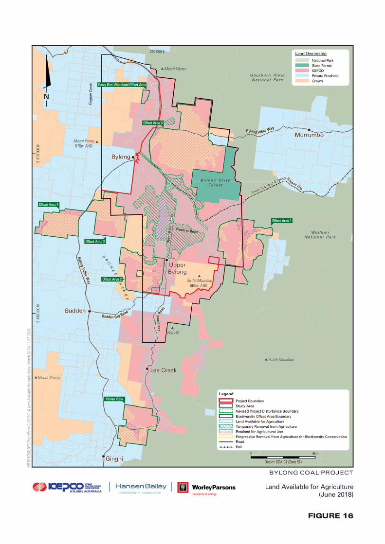

Bylong Coal Project Supplementary Information July 2018 for WorleyParsons Services Pty Limited Page 49
Ref: 180712 Bylong Coal Supplementary Information HANSEN BAILEY
Table 7
Land Available for Agriculture (June 2018)
Historic Heritage Sites Project (ha) Revised
Project (ha)
Land Available for Agriculture 3,166 3,258
Temporary Removal from Agriculture 974 882
BOS – Retained for Agricultural Use 295 295
BOS – Progressive Removal from Agriculture for Biodiversity Conservation 2,104 2,104
KEPCO Land Suitable for Agriculture 6,539 6,539
KEPCO Land Not Suitable for Agriculture 3,561 3,561
KEPCO Landholdings 10,100 10,100
3.9.2 Ecology
Figure 17 and Table 8 below illustrate the reduced disturbance to vegetation community for
the Revised Mine Plan compared with that previously assessed for the Project.
The Revised Project Disturbance Boundary reduces disturbance to approximately 62.4 ha (or
8.3%) of native vegetation, which includes approximately 24.8 ha (10.7%) of woodland
vegetation, which retains habitat suitable for a number for threatened bird and bat species
known to occur within the area. The Revised Mine Plan results in approximately 4.4 ha (or
1.8%) of reduced disturbance to woodland and grassland vegetation conforming to White Box
Yellow Box Blakely’s Red Gum Grassy Woodland and Derived Native Grassland (Box Gum
Woodland) vegetation community. Box Gum Woodland is listed as a Critically Endangered
Ecological Community (CEEC) under the Environment Protection and Biodiversity
Conservation Act 1999 (EPBC Act) and an Endangered Ecological Community (EEC) under
the former Threatened Species Conservation Act 1995 (TSC Act) (now repealed by
Biodiversity Conservation Act 2016).
Despite these material reductions in impacts to biodiversity values as a result of the Revised
Mine Plan, KEPCO does not propose any amendments to the BOS for the Project. Therefore,
there will be a net reduction to the long term ecological impacts compared to those previously
assessed within the EIS and associated approvals documents.


Bylong Coal Project Supplementary Information July 2018 for WorleyParsons Services Pty Limited Page 51
Ref: 180712 Bylong Coal Supplementary Information HANSEN BAILEY
Table 8
Revised Disturbance to Vegetation Communities
Vegetation Community
Project
Disturbance
Boundary (ha)
Revised Project
Disturbance
Boundary (ha)
Reduced
Disturbance (ha)
Slaty Box Woodland1 13.0 12.6 0.4
Yellow Box Woodland3 8.3 8.3 No change
White Box Woodland (Grassy)3 57.3 54.9 2.4
White Box Woodland (Shrubby) 70.5 53.5 17.0
Coastal Grey Box Woodland 29.0 24.3 4.7
Fuzzy Box Woodland 4.8 4.5 0.3
Blakely's Red Gum / Apple Riparian Forest 5.9 5.9 No change
Shrubby Regrowth 39.7 39.7 No change
Cypress Pine Forest 3.7 3.7 No change
River Oak / Redgum Riparian Woodland Derived
Native Grassland2
10.5 10.0 0.5 Blakely’s Redgum / Apple Riparian Forest Derived
Native Grassland3
Yellow Box Woodland Derived Native Grassland3 14.5 14.5 No change
White Box Woodland Derived Native Grassland3 171.0 169.0 2.0
Slaty Box Woodland Derived Native Grassland 29.4 29.4 No change
Coastal Grey Box Woodland Derived Native
Grassland 243.1 214.9
28.2
Fuzzy Box Woodland Derived Native Grassland 52.8 45.9 6.9
Cultivated Lands 385.7 336.1 49.6
Other (cleared, planted vegetation) 21.0 19.7 1.3
TOTAL 1,160 1,047 113.3
Total Native Vegetation 753 691.1 62.4
Total Woodland 232 207.1 24.8
Notes: Discrepancies may be present in totals due to rounding
1Hunter Valley Footslopes Slaty Gum Woodland 2Hunter Floodplain Red Gum Woodland
3Box Gum Woodland and Derived Native Grassland
3.9.3 Aboriginal Heritage
Figure 18 illustrates the Aboriginal Heritage sites identified within the vicinity of the Project in
relation to the Revised Project Disturbance Boundary. The Revised Mine Plan will avoid the
direct disturbance of four archaeological sites located on the Tarwyn Park property, including
three artefact scatters and one isolated find.
These revised impacts will be managed in accordance with the Aboriginal Heritage
Management Plan to be developed for the Project.


Bylong Coal Project Supplementary Information July 2018 for WorleyParsons Services Pty Limited Page 53
Ref: 180712 Bylong Coal Supplementary Information HANSEN BAILEY
3.9.4 Social
The Revised Mine Plan will require a slightly smaller workforce during the years of open cut
mining operations for the Project. The open cut mining workforce will also reduce by one year
from that previously assessed within the EIS and associated documents. No changes to the
underground mining workforce are required for the Revised Mine Plan.
The revised social impacts in relation to no longer proposing the use a Workforce
Accommodation Facility to accommodate the construction workforce for the Project (as
confirmed within the Response to PAC Review Report) has previously been assessed within
the RTS.
3.9.5 Traffic and Transport
In addition to the reduced workforce requirements (see Section 3.9.4), there will also be
reduced open cut mining operations and associated consumables to be delivered to the site.
Accordingly, there will be marginally lower traffic movements compared with those assessed
within in the EIS and associated approvals documents. Over the life of the Project, there will
also be a slight decrease in rail usage as a result the reduced transport of approximately
2.5 Mt of product coal (equivalent of approximately 284 train movements over open cut mining
phase). However, there will be no change in the peak of up to 10 return trips per day.
The Revised Project Disturbance Boundary borders the western side of the Tarwyn Park
property boundary and accordingly includes this section of Upper Bylong Road (which is
proposed to be formally closed). However, the soil stockpiles and the fuel storage facility will
be constructed within this area (which previously formed part of the Eastern Open Cut) to
minimise impacts to the existing formation of the Upper Bylong Road in this area. This section
of Upper Bylong Road will be retained to maintain an internal access (via the Mine
Infrastructure Area) to the Tarwyn Park Homestead and former Upper Bylong Catholic Church
and Cemetery. As outlined within Section 3.6.4, at mine closure KEPCO will consult with
MWRC to confirm whether the connection between Upper Bylong Road and Lee Creek Road
is required at the time. If it is agreed that this is required, KEPCO will re-establish this
connection.
It is important to note that the upgrades to the Wollar Road by MWRC (in accordance with
Resources for Regions funding) is now well advanced and will be completed in time to support
the Project.
As described within the Response to PAC Review Report, KEPCO has agreed to contribute
$3,635,802 of funding to MWRC for road upgrades. This funding for the Project will facilitate
the upgrade to sections of Wollar Road travelling through the Munghorn Gap Nature Reserve
and some pertinent sections of the Bylong Valley Way, including an upgrade to the intersection
between Bylong Valley Way and Wollar Road.

Bylong Coal Project Supplementary Information July 2018 for WorleyParsons Services Pty Limited Page 54
Ref: 180712 Bylong Coal Supplementary Information HANSEN BAILEY
These contributions align with Condition 54 under Schedule 4 of the Recommended
Development Consent for the Project. It is noted that a further $3 M of Resources for Regions
funding to MWRC has been announced in June 2018 to further assist with the upgrades
through the Munghorn Nature Reserve and other road related matters.
KEPCO has also held further discussions with the Muswellbrook Shire Council (MSC) in
relation to increasing the previous offer of a one off payment from $40,000 to $267,700 (CPI
indexed from 2016 to 2018), upon the commencement of the Project. This additional funding
is proposed to assist in remediating high risk road safety issues which have previously been
identified by MSC on the relevant section of Bylong Valley Way.
Despite the significantly less impacts on the road and rail network, KEPCO is not proposing
any reduction in committed funding to road upgrades and maintenance contributions.
Bylong Coal Project Supplementary Information July 2018 for WorleyParsons Services Pty Limited Page 55
Ref: 180712 Bylong Coal Supplementary Information HANSEN BAILEY
4 RESPONSE TO COMMENTS
This section responds to any additional submissions received from regulatory authorities and
other stakeholders following the Response to PAC Review Report. A response to each matter
raised is provided below.
4.1 NSW DEPARTMENT OF INDUSTRY
DoI provided comments on the Response to PAC Review Report within correspondence dated
12 February 2018. The comments have come from Crown Lands and Water (DoI-Water) in
relation to water and from the Department of Primary Industries (DPI) in relation to agricultural
resources and rehabilitation. The following sections respond to the comments raised in DoI’s
correspondence.
4.1.1 Water Management
Alluvial Water Take
DoI Water is satisfied that the maximum predicted loss of base flow in the Bylong
River Water Source has been appropriately accounted for and can be licensed
through existing entitlement. The proponent has also acknowledged that if water
takes were to exceed their entitlements, contingency measures will need to be
implemented including the purchasing of water allocations on the open water
market, redundancy of the proponent’s agricultural activities or the progressive
reduction in the mining activities that consume water.
As previously outlined and committed to by the proponent, the Water Management
Plan should outline monitoring and ongoing assessment of the impact of alluvial
aquifer depressurisation on base flow in the Bylong River, including appropriate
monitoring of the ecological impacts and impacts on basic landholder rights and
licensed extraction. It is noted that the Water Sharing Plan for the Hunter
Unregulated and Alluvial Water Sources 2009 makes provision for introduction of
a cease to take by year 10 of the plan based on studies to determine appropriate
groundwater levels and trigger points. Given that losses in base flow due to alluvial
aquifer depressurisation cannot be switched off during low flow events, the impact
of the reduced base flow during these low flows will need to be monitored and
assessed. Any active extraction from the alluvial borefield would be subject to any
cease to pump rules implemented within the Water Sharing Plan.
Noted.
The groundwater modelling for the Revised Mine Plan and associated accounting for the
predicted loss of baseflow has been prepared utilising a consistent methodology to that
completed for the Supplementary RTS for the EIS Mine Plan.

Bylong Coal Project Supplementary Information July 2018 for WorleyParsons Services Pty Limited Page 56
Ref: 180712 Bylong Coal Supplementary Information HANSEN BAILEY
As described within Section 3.3.3, it is important to note that the predicted baseflow losses
are almost entirely located on land owned by KEPCO. Further, baseflow losses have
marginally reduced as a result of the Revised Mine Plan.
Section 7.3.6 of the draft Water Management Plan which was prepared for the Response to
PAC Review Report describes the proposed monitoring program to determine the effects of
the Project on baseflows. Section 7.3.7 of the draft Water Management Plan refers to the
monitoring of groundwater dependent ecosystems to be undertaken in accordance with the
Biodiversity Management Plan to be prepared for the Project.
Compensatory Water Supply
The proponent has provided further information on the potential for the project to
result in impacts on neighbouring private landholder bores and commitment to
establish compensatory water supply agreements. Condition 27 of the Department
of Planning and Environment’s (DPE’s) recommended conditions of consent
requires that the proponent provide a compensatory water supply to the owner of
any privately-owned land whose surface water and/or groundwater supply is
adversely and directly impacted (other than a negligible impact) as a result of the
development. DoI Water is satisfied that the proposed consent conditions,
commitments by the proponent and further details to be outlined within the
proposed Water Management Plan will ensure adequate compensatory measures
for any impacts on private water users. The proponent has also stated that the
Water Management Plan will outline a program to investigate potential alternative
water supplies should these be required.
Noted.
KEPCO has commenced discussions with surrounding landholders in relation to entering into
a Compensatory Water Supply Agreement. Discussions with landholders are ongoing.
The draft Water Management Plan to be reviewed and updated prior to the commencement of
the Project will outline a program to investigate alternative water supplies in the unlikely event
that this be required.
Permian Water Take
The proponent currently holds a licence for 411 units and DoI Water received a
valid application for a water licence for 2,093 units submitted under the Water Act
1912 (Water Act) to extract groundwater from the Permian strata for the Project
from the Sydney Basin – North Coast Groundwater Source (North Coast
groundwater source) under the Water Sharing Plan for the North Coast Fractured
and Porous Rock Groundwater Sources 2016 (North Coast WSP).

Bylong Coal Project Supplementary Information July 2018 for WorleyParsons Services Pty Limited Page 57
Ref: 180712 Bylong Coal Supplementary Information HANSEN BAILEY
Predicted maximum groundwater inflows are 4,099 ML in year 23 of the project.
The application submitted for 2,093 units under the Water Act will be assessed and
determined on its merits should the project proposal be approved by DPE. Should
this application be approved, the proponent will need to obtain the remaining 1,596
shares from the water market to account for the predicted maximum take. If a
licence for 2,093 shares is not issued upon project approval, the full 3,689 ML
would need to be obtained from the market.
DoI Water notes that whilst the proponent has outlined that as at 1 July 2016, there
were 3,453 ML/year of unassigned water allocation entitlements and that the water
required for the project may therefore be available through a Controlled Allocation
Order, the department’s Strategy for the controlled allocation of groundwater (DoI
Water, May 2017) outlines that the amount of water made available in any
controlled allocation order is intended to keep total water requirements below 80
% of the appropriate extraction limit in any water source. Whilst water was made
available in the North Coast Fractured and Porous Rock Groundwater Source in
the 2017 Controlled Allocation Order, this did not include the Sydney Basin – North
Coast Groundwater Source. Controlled Allocations for this water source may not
be available in the future to account for the Permian water required for the project.
KEPCO notes DoI-Water’s comment that the water licence application lodged in December
2015 remains a ‘valid’ application and will be assessed on its merits should the Project be
approved.
In light of the concerns raised within the PAC Review Report, KEPCO is also actively seeking
water allocations within the Sydney Basin – North Coast Groundwater Source on the open
market. KEPCO has engaged a Water Broker in this regard. As explained within
Section 3.3.3, KEPCO remains confident that sufficient water licences will be secured to
account for the predicted water takes for the underground mine.
4.1.2 Agricultural Resources and Rehabilitation
Final Landform
A detailed erosion stability assessment, not just geotechnical studies, should be
conducted to determine the erodibility of the OEA, particularly on any areas greater
than 10 degrees. In relation to design of the final landform, DPI Agriculture does
not endorse the use of the GeoFluv approach alone as empirical measurements
from surrounding stable landforms in the area of interest is not an accurate
measure compared to varying unconsolidated materials of the overburden. DPI
recommends partnering the GeoFluv approach with sound erosion stability and
landform assessment modelling such as SIBERIA or Water Erosion Prediction
Project (WEPP).
Noted.

Bylong Coal Project Supplementary Information July 2018 for WorleyParsons Services Pty Limited Page 58
Ref: 180712 Bylong Coal Supplementary Information HANSEN BAILEY
The Conceptual Final Landform for the Project has previously been designed to minimise the
areas where landform slope exceeds 10 degrees. The Macro-Relief example provided within
this Report for the Revised Mine Plan has also been based on the need to minimise slopes of
greater than 10 degrees (in line with the proposed agricultural final land uses).
The draft Rehabilitation Management Plan which was prepared for inclusion within the
Response to PAC Review Report will be reviewed and updated prior to the commencement of
mining operations. This will be undertaken in close consultation with DPI and other regulatory
stakeholders. KEPCO will ensure that the revised Rehabilitation Management Plan includes
specific strategies and methodologies to address the rehabilitation objectives currently
specified within the Recommended Development Consent conditions, including “final
landforms maximise geotechnical performance, stability and hydrological function”.
BSAL Rehabilitation
Table 2 of the Rehabilitation Management Plan identifies restoration of 423.1 ha
of BSAL, while section 4.4.3.1 (and other parts of the Plan) identifies reinstatement
of only 319.5 ha of BSAL. Given previous commitments it is assumed that the 423.1
ha is to be rehabilitated to BSAL like conditions, however this should be confirmed.
Water Holding Capacity measurements should be included as completion criteria
in Table 16 Summary of BSAL and LSC Class 3 Completion Criteria, with
measurements to be conducted pre and post rehabilitation.
KEPCO is committed to reinstating or re-establishing BSAL which is directly disturbed as a
result of the Project. As noted within the response to DPI in August 2016 (Appendix K of the
Supplementary RTS), there was assessed to be 319.5 ha of BSAL to be directly and
permanently disturbed and a further 103.6 ha to be directly and temporarily disturbed as a
result of the Project (which totals 423.1 ha within the Project Disturbance Boundary).
The reinstatement of 319.5 ha refers to BSAL to be established on the mined landform as
opposed to the 103.6 ha to be replaced in areas temporarily utilised for mine infrastructure.
As discussed in Section 3.5, KEPCO is committing to reinstate approximately 400.4 ha of
BSAL on mine rehabilitation within the Revised Project Disturbance Boundary for the Revised
Mine Plan. This equates to the total area of BSAL to be directly disturbed as a result of the
Revised Mine Plan.
Erosion Assessment
Section 7.3.2.2 identifies that erosion data is to be collected from a 50m cross-
section along the centre of each Landscape Function Analysis (LFA) transect
conducted as part of the final landform monitoring procedure. It is recommended
that aerial imagery is used to identify erosion as LFA transects alone often miss
key erosion hazards.
Noted.

Bylong Coal Project Supplementary Information July 2018 for WorleyParsons Services Pty Limited Page 59
Ref: 180712 Bylong Coal Supplementary Information HANSEN BAILEY
Research Trials
Research trials are proposed to be undertaken over the life of the mine. DPI
Agriculture recommends that these trials start at the onset of approval of the mine
to ensure any outcomes from the research can be incorporated into rehabilitation
planning for the life of the mine.
Noted.
Consultation
As noted DPI Agriculture are to consulted with for all aspects relating to the
reinstatement of land to be used as agriculture purposes post mining.
Noted.
The Recommended Development Consent conditions specify that DPI is to be consulted over
the preparation of the Rehabilitation Management Plan.
4.2 ENVIRONMENT PROTECTION AUTHORITY
The NSW EPA provided comment on the Response to PAC Review Report within
correspondence dated 21 and 23 February 2018. This section has been prepared in response
to EPA’s comments for DPE’s consideration.
4.2.1 Low Frequency Noise
KEPCO notes that the EPA has reaffirmed its acceptance of the assessment of low frequency
noise utilising the modified DEFRA approach as reported within the DPE’s Preliminary
Assessment Report. EPA noted that the assessment found that the Project can comply with
the low frequency noise criteria and that a low frequency noise modifying factor is not
applicable.
As identified by the EPA, KEPCO supports the requirement that the noise monitoring program
for the Project will need to entail the monitoring of compliance against this assessment finding.
KEPCO further supports the fact that trigger action response plans will need to be developed
for implementation in the event that a low frequency noise modifying factor is deemed
necessary in the future. If it is identified that a low frequency noise modifying factor is
applicable during the monitoring program, KEPCO will modify its mining operations to ensure
that the noise generated from the operations continues to comply with the criteria specified
within any Development Consent for the Project.
KEPCO is supportive of the Noise Policy for Industry (EPA, 2017) being utilised within any
Development Consent conditions as the most contemporary noise policy which has effectively
replaced the former Industrial Noise Policy (EPA, 2000).

Bylong Coal Project Supplementary Information July 2018 for WorleyParsons Services Pty Limited Page 60
Ref: 180712 Bylong Coal Supplementary Information HANSEN BAILEY
4.2.2 Water
The EPA has commented that whilst a number of possible contingency measures have been
described within the Response to PAC Review Report to manage mine water within the ‘highly
unlikely’ groundwater modelling scenarios, there is no firm commitment to act upon them.
As described within the Response to PAC Review Report, there is a considerable amount of
time available (i.e. to Project Year 20) to confirm whether further contingency measures are
required. In the ‘highly unlikely’ event that further measures are required to manage the mine
water onsite, this would be triggered as part of the Water Management Plan (that will contain
the relevant trigger action response plans) which will be reviewed and updated throughout the
life of the Project.
Section 5.6 of the current draft Water Management Plan (Appendix F of the Response to PAC
Review Report) discusses the requirement to validate the site water balance. This regular site
validation review of the water balance will assist in determining the likelihood of the ‘highly
unlikely’ scenarios ever occurring. Further to this, the trigger action response plan for mine
water storage within the draft Water Management Plan provides another layer of assessment
which would identify the need for additional contingency measures at the time. Given the
extensive time available to further review and validate the water models for the Project with
operational data, it is not reasonable to expect detailed contingency measures for these ‘highly
unlikely’ scenarios to be accurately determined and committed to at this time. However, there
are numerous contemporary mechanisms described within the Response to PAC Review
report that have been successfully demonstrated to be able to manage excess mine water, if
indeed this is required in 20 years’ time. Nevertheless, in the ‘highly unlikely’ event that there
is surplus mine water to manage in PY 20, there will be further refined and new technologies
available to add value to and maximise the use of this water.
The EPA has also suggested that DPE recommend a condition of consent which requires the
Project to be a nil-discharge mine. Schedule 4, Condition 28 of the Recommended
Development Consent condition currently states:
“The Applicant must not discharge any water from the site or irrigate any waste
water onsite except as may be expressly provided by an EPL, or in accordance
with Section 120 of the POEO Act.”
This condition is considered appropriate for ensuring mine water is not discharged from the
mine. The detailed water balance modelling undertaken over the Project and the draft Water
Management Plan prepared will ensure this condition is complied with.
The EPA’s support for the revised sediment basin design criteria within the Response to PAC
Review Report is noted.

Bylong Coal Project Supplementary Information July 2018 for WorleyParsons Services Pty Limited Page 61
Ref: 180712 Bylong Coal Supplementary Information HANSEN BAILEY
4.2.3 Air Quality- Diesel Emissions
The EPA has recommended the following Development Consent conditions in order for
KEPCO to manage diesel emissions from the operations throughout the life of the Project.
1. “The applicant must implement all reasonable and feasible best practice
measures to prevent and/or minimise the emission of odour, blast fume, diesel
exhaust, spontaneous combustion and dust emissions of the development.
2. Best practice non-road diesel emissions standards, unless otherwise
approved in writing by the EPA.
2.1 The applicant must ensure that any item of non-road mobile diesel equipment
commissioned into service and operating at the premises after 30 June 2020:
i. Complies with the US EPA Tier 4 final or equivalent exhaust emission
standard; or
ii. Is otherwise approved, in writing, by the NSW EPA for use on the
premises.
Note 1 For the purpose of condition 2.1 ‘commissioned into service’ is defined as
the act of using an item of non-road mobile diesel equipment for commercial
or industrial activities for the first time in Australia.
Note 2 US EPA Tier 4 final is defined by USEPA (2016), Non-road Compression-
Ignition Engines: Exhaust Emission Standards, EPA-420-B-16-022, March
2016, U.S. Environmental Protection Agency, Office of Transportation and Air
Quality (6401A), 1200 Pennsylvania Avenue, NW, Washington, DC 20460,
United States. https://www.epa.gov/emission-standards-reference-
guide/nonroad-engines-and-vehicles-emission-standards Acceptable
equivalent standards include EU stage V and any other international non-road
emission standard with emission limits equal to or lower than the applicable
US EPA Tier 4 standard.
Note 3 – For the purpose of this condition, non-road mobile diesel equipment means:
i. Equipment fitted with a diesel (compression ignition) engine, that is
either self-propelled or portable and transportable as indicated by the
presence of wheels, skids, lifting handles/points, dolly, trailer or platform
mounted; and
ii. Which is primarily designed for off-road use; and
iii. Is not an eligible vehicle under the NSW Road Transport (Vehicle
Registration) Regulation 2007, but may be conditionally registered for
the purpose of moving from one off-road work site to another; but does
not include
a. Equipment primarily designed to be operated on public roads for
the transportation of freight or passengers; and
b. Diesel locomotives.
c. Diesel generators.”
Bylong Coal Project Supplementary Information July 2018 for WorleyParsons Services Pty Limited Page 62
Ref: 180712 Bylong Coal Supplementary Information HANSEN BAILEY
KEPCO has previously responded to the EPA’s comments in relation to the control of diesel
emissions from the open cut operational fleet and made the following key points:
The Project is located within a rural area with few nearby residential receivers;
Air quality modelling (conservatively undertaken based on US EPA Tier 2 standards) has
predicted that there would be no PM2.5 impacts greater than the relevant criteria, even
when considering background concentrations;
The primary diesel emissions from the Project are likely to be from the equipment fleet
required as part of the relatively short term eight year open cut mining operations (or
seven years for the Revised Mine Plan);
US EPA Tier 4 mining equipment was (in 2016) in short supply, with only industrial diesel
engines in Australia conforming to this emission standard; and
The relatively short term open cut operations are likely to be undertaken by contractors
whom may utilise existing equipment available to them which meets the relevant NSW
and Federal government regulatory requirements at the time.
During KEPCO’s meeting with EPA representatives on 26 October 2017 in Bathurst, the air
quality expert was understood to have been comfortable with KEPCO’s approach to ensuring
that any equipment either contracted or purchased to work at the mine site will comply with all
contemporary NSW and Federal emissions standards at the time. It is understood that since
this time, there has been a substantial uptake of the supply of US Tier 4 mining equipment
within Australia and it is likely to be available, should KEPCO (or its mining contractor) decide
to procure a new mining fleet for its open cut mining operations.
Point 1 of EPA’s recommended condition of approval is appropriately addressed by Schedule
4, Condition 21 (a) of the Recommended Development Consent conditions which states:
“Operating Conditions
21. The Applicant must:
(a) implement all reasonable and feasible measures to minimise the off-site odour,
fume, diesel particulate, spontaneous combustion and dust emissions of the
development;”
This Recommended Development Consent condition also appropriately addresses point 2 in
the EPA’s recommended conditions of approval. In light of the time passed since EPA initially
raised this matter and KEPCO’s latest investigations confirming that US EPA Tier 4 mining
equipment will be available for purchase within Australia at the time it may be required, KEPCO
has gained confidence that Point 2.1 of the EPA’s recommended conditions of approval will be
achievable and as such supports it being added to any Development Consent granted over
the Project.
4.3 HERITAGE COUNCIL OF NSW
In light of concerns over heritage issues enunciated within the PAC Review Report, DPE
requested the Heritage Council’s independent advice over the following matters:
Bylong Coal Project Supplementary Information July 2018 for WorleyParsons Services Pty Limited Page 63
Ref: 180712 Bylong Coal Supplementary Information HANSEN BAILEY
The heritage values of the Tarwyn Park Homestead complex;
The significance of NSF practices deployed on the property by Peter Andrews;
The overall scenic values of the Tarwyn Park property within the Bylong Valley confines
including clarification over the National Trust NSW classification of the Bylong Valley
Scenic Landscape; and
The implications of KEPCO’s proposed mitigation and management measures from a
heritage and cultural landscape perspective.
The Heritage Council subsequently provided their response in correspondence dated
23 February 2018 which included some recommendations for the Project to minimise the
impacts on the identified heritage values. This section has been prepared to respond to the
recommended mitigation measures provided by the Heritage Council.
KEPCO has previously provided a detailed response from its heritage and landscape technical
specialists (AECOM) over the external reports prepared on behalf of the Heritage Council by
Hector Abrahams Architects Pty Ltd (HAA). While HAA’s work was clearly utilised as the basis
for the Heritage Council’s advice to DPE, it has since been recognised that HAA’s work
contains some factual errors. Despite this, some observations raised within the HAA reports
have been utilised to guide the revisions to the Project mine plan and/or relevant responses to
the Heritage Council recommendations below.
4.3.1 Recommended Mitigation Measures
The Heritage Council provided the following recommendations:
1. “In relation to the NSF values, the Council strongly urges measures to be
introduced (should KEPCO’s application be favourably considered) to
mitigate loss of the research potential which is across a broader landscape
than the physical constructions of NSF on Tarwyn Park and the ‘readability’
of NSF practices.
2. The Council has significant concerns, aligned to HAA’s findings, that the
proposed post-mining modified landscape will not adequately respect the
current varied, complex and undulating character of the terrain. The Council
is concerned that the proposed remediation will create a landscape that
alters the existing reading of the valley system and is made up of landforms
that are too uniform and symmetrical, the whole being too potentially altered
to be able to ‘read’ the pre-disturbance condition. The Council urges DPE to
further evaluate the proposed post-mining landscape form to better
reproduce the current character of the terrain. This should include a more in-
depth study of the patterns of the landscape so that measures are put in
place to effectively respect the visual and functional aspects of the former
landscape. This should also consider the current layering of European built
elements such as roads, buildings, and rural structures in their current
context.”

Bylong Coal Project Supplementary Information July 2018 for WorleyParsons Services Pty Limited Page 64
Ref: 180712 Bylong Coal Supplementary Information HANSEN BAILEY
Each of these is responded to within the following sections.
Mitigate Impacts to NSF Practices
As explained in Section 9.4.1 of the EIS and within the subsequent approvals documents,
KEPCO is committed to avoiding open cut mining of land on the alluvial floodplain, which is
known to be the primary focus for NSF techniques. Subsequently, the EIS and associated
approvals documents proposed the Eastern and Western Open Cut mining areas within the
more elevated land outside of the alluvial floodplain.
In recognition of the NSF land management techniques which have been conducted,
Section 7.15.3 of the EIS commits to establish a trial area on rehabilitated land to investigate
the benefits of soil hydrology techniques in the post mining landform.
Further, consistent with KEPCOs responses to comments received from stakeholders during
the public exhibition period, Schedule 4, Condition 68 of the Recommended Development
Consent conditions states:
“The Applicant shall use its best endeavours to maintain or enhance the soil
hydrology farming techniques on the Tarwyn Park property and make reasonable
access to the property available for external study by applicable scientific
organisations (such as CSIRO, universities and government authorities) upon
request.”
KEPCO supports and is well advanced in its planning to fully comply with this proposed
development consent condition. It should be noted that since KEPCO acquired the property
(in February 2014), a number of baseline assessments, monitoring and research projects have
already been completed on the Tarwyn Park property to investigate the scientific values of this
land use. This has included:
“Tarwyn Park” Agricultural Productivity Audit (SLR, 2014), which was prepared following
KEPCO’s purchase of the property in February 2014 to document the baseline
agricultural productivity of the property;
“Tarwyn Park” Agricultural Assessment and Land Management Plan (SLR, 2016), which
was prepared to complete a comparative analysis of the agricultural condition upon
taking occupation of the property on 1 August 2016;
Comparative Agricultural Productivity Assessment of Properties Subject to Varying Land
Management Techniques (CAPA) (SLR, 2017) which was prepared for provision to the
IPC (formerly the PAC) during its review process for the Project; and
Various baseline monitoring, assessment and research projects completed in
collaboration with the University of New England to assist in the understanding of any
benefits of soil hydrology techniques and to assist with preliminary planning in relation to
developing the trial on mine rehabilitation (as per the commitment within the EIS).

Bylong Coal Project Supplementary Information July 2018 for WorleyParsons Services Pty Limited Page 65
Ref: 180712 Bylong Coal Supplementary Information HANSEN BAILEY
KEPCO’s Response to PAC Review Report also committed to the investigation of using the
Tarwyn Park Homestead and associated lands as the ‘Tarwyn Park Collaborative Research
and Education Centre’. Since this time, KEPCO has held preliminary discussions with a
number of universities and research institutions over this opportunity and is progressing
positive discussions with at least one academic institution.
Whilst the previously committed mitigation measures mentioned above are considered to be
appropriate, the contractions to the open cut mine plan requested by DPE (i.e. the Revised
Mine Plan), if conditioned by DPE, will further avoid/mitigate any impacts to Tarwyn Park and
NSF.
Mitigate Potential Landscape Impacts
As explained within Section 3.7.3, KEPCO’s mine planning team specifically designed the
open cut mine plan for the Project with specific consideration to minimising the potential visual
and landscape impacts to sensitive publicly available viewing locations. The mine plans for
the Project were strategically designed to be shielded from open public views by the
intervening natural topography and wooded vegetation. In this regard, the majority of open
views of the Project are from within the Upper Bylong Valley, which is predominantly owned
by KEPCO (with some crown land) (refer to Figure 10).
Whilst the Conceptual Final Landform design will result in elevated landforms being extended
to the north when compared to the natural landform, it is noted that the proposed landforms do
generally follow the shape of the terrain which divides the Lee Creek floodplain from the Bylong
River floodplain.
The photomontages from the new Upper Bylong Road view location (see Appendix K)
demonstrate the visual and landscape effects of the EIS Conceptual Final Landform design
compared to the Revised Conceptual Final Landform (Macro Relief) design. This new location
represents an important view of the Upper Bylong Valley which is experienced when first
entering the upper valley from the north. The EIS Conceptual Final Landform design when
viewed from this location results in some landform modifications and the rehabilitated landform
contrasts against the existing landscape. However, it does not significantly affect the reading
of the valley system from this location. This finding is in contrast to the views from the Tarwyn
Park Homestead and surrounds which are immediately adjacent to and looking across the
Eastern OEA, which understandably (given its immediate proximity) removes some views
towards distant landforms. It is these close up, localised views (on KEPCO owned land) that
have influenced the Heritage Council’s recommendations over the EIS Conceptual Final
Landform design.

Bylong Coal Project Supplementary Information July 2018 for WorleyParsons Services Pty Limited Page 66
Ref: 180712 Bylong Coal Supplementary Information HANSEN BAILEY
The Revised Conceptual Final Landform (Macro Relief) design associated with DPE’s request
provides some material improvements to the final landscape impacts when compared to the
EIS landform from the Upper Bylong Road viewing location. These improvements generally
relate to the reduced mining footprints, increased open woodland planting (to reduce contrasts
against the upper wooded slopes) and retention of existing forested ridgelines which are seen
from this location. The photomontages for the Tarwyn Park view locations illustrate a material
improvement in landscape impacts for the Revised Conceptual Final Landform design when
compared to the EIS Conceptual Final Landform design. This is primarily due to the OEA
landform being moved off the Tarwyn Park property and further away from the viewing
locations. The Revised Conceptual Final Landform design retains the existing views towards
the Upper Lee Creek valley (including Bald Hill) and upper slopes of the Growee Ranges which
have been identified by the Heritage Council (and its expert consultant) as an important view
to retain for the Tarwyn Park Homestead.
The Heritage Council has considered the Conceptual Final Landform design to be too uniform
and symmetrical in shape and recommended that the visual and functional aspects of the
surrounding natural landform be incorporated into the final landform design.
The Conceptual Final Landform presented within the EIS and associated approvals documents
is conceptual and has been developed based on standard mine planning design principles.
This is typical of mine plan designs prepared at the environmental approvals stage of a mining
project. Of course, the Conceptual Final Landform design is also supported by rehabilitation
objectives which are to be specifically addressed when undertaking the detailed design of the
final landform.
The RMP/MOP process provides the basis for detailed mine plan designs to be prepared in
accordance with the rehabilitation objectives for the site. The rehabilitation objectives for the
Project are outlined in Schedule 4, Condition 63 of the Recommended Development Consent
conditions. Rehabilitation objectives which specifically relate to the Heritage Council concerns
include:
“Final landforms designed to incorporate micro-relief and integrate with surrounding
natural landforms” and
“Minimise visual impact of final landforms as far as is reasonable and feasible”.
Accordingly, the final landform to be developed throughout the life of the Project will be
generally consistent with the Conceptual Final Landform design, however will also be required
to address the specific rehabilitation objectives. In this regard, the Heritage Council
recommendations have already largely been addressed within the Recommended
Development Consent conditions.
In order to provide further information for the Revised Mine Plan in light of the Heritage
Council’s comments, KEPCO’s mine planning team has completed detailed landform design
work to provide a final landform design which incorporates macro relief.

Bylong Coal Project Supplementary Information July 2018 for WorleyParsons Services Pty Limited Page 67
Ref: 180712 Bylong Coal Supplementary Information HANSEN BAILEY
Figure 9 illustrates the revised Conceptual Final Landform (Macro Relief) design as an
indicative representation of the intended outcome of the final landform for the Revised Mine
Plan. This is subject to refinement as part of the RMP/MOP process.
The reinstatement of the impacted heritage items on the post mining landform is addressed
within Section 3.6 and Appendix J. The re-establishment of the connection between Upper
Bylong Road and Lee Creek Road at mine closure will be undertaken subject to consultation
and agreement with MWRC over the need for this connection at the time. The heritage items
to be affected by the Project are not proposed to be reinstated into the final landform at mine
closure, which is consistent with sound conservation practice.
4.4 IEEFA SUBMISSION
DPE forwarded a submission prepared by the Institute for Energy Economics and Financial
Analysis (IEEFA) on behalf of the BVPA to KEPCO on 18 June 2018. Gillespie Economics
was commissioned by KEPCO to prepare a response to this submission. This is included
within Appendix M.
A brief summary of this response is provided within the following sections which are structured
according to the key matters raised within the IEEFA submission.
4.4.1 Global Coal Supply and Demand
The IEEFA makes a number of statements to infer that the global demand for coal fired
electricity generation will considerably reduce and therefore the need for a new coal mining
project is unjustified. This assertion is inconsistent with the current policy direction of both the
Australian and Republic of Korea Governments.
The IEEFA submission selectively utilises information contained within the International
Energy Agency’s (IEA) World Energy Outlook report for 2017 (IEA, 2017) to support its
assertions rather than providing a balanced summation of the information contained within this
report. In this regard, it is important to recognise the IEA’s function and objectives and thus
the context surrounding the information which is presented in its World Energy Outlook report.
The International Energy Agency (IEA) is an autonomous agency established in November
1974. Its primary mandate is twofold: to promote energy security amongst its member countries
through collective response to physical disruptions in oil supply and provide authoritative
research and analysis on ways to ensure reliable, affordable and clean energy for its 29 member
countries and beyond. The IEA carries out a comprehensive programme of energy co-operation
among its member countries, each of which is obliged to hold oil stocks equivalent to 90 days
of its net imports. The Agency’s aims include the following objectives:
Secure member countries’ access to reliable and ample supplies of all forms of energy;
in particular, through maintaining effective emergency response capabilities in case of oil
supply disruptions.
Promote sustainable energy policies that spur economic growth and
environmental protection in a global context – particularly in terms of reducing
greenhouse-gas emissions that contribute to climate change.
Bylong Coal Project Supplementary Information July 2018 for WorleyParsons Services Pty Limited Page 68
Ref: 180712 Bylong Coal Supplementary Information HANSEN BAILEY
Improve transparency of international markets through collection and analysis of energy
data.
Support global collaboration on energy technology to secure future energy
supplies and mitigate their environmental impact, including through improved
energy efficiency and development and deployment of low-carbon technologies.
Find solutions to global energy challenges through engagement and dialogue with non-
member countries, industry, international organisations and other stakeholders. Source IEA - Emphasis added
The World Energy Outlook report considers world energy demand and supply under three
policy settings:
1. Current Policy Scenario (CPS) that considers only those policies and measures enacted
into legislation by mid-2017 i.e. those currently in place.
2. New Policy Scenario (NPS) that considers existing policies as well as announced policy
intentions, including aspirational policies and targets. These are not enacted into
legislation and may not be implemented.
3. Sustainable Development Scenario (SDS) that is a new scenario which examines what
it would take to achieve the main energy-related components of the “2030 Agenda for
Sustainable Development” adopted in 2015 by member states of the United Nations.
The World Energy Outlook does not provide a preference between scenarios but rather
provides an analysis of demand for different energy sources under each policy setting
scenario. Only the CPS represents the current state of play with the other scenarios subject
to the vagaries of domestic and international politics. The SDS scenario has no basis in current
or aspirational policy announcements of either the Australian or Republic of Korea Government
or the IEA’s other 27 member countries. The IEEFA submission makes statements based on
the highly speculative SDS (and selectively the more speculative NPS) which are inconsistent
with the key directions outlined within the World Energy Outlook report for the current state of
play, namely:
A forecast increase in the quantity of coal demanded in the world to 2040 under both
the CPS and the more speculative NPS;
A forecast increase in the quantity of thermal coal traded in the world to 2040 under the
CPS, and a very slight decline under the more speculative NPS;
A forecast increase in the quantity of coal demanded in the world to 2040 for power
generation under both the CPS and NPS; and
Coal remains the second largest source of energy demanded in 2040 under the CPS
(behind oil), and the third largest source of energy demanded in 2040 under the NPS
(behind oil and gas).
The Australian Chief Economist has identified 286 advanced technology coal fired power
stations planned or under construction around the world. This demonstrates substantial
investment in coal fired power technology which will be utilised for some time into the future.

Bylong Coal Project Supplementary Information July 2018 for WorleyParsons Services Pty Limited Page 69
Ref: 180712 Bylong Coal Supplementary Information HANSEN BAILEY
The demand for a new export thermal export coal mine in NSW (the Bylong Coal Project) is
demonstrated by KEPCO's willingness to spend in excess of $700 M to progress and obtain
an approval to mine this NSW State owned coal resource.
KEPCO’s parent company has provided a letter of continued support for the Project, which
was included as Appendix C of the Response to PAC Review Report. KEPCO’s parent
company, being 51% owned by the Republic of Korea Government and being responsible for
the generation of 80% of electricity utilised within South Korea is well placed to confirm the
necessity for the Bylong Coal Project to the Republic of Korea.
4.4.2 Strategic Importance and New Energy Priorities
The IEEFA has questioned the strategic importance of the Project to South Korea given the
supposed policy announcements of the Korean Government and the KEPCO CEO in relation
to the new energy priorities, including the focus on renewable energy generation.
Coal will continue to be critical to the energy mix in South Korea. While some coal-fired power
plants will be retired in coming years, other high efficiency low emissions technology clean
coal-fired power stations are proposed to replace them.
The Republic of Korea Government has pledged to abandon nuclear power. While the Korean
Government did try to boost solar and wind power generation, it is not yet able to provide a
steady volume of affordable energy from renewable resources. According to the Republic of
Korea Government plan (the 8th Basic Plan for Long-term Electricity Supply and Demand
dated 29th December 2017), the total capacity of coal-fired power plants will grow from
36.8 Gigawatts (GW) in 2017 to 39.9GW in 2030. South Korea and KEPCO (which is 51%
Government owned and is currently responsible for supplying 80% of power to the people of
South Korea) see strategic advantages in being able to control its own supply of coal i.e. to
increase the vertical integration of KEPCO.
KEPCO has also recognised the coal to be produced from the Project will have a low sulphur
content (i.e. less than 0.4% on average over the life of the Project) that meets South Korea's
new regulations for coal utilised in electricity generation. Even under a highly conservative
NPS, South Korea’s demand for coal in 2040 will be over 10 times the average annual
production from the Project.
Accordingly, the Republic of Korea Government and KEPCO continue to support the need
(and strategic importance) of the Project to the people of South Korea.
4.4.3 Coal Price Forecasts and Coal Quality
The IEEFA raised concerns that the coal prices used within the Economic Impact Assessment were
out of date and do not reflect the coal quality to be recovered from the Project.
The Economic Impact Assessment over the Project was prepared in 2015 for inclusion within the
EIS. The coal price forecasts were based on a detailed Wood Mackenzie marketing study which
specifically considered the coal quality from the Project.

Bylong Coal Project Supplementary Information July 2018 for WorleyParsons Services Pty Limited Page 70
Ref: 180712 Bylong Coal Supplementary Information HANSEN BAILEY
It should be noted that the current coal price is substantially higher than the coal price forecast by
Wood Mackenzie in its marketing study for the Project. A sensitivity analysis of the CBA of +/- 20%
of AUD coal price was included within the EIS with the RTS providing additional sensitivity analysis
of +/-30% AUD coal price. This demonstrated that the Project would continue to provide
considerable economic benefits even under a 30% decline in the coal price.
The Economic Impact Assessment has been independently Peer Reviewed which confirmed that
the implied coal price used in the CBA is reasonable. This was further supported by the additional
sensitivity analysis completed as part of the RTS.
Whilst it is recognised that coal price forecasts will vary month to month and year to year, whatever
the coal price is during the operation of the Project, it is clear that the royalties to be paid to the
NSW Government as a result of recovering the coal resource will be in the hundreds of millions of
dollars (present value) in addition to the several billion dollars of economic stimulus to the
Mid-Western Region and even more to NSW as a whole, as forecast by the CGE Modelling
undertaken as requested by the IPC (formerly PAC) over the Project. This significant benefit to
NSW, along with the various other benefits from the Project will continue to substantially outweigh
any residual economic costs of the Project.
4.4.4 Corporate Tax Benefits
The IEEFA has commented that there are significant doubts over the corporate tax benefits of the
Project as it considers that there will inevitably be a high level of Project and corporate debt used
to fund the Project.
The Economic Impact Assessment actually significantly understated company tax benefits to NSW
at approximately $21 M (present value) as it used a company tax rate of 28.5%, which was a
proposed Australian Government policy at this time and attributed only 7% of this to NSW. The
NSW Government (2015) Guidelines for Economic Assessment of Mining and Coal Seam Gas
Proposals which was released shortly after the finalisation of the Economic Impact Assessment for
the Project provided a revised approach for apportioning company tax to NSW. Accordingly, the
RTS reassessed the company tax benefits of the Project to NSW (based on the new guidelines)
were projected at $102 M (present value).
The Project is 100% owned by KEPCO, which is 51% owned by the Republic of Korea Government,
and which has the capacity to fully fund the Project. However, in response to the IEEFA concerns,
a hypothetical analysis of company tax has been undertaken utilising the maximum allowable debt
financing to 60% in accordance with the thin capitalisation rules in Australian tax law.
The revised estimate of company tax benefits of the Project accruing to NSW (i.e. $102 M), would
reduce to approximately $68 M under this maximum debt funding scenario. Lower levels of debt
financing would increase the level of tax benefits from the Project to NSW. This company tax
forecast continues to be considerably higher than the $21M estimated within the EIS.
It is also noted that since the Project Economic Impact Assessment was undertaken, mining costs
across the industry, and particularly in Australia, have reduced. By way of example only, a 15%
reduction in costs since 2015 would completely offset the predicted company tax reductions from
the maximum allowable debt funding scenario.
Bylong Coal Project Supplementary Information July 2018 for WorleyParsons Services Pty Limited Page 71
Ref: 180712 Bylong Coal Supplementary Information HANSEN BAILEY
5 ADDITIONAL MANAGEMENT AND MONITORING SUMMARY
Appendix N provides a consolidated summary of the additional environmental management and
monitoring measures proposed, in the event that Development Consent is granted for the Revised
Mine Plan for the Project.

Bylong Coal Project Supplementary Information July 2018 for WorleyParsons Services Pty Limited Page 72
Ref: 180712 Bylong Coal Supplementary Information HANSEN BAILEY
6 CONCLUSION
This document definitively responds to DPE’s request for information over a mine plan which
steps open cut mining areas off the Tarwyn Park property (the Revised Mine Plan). DPE has
suggested this revision to the EIS Mine Plan to further avoid and minimise the potential impacts
to the heritage values of Tarwyn Park and the surrounding landscape. This report also
provides responses to issues raised by other regulatory bodies and a submission received by
DPE from the BVPA. This document comprehensively considers all of the additional matters
raised and addresses each with certainty.
KEPCO is concerned over the lateness of DPE’s request to revise the EIS Mine Plan and the
implications this may have on the timing of the approvals process. KEPCO is also not
convinced that further revisions to the EIS Mine Plan are required given that detailed
information has previously been provided to respond to the PAC’s (now IPC’s) concerns over
the potential impacts to items of heritage value as part of the Response to PAC Review Report.
Further, the Heritage Councils’ comments have been based on an independent technical
report which contains material errors and does not consider the comprehensive conservation
management regime addressed within DPE’s earlier Recommended Development Consent
conditions. Notwithstanding the above, KEPCO has prepared this report on the basis that DPE
intends to include these revisions to the open cut mine plan in any recommended conditions
of consent for the Project.
In careful consideration of DPE’s request, the Revised Mine Plan would entail the following
changes when compared to the EIS Mine Plan:
Reduced Eastern open cut mining area and associated OEA to remain on land outside
of the Tarwyn Park property;
Reduced Western open cut mining area and associated OEA to minimise visual impact
to views of parts of the Upper Bylong Valley from the Tarwyn Park Homestead; and
Revisions to the conceptual final landform design to assist in it better blending into the
surrounding natural topography so as to further minimise the perceived visual impacts
on the wider BLCA.
The Revised Mine Plan will leave behind approximately 4.6 Mt (or approximately 14%) of ROM
coal which is recoverable by open cut mining methods under the EIS Mine Plan. The Revised
Mine Plan will also result in open cut mining operations being shortened by approximately one
year when compared to the EIS Mine Plan. The life of the Project for the Revised Mine Plan
will remain at 25 years, with no changes to the timing of the underground mine.
KEPCO has commissioned various technical specialist reviews of environmental impacts
associated with the Revised Mine Plan to respond with certainty to DPE’s list of requested
information. As envisaged, these reviews have definitively confirmed that the environmental
impacts as a result of the Revised Mine Plan will be generally equal to or less than those
previously assessed for the EIS Mine Plan.

Bylong Coal Project Supplementary Information July 2018 for WorleyParsons Services Pty Limited Page 73
Ref: 180712 Bylong Coal Supplementary Information HANSEN BAILEY
The Revised Mine Plan has been developed at DPE’s request primarily to further avoid and
minimise any potential impacts on the heritage values of Tarwyn Park and the surrounding
landscape. Accordingly, the Revised Mine Plan further avoids direct impacts to land which
may have been used for NSF practices and the horse burials at the Tarwyn Park entry. It also
avoids impacts to the former Upper Bylong Catholic Church and Cemetery, which is visible
from the Tarwyn Park Homestead.
The Revised Mine Plan will minimise the indirect impacts (blasting and visual) to the Tarwyn
Park Homestead and Stables. Blasting activities will be more than 1.4 km from the Homestead
and Stables for the Revised Mine Plan and will be managed below the relevant blast criteria.
The OEA associated with the Eastern Open Cut will also be located further to the south of and
more distant from the assessed viewing locations at the Tarwyn Park Homestead and Stables,
retaining views towards the upper Lee Creek valley. The Heritage Council has advised DPE
that these views from KEPCO land are important to facilitate the reading of the valley system.
KEPCO’s mine planning team has completed further mine planning work to develop a revised
Conceptual Final Landform design which incorporates landform design features from the
surrounding natural topography to assist in minimising the visual impacts and blend the final
landform with the surrounding natural topography. Further, photomontages and cross sections
have been prepared for the Revised Mine Plan to illustrate the Conceptual Final Landform
design.
It should be highlighted that KEPCO now owns and manages the majority of land within the
Upper Bylong Valley from which the majority of the proposed open cut mining activities from
the Project will be openly visible. The Revised Mine Plan results in reduced open cut mining
footprints and will subsequently result in reduced visual impacts when compared to the EIS
Mine Plan. Available views of the Revised Mine Plan from publicly available locations will be
limited and all but indiscernible.
The Revised Mine Plan results in a reduced $13 M (present value) net production benefits
when compared to the EIS Mine Plan. This reduced net benefit is predominantly the result of
less NSW government royalties from not mining the 4.6 Mt of open cut mineable ROM coal
which was to be recovered by the EIS Mine Plan. Whilst there are reduced environmental
social and cultural impacts from the Revised Mine Plan, their economic values are immaterial
from an aggregate CBA perspective.
Notwithstanding the above, the Revised Mine Plan for the Project continues to be desirable
and justified from an economic efficiency perspective and accordingly remains within the public
interest.
Despite the reduced recovery of ROM coal for the Revised Mine Plan, the Project will continue
to provide significant economic activity to the regional economy, as well as more broadly
across NSW. The CGE analysis estimates the Revised Mine Plan will still increase gross
regional income to the regional economy by around $4.9 B (present value) and between
$6.4 B and $6.8 B (present value) to the NSW economy.

Bylong Coal Project Supplementary Information July 2018 for WorleyParsons Services Pty Limited Page 74
Ref: 180712 Bylong Coal Supplementary Information HANSEN BAILEY
In conclusion, this report has been prepared to provide the information required by DPE on a
Revised Mine Plan. The Revised Mine Plan results in a further reduction in the recovery of the
State’s coal resources which are known to exist within the Authorisations held by KEPCO. The
Revised Mine Plan will generally result in reduced environmental, social and cultural impacts
when compared to the EIS Mine Plan. However, it is important that the reduced environmental,
social and cultural impacts of the Revised Mine Plan (which have previously been assessed
and a comprehensive mitigation and management regime developed) are carefully weighed
against the 4.6 Mt of ROM coal recoverable by adopting the EIS Mine Plan.
* * *
for
HANSEN BAILEY
Nathan Cooper James Bailey
Principal Director

Bylong Coal Project Supplementary Information July 2018 for WorleyParsons Services Pty Limited Page 75
Ref: 180712 Bylong Coal Supplementary Information HANSEN BAILEY
7 ABBREVIATIONS
Abbreviation Description
% Percentage
AECOM AECOM Australia Pty Limited
AGE Australasian Groundwater and Environmental Consultants Pty Ltd
AQGHGIA Air Quality Greenhouse Gas Impact Assessment
AUD Australian Dollar
BLCA Bylong Landscape Conservation Area
BOS Biodiversity Offset Strategy
BSAL Biophysical Strategic Agricultural Land
BVPA Bylong Valley Protection Alliance
CBA Cost Benefit Analysis
CEEC Critically Endangered Ecological Community
CGE Computable General Equilibrium
CHPP Coal Handling and Preparation Plant
CIC Critical Industry Cluster
CO2-e Carbon Dioxide Equivalent
CPS Current Policy Scenario
dB Decibels
dBA
The peak sound pressure level, expressed as decibels (dB) and scaled on the ‘A-
weighted’ scale, which attempts to closely approximate the frequency response of the
human ear
DoI Department of Industry
DoI-Water Department of Industry - Crown Lands and Water Division
DPE Department of Planning and Environment
DPI Department of Primary Industries
EEC Endangered Ecological Community
EIS Environmental Impact Statement
EP&A Act Environmental Planning and Assessment Act 1979
EPA Environment Protection Authority
EPBC Act Environment Protection and Biodiversity Conservation Act 1999 (Commonwealth)
ERM Environmental Resource Management Pty Ltd
FTE Full Time Equivalent
GW Gigawatts
Ha Hectare
Hansen Bailey Hansen Bailey Environmental Consultants
Heritage
Council The Heritage Council of NSW
HHMP Historic Heritage Management Plan
HHVIA Historic Heritage and Visual Impact Assessment
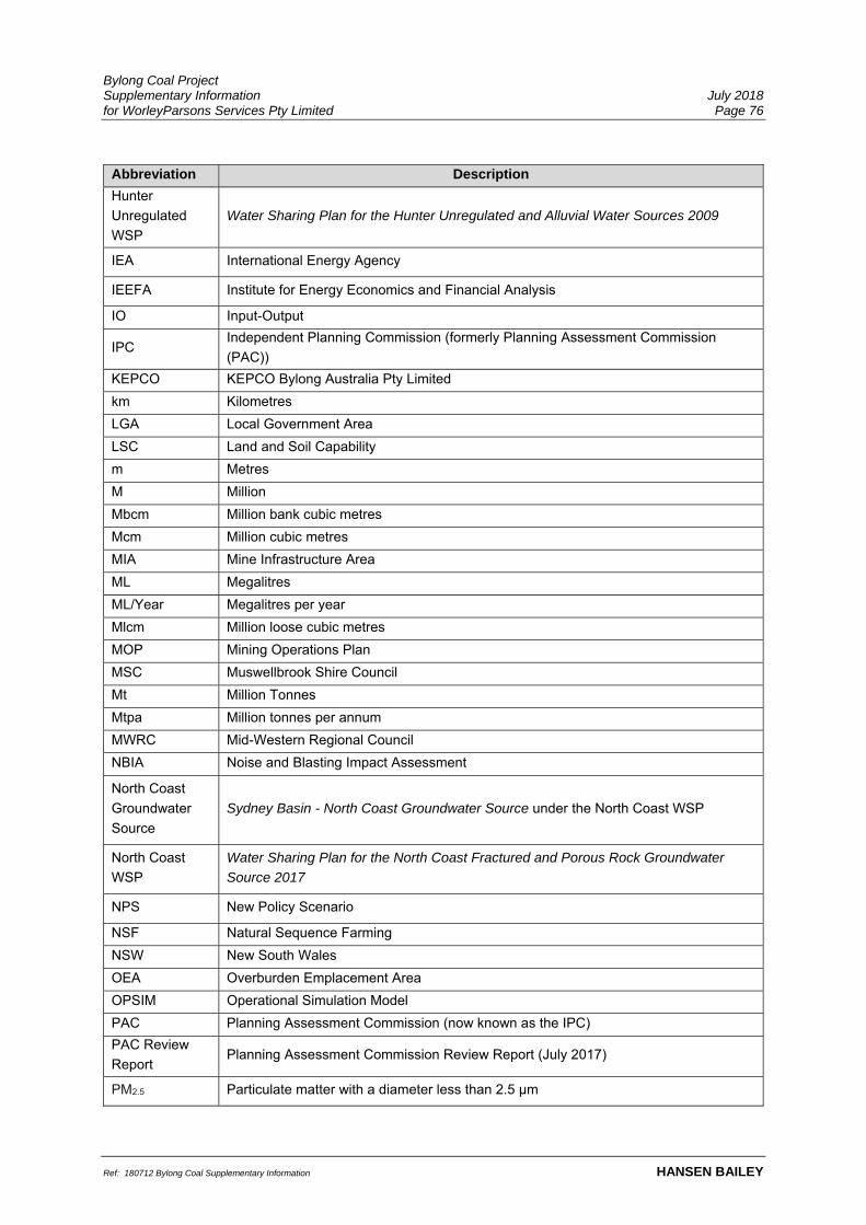
Bylong Coal Project Supplementary Information July 2018 for WorleyParsons Services Pty Limited Page 76
Ref: 180712 Bylong Coal Supplementary Information HANSEN BAILEY
Abbreviation Description
Hunter
Unregulated
WSP
Water Sharing Plan for the Hunter Unregulated and Alluvial Water Sources 2009
IEA International Energy Agency
IEEFA Institute for Energy Economics and Financial Analysis
IO Input-Output
IPC Independent Planning Commission (formerly Planning Assessment Commission
(PAC))
KEPCO KEPCO Bylong Australia Pty Limited
km Kilometres
LGA Local Government Area
LSC Land and Soil Capability
m Metres
M Million
Mbcm Million bank cubic metres
Mcm Million cubic metres
MIA Mine Infrastructure Area
ML Megalitres
ML/Year Megalitres per year
Mlcm Million loose cubic metres
MOP Mining Operations Plan
MSC Muswellbrook Shire Council
Mt Million Tonnes
Mtpa Million tonnes per annum
MWRC Mid-Western Regional Council
NBIA Noise and Blasting Impact Assessment
North Coast
Groundwater
Source
Sydney Basin - North Coast Groundwater Source under the North Coast WSP
North Coast
WSP
Water Sharing Plan for the North Coast Fractured and Porous Rock Groundwater
Source 2017
NPS New Policy Scenario
NSF Natural Sequence Farming
NSW New South Wales
OEA Overburden Emplacement Area
OPSIM Operational Simulation Model
PAC Planning Assessment Commission (now known as the IPC)
PAC Review
Report Planning Assessment Commission Review Report (July 2017)
PM2.5 Particulate matter with a diameter less than 2.5 μm

Bylong Coal Project Supplementary Information July 2018 for WorleyParsons Services Pty Limited Page 77
Ref: 180712 Bylong Coal Supplementary Information HANSEN BAILEY
Abbreviation Description
PM10 Particulate matter with a diameter less than 10 μm
PSNL Project Specific Noise Level
PY Project Years
RMP Rehabilitation Management Plan
ROM Run of Mine
RTS Response to Submissions (Hansen Bailey, 2016a)
SDS Sustainable Development Scenario
SLR SLR Consulting
SSD State Significant Development
Supplementary
RTS Supplementary Response to Submissions (Hansen Bailey, 2016b)
the Project Bylong Coal Project
TSC Act Threatened Species Conservation Act 1995 (repealed by Biodiversity Conservation
Act 2016)
TSP Total Suspended Particulates
VIA Visual Impact Assessment
WAF Workforce Accommodation Facility
WAL Water Access License
WRM WRM Water and Environment

Bylong Coal Project Supplementary Information July 2018 for WorleyParsons Services Pty Limited Page 78
Ref: 180712 Bylong Coal Supplementary Information HANSEN BAILEY
8 REFERENCES
Australasian Groundwater and Environmental Consultants Pty Ltd (2015). Bylong Coal
Project Groundwater Impact Assessment.
Australasian Groundwater and Environmental Consultants Pty Ltd (2016b). Bylong Coal
Project – Response to Submissions.
Australasian Groundwater and Environmental Consultants Pty Ltd (2018). Bylong Coal
Project-Supplementary Information.
Hansen Bailey (2015). Bylong Coal Project Environmental Impact Statement.
Hansen Bailey (2016a). Bylong Coal Project Response to Submissions.
Hansen Bailey (2016b). Bylong Coal Project Supplementary Response to Submissions.
Hansen Bailey (2018). Bylong Coal Project Response to PAC Review Report
International Energy Agency (2017). World Energy Outlook for 2017.
NSW Environment Protection Authority (2017). Noise Policy for Industry.
NSW Government (2015) Guidelines for Economic Assessment of Mining and Coal
Seam Gas Proposals.
Pacific Environment Limited (2015). Bylong Coal Project Noise and Blasting Impact
Assessment.
SLR (2014). “Tarwyn Park” Agricultural Productivity Audit.
SLR (2016). “Tarwyn Park” Agricultural Assessment and Land Management Plan.
SLR (2017). Comparative Agricultural Productivity Assessment of Properties Subject to
Varying Land Management Techniques (CAPA).

T 02 6575 2000
F 02 6575 2001
6/127-129 John Street, Singleton NSW 2330
PO Box 473, Singleton NSW 2330