Embed Size (px)
Citation preview
"
££
!
!
!
!
!
!
!
D
D
D
D
D
D
D
D
D
K
K
K KK
K
!!
!!
!!
!!
!!
!!
!!
!!
!!
!!
!!
!!
!!
!!
!!
!!
!!
!!
!!
!!
!!
!!
!!
!!
!!
!!
!!
!!
!!
!!
!!
!!
!!
!!
!!
!!
!!
!!
!!
!!
!!
!!
!!
!!
!!
!!
!!!!!!!!!!!!!
!!
!!
!!
!!
!!
!!
!!
!!
!!
!!
!!
!!
!!
!!!!!!!!!!!!!!!
!!
!!
!!
!!
!!
!!
!!
!!
!!
!!
!!
!!
!!
!!
!!
!!
!!
!!
!!
!!
!!
!
!!
!!
!!!
!!!
!!
!!
!!!
!!!
!!!
!!!
!!
!!!
!!
!!
!!!!
!!
!!!
!!
!!
!!!
!!!
!!!
!!
!!!
!!!
!!
!!
!!!
!!!
!!!
!!
!!
!!
!!
!!
!!
!!
!!
!!
!!
!!
!!
!!
!!
!!
!!
!!
!!
!!
!!
!!
!!
!!
!!
!!
!!
!!
!!
!!
!!!!!!
!!
!!
!!
!!
!!
!!
!!
!!
!!!!!!!!!!!!!!!!!
!!!
!!!
!!
!!
!!
!!
!!
!!
!!!
!!
!!
!!
!!
!!
!!
!!
!!
!!
!!
!!
!!
!!
!!
!!
!!
!!
!!
!!
!!
!!
!!
!!
!!
!!
!!
!!
!!
!!
!!
!!
!!
!!
!!
!!
!!
!!
!!
!!
!!
!!
!!
!!
!!
!!
!!
!!
!!
!!
!!
!!
!!
!!
!!
!!
!!
!!!!!!!!!!!!!
!!
!!
!!
!!
!!
!
!
!
!
!
!
!
!
!
!
!
!
!
!
!
!
!!!!!!!!!!!!!
!!
!!
!!
!!
!!
!!
!!
!!
!
!
!
!
!
!
!
!
!
!
!
!
!
!
!
!
!
!
!
!
!
!
!
!
!
!
!
!
!
!!
!!
!!!
!
!
!
!
!
!
!
!
!
!
!
!
!
!
!
!
!
!
!
!
!
!
!
!
!
!
!
!
!
!
!
!
!
!
!
!
!
!
!
!
!
!
!
!
!
!
!
!
!
!
!
!
!
!
!
!
!
!
!
!
!
!
!
!
!
!
!
!
!
!
!
!
!
!
!
!
!
!
!
!
!
!
!
!
!
!
!
!
!
!
!
!
!
!
!
!
!
!
!
!
!
!
!
!
!
!
!
!
!
!
!
!
!
!
!
!
!
!
!
!
!
!
!
!
!
!
!
!
!
!!!!!
!
!
!
!!
!!
!!
!!
!!
!!
!!
!!!
!!
!!!!!!!!!!!
!
!!
!
!
!
!!
!!
!!
!!
!!
!
!
!
!
!
!!
!!
!!
!!
!
!!
!
!
!
!
!
!
!
!
!
!
!!
!!
!!
!!
!!
!!
!!
!!
!!
!!
!!
!!
!!
!!
!!
!!
!!
!!
!!
!!
!!
!!
!!
!!
!!
!!
!!!!
!!
!!
!!
!!
!!
!!
!!
!!
!!!
!!
!!
!!
!!
!!
!!
!!
!!
!!
!!
!!
!!
!
!!
!!
!!
!!
!!
!!
!!
!!
!!
!!
!!
!!
!!
!!
!!
!!
!!
!!
!!
!!
!!
!!
!!
!!
!!
!!
!!
!!
!!
!!
!!
!!
!!
!!
!!
!!
!!
!!
!!
!!
!!
!!
!!
!!
!!
!!
!!
!!!
!!
!!
!!
!!
!!
!!
!!
!!
!!
!!
!!
!!!
!!
!!
!!
!!
!!
!!
!!
!!
!!
!!
!!
!!
!!
!!
!!
!!
!!
!!
!!
!!
!!
!!
!!
!!
!!
!!
!!
!!
!!
!!
!!
!!
!!
!!
!!
!!
!!
!!
!!
!!
!!
!!
!!
!!
!!
!!
!!
!!
!!
!!
!!
!!
!!
!!
!!
!!
!!
!!!
!!
!!
!!
!!
!!
!!
!!
!!
!!
!!
!!
!!
!!
!!
!!
!!
!!
!!
!!
!!
!!
!!
!!
!!
!!
!!
!!
!!
!!
!!
!!
!!
!!
!!
!!
!!
!!
!!
!!
!!
!!
!!
!!
!!
!!
!!
!!
!!
!!
!!
!!
!!
!!
!!
!!
!!
!!
!!
!!
!!
!!
!!
!!!!!
!!
!!
!!
!!
!!
!!
!!
!!
!!
!!
!!
!!
!!
!!
!!
!!
!!
!!
!!
!!
!!
!!
!!
!!
!!
!!
!!
!!
!!
!!
!!
!!
!! !
! !!
! !! !
!! !
! ! !!!
!!
!!
!!
!!
!!
!!
!!
!!
!!
!!
!!
!!
!!
!!!
!!
!!
!
!!!
!!
!!
!!
!!
!!
!!
!!
!!
!!
!!
!!
!!
!!
!!
!!
!!
!!
!!
!!
!!
!!
!!
!!
!!
!!
!!
!!
!!
!!
!!
!!
!!
!!
!!
!!
!!
!!
!!
!!
!!
!!
!!
!!
!!
!!
!!
!!
!!
!!
!!
!!
!!
!!
!!
!!
!!
!!
!!
!!
!!
!!
!!
!!
!!
!!
!!
!!
!!
!!
!!!!
!!
!!
!!
!!
!!
!!
!!
!!
!!
!!
!!
!!!
!!
!!
!!
!!
!!
!!
!!
!!
!!
!!
!!
!!
!!
!!
!!
!!
!!
!!
!!
!!
!!!
!!
!!
!!
!!
!!
!
!!
!!
!!
!!
!!
!!
!!
!!
!!
!!
!!
!!
!!
!!
!!
!!
!!
!!
!!
!!
!!
!!
!!
!!
!!
!!
!!
!!
!!
!!
!!
!!
!!
!!
!!
!!
!!
!!
!!
!!
!!
!!
!!
!!
!!
! ! ! ! ! ! ! ! ! !
!!
!!
!!
!!
!!
!!
!!
!!
!!
!!
!!
!!
!!
!!
!!
!!
!
!!
!!
!!
!!
!!
!!
!!
!!
!!
!!
!!
!!
!!
!!
!!
!! !
!! !
!!
!!
!!
!! !
! !!
!!
!!!
!!
!!
!!!
!!
!!
!!!
!!!
!!!
!!
! ! ! ! ! ! ! ! ! ! ! ! ! ! ! ! ! ! ! ! ! ! ! !
!!
!!
!!
!!
!!
!!
!!
!!
!!
!!
!!
!!
!!
!!
!!
!!
!!
!!
!!
!!
!!
!!
!!
!!!
!!!
!!
! ! !!
!!
!!
!!
!!
!!
!!
!
!!
!!
!!
!!
!!
!!
!!
!!
!!
!!
!!
!!
!!
!!
!!
!!
!
!!
!!
!!
!!
!!
!!
!!
!!
!!
!!
!!
!!
!!
!!
!!
! ! ! ! !!
!!
!!
!!
!!
!!
!!
!! ! ! !
!!
!!
!!
!!
!!
!!
!!
!!
!!
!!
!!
!!
!!
!!
! ! ! ! ! ! ! ! ! ! ! ! ! ! ! ! ! ! ! ! !!
!!
!!
!!
!!
!!
!!
! ! ! ! ! ! ! ! ! ! !!
!!
!!
!!
!!
!!
!!
!!
!!
!!
!!
!!
!!
!!
!!!
!!
!!
!!
!!
!!
!!
!!
!!
!!
!!
!! !
!!
!!
!!
!!
!!
!!
!!
! ! ! ! ! ! ! ! ! ! ! ! ! !!
!!
! ! ! ! !
!!
!!
!!
!!
!!
!!
!!
!!
!!
!!
!!
!!
!!
!!
!!
!!
!!
!!
!!
!!
!!
!!
!!
!!
!!
!!
!
!
!
!
!!
!!
!!
!
!
!
!
!
!
!
!
!
!
! !
!
!
!
!
!
!
!
!
!
!
!
!
!
!
!
!
!
!
!
!
!
!
!
!
!
!
!!
!!
!!
!!
!!
!!
!!
!!
!!
!!
!!
!!
!!
!!
!!
!!
!!
!!
!!
!!
!!
!!
!!
!!
!!
!!
!!
!!
!!
!!
!!
!!
!!
!!
!!
!!
!!
!!
!!
!!
!!
!!
!!
!!
!!
!
!
!
!
!
!
!
!
!
!
!
!
!
!
!!
!!
!!
!!
!
!
!
!
!
!
!
!
!!
!
!
!
!
!
!
!
!
!
!
!
!
!
!
!
!
!
!
!
!
!
!
!
!
!
!
!
!
!
!
!
!
!
!
!
!
!
!
!
!
!
!
!
!
!
!
!
!
!
!
!!
!!
!!
!!
!!
!!
!!
!
!
!
!
!
!
!
!
!
!
!
!
!
!
!
!
!
!
!
!
!
!
!
!
!
!
!
!
!
!
!
!
!
!
!
!
!
!
!
!
!
!
!
!
!
!
!
!
!
!
!
!
!!
!!
!!
!!
!!
!!
!!
!!
!
!!
!
!
!
!
!
!
!
!
!
!
!
!
!
!
!
!
!
!
!
!
!
!
!
!
!
!
!
!
!
!
!
!
!
!
!
!
!
!
!
!
!
!
!
!
!
!
!
!
!
!
!
!
!
!
!
!
!
!
!
!
!
!
!
!
!
!
!
!
!!
!!
!!
!!
!!
!!
!!
!!
!!
!!
!!
!!
!!
!!
!!
!!
!!
!!
!!
!
!
!
!
!
!
!
!
!
!
!
!
!
!
!
!
!
!
!
!
!
!
!
!
!
!
!
!
!
!
!
!
!
!
!
!
!
!
!
!
!
!
!
!
!
!
!
!
!
!
!
!
!
!
!
!
!
!
!
!
!
!
!
!
!
!
!
!!
!!
!!
!!
!!
!!
!!
!!
!
!
!
!
!
!
!
!
!
! !
!
!
!
!
!
!
!
!
!
!
!
!
!
!
!
!
!
!
!
!
!!
!!
!!
!
!
!
!
!
!
!
!
!
!
!
!
!
!!
!
!
!
!
!
!
!
!
!
!
!
!
!
!
!
!
!
!
!
!
!
!
!
!
!
!
!
!
!
!
!
!
!
!
!
!
!
!
!
!
!
!
!
!
!
!
!
!
!
!
!
!
!
!
!
!
!
!
!
!
!
!
!
!
!
!
!
!
!
!
!
!
!
!
!
!
!
!
!
!
!
!
!
!
!
!
!
!
!!
!!
!
!!
!
!!
!
!!
!
!!
!
!!
!
!!
!
!!
!
!!
!
!
!
!!
!!
!
!!
!
! !
!
!
!
!
!
!
!
!
!
!
!
!
!
!
!
!
!
!
!
!
!
!
!
!
!
!
!
!
!
!
!
!
!
!
!
!
!
!
!
!
!
!
!
!
!
!
!
!
!
!
!
!
!
!
!
!
!
!
!
!
!
!
!
!
!
!
!
!
!
!
!
!
!
!
!
!
!
!
!
!
!
!
!
!
!
!
!
!
!
!
!
!
!
!
!
!
!
!
!
!
!
!
!
!
!
!
!
!
!
!
!
!
!
!
!
!
!
!
!
!
!
!
!
!
!
!
!
!
!
!
!
!
!
!
!
!
!
!
!
!
!
!
!
!
!
!
!
!
!
!
!
!
!
!
!
!
!
!
!
!
!
!
!
!
!
!
!
!
!
!
!
!!
!!
!!
!!
!!
!
!
!
!
!
!
!
!
!
!
!
!
!
!
!
!
!
!
!
!
!
!
!
!
!
!
!
!
!
!
!
!
!
!!
!!
!
!
!
!
!
!
!
!
!
!
!
!
!
!
!
!
!
!
!
!
!
!
!
!
!
!
!
! !!
!!
!!
!!
!!
!!
!!
!
!
!
!
!
!
!
!
!
!
!
!
!
!
!
!
!
!
!
!
!
!
!
!
!
!
!
!
!
! ! !! ! ! !
! ! !! ! ! !
! ! ! !! ! !
! ! !
!!
!!
!!
!!
!
!
!
!
!
!
!
!
!
!
!
!
!
!
!
!
!
!
!
!
!
!
!
!
!!
!!
!!
!!
!!
!!
!
!
!
!
!
!
!
!
!
!
!! !
!
!
!
!
!
!
!
!
!
!
!
!
!
!
!
!
!
!
!
!
!
!
!
!!
!!
!!
!!
!!
!!
!
!
!
!
!
!
!
!!
!
!
!
!!
!!
!!
!!
!!
!!
!
!
!
!
!!
!!
!!
!!
!!
!!
!
!
! ! !! !
!
!
!
!
!
!
!
!
!
!
!
!
!
!!
!!
!
!!
!!
!!
!!
!!
!!
!!
!!
!!
!!
!!
!!
!
!
!
!
! ! !! ! ! ! ! ! ! !
! ! ! ! ! ! ! !!
!
!
!
!
!
!
!
!
!
!
!
!
!
!
! !! ! ! ! !
! ! ! !
!
!
!
!
!
!
!
!
!
!
!!
!!
!!
!!
!!
!!
!!
!!
!!
!
!
!
!
!
!
!
!
!
!
!!
!!
!!
!!
!!
!
!
!
! !
!
!
!
!
!!
!
!
!
!
!
!
!
!
!! ! ! ! ! ! ! ! ! ! !
!!
!
!
!
! ! ! ! !
Piratenschiff
IllesBalears
Illes balears
Manacor
SantLlorenç
des Cardassar
Son Servera
ambulatoride sa Coma
ThomasMeiners
Son Servera
Son Moro
CalaMillor
Cala Bona
Port Nou
Son Jordi
CostadelsPins
110
180
90
10
10
60
40
3010
30
190
100
170
100
130
190
120
120
10
10
20
130
330
30
170
100
10
140
10
40
10
180
30
110
100
20
10
250
260
270
110
30
120
10
170
10
320
130
110
140
80
10
110
160
160
120
10
90240
70
180
80
40
310
230
70
120
230
160
0
110
180
190
100
80
150
300
200
150
80
80
220
110
10
60
210
70
10
90
200
40
140
190
30
30
170160
50
130
20
120
40
100250
50
180
240
110
170
100
10
220
90
210
80160
150
70
10
60
160
20
130
140
150
140
130
1060
80 70
120
50 20
110
90
40
100
30
Torrentden Xinet
torrent de Son Jordi
Torrent deCala Millor
torrent Nou
torrent de
Xiclati
Torrent deca n'Amer
3°25'30"E
3°25'30"E
3°25'0"E
3°25'0"E
3°24'30"E
3°24'30"E
3°24'0"E
3°24'0"E
3°23'30"E
3°23'30"E
3°23'0"E
3°23'0"E
3°22'30"E
3°22'30"E
3°22'0"E
3°22'0"E
3°21'30"E
3°21'30"E
3°21'0"E
3°21'0"E
3°20'30"E
3°20'30"E
3°20'0"E
3°20'0"E
3°19'30"E
3°19'30"E
39°38
'30"N
39°38
'30"N
39°38
'0"N
39°38
'0"N
39°37
'30"N
39°37
'30"N
39°37
'0"N
39°37
'0"N
39°36
'30"N
39°36
'30"N
39°36
'0"N
39°36
'0"N
39°35
'30"N
39°35
'30"N
39°35
'0"N
39°35
'0"N
39°34
'30"N
39°34
'30"N
528000
528000
529000
529000
530000
530000
531000
531000
532000
532000
533000
533000
534000
534000
535000
535000
536000
536000
537000
537000
4381
000
4381
000
4382
000
4382
000
4383
000
4383
000
4384
000
4384
000
4385
000
4385
000
4386
000
4386
000
4387
000
4387
000
4388
000
4388
000 GLIDE number: N/A
!(!(
Balearic Sea
Illes Balears
Cala Millor01
0203
040506
07
08
09
^
Algeria
France
Morocco
Portugal
Spain
NORTHATLANTIC
OCEAN
Bay of Biscay
MediterraneanSea
BalearicSea
AlboranSea
Madrid
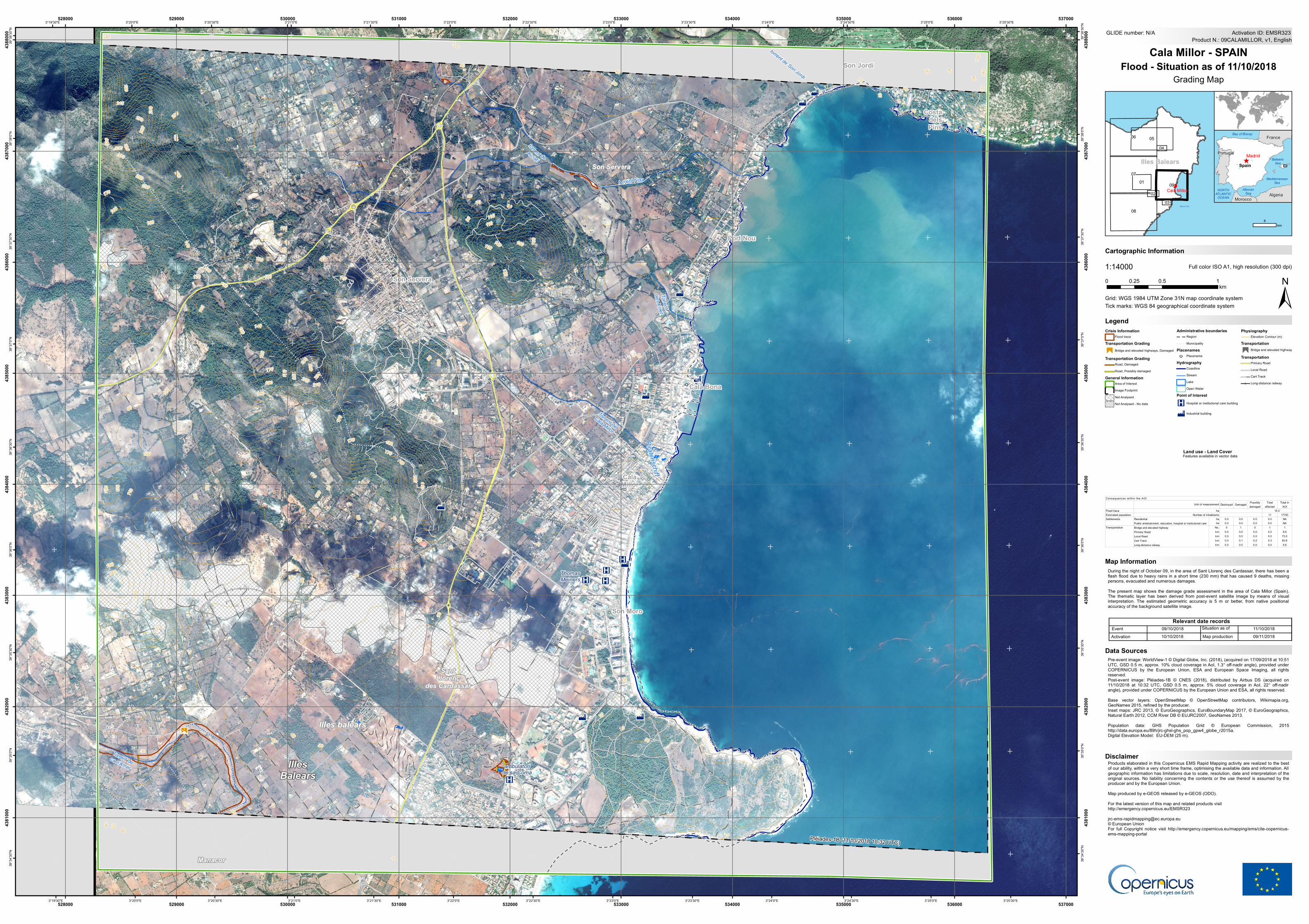
Cartographic Information
1:14000
±Grid: WGS 1984 UTM Zone 31N map coordinate system
Full color ISO A1, high resolution (300 dpi)
During the night of October 09, in the area of Sant Llorenç des Cardassar, there has been aflash flood due to heavy rains in a short time (230 mm) that has caused 9 deaths, missingpersons, evacuated and numerous damages.The present map shows the damage grade assessment in the area of Cala Millor (Spain).The thematic layer has been derived from post-event satellite image by means of visualinterpretation. The estimated geometric accuracy is 5 m or better, from native positionalaccuracy of the background satellite image.
Products elaborated in this Copernicus EMS Rapid Mapping activity are realized to the bestof our ability, within a very short time frame, optimising the available data and information. Allgeographic information has limitations due to scale, resolution, date and interpretation of theoriginal sources. No liability concerning the contents or the use thereof is assumed by theproducer and by the European Union.Map produced by e-GEOS released by e-GEOS (ODO).For the latest version of this map and related products visithttp://emergency.copernicus.eu/[email protected]© European UnionFor full Copyright notice visit http://emergency.copernicus.eu/mapping/ems/cite-copernicus-ems-mapping-portal
LegendTick marks: WGS 84 geographical coordinate system
Product N.: 09CALAMILLOR, v1, EnglishActivation ID: EMSR323
Pre-event image: WorldView-1 © Digital Globe, Inc. (2018), (acquired on 17/09/2018 at 10:51UTC, GSD 0.5 m, approx. 10% cloud coverage in AoI, 1.3° off-nadir angle), provided underCOPERNICUS by the European Union, ESA and European Space Imaging, all rightsreserved.Post-event image: Pléiades-1B © CNES (2018), distributed by Airbus DS (acquired on11/10/2018 at 10:32 UTC, GSD 0.5 m, approx. 5% cloud coverage in AoI, 22° off-nadirangle), provided under COPERNICUS by the European Union and ESA, all rights reserved.Base vector layers: OpenStreetMap © OpenStreetMap contributors, Wikimapia.org,GeoNames 2015, refined by the producer.Inset maps: JRC 2013, © EuroGeographics, EuroBoundaryMap 2017, © EuroGeographics,Natural Earth 2012, CCM River DB © EUJRC2007, GeoNames 2013.Population data: GHS Population Grid © European Commission, 2015http://data.europa.eu/89h/jrc-ghsl-ghs_pop_gpw4_globe_r2015a.Digital Elevation Model: EU-DEM (25 m).
Cala Millor - SPAINFlood - Situation as of 11/10/2018
Map Information
Grading Map
Pléiades-1B (11/10/2018 10:32 UTC)
Relevant date recordsEvent Situation as of09/10/2018 11/10/2018
Land use - Land CoverFeatures available in vector data
Activation Map production10/10/2018 09/11/2018
Disclaimer
Data Sources
6km
Crisis InformationFlood trace
Transportation Grading£
Bridge and elevated highways, Damaged
Transportation GradingRoad, DamagedRoad, Possibly damaged
General InformationArea of InterestImage FootprintNot AnalysedNot Analysed - No data
Administrative boundariesRegion
! ! ! ! !! ! ! ! ! MunicipalityPlacenames
! PlacenameHydrography
CoastlineStreamLakeOpen Water
Point of Interest
K Hospital or institutional care building
D Industrial building
PhysiographyElevation Contour (m)
Transportation"
£
Bridge and elevated highway
TransportationPrimary RoadLocal RoadCart TrackLong-distance railway
Destroyed Damaged Possibly damaged
Total affected
Total in AOI
Flood traceEstimated population 11 17700
Residential ha 0.0 0.0 0.0 0.0 NAPublic entertainment, education, hospital or institutional care ha 0.0 0.0 0.0 0.0 NABridge and elevated highway No. 0 1 0 1 1Primary Road km 0.0 0.0 0.0 0.0 6.6Local Road km 0.0 0.0 0.0 0.0 73.0Cart Track km 0.0 0.1 0.2 0.3 83.8Long-distance railway km 0.0 0.0 0.0 0.0 5.6
Number of inhabitantsSettlements
Transportation
Consequences within the AOIUnit of measurement
ha 15.5
0 0.5 10.25km