Embed Size (px)
Citation preview
S-69 R.::"Ward \O:.lliams Point P:- ivate
/C/67
Mid eighteenth century, April 18, 1794
Significantly unusal among the early houses of Somerset County 1 Reward was
b~ilt on the edge of the Pocomoke Sound during the middle years of the eighteenth
ce~tury. As originally erected, the squarish, Flemish bond brick house was covered
by a jerkinhead roof. In addition to an uncoventional roof shape, the four-room
p:an dwelling was heated by corner hearths, and rising from the southeast side
a:-e the only diamond chimeny stacks extant in Maryland. Attached to the north
s:de of the main block is a frame hyphen which connects a story-and-a-half brick-
e~ded kitchen. The construction of the kitchen is documented by a datebricks
a:arked April 18, 1794.
It is not certain when, or by whom, the early brick house was erected, but
a~chitectural evidence suggests it was raised during the period (1740-1760) for
E:ias White, ytho had the property resurveyed under the nane of "White's Gift" on
~arch 9, 1759, for 626 acres. White family occupation of the property dates to
1687 when Stephen White, Elias's grandfather, inherited the tract from William
Stevens. Elias White eventually mortgaged large portions of his plantation,
and during the early 1770s his holdings were divided and sold. On November
22, 1773, "White's Gift" was purchased by David Williams for £1065 (F/123).
One year later, the Pocomoke river plantation was resurveyed once again
as, "Williams Green." David Williams died in 1782, and his wife, Martha, was
assessed for her land the next year. With its situation, "on the Mouth of the
Pocomoke," Williams Green consisted of 488 acres and contained, "A Brick wall
dwelling house, three rooms below in midling repair, kitchen, barn, and other
-
improvements indifferent." Martha Williams' estate was valued at El245. David
~illiams' will had bequeathed one-half interest to his wife, Martha, while the
remaining half was to pass to their son Thomas, when he arrived at the age of
twenty-one.
Thomas Williams predeceased his mother, for in 1798 Thomas' heirs, Martha
and Katherine Williams, are listed in the tax assessment. Their plantation was
described as,
Situate on the mouth of the Pocomoke River adjoining a fast landing on said river. I Dwelling House 30 by 30 one story high with 3 windows Si feet by 3 feet, 2 windows 41 feet by 2 1 feet, and 4 windows 3~ feet by 2~ feet, brick walls and wood roof, I kitchen 18 by 22 with a covered waey from said kitchen to the dwelling house of wood.
By 1809 Thomas Williams was dead, and one-half interest in "Williams Green"
was inherited by Amelia Gale, who with her husband, General John Gale, sold her
share in the plantation to Ralph Milbourn, who in turn sold 300 acres to John
Milbourn in 1817 (see T/270 and JD 2/377). The Milbourns retained ownership
until 1847, when John Milbourn sold the plantation to William Adams (WP 2/12).
Si~ce the mid nineteenth century, the Williams Point farm has passed through a
half-dozen hands until the current ·owner acquired the property.
• • ; .. .,u>-100 UNITED STATES DEPARTMENT OF THE INTERIOR STATE:
"·"' (Rev. 6~72) NATIONAL PARK SERVICE U---1--...1 .. COUNTY! -
NATIONAL REGISTER OF HISTORIC PLACES ~
ilNVEMTORY - NOMINATION FORM FOR NPS USE ONLY ENTRY DATlt
(Type all entrie!t·· complete applicable sections)
MPtf4A•t:\••·-·· "::.:···":.· •..
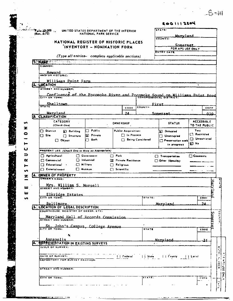
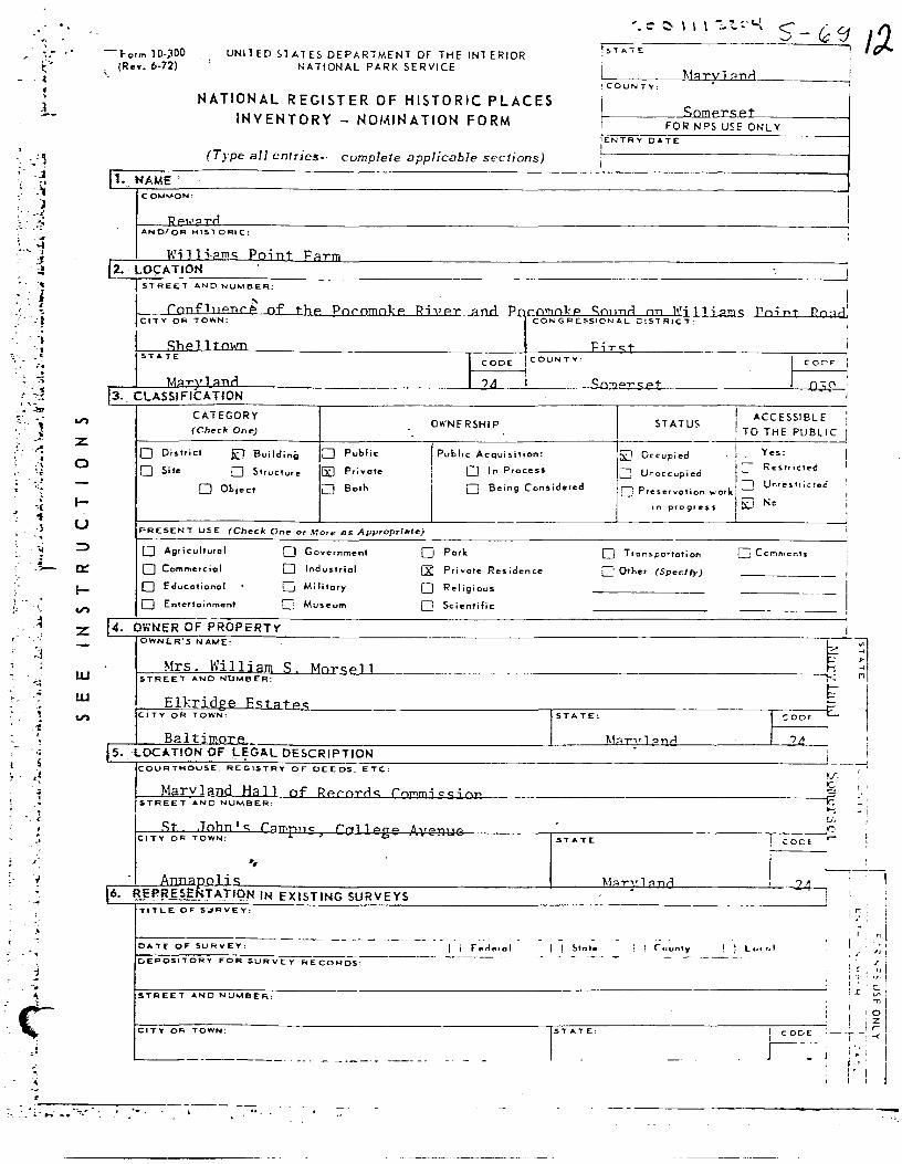
COMMON:
-AND/OR HISTORIC:
w;11.:..n· ...... n,.;nr p,,,..,.,,, f~.:U>CAT~ON ' ,
STREET ANO NUMl!ll!:R1
rn ... ~1 ~
n.f! +l. .. - !); ............. ...1 - c,..,,_,.i ,.._ Ill~ I 1 ; -- - "- .! __ ... n- • ..J
CITY OR TOWN: CONGRESSIONAi.. DIST.-ICT1
C::l.ol 1 rn• .... P-i--+ STATE I CODE COUNTY: I COOF
I ?A ' I Un-••1 "--" - n-,.,. I#·. Ct;ASSfFICATION
.,, CATEGORY OWNERSHIP STATUS
ACCESSIBLE (Ch.,c:lr Onft) TO THE PUBLIC z
0
-i ... u
0 Diatrict Kl Building D Public Public Acquisition: Ii] Occupied Yes:
0 Site 0 Structure lXJ Private 0 In Procen 0 Uneeeuplod Cl Re1111ete41
0 Object 0 Both D Being Considered 0 PreHr•otion worli 0 UnrHhicted
'" 11te11r•ll il No
PRESENT USE (Checlr One or More ea Appropriate)
:::> D Agrlculturol D Government D Pork D Transportation 0 Co111111onts
al: 0 Commercial D Industrial f.XI Private Residence 0 Other (Spoclty) ......._._... ___
... 0 Educational . .0 Military 0 Religious .. -"'
0 Entertainment 0 Museum 0 Scientific -·· -- ---z f!(. owwe~ QF PROPERTY
w
I OWN ER'S NAME:
~ .. ...
Mrs. w; 11; ...... ~ . I 1
> ... STREET AND Ntl!'IBER: ~ "'
w F.lkrina"' i::c::r!ll+oc: ~
"' CITY OR TOWN: STATE: CODF" .....
R.., l i-imn-rp ... Un-u1 "--1 _,A lS.. .. \;-CX:ATION OF ~EG~L DESCRIPTION -
--COURTHOUSE, REGISTRY OF DEEDS. ETC: 'l n
(l
M~rvl "'"~ i.:i<> 11 nf' ~ . r-'l'n"'~ CC!.;, __ c ~
STREET AND NUMBER: .. -<
~f" Tnl.n f c c rn11~~~ . 'I\
CITY OR TOWN: .. , .., STATE CODE "1'
r1.
He:: u--··1--...1 ·44j If, •. JJ:~ffS~FjlTAT~Q,. IN EXISTING SURVEYS I .
TITLE OF SURVEY:
I "' • ----------- - --- -·· - ·- -- -- - . I • .. - .. DATE 0" SURVEY: I I Federal I I !.lnte I I C"nu111y I I L11tt1I ,. ·---·---·---· -----. .. -. - - - -· .. f DEPOSITORY FOR SURVEY RECORDS: ·~ t
~ ., .• ·~ .. s STREET AND NUMBER: ..
Fj-m 0 z
CITY OR TOWN: rTATE: i--r -< .,
·- ---- - . -·-· - - - . ~
·- ·-· -··---·· - ' '"
' l.
. .
/.
·;1· ·~ -
·1
','' .'~ . .
i • l
· 1
' .' ~
' l<
I,
___ S-6 °i
" .. '
(Cheek One)
" 0 Excellent ~ Good 0 Fair 0 Deterioroted 0 RYln1 0 Uneapo•ed
(Cheek One)
I (Cllecll One)
0 Altered liJ Unalte,.d 0 Moved lYl 0.ltlMI Site
CONDITION
DIUCIU•E THE PRESENT AND ORIGINAL. (II fmown) PHYSICAL. APPEARANCE
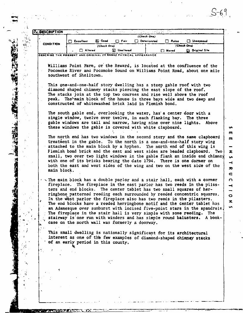
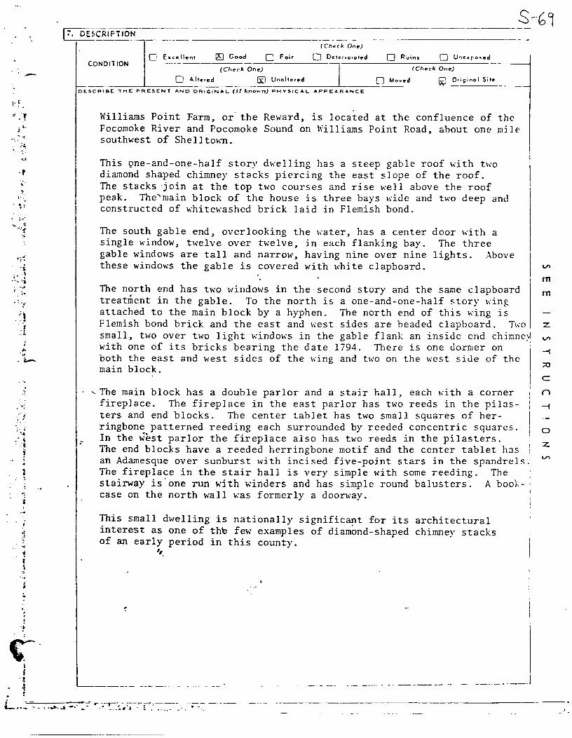
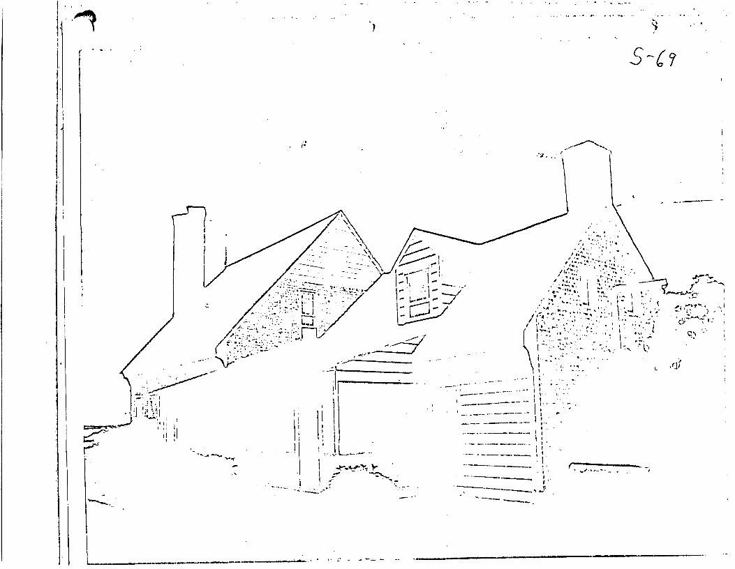
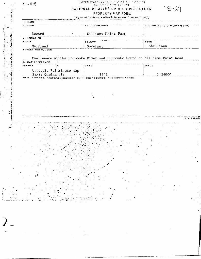
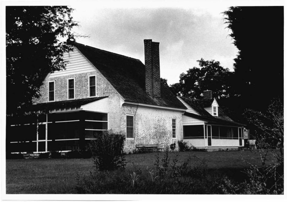
Williams Point Farm, or' the Reward, is located at the confluence of the Pocomoke River and Pocomoke Sound on Williams Point Road, about one mile southwest of Shelltown.
This Qne-and-one-half story dwelling has a steep gable roof with two diamond shaped chimney stacks piercing the east slope of the roof. The stacks join at the top two courses and rise well above the roof peak. Thel'main block of the house is three bays wide and two deep and constructed of whitewashed brick laid in Flemish bond •
The south gable end, overlooking the water, has· a center door with a single window, twelve over twelve, in each flanking bay. The three gable windows are tall and narrow, having nine over nine lights. Above these windows the gable is covered ~ith white clapboard. "'
The north end has two windows in the second story and the same clapboard treatment in the gable. To the north is a one-and-one-half story wing attached to the main block by a hyphen. The north end of this wing is Flemish bond brick and the east and west sides are beaded clapboard. Two small, two over two light windows in the gable flank an inside end chimnc) with one of its bricks bearing the date 1794. There is one dormer on both the east and west sides of the wing and two on the west siue of the main block.
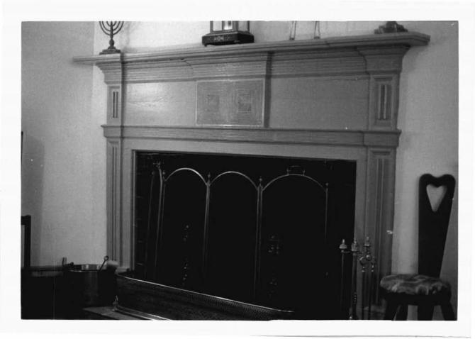
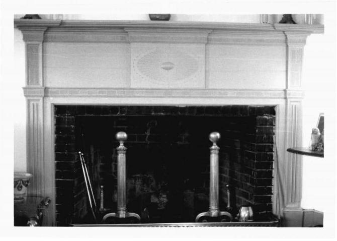
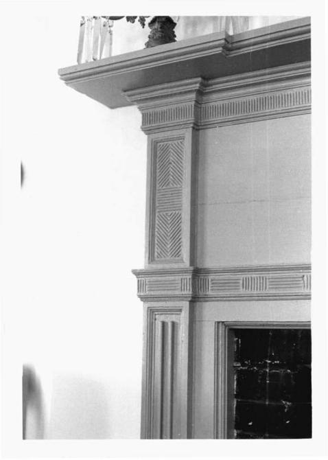
i , The main block has a double parlor and a stair hall, each with a corner fireplace. The fireplace in the east parlor has two reeds in the pilnsters and end blocks. The center tablet has two small squares of herringbone patterned reeding each surrounded by reeded concentric squares.
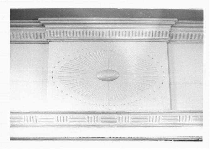
~ In the liest parlor the fireplace also has two reeds in the pilasters. The end blocks have a reeded herringbone motif and the center tablet has an Adamesque over sunburst with incised five-point stars in the spandrels. The fireplace in the stair hall is very simple with some reeding. The stairway is'one run with winders and has simple round balusters. A book-
'i case on the north wall was formerly a doorway . .i.,.
'i·
This small dwelling is nationally significant for its interest as one of the few examples of diamond-shaped
· of an early period in this county.
"·
architectural chimney stacks
---·-- ·- --- --· .. - - ..... -- ···-·----·· ·-·- _____ ... -~ ·----·- ... -· ____ .... .....,.___
m m
z
-f
:::0
c: n -f
0
z
, ' . -. I
·I
"' z 0
t-u :::> at:
t-
j I. "' z
w w .
"'
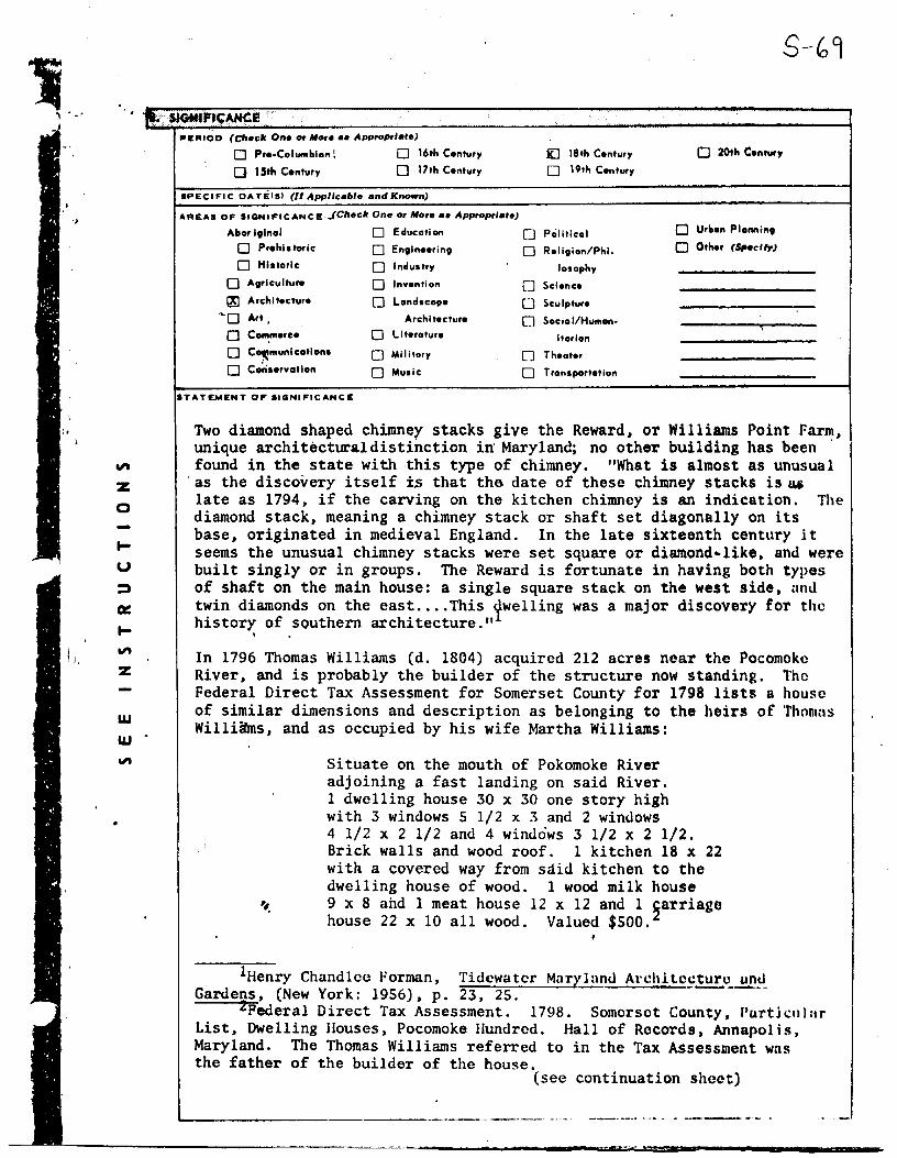
IOIEFllOD (Cltec:lr One or More ee Appropriate)
0 Pre-ColU111blon I 0 16th Century
0 15th Century 0 17th Century
SPECI Fl C DAT EIS) (II Appllcal>te and Known)
AFIEAS OF SIGNIFICANCE JClteclr One or More •e Appropriate)
Abor iglnal 0 Educ:otion
0 Prehiltarlc: O Engineering
O Historic:
O Agriculture
~ Architecture
·~o Art,
O C~merce 0 C°'munlcatlons
0 cori .. rvatlon
STATEMENT OF llGNIFICANCE
0 Industry
0 Invention
0 Londsc:ope
Arc:hl lecture
0 Llteroture
0 Mililory
O Music:
j[] 18th Century
O 19th Century
O Political
0 Religion/Phi.
losophy
0 Science
0 Sculpture
0 Sociol/Humon·
itorian
O Theater
0 Tronsportotlon
0 20th Century
0 Uri.on Plennint
0 Other (Spec:l,_,J
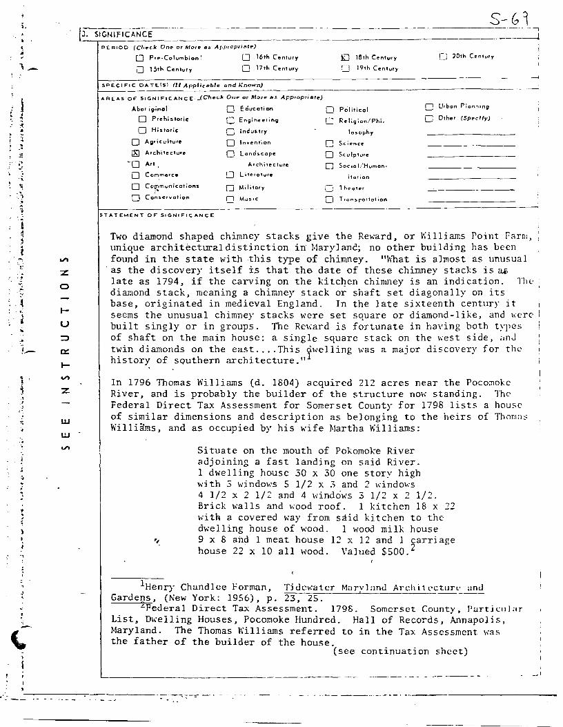
Two diamond shaped chimney stacks give the Reward, or Williams Point Farn~, unique architectural distinction in Maryland; no other building has been found in the state with this type of chimney. "What is almost as unusual as the discovery itself is that the date of these chimney stacks is u.a late as 1794, if the carving on the kitchen chimney is an indication. The diamond stack, meaning a chimney stack or shaft set diagonally on its base, originated in medieval England. In the late sixteenth century it seems the unusual chimney stacks were set square or diamond~like, and were built singly or in groups. The Reward is fortunate in having both types of shaft on the main house: a single square stack on the west side, nn<l twin diamonds on the east .... This ywelling was a major discovery for the history of sQuthern architecture." . In 1796 Thomas Williams (d. 1804) acquired 212 acres near the Pocomoke River, and is probably the builder of the structure now standing. 1'hc Federal Direct Tax Assessment for Somerset County for 1798 lists a house of similar dimensions and description as belonging to the heirs of Thomns Willimns, and as occupied by his wife Martha Williams:
Situate on the mouth of Pokomoke River adjoining a fast landing on said River. 1 dwelling house 30 x 30 one story high with 3 windows S 1/2 x 3 and 2 windows 4 1/2 x 2 1/2 and 4 windows 3 1/2 x 2 1/2. Brick walls and wood roof. 1 kitchen 18 x 22 with a covered way from said kitchen to the dwelling house of wood. 1 wood milk house
~ 9 x 8 ahd 1 meat house 12 x 12 and 1 ~arriage house 22 x 10 all wood. Valued $500. ,
lttenry Chandlce forman, Tidewater Mnrylund Archltoc~~J!E!1_ Gardens, (New York: 1956). p. 23, 25.
2Pederal Direct Tax Assessment. 1798. Somerset County. l'urtkul:ir List, Dwelling Houses, Pocomoke Hundred. Hall of Records, Annapolis, Maryland. The Thomas Williams referred to in the Tax Assessment was the father of the builder of the house.
(see continuation sheet)
----------------·-·--- - ---- --·-
,Oflll 10·3000 ~ (.lvly 1969)
UNITED STATES DEPARTMENT OF THE INTERIOR STA.Tit
NATIONAL PARK SERVICE
NATIONAL REGISTER OF HISTORIC PLACES COUNTY
)
"
INVENTORY • NOMINATION FORM FOR NPS USE ONLY
""T-----1 llENTRV NUM9ER I
(Cootinuation Sheet) 1
(Number •II ontrlH)
Reward
Numh._er 8. Significance continued.
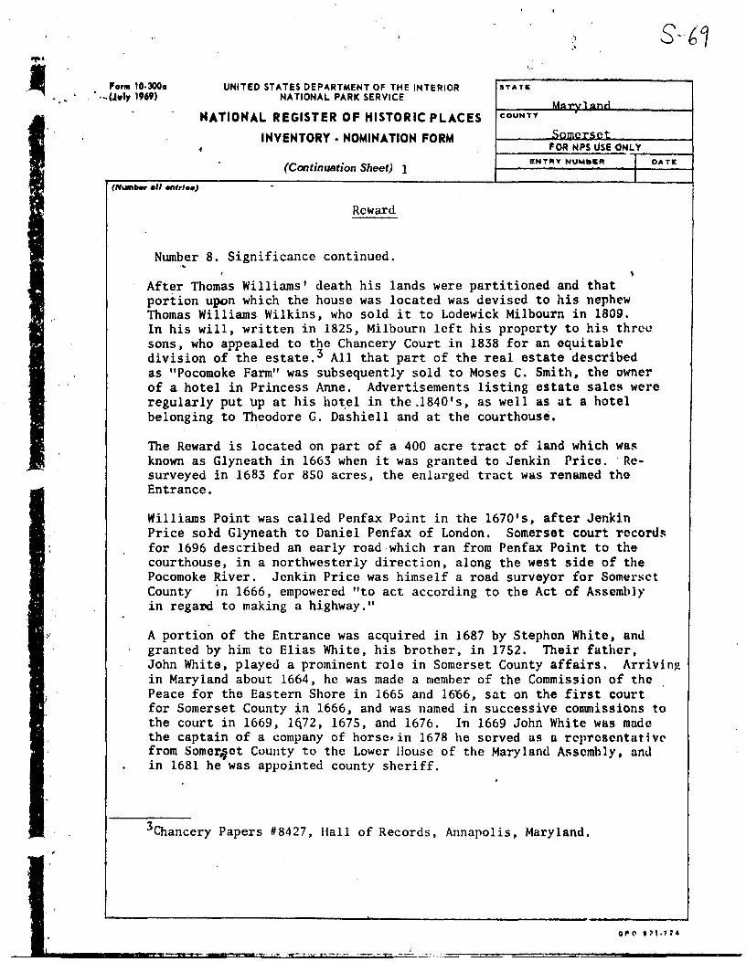
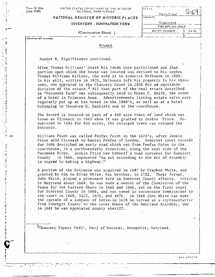
After Thomas Williams' death his lands were partitioned and that portion upon which the house was located was devised to his nephew Thomas Williams Wilkins, who sold it to Lodewick Milbourn in 1809.
DATii:
I
In his will, written in 1825, Milbourn left his property to his thrco sons, who appealed to the Chancery Court in 1838 for an equitable division of the estate.3 All that part of the real estate described as "Pocomoke Farm" was subsequently sold to Moses C. Smith, the owner of a hotel in Princess Anne. Advertisements listing estate sales were regularly put Up at his ho~el in the.1840's, as well as at a hotel belonging to Theodore G. Dashiell and at the courthouse.
The Reward is located on part of a 400 acre tract of land which W8$
known as Glyneath in 1663 when it was granted to Jenkin Price. Re· surveyed in 1683 for 850 acres, the enlarged tract was renamed tho Entrance.
Williams Point was called Penfax Point in the 1670's, after Jenkin Price sold Glyneath to Daniel Penfax of London. Somerset court record~ for 1696 described an early road-which ran from Penfax Point to the courthouse, in a northwesterly direction, along the west side of the Pocomoke River. Jenkin Price was himself a road surveyor for Somerset County in 1666, empowered "to act according to the Act of Assembly in regal'd to making a highway."
A portion of the Entrance was acquired in 1687 by Stephen White, anJ granted by him to Elias White, his brother, in 1752. Their father, John White, played a prominent role in Somerset County affairs. Arrivin~ in Maryland about 1664, he was made a member of the Commission of the Peace for the Eastern Shore in 1665 and 1606, sat on the first court for Somerset County in 1666, and was named in successive conunissions to the court in 1669, lq72, 1675, and 1676. I~ 1669 John White w~s made the captain of a company of horsc•in 1678 he served us a representative from Somer"ct County to the Lower House of the Maryland Assembly, an<l in 1681 he was appointed county sheriff,
3Chancery Papers #8427, Hall of Records, Annapolis, Maryland.
... r•~>"*Jf!R 8l&Lt0GRAPHICAL REFERENCES '•'
..
PRIMARY SOURCBS, Hall of Records, . Annapolis, Maryland. Chancery Papers. Federal~Direct Tax Assessment, of 1798. Somerset County. Somerset County Judicial Records. Somerset County Land Records.
SECONDARY SOURCES Clark, Charles B. The Eastern Shore of Maryland and Virginia:
(See rnnt-i ....... +; ...... c::h ..... +"I f-10;.· GEOGRAPHICAL DATA '
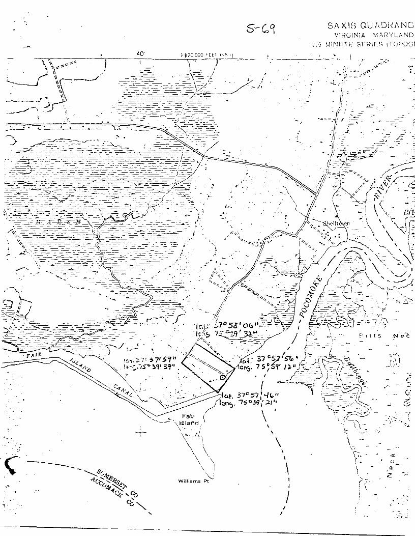
LATITUDE AND L t)NGITUDE COORDINATES-. L'TITUl"F ANC' LC'NGl""ll>E COOf'!)IHAT~S -·-DEFINING A RECTANGl,'.E LOCATING THE PRO"FffTY 0 DEFINING Tl; ... 1..1:.N r:;.N POIN I OF .. 1> .. o .. ERTY
~ - R- OF LESS THAN TPN ACltltl --COltNltR LATITUDE LONGITUDE LATITUDE 1.0NQI TUOlt
Degrees Minutes Second1 Degrees Minutes Seconds Degrees Minute• Second• Dette•• MlnuNa S.cOIMla NW 37° 58• 06• 75 ° 39. 32. 0 . . 0 . . NE 31 57' 56. 75 ° 39. 12. ,, SE 37° 57' 46. 75 ° 39. 21. "t.W "_o --· --· -- 0 -- . -- . I
APPltOlCIMA'fif ACRlAGE oll NOMINA'T'tD plf'dJ>El'IT"H' 32 _acr_es 11.llT ALI. STATES AND COUNTIES FOR PROPERTIE·s OVERLAPPINS STATE OR COUNTY l!IOUNOAltlltl --ITATE: CODE COUNTY CODli.
!ITATE1 CODE COUNTY: CODE
!ITATE1 COOE: COUNTY: COOi!
STATE: COOE COUNTY: COOP.
lit. FORM PREPARED BY -NAME AND TITLE:
A-- 1-H 11 C::1·-~- Tnt-o.,..... ~n.rl Lni c: "" . n . . - - . .... __ ....
ORGANIZATION ..
IO"T 1£
M~T"vl anA Hi c: f-nT"i "<> 1 - Nov. 1. 197~ STREET ANO NUMBER,
.,c:,,c: o; ..... o~ .. ..t CITY OR TOWN: STATE COOF
. '1 ; "' Marv1~n..1 ,,,
112. ' STATE.LIAISON OFFICER CERTIFICATION NATIONAL REGISTER Y!RIPICATIOH
As the designated State Liaison OHicer for the Na-
tional Historic Preservation Act or 1Q66 (Public I.aw I hereby certify that thia property ia includltd in tht-
89-665). I hereby nominate this properly for inclusion Nstiona l Register.
in the National Register and certiry that it t:ias been
--~aluatt>d accordirw; t~the c•lteria and proce~ res set
forth by the National Park Service. The recommended
level or signir'icance of this nomination i!•: Director, Olflce of ArcheolOfJ' lltld Hlatorlc rreaerNtlon
National I 1 Stute ,-, Local r i
I ., .. ,,~ ..... ------··
Name
Orlando Ridout, IV A11EST:
Title State Hjstorjc Preservnti an Officer for Maryland Keeper of The National Re~latet
Date Nallembe;c 19. rnZ.3 Date
if U,S. GOVERNMENT PlllNTINli 01 ~ICC : l!Hl• 729•10, 1441 1•1
"' m m
z
0
z
. ----·=:c=====~~~~--
_.
L
.· . . .... - .'") ... .! -:-~ ,,_ • -!!>
-~-. ."'!
·l
~- ';.
~
j
;_~
! .. , L•
,;
.·{ .,
1 , .• -. ~
V')
z 0
z
w w
... . ............... ~.' ..
-f-orm 10-;lOO (Rev. 6-72)
'.
UNITED ST AT ES DEPARTMENT OF THE INTERIOR NATIONAL PARK H RVICE
I STATE I
Maryland
11.
(2.
3 .
NATIONAL REGISTER OF HISTORIC PLACES
INVENTORY - NOMINATION FORM
(Type all entries-· complete applicable sections)
NAME COM~ON:
n,,.,.,,_...i ANOIOR HISTORIC:
h'j J] -l:Ems Eo]nt i::arm LOl=ATION I STREE-T AND NUMBER;
p CITY OFi TOWN:
STATE CODE I COUNTY'
? CLASSIFICATION
CATEGORY
(Ch~ck One) 0\\'NfRSHIP
0 District 0 Building CJ Public Public Acquisition:
0 Site 0 Structure 00 Private O In Process
0 Object 0 Both O Being Considered
PRESENT USE (Check One or Afore BS Appropriate)
0 Agricultural
0 Commercial
0 Educational
0 Entertainment
0 0
0 0
Go-,,ernment
Industrial
Military
Mu5eum
0 Park
[X Pri"'ote Residence
0 Religious
CJ Scientific
•COUNTY·
I c~~~~c:;a+
I FOR NPS USE ONLY !ENTRY I
DATE
j
I I I
:
!
corF
I ACCESSIBLE STATUS I
. TO THE PUBLIC
5.J Occupied I Yes:
Ir- Restricted
~ Unoccupied ~ 1 t Unrestricted
[J Pr~ser .... ction workl· ~ on progress . ti;..! Ne
0 Tror.sportotion C Comments
0 Other (Specify)
4. OWNER OF PROPERTY l OWNER'S NAME: b:: ~
t_____£M~r~s~.c_!'h~1i~1~1~·,_Q!!~L.._..fll:~ie...LL~~~~~~~~~~~~~~~~~~~~~~~~---'..F.,~ ~I STREET AND NtlMBER,
1.-.....__!0E~l~k~r~igd~--L.;::t..L..i~tue~ss__~~~~~~~~~~~~.--~~~~~~~~~~---.-~~-f'.[ I CITY OR TOWN, I STATE: :'.:OD' j
Balt' ______________________ ji------'~~l~aur~;~r~J~~~n~du.-----'----'-~?~4...__ i
c5~-~·~L~OC:...=A~T..:..:..:IO~N__:O~F__:~~E~.G.:.....c.:A~L~D:....=E~SC.=..:..:R~l~P~T~IO.~N ___________________________ ___.:i ___ ~ COURTHOUSE. REGISTRY OF DEEDS. ETC' 'f.
S: l-.___MM@axr~v~l1!Ilta.._.11.CU..;L.J:Lt..-..R.e..c.o.r:d..5c_.._[~1IlJJ~~:::m..~~---------------~---F. STREET AND NUMBER: ~
rJ. 1--~~~......o..!.illlll...:...!>-L.Cilll.p.l!S....,........L:a..ll....L~!.e.-J.i.¥-~1-U-g....----~-.---::-------------.----~~
STATE coo~
,,
.·
~.:.l.._..lillD..ap.ol..:i..£..~~~~~~~~~~~~~~---'~~-~Ma:g.:.:laIJLCL~~~~j_·---24:__,,·. ,-:--i 6. ~-EP.FESl:~TATIQ.N IN EXISTING SURVEYS
TITLE OF Si,;IRVEY: i r::
------------ -- -- --- ---OATE OF SURVEY: F edero I 5.tnte County ! ! L u .. .i DEPOSITORY FOR SURVEY RE.COHOS: _____ _
STREET AND NUMBEFL
CIT'r Of; TOWN: STATE:
...._ ____________ -·· -·-·---- --- --
- ------ ------------
.·
-
. '· ,
-1'
. '" ,. ; ..
. :) . !I :.L
.... . {
-- i ~ 'I
. ... ~ • . :
•. , , !
}
I f ..
'
~5CRIPTIO __ N __ · ______ --------------·---(Check One)
__Q Excellent ~ Good 0 Fair 0 Deteriorated
-----·-1----~ (Check One) (Check One)
0 Altered IXJ Unaltered [l Moved liJ Original Site
0 Ruins 0 Unexpc•ed CONDITION
DESCRIBE THE PRESENT ANO ORIGIN•L (Jf known) PHYSICAL APPEARANCE
. -
Williams Point Farm, or the Reward, is located at the confluence of the Pocomoke River and Pocomoke Sound on Williams Point Road, about one mile southwest of Shelltown.
This <;me-and-one-half story dwelling has a steep gable roof \d th two diamond shaped chimney stacks piercing the east slope of the roof. The stacks join at the top two courses and rise wel 1 above the roof peak. The"'main block of the house is three bays Kiele and two deep and constructed of whi te\,·ashed brick laid in Flemish bond.
The south gable end, overlooking the water, has a center door with a single window, twelve over twelve, in each flanking bay. The three gable windows are tall and narrow, having nine over nine lights. Above these windows the gable is covered with white clapboard.
The north end has two windows in the second story and the same clapboard treatment in the gable. To the north is a one-and-one-half story \,·ing attached to the main block by a hyphen. The north end of this wing is Flemish bond brick and the east and west sides are beaded clapboard. T\•.'O small, two over two light windows in the gable flank an inside end chimnc:-! with one of its bricks bearing the date 1794. There is one dormer on · both the east and west sides of the wing and two on the west siJe of the main block.
' The main block has a double parlor and a stair hal 1, each ,,·i th a corner fireplace. The fireplace in the east parlor has t\W reeds in the pilasters and end blocks. The center tablet has two small squares of herringbone patterned reeding each surrounded by reeded concentric squares. In the ~est parlor the fireplace also has two reeds in the pilasters . The end blocks have a reeded herringbone motif and the center tablet has an Adamesque over sunburst with incised five-point stars in the spandrels. The fireplace in the stair hall is very simple with some reeding. The stairway is.one run with winders and has simple round balusters. A book- 1
I case on the north wall \\'as formerly a doorway. I
This small dwelling is nationally significant for its architectural interest as one of th'e few examples of diam~nd-shaped chimney stacks of an early period in this county .
''·
-·- ----· - .. ----- - - ---·----·j
L ,.,:'--=-_-_ -, --,.>--.-_.-..... -.--. ----- ---------------------------
m
m
z
-I
;:u
c n -i
0
z
,_
' l • . .. ~ A
:. :: ~
:.; ·>.
~ -;
> ~
• ~ ~ ; i °' -. ,.
. ~
~ i
i
.J
' ;.-.
.. • ~
...
-~
~
; ! ~
• ' ' :
;
' .J
'
:i-
'-.·
S-01 ·. iJ. SIGIHFICANCE
---, ~~~~~~~~~~~-~~~~~~-----l
..,, :z 0
I-
u ::::>
ex:
I-..,, z
w UJ ..,,
PERIOD (Check Ont or Morre~ .Approprint~)
0 Pre-Columbian~
lJ 15th Century
0 16th Century
0 17th Century
SPECIF'IC DATEISl (It Applicable lJndKnown)
AREAS OF SIGNIFICANCE _(Check Ont> or lr1ore as Appropriate)
Abor iginol
0 Prehistoric
0 Historic
O Agriculture
~ Archi1ecture
~O Art
0 Commerce
0 Cc~municctions
0 Cc~s.ervotion
STATEMENT OF' SIGNIF'ICANCE
O Education
0 Engineering
0 Ind us try
0 ln ... enti on
0 Lands.cope
Archi1ecture
D literature
O Mili!ory
CJ Musoc
0 0
0 0 c
0 D
KJ 18th Century
0 19th Century
Political
Re I igion/Phi.
losophy
Science
Seu lp1ure
Socio I/Human·
it orion
Theater
Trcnsportotion
CJ 20th Century
L Urban Planning
0 Other (Specif>·)
Two diamond shaped chimney stacks give the Reward, or \\illiams Point Farm, unique architectlil"al distinction in Marylanc; no other building has been found in the state with this type of chimney. "What is almost as unusual
·as the discovery itself is that the date of these chimney stacks is ~ late as 1794, if the carving on the kitcl}en chimney is an indication. Thl' diamond stack, meaning a chimney stack or shaft set diagonally on its base, originated in medieval England. In the 1 ate sixteenth century it seems the unusual chimney stacks were set square or diamond-like, and \,·er<: built singly or in groups. The Re\rnrd is fortunate in having both types of shaft on the main house: a single square stack on the Kest side, ;rnJ twin diamonds on the east .... This dwelling was a major discovery for the history of southern architecture. 111
In 1796 Thomas Williams (d. 1804) acquired 212 acres near the Pocomoke River, and is probably the builder of the structure now standing. The Federal Direct Tax Assessment for Somerset County for 1798 lists a house of similar dimensions and description as belonging to the heirs of Thom;1~ Williams, and as occupied by his ,,.ife Martha Williams:
Situate on the mouth of Pokomoke River adjoining a fast landing on said River. l dwelling house 30 x 30 one story high with 3 windows 5 1/2 x 3 and 2 windows 4 1/2 x 2 1/2 and 4 windciws 3 1/2 x 2 1/2. Brick walls and wood roof. 1 kitchen 18 x 22 with a covered \\'a)' from said kitchen to the dwelling house of wood. 1 wood milk house
~ 9 x 8 and 1 meat house 12 x 12 and 1 carriage house 22 x 10 all wood. Valued $500. 2
1Henry Chandlee rorman, Ti<lc\\atcr Marylan<l Arch.itl•cturt· ;mcJ Gardens, (New York: 1956), p. 23, 25.
LFederal Direct Tax Assessment. 1798. Somerset County, Partj c11 I a r List, Dwelling Houses, Pocomoke Hundred. Hall of Records, Annapolis, Maryland. The Thomas Williams referred to in the Tax Assessment was the father of the builder of the house.
(see continuation sheet)
!
_I
·;---.·~--=- -- - . ---- ---- -----· ·-----------------
-:
_; .<; . ... -t
'• i . -;
- .. - ;:;
-.
i .
,; . ., .,
J, i ~ ... '
0--. .I ~
'
--~- --- -~--Form l 0- 30Do (.luly 1969)
UNITED STATES DEP,t.,RTMENT OF THE IN1ERIOR NI- TIONl-L PARK SERVICE
-------- - - -, SiAlL
S-(;9 I
NATIONAL REGISTER OF HISTORIC PLACES
ltNEHTORY · NO,~INATION FORM
(Continuation Sheet) 1
COUNTY
Somerset FOR NPS USE ONLY
--r-----1 ENTRY NUMBER I DATE
I (l\·i.:::ober aJI cntrle•)
a. •- ... -·
Reward
Number 8. Significance continued.
After Thomas Williams' death his lands \>.·ere partitioned and that portion upDn ,,·hich the house was located was devised to his nephe\\ Thomas Wil 1 iams Kil kins, ,,·ho sold it to Lodewick MiJ bourn in 1809. In his will, written in 1825, Milbourn left his property to his three sons, who appealed to the Chancery Court in 1838 for aN equitable division of the estate.~ All that part of the real estate described as "Pocomoke Farm" was subsequently sold to Moses C. Smith, the mmer of a hotel in Princess Anne. Advertisements listing estate sales ,,·ere regularly put up at his hotel in the .1840's, as well as at a hotel belonging to Theodore G. Dashiell and at the courthouse.
The Re,,·ard is located on part of a 400 acre tract of land which was known as Glyneath in 1663 when it was granted to Jenkin Price. Resurveyed in 1683 for 850 acres, the enlarged tract "·as renamed the Entrance.
\\'illj ams Pojnt was called Penfax Point in the 1670 's, after Jenkin Price sold Glyneath to Daniel Penfax of London. Somerset court records for 1696 described an early road which ran from Penfax Point to the courthouse, in a northwesterly direction, along the west side of the Pocomoke River. Jenkin Price was himself a road surveyor for Somerset County m 1666, empowered "to act according to the Act of Assembly in regaro to making a highv.·ay."
A portion of the Entrance was acquired in 1687 by Stephen White, and granted by him to Elias \\'hite, his brother, in 1752. Their father, John White, played a prominent roJ e in Somerset County affairs. ;\rri vi n.~ in Maryland about 1664, he was made a member of the Commission of the Peace for the Eastern Shore in 1665 and 16.66, sat on the first court for Somerset County in 1666, and was named in successive commissions to I the court in 1669, lq72, 1675, and 1676. In 1669 John White was made the captain of a company of horse.in 1678 he served as a representative
1
from Somer~et County to the Lm,•er House of the Maryl and Assembly, and in 1681 he was appointed county sheriff .
3Chancery Papers # 84-27, Hall of Records, Annapo1is, Maryland.
J. ,
.. - -; . 'I
"f I
1 -_ .!
_,
' . !
1
; ~ ·.~ . , . -;
- ·~ ~- -:~; :~-;~ :.i :- •:-.. i
~ ;- ' ~- ~
; '-_(
., -"'··
.• "" J' . ~~r -~ .. ·~ . .,.
.l -...
-. ·: .. . ' . ~·, -~
: --~
i :.,
[~ 1~.AJOR BIBLIOGRAPHICAL REFERENCES -· PRIM-4.RY SOURCES, Hall of Records, Annapolis, Maryland.
Chancery Papers. Federal Direct Tax Assessment, of 1798. Somerset County. I
Somerset County Judicial Records. I :
Somerset County Land Records. i
I SECONDARY SOURCES I
Clark, Charles B. The Eastern Shore of Maryland and Virginia: I
(See Continmnj on I Sbeet} _ _J I 10. GEOGRAPHICAL DAT~
LATITUDE AND l (")NtalTUOE COORDINATES---,- L&. TITUr"'E" .... C' LC' ... G1~·rDE COORDINATES ~ DEFINING A RECTANC(E LOCATING THE PROO("RT'\' 0 OE.FINING TMa..:.. Lt:.r .. T::::.~ POIN I OF A ;="CJ...,,ERTY
.... - R~-OF LE.SS THAN TFN .ACRE!"
CORNER LATITUDE LONGITUDE LATITUDE LONCI TUOE
Degrees Minutes Seconds Degre-es Minutes Seconds Degrees Minutes Seconds DegrePS Minutes Seconds NW 37° 58' 06· 75 ° 39. 32. 0 . 0 . NE 3 J' 57' 56" 75 ° 39 12. ~E 37° Si 46" 75 ° 39 21 • c;w --" --· --· -.- 0 ~- . -- . I l AFPROXIMA¥i.. AcRE•cE o'F--NOMINA
1T"'E.o PR'°'oi> ER TV;-' 32 acres
!LIST ALL STATES AND COUNTIES FOR PROPERTIE.S OVERLAPPIN~ STATE OR COUNTY 80UNDARIES
co~~ STATE: CODE COUNTY ..
I STATE: CODE COUNTY: CODE
STATE: CODE COUNTY: CODE
STATE: CODE COUNTY: CODE
--rn. FORM PREPARED BY NAME ANO Tl TL E:
.'!.~~ Hi 11 - TntPrn ,,~,:i t ,...; '"--5.nYderrnan R-- ____ ,_ ~ C" c; - ~ -- +
ORCANl2.ATION . ' I 0°ATE
M<i..-vl<>nrl J.:list-n..-ir::il Tr11st" Nov. 7. 197,:) STREET AND NUMBER~
?c:;?c:; p;""' n~~,:i
CITY OR TOWN: STATE COOE
.'l.nna-nol j s Marvland ') .1
! 12. STATE~UAISON OFFICER Cl::RTIFICA.1 ION NATIONAL REGISTER VERIFICATION
As the designated State Liaison Officer for the Na-
tional Historic Preservation Act of ]Q66 (Public Law I hereby certify that this property is included in !ht•
89-665), I hereby nominate this properly for inclusion J'«•t iona 1 R.-gister.
in the National Register and certify that it has been , . P~:aluatPd according tCfthe c--iteria and procedures set
forth by the National Park Service. The recommended
level of significance of this nomination is: Duector, Oflice of Arc.heolo~.v bnd Historic PreBcrvation
National ,-o, St:itc II I .ocul n ' I
I ,.,.,, .. -
I N"me
Orlando Ridout, ATTEST: IV
Title State Hjstorjc Preservation Officer for Maryland Keeper of The National ReRi!<ler
Date !SOYf'.mhcx: ]9 ] C)L) 1.Jate
"'1 U.S. GUV[f.lNMlNT PPlh'Tl~U OJ J IC( 1'l1i· 7~".J·l4-/ 14~/ ·1·
VI
m m
z
0
z
~-------- - - ---------------------~--.~
... · ..
·-.~
•. . }~
.... :r 1
:::
J .... :-1 ..
. ';
.!
t
Forrr. 10-3000 (July 1969)
UNITED STATES DEPARTMENT OF THE INTERIOR NATIONAL PARK SERVICE
NATIONAL REGISTER OF HISTORIC PLACES
INVENTORY • NOMI NA TIOH FORM
(Continuation Sheet) 2
~-------------------- -STATE
Man·l~nd 1-------COUNTY
Somerset FOR NPS USE ONLY
~------4
ENTRY NUMBER I OATE
(Nu:nber all entrl e•)
Reward
Nwnber 9. Major Bibliographical References continued.
3 volumes. New York: Lewis Historical Publishing Company, 19.SO. - Forman, Henry Chand lee. Tic.lC\\ater Marv land Architecture and Garden~.
New York: Bonanza Books, 1956. I I
Richardson, Hester Dorsey. Side-Lights on MarY1and Historv. 2 volurnc:;;j Baltimore: h"illiams and \\'ilkins. 1913. '
Torrence, William Clayton. Old Somerset on the Eastern Shore of / Maryland. reprint. Baltimore: Regional Publishing Company. 1966.
. .
,,
L------------------- ---- -------------- --- ----- . ·-•.I'' •t,'1 J .·J\
.. >;
- ....
--~i
.. . ~
c
r-o-=v 10·~01 A l~/721
1. NAME
L ·~ ! 1 [ r" ~--; 1.-: ! ~ :· '.:: ~ t. ~ 1 ~· ~ N "T ~;:- ~ f-... E 1 N "7 E;:;: I OR ~~ J.. i 1 C' ~, A L ? t.. KP, ~ ~ ;: \.' i CE
NATIONAL REGISTER OF HISTORIC PLACES PROPERTY PHOTOGRAPH FORM
(Type aII entries - attach to or enclose v.·ith photograph)
S-69 -~===~ ~=-=-=---:-- =-------~~--::::::-=-~;-.::--=--· --=.--::--:-=-~==~=~=~=~~~~~~~~
COMMON ANDtOR HISTORIC NUMERIC CODE (Asftlj;ned b}' !VPS) ---
Re'\\· a rd \\'i 11 i ams Point Farm 2. LOCATION
ST .i.TE COUNTY TOWN
Somerset Shell town STR.EET .C..ND NUMBER
Canfl11eoce of -the Pocomoke River and Pocomoke Sound on Wi 11 i ams Point .Ro:i.J 3. PHOTO REFERENCE FHOTO CREDIT NEGATIVE FILED AT ·.
Maryland Historjcal ·iruq
___,,_~..,_,_.J..!.J..~'---l,_,___-LLO.J.!J.~-------_J_-----'-''_J__!__7~~'-------------'--~2~5~2=S-'--------'R~1~·,~,~a_:_:R~o:.=acl~--~----~ 4. IDENTIFICATION Annanolis, Marv] and 21U.::i5 DESCRIBE VIEW, DIRECTION, ETC .
I ;-
·-· . -
f_
-.
, . J._ --
. ~ <: ~·- ,._, ....... . :.. .. ... : .
. ~· . ·' ... ·. -.~--.~ .. .
: . ; ... :': ... ..... ... ~ ...
. _ ......... ".: .··_.&.:.
·: ...
_., '· ..
.. -
.· , .. - ,; ;
/ /
i -._
l ' '
\ ,., I. . .
I
."J • ••
---
. ---·-· ------ ··--·-~··
---------·· I. - ----·------~- -...
Ii 1 I
-·--- -·---
J - lj .\ I
5-~"J;,... .~ ~
.-...:...., ... •'
~····---- -, -~·', - , .. -~·"
~._ --__ ..... ....._._... ___ _
----~· II ·•
.. -
:" .
!
1. NA.ME
U~-llTED $TATES ~>EPA:.-.··,-:,:"•" ··.-:0:\":R ~·A I ! 0 •,'A L :: ,:.. :.. r- ~ ~ r. ; 1 ~ f
NATIOt~AL REGISTER OF HISTORIC PLACES PROPERTY 1.1.A.P FORM
(Type all entries • BC!acr. to or enclose with map)
co ........ oN ANO/OR >-!lltTORIC NU°"ERIC CODE (11 .. ltlned b1· Nf'S)
Reward \\'illjams Point Fann 2. LOCATION
STATE COUNTY TOWN
Mar·land Somerset Shell town STREET AND NUMBER
Confluence of the Pocomoke River and Pocomoke Sound on Williams Point· Road 3. MAP REFERENCE SOURCE
U.S.G.S. 7.5 minute map Saxis Quadrangle
DATE
1942 REQUIREMENTS: PROPERTY. BOUNDARIES. WHERE REQUIRED, AND NORTH ARROW
~·
. .,.
. . ·' .,- ·. __ . . : ·· -- .
/. ··--·~-~ -:>· . . ·:
:>- . ·. · ..... ~_··.-;.~~·;.~- ••
/:-... . . - .:_..._( .•
. ..
. .-,. .. '.:-
.··._ .... _· .
I I
/
SCALE
1:24000
GPO 932.QIC
~;
1.
; .. ~ .... :
. · ... :
~' ~- ·-
.· ... ......
.. -... ,.-
5-G 9 . I
_)
ENTRIES IN THE NATJONAL .l<EGJSTER
STATE MARYLAND
Date Entered .C.llG 1 3 19?-4
Name
Reward/
Hyrtle Grove
.,
Also Notified
Hon: Charles McC. Mathias, Jr. Hon. J. Glenn Beall, Jr. Hon. Robert E. Bauman
Location
Shelltown vicinity Somerset County
Easton Talbot County
' .....
Form 10-445 (5/62)
UJ :::;: <( </)
u.. 0 1-w UJ :::: </)
z 0 0 UJ 0 0 <(
w al
><: ~ </)
ii: ._;.--[
L 0 lo I a... .:i z --:i:
z 0 1-..i: ::;: .:...::: c lL z __J <( 1-z w :::;: LLl __J
a... a... :::i </)
1. STATE
couNTY Sor.terset TOWN She J..lto n STREET NO.
ORIGINAL OWNER
VICINITY
ORIGINAL usE D.:e 11 i ng PRESENTOWNER Lr. \J;ll~ams PRESENT USE D·,.7ell5ng WALL coNsTRucT10N Flemish Bond NO. OF STORIES l;.z
HISTORIC AMERICAN BUILDINGS SURVEY
INVENTORY
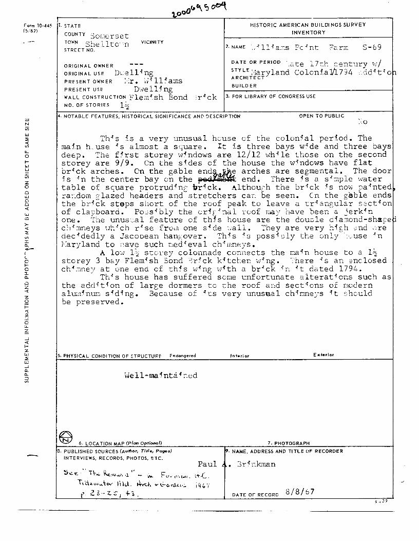
2-NAME .• .:llie.r:s ~c.:nt Fa.rm S-69
DATE OR PERIOD - c<.._e '7-J-, contury \•7/ ---l.. .L ~-" ~ ••
STYLE =·~aryland ColoniaJ/1794 . ddi ti 01:1 ARCHITECT
BUILDER
3. FOR LIBRARY OF CONGRESS USE
4. NOTABLE FEATURES, HISTORICAL SIGNIFICANCE AND DESCRIPTION OPEN TO PUBLIC
J:'his is a very unusual hcuse of the colonial per-iod. The mafn h.use is almost a sc;.uare. It is three bays wide and three bays deep. The f5rst storey .-.vindows are 12/12 whi.le those on the second storey are 9/9. Cn the sides of the house the windows have flat brick arches. On the gable end~ arches are segmental. The door is in the center bay on the psd-~ end. There is a siw.ple water table of sc;:uare protrudin[ brick. Althouch the brick is now painted, ra~dom 2lazed headers and stretchers ca~ be seen. Cn the z~ble ends the bri~k steps short of the roof peak to leave a trio.ngul~r section of clapboard. Po . .:sibly the orft_inal roof may have been a jerkin one. The unus'-~al feature of this house are the double dia::iond-shaoej chimneys uhich rise from one side ~.,·all. They are very hi[h and ctre decidedly a Jacobean han&,over. Th5s .:s possioly the only ::_use .:n i·:aryland to ~:ave such ;::·;ed.; eva 1 chi n-:neys •
A lm.v 1~2 stcrey colonnade connects the L'.a in house to a l~ storey 3 bc..y Flemish Bond 3r5ck kitchen wing. ·_'here is an enclosed ch-ir:mey at one end cf this v;ring 1.v-ith a brick "n .;t dated 1794.
This house has suffered soue unfortunate alterat°'ons such as the addition of large dormers tc the roof a:-,d sections of modern alu11inUE; siding. Because of ~-cs very unuse.al chimne:;·s °'t :.0 hculd be preserved.
5. PHYSICAL CONDITION OF ~TRUCTURE Endangered
\o'e 11-rna 5 nta i ned
~ 6. LOCATION MAP (Plan Optional)
ll. PUBLISHED SOURCES (Author, Title, Pages)
INTERVIEWS, RECORDS, PHOTOS, ':TC.
Interior Exterior
7. PHOTOGRAPH
19. NAME, ADDRESS AND Tl TLE OF RECORDER
Paul a. 3ri nk.rr.an
DATEOFRECORD 8/8/67
___ ,
·'
.;,.-.:
·,
-'
...____ _ __;-. Fair \.Island
\ ·. . / \' !:,',
\ \ \ ', \\
I
Williams~~
\
' \ \ \
.\
I I
I I
J
SA XI'' Q ,) U '' o· .i \' 1i~(_jIN1 t \ ,, N c ~ A f\'. ,..,,. ~/\N' JT . ' .... ,,, r LAND • I ' l I- ~Fl ,. - ' "\ES 1T()) •OCR
- I
' r ;;-: ' \ i . \
--'-..
u Q.J
z
,,,.. _·
::
.& __ •
r _ .
. --:---·
.J---( q (), 1J~ 1Zw1 ~ s~
P~:a.ph:J ~ DANIEL C. CHLinCH
Reward S- 69 William' s Point , Somerset County Federal Mantel 8/85 , Paul Touart , Photographer Neg . /Md . Historical Trust
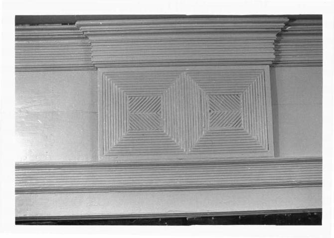
Reward S- 69 William's Point , Somerset County Federal Mantel Detail 8/85 , Paul Touart, Photographer Neg . /Md . Historical Trust
Reward S-69 William ' s Point, Somerset county Federal Mantel 8/85 , Paul Touart , Photographer Neg./Md . Historical Trust
" I
' '
..
Reward S-69 William's Point, Somerset County Federal Mantel Detail 8/85 , Paul Touart, Photographer Neg./Md. Historical Trust
Reward S- 69 William's Point , Somerset county Federal Mantel Detail 8/85 , Paul Touart , Photographer
Neg./Md . Historical Trust