Embed Size (px)
Citation preview
Stage 2 Education Pack – Breakfast Point and Cabarita Park
Page 1 of 33 Last Revised: 25/06/2013

Stage 2 Education Pack – Breakfast Point and Cabarita Park
Page 2 of 33 Last Revised: 25/06/2013
Table of Contents
1.0 Syllabus links ............................................................................................................................. 3
1.1 National Curriculum – syllabus implementation ..................................................................... 3
1.2 Human Society in its Environment ......................................................................................... 4
1.3 Science and Technology ........................................................................................................ 5
2.0 Additional resources ................................................................................................................. 6
2.1 Wangal People....................................................................................................................... 3
2.2 Images ................................................................................................................................... 4
2.3 General Information ............................................................................................................... 4
3.0 Traditional owners – the Wangal People ................................................................................. 8
3.1 Aboriginal people of the Wangal ............................................................................................ 8
3.2 Woollarawarre Bennelong ...................................................................................................... 8
4.0 Commemorations .................................................................................................................... 10
4.1 Federation – the Pavilion ..................................................................................................... 10
4.2 World War 2 – Victory Coppice ............................................................................................ 11
4.3 Sports Hero - William Beach ................................................................................................ 11
5.0 Changes over time ................................................................................................................... 12
5.1 Transport ............................................................................................................................. 12
5.2 Recreation ........................................................................................................................... 14
5.3 Industry ................................................................................................................................ 17
6.0 Student Activities..................................................................................................................... 18
7.0 Excursion ................................................................................................................................. 20
7.1 Notes for leaders ................................................................................................................. 21
7.2 Student worksheet .............................................................................................................. 31

Stage 2 Education Pack – Breakfast Point and Cabarita Park
Page 3 of 33 Last Revised: 25/06/2013
1.0 Syllabus Links Breakfast Point and Cabarita Park are an ideal educational resource for the students of the City of Canada Bay and
surrounding areas. Not only is it rich in history, it provides a fascinating study of a community and how it changes over
time. Within a small geographic area students can study the local aboriginal people, industry, transport, recreation, culture
and how a community celebrates its history through commemorations.
This education pack has been designed for Stage 2 as an integrated HSIE/History and Science unit of work. The
information packs provides background information and learning activities including a walking tour to the area – an ideal
excursion to bring the content to life. Many of the student tasks also have a strong literacy focus with activities requiring
students to write using text types - recounts, narrative, exposition and general communications as well as present a speech
to their classmates.
This education pack has been designed to cover both the current syllabi and the new national syllabi being introduced
during 2013 – 2016. See below for the implementation timetable of the NSW syllabuses for the Australian curriculum for
Kindergarten – Year 6
1.1 National Curriculum - syllabus implementation
Implementation timetable - NSW syllabuses for the Australian curriculum
2013 Familiarisation and planning
2014 English – start teaching
Mathematics – optional to start teaching
Science and Technology – optional to start teaching
2015 Mathematics – start teaching
Science and Technology – start teaching
History – optional to start teaching
2016 History – start teaching

Stage 2 Education Pack – Breakfast Point and Cabarita Park
Page 4 of 33 Last Revised: 25/06/2013
1.2 Human Society in its Environment/History
Current NSW Syllabus (Human Society in its Environment)
LEARNING OUTCOMES
Change and Continuity
CCS2.2
Explains changes in the environment and family life and evaluates the effects of these on different individuals, groups and
environments.
Environments
ENS2.5
Describes places in the local area and other parts of Australia and explains their significance.
ENS2.6
Describes people‟s interactions with environments and identifies responsible ways of interacting with environments.
New NSW syllabuses for the Australian curriculum (History)
LEARNING OUTCOMES
Community and Remembrance
HT2-1
Identifies celebrations and commemorations of significance in Australia and the world.
HT2-2
Describes and explains how significant individuals, groups and events contributed to changes in the local community over
time.
HT2-5
Applies skills of historical inquiry and communication.
Key Inquiry Questions
Who lived here first and how do we know?
How has our community changed?
What features have been lost and what features have been retained?
What is the nature of the contribution make by different groups and the individuals in the community.

Stage 2 Education Pack – Breakfast Point and Cabarita Park
Page 5 of 33 Last Revised: 25/06/2013
1.3 Science and Technology
Current NSW Syllabus
LEARNING OUTCOMES
Built Environments
People create specialised environments to meet specific needs.
Structures are built from natural and processed materials and components.
Environments are sometimes modified to fulfil new and different requirements.
New NSW syllabuses for the Australian curriculum
LEARNING OUTCOMES
Built Environments
ST2-14BE
Describes how people interact within built environments and the factors considered in their design and construction.

Stage 2 Education Pack – Breakfast Point and Cabarita Park
Page 6 of 33 Last Revised: 25/06/2013
2.0 Additional Resources
2.1 Wangal People
Detailed information is available from the Cadigal Wangal website developed by Marrickville Council that tells the
Indigenous history of the Cadigal and Wangal peoples. http://cadigalwangal.org.au/clientsite/
The Australian Encyclopaedia. Sydney, Australian Geographic, 1996 (Entry for Bennelong vol. 2 pp. 440-441)
Coupe, Sheena Concord, a centenary history. Concord, NSW: Council of the Municipality of Concord, 1983. (Contains
useful information although it incorrectly identifies the local Aboriginals as being part of the Kuringai tribe instead of the
Darug)
Guider, Michael Aboriginal history of the City of Canada Bay. The Author, 2003
Smith, Keith. Bennelong. Kangaroo Press, 2001
Turbet, Peter The Aborigines of the Sydney district before 1788. Kangaroo Press, 2001
Willey, Keith When the sky fell down. Collins, 1979
2.2 Images
Dedicated libraries relevant to the content of this education pack have been created in Flickr:
AGL http://tinyurl.com/cs9m64a Cabarita Park http://tinyurl.com/cazzhgx Correy’s Pleasure Gardens http://tinyurl.com/a43huha
For a comprehensive library of historial images of the City of Canada Bay visit
http://www.flickr.com/photos/canadabayconnections/
Further images are available from a larger image library that can only be accessed from within Concord and Five Dock
libraries. Refer to the link under Canada Bay Connections
http://www.canadabay.nsw.gov.au/your_local_library/local_studies_pg.html
2.3 General Information
Canada Bay Local History Blog
http://canadabayconnections.wordpress.com/
The Local Studies Librarian
Concord Library, 60 Flavelle St, Concord NSW 2137,
Five Dock Library, Level 1, 4-12 Garfield St, Five Dock NSW 2046
Tel 9911 6210 (Concord) or 9911 6310 (Five Dock) Fax 9911 6550 www.canadabay.nsw.gov.au

Stage 2 Education Pack – Breakfast Point and Cabarita Park
Page 7 of 33 Last Revised: 25/06/2013
1890. AGL site, Breakfast Point and Cabarita Park

Stage 2 Education Pack – Breakfast Point and Cabarita Park
Page 8 of 33 Last Revised: 25/06/2013
3.0 Traditional Owners – the Wangal People The Canada Bay area was part of the traditional
lands of the Aboriginal people of the Wangal
clan (also spelt „Wann-gal‟), whose name was
derived from the word for their country.
3.1 Aboriginal people of the Wangal
The Wangal were a clan of the Darug
(sometimes spelt Dharug) tribe or language
group. They called themselves the Eora,
meaning „the people‟. The Wangal clan‟s
territory is thought to have originally extended
from Darling Harbour, around the Balmain
Peninsula (including Goat Island (called Me-mel
or Memill) almost to Parramatta in the west, the
Parramatta River formed the northern boundary
although it is uncertain how far south their land
extended. The Wangal are believed to have
occupied the area for over 20,000 years.
First contact was made with local Aboriginals of
the Wangal Clan by Captain John Hunter who
led an exploration of the Parramatta River. On 5
February 1788 while having breakfast he was
met by Wangal at the location now referred to as Breakfast Point. William Bradley, First Lieutenant on board HMS Sirius,
recorded the following entry in the log:
We landed to cook breakfast on the opposite shore to them (Breakfast Pt.). We made signs to them to come over and waved
green boughs. Soon after which 7 of them came over in 2 canoes and landed near our boats. They left their spears in the
canoes and came to us. We tied beads etc. about them and left them our fire to dress their muscles which they went about as
soon as our boats put off.
During the summer months, the Wangal gathered much of their food from along the Parramatta River. The food consisted
mainly of fish and shellfish and the remains of these meals, known as shell middens, may still be seen on the foreshore.
The Wangal called the area Booridiow-o-gule. The name Cabarita is an Aboriginal word which is though to mean „by the
water‟.
3.2 Woollarawarre Bennelong
One of the best known members of the Wangal was
Woollarawarre Bennelong, who had a special
relationship with Goat Island for which he had
custodial or ownership responsibilities.
Bennelong was initially captured in November 1788
along with Colby, of the Cadigal clan, under the
instructions of Governor Arthur Phillip so he could
learn more about the local Aboriginal people.
Although some sources give the impression that
Bennelong was a willing collaborator, more recent
sources suggest that Bennelong was a far more
complex person in his dealings with the British. While
he and Phillip formed cordial relations it is
nevertheless thought that he probably instigated the
spearing of Phillip in 1790 at Manly as a payback for

Stage 2 Education Pack – Breakfast Point and Cabarita Park
Page 9 of 33 Last Revised: 25/06/2013
his earlier abduction. Bennelong had escaped in May 1790 but by September he was leading negotiations with Phillip for
peaceful Aboriginal-European contact following the Governor‟s spearing. Soon he was living at Government House eating
at Phillip‟s table and calling him beanga (father) while Phillip called him dooroow (son).
Bennelong was quick to learn English and adopted many British ways. A brick hut was built for him at Tubowgule (believed
to mean „white-clay headland‟) now known as Bennelong Point, the site of the Sydney Opera House.
In 1792 he travelled with Phillip to England where he met King George III, returning to his country in 1795. He resumed a
traditional Aboriginal lifestyle, fathering one son Dickie (c.1803-1823) by his third wife. Bennelong however found himself at
variance both with his own people and the British settlers. In January 1813 he died at the age of about 50 at Kissing Point,
Sydney, as a result of a tribal fight.
3.3 The Wangal at Canada Bay today
Today few traces of Aboriginal occupation survive in the Canada Bay area other than a few cave painting sites, rock
shelters and middens. It is believed that Parramatta Road was built upon an Aboriginal pathway which had been in use for
centuries.
The Wangal today are remembered by the Wangal Bushland Reserve (Mortlake) and Wangal Place (Five Dock).
Bennelong‟s name has been perpetuated in numerous street names throughout Sydney and is also the name of a Federal
Electorate. In nearby Sydney Olympic Park an area has been named the Wangal Woodland.
Illustrations of the Wangal People and Bennelong are from the Waiting Collection at the Natural History Museum, London.

Stage 2 Education Pack – Breakfast Point and Cabarita Park
Page 10 of 33 Last Revised: 25/06/2013
4.0 Commemorations
Cabarita Park is home to many memorials and commemorations to our past including the Federation of Australia, the
Second World War and even a local sports hero!
4.1 Federation – The Pavilion
Located in Cabarita Park is the Pavilion which had
been used for the signing of the Federation
documents and the proclamation of the
Commonwealth of Australia at Centennial Park in
1901. Concord Council bought the Pavilion for £60
and re-erected in Cabarita Park in 1903.
In 1901 it was a highly decorated pavilion. Now it is
a simple wooden structure.
In 1951, the Jubilee (50th birthday) of Federation
was celebrated at Cabarita Park at the Federation
Pavilion. A memorial tablet and plaque at the
rotunda was unveiled by the Honourable K.W. Street,
Lieutenant Governor and Chief Justice of NSW on 9
May. 10,000 people attended the unveiling
ceremony. The ceremony also included exhibitions
of gymnastics, waterskiing and speedboat racing.
1951. Jubilee of Federation at the Federation Pavilion, Cabarita Park.
1901. Signing of the Federation documents and the proclamation of the
Commonwealth of Australia at Centennial Park.

Stage 2 Education Pack – Breakfast Point and Cabarita Park
Page 11 of 33 Last Revised: 25/06/2013
4.2 World War 2 Memorial – Victory Coppice
A small memorial was placed in Cabarita Park in 1945 to
commemorate those men and women from the Concord area who
served and died in World War 2,
A row of trees forming a “Victory Coppice“ was also planted in a
ceremony on Arbor Day (25 August).
Unusually, the plantings are all native Australian plants. A similar
planting ceremony was held the following year on Arbor Day.
4.3 Sports Hero - William Beach
In 1938 a monument to William Beach was erected on the northern
shoreline of the park.
William Beach (1850 – 1935) was one of Australia‟s great international
scullers and undefeated world champion. In 1884 he defeated the
word champion Edward Hanlon on the sculling course on the
Parramatta River between Ryde Bridge and Henley Point.
Beach went on to defend his world title successfully six times before
his retirement in 1887.
1880. William Beach.

Stage 2 Education Pack – Breakfast Point and Cabarita Park
Page 12 of 33 Last Revised: 25/06/2013
5.0 Changes Over Time
5.1 Transport
Tram
In 1907 the steam tramway between Enfield and
Mortlake was extended to Cabarita. In February
1912 electric tram services replaced steam ones.
The tram ran until August 1948.
Bus
Today a bus service links Cabarita Park to
Ashfield Railway Station via Burwood Railway
Station, Enfield and Croydon Park.
Circa 1910. Steam Tram.
1912. Tram turning area now the bus turning area.
Stage 2 Education Pack – Breakfast Point and Cabarita Park
Page 13 of 33 Last Revised: 25/06/2013
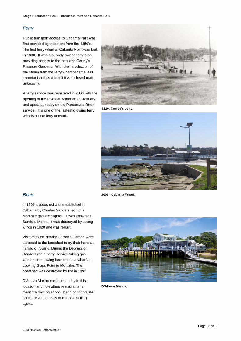
1920. Correy’s Jetty.
Ferry
Public transport access to Cabarita Park was
first provided by steamers from the 1850‟s.
The first ferry wharf at Cabarita Point was built
in 1880. It was a publicly owned ferry stop,
providing access to the park and Correy‟s
Pleasure Gardens. With the introduction of
the steam tram the ferry wharf became less
important and as a result it was closed (date
unknown).
A ferry service was reinstated in 2000 with the
opening of the Rivercat Wharf on 20 January,
and operates today on the Parramatta River
service. It is one of the fastest growing ferry
wharfs on the ferry network.
Boats
2006. Cabarita Wharf.
In 1906 a boatshed was established in
Cabarita by Charles Sanders, son of a
Mortlake gas lamplighter. It was known as
Sanders Marina. It was destroyed by strong
winds in 1920 and was rebuilt.
Visitors to the nearby Correy‟s Garden were
attracted to the boatshed to try their hand at
fishing or rowing. During the Depression
Sanders ran a „ferry‟ service taking gas
workers in a rowing boat from the wharf at
Looking Glass Point to Mortlake. The
boatshed was destroyed by fire in 1992.
D‟Albora Marina continues today in this
location and now offers restaurants, a
maritime training school, berthing for private
boats, private cruises and a boat selling
agent.
D’Albora Marina.

Stage 2 Education Pack – Breakfast Point and Cabarita Park
Page 14 of 33 Last Revised: 25/06/2013
5.2 Recreation
Before the arrival of settlers, Cabarita Park was a typical rocky outcrop along the shores of the Parramatta River. It was
first sighted by the new settlers in 1788.
The Park was reserved as a recreation area in 1856 and was accessible by steamer in the 1850‟s.
In the 1900‟s Cabarita Park was popular for picnics, swimming and watching boating races on the river. The park was
dedicated for public use in 1880.
Today over 2,000 Sydneysiders enjoy walking, cycling, swimming and running around the park every week.
Music, dancing and picnics
Music, dancing and picnics have always been
enjoyed at Cabarita Park.
From the 1880‟s until World War 1, a focus of
the park was Correy‟s Pleasure Gardens
operated on land adjacent to Cabarita Park.
The pleasure ground was established by
Thomas Obed Correy, who had previously
owned gardens at Botany in the 1870s.
Correy brought plants, flowers, shrubs and
trees to Cabarita and provided swings, merry-
go-rounds, a cricket field, a running track,
summer houses, and from 1887, a dance
pavilion, which was a great attraction for the
many social and sporting clubs that held their
annual picnics at the grounds.
The dance pavilion could accommodate up to
900 people who would be entertained by a ten-
piece string orchestra. Daytime dances were
popular until gas replaced the kerosene lamps
and evening dinners and dances became
increasingly popular making the pleasure
gardens one of Sydney‟s leading recreational
resorts.
During the World War One, Correy‟s Pleasure
Gardens declined in popularity and was
eventually sold in 1918.
1910. Correy’s Pleasure Gardens.
25 May 1897. Sydney Morning Herald http://trove.nla.gov.au/ndp/del/article/14105363?searchTerm=correys pleasure gardens steamer amusements&searchLimits=. Retrieved 12/02/13.

Stage 2 Education Pack – Breakfast Point and Cabarita Park
Page 15 of 33 Last Revised: 25/06/2013
Picnics continue to be popular at the park and today visitors can
enjoy art installed in the park in 2012 as part of the Reclamation
Art Project funded by Arts NSW..
Called the Observatory the artwork was inspired by the local
history of Correy‟s Pleasure Garden, weather observation from
the 18th century and the style of the 18th century. It is made up
of three pieces:
I. Storm Glass Hut features a barometer and weather
vane (pictured right)
II. Sundial Windflute features a listening device to hear the
sound of the prevailing wind and to tell the time using a
sundial.
III. Chaise Lounge Observatory provides a place to rest and
observe the area and includes a wind turbine to show
the speed of the wind.
2013. Google maps.
Approximate location of Correy’s Pleasure Gardens

Stage 2 Education Pack – Breakfast Point and Cabarita Park
Page 16 of 33 Last Revised: 25/06/2013
Swimming
Swimming has always been popular at Cabarita Park.
In the 1920‟s Concord Council netted in a shark proof swimming pool at the northern end o f Cabarita Park. It was a
segregated pool with one half for men and boys, the other half for women and girls. A popular place to meet was the
dividing fence and many romances bloomed! On busy days between 400 and 500 people visited the baths.
In 1930, work began on the Concord-Cabarita
Coronation Baths. It was built to provide employment
for the local community during the Depression. The
baths officially opened in November 1937. The baths
were named to commemorate the coronation of King
George IV. The baths cost £10,230 to build and uses
water pumped from Parramatta River.
About 3000 people turned up for the pool opening and
in the first month 30,000 people visited the baths. The
baths were remodelled in 1961 and again in 2008 and
remains a popular swimming spot.
It is open from September to April each year.
Cabarita Baths website:
http://www.cabaritaswimmingcentre.com.au/
1923. Cabarita Baths.
2009. Cabarita Baths.

Stage 2 Education Pack – Breakfast Point and Cabarita Park
Page 17 of 33 Last Revised: 25/06/2013
5.3 Industry – Australian Gaslight Company (AGL)
1893. Australian Gaslight Company.
Australian Gaslight Company (AGL) established the
Mortlake Gas Works in 1886 and occupied most of
the area now known as Breakfast Point. For many
companies involved in heavy industry, the
Parramatta River provided easy access for
transportation and, unfortunately, a means of
dumping the waste products from production. Today
the Parramatta River remains polluted.
The coal needed at AGL was transported from
Newcastle and a jetty was built to allow its delivery.
When AGL‟s plant was in full operation it used nearly
460,000 tonnes of coal per year. The last delivery of
coal was in 1971.
AGL began developing the site from 1883. By 1900
nearly 300 workers were employed at the site and
new shops, transport services, churches and
housing were developed to serve the workers.
During both World War 1 and World War 2, demand
for gas was high, so AGL expanded its operations.
By the 1960‟s the number of workers had increased
to 2,000 and included carpenters, plumbers,
machinists, fitters and blacksmiths.
In the 1990‟s operations wound down and when it
closed it was the largest gas manufacturing plant in
the southern hemisphere. In 2000 AGL sold the land
to a property developer and it was then turned into a
new suburb called Breakfast Point.
In 2000, AGL sold the land to property developer -
Rose Group. The Rose Group is owned by the Rose
Family, direct descendents of Thomas Rose who
came to Australia in 1793 as a free settler on board
HMS Bellona. In the same year, Thomas Rose was
given farming land at Liberty Plains, an area which
borders Breakfast Point.
The Rose Group then turned the old AGL site into a
new suburb called Breakfast Point.
These days Breakfast Point is a residential suburb
with a small town centre featuring a supermarket,
restaurants, shops, dentist and optometrists and is
home to nearly 2,000 people. Heavy industry has
left the Cabarita area.
Video of Breakfast Point residential estate from
Breakfast Point Realty:
http://www.breakfastpointrealty.com.au/index.cfm?pagecall=misc&pagemode=breakfastPointSuburbs
1960. Mortlake Bank at the AGL Wharf.
2008. Breakfast Point.

Stage 2 Education Pack – Breakfast Point and Cabarita Park
Page 18 of 33 Last Revised: 25/06/2013
6.0 Student Activities
These activities address:
Key enquiry questions from the History Syllabus (NSW Syllabus for Australian curriculum)
Who lived here first and how do we know?
How has our community changed?
What features have been lost and what features have been retained?
What is the nature of the contribution made by different groups and the individuals in the community
Learning outcomes for the Built Environments component of the NSW Syllabus and the NSW Syllabus for Australian
curriculum
Describe how people interact within built environments and the factors considered in their design and construction.
Activities
1. Research the local clan, the Wangal people, and its most famous member, Bennelong. Prepare a poster showing
your findings. What was the name for the area the Wangal people used?
2. The year is 1895. Imagine you are Mr Thomas Obed Correy, owner of Correy‟s Pleasure Gardens. You are
currently planning your summer programme of activities and need to create advertising showing the program of
activities for visitors to your Pleasure Gardens. Using Microsoft Word or Powerpoint, create either a brochure or a
presentation of what you are offering visitors. Use the Flickr accounts to access images:
http://tinyurl.com/a43huha
3. Create a timeline of Breakfast Point showing the events listed below. Include interesting facts and images:
Consider creating a class timeline with each child being responsible for gathering facts and images on a particular
event to add to the timeline. Encourage them to go and visit the area taking a camera to capture images of
remaining AGL buildings, the new residential development etc. The walking tour is a great excursion and is a
valuable source of information in the creation of the timeline.
Original inhabitants
First visit by a white person
Australian Gas Light establishment
Other buildings built due to AGL
Closure of the AGL plant
Breakfast Point residential development
4. Interview your parents, grandparents and/or neighbours and have them share their memories of Breakfast Point
and Cabarita Park. Ask them how things have changed and what activities they have enjoyed in the park over
their lives. See what they remember about AGL. Do they think Breakfast Point was better when AGL was there,
or now as a suburb of houses. Share your findings with the class in the form of a speech.
5. Prepare a list of pros and cons about closing an industrial site and turning it into a residential suburb.

Stage 2 Education Pack – Breakfast Point and Cabarita Park
Page 19 of 33 Last Revised: 25/06/2013
6. After the excursion: Have the students take on the role as Town Planner for the City of Canada Bay. Each Town
Planner has responsibility for one of these areas – transport, recreation and housing. Write a report to the Mayor
of Canada Bay about the current facilities provided and what improvements they would recommend. Think about
things such as needs for disabled people, families, older people, workers and residents. As a class write a letter to
the Mayor of Canada Bay with your recommendations.
7. After the excursion: Compare swimming at Cabarita Park today with what it would have been like in 1923. What
are the differences and the similarities? Do you think the baths are better today than in 1923? Why?
8. After the excursion: Prepare a diary entry recording a day out to Cabarita from either the viewpoint of 1912 or
2012. Describe what public transport you used to get there and what you did when you were there.

Stage 2 Education Pack – Breakfast Point and Cabarita Park
Page 20 of 33 Last Revised: 25/06/2013
7.0 Excursion
Explore Cabarita and Breakfast Point with a walking tour. The walk will take approximately 2-3 hours and can be concluded
with a lunch stop at Cabarita Park.
The walking tour commences at the Palace Hotel, Tennyson Road, Mortlake, proceeds through the former AGL site, now
known as Breakfast Point and concludes in Cabarita Park at the Federation Pavilion and picnic shed – an ideal spot for a
well earned lunch.
Length and time needed
The walk is approximately 3kms in length and is a relatively flat path. Allow approximately 90-120 minutes for the walk. As
the walk concludes in Cabarita Park, it is an ideal location for the group to enjoy a lunch before heading back to the school.
Access
The walk from Breakfast Point to Cabarita Park is on enclosed walkways and roads. Within Cabarita Park parts of the walk
are across grassed and sandy land. Due to this small stretch of grassed and sandy land, it is not suitable for students with
disabilities that impair their walking.
Recommended structure
The walk takes students on some roads, although the majority of the walk is on pedestrian pathways.
Care is needed when the students will cross Tennyson Road into the Breakfast Point Estate as there is no pedestrian
crossing.
Students will walk and cross some roads within the Breakfast Point Estate, however there is very little traffic on these roads.
It is recommended dividing the class into small groups accompanied by at least one adult.
What to bring
Students need to bring a pen and clipboard to complete the worksheet. All walkers will also need their hat and water bottle.
Children must also wear sunscreen.
Parramatta River
Students should not swim or paddle in the Parramatta River due to pollution.
Toilets
Toilets are located at the end of the walk at the Federation Pavilion at Cabarita Park but no where else on the walk.
Bus Parking
It is recommended that buses park on Tennyson Road, near the Palace Hotel to allow the students to disembark. Breakfast
Point estate does not have bus parking facilities.
Courtesy
Breakfast Point is a quiet residential area with many older residents and as such ask that the students ensure appropriate
behaviour.

Stage 2 Education Pack – Breakfast Point and Cabarita Park
Page 21 of 33 Last Revised: 25/06/2013
7.1 Notes for Leaders – Breakfast Point and Cabarita Park Walking Tour Excursion
The focus of the excursion is to address the following learning outcomes derived from the History and Science syllabi.
History
Gain an understanding of the traditional owners and the nature of their first contact with white settlers in the local area.
Understand how the areas of Breakfast Point and Cabarita Park have changed over the past 150 years with a
particular focus on transport, recreation and industry. Understand who made these changes and why they occurred.
Gain an understanding of how we celebrate and commemorate local history and events.
Science and Technology
View the nature of the foreshore of Parramatta River identifying natural features (i.e. mangroves, beaches) and
manmade features (i.e. wharves and swimming pools)
Observe how people use the area i.e. living, recreation, work, transport and how the area has been designed to meet
their needs such as access, parking, aesthetic and environmental needs.
Have students consider improvements that could be made to the area i.e. disabled access, needs of young families.

Stage 2 Education Pack – Breakfast Point and Cabarita Park
Page 22 of 33 Last Revised: 25/06/2013

Stage 2 Education Pack – Breakfast Point and Cabarita Park
Page 23 of 33 Last Revised: 25/06/2013
1. Palace Hotel
The original Palace Hotel was opened in 1886, the
same year as the opening of the AGL gasworks and
catered for the gasworkers nearer the river end.
First known as Montgomery‟s Palace, it was a
distinctive building with verandas and a tower and
was a popular spot for viewing of rowing events.
This hotel was demolished in the mid 1920s and a
new hotel, still named the Palace was built further
up Tennyson Road, nearly opposite the entrance to
the gasworks.
The AGL entrance was also the Mortlake tram
terminus. The hotel became a very popular watering
hole for the thirsty workers and was one of the few
of Sydney‟s early-opener hotels. This variation to
the normal hotel trading hours was to accommodate
workers coming off night shift.
2. Tennyson Road Shops
The establishment of the Australian Gas Light
Company‟s works at Mortlake in 1886 meant lots of
people coming into the area, which saw new
transport services, shops, churches open.
Mortlake became a thriving suburb. The shops on
the corner of Tennyson Road and MacDonald Street
date from the 1890s and the corner shop appears to
have been the area‟s first Post Office.

Stage 2 Education Pack – Breakfast Point and Cabarita Park
Page 24 of 33 Last Revised: 25/06/2013
3. AGL Gasworks – Fence and Entry
Destined to be the largest gas manufacturing plant in the
southern hemisphere, the Australian Gas Light Company‟s
(AGL) works at Mortlake opened in 1886. The site offered
easy access to Sydney by both land and water.
AGL began developing the site from 1883. By 1900 nearly
300 workers were employed at the site. During both World
War 1 and 2, demand for gas was high, so AGL expanded
its operations.
By the 1960‟s the number of workers had increased to 2,000
and included carpenters, plumbers, machinists, fitters and
blacksmiths.
In the 1990‟s operations wound down and when it closed it
was the largest gas manufacturing plant in the southern
hemisphere. In 2000, AGL sold the land to property
developer - Rose Group. The Rose Group is owned by the
Rose Family, direct descendents of Thomas Rose who came
to Australia in 1793 as a free settler on board HMS Bellona.
In the same year, Thomas Rose was given farming land at
Liberty Plains, an area which borders Breakfast Point.
The Rose Group then turned the old AGL site into a new
suburb called Breakfast Point.
These days Breakfast Point is a residential suburb with a
small town centre featuring a supermarket, restaurants,
shops, dentist and optometrists and is home to nearly 2,000
people. Heavy industry has left the Cabarita area.
4. Main Office No. 1
The main office building was the main administrative centre
of the complex during a large part of the last century. Today
it operates as the Estate Office, a recreation space for
Breakfast Point residents and offices for local businesses.

Stage 2 Education Pack – Breakfast Point and Cabarita Park
Page 25 of 33 Last Revised: 25/06/2013
5. Meter Readers‟ Office
This building is also known as the “Steel Mains Office”, “Pay
Office”, and “Telephone Room”. Available evidence suggests
that it was built in 1924 in its original form with three sections
separated by roofed walk- through bays. Today is a real
estate office for the Breakfast Point estate.
6. Fitters‟, machinists‟, carpenters‟ and plumbers‟
workshop
This building was built as part of the extensive building
program commenced in 1913. Furnished with a range of
machine tools, the workshops were described as being well-
equipped for all trades. By 1955 workshops on the site
accommodated 750 tradesmen. The building remains empty
today.
7. Blacksmith‟s Shop
The building now known as the Blacksmith‟s Shop was
erected as a general workshop in late 1891. It was
renovated in 1922 and is one of the few nineteenth century
structures which remain largely intact at the former AGL site.
Today the building is the display office for the Breakfast
Point Estate.

Stage 2 Education Pack – Breakfast Point and Cabarita Park
Page 26 of 33 Last Revised: 25/06/2013
8. Powerhouse
The Powerhouse was built in 1910-11 to help provide power
to a major extension to the AGL plant. Today it remains
empty.
9. Breakfast Point
Breakfast Point was so named because it was here that
Captain John Hunter who led an exploration of the
Parramatta River stopped to have breakfast on the 5
February, 1788. On that occasion Hunter was met by
members of the Wangal clan.
Breakfast Point was one of the few place names
included on Hunter‟s chart of the expedition and the
name was in common use by 1799. The Wangal people
called the area Booridiow-o-gule.
Take the gravel path down to the foreshore and then
follow gravel path to the site of the original AGL wharf.
10. Site of the original AGL wharf
The Mortlake site offered easy access to Sydney by
both land and water. A jetty was built to allow the direct
delivery of coal. When AGL‟s plant was in full operation
it used nearly 460,000 tonnes of coal per year. This was
brought from Hexham on the Hunter River by colliers
known as the „Sixty Milers‟. The last collier brought coal
to Mortlake in 1971.

Stage 2 Education Pack – Breakfast Point and Cabarita Park
Page 27 of 33 Last Revised: 25/06/2013
11. Mangroves
Throughout the 1800‟s and for the first half of the 20th
century, tidal mangroves and salt marsh flats were found at
the heads of many of the bays and inlets of the Parramatta
River. The mangroves depended on drainage and tides.
The shape of the foreshores and the recreation areas
around the bays are because of projects undertaken by
Concord Council from the 1920s to the 1980s to reclaim the
local environment.
12. Current ferry wharf
The wharf was opened on 20 January, 2000 and is serviced
by the Rivercat as part of the Parramatta River service.
Ferries have played an important role in how people have
used Cabarita Park. Today many people walk, cycle and
drive to the ferry wharf as they make their way to work or
social activities.
13. Site of the original baths (demolished)
Concord Council netted in a shark proof swimming pool at
the northern end of Cabarita Park in the early 1920s. The
pool was divided with one half for men and boys, the other
half for women and girls. A popular place to meet was the
dividing fence with many romances blooming! On busy days
between 400 and 500 people visited the baths.
Stage 2 Education Pack – Breakfast Point and Cabarita Park
Page 28 of 33 Last Revised: 25/06/2013
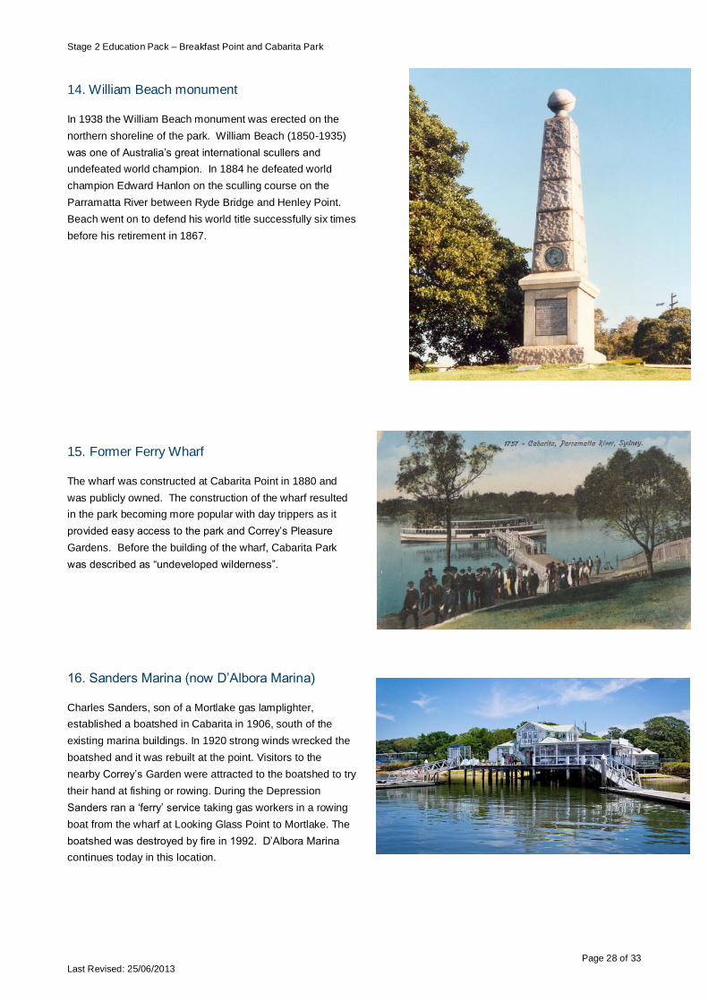
14. William Beach monument
In 1938 the William Beach monument was erected on the
northern shoreline of the park. William Beach (1850-1935)
was one of Australia‟s great international scullers and
undefeated world champion. In 1884 he defeated world
champion Edward Hanlon on the sculling course on the
Parramatta River between Ryde Bridge and Henley Point.
Beach went on to defend his world title successfully six times
before his retirement in 1867.
15. Former Ferry Wharf
The wharf was constructed at Cabarita Point in 1880 and
was publicly owned. The construction of the wharf resulted
in the park becoming more popular with day trippers as it
provided easy access to the park and Correy‟s Pleasure
Gardens. Before the building of the wharf, Cabarita Park
was described as “undeveloped wilderness”.
16. Sanders Marina (now D‟Albora Marina)
Charles Sanders, son of a Mortlake gas lamplighter,
established a boatshed in Cabarita in 1906, south of the
existing marina buildings. In 1920 strong winds wrecked the
boatshed and it was rebuilt at the point. Visitors to the
nearby Correy‟s Garden were attracted to the boatshed to try
their hand at fishing or rowing. During the Depression
Sanders ran a „ferry‟ service taking gas workers in a rowing
boat from the wharf at Looking Glass Point to Mortlake. The
boatshed was destroyed by fire in 1992. D‟Albora Marina
continues today in this location.

Stage 2 Education Pack – Breakfast Point and Cabarita Park
Page 29 of 33 Last Revised: 25/06/2013
17. Cabarita Baths
Construction of the Concord-Cabarita Coronation Baths was
a project of the Depression years, providing employment for
the local community. Work on the project began in 1930 but
it was not until November 1937 that the saltwater baths were
opened. Named to commemorate the coronation of King
George VI the baths were constructed at a cost of ₤10,230
using water pumped from the Parramatta River. About 3,000
people turned up for the pool opening and in the first month
30,000 people visited the baths. The baths were remodeled
in 1961.
18. Reclamation Art Project – The Observatory
The featured art was installed in 2012 as part of the
Reclamation Art Project funded by Arts NSW.
Called the Observatory the artwork was inspired by the local
history of Correy‟s Pleasure Garden, weather observation
from the 18th century and the style of the same period. It is
made up of three pieces:
I. Storm Glass Hut features a barometer and weather
vane (pictured right)
II. Sundial Windflute features a listening device to
hear the sound of the prevailing wind and to tell the
time using a sundial
III. Chaise Lounge Observatory provides a place to
rest and observe the area and includes a wind
turbine to show the speed of the wind.
19. Victory Coppice
To commemorate those from the Concord area who
served and died during World War 2, a small memorial
was placed in Cabarita Park in 1945.
A row of trees forming a „Victory Coppice‟ was also
planted in a ceremony on Arbor Day (25 August) along
the southern road.
Unusually, the plantings are exclusively of species
native to Australia. A similar planting ceremony was
held the following year on Arbor Day.

Stage 2 Education Pack – Breakfast Point and Cabarita Park
Page 30 of 33 Last Revised: 25/06/2013
20. Tram turning area
In 1907 the steam tramway between Enfield and
Mortlake was extended to Cabarita. The present bus
stop was the tram turning area. The tram made Correy‟s
Pleasure Gardens even more popular. The ferry wharf
became less important after the steam tram operated to
the park entrance.
21. Federation Pavilion
The pavilion which had been used for the signing of the
Federation documents and the proclamation of the
Commonwealth of Australia at Centennial Park in 1901.
Concord Council bought the pavilion for ₤60 and re-
erected in Cabarita Park in 1903. Much altered, the
simple wooden structure is scarcely recognisable as the
elaborately decorated pavilion of the Federation
ceremonies.
22. Site of former kiosk.
In 1923, a substantial kiosk was erected. The kiosk and
caretaker‟s cottage were damaged by fire in 1979 and
demolished in 1981.
In 1982, Concord Council constructed a large picnic
shed on the site of the former caretaker‟s residence and
kiosk.

Stage 2 Education Pack – Breakfast Point and Cabarita Park
Page 31 of 33 Last Revised: 25/06/2013
Breakfast Point and Cabarita Park Walking Tour
7.2 Student worksheet

Stage 2 Education Pack – Breakfast Point and Cabarita Park
Page 32 of 33 Last Revised: 25/06/2013
Mapping
Using the map mark label the locations using numbers of the following landmarks:
1. Palace Hotel
2. Tennyson Road Shops
3. Original entrance to Australian Gaslight Company (AGL)
4. Original main office of AGL (now the estate office)
5. Original meter readers‟ office (now a real estate office)
6. Fitters‟, machinists‟, carpenters‟ and plumbers‟ workshop
7. Blacksmiths‟ shop
8. Powerhouse
9. Breakfast Point
10. Site of the original AGL wharf
11. Mangroves
12. Current ferry wharf
13. Sit of the original baths (demolished)
14. William Beach monument
15. Former ferry wharf
16. D‟Albora Marina (former Sanders Marina)
17. Cabarita Baths
18. Reclamation Art Project
19. Victory Coppice
20. Bus/Tram turning circle
21. Federation Pavilion
22. Picnic shed (Site of the former kiosk)
The past
During your walk list all things that remind us of the past use of the area and the people that lived and worked in the area.
__________________________________________________________________________________________________
__________________________________________________________________________________________________
__________________________________________________________________________________________________
__________________________________________________________________________________________________
__________________________________________________________________________________________________
__________________________________________________________________________________________________
__________________________________________________________________________________________________
__________________________________________________________________________________________________
__________________________________________________________________________________________________

Stage 2 Education Pack – Breakfast Point and Cabarita Park
Page 33 of 33 Last Revised: 25/06/2013
Transport
List all the forms of transport you see during the walk. Why do you think people use these forms of transport?
__________________________________________________________________________________________________
__________________________________________________________________________________________________
__________________________________________________________________________________________________
__________________________________________________________________________________________________
__________________________________________________________________________________________________
__________________________________________________________________________________________________
__________________________________________________________________________________________________
__________________________________________________________________________________________________
Man made structures. Choose one man made structure you see on your walk. Describe it and then think of three (3) improvements you would make:
__________________________________________________________________________________________________
__________________________________________________________________________________________________
__________________________________________________________________________________________________
__________________________________________________________________________________________________
__________________________________________________________________________________________________
__________________________________________________________________________________________________
__________________________________________________________________________________________________
__________________________________________________________________________________________________
Natural Environment.
Recommend three (3) actions or changes to improve the quality of the natural environment i.e. foreshore, beaches,
Parramatta River, parks.
__________________________________________________________________________________________________
__________________________________________________________________________________________________
__________________________________________________________________________________________________
__________________________________________________________________________________________________
__________________________________________________________________________________________________
__________________________________________________________________________________________________
__________________________________________________________________________________________________
__________________________________________________________________________________________________