Embed Size (px)
Citation preview

Part 6 Zones
6.1 Preliminary(1) Zones organise the planning scheme area in a way that facilitates the location of preferred or
acceptable land uses.
(2) Zones are mapped and included in Schedule 2.
(3) The levels of assessment for development in a zone are in Part 5.
(4) Assessment criteria for zones are contained in a zone code.
(5) A precinct may be identified for part of a zone.
(6) Precinct provisions are contained in the zone code.
(7) Each zone code identifies the following:(a) the application of the code;(b) the purpose of the code;(c) the overall outcomes that achieve the purpose of the code;(d) the performance outcomes of the code;(e) the acceptable outcomes of the code.
(8) The following are the zone codes for the planning scheme:(a) 6.2.1 Community facilities zone code;(b) 6.2.2 Conservation zone code;(c) 6.2.3 District centre zone code;(d) 6.2.4 Emerging community zone code;(e) 6.2.5 Environmental management zone code;
(i) Environmental management precinct 1 – Residential;(ii) Environmental management precinct 2 – Russell Heads;
(f) 6.2.6 High impact industry zone code;(g) 6.2.7 Local centre zone code;(h) 6.2.8 Low density residential zone code;(i) 6.2.9 Low impact industry zone code;(j) 6.2.10 Low-medium density residential zone code;(k) 6.2.11 Major centre zone code;(l) 6.2.12 Medium density residential zone code;(m) 6.2.13 Medium impact industry zone code;(n) 6.2.14 Mixed use zone code;
(i) Mixed use precinct 1 – Commercial;(ii) Mixed use precinct 2 – Trades and services;(iii) Mixed use precinct 3 – Residential.
(o) 6.2.15 Neighbourhood centre zone code;(p) 6.2.16 Open space zone code;(q) 6.2.17 Principal centre zone code;(r) 6.2.18 Rural residential zone code;(s) 6.2.19 Rural zone code;(t) 6.2.20 Special purpose zone code;(u) 6.2.21 Specialised centre zone code;
(i) Specialised centre precinct 1 – Hospitals and allied medical;(ii) Specialised centre precinct 2 – Showgrounds and major sports;(iii) Specialised centre precinct 3 – James Cook University.
CairnsPlan 2016 Version 1.2Part 6 │ Page 126
(v) 6.2.22 Sport and recreation zone code;(w) 6.2.23 Tourism zone code;(x) 6.2.24 Tourist accommodation zone code;
(i) Tourist accommodation precinct 1 – Islands(y) 6.2.25 Township zone code;(z) 6.2.26 Waterfront and marine industry zone code.
CairnsPlan 2016 Version 1.2Part 6 │ Page 127
6.2 Zone codes
6.2.1 Community facilities zone code
6.2.1.1 Application
(1) This code applies to assessing development in the Community facilities zone.
(2) When using this code, reference should be made to Part 5.
6.2.1.2 Purpose
(1) The purpose of the Community facilities zone code is to provide for community related activities and facilities whether under public or private ownership.
These may include the provision of municipal services, public utilities, government installations, hospitals and schools, transport and telecommunication networks and community infrastructure of an artistic, social or cultural nature.
(2) The purpose of the code will be achieved through the following overall outcomes:(a) development is located in accessible locations and is generally consistent in scale, height
and bulk with that of surrounding development;(b) development is designed to provide and promote safe and efficient public use, walking
and cycling;(c) development is in accessible locations;(d) development is supplied with necessary infrastructure and is well integrated with
surrounding land uses;(e) development is of a form specific to the operational requirements of the facility;(f) development reflects and responds to the natural features and constraints of the land.
6.2.1.3 Criteria for assessment
Part A – Criteria for self-assessable and assessable development
Table 6.2.1.3.a - Community facilities zone code – self-assessable and assessable development
Performance outcomes Acceptable outcomes
For self-assessable and assessable development
Height
PO1The height of all buildings and structures is compatible with the character of the area and does not adversely affect the amenity of the area.
Note – A visual impact assessment may be required where a proposed development exceeds the height stated in AO1.1. Planning scheme policy – Landscape values provides guidance on undertaking a visual impact assessment.
Note – The setbacks stated in AO2.1 correspond with the height stated in AO1.1. Where a proposed development exceeds the height stated in AO1.1, the proposed development will also be assessed against PO2.
AO1.1Buildings and structures are not more than 8.5 metres and 2 storeys in height.
Note – Height is inclusive of the roof height.
CairnsPlan 2016 Version 1.2Part 6 │ Page 128

Performance outcomes Acceptable outcomes
Setbacks
PO2Buildings and structures are set back to ensure that they are compatible with the amenity of the area and do not adversely affect other uses.
AO2.1Buildings and structures are set back not less than:(a) 10 metres from the frontage to a State-
controlled road or existing or proposed Sub-arterial road, as identified on the Transport network overlay maps contained in Schedule 2;
(b) 6 metres from the frontage to any other road;
(c) 3 metres from all other boundaries.
PO3Car parking areas are set back from the boundaries of the site to ensure that they do not dominate the character of the site.
AO3.1Car parking areas are set back not less than:(a) 2 metres from the road frontage/s of the
site;(b) 2 metres from side and rear boundaries.
PO4Setbacks to car parking areas are landscaped to enhance the amenity of the site and to provide a buffer to adjacent residential land, residential uses and other sensitive sites.
AO4.1The setback between the road frontage/s and the car parking area is landscaped in accordance with the Landscaping code.
AO4.2The setback between the boundary with land included in a Residential zone and the car parking area is landscaped in accordance with the Landscaping code to provide a buffer to the residential land.
Note – Refer to the definition of Residential zones contained in Schedule 1.2.
For assessable development
Uses and other development
PO5Development is consistent with the purpose and overall outcomes sought for the zone.
AO5.1No acceptable outcomes are provided.
Site constraints
PO6Development is located, designed, operated and managed to respond to the characteristics, features and constraints of the site and its surrounds.
Note – Planning scheme policy – Site assessments provides guidance on identifying the characteristics, features and constraints of a site and its surrounds.
AO6.1No acceptable outcomes are provided.
CairnsPlan 2016 Version 1.2Part 6 │ Page 129
6.2.2 Conservation zone code
6.2.2.1 Application
(1) This code applies to assessing development in the Conservation zone.
(2) When using this code, reference should be made to Part 5.
6.2.2.2 Purpose
(1) The purpose of the Conservation zone code is to provide for the protection, restoration and management of areas identified as supporting significant biological diversity and ecological integrity.
(2) The local government purpose of the code is:(a) to ensure the conservation, protection and restoration of the biological diversity,
ecological integrity and scenic amenity values of land and provide for habitat connectivity;(b) to recognise that land within this zone is generally not suitable for further development;(c) to ensure that where development does occur in the zone, it does not adversely affect the
environmental and scenic amenity values of the zone and is in keeping with the natural characteristics of the land.
(3) The purpose of the code will be achieved through the following overall outcomes:(a) land within the Conservation zone is appropriately managed to protect and maintain
biological diversity, water quality, ecological functioning, beach protection and coastal management, scenic amenity and historical and cultural values;
(b) the values of the Wet Tropics World Heritage Area are protected; (c) development does not occur within the zone, with the exception of low intensity
development based on the appreciation of the significant values of the area where a demonstrated need exists;
(d) areas which form part of the scenic rim are protected from adverse effects of development on their scenic values;
(e) development does not adversely affect the conservation or scenic values of the site or surrounding area;
(f) development does not adversely affect areas of environmental significance on the site or surrounding area;
(g) lot reconfiguration, other than amalgamations or boundary realignments to resolve minor, existing encroachments, does not occur;
(h) development reflects and responds to the natural features and constraints of the land.
Note – Planning scheme policy – Natural areas provides further guidance on meeting the overall outcomes.
CairnsPlan 2016 Version 1.2Part 6 │ Page 130

6.2.2.3 Criteria for assessment
Part A - Criteria for assessable development
Table 6.2.2.3.a – Conservation zone code – assessable development
Performance outcomes Acceptable outcomes
For assessable development
Height
PO1The height of buildings and structures is compatible with the character of the area and does not adversely affect the amenity of the area.
Note – A visual impact assessment may be required where a proposed development exceeds the height stated in AO1.1. Planning scheme policy – Landscape values provides guidance on undertaking a visual impact assessment.
Note – The setbacks stated in AO2.1 correspond with the height stated in AO1.1. Where a proposed development exceeds the height stated in AO1.1, the proposed development will also be assessed against PO2.
AO1.1Buildings and structures are not more than 8.5 metres and 2 storeys in height.
Note – Height is inclusive of the roof height.
Setbacks
PO2Buildings and structures are set back from the boundaries of the site to maintain the character and amenity of the area.
AO2.1Buildings and structures are set back not less than:(a) 40 metres from the frontage to a state
controlled road;(b) 20 metres from the frontage to any other
road;(c) 10 metres from the side and rear
boundaries.
Uses and other development
PO3Development is consistent with the purpose and overall outcomes sought for the zone.
AO3.1No acceptable outcomes are provided.
Site constraints
PO4Development is located, designed, operated and managed to respond to the characteristics, features and constraints of the site and its surrounds.
Note - Planning scheme policy – Site assessments provides guidance on identifying the characteristics, features and constraints of a site and its surrounds.
AO4.1No acceptable outcomes are provided.
Amenity
PO5Development complements, and is subservient to, the surrounding environment and is in keeping with the unique ecological and scenic values of the area.
AO5.1The exterior finishes and colours of development are non-reflective and complement the colours of the surrounding vegetation and view shed.
CairnsPlan 2016 Version 1.2Part 6 │ Page 131

Performance outcomes Acceptable outcomes
PO6Development is screened from view from the boundaries of adjoining premises and roads through appropriate landscaping which ensures the native landscape character of the area dominates.
Note - Planning scheme policy – Landscaping provides further guidance on meeting this Performance Outcome.
AO6.1No acceptable outcomes are provided.
Values
PO7Development is located to:(a) protect the ecological values of the site
and surrounding land;(b) maintain the scenic values of the area;(c) maintain appropriate setbacks to
waterways, watercourses, wetlands and tidal areas, and overland flow paths;
(d) avoid areas that are vulnerable to natural hazards;
(e) minimise to the greatest extent possible, on-site excavation and filling;
(f) provide buffers to cultural, historical or ecological features;
(g) minimise visibility from external sites or public viewing points;
(h) minimise to the greatest extent possible the loss of native vegetation and fauna habitat.
AO7.1No acceptable outcomes are provided.
PO8Development does not result in adverse impacts on ecological function or values onsite, on surrounding land or waterways or wetlands.
PO8.1No acceptable outcomes are provided.
PO9Rehabilitation of natural processes on disturbed sites is undertaken to improve the environmental integrity of the area.
AO9.1No acceptable outcomes are provided.
PO10Fencing is designed to not impede the movement of fauna through the site.
AO10.1No acceptable outcomes are provided.
Lot reconfiguration
PO11Lot reconfiguration results in no additional lots, except where associated with a lease exceeding 10 years and associated with an existing or approved Telecommunications facility.
PO11.1No acceptable outcomes are provided.
CairnsPlan 2016 Version 1.2Part 6 │ Page 132
6.2.3 District centre zone code
6.2.3.1 Application
(3) This code applies to assessing development in the District centre zone.
(4) When using this code, reference should be made to Part 5.
6.2.3.2 Purpose
(1) The purpose of the District centre zone code is to provide for a mix of uses and activities.
It includes a concentration of land uses including retail, commercial, residential, offices, administrative and health services, community, small-scale entertainment and recreational facilities capable of servicing a district.
(2) The local government purpose of the code is to ensure development is consistent with the identified role and function of District centres within the hierarchy of centres.
(3) The purpose of the code will be achieved through the following overall outcomes:(a) a range of retail, business, entertainment and community activities focussed on the
weekly and fortnightly shopping and service needs of the surrounding communities is provided;
(b) higher density residential uses are integrated through mixed use development that is appropriate to the scale of the District centre and supports the public transport network;
(c) retail, business, entertainment and community activities occur on the first two storeys of development to ensure these uses are highly accessible and contribute to a vibrant mixed use space at ground level;
(d) development is located and designed to maximise activity along the primary street frontage with buildings maintaining a human scale and pedestrian focus at street level;
(e) development provides a high level of amenity and reflects the surrounding character of the area;
(f) development provides a high quality interface to adjoining premises and manages impacts on adjacent development through appropriate location, design, operation and management;
(g) development contributes to vibrant, engaging and active district centres that are safe, comfortable and enjoyable for pedestrians;
(h) development incorporates appropriately scaled art and cultural infrastructure;(i) development incorporates a high standard of urban design, and landscaping that
contributes to attractive and functional buildings, streets and places;(j) development maximises public transport accessibility and use, and encourages walking
and cycling;(k) development has access to infrastructure and essential services;(l) development does not compromise the hierarchy of centres, whether as a result of the
impacts from an individual development or the cumulative impacts of multiple developments;
(m) development reflects and responds to the natural features and constraints of the land.
CairnsPlan 2016 Version 1.2Part 6 │ Page 133
6.2.3.3 Criteria for assessment
Part A - Criteria for self-assessable and assessable development
Table 6.2.3.3.a – District centre zone code – self-assessable and assessable development
Performance outcomes Acceptable outcomes
For self-assessable and assessable development
Height
PO1The height of buildings contributes to the establishment of clearly recognisable commercial nodes without significantly affecting the character and desired amenity of the surrounding area.
Note – A visual impact assessment may be required where a proposed development exceeds the height stated in AO1.1. Planning scheme policy – Landscape values provides guidance on undertaking a visual impact assessment.
Note – The site coverage stated in AO2.1 and setbacks stated in AO3.1 correspond with the height stated in AO1.1. Where a proposed development exceeds the height stated in AO1.1, the proposed development will also be assessed against PO2 and PO3.
AO1.1Buildings and structures are not more than 14 metres and 3 storeys in height.
Note – Height is inclusive of the roof height.
Site coverage
PO2The site coverage ensures that there is sufficient space for landscaping, access and the provision of services.
AO2.1The site coverage is not more than 80%.
Setbacks
PO3The siting of buildings contributes to the desired amenity and character of the area and protects the amenity of other land uses.
AO3.1Buildings are set back:(a) 0 metres from a street frontage boundary;
or(b) not less than 3 metres from a street
frontage boundary;(c) not less than 5 metres from the side and
rear boundaries; or(d) 0 metres from the side and rear boundaries
where there is a common boundary with land in a Centre zone, the Mixed use zone or an Industry zone.
Note – Refer to the definitions of Centre zone and Industry zone contained in Schedule 1.2.
AO3.2Setback areas are clear of service equipment and storage areas and landscaped in accordance with the Landscaping code.
For assessable development
Uses and other development
PO4Development is consistent with the purpose and overall outcomes sought for the zone.
AO4.1No acceptable outcomes are provided.
CairnsPlan 2016 Version 1.2Part 6 │ Page 134

Performance outcomes Acceptable outcomes
Site constraints
PO5Development is located, designed, operated and managed to respond to the characteristics, features and constraints of the site and its surrounds.
Note – Planning scheme policy – Site assessments provides guidance on identifying the characteristics, features and constraints of a site and its surrounds.
AO5.1No acceptable outcomes are provided.
Role and function of District centres
PO6Development reinforces the role and function of District centres within the hierarchy of centres.
Note – The role and function of the hierarchy of centres is described 3.3.2 Element – Centres and centre activities within Part 3 Strategic framework.
Note – A Centre need and impact assessment may be required to demonstrate compliance with this performance outcome.
AO6.1Development within a District centre (excluding Babinda and Gordonvale District centres) does not exceed 15,000m2 GFA;
or
AO6.2Where development exceeds a cumulative total of 15,000m2 for the District centres of Manoora, Manunda, Mount Sheridan, Redlynch or Westcourt, then development does not exceed 500m2 GFA in any calendar year;
or
AO6.3Development provides a Centres need and impact assessment that demonstrates:(a) there is a need for the development:(b) the development does not compromise the
hierarchy of centres, whether as a result of the individual or cumulative impacts of the development;
(c) that the development does not result in the District centre performing the role and function of a Major centre or the Principal centre.
Note – Planning scheme policy – Centres and centre activities provides further guidance on meeting the acceptable outcome.
Lot reconfiguration
PO7Reconfiguration of land results in a layout and size of lots that reinforces:(a) a mix of adaptive buildings and centre
activities;(b) large, rectangular shaped lots;(c) accessibility across land within the zone to
key public transport and public places on adjacent roads and land;
(d) integrated drainage across sites.
AO7.1Reconfiguration of land ensures future development contains sufficient area to further develop the zone with consistent uses.
AO7.2Lots are serviced with safe, efficient and legal access without diminishing existing improvements and future development on the resulting lots.
AO7.3Drainage management and infrastructure
CairnsPlan 2016 Version 1.2Part 6 │ Page 135
Performance outcomes Acceptable outcomes
services are integrated across sites through easements, reserves or other legal means.
CairnsPlan 2016 Version 1.2Part 6 │ Page 136

6.2.4 Emerging community zone code
6.2.4.1 Application
(5) This code applies to assessing development in the Emerging community zone.
(6) When using this code, reference should be made to Part 5.
6.2.4.2 Purpose
(1) The purpose of the Emerging community zone code is to:(a) identify land that is suitable for urban purposes and protect land that may be suitable for
urban development in the future;(b) manage the timely conversion of non-urban land to urban purposes;(c) prevent or discourage development that is likely to compromise appropriate longer term
land use.
(2) The local government purpose of the code is to:(a) allocate land suitable for urban purposes, where a degree of flexibility is necessary to
determine a suitable pattern of development and to meet future needs of emerging communities;
(b) recognise that some land within the zone is subject to constraints that may make it unsuitable for urban development;
(c) provide for the sequential delivery of infrastructure to meet the needs of future communities.
(3) The purpose of the code will be achieved through the following overall outcomes:(a) land is developed in an orderly sequence providing physical, social and cultural
infrastructure to meet the needs of the emerging community;(b) development contributes to an integrated and coordinated community and provides a
structure that considers future development, infrastructure provision and land use allocations;
(c) development is carried out in accordance with a structure plan that integrates land use, infrastructure and the sequencing of development within more discrete areas of the zone;
(d) development of land affected by overlays meets the outcomes of the relevant overlay codes;
(e) development is not established where it would constrain future urban development or be in conflict with the efficient expansion of urban areas;
(f) development reflects and responds to the natural features and constraints of the land.
CairnsPlan 2016 Version 1.2Part 6 │ Page 137
6.2.4.3 Criteria for assessment
Part A - Criteria for self-assessable and assessable development
Table 6.2.4.3.a – Emerging community zone code – self-assessable and assessable development
Performance outcomes Acceptable outcomes
For self-assessable and assessable development
Development not in a structure plan area
Height
PO1The height of all buildings and structures is in keeping with the rural character and amenity of the area.
Note – A visual impact assessment may be required where a proposed development exceeds the height stated in AO1.1. Planning scheme policy – Landscape values provides guidance on undertaking a visual impact assessment.
Note – The setbacks stated in AO2.1 correspond with the height stated in AO1.1. Where a proposed development exceeds the height stated in AO1.1, the proposed development will also be assessed against PO2.
AO1.1Buildings and structures are not more than 8.5 metres and 2 storeys in height.
Note – Height is inclusive of the roof height.
Setbacks
PO2Buildings and structures are set back to:(a) maintain the rural character and amenity of
the area;(b) achieve separation from neighbouring
development and road frontages.
AO2.1Buildings and structures are set back not less than:(a) 40 metres from the frontage to a State-
controlled road;(b) 10 metres from the frontage to a Major rural
road;(c) 6 metres from any other road;(d) 6 metres from the side and rear boundaries
of the site.
For assessable development
Structure planning
PO3A structure plan is prepared outlining the manner in which the development outcomes have been integrated with respect to the following, including any precinct specific outcomes:(a) development sequencing;(b) structure of communities and place making;(c) economic development and employment;(d) housing diversity;(e) transport and mobility;(f) community facilities and recreation land;(g) infrastructure networks;(h) centres;(i) overlay code outcomes;(j) local plan code outcomes.
Note – Guidance on preparing a structure plan is provided within Planning scheme policy – Structure planning.
AO3.1No acceptable outcomes are provided.
CairnsPlan 2016 Version 1.2Part 6 │ Page 138
Performance outcomes Acceptable outcomes
Incompatible development
PO4Non-urban development is only established where it would not constrain the efficient expansion of urban development in the future.
AO4.1Development does not constrain the efficient expansion of urban areas.
Interim development
PO5Development which is not in its ultimate intended form does not compromise the achievement of such desired form.
AO5.1The use of land, which is inconsistent or incompatible with the ultimate form of development is not established;
or
AO5.2The use of land, which is inconsistent or incompatible with the ultimate form of development has a limited life or ceases operation when urban development is established on adjoining premises.
Uses and other development
PO6Development is consistent with the purpose and overall outcomes sought for the zone.
AO6.1No acceptable outcomes are provided.
Site constraints
PO7Development is located, designed, operated and managed to respond to the characteristics, features and constraints of the site and its surrounds.
Note – Planning scheme policy – Site assessments provides guidance on identifying the characteristics, features and constraints of a site and its surrounds.
AO7.1No acceptable outcomes are provided.
CairnsPlan 2016 Version 1.2Part 6 │ Page 139

6.2.5 Environmental management zone code
6.2.5.1 Application
(7) This code applies to assessing development in the Environmental management zone.
(8) When using this code, reference should be made to Part 5.
6.2.5.2 Purpose
(1) The purpose of the Environmental management zone code is to recognise environmentally sensitive areas and constrained land and provide for houses on lots and other low impact activities where suitable.
These areas are protected from intrusion of any urban, suburban, centre, rural or industrial land use.
(2) The local government purpose of the code is to protect and buffer areas of environmental significance and constrained land from inappropriate development.
(3) The purpose of the code will be achieved through the following overall outcomes:(a) development is limited to a low scale that does not result in adverse impacts on areas of
environmental significance;(b) lot reconfiguration, other than boundary realignments and amalgamation, do not occur;(c) adverse impacts on natural systems, both on-site and on adjoining land are minimised
through the location, design and management of development;(d) development reflects and responds to the natural features and environmental values of
the area;(e) visual impacts are minimised through the location and design of development;(f) development does not adversely affect water quality or habitat connectivity;(g) development reflects and responds to the natural features and constraints of the land.
Environmental management precinct 1 – Residential(4) In addition to 6.2.5.2(3), the overall outcomes sought for the precinct are:
(a) the precinct provides for dwelling houses that are located, designed and managed to avoid adverse impacts on areas of ecological significance.
Environmental management precinct 2 – Russell Heads(5) In addition to 6.2.5.2(3), the overall outcomes sought for the precinct are:
(a) development provides for the maintenance of existing dwelling houses and retains the low scale residential character of Russell Heads;
(b) vacant sites within the precinct accommodate a single dwelling house;(c) development does not increase the density of the precinct beyond one dwelling house per
lot to minimise the exposure of people and property to unacceptable risk from natural hazards;
(d) infrastructure is provided at a standard that is safe and efficient and meets the needs of development.
CairnsPlan 2016 Version 1.2Part 6 │ Page 140
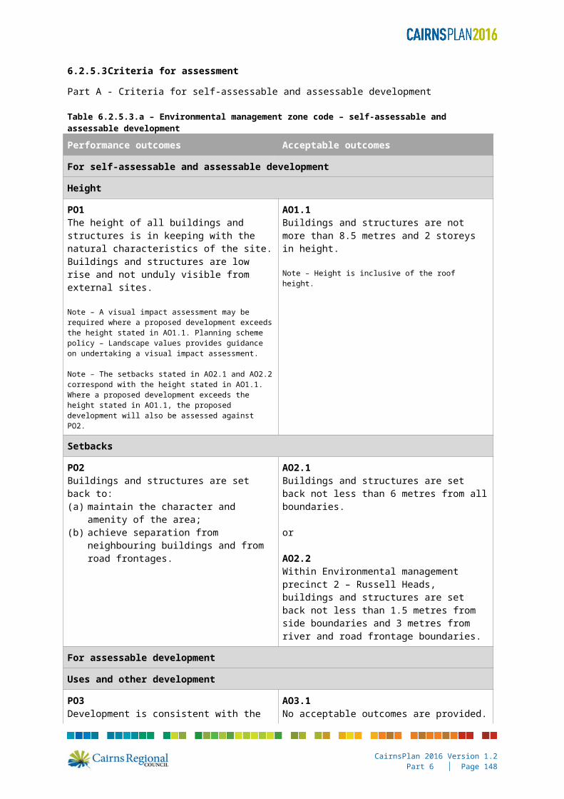
6.2.5.3 Criteria for assessment
Part A - Criteria for self-assessable and assessable development
Table 6.2.5.3.a – Environmental management zone code – self-assessable and assessable development
Performance outcomes Acceptable outcomes
For self-assessable and assessable development
Height
PO1The height of all buildings and structures is in keeping with the natural characteristics of the site. Buildings and structures are low rise and not unduly visible from external sites.
Note – A visual impact assessment may be required where a proposed development exceeds the height stated in AO1.1. Planning scheme policy – Landscape values provides guidance on undertaking a visual impact assessment.
Note – The setbacks stated in AO2.1 and AO2.2 correspond with the height stated in AO1.1. Where a proposed development exceeds the height stated in AO1.1, the proposed development will also be assessed against PO2.
AO1.1Buildings and structures are not more than 8.5 metres and 2 storeys in height.
Note – Height is inclusive of the roof height.
Setbacks
PO2Buildings and structures are set back to:(a) maintain the character and amenity of the
area;(b) achieve separation from neighbouring
buildings and from road frontages.
AO2.1Buildings and structures are set back not less than 6 metres from all boundaries.
or
AO2.2Within Environmental management precinct 2 – Russell Heads, buildings and structures are set back not less than 1.5 metres from side boundaries and 3 metres from river and road frontage boundaries.
For assessable development
Uses and other development
PO3Development is consistent with the purpose and overall outcomes sought for the zone.
AO3.1No acceptable outcomes are provided.
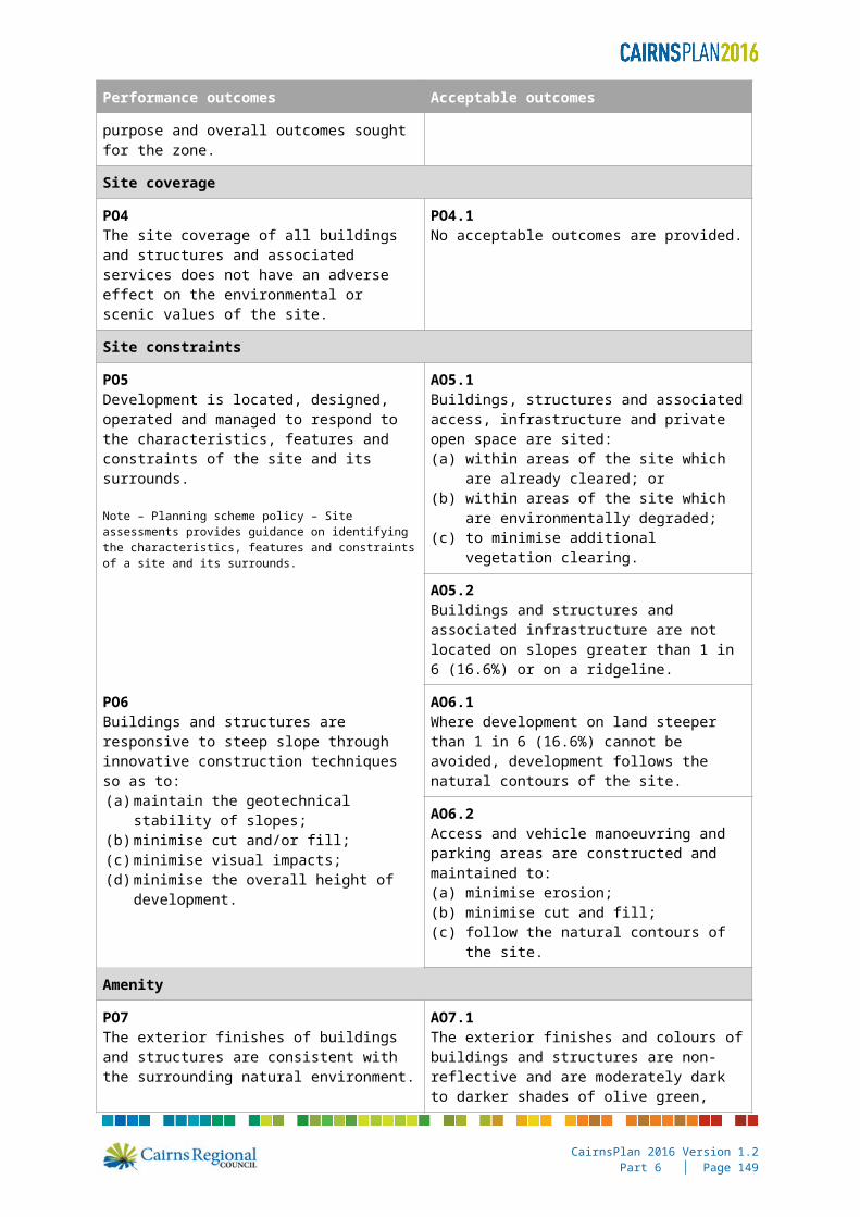
Site coverage
PO4The site coverage of all buildings and structures and associated services does not have an adverse effect on the environmental or scenic values of the site.
PO4.1No acceptable outcomes are provided.
Site constraints
PO5Development is located, designed, operated and managed to respond to the characteristics, features and constraints of the site and its surrounds.
AO5.1Buildings, structures and associated access, infrastructure and private open space are sited:(a) within areas of the site which are already
cleared; or
CairnsPlan 2016 Version 1.2Part 6 │ Page 141

Performance outcomes Acceptable outcomes
Note – Planning scheme policy – Site assessments provides guidance on identifying the characteristics, features and constraints of a site and its surrounds.
(b) within areas of the site which are environmentally degraded;
(c) to minimise additional vegetation clearing.
AO5.2Buildings and structures and associated infrastructure are not located on slopes greater than 1 in 6 (16.6%) or on a ridgeline.
PO6Buildings and structures are responsive to steep slope through innovative construction techniques so as to:(a) maintain the geotechnical stability of slopes;(b) minimise cut and/or fill;(c) minimise visual impacts;(d) minimise the overall height of development.
AO6.1Where development on land steeper than 1 in 6 (16.6%) cannot be avoided, development follows the natural contours of the site.
AO6.2Access and vehicle manoeuvring and parking areas are constructed and maintained to:(a) minimise erosion;(b) minimise cut and fill;(c) follow the natural contours of the site.
Amenity
PO7The exterior finishes of buildings and structures are consistent with the surrounding natural environment.
AO7.1The exterior finishes and colours of buildings and structures are non-reflective and are moderately dark to darker shades of olive green, brown, green, blue, or charcoal;
or
AO7.2The development is not visible external to the site.
PO8Development does not adversely affect the amenity of the zone and adjoining land uses in terms of traffic, noise, dust, odour, lighting or other physical or environmental impacts.
AO8.1No acceptable outcomes are provided.
Density
PO9The density of development ensures that the environmental and scenic amenity values of the site and surrounding area are not adversely affected.
AO9.1The maximum residential density is one dwelling house per lot.
Lot reconfiguration
PO10Lot reconfiguration results in no additional lots, except where associated with a lease exceeding 10 years and associated with an existing or approved Telecommunications facility.
AO10.1No acceptable outcomes are provided.
CairnsPlan 2016 Version 1.2Part 6 │ Page 142

Performance outcomes Acceptable outcomes
Additional requirements for Environmental management precinct 2 – Russell Heads
Water supply
PO11An adequate, safe and reliable supply of potable, firefighting and general use water is provided.
AO11.1No acceptable outcomes are provided.
Treatment and disposal of effluent
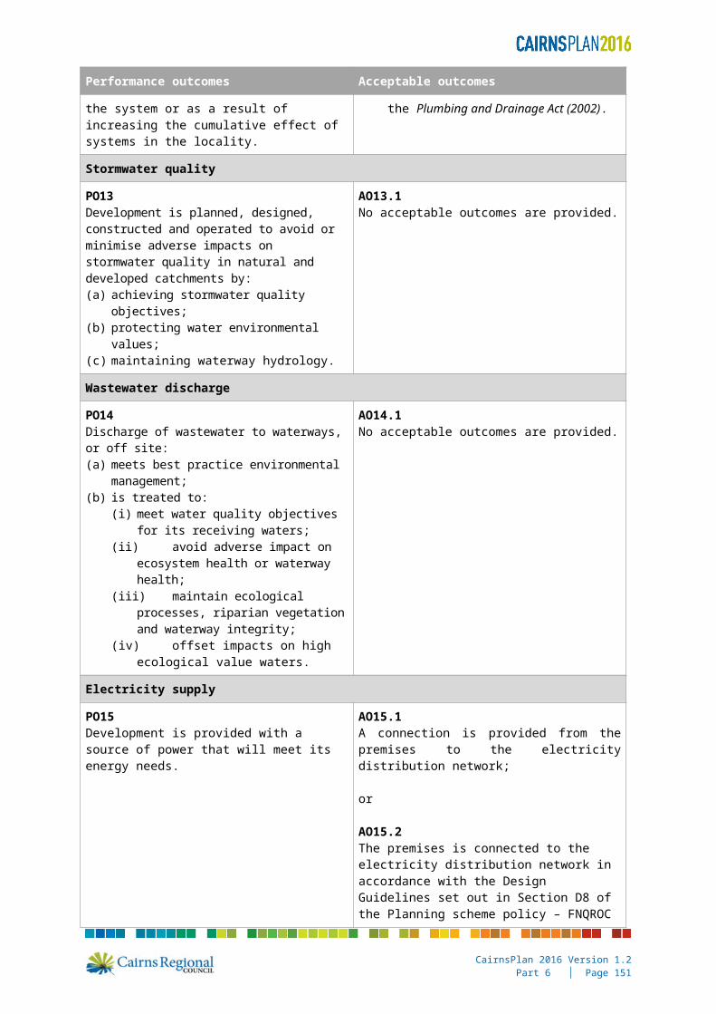
PO12Provision is made for the treatment and disposal of effluent to ensure that there are no adverse impacts on water quality and no adverse ecological impacts as a result of the system or as a result of increasing the cumulative effect of systems in the locality.
AO12.1The effluent disposal system:(a) meets the requirements of Section 33 of the
Environmental Protection Policy (Water) 1997;
(b) is designed in accordance with the Plumbing and Drainage Act (2002).
Stormwater quality
PO13Development is planned, designed, constructed and operated to avoid or minimise adverse impacts on stormwater quality in natural and developed catchments by:(a) achieving stormwater quality objectives;(b) protecting water environmental values;(c) maintaining waterway hydrology.
AO13.1No acceptable outcomes are provided.
Wastewater discharge
PO14Discharge of wastewater to waterways, or off site:(a) meets best practice environmental
management;(b) is treated to:
(i) meet water quality objectives for its receiving waters;
(ii) avoid adverse impact on ecosystem health or waterway health;
(iii) maintain ecological processes, riparian vegetation and waterway integrity;
(iv) offset impacts on high ecological value waters.
AO14.1No acceptable outcomes are provided.
Electricity supply
PO15Development is provided with a source of power that will meet its energy needs.
AO15.1A connection is provided from the premises to the electricity distribution network;
or
AO15.2The premises is connected to the electricity distribution network in accordance with the Design Guidelines set out in Section D8 of the Planning scheme policy – FNQROC Regional Development Manual.
CairnsPlan 2016 Version 1.2Part 6 │ Page 143
Performance outcomes Acceptable outcomes
Telecommunications
PO16Development is connected to a telecommunications service approved by the relevant telecommunication regulatory authority.
AO16.1The development is connected to telecommunications infrastructure in accordance with the standards of the relevant regulatory authority.
Trade waste
PO17Where relevant, the development is capable of providing for the storage, collection treatment and disposal of trade waste such that:(a) off-site releases of contaminants do not
occur;(b) the health and safety of people and the
environment are protected;(c) the performance of the wastewater system
is not put at risk.
AO17.1No acceptable outcomes are provided.
CairnsPlan 2016 Version 1.2Part 6 │ Page 144

6.2.6 High impact industry zone code
6.2.6.1 Application
(9) This code applies to assessing development in the High impact industry zone.
(10) When using this code, reference should be made to Part 5.
6.2.6.2 Purpose
(1) The purpose of the High impact industry zone code is to provide for high impact industry uses.
It may include non-industrial and business uses that support the industrial activities where they do not compromise the long-term use of the land for industrial purposes.
Activities considered appropriate in this zone are defined as high impact industry in the schedule of definitions.
(2) The local government purpose of the code is to provide land for high impact industry where such land use activity may not be compatible with medium impact industry working environments. The quantity of land zoned high impact industry in the region is very limited and restricts the intrusion of other land uses that may compromise the establishment of heavier forms of industry.
(3) The purpose of the code will be achieved through the following overall outcomes:(a) a range of high impact industry uses that satisfy the purpose of the zone are facilitated;(b) accommodation activities are not established within the zone;(c) lot sizes are of sufficient size to cater for a range of high impact industries;(d) development reflects and responds to the natural features and constraints of the land;(e) development does not affect the operational aspects of the Port of Cairns.
6.2.6.3 Criteria for assessment
Part A - Criteria for self-assessable and assessable development
Table 6.2.6.3.a – High impact industry zone code– self-assessable and assessable development
Performance outcomes Acceptable outcomes
For self-assessable and assessable development
Height
PO1The height of buildings and structures is compatible with the character of the area and does not adversely affect the amenity of the area.
Note – A visual impact assessment may be required where a proposed development exceeds the height stated in AO1.1. Planning scheme policy – Landscape values provides guidance on undertaking a visual impact assessment.
Note – The site coverage stated within AO1.1 and the setbacks stated in AO2.1 of the Industry design code correspond with the height stated in AO1.1 of this code. Where a proposed development exceeds the height stated in AO1.1 of this code, the proposed development will also be assessed against PO1 and PO2 of the Industry design code.
AO1.1Buildings and structures are not more than 15 metres in height.
Note – Height is inclusive of the roof height.
CairnsPlan 2016 Version 1.2Part 6 │ Page 145
Performance outcomes Acceptable outcomes
For assessable development
Uses and other development
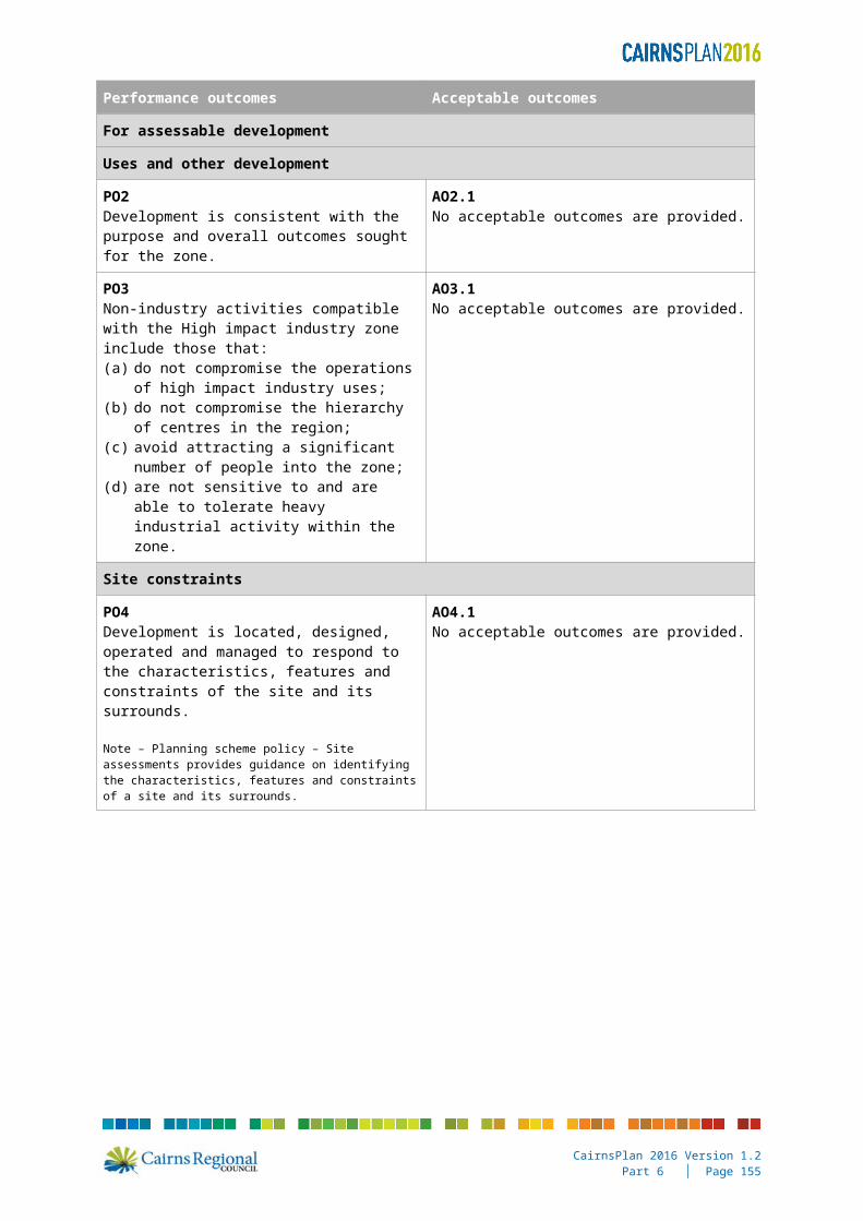
PO2Development is consistent with the purpose and overall outcomes sought for the zone.
AO2.1No acceptable outcomes are provided.
PO3Non-industry activities compatible with the High impact industry zone include those that:(a) do not compromise the operations of high
impact industry uses;(b) do not compromise the hierarchy of centres
in the region;(c) avoid attracting a significant number of
people into the zone;(d) are not sensitive to and are able to tolerate
heavy industrial activity within the zone.
AO3.1No acceptable outcomes are provided.
Site constraints
PO4Development is located, designed, operated and managed to respond to the characteristics, features and constraints of the site and its surrounds.
Note – Planning scheme policy – Site assessments provides guidance on identifying the characteristics, features and constraints of a site and its surrounds.
AO4.1No acceptable outcomes are provided.
CairnsPlan 2016 Version 1.2Part 6 │ Page 146
6.2.7 Local centre zone code
6.2.7.1 Application
(11) This code applies to assessing development in the Local centre zone.
(12) When using this code, reference should be made to Part 5.
6.2.7.2 Purpose
(1) The purpose of the Local centre zone code is to provide for a limited range of retail, commercial and community activities to service local needs.
It includes local shopping, local employment nodes, commercial, cafes and dining, entertainment, community services and residential development where it can integrate and enhance the fabric of the centre.
(2) The local government purpose of the code is to ensure development is consistent with the identified role and function of Local centres within the hierarchy of centres.
(3) The purpose of the code will be achieved through the following overall outcomes:(a) a small range of uses including retail, business, cafes and dining, and community
activities are provided that are focussed on the daily and weekly shopping and service needs of their surrounding local community; Showrooms, department stores and other large floor space land uses, other than supermarkets, are not located in Local centres.
(b) development provides a high level of amenity and reflects the surrounding character of the area;
(c) development contributes to vibrant, engaging and active local centres that are safe comfortable and enjoyable for pedestrians;
(d) development provides a high quality interface to adjoining premises and manages impacts on adjacent development through appropriate location, design, operation and management;
(e) development has access to infrastructure and essential services;(f) development maximises public transport accessibility and use, and encourages walking
and cycling;(g) development does not compromise the hierarchy of centres, whether as a result of the
impacts from an individual development or the cumulative impacts of multiple developments;
(h) development reflects and responds to the natural features and constraints of the land.
6.2.7.3 Criteria for assessment
Part A - Criteria for self-assessable and assessable development
Table 6.2.7.3.a – Local centre zone code – self-assessable and assessable development
Performance outcomes Acceptable outcomes
For self-assessable and assessable development
Height
PO1The height of all buildings is in keeping with the character of the surrounding residential neighbourhoods and does not adversely affect the amenity of the neighbourhood.Note - A visual impact assessment may be required where a
AO1.1Buildings and structures are not more than 10.5 metres and 2 storeys in height.
Note – Height is inclusive of the roof height.
CairnsPlan 2016 Version 1.2Part 6 │ Page 147
Performance outcomes Acceptable outcomes
proposed development exceeds the height stated in AO1.1. Planning scheme policy – Landscape values provides guidance on undertaking a visual impact assessment.
Note – The site coverage stated in AO2.1 and the setbacks stated in AO3.1 correspond with the height stated in AO1.1. Where a proposed development exceeds the height stated in AO1.1, the proposed development will also be assessed against PO2 and PO3.
Site coverage
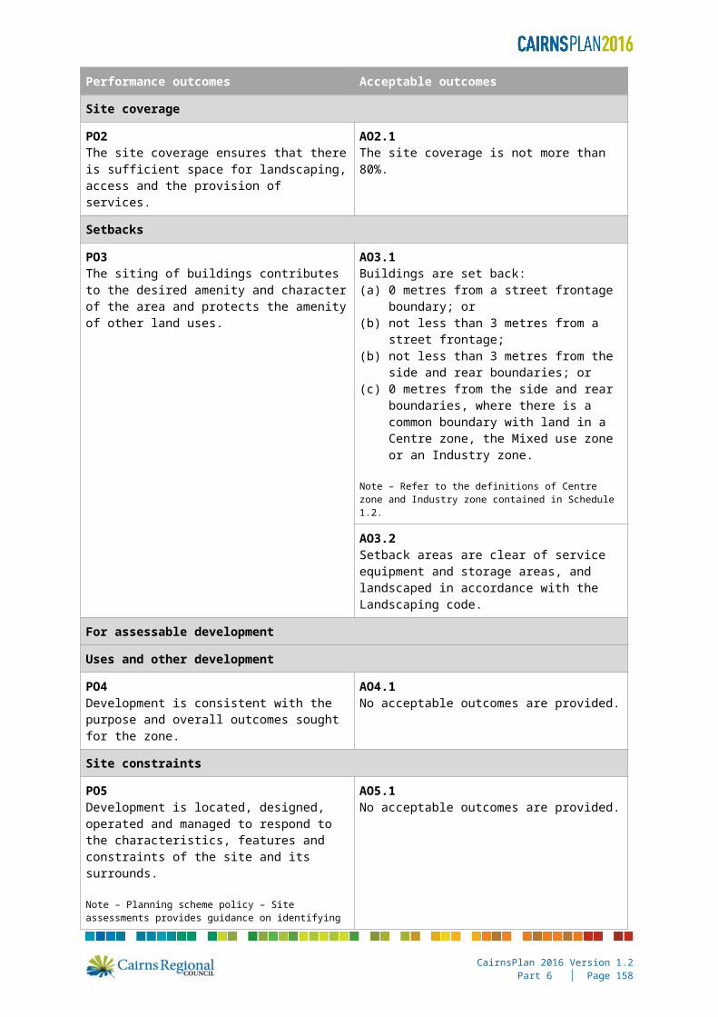
PO2The site coverage ensures that there is sufficient space for landscaping, access and the provision of services.
AO2.1The site coverage is not more than 80%.
Setbacks
PO3The siting of buildings contributes to the desired amenity and character of the area and protects the amenity of other land uses.
AO3.1Buildings are set back:(a) 0 metres from a street frontage boundary;
or(b) not less than 3 metres from a street
frontage;(b) not less than 3 metres from the side and
rear boundaries; or(c) 0 metres from the side and rear
boundaries, where there is a common boundary with land in a Centre zone, the Mixed use zone or an Industry zone.
Note – Refer to the definitions of Centre zone and Industry zone contained in Schedule 1.2.
AO3.2Setback areas are clear of service equipment and storage areas, and landscaped in accordance with the Landscaping code.
For assessable development
Uses and other development
PO4Development is consistent with the purpose and overall outcomes sought for the zone.
AO4.1No acceptable outcomes are provided.
Site constraints
PO5Development is located, designed, operated and managed to respond to the characteristics, features and constraints of the site and its surrounds.
Note – Planning scheme policy – Site assessments provides guidance on identifying the characteristics, features and constraints of a site and its surrounds.
AO5.1No acceptable outcomes are provided.
CairnsPlan 2016 Version 1.2Part 6 │ Page 148
Performance outcomes Acceptable outcomes
Role and function of Local centres
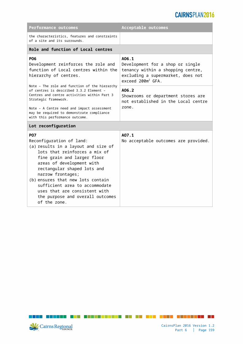
PO6Development reinforces the role and function of Local centres within the hierarchy of centres.
Note – The role and function of the hierarchy of centres is described 3.3.2 Element – Centres and centre activities within Part 3 Strategic framework.
Note – A Centre need and impact assessment may be required to demonstrate compliance with this performance outcome.
AO6.1Development for a shop or single tenancy within a shopping centre, excluding a supermarket, does not exceed 200m2 GFA.
AO6.2Showrooms or department stores are not established in the Local centre zone.
Lot reconfiguration
PO7Reconfiguration of land:(a) results in a layout and size of lots that
reinforces a mix of fine grain and larger floor areas of development with rectangular shaped lots and narrow frontages;
(b) ensures that new lots contain sufficient area to accommodate uses that are consistent with the purpose and overall outcomes of the zone.
AO7.1No acceptable outcomes are provided.
CairnsPlan 2016 Version 1.2Part 6 │ Page 149

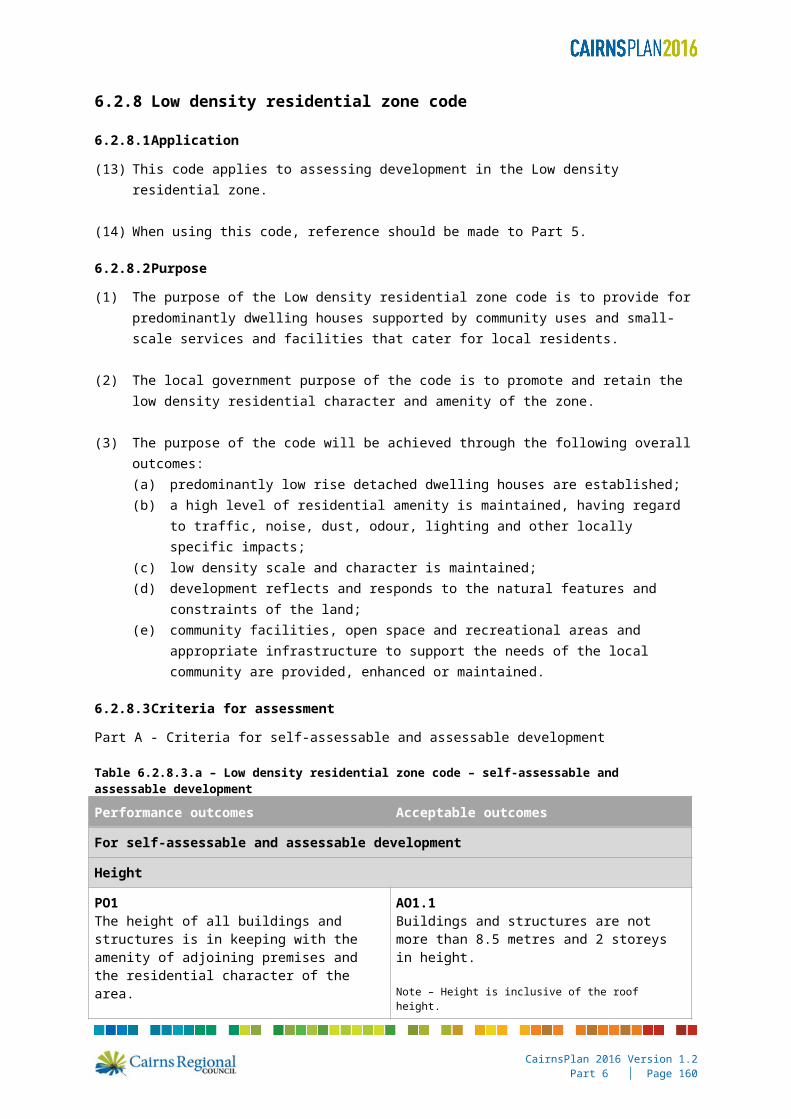
6.2.8 Low density residential zone code
6.2.8.1 Application
(13) This code applies to assessing development in the Low density residential zone.
(14) When using this code, reference should be made to Part 5.
6.2.8.2 Purpose
(1) The purpose of the Low density residential zone code is to provide for predominantly dwelling houses supported by community uses and small-scale services and facilities that cater for local residents.
(2) The local government purpose of the code is to promote and retain the low density residential character and amenity of the zone.
(3) The purpose of the code will be achieved through the following overall outcomes:(a) predominantly low rise detached dwelling houses are established;(b) a high level of residential amenity is maintained, having regard to traffic, noise, dust,
odour, lighting and other locally specific impacts;(c) low density scale and character is maintained;(d) development reflects and responds to the natural features and constraints of the land;(e) community facilities, open space and recreational areas and appropriate infrastructure to
support the needs of the local community are provided, enhanced or maintained.
6.2.8.3 Criteria for assessment
Part A - Criteria for self-assessable and assessable development
Table 6.2.8.3.a – Low density residential zone code – self-assessable and assessable development
Performance outcomes Acceptable outcomes
For self-assessable and assessable development
Height
PO1The height of all buildings and structures is in keeping with the amenity of adjoining premises and the residential character of the area.
Note - A visual impact assessment may be required where a proposed development exceeds the height stated in AO1.1. Planning scheme policy – Landscape values provides guidance on undertaking a visual impact assessment.
Note – The site coverage stated within AO2.1 corresponds with the height stated in AO1.1. Where a proposed development exceeds the height stated in AO1.1, the proposed development will also be assessed against PO2.
AO1.1Buildings and structures are not more than 8.5 metres and 2 storeys in height.
Note – Height is inclusive of the roof height.
Site coverage
PO2The site coverage of all buildings and structures is in keeping with the residential character and amenity of the area.
AO2.1The site coverage is not more than 50%.
CairnsPlan 2016 Version 1.2Part 6 │ Page 150
Performance outcomes Acceptable outcomes
For assessable development
Uses and other development
PO3Development is consistent with the purpose and overall outcomes sought for the zone.
AO3.1No acceptable outcomes are provided.
Setbacks
PO4The setback of buildings and structures:(a) maintains the amenity of adjoining premises
and the residential character of the area;(b) achieves separation from neighbouring
buildings and frontages.
AO4.1No acceptable outcomes are provided.
Site constraints
PO5Development is located, designed, operated and managed to respond to the characteristics, features and constraints of the site and its surrounds.
Note – Planning scheme policy – Site assessments provides guidance on identifying the characteristics, features and constraints of a site and its surrounds.
AO5.1No acceptable outcomes are provided.
Amenity
PO6Development does not adversely affect the residential character and amenity of the area in terms of traffic, noise, dust, odour, lighting or other physical or environmental impacts.
AO6.1No acceptable outcomes are provided.
CairnsPlan 2016 Version 1.2Part 6 │ Page 151

6.2.9 Low impact industry zone code
6.2.9.1 Application
(15) This code applies to assessing development in the Low impact industry zone.
(16) When using this code, reference should be made to Part 5.
6.2.9.2 Purpose
(1) The purpose of the Low impact industry zone code is to provide for service and low impact industry uses.
It may include non-industrial and business uses that support the industrial activities where they do not compromise the long-term use of the land for industrial purposes.
Activities considered appropriate in this zone are defined as low impact industry or service industry in the schedule of definitions.
(2) The local government purpose of the code is to recognise that parts of the region are characterised by land in transition from residential land use to industrial land use. Low impact industry land uses are preferred in these locations over residential or other forms of incompatible land use. Development ensures that any interface between industrial and sensitive land uses minimise the impact on amenity and safety.
(3) The purpose of the code will be achieved through the following overall outcomes:(a) a range of industrial uses that satisfy the purpose of the zone will be facilitated, provided
that there are no undue impacts on adjacent residential living environments;(b) other uses such as food and drink outlets and warehouses that are ancillary to, and
directly support, the industrial area are facilitated;(c) accommodation activities, other than caretaker’s accommodation, are not established
within the zone;(d) lot sizes are of a sufficient size to cater for a range of low impact industrial and ancillary
land uses;(e) the scale, character and built form of development contributes to a high standard of
amenity;(f) development reflects and responds to the natural features and constraints of the land.
6.2.9.3 Criteria for assessment
Part A - Criteria for self-assessable and assessable development
Table 6.2.9.3.a – Low impact industry zone code – self-assessable and assessable development
Performance outcomes Acceptable outcomes
For self-assessable and assessable development
Height
PO1The height of buildings and structures is compatible with the character of the area and does not adversely affect the amenity of the area.
Note – A visual impact assessment may be required where a proposed development exceeds the height stated in AO1.1. Planning scheme policy – Landscape values provides
AO1.1Buildings and structures are not more than 11 metres in height.
Note - Height is inclusive of the roof height.
CairnsPlan 2016 Version 1.2Part 6 │ Page 152

Performance outcomes Acceptable outcomes
guidance on undertaking a visual impact assessment.
Note – The site coverage stated within AO1.1 and the setbacks stated in AO2.1 of the Industry design code correspond with the height stated in AO1.1 of this code. Where a proposed development exceeds the height stated in AO1.1 of this code, the proposed development will also be assessed against PO1 and PO2 of the Industry design code.
For assessable development
Uses and other development
PO2Development is consistent with the purpose and overall outcomes sought for the zone.
AO2.1No acceptable outcomes are provided.
PO3Non-industrial activities compatible with the Low impact industry zone include those that:(a) do not compromise the hierarchy of centres
in the region;(b) complement industrial activities;(c) generally operate in daylight hours;(d) provide a direct service to the nearby
workforce.
AO3.1No acceptable outcomes are provided.
Site constraints
PO4Development is located, designed, operated and managed to respond to the characteristics, features and constraints of the site and its surrounds.
Note – Planning scheme policy – Site assessments provides guidance on identifying the characteristics, features and constraints of a site and its surrounds.
AO4.1No acceptable outcomes are provided.
CairnsPlan 2016 Version 1.2Part 6 │ Page 153

6.2.10 Low-medium density residential zone code
6.2.10.1 Application
(17) This code applies to assessing development in the Low-medium density residential zone.
(18) When using this code, reference should be made to Part 5.
6.2.10.2 Purpose
(1) The purpose of the Low-medium density residential zone code is to provide for a range and mix of dwelling types including dwelling houses and multiple dwellings supported by community uses and small-scale services and facilities that cater for local residents.
(2) The local government purpose of the code is to promote the mixed residential character and amenity of the zone.
(3) The purpose of the code will be achieved through the following overall outcomes:(a) a range of accommodation activities are provided on a range of lot sizes;(b) a high level of residential amenity is maintained, having regard to traffic, noise, dust,
odour, lighting and other locally specific impacts;(c) a mixed residential density and character is achieved;(d) a low rise character is achieved;(e) development reflects and responds to the natural features and constraints of the land;(f) community facilities, open space and recreational areas and appropriate infrastructure to
support the needs of the local community are provided, enhanced or maintained;(g) non-residential uses are established where they serve the local community and do not
detract from the residential amenity of the area.
6.2.10.3 Criteria for assessment
Part A - Criteria for self-assessable and assessable development
Table 6.2.10.3.a – Low-medium density residential zone code – self-assessable and assessable development
Performance outcomes Acceptable outcomes
For self-assessable and assessable development
Height
PO1The height of all buildings and structures is in keeping with the amenity of adjoining premises and the residential character of the area.
Note – A visual impact assessment may be required where a proposed development exceeds the height stated in AO1.1. Planning scheme policy – Landscape values provides guidance on undertaking a visual impact assessment.
Note – The site coverage stated in AO2.1 and AO2.2 corresponds with the height stated in AO1.1. Where a proposed development exceeds the height stated in AO1.1, the proposed development will also be assessed against PO2.
AO1.1Buildings and structures are not more than 8.5 metres and 2 storeys in height.
Note – Height is inclusive of the roof height.
CairnsPlan 2016 Version 1.2Part 6 │ Page 154
Performance outcomes Acceptable outcomes
Site coverage
PO2The site coverage of all buildings and structures is in keeping with the residential character and amenity of the area.
AO2.1The site coverage is not more than 40%;
or
AO2.2Where for a Dwelling house or Dual occupancy, the site coverage is not more than 50%.
For assessable development
Uses and other development
PO3Development is consistent with the purpose and overall outcomes sought for the zone.
AO3.1No acceptable outcomes are provided.
PO4Non-residential uses that serve the local community are established in appropriate locations and subject to detailed development requirements including:(a) being located in highly accessible locations;(b) being co-located with other similar uses;(c) providing for the identified convenience
needs of the local community;(d) not impacting on the role and function of the
hierarchy of centres within the region;(e) resulting in positive economic and social
benefits for the local community;(f) small scale extensions to existing non-
residential uses.
Note – A Centre need and impact assessment may be required to demonstrate compliance with this performance outcome.
AO4.1No acceptable outcomes are provided.
Setbacks
PO5The setback of buildings and structures:(a) maintains the amenity of adjoining premises
and the residential character of the area;(b) achieves separation from neighbouring
buildings and frontages.
AO5.1No acceptable outcomes are provided.
Site constraints
PO6Development is located, designed, operated and managed to respond to the characteristics, features and constraints of the site and its surrounds.
Note – Planning scheme policy – Site assessments provides guidance on identifying the characteristics, features and constraints of a site and its surrounds.
AO6.1No acceptable outcomes are provided.
CairnsPlan 2016 Version 1.2Part 6 │ Page 155

Performance outcomes Acceptable outcomes
Amenity
PO7Development does not adversely affect the residential character and amenity of the area in terms of traffic, noise, dust, odour, lighting or other physical or environmental impacts.
AO7.1No acceptable outcomes are provided.
CairnsPlan 2016 Version 1.2Part 6 │ Page 156

6.2.11 Major centre zone code
6.2.11.1 Application
(19) This code applies to assessing development in the Major centre zone.
(20) When using this code, reference should be made to Part 5.
6.2.11.2 Purpose
(1) The purpose of the Major centre zone code is to provide for a mix of uses and activities.
It includes concentrations of higher order retail, commercial, offices, residential, administrative and health services, community, cultural and entertainment facilities and other uses capable of servicing a subregion in the planning scheme area.
(2) The local government purpose of the code is to ensure development is consistent with the identified role and function of Major centres within the hierarchy of centres.
(3) The purpose of the code will be achieved through the following overall outcomes:(a) a broad range of higher order retail, employment, commercial, administrative, community,
cultural, education, higher density housing and entertainment activities are provided;(b) development is well-designed and incorporates appropriately scaled art and cultural
infrastructure;(c) development is clustered around public transport facilities to promote public transport,
walking and cycling;(d) accommodation activities are provided at an appropriate scale and integrate with and
enhance the vibrancy of the centre;(e) development provides a high level of tropical design and reflects the surrounding
character of the area;(f) development is located and designed to maximise activity along the primary street
frontage with buildings maintaining a human scale and pedestrian focus at street level;(g) development provides a high quality interface to adjoining premises and manages
impacts on adjacent development through appropriate location, design, operation and management;
(h) public open space areas including malls, plazas, parks and gardens are provided;(i) landscaping is of a high quality and contributes to the visual dominance of tropical
vegetation in the streetscape;(j) development contributes to vibrant, engaging and active major centres that are safe
comfortable and enjoyable for pedestrians;(k) development maximises public transport accessibility and use, and encourages walking
and cycling;(l) development does not compromise the hierarchy of centres, whether as a result of the
impacts from an individual development or the potential cumulative impacts of multiple developments;
(m) development reflects and responds to the natural features and constraints of the land.
CairnsPlan 2016 Version 1.2Part 6 │ Page 157
6.2.11.3 Criteria for assessment
Part A - Criteria for assessable development
Table 6.2.11.3a – Major centre zone code – assessable development
Performance outcomes Acceptable outcomes
For assessable development
Uses and other development
PO1Development is consistent with the purpose and overall outcomes sought for the zone.
AO1.1No acceptable outcomes are provided.
Role and function of Major centres
PO2Development reinforces the role and function of Major centres within the hierarchy of centres.
Note – The role and function of the hierarchy of centres is described 3.3.2 Element – Centres and centre activities within Part 3 Strategic framework
Note – A Centre need and impact assessment may be required to demonstrate compliance with this performance outcome.
AO2.1No acceptable outcomes are provided.
CairnsPlan 2016 Version 1.2Part 6 │ Page 158
6.2.12 Medium density residential zone code
6.2.12.1 Application
(21) This code applies to assessing development in the Medium density residential zone.
(22) When using this code, reference should be made to Part 5.
6.2.12.2 Purpose
(1) The purpose of the Medium density residential zone code is to provide for medium density multiple dwellings supported by community uses and small-scale services and facilities that cater for local residents.
(2) The local government purpose of the code is to promote and retain a mixed residential density character and amenity, with access to centres, major transport facilities, open space and recreation activities.
(3) The purpose of the code will be achieved through the following overall outcomes:(a) a range of accommodation activities, in low to medium rise multiple dwelling and mixed-
use buildings is established;(b) development provides a high level of amenity taking into account impacts such as traffic,
noise, dust, odour, and lighting;(c) a medium residential density, scale and character of the area is achieved;(d) development reflects and responds to the natural features and constraints of the land;(e) community facilities, open space and recreational areas and appropriate infrastructure to
support the needs of the local community are provided.
6.2.12.3 Criteria for assessment
Part A - Criteria for self-assessable and assessable development
Table 6.2.12.3.a – Medium density residential zone code – self-assessable and assessable development
Performance outcomes Acceptable outcomes
For self-assessable development and assessable development
Height
PO1The height of all buildings and structures is in keeping with the amenity of adjoining premises and the residential character and amenity of the area.
Note – A visual impact assessment may be required where a proposed development exceeds the height stated in AO1.1. Planning scheme policy – Landscape values provides guidance on undertaking a visual impact assessment.
Note – The site coverage stated in AO2.1 and AO2.2 corresponds with the height stated in AO1.1. Where a proposed development exceeds the height stated in AO1.1, the proposed development will also be assessed against PO2.
AO1.1Buildings and structures are not more than 15 metres and 4 storeys in height.
Note - Height is inclusive of the roof height.
CairnsPlan 2016 Version 1.2Part 6 │ Page 159
Performance outcomes Acceptable outcomes
Site coverage
PO2The site coverage of all buildings and structures is in keeping with the residential character and amenity of the area.
AO2.1The site coverage is not more than 40%.
or
AO2.2Where for a Dwelling house or Dual occupancy, the site coverage is not more than 50%.
For assessable development
Uses and other development
PO3Development is consistent with the purpose and overall outcomes sought for the zone.
AO3.1No acceptable outcomes are provided.
PO4Non-residential uses that serve the local community are established in appropriate locations and subject to detailed development requirements including:(a) being located in highly accessible locations;(b) their proximity with other similar uses;(c) providing for the identified convenience
needs of the local community;(d) not impacting on the role and function of the
hierarchy of centres within the region;(e) resulting in positive economic and social
benefits for the local community;(f) small scale extensions to existing non-
residential uses.
Note – A Centre need and impact assessment may be required to demonstrate compliance with this performance outcome.
AO4.1No acceptable outcomes are provided.
Setbacks
PO5Buildings and structures are set back to:(a) maintain the residential character and
amenity of the area;(b) achieve separation from neighbouring
buildings and frontages.
AO5.1No acceptable outcomes are provided
Site constraints
PO6Development is located, designed, operated and managed to respond to the characteristics, features and constraints of the site and its surrounds.
Note – Planning scheme policy – Site assessments provides guidance on identifying the characteristics, features and constraints of a site and its surrounds.
AO6.1No acceptable outcomes are provided.
CairnsPlan 2016 Version 1.2Part 6 │ Page 160

Performance outcomes Acceptable outcomes
Amenity
PO7Development does not adversely affect the residential character and amenity of the area in terms of traffic, noise, dust, odour, lighting or other physical or environmental impacts.
AO7.1No acceptable outcomes are provided.
CairnsPlan 2016 Version 1.2Part 6 │ Page 161
6.2.13 Medium impact industry zone code
6.2.13.1 Application
(1) This code applies to assessing development in the Medium impact industry zone.
(2) When using this code, reference should be made to Part 5.
6.2.13.2 Purpose
(1) The purpose of the Medium impact industry zone code is to provide for medium impact industry uses.
It may include non-industrial and business uses that support the industrial activities where they do not compromise the long-term use of the land for industrial purposes.
Activities considered appropriate in this zone are defined as medium impact industry in the schedule of definitions.
(2) The purpose of the code will be achieved through the following overall outcomes:(a) a range of industrial uses that satisfy the purpose of the zone will be facilitated;(b) accommodation activities, other than caretaker’s accommodation, are not established
within the zone;(c) service and low impact industry uses may be appropriate where they are not detrimentally
affected by or compromise the operations of medium impact industry uses;(d) lot sizes are of a sufficient size to cater for a wide range of industry activities;(e) the scale, character and built form of development contributes to a high standard of
amenity;(f) development reflects and responds to the natural features and constraints of the land;(g) development does not affect the operational aspects of the Port of Cairns.
6.2.13.3 Criteria for assessment
Part A - Criteria for self-assessable and assessable development
Table 6.2.13.3.a – Medium impact industry zone code – self-assessable and assessable development
Performance outcomes Acceptable outcomes
For self-assessable and assessable development
Height
PO1The height of buildings and structures is compatible with the character of the area and does not adversely affect the amenity of the area.
Note – A visual impact assessment may be required where a proposed development exceeds the height stated in AO1.1. Planning scheme policy – Landscape values provides guidance on undertaking a visual impact assessment.
Note – The site coverage stated within AO1.1 and the setbacks stated in AO2.1 of the Industry design code correspond with the height stated in AO1.1 of this code. Where a proposed development exceeds the height stated in AO1.1 of this code, the proposed development will also be assessed against PO1 and PO2 of the Industry design code.
AO1.1Buildings and structures are not more than 15 metres in height.
Note – Height is inclusive of the roof height.
CairnsPlan 2016 Version 1.2Part 6 │ Page 162
Performance outcomes Acceptable outcomes
For assessable development
Uses and other development
PO2Development is consistent with the purpose and overall outcomes sought for the zone.
AO2.1No acceptable outcomes are provided.
PO3Non-industry activities compatible with the zone include those that:(a) do not compromise the operations of
medium impact industry uses;(b) do not compromise the hierarchy of centres
in the region;(c) complement industrial activities;(d) require large land holdings and/or industrial
scale buildings;(e) provide a service to the nearby workforce.
AO3.1No acceptable outcomes are provided.
Site constraints
PO4Development is located, designed, operated and managed to respond to the characteristics, features and constraints of the site and its surrounds.
Note – Planning scheme policy – Site assessments provides guidance on identifying the characteristics, features and constraints of a site and its surrounds.
AO4.1No acceptable outcomes are provided.
CairnsPlan 2016 Version 1.2Part 6 │ Page 163

6.2.14 Mixed use zone code
6.2.14.1 Application
(1) This code applies to assessing development in the Mixed use zone.
(2) When using this code, reference should be made to Part 5.
6.2.14.2 Purpose
(1) The purpose of the Mixed use zone code is to provide for a mix of activities that may include business, retail, residential, tourist accommodation and associated services, service industry and low impact industrial uses.
(2) The local government purpose of the code is to recognise the presence of areas of mixed land use outside the hierarchy of centres that contain a wide variety of uses.
(3) The purpose of the code will be achieved through the following overall outcomes:(a) a mix of appropriate uses within the precincts are established;(b) development in the mixed use zone does not compromise the role and successful
function of centres within the hierarchy of centres, whether as a result of the impacts from an individual development or the potential cumulative impacts of multiple developments;the scale, character and built form of development contributes to a high standard of amenity;
(c) development reflects and responds to the natural features and constraints of the land.
Mixed use precinct 1 – Commercial(4) In addition to 6.2.14.2(3), the overall outcomes sought for the precinct are:
(a) development within the precinct provides a mix of land uses where the predominant land use is for commercial purposes;
(b) development does not diminish the amenity of any adjoining residential areas and reflects and responds to the character of the area;
(c) medium density residential and short term accommodation uses are provided in a mixed use setting involving commercial or retail uses on the lower and ground floor storeys;
(d) development addresses the street frontage and provides car parking behind buildings.
Mixed use precinct 2 – Trades and services(5) In addition to 6.2.14.2(3), the overall outcomes sought for the precinct are:
(a) development within the precinct provides a mix of land uses where the predominant land use is for trades and services purposes;
(b) development for low impact industry uses is facilitated;(c) residential development is only established where an appropriate level of amenity can be
achieved and it does not compromise the ability for low impact industry uses to be developed;
(d) development does not affect the operational aspects of the Port of Cairns.
Mixed use precinct 3 – Residential(6) In addition to 6.2.14.2(3), the overall outcomes sought for the precinct are:
(a) development within the precinct provides a mix of land uses where the predominant land use is for residential purposes;
(b) development is provided through the adaptive reuse of existing buildings;(c) development maintains the residential scale and character of the area;(d) a range of accommodation activities are established;(e) development provides a high level of amenity taking into account impacts such as traffic,
CairnsPlan 2016 Version 1.2Part 6 │ Page 164

noise, dust, odour and lighting;(f) industry activities are not established;
6.2.14.3 Criteria for assessment
Part A - Criteria for self-assessable and assessable development
Table 6.2.14.3.a – Mixed use zone code – self-assessable and assessable development
Performance outcomes Acceptable outcomes
For self-assessable and assessable development
Height
PO1The height of buildings and structures is of a scale compatible with the character of the area and does not adversely affect the amenity of the area.
Note – A visual impact assessment may be required where a proposed development exceeds the height stated in AO1.1, AO1.2 or AO1.3. Planning scheme policy – Landscape values provides guidance on undertaking a visual impact assessment.
Note – The site coverage stated in AO2.1 and AO2.2 and the setbacks stated in AO3.1, AO3.2, AO4.1 and AO4.2 correspond with the heights stated in AO1.1, AO1.2 and AO1.3. Where a proposed development exceeds the height stated in AO1.1, AO1.2 or AO1.3, the proposed development will also be assessed against PO2, PO3 and PO4.
AO1.1Within Mixed use precinct 1 – Commercial, buildings and structures are not more than:(a) 11 metres in height; or(b) 14 metres and 3 storeys in height, where
involving a mix of land uses that includes multiple dwellings;
or
AO1.2Within Mixed use precinct 2 – Trades and services, buildings and structures are not more than 11 metres in height;
or
AO1.3Within Mixed use precinct 3 – Residential, buildings and structures are not more than 11 metres and 2 storeys in height;
Note – Height is inclusive of the roof height.
Site coverage
PO2The site coverage of all buildings:(a) does not result in a built form that is bulky or
visually obtrusive to the streetscape;(b) respects the individual character of the zone
and/or precinct and responds to the features of the site.
AO2.1Within Mixed use precinct 1 – Commercial and Mixed use precinct 2 – Trades and services, site coverage is not more than 80%;
or
AO2.2Within Mixed use precinct 3 – Residential, site coverage is not more than 50%.
CairnsPlan 2016 Version 1.2Part 6 │ Page 165
Performance outcomes Acceptable outcomes
Setbacks
PO3Front building setbacks are consistent with the prevailing setbacks in the street.
AO3.1Within Mixed use precinct 1 – Commercial and Mixed use precinct 2 – Trades and services, development fronting a State-controlled road, existing or proposed Sub-arterial road, as identified on the Transport network overlay maps contained in Schedule 2, is built to the road frontage.
or
AO3.2For all other development, buildings and structures are set back not less than:(a) 6 metres from the primary road frontage;(b) 3 metres from any secondary road
frontage.
PO4Side and rear building setbacks:(a) are appropriate to the scale of the
development and the character of the locality;
(b) are sufficient to minimise overshadowing and overlooking of adjoining premises;
(c) provide adequate separation and buffering from residential premises;
(d) minimise unusable spaces between buildings / boundaries.
AO4.1Where the site has a common boundary with land in a Centre zone, Mixed use precinct 1 – Commercial, Mixed use precinct 2 – Trades and services, or an Industry zone, the building:(a) is set back 0 metres from the side and rear
boundaries; or(b) not less than 3 metres from the side and
rear boundaries;
or
AO4.2Where the site has a common boundary with land in a zone other than a centre, mixed use precinct 1 – Commercial, mixed use Precinct 2 – Trades and services, or Industry zone, the setback from the boundary is not less than 3 metres.
Note – Refer to the definition of Centre zone contained in Schedule 1.2.
For assessable development
Uses and other development
PO5Development:(a) does not compromise or perform the role
and function of a centre within the hierarchy of centres in the region;
(b) services local and visitor needs of the surrounding catchment;
(c) complements the scale and character of the surrounding area;
(d) protects the amenity of adjoining premises and surrounding uses.
Note – The role and function of the hierarchy of centres is described 3.3.2 Element – Centres and centre activities within Part 3 Strategic framework.
AO5.1Shopping centres located within Mixed use precinct 1 – Commercial or Mixed use precinct 2 – Trades and services do not exceed 500m2
GFA.
AO5.2Shopping centres are not established within Mixed use precinct 3 – Residential.
AO5.3Development for a shop or single tenancy within a shopping centre does not exceed 200m2 GFA.
AO5.4
CairnsPlan 2016 Version 1.2Part 6 │ Page 166

Performance outcomes Acceptable outcomes
Note – A Centre need and impact assessment may be required to demonstrate compliance with this performance outcome.
Department stores and supermarkets are not established within the Mixed use zone.
Site constraints
PO6Development is located, designed, operated and managed to respond to the characteristics, features and constraints of the site and its surrounds.
Note – Planning scheme policy – Site assessments provides guidance on identifying the characteristics, features and constraints of a site and its surrounds.
AO6.1No acceptable outcomes are provided.
Additional requirements for Mixed use precinct 1 – Commercial
PO7Development is consistent with the purpose and overall outcomes sought for the zone and the outcomes sought for Mixed use precinct 1 – Commercial.
AO7.1No acceptable outcomes are provided.
Additional requirements for Mixed use precinct 2 – Trades and services
PO8Development is consistent with the purpose and overall outcomes sought for the zone and the outcomes sought for Mixed use precinct 2 – Trades and services.
AO8.1No acceptable outcomes are provided.
Additional requirements for Mixed use precinct 3 – Residential
PO9Development is consistent with the purpose and overall outcomes sought for the zone and the outcomes sought for Mixed use precinct 3 – Residential.
AO9.1No acceptable outcomes are provided.
PO10Development is of a size, scale and design to complement the traditional character of the precinct.
AO10.1Development provides for the retention and/or adaptive re-use of buildings.
AO10.2Development complements the traditional residential scale and character of the area.
CairnsPlan 2016 Version 1.2Part 6 │ Page 167

6.2.15 Neighbourhood centre zone code
6.2.15.1 Application
(23) This code applies to assessing development in the Neighbourhood centre zone.
(24) When using this code, reference should be made to Part 5.
6.2.15.2 Purpose
(1) The purpose of the Neighbourhood centre zone code is to provide for a small mix of land uses to service residential neighbourhoods.
It includes small-scale convenience shopping, professional offices, community services and other uses that directly support the immediate community.
(2) The local government purpose of the code is to ensure development is consistent with the identified role and function of Neighbourhood centres within the hierarchy of centres.
(3) The purpose of the code will be achieved through the following overall outcomes:(a) a limited range of small scale convenience, retail or community facilities are provided that
meet the basic, daily convenience needs of the surrounding neighbourhood and encourage walkable neighbourhoods;
(b) showrooms, department stores, supermarkets and other large floor space land uses are not located in Neighbourhood centres;
(c) development provides a high level of amenity and reflects the surrounding character of the area;
(d) development contributes to vibrant, engaging and active neighbourhood centres that are safe comfortable and enjoyable for pedestrians;
(e) development provides a high quality interface to adjoining premises and manages impacts on adjacent development through appropriate location, design, operation and management;
(f) development has access to infrastructure and essential services;(g) development maximises public transport accessibility and use, and encourages walking
and cycling;(h) development does not compromise the hierarchy of centres, whether as a result of the
impacts from an individual development or the cumulative impacts of multiple developments;
(i) development reflects and responds to the natural features and constraints of the land.
6.2.15.3 Criteria for assessment
Part A - Criteria for self-assessable and assessable development
Table 6.2.15.3.a –Neighbourhood centre zone code – self-assessable and assessable development
Performance outcomes Acceptable outcomes
For self-assessable and assessable development
Height
PO1The height of all buildings is in keeping with the character of the surrounding residential neighbourhoods and does not adversely affect the amenity of the neighbourhood.
AO1.1Buildings and structure are not more than 8.5 metres and 2 storeys in height.
Note – Height is inclusive of the roof height.
CairnsPlan 2016 Version 1.2Part 6 │ Page 168

Performance outcomes Acceptable outcomes
Note – A visual impact assessment may be required where a proposed development exceeds the height stated in AO1.1. Planning scheme policy – Landscape values provides guidance on undertaking a visual impact assessment.
Note – The site coverage stated in AO2.1 and the setbacks stated in AO3.1 correspond with the height stated in AO1.1. Where a proposed development exceeds the height stated in AO1.1, the proposed development will also be assessed against PO2 and PO3.
Site coverage
PO2The site coverage ensures that there is sufficient space for landscaping, access and the provision of services.
AO2.1The site coverage is not more than 50%.
Setbacks
PO3The siting of buildings contributes to the desired amenity and character of the area and protects the amenity of other land uses.
AO3.1Buildings are set back:(a) 0 metres from a street frontage boundary;
or(b) not less than 3 metres from a street
frontage boundary(c) not less than 3 metres from the side and
rear boundaries; or(d) 0 metres from the side and rear boundaries
where there is a common boundary with land in a Centre zone, the Mixed use zone or an Industry zone.
Note – Refer to the definitions of Centre zone and Industry zone contained in Schedule 1.2.
AO3.2Setback areas are clear of service equipment and storage areas, and landscaped in accordance with the Landscaping code.
For assessable development
Uses and other development
PO4Development is consistent with the purpose and overall outcomes sought for the zone.
AO4.1No acceptable outcomes are provided.
Site constraints
PO5Development is located, designed, operated and managed to respond to the characteristics, features and constraints of the site and its surrounds.
Note – Planning scheme policy – Site assessments provides guidance on identifying the characteristics, features and constraints of a site and its surrounds.
AO5.1No acceptable outcomes are provided.
CairnsPlan 2016 Version 1.2Part 6 │ Page 169
Performance outcomes Acceptable outcomes
Role and function of Neighbourhood centres
PO6Development reinforces the role and function of Neighbourhood centres within the hierarchy of centres.
Note – The role and function of the hierarchy of centres is described 3.3.2 Element – Centres and centre activities within Part 3 Strategic framework
Note – A Centre need and impact assessment may be required to demonstrate compliance with this performance outcome.
AO6.1Development for a shop or Single tenancy within a Shopping centre does not exceed 200m2 GFA.
AO6.2Showrooms, department stores and supermarkets are not established in the Neighbourhood centre zone.
Lot reconfiguration
PO7Reconfiguration of land:(a) results in a layout and size of lots that
reinforces a fine grain of development with rectangular shaped lots and narrow frontages;
(b) ensures that new lots contain sufficient area to accommodate uses that are consistent with the purpose and overall outcomes of the zone.
Note – Planning scheme policy – Centres and centre activities provides further guidance.
AO7.1No acceptable outcomes are provided.
CairnsPlan 2016 Version 1.2Part 6 │ Page 170

6.2.16 Open space zone code
6.2.16.1 Application
(25) This code applies to assessing development in the Open space zone.
(26) When using this code, reference should be made to Part 5.
6.2.16.2 Purpose
(1) The purpose of the Open space zone code is to provide for local, district and regional scale parks that serve the recreational needs of a wide range of residents and visitors.
Where required to meet community needs, development may include shelters, amenity facilities, picnic tables, and playgrounds and infrastructure to support safe access and essential management.
(2) The local government purpose of the code is to recognise the importance of open space areas to the liveability, health and wellbeing of the region’s communities.
(3) The purpose of the code will be achieved through the following overall outcomes:(a) open space is accessible to the community for a range of outdoor activities;(b) a range of functional and accessible open spaces, including local, district and regional
scale parks and linear corridors are available for the use and enjoyment of the community;
(c) structures and buildings such as shelters, amenity facilities, picnic tables and playgrounds are provided;
(d) open space areas are planned and designed to enhance community liveability and scenic amenity;
(e) development reflects and responds to the natural features and constraints of the land;(f) development does not affect the operational aspects of the Port of Cairns.
6.2.16.3 Criteria for assessment
Part A - Criteria for self-assessable and assessable development
Table 6.2.16.3.a – Open space zone code – self-assessable and assessable development
Performance outcomes Acceptable outcomes
For self-assessable and assessable development
Height
PO1The height of all buildings and structures is compatible with the character of the area and does not adversely affect the amenity of the area.
Note – A visual impact assessment may be required where a proposed development exceeds the height stated in AO1.1. Planning scheme policy – Landscape values provides guidance on undertaking a visual impact assessment.
Note – The setbacks stated in AO2.1 correspond with the height stated in AO1.1. Where a proposed development exceeds the height stated in AO1.1, the proposed development will also be assessed against PO2.
AO1.1Buildings and structures are not more than 8.5 metres in height.
Note – Height is inclusive of the roof height.
CairnsPlan 2016 Version 1.2Part 6 │ Page 171
Performance outcomes Acceptable outcomes
Setback
PO2Buildings and structures are setback to ensure that they are compatible with the amenity of the area and do not adversely affect other uses, particularly residential uses.
AO2.1Buildings and structures are set back not less than 6 metres from all boundaries.
PO3Car parking areas are set back from the boundaries of the site to ensure that they do not dominate the open space character of the site.
AO3.1Car parking areas are set back:(a) 2 metres from the road frontage/s of the
site;(b) 6 metres from side and rear boundaries.
PO4Setbacks to car parking areas are landscaped to enhance the amenity of the site and to provide a buffer to adjacent residential land, residential uses and other sensitive sites.
AO4.1The setback between the road frontage/s and the car parking area is landscaped in accordance with the Landscaping code.
AO4.2The setback between the boundary with land included in a Residential zone and the car parking area is landscaped in accordance with the Landscaping code to provide a buffer to the residential land.
Note – Refer to the definition of Residential zones contained in Schedule 1.2.
Outdoor sport and recreation
PO5Development for outdoor sport and recreation does not adversely affect the amenity of the area.
AO5.1Development for outdoor sport and recreation does not include sports field lighting.
For assessable development
Uses and other development
PO6Development is consistent with the purpose and overall outcomes sought for the zone.
AO6.1No acceptable outcomes are provided.
Site constraints
PO7Development is located, designed, operated and managed to respond to the characteristics, features and constraints of the site and its surrounds.
Note – Planning scheme policy – Site assessments provides guidance on identifying the characteristics, features and constraints of a site and its surrounds.
AO7.1No acceptable outcomes are provided.
CairnsPlan 2016 Version 1.2Part 6 │ Page 172

6.2.17 Principal centre zone code
6.2.17.1 Application
(27) This code applies to assessing development in the Principal centre zone.
(28) When using this code, reference should be made to Part 5.
6.2.17.2 Purpose
(1) The purpose of the Principal centre zone code is to provide for the largest and most diverse mix of uses and activities that forms the core of an urban settlement.
It includes key concentrations of high-order retail, commercial, employment, residential, health services, administrative, community, cultural, recreational and entertainment activities and other uses, capable of servicing the planning scheme area.
(2) The local government purpose of the code is to ensure development is consistent with the identified role and function of the Principal centre within the hierarchy of centres.
(3) The purpose of the code will be achieved through the following overall outcomes:(a) the widest range of retail, commercial, administrative, community, cultural, tourism,
recreation and entertainment activities are provided;(b) development is well-designed and incorporates appropriately scaled art and cultural
infrastructure;(c) accommodation activities are provided at an appropriate scale and integrate with and
enhance the vibrancy of the centre;(d) development provides a high level of amenity, with a tropical design incorporating
appropriate architectural elements and building features;(e) public open space areas including malls, plazas, parks and gardens are provided;(f) landscaping is of a high quality and contributes to the visual dominance of tropical
vegetation in the streetscape;(g) development maximises public transport accessibility and use, and encourages walking
and cycling;(h) development contributes to a vibrant, engaging and active city centre that is safe
comfortable and enjoyable for pedestrians;(i) development reflects and responds to the natural features and constraints of the land;(j) development does not affect the operational aspects of the Port of Cairns.
6.2.17.3 Criteria for assessment
Part A - Criteria for assessable development
Table 6.2.17.3.a – Principal centre zone code – assessable development
Performance outcomes Acceptable outcomes
For assessable development
Uses and other development
PO1Development is consistent with the purpose and overall outcomes sought for the zone.
AO1.1No acceptable outcomes are provided.
CairnsPlan 2016 Version 1.2Part 6 │ Page 173
Performance outcomes Acceptable outcomes
Role and function of the Principal centre
PO2Development reinforces the role and function of the Principal centre within the hierarchy of centres.
Note – The role and function of the hierarchy of centres is described 3.3.2 Element – Centres and centre activities within Part 3 Strategic framework
Note – A Centre need and impact assessment may be required to demonstrate compliance with this performance outcome.
AO2.1No acceptable outcomes are provided.
CairnsPlan 2016 Version 1.2Part 6 │ Page 174

6.2.18 Rural residential zone code
6.2.18.1 Application
(29) This code applies to assessing development in the Rural residential zone.
(30) When using this code, reference should be made to Part 5.
6.2.18.2 Purpose
(1) The purpose of the Rural residential zone code is to provide for residential development on large lots where local government infrastructure and services may not be provided on the basis that the intensity of development is generally dispersed.
(2) The local government purpose of the code is to maintain the semi-rural character that is achieved through large residential lots.
(3) The purpose of the code will be achieved through the following overall outcomes:(a) the dominant character of the area is single detached dwelling houses on large lots with a
high standard of amenity;(b) areas with limited accessibility, infrastructure and services are not developed;(c) reconfiguration results in lots of regular shapes and proportions;(d) land within the zone that is constrained by factors such as slope, ecological values,
vegetation or waterways may be appropriate for rural residential uses where a functional and practical building envelope can be established without compromising the integrity, stability and natural structure of those slopes, ecological values, vegetation or waterways;
(e) development reflects and responds to the natural features and constraints of the land;(f) rural residential development is contained within identified areas to prevent the loss and
further fragmentation of agricultural land.
6.2.18.3 Criteria for assessment
Part A - Criteria for self-assessable and assessable development
Table 6.2.18.3.a – Rural residential zone code – self-assessable and assessable development
Performance outcomes Acceptable outcomes
For self-assessable and assessable development
Height
PO1The height of all buildings and structures is in keeping with the amenity of adjoining premises and the rural residential character of the area.
Note – A visual impact assessment may be required where a proposed development exceeds the height stated in AO1.1. Planning scheme policy – Landscape values provides guidance on undertaking a visual impact assessment.
Note – The site coverage stated in AO2.1 and setbacks stated in AO3.1 correspond with the height stated in AO1.1. Where a proposed development exceeds the height stated in AO1.1, the proposed development will also be assessed against PO2 and PO3.
AO1.1Buildings and structures are not more than 8.5 metres and 2 storeys in height.
Note – Height is inclusive of the roof height.
CairnsPlan 2016 Version 1.2Part 6 │ Page 175

Performance outcomes Acceptable outcomes
Site coverage
PO2The site coverage of all buildings and structures is in keeping with the rural residential character and amenity of the area.
AO2.1The site coverage is not more than 20%.
Setbacks
PO3The setback of buildings and structures:(a) maintains the amenity of adjoining premises
and the rural residential character of the area;
(b) achieves separation from neighbouring buildings and frontages.
AO3.1Buildings and structures are set back not less than:(a) 10 metres from the frontage to a State
controlled road, Major rural road or Sub-arterial road;
(b) 6 metres from the frontage to any other road;
(c) 6 metres from the side and rear boundaries of the site.
For assessable development
Uses and other development
PO4Development is consistent with the purpose and overall outcomes sought for the zone.
AO4.1No acceptable outcomes are provided.
Site constraints
PO5Development is located, designed, operated and managed to respond to the characteristics, features and constraints of the site and its surrounds.
Note – Planning scheme policy – Site assessments provides guidance on identifying the characteristics, features and constraints of a site and its surrounds.
AO5.1No acceptable outcomes are provided.
Amenity
PO6Development does not adversely affect the rural residential character and amenity of the area in terms of traffic, noise, dust, odour, lighting or other physical or environmental impacts.
AO6.1No acceptable outcomes are provided.
CairnsPlan 2016 Version 1.2Part 6 │ Page 176
6.2.19 Rural zone code
6.2.19.1 Application
(31) This code applies to assessing development in the Rural zone.
(32) When using this code, reference should be made to Part 5.
6.2.19.2 Purpose
(1) The purpose of the Rural zone code is to:(a) provide for rural uses including cropping, intensive horticulture, intensive animal
industries, animal husbandry, animal keeping, extractive industries and other primary production activities;
(b) provide opportunities for non-rural uses that are compatible with agriculture, the environmental features, and landscape character of the rural area where the uses do not compromise the long-term use of the land for rural purposes;
(c) protect areas of Agricultural Land Classification Class A and Class B for agricultural use by avoiding fragmentation and locating non-agricultural development on or adjacent to Rural zoned land;
(d) protect or manage significant natural resources and processes to maintain the capacity for primary production.
(2) The local government purpose of the code is to:(a) recognise the primacy of rural production and farming practices in rural areas;(b) recognise existing extractive resource / processing areas in rural areas; (c) provide protection to areas of environmental and scenic significance.
(3) The purpose of the code will be achieved through the following overall outcomes:(a) areas for use for primary production are conserved and fragmentation is avoided;(b) uses that require isolation from urban areas as a consequence of their impacts, such as
lighting, noise, dust or odour, may be appropriate where land-use conflicts are minimised;(c) rural lots are consolidated to reduce fragmentation to maintain the predominant form of
rural use in the area;(d) development reflects and responds to the natural features and constraints of the land;(e) development other than a rural use is directly associated with the rural character of the
zone;(f) development is separated from natural features such as creeks, gullies, waterways,
wetlands and areas of bushland are retained, managed, enhanced and separated from development where possible;
(g) adverse impacts of land use, both on-site and on adjoining areas, are avoided and any unavoidable impacts are minimised through location, design, operation and management;
(h) existing and future rural uses and activities are protected from the intrusion of incompatible uses.
CairnsPlan 2016 Version 1.2Part 6 │ Page 177
6.2.19.3 Criteria for assessment
Part A - Criteria for self-assessable and assessable development
Table 6.2.19.3.a – Rural zone code – self-assessable and assessable development
Performance outcomes Acceptable outcomes
For self-assessable and assessable development
Height
PO1The height of all buildings and structures is in keeping with the amenity of adjoining premises and the rural character of the area.
Note – A visual impact assessment may be required where a proposed development exceeds the height stated in AO1.1. Planning scheme policy – Landscape values provides guidance on undertaking a visual impact assessment.
Note – The setbacks stated in AO2.1 correspond with the height stated in AO1.1. Where a proposed development exceeds the height stated in AO1.1, the proposed development will also be assessed against PO2.
AO1.1Buildings and structures are not more than 11 metres in height.
Note – Height is inclusive of the roof height.
Setbacks
PO2Buildings and structures are set back to:(a) maintain the rural character of the area;(b) achieve appropriate separation from
agricultural activities occurring on adjoining premises;
(c) achieve separation from neighbouring buildings and from road frontages.
AO2.1Buildings and structures are set back not less than:(a) 40 metres from the frontage to a State-
controlled road;(b) 10 metres from the frontage to a Major rural
road;(c) 6 metres from any other road;(d) 6 metres from the side and rear boundaries
of the site.
For assessable development
Uses and other development
PO3Development is consistent with the purpose and overall outcomes sought for the zone.
AO3.1No acceptable outcomes are provided.
PO4Uses and other development include those that:(a) promote rural activities such as agriculture,
rural enterprises and small scale industries that serve rural activities;
(b) promote low impact tourist activities based on the appreciation of the rural character and landscape;
(c) are compatible with rural activities or are capable of establishing in a rural settling within suitable buffers so that nearby rural activities are not compromised;
(d) protect areas of environmental significance.
AO4.1No acceptable outcomes are provided.
CairnsPlan 2016 Version 1.2Part 6 │ Page 178
Performance outcomes Acceptable outcomes
Site coverage
PO5The site coverage of buildings, structures and associated services does not have an intrusive effect on the rural or scenic values of the site.
PO5.1No acceptable outcomes are provided.
Site constraints
PO6Development is located, designed, operated and managed to respond to the characteristics, features and constraints of the site and its surrounds.
Note – Planning scheme policy – Site assessments provides guidance on identifying the characteristics, features and constraints of a site and its surrounds.
AO6.1No acceptable outcomes are provided.
Amenity
PO7Rural activities are protected from the intrusion of incompatible uses.
AO7.1No acceptable outcomes are provided.
PO8Noise emissions and air quality impacts are compatible with an active and productive rural setting.
AO8.1No acceptable outcomes are provided.
PO9Traffic generation is compatible with an active and productive rural environment.
AO9.1No acceptable outcomes are provided.
Additional requirements for Rural workers’ accommodation
PO10Where for Rural workers’ accommodation, accommodation is provided for workers employed on-site only.
AO10.1No acceptable outcomes are provided.
CairnsPlan 2016 Version 1.2Part 6 │ Page 179

6.2.20 Special purpose zone code
6.2.20.1 Application
(33) This code applies to assessing development in the Special purpose zone.
(34) When using this code, reference should be made to Part 5.
6.2.20.2 Purpose
(1) The purpose of the Special purpose zone code is to provide for public uses that are owned or operated by a government, statutory authority, government owned corporation, local government or private organisation in the course of a public utility undertaking, such as a defence establishment, airport, sea port, rail line, rail station, or the provision of water supply, sewerage, electricity, gas, telecommunications, transport, drainage or other like services.
Development is buffered from encroachment by incompatible uses.
The zone may also provide for special development areas.
(2) The local government purpose of the code is to facilitate the on-going operation of public utilities.
(3) The purpose of the code will be achieved through the following overall outcomes:(a) special uses and works that are owned or operated by federal, state or local government
are facilitated;(b) development is located appropriately for the type of special purpose proposed and is
generally consistent in scale, height and bulk with that of surrounding development;(c) development reflects and responds to the natural features and constraints of the land;(d) development does not affect the operational aspects of the Port of Cairns.
6.2.20.3 Criteria for assessment
Part A - Criteria for self-assessable and assessable development
Table 6.2.20.3.a –Special purpose zone code – self-assessable and assessable development
Performance outcomes Acceptable outcomes
For self-assessable and assessable development
Height
PO1The height of all buildings and structures is in keeping with the intended character of the area and the height of buildings does not adversely affect the amenity of residential neighbourhoods.
Note – A visual impact assessment may be required where a proposed development exceeds the height stated in AO1.1. Planning scheme policy – Landscape values provides guidance on undertaking a visual impact assessment.
Note – The setbacks stated in AO2.1 correspond with the height stated in AO1.1. Where a proposed development exceeds the height stated in AO1.1, the proposed development will also be assessed against PO2.
AO1.1Buildings and structures are not more than 8.5 metres in height.
Note – Height is inclusive of the roof height.
CairnsPlan 2016 Version 1.2Part 6 │ Page 180

Performance outcomes Acceptable outcomes
Setbacks
PO2Buildings and structures are set back to ensure that they are compatible with the character of the area and do not adversely affect other uses, particularly sensitive land uses.
AO2.1Buildings and structures are set back not less than:(a) 6 metres from the road frontage/s;(b) 4.5 metres from side and rear boundaries.
PO3Car parking areas are set back from the boundaries of the site to ensure a high standard of amenity and to ensure that the amenity of residential land, residential uses and sensitive land uses are protected.
AO3.1Car parking areas are set back not less than 2 metres from all boundaries.
PO4The setbacks to car parking areas are landscaped to enhance the amenity of the site and to provide a buffer to residential land, residential uses and sensitive land uses.
AO4.1The setback between the road frontage/s and the car parking area is landscaped in accordance with the Landscaping code.
AO4.2The setback between the boundary with land included in a residential zone and the car parking area is landscaped in accordance with the Landscaping code to provide a buffer to the residential land.
Note – Refer to the definition of Residential zones contained in Schedule 1.2.
For assessable development
Uses and other development
PO5Development is consistent with the purpose and overall outcomes sought for the zone.
AO5.1No acceptable outcomes are provided.
Site constraints
PO6Development is located, designed, operated and managed to respond to the characteristics, features and constraints of the site and its surrounds.
Note - Planning scheme policy – Site assessments provides guidance on identifying the characteristics, features and constraints of a site and its surrounds.
AO6.1No acceptable outcomes are provided.
CairnsPlan 2016 Version 1.2Part 6 │ Page 181
6.2.21 Specialised centre zone code
6.2.21.1 Application
(35) This code applies to assessing development in the Specialised centre zone.
(36) When using this code, reference should be made to Part 5.
6.2.21.2 Purpose
(1) The purpose of the Specialised centre zone code provides for one (or more) specialised uses.
(2) The local government purpose of the code is to provide a focus for specialised activities and facilitate the effective on-going operation of these activities in particular precincts.
(3) The purpose of the code will be achieved through the following overall outcomes:(a) development provides for specific mix or type of activities;(b) development complements the hierarchy of centres;(c) development reflects and responds to the natural features and constraints of the land.
Specialised centre precinct 1 – Hospitals and allied medical (4) In addition to 6.2.21.2(3), the overall outcomes sought for the precinct are:
(a) a range of activities that support and strengthen the precinct as a place of medical and allied health activities are facilitated;
(b) supporting uses including education and research uses, staff accommodation, short term accommodation and limited centre activities and community uses that support employees and visitors are facilitated;
(c) development provides clear legibility within the precinct and identifies points of arrival/destinations at key public areas;
(d) development is designed to encourage public transport accessibility and walking and cycling.
Specialised centre precinct 2 – Showgrounds and major sports (5) In addition to 6.2.21.2(3), the overall outcomes sought for the precinct are:
(a) a wide variety of activities, including temporary uses, that are normally associated with regional showgrounds and major sporting facilities are facilitated;
(b) it is recognised that temporary uses may occasionally result in significant impacts in terms of attracting large volumes of people, noise and night time lighting amenity impacts.
Specialised centre precinct 3 – James Cook University(6) In addition to 6.2.21.2(3), the overall outcomes sought for the precinct are:
(a) a wide variety of activities associated with the university and its designation are facilitated;
(b) buildings and structures are located and designed to transition in height and their intended uses to the surrounding residential neighbourhoods to maintain the amenity of the surrounding area;
(c) the establishment of land uses is consistent with the Community infrastructure designation, Smithfield Local Plan or the continued and improved use of the land as a tertiary institution.
CairnsPlan 2016 Version 1.2Part 6 │ Page 182

6.2.21.3 Criteria for assessment
Part A - Criteria for self-assessable and assessable development
Table 6.2.21.3.a –Specialised centre zone code – self-assessable and assessable development
Performance outcomes Acceptable outcomes
For self-assessable and assessable development
Height
PO1The height of buildings is compatible with the character of the area and does not adversely affect the amenity of the area.
Note – The building height overlay code provides outcomes for height within Precinct 1 – Hospitals and allied medical.
Note – A visual impact assessment may be required where a proposed development exceeds the height stated in AO1.1, AO1.2, AO1.3 or AO1.4. Planning scheme policy – Landscape values provides guidance on undertaking a visual impact assessment.
AO1.1Within Specialised centre precinct 2 - Showgrounds and major sports, buildings and structures are not more than 10 metres in height.
Note – Height is inclusive of the roof height.
AO1.2Within Specialised centre precinct 2 - Showgrounds and major sports, structures for lighting are not more than 25 metres in height and do not include telecommunications facilities or low impact telecommunications facilities.
Note – Height is inclusive of the roof height.
AO1.3Within Specialised centre precinct 2 – Showgrounds and major sports, structures for lighting are designed, constructed and operated in a manner which complies with:(a) AS4282-1997 Control of the obtrusive
effects of outdoor lighting;(b) AS2560-2007 Sports lighting.
AO1.4Within Specialised centre precinct 3 – James Cook University, buildings and structures are not more than 15 metres in height.
Note – Height is inclusive of the roof height.
For assessable development
Uses and other developments
PO2Development is consistent with the purpose and overall outcomes sought for the zone and the outcomes sought for the relevant precinct.
AO2.1No acceptable outcomes are provided.
Site constraints
PO3Development is located, designed, operated and managed to respond to the characteristics, features and constraints of the site and its surrounds.
Note – Planning scheme policy – Site assessments provides guidance on identifying the characteristics, features and constraints of a site and its surrounds.
AO3.1No acceptable outcomes are provided.
Setbacks
CairnsPlan 2016 Version 1.2Part 6 │ Page 183
Performance outcomes Acceptable outcomes
PO4Front building setbacks are consistent with the prevailing setbacks in the street.
AO4.1No acceptable outcomes are provided.
PO5Side and rear building setbacks:(a) are appropriate to the scale of the
development and the character of the locality;
(b) are sufficient to minimise overshadowing and overlooking of adjoining premises;
(c) provide adequate separation and buffering from sensitive land uses.
AO5.1No acceptable outcomes are provided.
Amenity
PO6Built form and scale is consistent with the role, function and character of the Specialised centre, and provides an appropriate interface with the scale and character of any nearby residential areas.
AO6.1No acceptable outcomes are provided.
PO7Any loading/unloading areas and outdoor storage areas are screened from public view or adjacent sensitive land uses.
AO7.1Outdoor loading/unloading and storage areas are sited or screened so they are:(a) not visible from any off-site public place;(b) not located adjacent to premises used for a
sensitive land use.
CairnsPlan 2016 Version 1.2Part 6 │ Page 184
6.2.22 Sport and recreation zone code
6.2.22.1 Application
(37) This code applies to assessing development in the Sport and recreation zone.
(38) When using this code, reference should be made to Part 5.
6.2.22.2 Purpose
(1) The purpose of the Sport and recreation zone code is to provide for a range of organised activities that includes sport, cultural and educational activities where the uses require a level of built infrastructure.
It includes structures such as clubhouses, gymnasiums, public swimming pools, tennis courts, and other infrastructure to support recreational and sporting activities.
(2) The local government purpose of the code is to recognise the importance of sport and recreation facilities to community liveability, health and well-being and to exclude uses that would compromise continuing sport and recreation activity.
(3) The purpose of the code will be achieved through the following overall outcomes:(a) areas available for active sport and recreational uses such as playing fields, equestrian
facilities, outdoor cultural facilities, educational activities, public swimming pools and outdoor courts are provided;
(b) development is supported by transport infrastructure that is designed to provide and promote safe and efficient public transport use, walking and cycling;
(c) impacts on adjacent areas from development and activities within the zone are managed through buffering, design, siting and operation of facilities and infrastructure;
(d) ancillary structures and buildings such as club houses, kiosks, shelters, stands, amenity facilities, picnic tables and playgrounds are provided were necessary;
(e) the viability of sport and recreation uses is protected by excluding development that could limit the ongoing operation of existing sport and recreation uses or prejudice appropriate new sport and recreation activities;
(f) development reflects and responds to the natural features and constraints of the land.
6.2.22.3 Criteria for assessment
Part A - Criteria for self-assessable and assessable development
Table 6.2.22.3.a – Sport and recreation zone code – self-assessable and assessable development
Performance outcomes Acceptable outcomes
For self-assessable and assessable development
Height
PO1The height of all buildings and structures is compatible with the character of the area and does not adversely affect the amenity of the area.
Note – A visual impact assessment may be required where a proposed development exceeds the height stated in AO1.1, AO1.2, AO1.3 or AO1.4. Planning scheme policy – Landscape values provides guidance on undertaking a visual impact assessment.
AO1.1Buildings and structures other than pole structures are not more than 10 metres in height.
Note – Height is inclusive of the roof height.
AO1.2On a site greater than 5,000m², structures for lighting are not more than 25 metres in height and do not include telecommunications facilities;
CairnsPlan 2016 Version 1.2Part 6 │ Page 185
Performance outcomes Acceptable outcomes
Note – The setbacks stated in AO2.1 correspond with the heights stated in AO1.1, AO1.2 and AO1.3. Where a proposed development exceeds the height stated in AO1.1, the proposed development will also be assessed against PO2.
or
AO1.3On a site less than 5,000m², structures for lighting are not more than 8.5 metres in height.
Note – Height is inclusive of the roof height.
AO1.4Structures for lighting are designed, constructed and operated in a manner which complies with:(a) AS4282-1997 Control of the obtrusive
effects of outdoor lighting;(b) AS2560-2007 Sports lighting.
Setbacks
PO2Buildings and structures are set back to ensure that they are compatible with the amenity of the area and do not adversely affect other uses, particularly sensitive land uses.
AO2.1Buildings and structures are set back not less than:(a) 10 metres from the frontage to a State-
controlled road or existing or proposed Sub-arterial road, as identified on the Transport network overlay maps contained in Schedule 2;
(b) 6 metres from the frontage to any other road;
(c) 6 metres from a boundary with land in a Residential zone;
(d) 3 metres from a boundary with land in any other zone.
Note – Refer to the definition of Residential zones contained in Schedule 1.2.
PO3Car parking areas are set back from the boundaries of the site to ensure that they do not dominate the character of the site.
AO3.1Car parking areas are set back not less than:(a) 2 metres from the road frontage/s of the
site;(b) 2 metres from side and rear boundaries.
PO4Setbacks to car parking areas are landscaped to enhance the amenity of the site and to provide a buffer to adjacent residential land, residential uses and sensitive land uses.
AO4.1The setback between the road frontage/s and the car parking area is landscaped in accordance with the Landscaping code.
AO4.2The setback between the boundary with land included in a Residential zone and the car parking area is landscaped in accordance with the Landscaping code to provide a buffer to the residential land.
Note – Refer to the definition of Residential zones contained in Schedule 1.2.
CairnsPlan 2016 Version 1.2Part 6 │ Page 186
Performance outcomes Acceptable outcomes
Operation
PO5Development ensures that the hours of operation are consistent with reasonable community expectations for the use and do not impact on the amenity of nearby sensitive land uses.
AO5.1Hours of operation are limited to 6.00am to 9.00pm.
For assessable development
Uses and other development
PO6Development is consistent with the purpose and overall outcomes sought for the zone.
AO6.1No acceptable outcomes are provided.
Site constraints
PO7Development is located, designed, operated and managed to respond to the characteristics, features and constraints of the site and its surrounds.
Note – Planning scheme policy – Site assessments provides guidance on identifying the characteristics, features and constraints of a site and its surrounds.
AO7.1No acceptable outcomes are provided.
CairnsPlan 2016 Version 1.2Part 6 │ Page 187

6.2.23 Tourism zone code
6.2.23.1 Application
(1) This code applies to assessing development in the Tourism zone.
(2) When using this code, reference should be made to Part 5.
6.2.23.2 Purpose
(1) The purpose of the Tourism zone code is to provide for tourist localities or facilities located in urban, rural, environmental or coastal areas.
(2) The local government purpose of the code is to provide for the continued operation of existing tourist attractions and facilities. New or expanding tourism development makes a positive contribution to the region.
(3) The purpose of the code will be achieved through the following overall outcomes:(a) development provides for the continued operation of existing tourist attractions and a
range of other activities that are ancillary to and support tourist attractions; (b) accommodation activities are provided at an appropriate scale and integrate with and
enhance existing tourist attractions;(c) development enhances and protects the unique local, scenic, cultural and historic
character of the locality;(d) development provides a high level of amenity, incorporating tropical architectural
elements and building design features;(e) development reflects and responds to the natural features and constraints of the land;(f) development minimises impacts such as traffic, noise, dust, odour, and lighting.
6.2.23.3 Criteria for assessment
Part A - Criteria for assessable development
Table 6.2.23.3.a – Tourism zone code – assessable development
Performance outcomes Acceptable outcomes
For assessable development
Height
PO1The height of buildings and structures is compatible with the character and amenity of the area.
Note – A visual impact assessment may be required to demonstrate compliance with the performance outcome. Planning scheme policy – Landscape values provides guidance on undertaking a visual impact assessment.
AO1.1No acceptable outcomes are provided.
Uses and other development
PO2Development is consistent with the purpose and overall outcomes sought for the zone.
AO2.1No acceptable outcomes are provided.
Setbacks
PO3Buildings and structures are set back to:
AO3.1No acceptable outcomes are provided.
CairnsPlan 2016 Version 1.2Part 6 │ Page 188

Performance outcomes Acceptable outcomes
(a) establish a high standard of amenity;(b) achieve separation from adjoining premises.
Site constraints
PO4Development is located, designed, operated and managed to respond to the characteristics, features and constraints of the site and its surrounds.
Note – Planning scheme policy – Site assessments provides guidance on identifying the characteristics, features and constraints of a site and its surrounds.
AO4.1No acceptable outcomes are provided.
Amenity
PO5Development does not adversely affect the character and amenity of the area and adjoining areas in terms of traffic, noise, dust, odour, lighting or other physical or environmental impacts.
AO5.1No acceptable outcomes are provided.
CairnsPlan 2016 Version 1.2Part 6 │ Page 189

6.2.24 Tourist accommodation zone code
6.2.24.1 Application
(39) This code applies to assessing development in the Tourist accommodation zone.
(40) When using this code, reference should be made to Part 5.
6.2.24.2 Purpose
(1) The purpose of the Tourist accommodation zone code is to provide for short-term accommodation supported by community uses and small-scale services and facilities in locations where there are tourist attractions.
(2) The local government purpose of the code is to provide for multiple dwellings and the establishment of short-term accommodation that has a tropical design and character.
(3) The purpose of the code will be achieved through the following overall outcomes:(a) short-term accommodation is provided at a scale, density and in locations that service
tourist needs;(b) a range of accommodation activities is established at a scale and density to service local
and tourist needs;(c) development provides a high level of amenity taking into account impacts such as traffic,
noise, dust, odour, and lighting; (d) development facilitates opportunities for establishing tourist facilities and services within,
or adjacent to, tourist accommodation to complement the tourist accommodation and enhance the attractiveness of tourist areas;
(e) development provides a high level of amenity, incorporating tropical architectural elements and building design features;
(f) development reflects and responds to the natural features and constraints of the land;(g) community facilities, open space and recreational areas and appropriate infrastructure to
support the needs of the local community are provided.
Tourist accommodation precinct 1 – Islands(4) In addition to 6.2.24.2 (3), the overall outcomes sought for the precinct are:
(a) development is subservient to the natural landscape;(b) development ensures that there are no adverse effects on the natural qualities and values
of the precinct.
CairnsPlan 2016 Version 1.2Part 6 │ Page 190

6.2.24.3 Criteria for assessment
Part A - Criteria for self-assessable and assessable development
Table 6.2.24.3.a – Tourist accommodation zone code – self-assessable and assessable development
Performance outcomes Acceptable outcomes
For self-assessable and assessable development
Height
PO1The height of all buildings and structures is in keeping with the tourist and residential character and amenity of the area.
Note – A visual impact assessment may be required where a proposed development exceeds the height stated in AO1.1 or AO1.2. Planning scheme policy – Landscape values provides guidance on undertaking a visual impact assessment.
Note – The site coverage stated in AO2.1 and AO2.2 corresponds with the heights stated in AO1.1 and AO1.2. Where a proposed development exceeds the height stated in AO1.1 or AO1.2, the proposed development will also be assessed against PO2.
AO1.1Buildings and structures are not more than 15metres and 4 storeys in height;
or
AO1.2Within Tourist accommodation precinct 1 – Islands, building and structures are not more than 8.5 metres and 2 storeys in height.
Note – Height is inclusive of the roof height.
Site coverage
PO2The site coverage of all buildings and structures is in keeping with the tourist and residential character and amenity of the area.
AO2.1The site coverage is not more than 50%.
or
AO2.2Where for Multiple dwellings, the site coverage is not more than 40%.
For assessable development
Uses and other development
PO3Development is consistent with the purpose and overall outcomes sought for the zone and the outcomes sought for the relevant precinct.
AO3.1No acceptable outcomes are provided.
PO4Non-residential uses that serve the local community are established in appropriate locations and subject to detailed development requirements including:(a) being located in highly accessible locations;(b) their proximity with other similar uses;(c) providing for the identified convenience
needs of the local community;(d) not impacting on the role and function of the
hierarchy of centres within the region;(e) resulting in positive economic and social
benefits for the local community;(f) small scale extensions to existing non-
residential uses.
AO4.1No acceptable outcomes are provided.
CairnsPlan 2016 Version 1.2Part 6 │ Page 191

Performance outcomes Acceptable outcomes
Setbacks
PO5Buildings and structures are set back to:(a) maintain the character of the area;(b) achieve separation from neighbouring
buildings and frontages.
AO5.1No acceptable outcomes are provided.
Site constraints
PO6Development is located, designed, operated and managed to respond to the characteristics, features and constraints of the site and its surrounds.
Note – Planning scheme policy – Site assessments provides guidance on identifying the characteristics, features and constraints of a site and its surrounds.
AO6.1No acceptable outcomes are provided.
Amenity
PO7Development does not adversely affect the tropical, tourist and residential character and amenity of the area in terms of traffic, noise, dust, odour, lighting or other physical or environmental impacts.
AO7.1No acceptable outcomes are provided.
CairnsPlan 2016 Version 1.2Part 6 │ Page 192

6.2.25 Township zone code
6.2.25.1 Application
(41) This code applies to assessing development in the Township zone.
(42) When using this code, reference should be made to Part 5.
6.2.25.2 Purpose
(1) The purpose of the Township zone code is to provide for small to medium size urban settlements located in a rural or coastal area.
Development provides for a mix of uses including residential, retail, business, education, industrial, community purpose, recreation and open space that support the needs of the local community.
Facilities such as tourist attractions and short-term accommodation may be appropriate.
(2) The local government purpose of the code is to provide flexibility in zoning to facilitate appropriate development and promote opportunities in the smaller townships in the region, particularly where it is much more difficult to anticipate, plan and zone for a range of uses that may be compatible within a township and the surrounding rural area.
(3) The purpose of the code will be achieved through the following overall outcomes:(a) a range of land uses are provided which directly supports and services residents and
visitors of the township and surrounding rural area;(b) development protects and enhances the unique local character of a town; (c) development provides a high level of amenity;(d) community facilities and infrastructure that directly support the local community are
facilitated;(e) development has access to appropriate development infrastructure and essential
services;(f) the location and type of industrial development is carefully considered to mitigate impacts
on sensitive land uses;(g) development reflects and responds to the natural features and constraints of the land.
6.2.25.3 Criteria for assessment
Part A - Criteria for self-assessable and assessable development
Table 6.2.25.3.a – Township zone code – self-assessable and assessable development
Performance outcomes Acceptable outcomes
For self-assessable and assessable development
Uses and other development
PO1Development is consistent with the purpose and overall outcomes sought for the zone.
AO1.1A use identified in Table 6.2.25.3.b:(a) is carried out in an existing building;(b) does not increase the GFA of the building;(c) is a single tenancy only.
CairnsPlan 2016 Version 1.2Part 6 │ Page 193
Performance outcomes Acceptable outcomes
Height
PO2The height of buildings and structures are consistent with the character of the township.
Note – A visual impact assessment may be required where a proposed development exceeds the height stated in AO2.1. Planning scheme policy – Landscape values provides guidance on undertaking a visual impact assessment.
Note – The site coverage stated in AO3.1 and setbacks stated in AO4.1, AO5.1 and AO5.2 correspond with the height stated in AO2.1. Where a proposed development exceeds the height stated in AO2.1, the proposed development will also be assessed against PO3, PO4 and PO5.
AO2.1Buildings are not more than 8.5 metres and 2 storeys in height.
Note – Height is inclusive of the roof height.
Site coverage
PO3Site coverage of all buildings:(a) does not result in a built form that is bulky or
visually obtrusive to the streetscape;(b) respects the individual character of the
township.
AO3.1The site coverage is not more than 60%.
Setbacks
PO4Front building setbacks are consistent with the prevailing front setbacks in the street.
AO4.1New buildings are built within 20% of the average front setback of adjoining buildings.
PO5Side and rear setbacks:(a) are appropriate for the scale of the
development and the character of the township;
(b) provide adequate daylight for habitable rooms on adjoining premises;
(c) provide adequate separation between residential and non-residential uses.
AO5.1Buildings are set back not less than 1.5 metres from side boundaries.
AO5.2Buildings are set back not less than 6 metres from rear boundaries.
For assessable development
Uses and other development
PO6Activities compatible with the Township zone include those that:(a) do not compromise the hierarchy of centres
in the region;(b) service local and visitor needs of the
township and its surrounding catchment;(c) complements the scale and character of the
township;(d) maintain the main street character of
townships.
AO6.1No acceptable outcomes are provided.
PO7Development is consistent with the purpose and overall outcomes sought for the zone.
AO7.1No acceptable outcomes are provided.
CairnsPlan 2016 Version 1.2Part 6 │ Page 194
Performance outcomes Acceptable outcomes
Site constraints
PO8Development is located, designed, operated and managed to respond to the characteristics, features and constraints of the site and its surrounds.
Note - Planning scheme policy – Site assessments provides guidance on identifying the characteristics, features and constraints of a site and its surrounds.
AO8.1No acceptable outcomes are provided.
Main street designs
PO9Building design, streetscapes and pathways and are designed to promote integration with surrounding developments and other parts of the township.
AO9.1No acceptable outcomes are provided.
PO10Buildings complement the character of the individual townships.
AO10.1Buildings exhibit variations in their appearance to add visual interest through a combination of the following:(a) a variation of wall finishes, window
treatments, balconies, awnings or other visible structural elements;
(b) differentiation between upper and lower levels portions of the building;
(c) traditional parapet designs provided to façades.
PO11Building plant or equipment cannot be viewed from public places.
AO11.1Where plant or equipment is visible from public places, it is appropriately screened from the view using a design feature.
Parking and access
PO12Off street parking and vehicular access are designed and located to not detract from the character of the township.
AO12.1No acceptable outcomes are provided.
Table 6.2.25.3.b — Self-assessable interchangeable uses in compliance with AO1.1Interchangeable uses
Food and drink outlet (where not involving a drive through facility)
Health care services Office
Shop (>100m²) Service industry
CairnsPlan 2016 Version 1.2Part 6 │ Page 195
6.2.26 Waterfront and marine industry zone code
6.2.26.1 Application
(43) This code applies to assessing development in the Waterfront and marine industry zone.
(44) When using this code, reference should be made to Part 5.
6.2.26.2 Purpose
(1) The purpose of the Waterfront and marine industry zone code is to provide for uses for which a location adjoining or near the waterfront or a marine environment is essential.
It may include non-industrial and business uses that support the industrial activities where they do not compromise the long-term use of the land for industrial purposes.
(2) The local government purpose of the code is to ensure that land included within this zone is used for marine orientated industries rather than general forms of industry activities or other incompatible land uses.
(3) The purpose of the code will be achieved through the following overall outcomes:(a) marine industry uses are designed and managed to maintain safety of people and to
avoid adverse impacts on the natural environment;(b) development reflects and responds to the natural features and constraints of the land;(c) lot sizes are of a sufficient size to cater for a range of waterfront and marine industrial
activity;(d) existing and future marine industry uses and operations are protected from the intrusion
of incompatible uses;(e) development does not affect the operational aspects of the Port of Cairns.
6.2.26.3 Criteria for assessment
Part A - Criteria for self-assessable and assessable development
Table 6.2.26.3.a – Waterfront and marine industry zone code – self-assessable and assessable development
Performance outcomes Acceptable outcomes
For self-assessable and assessable development
Height
PO1The height of buildings and structures is compatible with the character of the area and does not adversely affect the amenity of the area.
Note – A visual impact assessment may be required where a proposed development exceeds the height stated in AO1.1. Planning scheme policy – Landscape values provides guidance on undertaking a visual impact assessment.
Note – The site coverage stated within AO1.1 and the setbacks stated in AO2.1 of the Industry design code correspond with the height stated in AO1.1 of this code. Where a proposed development exceeds the height stated in AO1.1 of this code, the proposed development will also be assessed against PO1 and PO2 of the Industry design code.
AO1.1Buildings and structures are not more than 20 metres in height.
Note – Height is inclusive of the roof height.
PO2 AO2.1
CairnsPlan 2016 Version 1.2Part 6 │ Page 196

Performance outcomes Acceptable outcomes
Development does not adversely impact on visibility of the aids to navigation marking the shipping channel.
No acceptable outcomes are provided.
For assessable development
Uses and other development
PO3Development is consistent with the purpose and overall outcomes sought for the zone.
AO3.1No acceptable outcomes are provided.
PO4Non-industry activities compatible with the Waterfront and marine industry zone include those that:(a) do not compromise the operations of
medium impact industry uses;(b) do not compromise the hierarchy of centres
in the region;(c) complement waterfront and marine industry
activities;(d) require large land holdings and/or buildings;(e) adequately cater for the individual car
parking needs;(f) provide a service to the nearby workforce.
AO4.1No acceptable outcomes are provided.
Site constraints
PO5Development is located, designed, operated and managed to respond to the characteristics, features and constraints of the site and its surrounds.
Note – Planning scheme policy – Site assessments provides guidance on identifying the characteristics, features and constraints of a site and its surrounds.
AO5.1No acceptable outcomes are provided.
CairnsPlan 2016 Version 1.2Part 6 │ Page 197