Embed Size (px)
Citation preview

8/7/2019 California Geology Magazine October 1991
http://slidepdf.com/reader/full/california-geology-magazine-october-1991 1/24
8/7/2019 California Geology Magazine October 1991
http://slidepdf.com/reader/full/california-geology-magazine-october-1991 2/24
8/7/2019 California Geology Magazine October 1991
http://slidepdf.com/reader/full/california-geology-magazine-october-1991 3/24

8/7/2019 California Geology Magazine October 1991
http://slidepdf.com/reader/full/california-geology-magazine-october-1991 4/24
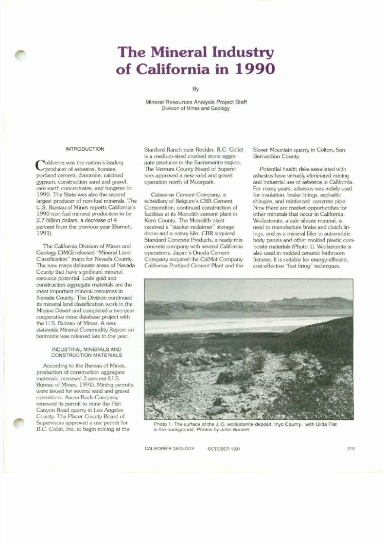
Photo 2. These two cones contain $184,308 in gold and $4,381 '" silver.
PRECIOUS METALS
California was the second largest goldproducer in the United States during1990 (Photo 2). Increased prOOuctionfrom large open-pit gold mines in theCalifornia desert region and northemCalifornia compensated for the closure of5e'Jerai small·production metal mines.Precious metal annual average prices de-clined in 1990. continuing the downwardtrend evident since 1988.
with Silliton Minerals U.S.A.. conductedan exploration-development program atthe Sixteen-to-One mine in Sierra County(Photo 3). Brush Creek Mining Companyundertook an aggressive land acquisitionprogram and eYeI'1tual/ygained control ofmost of the once-prooucing mines ofthe Allegheny Mining District. SierraCounty. Other promising properties inthe Allegheny Distlict are the famousRuby, Bonanza, and Gardner Point
mines.
Exploration activities were alsoreported throughout the MojaveDesertregion, including the Kelso Dunes areaof San Bernardino County. The U.S.Bureau of Land Management (BLM)revie\.veda proposal to develop mineraldeposits within a BLM WUcIemessStudyArea near the Kelso Dunesarea.
Homestake Mining Company pouredits one-millionth ounce of gold at theMcLaughlinmine in Napa County. GoldFJekis Operating Company opened theRainbovJ pitat the Mesquite mine inImperial County. U.S. Gold Cor lxnt ion
and AMAXGold. Inc. continued de\IeIopment al the ~ Hill gold project inLassen County. Hayden HiDwiD have aconventional ore processing miD andcyankJeheap leach facility.
RECYCLING
Recyclingbroken concrete debris intoconstnJctoo aggregate material hasbecome routine practice in California. In1989, the California Legislature enactedAB939, the nation's first integratedwaste-management law. 1b e neu.rlawrequires local governments to recycle25 percent of the saiKI waste in !heirjurisdictions by 1995, and 50 percent bythe year 2000. Aggregate base materials.asphaltic concrete, and foundry slags(v.aste products from meta! production)
v.lere addressed.Considerable mineral exploration anddevelopment drilling took place in Imperial County in 1990. Eastmaque GoldMinesdrilled the Oro Cruz Joint-Ventureproject. Exploration learns forHomestake Mining Company, GoldRelds Operating Company, and BemaGold Corporation 'JJere also active in theColorado desert region. Glamis Gold.Ltd. purchased Echo Bay mine's goldproperties near Randsburg. Kem County.The purchase included the Baltic andLamont deposits. G1amisGold also con
ducted further drilling at the YellovJ Astermine, Kern County.
Gold exp!oratoo and developmenttook place throughout the Siena MotherLode. Pegasus Gokl Corporation drilledthe Virginia mine $lte in MariposaComty. Sonora Mining Corporatooexplored the D u t c h · A p P ' " N ~ nareanear Quartz Mountain in TuolumneCounty. RoyalGold. Inc.. in partnership
Photo 3. The ongmal SIxteen-to-One mine at Allegheny, Sierra County. Ores from lodemines in this distrICt are some 01 th e nchestln c a ~ l o r n i a _
220 CAUfORNlA GEOlOGY OCTOBER 1991
8/7/2019 California Geology Magazine October 1991
http://slidepdf.com/reader/full/california-geology-magazine-october-1991 5/24
Several Califomia waste managementcompanies have purchased rock plants orhave modified existing facilities to crush.screen. and clean broken asphalticconcrete, brick, and other constructionaggregate materials. Recycled construc
tion aggregate materials are sold toconstruction companies. Steel reinforcingbars recovered in the recycling processare sold for scrap.
Santa Barbara County. stricken withseveral years of drought. offered rebatesto its residents who replaced theirstandard toilets with new low-nowmodels. Used toilets generated by thereplacement campaign posed a disposalproblem. The solution was to crush thetoilets and recycle them as asphalticconcrete aggregate. The ceramic
aggregate material performed quite \wll.
MINERAL RESOURCE POTENTIAL OFMATHER AIR FORCE BASE
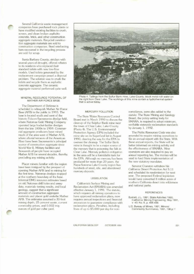
Photo 4. Tailings Irom the SulfurBank mine, LakeCounty. block metal·rich wateronthe right lrom Clear Lake. The workings 01 this mine contain a hydrothermal systemthat is active today.
The Department of Defense isscheduled to relinquish Mather Air ForceBase (AFB) to the public in 1993. Thebase is located south and west of thehistoric Folsom-Sacramento dredge field.where Natomas Gold Mining Companyoperated large bucket-ladder dredgesfrom the late 1800s to 1959. Commercial aggregate prooucers have minedmuch of the area west of Mather AFB,where alluvial terraces of the AmericanRiver have been Sacramento's principalsource of construction aggregate sinceWork! War II. Military facilities andthousands of people have occupiedMather AFB for several decades. therebyprecluding any mining at:livity.
Placer miners familiar with the regionhave been intrigued by the prospect ofopening Mather AFB land to mining forthe first time. Natomas dredges stoppedal the nonhem ooundary of the base.Informal DMG resource estimates basedon old Natomas drill holes and assaydata. materials-testing results. and localgeology. suggest that a significantamount of construction aggregatemalerials and placer gok! underlie MatherAFB. The estimates assumed a 30-footmining depth. 25 percent waste. currentcommodity prices. and 0.002 troyounces of gold per cubic yard.
MERCURY POLLUTION
The Slale Water Resources ControlBoard mel in March 1990 to discuss thecleanup of the Sulphur Bank mine nearthe town of Clear Lake. Lake County(photo 4). The U.S. EnvironmentalProtection Agency (EPA) included themine site on its Superfund list in August1990. clearing the way for the EPA tooversee the cleanup. The Sulfur Bankmine is thought to be a major source ofthe mercury that is poisoning the fish inClear Lake. Mercury pollution mitigationin the area will be a formidable task forthe EPA. Although no mercury has beenproouced for more than 20 years. theNapa-Sonoma-Lake County region hashundreds of small, idle. and abandonedmercury deposits.
LEGISLATION
Califomia's Surface Mining andReclamation Act (SMARA) was amendedeffective January 1. 1991. The statute.which requires all mining operations tohave approved reclamation plans. nowrequires annual inspections and financialassurances to guarantee compliance withreclamation plans. Penalties. includingfines of up to $5,000 per day for non-
compliance, were also added 10 thestatute. The State Mining and GeologyBoard. the policy setting body for5MARA. is reqUired to adopt minimum.verifiable statewide reclamation standardsbyJanuary 1. 1992.
The Public Resources Code was alsoamended to require mining operations tofile an annual report with the State. Withthese annual reports. the Slate will bebetter informed on mining activityandthe effectiveness of SMARA. Mineoperators are also required to pay anannual reporting fee. The monies will beused to fund State implementation ofthe new statutory mandates.
Senator Cranston withdrev.r hisCalifornia Desert Protection Act 5.11and scheduled its resubmission for nextyear. The proposed Federal1egislation
would have converted 8 million acres ofsouthem Califomla desen into wildemessand national parks.
REFERENCES
Burnen. J.L. 1991. State Activities 1990,California: Mining Engineering. May 1991.v. 43. No.5. p. 495·496
U.S. Bureau 01 Mines. 1991, MineralCommodity Summaries. 1991. 196 p.X
CALIFORNIA GEOLOGY OCTOBER 1991 '"
8/7/2019 California Geology Magazine October 1991
http://slidepdf.com/reader/full/california-geology-magazine-october-1991 6/24
Geology at the Intersection of theGarlock and Death Valley Fault Zones,
Northern Avawatz MountainsMojave Desert Quaternary Research Center
Field Trip Road Log
By
ROLAND H. BRADY IIICalifornia Stale University. Fresno
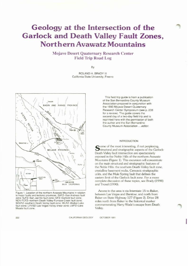
Figure 1. Location al tha northern Avawalz Mountains in relationto major faults and tectonic provinces. SAFZ-San Andreas tauflzone: SJFZ-San Jacinto fault zone: GFZ-Garlock faull zone:NOV-FeF2-northern Death Valley-Furnace Creek fault zone;SOVFZ-sauthern Death Valley fault zone; WLFZ-Walker Lakefaull zone: lVVSZ-Las Vegas Valley shear zone; LMFZ-lake
Meade fault zone.
- (MEXICO)BAJA CAUFORNIA
This field trip guide is from a publication01 the San Bernardino County MuseumAssociation prepared in conjunction withthe 1990 Mojave Desert QuaternaryResearch Center Symposium (see p. 238tor a review). The guide covers thesecond day of a two-day field trip and isreprinted here with the permission of boththe author and the San BernardinoCounty Museum Association .... editor.
INTRODUCTION
S om e of the most interesting, if not perplexing,structural and stratigraphic aspects of the Garlock-
Death Valley fault intersection are spectacularlyexposed in the Noble Hills of the northern AvawatzMountains (Agure 1). This excursion will concentrateon the main structural and stratigraphic features ofthe Noble Hills: the southem Death Valley fault lone.
crystalline basement rocks, Cenozoic stratigraphic
units, and the Mule Spring fault that defines theeastem limit of the Garlock fault zone. For a morecomplete discussion of these topics, see Brady (1990)and Troxel (1990).
Access to the area is via Interstate 15 to Baker,bel\.veen Las Vegas and Barstow, and north fromBaker on State Highway 127 (Rgure 2), Drive 28
miles north from Baker to the historical markercommemorating Harry Wade's escape from DeathValley.
CALIFORNIA GEOlOGY OCTOBER 1991

8/7/2019 California Geology Magazine October 1991
http://slidepdf.com/reader/full/california-geology-magazine-october-1991 7/24
QUAILMTS
OWLSHEADMTS
"
" ,•VALJEAN
HILLS
15
BAKER
HALLORAN• HILL
SILURIAN" .. " HILLS'"~ , L\III111
f
AVAWATZMTS
o,
LASVEGAS
F"lQUf92. Locatton 01 th e AvawalZ MountainSand saTOUndlng ranges.
MILEAGE LOG
MIleage Inlerval
00.0 00.0 From the Harry Wade monumenl. turn lett(weSI) onto the dirt road. Pass lIle turnofl tosaratoga Spring, enter Dealh VaDey NationalMonument. and proceed to th e first map- lor1l..
whdl is to.4 miles north of th e Hilfry Wademonument.
01.6 01.6 InlersectJOn of the Harry Wade road (alsocalled saratoga Spnogs road) and the road toSheep Creek camp. Continue 00 the Waderoad (01' tu m left onto the Wade road if coming
from the Sheep Creek road).
10.4 08.8 Bear lett at the fOfil.which is just north of aSIgn lhal warns. Driving 0 " roads is prohibited.Proceed 0.3 miles through a depreSSIOn in !henorthern end of the Noble Hils.
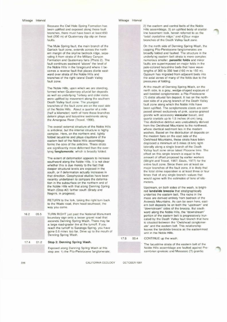
10.7 0.3 Stop 1: Northern Noble Hills.
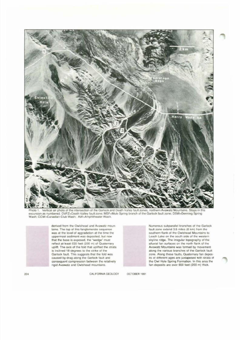
Par1l. an d walk north 10 the nearest hi I north 01th e toad (PhoIO 1). Ths Slop attords a distant
'TermS in b o l d f _ a, e Ixplaltl8d in me glMsary on page 231
V!ClWof th e GarklCk fault zone and exposures ofupper·level deformation along !he southernDeath Valley 'aull zone.
The prominent ridge on the southwestern skylineis the bedrock mass oj the Avawatz Mountains.Dtonte composes the eastern (left) hall: thewestern t\aIf is metavotcal"llCrock. In the leftforeground are the Celestite HiIs-a told S11TM1ar
structura/ly an d strabgraphicaJIy 10 the northernNoble Hills.
The isolated, wedge-Shaped mound on the wesl·ern skyline between the Avawatz and Owlshead
mountains is the southern limb 01 a synclinehaving a SOtJth-dipping ex18'surface', The oldest strata exposed in the 'old are lacu,trlneevaporite and carbonale rocks 01 the the OwlHole $pring Formation (new name), Theserocks, radiometneally dated at a malumum8.'9:*:24 Ma (Brady, 1990). are stratigraphicallyand petrologICally srmiIar 10 those of the easternbell of the Noble Hills assemblage, and areprobably conelatJve.
OverlyIng the lac;u$trine strata at the "wedge:are 650 teet (200 m) 0' alluvial 'a n deposits
CALIFORNIA GEOlOGY OCTOBER 1991 223
8/7/2019 California Geology Magazine October 1991
http://slidepdf.com/reader/full/california-geology-magazine-october-1991 8/24
~ • · u " .
".='j\-; ~
Photo 1 VertICal i l I · , L p h o ~ l O ~ o l " " " ' - ' - " t C _ ' - " ' ' ' o O t " t ' ' ' ~ G o < t o d < ; ! ' ' ' 'and Death Valley fault zOnes. northern AvawalZ Mountains. Stops in thiseXCUfllOfl as numbered. OVFZ.Death Valley laullzone. MSF.MuIe Spring branch 01 the Garicldl;laJIt zone, DSW.Dennll'lg SpnngWash. CCW.Canadlilll Club Wash; AW_Amphltheatel Wasil.
'"
denved from the OwIshead an d Avawatz moun-tain, The to p of thls fang!omel"ato coquctf'lCG
wa s at th e level of aggrada tion at the lime theuppormost sediment WII$ dcpo$tod. bu t now
that !he baSe is exposed. I'le "'wedge" muSlreflftcl at lea$1 GSO leet (200 m) 01 <Aoatemer.ryuplift The axIS 01 th e fold that uphlled the stratais iodined HI deg . . - s 10 the stri.e of th eGarlOck fault. This SUQgests thai th e bi d wascaused by (trag alol'lllttle Garlock laull anclconsequent compression between the relalvelyr igid Avawalz and Owlshead mounlams.
CALFORNIA GEOlOGY OCTOBER 1991
Numerous subpasalel branches of tI'Ie Garlockf Q u ~zona extend 3.5 milos (6 kmjfrom thesouthern lIank of the Ow5head Mountains 10Leach lake on the south SIde of th e _ , ! e m
skyline ndge. The irregular topography 01 thea......... f¥ l SUIlaces on th e 00fth flank ol lheAvawalZ Mo!Jntams was !ormed by movementalong the various branches o l l h e Garloct laull
zone. Along these faults, Quaternary Ian depos-itS 01 dlflerent ages ar e Juxtaposed With Slrata orthe Owl Hole Spring Formatlon_ In Ihls area thefan deposits .e over 650 feet (200 m) ltlck.

8/7/2019 California Geology Magazine October 1991
http://slidepdf.com/reader/full/california-geology-magazine-october-1991 9/24
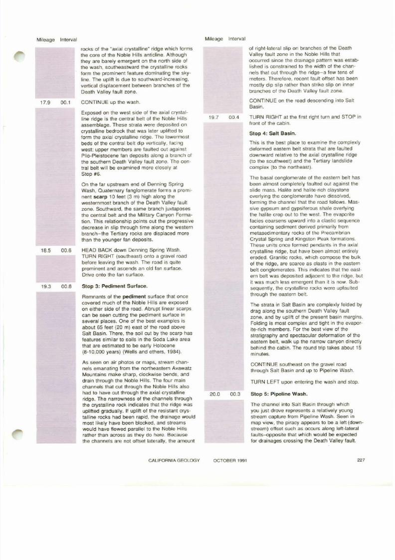
Photo 2. Oblique air photo view to southeast along the Noble Hills and Death Valley fault zone. Avawatz Mountains in backgrour"ld.Garlock fault zone enters photo righl center.
CALIFORNIA GEOlOGY OCTOBER 1991 225
8/7/2019 California Geology Magazine October 1991
http://slidepdf.com/reader/full/california-geology-magazine-october-1991 10/24
Mileage Interval
Because the Owl Hole Spring Formallon hasbeen uplilted and exposed along these faultbranches, there must have been at least 650fee t (200 m) of Quaternary dip sl ip on thesefaults.
Mileage Interval
2) the eastern and central belts ot the NobleHills assemblage, 3) an uplifted body of crystal ·l ine basement rock, herein referred to as the"axial crystalline ridge:" and 4)ltour majorbranches of the Death Valley fault zone.
16.2
17.4
05.5
01.2
The Mule Spring !aul1, the main branch of theGarlock fault zone. extends across the northern margin of the skyline bedrock ridge. separating it from strata of the Mititary CanyonFormation and Quaternary fans (Photo 2). Thefault continues eastward "above" the level ofthe Noble Hills in the foreground where it be-comes a reverse faulttha! places diorite east·ward over strata of the Noble Hills andbranches of the right-lateral Death Valleyfault zone.
The Noble Hills. upon which we are standing,formed when Quaternary alluvial fan depositsas well as underlying Tertiary and older rockswere uplifted by movement along the southernDeath Valley fault zone. The youngest
branches of the tault zone are on the eas t s ideof the Noble Hills. Abou t a qua rt er of a mile(half a kilometer) north o! here these branchesdeform playa and lacustrine sediments alongthe Amargosa River (Troxel. 1990).
The overall external structure of the Noble Hillsis anticlinal. but the internal structure is highlycomplex. Here. on the northern end, tightlyfolded lacustrine and playa claystone of theeastern belt of the Noble Hills assemblageforms the core of the anticline. These strataare significantly more deformed than the over·lying fanglomerate. which is broadly !olded.
The extent of deformation appears to increasesouthward along the Noble Hills. It is not clearwhether this is due merely to the fact tha tdeeper structural levels are exposed in thesouth, or if deformation actually increases inthat direction. Geophysical studies have beenrecently undertaken to compare the deformat ion in the subsurface on the northern end o!the Noble Hilts with that along Denning SpringWash (Stop #2) farther south (Brady andNegrini. in progress).
RETURN to the fork. taking the right turn backto the Wade road. then head southeast, theway you came.
TURN RIGHT just past the National Monumentboundary sign onto a lesser gravel road thatascends Denning Spring Wash. There may bea large road·grader tire at the turnoff. If youreach the turnoU to Saratoga Spring, you havegone 0.6 m il es too tar. Drive up to the mouth otDenning Spring Wash.
Stop 2: Denning Spring Wash.
Exposed along Denning Spring Wash at thisstop are: 1) the Plio·Pleistocene tanglomerate:
17.8 00.4
O n t he north side of Denning Spring Wash. thecapping Plio-Pleistocene fanglomerates are
broadly folded and faulted. The structure in theunderlying eastern belt strata is more complex:numerous smaller. parasitic folds and minorfaults are superimposed on major folds in thepale·colored lacustrine beds that have wavel engths of 300 to 350 feet ( 100 m to 150 ml.Gypsum has migrated from adjacent beds intothe axial zones 01 many of the folds due to thepressures of folding.
At the mouth of Denning Spring Wash, on thenorth side, is a gray, wedge'shaped exposure ofwell-bedded conglomerate: a Plio-Pleistocene(1) distal alluvial fan deposit. II l ies on the north·east side of a young branch of the Death Valley
fault zone along which the Noble Hills havebeen uplilled. The conglomerate clasts are composed almost exclusively of pink, coarse·grainedgranite with accessory vesicular basal\, andquartz crystals up to 1.5 inches (4 cm) long.This distinctive detritus was undoubtedly derivedfrom the Owlshead Mountains to the northwest.where identical sediment lies in the modernwashes. Based on the distribution 01 deposits onthe mode rn fans on the east side of theOwlshead Mountains, these strata have beendisplaced a minimum of 5 miles (8 km) rightlaterally along a single branch of the DeathValley fault zone since latest Pliocene time. Theoffse t on this s ingle branch is equal to the
amount of offset proposed by earlier workers(Wright and Troxel, 1967; Davis. 1977) for fheentire fault zone. Since there are at least sixmajor branches of the fault zone, it is l ikely thatIhe lotal strike separation is at least three Of fourtimes thaI of any single branch-values thatwould agree with the estimates of tens of kilo·meters.
Upstream. on both sides of the wash. is brightred landslide breccia that stratigraphicallyunderlies the eastern belt. The rocks in themass are derived entirely from bedrock of theAvawafz Mountains. As can be seen here. eastern belt deposits l ie on both the 'upstream" and"downstream" sides of the breccia. But soufhward along the Noble Hills, the "downstream"portion of the eastern belt is progressively truncated by the Death Valley fault branch thaI hereis situated between the "Owlshead conglomer·ate" and the eastern bell. This relationshipleaves the landslide breccia as the easternmostunit in the Noble Hills.
CQNTINUE up the wash.
The lacustrine strata 01 the eastern belt of theNoble Hills assemblage are laulted against Pre·cambrian gneissic and Mesozoic (1) granitic
CALIFORNIA GEOLOGY OCTOBER 1991
8/7/2019 California Geology Magazine October 1991
http://slidepdf.com/reader/full/california-geology-magazine-october-1991 11/24
Mileage Interval Mileage Interval
17.9
18.5
19.3
00.1
00.6
00 8
rocks 01 the "a)(lal crystalline" ridge which formsthe core of Ihe Noble Hills anticline. Althoughthey are barely emergent on the nonh side ofthe wash. southeastward the crystalline rocksform the prominent feature dominating the skyline. The uplift is due to southward-increasing.venical displacement between branches of the
Death Valley fault zone.
CONTINUE up the wash.
E)(posed on the west side of the a)(ial crystall ine ridge is the central belt 01 the Noble Hillsassemblage. These strata were deposited oncrySlalline bedrock that was later uplifted tolorm the axial crystalline ridge. The lowermostbeds 0' the central bell dip venically. 'acingwest: upper members are faulted out againstPlio-Pleistocene Ian deposits along a branch 0'the southern Death Valley faull zone. The cen·tral belt will be e)(amined more closely atStop #6.
On the far ups tream end of Denning Spr ingWash. Quaternary 'anglomerate forms a promInent scarp 10 ' ee t (3 m) high along thewesternmost branch of the Death Valley 'aultzone. Southward. the same branch ju)(taposesthe central bell and the Military Canyon Formation. This relationship points out the progressivede<:rease in slip through time along the westernbranch-the Teniary rocks are displaced morethan the younger Ian deposits.
HEAD BACK down Denning Spring Wash.TURN RIGHT (southeast) onto a gravel roadbelore leaving the wash. The road is quiteprominent and ascends an old fan surface.
Drive onlo the fan surface.
Stop 3: Pediment Surface.
Remnants of the pediment surface that oncecovered much of the Noble Hills are e)(posedon either side 01 the road. Abrupt linear scarpscan be seen cutting the pediment surface inseveral places. One of the best e)(amples isabout 65 feet (20 m) east of the road aboveSalt Basin . There . the soil cut by the scarp hasfeatures similar to soils in the Soda Lake areathat are estimated to be early Holocene(8-10.000 years) (Wells and others, 1984).
As seen on air photos or maps, stream channels emanating lrom the nonheastern AvawatzMountains make sharp, clockwise bends. anddrain through the Noble Hills. The lour mainchannels that cut through the Noble Hills alsohad to have cut through the a)(ial crystallinerldge. The narrowness 01 the channels throughthe crystalline rock indicates that the ridge wasuplifted gradually. II uplift of the resistant crystalline rocks had been rapid, the drainage wouldmost likely have been blocked, and streamswould have Ilowed parallel to the Noble Hillsrather than across as they do here. Becausethe channels are nol oHset laterally. the amount
19.7
20.0
00.4
00.3
of right-lateral slip on branches 01 the DeathValley laull zone in the Noble Hills thatoccurred since the drainage pattern was established is constrained to the width 01 the channels that cut through the ridge-a lew tens 0'meters. Therefore. recent fault oHset has beenmostly dip slip rather than stnke slip on inner
branches of the Death Valley fault zone.
CONTINUE on the road descending into SaltBasin.
TURN RIGHT at the f irst r ight turn and STOP infront of the cabin.
Stop 4: Salt Basin.
This is the bes t place to e)(amine the complexlydeformed eastern belt strata thai are laulleddownward relative to the aXial crystalline ridge(to the southwest) and the Tertiary landslidecomplex (to the northeast).
The basal conglomerate of the eastern belt hasbeen almost completely 'aulted out against theslide mass. Halite and halite-rich claystoneoverlying the conglomerate have dissolved.torming the channel that the road follows. Massive gypsum and gypsiferous shale overlyingthe halile crop out 10 the west. The evaporitelacies coarsens upward into a claslic sequencecontaining sediment derived pl"imarily frommetasedimentary rocks of the PrecambrianCryslal Spring and Kingston Peak formations.These units once formed pendants in the axialcrystalline ridge. but have been almost entirelyeroded. Granitic rocks. which compose the bulkof the ridge, are scarce as c lasts in the easternbelt conglomerates. This indicates that the eastern belt was deposited adjacent to the ridge, butit was much less emergent than it is now. Sub·sequently. the crystalline rocks were upfaultedthrough the eastern belt.
The strata in Salt Basin are complexly folded bydrag along the southern Death Valley faullzone. and by uplit t 01 the present basin margins.Folding is most complex and tight in the evaporite-rich members. For the best view of thestratigraphy and spectacular deformation of theeastern belt. walk up the narrow canyon directlybehind the cabin. The round trip takes about 15minutes.
CONTINUE southeast on the gravel roadthrough Salt Basin and up to Pipeline Wash.
TUAN LEFT upon entering the wash and SfOp.
Slop 5: Pipeline Wash.
The channel into Salt Basin through whichyou just drove represents a relatively youngstream capture trom Pipeline Wash. Seen inmap view, the piracy appears to be a lett (downstream) offset such as occurs along lett·lateralfaults-opposite that which would be expectedtor drainages crossing the Death Valley fault.
CALIFORNIA GEOLOGY OCTOBeR 1991
8/7/2019 California Geology Magazine October 1991
http://slidepdf.com/reader/full/california-geology-magazine-october-1991 12/24
s
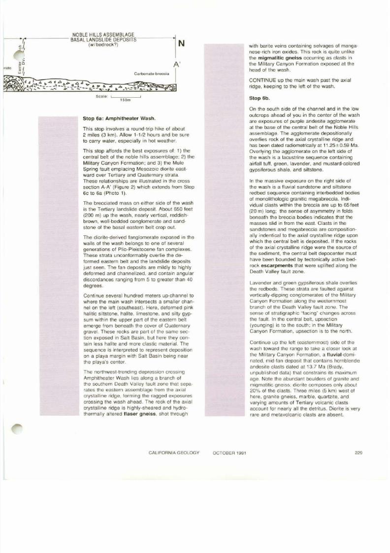
FIgure 2 SW-NE cross sectIOn through the southwestern Noble Hils In Aml1l1lheater Wash Sl'loWlng majOr Iltholoqtc U111ts and faultsCross sectJOn ellter:ds from SlOP 6c (SW) 10 6a (PhoIO 1).
NOBLE HillS ASSEIJ8t.A(EASTERN BEtT
,j•o
NOelE i1IlLSASSEM3 AXIAl.CRYSTAlUNE PIOGE -r:"~ CENTRAl. BEL 3 I.. l: } .I; ,
~ D l i _ ~ , I'" - .:>... ".,1. .. --lI,.,p ~......
, 0 ' ~ : f i 5 ! i ~ ~ - : : - ; . : - ~ : ' ~ ' " , " , " , - : ", \ ~ 111 1 ' 1 , ' , . ur 'I " 1 , 1 , .
" " . - ' , , \ ' " ,
\ ld , ', f ' , \ • • - I t ~ \ ' •- ~ I ' . " ' , " ,- .
D<lM'--•
-•
A
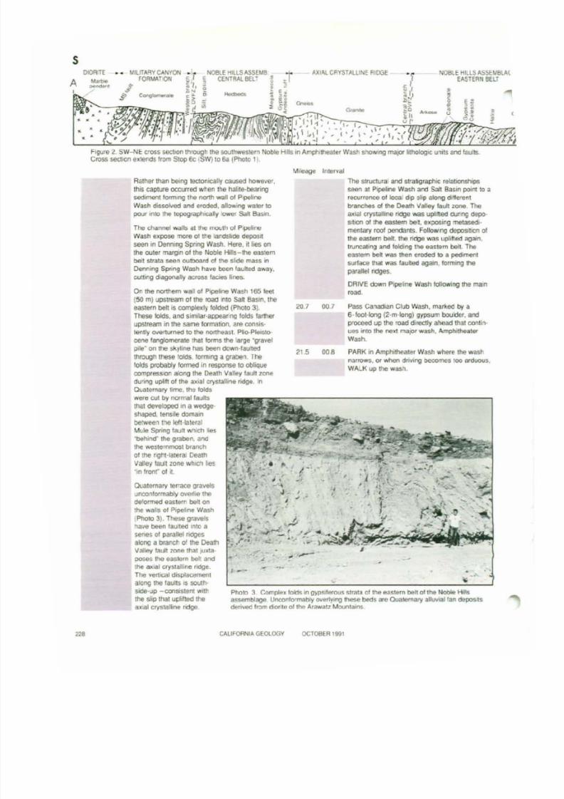
Photo 3 Con'plell fokts In g)o-pM9rOIIS Simla of lh e easlern belt cl lhe Noble Hillsassemblaoe Uncorlormably ~ n gf1ese b ed s a re Oua,,",ary a o ~Ian depo$ t$derMld from clontS of th e Arawall Mounlao",s
Rather than being tectOnically caused ~ 8 f .
thIS capture IXCU'led when the halile·beanros e d i ~ lIOfInrlg !h e north wan 01 Pl>8"neWath d i s s o ~ o dand eroded, allov.,ng wtllCr topour ,nlO the topograptucaly owe. Sa h BaY"!.
The channel walls at !he moul/l or P>pelineWaSh expose more o t tile I8ndSl!de tleposIlseen In DemIng Spnng WaSh. Here. it lies on!he ouler margin 01 the IkJbIe Hills-the easternbe t slrala seen outboard of th e slide mass nDenring Spring Wooh have tJo(:n faulted away,QJnong diagonally IlIcross facies lines.
On the northem wall 01 P. p e h Wash 1651eet(50 ml upstream of th e road into sa l Basin, th eeastern belt is ccmplexly folded (Photo 3).These Iolds, and Slmi\at·appeal'ng folds 1ar1herupstream in the same formaton. ate oonsis·lenlly O l o ' . r t l S ~to thlt nofth9a,l. PIio-PltIGlo·cene ItIf'IgIometate tt\lIllotms the lerge -gravelpile- on l/18 skyline ha s been etown·lau:le<tlhrot.lJh these ~ o l l 1 slorrrutg a graben. The!oIds proba.bIy formed in response to obIiQutcompress.on aIoog lhe Dealh Valley faull ZM edunng upift o l l h t Dial C f ) ' " t a l ~ n eridge. InQuoIO!"l\{Iry time, m e l ol dswere cut by IlOfmallaultsthai cleYelopec:l In a Wedgeshaped, tensile domanbe'Ween !he lett·lateralMule Sprlflg f;tU1t whll;h ie s'behllld"" th e grablm. ancthe v.e, temmost brench01 the nghHaterai DealhValley taull zone wtlK:h le s'i n lronf 01 it.
Quaternary lefTace gravelsunco'lformab/y' owertie thede'ormed e;ast,rn bell onthe walls 01 Plpetne WashfPhoto 3)_ These gravelsha'ie been lau: ted Inlo asenas 01 parallel ndgesalong a bfanch of the DeatlValley taUt lone lhat Il'llta~ tho G;LSktrn boll an d!h e <181 crystan,ne ridge.The vertical dispfitC8mentalong the taul ls IS SOIAhSIde-up -COOSIsttnt WIth\tie slip Chat uplilted theax.al cryslalline rOge
20.7
21 S
00.7
00 8
The stnJCtllral and strallO,att!1C relallOOshlpsseen at Pipelne Wash arc! Salt Basin pOIfII to arecurrer'lCe 01 local d p slip olong di'fo'onlbranches cl lhe Death Vi!IIley IalAl zone. Theaxial crystalline rklge was uplifted QJf,ng depo5 bo n 01 the eaSiern be'!, exposmg melaSedi·mentary rool oondatts. FolJow.ng deposition ollh e easlern bah. th e ~ e was uplifted again.tlVncatlng an d folcling the ea510m belt. Theea3:em be l WIIS !tIen eroded b e pedimentsurface 'Iatwas lauled again, lorrning tl e
parallel ridges.DRIVE down pipttine Wash lolloWing the ma.n.....
Pass canad ian Club Wash. marl\ed by a6·loot-!ong (2·m·long) gypsum bou'der, andproceed up lhe road direclly altead that COOI,nues mto " , . next n a p r wnh, AmptuthealerW(l$h.
PARK in Amphitheater Wash where tlte washn:mows. or.....non dnvlI'Ig Deeo'1"les too ordvous.WALK up me wash.
12. CAlIFOR>llAGEOlOGY OCTOBER 199'
8/7/2019 California Geology Magazine October 1991
http://slidepdf.com/reader/full/california-geology-magazine-october-1991 13/24
Stop 6b_
CONTINUE up the main wash past the axialridge, keeping to the left of the wash.
with barite veins containing selvages 01 manganese-rich iron o ~ i d e s .This rock is quite unlikethe migmati tic gneiss occurring as clasts inthe Military Canyon Formation exposed at thehead of the wash.
A'
ICarbona\(l brecc,a
, SOm
NOBLE HIllS ASSEMBLAGE- - - - - B A S A l l A N O S l I D E DEPOSITS----l N
'J (w/bedrock?)fj I,
Stop 6a: Amphitheater Wash.
This stop involves a round-trip hike of about2 miles (3 km). Allow '-112 hours and be sureto cafry water, especially in hOI weather.
This Slop affords the best exposures 01: 1) thecentral bell of the noble hills assemblage; 2) theMilitary Canyon Formalion; and 3) the MuleSpring faull emplacing Mesozoic diorite easlward over Tertiary and Quaternary strata.
These relationships are illustrated in the crosssection A-A' (Figure 2) which extends from Stop6 c to 6a (Photo 1).
The brecciated mass on either side 01 the washis the Teniary landslide deposit. About 650 feel(200 m) up the wash. nearly vertical, reddishbrown. well-bedded conglomerate and sandstone of the basa l eas tern bel l crop out.
The diorite-derived langlomerate e ~ p o s e din thewalls 01 the wash belongs to one of severalgenerations of Plio-Pleistocene Ian c o m p l e ~ e s .
These strata unconformably overlie the deformed eastern belt and the landslide depositsjust seen. The fan deposits are mildly to highlydeformed and channelized. and contain angulardiscordances ranging from 5 to greater than 40degrees.
Continue several hundred meters up-channel towhere the main wash intersects a smaller channel on the lelt (southeast)_ Here, deformed pinkhalitic siltstone. halite. limestone, and silty gypsum within the upper par t of the eastern beltemerge trom beneath the cover 01 Quaternarygravel. These rocks are par t of the same section e ~ p o s e din Salt Basin. but here they contain less halite and more clastic material . Thesequence is interpreted to represent depositionon a playa margin wi th Sal t Basin being near
the playa's center.
The northwest-trending depression crossingAmphitheater Wash lies atong a branch ofthe southern Death Valley tault zone that separates the eastern assemblage from the axialcrystalline ridge. fOrming the ragged e ~ p o s u r e s
cross ing the wash ahead. The rock of the a ~ i a l
crystalline ridge is highly-sheared and hydrothermally altered lIaser gneiss, shot through
On th e south side of the channel and in the lowoutcrops ahead of you in the center of the washare exposures of purple andesite agglomerateat the base of the central bel t of the Noble Hillsassemblage. The agglomerate depositionatlyoverlies rock 01 the axial crystalline ridge andha s been dated radiometricaJly at 11.25±0.59 Ma.Overlying the agglomerate on the left side ofthe wash is a lacustrine sequence containingairfaU tuff. green. lavender. and mustard-colOredgypsiferous shale. and siltstone.
In the massive exposure on the right side ofthe wash is a !Iuvial sandstone and siltstoneredbed sequence containing interbedded bodies01 monolithologic granitic megabreccia. Individual clasts within the breccia are up to 65feet(20 m) long: the sense of asymmetry in foldsbeneath the breccia bodies indicates that themasses slid in from the east. Clasts in thesandstones and megabreccia are compositionally indentical to the axial crystalline ridge uponwhich the central belt is deposited. If the rocksof the axial crystalline ridge were the source ofthe sediment. the central belt depocenter musthave been bounded by tectonically active bed-rock escarpments that were uplifted along the
Death Valley lault zone.
Lavender and green gypsiferous shale overliesthe redbedS. These strata are faulted againstvertically-dipping conglomerates of the MilitaryCanyon Formation along the westernmostbranch of the Death Valley lautt zone. Thesense 01 stratigraphic "facing" changes acrossthe fault . In the central belt, upsection(younging) is to the south: in the MilitaryCanyon Formation, upseClion is to the nonh.
Continue up the left (easternmost) side of thewash toward the range to lake a closer look atthe Military Canyon Formation, a fluvial-domi
nated. mid-fan deposit that contains hornblendeandesite clasts dated at 13.7 Ma (Brady.unpublished data) that constrains its maximumage. Note the abundant boulderS of granite andmigmatitic gneiss: diOrite composes only about20% of the Clasts. Three miles (5 km) west ofhere, granite gneiss, marble. quartzite, andvarying amounts of Teniary volcanic clastsaccount for nearly all the detritus. Diorite is veryrare and metavolcanic clasts are absent.
CALIFORNIA GEOLOGY OCTOBER 1991 229
8/7/2019 California Geology Magazine October 1991
http://slidepdf.com/reader/full/california-geology-magazine-october-1991 14/24
230
The clast composition 01 the Military Canyon
Formation is dissimilar to the bedrock types ofthe modern Avawall Mountains and the axialcrystalline ridge. Therefore it IS unlikely that ll'lesediment in the Military Canyon FOfrnalJon wasderived Irom these sources. The naser gneissin the axial CTystalline ridge and the migmatlhcgneiss in the Mili tary Canyon Formation arealso dissimilar. Furthermore. the Military Canyon Formation contains marble and quartZIte,which do not occur In the axial crystallineridge. Clasts from the Kingston Peak or CrystalSpring Formation. which are exposed on tne aJUalc r y s t a l ~ n eridge. are absent in the MilitarycanyonFormation.
Although the Avawall Mountains' diorite core isnow adjacent to three sides of the M i l ~ a r yCanyonFormation. the lack of diorite and metavolCanicdetritus indicates that the M i l ~ a r ycanyon Formation was not deposited in its present geographic:setting. 'Nhen the Military CanyonFormation wasdeposited during tOOdle Miocene (?) time. thediorile an d metaVOlcaniccore of the AvawatzMountains was not SIgnificantly emergent. Therelore. the site of !he present Avawatz Mountainswas a MIClO&I'l8 basin InlO which !he ftuviaI conglomerates of the M i ~ t a r ycanyon Formationwere deposited The Haloran Hills. now situated12 mileS (20 kin) south oflhe AVirNatz. Mountainson !he opposlte side of th e Death Valley faultzone. may have been !he source of !he M i ~ t a J y
Canyon Formation detritus. as Brady (1990) discussed. Alternatively. the source may have been abIoc::kderived from the Haban Hils terrane thatwas faulted over !he Avawatz bedrock and subse-QUently eroded.
The pronounced angular unc:ontormity betweenthe Neogene units and the diorite-deoved P\ir).Pleistocene fan strata records a rnarited tectonICchange. The Tertiary units are mainly aHlMalIan.braided river. and playa strata deposited Insyntectonic basins that existed at the site of !hepresent Avawatz Mountains befOfe the range wasuplifted. The deposition of the Avawatz-deriYedfans over the Neogene deposits oontaining exoticclasts may have been caused by structural interference between the Garlock and southern DeathValley faults. which uplifted the range through itssedimentary cover during Pliocene time andcaused !he onset oflocally-deriYed alluYiai fansedimentation. Since the diorite now stands
8.200 leet (2.500 m) above the valley floor, itmust have been uplifted at Ieasl that amount.
CONTINUE up !he southernmost (left) side of thewash to its termination against the mountain front.
Slop 6C.
The brighl blue rock at !he head of the wash ischloriticgouge along !he Mule Spring fault where
CALIFORNIAGEOlOGY OCTOBER t991
the diorite is faulted eastward over the MilitaryCanyon Fonnalion. The Mule Spring fault zonehere in Amphitheater Wash is a single plane,but about a mile (2 km) to the south, the zonebroadens and contains numerous imbricated west·dipping branches. At the zone's southern eod, thediorite of the Avawatz Mountains is faulted eastward over young (Holocene?) alluYiallans, thebelting of wtlich h as b ee n tectonically steepenedto 60 degrees east.
5eYeraI ~ n e sof evideo::e support the hypotheSISthat the Garlock fault terminates here in theAvawatz Mountarns aJong the east·vel'"genl secoonof the Mule Spong fault zone. West of the DeathValley fault rona, there are abundant OJaternary,fault·related features haYll'lQ"Garlock" trends. butnone are 8YJdent east of it. Tertiary rocks of theNoble H ~ 1 sassemblage extend across the easlernprOf8ChOll 01 !he Garlodt fault zone. but are ro tollset by it as would be eXpeeled if !he GarlockconlJnued eastward. furthermore, graVItydata
collected across the Mule Spring fault~ s t
south ofthere suggest that the dionte pluton is a thin(1 mile Of 1.5 kin) slab havmg a nearty flat, hori·zontal lower boundary. ThIs geometry indicatesthat the dl()(lte has been truncated from ItS root bythe Mule Spring fault that Ilanens beneath therange (see Brady, 1990). This westward lIanenlngof the Mule Spring fault may be !he mechanismthat tenninates !he Garlock fault here. Because 01
this llanenlng. Ieft·lateral strike·slip motion on the
verlJcal weslern part oflhe Mule Spring fault istransformed on the east side into east·vergentreverse rTlOYemetl!. The lotal amount of eaSl·directed offset is estimated to be between 3 and 5mites (5 and 8 km).
As seen on this excursion. o..,atemary lateral 011·
set along the western branches of the DeathValley fault zone in the Noble Hills is no more than0. 3 mile (0.5 kin). although the eastern branch inthe Noble Hils ha s transpOrted the granite·beanngconglomerate all east 5 miles (8 kin). This trendof increa5lflg ollset from wes1 to east indicates thatany large movements that might have occurred onIhe Death Valley fault zone did so on brancheseast of the Noble Hills. II indeed there have beentens of kilometers of Cenozoic offset along !hefault zone (see Brady, 1990), it is highly unlikelythat the Death Valley fault terminates in theAvawatz Mountains. Rathel". it probably continuestens of kilometers. if not farther. iflto the southeast·
ern Mojave Desert.RETURN to the mouth of Canadian Club Washthe same way you arrived.
TURN RIGHT (north) and drive down the wellgraded gravel road 10 the Wade road. andTURN RIGHT to Highway 127.
8/7/2019 California Geology Magazine October 1991
http://slidepdf.com/reader/full/california-geology-magazine-october-1991 15/24
Glossary
.'luYiaItan: A gently skIpIng fan-shaped mass ofloose rock deposIled by a Siream where II flows Irom
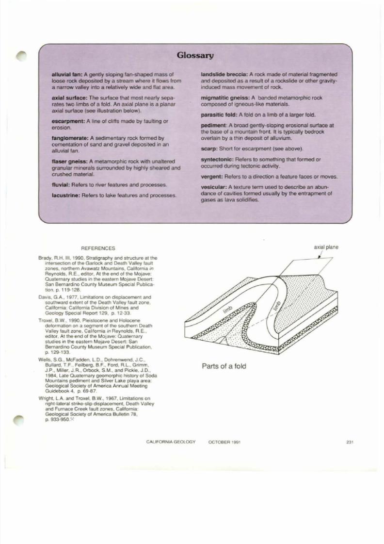
a narrow valley Into a relatively wide and flal area.ax i l ' surface: The surface Ihal most nearly separates two limbs of a fold. An axial plane is a planaraxial surface (see illustrahon below).
HQrpment: A line of dlffs made by faUlting 0 (
e<0SK>n.
fangkHnerate: A sedimentary rock formed bycemenlation of sand and gravel deposited in analluvial fan.
f tner gneiss; A metamorphic rock with unalteredgranular mlOElrals surrounded by highly sheared andcrushed matenal.
fluvill : Refers to river fealures and processes.
lacustrine: Refers to lake fealures and processes.
REFERENCES
Brady. R.H. m. 1990. SlratJgraphy and structure at !hetnlefSeCbOfl 01 !he Gal10ck an d Death Valley fault
zones, northern Avawall Mount.aJns. Ga/JlornJa 11'1
Reynolds, RE., editor, At !he end of !he Mojave:Quaternary sludies in the easlern Mo,ave Desert:San Bernardino Counly Museum Special Publica·tion.p.119-128.
DaVIS. G.A., 19n, LImitations on dlsplacemenl andsoultlward extenl 01 the Dealh Valley laullzonct.GaIil()ll"ll,aCa:.trtoma DrvtsIon 01 MInes andGeology SpeoaI Report 129, p. 12-33.
Troxel, 8 W 1990. PleIstocene and Holocenedelonnabon on a segment of !he SOIJlhern DeathVaney laullzone, CalifornIa 1ft Reynolds. R.E ..editor. Al the end althe Mojave: Ouaternarystudies in the eastern Mojave Desert: Sa nBernardino County Museum Special Publicabon,p. 129·133
Wells. S.G, McFadden, LD" Dotvenwend. JC ..Bullard, T F. Feilberg, B F., Ford, R_L, Gnmm.J P., Miller. J.R., Ortlock. S.M., and P1ckIe. J.D.,1984, Lale Quaternary geomorphic: htstory ot SodaMountains pediment and Silver Lake playa areaGeological Society 01 America Annual MeelJngGuidebook 4, p. 69·87.
Wnght, LA. and Troxel, B.W" 1967,lJn'w\alJOns onnghI·! alerai slJike-sJip dispIacemenc, Death Valleyand Furnace Creek tault zones. ca10rnlaGeo6ogIcaI Sooety of Amenca BulletIn78,p.933·95O,"><
landslide brecc:1a: A roctl. made of malenaJ fragmentedand deposited as a result of a roc:tlslide or othergravlty
Induced mass movement01
rock.migmatltlc gneiss: A banded metamorphic rockcomposed of igneous-like materials.
parasit ic fold: A fold on a l imb of a larger foki.
pediment A broad gently-skIpIng erosional surface at
the base 01 a mountain front. It is typiCally bedrockovel1aln by a thin deposit of alluvium.
scarp: Short lo r escarpment (see above).
syntectonic: Refers to something that formed oroccurred dumg tectonIC aetMty.
vergent: Refers 10 a direction a fealure faces or moves.vesicular: A texture term used to describe an abundance of cavities formed usually by the entrapment 01
gases as lava solidifies.
ax181 plane
Parts of a fold
CAliFORNIA GEOlOGY OCT08E.R 1991 ,,,
8/7/2019 California Geology Magazine October 1991
http://slidepdf.com/reader/full/california-geology-magazine-october-1991 16/24
( Retirements DMG AppUed GeophysicsEmployees Retire J
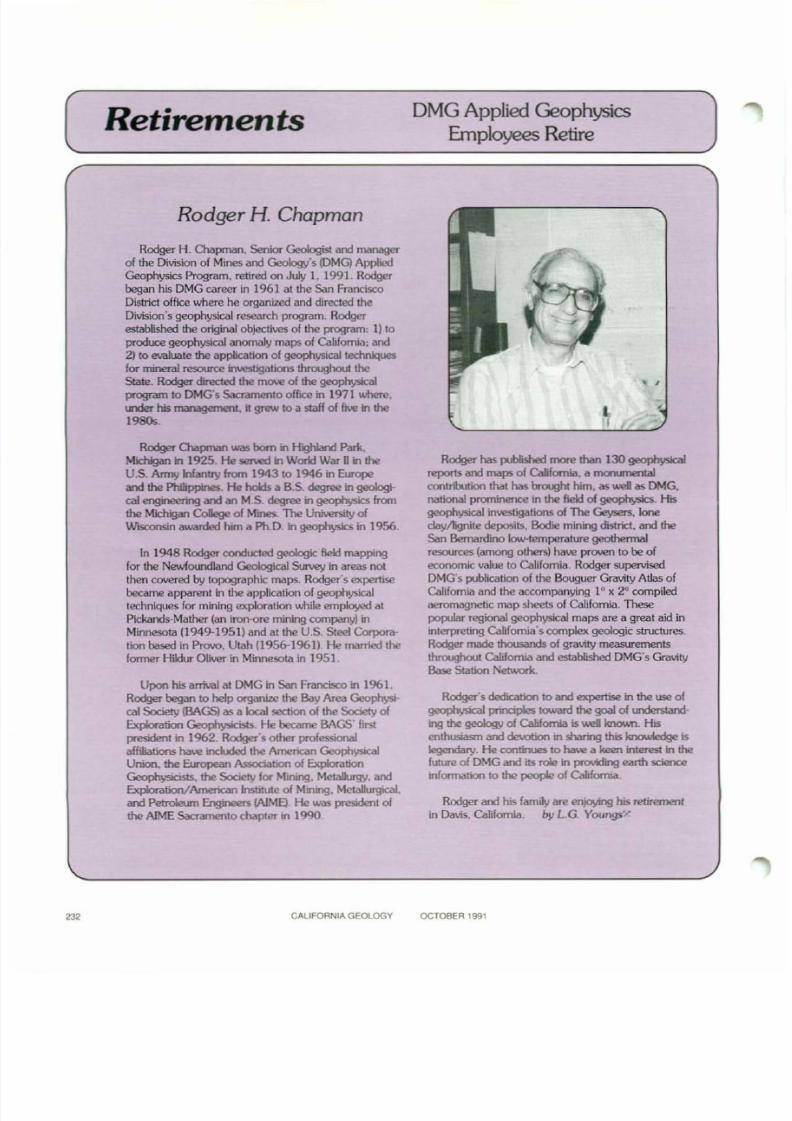
Rodger H. Chapman
Rodge< H. O>apman. Son. . . Gool<>gNom _of the Divisionof Mines and Geology's (DMG)AppliedGeophysics Program. retired on July I, 1991. Rodgerbegan his DMG career In 1% 1 al the San FranciscoDistrict office where he organized and directed theDivision's geophysical research program. Rodgerestablished the original objectives of the program: I) 10
pnxIuce geophysical anomaly maps of California;and2) to evaluate the applK:atlon of geophysicallec:hniquesfew mineral resource bwestigations throughout theState. Rodger directed the ma..oe of the geophysicalprtJgT'am to DMG's Sacramento offICe in 1971 where.under his management. It grew to a staff of five in the1980s.
,
232
Rodger Q\apman was ho m in Highland Park.Michigan in 1925 He served in Wortd War 0 in theU.S. Army Infantry from 1943 to 1946 in Europeom the Phllippones. He hoId>. as. dog<ee" geoIog\-cal engineemg and an M.S, degree in geophysics fromthe M<h;gan CoIoge of M _ ." . . , lJnNenity ofWISCOf'lSinawarded him a Ph.D, in geophysics in 1956.
In 1948 Rodger conducted geologic field mappmgfor the Newfoundland Geological Survey in areas notthen covered by lopographk maps. Rodger's expertisebecame apparent in the application of geophysicaltechniques fo r mining exploration lA.-hileemployed alPlckands-Matner (an iron-ore mining company) inMinnesota (1949-1951) an d at the U.S. Steel Corporation based in Provo, Utah (1956-1961). He married theformer Hildur Oliver in Minnesota in 1951
Upon his anival at DMG in San Francisco in 1961.Rodger began to help organize the Bay Area Ge0physical Sodety (BAGS) as.1ocaI section of the Sodety ofExploration Geophysicists. He became BAGS' frrstpeesidellt'" 1962 Rodger's other professionalaffiliations have ird.ded the American Geophysk.aIUnion. the Euopean Association of ExplorationGeophysicists, the Society f(K Mining, Metabgy. an dExploration/American Institute of Mining. MetWrgical,and Petroleum Engineers (AlME).He was president ofthe AIME Sacramento chapter in 1990,
C....
lIFORNI....
GEOLOGY
Rodge< ha s ~ """" than 130 " " " " " " ' "
reportS an d maps of Cabfomia. a morunentalcontrbrtion that has broughl him, as we i a s DMG,naOOnal prominence in the field of geophysics. Hisgeophysical investigations of The Geysers. kloeday/lignite deposits, Bodte mining district, a nd t heSan Bernardino Iow-Iemperature geothermal
resources (among others) have proven to be ofeconomic value to California. Rodger supervisedDMG's publication of the Bouguer Gravity Atlas ofCalifornia and the accompanying 10
)( 2° compiledaeromagnetic map sheets of Califomia. ThesepopuIa.r regional geophysical maps are a great aid inblterpreling California's complex geologic structures.Rodger made thousands of gravity measurementsthroughout California and established DMG's GravityBase Station Network.
Rodger's dedication to an d expertise in the use of~ pmc;pIo5 Iowan! the goal of urodomanding the geoIoqy of California is we i knol.vn. His
enthusiasm an d ~111 sharing this knolMedge Is
Iegerd<uy. He continues 10 have a keen interest in thefuture of DMG and its role in pn::Mding earth sdencetnformation 10 the peop&e of CaJjfOf'Tlia.
Rodger and his family ar e enjoying his lememenlin Davis. California. by LG Yoongs· ....
OCTOBER 1991
8/7/2019 California Geology Magazine October 1991
http://slidepdf.com/reader/full/california-geology-magazine-october-1991 17/24
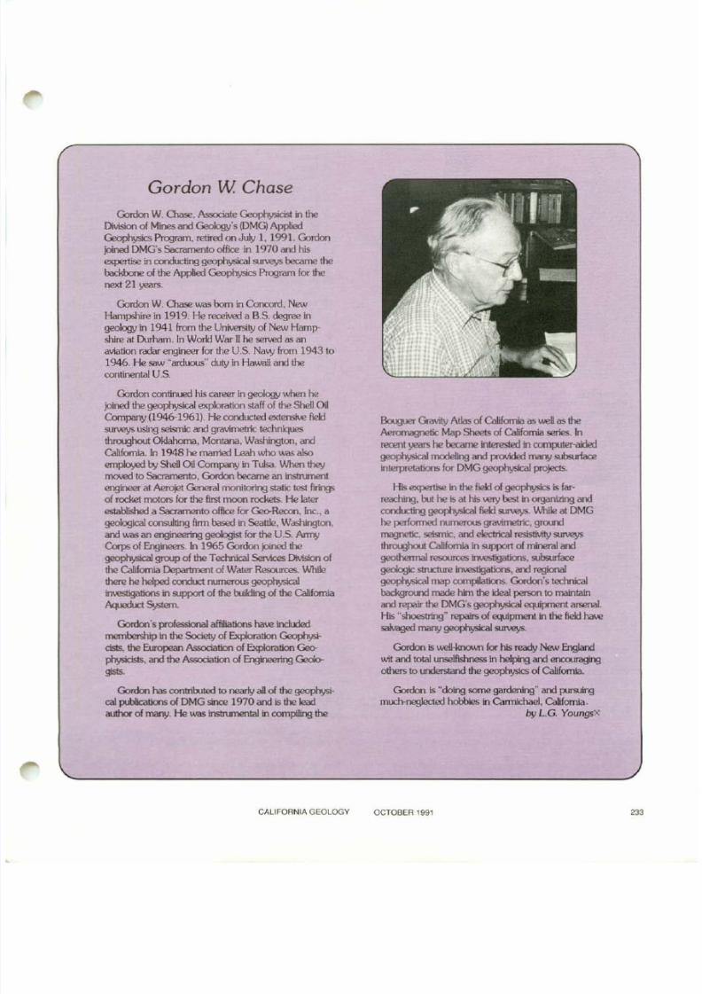
Gordon W Chase
Gordon W. Cl\ase. Associate GeopI"Jysicist in theDMoon 01 Mine><>ndGooIog;'slDMGIApplied~ _ , _ o n J u l ; I , l 9 9 1 , G o o l o n
joined DMG'sSacramento office in 1970 arxi his_ in """'-<ting geophy.;ioaJ " " " " ¥ bocame thebod<bone 01 the Applied Goo""""'"Prog""" fo< thenext 21 years.
Gordon W. 00se was born in Concord, NewHampshire in 1919. He received a B.S. degree in
~ in 1941 ITem the University of New Hampshire at Durham. In Work! War D he served as anaviation radar engineer for the U.S. Navy fran 1943 to1946. He saw ~ a r d u o u s · 'duty in I-faI.v.:iliard thecontinental U.S.
Gordon continued his career in geology UJhen hejoined the geophysical exploration staff of the Shell OilCompany (1946-1961). Hecondocted extensive f\eIdsurveys using seismic arrl gravimetric techniq..iesthroughc:ut Oklahoma, Mootana. Washington, aMCalifornia. In 1948 he married Leah who was alsoemployed by SheD Oil Company in Tulsa. IJJhen theylllO'.e:llo Sacramento, Gordon became an instn.Jnent
engineer at Aero;et General monitoring static lest firingsof rocket rrdors for the first IT"ICXXlrockets. He laterestablished a Sacramento office for Geo-Rec:a1. Inc., ageOOg;caI oonsuItir<Ifum bosEd in SeattI<, W"""""""and was an engineering geologist for the U.S. Arrr'JCo<ps 01 Er<linEm.in 1965 Goolon _ thegeophy.;ioaJ gro.q> of the T_ SeMoos DMoon 01
the CaliforniaDepartment of Water Resources. VJhDe!hem he _ ard>ct " " " " " ' " geophy.;ioaJ~ t i c J n sin support of the buildingof the California........... s"stem.
Gordon's professional affiliationsha w incWed~ in the SoOOty 01 Expbation ~_ , the _ """" ' t ion 01 Expbation Goo-
ply.;idsIs, " " the """" ' t ion 01 Eng;neering GeQo.....'
Gordon has contribuled 10 nearly all of the ge0physical p.bIicaticns of DMGsince 1970 ard is the leadauthor of rTlaI"P/.He was instnmental in canpiIing the
CALIfORNIA GEOlOOY
I3ol.qJer Qao..;ty Atlas or California as well as theAeromagnetic Map Sheets of Californiaseries. Inrecent years he 00carne interested in COOlp.Jter-aKtro
geophy.;ioaJ m<><1<ling<>nd _ " " " ' . . -ilterpretalions for DMG geophysIc:aI projects.
His expertise in the fiekiof~ is far·reachng. but he is at his WIY best in aganizing arv::I"""'-<ting geop/>ysio> fi<ld""""¥ . I.IIh;\o . . DMGhe perlonned ounerous_ , gro.r<l
magnetic, seismic. and electrical resistivity surveysthroughout California11 support of mineral aMgeothennal ~ _ t i o n s , " -geoIog;< """""" _tions,<>nd """" ' "geophysical ma p COO1pi1ations. Gordon's technX:albackgro.nd made him the ideal person to maintainand repair the DMG'sgeophysical EqJipnenl. arsenal.His ..! : h o e s t r i n g ~repairs of eq..dpment in the fiek:l have
" " - ' " " ' " geophy.;ioaJ """"¥ '
Gordon is \l..OeI-knownfor his ready New Englandv..;l and totall.l'lSelf\shnes in heIpin;}and encooragingothers to IJ'der.;tand the geophysics of California.
Gordon is ~ d o i n gsome gardeningM and pur9JingIT'lrll-negiected robbes in CannichaeI, California.
by L.G. Y o u n ~
OCTOBER 1991

8/7/2019 California Geology Magazine October 1991
http://slidepdf.com/reader/full/california-geology-magazine-october-1991 18/24
Official Maps o f New or RevisedALQUIST- PRIOLO SPECIAL STUDIES ZONES
i,
37. Swains Hole38 . Standish39. Stony Ridge ~ .
40 . Milford41. Herlong42 . CaIneYa Lake43 . McKesick Peak44 . Doyle'45. Constanli<l46. Los GaIOS'
47. Laurel'48. Piti'S Point'49 . F"1!lmore'SO. Moorpark51 . EI Monte'52 . La Habra'53. La JoI<l54 . Point l..oma
. ... ~ .........-
r '
• Revised wo e map
19. Eagleville20. Snake Lake21 . Porcupine Butte22. Indian Spring Min23. East of Pondosa24. TlfTlbeTed Craler25. Day26. Burney Falls27. Dana28. Fall River Milk29. Pittville30. Burney31. Cassel32 . Hogbac:k Ridge33. Coble MCM.lfltain34. Murken Bench35. JeUic:o36. Old Statkln
•
(Map numbers keyed to index map)OfRdal Maps - N;"ember 1.-1991
1. F"Jekls Landing2. Fortuna3 Hydesville'4. Sams Neck5. Dorris6 Macdoel7. Sheep MOllrItain8. Red Rock u.ke9 Bray
10. Sharp MIn.I ! . Tennant12. Gamer Mtn13. Rambow MIn.14. FOI"l8KtweDIS. Lake CIty16. Ce&.M8e17. Warren Peak18. Eagle Peak
, .....
,,
".,
_ . ~ -._,.- ~ - -
~i
, ,~ r - ~ - - - - ~!
.1:.;:.
, , .
..) ~ - - - ~ " - - '••~ - - . . . - - - ' I
1 . . . . . . J V. ....,.
!-
r,- ,\ ,...
CountiesHumboldt Santa ClaraLassen Santa CfUlLos Angeles Shas taModoc SiskiyouOrange Ventura
j"San Diego
New or Revised Official Maps of Special Studies Zonesare available at the foUowing DMG Publk: Information Offices.
SACRAMENTO AREA SAN FRANCISCO AREA lO S ANGElES AREA~ Publicalklns & Information 1145 Market Street 1075 Broadway.
66 0 Bercul Driw San FranciKo. CA 94103-1513 Room 1065 ~' - ' ~ 'Sacramento. CA 95814 (415) 557-1500 Los Angeles. CA 900 12 _ .. _ .. _ .. - .. _ .. - .
(916 445-5716 (213)620-3560 ..!=-._..-.-_.
""". "" ,, '." ...... ,- .. ·1·.. • >I-. I'""--", - ~ r · ' - r - - - - - - ""Cities and cCM.lfltiesaffected \ \.. . . . . . . . ~ .f . , '.
.•~ by new or revised Special ,,....... '......( . " " ~ "~ -..r.' r/ ' l " " ' "
51udies Zones shown on Offi- > - ' 3 . . , " ' " ' ~ _ ~ ' : " " - - c C ' ~ : " "_ _ . L _ ~ _ - - r -_ _ --'"cial Maps of November L " ' ~ ' ' ' . ~ ~ r - - , ", .1991 _ t - _ · , ~ ~
...
: ......~ ' , -" ,"'" ".~ '-"\ '.''''''.,."". , ......: : , , ~ " ...,
ClUesFortuna
1- La Habra Heights
RosemeadSan DIegoSan MarinoWhittier
,..
O ffltial"""ps of I'leIN and ~ Specia1 Stuiies Zones. indexed hereon. are issued pursuant to the Alquist·PrioIo Special Studies Zones Actand ar e effectIVe on November 1. 1991. Revised maps supersede e.vIier Ollkial Maps.
Copies of these ~ p smay be examined at the offices of affected CIties and COU'lties. and at the dislrict offICeS of the California DMsionofMines and Geology. Copies; ITIOIYbe purchased from Blue Print SeMce Company. 1147 MISSklnStreet. 5M Francisco. California 94103. {415149a-B700. ext. 550.
For infOfTT'l<ltion on 0llkiaI Maps of Spedal Studies Zones previously issued. and for provisions of the AIquisl:·PrioIo Special Studies Zones Act.consult the 1990 edition of Special Public:ation 42 . This reference. titled ~ F a u I t · r o p t U r eHMmt Zones in California: is fme from the CalilorruaDMsionof Mines lind Geology. P.O. Box 2980. Sacramento. California 95814, or from the olfic:a listed abcM!.X
CAUFORNIA GeOlOGY OCTOBER t991
8/7/2019 California Geology Magazine October 1991
http://slidepdf.com/reader/full/california-geology-magazine-october-1991 19/24
A Page for Teachers
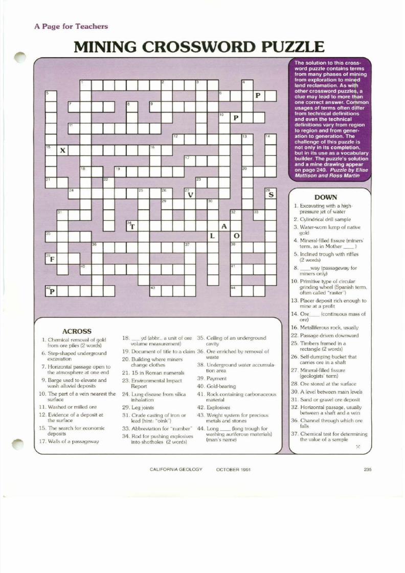
MINING CROSSWORD PUZZLE
x
DOWNI. Excavating with a high
pressure jet of water
2, Cylindrical drill sample
3. Waler-worn lump of nativego"
4. Mineral-filled fissure (miners'lenn, as in Mother _ _ I
5. Inclined trough with riffles(2 words)
8 _ _way (passageway forminers only)
to. Primitive type of circulargrinding wheel (Spanish term.often called "raster")
13. Placer deposit rich enough tomine al a profit
14. Ore _ _ (continuous mass ofare)
16. Metalliferous rock. usually
22. Passage driven doo.vnward
25. TImbers framed in arectangle (2 words)
26. Self-dumping bucket lhatcarries are in a shaft
27. Mineral-filled fissure(geologists' tenn)
28. Ore stored at the surface
30. A level between main levels
31. Sand or gravel ore deposit
32. Horizontal passage, usuallybetween a shaft and a vein
36. Channel through which orefalls
37. Chemical test for delenniningthe value of a sample
42. Explosives
43 Weight system for preciousmetals and stones
44. Long _ _ (long trough forwashing auriferous materials)(man's name)
29. Leg joints
31. Crude casting of iron orlead (hint: "oink")
33. Abbreviation for "number"
34. Rod for pushing explosivesinto sholholes (2 words)
18. _ ~ ' C I(abbr., a unit of are 35. Ceiling of an undergroundvolume measuremenl) cavity
19. Document of Ii1le to a claim 36. Ore enriched by removal of
20. Buikling where miners wastechange clothes 38. Underground water accumula·
21. 15 in Roman numerals lion area
23. Environmental Impact 39, PaymentReport 40. Gold·bearing
24. Lung disease from silica 41. Rock containing carbonaceousinhalation material
,I I I
, , ,--
.--- • I PIf - ,I I .- ,
f - - .. P If -
" I I -f - " " r,:;-
-" X I I I "" I I - -
f - " " I~
, n n I" " ~ " - ,,--V - ~
~ ~
" - f -
" D
- ~
T A
" - L 0 -~
I " ~
I"F -~
I..
I' - -
-"p I I.,
I~
I
The solut ion 10 Ihis crossword puzzle conlains termsfrom many phases of miningf rom explorat ion to minedland rectamat ion, As with
other crossword puzzles, aclue ma y lead to more lhanone correct answer, Commonusages of t erms o lt en d i ll e rfrom technical definitionsa nd e ve n t he technicaldefinitions vary f rom reg ionto region and from gener"ation 10 generation. Thechallenge ot lh i s puzzle isno t only in it s completion,bu t in i ts u se a s a vocabularybuilder, The putt le 's solutionand a mine drawing appearon page 240. Puzzle by EliseMattison an d Ross Martin
ACROSSL Chemical removal of gokl
from are piles {2 words)
6. Step-shaped undergroundexcavation
7. Horizontal passage open tothe
atmospherealone
end9. Barge U5ed to elevate andwash alluvial deposits
10. The part of a vein nearest thesurface
11. Washed or milled ore
12, Evidence of a deposit atthe surface
15 The search for economicdeposits
17. Walls of a passageway
CALIFORNIAGEOLOGY OCTOBER 1991 235
8/7/2019 California Geology Magazine October 1991
http://slidepdf.com/reader/full/california-geology-magazine-october-1991 20/24
[ ~ D_M_G_R_e_'_ea_se_s J
SPECIAL PUBLICATION106
CONffiIBlJTIONS AND PUBUCATIONS OF THEAPPUED GEOPHYSICS PROJECf: Division of Minesand Geology. 1965-1989. Compiled by Leslie G. Youngs.1990.49 p. $6.00.
Applied geophysics is the branch of earth science thaIuses lhe melhOOs of physics and engineering to studythose parts of the Earth that are hidden from direct view.Perhaps as much as 50 percent of the Slate of Califomia iscovered by alluvium and marine deposits. Applied ge0-
physical methods prOVide the means to delennine theEarth's structure and composition beneath those extensivesedimentary deposits. Applied geophysical studies can beused to define fault zones. discern subsurface geology andgeologic structure. delennine bedrock depths and varia-lions in the thickness of subsurface strata. aid in oil and gasexploration. locate certain typeS of rocks. explore andassess mineral and geothermal resources, measure rockvelocities. locate some buried hazardous waste prOOuc1S.aid hydrological studies, record volcanic activity. and showthe regional effects of the Earth·s tectonic processes.
For more than 25 years. the Division of Mines andGeology lOMG) has supported an active applied geophysical program for the State 01 California through its AppliedGeophysics Project. HO\.O.Ie\Ier. the project was terminatedin July 1991 due to a reduction in the DMG budget.
The Applied Geophysics Project provided geophysicalsupport services for all DMG projects where needed. Inaddition. the Applied Geophysics Project carried outindependen! studies including compilation of regional andlocal geophysical maps. miscellaneous geoscientificcontributions. and mineral resource studies. The stafl hadstate-of·the·art equipment and computer capabilities tomeasure the Earth's magnetic and gravity fields. electricalproperties of the Earth. seismic refraction. magneticsusceplibility of rocks. lithologic densities. and subsurfacetemperatures. Basic geophysical data IAlE!re collected.reduced. and modeled. and interpretive correlations were
made. Data and interpretations were presented aspublished contour maps. graphs. cross sections. graphicmodels, diagrams. and reports. The Division of Mines andGeoIogy's Applied Geophysics Pro)ect was the only unit inCalifornia government that provided these combinedservices. As such, the staff provided advice and interpretiveservices to other state agencies. as well as local governments. the public, geo-c:onsultants. and academia.
This report documents the publications and contributions ofthe Applied Geophysics Project from 1965 to 1989. The reportlists all publications in reverse chronological order. Under eachyear of publication. the references are listed alphabetically byaUlhor. The report also indexes the publications by topic.including regional geophysical anomaly maps. miscellaneousgeoscienlific contributions. mineral resource contributions.geothennal resource contributions. and applied geophYSICalcontributions by county.
SPECIALPUBliCATION 111
MINERAL COMMODnY REPORT-Diatomile. By John LBurnett. 1991. 26 p. $5.00
The United States' sales of processed diatomite decreasedslightly in 1989 to 617.000 metric Ions, with a value of morethan $137 million. according to the Bureau of Mines. U.S.Department of the Interior. Seven companies process diatomiteat 11 plants in live states. California continued to be the leadingstate followed by Nevada, Washington, Oregon. and Arizona,Ma}or domestic producers are located in Lompoc and Burney,California: Mina. Sparks. and Lovelock. Nevada: Vale. Oregon:and Quincy, Washington.
Apparent domestic consumption of processed diatomite in1989 decreased slightly to 481.000 metric tons. The mapr useof diatomite is in filtration to separate suspended solids inliquids. In 1989, domestic and export sales of fiher'9radediatomite totaled 441.000 tons. slightly more than in 1988.Diatomite sok:! as a filler (the second largest use) totaled 90.000tons, about 15 percent less than in 1988.
The average unit value 01 sales for processed diatomite in1989 was $222.00 per ton. This was slightly less than in 1988.U.S. exports of processed diatomite amounted to 137.000tons. about 7 percenl less than in 1988. Average unit value was$302.00 per ton. compared with $268.00 per ton in 1988.Diatomite was exported to 67 countries. The fol1ouJing countries combined received 37 percent 01 the total diatomiteexported: Japan. 16.600 tons: Australia. 12.600 tons: theFederal Republic of Germany, 11,100 tons: and the UnitedKingdom. 10.100 tons. U.S. exports representee! 22 percent ofdomestic production. Diatomite imports totaled 83 8 tons. 84percent 01 which was supplied by Mexico.
World production was estimated to be 1.8 million tons in1989. The United States remained the \AIOrkl's leading producerfollowed by Romania. the USSR. and France. 1llese fourcountries accounted lor 75 percent 01 VJOrId production. '.
236CALIfORNIA
GEOLOGY OCTOBER 1991
8/7/2019 California Geology Magazine October 1991
http://slidepdf.com/reader/full/california-geology-magazine-october-1991 21/24
('-- A_"_"_o_u_"_c_e_m_e_"_t_s J
Chrysalis ScholarshipAssociation forWorTI€f1 Geoscientists FoundationMacAlester College Geok:lgy DepartrnerJI
1600 Grand Avenue,St. Paul, MN 55105-1899
Chrysalis Scholarships to be Awarded
Three Chrysalis Scholarships VJilI be awarded by the AWG (Association for WomenGeoscientists) Foundation on March31, 1992. The $500 awards VJilI be given to geoscienceMasters or Ph.D. cardidates to c ~ expenses associated with finishingtheir theses. TheOtrysalis Scholarship is for cardidales UJho have returned 10 school after an interruption intheir e:lucalion of a year or longer. The support can be used for typing or drafting expenses.chil:!care. or anything necessary to aIIow a degree candidate to finish her thesis and enter ageoscierre profession. Applications should be made by February 2 8. 1 99 1. Forinformation contact:
Price includesposlage and sales lax.
...........$10.00. $21l-OO
. , , $1.25
F.anciscan and related rocks and lheil significance in the Q{l"OIogy01
western Calilornia.t964 $8.00Geology of the San And.eas [151 quadrangle. Calaveras County, California(scale: 1:62.500). 1970................ . $5.00Geology and ol e deposits ollhe Bodie mining district. Mona Counly,Calilornia. 1987 ................•.. . $18.00
B2Q6
, - - - - - - - - - - - - - - - - - - - - - - - - - - - -I MAIL ORDER FDRM
IIndicate number Complele add.ess 10.m on nexl page.of copies
I BULLETINSI Bt83
I __ Bt95
III SPECIAL REPORTS
I _ _ SR106 Geologic teatu.es 01 Death Valley Ilnyo and San Bemardino counlles].Cahlornia. 1976 ' ....... . $5 .00.I __ SRtI3 Geologic haza.ds in southweste.n San Berna/dina Counly,
I SR143 f p ~ i ~ 0 ~ 7 ; a c ~ ~ ~ i c a t l o r ; ~ i " ~ ~ · ~ ~ · g ~ ~ ~ ~ i · ; ~ I p.oduct;on-eonsumplion 'eglon ILos Angeles and San Bernardino counties.
I _ _ SRt43 ~ ~ i ~ o ~ ~ : ~ h l ~ ~ ~ ~ ~ t i O n01 sand a ~ · g ; ~ ~ ~ i · ; ~ ~ u r ~ ~ · ~ ; ~ ~ ~ : · S ~ · $14.00
I production·consumption regIon ISan Bernardl110 County. Calito.nial 1988 $10.00
I SPECIAL PUBLICATIONS_ _ SP50 ColemanitedepoSils near Kramer JUnc1ion, San Bernardino County.I Calitornia. 1976 ................•.............. $5.00I SP72 Mineral commodity report - gypsum. 1984 . $5.00
SP74 Minerai commodIty report - sulphur. 1984 $5.00I _ _ SP76 Mlne.al commod,ty report- bante . 1985.. .. $5.00I $1'106 Contributions and pubhcations ot the Applied GeophysICS P,oJe<:t:
DMG 1965·1989. 1m (NEW) ..... ........................•................ $6.00
I SPtl1 Mlne.alcommod,tyreport-dialomlte, 1991 (NEW) , , $5.00I GEOLOGIC MAPS O f CALIfORNIA - REPRINTS
I = = ~ ~ ~ ~~ : ; ~ v : ~ t ~ h e e l: : : : : : : : : : : : : : : : : : : : : : : : : : : : : : : : : : : : : : : : . : : : : : : : I _ _ GAM8 Los Angeles sheet . $5.00_ _ GAM9 Mariposa sheet , ,........................ . $S.OO
I CALIfORNIA GEOLOGYI _ _ 1 yea. (12 issues) ..•, , .I __ 2 years (24 Issues) , .
Each bacll. Issue .I SpElClty volume and monthI _ _ LIst ot Available Publication ,.. . .. .. .. .. . .. .. .. .. .. . .. .. .. .. . .. .. .. .. . .. .. .. .. .. . .. .. .. .. . .•.. .. .. .. .. . .. .. .F.ee
L T O T A ~ ~ U :~ C ~ S ~=. :: .. =:.::.::.:=.:=..=.. =:.. =:,::.::.=... : : $
PAYMENT MUST BE INCLUDED WITH ORDER
These letters of nomination mustbe postmarked no later than Febru-ar y 28 , 1992 to be considered.
The Earthquake Safety Foundation.founded as a California nonprofit corporation in 1985. manages the Alquist Awardprocess. It also publishes technical andpublic information materials. sponsorsspecial events. supports special studiesand research. and provides financial assis-tance to groups to promote the cause ofearthquake safety. It relies on tax deductible donations to support its activities. andthe Board of Directors is made up of vol-unteers.
Nominations Sought forAlFRED E. ALQUIST AWARD
Past awards have been made 10 electedleaders, engineers, government advisors,disaster specialists, and architects. On e tothree awards are given each year. andnames of nominees can only be considered in the year in which they ar e nominated. Posthumous awards are not made.
The awards ar e presented in April,Earthquake Preparedness Month. of eachyear. A candidate may be nominated byanother individual. a firm. or an agency.Letters describing the nominee's background and accomplishments should besent to:
California Earlhquake SafetyFoundation
clo VSP Associates, Inc.45 5 University Avenue, Suite 340Sacramento. CA 95825
Nominations are no w being sought bythe California Earthquake Safety Foundat ion for the 1992 Alfred E. Alquist AwardfOT Achievements in Earthquake Safety.This annual award recognizes individualswho have made outstanding contributions10 or have had a major impact, past orpresent, on seismic safety in California.Awards are given in such areas as basicand applied research, public policyadvancement. education, volunteerservice. and program management.
CALIFORNIA GEOLOGY OCTOBER t991 ,,,
8/7/2019 California Geology Magazine October 1991
http://slidepdf.com/reader/full/california-geology-magazine-october-1991 22/24
[ ~ B_o_o_k_R_e_V_ie_w_s ~ JQuaternary Studies MIl'llng Patents
CITY _
S T ' ~ ZlP 1
..-ADDRESS ~ _
- - - - - - - - - - - - - - - - - - - - - - - - - - ,ADDRESS FORM FOR AL L ORDERS
Please pont or type.
PAYMENT MUST BE INCLUDED WITH ORDER
AT THE END OF TI-lE MOJAVE:QUAlffiNARY S1UD1ES IN ll-lEEASTERN MOJAVE. Edited by JenniferReynolds. 1990. San Bernardino CountyMuseum Association. 2024 Orange TTeeLane. Redlands. CA 92374. 133 p.$7.50 plus 7.75% sales tax and $2.00shipping. soft cover.
The San Bernardino County MuseumAssociation prepared this specialpublication in conjunction with the 1990Mojave Desert Quaternary ResearchCenter Symposium held May 18-2l.Geology 01 the intersection 01 th e
Garlock an d Death Valley fault zones.
northern Aoowatz Mountains. a fieldtrip road log. is reprinted in this issue of
CAUFORNIA GEOLOGY. Another roadlog focuses on Quatematy landscapeevolution in !he eastern Mojave Desen.Articles address topics pertaining to theQuaternary study area: floods and lakes;alluvial fan deposition and ag e estimation;pluvial (resulting from rain) basin histories:polycyclic strombolian eruptions;C1arendonian faunas: Rancholabrean agevertebrates: the response of alluvial fansystems to climatic and local base-levelchanges: defannalion on a segment ofthe southern Death Valley fault zone: andstructural and other studies of the OldDad Mountain area. the Halloran Hills~ u e n c e .and the intersection of the
Garlock and Death Valley fault zones.
PAITNIlNG MINING UAlMS ANDMILLsntS IN CAUFORNlA. 2nd edition. Edited by J.R. Evans. 1991. U.S.Department or the Inlerior. Bureau orLand Management. 2800 Cottage Way.Sacramento. CA 9 58 25 . 1 02 p. $4.00including lax and shipping. soft cover.
Mining patents are documents that convey fee Utles- titles that usually pertain tothe surface as VJeIi as to the minerals. Thisbook explains the patenting process andprovides a sequential approach for prepar·ing palenl applications in California. Min·ers. mining 1a'N';,let'S.and mineral surveyorsmight use it to guide them through this
complex. expensive process. The bookexplains procedures. lists requirements.defines lenns. and provides sample formsand maps. This seoorx.:I edition includesfl0N U.s. Forest Service regulations. infor·mation about posting a Notice 01 Intent.updated forms regarding mineral surveys.and an updated list of mineral SlJl'\IeYOI'"S.
Also included are the UJXiated FederalCode of Regulations regarding patent app1icatK>ns and adverse claims. and a briefdiscussion of the Bureau of landManagement's requirements regardingreclamation and environmental evalua-
" " " ' ~
Data
, GIFT: (G'ft card Irom _
TOTAl. AMOUNT ENCLOSED: S
CALIFORNIA GEOLOGY SUBSCRIPTIONS
NON·FERROUS METAL DATA:1990. a yearbook published by the Ameri·can Bureau of Metal Statistics Inc.. 1991.Available from the American Bureau ofMetal Statistics Inc., 400 Plaza Drive(Harmon Meado-.v). P.O. Box 1405Secaucus. NJ 07094-0405. 153 p.$290.00 plus postage and handling.hard cover.
T he American Bureau of Metal StatisticsInc. is an organization that compiles statistical industry data on non-ferrous metals.ThiS yearbook provides worldwide data oncOppeT. lead. zinc. aluminum. siNer. gold.antimony. cadmiLm. cobalt. magnesium.mercury. molybdenum. nickel. platinum.selenium. teDurium. lin. titanium. and uranium. Comparative data for 19$6 through1990 is tabulated lor each metal. Th ebook contains over 180 other statisticaltables for metal production. consumption.smelters. refinery capacities. imports. exports. published prices. and other data.
ACCT.
(lndlllrdualissues are $1.25 each)
EXPIR. DATE
, 2 yrs. $20.00, 1 yr. $10.00
1.0 . •
Your ordeflsubscl'If!t,on caonot be Pfocessed urtJess conect amouol IS rem.l1ed AU 'me,go aodC.oad'1I0 OtOOrs muSI be paid W1lh an ,oteroahOnal money Otoor Of draft payable ,n U.S dollars 10DIVISIONOF MINES AND GEOLOGY. P 0 80.2980. Sacrtlmenlo. Cau'orool 958122980
, ADDRESS CHANGE: send us an old address label and your new addressAllow two Issues to rellecl address change
, RENEWAL: To receIVe your magaZIne conlinUOOSIy.send In renewal 60 days beloreeMpiratlon date shown on)'OUr address label. (Example EXP9112 meansthat the subscnptlon e_prres on recelpl of December 199\ Issue) Pleaseenclose address label from pastlSSl.l9. Without an address label. renewalSUbscnptlonS WIlltake 3 to 4 months to process
, NEW SUBSCRIPTION' Allow 60 days for dehvery of first issue
lrom . . . . . . .
III
IIIIIIIII
- - - - - - - - - - - - - - - - - - - - - - - - - - - - ~Mining History
238 CALIFORNIA G EOLOGY OCTOBER 1991
8/7/2019 California Geology Magazine October 1991
http://slidepdf.com/reader/full/california-geology-magazine-october-1991 23/24
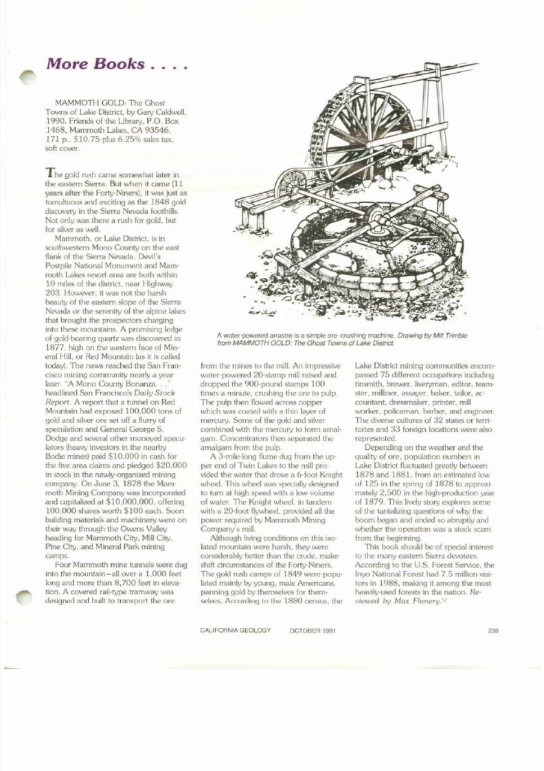
A water-powered arrastre IS a SIf11)Ie OAt·crushingmachne. DraWIngby MillTnmbIefrom MAMMOTHGOLD: T1Je Ghost Towns 01 Lake Drsmct.
More Books . .. .
MAMMon; GOlD: The GhostTovms of Lake District. by Gal)' Calclwell.1990. Friends of the Ubrary. P.O. Box1468. Mammoth Lakes. CA 93546.171 p., $10.75 plus 6.25% saJes tax.soft cover.
T he gold rush came somewhat later inthe eastern Sierra. But when it came (I Iyears after the Forty-Niners). it was just astumultuous and exciting as the 1848 golcldiscovery in the Sierra Nevada foothills.Not only was there a rush for gold. butfor silver as well.
Mammoth. or Lake District. is insouthwestern Mono County on the eastflank of the Sierra Nevada. Devil'sPostpi!e National Monument and Mammoth Lakes reson area are both within10 miles of the district. near Highway203. However. it was nolthe harshbeauty of the eastern slope of me SierraNevada or the serenity of the alpine lakesthat brought the prospectors charginginto these mountains. A promising ledgeof gold·bearing quartz was discovered in1877. high on the western face of Min-erai Hill. or Red Mountain (as it is calledtoday). The news reached the Sa n Francisco mining
community nearly a yearlater. "A Mono County Bonanza . . . "headlined San Francisco's Daily Stock
Reporl. A report that a tunnel on RedMountain had exposed 100.000 tons ofgold and silver ore set off a flurry ofspeculation and General George S.Dodge and several other moneyed speculators (heavy investors in the nearbyBodie mines) paid $10.000 in cash forthe five area claims and pledged $20.000in stock in the newIy-organized miningcompany. On June 3. 1878 the Mammoth Mining Company was incorporated
and capitalized at $10.000.000. offering100.000 shares worth $100 each. Soonbuilding materials and machinery were ontheir way through the Owens Valleyheading for Mammoth City. Mill City.Pine City. and Mineral Park miningcamps.
Four Mammoth mine tunnels were duginto the mountain-all over a 1.000 feetlong and more than 8,700 feet in elevation. A covered rail-type tramway wasdesigned and built to transport the ore
from the mines to the mill. An impressive
water-powered 20-stamp mill raisedand
dropped the 900·pound stamps 10 0limes a minute. crushing the ore to pulp.TIle pulp then flowed across copperwhich was coated with a thin layer ofmercury. Some of thc gold and silvercombined with the mercury to fonn amalgam. Concentrators thcn separated theamalgam from the pulp
A 3-mile-1ong flume dug from the upperend of Twin Lakes to the mill provided the water that drove a 6-foot Knightwheel. This wheel was specially designedto tu m at high speed with a low volume
01 water. Th e Knight wheel. in tandemwith a 20·(oot ~ l . prOVIded aU thepou.>er required by Mammoth MiningCompany's mill.
Although living conditions on this is()Iated mountain were harsh. they wereconsiderably beller than the crude. makeshift circumstances of the Forty-Niners.Th e gok:! rush camps of 1849 were populated mainly by young. male Americans.panning gold by themselves for themselves. According to the 1880 census. the
Lake District mining communities encom
passed 75 different occupations includingtinsmith. breo.ver. liveryman. editor. team'ster, milliner. assayer. baker, tailor. accountant. dressmaker. printer. millI.UOrker, policeman. barber. and engineer.Th e diverse cultures of 32 states or territories and 33 foreign locations were alsorepresented.
Depending on the weather and thequality of ore, population numbers inLake District fluctuated greatly between1878 and 1881. from an estimated lowof 12 5 in the spring of 1878 to approximately 2.500 in the high-production year
of 1879. This lively story explores someof the tantalizing questions of why theboom began and ended so abruptly andwhether the operation was a stock scamfrom the beginning
This book should be of special interestto the many eastern Sierra devotees.According to the U.S Forest Service. the[nyc National Forest had 7. 5 mlllion visitors in 1988. making it among the mostheavily-used forests In the nation. Re-
viewed by Max Flanery. Y'
CALIFORNIA GEOLOGY OCTOBER 1991
8/7/2019 California Geology Magazine October 1991
http://slidepdf.com/reader/full/california-geology-magazine-october-1991 24/24
STATE O f CAliFORNIATHE RESOURCES AG€NCY
DEPARTMENT O f CONSERVATION
CALIFORNIA GEOLOGYDIVISION O f
MINES AND GEOlOGYP.O BQX2980
SACRAMENTO, CALIFORNIA 95812·2980
USPS 350 14 0
ACDRESS CORRECTION REQUESTED
SECOND ClASS POSTAGE PAIDAT SACRAMENTO, CALIFORNIA
""'"
G L, T 0 P ,
E D• P E X
•C R O '
A • 0., V DT
• VI R I
E R, T TU C D• A R CL 0 XE , U • Pv S IE C O A ,L U ,
T O •
A T
S,•v
N , ,
IN G
T • 0
Q
U I
•• p
•E N T R,E R 0 UT
O N eH
A U R I FT
D , •
H , . p , , • C H I
V 0 U• D I T '. R , D G
R • , G
T • I , I N G , ,U U T
X P L o RT I " N
I • R I
• T , N T ,
o w
'pL• C •C, , ,•
"...",'"•
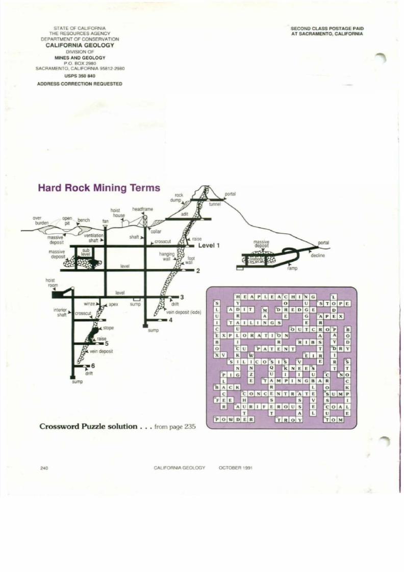
Hard Rock Mining Terms
Crossword Puzzle solution . . . from page 235
... .....""" """"'" .. •...... " " , " " "
""""1"'" "",. .""'"............•• 00 ....
, 2
....3
"". ""'" ; 'M ,lI'llenor)0 ....." deposit (lode)
,""" """'" u
4 ,..,. c