Embed Size (px)
Citation preview
CAMINO Á LAGO
SPECIFIC PLAN February 18, 1997
Revisions: SP02-02 December 10, 2002 Res. 02-272 GPA04-17 January 5, 2005 Res. 05-09 GPA07-06 January 15, 2008 Res. 08-11 GPA13-0009 April 22, 2014 Res. 2014-54
TABLE OF CONTENTS
I. Introduction .......................................................................................................................1
II. Site Analysis .....................................................................................................................4
A. Site Legal Description/Boundary Survey .............................................................5 B. Topographic/Slope Analysis .................................................................................5 C. Site Characteristics................................................................................................5D. Existing Land Use/Zoning ..................................................................................10 E. Site Development Constraints/Opportunities .....................................................10 F. Development Trends ...........................................................................................12 G. Peoria General Plan.............................................................................................12
III. Community Goals Relationship ......................................................................................13
IV. Specific Plan ...................................................................................................................18
A. Land Use Element ...............................................................................................19 1. Proposed Land Uses ................................................................................19 2. Land Use Classifications.........................................................................19 3. Land Use Intensity ..................................................................................24
B. Circulation Element ............................................................................................24 1. Introduction .............................................................................................24 2. Vehicular Circulation ..............................................................................24 3. Non-Vehicular Circulation......................................................................26 4. Public Transit ..........................................................................................26
C. Preliminary Phasing Plan ....................................................................................27
D. Urban Design Element ........................................................................................27 1. Introduction .............................................................................................27 2. Landscape Guidelines .............................................................................29 3. Design Guidelines ...................................................................................30 4. Residential Guidelines ............................................................................32 5. Commercial Guidelines ..........................................................................33
Appendix Utilities Plans
i
LIST OF MAPS
Map No. Map Title Page No.
1. Regional Location .............................................................................................................3
2. Site Legal Description.......................................................................................................6
3. Site Topography ................................................................................................................7
4. Site Analysis .....................................................................................................................8
5. City of Peoria Zoning Map 5-B ......................................................................................11
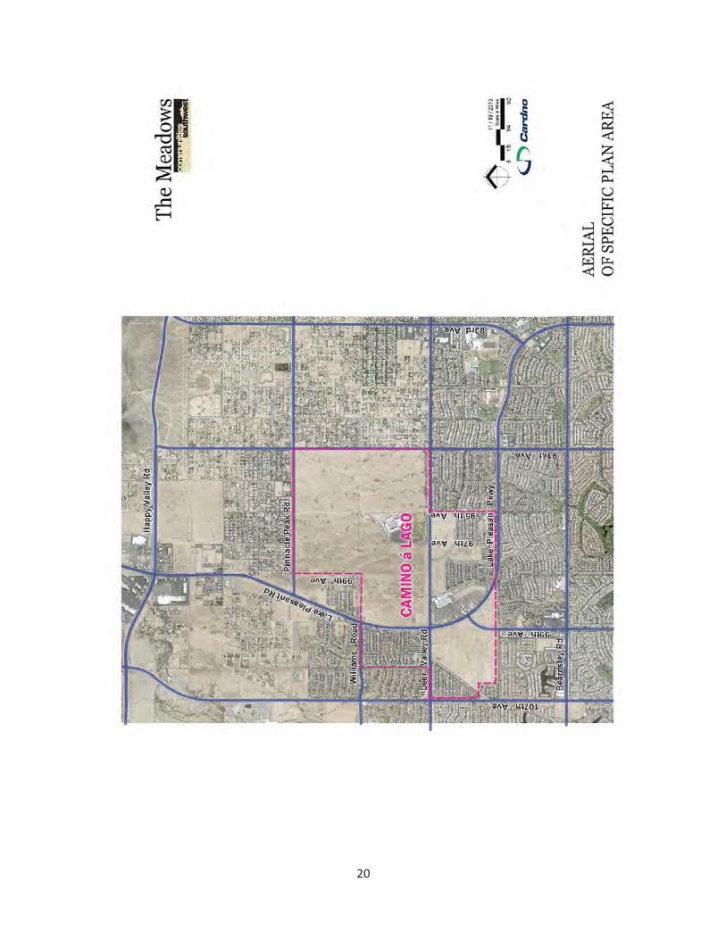
6. Aerial Photograph ...........................................................................................................20
7. Land Use Plan .................................................................................................................21
8. Circulation Plan ..............................................................................................................25
9. Preliminary Phasing Plan ................................................................................................28
LIST OF TABLES
Table No. Table Title
1. Land Use Program ..............................................................................................22
2. Preliminary Phasing Plan, Roadway Dedication and Construction Requirements .......................................................27
ii

I. INTRODUCTION
1
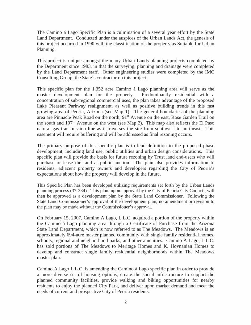
The Camino á Lago Specific Plan is a culmination of a several year effort by the State Land Department. Conducted under the auspices of the Urban Lands Act, the genesis of this project occurred in 1990 with the classification of the property as Suitable for Urban Planning.
This project is unique amongst the many Urban Lands planning projects completed by the Department since 1983, in that the surveying, planning and drainage were completed by the Land Department staff. Other engineering studies were completed by the IMC Consulting Group, the State’s contractor on this project.
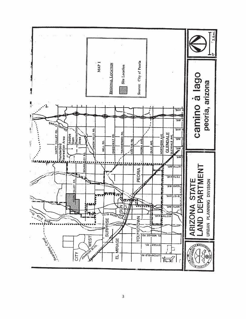
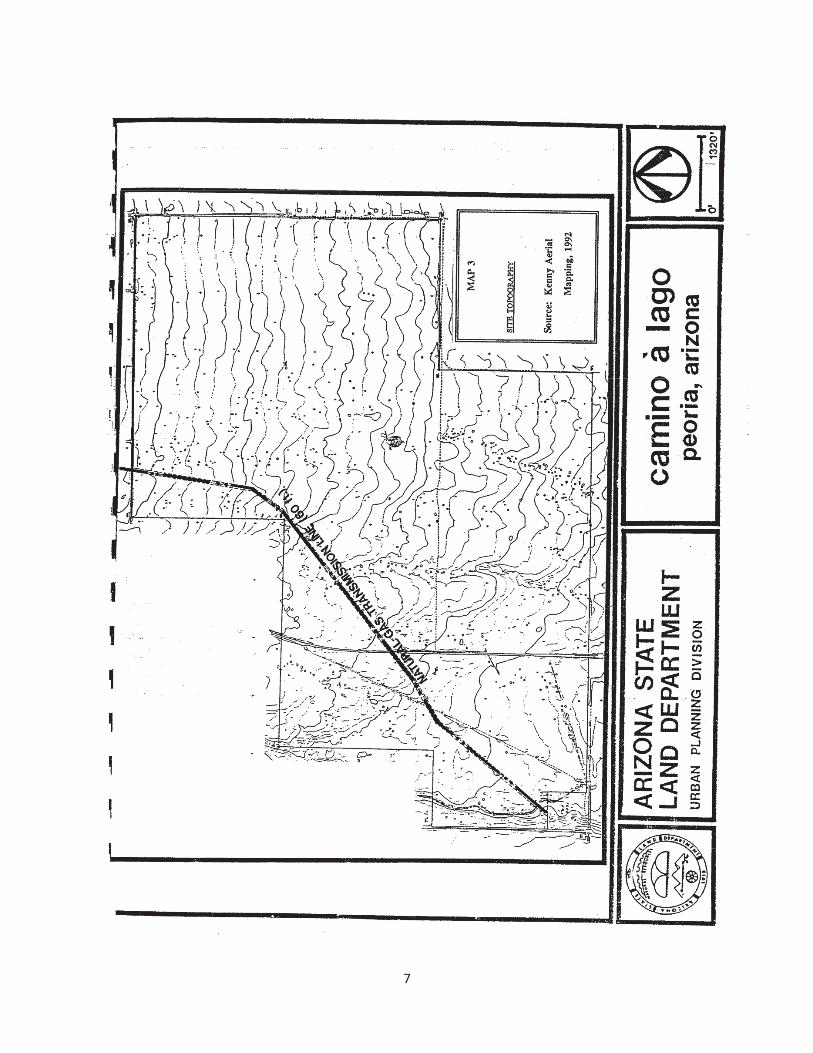
This specific plan for the 1,352 acre Camino á Lago planning area will serve as the master development plan for the property. Predominantly residential with a concentration of sub-regional commercial uses, the plan takes advantage of the proposed Lake Pleasant Parkway realignment, as well as positive building trends in this fast growing area of Peoria, Arizona (see Map 1). The general boundaries of the planning area are Pinnacle Peak Road on the north, 91st Avenue on the east, Rose Garden Trail on the south and 107th Avenue on the west (see Map 2). This map also reflects the El Paso natural gas transmission line as it traverses the site from southwest to northeast. This easement will require buffering and will be addressed as final rezoning occurs.
The primary purpose of this specific plan is to lend definition to the proposed phase development, including land use, public utilities and urban design considerations. This specific plan will provide the basis for future rezoning by Trust land end-users who will purchase or lease the land at public auction. The plan also provides information to residents, adjacent property owners and developers regarding the City of Peoria’s expectations about how the property will develop in the future.
This Specific Plan has been developed utilizing requirements set forth by the Urban Lands planning process (37-334). This plan, upon approval by the City of Peoria City Council, will then be approved as a development plan by the State Land Commissioner. Following the State Land Commissioner’s approval of the development plan, no amendment or revision to the plan may be made without the Commissioner’s approval.
On February 15, 2007, Camino A Lago, L.L.C. acquired a portion of the property within the Camino á Lago planning area through a Certificate of Purchase from the Arizona State Land Department, which is now referred to as The Meadows. The Meadows is anapproximately 694-acre master planned community with single family residential homes, schools, regional and neighborhood parks, and other amenities. Camino A Lago, L.L.C.has sold portions of The Meadows to Meritage Homes and K. Hovnanian Homes to develop and construct single family residential neighborhoods within The Meadows master plan.
Camino A Lago L.L.C. is amending the Camino á Lago specific plan in order to provide a more diverse set of housing options, create the social infrastructure to support the planned community facilities, provide walking and biking opportunities for nearby residents to enjoy the planned City Park, and deliver upon market demand and meet the needs of current and prospective City of Peoria residents.
2
3
II. SITE ANALYSIS
4
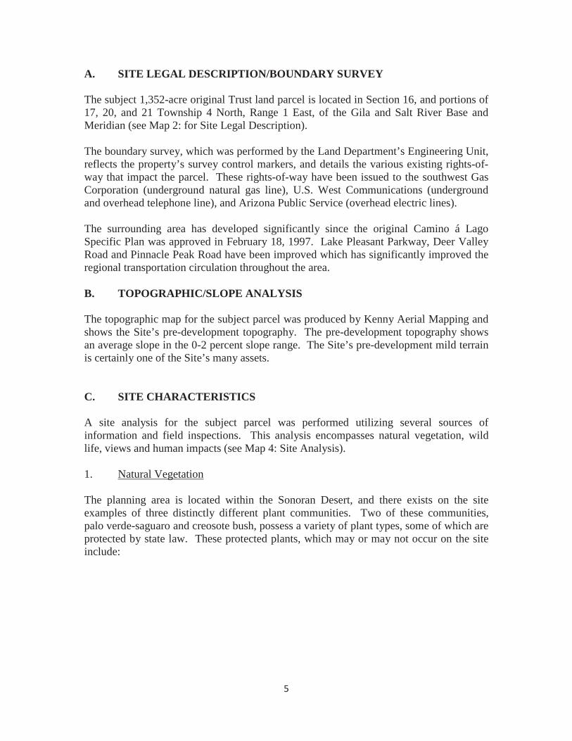
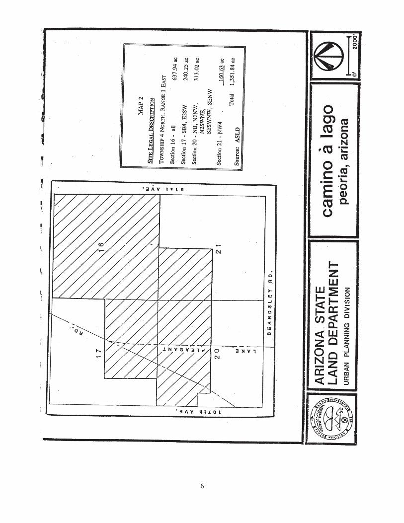
A. SITE LEGAL DESCRIPTION/BOUNDARY SURVEY
The subject 1,352-acre original Trust land parcel is located in Section 16, and portions of 17, 20, and 21 Township 4 North, Range 1 East, of the Gila and Salt River Base and Meridian (see Map 2: for Site Legal Description).
The boundary survey, which was performed by the Land Department’s Engineering Unit, reflects the property’s survey control markers, and details the various existing rights-of-way that impact the parcel. These rights-of-way have been issued to the southwest Gas Corporation (underground natural gas line), U.S. West Communications (underground and overhead telephone line), and Arizona Public Service (overhead electric lines).
The surrounding area has developed significantly since the original Camino á LagoSpecific Plan was approved in February 18, 1997. Lake Pleasant Parkway, Deer Valley Road and Pinnacle Peak Road have been improved which has significantly improved the regional transportation circulation throughout the area.
B. TOPOGRAPHIC/SLOPE ANALYSIS
The topographic map for the subject parcel was produced by Kenny Aerial Mapping and shows the Site’s pre-development topography. The pre-development topography showsan average slope in the 0-2 percent slope range. The Site’s pre-development mild terrain is certainly one of the Site’s many assets.
C. SITE CHARACTERISTICS
A site analysis for the subject parcel was performed utilizing several sources of information and field inspections. This analysis encompasses natural vegetation, wild life, views and human impacts (see Map 4: Site Analysis).
1. Natural Vegetation
The planning area is located within the Sonoran Desert, and there exists on the site examples of three distinctly different plant communities. Two of these communities, palo verde-saguaro and creosote bush, possess a variety of plant types, some of which are protected by state law. These protected plants, which may or may not occur on the site include:
5
6
7
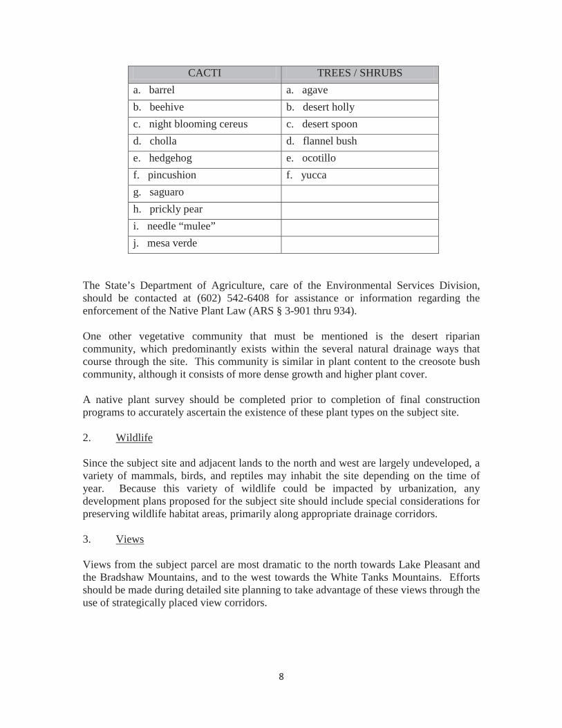
CACTI TREES / SHRUBSa. barrel a. agaveb. beehive b. desert hollyc. night blooming cereus c. desert spoond. cholla d. flannel bushe. hedgehog e. ocotillof. pincushion f. yuccag. saguaroh. prickly peari. needle “mulee”j. mesa verde
The State’s Department of Agriculture, care of the Environmental Services Division, should be contacted at (602) 542-6408 for assistance or information regarding the enforcement of the Native Plant Law (ARS § 3-901 thru 934).
One other vegetative community that must be mentioned is the desert riparian community, which predominantly exists within the several natural drainage ways that course through the site. This community is similar in plant content to the creosote bush community, although it consists of more dense growth and higher plant cover.
A native plant survey should be completed prior to completion of final construction programs to accurately ascertain the existence of these plant types on the subject site.
2. Wildlife
Since the subject site and adjacent lands to the north and west are largely undeveloped, a variety of mammals, birds, and reptiles may inhabit the site depending on the time of year. Because this variety of wildlife could be impacted by urbanization, any development plans proposed for the subject site should include special considerations for preserving wildlife habitat areas, primarily along appropriate drainage corridors.
3. Views
Views from the subject parcel are most dramatic to the north towards Lake Pleasant and the Bradshaw Mountains, and to the west towards the White Tanks Mountains. Efforts should be made during detailed site planning to take advantage of these views through the use of strategically placed view corridors.
8
D. EXISTING LAND USE/ZONING
1. Camino á Lago Planning Area
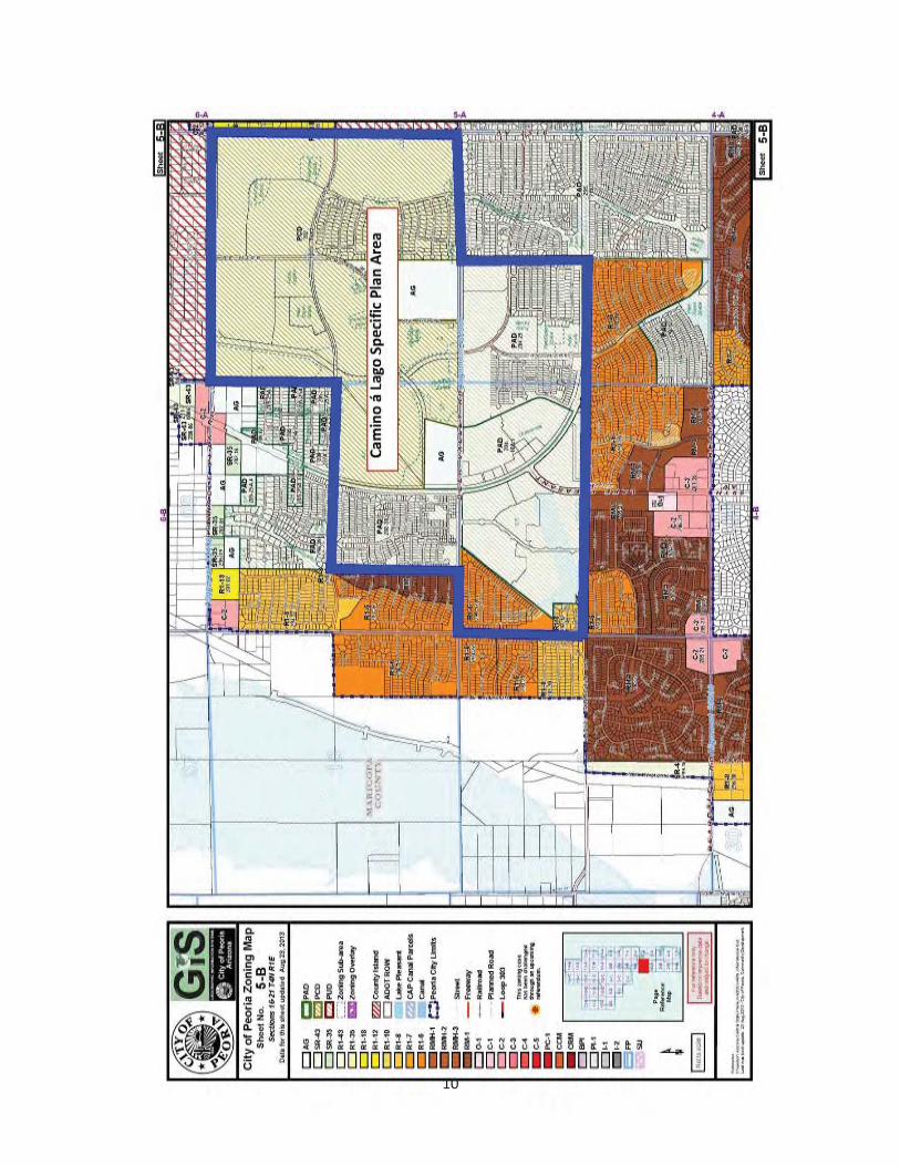
A portion of the Camino á Lago planning area is located south of Deer Valley Road,which is zoned Planned Area Development (PAD). The Meadows is zoned Planned Community District (PCD). The parcel located at the northeast corner of Lake Pleasant Parkway and Deer Valley Road is zoned General Agricultural (AG), and the Liberty High School site located at the northwest corner of 95th Avenue and Deer Valley Road is zoned AG (See Map 5, City of Peoria Zoning Map 5-B).
2. Surrounding Area
The Camino á Lago planning area is surrounded by a variety of mostly residential uses. The only non-residential properties adjacent to the Camino á Lago planning area are Commercial (C-2) zoned properties located at the northeast corner of 91st Avenue and Pinnacle Peak Road and the northwest corner of 99th Avenue and Pinnacle Peak Road (See Map 5, City of Peoria Zoning Map 5-B).
E. SITE DEVELOPMENT CONSTRAINTS/OPPORTUNITIES
The subject parcel possesses very few constraints to urban development when compared to the site’s many opportunities. One such constraint, archaeological sites, have been examined and documented by Archaeological Consulting Services. Site mitigation must be accomplished by an archeologist with a permit from the Arizona State Museum prior to any disposition.
A final constraint that was documented by ASLD staff on-site surveys is the potential environmental hazard at Section 16. An aging stock tank from previous grazing activities has become a repository for several unmarked 55-gallon drums. Any environmental impact from these drums must be assessed by the State Land Department and the Department of Environmental Quality and/or mitigated prior to any disposition.
Development opportunities for the Camino á Lago project include a mild-site topography, a manageable drainage pattern within no documented on-site flood plains, excellent views to the west and north, and excellent vehicular access, such as Lake Pleasant Parkway, Pinnacle Peak Road, Deer Valley Road, and 91st Avenue.
Two other related opportunities that deserve mention are the close proximity of the site to existing high-quality single-family residential developments, commercial development and communities amenities such as school, parks, and a library.
9
10
DEVELOPMENT TRENDS
The development trends in the area surrounding the subject site have been predominately geared towards master planned communities with a mixture of various densities of residential and commercial land uses. There are three master planned communities to thesouth of and within one-half mile of the Camino á Lago project: Sun City (Del Webb); Westbrook Village (UDC Homes); and the newest of the three, Ventana Lakes (Lennar Homes). This master planned community trend can be expected to continue given the great success that these communities have experienced.
The same trend is also impacting large tracts of land north of the subject site in the immediate proximity to Lake Pleasant. In addition to an improving housing market, the Lake Pleasant Regional Recreation Area is proving to be a major catalyst for these projects. In fact, the expansion of Lake Pleasant has caused the entire undeveloped area north of Beardsley Road, including the Camino á Lago parcel, to develop more quickly as recreational opportunities at the lake expand.
In addition, residential developments have developed both immediately north and east of the project site. The residential developments north, east and south of the Site vary in density and lot sizes. There are established commercial uses in the area also. A commercial use exists at the northwest and northeast corners of Beardsley Road and 99th
Avenue. There is an existing commercial use anchored by a Wal-Mart located within the Specific Plan area at the southeast corner of Deer Valley Road and Lake Pleasant Parkway. Also, there is an existing restaurant and real estate office located at the northeast corner of 91st Avenue and Pinnacle Peak Road. Lastly, there is an existing gas station located at the southwest corner of Pinnacle Peak Road and Lake Pleasant Parkway.
A catalyst to the growth has been the completion of the northwestern leg of the Agua Fria Freeway. In fact, this transportation facility has also caused intensive growth at the intersection of Bell Road and the Agua Fria Freeway, such as the Arrowhead Regional Mall and the Target Power Center.
G. PEORIA GENERAL PLAN
The Peoria General Plan designates the area as Residential Low (2-5 du/ac), Residential Estate (0-2 du/ac) and Community Commercial. Residential densities may vary within the Camino á Lago project area provided the overall density is less than 4.0 units per acre.
A major commercial center, which is included in the Camino á Lago Specific Plan is located at the intersection of Lake Pleasant Parkway and Deer Valley Road.
Finally, the Camino á Lago Specific Plan conforms to the City’s Transportation and Community Facilities Elements of the General Plan.
11
III. COMMUNITY GOALS RELATIONSHIP
12
The Camino á Lago Specific Plan implements various goals and policies of the City of Peoria General Plan. Several Goals and Policies are identified below for both the original Specific Plan and this Amendment to the Specific Plan.
I. Original Submittal
The goals identified below were the goals originally identified and implemented by the 1997 Camino á Lago Specific Plan.
GOAL A: Create and maintain a high level of environment quality consistent with a healthy, safe and enjoyable living environment in Peoria.
The Camino á Lago Specific Plan seeks to satisfy this goal in that the Plan contains general provisions ensuring a safe and healthy living and working environment for future plan area residents. A balance of land uses, property sized utilities, including streets, and general urban design considerations all serve to satisfy this goal.
GOAL B: Carefully manage and control development to achieve orderly and efficient growth.
The timing of planning and development of this 1,352 acre Trust land parcel is in sync with the planning and development of other privately held properties in the immediate area. This timing will allow the city of Peoria to ensure that growth in this area will be both orderly and efficient, with the end result being quality, market responsive and sensible development.
GOAL C: Encourage the development of sound and stable residential neighborhoods.
The Camino á Lago Use Plan has been crafted to promote high quality residential environments at varying densities that will be convenient to commercial, school and open space uses. The unique design of the project’s circulation system and the size of the residential parcels ensure cohesive and functioning neighborhoods which will be adequately buffered from the commercial core planned for the intersection of Lake Pleasant Parkway and Deer Valley Road.
GOAL D: Promote and maintain balance commercial activity that is economically viable and responsive to the needs of the community.
The planned commercial core at Lake Pleasant Parkway and Deer Valley Road seeks to provide future residents with a concentration of commercial activities. This concentration will enhance shopping opportunities as well as promoting safe and energy efficient travel patterns.
GOAL E: Industrial Development (no applicable).
13
GOAL F: Provide a safe, convenient and efficient system of transporting both people and goods to, from, and throughout the City.
The planned circulation system for Camino á Lago contains a variety of street types, ranging from Lake Pleasant Parkway to local residential streets, which will promote safe and efficient travel patterns in this quickly growing area of the City. The circulation system is designed to be compatible with the proposed densities, both within and surrounding project area.
GOAL G: Plan, program and provide a functional, efficient, and cost effective system of services to serve the City’s expanding population.
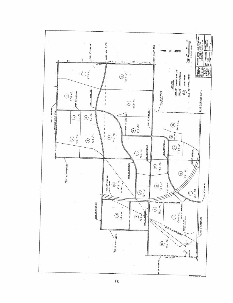
The preliminary utilities plans and phasing plan contained in the Camino á Lago Specific Plan seek to provide for both adequately sized and properly timed construction of the utilities to serve this area. Further work with the City to get these utilities constructed will be required prior to any rezoning approvals granted by the City.
GOAL H: Increase the employment base in Peoria.
GOAL I: Capture a large proportionate share of retail expenditures within the Phoenix metropolitan area.
GOAL J: Increase City revenues.
The Camino á Lago Specific Plan promotes a concentration of commercial activities at the future intersection of Lake Pleasant Parkway and Deer Valley Road. This approximately 87 acre commercial core will support both local and sub-regional shopping needs and will generate additional sales tax revenues for the City. This commercial core will also provide commercial opportunities for future residents.
II. This Amendment
In addition to the goals identified above, this amendment to the Camino á Lago Specific Plan will implement the following goals and policies from the City of Peoria 2011 General Plan.
Land Use Element, Goal 1: Provide a balance of land uses that will preserve and enhance neighborhoods, promote economic development and encourage redevelopment at appropriate locations.
This Amendment proposes a greater mixture of diverse housing types and sizes. The diversity of housing types will enhance neighborhood livability, promote greater resident interaction in the neighborhood parks, and promote a more vibrant community.
14
Land Use Element, Goal 1, Objective 1.M: Provide a diversity of housing types to meet the needs of persons of all income levels and ages.
This Amendment proposes a greater diversity of housing types that will meet the needs of all income levels and ages. Approximately 311 acres of the total approximately 694 acres within The Meadows is identified in the current Camino á Lago Specific Plan as residential parcels with residential densities not to exceed 1.1 du/acre (otherwise known as “Residential Estate” in the General Plan and “Estate Low Density Residential” in the this Specific Plan). This Amendment proposes to decrease the overwhelming amount of Residential Estate areas (which are often not desired or affordable for many families) and instead provide more (2.0-3.59 du/ac) in this Specific Plan) for families, move up buyers, and other buyers who desire to live in areas with greater resident interaction within the community and enhanced amenities.
Land Use Element, Goal 1, Objective 1.N: Support healthy residential environments that provide for safe and convenient access, open space and recreational opportunities, access to public schools and services and protection from incompatible land uses.
This Amendment preserves a row of large lots (max. density of 1.1 du/ac) along the perimeter of The Meadows, abutting Pinnacle Peak Road, 91st Avenue and a portion of Deer Valley Road. In addition, the residential density is transitioned from the lowest residential densities (Estate Low Density Residential) along the perimeter of the Site, tothe second lowest residential densities (Estate High Density Residential), and finally tomedium residential densities (Low Medium Density Residential) around the School and Public Park sites near the center of The Meadows, which will create safe, close, and convenient access to the School and Public Park sites for families who desire to live and play in The Meadows.
Land Use Element, Goal 1, Objective 1N, Policy 1.N.5: Require new residential developments to provide pedestrian linkages to parks, schools and other appropriate public facilities.
This Amendment will create more pedestrian linkages to the School and Public Park sites and attract more Peoria residents to a vibrant Public Park.
Land Use Element, Goal 1, Objective 1N, Policy 1.N.6: Encourage the development of master planned communities where large land holding can be designed to provide a wealth of amenities to City residents.
This Amendment will create more opportunities for enhanced amenities. The current mix of housing opportunities and limited feasibility of developing the Estate Low Density
15
Residential areas within The Meadows limits the ability to provide the types of amenities that should be provided in master-planned communities like The Meadows.
Land Use Element, Goal 1, Objective 1N, Policy 1.N.8: Support and facilitate convenient access to schools.
This Amendment will locate more houses closer to the School site, which will provide families with more housing options that are closer to a school. Locating houses closer to the School Site will create safer and more convenient access for children.
Land Use Element, Goal 1, Objective 1.Q: Consider periodic amendments to the General Plan Land Use Map to ensure relevancy.
The latest amendment to the Camino á Lago Specific Plan occurred in 2008 (originally adopted in 1997). Now five years later, after possibly the most severe real estate depression the Valley has ever seen, new housing demands and a drastic change in the character of the Camino á Lago area have prompted this Amendment. This Amendment is needed to meet the housing demands of families who desire more livable neighborhoods and to support the growing commercial opportunities along Lake Pleasant Parkway, which is quickly becoming a significant regional transportation corridor leading to the growing recreational and entertainment opportunities at Lake Pleasant.
Housing Element, Goal 1, Objective 1.A: Promote quality residential development through diversity in housing type.
This Amendment proposes a healthy and sustainable mix of diverse housing types that will benefit The Meadows and the surrounding area. The Estate Low Density Residentialdesignated areas have been decreased to provide more Low Medium Density Residentialdesignated areas, which will provide a more diverse mix of housing within The Meadows. This Amendment proposes approximately 80 acres of The Meadows to remain under the Estate Low Density Residential designation which represents approximately 12% of The Meadows land area. Currently, approximately 45% (approximately 311 acres) of The Meadows land area is designated Estate Low Density Residential.
Recreation and Open Space Element, Goal 3, Objective 3.B, Policy 3.B.2: Continue to evaluate growing and changing recreational needs and opportunities presented by large scale, Planned Area Developments currently being planned for northern Peoria.
Housing demand for family-oriented neighborhoods, with access to amenities and schools, has grown at a rapid pace since the Camino á Lago Specific Plan was first adopted. Families desire safe communities where they can interact with other families
16
walking down the street, spending time at nearby parks, or on the way to and from school. This Amendment will cause The Meadows to thrive as a place where families of all ages, types and sizes are integrated and form the social fabric of a safe, convenient, and vibrant community.
17

IV. SPECIFIC PLAN
18
A. LAND USE ELEMENT
1. Proposed Land Uses
The land use planning for the subject parcel has taken all site factors into consideration. The land use element, including the land use plan, is intended to provide generalized guidelines for the proposed land uses, taking into account the property’s unique character and location. The planned land use mix will create an attractive and functional development comprised of a variety of residential densities, and sub-regional commercial uses.
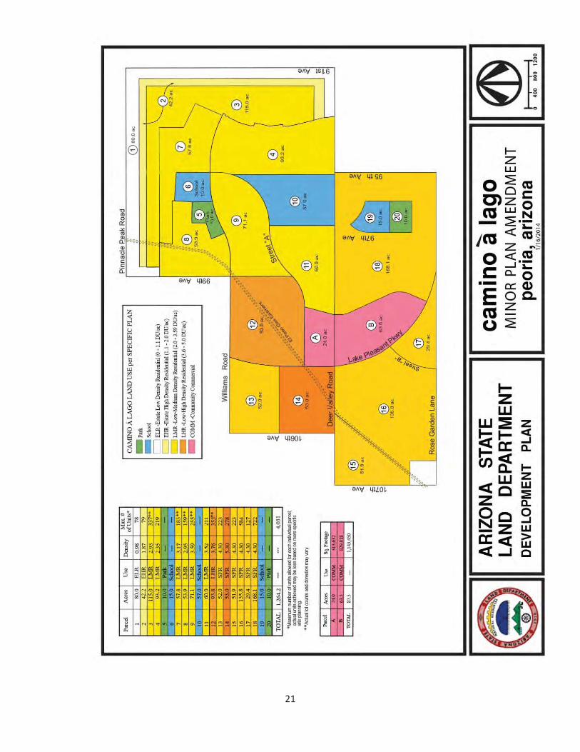
The Land Use plan identifies the type, location and development intensity for the Camino á Lago planning area and provides appropriate transitions between new development and project’s immediate periphery (see Map 6).
2. Land Use Classifications
This section of the Camino á Lago Specific Plan identifies the type and location of those land uses deemed appropriate for the plan area. The proposed land use categories take into account the physical features of the site, as well as existing adjacent land uses (see Map 7 and Table 1). In addition, the land uses and their locations were further solidified through discussions with the City’s Planning, Engineering, and Parks staff, the Peoria Unified School District, and interested residents surrounding project site.
a. Single Family Residential (SFR)
Single Family Residential denotes areas where residential densities of 1.1-5.3 dwelling units per acres are desirable. Lower density residential areas with a density range of 1.1-1.9 dwelling units per acre are located on the northern and eastern boundary of the Site to serve as a buffer for existing residential developments north of Pinnacle Peak Road and east of 91st Avenue. The row of buffer lots along the Pinnacle Peak Road, 91st Avenue and a portion of Deer Valley Road boundaries are lower density and provide larger lot sizes than many of the residential developments located on the north side of Pinnacle Peak Road and east side of 91st Avenue.
19
20
21
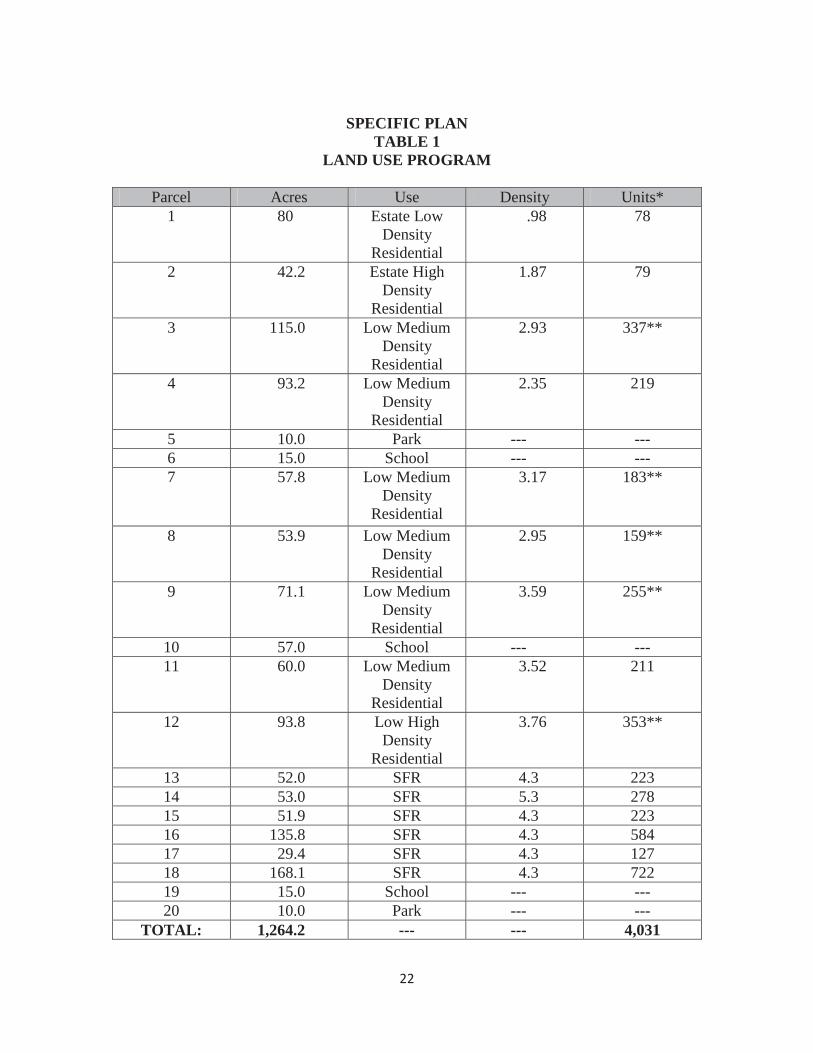
SPECIFIC PLANTABLE 1
LAND USE PROGRAM
Parcel Acres Use Density Units*1 80 Estate Low
Density Residential
.98 78
2 42.2 Estate High Density
Residential
1.87 79
3 115.0 Low Medium Density
Residential
2.93 337**
4 93.2 Low Medium Density
Residential
2.35 219
5 10.0 Park --- ---6 15.0 School --- ---7 57.8 Low Medium
Density Residential
3.17 183**
8 53.9 Low Medium Density
Residential
2.95 159**
9 71.1 Low Medium Density
Residential
3.59 255**
10 57.0 School --- ---11 60.0 Low Medium
Density Residential
3.52 211
12 93.8 Low High Density
Residential
3.76 353**
13 52.0 SFR 4.3 22314 53.0 SFR 5.3 27815 51.9 SFR 4.3 22316 135.8 SFR 4.3 58417 29.4 SFR 4.3 12718 168.1 SFR 4.3 72219 15.0 School --- ---20 10.0 Park --- ---
TOTAL: 1,264.2 --- --- 4,031
22
COMMERCIAL PARCELS
Parcel Acres Use Sq. FootageA 24.0 COMM 313,632B 63.5 COMM 829,818
TOTAL 87.5 1,143,450
* Maximum number of units allowed for each individual parcel; actual units achieved may be less based on more specific site planning.
** Actual lot counts and densities may vary.
23
SPECIFIC PLANTABLE 1
LAND USE PROGRAM(Continued)
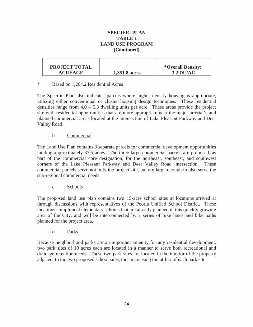
PROJECT TOTALACREAGE 1,351.8 acres
*Overall Density: 3.2 DU/AC
* Based on 1,264.2 Residential Acres
The Specific Plan also indicates parcels where higher density housing is appropriate, utilizing either conventional or cluster housing design techniques. These residential densities range from 4.0 – 5.3 dwelling units per acre. These areas provide the project site with residential opportunities that are more appropriate near the major arterial’s and planned commercial areas located at the intersection of Lake Pleasant Parkway and Deer Valley Road.
b. Commercial
The Land Use Plan contains 3 separate parcels for commercial development opportunities totaling approximately 87.5 acres. The three large commercial parcels are proposed, as part of the commercial core designation, for the northeast, southeast, and southwest corners of the Lake Pleasant Parkway and Deer Valley Road intersection. These commercial parcels serve not only the project site, but are large enough to also serve the sub-regional commercial needs.
c. Schools
The proposed land use plan contains two 15-acre school sites at locations arrived at through discussions with representatives of the Peoria Unified School District. These locations compliment elementary schools that are already planned in this quickly growing area of the City, and will be interconnected by a series of bike lanes and bike paths planned for the project area.
d. Parks
Because neighborhood parks are an important amenity for any residential development, two park sites of 10 acres each are located in a manner to serve both recreational and drainage retention needs. These two park sites are located in the interior of the propertyadjacent to the two proposed school sites, thus increasing the utility of each park site.
24
3. LAND USE INTENSITY
The proposed land use intensity for the Camino á Lago plan area exclusive of the commercial core, identifies the anticipated development permitted on the subject property.
These intensities include a maximum of 4,031 Single Family Residential dwelling units which will result in an overall residential density of approximately 3.2 dwelling units per acre.
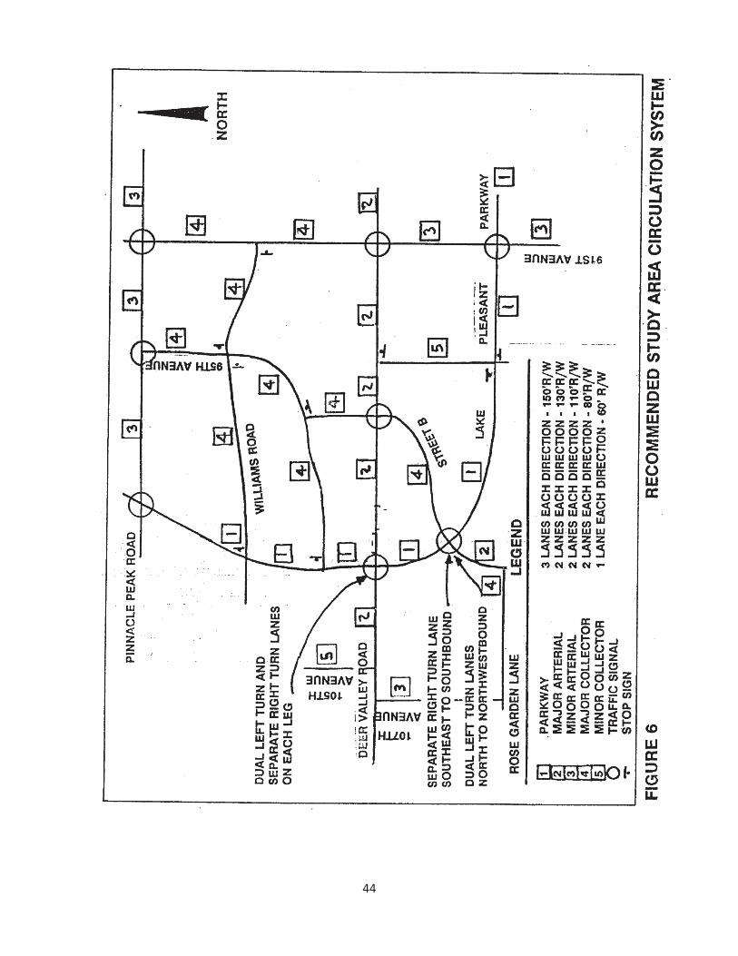
B. CIRCULATION ELEMENT
1. Introduction
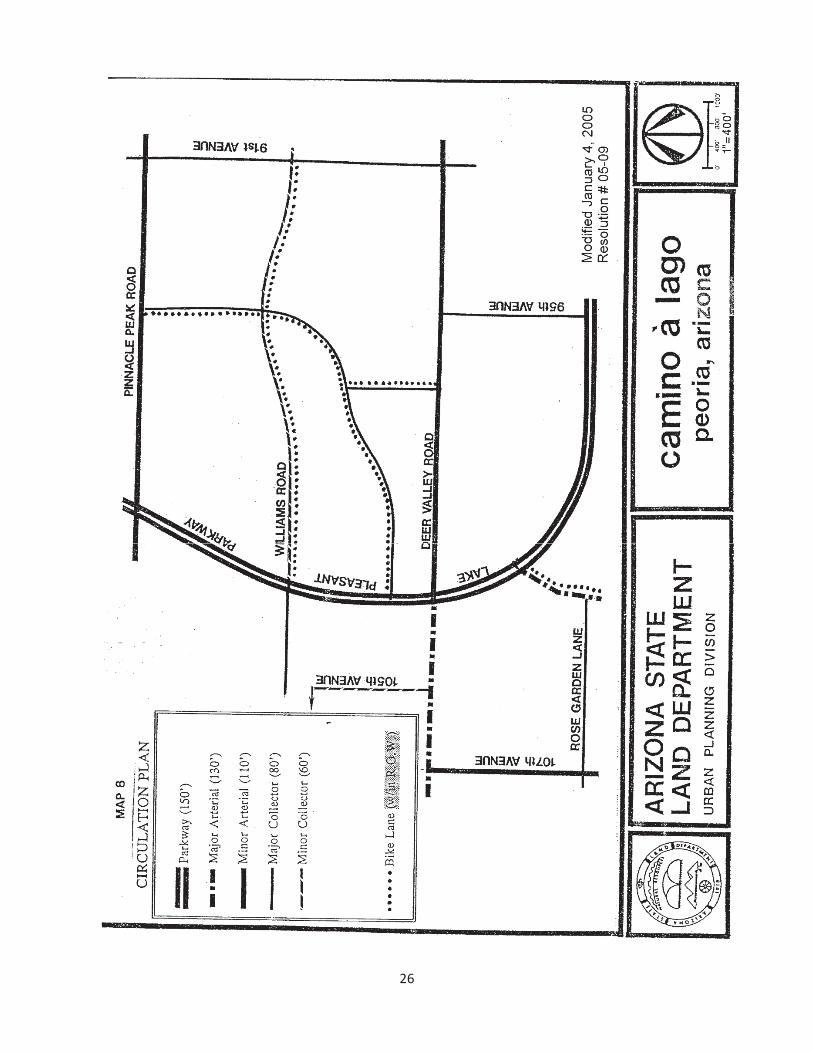
The circulation element of the Camino á Lago Specific Plan describes the type, size and location of streets, bike paths and bike lanes that will serve the plan area. Design and ultimate construction of the various components of the circulation element will adhere to specifications consistent with the City of Peoria’s design guidelines. Prior to the approval of any phase of development, a master street plan and traffic study should be completed by the end-user for review and approval by the City of Peoria.
Planned circulation for the plan area includes an integrated system of public streets, an urban parkway and bike lanes (see Map 8). The proposed transportation network should provide for regional and sub-regional access to the planning area and efficient internal circulation between the plan’s residential and commercial land uses.
2. Vehicular Circulation
Traffic movements that will result from land uses both within and around the property of the plan area will be accommodated by a series of parkway, arterial and collector streets. The parkway and arterial streets will be designed to carry vehicular traffic to and from the Camino á Lago planning area, as well as to destinations outside the planning area. A series of collector and local streets will then provide vehicular movement and access between land uses within the boundaries of the planning area.
PRINCIPAL ARTERIAL/PARKWAY
Lake Pleasant Parkway serves as the main access between Peoria’s main business/commercial district and Lake Pleasant and its expanding recreational opportunities. This parkway facility also carries sub-regional traffic as a main north-south artery. There is controlled access along this facility and many residential parcels are be served by major/minor arterials, collectors and local streets.
25
26
MAJOR ARTERIALS
The continuation of 99th Avenue from Rose Garden Lane to the intersection with Lake Pleasant Parkway and Deer Valley Road from Lake Pleasant Parkway to 107th Avenue are classified as major arterials per the City’s transportation plan. These major arterials serve both regional and sub-regional traffic.
MINOR ARTERIALS
The minor arterials serving the Camino á Lago Specific Plan are 107th Avenue, Deer Valley Road (from Lake Pleasant Parkway to 91st Avenue) and Pinnacle Peak Road. These minor arterials move large volumes of moderate speed traffic to areas of minor traffic generation. There is controlled access for commercial uses located at the Lake Pleasant Parkway/Deer Valley Road intersection, while residential areas are served by collector and local streets.
COLLECTORS
Major and primary collectors enable neighborhood traffic to travel from local to school/park sites located within the project area and to arterial streets. These collectors, which are not intended for non-neighborhood through-traffic include:
* 91st Avenue (80’) * Rose Garden Lane (80’) * 95th Avenue (80’) * Williams Road (80’ / 60’) * 105th Avenue (60’) * Street ‘A’ and Street ‘B’ (80’)
LOCAL STREETS
Local streets, meant to serve only neighborhood traffic, are the design and constructionresponsibility of the property’s ultimate end-user, again meeting Peoria’s design specifications.
3. NON-VEHICULAR CIRCULATION
An integrated system of bicycle lanes are located in a manner that provides future local residents the opportunity to engage in non-vehicular travel. These bike lanes should be developed in a manner consistent with the City’s design criteria.
With respect to location, there is an extensive system of class 2 bike lanes located along all interior collectors within the road right-of-way, which serve to connect school and part sites located within the planning area.
4. PUBLIC TRANSIT
Provision of public transportation is not anticipated in the near term. Should public transportation become available to serve the project site, it is recommended that Lake
27
Pleasant Parkway and major collector roadway cross-sections be designed and constructed with bus pull-outs and other transit-related facilities.
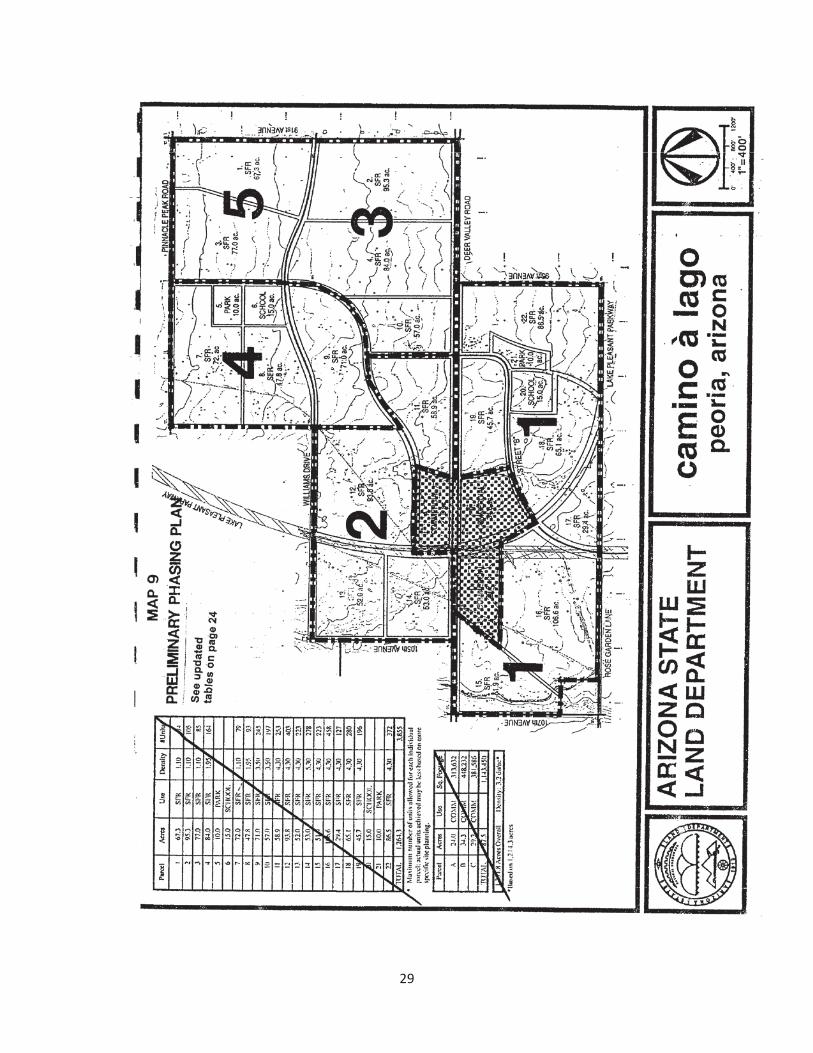
C. PRELIMINARY PHASING PLAN
The Preliminary Phasing Plan, which is shown on Map 9, represented the original sequencing of dispositions that was anticipated. Actual dispositions have varied in accordance with market demand and infrastructure availability. The issues addressed in this report are based on the General Plan and other City of Peoria information. Many of the issues such as drainage, sewer lines, and utilities, will require further negotiations, engineering, and studies.
The roadway improvements, underground utilities and major draining improvements are to be dedicated to the City of Peoria. If the City of Peoria has purchased part of any right of way prior to final rezoning, the parcel end-user will be responsible for dedication of all roadways and pertinent infrastructure not yet in place.
D. URBAN DESIGN ELEMENT
1. Introduction
The Urban Design Element explains the design expectations and guidelines for the land use mixture for the Camino á Lago project area. Site designs, site amenities, and architectural style will combine to create the environment. The definition and maintenance of a unique design environment requires consistent applications of landscape, building design, materials, colors, and signage.
Table 2Preliminary Phasing Plan Roadway Dedication
and Construction Requirements as Anticipated by the Original Phasing Plan (Actual phasing and construction has varied from the below)
Phase 1: Deer Valley Road – 95th Avenue to 107th Avenue (1/2 street). 95th Avenue – Deer Valley Road to Lake Pleasant Parkway (1/2 street).Lake Pleasant Parkway – 95th Avenue to Deer Valley Road (1/2 street/full street).Rose Garden Lane – 99th Avenue to property line (1/2 street). 107th Avenue – Property line to Deer Valley Road (1/2 street).Street B – Deer Valley Road to Lake Pleasant Parkway (full street).
Phase 2:Deer Valley Road – Street B to 10th Avenue (1/2 street). Street B – Deer Valley Road to Street A (1/2 street).Street A – Street B to Lake Pleasant Parkway (1/2 street/full street).Lake Pleasant Parkway – Deer Valley Road to Williams Drive (full street).Williams Drive – Phase 2 Boundary to 105th Avenue (1/2 street).
28
29
105th Avenue – Deer Valley Road to Robin Lane (1/2 street).
Phase 3: Deer Valley Road – 91st Avenue to Street B (1/2 street).91st Avenue – Deer Valley Road to Williams Drive (1/2 street).Street B – Deer Valley Road to Street A (1/2 street).Street A – Street B to Williams Drive (1/2 street).Williams Drive – 91st Avenue to Street A (1/2 street).
Phase 4:Pinnacle Peak Road – Street A to property line (1/2 street).Street A – Pinnacle Peak Road to phase line (1/2 street).Williams Drive – Street A to phase line (1/2 street).
Phase 5:Pinnacle Peak Road – 91st Avenue to Street A (1/2 street).91st Avenue – Williams Drive to Pinnacle Peak Road (1/2 street).Williams Drive – 91st Avenue to Street A (1/2 street).Street A – Williams Drive to Pinnacle Peak Road (1/2 street).
The Urban Design Element is intended to set the “tone” for the quality of development in the plan area. These guidelines will provide a basis for insuring consistency in quality and compatibility in design for development within the plan area. Prior to commencement of any development, appropriate approvals will be required from the applicable departments of the City of Peoria.
2. Landscape Guidelines
The objective of landscaping within the plan area should be that its design and location remain consistent with the desert environment. To the extent that is reasonable and feasible, the preservation of the natural vegetation and environment will be encouraged. Whenever appropriate and as required, selective forms of existing vegetation as specified by City of Peoria regulations, should be transplanted if development has necessitated their removal.
Streetscape
The scale and function of the streets within the plan area may require different types of landscaping. The streetscape is defined through right-of-way landscape, landscape buffer/retention, and major landscape features.
The design of the various landscape treatments shall meet these policies:
o Use plant materials of appropriate species, size and spacing so that the visual intent of the material, such as defining an edge or emphasizing an entrance, is perceivable upon installation.
30
o Use materials to minimize the requirement for irrigation, and, when possible, native plants should be selected. Non-native plan selections should be appropriate for and compatible with the environment of the area.
o Provide setbacks from the right-of-way line in the plan area in accordance with the design standards. Where there is a bike path in conjunction with a significant street edge, there must be adequate setback to accommodate the trees, plant material, and bike path.
o Design retention areas, to the extent that is reasonable and feasible, which will enhance the landscape character of the area.
o Preserve existing, or provide new landscaping for any part of development not used for building or parking in order to enhance the landscape character of the area.
o Design landscape medians to reinforce the established street edge landscape. The use of landscape medians is a major identity component of the landscape theme.
Neighborhood Parks
Two park sites of approximately ten (10) acres each are to be located adjacent to two (2) planned schools. The design of these areas should provide an open space for a variety of both active and passive recreational activities. Within these areas there should also be bike lanes.
3. DESIGN GUIDELINES
The purpose of these guidelines is to provide and maintain quality in the various development projects within the plan area. The projects should maintain high quality standards as to the use of material, the relationship of buildings to the environment, and meeting the needs of the users. The availability of space, natural esthetics and the variety of land uses provide opportunity for creative and original design approaches within the context of the project’s overall development.
Site Design
Develop each parcel so that building, parking, open space, retention, and entrances are compatible with adjacent development. Maintain proper distances between structures to reduce the mass and impact of parking. Facilitate non-vehicular circulation to open space features and promote safe vehicular movements.
* On each site, both parking and building should be contained by continuous landscaped open space except where broken by access drives. This landscape perimeter should provide the appropriate edge to adjacent thoroughfares to reinforce the landscape design intent of that street.
31
* Screen all ancillary structures and equipment such as trash receptacles, mechanical equipment, and electrical equipment from public view, especially from existing residences. These screens should be of appropriate materials so as to conform to or enhance the building and landscape.
* All site designs should incorporate energy and water conservation measures and building orientation and landscaping plans should reflect these measures.
Building Design
* Design buildings appropriate to the southwestern climate. Orient buildings to recognize cooling requirements and relationship to landscape materials. Colors and materials should reflect or appropriately contrast with the desert palette.
* Adapt retail operation designs to an appropriate regional treatment. These efforts should avoid thematic imagery and instead should draw upon the natural colors in the landscape.
* Design roof lines, relative building heights, entrance orientation and other major architectural elements within the context of the overall project. Emphasis should be placed in design on conformity and enhancement of the surrounding area rather than contrasting or standing apart from the rest of the development.
* Screen service entries from view, both from surrounding streets and adjacent properties.
* Building materials should reflect or appropriately contrast with the desert palette. The building materials and colors should also be consistent with the regional building vernacular.
* Colors should be used to create visual harmony within the land use districts in the plan area. Appropriate colors should include, but are not limited to:
Desert hues and other earth tones including light brown, cream, and tan Off-white, light greyColors appearing in natural stone utilized in buildings Reds and oranges appearing in brick utilized in buildings or in roof tiles
Signage
Strengthen the identity of the planning area by appropriate signage, sculpture, repetitive graphic symbols and distinctive landscaping with hardscape features at entrances into the area and at key locations within.
32
Parking
Parking areas should be contained within a parcel with controlled access from adjoining thoroughfares. They should be broken up in scale by landscaping treatments to provide screening, shade aesthetics, and to define access points.
Parking aisles should be oriented to facilitate pedestrian movement to the building served as well as to adjacent pedestrian paths of movement.
Lighting
Lighting represents another opportunity to unify the planning area and create an ambiance through the consistent use of a common type of fixture for exterior lighting. Lighting should be designed and located so as to limit light dispersion onto any adjacentresidential properties. Landscape and/or sidewalk lighting should be concealed or painted to blend into the landscape.
4. RESIDENTIAL GUIDELINES
Site Design
Each residential parcel may require its own identity; however, there is a need to maintain a sense of unity in these residential areas through consistent standards and organization principles. Architectural motifs may vary but principles of basic site organization, parking location and screening, landscape standards and setbacks exterior lighting, unit access and parcel access should be consistent within this land use category and with other residential and commercial development within the plan area.
Each medium density parcel should be bound by a continuous border of landscaped open space, broken only by access drives. These points of access should be kept to a minimum to avoid conflicts with pedestrian and bicycle movements.
Each project should have its own entry and identity, accomplished by offsetting and staggering buildings and by combining one-and-two-story buildings forms to separate massing.
Orient internal drives away from buildings, service areas and unit entries.
Non-vehicular circulation within Residential-Medium and Low Density sites should be accommodated with a network of bike paths, bike lanes, and sidewalks. This non-vehicular transportation network should be developed internally, allowing for movement throughout the site, while providing linkage to the plan area’s overall transportation network.
Parking should be oriented away from the street edges. Where fronting on streets, parking should be screened with either landscape or masonry screen walls. Parking lots should be broken down in scale and located conveniently to the units served.
33
All site-mounted equipment, trash containers, and other service facilities should be either treated architecturally as a part of the building or screened with either landscape material or a decorative masonry wall.
Building Design
Buildings should be designed to meet the general guidelines described earlier. They should also be designed with an emphasis on private and public open space. The units should maximize privacy within individual buildings.
There should be a mix of unit types and sizes to promote diversity within the housing alternatives provided by these developments while at the same time displaying a consistency with the quality and scale of other residential components within the plan area.
Roof mounted equipment, including antennas, should not be visible from public streets or surrounding parcels.
Covered parking structures should be discouraged and replaced by enclosed garages reflecting the architecture and materials of the residential buildings. Parking structures should not be located immediately adjacent to public streets.
Signage
Signage should be limited to regulatory, directional and monument or wall-mounted project identification signs and shall conform to City of Peoria code.
Lighting
Lighting in residential medium density should be consistent with lighting principles outlined under “General Guidelines.”
5. COMMERCIAL GUIDELINES
Commercial land use comprises approximately 7 percent of development in the plan area. However this land use category may provide a wide variety of development forms, parcel sizes and configurations. Commercial development should be compatible in quality and design with the residential component of the plan area.
The storefronts and entrances relate to both their immediate parking, and outdoor dining and seating should be encouraged where appropriate.
Parking should be discouraged in front of store entries to allow for more generous landscaping and greater visibility of the entrances. Sidewalks should link each parcel to facilitate pedestrian movement and reinforce the idea of unity within the planning area.
34
Service entrances and docks should be located so as to mitigate their impact and facilitate circulation of service vehicular traffic.
Building Design
Commercial building materials and colors should remain consistent with those referenced herein under “General Guidelines.”
All visible sides of buildings are to be treated with design features. Transitions between rears of structures and front doors of adjacent parcels must be recognized.
Freestanding buildings and accessory structures shall conform to the main building in color, material, scale and architectural character.
Roof proportions and overhangs are encouraged as a response to energy, conservation and climate concerns.
Consistent building heights contribute to the definition of an identifiable district and should not exceed the cornice line of neighboring buildings with pitched roofs.
Lighting
Parking lot light standards should be uniform throughout the plan area. The standards should be as short as economically practical within the retail parcels.
Lighting should be integrated into the landscape design of the parking area. Lighting should match the scale of adjacent buildings and not cause an adverse impact on adjacent properties. Special consideration for lighting is necessary when adjacent to residential properties.
35
APPENDIX UTILITIES PLANS
A. CONCEPTUAL WATER PLANB. CONCEPTUAL WASTEWATER PLANC. CONCEPTUAL DRAINAGE PLAND. CONCEPTUAL CIRCULATION SYSTEM
36
MAP A: CONCEPTUAL WATER PLAN
37
38
MAP B: CONCEPTUAL WASTEWATER PLAN
39
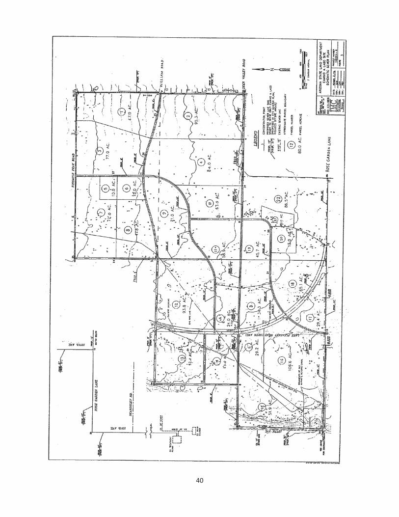
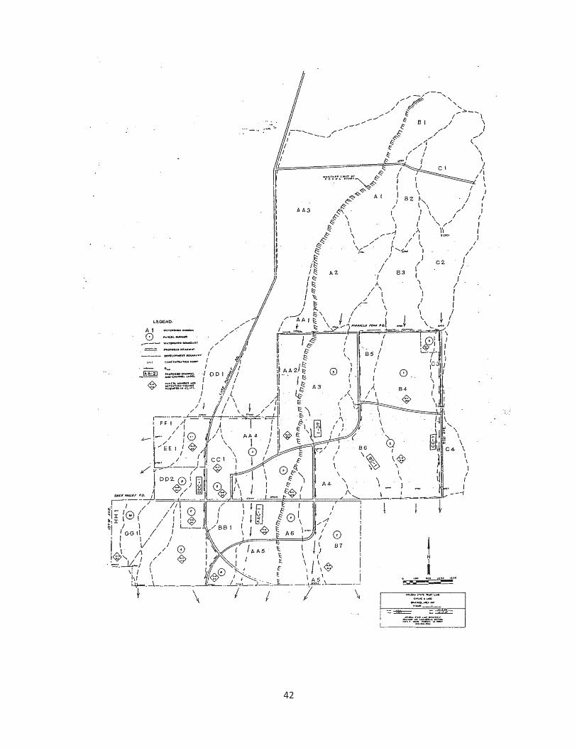
40
MAP C: CONCEPTUAL DRAINAGE PLAN
41
42
MAP D: CONCEPTUAL CIRCULATION SYSTEM
43
44