Embed Size (px)
Citation preview
Cammeray Golf Course,
Cammeray
Heritage Impact Assessment
Prepared for Ausgrid
August 2018 - Draft
Document Control Page
CLIENT: Ausgrid
PROJECT: SYD18236 Cammeray Golf Course, Cammeray HIA
SITE NAME: Cammeray Golf Club, Park Ave, Cremorne NSW
EXTENT HERITAGE PTY LTD INTERNAL REVIEW/SIGN OFF
WRITTEN BY DATE VERSION REVIEWED APPROVED
Lorna Cooper Vidhu Gandhi
08.08.18 Draft 14.08.18 Anita Yousif
Lorna Cooper 22.08.18 Final 22.08.18 Anita Yousif
Lorna Cooper 5.09.18 Final (with alternative plan)
5.09.18 Anita Yousif
Copyright and Moral Rights
Historical sources and reference materials used in the preparation of this report are
acknowledged and referenced in figure captions or in text citations. Reasonable effort has been
made to identify, contact, acknowledge and obtain permission to use material from the relevant
copyright owners.
Unless otherwise specified in the contract terms for this project EXTENT HERITAGE PTY LTD:
▪ Vests copyright of all material produced by EXTENT HERITAGE PTY LTD (but excluding
pre-existing material and material in which copyright is held by a third party) in the client for
this project (and the client’s successors in title);
▪ Retains the use of all material produced by EXTENT HERITAGE PTY LTD for this project
for EXTENT HERITAGE PTY LTD ongoing business and for professional presentations,
academic papers or publications.
Extent Heritage Pty Ltd | Cammeray Golf Course HIA i | Page
Contents
1. INTRODUCTION ......................................................................................................... 2
1.1 THE BRIEF ........................................................................................................ 2
1.2 STUDY AREA LOCATION ................................................................................. 2
1.3 STATUTORY CONTEXT AND PLANNING TOOLS ........................................... 2
1.5 PREVIOUS REPORTS AND INVESTIGATIONS ............................................... 4
1.6 APPROACH ....................................................................................................... 4
1.7 LIMITATIONS .................................................................................................... 4
1.8 AUTHOR IDENTIFICATION............................................................................... 4
2. HISTORIC CONTEXT.................................................................................................. 7
2.1 INTRODUCTION ............................................................................................... 7
2.2 HISTORY ........................................................................................................... 7
3. SITE DESCRIPTION ................................................................................................. 14
3.1 GENERAL ........................................................................................................ 14
3.2 ARBORIST REPORT ....................................................................................... 15
3.3 SETTING AND VIEWS .................................................................................... 16
3.4 STUDY AREA IMAGERY ................................................................................. 17
4. HISTORICAL ARCHAEOLOGICAL ASSESSMENT .................................................. 19
4.1 INTRODUCTION ............................................................................................. 19
4.2 SITE DEVELOPMENT ..................................................................................... 19
4.3 SUMMARY OF HISTORICAL ARCHAEOLOGICAL POTENTIAL .................... 20
4.4 ASSESSMENT OF ARCHAEOLOGICAL SIGNIFICANCE ............................... 20
5. ASSESSMENT OF HERITAGE SIGNIFICANCE ....................................................... 22
5.1 BUILT HERITAGE ........................................................................................... 22
5.2 EXISTING STATEMENT OF SIGNIFICANCE .................................................. 22
6. ASSESSMENT OF HERITAGE IMPACT ................................................................... 24
6.1 PROPOSED DEVELOPMENT ......................................................................... 24
6.2 POTENTIAL DEVELOPMENT IMPACTS......................................................... 24
7. CONCLUSIONS AND RECOMMENDATIONS .......................................................... 26
7.1 CONCLUSION ................................................................................................. 26
7.2 RECOMMENDATIONS .................................................................................... 26
8. REFERENCES .......................................................................................................... 28
Extent Heritage Pty Ltd | Cammeray Golf Course HIA 2 | Page
1. Introduction
1.1 The Brief
Extent Heritage Pty Ltd (Extent) has been commissioned by Ausgrid to undertake a Heritage
Impact Assessment (HIA) for the replacement of electrical cabling feeders supplying the
Mosman substation. The route passes through Cammeray Golf Course (the ‘study area’), a
locally significant item listed on the North Sydney LEP (2013) (Item No. I0024). The purpose of
this report is to assess the potential impacts of the proposed works on the heritage significance
and archaeological potential of the study area.
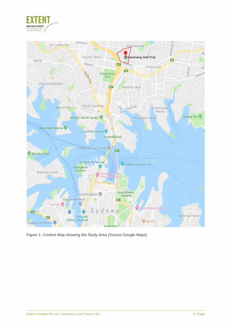
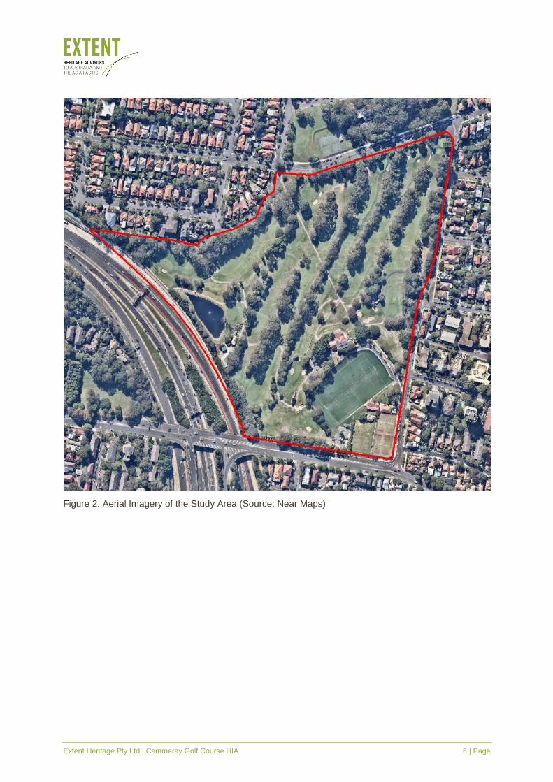
1.2 Study Area Location
The study area is located within Cammeray Golf Course, Cammeray (Figures 1 and 2). It is
bordered by the Warringah Expressway, Ernest Street, Park Avenue, Cammeray Road, Nisbett
Street and adjacent to Morden Street, Cammeray. The study area encompasses Lots 2–6, DP
244543, Lot 7302&7303 DP 1136001 and Lot 1, DP 166171. It is located within the Northern
Sydney LGA, Parish of Willoughby, County of Cumberland.
1.3 Statutory Context and Planning Tools
The subject area is subject to the following statutory controls:
▪ Heritage Act 1977 (NSW).
▪ North Sydney Local Environmental Plan 2013.
▪ North Sydney Development Control Plan 2013.
1.3.1 NSW Heritage Act 1977
The Heritage Act 1977 (NSW) (the Heritage Act, the Act) is designed to conserve the
environmental heritage of New South Wales and regulate development impacts on the state’s
heritage assets. Significant historical archaeological features are afforded automatic statutory
protection by the ‘relics’ provisions of the Act.
A relic is defined as any deposit, artefact, object or material evidence that:
a. relates to the settlement of the area that comprises New South Wales, not being
Aboriginal settlement, and
b. is of State or local heritage significance.
In accordance with Section 139 of the Act, it is an offence to disturb or excavate land, where
this may affect a relic, without the approval/excavation permit of the NSW Heritage Council,
unless an endorsed ‘Exemption’ under Section 57(2) for the State Heritage Register (SHR)
listed sites or ‘Exception’ under Section 139(4) for the locally listed sites and those that contain
relics is issued for works that are minor in nature or with minimal impact onto the heritage
significance of the place.
Extent Heritage Pty Ltd | Cammeray Golf Course HIA 3 | Page
Disturbance of sites which may contain archaeological relics of local significance are dealt with
under Section 140 and 141 of the Heritage Act. Disturbance of potential archaeological relics
within sites, listed on the SHR, are dealt with under Section 60 and 63 of the Heritage Act.
The study area is not listed on the SHR.
1.3.2 North Sydney Local Environmental Plan 2013
Environmental planning instruments made under the Environmental Planning and Assessment
Act 1979 (EPA Act) include State Environment Planning Policies (SEPPs), which deal with
matters of State or regional environmental planning significance; and Local Environmental
Plans (LEPs), which guide planning decisions for local government areas. The study area falls
within the North Sydney Local Government Area (LGA). The relevant environmental planning
instrument is North Sydney LEP 2013.
The objectives of North Sydney LEP 2013 with respect to heritage conservation and
archaeological sites are provided in clause 5.10, which (amongst other objectives) aims to
conserve archaeological sites and requires consent to demolish, move or alter known or
potential archaeology. Additionally, it requires that the consent authority must notify the Heritage
Council of this development and take into consideration their response.
The subject area is listed as a heritage item on Schedule 5 of North Sydney LEP 2013 for its
landscape values:
Suburb Item Address Property Description Significance Item no
Cammeray Cammeray Park (including golf course)
Park Ave, Cammeray
Lots 2–4, DP 244543; Closed road; Crown reserve
Local I0024
1.3.3 North Sydney Development Control Plan 2013
North Sydney Development Control Plan (DCP) 2013 is a non-statutory tool developed to
support North Sydney LEP 2013 with detailed planning and design guidelines.
Part B Section 13 Heritage & Conservation includes provisions applicable to heritage items and
archaeological sites. Its implementation is to ensure that significance of heritage items and
heritage conservation areas is considered, sympathetically approached and enhanced by the
new development.
1.4 Heritage Items in the Vicinity There are a number of heritage items in the vicinity. The items listed below are those adjacent
to the study area.
Item Name Item Number
Address Lot and DP Significance
House I0619 317 Ernest Street Lot 1, DP 599215 Local
House I0620 319 Ernest Street Lot 2, DP 599215 Local
Extent Heritage Pty Ltd | Cammeray Golf Course HIA 4 | Page
House I0621 321 Ernest Street Lot 3, DP 599215 Local
House I0622 323 Ernest Street Lot 11, DP 599216 Local
House I0623 325 Ernest Street Lot 12, DP 599216 Local
Cammeray Heritage Conservation Area
CA01 NA NA Local
Oaks Avenue Heritage Conservation Area
CA05 NA NA Local
1.5 Previous Reports and Investigations
No reports or assessments have been previously prepared for the study area.
1.6 Approach
This report was prepared in accordance with the principles and procedures established by the
following documents:
▪ Archaeological Assessment Guidelines (NSW Heritage Office, Department of Urban Affairs
& Planning 1996).
▪ Statement of Heritage Impact Guidelines (NSW Office of Environment and Heritage 2002)
▪ Assessing Significance for Historical Archaeological Sites and Relics (Heritage Branch
2009).
▪ The Australia ICOMOS Charter for Places of Cultural Significance (The Burra Charter)
(Australia ICOMOS, 2013).
▪ Historical Archaeology Code of Practice (Heritage Office 2006).
The terminology used in this report is consistent with the NSW Heritage Manual prepared by
the NSW Heritage Office (now the Heritage Division) and the Burra Charter.
1.7 Limitations
This report deals with the historical archaeology and built heritage values of the subject area
only. The Aboriginal and cultural heritage values of the study area are not addressed in this
report.
1.8 Author Identification
This Heritage Impact Assessment has been prepared by Lorna Cooper, Heritage Advisor and
Archaeologist and Dr Vidhu Gandhi, Senior Heritage Consultant.
The report has been reviewed by Anita Yousif, Historical Archaeology Team Leader.
Extent Heritage Pty Ltd | Cammeray Golf Course HIA 5 | Page
Figure 1. Context Map showing the Study Area (Source Google Maps)
Extent Heritage Pty Ltd | Cammeray Golf Course HIA 6 | Page
Figure 2. Aerial Imagery of the Study Area (Source: Near Maps)
Extent Heritage Pty Ltd | Cammeray Golf Course HIA 7 | Page
2. Historical Context
2.1 Introduction
This historical context relies largely on the historical research contained in readily available local
history studies. In addition to the review and compilation of these sources, an analysis of
historical plans, aerials and photographs was carried out. It is not intended as a complete history
of the site, but as a resource for understanding the historical archaeological potential of the
study area.
2.2 History
The traditional lands of the Cammerayygal people of the Eora nation are contained within what
is now North Sydney, Willoughby, Mosman, Many and Warringah. The suburb of Cammeray
and the golf course within it take their name from the people (North Sydney Council website
2018).
2.2.1 The North Shore and Cammeray
The North Shore of Sydney was developed with aspirational vision: “In time we will see a town
rising in the North Shore equal in consequence to Sydney” (The Australian 1826 in Brodsky
1963, 9). The township of St Leonards was gazetted in 1838 and laid out by Surveyor General,
Major Thomas Mitchell (Brodsky 1963, 9) (Figure 3). The suburb of Cammeray is situated on
what was largely unallocated land (Figure 4, 5 and 6).
The study area is situated adjacent to land owned by Alfred Thrupp (acquired in 1814) (Godden
Mackay 1993, 77), which was not sought for subdivision as it had poor access to transport
facilities. (Jones 1988, 52). Indeed, it was the last area of North Sydney to be subdivided with
land sales beginning around World War I, only once the tramline had been extended into the
area in 1909 (Godden Mackay 1993, 43).
Extent Heritage Pty Ltd | Cammeray Golf Course HIA 8 | Page
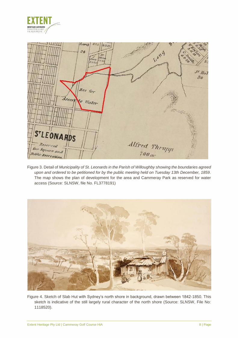
Figure 3. Detail of Municipality of St. Leonards in the Parish of Willoughby showing the boundaries agreed
upon and ordered to be petitioned for by the public meeting held on Tuesday 13th December, 1859.
The map shows the plan of development for the area and Cammeray Park as reserved for water
access (Source: SLNSW, file No. FL3778191)
Figure 4. Sketch of Slab Hut with Sydney’s north shore in background, drawn between 1842-1850. This
sketch is indicative of the still largely rural character of the north shore (Source: SLNSW, File No:
1118520).
Extent Heritage Pty Ltd | Cammeray Golf Course HIA 9 | Page
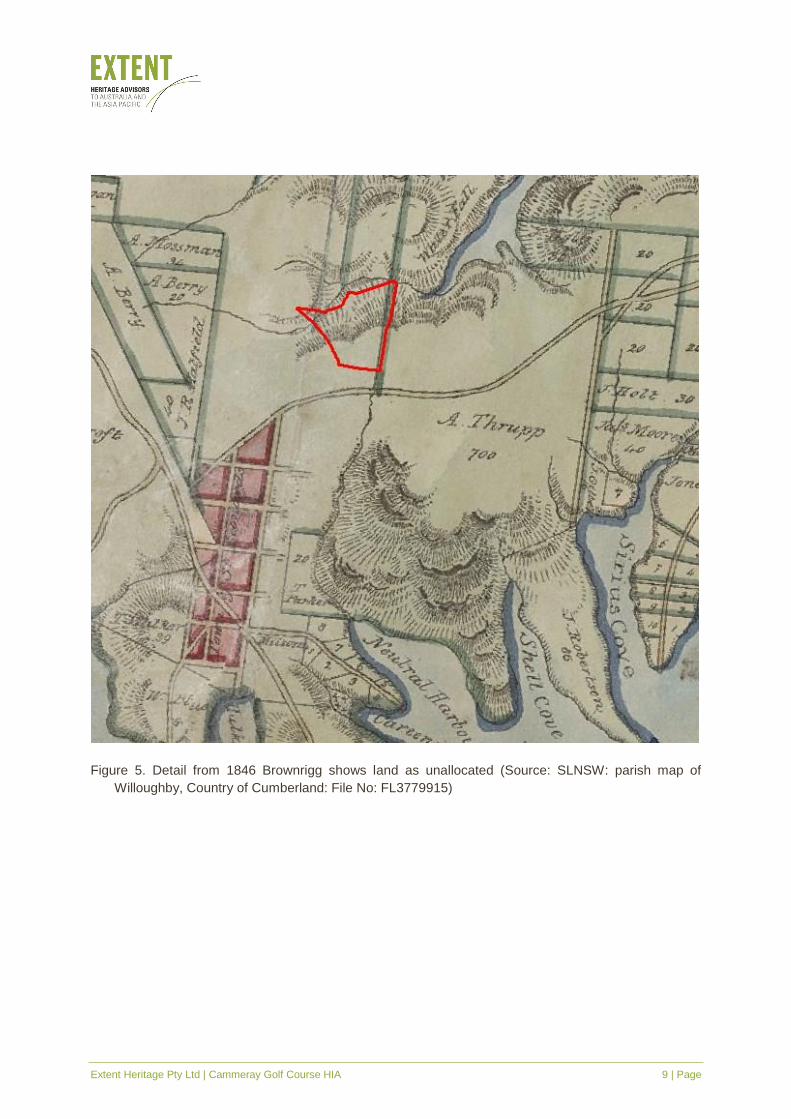
Figure 5. Detail from 1846 Brownrigg shows land as unallocated (Source: SLNSW: parish map of
Willoughby, Country of Cumberland: File No: FL3779915)
Extent Heritage Pty Ltd | Cammeray Golf Course HIA 10 | Page
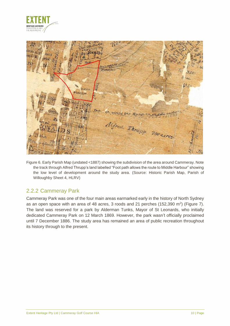
Figure 6. Early Parish Map (undated <1887) showing the subdivision of the area around Cammeray. Note
the track through Alfred Thrupp’s land labelled “Foot path allows the route to Middle Harbour” showing
the low level of development around the study area. (Source: Historic Parish Map, Parish of
Willoughby Sheet 4, HLRV)
2.2.2 Cammeray Park
Cammeray Park was one of the four main areas earmarked early in the history of North Sydney
as an open space with an area of 48 acres, 3 roods and 21 perches (152,390 m2) (Figure 7).
The land was reserved for a park by Alderman Tunks, Mayor of St Leonards, who initially
dedicated Cammeray Park on 12 March 1869. However, the park wasn’t officially proclaimed
until 7 December 1886. The study area has remained an area of public recreation throughout
its history through to the present.
Extent Heritage Pty Ltd | Cammeray Golf Course HIA 11 | Page
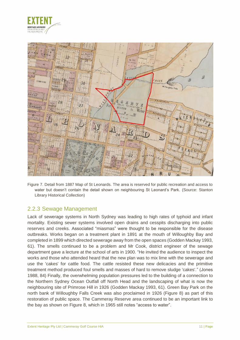
Figure 7. Detail from 1887 Map of St Leonards. The area is reserved for public recreation and access to
water but doesn’t contain the detail shown on neighbouring St Leonard’s Park. (Source: Stanton
Library Historical Collection)
2.2.3 Sewage Management
Lack of sewerage systems in North Sydney was leading to high rates of typhoid and infant
mortality. Existing sewer systems involved open drains and cesspits discharging into public
reserves and creeks. Associated “miasmas” were thought to be responsible for the disease
outbreaks. Works began on a treatment plant in 1891 at the mouth of Willoughby Bay and
completed in 1899 which directed sewerage away from the open spaces (Godden Mackay 1993,
61). The smells continued to be a problem and Mr Cook, district engineer of the sewage
department gave a lecture at the school of arts in 1900. “He invited the audience to inspect the
works and those who attended heard that the new plan was to mix lime with the sewerage and
use the 'cakes' for cattle food. The cattle resisted these new delicacies and the primitive
treatment method produced foul smells and masses of hard to remove sludge 'cakes'.” (Jones
1988, 84) Finally, the overwhelming population pressures led to the building of a connection to
the Northern Sydney Ocean Outfall off North Head and the landscaping of what is now the
neighbouring site of Primrose Hill in 1926 (Godden Mackay 1993, 61). Green Bay Park on the
north bank of Willoughby Falls Creek was also proclaimed in 1926 (Figure 8) as part of this
restoration of public space. The Cammeray Reserve area continued to be an important link to
the bay as shown on Figure 8, which in 1965 still notes “access to water”.
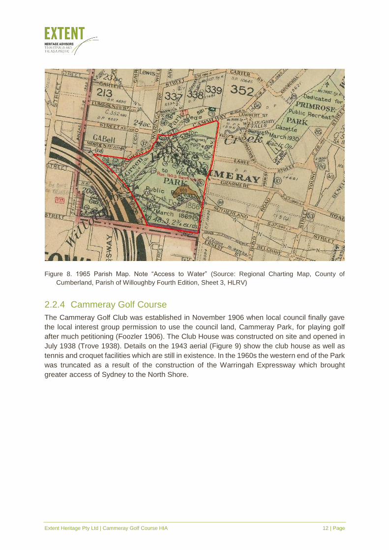
Extent Heritage Pty Ltd | Cammeray Golf Course HIA 12 | Page
Figure 8. 1965 Parish Map. Note “Access to Water” (Source: Regional Charting Map, County of
Cumberland, Parish of Willoughby Fourth Edition, Sheet 3, HLRV)
2.2.4 Cammeray Golf Course
The Cammeray Golf Club was established in November 1906 when local council finally gave
the local interest group permission to use the council land, Cammeray Park, for playing golf
after much petitioning (Foozler 1906). The Club House was constructed on site and opened in
July 1938 (Trove 1938). Details on the 1943 aerial (Figure 9) show the club house as well as
tennis and croquet facilities which are still in existence. In the 1960s the western end of the Park
was truncated as a result of the construction of the Warringah Expressway which brought
greater access of Sydney to the North Shore.
Extent Heritage Pty Ltd | Cammeray Golf Course HIA 13 | Page
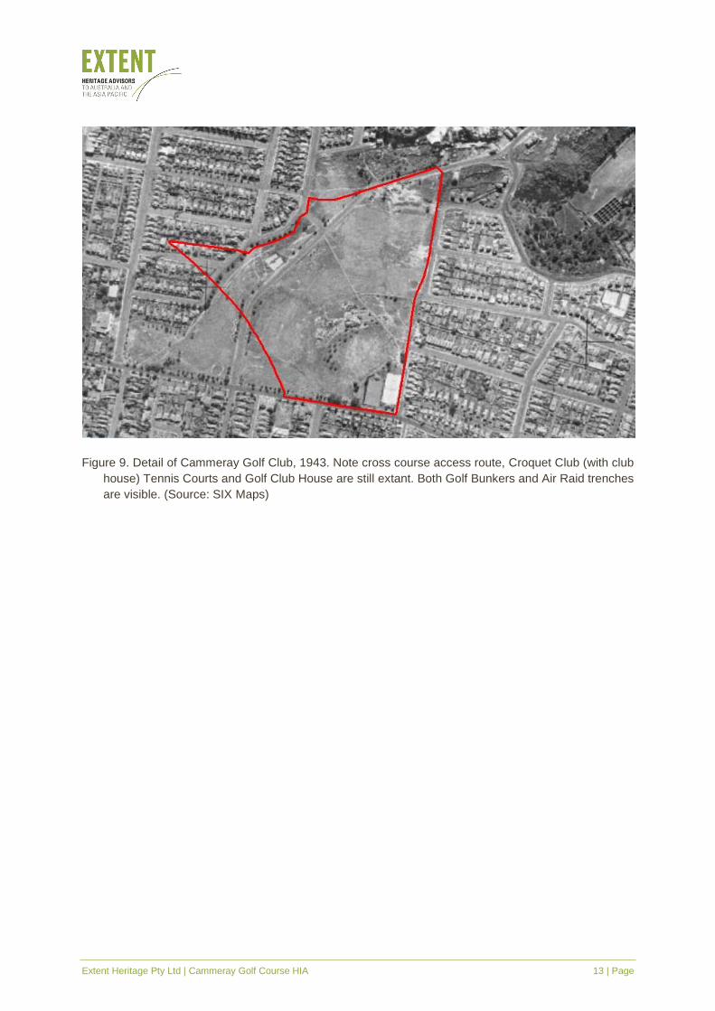
Figure 9. Detail of Cammeray Golf Club, 1943. Note cross course access route, Croquet Club (with club
house) Tennis Courts and Golf Club House are still extant. Both Golf Bunkers and Air Raid trenches
are visible. (Source: SIX Maps)
Extent Heritage Pty Ltd | Cammeray Golf Course HIA 14 | Page
3. Site Description
3.1 General
The site was inspected and photographed by the authors of this report on 8th August 2018. The
inspection was undertaken as a photographic visual study only, no physical investigation was
carried out to inform this assessment. Unless stated otherwise, photographs in this section are
all produced by Extent.
The study area is an active golf course and local park with well-manicured bentgrass fairways
and greens with numerous sand bunkers and a water trap on the western edge. The course is
lined with tree plantings and free of rough and undergrowth. The lay of the land is relatively
steeply sloped down away from the Park Avenue, Ernest Street corner in the direction of Green
Park to the north. The fairways are crossed at right angles with a north west, south east
pedestrian access concrete path with dish drain on the south western side. Storm water drains
line the path and the fairways are reticulated with pop up sprinklers below the turf. The grounds
have been continually maintained and developed by grounds keeping staff.
The study area also comprises of Cammeray Park, which includes an oval used for soccer and
rugby, tennis courts, and croquet lawns. There is also a recently constructed skate park to the
west of the tennis court. There are a number of buildings on site, largely concentrated to the
southern section of the site. This includes the 1938 clubhouse, which is located to the upper
southern section of the site. The south-eastern section is occupied by two buildings which cater
to the tennis courts and a weatherboard building associated with the croquet lawn.
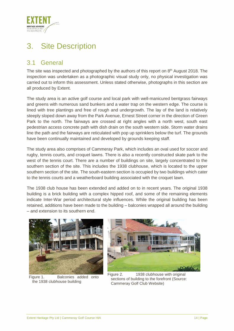
The 1938 club house has been extended and added on to in recent years. The original 1938
building is a brick building with a complex hipped roof, and some of the remaining elements
indicate Inter-War period architectural style influences. While the original building has been
retained, additions have been made to the building – balconies wrapped all around the building
– and extension to its southern end.
Figure 1. Balconies added onto
the 1938 clubhouse building
Figure 2. 1938 clubhouse with original
sections of building to the forefront (Source: Cammeray Golf Club Website)
Extent Heritage Pty Ltd | Cammeray Golf Course HIA 15 | Page
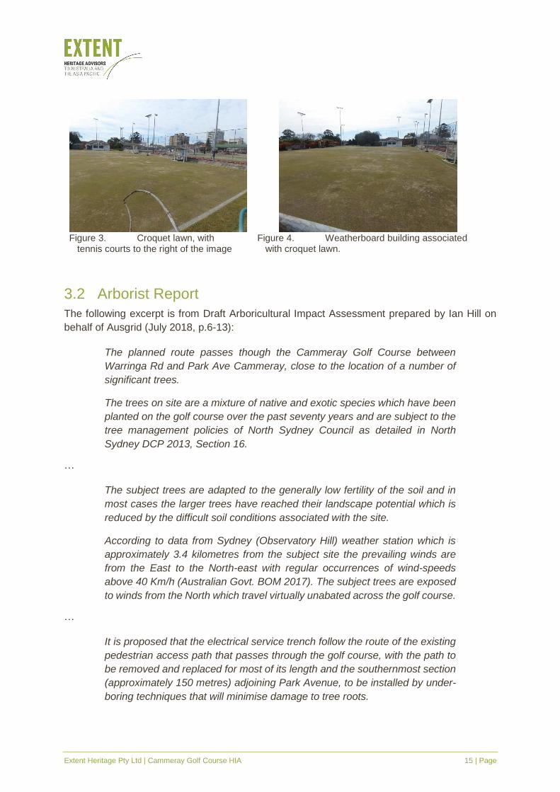
Figure 3. Croquet lawn, with
tennis courts to the right of the image
Figure 4. Weatherboard building associated
with croquet lawn.
3.2 Arborist Report
The following excerpt is from Draft Arboricultural Impact Assessment prepared by Ian Hill on
behalf of Ausgrid (July 2018, p.6-13):
The planned route passes though the Cammeray Golf Course between
Warringa Rd and Park Ave Cammeray, close to the location of a number of
significant trees.
The trees on site are a mixture of native and exotic species which have been
planted on the golf course over the past seventy years and are subject to the
tree management policies of North Sydney Council as detailed in North
Sydney DCP 2013, Section 16.
…
The subject trees are adapted to the generally low fertility of the soil and in
most cases the larger trees have reached their landscape potential which is
reduced by the difficult soil conditions associated with the site.
According to data from Sydney (Observatory Hill) weather station which is
approximately 3.4 kilometres from the subject site the prevailing winds are
from the East to the North-east with regular occurrences of wind-speeds
above 40 Km/h (Australian Govt. BOM 2017). The subject trees are exposed
to winds from the North which travel virtually unabated across the golf course.
…
It is proposed that the electrical service trench follow the route of the existing
pedestrian access path that passes through the golf course, with the path to
be removed and replaced for most of its length and the southernmost section
(approximately 150 metres) adjoining Park Avenue, to be installed by under-
boring techniques that will minimise damage to tree roots.
Extent Heritage Pty Ltd | Cammeray Golf Course HIA 16 | Page
Three (3) of the subject trees exhibit structural faults, severe decline, or are
considered generally undesirable species, and would be removed in the
course of routine tree management for the site regardless of the proposed
development. Eleven (11) trees are unlikely to be affected by the proposed
works due to their setback from the trench or being located in the proposed
under-bored section.
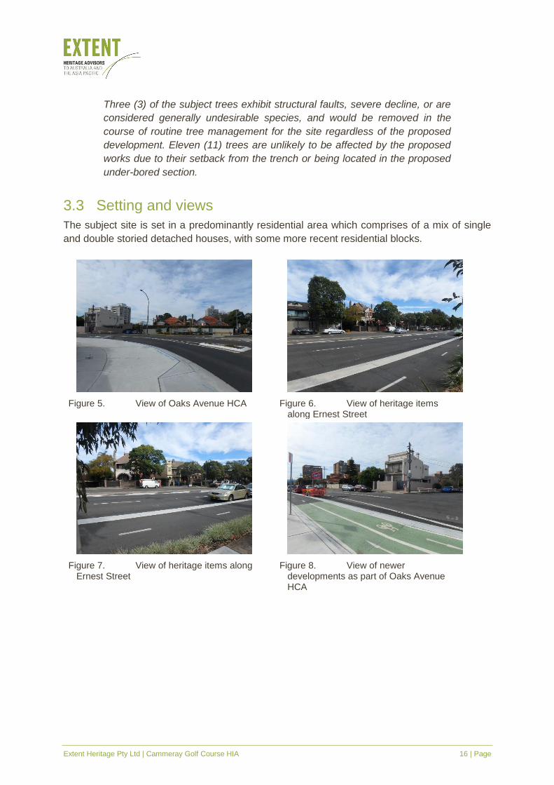
3.3 Setting and views
The subject site is set in a predominantly residential area which comprises of a mix of single
and double storied detached houses, with some more recent residential blocks.
Figure 5. View of Oaks Avenue HCA
Figure 6. View of heritage items along Ernest Street
Figure 7. View of heritage items along Ernest Street
Figure 8. View of newer developments as part of Oaks Avenue HCA
Extent Heritage Pty Ltd | Cammeray Golf Course HIA 17 | Page
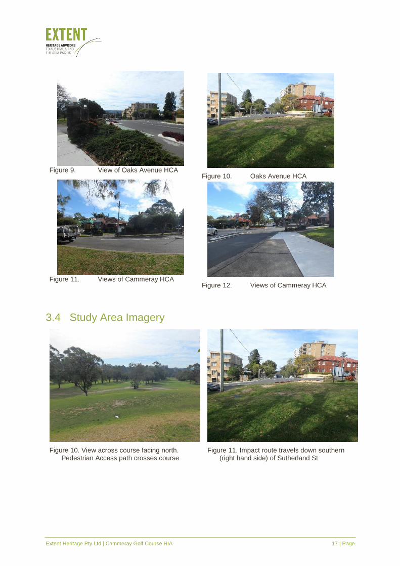
Figure 9. View of Oaks Avenue HCA
Figure 10. Oaks Avenue HCA
Figure 11. Views of Cammeray HCA
Figure 12. Views of Cammeray HCA
3.4 Study Area Imagery
Figure 10. View across course facing north. Pedestrian Access path crosses course
Figure 11. Impact route travels down southern (right hand side) of Sutherland St
Extent Heritage Pty Ltd | Cammeray Golf Course HIA 18 | Page
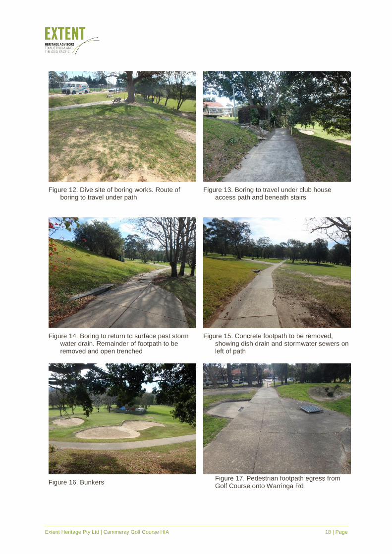
Figure 12. Dive site of boring works. Route of boring to travel under path
Figure 13. Boring to travel under club house access path and beneath stairs
Figure 14. Boring to return to surface past storm water drain. Remainder of footpath to be removed and open trenched
Figure 15. Concrete footpath to be removed, showing dish drain and stormwater sewers on left of path
Figure 16. Bunkers
Figure 17. Pedestrian footpath egress from Golf Course onto Warringa Rd
Extent Heritage Pty Ltd | Cammeray Golf Course HIA 19 | Page
4. Historical Archaeological Assessment
4.1 Introduction
This section identifies where archaeological evidence is likely to be found at the site, and to
what extent it may be preserved. Having provided an evaluation of the site’s potential to contain
historical archaeological remains it assesses the significance of any potential remains.
The potential for the archaeological resource to reveal useful information about the previous
uses or activities that shaped its history depends on its extent, nature and level of intactness.
Disturbed archaeological features and deposits in the form of fragmentary structural remains
and random artefacts may be evidence of previous occupation, but their use or value in
reconstructing the past though providing meaningful information is limited. This is because such
features and deposits are disassociated from the stratigraphic sequence that establishes their
provenance and secured date of deposition.
4.2 Site Development
The development of the site overall has been relatively minimal. Initial town plans of the North
Shore set aside the area as an access to water in the 1850s. It was unallocated until 1869 when
it was reserved for Public Recreation and finally proclaimed as Cammeray Park in December
1886. No details are available as to the use of the area, however 1887 maps, which show
detailed landscaping and recreational use of nearby St Leonard’s Park, are starkly blank over
the study area. The potential for evidence of land clearing and other use prior to 1887 is
considered to be low to nil across the whole site.
Historical studies into the use of public open space and creeks as an outlet for sewage and the
development of neighbouring Primrose Park as treatment plant in the 1890s indicates the area
would likely have been a source of noxious waste. This would have lasted until both the
encroachment of the suburbs and complaints of the neighbours called for Council to make a
connection to the Northern Suburbs Ocean Outfall off North Head. Potential evidence of this
within the study area may include waste management practices such as the use of Willoughby
Falls Creek as an open sewer, or of drains and cesspits across the area. The later development
of the site would likely have erased or impacted on any such evidence, rendering it low to nil.
The use of the site for public recreation appears to have been formalised in the 1900s, with local
interest groups granted the right to play golf in the area in 1906. Aerials show the site complete
with golf bunkers and a club house as well as Tennis Courts and a Croquet Club which remain
extant. Impact maps below (Error! Reference source not found. - Error! Reference source
not found.) show the development of sewers, water, electricity and other services through
Cammeray Park. Development of irrigation and landscaping for the golf course will have
impacted on previous development across the site, likely erasing and impacting on earlier
evidence.
Extent Heritage Pty Ltd | Cammeray Golf Course HIA 20 | Page
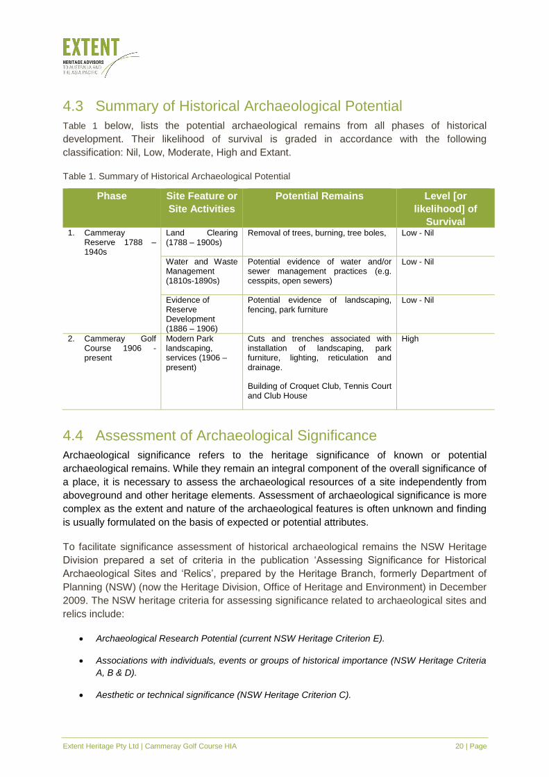
4.3 Summary of Historical Archaeological Potential
Table 1 below, lists the potential archaeological remains from all phases of historical
development. Their likelihood of survival is graded in accordance with the following
classification: Nil, Low, Moderate, High and Extant.
Table 1. Summary of Historical Archaeological Potential
Phase Site Feature or
Site Activities
Potential Remains Level [or
likelihood] of
Survival 1. Cammeray
Reserve 1788 – 1940s
Land Clearing (1788 – 1900s)
Removal of trees, burning, tree boles, Low - Nil
Water and Waste Management (1810s-1890s)
Potential evidence of water and/or sewer management practices (e.g. cesspits, open sewers)
Low - Nil
Evidence of Reserve Development (1886 – 1906)
Potential evidence of landscaping, fencing, park furniture
Low - Nil
2. Cammeray Golf Course 1906 - present
Modern Park landscaping, services (1906 –
present)
Cuts and trenches associated with installation of landscaping, park furniture, lighting, reticulation and
drainage.
Building of Croquet Club, Tennis Court and Club House
High
4.4 Assessment of Archaeological Significance
Archaeological significance refers to the heritage significance of known or potential
archaeological remains. While they remain an integral component of the overall significance of
a place, it is necessary to assess the archaeological resources of a site independently from
aboveground and other heritage elements. Assessment of archaeological significance is more
complex as the extent and nature of the archaeological features is often unknown and finding
is usually formulated on the basis of expected or potential attributes.
To facilitate significance assessment of historical archaeological remains the NSW Heritage
Division prepared a set of criteria in the publication ‘Assessing Significance for Historical
Archaeological Sites and ‘Relics’, prepared by the Heritage Branch, formerly Department of
Planning (NSW) (now the Heritage Division, Office of Heritage and Environment) in December
2009. The NSW heritage criteria for assessing significance related to archaeological sites and
relics include:
• Archaeological Research Potential (current NSW Heritage Criterion E).
• Associations with individuals, events or groups of historical importance (NSW Heritage Criteria
A, B & D).
• Aesthetic or technical significance (NSW Heritage Criterion C).
Extent Heritage Pty Ltd | Cammeray Golf Course HIA 21 | Page
• Ability to demonstrate the past through archaeological remains (NSW Heritage Criteria A, C, F &
G).
They area augmented by three questions formulated by Bickford and Sullivan that place
emphasis on the research contribution of the identified archaeological resource to the field of
Australian history and archaeology. They include:
• Can the site contribute knowledge that no other resource can?
• Can the site contribute knowledge that no other site can?
• Is this knowledge relevant to general questions about human history or other substantive
questions relating to Australian history, or does it contribute to other major research questions?
Given that the site’s potential to contain archaeological evidence of historical occupation is
assessed to be low to nil, the above criteria have not been addressed separately. Instead a
synthesised evaluation of significance is expressed in a statement below.
4.4.1 Summary Statement of Significance
The study area neighbours an 1814 land grant to Alfred Thrupp, but wasn’t itself allocated until
1869 when it was reserved as a park for access to water. The site then took nearly 20 years to
be proclaimed as Cammeray Park in 1886. There is limited historical evidence surrounding the
use of the site as a public recreation space; any evidence of early use for public recreation
including land clearing or park furnishing and landscaping would have little to no research value.
The study area, as an access to water throughout the nineteenth century, probably played an
appreciable part in early water and sewage management strategies of North Sydney. Potential
evidence of formalisation of Willoughby Falls Creek as an open sewer, or of pipes and drains,
may be evident across the site, however such evidence has limited potential to add significantly
to the information already known about water and sewage treatment in North Sydney. Sites in
the vicinity such as Primrose Park and the Sewer Vent at St Leonard’s Park are more broadly
able to speak to the history of such management and the tail end of drains and sewers as may
be in evidence under the current golf course. Therefore, such features would have limited
potential to add significantly to the body of knowledge. Consequently, such material evidence
would not satisfy the significance criteria to be considered as relics with local or State
significance.
With changing sewage management in the 1890s and a beginning of understanding of the role
that raw sewage played in disease outbreaks like typhoid and diphtheria led to public reserves
being use more formally for public recreation. By the 1900s the site was used for tennis, croquet
and its use as a golf course was formalised in 1906, all of which continue today with limited
changes. Evidence of the construction of the course would not satisfy the above significance
criteria and would not be regarded to hold heritage significance.
As a whole the study area is not considered to hold historical archaeological significance on a
local or State level.
Extent Heritage Pty Ltd | Cammeray Golf Course HIA 22 | Page
5. Assessment of Heritage Significance
5.1 Built Heritage
The NSW Heritage Manual was developed by the Heritage Office and former NSW Department
of Urban Affairs and Planning to provide the basis for an assessment of heritage significance of
an item or place. This is achieved by evaluating the place or items significance in reference to
specific criteria, which can be applied at a national, state or local level (NSW Heritage Office
1996).
5.2 Existing Statement of Significance
The following extract of the Statement of Significance is reproduced from the Office of
Environment and Heritage entry for Cammeray Golf Course:
Of social value for its general recreational facilities and open space. Of historic interest as a
relatively intact early reservation to protect water supply and associated with the nearby
Willoughby Falls. An example of early twentieth century reclamation of watercourses in urban
areas.
It should be noted that the heritage database entry does not contain any information on the
existing buildings on site, including mention or assessment of the 1938 clubhouse, as the
structure is an ordinary and highly altered example of a building.
5.2.1 Heritage Assessment of Built Fabric
In addition to the baseline assessment previously noted for the site, the following heritage
significance assessment is prepared for the site:
Criterion (a) An item is important in the course, or pattern, of NSW’s cultural or natural
history (or the cultural or natural history of the local area).
Cammeray Golf Course and Cammeray Park are able to demonstrate historical significance in
terms of the continuing use of the site for recreational facilities notably the existing tennis courts,
croquet lawns and the 1938 clubhouse.
The site is of LOCAL cultural significance under this criterion
Criterion (c) An item is important in demonstrating aesthetic characteristics and/or a high
degree of creative or technical achievement in NSW (or the local area).
The 1938 clubhouse is an ordinary and highly altered example of a building from this time
period, and is unable to demonstrate any significance under this criterion.
Criterion (g) An item is important in demonstrating the principal characteristics of a class
of NSW’s cultural or natural places; or cultural or natural environments (or a class of the
local area’s cultural or natural places; or cultural or natural environments)

Extent Heritage Pty Ltd | Cammeray Golf Course HIA 23 | Page
As a site that was and continues to be used extensively by community in and around the area,
notably the Cammeray Golf Course, the site has social representativeness at the local level.
The site is of LOCAL cultural significance under this criterion
Extent Heritage Pty Ltd | Cammeray Golf Course HIA 24 | Page
6. Assessment of Heritage Impact
6.1 Proposed Development
In 2017, Ausgrid identified the need to replace the feeders supplying the Mosman Substation
and identified a preferred solution to mitigating the identified risks.
The 132 kilo volt cables supplying Mosman Substation have experienced significant fluid leaks
over the past fifteen years. To address supply limitations, it is proposed to retire the existing
cables from Castle Cove Zone Substation to Mosman Zone Substation, by installing a new dual
132 kilo volt cables from Willoughby Sub-transmission Substation to Mosman Zone Substation.
The feeder between Willoughby Substation and Mosman Zone Substation would also be retired.
It is understood that the cable route impacts the pedestrian access route through Cammeray
Golf Course. It will be installed under Morden Street – which falls within the Cammeray Heritage
Conservation Area (HCA) and will therefore impact the HCA as well.
The cable route travels along the southern side of Sutherland Street and to a 2m x 2m dive site
north of entrance gates to the golf course. The cable will be under bored to the base of the park
stairs, located opposite Sutherland Street, at a depth of 4m, below tree roots access stairs and
stormwater pipes some 80m distance to the base of the stairs. From there, a trench for cabling
will be open cut, with a 1.2m wide by 1.2m deep trench being opened underneath the existing
concrete path. A 13-tonne mechanical excavator with tooth bucket will be used for mechanical
trenching. After the cable is laid the existing path, irrigation, drainage and turf will be reinstated.
6.2 Potential Development Impacts
6.2.1 Built Heritage
As there are no buildings or structures on the subject site which are heritage listed, the proposed
cable which will be routed through the Cammeray Golf Course will have no impact on the site.
6.2.2 Curtilage and Subdivision
There will be no impact on the curtilage of the subject area, as the cables will be routed
underground.
6.2.3 Views and Settings
As the cabling will be underground views to and from the Cammeray Golf Course will remain
unaffected.
6.2.4 Heritage Items in the Vicinity
The proposed cable from from Willoughby Sub-transmission Substation to Mosman Zone
Substation, will be routed through the Cammeray Golf Course, and as the works will installed
underground impacts on the heritage items along Ernest Street and to the Oaks Avenue HCA
Extent Heritage Pty Ltd | Cammeray Golf Course HIA 25 | Page
will be negligible. However, the cable is also to be installed under Morden Street which forms
the southern edge of the Cammeray HCA, but as the works are underground impacts to the
HCA are considered to be minimal.
6.2.5 Historical Archaeology
The earthworks, both under boring and excavation conducted by mechanical excavator, are
unlikely to have any impacts on any potential archaeology due to the combined factors of depth;
localised and narrow area of impact and low-nil. As the historical archaeological potential has
been assessed as low to nil from all phases of site development, it is considered that the
proposed impacts would be negligible.
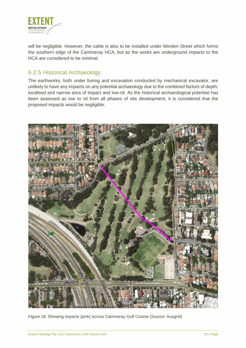
Figure 18. Showing impacts (pink) across Cammeray Golf Course (Source: Ausgrid)
Extent Heritage Pty Ltd | Cammeray Golf Course HIA 26 | Page
7. Conclusions and Recommendations
7.1 Conclusion
The study area of Cammeray Park and Golf Course is listed on the North Sydney LEP 2013 as
item I0024, for its landscape values.
Historical sources suggest that the development of the site has been minimal. It was assigned
in 1859 as an open space for access to water and proclaimed as a public recreation space in
1886. The study areas use was formalised for public recreation in its current format in 1906
when the local council allowed it to be used for playing golf. The site was subject to development
of the Warringah Expressway but otherwise has remained a site of public recreation throughout
its existence.
The proposed works fall within the definitions of works permitted without consent under Clause
41 of the State Environmental Planning Policy (Infrastructure). For the purposes of Clauses 14
and 41(2)(a)(iii), the impacts of the works are “minor or inconsequential”.
Built Heritage
The site is considered to have local cultural significance for its ability to demonstrate both
historical significance in terms of the continuing use of the site for recreational facilities and
social representativeness as a site that was and continues to be used extensively by community
in and around the area.
Historical Archaeology
The potential for the site to contain historical archaeological remains has been assessed as low
to nil for all phases of historical development. The historical archaeological potential would be
of no or very little research potential and of no ability to provide any significant information about
the site. Therefore, the assessed archaeological potential is not considered to be significant at
local or state level. The proposed development is unlikely to have any historical archaeological
impact.
7.2 Recommendations
The following recommendations are intended to ensure that more substantial heritage impact
does not inadvertently result from the works:
▪ It is recommended that the heritage database listing of Cammeray Golf Course be updated
to include assessment of the 1938 clubhouse, tennis courts and croquet lawns.
▪ As the proposed cable will be installed under Morden Street, it is suggested that the impact
of the works be assessed on the significance of the Cammeray HCA, which falls outside the
scope of this SoHI prepared for the Cammeray Golf Course only.
Extent Heritage Pty Ltd | Cammeray Golf Course HIA 27 | Page
▪ On the balance of the evidence presented in this report, no archaeological mitigation is
considered to be warranted for the proposed works.
▪ If, in unlikely event, archaeological deposits are encountered, they would be managed in
accordance with the Unexpected Find Procedure, (attached as Appendix A), which details
the actions to be taken when a previously unidentified relics are found during excavation
activities.
▪ Any unexpected archaeological relics that are present in the study area remain protected
by the Heritage Act. If the exposed remains are assessed to be archaeological relics, the
works in the affected area should stop and the Heritage Division should be notified under
Section 146 of the Heritage Act. It is possible that further works would require a further
assessment and/or an application for an Approval under Section 60 of the Heritage Act to
allow works to proceed, should the remains be assessed to be of local or state significance.
▪ In the event that evidence of the Aboriginal occupation of the site is identified during any
phase of onsite works, all works in the affected area should stop, the area adequately
protected and OEH informed about the discovery under section 89(A) of the National Parks
and Wildlife Act 1974.
Extent Heritage Pty Ltd | Cammeray Golf Course HIA 28 | Page
8. References
Brodsky, I. 1963. North Sydney: 1788-1962, Prepared by Municipality of North Sydney.
Foozler, 1906, Golf, The Sydney Mail and NSW Advertiser, 21 November, p.1350. Available
from Trove
Godden Mackay Pty Ltd. 1993. North Sydney Heritage Study Review Part 1, Volume 1, Main
Report, Prepare for North Sydney Council.
Jones, M. 1988. North Sydney: 1788-1988, Sydney: Allen & Unwin.
No Author, 1938, Clubhouse at Cammeray, The Labor Daily: Sydney 2 July, p.12. Available
from Trove
NSW Heritage Office & Department of Urban Affairs and Planning (DUAP) 1996, NSW Heritage
Manual, NSW Heritage Office and DUAP, Sydney.
Appendix A – Unexpected Finds Procedure
Aboriginal and Historic Heritage
Purpose
This procedure details the actions to be taken when a previously unidentified and/or potential
Aboriginal and/or historical heritage item/object/site is found during construction activities.
Scope
This procedure is applicable to all activities conducted by project personnel that have the
potential to uncover an Aboriginal and/or historical heritage artefact/item/object/site.
Procedure – Aboriginal and Historic Heritage
In the event that a potential heritage artefact/item/object/site is encountered during construction
the following steps shall be taken.
▪ STOP ALL WORK in the vicinity of the find and immediately notify the relevant Site
Supervisor. The Supervisor will then notify the Project Manager and demark the area to
protect the artefact/item/object/site.
▪ The Project Manager is to record the details, take photos of the find and ensure that the
area is adequately protected from additional disturbance.
▪ The Project Manager contacts a suitably qualified Archaeologist (Project Archaeologist) to
notify them of the location of the find.
▪ If the Project Archaeologist advises that the find is not a potential Aboriginal object or
significant historical relic, work will recommence in consultation with the Project Manager.
▪ If the Project Archaeologist advises that the find is a potential Aboriginal object or significant
historical relic, the Project Manager should undertake the following procedure:
Liaise with the Project Archaeologist to determine the significance of the relics. Note
this may require liaison with Relevant Aboriginal Parties; and
Implement the appropriate heritage mitigations dependent on the significance of the
site as outlined in the relevant heritage report.


![[XLS]s3.amazonaws.com · Web viewLast Hill Golf & R.v. Park Lewis Estates Golf Course Mayfair Golf & Country Club Mccall Lake Golf Course-championship Course Mckenzie Meadows Golf](https://img.pdfslide.net/doc/110x75/5b3867137f8b9a5a518d6124/xlss3-web-viewlast-hill-golf-rv-park-lewis-estates-golf-course-mayfair.jpg)