Embed Size (px)
Citation preview

CANADIAN OCEAN SCIENCE NEWSLETTER LE BULLETIN CANADIEN DES SCIENCES DE L'OCÉAN
Table of Contents, Newsletter Number 17, August 25, 2005 Table des matières, Bulletin numéro 17, 25 août 2005
JOBS:
• No submissions
OCEAN SCIENCE PROGRAMS •••• ROPOS reborn •••• ASL performs current and wave surveys for new tidal power project •••• Rapid Changes of Temperature and Salinity near the Bottom of the Labrador Sea •••• OEA Completes Radarsat METOC Project for National Defence
PERSONNEL:
•••• Savi Narayanan Appointed Dominion Hydrographer •••• Canadian Oceanographic Historical Photos •••• Retirement of Allyn Clarke
MEETINGS:
•••• CNC/SCOR Tour Speaker •••• 39th CMOS: Sea to Sky - Entre Ciel et Mer •••• Conference on Marine and Remote Sensing for Marine and Coastal Environments •••• JCOMM Assembly in Halifax, NS, Canada
GENERAL:
•••• Letter to the President of NSERC •••• Response from the President of NSERC •••• International News •••• SCOR Electronic Newsletter #3 •••• Canadian Ocean Science Theses
2
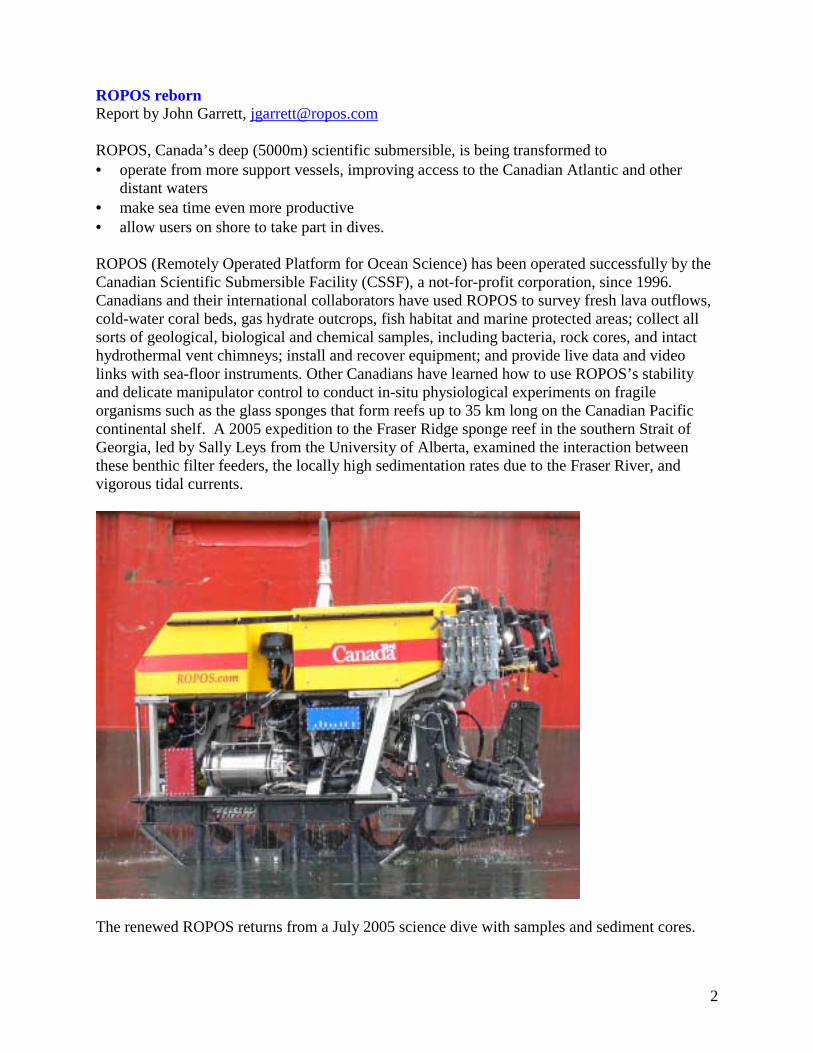
ROPOS reborn Report by John Garrett, [email protected] ROPOS, Canada’s deep (5000m) scientific submersible, is being transformed to • operate from more support vessels, improving access to the Canadian Atlantic and other
distant waters • make sea time even more productive • allow users on shore to take part in dives. ROPOS (Remotely Operated Platform for Ocean Science) has been operated successfully by the Canadian Scientific Submersible Facility (CSSF), a not-for-profit corporation, since 1996. Canadians and their international collaborators have used ROPOS to survey fresh lava outflows, cold-water coral beds, gas hydrate outcrops, fish habitat and marine protected areas; collect all sorts of geological, biological and chemical samples, including bacteria, rock cores, and intact hydrothermal vent chimneys; install and recover equipment; and provide live data and video links with sea-floor instruments. Other Canadians have learned how to use ROPOS’s stability and delicate manipulator control to conduct in-situ physiological experiments on fragile organisms such as the glass sponges that form reefs up to 35 km long on the Canadian Pacific continental shelf. A 2005 expedition to the Fraser Ridge sponge reef in the southern Strait of Georgia, led by Sally Leys from the University of Alberta, examined the interaction between these benthic filter feeders, the locally high sedimentation rates due to the Fraser River, and vigorous tidal currents.
The renewed ROPOS returns from a July 2005 science dive with samples and sediment cores.

3
Funding for these upgrades was provided by the CSSF and by grants by the Canada Foundation for Innovation and the British Columbia Knowledge Development Fund to Ross Chapman and Verena Tunnicliffe, both at the University of Victoria. ROPOS has operated from more than a dozen support ships from four countries and mobilized in ports as distant as Capetown and Guam, but up until now deeper waters off Atlantic Canada have been inaccessible due to lack of suitable support vessels. ROPOS can now operate in depths down to 2500m from smaller vessels without large A-frames. The new system performed flawlessly on sea trials in June 2005, with the new umbilical cable, all-fibre telemetry system and high-voltage electrical motors exceeding all expectations. A new winch for the new mid-depth cable will be lighter and easier to install on the support vessel and will cost less to ship. A new self-contained portable launch and recovery crane will even allow ROPOS to be launched from ships without any A-frame or crane and to work in worse weather conditions offshore. The shallow live-boating system can be used on even smaller ships, and will now reach 1000 metres depths. The 5000m caged deep-water configuration is still available. Another goal of the transformation is to make time at sea with ROPOS even more productive. In 2004 ROPOS was equipped with a new Kraft Raptor manipulator arm. Its greater dexterity allows manipulations to be completed more quickly. Finding and returning to research sites is easier and quicker due to continuous navigation on the bottom with a new Doppler velocity log and fibre optic gyro. An Ultra Short Base-Line tracking system added in 2005 provides geo-referenced navigation in depths to 2500m, saving the time needed to deploy a transponder network and survey it in. ROPOS’s in-water payload has been more than doubled, allowing at least 250kg of instruments. Large and awkward items are easier to carry: they no longer have to fit into the cage. The new cable, winch and frame can lift up to 2000kg attached to the vehicle There is less need to change instruments on deck because the enormous increase in communications bandwidth allows ROPOS to carry and control more instruments. Interfacing instruments is easier since the submersible now supports 100 BaseT Ethernet. It is also easier to aim and focus the digital still camera precisely using full frame digital images available in real time. Increased communication bandwidth allows better video. More people want to take part in ROPOS dives than can be accommodated on even large support vessels. In 2006 CSSF plans to bring live ROPOS video and two-way audio to users ashore. A gyro-stabilized shipboard Ku-band antenna will send full-screen full-motion video to a commercial satellite for direct rebroadcast to receivers at locations across North American. Users in laboratories will be able to see what the submersible sees and hear what is taking place in the control room, in real time, while it is happening. This and a continuous satellite audio link will allow real-time conversations between the shipboard team and shore users will also be able to talk directly with the shipboard team through a continuous satellite audio link, giving immediate feedback for sampling and instrument placement. Canadian university scientists have access to funding for ROPOS through the NSERC Ship Time grant program, with an October 1 application deadline. The costs of shipping and mobilizing ROPOS onto the support vessel may be fully or partly covered through an NSERC Major Facilities Access grant to the University of Toronto. ROPOS has frequently served as the focus of very productive collaborations between Canadian academics and their government and foreign

4
counterparts (e.g. www.oceanexplorer.noaa.gov/explorations/04fire/welcome.html ). ROPOS is still available for some periods in 2006. More information is available at www.ropos.com . ASL performs current and wave surveys for new tidal power project Report by Chris Elmer, [email protected] Thanks to an innovative partnership between Lester B. Pearson College of the Pacific, EnCana Corporation, Sustainable Development Technology Canada and Clean Current Power Systems Incorporated, Canada’s first free-stream tidal power project will be built at the Race Rocks Ecological Reserve, offshore Vancouver Island in British Columbia. The tidal power project will enable the world famous marine park to tap into surrounding ocean currents and convert tidal energy to electric power for its needs beginning in early 2006. It will be the first sustained field-testing of new electricity- generating technology in the harsh marine environment. Officially known as the “Pearson College - EnCana - Clean Current Tidal Power Demonstration Project at Race Rocks”, the project is enabled by a $3-million investment from the EnCana Environmental Innovation Fund. This investment will cover 75 percent of the expected $4-million total cost of the demonstration project. The federal government’s Sustainable Development Technology Fund will provide most of the remaining funding. In order to determine the optimum site for the turbine in terms of depth and tidal current, ASL Environmental Sciences of Sidney, BC Canada was contracted by Triton Consultants of Vancouver to collect ADCP (Acoustic Doppler Current Profiler) transect data to verify Triton’s numerical model and to narrow down the potential installation sites. ASL then collected current and wave data over the course of a lunar month at one, and 15 days later, at another of the selected sites. Rapid Changes of Temperature and Salinity near the Bottom of the Labrador Sea Report by: Igor Yashayaev ([email protected]) and Allyn Clarke ([email protected])
On June 7th the CCGS Hudson returned from the 2005 annual hydrographic survey of the Labrador Sea (the AR7W line in the Figure 1). In addition to providing an annual oceanographic assessment of one the North Atlantic’s most active basins, the Labrador Sea monitoring program is a major contributor to international climate projects aimed at observing and understanding the linkages between the Arctic/Subarctic Seas and the global ocean circulation and climate change.
This report describes the time scales and magnitude of the temperature and salinity variability in the bottom waters of the Labrador Sea.

5
Figure 1. Oceanographic stations occupied during the 2005 Labrador
Sea mission. AR7W denotes the hydrographic section annually surveyed by the Ocean Sciences and Ecosystem Research Divisions.
Labrador Sea hydrographic data have been previously used to establish a relation between the properties of the cold and dense Arctic waters entering the North Atlantic across the Greenland-Scotland ridge and the properties of the deep and bottom waters of the Labrador Sea. The signals seen in the deep and abyss layers in the Labrador Sea were traced back to the sources of the Arctic overflows. With the ongoing debate about a possible slow-down and even a shut-down of the Meridional Overturning Circulation (MOC) of the Atlantic Ocean altering global climate, the Labrador Sea hydrographic data are providing an early indicator of the operational state of the whole MOC which should help to avoid any ambiguity about the fate of the MOC in the future. The key question answered on the completion of the 2005 Labrador Sea mission is: Were the bottom waters of the Labrador Sea renewed in 2004-2005 or, in other words, is the “pipeline” between upper Arctic and deep Subarctic waters still operational?

6
Figure 2. Salinity (upper) and temperature (lower) of the bottom waters along the AR7W line, from 1987 to 2005. The vertical axis is the distance from the central point of the section line, with the positive direction toward the Greenland coast and the negative direction toward the Labrador coast.
Figure 2 presents the changes of salinity and temperature averaged in a 100-m layer above the bottom at each AR7W station since 1987. Distinct events or episodes of cooling (freshening) and warming (salinity increase) of the entire bottom layer of the Labrador Sea are apparent. These events are well correlated with the changes in the properties of the Denmark Strait Overflow Water (DSOW) at the Sills of the Denmark Strait (about 600 m deep). After this overflow passes the Denmark Strait it descends down the continental slope to the south-east and south-west of Greenland to the abyss layers of the Irminger and Labrador Seas bringing there water which is relatively cold, fresh and rich in dissolved gases (oxygen, CFCs, etc.).

7
The most striking hydrographic change on the section over the past year was the cooling and freshening of the bottom waters, which contrast the preceding four-year increase in DSOW temperature and salinity (2000 to 2004). Why is this cooling and freshening so important for understanding ocean dynamics and detecting climate change? The interpretation of an increase in temperature and salinity of the deep waters can be ambiguous, implying either a change in their source waters or a weakening in the production and spreading of the cold and dense waters that arrive from the Arctic, or both. A cooling and freshening signal in the waters which are already cold and fresh can be only caused by a change at the sources and imported to the deep and bottom layers by an operational overturning circulation. Therefore, the 0.2º cooling and 0.02 freshening of DSOW in the Labrador Sea in at most one year seen in the 2005 occupation was caused by the variability in the overflow properties upstream (possibly somewhere near or to the north of the Denmark Strait) and indicates that the bottom layers of the subpolar North Atlantic are still being fed by the Arctic “pipeline”. The data collected on the Labrador Sea missions will be integrated and co-analyzed with the observations collected by researchers from the UK, Germany, USA, Denmark and other countries in order to provide an assessment of the ocean circulation and variability on basin-to-global ocean scales. OEA Completes Radarsat METOC Project for National Defence Contact: Dr. Brian Whitehouse; [email protected] On behalf of Defence R&D Canada – Ottawa, OEA Technologies Incorporated has completed an investigation of certain meteorology and oceanography (METOC) capabilities of Canada’s Radarsat satellite. The study was completed in June and supports the Canadian Forces’ recently established Polar Epsilon project, which will use Radarsat to expand Canada’s space-based ship and oil spill detection capabilities in the Arctic, Atlantic and Pacific Oceans. Radarsat’s ability to detect ships and oil is influenced by surface winds, waves and currents. As existing sources of wind, wave and current data are too coarse in spatial resolution or too removed in time, OEA investigated the feasibility of deriving such information from the satellite imagery itself to conduct a rapid environmental assessment (REA) of (i) minimum detectable ship size and (ii) probability of oil spill false detection. The investigation was a follow-on of a previous study conducted by OEA on behalf of Defence R&D Canada – Atlantic. As a component of the project, OEA also investigated means to overcome limitations in Canadian Forces’ deployed ocean observing infrastructure by using civilian ocean observing systems for military purposes. Such systems are required to develop and demonstrate space-based REA products. In addition, as a means of decreasing limitations inherent in space-based synthetic aperture radar (e.g. the sensor on Radarsat) and ocean colour sensors used by Polar Epsilon (e.g. the Modis sensors on NASA’s Terra and Aqua satellites), the study raised the long-standing but poorly understood issue of employing both types of sensors operationally to monitor certain meteorological and oceanographic features of military interest. A final report authored by staff from OEA Technologies, DRDC Ottawa, the Canadian Forces and the GOMOOS program within the University of Maine will be published by DRDC as

8
DRDC Ottawa Technical Memorandum No. 2005-119. For addition information on OEA Technologies Inc. and related projects access www.oeatech.com Savi Narayanan Appointed Dominion Hydrographer Dr. Savithri (Savi) Narayanan was appointed Dominion Hydrographer and Director General of the Canadian Hydrographic Service (CHS) effective August 2, 2005. Savi holds a doctorate degree in applied mathematics (1973) from Harvard University. After her graduation, until 1988, she worked as the section head of oceanography in a consulting firm in Victoria BC, as a visiting scientist at Memorial University of Newfoundland, and subsequently as an assistant professor at the same university. She joined the Fisheries and Oceans Canada in 1988 as an Oceanographer and later as the section head of oceanography in St. John’s, Newfoundland. In 1996, she became the director of the Marine Environmental Data Service (MEDS) in Ottawa. From October 2004 to the present, Dr. Narayanan has been acting as the Dominion Hydrographer and the Director General of the CHS. Savi also brings considerable international experience to CHS, having played a leadership role in the activities of International Council for the Exploration of the Seas (ICES), North Atlantic Fisheries Organization (NAFO), Intergovernmental Oceanographic Commission (IOC) and World Meteorological Organization (WMO), and since 2001, as the co-president of the WMO/IOC Joint Technical Commission for Oceanography and Marine Meteorology. Canadian Oceanographic Historical Photos Report by: Dick Stoddart, Secretary for CNC/SCOR, [email protected] The Canadian National Committee for SCOR www.cncscor.ca is working with the Canadian Meteorological and Oceanographic Society (CMOS) to establish an archive of Canadian oceanographic photographs. The intent is to create an on-line library of historical photos that would parallel those of the Canadian meteorological community. Hopefully submissions will be scanned photos sent by email, but some providers may not have such capabilities. In this case we would have to make arrangements for submission to a third party for scanning and guarantee of return of the originals. An initial site has been established to post photos; see http://www.cmos.ca/Oceanphotos/photoindex.html Photos should be reasonably clear so as to be able to identify individuals in the photo, and have a caption that would explain the event (a cruise, conference, university faculty, etc.), a date (year) of the event, and an organized list of (many) of those in the photo. The names associated with the photo should be in a standard format if at all possible, along the lines of "Richard (Dick) BL Stoddart". Obviously we are looking for Canadian content, but international events held in Canada would also be useful if there were several notable Canadian oceanographers in attendance. Realizing the significance of "ships" to oceanographic effort we would also like to get photos of all the Canadian oceanographic vessels as well as photos of people. General guidelines for input photos are that they should be between 500K and 1MB. The original photo size (e.g. 8x10 or 4x6) is not important; whatever the size of the original is fine. However,

9
a good clear input photo is needed to produce a nice online version. JPEG is the preferred format. If you are able to help out, it would be appreciated if you could send a few (up to 5) scanned photos to me ([email protected]) at your convenience. Additional photos would also be very much welcomed, but you should await confirmation that the first batch has been successfully received – just in case there are multiple emails from others that collectively, with their attachments, end up being too many to handle. You may wish to use the CMOS ftp service if large numbers of photos need to be transferred. Anyone who wishes to use this service should contact the CMOS webmaster, Bob Jones, at [email protected] Retirement of Allyn Clarke Distinguished Canadian oceanographer Allyn Clarke will be retiring from the Canadian Department of Fisheries and Oceans (Bedford Institute of Oceanography) on September 2, 2005 after 35 years of service. Among his many contributions to Canadian and international oceanography, Clarke was a recent President of CMOS (2003-2004) and a co-opted member of the SCOR executive (1993-1996). The citation for the award of the 2001 CMOS J.P. Tully Medal in Oceanography to Allyn Clarke noted his “outstanding commitment to Canadian oceanography, his pioneering work on deep convection in the Labrador Sea, and his national and international leadership in ocean and climate scientific research.” A reception at BIO to honour his retirement will be held on Thursday, September 1. If anyone would like to send a card or e-mail to be read or passed to him at the reception it should be sent to Ross Hendry at [email protected] CNC/SCOR Tour Speaker Report Report by Susan Allen, [email protected] For the Western segment of the inaugural CNC-SCOR seminar tour, we were fortunate to have Dr. Marlon Lewis visit British Columbia and Alberta. He gave two different talks (abstracts below) at a total of four venues (University of British Columbia (UBC), University of Victoria (UVic), Institute of Ocean Sciences (IOS) and University of Alberta (UofA)). I know personally that the talk at UBC was well attended (about 30) and many felt they left looking at light in a different way. At UofA, the talk was attended by 29 people from the Biology and Math departments as well as from the Earth and Atmospheric Sciences. Graduate students also found Marlon's visit very useful and he had an number of individual discussions with various such students (as well as meetings with individual faculty members). SCOR funded the required flights and the local hosts covered local travel, food and accommodation costs. Islands in the Stream (given at UVic and UofA) There continues to be active controversy regarding the rate of export of carbon from the surface ocean. The magnitude of this rate depends on the rate of supply of nutrients to the surface in some sort of average sense. The vertical supply of nutrient in the open gyre regions appears to be insufficient to meet the requirements of the large scale geochemical distributions of oxygen and some of the newer respiration measurements. The reason likely relates to a similar discomfort in
10
maintaining the thermocline balance with measured rates of turbulent energy dissipation and associated heat transport. A common source of mixing associated with topographic interactions may explain both discrepancies between large scale balances and small scale mixing observations. A dramatic large scale phytoplankton bloom during the El Nino/La Nina transition associated with islands in the equatorial Pacific will be used to illustrate this idea. Why isn’t the ocean black? (given at UBC and IOS) Variations in the intensity and color of the ocean as seen from above depend on scattering of light in the backward direction in the ocean interior. Observed scattering in the forward direction, and observed absorption are well understood in the open ocean; however, despite over thirty years of progressively more sophisticated observations, we have been singularly unsuccessful in identifying more than 10% of the particles that must be present to account for the observed radiances leaving the ocean surface. Based on theoretical scattering investigations, and both laboratory and field measurements of the volume scattering function, we now have good evidence that microbubbles in the surface ocean may be the responsible agent. Little direct evidence of their presence exists; indeed, such small bubbles theoretically would not persist in pure water. However, in the ocean, these small bubbles appear to be stabilized by organic coatings (produced by biological activity) which also serve to enhance backscattering efficiencies by a factor of 4-5. The primary difficulty is in the direct measurement at sea of the number and size distribution of these bubbles (or any particle for that matter) in the size range from 0.05 to 0.5 µm. 39th CMOS: Sea to Sky - Entre Ciel et Mer Report by: William Perrie, [email protected] The 39th Annual Congress of CMOS (Canadian Meteorological and Oceanographic Society) was held on 31 May – 3 June 2005 in Vancouver. Delegates from across Canada attended, as well as invited speakers from Canada, USA and overseas. This Congress was one of the largest and most successful ever. Over 425 papers were presented in as many as seven concurrent sessions lasting four full days. There were about 600 registrants. Exhibition booths were set up by thirty-one companies and institutions which support CMOS, also a very good representation. The President’s Prize went to Dr. Frédéric Fabry for his very innovative and important contribution to radar meteorology in deriving humidity fields from meteorological radars ground clutter echoes, as highlighted by his paper, co-authored with Frush, Zawadzki and Kilambi, "On the extraction of near-surface index of refraction using radar phase measurements from ground targets", published in 1997 the Journal of Atmospheric and Oceanic Technology 14, 978-987. The J.P. Tully Medal in Oceanography went to Bedford Institute’s Dr. Brian Petrie for an outstanding career in oceanography, the breadth and impacts of numerous collaborations, and his sustained leadership to the description, understanding and implications of physical oceanographic variability in the Atlantic Canadian coastal ocean. The Dr. Andrew Thomson Prize in Applied Meteorology went to Peter Bowyer for his innovative work in operational extreme-wave analysis and prediction, along with his accomplishments in education and outreach in the area of the extratropical transition of hurricanes. As a program manager of the Canadian Hurricane Centre, Peter has made important contributions to the forecasting of hurricanes and their impacts in Canada, and in the application of his scientific knowledge to support decision making of those involved in mitigating risks related to hurricanes and educating

11
users. Special sessions were convened to honour Prof. Lawrence Mysak of McGill University and Dr. Norm McFarlane of Canada Climate Centre/University of Victoria, both of whom many of us have worked over the years. Conference on Marine and Remote Sensing for Marine and Coastal Environments Report by Gary Bugden, [email protected] Gary Bugden (Coastal Ocean Sciences) recently attended the 8th International Conference on Remote Sensing for Marine and Coastal Environments held in Halifax at the Casino Nova Scotia Hotel. The conference was intended to bring together scientists, technologists and end-to-end users from government, industry, and academia to address “bridging the gap between research and marine and coastal operations”. The conference included technical sessions on Hyperspectral Sensing for Coastal Applications, Combining Remote sensing with Marine and Coastal Models, The Challenge of Accurately Determining Marine Suspended Sediment Concentrations with Satellite Remote Sensing and The Application of Remote Sensing to Coastal Management. The wide swath width, higher resolution and spectral flexibility of the newer ocean colour satellites now coming on line makes the imagery potentially more useful for coastal management than ever before. Image widths of several hundred kilometres lead to more frequent coverage and the smaller pixel sizes move applications closer to the shoreline than previously possible. Close to shore, even in optically deep waters where the bottom is not visible, colour producing agents such as land-derived dissolved organic matter and suspended inorganic matter confound remote sensing concepts developed for offshore waters where phytoplankton and their related metabolic excretions dominate ocean colour. These developments place increasing pressure on the requirement for parameter algorithms for these optically complex nearshore waters. The development of these algorithms and interpretation of the resulting parameter distributions will require a multi-disciplinary approach, combining such fields as marine photochemistry, phytoplankton biology, suspended particle dynamics and hydrodynamic modelling. Apparent at the conference was a growing appreciation by the remote sensing community of the complexity of suspended particulate matter dynamics and, for example, the potential differences between disaggregated and in-situ grain size distributions. Shown below is a chlorophyll distribution derived from airborne hyperspectral imagery. Although much higher in resolution than anything which can be obtained from a satellite, the image gives some suggestion of remote sensing applications in coastal regions. The image shows the advection of patches of phytoplankton, the food of cultured mussels, through individual mussel leases which are outlined in red. The arrows are the currents predicted by a numerical model at the time the image was acquired. The black contours show the depth in metres which is seen to be quite constant in the area of interest. Also visible is the apparent depletion of the phytoplankton patch as it progresses through some farms. Tools such as this will answer questions such as why does production vary from one lease to another and how might the leases be arranged to maximize yield and minimize environmental impact.

12
Distribution of chlorophyll among mussel farms from airborne spectral imagery. Individual leases are outlined in red. The individual mussel strings are visible within each lease. Contours are the depth in metres. The arrows show currents at the time the image was acquired. Image courtesy of Edward Horne (Ecosystem Research Division).
JCOMM Assembly in Halifax, NS, Canada The Joint WMO-IOC Technical Commission for Oceanography and Marine Meteorology (JCOMM) will be hosting a scientific conference and JCOMM Assembly in Halifax, NS, Canada on 15 - 27 September, 2005. These two meetings will bring together the world's scientists, engineers and managers who are operating and developing operational ocean observations, data and services in the areas of oceanography, marine meteorology and sea ice. Further information can be found at http://ioc.unesco.org/jcomm/index.php

13
Letter to the President of NSERC Montreal, June 10, 2005 Dr. Thomas Brzustowski President Natural Sciences and Engineering Research Council of Canada 350 Albert Street Ottawa, ON K1A 1H5 Dear Dr. Brzustowski, I am writing as a concerned Canadian oceanographer and as the President of the Scientific Committee on Oceanic Research (SCOR)1 to alert you to the negative impacts of the current funding situation on the ability of Canadian oceanographers to participate in any meaningful way in international oceanic research programs of relevance to Canadians. By its very nature, oceanographic research is international, and Canadians have in the past been major players on the international scene. It would be a tragedy if we were reduced to the level of spectators, incapable of exercising influence and leadership. I realize that some of the problems we face are beyond the ability of NSERC to resolve, but there are things that NSERC can do. Some of these were brought to your attention in a letter, dated February 21, 2005, from members of the Grant Selection Committee for Environmental Earth Sciences. This is the committee to which physical, chemical, and geological oceanographers apply. I share entirely the concerns of this committee and I support its recommendations. Beyond the problems raised by the grant selection committee, the factor that has caused the most damage to the Canadian oceanographic community is the policy of the Canadian Government to move scientific research out of government departments and into the University sector. This policy has led the Department of Fisheries and Oceans to diminish its role in ocean research to a shadow of what it once was. This traditionally strong partner in Canadian ocean research has been weakened to the point where it is now struggling for survival. The weakening of DFO based research, which has happened without a corresponding change in the mandate and funding of the university based community, has diminished the ability of the Canadian research community to take on new responsibilities in ocean research and everything that is related to it. For example, the current annual NSERC allocation to ship time, $1M, translates to 67 days of ship time per year at the average rate of $15K per day. Does anyone seriously expect that the university based oceanographic community can carry out their research, which includes such important international and national issues as marine resources, climate change, and global warming, with barely two months of ship time? Within the context of NSERC, the weakening of DFO based research means that it has become difficult for DFO to participate in research proposals with the university based community as a full partner in the sense required by NSERC. This has dire consequences for the members of the
1 SCOR is a standing committee of the International Council for Science and the principal non-governmental organization that promotes international collaboration in oceanographic research.

14
community who rely on NSERC for support. For example, the Canadian GEOHAB2 proposal to NSERC died because DFO was unable to participate financially. The private sector is not a viable alternative to DFO, which was demonstrated by the collapse of the Canadian GLOBEC project when the private partners in the fisheries industries pulled out. Indeed, NSERC’s policy on partnership in research programs outside the Discovery Grants is a major obstacle to the Canadian oceanographic community’s participation in international programs of relevance to Canadians. NSERC could help remedy the present situation, and hopefully reverse the downward trend, by:
1. Re-examining its policy with regard to partnership requirements in the case of proposals where a government department is the principal (or the only) natural partner. In the case of oceanography, the objective should be to make it possible for the Canadian scientific community to propose and participate in international research programs in cases where it is difficult for the natural partner to provide direct financial support.
2. Examining how the policy to reduce or eliminate “in-house” research has affected the
capacity of Canada as a nation to carry out research at the national and international levels.
As a Canadian researcher I think highly of NSERC, which I think is far superior to funding agencies elsewhere in the world and largely responsible for the high standing of Canadian science. We live in difficult times with rapidly shifting priorities, but I am convinced that high quality scientific research of the type fostered by NSERC is indispensable for the well being of future generations of Canadians. I shall be pleased if I can be of some help in improving the state of research in Canada. Yours very truly, Bjorn Sundby President of SCOR Mailing address: c/o Department of Earth and Planetary Sciences, McGill University, 3450 University Street, Montreal, QC, H3A 2A7. E-mail: [email protected] CC: Dr. Arthur Carty, National Science Advisor Mr. Larry Murray, Deputy Minister, DFO 2 GEOHAB (Global Ecology and Oceanography of Harmful Algal Blooms) and GLOBEC (Global Ocean Ecosystem Dynamics) are initiatives of SCOR and the Intergovernmental Oceanographic Commission of UNESCO.

15
Response from the President of NSERC

16
International News The Canadian Ocean Science Newsletter focuses predominantly on issues having a decided Canadian flavour. When international ocean science items, such as jobs, conferences, etc. come to our attention they are posted on our web site www.cncscor.ca under “international news” rather than being posted in this electronic newsletter. Readers are encouraged to visit that site occasionally to view such items. That being said, the following are a few upcoming SCOR related meetings that might be of interest:
• WG 120 Conference on Phaeocystis: Major Link in the Biogeochemical Cycling of Climate-Relevant Elements, August 30 – September 4, 2005, Haren, The Netherlands
• GEOTRACES Standards Committee, October 24-25, 2005, Monaco • SCOR Panel on New Technologies for Observing Marine Life, November 6, 2005,
Frankfurt, Germany • WG 125 on Global Comparisons of Zooplankton Time Series, November 7-9, 2005 Silver
Spring, Maryland, USA • GEOTRACES Data Management Committee, November 30-December 2, 2005, Liverpool,
UK • GEOHAB OSM on Harmful Algal Blooms and Stratification, December 5-8, 2005 Paris,
France • WG 124 on Analyzing the Links Between Present Oceanic Processes and Paleo-records,
December, 2005, San Francisco, California, USA • GEOHAB Scientific Steering Committee, 16-20 January, 2006, Villefranche, France • WG 125 on Global Comparisons of Zooplankton Time Series, April, 2006, Honolulu,
Hawaii, USA • WG 115 on Standards for the Survey and Analysis of Plankton, May 18-19, 2006, Plymouth,
UK • WG 126 on Role of Viruses in Marine Ecosystems, June, 2006, Victoria, B.C., Canada • SOLAS Science 2007, 6-9 March, 2007, Xiamen, China • Open science conference on Polar Dynamics, Bergen, Norway, August 29-31, 2007. Held in
conjunction with the 2007 SCOR Annual Meeting. The full announcement may be found at: http://www.gfi.uib.no/conference2007/info.htm
SCOR Electronic Newsletter #3 The July 2005 issue of the international SCOR electronic newsletter is available at: http://www.jhu.edu/~scor/ under the forth “red” box entitled “Newsletter July 2005”. It contains updates on numerous SCOR Ocean Carbon Activities, news on SCOR Working Groups (specifically on SCOR WG 116 on Sediment Trap and 224Th Methods for Carbon Export Flux Determination, SCOR WG 125 on Global Comparisons of Zooplankton Time Series and SCOR WG 126 on The Role of Viruses in Marine Ecosystems), news on major projects sponsored by SCOR such as GEOTRACES and the SCOR/IGBP Integrated Marine Biogeochemistry and Ecosystem Research (IMBER), and information on recent publications from SCOR related activities such as:

17
• Jickells, T.D. et al. 2005. Global iron connections between desert dust, ocean biogeochemistry, and climate. Science 308:67-71
• GEOHAB. 2005. Research Plan on HABs in Upwelling Systems. IOC, Paris. • Daan et al. (eds.). 2005. Quantitative Ecosystem Indicators for Fisheries Management.
ICES Journal of Marine Science 62:307-614. • Wang, P. et al. 2005. Evolution and variability of the Asian monsoon system: State of the
art and outstanding issues. Quaternary Science Reviews 24:595-629. Canadian Ocean Science Theses The Canadian National Committee for SCOR has recently updated its listings of PhD and MSc theses, on related ocean sciences topics, which have been awarded at Canadian institutions since 2000. The site may be found at http://www.cmos.ca/scor/thesesdirectory.html The site has been expanded to include additional institutions. Additional listings be would welcomed to ensure a comprehensive compilation into the future. CANADIAN OCEAN SCIENCE NEWSLETTER LE BULLETIN CANADIEN DES SCIENCES DE L'OCÉAN Previous newsletters may be found on the CNC/SCOR web site. Les bulletins antérieurs se retrouvent sur le site web du CNC/SCOR. Newsletter #18 will be distributed on October 12, 2005. Please send contributions to [email protected] Bulletin #18 sera distribué le 12 octobre 2005. Veuillez faire parvenir vos contributions à [email protected] If you wish to subscribe to this newsletter, please send an email to [email protected] with the following message: SUBSCRIBE OCEAN-NEWSLETTER. If you wish to cancel your subscription, please send an email to [email protected] with the following message: SIGNOFF OCEAN-NEWSLETTER. Si vous désirez vous abonner à ce bulletin de nouvelles, veuillez envoyer un courriel à [email protected] incluant le message: SUBSCRIBE OCEAN-NEWSLETTER. Si vous désirez annuler votre souscription, veuillez envoyer un courriel à [email protected] incluant le message: SIGNOFF OCEAN-NEWSLETTER.
WWW.CNCSCOR.CA