Embed Size (px)
Citation preview

Page 1 Canberra Newsletter Issue 1/17
January 2017 Canberra Survey Corps Association
Canberra Survey Corps Association
IN THIS ISSUE 1/17 – JANUARY 2017
A note from the editor
I ANZAC Corps Topographic Section – formed 5th February 1917
Soldiers of 1st Australian Division – from the same family separated by 100 years
1917 and each 10 years hence – some happenings of Royal Australian Survey Corps
Vale
The Australian Army Museum of Military Engineering – an update
Postcards – people, events and what’s new
Faces of the Corps – Crossword #4 WHAT’S IN A NAME
Our Association Calendar 2016/2017 - the fridge magnet
1
2
11
13
17
17
18
19
19
A note from the Editor
Happy New Year 2017 and welcome once again to all Canberra Survey Corps Association
members and friends.
I hope that you enjoy this issue of the first newsletter for 2017 which especially
recognises that on the 5th February 2017 it will be 100 years since I ANZAC Corps
Topographic Section was formed to support the Corps then fighting in France in the First
World War.
I ANZAC Corps Topographic Section is the original ancestral unit of the former Royal
Australian Survey Corps unit 1st Topographic Survey Squadron which is now under command 1st
Intelligence Battalion, 6th Combat Support Brigade. The role of the two topographic units is
similar and as the lineage to the original Topographic Section was established when unit
colour patches were revived in the 1980s/1990s, the 1st Topographic Survey Squadron was
authorised to wear the original 1917-1919 I ANZAC/Australian Corps Topographic Section
patch of the purple triangle (a Corps Troops Engineer unit) with a white vertical stripe
centred on the upper apex (Topographic Survey).
The first article in this newsletter is a sketch of the I ANZAC Corps Topographic Section (1917)
/ Australian Corps Topographic Section (1918-1919). The monthly unit war diaries held at
the Australian War Memorial, and available on-line, summarise the work done by the Section,
Canberra Newsletter

Page 2 Canberra Newsletter Issue 1/17
January 2017 Canberra Survey Corps Association
and the official Survey Corps history1 covers the work in some detail, but this newsletter
article focusses on some of the men who served in the 1917-1919 Topographic Section.
Information is drawn mainly from the unit war diaries, the Survey Corps history, soldier
Service Records and Australian War Memorial awards records. I found that two members of
the Topographic Section received awards which to my knowledge have not been mentioned in
military survey history related publications. Sergeant (later Warrant Officer Class One) NH
Finlason (topographer) and Sergeant JS Dunstan (lithographer) were both awarded the French
Croix de Guerre. Finlason was recommended for the Military Medal which was mentioned in
the Survey Corps history, but his French award may have gone unnoticed because his surname
is misspelt (Finlayson) in the unit war diaries.
Thank you to those who have contributed to this newsletter, in particular Greg Tolcher and
John Mobbs with his final Faces of the Corps crossword.
Peter Jensen
Editor/President [email protected]
I ANZAC Corps Topographic Section – formed 5th February
1917 By Peter Jensen
Since the beginning of the First World War in August 1914, the Survey Section RAE
(Permanent) and then the Australian Survey Corps (Permanent) - from 1st July 1915 - was
tasked with military survey for the defence of cities, ports and other key areas in Australia.
For the Gallipoli campaign in 1915, early mapping for the Australian and New Zealand Army
Corps (ANZAC) was provided by the Survey of Egypt, the ANZAC Printing Section and the GHQ
Mediterranean Expeditionary Force (MEF) Printing Section. Before the landings, the standard
military maps for formation headquarter staff and unit commanders were enhanced with
terrain visualisation drawings and intelligence of Turk positions by surveyors, engineers and
draftsmen from the engineer field companies and from other units especially the infantry
battalions. Once ashore, updated intelligence of Turk trenches and positions was plotted
from aerial photographs and overprinted on the maps by GHQ MEF Printing Section. In August
a new series of systematic topographic mapping was approved and the Corps-level survey and
mapping needs were coordinated through Major Newcombe, Royal Engineers (RE), who was
then Officer Commanding 4th Field Company, Australian Engineers. Newcombe was a skilled
and experienced topographic surveyor in the Middle East. With the assistance of the Survey
of Egypt, a theatre grid was surveyed to connect the British, French and ANZAC sectors and
surveys were extended into the Turkish areas to improve the accuracy of targeting for
artillery and naval gunfire support and to improve the accuracy of intelligence of Turk
trenches and positions plotted from aerial photography. Large scale diagrams and maps of
tunnels and mine works were produced and maintained by the engineer field companies and
surveyors and draftsmen attached to infantry battalion, brigade and division headquarters.
When the AIF arrived in France from Egypt from March 1916, survey and mapping was
provided through the Royal Engineer (RE) field survey companies which were allocated on the
1 Coulthard-Clark CD, Australia’s Military Map-Makers, The Royal Australian Survey Corps 1915-96, 2000, Oxford University Press

Page 3 Canberra Newsletter Issue 1/17
January 2017 Canberra Survey Corps Association
scale of one company for each of the four British Armies then part of the British
Expeditionary Force. Base mapping was produced by Ordnance Survey through General Staff
Geographic Section from the French and Belgium 1:40,000 and 1:20,000 scale topographic
maps updated by the field survey companies. Later in 1916 Topographic Sections were
assigned to British Corps but throughout the battles of mid-1916 such as Fromelles and
Pozieres there was no formed topographic unit in direct support of I or II ANZAC Corps.
Drafting work required by Corps headquarters was done by attached surveyors and draftsmen
from engineer field companies or other units.
This changed in early 1917, when I ANZAC Corps Topographic Section was formed in the field
at Henencourt, France (near Albert north of the Somme River) on 5th February 1917, manned
by suitably qualified officers and soldiers of the AIF2. The initial personnel establishment was
one officer (Engineer Lieutenant) and 12 other ranks being three topographers (one Sergeant,
two Corporals), six draftsman (one Warrant Officer Class One, two Sergeants, three
Corporals), one lithographic draftsman (Sergeant), one clerk (Corporal) and one orderly
(Private). The topographers were surveyors or engineers and the draftsmen were surveyors,
engineers, draftsmen, architects and artists. Two draftsman (one Sergeant, one Corporal)
positions and the clerk and orderly were from the Branch Intelligence Section which had been
attached to 3 Squadron Royal Flying Corps, with the draftsman skilled in photo interpretation
to update intelligence about German positions. II ANZAC Corps, also in France, had a similar
Topographic Section, but as the Corps was a mix of Australian, New Zealand and British
divisions, the Section comprised a mix of nationalities.
Initially the primary tasks for the topographers were fixing field artillery positions by plane-
table resection and making artillery map boards, but field work soon developed into various
surveys including minor triangulation, trench surveys, fixing enemy pill-boxes and other
works, and map updates mainly using plane-table resections and intersections, compass and
tape/pace traverse until a theodolite was acquired on loan from a RE field survey company.
The draftsmen drew and maintained the operations and intelligence overprints and maps of
enemy trenches, guns and obstacles, much of it from aerial photographs taken daily by Royal
Flying Corps. Early I ANZAC Corps Topographic Section printing was arranged to be done by 3
Squadron Royal Flying Corps, but two weeks after the Section was formed, Major-General
Brudenel-White, General Staff, I ANZAC Corps, ordered that a lithographic press was to be
made for the Topographic Section by ANZAC RE Workshop from materials purchased by the
AIF fund.
The 1917-1919 I ANZAC/Australian Corps Topographic Section unit colour patch of wool flannel
authorised for wearing on each upper sleeve of the uniform - purple triangle (meaning Corps Troops
2 Australian War Memorial – Unit war diary – 1st ANZAC Corps Topographic Section (1917) and Australian Corps Topographic Section (1918) https://www.awm.gov.au/collection/RCDIG1000697/

Page 4 Canberra Newsletter Issue 1/17
January 2017 Canberra Survey Corps Association
Engineer unit) with a vertical white stripe centred on the upper apex (Topographic Survey). The
stitching of the white stripe on the purple triangle is clearly visible.
The names of the soldiers posted to the I ANZAC Corps Topographic Section from 5th February
1917 are not included in the unit war diaries, nor are those who were in the Section between
February and September 1917, or after that, but those who were in the Section or attached
to it at the Third Battle of Ypres (Belgium), popularly known as the Battle of Passchendaele,
in September/December 1917, are recorded in the diary. This battle was the defining period
for the Section when the high value of the work of I ANZAC Corps Topographic Section was
recognised and acknowledged by staff officers and commanders at all levels, with the unit
honoured by two visits of Lieutenant-General Sir William Birdwood, General Officer
Commanding I ANZAC Corps, and operations and intelligence officers from other Army Corps
and the US Army.
The following list is from the unit war diaries with information about each individual being
drawn from their Service Record (on-line at National Archives Australia) and Australian War
Memorial awards records.
Officer Commanding
2969 Lieutenant Herbert Sidney BUCHANAN, age 28, engineer (working as a railway
engineer), from Melbourne VIC, enlisted 30 Aug 15 in 5 Field Company Engineer, posted
OC Topographic Section 26 Jan 17 from 14 Field Company Engineer, awarded the Belgian
Croix de Guerre 12 Jul 18, attached to the 1919 Australian Historical Mission to Gallipoli
Topographers
1448 Sergeant Norman Harold FINLASON, age 27, surveyor, from Brighton VIC, enlisted 2
Jul 15 in 13 Light Horse Regiment, posted Topographic Section 15 Feb 17, later Warrant
Officer Class One, recommended for Military Medal – awarded the French Croix de
Guerre 14 Jul 19 (note: the spelling of his surname in the unit war diary – Finlayson - is
incorrect and is possibly the reason that his award is not mentioned in the Survey Corps
history)
2294 Corporal Lincoln James SCOTT, age 24, surveyor and draftsman, from Murtoa VIC,
enlisted 23 Jul 15 in 2 Field Company Engineer, posted Topographic Section 10 Feb 17
from 4 Field Company Engineer, later Lieutenant Australian Flying Corps
5395 Corporal Wallace Clements STAFFORD, age 25, university graduate possibly
Engineer, from Sydney NSW, enlisted 4 Sep 15 in 7 Field Company Engineer, posted
Topographic Section 10 Mar 17, as Sergeant awarded the Distinguished Conduct Medal
(second to the Victoria Cross for gallantry) on 5 Dec 18 for his work on 4 Aug 18 east of
Villiers-Bretoneux in the preparation for the Battle of Amiens. The citation reading:
“Awarded the DCM for conspicuous gallantry and devotion to duty as a topographer attached to
Brigade (4th Brigade Field Artillery). He had to resect with plane-table 18 fixed battle positions
for field artillery. The only fixed points which could be used were in enemy territory and were
not visible from battery positions themselves consequently he had to set up his plane-table upon
high ground between the battery positions and the enemy. This meant he was in full view of the
enemy, who during the whole time (about 8 hours) he was fixing these 18 batteries, were shelling
him with 5.9” howitzers. He successfully accomplished his work, thus enabling the field batteries
to fire with accuracy on zero day. In the subsequent attack he kept in close touch with the
batteries and had all the new positions accurately resected the same evening. He performed most
valuable service.”

Page 5 Canberra Newsletter Issue 1/17
January 2017 Canberra Survey Corps Association
Draftsmen
23/815 Warrant Officer Class One GT Lucas – service record not found, made Lieutenant
Dec 17 and posted II ANZAC Corps Topographic Section
8398 Sergeant Peter Rigby WIGHTMAN, age 23, surveyor and draftsman, from Norwood
SA, enlisted 18 Sep 15 in 18 Battery 6 Brigade, posted Topographic Section 5 Feb 17,
awarded the Meritorious Service Medal Jun 18, later Lieutenant serving with Army War
Records Section in London and on return to Australia and after discharge worked for six
years at Tuggeranong Homestead, on the outskirts of Canberra, on drawing maps for
CEW Bean’s official history of the war.
339 Sergeant Alec MCPHERSON, age 24, commercial artist, from Geelong VIC, enlisted 10
Mar15 in 24 Infantry Battalion, posted Topographic Section 14 Feb 17
10193 Sergeant Henry Xavier MCGEE, age 25, survey draftsman, from Redfern NSW,
enlisted 6 Sep 15 in 5 Field Artillery Brigade, posted Topographic Section 5 Feb 17
10258 Corporal Samuel Reginald MAISEY, age 27, architect, from Newcastle NSW,
enlisted 10 Dec 15 in Aust Service Corps, posted Topographic Section 5 Feb 17
3778 Corporal Rupert Henry MEAKIN, age 24, electrical engineer, from Geelong VIC,
enlisted 28 Jul 15 in 14 Field Company Engineer, posted Topographic Section 30 Jun 17,
later Staff-Sergeant serving with Army War Records Section in London.
2827 Corporal Leo BOTHAM, age 22, draftsman, from Sydney NSW, enlisted 6 Oct 15 in 7
Field Company Engineer, posted Topographic Section 14 Feb 17, later Lieutenant 18
Infantry Battalion
3068 Corporal William Alexander LESLIE, age 32, civil engineer, from Coburg VIC,
enlisted 9 Sep 15 in 8 Field Company Engineer, wounded-in-action 3 May 17, posted
Topographic Section 22 Sep 17
2276 Private Henry ROBINSON, age 22, surveyor, from Melton VIC, enlisted 26 Apr 16 in
60 Infantry Battalion, posted Topographic Section 16 Sep 17
8414 Driver Frank Blake HUMPHRIS – age 22, surveyor, from Newcastle NSW, enlisted 6
Sep 15 in Australian Service Corps 2 Div Train, posted Topographic Section 28 Sep 17
Lithographers
2161 Sergeant John Sickler DUNSTAN, age 26, lithographer, from Ballarat VIC, enlisted
23 Jul 15 on 2 Division HQ, served as an escort for the I ANZAC Corps Commander
Lieutenant-General Birdwood, posted Topographic Section 23 Jun 17, awarded the
French Croix de Guerre on 14 Jul 19 (his award is not mentioned in the Survey Corps
history)
2004 Driver John Stanley REDFERN, age 23, labourer, from Ballarat VIC, enlisted 17 Jul
15 in 22 Infantry Battalion, posted to Topographic Section 11 Nov 17 as Assistant
Lithographer
Clerk
9899 Corporal Clive Veal DUNLOP, age 23, clerk, from Euroa VIC, enlisted 13 Aug 15 in 1
Field Artillery Brigade, posted to Topographic Section 28 Feb 17

Page 6 Canberra Newsletter Issue 1/17
January 2017 Canberra Survey Corps Association
Orderly
3337 Private Robert Bruce HENDRY, age 24, assayer, from Broken Hill NSW, enlisted 17
Sep 15 in 27 Infantry Battalion, posted to Topographic Section 13 Feb 17
8423 Sapper Roy Ashley DOUGLAS, age 23, accountant, from Geelong VIC, enlisted 21
Aug 15 in 1 Division Signal Company, posted Topographic Section 23 Jun 17
From 1st January 1918, when the five Australian infantry divisions were reorganised into the
new Australian Corps, I ANZAC Corps Topographic Section was retitled Australian Corps
Topographic Section. By then the Section, including attachments, had grown to one officer
and 19 other ranks and by September it was two officers and 33 other ranks including four US
Army other ranks from the US Corps in the same area. Staff plans were developed to increase
the establishment to that of a topographic survey company, but this was never approved.
The unit war diaries do not include a list of postings in and out of the unit but sometimes
names appear on records and photographs. One such soldier is in an Australian War Memorial
photo of the War Records Section in London. The photograph caption has him as belonging to
10 Field Company, in which he enlisted, but he is wearing the Topographic Section unit colour
patch:
10341 Staff Sergeant Arthur Edward Scammell, age 22, surveyors draftsman, from
Melbourne VIC, enlisted 11 Feb 16 in 10 Field Company Engineer, attached Topographic
Section 9 Apr 18, attached Australian War Records Section 9 Dec 18
In March that year some of the AIF members of the Survey Corps draft (11 in total) had
reached England, and after training five members (one officer draftsman and four NCO
topographers) were attached to the Australian Corps Topographic Section. These men had
transferred from the Australian Survey Corps (Permanent) in Australia to the AIF in late 1917:
Second-Lieutenant John James RAISBECK, age 35, was the first Australian appointed to
the Survey Section RAE, on 16 April 1910, as a draughtsman which was his civilian
profession, with the rank Warrant Officer, honorary Second-Lieutenant. He was
required to resign his commission which he held in the Citizens Military Force. He
supervised the drafting work of the Section in Melbourne and was largely responsible for
the mapping standards and specifications set in the production of the Cowes one-inch-
to-one-mile military map, which became the enduring Australian standard. He was also
responsible for supervising the printing of the maps by the Victorian Government
Printer. He was appointed Second-Lieutenant in the AIF Survey Corps draft on 6 Dec17
(from Melbourne) and was attached to the Australian Corps Topographic Section in
France from 18 Apr 18 to 5 Mar 19 serving as Second-in-Command and as Officer
Commanding after Lieutenant Buchanan departed for London and Gallipoli in Jan 19. He
was promoted Lieutenant 15 Oct 18, attending the AIF Survey School, Southampton in
1919, returning to Australia 23 Jun 19, before his AIF appointment was terminated 17
Jul 19. He went on to serve the Survey Section RAE and Australian Survey Corps,
including in the Second World War, having been promoted Captain then Major and
Officer Commanding Army Headquarters Cartographic Section until February 1940.
After 33 years of service to military survey, and after serving the AIF and Australian
Survey Corps in two world wars, he retired on 4 Jul 43 with the retired rank Lieutenant-
Colonel. He was the author of the article ‘A Short History of the Military Survey of
Australia, 1907-1936’, published in The Australian Surveyor, Sept 1, 1937
1 Sergeant Arthur Joseph CLEMENTS DCM, age 34, enlisted as a Sergeant Assistant
Surveyor - Topographer on 1 Aug 12 in the Survey Section RAE (4th Military District),

Page 7 Canberra Newsletter Issue 1/17
January 2017 Canberra Survey Corps Association
enlisted as a Sergeant in the AIF Survey Corps draft in Nov 17, serving in France from
May 18 with the Australian Corps Topographic Section. He returned to Australia in Aug
19, was discharged from the AIF and rejoined the Survey Section RAE/Australian Survey
Corps from which he was discharged on 24 Mar 23. He was awarded the Distinguished
Conduct Medal in the Boer War while serving with the British Army Duke of Cornwall’s
Light Infantry. In the Second World War he enlisted on 17 Sep 40 as Company Sergeant
Major in the 2nd Australian Field Survey Company being discharged on 2 Sep 44, aged 63
years, and after serving in three major wars.
2 Sergeant Adiel John Lupton ANDERSON, age 24, from Toolamba VIC, enlisted as a
Corporal Topographer in the Survey Section RAE on 1 Jan 14. In Aug 17, he enlisted as a
Private in the 1st Australian Imperial Force (AIF) Australian Flying Corps but was still at
Laverton, Victoria when the AIF Survey Corps draft was assembled in Nov 17 and he
transferred back to the Australian Survey Corps as a Sergeant to embark for active
service with the AIF on 22 Dec 17 (enlisted in Melbourne), attached to the Australian
Corps Topographic Section in France 18 Apr 18. In Feb 19 he attended the AIF Survey
School, at UK Ordnance Survey, Southampton, England then returned to Australia in Jun
19. He was discharged from the AIF on 10 Sep 19 and from the Survey Section
RAE/Australian Survey Corps in Jan 20.
4 Corporal Alan Burt ROBERTS, age 21, surveyor, from Adelaide SA, enlisted as a
Corporal Topographer on Feb 16 in the Australian Survey Corps, enlisted in the AIF
Survey Corps draft 21 Nov 17, attached to the Australian Corps Topographic Section in
France 18 Apr 18, returned to Australia and discharged from the AIF in Apr 19. He
returned to the Survey Section RAE (Permanent) and later the Australian Survey Corps
serving for the next 32 years through Second World War appointed as Officer
Commanding 12 Field Survey Depot and retiring as Major in 1951.
5 Corporal Oswald WATSON, age 24, from Sydney, NSW, enlisted as a Corporal
Topographer on 1 Jan 14 in the Survey Section RAE, enlisted in the AIF Survey Corps
draft in Nov 17 in Sydney, attached to the Australian Corps Topographic Section on 17
Jul 18. He was promoted Lance Sergeant on 22 Feb 19 before attending the AIF Survey
School, Southampton. He returned to Australia in July 1919 and was discharged from
the AIF on 12 Sep 19. He then discharged from the Survey Section RAE in December
1919.
II ANZAC Corps was retitled XXII Corps (British) after the Australian Corps was formed in early
1918. Some Australians remained for a time with XXII Corps staff as individuals, one of those
being Sergeant Rogers who was previously in II ANZAC Corps Topographic Section:
Sergeant George Hunter ROGERS, age 19, civil engineer student, from Dromana VIC,
enlisted 17 Mar 15 in 6th Field Ambulance serving at Gallipoli for three months as a
stretcher bearer, posted II ANZAC Corps HQ as an engineer draftsman, then XXII Corps
HQ Feb 18, attached Australian Corps Topographic Section 1 Jun 18, later Staff
Sergeant. He was later posted to the Australian War Records Section in London and in
early 1919 he returned to Gallipoli as the cartographer with the Australian Historical
Mission, along with the former Officer Commanding I ANZAC Corps and Australian Corps
Topographic Section, Lieutenant Buchanan. After returning to Australia he worked for
two years with CEW Bean at Tuggeranong Station homestead, on the outskirts of
Canberra, drawing maps for the official history of the war.

Page 8 Canberra Newsletter Issue 1/17
January 2017 Canberra Survey Corps Association
Photo AWM E02766K Australian Corps Headquarters officers at Quierrieu, France 20 July 1918 -
Lieutenant-General Monash (5), Topographic Section Lieutenant Buchanan (46) and Lieutenant
Raisbeck (47)
Photo AWM E02763K Australian Corps Headquarters WOs and NCOs at Quierrieu, France 20 July 1918 -
Topographic Section Warrant Officer Class One Finlason (81- front row second from right), Sergeant
Anderson (55), Corporal Leslie (56), Sergeant Maisey (57) Sergeant Rogers (58). Others probably are:
Sergeant McPherson (4), Corporal Redfern (14), Corporal Humphris (41), Corporal Douglas (42),
Corporal Roberts (45), Sergeant AE Scammell (16)
Page 9 Canberra Newsletter Issue 1/17
January 2017 Canberra Survey Corps Association
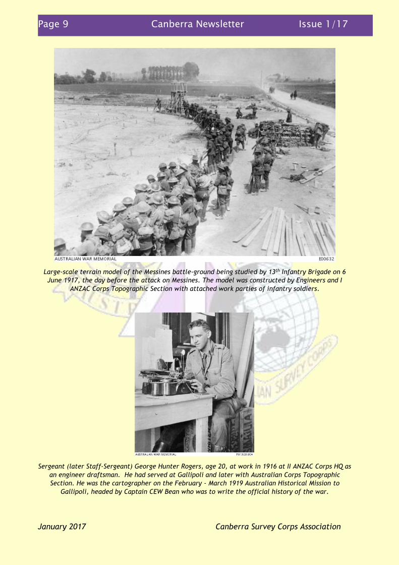
Large-scale terrain model of the Messines battle-ground being studied by 13th Infantry Brigade on 6
June 1917, the day before the attack on Messines. The model was constructed by Engineers and I
ANZAC Corps Topographic Section with attached work parties of infantry soldiers.
Sergeant (later Staff-Sergeant) George Hunter Rogers, age 20, at work in 1916 at II ANZAC Corps HQ as
an engineer draftsman. He had served at Gallipoli and later with Australian Corps Topographic
Section. He was the cartographer on the February - March 1919 Australian Historical Mission to
Gallipoli, headed by Captain CEW Bean who was to write the official history of the war.

Page 10 Canberra Newsletter Issue 1/17
January 2017 Canberra Survey Corps Association
Officer Commanding I ANZAC Corps and Australian Corps Topographic Section (1917-1919) Lieutenant
HS Buchanan at Gallipoli (Silt Spur) on the 1919 Australian Historical Mission, looking at a small
flowering fruit tree, perhaps from a seed of an apricot or plum left there by an Australian soldier
nearly four years earlier. The task of Buchanan and Rogers (as later explained by Bean) was to mark
on the spot, and afterwards on our maps, whatever topographical points we managed to determine.
AWM D00620: From left – I ANZAC Corps and Australian Corps Topographic Section members
Lieutenant PR Wightman (surveyor and draftsman) and Sergeant RH Meakin (electrical engineer) and
far right Staff Sergeant AE Scammell (surveyors draftsman), with maps and aerial photographs at
Australian War Records Section in London in 1919.

Page 11 Canberra Newsletter Issue 1/17
January 2017 Canberra Survey Corps Association
In the months after the armistice, the work of the Topographic Section continued in France at
a reduced rate with staff being posted to England before returning to Australia. When
Lieutenant HS Buchanan was posted to the Australian War Records Section in London in
January 1919, and then to the Gallipoli Australian Historical Mission, Lieutenant JJ Raisbeck
(Australian Survey Corps) was appointed Officer Commanding. In February 1919 staff
numbers reduced from one officer and twenty other ranks to one officer and eight other
ranks when the unit was disbanded on 5 March 1919 at Ham-sur-Heure, France. In the just
over two years that the I ANZAC Corps Topographic Section/Australian Corps Topographic
Section had served on the Western Front in France/Belgium the unit produced: 1095 special
maps (with print runs of a few up to 3000) issuing more than 50,000 maps for the Third Battle
of Ypres in September/October 1917, surveyed more than 1,200 field artillery battery
positions (875 in August/September 1918), surveyed 250 captured “pill-boxes”
October/November 1917, produced hundreds of artillery map boards, revised standard
topographic maps and carried out hundreds of miscellaneous surveys, drafting and printing
tasks. The individual efforts of the men of the Section were recognised with the awards: one
Distinguished Conduct Medal (Stafford), one recommendation Military Medal (Finlason), one
Meritorious Service Medal (Wightman), one Belgian Croix de Guerre (Buchanan), two French
Croix de Guerre (Finlason and Dunstan). That so many awards went to such a small unit says
a lot about not only the individuals, but the value and quality of their work done under very
difficult and dangerous war conditions.
Whilst the Corps Topographic Section was on the Western Front, topographic support to the
AIF element of the Egyptian Expeditionary Force was mainly through the Survey of Egypt and
British field survey units with three Australian Survey Corps members attached from early
1917. Warrant Officers Class One AS Murray, NL Shiels and JH Macdonald had transferred
from the Australian Survey Corps to the AIF in 1916. Murray and Shiels, both later
Lieutenants, were recognised for their bravery and work with Murray being awarded the
Distinguished Conduct Medal and Shiels being Mentioned in Despatches. Murray’s citation
read:
“For conspicuous gallantry and devotion to duty. For a prolonged period this Warrant Officer
was engaged in surveying the area between the lines, repeatedly working under machine-gun
fire and sniping. In order not to attract attention he usually worked alone, his plane-table and
instruments. Owing to his energy and coolness he has mapped a piece of country accurately and
his work has been most valuable”
The value of topographic units organic to war-fighting formations was proven in the First
World War and the lessons learnt were recognised and applied in 1940 in the Second World
War when the capability to support the 2nd AIF Australian Corps deployed to the Middle East in
1941, was upgraded from a topographic section to a field survey company (RAE). From 1942
this changed to one topographic survey company, supported by other survey units, as part of
each of the field armies and the lines of communication organised to defeat the Japanese
Armies in the South-West Pacific Area theatre.
Soldiers of 1st Australian Division – from the same family
separated by 100 years, 1917 and 2017 By Greg Tolcher
(Ed: This is from an email to me from Greg Tolcher. “I have attached a one page synopsis of
my Great Uncle David, who fought at Gallipoli and Northern France, where he was killed in
action. Like so many others, he was deployed at a young age, 22, promoted to LCPL and CPL,
and died at 23. The historical twist is that both of us have served in 1 Division (one form or

Page 12 Canberra Newsletter Issue 1/17
January 2017 Canberra Survey Corps Association
another). The synopsis will be added to the 1 Division Historical touch screen display that
will honour him for years to come. I also have transcribed his diary, which is a compelling
read, and added that to the 1 Div historical archive.”)
830 Corporal David Golding
“D” Coy – 1st Battalion 1st Australian Infantry Brigade
830 Corporal David Golding was a member of D Company 1st Battalion 1st Australian Infantry
Brigade who volunteered for Service in WW1 and served in Gallipoli and France. He was born
in England and enlisted in Sydney at age 22. While in France, he was promoted to Lance
Corporal on 2 August 1916 and then to Corporal on 24 October 1916. He died in battle on 09
April 1917.
Corporal Golding was the Great Uncle to 8238455 Lieutenant Colonel Greg Tolcher, RASvy and
RAE, who served at Headquarters 1st Division as the Staff Officer Grade 1 Capability
Development from 2014 to 2016, one hundred years after CPL Golding’s service and death in
France.
Diary entries from the Battle for Lone Pine from 4 to 8 August 1915 were read to 1st Division
staff during their Lone Pine commemorations in August 2015. Selected excerpts are provided
below.
April 24, 1915 We leave Lemnos at 12am with all lights out.
April 25, 1915 4 am. I wake to find a terrific noise going on around me. The warships
were bombarding the fort of Gaba Tepe and the 3rd Australian Brigade were
landing. 6am – We, the 1st Battalion, make our landing and advance to the
left driving everything before us. Unfortunately, we advanced too far and
for want of supports had to retire in disorder for 1½ miles. I estimate our
Batt. Losses at 550 this day.
Night - We are completely demoralised and disorganised but still we hold
on to the last ridge, our only chance. 50 of us under Capt Jacobs go out as
a screen & hold a ridge till 3am & returned 200 yards to our main line.
Raining, cold, our own reinforcements fire at us from behind and on right.
Twice I narrowly escaped a bullet through the head from behind.
Page 13 Canberra Newsletter Issue 1/17
January 2017 Canberra Survey Corps Association
April 28,1915 Two of us are taken on left flank by a staff officer & sniped at enemy for 3
hours, used 100 rounds of ammunition with a target every time. 11am.
Came down and found 1st Battalion in gully, had a rest and tucker. Three
times we went up as reinforcements but not wanted. Our artillery land and
begin blazing away
August 1, 1915 3rd Brigade takes trenches on right flank. Losses 20 killed. Brigadier among
the dead. 200 of the enemy take refuge in the underground safes and stay
there for 2 days
August 4, 1915 7000 of Kitchener’s Army land at Anzac, Wilts and Worcesters
August 5, 1915 More British troops arrive - Welsh Regiment. Also 6th Australian
reinforcements arrive. The long expected advance is being prepared and
we are fully confident of success
August 6, 1915 Leisters and Connaught Rangers, about 7000. 5.30pm – 1st Brigade charges
and capture Lone Pine. We charge about 100 yards with machine guns
playing on us. The Turks fled, but came on again continuously doing much
damage with bombs. Midnight – 40,000 British troops land on Salt Lake and
advance three miles. Gurkas land and assist us at Quinn’s Post.
August 7, 1915 We take hill 971 and loose it again
August 8, 1915 We are in a tight corner in a dead end trench on the right of Lone Pine. A
few Turks creep up and infiltrate us. I get shot in the right thigh, and leave
the Peninsular. Turks bombs do great damage amongst us. Left Gallipoli 10
am on the El-Kahira flying the Red Cross. Turks send ½ a dozen shells over
us and we make a hurried exit. Transhippe at Imbros Island to the P.S.N.C.
Esmerelda, a slow cattle boat. Imbros full of shipping and many troops
leaving for Gallipoli. Midnight – Left Imbros and arrived at Lemnos next day
1917 and each ten years hence – some happenings in the
Royal Australian Survey Corps By Peter Jensen
In the first edition of the newsletter of the last few years I have written an article about
military mapping and the Survey Section RAE/Australian Survey Corps 100 years ago. I have
now added a snapshot of some of what was happening in the Corps each ten years since, so
that each year 1915 to 1996 will be covered over ten years. I have also included ‘75 years
ago’ to cover in the next few years the Corps’ massive efforts in the Second World War.
100 years ago – 1917. For most of the year the Australian Survey Corps continued with its
primary task of producing military mapping (1 inch to 1 mile maps) around the key areas for
defence of southern Australia. Towards the end of the year another eleven members
followed the three Warrant Officers (Shiels, Murray, Macdonald) who had transferred to the
AIF. The eleven was what was known as the Survey Corps AIF draft. This left only five
members in the Corps in Australia and military survey in Australia came to a near standstill
for the remainder of the war. I ANZAC Corps Topographic Section was formed in France in
February 1917 (see the article in this newsletter).

Page 14 Canberra Newsletter Issue 1/17
January 2017 Canberra Survey Corps Association
90 years ago – 1927. The fourteen men of the Corps, which reverted in name to Survey
Section RAE (Permanent) from 1920 to 1932, were working on ‘1 mile’ mapping in coastal
regions around Adelaide, New South Wales and Victoria capable of producing five new maps
per year. Captain Lynch was the senior officer of the Section and there were no recruits.
80 years ago – 1937. Major Vance was posted at Army Headquarters (AHQ), Melbourne, to
perform his duties as Officer Commanding Australian Survey Corps and as part of AHQ staff.
The Corps structure was Nos 1 (4th Military District – South Australia), 2 (3rd Military District -
Victoria), 3 (2nd Military District – New South Wales), 4 (Geodetic) Topographic Sections and
No1 Drafting Section in Melbourne. Geodetic surveys of the Corps allowed 1st Order survey
connections of 2nd, 3rd and 4th Military Districts to the Sydney Observatory. Some of this work
identified that some parts of the network had to be upgraded with new observations. The
Corps establishment was five officers, nineteen warrant officers and one sergeant. There
were no additional recruits into the Corps this year. The main map compilation method was
transitioning from plane-tabling to the Arundel method of graphical radial line plotting from
RAAF photography.
75 years ago - 1942. After 2/1st Australian Corps Field Survey Company RAE returned to
Australia from the Middle East in early 1942, along with much of 1st Australian Corps, the
survey force was reorganised to fit the revised Army war-fighting organisation to defeat the
Japanese Army. Two Army Topographical Survey Companies, one Land Headquarters
(formerly Army Headquarters) Cartographic Company, four Field Survey Companies, a Mobile
Lithographic Section, three Field Survey Depots and a Field Survey Training Depot were raised
and equipped, with Survey Directorates at all higher formations. In early-1942 survey
sections were in direct support in New Guinea and the Northern Territory. Lieutenant-
Colonel Vance, then nearly 60 years of age, retired as Director (retired as Colonel), after
serving military survey for 27 years and in two World Wars, and Lieutenant-Colonel Fitzgerald
(promoted Colonel in 1943) was appointed Director of Survey, Land (Advanced) Headquarters,
and as head of the Australian Survey Corps. The field survey companies were intended to
work on Australian military survey but were soon under command the major war-fighting
formations augmenting the two Army-level units in the operational areas of the South-West
Pacific Area theatre. New Guinea Survey Section (initially an adhoc organisation of civilian
surveyors/engineers and later retitled 2nd and then 8th Field Survey Sections) was formed in
March 1942 to support the Army there and by July were assisted by a detachment from 3rd
Field Survey Company. By the end of the year, section size detachments from 2nd Field Survey
Company and 2/1st Army Topographical Survey Companies were in New Guinea with a section
of 2nd Company tasked with astronomic fixes and air photo interpretation in preparation for
the final assaults to defeat the Japanese Army at Buna-Gona-Sanananda in early-1943. The
Cartographic Company moved from under command Army Headquarters to Land Headquarters
and moved from Melbourne to the Fortuna Villa (formerly owned by the gold baron Lansell
family) in Bendigo, where it and successor units remained for the next 54 years.
70 years ago – 1947. Post Second World War general demobilisation continued. This was
consistent with other parts of the demobilised Army. The full-time Army transitioned from
the 1946 Interim Army to the 1947 formed Australian Regular Army. The structure of the
Australian Survey Corps was the force-in-being and the minimum base for expansion in war,
consisting of a Survey Directorate on Army Headquarters, an Army Headquarters Cartographic
Company, an Army Headquarters Survey Company, an Army Headquarters Field Survey Depot
and a Field Survey Section in each of Northern, Eastern, Southern, Central and Western
Commands (then sections of 3rd and 5th Field Survey Companies). The 4th Military District
Survey Section was raised to provide mapping and survey for what became known as the

Page 15 Canberra Newsletter Issue 1/17
January 2017 Canberra Survey Corps Association
Woomera Rocket Range. AHQ Cartographic Company produced the mapping for the 1947
national census. 5th Field Survey Company continued topographic survey in the Snowy
Mountains and the Cartographic Company produced black-and-white maps for early
investigations of the Snowy Mountains Hydroelectric Scheme. Two officers continued their
overseas study of using aircraft mounted radar for measuring long geodetic lines and the Wild
A6 and multiplex photogrammetric map compilation system which the Corps was keen to
acquire.
60 years ago – 1957. Geodetic survey was revolutionised with the introduction into service of
firstly the light-based distance measurement system, the Geodimeter, which was soon
replaced a year later by the more portable electronic (microwave) distance measurement
system, the MRA101 Tellurometer, introducing long line-of-sight (some lines up to 70km)
high-order traversing (replacing triangulation) for rapid extension and survey network infill.
The other revolution was the use of helicopters to rapidly position and resupply field survey
parties. This was to be of huge benefit in Northern Australia and Papua New Guinea. 1st
Topographic Survey Company (Citizen Military Force) was disbanded after reorganisation of
the National Service scheme. Army Headquarters Survey Regiment Topographic Squadron
completed Project Cutlass in New Britain.
50 years ago – 1967. The first rotation of personnel in A Section 1st Topographic Survey Troop
(formerly Detachment 1st Topographic Survey Troop) 1st Australian Task Force, Vietnam took
place mid-year after deployment of about 12 months. The Director of Survey – Army, and
Head of the Royal Australian Survey Corps, Colonel Don Macdonald, retired as Brigadier, after
31 years of service in the Corps including in the Second World War. He had been appointed in
1960 after the retirement of Colonel Lawrence Fitzgerald OBE (retired as Brigadier) after 37
years of service including being the wartime Director 1942-1945. Colonel Frank Buckland was
appointed to replace Colonel Macdonald. Brigadier Don Macdonald AM was appointed the
first Colonel Commandant of the Royal Australian Survey Corps. The Corps was nearing the
end of its commitment to producing about half of the 550 maps in first series of general
topographic maps of Australia, the Series R502 scale 1:250,000 and commencement of its part
(862 maps) in the second series of general topographic maps of Australia, the scale 1:100,000
topographic maps. The Corps commenced a joint Australia/United States astro-triangulation
program using large Wild BC4 cameras to photograph Echo and Pageos passive low earth
orbiting satellites against star backgrounds at Thursday Island, Queensland and Narrabri, New
South Wales. This was part of a global survey to produce the World Geodetic System 1972.
40 years ago – 1977. 1st Field Survey Squadron conducted Operation Sunbird in north
Queensland establishing mapping control using AN/PRR14 Geoceivers observing the US Navy
Navigation Satellite System Geoceivers, WREMAPS2 Laser Airborne Terrain Profiler (APR),
spirit levelling and doing air photo annotation and field map completion. Later in the year 1
Squadron was busy on Cape York on Operation Tropic Shores doing survey point air photo
identification, field map completion and supplementary air photography. 2nd Field Survey
Squadron deployed for a second year to Irian Jaya, Indonesia on Operation Cenderawasih
1977, conducting geodetic survey using Geoceivers and APR. On 30th July, a helicopter crash
on a survey task in the central highlands near Wamena claimed the life of Flight Lieutenant
Ralph Taylor, 9 Squadron RAAF. This was the first death on survey operations since
Lieutenant Kevin Shoppe, 1st Aviation Regiment, was killed on a survey task in Papua New
Guinea in 1973. Both officers are commemorated on the Australian War Memorial Roll of
Honour. Individual efforts in the rescue phase were recognised with the making of more
awards and commendations than for any other single incident on military survey operations
(Air Force Cross – Squadron Leader Arthur Lowe, Bravery Medal – Craftsman Phil Edwards,

Page 16 Canberra Newsletter Issue 1/17
January 2017 Canberra Survey Corps Association
General Officer Commanding Field Force Command Commendations – Staff Sergeant Greg
Chambers and Sergeant Peter Jensen). For the first time on survey operations, Australian
Special Air Services Regiment armed patrols were deployed from Australia and inserted into
the crash site to provide medical support and protection against possible terrorist
interference during rescue and recovery operations. 4th Field Survey Squadron conducted
Operation Short Walk III in South Australia doing air photo annotation, field map completion
and photo interpretation guides for scale 1:50,000 maps of the Woomera area, as well as
scale 1:100,000 mapping mainly in Victoria, South Australia and Queensland. 4 Squadron also
completed its tasks for photogrammetric plotting for Papua New Guinea scale 1:100,000
mapping and established a capability for final cartographic completion – a first for any field
survey squadron. 5th Field Survey Squadron was busy on field map completion and survey
control in the Geraldton/Exmouth areas also with road classification tasks. 8th Field Survey
Squadron, based in Wewak, Papua New Guinea, conducted Operation Nyalun Kup Phases 1, 2
and 3 with geodetic survey using Geoceivers and field map completion from New Britain to
the western highlands. Army Survey Regiment continued developing AUTOMAP1 including
Symbolisation All Scales (SYMBAS) for digital cartographic production, upgraded its air photo
triangulation capability with a new OMI/NISTRI AP/C-3T Analytic Plotter and PDP 11/70
computer. Army Headquarters Field Survey Depot was retitled Army Map Depot. School of
Military Survey established the Doctrine Cell. An officer exchange program was established
between the Australian Army - RA Svy (at Army Survey Regiment new Technical Services Cell)
and US Army (at US Defense Mapping Agency).
30 years ago – 1987. Army Survey Regiment produced 94 maps (printed 9,400) in 54 hours for
a potential military operation in Fiji (Operation Morrisdance). The second generation
computer assisted mapping system, AUTOMAP 2, was in the operational development phase at
Army Svy Regt having been delivered in 1984. The four Australian based field survey
squadrons were working on surveys and map compilation for the Defence 1:50,000
topographic mapping program across northern Australia and 8th Field Survey Squadron, based
at Port Moresby Papua New Guinea, was concentrating its efforts on a border survey
PNG/Indonesia, providing mapping for Papua New Guinea Defence Force and
training/mentoring National Mapping Bureau staff. The Corps’ geodetic survey capability was
hugely boosted with the introduction into service of nine Texas Instruments TI4100 Global
Positioning System survey instruments and the complementary Ferranti Inertial Land Surveyor
3 – helicopter and vehicle mounted. Equipment testing and training was developed by School
of Military Survey using and upgrading the Lake Hume Photogrammetric Test Range.
20 years ago – 1997. The former Colonel-in-Chief of the Royal Australian Survey Corps, Her
Royal Highness the Princess of Wales (Diana) was killed in a car accident in Paris, France on
31st August. Strategic level survey and mapping continued to be reorganised with Army
responsibilities transferred to the newly raised Australian Defence Headquarters Directorate
of Strategic Military Geographic Information. This was the first time that a military survey
related directorate had been formed on the highest headquarters of the Australian Defence
Force.
10 years ago – 2007. On 9th July, the Governor-General of the Commonwealth of Australia,
His Excellency Major-General Michael Jeffery AC CVO MC dedicated a commemorative plaque
at the Australian War Memorial to recognise the sacrifice and service of the members of
Survey Corps units.
Page 17 Canberra Newsletter Issue 1/17
January 2017 Canberra Survey Corps Association
Vale By the editor with contributions by Oreste Biziak, John Bullen, Lyall Camp
41896 Warrant Officer Class One William Alexander Munro (Alex or Darby) passed away in
Adelaide on 26th December 2016, aged 85 years. Alex enlisted as a Topographic Surveyor in
the Corps on 2nd February 1956 and served full-time for 30 years retiring in Adelaide on 19th
February 1986. Alex’s postings included Central Command Field Survey Section, Western
Command Field Survey Unit, Central Command Field Survey Unit, School of Military Survey, A
Section 1st Topographical Survey Troop 1st Australian Task Force Vietnam (Warrant Officer
Class One March 1969 – March 1970), Army Survey Regiment, 4th Field Survey Squadron
returning to Adelaide in 1978 for his last posting as Warrant Officer Class One Squadron
Sergeant Major. Alex served nearly 18 years of his 30 years based in Adelaide. Alex was held
in high regard by all ranks, being deeply and widely respected as a thoroughly professional,
decent, highly dependable and utterly sincere man. As a senior soldier he was a champion
for soldier welfare acting in a gentle but firm manner and always available to help guide
soldiers through difficult personal matters. Alex was always very active in the Royal
Australian Survey Corps Association of South Australia serving on the Executive for many
years. He felt very honoured to propose a toast at the Corps centenary dinner in Canberra on
1st July 2015.
Our sincere sympathies and condolences go to his wife Joan and family.
The Australian Army Museum of Military Engineering
(AAMME) at Holsworthy – an update By Peter Jensen
In early December 2016 I met with Sebastian Spencer (AAMME Curator) and former RA Svy
member museum volunteers Peter Raue, Phil Bannister and Frank Fischer at AAMME
Holsworthy to discuss how the Association might assist the museum. The whole of Holsworthy
Base had just gone through a security renewal process to meet the current security
requirements of the base after the huge base upgrade and the move of School of Military
Engineering from Moorebank to Holsworthy.
AAMME being one Corps museum in the museum network, is now under command Australian
Army History Unit (AAHU), a unit of Army Headquarters. This was not the case when the
museum was at Moorebank and was then run by the Military Engineering Company, an
incorporated organisation. The big advantage of the new arrangement is that the museum
will be sustained in the long-term in accordance with Army policy which places high value on
military history and heritage. One disadvantage is that AAHU is increasingly using the
museums, and in most cases volunteers, to research responses to questions of military history
content, including information for responses to Ministerial letters. Phil and Frank are now
working on the enormous task of cataloguing maps but of recent times are being drawn in to
answering questions about military survey history. Much of this is to the best of their
recollection as many of the files which might have information are not indexed or are
possibly still in boxes.
Like other military museums, such as that which is part of the Australian War Memorial, there
is now a focus on collecting personal stories to put in to context much of what the museums
put on display as part of the history and heritage. AAHU is developing a public on-line based
system which will essentially allow the museums to publicly ‘crowd-source’ information

Page 18 Canberra Newsletter Issue 1/17
January 2017 Canberra Survey Corps Association
including personal accounts and stories. Collectively the people in our Survey Associations
have a huge corporate knowledge of military survey, especially the part of the Royal
Australian Survey Corps, and hopefully this system using modern technology will allow those
who are interested to add to the knowledge of the museums and to be made available to the
public. The AAMME curator does understand that untapped this huge collection of knowledge
will not last forever, perhaps another 10 years.
Phil and Frank are congratulated for doing a superb job supporting Sebastian, voluntarily
devoting their time and effort to put the work of the Survey Corps on display and in its
correct place being a highly valued part of Australian Army history and heritage. Much of the
survey and mapping work of the Corps remains as valid today as when it was done more than
20 years ago.
I later found an index which is a very useful resource, that being Christopher Coulthard-
Clark's papers which he collected for his research to write the Corps history and which are
now at University of New South Wales Australian Defence Force Academy library in
Canberra. A public on-line index to the papers, which include photocopies of files held by
SME Museum (now AAMME) is at https://www.unsw.adfa.edu.au/library/finding-aids/guide-
papers-christopher-clark Many of Coultard-Clark’s references are files which for many years
were kept in ‘the vault’ at the Directorate of Survey – Army at Campbell Park Offices and
were moved to SME Museum Moorebank 1998-2000.
Postcards – people, events, what’s new etc
By the editor
Service medals In early-December I was contacted by a reserve member of the Special Air Services Regiment to advise me that he had recently assisted a former non-RA Svy soldier to be issued with the Australian Service Medal 1945-1975 Clasp PNG, which the soldier was entitled to having served with 4th Field Survey Squadron on Project C1 Operation Wine Glass 1972 in Territory Papua New Guinea. He thought that it was possible that other members who served with survey units in Papua New Guinea may not be aware of their entitlement to the medal. I ‘googled’ Op Plastic Flagon 1973, Wine Glass 1972 and Sea King 1974 to find on-line a relevant Defence Honours and Awards Appeals Tribunal decision of 2015 which is very clear in its reasons, findings and decision and should help medal claimants, see https://defence-honours-tribunal.gov.au/wp-content/uploads/2015/09/2015_DHAAT-24_Howard-J-Decision-Report.pdf The longest serving RA Svy member to serve in the ADF John Bullen has alerted me to the fact that Major Fred Brown RFD served continuously in the Australian Army for 47 years, full-time and part-time, enlisting 24th May 1966 and being discharged 4th June 2013. Still running Spotted running on the early Saturday morning Lake Ginninderra Parkrun was Peter Ralston keeping a fast pace with five kilometre runners much less than half his age.

Page 19 Canberra Newsletter Issue 1/17
January 2017 Canberra Survey Corps Association
Christmas Happy-Hour The 2016 Christmas Happy-Hour was a very popular event with nearly twenty members getting together for a couple of hours at the Duxton Bar and Restaurant at O’Connor shops. This event has been added to this year’s calendar of events on Thursday 14th December.
Faces of the Corps Crossword #4 - WHAT’S IN A NAME? By John Mobbs
Solution for Crossword #4 in Newsletter 4-16
Our Association Calendar 2017 – the fridge magnet
Tue 25th April 2017 ANZAC Day march, commemorative service and lunch
Sat 1st July 2017 Royal Australian Survey Corps birthday (102nd) lunch
September – October 2017 Golf Day (SNAGA)
Sat 11th November 2017 Remembrance Day dinner
Thu 14th December 2017 Christmas Happy-Hour – The Duxton Bar and Restaurant,
OConnor shops
![[XLS-SVY-13]_ Plotting Cross Section Dari Excel Ke AutoCAD Versi 1.1 _ Coretan Tentang Autocad Dan Excel](https://img.pdfslide.net/doc/110x75/5695d3781a28ab9b029e07d6/xls-svy-13-plotting-cross-section-dari-excel-ke-autocad-versi-11-coretan.jpg)


![CASIO FX-603P 測量計算プログラム SVY 取扱説明 …khf00050.fc2web.com/home/tossy/svy/sound-file/603P/SVY...2 CASIO FX-603P 測量計算プログラム SVY [ 概 要 ]](https://img.pdfslide.net/doc/110x75/5e6201454df1c73802797235/casio-fx-603p-eecffff-svy-e-2-casio-fxi603p.jpg)


![corps fœtal - corps mental [ le corps amoureux / la poche humaine ]](https://img.pdfslide.net/doc/110x75/56815e7f550346895dcd0bb4/corps-foetal-corps-mental-le-corps-amoureux-la-poche-humaine-.jpg)


![[XLS SVY 20] SolvingNetworkAdjustmentWithSolver R1](https://img.pdfslide.net/doc/110x75/577cdd0b1a28ab9e78ac1323/xls-svy-20-solvingnetworkadjustmentwithsolver-r1.jpg)
![[SVY] Survey Data](https://img.pdfslide.net/doc/110x75/586678191a28ab7d408b482a/svy-survey-data.jpg)
