Embed Size (px)
Citation preview
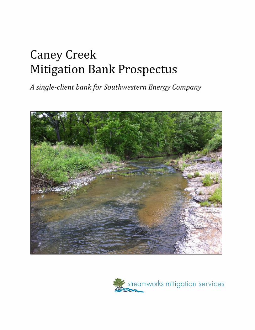
Caney Creek Mitigation Bank Prospectus
A single-client bank for Southwestern Energy Company
i Caney Creek Mitigation Bank Prospectus
TABLE OF CONTENTS INTRODUCTION 1
1.0 Objective 2
2.0 Site Selection and Justification 2
3.0 Site Protection Instrument 2
4.0 Baseline Information 3
5.0 Determination of Credits 4
6.0 Mitigation Work Plan 4
7.0 Operation and Maintenance Plan 6
8.0 Performance Standards 6
9.0 Monitoring Requirements 6
10.0 Long-term Management 6
11.0 Adaptive Management 6
12.0 Financial Assurances 6
LIST OF TABLES
Table 1: Summary of background information of the Caney Creek Mitigation Bank 1
Table 2: Reach names, stream lengths, and associated stream credit production for the
Caney Creek Mitigation Bank 2
Table 3: Mean Wetland Indicator Value for plants collected at the Caney Creek
Mitigation Bank on July 30th, 2012 3
Table 4: Vegetation planting list for the Caney Creek Mitigation Bank 5
APPENDIX A: Figures
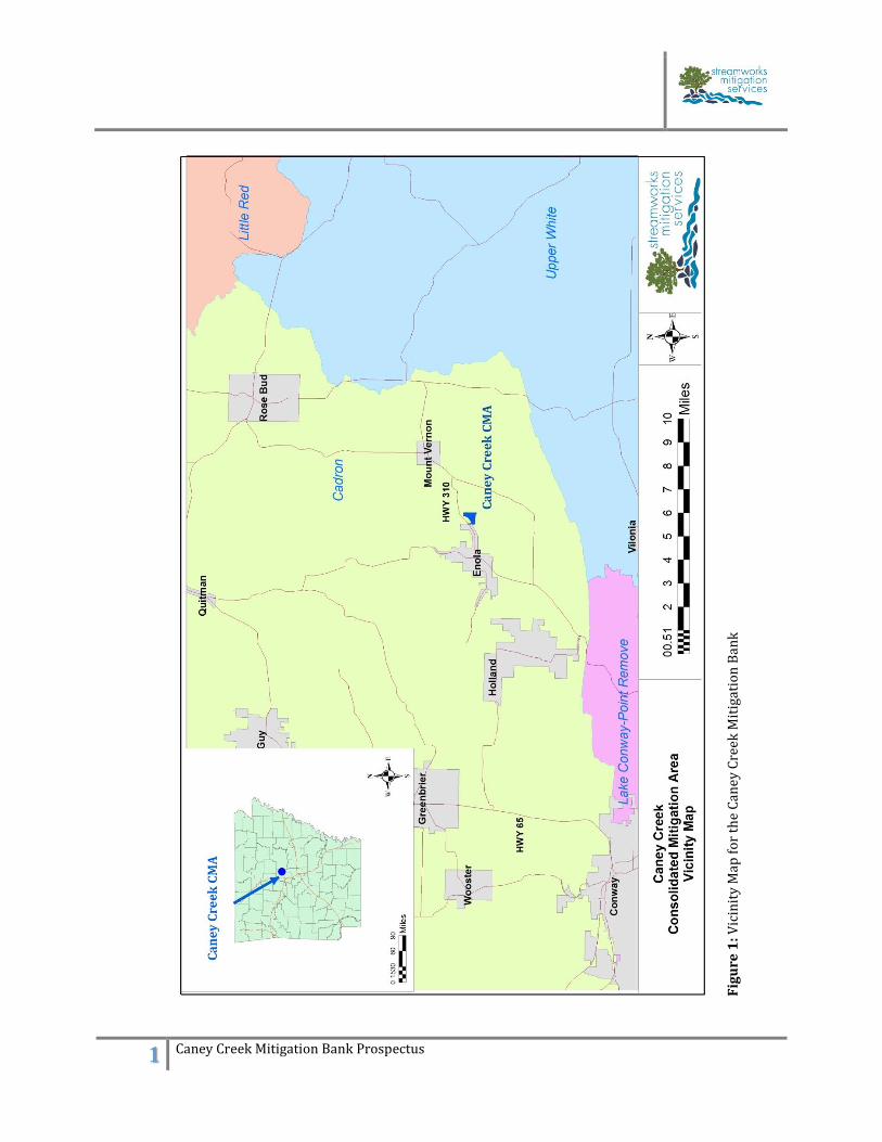
Figure 1: Vicinity Map for the Caney Creek Mitigation Bank
Figure 2: Topographic map of the Caney Creek Mitigation Bank (USGS)
Figure 3: Aerial map of the Caney Creek Mitigation Bank
Figure 4: Aerial map of the Caney Creek Mitigation Bank wetland areas
Figure 5: Wetland delineation sampling points for the Caney Creek Mitigation Bank
Figure 6: Topographic map of the wetland areas of the Caney Creek Mitigation Bank
Figure 7: Wetland area soils map of the Caney Creek Mitigation Bank
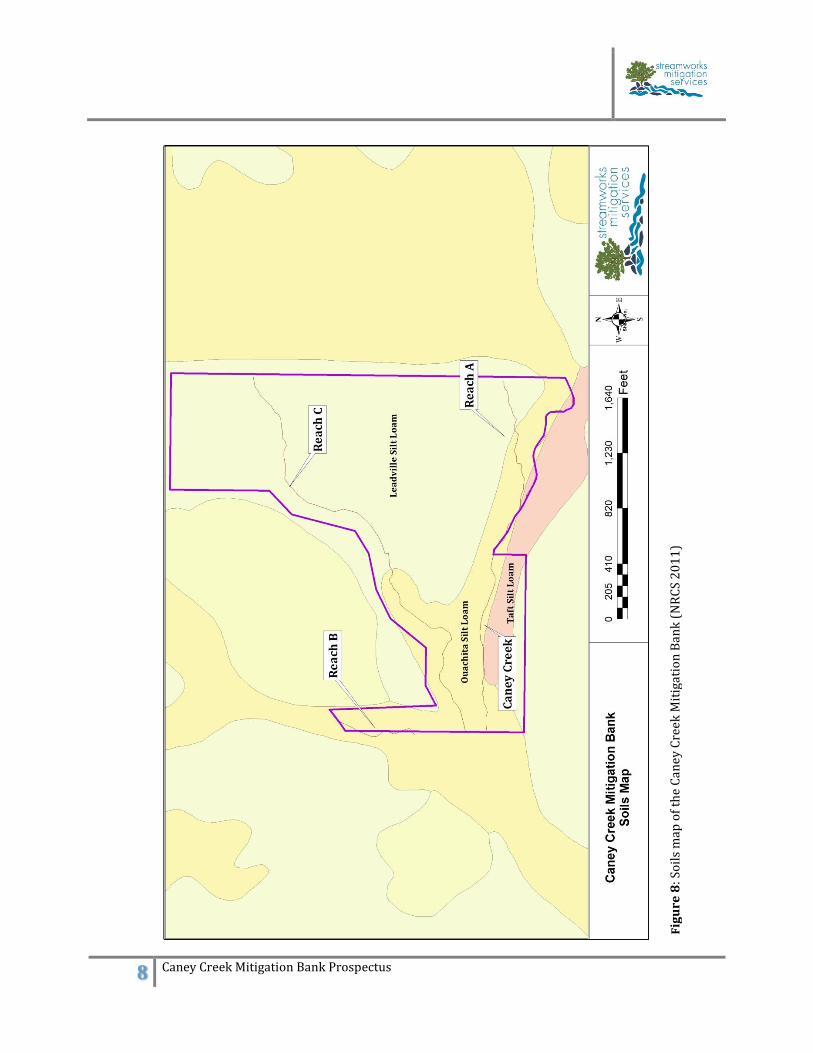
Figure 8: Soils map of the Caney Creek Mitigation Bank (NRCS 2011)
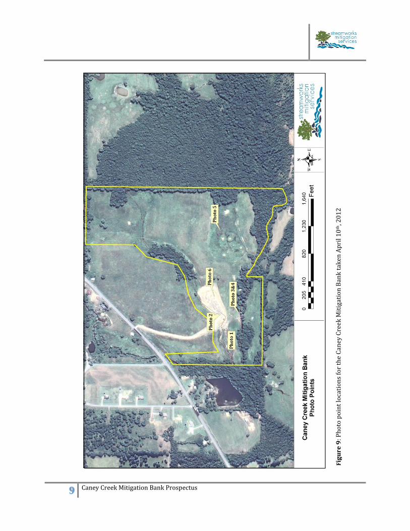
Figure 9: Photo point locations for the Caney Creek Mitigation Bank taken April 10th, 2012
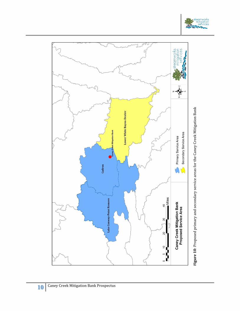
Figure 10: Proposed primary and secondary service areas for the Caney Creek Mitigation Bank
APPENDIX B: Site photographs
1 Caney Creek Mitigation Bank Prospectus
Introduction The proposed Caney Creek Mitigation Bank is a single client bank in the Cadron watershed
developed for Southwestern Energy Company to be used as compensatory mitigation for
unavoidable impacts authorized under Section 404 of the Clean Water Act. This combined wetland
and stream mitigation project is located on 100-acres in Section 33, Township 7N, Range 11W of
Faulkner County, Arkansas, east of Enola along HWY 310 (Figure A-1). The project will restore,
enhance, or protect 3,098 linear feet (LF) of Caney Creek, 5,564 LF of tributaries, and approximately
28-acres of wetland prairie and Pin Oak/Willow Oak flat under the guidance of the Compensatory
Mitigation for Losses of Aquatic Resources, Final Rule. Regulation 40CFR Part 230 (USACE & USEPA
2008). Caney Creek is a tributary to Muddy Bayou, a primary contributing waterbody to East Fork
Cadron Creek. An initial site visit by the Little Rock District Corps of Engineers (LRD) was
conducted in November 2011 and additional Interagency Review Team participation will include:
the U.S. Fish and Wildlife Service, Region IV (FWS); the U.S. Environmental Protection Agency,
Region VI (EPA); the Arkansas Department of Environmental Quality (ADEQ); the Arkansas Game
and Fish Commission (AGFC); the Arkansas Natural Heritage Commission (ANHC); and the
Arkansas Natural Resources Commission (ANRC).
Table 1: Summary of background information of the Caney Creek Mitigation Bank
BACKGROUND INFORMATION
Project Name Caney Creek Mitigation Bank
Project Sponsor Southwestern Energy Company
Site Location Sections 33, Township 7N, Range 11W
County Faulkner
8-digit HUC Cadron 11110205
10-digit HUC East Fork Cadron Creek 1111020502
12-digit HUC Muddy Bayou 111102050304
Proposed primary service AreaCadron
Lake Conway-Point Remove
Proposed secondary service area Upper White-Bayou Des Arc
Protection MechanismConservation Easement filed and recorded
with the Land Trust of Arkansas March 2012
Monitoring Frequency annually
Anticipated Date of Final Monitoring 2018
Size of Mitigation Area ~100 acres/8,662 LF of streams
28-acres of wetlands and buffers
Date of Initial USACE Visit November 2011
Mitigation Objectives
To establish a single client mitigation bank in
association with the granting of Department
of the Army permits through restoration and
enhancement of a 8,662 LF of streams, 28-
acres of wetlands, and associated riparian
buffer zones.
2 Caney Creek Mitigation Bank Prospectus
1.0 Objective The project objective is to develop a single client mitigation bank in the Cadron watershed in
association with the granting of Department of Army permits through restoration, enhancement,
and preservation of stream channels, wetlands, and associated buffers along Caney Creek. The
project goal is to restore the perennial, intermittent, and ephemeral streams and to restore and
create wetland habitat. The specific design objectives of the project included: • Restoration or enhancement of channel dimension, pattern and profile;
• Water quality enhancement in the Cadron watershed through sediment reduction, nutrient
removal, streambank stability, and erosion control;
• Water quantity improvement through water storage and flood control, improved ground water
recharge, and improved and restored hydrologic connections;
• Enhancement of aquatic and terrestrial habitats through improved substrate and instream cover,
addition of woody debris, reduction in water temperature due to shading, restoration of terrestrial
habitat, increase of spatial extent of natural area, and improved aesthetics.
Table 2: Reach names, stream lengths, and associated stream credit production for the Caney Creek Mitigation Bank
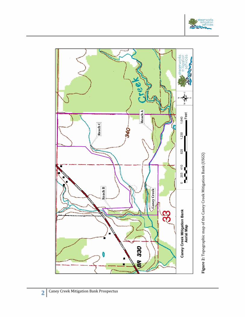
2.0 Site Selection and Justification The proposed Caney Creek Mitigation bank is a 100-acre site located along Caney Creek
approximately two miles upstream from the confluence with Muddy Bayou (HUC 11110205)
(Figure A-1). The project site was used for cattle and hay production with stream channel segments
filled or degraded to facilitate agriculture. Hydrology on site has been manipulated through land
clearing, channel filling, dredging, and surface mining. Impacts to the site model existing and
potential effects of natural gas drilling on headwater systems and will offset future gas
development impacts. Additional benefits include improved water quantity through water
retention and increased ground water recharge. Restoration and reforestation of this site will
reduce sediment contributions to East Fork Cadron Creek and provide connectivity to adjacent
forested areas. 3.0 Site Protection Instrument The property is owned by a private third party and the mitigation acreage was placed in a
conservation easement with the Arkansas Land Trust and filed at the courthouse in Faulkner
County on April 30th, 2012. The site will be monitored annually by the Arkansas Land Trust to
ensure that the easement restrictions are being followed.
Reach Name Stream TypeEstimated Stream
Length (ft)Mitigation Activity
Caney Creek Perennial 3,098 Enhancement
Reach A Intermittent 1,075 Enhancement
Reach B Perennial 955 Preservation
Reach C Intermittent 2,915 Restoration
Totals 8,043
3 Caney Creek Mitigation Bank Prospectus
4.0 Baseline Information The Caney Creek site is located within the Arkansas River Valley Ecoregion (37); subsection 37c –
Arkansas Valley Hills (AWAP 2004). Within this ecoregion, there are two major ecosystems at the
Caney Creek site described in baseline vegetation monitoring report: Ozark-Ouachita Riparian and
Interior Highlands Unglaciated Forest. The valley slope within the project area is relatively flat,
with elevations ranging from 318 ft along Caney Creek to 345 ft within the uplands. Enola,
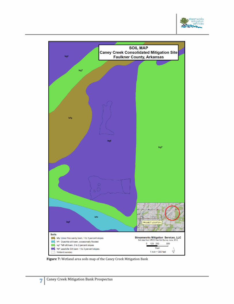
Arkansas, receives an average of 48.3 inches of rainfall per year. Wetland delineation sampling was conducted in June 2012. Soil sampling revealed the presence of
wetland indicators including, but not limited to, oxidized rhizospheres, reduced iron lenses, and
saturation visible on aerial photos (Figure A-5). Soils are mapped into three primary units, all are
considered partially hydric. The majority of the site, 70-acres, is Leadville silt loam, one to three
percent slopes. These are moderately well-drained soils with a parent material of loamy colluvium
derived from shale and siltstone. The secondary soils, 25-acres, are Ouachita silt loam, occasionally
flooded. These soils are a loamy alluvium located in the floodplain of Caney Creek and Reach C. The
third unit is Taft silt loam, zero to two percent slopes located along four acres of the left descending
bank of Caney Creek (Figures A-6 & A-7). A baseline plant community monitoring survey was established along two 100-meter transects
within the mitigation area. Wetland components of this ecosystem are represented by various panic
grasses (Dichanthelium/Panicum spp.), sedges, a spikerush (Eleocharis sp.), buttonbush
(Cephalanthus occidentalis) and smartweed (Polygonum pennsylvanicum). Oak flatwood
components are represented by several native, warm-season grasses including Tridens strictus and
Eragrostis spectabilis, as well as slender mountain mint, greenbrier (Simlax spp.) and blue sedge
(Carex glaucodea). Preliminary site evaluations were conducted in June 2012. Results from the
vegetative sampling yielded a mean indicator value of 2.43 (a value of 3.0 or less serves as a good
indicator of the presence of a wetland). Table 3: Mean Wetland Indicator Value for plants collected at the Caney Creek Mitigation Bank on July 30th, 2012
SCIENTIFIC NAME COMMON NAME
REGON 2
INDICATOR
STATUS
INDICATOR
VALUE
LUDWIGIA GLANDULOSA Seed box Obligate 1
POLYGONUM PUNCTATUM Dotted Smartweed Fac Wetland 2
ERYNGIUM YUCCIFOLIUM Rattlesnake Master Fac 3
TRIDENS STRICTUS Long Spike Tridens Fac Wetland 2
CYPERUS ERYTHRORHIZOS Red root Flat Sedge Obligated 1
HELIANTHUS MOLLIS Prairie Sunflower Upland 5
SENECIO TOMENTOSUS Woolly Groundsel Fac Upland 4
JUNCUS MARGINATUS Grass leaf Rush Fac Wetland 2
PANICUM RIGIDULUMRed Top Panic
GrassFac Wetland 2
ELYMUS VIRGINICUS Virginia Wild Rye Fac 3
HYDROLEA OVATA False Fiddle Leaf Obligate 1
PANICUM DICHOTOMIFLORUM Velvet Panic Grass Fac Wetland 2
PANICUM ANCEPS Beaked Panic Grass Fac 3
PYNANTHEMUM TENUIFOLIUM Slender Mountain
MintFac 3
Mean Indicator
Value = 2.43
4 Caney Creek Mitigation Bank Prospectus
In addition to the baseline vegetation monitoring effort, a baseline avian point count was conducted
between May 27th and June 6th 2012. The five most abundant species at Caney Creek tended to be
those that prefer open and/or brushy habitats: American crow (Corvus brachyrhynchos), Dickcissel
(Spiza Americana), Indigo Bunting (Passerina cyanea), Northern Cardinal (Cardinalis cardinalis),
and Barn swallow (Hirundo rustica). Three species showed signs of breeding on this site: Brown-
headed cowbirds (Molothrus ater), Red-tailed hawk (Buteo jamaicensis) and Dickcissels. The
greatest species diversity and bird abundance was observed north of the riparian area on the
western portion of the site. The fallow field areas in this portion of the property lacked dense
stands of exotic grasses and forbs (e.g., Sericea lespedeza) as compared to the eastern portion of the
property. Higher avian observations in the western portion would suggest that these habitats may
fulfill important requirements for these species and should be expanded. A benthic
macroinvertebrate study is slated for 2013. These baseline studies help determine restoration
activities and goals, as well as, illustrate ecological lift after restoration efforts are implemented. 5.0 Determination of Credits The method of credit determination will be a combination of stream channel restoration,
enhancement, preservation and riparian buffer creation. The Little Rock Stream Method (USACE
2011) will be used to determine the amount of stream credits with wetland credit determination
following the Charleston Method (USACE 2002). Stream segments that overlay with wetland areas
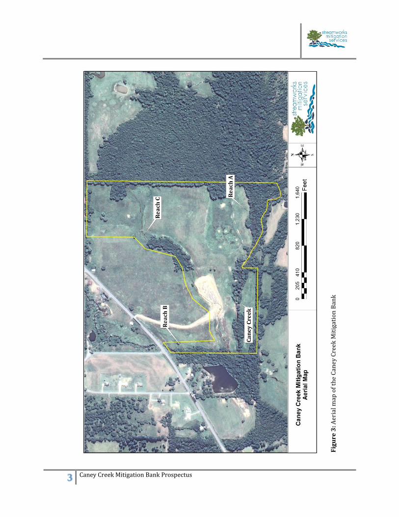
or buffers will not be stacked for mitigation credits. 6.0 Mitigation Work Plan Preliminary site surveys found Reach A as an intermittent channel which enters Caney creek at
station 1+150. Reach B is a perennial channel running along the western boundary of the
mitigation area. Reach C bisects the project area and is the primary focus for restoration activities.
The entire project area will be re-vegetated in native trees, shrubs, grasses, and forbs after a
prescribed burn is conducted. Caney Creek
Caney Creek is a third order stream running east to west along the southern boundary of the
property. The channel is incised to bedrock and overwidened with areas of severe to moderate
bank erosion. Bank stabilizations efforts will be implemented where needed and feasible.
Intermittent Channels
Reach A is a first order stream which enters Caney Creek at station 1+168. Similar to Caney
Creek, the channel is incised with eroding banks located throughout. Enhancement activities
will include bank stabilization and grade control where necessary. Reach B is located along the
western edge of the mitigation area and enters Caney Creek downstream of the mitigation site.
This reach will be preserved and the left descending bank will be re-vegetated to ensure a
minimum 100ft buffer. The majority of restoration activities will take place along Reach C.
Reach C drains approximately 0.25 mi2 and is approximately 3,600 LF. The upper portion of the
reach was filled years ago in order to increase hay production and cattle grazing. The lower
portion was altered by extensive surface soil removal and ditching. Activities will include
5 Caney Creek Mitigation Bank Prospectus
installation of structures and bioengineering materials where needed to stabilize the channel
and to restore aquatic habitat. Wetlands
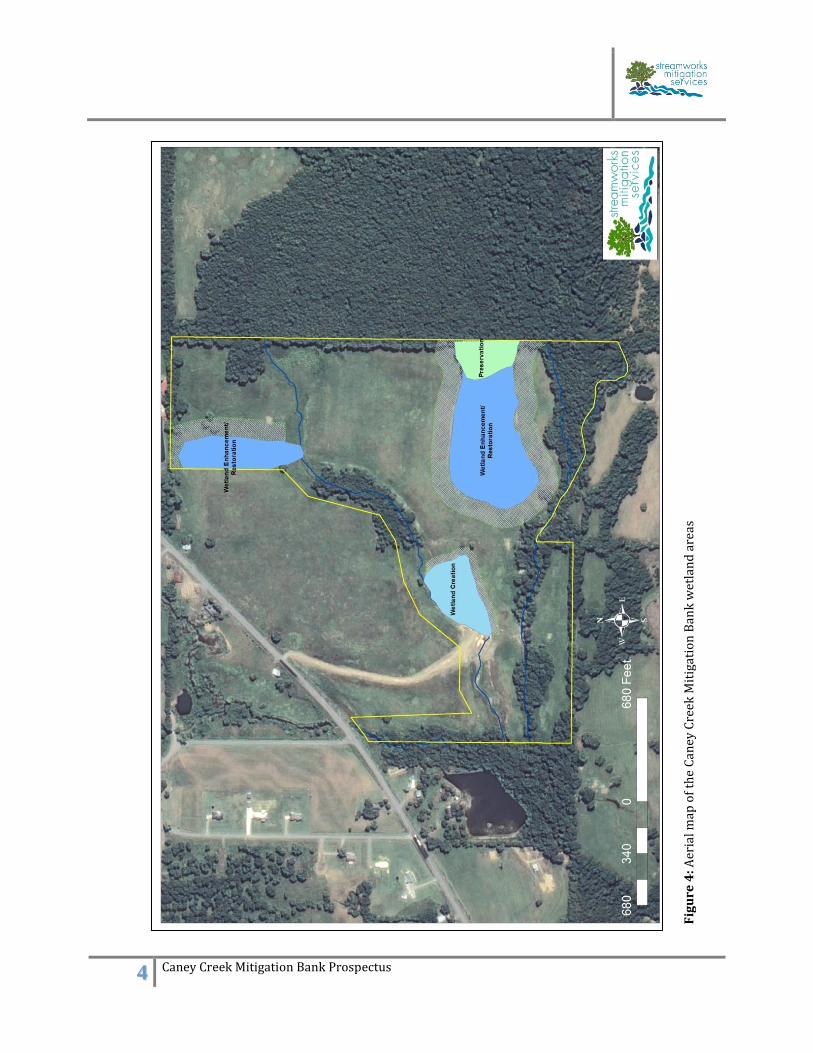
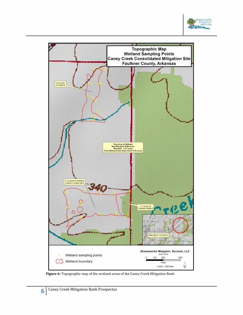
The wetland activities will be a combination of restoration, buffer enhancement, and creation
on 28-acres of the site (Figure 4). There are two separate wetland restoration areas totaling
approximately 9.09 acres. The three-acre shale pit will be converted into a shallow wetland in
conjunction with the restoration of Reach C. Soils will be replaced and planted with
appropriate vegetation grown within the Streamworks Mitigation Services, LLC greenhouse
operation. The 1.37-acre Pin oak (Quercus palustris) flat located along the western boundary is
only slightly impaired and will be used for preservation.
Riparian Buffer
The entire site will be revegetated with native hardwood and herbaceous species with a density
of 302 stems/acre. A minimum 100-ft buffer will be maintained where property boundaries
allow. During the dormant season, Black willow (Juglans nigra), Alder (Alnus serrulata) and
Sycamore (Platanus occidentalis) stakes will be placed along the streambanks of the
intermittent and perennial channels. Seedlings will be planted in winter 2013-2014. The
floodplain zone will consist of the appropriate floodplain species, while the upland buffers will
consist of an oak-hickory mix with a representative understory if available (Table 4).
Table 4: Vegetation planting list for the Caney Creek Mitigation Bank
Common Name Scientific Name
Pin Oak Quercus palustris
Nutall Oak Quercus phellos
Willow Oak Quercus nuttallii
Black Walnut Juglans nigra
River Birch Betula nigra
Black Willow Salix nigra
Northern Red Oak Quercus rubra
White Oak Quercus alba
Flowering Dogwood Cornus florida
Box Elder Acer negundo
Wild Plum Prunus mexicana
Spicebush Lindera benzoin
Persimmon Diospyros virginiana
Black Gum Nyssa sylvatica
Alder Alnus serrulata
Elderberry Sambucus canadensis
Sycamore Platanus occidentalis
Hackberry Celtis occidentalis
6 Caney Creek Mitigation Bank Prospectus
7.0 Operation and Maintenance Plan
The project will be developed and implemented by Streamworks Mitigation Services, LLC with
oversight from Southwestern Energy Company. This is the sixth mitigation project Southwestern
Energy Company has developed with Streamworks for a total of 750 acres under conservation
easement with restoration and protection of over nine miles of streams. The site will be maintained
and monitored annually by Streamworks with reports submitted to the LRD for review.
8.0 Performance Standards
The overall performance standard and success criteria for the stream and wetland compensation is
demonstrable ecological lift within the project site. This lift will be measured through biological
surveys and reinforced through geomorphic monitoring, vegetative monitoring, and qualitative
stability indices. The performance standards will follow guidelines from the Compensatory
Mitigation Standard Operating Procedure (USACE 2006) and approved by the IRT and LRD.
9.0 Monitoring Requirements
Monitoring will be conducted by Streamworks Mitigation Services, LLC, for five years or until the
LRD determines the project is complete. Permanent cross-sections and longitudinal feature
parameters will be established following the guidelines set forth in the Little Rock Stream Method
(USACE 2002). This data will be collected and analyzed annually to determine if success criteria
are being met.
10.0 Long-term Management An escrow account will be established by Streamworks Mitigation Services, LLC to adequately
service long-term management goals. These long-term management activities will be conducted by
Streamworks. At a later time, and with approval from the LRD, Streamworks may designate a long-
term steward or an entity to act as steward.
11.0 Adaptive Management Upon a determination by USACE that performance standards have not been met or the
compensatory mitigation project is not on track to meet those standards, the monitoring period
may be extended. USACE may also revise monitoring requirements when remediation and/or
adaptive management are required. In the event that the success criteria have not been met,
remedial action will be taken within 90 days.
12.0 Financial Assurances Financial assurances will be provided by Southwestern Energy Company in the form of an escrow
agreement with Streamworks Mitigation Services, LLC.
7 Caney Creek Mitigation Bank Prospectus
References AWAP (2004) Ecoregions of Arkansas , Arkansas Wildlife Action Plan USEPA and USACE (2008) Compensatory Mitigation for Losses of Aquatic Resources, Final Rule. Regulation 40CFR Part 230 USACE (2002) Compensatory Mitigation Standard Operating Procedure, Department of Army, Regulatory Branch, Charleston District. USACE (2005) Compensatory Mitigation Standard Operating Procedure, Department of Army, Regulatory Branch, LRD. USACE (2011) Little Rock District Stream Method. Department of the Army, Little Rock District. USEPA (1972) Clean Water Act, CWA. 33 U.S.C. §1251 et seq. Regulation 40 C.F.R. pts. 104-149. Charleston Regulatory Division - Standard Operating Procedure Issued September 19, 2002 Compensatory Mitigation

APPENDIX A Figures
1 Caney Creek Mitigation Bank Prospectus
Fig
ure
1:
Vic
init
y M
ap f
or
the
Can
ey C
reek
Mit
igat
ion
Ban
k
2 Caney Creek Mitigation Bank Prospectus
Fig
ure
2:
To
po
grap
hic
map
of
the
Can
ey C
reek
Mit
igat
ion
Ban
k (
USG
S)
3 Caney Creek Mitigation Bank Prospectus
Fig
ure
3: A
eria
l map
of
the
Can
ey C
reek
Mit
igat
ion
Ban
k
4 Caney Creek Mitigation Bank Prospectus
Fig
ure
4: A
eria
l map
of
the
Can
ey C
reek
Mit
igat
ion
Ban
k w
etla
nd
are
as
5 Caney Creek Mitigation Bank Prospectus
Figure 5: Wetland delineation sampling points for the Caney Creek Mitigation Bank
6 Caney Creek Mitigation Bank Prospectus
Figure 6: Topographic map of the wetland areas of the Caney Creek Mitigation Bank
7 Caney Creek Mitigation Bank Prospectus
Figure 7: Wetland area soils map of the Caney Creek Mitigation Bank
8 Caney Creek Mitigation Bank Prospectus
Fig
ure
8: S
oil
s m
ap o
f th
e C
an
ey C
reek
Mit
igat
ion
Ban
k (
NR
CS
20
11
)
9 Caney Creek Mitigation Bank Prospectus
Fig
ure
9: P
ho
to p
oin
t lo
cati
on
s fo
r th
e C
aney
Cre
ek M
itig
atio
n B
ank
tak
en A
pri
l 10
th, 2
01
2
10 Caney Creek Mitigation Bank Prospectus
Fig
ure
10
: Pro
po
sed
pri
mar
y a
nd
sec
on
dar
y s
erv
ice
area
s fo
r th
e C
an
ey C
reek
Mit
igat
ion
Ban
k

APPENDIX B Site Photographs
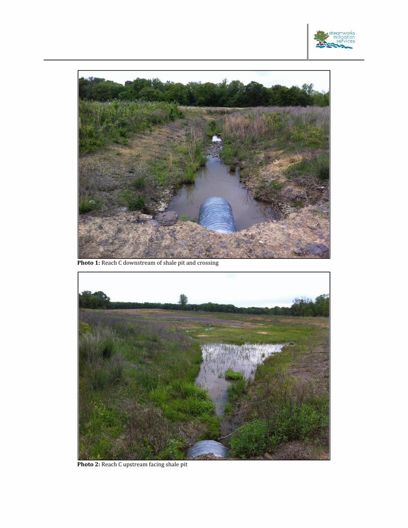
Photo 1: Reach C downstream of shale pit and crossing
Photo 2: Reach C upstream facing shale pit
2 Caney Creek Mitigation Bank Prospectus
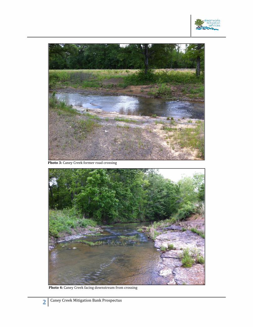
Photo 3: Caney Creek former road crossing
Photo 4: Caney Creek facing downstream from crossing
3 Caney Creek Mitigation Bank Prospectus
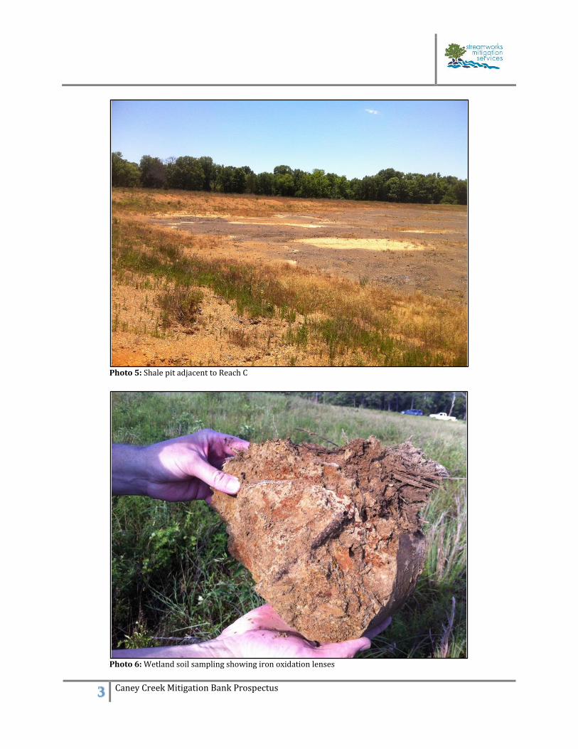
Photo 5: Shale pit adjacent to Reach C
Photo 6: Wetland soil sampling showing iron oxidation lenses