Embed Size (px)
Citation preview

CAPACITY
Project No SRC/EOS/CAPACITY
Issue 5.0 Page 1 of 35
1
CAPACITY – WP2300
May (25th) 2005
Report
for ESA SRC/EOS/CAPACITY/05
Prepared by EOS group, University of Leicester
Paul Monks
John Remedios Gary Corlett Simon Good

CAPACITY
Project No SRC/EOS/CAPACITY
Issue 5.0 Page 2 of 35
2
Table of Contents 1. Introduction – Aims and Objectives...................................................................... 3 2. System Assessment .............................................................................................. 4
2.1 Ozone and UV.................................................................................................... 4 2.1.1 System Overview............................................................................................. 4 2.1.2 Current Planned/Missions ................................................................................ 4 2.1.3 System Concept............................................................................................... 7 2.1.4 Future requirements ........................................................................................11 2.2 Regional Air Quality .........................................................................................13 2.2.1 System Overview............................................................................................14 2.2.2 Current Planned/Missions ...............................................................................15 2.2.3 System Concept..............................................................................................16 2.2.4 Future Requirements.......................................................................................20 2.3 Climate..............................................................................................................23 2.3.1 System Overview............................................................................................23 2.3.2 Current Planned/Missions ...............................................................................23 2.3.3 System Concept..............................................................................................25 2.3.4 Future Requirements.......................................................................................34
3. Conclusion ..........................................................................................................34 3.1 Recommendations .............................................................................................35

CAPACITY
Project No SRC/EOS/CAPACITY
Issue 5.0 Page 3 of 35
3
CAPACITY – WP2300. Paul S. Monks, John J. Remedios, Simon A. Good, Gary K. Corlett Earth Observation Science Group, Departments of Physics and Chemistry University of Leicester, LE1 7RH, UK.
1. Introduction – Aims and Objectives The objective of this work package within the CAPACITY study is to
– Identify the requirements for integrated observing system focussed on Earthwatch target applications
The aims of this work package within the CAPACITY study are – To provide a vision of integrated observing systems for Earthwatch, – To identify ground-based, airborne and space-based components to the system that
would add value (information) to observables directly required/measured by existing/potential new systems,
– To consider the most pressing application questions and make recommendations as to potential elements of appropriate observing systems.
The report is ordered in terms of a system assessment for each of the selected application areas within the study namely
a) Ozone and UV (§2.1) b) Air Quality (§2.2) c) Climate (§2.3)
The user requirements have been taken from the analysis of WP2100, based on the analysis of WP1000, and the quantitative assessment of instrument capabilities vs requirements was performed in WP2200. In this prior workpackage, WP2200, the assessment first delivers an appraisal of the missions which currently exist, which exist in the future or which are planned to operate, in particular beyond 2008. However, although the instruments analysed are specific designs, they can be thought of as being representative of that class of instrument e.g. SCIAMACHY, ultra-violet/visible, nadir class, and much of the broader analysis in this workpackage points towards these broader instrument classes; inherently this identification also points towards instrument heritage which is an important factor in advancing instruments from research to operational missions. An important aspect of the work reported here is the use of hierarchical diagrams to reflect the variety of instrument types that can contribute aspects of the required information for atmospheric operational services. These diagrams display a “hierarchy of capability” approach illustrating how designs of mission systems could improve in performance from minimum specification to maximum specification. Departures from the diagonal line shown on each diagram indicate qualitatively the extent to which the instrument type identified is not fully compliant with the user requirements. Thresholds for “significant Capacity capability” for operational missions are identified as well as priority instrument performances. In order to satisfy Capacity requirements for
CAPACITY
Project No SRC/EOS/CAPACITY
Issue 5.0 Page 4 of 35
4
a particular mission concept, missions should have sufficient specification to meet both the threshold requirements and to address the priority instrument performances.
2. System Assessment
2.1 Ozone and UV Stratospheric ozone and surface ultra-violet (UV) radiation has been of concern for research investigations and analysis of long term trends since the 1970s. The elements of the observing system concerned directly with stratospheric ozone, although more complicated in terms of the range of atmospheric constituents required, are more mature than those of the corresponding U/V system. The differences lie partly in the more highly variable nature of the factors that control U/V radiation compared to those that are important for ozone. It is also true that integration of relevant observations is more demanding for U/V radiation than for ozone and much work remains to be performed in this area. Since U/V radiation depends fundamentally on knowledge of ozone, principally total column ozone, the ozone system is considered first followed by the equivalent exercise for U/V radiation.
2.1.1 System Overview The stratospheric ozone system can be divided into four components:
1. Monitoring of total ozone column and ozone profiles 2. Monitoring of emissions of ozone depleting substances, their distributions in the
stratosphere and the total chlorine loading of the stratosphere 3. Measurement of parameters which are markers for severe polar ozone loss. 4. Measurement of variables that that are significant for our understanding of ozone changes
due to chemistry or changes in dynamical circulation. Systems are likely to employ a combination of ground-based in situ and remote sensing instruments, ozonesondes, and satellites. Aircraft instrumentation, deployed on regular commercial flights, has also made and could continue to deliver a useful contribution.
2.1.2 Current Planned/Missions In this section, we discuss the implications of the analyses of WP2200 for operational monitoring systems that might operate in the future. We concentrate on the space segments of the system. A1S
CAPACITY
Project No SRC/EOS/CAPACITY
Issue 5.0 Page 5 of 35
5
A1S requires measurement of ozone columns and ancillary parameters for the determination of ultra-violet radiation at the surface. A number of instrument types fulfil the requirements for ozone columns, most of which are nadir-viewing UV/VIS instruments e.g. OMPS, or GOME-2 (which only partially meets the horizontal resolution requirement). MIR instruments such as TES may also be utilised. Nadir-viewing UV/VIS instruments SCIAMACHY and GOME-2, however, are required to provide solar irradiance and aerosol products appropriate to ultra-violet radiation. The space component for A1 is well covered by the existing Metop mission providing a heritage of UV-visible measurements of total ozone through GOME-2. In addition, the IASI instrument could provide total ozone column information as a back-up although a quantitative link to the historical ozone record would have to be made; it is interesting to note that ATOVS ozone columns now agree very well on with TOMS and GOME in the tropics (a weekly averaged basis). GOME-2 delivers necessary information for surface UV applications including UV spectral solar irradiance, UV aerosol optical depth and UV aerosol absorption optical depth. The aerosol parameters from GOME-2 meet the threshold requirements for protocol monitoring but there would be an advantage to the deployment of a new UV-visible instrument with better spatial resolution (<? km) for the aerosol. A2S The requirements for near real-time ozone information build on the essential components required to satisfy A1, protocol monitoring, by adding specifications for vertical resolution of ozone (<2 km). In addition, it is desirable but not mandatory to perform measurements for a number of trace gases and particles which control ozone chemistry. The requirement for ozone profiles with information in the upper troposphere suggests a limb mid-infrared or microwave instrument; UV-visible instruments do not provide good information in the upper troposphere (UT) but do provide good information in the lower stratosphere (LS) and above. A limb mid-infrared (MIR) instrument can deliver information on a large number of species. Amongst its key measurements for NRT are the ability to observe PSC occurrence, HNO3, enhanced ClO in the LS and MS, and tracers such as CH4 and N2O; SF6 is also measured although not with the required uncertainty. Hence existing limb MIR instruments can deliver both information on heterogeneous processes and on tracers for transport characterisation. In terms of instrumentation, both existing limb MIR Fourier transform spectrometers, such as MIPAS, and radiometers, such as HIRDLS, can meet the majority of the threshold and many of the target requirements; we assume here that operational products for MIPAS can reach close to required vertical resolutions of 3 km without substantial degradation in performance (uncertainty). However, only radiometers of the HIRDLS-type currently achieve required vertical resolution and horizontal resolution for all species. Hence to meet all requirements, a modification to a MIPAS-type instrument is required for it to achieve 2 km vertical resolution and better horizontal coverage; uncertainty performance would need to be maintained.

CAPACITY
Project No SRC/EOS/CAPACITY
Issue 5.0 Page 6 of 35
6
Microwave instruments appear best suited to provide a broad range of complementary species (ClO, HCl and N2O measurements are particularly useful). The unique attributes of microwave measurements are the ability to deliver information in the presence of clouds (e.g. polar stratospheric clouds) and to observe O3, H2O, N2O, HNO3 and HCl. The MIR instruments can measure these species, except for HCl and not in the presence of the thickest PSCs; the latter probably does not matter for NRT purposes since it is the detection of PSCs and subsequent denitrification that matters. Therefore the key aspect for use of existing microwave instruments lies in the potential ability to detect HCl. Aerosol absorption optical depths are an important measurement for NRT applications and could be met by SAGE III, for example. However, it is also the case that infra-red occultation and infra-red emission measurements could provide information although extinction measurements would not be sensitive to post-Pinatubo “background” aerosol. From remaining measurements, it is likely that the chief issue remaining is the measurement of LS NO2. A UV-visible instrument would be most suited to this and existing OSIRIS-type observations can provide the required uncertainty, albeit preferably with an improvement in horizontal resolution. A3S A3S is very similar to A2S in broad outline. The major difference now is that measurements of trace gases and particles (PSCs) are now essential to deliver a significant Capacity capability. Metop measurements can only provide a starting point through GOME-2 measurements. IASI measurements of UT H2O are complementary to GOME-2 data and provide further weight to the planned suite of operational atmospheric observations. However for A3S, a limb instrument component is clearly missing but there are existing instruments which fulfil many of the requirements. A limb mid-infrared (MIR) instrument can deliver information on a large number of species. Amongst its key measurements for NRT are the ability to observe PSC occurrence, HNO3, enhanced ClO in the LS and MS, and tracers such as CH4 and N2O; SF6 is also measured although not with the required uncertainty. Hence existing limb MIR instruments can deliver both information on heterogeneous processes and on tracers for transport characterisation. The limb-viewing MIR instrument, HIRDLS, already meets requirements for H2O, N2O, CH4, PSC occurrence, SO2, CFC-11, CFC-12 and HNO3, and ClONO2 for part of the height range. TES or MIPAS (also limb-viewing MIR) will cover molecules such as SO2, but improved capabilities are required e.g. 3 km vertical resolution and better than 50% uncertainty for SO2. Similarly, SCIAMACHY (limb UV/VIS) is of use for O3, NO2 and BrO, but requires better horizontal and vertical resolution for the latter. Microwave instruments could provide complementary measurements of O3, ClO (MS), HNO3, H2O, tracers, and HCl. Occultation instruments could be more important in A3S than A2S because they might measure stratosphere aerosol, HCl and CO with good precision. Overall, the instrument performances and requirements for A2 and A3 are similar. The chief differences lie in the addition of (H)CFCs and BrO, measured by mid-MIR and UV/VIS instruments respectively, with some increased attraction to solar occultation instruments.
CAPACITY
Project No SRC/EOS/CAPACITY
Issue 5.0 Page 7 of 35
7
Some improvements in MIR instruments performance may be necessary to achieve uncertainty requirements for CH3Cl and SO2 enhanced. It is not clear how HBr and BrONO2 are addressed with existing instrumentation. A1G Existing in-situ measurements fulfil the majority of the requirements for surface measurements; FTIR occultation provides total column O3, CFC-11, CFC-12, HCFC-22. However, for historical continuity and accuracy, we would expect that Dobson/Brewer measurements would continue to be made. Measurements of CFC-113 and CH3CCl3 are missing. A2G A range of instruments is useful for these measurements; DIAL, UVV DOAS, MWAVE radiometer and FTIR occultation all uniquely provide at least one of the measurements. A3G Again, a combination of in-situ, MWAVE, FTIR and UVV DOAS are all used for the measurements that can be made. Essentially, existing systems for A1 and A2 meet and can contribute to aspects of A3. Vertical resolution is desirable – balloon and aircraft measurements may be suitable techniques to cross the gap.
2.1.3 System Concept An outline system concept for stratospheric ozone and U/V radiation is given in Figure 2.1.1. It consists of the following key elements as linkages.
a) Ground-based measurements for O3 and (H)CFCs for trends in ozone and chlorine loading (largely based on the Network for Detection of Stratospheric Change).
b) Existing satellite observations supplemented by a suggested annual balloon programme for total chlorine (Cly) and total nitrogen (NOy).
c) Dedicated satellite observation d) An assessment system and U/V monitoring/forecast system incorporating both direct
analysis of the observations, e.g. for trends, and data assimilation systems. The analysis here largely concentrates on the space-borne component of the required systems. Analysis of the input information shows clearly that there is an increasing system complexity from A1 to A3. MetOP and NPOESS will provide a backbone for these systems but dedicated measurements are also necessary for A2 and A3 in particular. Figure 2.1.1 illustrates the broad concept of these systems.

CAPACITY
Project No SRC/EOS/CAPACITY
Issue 5.0 Page 8 of 35
8
Figure 2.1.1 – System concept for UV/Ozone monitoring system The following analysis and diagrams describe space system concepts for the three cases A1S-A3S. On each diagram we indicate how each advance in instrumentation improves the performance of the system from one that meets the minimum specification to concepts that could potentially meet the full specification. We also make recommendations for study of new instrument concepts in WP3000. A1S Mission concept:
� Metop (GOME-2), ideally with new nadir UV aerosol instrument at high spatial resolution � Re-visit time and global coverage suggests LEO implementation if a new nadir instrument is
implemented. Recommendations for WP3000:
� New nadir UV aerosol instrument with 10 km horizontal spatial resolution should be studied but with low priority.
� Further information on measurement of UV surface albedo would be good.
CAPACITY
Project No SRC/EOS/CAPACITY
Issue 5.0 Page 9 of 35
9
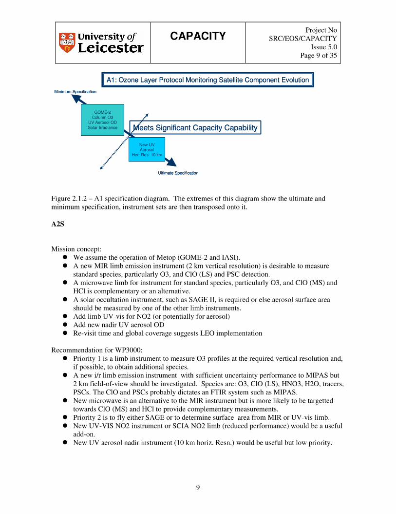
A1: Ozone Layer Protocol Monitoring Satellite Component Evolution
Ultimate Specification
Minimum Specification
GOME-2Column O3
UV Aerosol ODSolar Irradiance
New UVAerosol
Hor. Res. 10 km
Meets Significant Capacity Capability
A1: Ozone Layer Protocol Monitoring Satellite Component Evolution
Ultimate Specification
Minimum Specification
GOME-2Column O3
UV Aerosol ODSolar Irradiance
New UVAerosol
Hor. Res. 10 km
Meets Significant Capacity Capability
Figure 2.1.2 – A1 specification diagram. The extremes of this diagram show the ultimate and minimum specification, instrument sets are then transposed onto it. A2S Mission concept:
� We assume the operation of Metop (GOME-2 and IASI). � A new MIR limb emission instrument (2 km vertical resolution) is desirable to measure
standard species, particularly O3, and ClO (LS) and PSC detection. � A microwave limb for instrument for standard species, particularly O3, and ClO (MS) and
HCl is complementary or an alternative. � A solar occultation instrument, such as SAGE II, is required or else aerosol surface area
should be measured by one of the other limb instruments. � Add limb UV-vis for NO2 (or potentially for aerosol) � Add new nadir UV aerosol OD � Re-visit time and global coverage suggests LEO implementation
Recommendation for WP3000:
� Priority 1 is a limb instrument to measure O3 profiles at the required vertical resolution and, if possible, to obtain additional species.
� A new i/r limb emission instrument with sufficient uncertainty performance to MIPAS but 2 km field-of-view should be investigated. Species are: O3, ClO (LS), HNO3, H2O, tracers, PSCs. The ClO and PSCs probably dictates an FTIR system such as MIPAS.
� New microwave is an alternative to the MIR instrument but is more likely to be targetted towards ClO (MS) and HCl to provide complementary measurements.
� Priority 2 is to fly either SAGE or to determine surface area from MIR or UV-vis limb. � New UV-VIS NO2 instrument or SCIA NO2 limb (reduced performance) would be a useful
add-on. � New UV aerosol nadir instrument (10 km horiz. Resn.) would be useful but low priority.

CAPACITY
Project No SRC/EOS/CAPACITY
Issue 5.0 Page 10 of 35
10
SCIA LimbNO2
GOME-2Column O3UV Aerosol
Solar IrradianceIASI UT H2O
A2: Ozone Layer Near Real Time Data Satellite Component Evolution
Ultimate Specification
Minimum Specification
OSIRISNO2
NEW UV VISLimb NO2
Ver. Res. 2 km, 50 km
HIRDLSO3
SCIA LimbO3
MLSO3 NEW
MICROWAVEor IR or UV Limb
O3Ver. Res. 2 km, 50 km
Inc. UT
MIPASO3
CURRENTIR
A2 SPECIES
NEWIR
A2 SPECIESVer. Res. 2km, 50 km
NEWMICROWAVEA2 SPECIES
Ver. Res. 2km, 50 km
CURRENTMICROWAVEA2 SPECIES
Meets SignificantCapacity Capability
New AerosolRev. Time6-24 hours
A2 Species:
ClO (LS), HNO3, H2O, tracers
MIR: + PSCs
Microwave: + HCl + ClO (MS)
SAGE equivalent Strat. Aerosol
PRIORITY
SCIA LimbNO2
GOME-2Column O3UV Aerosol
Solar IrradianceIASI UT H2O
A2: Ozone Layer Near Real Time Data Satellite Component Evolution
Ultimate Specification
Minimum Specification
OSIRISNO2
NEW UV VISLimb NO2
Ver. Res. 2 km, 50 km
HIRDLSO3
SCIA LimbO3
MLSO3 NEW
MICROWAVEor IR or UV Limb
O3Ver. Res. 2 km, 50 km
Inc. UT
MIPASO3
CURRENTIR
A2 SPECIES
NEWIR
A2 SPECIESVer. Res. 2km, 50 km
NEWMICROWAVEA2 SPECIES
Ver. Res. 2km, 50 km
CURRENTMICROWAVEA2 SPECIES
Meets SignificantCapacity CapabilityMeets Significant
Capacity Capability
New AerosolRev. Time6-24 hours
A2 Species:
ClO (LS), HNO3, H2O, tracers
MIR: + PSCs
Microwave: + HCl + ClO (MS)
SAGE equivalent Strat. Aerosol
PRIORITY
Figure 2.1.3 – A2 specification diagram. The extremes of this diagram show the ultimate and minimum specification, instrument sets are then transposed onto it. A3S Mission concept:
� Metop (GOME-2 and IASI) � Add SAGE or include aerosol surface area in one of the limb instruments below. � Add infra-red instrument: either MIPAS or a new instrument with preferably 2 km vertical
resolution. It should measure standard species plus ClO (LS), PSCs, (H)CFCs, ClONO2. � As a complementary measurement or as an alternative, elements of existing microwave
(SMR type) or a new instrument with preferably 2 km vertical resolution could be implemented for standard species and ClO (MS), SO2 (enh.) and HCl.
� Add limb UV-vis for NO2 and BrO. � Add new UV-nadir for aerosol OD � Re-visit time and global coverage suggests LEO implementation
Recommendation for WP3000:
� Priority 1 is to choose to fly either SAGE or to determine surface area from i/r or UV-vis. � Priority 2 is consider whether new i/r with at least similar uncertainty performance to
MIPAS but 2 km field-of-view for O3 is cost-effective. Species are: O3, ClO (LS), HNO3,

CAPACITY
Project No SRC/EOS/CAPACITY
Issue 5.0 Page 11 of 35
11
H2O, (H)CFCs, tracers, PSCs. Measurements of ClO, PSCs, HCFC-22 probably dictate an FTIR system such as MIPAS.
� New microwave with 2 km vert resn. is an alternative to IR instrument but is more likely to be targetted towards ClO (MS) and HCl to provide complementary measurements.
� A new UV-VIS NO2 and BrO instrument or SCIA NO2 and BrO limb (reduced performance) would be a useful add-on.
� New UV aerosol nadir instrument (10 km horiz. resn.) would useful but low priority.
A3: Ozone Layer Scientific Assessment Satellite Component Evolution
SCIA LimbBrO, NO2
GOME-2Column O3UV Aerosol
Solar IrradianceIASI UT H2O
Ultimate Specification
Minimum Specification
OSIRISNO2
HIRDLSO3
SCIA LimbO3
MLSO3
MIPASO3 Meets Significant
Capacity Capability
A3 Species:
ClO (LS), HNO3, H2O, tracers
MIR: + PSCs, (H)CFC’s, ClONO2
Microwave: + HCl, ClO (MS), SO2 (enh)
SAGE equivalentStrat. Aerosol
CURRENTIR
A3 SPECIES
CURRENTMICROWAVEA2 SPECIES
NEWIR or MICROWAVE
or UV LimbO3
Ver. Res. 2 km, 50 kmInc. UT
NEW UV VISLimb BrO,NO2Ver. Res. 2 km
NEWIR
A3 SPECIESVer. Res. 2km
NEWMICROWAVEA3 SPECIESVer. Res. 2km
New AerosolRev. Time6-24 hours
Figure 2.1.4 – A3 specification diagram. The extremes of this diagram show the ultimate and minimum specification, instrument sets are then transposed onto it.
2.1.4 Future requirements Table 2.1.1 lists the consolidated requirements for ozone/UV satellite measurements. The table is colour coded to reflect how well current/planned systems meet the requirements. The order of table reflects the importance of the measurement to the achievement of the system.

CAPACITY
Project No SRC/EOS/CAPACITY
Issue 5.0 Page 12 of 35
12
Table 2.1.1 - Consolidated requirements for ozone satellite measurements (data merge of all satellite requirements from WP2100)
Requirement Data Product
Height Range
Horizontal resolution (km)
Vertical resolution (km)
Revisit Time (hours)
Uncertainty
O3 UT LS MS
US+M Troph column Total column
20 / 100 50 / 100 100 / 200 100 / 200 10 / 50 50 / 100
05 / 2 0.5 / 2 2 / 3 3 / 5 -- --
6 / 24*3 6 / 24*3 6 / 24*3 12 / 24*7 6 / 24*3 24 ([6]) / 24*3
20% 20 [10] % 20% 20% 20% 3 [10] %
Spectral UV surface albedo
Surface 10 / 50 -- 24 ([6]) / 24*3 0.1
Spectral UV solar irradiance
TOA -- -- Daily / Monthly 25 ([2]) %
UV AOD Total column 10 / 50 -- 24 ([6]) / 24*3 0.1 UV aerosol absorption OD
Total column 10 / 50 -- 24 ([6]) / 24*3 0.02
Strat AOD LS MS
Stratosphere
50 / 100 50 / 200 50 / 200
0.5 / 2 1 / 3 --
6 / 24*3 12 / 24*7 6 / 24*7
0.05 0.05 0.05
ClO LS
MS
Stratosphere
50 / 200 [100] 100 / 200 50 / 200
2 [1] / part. column [3] 2 / part. column [3] --
24 [1]2 / 24*7 [24*3] 24 [12] / 24*7 24[12] / 24*7
50 [30] % 50 [30] % 50 [30] %
NO2 LS
MS
Stratosphere
50 / 200 [100] 100 / 200 50 / 200
2 [1] / part. column [3] 2 / part column [3] --
24 [12] / 24*7 [24*3] 24 [12] / 24*7 24 [12] / 24*7
20 [30] % 20 [30] % 20 [30] %
PSC occurrence LS 50 / 100 0.5 [1] / 2 [3] 6 [12] / 24*3 <10% mis-assignments SF6 LS
MS 50 / 200 100 / 200
1 / 2 2 / 3
6 / 24*3 12 / 24*7
10% 10%
CO2 LS MS
50 / 200 100 / 200
1 / 2 2 / 3
6 / 24*3 12 / 24*7
10% 10%
H2O UT LS MS US
Stratosphere
20 / 100 50 / 100 100 / 200 100 / 200 50 / 200
0.5 / 2 1 / 2 [3] 2 / 3 3 / 5 --
6 / 24*3 6 [12]/ 24*3 12 / 24*7 12 / 24*7 12 / 24*7
20% 20 [15] % 20 [15] % 15% 15%
N2O LS MS US
Stratosphere
50 / 100 50 [100] / 200 50 [100] / 200 50 / 200
1 / 2 [3] 2 / 3 3 / 5 --
6 [12] / 24*3 12 / 24*7 12 / 12 / 24*724*7
20 [10] % 20 [10] % 20 [10] % 10%
CH4 LS MS US
Stratosphere
50 / 200 100 / 200 100 / 200 50 / 200
1 / 2 [3] 2 / 3 3 / 5 --
6 / 24*3 12 / 24*7 12 / 24*7 12 / 24*7
20 [10] % 20 [10] % 10% 10%
HCl LS
MS Stratosphere
Co-located with O3 [50 / 100] 100 / 200 50 / 200
Co-located with O3 [1 / 3] 2 / 3 --
Co-located with O3 [12 / 24*3] 12 / 24*7 12 / 24*7
20 [30] % 30% 30%
HNO3 LS
MS Stratosphere
Co-located with O3 [50 / 100] 100 / 200 50 / 200
Co-located with O3 [1 / 3] 2 / 3 --
Co-located with O3 [12 / 24*3] 12 / 24*7 12 / 24*7
20 [30] % 30% 30%
CO UT+LS Co-located with O3 Co-located with O3 Co-located with O3 20% CFC-11 LS
MS Stratosphere
50 / 100 100 / 200 50 / 200
1 / 3 2 / 3 --
12 / 24*3 12 / 24*7 12 / 24*7
5% 5% 5%
CFC-12 LS MS
Stratosphere
50 / 100 100 / 200 50 / 200
1 / 3 2 / 3 --
12 / 24*3 12 / 24*7 12 / 24*7
5% 5% 5%
HCFC-22 LS MS
Stratosphere
50 / 100 100 / 200 50 / 200
1 / 3 2 / 3 --
12 / 24*3 12 / 24*7 12 / 24*7
20% 20% 20%
BrO LS MS
Stratosphere
50 / 100 100 / 200 50 / 200
1 / 3 2 / 3 --
12 / 24*3 12 / 24*7 12 / 24*7
30% 30% 30%
Aerosol surface LS 50 / 100 1 / 3 12 / 24*3 100%

CAPACITY
Project No SRC/EOS/CAPACITY
Issue 5.0 Page 13 of 35
13
density MS Stratosphere
100 / 200 50 / 200
2 / 3 --
12 / 24*7 12 / 24*7
100% 100%
HBr LS MS
Stratosphere
50 / 100 100 / 200 50 / 200
1 / 3 2 / 3 --
12 / 24*3 12 / 24*7 12 / 24*7
30% 30% 30%
BrONO2 LS MS
Stratosphere
50 / 100 100 / 200 50 / 200
1 / 3 2 / 3 --
12 / 24*3 12 / 24*7 12 / 24*7
30% 30% 30%
Ch3Cl LS MS
Stratosphere
50 / 100 100 / 200 50 / 200
1 / 3 2 / 3 --
12 / 24*3 12 / 24*7 12 / 24*7
30% 30% 30%
Ch3Br LS MS
Stratosphere
50 / 100 100 / 200 50 / 200
1 / 3 2 / 3 --
12 / 24*3 12 / 24*7 12 / 24*7
30% 30% 30%
SO2 enhanced LS MS
Stratosphere
50 / 100 100 / 200 50 / 200
1 / 3 2 / 3 --
12 / 24*3 12 / 24*7 12 / 24*7
5% 5% 5%
Volcanic aerosol LS MS
Stratosphere
50 / 100 100 / 200 50 / 200
1 / 3 2 / 3 --
12 / 24*3 12 / 24*7 12 / 24*7
50% 50% 50%
(A2S- requirement), [A3S – requirement] Requirements can be met by current instruments Some requirements met No requirements met In summary, what is required is
• Limb instrument(s) that measures a range of trace species and complements the Nadir measurements made on Metop/NPOESS.
• Implementation options include a limb-MIR, in combination with a limb microwave instrument in order to meet the optimal number of requirements. However, a single instrument of either type would provide significant aspects of the system.
• A limb UV/VIS system to measure NO2 and potentially BrO would be invaluable. • Ground-based systems provide a total ozone verification system, validation and source gas
monitoring, but cannot provide the range of height resolved information required.
2.2 Regional Air Quality Air quality (AQ), i.e. gaseous pollutants and particulate matter impacts from the urban and regional scale to the global scale. AQ on these scales has implications for a number of contemporary issues including:
• Human health, (e.g. respiratory, cancer, allergies…),
• Eco systems (e.g. crop yields, acidification / eutrophication of natural ecosystems),
• National heritage (e.g. buildings),
• Regional climate (aerosol and ozone exhibit a strong regionality in climate forcing).
Primary pollutants (e.g. CO, SO2, NO2 and volatile organic compounds (VOCs) - The primary pollutants are those directly emitted into the atmosphere from a range of anthropogenic sources, such as transportation, industrial processes and agriculture. Some VOCs and NOx have concomitant biogenic sources.
Oxidants -Owing to its toxicity for plants, animals and humans, and its importance as a green house gas, strategies were developed in the US and later in Europe to reduce the levels of ozone in the
CAPACITY
Project No SRC/EOS/CAPACITY
Issue 5.0 Page 14 of 35
14
troposphere both during photochemical episodes and in general. These strategies are not as straightforward as for primary pollutants because ozone is not emitted into the atmosphere but is formed in situ from a complex mixture of precursor pollutants (CO, VOCs and NOx) under the action of ultra-violet radiation from the sun. Therefore ozone abatement strategies must be directed towards lowering the emissions of ozone precursors, NOx and VOCs. The non-linear influence of NOx and VOC emissions on ozone formation and destruction, the influence of transport and dispersion processes on the atmospheric distribution of chemical compounds, and the vast differences in their chemical lifetimes require thorough scientific understanding for the design of successful abatement strategies.
Aerosol – Aerosols affect life on earth in several ways. They play an important role in the climate system; the effect of aerosols on the global climate system is one of the major uncertainties of present climate predictions. They play a major role in atmospheric chemistry and hence affect the concentrations of other potentially harmful atmospheric constituents, e.g. ozone. They constitute an important controlling factor for the radiation budget, in particular in the UV-B part of the spectrum. At ground level, they can be harmful, even toxic, to man, animals, and plants. Because of the adverse effects that aerosols can have on human life, it is necessary to achieve an advanced understanding of the processes that generate, redistribute, and remove aerosols within the atmosphere.
The user requirements with respect to AQ have been detailed in the WP1000 report.
2.2.1 System Overview In general terms, the system should be able to for key policy relevant gas-phase and particulate species
• Establish pollutant concentrations, deposition, emissions and transboundary fluxes on the regional scale, including intercontinental transport and boundary conditions for urban AQ,
• Identify trends in time, • Assess the success of international abatement strategies for atmospheric pollutants, • Improve the understanding of atmospheric chemical and physical processes and provide data
for the validation of models, • Provide data which, in conjunction with models, are the basis for the assessment of
environmental problems related to air pollution, • Provide measurements required to assess the effects of atmospheric pollutants,
(adapted from EMEP observation strategy). The likely information requirements for a rationale air quality system are given in Figure 2.1.1. Systems are likely to employ a combination of ground-based in situ and remote sensing instruments, sondes, and satellites. Aircraft instrumentation, deployed on regular commercial flights, has also made and could continue to deliver a useful contribution. The current air quality system throughout Europe consists of an expensive non-integrated series of measurements viz
1. Background sites
2. Regional master sites
CAPACITY
Project No SRC/EOS/CAPACITY
Issue 5.0 Page 15 of 35
15
3. Local monitoring networks
4. Aircraft measurements
5. Passenger aircraft
6. Satellite measurements
2.2.2 Current Planned/Missions B1S The requirements make clear that instruments should be sensitive to the Planetary Boundary Layer (PBL). Re-visit times of 2 hours are threshold requirements. Horizontal resolutions should ideally be better than 20 km with a target of 5 km. Nighttime measurements would be ideal, as well as daytime measurements. Both trace gas and aerosol information are required Metop provides a basic set of measurements through GOME-2 (O3, NO2, SO2, HCHO) and IASI (CO). Aerosol information is likely to be available from GOME-2 and AVHRR but with caveats on uncertainty and spatial resolution achieved. Combination of O3 data from GOME-2 and IASI could provide greater height resolution in the PBL and free troposphere. Development work to support this product is highly recommended. However, in order to support air quality monitoring, it is quite clear that a new mission is required. For this purpose, a number of instruments measure one or more products. A Nadir-UV/VIS instrument such as SCIAMACHY/OMI can measure the largest number of relevant trace gases, for example SO2 and CH2O, but only delivers height resolved data for O3. Others, for example the nadir-MIR TES or IASI, are sensitive to the lower layers, but with insufficient vertical resolution compared to that desired. Re-flight of an ice-free SCIAMACHY nadir near infra-red instrument could give better information on CO. Similar combination with nadir-MIR could be performed for CO to advantage if a near infra-red instrument could be flown to complement MetoP. Re-flight of an existing aerosol instrument could deliver required aerosol information at 550 nm. A new instrument achieving better uncertainty performance is highly desirable. The key question is how to meet the revisit time requirement (2 hours max, preferably 0.5 hours) while maintaining the high horizontal and vertical resolution. The greatest requirement for the mission is frequent re-visit time (< 2 hours) as well as high spatial resolution (< 20 km). This is not met by existing orbital elements such as MetOp and is necessary to meet existing basic operational modes. B2S B2S is very similar to B1 with the addition of vertically resolved H2O and nitrogen compounds in the PBL; near-surface H2O is desirable for boundary layer chemistry. For B2S, the other major difference is the fact that HNO3, N2O5 (night) and PAN are desirable nitrogen compound measurements which could significantly enhance near real-time operational air quality services.
CAPACITY
Project No SRC/EOS/CAPACITY
Issue 5.0 Page 16 of 35
16
As for B1, re-visit time and spatial resolution are the priority improvements to current or planned missions. IASI is close to meeting requirements for near-surface H2O, although other sensors could meet requirements for H2O columns. Improved aerosol instrumentation is desirable. Nadir-UV/Vis instruments can provide some of the measurements if suitably enhanced and deployed. The nitrogen species have not been measured from space until now, but, combined with the desirability of nighttime measurements and CO, suggests that nadir-MIR should be investigated for future contributions to air quality systems. Nadir-SWIR (short wave infra-red) observations can also provide CO. Hence to meet air quality requirements, neither the planned missions nor existing instruments as deployed are satisfactory. Re-visit time is often critical. B3S The analysis for B3S is the same as B2S, apart from organic nitrates, for which no measurement techniques are currently available. For scientific assessment, multi-spectral AOD and aerosol type arguably become more important. Aerosol multi-spectral AOD and aerosol type are not measured adequately by current or planned missions. B1G There are a lot of gaps in the measurements. In-situ measurements make a number of the surface measurements; a few other instruments may be used e.g. O3 sondes, but these fail the revisit requirements. Others fail for other reasons e.g. FTIR CO measurements do not the required vertical resolution, DIAL for O3 the uncertainty in the PBL. B2G In-situ data meets a lot of the surface requirements. O3 sondes are useful, but their revisit time is poor. B3G Analysis Few of the requirements are met, less than B2G. Conclusions As B2G.
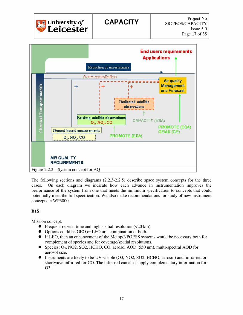
2.2.3 System Concept An outline system concept for air quality is given in Figure 2.2.2. It consists of the following key elements as linkages.
e) Ground-based measurements f) Existing satellite produce observations g) Dedicated satellite observation h) A data assimilation system to produce an air quality management and forecast system,
CAPACITY
Project No SRC/EOS/CAPACITY
Issue 5.0 Page 17 of 35
17
Figure 2.2.2 – System concept for AQ The following sections and diagrams (2.2.3-2.2.5) describe space system concepts for the three cases. On each diagram we indicate how each advance in instrumentation improves the performance of the system from one that meets the minimum specification to concepts that could potentially meet the full specification. We also make recommendations for study of new instrument concepts in WP3000. B1S Mission concept:
� Frequent re-visit time and high spatial resolution (<20 km) � Options could be GEO or LEO or a combination of both. � If LEO, then an enhancement of the Metop/NPOESS systems would be necessary both for
complement of species and for coverage/spatial resolutions. � Species: O3, NO2, SO2, HCHO, CO, aerosol AOD (550 nm), multi-spectral AOD for
aerosol size. � Instruments are likely to be UV-visible (O3, NO2, SO2, HCHO, aerosol) and infra-red or
shortwave infra-red for CO. The infra-red can also supply complementary information for O3.

CAPACITY
Project No SRC/EOS/CAPACITY
Issue 5.0 Page 18 of 35
18
� There is a requirement for an enhanced aerosol instrument/system delivering uncertainties of < 0.05 in aerosol optical depth at 10 km spatial resolution and enhancing our ability to discriminate aerosol type.
� Limb instruments would enable better correction for upper parts of NO2, O3, and CO. Recommendation for WP3000:
� Both GEO and LEO options should be studied. � Priority 1 is to achieve the re-visit time with high spatial resolution as the 2nd priority. � A key decision concerns our ability to measure CO. Flight of both an infrared and near
infrared instrument would provide the greatest performance but would add to mission complexity.
� Multi-spectral aerosol information with improved uncertainty (equivalent to <0.05 nm at 550 nm) would be ideal. Aerosol type measurements are also useful.
GOME-2Column
O3, NO2, SO2, H2COColumn AOD
B1: Air Quality Protocol Monitoring Satellite Component Evolution
Ultimate Specification
Minimum Specification
IASICO
Col/Profile
NEWCombined CO
Profiles(Data)
CombinedUV/VIS & IRO3 Profiles
(Data)
B1 SPECIESImproved Revisit Times
Improved HorizontalResolution
< 2 hrs < 20 km
Meets SignificantCapacity Capability
NEWAEROSOL
Type<10% mis-assign
SCIA NADIR NIR CO
MODIS,MISR, POLDERColumn AOD (550 nm)
B1 Species:
O3, CO, NO2, SO2, H2CO
Aerosol OD (550 nm)
Multi-spectral AOD and type should be < 2 hours re-visit time but accept high spatial resolution (5 km) would be a trade-off.
Note:
PBL sensitivity is mandatory for all measurements
NEWAEROSOL
Multi-spectralColumn AOD
AOD < 0.05, 10 km
PRIORITY
Figure 2.2.3 – B1 specification diagram. The extremes of this diagram show the ultimate and minimum specification, instrument sets are then transposed onto it. B2S Mission concept:
� As for B1, GEO or LEO with frequent re-visit time (<2 hours) and high spatial resolution (< 20 km)
CAPACITY
Project No SRC/EOS/CAPACITY
Issue 5.0 Page 19 of 35
19
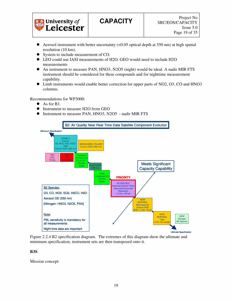
� Aerosol instrument with better uncertainty (<0.05 optical depth at 550 nm) at high spatial resolution (10 km).
� System to include measurement of CO. � LEO could use IASI measurements of H2O. GEO would need to include H2O
measurements � An instrument to measure PAN, HNO3, N2O5 (night) would be ideal. A nadir MIR FTS
instrument should be considered for these compounds and for nighttime measurement capability.
� Limb instruments would enable better correction for upper parts of NO2, O3, CO and HNO3 columns.
Recommendations for WP3000:
� As for B1. � Instrument to measure H2O from GEO � Instrument to measure PAN, HNO3, N2O5 - nadir MIR FTS
B2: Air Quality Near Real Time Data Satellite Component Evolution
GOME-2Column
O3, NO2, SO2, H2COH2O
Column AOF (550 nm)
Ultimate Specification
Minimum Specification
IASICO
Col/Profile
CombinedUV/VIS & IRO3 & H2O
Profiles(Data)
B2 Species:
O3, CO, NO2, SO2, H2CO, H2O
Aerosol OD (550 nm)
[Nitrogen: HNO3, N2O5, PAN]
Note:
PBL sensitivity is mandatory for all measurements
Night time data are important
IASIH2O
Profile
NEWNitrogen
B2 Species
SCIA NADIR NIR CO
MODIS,MISR, POLDERColumn AOD (550 nm)
NEWCombined CO
Profiles(Data)
B2 SPECIESImproved Revisit Times
Improved HorizontalResolution
< 2 hrs < 20 km
Meets SignificantCapacity Capability
NEWAEROSOL
Type<10% mis-assign
PRIORITY
NEWAEROSOL
Multi-spectralColumn AOD
AOD < 0.05, 10 km
Figure 2.2.4 B2 specification diagram. The extremes of this diagram show the ultimate and minimum specification, instrument sets are then transposed onto it. B3S Mission concept:

CAPACITY
Project No SRC/EOS/CAPACITY
Issue 5.0 Page 20 of 35
20
� As for B2, GEO or LEO with frequent re-visit time (<2 hours) and high spatial resolution (< 20 km)
� Aerosol instrument with better uncertainty (<0.05 optical depth at 550 nm), multi-spectral for aerosol size but also for aerosol type.
� An instrument to measure PAN, HNO3, N2O5 (night) and organic nitrates would be ideal. A nadir MIR FTS instrument should be considered for these compounds and for nighttime measurement capability.
� Limb instruments would enable better correction for upper parts of NO2, O3, CO and HNO3 columns.
Recommendations for WP3000:
� As for B2. � Instrument to measure aerosol type as well as multi-spectral for aerosol size. � Instrument to measure PAN, HNO3, N2O5 and organic nitrates – nadir MIR FTS.
B3: Air Quality Scientific Assessment Satellite Component Evolution
GOME-2Column
O3, NO2, SO2, H2COH2O
Ultimate Specification
Minimum Specification
IASICO
Col/Profile
B3 Species:
O3, CO, NO2, SO2, H2CO, H2O
Aerosol OD (550 nm)
[All Nitrogen: HNO3, N2O5, PAN, Organic nitrates]
Note:
PBL sensitivity is mandatory for all measurements
Night time data are important
IASIH2O
Profile
SCIA NADIR NIR CO
CombinedUV/VIS & IRO3 & H2O
Profiles(Data)
MODIS,MISR, POLDERColumn AOD (550 nm)
NEWCombined CO
Profiles(Data)
B3 SPECIESImproved Revisit Times
Improved HorizontalResolution
< 2 hrs < 20 km
Meets SignificantCapacity Capability
NEWAEROSOL
Type<10% mis-assign
NEWNitrogen
B3 Species
PRIORITY
NEWAEROSOL
Multi-spectralColumn AOD
AOD < 0.05, 10 km
Figure 2.2.5 – B3 specification diagram. The extremes of this diagram show the ultimate and minimum specification, instrument sets are then transposed onto it.
2.2.4 Future Requirements
It is quite clear that only an integrated system of satellite measurements coupled to the appropriate ground-based measurements will be able to fulfil the user requirements for AQ.
CAPACITY
Project No SRC/EOS/CAPACITY
Issue 5.0 Page 21 of 35
21
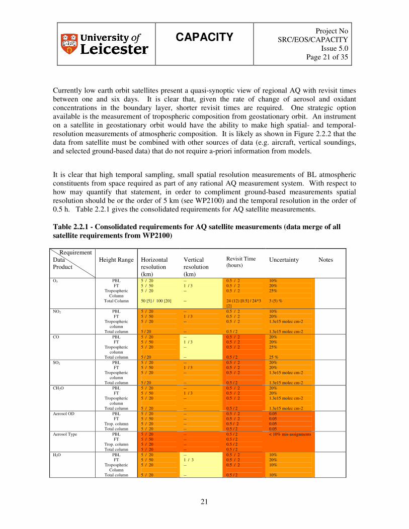
Currently low earth orbit satellites present a quasi-synoptic view of regional AQ with revisit times between one and six days. It is clear that, given the rate of change of aerosol and oxidant concentrations in the boundary layer, shorter revisit times are required. One strategic option available is the measurement of tropospheric composition from geostationary orbit. An instrument on a satellite in geostationary orbit would have the ability to make high spatial- and temporal-resolution measurements of atmospheric composition. It is likely as shown in Figure 2.2.2 that the data from satellite must be combined with other sources of data (e.g. aircraft, vertical soundings, and selected ground-based data) that do not require a-priori information from models.
It is clear that high temporal sampling, small spatial resolution measurements of BL atmospheric constituents from space required as part of any rational AQ measurement system. With respect to how may quantify that statement, in order to compliment ground-based measurements spatial resolution should be or the order of 5 km (see WP2100) and the temporal resolution in the order of 0.5 h. Table 2.2.1 gives the consolidated requirements for AQ satellite measurements. Table 2.2.1 - Consolidated requirements for AQ satellite measurements (data merge of all satellite requirements from WP2100)
Requirement Data Product
Height Range
Horizontal resolution (km)
Vertical resolution (km)
Revisit Time (hours)
Uncertainty
Notes
O3 PBL FT
Tropospheric Column
Total Column
5 / 20 5 / 50 5 / 20 50 [5] / 100 [20]
-- 1 / 3 -- --
0.5 / 2 0.5 / 2 0.5 / 2 24 (12) [0.5] / 24*3 [2]
10% 20% 25% 3 (5) %
NO2 PBL FT
Tropospheric column
Total column
5 / 20 5 / 50 5 / 20 5 / 20
-- 1 / 3 -- --
0.5 / 2 0.5 / 2 0.5 / 2 0.5 / 2
10% 20% 1.3e15 molec cm-2 1.3e15 molec cm-2
CO PBL FT
Tropospheric column
Total column
5 / 20 5 / 50 5 / 20 5 / 20
-- 1 / 3 -- --
0.5 / 2 0.5 / 2 0.5 / 2 0.5 / 2
20% 20% 25% 25 %
SO2 PBL FT
Tropospheric column
Total column
5 / 20 5 / 50 5 / 20 5 / 20
-- 1 / 3 -- --
0.5 / 2 0.5 / 2 0.5 / 2 0.5 / 2
20% 20% 1.3e15 molec cm-2 1.3e15 molec cm-2
CH2O PBL FT
Tropospheric column
Total column
5 / 20 5 / 50 5 / 20 5 / 20
-- 1 / 3 -- --
0.5 / 2 0.5 / 2 0.5 / 2 0.5 / 2
20% 20% 1.3e15 molec cm-2 1.3e15 molec cm-2
Aerosol OD PBL FT
Trop. column Total column
5 / 20 5 / 50 5 / 20 5 / 20
-- -- -- --
0.5 / 2 0.5 / 2 0.5 / 2 0.5 / 2
0.05 0.05 0.05 0.05
Aerosol Type PBL FT
Trop. column Total column
5 / 20 5 / 50 5 / 20 5 / 20
-- -- -- --
0.5 / 2 0.5 / 2 0.5 / 2 0.5 / 2
< 10% mis-assignments
H2O PBL FT
Tropospheric Column
Total column
5 / 20 5 / 50 5 / 20 5 / 20
-- 1 / 3 -- --
0.5 / 2 0.5 / 2 0.5 / 2 0.5 / 2
10% 20% 10% 10%

CAPACITY
Project No SRC/EOS/CAPACITY
Issue 5.0 Page 22 of 35
22
HNO3 PBL FT
Tropospheric Column
Total column
5 / 20 5 / 50 5 / 20 5 / 20
-- 1 / 3 -- --
0.5 / 2 0.5 / 2 0.5 / 2 0.5 / 2
20% 20% 1.3e15 molec cm-2 1.3e15 molec cm-2
N2O5 (night) PBL FT
Tropospheric Column
Total column
5 / 20 5 / 50 5 / 20 5 / 20
-- 1 / 3 -- --
0.5 / 2 0.5 / 2 0.5 / 2 0.5 / 2
20% 50% 1.3e15 molec cm-2 1.3e15 molec cm-2
PAN PBL FT
Tropospheric Column
Total column
5 / 20 5 / 50 5 / 20 5 / 20
-- 1 / 3 -- --
0.5 / 2 0.5 / 2 0.5 / 2 0.5 / 2
20% 20% 1.3e15 molec cm-2 1.3e15 molec cm-2
Organic Nitrates PBL 5 / 20 -- 0.5 / 2 30% B3S only Spectral UV surface albedo
Surface 5 / 20 -- 24 / 24*3 0.1
(B2S- requirement), [B3S – requirement] Requirements can be met by current instruments Some requirements met No requirements met In summary,
• An effective AQ system is going to require a fusion of ground-based and satellite measurements.
• There is a general requirement in AQ for high time resolution measurements, there are a number of potential implementation options
o Constellation of LEO instruments o Instruments in MEO o Instruments in Molniya orbit o An instrument in a GEO orbit
� It is recommended to perform a brief trade-off between orbit options. • With respect to future LEO components the benefits of an additional CO channel in
compliment to MetOP should be assessed • A measurement challenge from space is how to deliver the best height resolved (sensitivity
to PBL) information on the target species. A number of implementation options should be explored to look at the best space-borne observing strategy.
o A combination of UV/VIS and IR (Thermal or Mid) might provide added height information. This synergy should be explored.
• There is requirement for high spatial (horizontal) resolution. • Need an assessment of aerosol products from space in particular GEO and LEO.
o User products currently focus on PM size • It maybe worth looking at a mission envelope that looks at both the minimum and optimal
requirements in satellite implementation. • Any future operational nadir viewing AQ satellite system should explore optimal
combination with any limb-type missions. • Beyond the scope of this study there is the requirement for a better assessment of the
quantitative benefits of a space-borne system in regional AQ monitoring.

CAPACITY
Project No SRC/EOS/CAPACITY
Issue 5.0 Page 23 of 35
23
2.3 Climate Within the area of climate there are two different user needs. The first is centred on protocol monitoring and the production of emission databases (C1). The second is centred on using the profile information in the UT/LS as a climate diagnostic (C2+C3).
2.3.1 System Overview The current climate monitoring system is dominated by ground-based measurement of greenhouse gases that are used for the determination mainly of long-term trends of greenhouse gases. Development work in the current EU project GEMS is using CO2 satellite data from AIRS.
2.3.2 Current Planned/Missions The following is an assessment of the ability of current or planned mission to fulfil the user requirements, from the output of WP2200: C1S This mission seeks to measure greenhouse gases, CO and aerosols. The mission is intended to be global and have PBL sensitivity for CH4, CO2, CO, NO2. The chief targets are CO2, CH4, CO, O3, NO2, aerosols. Stratospheric aerosol is required as well as tropospheric aerosols but not with as high a priority. Metop provides a basis set of measurements with information on CO2, CH4 and CO provided by IASI, and O3 and NO2 delivered by GOME-2. Existing aerosol instruments can provide useful information although higher accuracy is desirable for tropospheric measurements. Re-flight of an ice-free SCIAMACHY nadir shortwave infra-red instrument could give better information on CO2, CH4, and CO. Achieving the requirements for CO2 is very difficult with any current technology suitable for operational implementation and is not strongly emphasized here as a mission driver. Improvements in uncertainty performance for CH4 would be ideal as well as higher spatial resolution. Combination of O3 data from GOME-2 and IASI could provide greater height resolution in the PBL and free troposphere. Development work to support this product is highly recommended. Similar work could be performed for CO with advantage if a near infra-red instrument could be flown to complement MetoP. It is important to note that the analysis implies the mission is similar to B1 but re-visit time not as high a priority (6-12 hours for C1), CH4 is emphasized for C1 rather than CO. Stratospheric aerosol information desirable for C1 and aerosol type is not as important. C2S

CAPACITY
Project No SRC/EOS/CAPACITY
Issue 5.0 Page 24 of 35
24
The mission seeks to derive climate information in near real-time. This mission concept is driven by NRT system assimilation and the improvement in representation of climate from assimilation of observations for rapidly varying constituents. The targets are H2O (very important), O3, aerosols/cirrus, stratospheric tracer information. Stratospheric aerosol is required as well as tropospheric aerosols
� IASI on Metop provides a basis set of measurements with vertically resolved information on H2O and O3, and column information on CH4, N2O and CO2. information on CO2, CH4 and CO.
� A set of limb observations are required targetting the UT and stratosphere for H2O, O3, UT cirrus and stratospheric tracers.
� Microwave limb measurements which are cloud-free could be most important for H2O and O3, and there is also useful information on thicker UT cirrus.
� MIR limb instruments tend to provide good tracer measurements. They can also provide measurements of H2O, O3 (not in the presence of thick clouds) and also have additional sensitivity to very thin clouds and also to some aerosols.
� Aerosol can be measured adequately in the stratosphere using existing measurements from SAGE. Tropospheric measurements need to meet 0.05 requirement.
� Re-visit time for H2O is an issue since 6 hours is a threshold and 1 hour is a target. Also for O3 (6 hours target) and aerosol OD (1 hour target).
C3S The mission seeks to provide a fundamental capability for scientific assessment of the climate system. The mission targets can be sub-divided into radiative forcing, oxidising capacity and stratospheric ozone. There are many target species and domains but the upper troposphere and lower stratosphere (UTLS) are particularly important. We assume that vertical resolution and no. of species is more important than re-visit times.
� Metop provides a starting basis for the measurement system � A limb MIR FTS instrument meets the major requirement is to provide enhanced
capabilities to sound many species in the UTLS in all 3 categories. Its vertical resolution should approach 2 km.
� In addition, the remainder of the ozone system for C3 looks like A3, i.e. with limb MIR, and possibly additional microwave capability, and SAGE aerosol.
� The radiative forcing system for C3 looks like the first part of C2 with tropospheric aerosol required and PBL sensitive CH4, N2O as well as Metop.
� The oxidising capacity system for C3 looks like Metop with a MIR limb instrument and possibly UV limb for CH2O in the UT.
This is a very extensive list of requirements. A lot of these species seem to require a limb-sounding MIR instrument; HIRDLS and SCIAMACHY can be used for many of the measurements. MIPAS and TES (limb-MIR) are also useful, but fail the vertical resolution requirements for a number of the species. Other instruments, e.g. SMILES and MLS (limb-MM) and ACE (IR occult) are also needed for some of the measurements.
CAPACITY
Project No SRC/EOS/CAPACITY
Issue 5.0 Page 25 of 35
25
C1G For this set of requirements, in-situ measurements of the surface often do not have the required uncertainty. FTIR occultation makes a number of the column measurements, but again not at the required uncertainty, except for N2O and CH4. C2G O3 requirements can be met by sondes and DIAL, together with another instrument e.g. FTIR occultation for the column. The latter is also useful for a number of other measurements, although the vertical resolution needs improving. C3G There are a lot of species that are not measured. In-situ and FTIR occultation might be used for a number of the observations, but uncertainty and vertical resolution are problems.
2.3.3 System Concept With respect to Protocol monitoring it is clear that the satellite must be able to measure total abundances/global concentrations in terms of monthly means of GHG, the inversion of which can lead to the production of emission products. The satellite measurements should give dry air mixing ratios with vertical information having significant sensitivity to boundary layer. There are stringent precision target and thresholds for GHG such as CO2 (3 ppmv threshold, 1ppmv target) The analysis here largely concentrates on the space-borne component of the required systems. Analysis of the input information shows clearly that there is an increasing system complexity from C1 to C3. The following analysis and diagrams describe space system concepts for C1, C2 and C3. On each diagram we indicate how each advance in instrumentation improves the performance of the system from one that meets the minimum specification to concepts that could potentially meet the full specification. C1S Mission concept:
� As for B1 with addition of CH4, stratospheric aerosol and aerosol absorbing OD. � Metop (GOME-2), ideally with near i/r or mid-infrared nadir instrument and new nadir
aerosol instrument at high spatial resolution. � Re-visit time and global coverage suggests LEO implementation. � Limb instruments could improve tropospheric data accuracy.

CAPACITY
Project No SRC/EOS/CAPACITY
Issue 5.0 Page 26 of 35
26
Figure 2.3.1 – Outline system concept for Climate monitoring system for protocol monitoring
Recommendations for WP3000:
� Improved near infra-red instrument should be studied which has high spatial resolution (10 x 10 km) and improved uncertainty for CH4 (2%).
� New nadir UV aerosol instrument with 10 km horizontal spatial resolution and improved performance for aerosol absorbing AOD (<0.01) should be studied but with low priority. Improved re-visit time could be more important with 6 hours being desirable.
� Stratospheric aerosol instrument should be considered.

CAPACITY
Project No SRC/EOS/CAPACITY
Issue 5.0 Page 27 of 35
27
IASI
CH4, CO, CO2, O3GOME-2O3, NO2
Column AOD (550 nm)Absorbing aerosol OD
C1: Climate Protocol Monitoring Satellite Component Evolution
Ultimate Specification
Minimum Specification
SCIANADIR NIR
CH4, CO, CO2,
NEWNADIR UV/VIS
O3, NO2Improved SpatialResolution10 km
Improved re-visit times12 hours
NEWAEROSOL OD
0.05 uncertainty 550 nm
Absorbing Aerosol OD0.01 uncertainty
Improved re-visit times6-12 hours
Meets SignificantCapacity Capability
CombinedUV/VIS/NIR & IRO3, CO Profiles
(Data)
NEWNADIR NIRCH4, CO
CH4 error (2%)Improved Spatial Resolution 10 km
SAGE equivalentStrat. Aerosol
TOMS, MODIS,MISR, POLDER
Equivalent Column AOD (550 nm)
NEWCO2
CO2 error (PBL)
CH4, CO2, CO and NO2 measurements should be PBL sensitive.
Note CO2:
CO2 (highlighted in red) information does not meet capacity requirements but could be sufficient for some user services
PRIORITY
IASI
CH4, CO, CO2, O3GOME-2O3, NO2
Column AOD (550 nm)Absorbing aerosol OD
C1: Climate Protocol Monitoring Satellite Component Evolution
Ultimate Specification
Minimum Specification
SCIANADIR NIR
CH4, CO, CO2,
NEWNADIR UV/VIS
O3, NO2Improved SpatialResolution10 km
Improved re-visit times12 hours
NEWAEROSOL OD
0.05 uncertainty 550 nm
Absorbing Aerosol OD0.01 uncertainty
Improved re-visit times6-12 hours
Meets SignificantCapacity CapabilityMeets Significant
Capacity CapabilityCombined
UV/VIS/NIR & IRO3, CO Profiles
(Data)
NEWNADIR NIRCH4, CO
CH4 error (2%)Improved Spatial Resolution 10 km
SAGE equivalentStrat. Aerosol
TOMS, MODIS,MISR, POLDER
Equivalent Column AOD (550 nm)
NEWCO2
CO2 error (PBL)
CH4, CO2, CO and NO2 measurements should be PBL sensitive.
Note CO2:
CO2 (highlighted in red) information does not meet capacity requirements but could be sufficient for some user services
PRIORITY
Figure 2.3.2 – C1 specification diagram. The extremes of this diagram show the ultimate and minimum specification, instrument sets are then transposed onto it. C2S Mission concept:
� The basic system consists of Metop with a limb system, based around a limb MIR instrument, and a nadir system built around a re-flight of a SCIMACHY-type nadir system with aerosol capabilities.
� The limb system looks like an MIR FTS (2 km resolution), with additional microwave capability for radiative forcing measurements and HCl/ClO for stratospheric ozone measurements, and possibly a UV instrument for CH2O UT limb.
� The nadir system consists in part of a LEO system with nadir near i/r and tropospheric aerosol instruments.
� A GEO system would be ideal to meet re-visit time targets for H2O, O3, aerosol but would not be global.
Recommendations for WP3000:
� Examine MIR limb instruments to look ability to achieve wide coverage of species, with 2 km vertical resolution.
� Consider microwave limb instrument concentrating on H2O, O3, cirrus OD HCl. � Also examine a specific limb instrument obtaining information on aerosol.
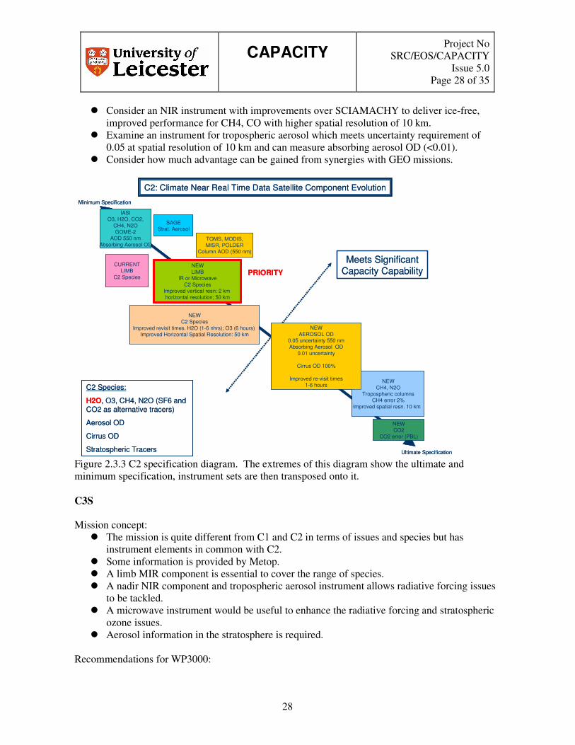
CAPACITY
Project No SRC/EOS/CAPACITY
Issue 5.0 Page 28 of 35
28
� Consider an NIR instrument with improvements over SCIAMACHY to deliver ice-free, improved performance for CH4, CO with higher spatial resolution of 10 km.
� Examine an instrument for tropospheric aerosol which meets uncertainty requirement of 0.05 at spatial resolution of 10 km and can measure absorbing aerosol OD (<0.01).
� Consider how much advantage can be gained from synergies with GEO missions.
C2: Climate Near Real Time Data Satellite Component Evolution
Ultimate Specification
Minimum Specification
IASIO3, H2O, CO2,
CH4, N2OGOME-2
AOD 550 nmAbsorbing Aerosol OD
CURRENTLIMB
C2 Species
NEWC2 Species
Improved revisit times. H2O (1-6 nhrs); O3 (6 hours) Improved Horizontal Spatial Resolution: 50 km
NEWLIMB
IR or MicrowaveC2 Species
Improved vertical resn: 2 km horizontal resolution; 50 km
Meets SignificantCapacity Capability
C2 Species:
H2O, O3, CH4, N2O (SF6 and CO2 as alternative tracers)
Aerosol OD
Cirrus OD
Stratospheric Tracers
NEWCH4, N2O
Tropospheric columnsCH4 error 2%
Improved spatial resn. 10 km
SAGEStrat. Aerosol
TOMS, MODIS,MISR, POLDER
Column AOD (550 nm)
NEWCO2
CO2 error (PBL)
PRIORITY
NEWAEROSOL OD
0.05 uncertainty 550 nmAbsorbing Aerosol OD
0.01 uncertainty
Cirrus OD 100%
Improved re-visit times1-6 hours
Figure 2.3.3 C2 specification diagram. The extremes of this diagram show the ultimate and minimum specification, instrument sets are then transposed onto it. C3S Mission concept:
� The mission is quite different from C1 and C2 in terms of issues and species but has instrument elements in common with C2.
� Some information is provided by Metop. � A limb MIR component is essential to cover the range of species. � A nadir NIR component and tropospheric aerosol instrument allows radiative forcing issues
to be tackled. � A microwave instrument would be useful to enhance the radiative forcing and stratospheric
ozone issues. � Aerosol information in the stratosphere is required.
Recommendations for WP3000:

CAPACITY
Project No SRC/EOS/CAPACITY
Issue 5.0 Page 29 of 35
29
� Examine performance of new limb MIR FTS instrument compared to MIPAS with respect to the full range of species required here.
� Consider an NIR instrument with improvements over SCIAMACHY to deliver ice-free, improved performance for CH4, CO with higher spatial resolution.
� Examine an aerosol instrument for tropospheric aerosol which meets uncertainty requirement of 0.05 at 10 km spatial resolution and good absorbing aerosol AOD performance.
� Consider how best stratospheric aerosol OD measurements might be performed. � Consider microwave instrument concentrating on H2O, O3, cirrus OD, ClO (MS) and HCl.
C3: Climate Scientific Assessment Satellite Component Evolution
MetOpIASI/GOME-2
CurrentIR Limb
CurrentIR Limb
Microwave LimbUV-vis Limb NO2
CurrentIR Limb
NewUV-vis Limb
NO2 UT
NewOccultation
or Microwave
NewNIR Nadir
CombinationsTrop. O3Profiles
NewTrop. Aerosol
CurrentAerosolSAGE-3
NewIR Limb
Single Track Approach
Oxidising Capacity
Radiative Forcing
Ozone
NewIR Limb
UT
NewNIR Nadir
CO
CAPACITY
Project No SRC/EOS/CAPACITY
Issue 5.0 Page 30 of 35
30
C3: Climate Scientific Assessment Satellite Component Evolution
Ultimate Specification
Minimum Specification
MetopIASI Nadir IR FTS
O3, H2O, CO, C2H6, CH4, N2ONadir UV-VIS
O3, H2O, NO2, CH2O, Aerosol, Solar irradiance
Meets SignificantCapacity CapabilityCURRENT
Limb IR FTSIR species
Oxidising Capacity
Radiative Forcing
Ozone
NEW SCIA NIRCH4, CO
CH4 error < 2%Horiz resn < 10 km
NewOccultation or
MicrowaveHCl
NEWTrop Aerosol
0.05 nm 10 km
Meets SignificantCapacity Capability
CURRENTLimb Microwave (in addition to Limb IR)
O3, H2O (clouds)Cirrus OD, ClO (MS), SO2 (enh.)
Meets SignificantCapacity Capability
Integrated Approach
CombinationO3 profiles
(data)
SAGE equivalentStrat. Aerosol
IR species:
O3, H2O, CO, HNO3, H2O2, CH3COCH3, PAN, C2H6, CFCs, HCFC, PSCs, CH4, N2O, SF6, N2O5, ClO (LS), ClONO2, SO2 (enh.)
PRIORITY
PRIORITY
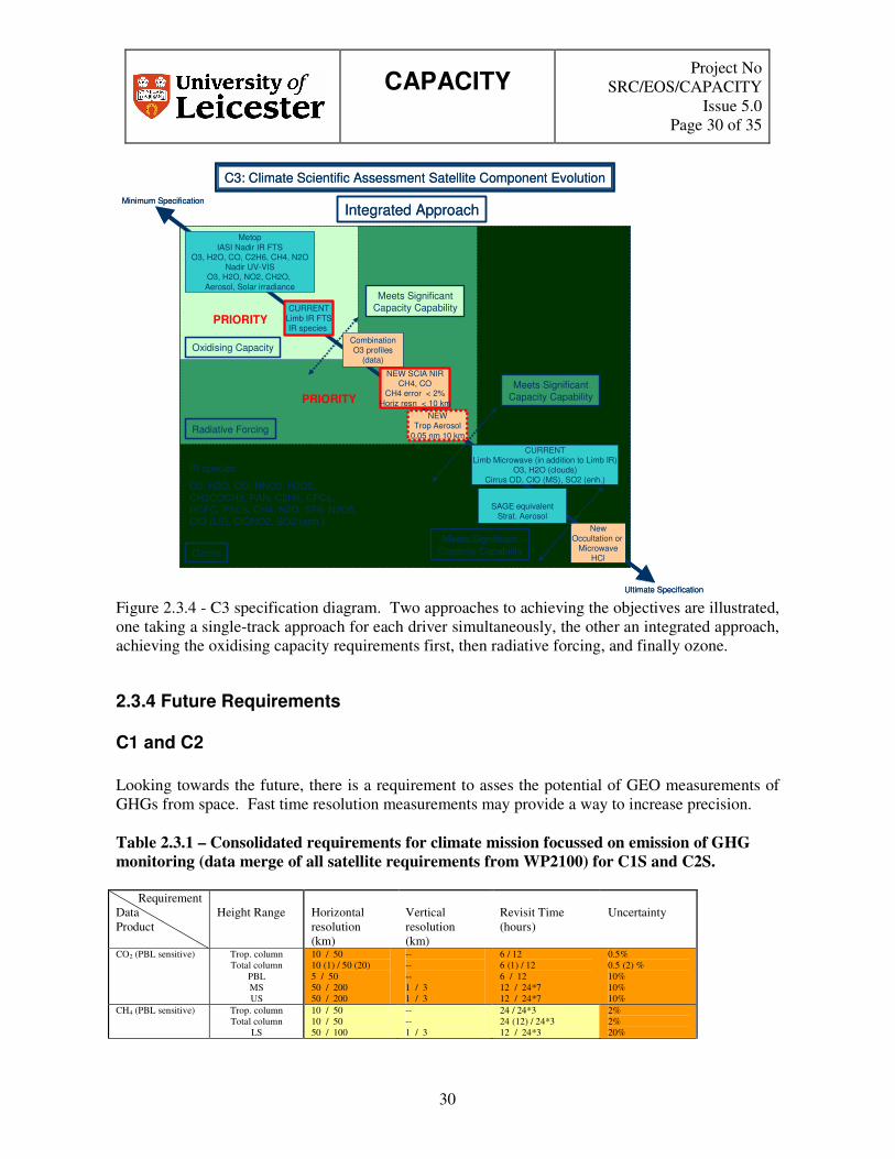
Figure 2.3.4 - C3 specification diagram. Two approaches to achieving the objectives are illustrated, one taking a single-track approach for each driver simultaneously, the other an integrated approach, achieving the oxidising capacity requirements first, then radiative forcing, and finally ozone.
2.3.4 Future Requirements
C1 and C2 Looking towards the future, there is a requirement to asses the potential of GEO measurements of GHGs from space. Fast time resolution measurements may provide a way to increase precision. Table 2.3.1 – Consolidated requirements for climate mission focussed on emission of GHG monitoring (data merge of all satellite requirements from WP2100) for C1S and C2S.
Requirement Data Product
Height Range
Horizontal resolution (km)
Vertical resolution (km)
Revisit Time (hours)
Uncertainty
CO2 (PBL sensitive) Trop. column Total column
PBL MS US
10 / 50 10 (1) / 50 (20) 5 / 50 50 / 200 50 / 200
-- -- -- 1 / 3 1 / 3
6 / 12 6 (1) / 12 6 / 12 12 / 24*7 12 / 24*7
0.5% 0.5 (2) % 10% 10% 10%
CH4 (PBL sensitive) Trop. column Total column
LS
10 / 50 10 / 50 50 / 100
-- -- 1 / 3
24 / 24*3 24 (12) / 24*3 12 / 24*3
2% 2% 20%

CAPACITY
Project No SRC/EOS/CAPACITY
Issue 5.0 Page 31 of 35
31
MS 50 / 200 1 / 3 12 / 24*3 20% O3 Troposphere
Tropospheric column
Total column PBL LS MS
US+M
10 / 50 10 / 50 50 / 100 5 / 50 50 / 100 50 / 200 50 / 100
2 / 5 -- -- -- 0.5 / 2 1 / 3 3 / 5
12 / 24*3 12 (6) / 24*3 24 (6) / 24*3 6 / 24 6 / 24*3 6 / 24*7 6 / 24*7
20% 25% 3 (5) % 30% 10% 20% 20%
NO2 (PBL sensitive) Troposphere Tropospheric
column Total column
10 / 50 10 / 50 10 / 50
2 / 5 -- --
12 / 24*3 12 / 24*3 12 / 24*3
50% 1.3·(10)15 cm-2
1.3·(10)15 cm-2 CO (PBL sensitive) Troposphere
Tropospheric column
Total column
10 / 50 10 / 50 10 / 50
2 / 5 -- --
12 / 24*3 12 / 24*3 12 / 24*3
20% 25% 25%
Aerosol OD PBL Troposphere
LS MS
Total column
5 / 10 10 (5) / 50 50 / 100 50 / 200 10 / 50
-- -- 1 / part. column 2 (1) / part. column --
1 / 6 6 (3) / 24*3 (24) 12 / 24*3 12 / 24*3 12 / 24*3
0.05 0.05 0.05 0.05 0.05
Aerosol absorption OD
PBL Troposphere Total column
5 / 10 10 (5) / 50 10 / 50
-- -- --
1 / 6 6 (3) / 24*3 (24) 6 / 24*3
0.01 0.01 0.01
H2O PBL FT UT LS MS US
Total column
5 / 50 10 / 50 10 / 100 50 / 100 50 / 200 50 / 200 10 / 50
-- 0.5 / 2 0.5 / 2 0.5 / 2 1 / 3 3 / 5 --
1 / 6 1 / 6 1 / 6 3 / 24 6 / 24*7 6 / 24*7 6 / 24*3
50% 30% 30% 20% 20% 20% 5%
N2O LS MS US
Total column
50 / 100 50 / 200 50 / 200 10 / 50
1 / 3 1 / 3 3 / 5 --
12 / 24*3 12 / 24*3 12 / 24*3 12 / 24*3
20% 20% 20% 2%
Cirrus OD UT 50 / 100 -- 6 / 24 100% SF6 LS
MS US
50 / 100 50 / 200 50 / 200
1 / 3 1 / 3 3 / 5
12 / 24*7 12 / 24*7 12 / 24*7
10% 10% 10%
HDO LS MS US
50 / 100 50 / 200 50 / 200
1 / 3 1 / 3 3 / 5
12 / 24*7 12 / 24*7 12 / 24*7
10% 10% 10%
HF LS MS US
50 / 100 50 / 200 50 / 200
1 / 3 1 / 3 3 / 5
12 / 24*7 12 / 24*7 12 / 24*7
10% 10% 10%
Aerosol phase function
PBL Troposphere
5 / 10 5 / 50
-- --
1 / 6 3 / 24
0.1 on asymmetry factor
Cirrus phase function UT 10 / 100 -- 6 / 24 0.1 on asymmetry factor
(C2S- requirement) Requirements can be met by current instruments Some requirements met No requirements met
C3S The requirements for C3 are extensive but can broadly be divided into three areas: 1) radiative forcing and emissions; 2) oxidising capacity and 3) recovery of the stratospheric ozone layer. This is an essential step in order to match requirements and potential system elements directly. Table 2.3.2 – Consolidated requirements for climate mission focussed on emission of GHG monitoring (data merge of all satellite requirements from WP2100) for C3S separated into main driver

CAPACITY
Project No SRC/EOS/CAPACITY
Issue 5.0 Page 32 of 35
32
Radiative forcing
Requirement Data Product
Height Range
Horizontal resolution (km)
Vertical resolution (km)
Revisit Time (hours)
Uncertainty
O3 Troposphere UT
10 / 50 20 / 100
1 / 3 0.5 / 2
6 / 24*3 6 / 24*3
30% 20%
H2O PBL Troposphere
UT
1 / 20 10 / 50 20 / 100
-- 1 / 3 0.5 / 2
6 / 24 6 / 24*3 6 / 24*3
30% 30% 20%
CO2 MS Total column
50 / 100 10 / 50
2 / 3 --
12 / 24*3 1 / 12
10% 0.5%
CH4 Total column 10 / 50 -- 12 / 24*3 2% N2O Total column 10 / 50 -- 12 / 24*3 2% Cirrus OD UT 10 / 100 -- 6 / 24 100% PSC occurrence LS 50 / 100 0.5 / 2 6 / 24*3 < 10% mis-
assignments AOD PBL
Troposphere Total column
5 / 20 10 / 50 10 / 50
-- -- --
6 / 24 6 / 24 12 / 24*3
0.05 0.05 0.05
Aerosol absorption OD
Troposphere Total column
5 / 50 5 / 50
-- --
6 / 24 6 / 24
0.01 0.01
Spectral solar irradiance
TOA -- -- 24 / 24*7 2%
CFC-11 LS MS
Stratosphere
50 / 100 50 / 200 50 / 100
1 / 3 2 / 3 --
12 / 24*7 12 / 24*7 12 / 24*7
20% 20% 20%
CFC-12 LS MS
Stratosphere
50 / 100 50 / 200 50 / 100
1 / 3 2 / 3 --
12 / 24*7 12 / 24*7 12 / 24*7
20% 20% 20%
HCFC-22 UT LS MS
Stratosphere
20 / 100 50 / 100 50 / 200 50 / 100
1 / 3 1 / 3 2 / 3 --
12 / 24*3 12 / 24*3 12 / 24*3 12 / 24*3
20% 20% 20% 20%
SO2 (enhanced) Troposphere LS MS
Total column
10 / 50 50 / 100 50 / 200 10 / 50
1 / 3 1 / 3 2 / 3 --
6 / 24*3 12 / 24*3 12 / 24*3 6 / 24*3
50% 50% 50% 50%
Aerosol phase function
Troposphere LS MS
Total column
10 / 50 50 / 100 50 / 200 10 / 50
-- 1 / part. column 2 / part. column --
6 / 24 12 / 24*3 12 / 24*3 6 / 24
0.1 on asymmetry factor
Cirrus phase function UT 10 / 100 -- 6 / 24 0.1 on asymmetry factor
Oxidising capacity
Requirement Data Product
Height Range
Horizontal resolution (km)
Vertical resolution (km)
Revisit Time (hours)
Uncertainty
O3 Tropospheric column
10 / 50 -- 6 / 24*3 25%
H2O Trop. column 10 / 50 -- 6 / 24*3 10% CO Troposphere
Trop. column UT LS
10 / 50 10 / 50 20 / 100 50 / 100
1 / 3 -- 1 / 3 1 / 3
12 / 24*3 12 / 24*3 12 / 24*3 12 / 24*3
30% 25% 20% 20%
NO2 Troposphere Trop. column
UT
10 / 50 10 / 50 20 / 100
1 / 3 -- 1 / 3
6 / 24*3 12 / 24*3 6 / 24*3
30% 1.3·(10)15 cm-2 50%
CH2O Troposphere Trop. column
UT Total column
10 / 50 10 / 50 20 / 100 10 / 50
1 / 3 -- 1 / 3 --
6 / 24*3 12 / 24*3 6 / 24*3 12 / 24*3
30% 1.3·(10)15 cm-2 30% 1.3·(10)15 cm-2
HNO3 Troposphere UT
Total column
10 / 50 20 / 100 10 / 50
1 / 3 1 / 3 --
6 / 24*3 6 / 24*3 12 / 24*3
30% 20% 20%
H2O2 Troposphere UT
10 / 50 20 / 100
1 / 3 1 / 3
6 / 24*3 6 / 24*3
30% 30%
CH3COCH3 Troposphere 10 / 50 -- 6 / 24*3 30%

CAPACITY
Project No SRC/EOS/CAPACITY
Issue 5.0 Page 33 of 35
33
UT Total column
20 / 100 10 / 50
1 / 3 --
6 / 24*3 6 / 24*3
30% 30%
C2H6 Troposphere UT
Total column
10 / 50 20 / 100 10 / 50
-- 1 / 3 --
6 / 24*3 6 / 24*3 6 / 24*3
50% 50% 50%
Ozone
Requirement Data Product
Height Range
Horizontal resolution (km)
Vertical resolution (km)
Revisit Time (hours)
Uncertainty
O3 LS MS
US+M Total column
50 / 100 50 / 100 100 / 200 50 / 100
0.5 / 2 2 / 3 3 / 5 --
6 / 24*3 6 / 24*3 6 / 24*7 6 / 24*3
20% 20% 20% 3%
H2O LS MS
US+M Total column?
50 / 100 50 / 100 100 / 200 50 / 100
0.5 / 2 2 / 3 3 / 5 --
6 / 24*3 6 / 24*7 6 / 24*7 6 / 24*3
20% 20% 20% 10%
CH4 LS MS
50 / 100 50 / 100
1 / 3 2 / 3
12 / 24*3 12 / 24*3
20% 20%
N2O LS MS US
50 / 100 50 / 100 50 / 100
1 / 3 2 / 3 3 / 5
12 / 24*3 12 / 24*3 12 / 24*7
20% 20% 20%
NO2 LS MS
Total column
50 / 100 50 / 200 50 / 100
1 / 3 2 / 3 --
12 / 24*3 12 / 24*3 12 / 24*3
50% 30% 10%
HNO3 LS MS
50 / 100 50 / 200
1 / 3 2 / 3
12 / 24*3 12 / 24*3
20% 20%
AOD LS MS
50 / 100 50 / 200
1 / part. column 2 / part. column
12 / 24*3 12 / 24*3
0.05 0.05
HCl LS 50 / 100 1 / 3 12 / 24*3 20% CH3Cl LS
MS Stratosphere
50 / 100 50 / 200 50 / 100
1 / 3 2 / 3 --
12 / 24*3 12 / 24*3 12 / 24*3
20% 20% 20%
CH3Br LS MS
Stratosphere
50 / 100 50 / 200 50 / 100
1 / 3 2 / 3 --
12 / 24*3 12 / 24*3 12 / 24*3
20% 20% 20%
SF6 LS MS US
50 / 100 50 / 200 50 / 200
1 / 3 2 / 3 3 / 5
12 / 24*7 12 / 24*7 12 / 24*7
10% 10% 10%
HDO LS MS US
Stratosphere
50 / 100 50 / 200 50 / 200 50 / 100
1 / 3 2 / 3 3 / 5 --
12 / 24*7 12 / 24*7 12 / 24*7 12 / 24*7
10% 10% 10% 10%
HF LS MS US
50 / 100 50 / 200 50 / 200
1 / 3 2 / 3 3 / 5
12 / 24*7 12 / 24*7 12 / 24*7
10% 10% 10%
N2O5 Troposphere UT LS MS
Stratosphere
10 / 50 20 / 100 50 / 100 50 / 200 50 / 100
-- 1 / 3 1 / 3 1 / 3 --
6 / 24*3 6 / 24*3 12 / 24*3 12 / 24*3 12 / 24*3
30% 30% 50% 50% 50%
PAN Troposphere UT
Total column
10 / 50 20 / 100 10 / 50
-- 1 / 3 --
6 / 24*3 6 / 24*3 6 / 24*3
30% 30% 30%
ClO LS MS
Stratosphere
50 / 100 50 / 200 50 / 100
1 / 3 2 / 3 --
12 / 24*3 12 / 24*3 12 / 24*3
20% 20% 20%
ClONO2 LS MS
Stratosphere
50 / 100 50 / 200 50 / 100
1 / 3 2 / 3 --
12 / 24*3 12 / 24*3 12 / 24*3
20% 20% 20%
Requirements can be met by current instruments Some requirements met No requirements met As only CO2 and CH4 are not in Table 2.2.1 recommend that some assessment of GEO to deliver these measurements is made.

CAPACITY
Project No SRC/EOS/CAPACITY
Issue 5.0 Page 34 of 35
34
2.3.4 Future Requirements In summary, for GHG emissions (protocol monitoring)
� There are not enough data from current missions to assess the impact of space borne measurements for climate monitoring.
� With respect to routine monitoring, ground-based sites fulfil many of the requirements � Clearly not a candidate for operational monitoring but there is an urgent requirement for the
development of precursor missions For assessment, there is a complex web of requirements, probably best served by a LEO limb-sounding mission that measures lots of things. There is some overlap with the requirements of ozone and UV.
3. Conclusion There are three different areas at different levels of maturity Ozone and UV - Many of the requirements for stratospheric O3 and UV can be met by current/planned systems with respect to nadir measurements, there seems to be a hole with respect to operational limb monitoring of key trace species. It is concluded that only the A1 theme requirements can be met by the planned Metop and ground-based systems. The other stratospheric A2 and A3 themes require limb sounding capabilities. For A2, only ozone profiles are mandatory but measurements of other species are highly desirable: ClO, polar stratospheric clouds, stratospheric aerosol, HNO3, H2O, tracers, and HCl. For A3, all the A2 measurements are required with, in addition, HCFCs, ClONO2, and SO2 (enhanced). A limb mid-infrared system is therefore suggested although a microwave system also has significant capabilities, particularly in cloudy regions of the atmosphere. An ultra-violet visible limb instrument (building on SCIAMACHY and GOMOS) can also monitor the important compounds of NO2 and BrO. For Air Quality, there is a need and requirement for a space-based system but the requirements/performance require a better quantitative basis. The implementation of a high time resolution, horizontal spatial resolution with optimal PBL information is required. For air quality, it was shown that all systems (B1 to B3) were essentially similar with a prime requirement for high spatial (<20 km) and temporal (<2 hours) resolution measurements of O3, CO, NO2, SO2, HCHO, and H2O (B2/B3), with sensitivity to the PBL. Instruments are likely to be nadir ultra-violet/visible with shortwave infra-red or mid infra-red capability for CO. For B3 particularly, aerosol measurements at multiple wavelengths would enhance the system ideally in conjunction with nighttime measurements
CAPACITY
Project No SRC/EOS/CAPACITY
Issue 5.0 Page 35 of 35
35
Climate - For treaty monitoring and verification in respect of GHG, a better assessment of current and planned systems is required. There would be some benefit to looking at high time resolution measurements of GHG. Future monitoring of GHG from space is important. Climate - For assessment and NRT climate, the overall requirements suggest a need for an operational limb monitoring mission. There is some need to prioritise the trace species requirements. For operational use, there is requirement to analyse the clear sky bias of the measurement systems. For climate, the C1 (protocol-monitoring) system was notably different to those for C2 and C3. Kyoto protocol-monitoring in C1 demands high precision measurements of CH4 and CO (and CO2) building on the shortwave infra-red measurements demonstrated by SCIAMACHY. Improved NO2 measurements (spatial resolution of 10 km) would also be ideal. It is suggested that C1 systems could be combined with B1 to B3 systems at some point in the evolution of the GMES system. For C2 and C3, the priorities are limb sounder measurements for high vertical resolution (<2 km). For C2, measurements of H2O, O3, CH4, and N2O suggest either microwave or mid infra-red (building on MIPAS capabilities) limb whereas for C3, limb mid-infrared is more likely to be a priority to measure the large range of necessary species to monitor changes in radiative forcing, oxidising capacity and stratospheric ozone wth sensitivity also to the upper troposphere.
3.1 Overall Recommendations With respect to a space segment of a measuring system for operational monitoring, it is clear there are three overall requirements that cannot be met by current or planned systems
– High temporal/spatial resolution space-based measurements of tropospheric (PBL) composition for application to AQ
– High vertical resolution measurements in the UT/LS region for application in ozone and climate applications
– High spatial resolution and high precision monitoring of climate gases (CH4, CO and CO2) and aerosol monitoring with sensitivity to the PBL
Implementation options should be investigated as part of this study. With respect to the issue of greenhouse gas monitoring from space, there is a strategic and user requirement for this be further investigated. Given the time-lag with respect to the development of missions it would be dangerous to wait until OCO is proven. Looking further into the future beyond operational monitoring, it is clear that the ideal space borne system would be able to provide vertical information throughout the depth of the atmosphere. Active systems have the potential in the longer term to provide this for a number of chemical species and aerosol.