Embed Size (px)
Citation preview
Cape Royds
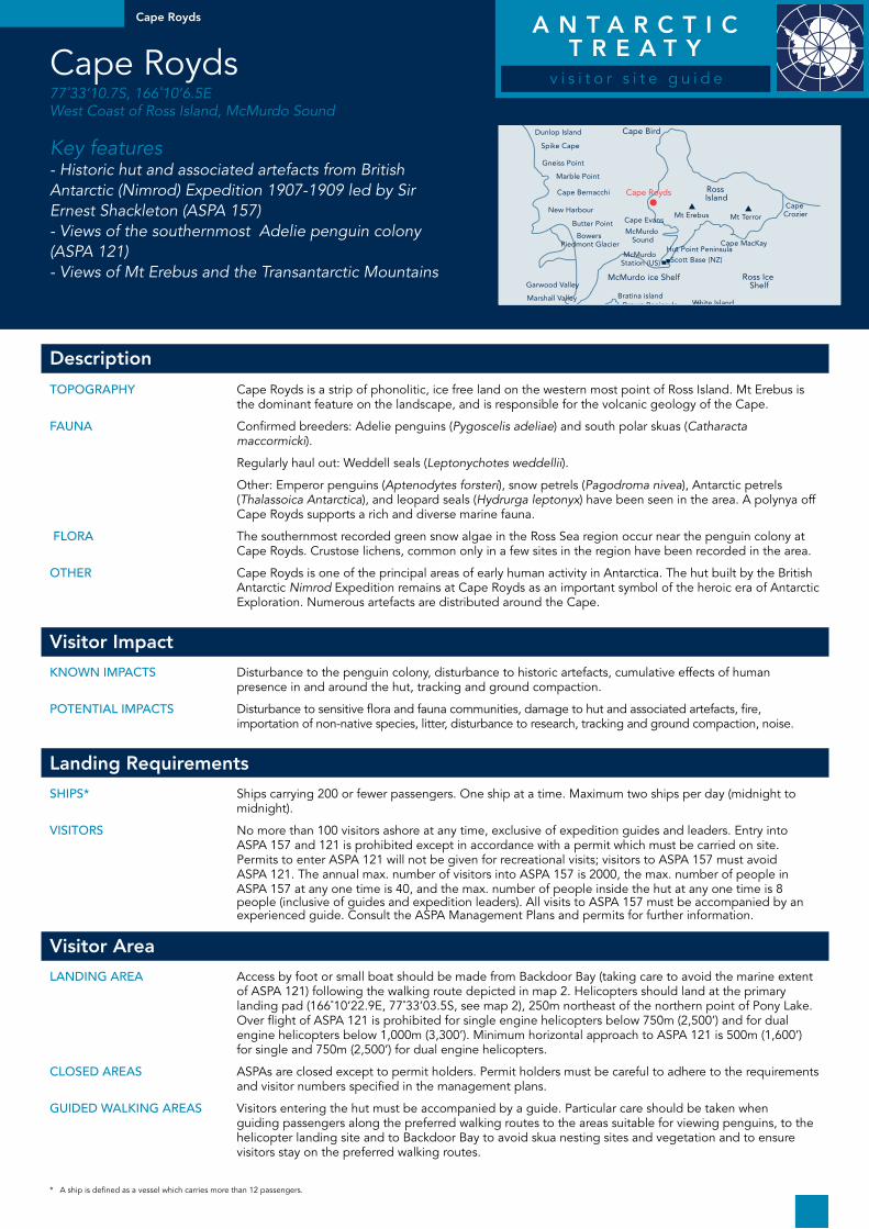
Cape Royds 77˚33’10.7S, 166˚10’6.5E West Coast of Ross Island, McMurdo Sound
Key features- Historic hut and associated artefacts from British Antarctic (Nimrod) Expedition 1907-1909 led by Sir Ernest Shackleton (ASPA 157)- Views of the southernmost Adelie penguin colony (ASPA 121)- Views of Mt Erebus and the Transantarctic Mountains
Dunlop Island Cape Bird
Ross Island
Mt ErebusCape Evans
Bratina islandBrown Peninsula
Black island
White Island
McMurdo ice Shelf Ross Ice Shelf
Kilometres
0 40
McMurdo Sound
McMurdo Station (US)
Hut Point PeninsulaScott Base (NZ)
Mt Terror
Cape MacKay
Cape Crozier
Spike Cape
Gneiss Point
Marble Point
Cape Bernacchi
New Harbour
Butter Point
Garwood Valley
Marshall Valley
Miers Valley
Bowers Piedmont Glacier
Cape Royds
Description
Topography Cape Royds is a strip of phonolitic, ice free land on the western most point of Ross Island. Mt Erebus is the dominant feature on the landscape, and is responsible for the volcanic geology of the Cape.
Fauna Confirmed breeders: Adelie penguins (Pygoscelis adeliae) and south polar skuas (Catharacta maccormicki).
Regularly haul out: Weddell seals (Leptonychotes weddellii).
Other: Emperor penguins (Aptenodytes forsteri), snow petrels (Pagodroma nivea), Antarctic petrels (Thalassoica Antarctica), and leopard seals (Hydrurga leptonyx) have been seen in the area. A polynya off Cape Royds supports a rich and diverse marine fauna.
Flora The southernmost recorded green snow algae in the Ross Sea region occur near the penguin colony at Cape Royds. Crustose lichens, common only in a few sites in the region have been recorded in the area.
oThEr Cape Royds is one of the principal areas of early human activity in Antarctica. The hut built by the British Antarctic Nimrod Expedition remains at Cape Royds as an important symbol of the heroic era of Antarctic Exploration. Numerous artefacts are distributed around the Cape.
Visitor Impact
Known impacTs Disturbance to the penguin colony, disturbance to historic artefacts, cumulative effects of human presence in and around the hut, tracking and ground compaction.
poTEnTial impacTs Disturbance to sensitive flora and fauna communities, damage to hut and associated artefacts, fire, importation of non-native species, litter, disturbance to research, tracking and ground compaction, noise.
Landing Requirements
ships* Ships carrying 200 or fewer passengers. One ship at a time. Maximum two ships per day (midnight to midnight).
VisiTors No more than 100 visitors ashore at any time, exclusive of expedition guides and leaders. Entry into ASPA 157 and 121 is prohibited except in accordance with a permit which must be carried on site. Permits to enter ASPA 121 will not be given for recreational visits; visitors to ASPA 157 must avoid ASPA 121. The annual max. number of visitors into ASPA 157 is 2000, the max. number of people in ASPA 157 at any one time is 40, and the max. number of people inside the hut at any one time is 8 people (inclusive of guides and expedition leaders). All visits to ASPA 157 must be accompanied by an experienced guide. Consult the ASPA Management Plans and permits for further information.
Visitor Area
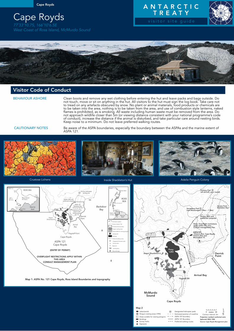
landing arEa Access by foot or small boat should be made from Backdoor Bay (taking care to avoid the marine extent of ASPA 121) following the walking route depicted in map 2. Helicopters should land at the primary landing pad (166˚10’22.9E, 77˚33’03.5S, see map 2), 250m northeast of the northern point of Pony Lake. Over flight of ASPA 121 is prohibited for single engine helicopters below 750m (2,500’) and for dual engine helicopters below 1,000m (3,300’). Minimum horizontal approach to ASPA 121 is 500m (1,600’) for single and 750m (2,500’) for dual engine helicopters.
closEd arEas ASPAs are closed except to permit holders. Permit holders must be careful to adhere to the requirements and visitor numbers specified in the management plans.
guidEd walKing arEas Visitors entering the hut must be accompanied by a guide. Particular care should be taken when guiding passengers along the preferred walking routes to the areas suitable for viewing penguins, to the helicopter landing site and to Backdoor Bay to avoid skua nesting sites and vegetation and to ensure visitors stay on the preferred walking routes.
* A ship is defined as a vessel which carries more than 12 passengers.
A N T A R C T I C T R E A T Y
v i s i t o r s i t e g u i d e
A N T A R C T I C T R E A T Y
v i s i t o r s i t e g u i d e
Crustose Lichens
Visitor Code of Conduct
BEhaViour ashorE Clean boots and remove any wet clothing before entering the hut and leave packs and bags outside. Do not touch, move or sit on anything in the hut. All visitors to the hut must sign the log book. Take care not to tread on any artefacts obscured by snow. No plant or animal materials, food products or chemicals are to be taken into the area, nothing is to be taken from the area, and use of combustion style lanterns, naked flames is prohibited, as is smoking. All waste including human waste must be removed from the area. Do not approach wildlife closer than 5m (or viewing distance consistent with your national programme’s code of conduct), increase the distance if the animal is disturbed, and take particular care around nesting birds. Keep noise to a minimum. Do not leave preferred walking routes.
cauTionary noTEs Be aware of the ASPA boundaries, especially the boundary between the ASPAs and the marine extent of ASPA 121.
Cape Royds
Cape Royds 77˚33’10.7S, 166˚10’6.5E West Coast of Ross Island, McMurdo Sound
Inside Shackleton’s Hut Adelie Penguin Colony
Pony Lake
30
10
20
10
H
H
Ross IslandMt Erebus
Scott Base (NZ)
McMurdoStation
(US)
MAP 1ASPA 121
Cape Royds
ASPA 121Cape Royds
INSET 2
CapeBird
CapeCrozier
Ross Ice
Shelf
Shelter (NZ) and preferred campsite
ASPA 157Backdoor Bay
(Entry by Permit)
DerrickPoint
BackdoorBay
ArrivalBay
Flagstaff Point
IT3
Depot (Shackleton’s)
Cape Royds
(ENTRY BY PERMIT)
OVERFLIGHT RESTRICTIONS APPLY WITHIN THIS AREA
CONSULT MANAGEMENT PLAN
Map 1: ASPA No. 121 Cape Royds, Ross Island Boundaries and topography
Shacketon’s HutHistoric Site& Monument
No. 15
Primary helicopterlanding site
ASMA No. 2McMurdoDry Valleys
ROSSSEA
Cape Adare
INSET 1
INSET 2
VIC
TORI
A
LAN
D
Mario Zucchelli (IT)
Estimated coastline
Contour interval: 10m
Protected area boundary
Penguin nesting areas
Areas suitable for viewing penguins
Lakes/ponds
Buildings
Preferred walking routes
Designated helicopter pads
Survey marks
Signposts
Landing place
Ship anchorage
IT2
ROSS SEA
Ross IceShelf
30
30
20
10
10 20 20
20
20
20
10
Lakes/ponds
Penguin nesting areas (1990)
Areas suitable for viewing penguins
BuildingsSurvey marks
Signposts
Primary Pad (all aircraft, year round)
Access from Backdoor BaySecondary Pad
(use discouraged 1 Nov – 1 Mar)
Shelter (NZ) and preferred campsite
Note: Overflight restrictions apply within this area. Consult management Plan
Depot (Shackleton’s)
Flagstaff Hill
Boundary of marine area
ASPA157 –Historic Hut, Cape Royds, Historic Site and Monument 15
Arrival Bay
Cape Royds
IT3
McMurdoSound
Derrick Point
0 meters 50
H
H
H
Pony Lake
ASPA 121
Projection: Lambert conformal conic
Spheroid: WGS 1984
Source: Cape Royds Management plan
IT2
IT1
Preferred walking routes
ASPA 121 Boundary
ASPA 157 boundary
Estimated position of coastline
Designated helicopter pads
Contour interval: 2m
Map 2