Embed Size (px)
Citation preview
CAROLINA GEOLOGICAL SOCIETY
GUIDEBOOK
FOR THE
SOUTH CAROLINA COASTAL PLAIN FIELD TRIP
NOVEMBER 16-17, 1957
By
George E. Siple, Geologist
U.S. Geological Survey
Prepared in cooperation with the South Carolina State Planning Board
NOVEMBER 1957
Retyped and formatted from the original. Some very light editing. October 1999

na
Officers of Carolina Geological Society (1956-1957
President: Harry LeGrand, Raleigh, North CarolinaVice-president: W.H. Wheeler, Department of Geology, University of North Carolina, Chapel, North CaroliSecretary: E. Willard Berry, Duke University, Durham, North Carolina
Excursion Leader
George E. Siple, GeologistU.S. Geological Survey
Open-file report.Not reviewed for conformance with standards and nomenclature of the U.S. Geological Survey
224
iddle
CONTENTS
Page
Introduction 1Description of formationsUpper Cretaceous serie 3
Tuscaloosa formation 3Black Creek formation 5Peedee formation 7
Tertiary system 8Paleocene (?) series 8
Midway (?) formation 8Eocene series 8
Wilcox (?) group 8Black Mingo formation 8
Claiborne group 9Congaree formation 9Warley Hill formation 11McBean formation 12Santee limestone 13Castle Hayne limestone 13
Jackson group 15Barnwell formation 15
Oligocene series 16Cooper marl 16Flint River formation 17
Miocene series 17Tampa (?) limestone 17Hawthorn formation 18Duplin formation 19
Pliocene series 20Waccamaw formation 20
Pleistocene series 22Structure 24Road log 31Description of localities 35References 48
ILLUSTRATIONS
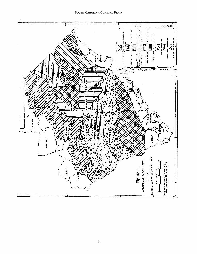
Figure 1. Generalized geologic map of the Coastal Plain of South Carolina2. Map showing subsea contours on the pre-Cretaceous Surface3. Excursion route and localities 31
TABLES
Table 1. Description of geologic formations in South Carolina and their correlation with Gulf Coast and MAtlantic Coast equivalents2
CAROLINA GEOLOGICAL SOCIETYGuidebook for 1957 Annual Meeting
Pages 1-1
cksasmeingces,
e-
alral-en-eost
uth-
ri-allas
eis-nd-y
ys-us.
ous.ous,ro- in
reevelyon-
edith
ndded
INTRODUCTION
The annual field trip taken by the Carolina GeologicSociety is designed to acquaint members with interesting noteworthy features concerning the geology of the two Calinas. Some members have requested that a trip, organby the Ground Water Branch of the U.S. Geological Survbe held in the Coastal Plain of South Carolina. This trip warranged to fulfill that request.
Since 1946, ground- water investigations have been cried out intermittently by the U.S. Geological Survey withthe State, in cooperation with the South Carolina StDevelopment Board (formerly the South Carolina Reseaand Development Board). During the course of these actties, the writer has had opportunity to study some of the sface and subsurface geology of the area. However, this trnot intended to be an all- inclusive or detailed account of Coastal Plain geology. Limitation of time and other factoprohibit more than a general survey of some of the mimportant sections of the stratigraphic column. The stragraphic nomenclature and age designations used in threport do not necessarily follow the usage of the U.S. Glogical Survey.
Good outcrops of the sedimentary formations are scaowing to the covering mantle of material of PleistoceneRecent age and the generally low relief of the area. But ihoped that the locations selected will afford an accurate resentation of a greater part of the stratigraphic column.
Some localities show only beds of one formatiowhereas others have two or more and thereby indicatenature of the formational contact.
Early investigators and travelers from the late 18th cen-tury to the present time have reported on the geology ofSouth Carolina Coastal Plain. Many of their works areferred to in the text and identified in the list of references
DESCRIPTION OF FORMATIONS
The sedimentary formations of the Coastal Plain ranin age from Late Cretaceous to Recent. They consist, formost part, of unconsolidated sand, clay, gravel, marl, alimestone which have been deposited on a surface of gran
1
alandro-izedey,as
ar-inaterchivi-ur-
ip isthersoreti-iseo-
rce, tot isrep-
n, the
there.
ge thendite,
schist, and gneiss similar to and a continuation of the rounderlying the adjoining Piedmont province. Some coquinhave been silicified to form so-called buhrstones and soclays hardened into siltstones. The phosphate rock occurrin the southern part of the Coastal Plain is, in some plavery hard and forms a caprock overlying the permeable limstone.
The distribution of geologic formations on the CoastPlain is indicated on figure 1. The boundaries are geneized and are not to be interpreted rigorously. The sedimtary beds form wedges which dip and thicken gently to thsouth and southeast. They crop out at the surface in almparallel belts that extend across the Coastal Plain from sowest to northeast.
The effect of topography is reflected in the greater intcacy of contact pattern in the areas contiguous to the FLine, contrasted with the simpler pattern in downdip areleveled by Pleistocene marine inundations.
Such factors as weathering and the thin mantle of Pltocene cover complicate the mapping of formational bouaries in the Coastal Plain, making it rather difficult in manparts of the area.
Upper Cretaceous Series
At the present time, all deposits of the Cretaceous stem in South Carolina are considered Upper CretaceoSloan (1904) considered the basal beds Lower CretaceSloan (1904) considered the basal beds Lower Cretaceas did Stephenson (personal communication) in North Calina because of their similarity to Lower Cretaceous bedsthe Middle Atlantic states.
The Upper Cretaceous deposits are divided into thformations, the Tuscaloosa at the base, overlain successiby the Black Creek and Peedee formations. Erosional uncformities separate each of the three formations.
Tuscaloosa FormationThe Tuscaloosa formation is the oldest recogniz
deposit of Late Cretaceous age in the State. In 1887 Smand Johnson named this formation from the city, county, ariver of that name in Alabama. Later, the name was exten
GUIDEBOOK FOR THE SOUTH CAROLINA COASTAL PLAIN FIELD TRIP
NOVEMBER 16-17, 1957 1
George E. Siple
Geologist, Ground Water Branch Water Resources Division
U.S. Geological Survey, Columbia, S.C.
1.Publication authorized by the Director, U.S. Geological Survey

GEORGE E. SIPLE
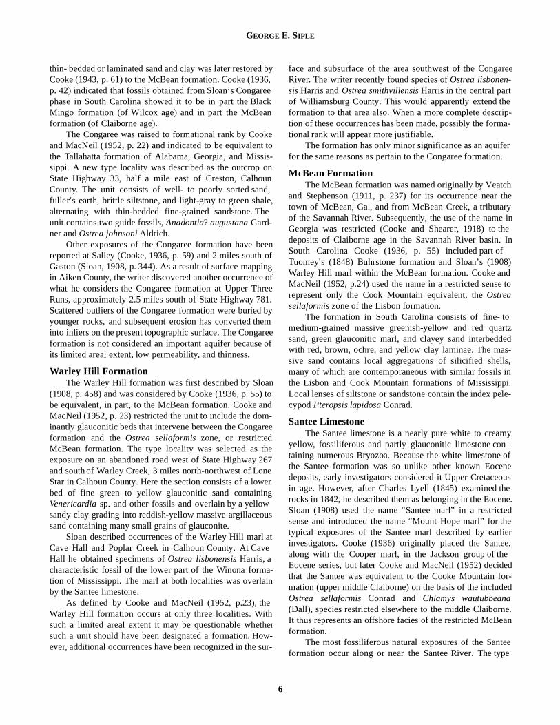
Table 1: Description of geologic formations in South Carolina and their correlation with the Gulf and Middle Atlantic equivalents.
System Series GroupGulf Coast
South Carolina
Middle Atlantic Coast
Description of formation in South Carolina
Quaternary
Recent Light-gray and tan fine to coarse lenticular sand and interbedded clay of marine and conti-nental origin.
PleistoceneBeaumont clay
Lissie sand
PamlicoTalbotPenhalowayWicomicoCoharieHazelhurst
PamlicoTalbotPenhalowayWicomicoCoharieHazelhurst
Light-gray, tan, orange, red, and black clay interbedded with sand and gravel. Deposits form a thin cover over greater portion of Coastal Plain.
Tertiary
Pliocene Willis (?) sand and Goliad sand
Waccamaw Brandywine (?) Waccamaw
Blue-gray to yellow and brown sandy shell marl.
Miocene
Lagarto (?) clay
Duplin marl Yorktown Buff sandy, friable shell marl occurring in isolated patches in lower half of Coastal Plain
Oakville ssHawthorn----------?--------
Tampa (?)limestone1
St. MarysChoptankCalvert
Hard, brittle shale resembling silicified fuller’s earth, with fine sandy phosphatic marl.
Catahoula ssWhite sandy phosphatic, fossiliferous limestone with molds and fragments of macro-shells.
OligoceneVicksburg or Upper Suwanee Flint River
? Broken lumps of yellow vitreous chert in reddish-yellow sand. Chert is sparingly fossilifer-ous.
Red Bluff Cooper Marl ? Light-brown to grayish-green marl, phosphatic.
Eocene
Jackson Jackson Cooper Piney PointLight-brown to grayish-green phosphatic marl is characteristic of the Cooper. The Barn-well consists typically of deep-red to brown fine to coarse massive red sandy clay and clayey sand. Probably represents a residuum derived from solution of a sandy limestone.
Claiborne
Cockfield or Gosport
Castle Hayne Limestone
Nanjemoy
Aquia
Buff-gray tough or crumbly fossiliferous limestone underlain by soft fine-grained granular limestone. Fore-reef type of deposition.
Cook Mountain McBean/Santee
The McBean formation consists of fine- to medium-grained massive green-yellow and red quartz sand, green glauconitic marl, silicified beds of coquina, and clayey sand interbed-ded with red, brown, ochre, and yellow clay laminae. Littoral to neritic environment grada-tional with some estuarine or continental.The Santee limestone is a nearly pure white to creamy yellow fossiliferous and partly glau-conitic limestone containing numerous Bryozoa. Fore-reef type of depositional environ-ment.
Zilpha clayWinona
Warley Hill marl Fine green to yellow glauconitic sand overlain by yellow to reddish-yellow sandy clay.
Tallahatta CongareeWell to poorly sorted sand, fuller’s earth, brittle siltstone, and light-gray to green shale alternating with thin bedded fine-grained siltstone.
WilcoxHatchetigbee to Nanafalia Black Mingo
Partly indurated fine white to yellow sand and sugary sandstone or bioclastic limestone. Cement is white and calcareous to siliceous. Underlain by gay to black laminated shales containing numerous macro-shells in some areas.
Paleocene Wills PointKinkaid
? Unnamed - may be in part Black Mingo
Peedee
Brightseat Black to gray laminated clay interbedded with fine white sand and in some areas contain-ing many shells.
CretaceousUpper
Cretaceous
Navarro Kemp clay to Naylandville marl
Monmouth Dark-green to gray micaceous, glauconitic, argillaceous sand interbedded with impure limestone and massive dark clays. Deposited under open marine conditions -- probably at depths of not less than 100 fathoms.
TaylorTaylor group Snow
Hill Marl Mem-ber
Unnamed mem-ber
Matawan group Light-gray and dark clays interbedded with greensand and marine clay. Transition zone between the deeper marine Peedee formation and the more shallow marine Black Creek deposits.
Austin
Austin Magothy Dark-gray to black laminated lignitic clays interbedded with white to gray phosphatic, glau-conitic sand. Deposited in shallow marine, estuarine, and paludal environment.
Eagle Ford shale Eagle Ford shale1
?
?
Gray, buff, and red arkosic crossbedded sand and gravel, interbedded with lenses of white and purple clay and kaolin. Mixed continental and marine environment characterized by fluvial, deltaic, and littoral deposits.
Woodbine Woodbine sand Tuscaloosa Raritan
1 Recognized only in the subsurface.
Bar
nwe
llB
lack
Cre
ek
2
SOUTH CAROLINA COASTAL PLAIN
3

GEORGE E. SIPLE
aedstial theical
bleldsen
anlo-ng
oThed theon-ca-
ingain,yboutells
gig-
stonedsrope
nsrry
er
on-hee00nal
aliseetthehel-
into Georgia by Spencer (1890). In 1936, Cooke correlaSloan’s Hamburg and Middendorf beds (1904, 1908) oSouth Carolina with the Tuscaloosa of Georgia. From tMiddendorf locality in Chesterfield County, Berry (1914)lists 41 plant species, 23 of which occur in the Raritan aMagothy formations of New Jersey and Maryland and tTuscaloosa formation of Alabama.
On the basis of re-analysis of the flora at MiddendoDorf (1952) placed 25 species in common with the BlaCreek of North Carolina; 26 with the Tuscaloosa of Albama; 24 with Magothy of Virginia; 14 with the Eutaw oAlabama, and 4 with the Woodbine formation of Texas. Hconcluded that the plant-bearing beds of the Middendlocality were age equivalents to the plant-bearing lower pof the undifferentiated Black Creek formation of NortCarolina.
The Tuscaloosa formation in South Carolina consitypically of light-gray, white, or buff-colored arkosic sandand grave interbedded with white, pink, brown, or purpclay. The formation is broken by many local unconformitieVoidal iron-oxide concretions, festoon crossbedding, angraded bedding are characteristic structural features. TTuscaloosa crops out in a belt gradually widening from 1040 miles, extending in a northeasterly direction from AikeCounty to Marlboro County. In updip areas the top of thformation dips 15 to 20 feet per mile, although across the length of the Coastal Plain the degree of dip increasesapproximately 30 feet per mile. The thickness ranges fromfeatheredge at the Fall Line to more than 800 feet in tsouth coastal area. In its outcrop area, the Tuscaloosa ctains lenticular deposits of kaolin, which, in some localitieare commercially minable--- principally in Aiken County.
Except for the occurrence noted by Siple, Brown, aLeGrand (1956) in an outcrop of questionable Tuscalooage near Cheraw, Chesterfield County, there has beenrecorded faunal evidence in the outcropping beds of the Tcaloosa in the Atlantic Coastal Plain. Mrs. E.R. Applin (pesonal communication) reports that fauna similar to threported at Cheraw were found in the USGS Boykin no.2borehole drilled through the Tuscaloosa formation near outcrop area in western Alabama.
The authenticity of the use of the name Tuscaloosa been open to some question in this area. Berry (1914) csidered the beds in the Middendorf area as an arkosic mber of the Black Creek formation. Eargle (1955) considethat the Tuscaloosa thins out to 30 feet or less as it croGeorgia in the northeastern direction, and that most of deposits in east Georgia mapped as Tuscaloosa reprebeds of Selma age. Considered to be mostly nonmarine,formation does evidence facies changes both along the stand down the dip. Thus, it is possible that the sand and cidentified as the Tuscaloosa formation in Kershaw and Chterfield Counties become the marine or near-marine depoof the Black Creek formation downdip. Similarly, the san
4
tedf
he
ndhe
rf,cka-fe
orfarth
sts
les.dhe tonefull to a
heon-s,
ndsa nous-r-at, aits
hason-em-rs
ssesthesent
therikelayes-sitsd
and clay of Aiken and lower Lexington Counties have marked lithologic resemblance to the post-Tuscaloosa bof southwestern Georgia. However, until more substanevidence is obtained and a more suitable name applied,name Tuscaloosa is herewith used in reference to typlithology in this State.
The Tuscaloosa formation is one of the most permeaunits in the stratigraphic column and provides large yie(up to 2,000 gallons per minute) to individual wells. Thchemical quality of the water moving through the formatiois very good for most purposes.
Black Creek FormationThe name “Black Creek shale” was used by Slo
(1907) to describe beds exposed along Black Creek in Frence and Darlington Counties and at various points alothe Pee Dee River
The formation consists principally of very dark gray tblack laminated clay and white to tan micaceous sand. sands are to some degree phosphatic and glauconitic anentire formation contains a considerable amount of carbaceous material which includes nodules of pyrite and marsite.
The Black Creek crops out in an arcuate belt extendfrom the central to the northeastern part of the Coastal Plfrom Lexington County on the southwest to Dillon Counton the northeast. The formation has an average dip of a23 feet per mile to the south-southeast. Its thickness in wnear the coast approximates 600 feet.
The upper part of the Black Creek formation, containina prolific and characteristic marine macrofauna, was desnated the Snow Hill member by Stephenson (1923).
The lower part of the Black Creek formation, in contrato the Snow Hill, is only sparsely fossiliferous. Stephensidentified only three molluscan species from the basal bof the Black Creek, whereas he described 140 species fthe Snow Hill marl member. In the area considered the tylocality, eastern Darlington County, the only fossil remaiconsist of plant species, 15 of which are listed by Be(1914).
The Snow Hill marl member compromises the upppart of the Exogyra ponderosa zone of the Atlantic and GulfCoastal Plains, as indicated by Stephenson (1923). It is csidered correlative with beds of Taylor age in this area. Tlower part of the Black creek is thus correlative with thearly Taylor to late Austin (Eutaw?). From a depth of 18feet in a well on Sullivan’s Island, Stephenson (persocommunication) obtained a specimen he identified as Ostreaelegantula Newberry. This species has a very narrow verticrange, restricted to the lower Blufftown in Alabama. Thwould indicate that the Austin occurs at a depth of 1800 for less at Charleston, and lends additional credence to possibility that outcropping beds of Eutaw age occur in tPee Dee River valley. (See description of Mars Bluff loca
SOUTH CAROLINA COASTAL PLAIN
)ther,e-
edl. 2)n,er-
eri-ut-ely
ck
il- inropsi-
catend
-est-ackofthet is,sent
rkulteds
ous
, p.and,ly-ern. In67) the atree
or-ing
ity.)
Peedee FormationThe youngest and uppermost Cretaceous unit in So
Carolina is the Peedee formation. It was first described Ruffin (1843) when he applied the name “Peedee bedLater, Sloan (1908) used the term “Burches Ferry phawhen describing the formation but also used the name “PDee phase” to deposits of Miocene age.
The Peedee formation consists of greenish-gray glaunitic sand interbedded with sandy marl and thick black claOutcrop areas are restricted to those along streams andIntercoastal Canal. In interstream areas the younger stratTertiary or Pleistocene age form a concealing cover. Frence, Horry, Georgetown, and Williamsburg Counties cotain almost all the known outcrop areas, the best of whichalong the Pee Dee River between Burches Ferry and Yaunah Ferry. Additional outcrop areas are located on JeffrCreek, the Lynches River, Black Mingo Creek, the BlaRiver, the Waccamaw River, and the Intercoastal CanOwing to the structural influence of the Great Carolina arcthe Peedee formation has a gentle slope to the southeathe area near the North Carolina- South Carolina State but dips to the south in the lower parts of the South Carocoastal areas. The latter might be due in part to other sttural features, such as a basin in the area of the SavanRiver or the Santee River.
The most conspicuous Upper Cretaceous fossil is Exo-gyra costata, present in the upper beds. The characterisspecies, Exogyra cancellata, present in the basal beds of thformation in North Carolina is reportedly missing in SouCarolina.
The sandy parts of Peedee formation are utilizedmajor aquifers over a large part of the Coastal Plain, prinpally north and east of the Santee River. The permeabilitythese sands in not very high, and as a result, the water lehave been lowered substantially in local areas of hepumping. The water is generally of good quality, althoughis high in fluoride in the coastal areas.
Tertiary System
Paleocene (?) Series, Midway (?) Formation
Eocene Series, Wilcox (?) Group, Black Mingo Formation
The basal formation of the Tertiary system recognizedSouth Carolina is the Black Mingo formation of the Wilcogroup, equivalent to the Aquia formation of the MiddAtlantic States and the Tuscahoma and Nanafalia formatiof the Gulf Coast. Sloan (1908) adopted the name “BlaMingo shales” after Black Mingo Creek to describe the laminated sandy shale cropping out between the mouth of creek and Rhems. Cooke (1936) used the name to applall Eocene strata older than the McBean formation. His c
5
uthby.”
se”ee
co-ys. thea oflo-n- arehan-eysckal.h,st inlinelinaruc-nah
ticeth
asci- ofvelsavy it
inxleonsck-
they toor-
relation of the Black Mingo formation with the Wilcoxgroup was based primarily on the presence of Ostrea arrosisAldrich (restricted to the Nanafalia formation in Alabamaand Turritella mortoni Conrad, a species abundant in bothe Nanafalia and the Tuscahoma of Alabama. HowevBowles (1939, p. 271) later identified one of the latter spcies as a subspecies, T. mortoni mediavia Bowles, whichoccurs in the Midway group in Alabama.
Cooke and MacNeil (1952, p.21) subsequently indicatthat much of what had been mapped by Cooke (1936, pas the Black Mingo in Richland, Lee, Sumter, Clarendoand Williamsburg Counties should be considered as eithCongaree or Midway. Lithologically, the basal clays are similar to those of the Midway of the Gulf Coast, and the uppsand member presumably could be either Wilcox or Claborne in age. The Foraminifera obtained to date from ocrop areas of the Black Mingo have not indicated decisivwhether the material is Wilcox or Midway. Localitiesincluded below contained species identified by S.M. Herrias Anomalina umbonifera (Schwager), which could be ofeither age although Herrick thinks it is more probably Wcox. Foraminifera of Paleocene age have been identifiedthe subsurface in wells to the south and east of the outcarea. Thus, definite separation of the formation is not feable at the present time but the evidence appears to indithat it contains deposits of at least two ages (Midway aWilcox) and probably three (Midway, Wilcox, and Claiborne). There is also some indication that beds in the wcentral part of the Coastal Plain, previously mapped as BlMingo, actually represent the Black Creek formation Early Cretaceous age. MacNeil (1952, p. 21) regards reverse to be applicable in eastern Sumter County--- thathat the beds mapped by Cooke as Black Creek repreBlack Mingo.
The lack of a definite age classification of the dashales included in this group makes it considerably difficto identify or contour the top of the Upper Cretaceous bfrom well cuttings, owing to the similarity in lithologybetween the basal Tertiary clays and the Upper Cretaceclays.
Claiborne Group
Congaree FormationThe name Congaree was first used by Sloan (1908
455) as his Congaree phase, which included the shale, sand buhrstone underlying the Warley Hill phase and overing the Black Mingo phase. Exposures along the westscarp of the Congaree River were regarded as typicalGeorgia, Veatch and Stephenson (1911, pp. 238, 2described the Congaree clay as the basal member ofMcBean formation, the oldest Claiborne unit recognizedthat time. Cooke and Shearer (1918) reduced the Congato the rank of member and transferred it to the Barnwell fmation, of Jackson age. That part of the Congaree contain
GEORGE E. SIPLE
aree
erip-ma-
ern.
h therye in
the. In
8)
e to
ortz
deds-ls, ini.ele-
my- ofne
ousheene.tedheliere,ededfor-ed
ne.ean
teepe
thin- bedded or laminated sand and clay was later restoreCooke (1943, p. 61) to the McBean formation. Cooke (193p. 42) indicated that fossils obtained from Sloan’s Congarphase in South Carolina showed it to be in part the BlaMingo formation (of Wilcox age) and in part the McBeaformation (of Claiborne age).
The Congaree was raised to formational rank by Cooand MacNeil (1952, p. 22) and indicated to be equivalenthe Tallahatta formation of Alabama, Georgia, and Misssippi. A new type locality was described as the outcrop State Highway 33, half a mile east of Creston, CalhoCounty. The unit consists of well- to poorly sorted sanfuller’s earth, brittle siltstone, and light-gray to green shaalternating with thin-bedded fine-grained sandstone. Thunit contains two guide fossils, Anadontia? augustana Gard-ner and Ostrea johnsoni Aldrich.
Other exposures of the Congaree formation have breported at Salley (Cooke, 1936, p. 59) and 2 miles southGaston (Sloan, 1908, p. 344). As a result of surface mappin Aiken County, the writer discovered another occurrencewhat he considers the Congaree formation at Upper ThRuns, approximately 2.5 miles south of State Highway 78Scattered outliers of the Congaree formation were buriedyounger rocks, and subsequent erosion has converted tinto inliers on the present topographic surface. The Congaformation is not considered an important aquifer becauseits limited areal extent, low permeability, and thinness.
Warley Hill FormationThe Warley Hill formation was first described by Sloa
(1908, p. 458) and was considered by Cooke (1936, p. 55be equivalent, in part, to the McBean formation. Cooke aMacNeil (1952, p. 23) restricted the unit to include the dominantly glauconitic beds that intervene between the Congaformation and the Ostrea sellaformis zone, or restrictedMcBean formation. The type locality was selected as texposure on an abandoned road west of State Highway and south of Warley Creek, 3 miles north-northwest of LoStar in Calhoun County. Here the section consists of a lowbed of fine green to yellow glauconitic sand containinVenericardia sp. and other fossils and overlain by a yellowsandy clay grading into reddish-yellow massive argillaceosand containing many small grains of glauconite.
Sloan described occurrences of the Warley Hill marlCave Hall and Poplar Creek in Calhoun County. At CavHall he obtained specimens of Ostrea lisbonensis Harris, acharacteristic fossil of the lower part of the Winona formtion of Mississippi. The marl at both localities was overlaby the Santee limestone.
As defined by Cooke and MacNeil (1952, p.23), thWarley Hill formation occurs at only three localities. Witsuch a limited areal extent it may be questionable whesuch a unit should have been designated a formation. Hever, additional occurrences have been recognized in the
6
d by6,eeckn
ket tois-onund,le,e
een ofing ofree1. byhemree of
n) tond
-ree
he267neerg
us
ate
a-in
ehtherow-sur-
face and subsurface of the area southwest of the CongRiver. The writer recently found species of Ostrea lisbonen-sis Harris and Ostrea smithvillensis Harris in the central partof Williamsburg County. This would apparently extend thformation to that area also. When a more complete desction of these occurrences has been made, possibly the fortional rank will appear more justifiable.
The formation has only minor significance as an aquiffor the same reasons as pertain to the Congaree formatio
McBean FormationThe McBean formation was named originally by Veatc
and Stephenson (1911, p. 237) for its occurrence neartown of McBean, Ga., and from McBean Creek, a tributaof the Savannah River. Subsequently, the use of the namGeorgia was restricted (Cooke and Shearer, 1918) to deposits of Claiborne age in the Savannah River basinSouth Carolina Cooke (1936, p. 55) included part ofTuomey’s (1848) Buhrstone formation and Sloan’s (190Warley Hill marl within the McBean formation. Cooke andMacNeil (1952, p.24) used the name in a restricted sensrepresent only the Cook Mountain equivalent, the Ostreasellaformis zone of the Lisbon formation.
The formation in South Carolina consists of fine- tmedium-grained massive greenish-yellow and red quasand, green glauconitic marl, and clayey sand interbedwith red, brown, ochre, and yellow clay laminae. The masive sand contains local aggregations of silicified shelmany of which are contemporaneous with similar fossilsthe Lisbon and Cook Mountain formations of MississippLocal lenses of siltstone or sandstone contain the index pcypod Pteropsis lapidosa Conrad.
Santee LimestoneThe Santee limestone is a nearly pure white to crea
yellow, fossiliferous and partly glauconitic limestone containing numerous Bryozoa. Because the white limestonethe Santee formation was so unlike other known Eocedeposits, early investigators considered it Upper Cretacein age. However, after Charles Lyell (1845) examined trocks in 1842, he described them as belonging in the EocSloan (1908) used the name “Santee marl” in a restricsense and introduced the name “Mount Hope marl” for ttypical exposures of the Santee marl described by earinvestigators. Cooke (1936) originally placed the Santealong with the Cooper marl, in the Jackson group of thEocene series, but later Cooke and MacNeil (1952) decithat the Santee was equivalent to the Cooke Mountain mation (upper middle Claiborne) on the basis of the includOstrea sellaformis Conrad and Chlamys wautubbeana(Dall), species restricted elsewhere to the middle ClaiborIt thus represents an offshore facies of the restricted McBformation.
The most fossiliferous natural exposures of the Sanformation occur along or near the Santee River. The ty
SOUTH CAROLINA COASTAL PLAIN
toasies a
arl,theome orartsoncalasen-
ettledserndyts.esselldyus
)ard
ion, of ofthe
hndt
dlytheuth-alree
lytic
toametyostmeoseid-
exposure is usually considered to be that at Eutaw SpringOrangeburg County, 3 ½ miles east-northeast of EutawviA good collecting site may be found on the spoil bank of tNew Santee-Cooper Diversion Canal near Eadytown.
The Santee limestone is a moderately good aquifer, pviding sufficient amounts of water for domestic use ansome industrial use. The water is hard.
Castle Hayne LimestoneThe Castle Hayne limestone was named by Mil
(1910, 1912) from the town in New Hanover County, N.CReferred to the upper Eocene by Miller, it was correlatwith the Jackson group by Kellum (1926) and Richar(1950). Canu and Bassler (1920) specified the age of a lafauna of Bryozoa from the Wilmington area as “middle Jacsonian.”
Because many of the species used by Kellum to corlate the Castle Hayne with the Jackson group were lafound to have a greater stratigraphic range and because sspecies such as Crassatella alta Conrad are confined to theGosport sand, Cooke and MacNeil (1952, p. 25) restricthe Castle Hayne to the late Claiborne, equivalent to thGosport sand of Alabama.
In South Carolina surficial exposures of the CasHayne were recognized by Cooke and MacNeil (1952) onin artificial excavations such as the quarry of the CaroliCement & Lime Co., 2 miles north of Harleyville, Dorchester County. At this locality, Cooke and MacNeil measured46-foot section of the formation at the bottom of the pwhere it consisted of a buff-gray tough to hard, crumbly fosiliferous limestone overlying a gray soft fine-grained granlar limestone. The presence of the ostracod Haplocytherideamontgomeryensis (Howe and Chambers) at the surface neSantee Falls might indicate that this limestone is also CaHayne.
The full extent of the formation and its downdip extesion are as yet undetermined. Recent studies by the writeBeaufort and Jasper Counties appear to confirm the preseof the unit along the coast at comparatively shallow depth
The evaluation of the Castle Hayne as an aquifer wdepend on the extent to which some of the limestones, fmerly called the Cooper marl, may now be classified as Gport in age. Some of the Foraminifera in the lower Jackor Ocala unit in southern Beaufort County are closely simito species of Gosport age found in adjacent wells to north. The inferences are that much of what was formeconsidered Santee limestone or Cooper marl, may actube the Castle Hayne limestone.
Jackson Group
Barnwell FormationThe name Barnwell was affixed by Sloan (1908, p. 45
to the lower unit of his “Buhrston” in western South Carolina, characteristically developed in Barnwell County. Coo
7
s inlle.he
ro-d
ler.
eddsrgek-
re-terome
tede
tlely
na-
ait,s-u-
arstle
n-r innce
s. illor-os-slartherlyally
4)-
ke
(1936, p. 89) considered part of Sloan’s “Barnwell phase”be Claiborne in age but defined the Barnwell formation “an Eocene formation composed chiefly of sand that overlunconformably the McBean formation.” He considered itshoreward facies of the Santee limestone and Cooper min the Jackson group. Cooke and MacNeil (1952) revised dating of the Santee and the Cooper and considered sbeds mapped as Barnwell to be either middle Claibornemiddle Miocene in age. Thus they regarded only a small pof the supposed Barnwell to be representative of the Jackin the outcrop areas, but considered it possible that the Olimestone was present under cover as the offshore repretative of the Barnwell formation.
In South Carolina the Barnwell consists typically of finto coarse red massive sandy clay and clayey sand. Mogray or greenish-gray sandy clay also is present in lesamounts. The characteristic color is a deep red and saclay is exposed in vertical cliffs similar to loess deposiFerruginous sandstone layers 1 inch to 3 feet in thicknoccur locally. The appearance and lithology of the Barnwformation suggest that it represents a residuum of sanlimestone strata from which most, if not all, the calcareomaterial has been removed by solution.
In Aiken and Lexington Counties (Siple, 1957, p. 30the Barnwell has overlapped or transgressed northwestwover the rocks of Claiborne age, the Tuscaloosa formatand the crystalline rocks of the Piedmont. The thicknessthe formation is about 10 feet in the extreme northern partAiken County and increases downdip to about 90 feet in northern part of Allendale County.
Fossils are rare in the Barnwell formation, althougsome cherty layers have yielded fragments of Mollusca aBryozoa. At Shell Bluff in Burke County, Ga., a 30-fooshell bed containing Ostrea gigantissima Finch crops outalong the west side of the Savannah River. This reporteforms the basal unit of the Jackson group. Quantities of same species were recovered in n excavation 2 miles soeast of Ellenton in Barnwell County, S.C., and additionspecimens were obtained from the east bank of Lower ThRuns Creek in the Allendale quadrangle.
The Barnwell formation is significant as an aquifer onin that it supplies fairly ample amounts of water for domesuse.
Oligocene Series
Cooper MarlThe first use of the name Cooper has been attributed
several investigators, but Stephenson (1914) used the nto describe a foraminiferal marl outcropping in the viciniof Charleston, to which he referred as “either uppermEocene or Oligocene.” Cooke (1936, p. 82) applied the naCooper marl to exposures along the Cooper River, GoCreek, the Ashley River, and the Edisto River and consered the unit as late Eocene in age.
GEORGE E. SIPLE
w--
the the of
ticlic-rdedthe aheicds,thentlyinsway
rycol-
sdle
ot its-
orva-a (3ysornedke
up-
nnatebe
r-
lyder
On the basis of the macrofossil Chlamys cocoana (Dall)and the microfossil Bolivinella rugosa Howe, both consid-ered Red Bluff (early Oligocene) fossils, Cooke and MaNeil (1952, p. 27) placed the Cooper marl back in tOligocene series.
The Cooper marl is a finely granular olive-drab brownish marl containing glauconite and Foraminifera acharacterized by phosphatic nodules in the lower part. Gerally not very great, the maximum thickness is thought toless than 200 feet.
The formation has only minor significance as an aquiin South Carolina, and in fact is more important in its capity as an aquiclude (confining bed).
Flint River FormationThe Flint River formation of late Oligocene age wa
described by Cooke (1936, p. 98) as being typically devoped along the Flint River near Bainbridge, Ga., whenceextends northeastward across Georgia into South Carowhere it occurs only in a narrow strip bordering the Savanah River in Allendale County. Scanty exposures consistyellow vitreous chert in reddish-yellow sand. The chert hvery few fossils, most of which are unrecognizable.
The unit has very little significance as an aquifer.
Miocene Series
Tampa (?) LimestoneThe first use of the name “Tampa formation” is credite
to L.C. Johnson (1888, p. 235). Used subsequently asgroup and later restricted to a limestone formation in thvicinity of Tampa, Fla., Vernon (1942) revised the originterm, Tampa formation, to include “all sediments lyinabove the Suwanee limestone and below the Alum Blgroup.” Later, Vernon, Puri, and Calver (1956, p.13) dividthe Miocene series into three time-rock units, the oldestwhich was the Tampa stage. Downdip the Tampa consistsand, silt, marl, limestone, and fuller’s earth. The type arenear Tampa Bay.
Cooke (1943, p. 87) describes the Tampa in the outcarea of Georgia, and Herrick (in Herrick and Wait, 1955,7) tentatively identifies as Tampa the dense sandy acoarsely phosphatic material at depths of 110 to 140 feethe Savannah area. The writer likewise has made a tentacorrelation, mostly on the basis of lithology, of analogosubsurface sections in the adjacent area of Jasper and Bfort counties, S.C. Herrick (1955) found poorly preservForaminifera belonging to the genera Textularia, Quinquelo-culina, and Discorbis in a test well on Hilton Head IslandBeaufort County, S.C., and considered the fossils represetive of early Miocene or Tampa age.
That the formation has been recognized only in the susurface and is not very thick in the areas where it has brecognized limits its importance as an aquifer in South Calina.
8
c-he
tonden- be
ferac-
sel- it
linan- ofas
d ae
alguffed ofs ofa is
rop p.nd
t intive
useau-
ed
,nta-
b-eenro-
Hawthorn formationThe name Hawthorn was taken from the town of Ha
thorn in Alachua County, Fla. (Dall, 1892). In South Carolina, Cooke (1936, p. 101) included the Combahee shale,Parachucla marl, the Parachucla shale and marl part ofAshley marl, the Edisto marl, and the Salkehatchie phaseSloan (1908) within the Hawthorn formation.
The Hawthorn is characterized by sandy phosphamarl or soft limestone and hard brittle shale resembling siified fuller’s earth. Formerly recognized only in the lowepart of the Coastal Plain, it has subsequently been exten(Siple, 1957, p.33) to cover the high interstream areas of inner Coastal Plain. In its updip facies the unit exhibitscharacteristic mottling of deep purple, pink, and gray in tsandy clays and gravels. Small white flecks of kaolinitmaterial are commonly disseminated in the clayey sangiving them a milky appearance. From a featheredge in updip areas the formation thickens coastward apparereaching a maximum in Hampton County, and then thtoward the coast where it has been completely eroded ain places.
The Hawthorn formation is not considered to be vefossiliferous. The most common species that have been lected in areas along the Savannah River include Ostrea nor-malis Dall, Pecten acanikos Gardner, Carolia foridana Dall,and Mytilus conradinus d’Orbigny. These species and othercollected from the same area are considered Chipola (midMiocene) in age.
The Hawthorn, because of its low permeability, does nrate as an important aquifer in South Carolina, althoughdoes provide sufficient water for domestic and limited indutrial use.
Cooke (1936, p.115) used the name “Raysor marl” fdeposits of Miocene age alder than the Duplin and equilent to the middle part of the Yorktown formation of Virginiand North Carolina. However, these beds were very thin½ feet) and occurred at only one small exposure near RaBridge on the Edisto River. The name was later abandoand the unit transferred to the Dublin formation by Coo(1945, p. 182).
Duplin FormationThe Duplin formation is the youngest deposit of
Miocene age in South Carolina. The use of the name “Dlin” apparently originated with Dall (1896, p. 40), whoreferred to a fossil from the Duplin formation exposed iNatural Well, 2 miles southwest of Magnolia in DupliCounty, N.C. He later correlated the beds with the lMiocene. The Duplin in South Carolina is considered to equivalent to the upper Yorktown of Virginia and the Can-cellaria biofacies within the Choctawhatchee stage of Floida. A remnant of the lower Ecphora facies (equivalent tolower Yorktown) may be represented by the unit formercalled the Raysor marl, inasmuch as it contains an ol
SOUTH CAROLINA COASTAL PLAIN
easoth
.ger
la-eeln.
d asists.e-Pee
nore-15ay,ce
low-beeningur-inerpsir--nder
rea:et,
30. In at45,
verr-
fauna than the Duplin.The Duplin formation consists of a buff sandy friab
shell marl, generally less than 50 feet thick in South Calina. It occurs as isolated patches of various sizes, the larof which includes the area between Sumter, DarlingtoHemingway, and Mullins. In the writer’s opinion, a largpart of the Miocene deposits in the State have not bmapped as such; in other words, both the continental ph(Hawthorn formation) and the marine (Duplin formationextend more broadly than has been commonly recognizFrom both faunal and geomorphic criteria there is fairly deinite evidence to indicate that the Duplin formation exisalong with or in place of the Waccamaw formation in areextending from the North Carolina line down to BeaufoCounty near the Georgia State line.
Because of its limited thickness and permeability, tDuplin formation is not a major aquifer in this State. It isused as a source for domestic use by rural residents incounties indicated above.
Pliocene Series
Waccamaw FormationFrom the name “Waccamaw beds,” adopted by D
(1892), the name “Waccamaw formation” has come ingeneral use in describing the marine Pliocene depositsNorth and South Carolina. The formation consists of blugray to yellow and brown sandy shell marl. Its distributiothroughout the State is not well known but from recognizoccurrences it is thought to extend in a belt parallel to tcoast from the North Carolina boundary through HorCounty and part of Georgetown County. Its total thicknedoes not exceed 35 feet. Smaller areas have been recognin Berkeley County near the Cooper River and Goose Crand in parts of Charleston County. Characteristic Pliocemollusks include Pecten ernestsmithi Tucker, Pecteneboreaus senescens Dall, Scaphella floridana (Heilprin), andEncope macrophora (Ravenel).
Cooke noted that the fossil assemblage collected frothe exposure of this bed on the southeast side of GoCreek, Berkely County, contained species that were eituppermost Miocene or Pliocene but could not be pinndown more conclusively as to age. Mainly on the basisEncope macrophora, the unit was tentatively referred to thPliocene. Thus, although the exact age of the Waccamcould be either latest Miocene or Pliocene, it is herewincluded in the Pliocene until more conclusive evidencefound to the contrary. The presence of unconformable ctacts with underlying and overlying units in this State andother coastal States, plus the presence of restricted Pliomacrofossils, are regarded as supporting criteria forPliocene age. However, the writer identified specimens Andara lienosa (Say) Mansfield from the formation in northern Horry County. Mansfield reported this species from t
9
lero-gestn,
eeenase)ed.f-tsasrt
he
the
allto ofe-n
edheryssized
eekne
mosehered ofeaw
ith ison- incene aof
-he
Choctawhatchee stage (upper Miocene) of Florida, wherin North and South Carolina it has been described from bMiocene and Pliocene formations.
From the Bears Bluff locality in Horry County, S.MHerrick (personal communication) identified the followinForaminifera and classified them as probably uppMiocene:
Cibicides cf. C. americanus (Cushman)Cancris sagr D’OrbignyCibicides pseudoungerianus (Cushman)Cibicides concentricus (Cushman)Cibicides lobatulus (Walker and Jacob)Nonion advenum (Cushman)Nonion grateloupi D’OrbignyDiscorbis vilardeboana D’OrbignyTextularia cf. T. gramen D’OrbignyCibicides americanus (Cushman)Textularia candeiana D’OrbignyAsterigerina miocenica Cushman and PontonContemporaneous with marine deposits was accumu
tion of various continental deposits on the land. Thesinclude fulfill and deltaic deposits of sand and gravreferred to on the Gulf Coast as the Citronelle formatioEquivalent beds in South Carolina have not been mappeCitronelle but have been so regarded by several geologMany of the so-called “high-level gravels” are in this catgory; heavy concentrations are noted in the basins of the Dee, Wateree, and Savannah Rivers.
Pleistocene Series
Cooke (1936, p. 130) originally identified with seveseparate marine terraces which, with their respective shline altitudes, were the Brandywine, 270 feet; Coharie, 2feet; Sunderland, 170 feet; Wicomico, 100 feet; Penholow70 feet; Talbot, 42 feet; and Pamlico 25 feet. This terrachronology designates the highest as the oldest and the est as the youngest. It presumes the terraces to have formed as a result of a series of sea-level oscillations durglacial and interglacial stages, the terrace being formed ding the interglacial stage. Flint (1940) questioned the marorigin of the higher terraces but agreed that the lower scaand terraces along the Atlantic seaboard from southern Vginia to Florida were of marine origin. Flint identified seaward-facing scarps for the recognition of marine shores amapped remnants from the James River in Virginia to lowSouth Carolina. He recognized two such scarps in this athe Suffolk scarp, have a toe at an altitude of 20 to 30 feand the Surry scarp, having a toe at an altitude of 20 tofeet, and the Surry scarp, having a toe at 90 to 100 feetGeorgia and Florida, however, he recognized Trail Ridgealtitudes of 180 to 240 feet as a marine feature. Cooke (19p. 248) added the possibility of an eighth terrace, the SilBluff (?), at an altitude of 5 feet. MacNeil (1950, p.96) co

GEORGE E. SIPLE
on-
e57)iple,cks ofal-
cateuth-
thew)nd
entt ofan-ia,cks55ileile
herter-0-
heorepere-ile)
y aandth ass meern
ost orosero-se
ac-st-dee-73)
nderonhero-ural
roborated the existence of this terrace along with the 25-fo70-foot, and 100-foot, but considered the 42-foot terracebe obscure in Georgia and Florida. The highest recognizamarine shoreline according to MacNeil was the Okefenok(questionably equivalent to the Sunderland) at an altitude150 feet. Subsequently, Cooke (1954, p. 203) recognizedOkefenokee shoreline at an altitude of 145 feet and revivthe name Hazelhurst to replace Brandywine as the 270-terrace.
The Pleistocene formations in South Carolina consmostly of sand, clay, and gravel. In general, the younger fmations contain material less coarse than the older. The ors range from dark blue to gray, pink, yellow, and red. Tthickness of each is generally less than 25 feet and not mthan 50 feet. A considerable number of macrofossils habeen identified from the Pamlico formation but none froolder Pleistocene formations, except for the possibility indcated by Richards (1943) that mollusks from the SantCooper area might represent the Penholoway formationCooke or be contemporaneous with the formation of tSurry scarp of Flint.
Most observers agree that the data available are incclusive with respect to the delineation and origin of thigher terraces, and Taber (1954) includes all the posPliocene in one blanket Pleistocene deposit which believes overlapped the present Fall Line and extended the Piedmont. As is invariably pointed out, much sturemains to be done before a complete understandPliocene and Pleistocene stratigraphy is reached.
STRUCTURE
Considered en masse, the formations of the CoasPlain may be classified as having a monoclinal or aclinstructure; they rest on rocks of a much older crystalline coplex. The unconsolidated rocks occur as wedges of saclay, marl, and limestone which, from a featheredge at tFall Line, thicken coastward to approximately 10,000 feetNorth Carolina and more than 3,500 feet in South CaroliIn general, the strike is northeast-southwest and the dip ithe southeast or south.
Underlying the unconsolidated sediments are “crystline” rocks consisting of granite, gneiss, schist, and a seof volcanics. Fault troughs or grabens were formed in thpre-Mesozoic rocks during Triassic time, into which wedeposited ferruginous and carbonaceous sands and cThese sediments were subsequently injected by diabdikes and sills.
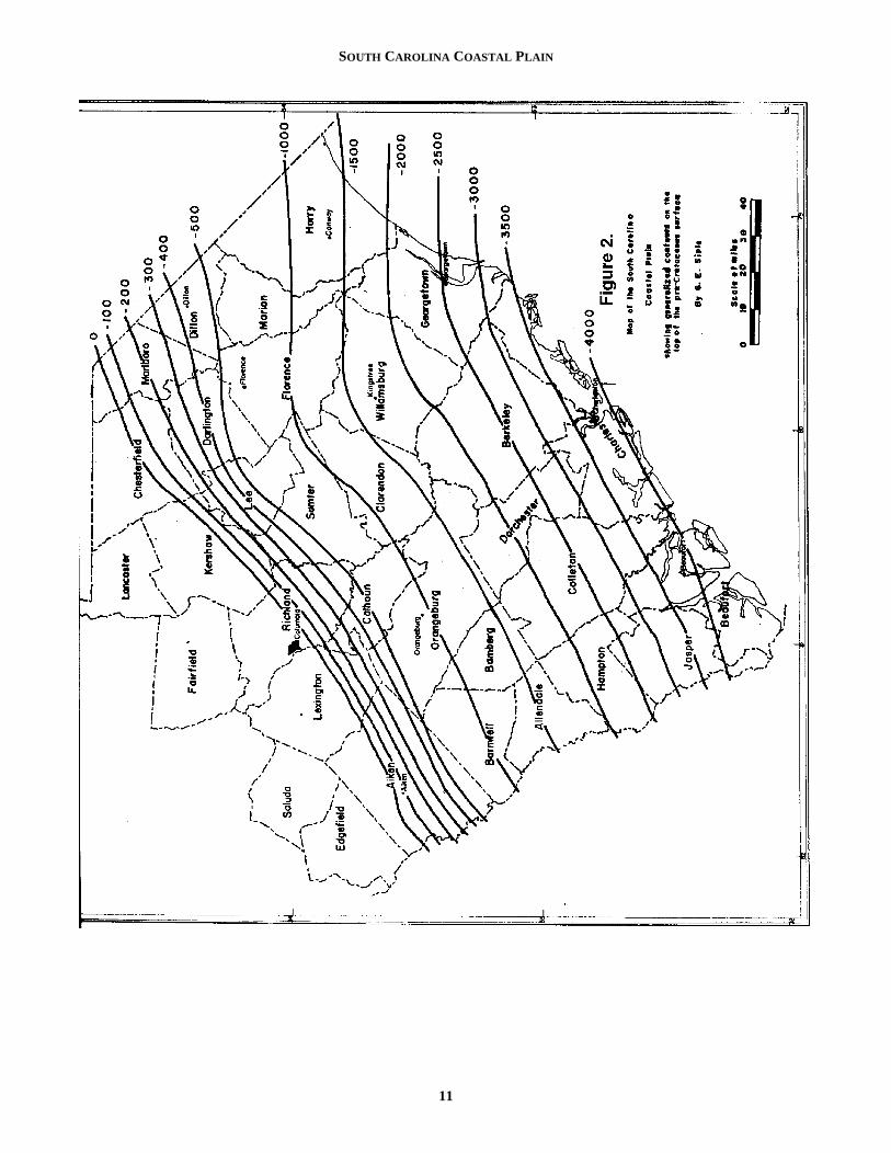
Figure 2 shows the configuration of the pre-Cretaceosurface as interpreted from geophysical and well data (wawells and oil tests), together with the data on basement-raltitudes contained in earlier publications. This contoursurface is essentially the basement surface, except thincludes elevations on top of the buried Triassic rocks, wh
1
ot, tobleee of aned
foot
istor-col-heoreve
mi-
ee- ofhe
on-het-heintodying
talalm-nd,he inna.s to
al-rieseserelays.ase
usterockedat itich
are “bedrock” so far as the Coastal Plain sediments are ccerned.
Three-point calculations of the strike and dip of thbasement rock in the western Coastal Plain (Siple, 19indicate that the average in the western Coastal Plain (S1957) indicate that the average strike of the basement roin this area is approximately N. 66 E. and the average diptheir surface is 36 feet per mile to the southeast. Similar cculations on basement altitudes in adjacent areas indithat these figures can be applied generally to the area sowest of the Pee Dee River. Northeast of the Pee Dee,structure of the Great Carolina ridge (described belomakes a considerable change in the direction of strike adegree of dip.
In adjoining States the structure of the buried basemrocks has been described in several reports, the lateswhich includes those of Eargle (1955) in Georgia and Spgler (1950 and Berry 1948) in North Carolina. In GeorgEargle determined that the strike of the basement roswings gradually form N. 77 E. in the western part to N. E. in the eastern part. He gives a dip of 55 to 60 feet per min the Chattahoochee River region and 70 to 80 feet per min the central region, the dips being more gentle dips fartto the east. In North Carolina, Spangler (1950, p. 132) demined the average slope of the crystalline floor to the 2,50foot subsea contour to be 35 feet per mile, but from t2,500- to the 5,500-foot contour the dip increased to mthan 100 feet per mile. Berry (1948) reported the steeslope to be from 122 to 124 feet per mile. Spangler’s basment map shows the steep slope (about 117 feet per mbetween the 2,500 and 5,500 subsea contour, followed bgentler slope (about 99 feet per mile) between the 5,500- 10,000-foot subsea contours. At the North Carolina-SouCarolina line the dip of the basement surface is indicatedabout 14 feet per mile. Richards’ map (1945, p. 952) showbasement dip of approximately 16 feet per mile in the saarea and a maximum dip of 38 feet per mile in the southpart of the Coastal Plain.
In the northeastern part of the Coastal Plain the mprominent structural feature is the Great Carolina ridgeCape Fear arch. This ridge is a broad anticlinal arch whaxis is roughly parallel to the Cape Fear River in North Calina. Spangler (1950, p. 132) describes it as a wide noplunging southeast at approximately 15 feet per mile.
On the basis of magnetometer surveys in this area, MCarthy (1936) obtained supporting evidence of a northwesoutheast structural uplift. Seismic-refraction traverses maby Bonini (1955, p. 1533) confirmed the attitude of the basment ridge, and those of Hersey and others (1955, p. 15demonstrated the extension of the Cape Fear arch out uthe continental shelf. Offshore reverse seismic-refractiprofiles conducted by Meyer (1955, p. 1579) between t10- and 20- fathom lines off the North Carolina- South Calina coast included six profiles near the Cape Fear struct
0
SOUTH CAROLINA COASTAL PLAIN
11
GEORGE E. SIPLE
ce.nd
it-iv-neite-ateforion.s6,ateyondnsedrlyro-
rly947;
ay, p.iane-
the
uc-red for the to
as offea-eis-otaro-
tod inkFallg to
oftruc- aith
eethanhalfreas
axis. This, as Meyer described it, “constitutes a prominebasement ridge rising from about -4,000 feet off of Charleton to –2,000 feet off Cape Fear and falling away to the noto about –10,000 feet at Cape Hatteras. The ridge striapproximately perpendicular to the general coast line.”
The true relationship between structure and stratigrapsequence in the vicinity of the arch, as indicated by LeGra(1955), is not a simple one.
Stephenson, in 1912, noted the absence of Lower Crceous beds representing the Patuxent formation (equivain part to the Tuscaloosa formation), in a deep well in tWilmington area and inferred that this was an indication oland barrier of some kind in this region. Later, Stephens(1923, p. 5) offered three hypotheses to explain the abseof the “Lower Cretaceous” beds in the Wilmington areThey were (1) that a land barrier existed in the Wilmingtarea during Early Cretaceous time, (2) that Lower Creceous beds were removed by erosion before the beginninUpper Cretaceous deposition, and (3) that the format(Patuxent) thins toward the southeast and pinches entirely between the underlying basement rocks and overlying Upper Cretaceous deposits before the coasreached.
Stephenson considered the basal sedimentary formatthe Patuxent, to be of Early Cretaceous age. This formawas subsequently considered equivalent to the Tuscaloformation in the lower part of North Carolina. In SoutCarolina Cooke (1926) included the Middendorf formatioin the Tuscaloosa formation. Stephenson had consideredMiddendorf to be equivalent to parts of the Black Creek fomation in North Carolina. Thus, to Stephenson, the presein the subsurface of beds of Middendorf lithology would bindicative of his Upper Cretaceous--- that is his Black Creformation, whereas in more recent stratigraphic interpretions this lithologic sequence would be considered characistic of the Tuscaloosa formation.
On the basis of structure, lithology, and possibly paleotology, there is considerable evidence to indicate the prence of buried pre-Taylor to pre-Austin (or Eutaw to EagFord equivalents) on the southern flank of the Carolina ArHowever, there is also the possibility, as indicated Stephenson, that beds of Tuscaloosa age may pinch between outcrop areas and the coastal areas or thatdeposits considered as Tuscaloosa in the outcrop reprethe continental facies of a unit of which the Black Creek fomation is the downdip equivalent.
The extent to which the stratigrahic sequence in tvicinity of the arch might have been affected by Triassbeds or terrain has not been determined. In a magnetic renaissance of the Coastal Plain, MacCarthy (1936, p. 4traced a Triassic basin (previously identified only from well log) northeast and southwest from Florence. As a cosequence of recent ground-water studies, the first cointerval of buried Triassic rocks in the South Carolin
1
nts-rth
kes
hicnd
eta-lenthef a
ncea.onta-g ofionoutthet is
ion,tionosahn ther-nceeekta-ter-
n-es-lech.byout thesentr-
heiccon-05)an-reda
Coastal Plain was obtained from a test well near FlorenThe cored sample was subsequently thin sectioned aexamined by Charles Milton, U.S. Geological Survey (wrten communication, 1955). He identified the rock as an oline diabase, consisting of fresh diopsidic pyroxene, olivi(somewhat serpentinized), calcic plagioclase, and ilmenmagnetite. Thus, the presence of Triassic ridges during LCretaceous or early Tertiary time could be responsible the absence of one or more units of the sedimentary sect
The formation of the Cape Fear arch or uplift waaccompanied by downwarping on the flanks. Cooke (193p. 158) believed that the downwarping occurred during lEocene time, causing the Jackson sea to transgress bethe limit of older Eocene and Upper Cretaceous formatioand to flood the border of the Piedmont. This was followby a Miocene transgression which left thin patches of neahorizontal marine formations, subsequently reduced by esion to separated remnants.
Other dates suggested for the arch range from EaCretaceous to the close of early Miocene. Some (Siple, 1Eardley, 1951) have suggested that uplift and erosion mhave occurred during more than one stage. Sloan (1908455) postulated a Cretaceous capped ridge, the “Carolinridge,” extending southeasterly from Florence to Georgtown, which was never extensively submerged until near close of the Miocene.
Supporting evidence for the existence of a basinal strtural on the west side of the arch is found in the contoupre-Cretaceous surface and such additional criteria as,example, the discordant dips of the Cretaceous strata inarea extending from the western part of Sumter Countythe central or eastern part of the county.
Major irregularities of the basement surface, such block faulting and resultant fault troughs (other than thosethe Triassic), have been suggested as specific structural tures in the vicinity of the Cape Fear arch. However, the smic and well data available at the present time do ncorroborate such large-scale features under the South Clina Coastal Plain.
The existence of medips, or basement rock, similarthat found at the Fountain, N.C., has never been confirmeSouth Carolina. Inliers, or “windows,” of basement rochave been observed in stream valleys contiguous to the Line, where the basement rock has been exposed owinthe erosion of overlying Coastal Plain sediments.
Structural features of the basement rocks exclusivethe Great Carolina arch include (1) a suggested basinal sture in the vicinity of the Savannah River valley and (2)basin in the Beaufort area which may not be connected wthe Savannah basin.
The dips of the Coastal Plain strata, ranging from 33 fper mile to less than 10 feet per mile, are slightly greater tthe drainage gradient. The dips of beds in the southern of the Coastal Plain are generally to the southeast, whe
2
SOUTH CAROLINA COASTAL PLAIN
13
GEORGE E. SIPLE
ro-
.d
on
ed
-
ein-
n
ast
ft)
on
on
on
).
urn.
’s
en
lo-
d
those in the north or northeastern part dip to the southeven southwest in the vicinity of the Carolina arch.
Fairly extensive overlap of the Cretaceous beds by Tertiary sediments is particulary characteristic of the abetween the Congaree and Savannah Rivers. There is sindication that Tertiary sediments were once extensivedeveloped in the area between the Congaree and PeeRivers, but the most of them have been removed b subquent erosion.
Faulting in the unconsolidated sediments, though nidentified specifically or known to extend over large areasfairly certain to have taken place in some areas. Neither eral nor vertical displacement is likely to have been larNevertheless, older residents of the State who rememberCharleston earthquake describe such phenomena as boiling up through cracks in the surface soil during and afthe first shock. Therefore, it is not improbable that mafractures do exist in the sediments and that there has bdisplacement along some. The fairly common occurrenceclay dikes in certain younger strata might be associated wstructural disturbances (Siple, 1954). Apparent lateral dcordance of the strata in the Jasper-Beaufort County amay have been caused by faulting.
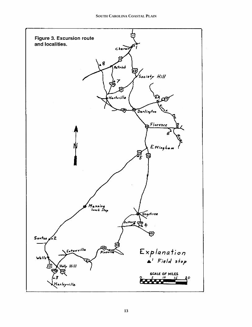
ROAD LOG
Assembling point: 8:30 a.m. – On U.S. Highway 1, newest end of bridge over the Pee Dee River at Cheraw, SPlease have a full tank of gas.Mileage
0.0 Stop 1. Cheraw, S.C. Proceed southwest on USthrough Cheraw.
2.0 Junction of US-1 and SC-9. Proceed south (left)US-1.
4.3 Junction of US-1 and US-52. Proceed southe(left) on US-52.
15.3 Society Hill- Junction of US-52 and US-15. Procesouthwest (right) on US-52
17.3 Junction of US-52 and US-15 on south side of Soety Hill. Proceed south (left) on US-52.
31.3 Darlington- Continue on US –52
41.3 Florence- Junction of US- 301 and US- 52. Continsouth on US-52 and US- 301 (straight ahead).
48.3 Effingham- Junction of US- 301 and US- 52. Prceed southwest (right) on US- 301.
61.7 Olanta – Continue southwest on US- 301.
85.7 Manning- Lunch stop. Variety of restaurants anlunch stands along US-301. Please reassempromptly. Reassembling Point: Manning City limit onsouth side of town – US-301. Continue trip procee
1
, or
thereaomely
Deese-
ot, islat-ge. thesandternyeen ofithis-rea
ar.C.
01
on
ast
ed
ci-
ue
o-
dble
d-
ing southwest on US-301.
95.8 Junction of US- 15 and US- 301 in Summerton. Pceed southwest (left) on US- 15.
103.2Lake Marion.
106.9Stop 2. Southwest end of bridge over Lake MarionTurn off highway to the right and park cars on olroad.
108.9Junction of US-15 and US-301. Continue south US-15 (left).
116.9Wells- Junction of US- 15 and SC- 176. Procesouthwest (left) on SC- 176.
120.9Holly Hill- Junction of SC-176 and SC-453. Proceed south (right) on SC-453.
127.3Stop 3. Carolina Giant Cement Company. Pleasreassemble promptly in order to complete the remader of the trip and arrive back in Florence on time.
133.7Return to Holly Hill via SC- 453. Continue north oSC- 453 to Eutawville.
140.7Junction of SC-453 with SC-6 and SC- 45. Turn e(right) on SC- 45.
151.7Junction of SC-6 and SC- 45. Turn northeast (leon SC-45 to Pineville.
163.5Pineville- Junction of SC-45 and SC-6. Take left SC-6.
166.0Junction of SC-6 and US-52. Proceed north (left)US-52.
170.0Santee River
176.6Junction of US-52 and US-521. Turn east (right) US- 521.
183.6Junction of US- 521 and SC- 377. Turn north (left
183.9Stop 4. Lower Bridge. Continue north on SC- 377.
190.3Junction of SC- 377 and SC- 175 in Kingstree. Tleft to junction of SC- 175 and US- 52 in KingstreeTurn north (right) on US- 52.
228.3Return to Florence on US- 52 (end of first daytrip).
Sunday – 8:30 a.m.Assemble on US-52 and US-301 in front of Gard
Gate Cafeteria, Florence. Head South.Mileage
0.0 Junction of US- 76 and US-301 and US-52 in Frence. Proceed south.
9.4 Effingham. Turn southwest (right) on US- 301.
11.8Elim at Sinclair Station- Turn south (left) onunpaved road.
12.1Stop 5. Continue around circle on unpaved roa
4
SOUTH CAROLINA COASTAL PLAIN
hen
og-ta,
d of
handsousr-ely
b-
-
du-
nd g-
theonet
back to
12.5Highway 301. Turn right and return to Florence.
24.6Junction of US- 76 with US-301 and 52 in FlorenTurn east (right) on US- 301.
34.1Junction of US- 301 with abandoned road, US- Turn right (southeast).
36.1Stop 6. Mars Bluff locality. Return to Florence onUS- 301 to
47.6Junction of US-301 and US-52 in Florence. Tunorth (right) on US-52. Proceed to
57.6Darlington. Turn left on SC-151.
68.1Junction of SC-151 and Alt- SC- 151. Keep to rigon Alt- 151.
72.1Hartsville- Take US-15 north (right).
74.4Junction of US- 15 and SC- 102. Turn north (leon SC-102.
79.9Note the change in topography from a level plaina dissected upland of rolling hills, representing thoutcrop area of the Tuscaloosa formation.
80.7Stop 7. Continue north on SC-102.
87.4Patrick – Junction of US-1 and SC-102. Turn souwest (left) on US-1.
92.5Junction of US-1 and SC-29. Turn north (right) oSC- 29.Signpost reads “Sugar Loaf Mountain.”
93.1Stop 8. Middendorf locality (McKennon on map).
End of Trip.
DESCRIPTION OF LOCALITIES
Stop 1 – Cheraw, Chesterfield County – Tuscaloosa formation
In a borrow pit on the west side of the flood- plain of thPee Dee River, approximately 300 feet south of U.S. Higway 1, beds assumed to be of Tuscaloosa age, are expbetween the highway and the Seaboard Air Line RailroThe locality lies well within the outcrop area of the Tuscloosa formation as mapped by Cooke (1936) but some of
1
ce.
76.
rn
ht
ft)
toe
th-
n
eh-
osedad.a- the
beds have a striking similarity to those characteristic of tEutaw or Black Creek formations. Form bed 7 Siple, Browand LeGrand (1956) collected what may be the first recnized microfauna from outcropping basal Cretaceous straeast of the Mississippi. The faunal assemblage consistedepauperate arenaceous forams including: Eouvigennia sp.,Pseudovigerina sp., Globigerina sps., Proteonina sp., Pelo-sina sp., Stilostonella sp., and Globulina (?) sp. Although thefauna were not diagnostic, they appeared to be older tforaminifera found by Brown in the subsurface Austin beof North Carolina. The host bed is a dark- gray carbonaceclay containing large fragments of lignite and fairly numeous nodules or concretions composed of approximatequal parts of quartz grains and marcasite.
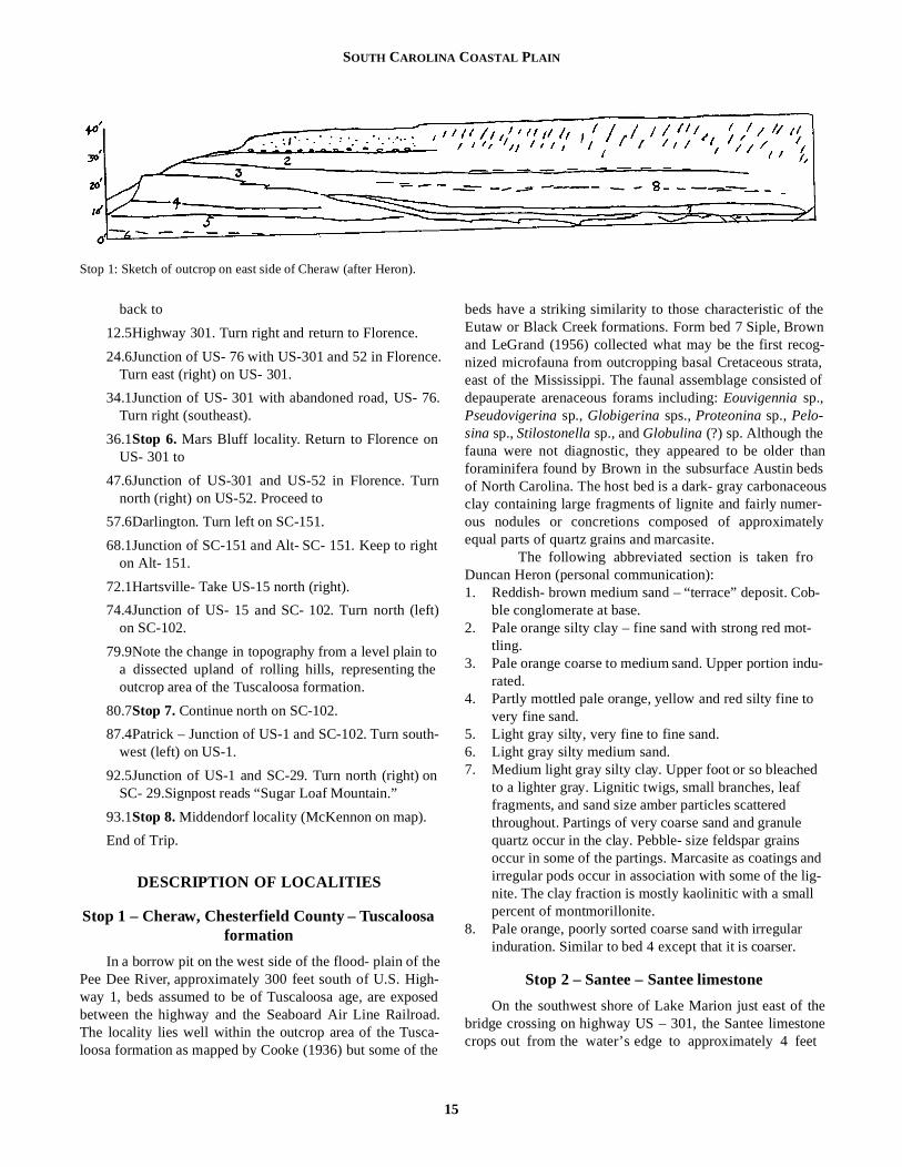
The following abbreviated section is taken froDuncan Heron (personal communication):1. Reddish- brown medium sand – “terrace” deposit. Co
ble conglomerate at base.2. Pale orange silty clay – fine sand with strong red mot
tling.3. Pale orange coarse to medium sand. Upper portion in
rated.4. Partly mottled pale orange, yellow and red silty fine to
very fine sand. 5. Light gray silty, very fine to fine sand.6. Light gray silty medium sand.7. Medium light gray silty clay. Upper foot or so bleached
to a lighter gray. Lignitic twigs, small branches, leaf fragments, and sand size amber particles scattered throughout. Partings of very coarse sand and granulequartz occur in the clay. Pebble- size feldspar grains occur in some of the partings. Marcasite as coatings airregular pods occur in association with some of the linite. The clay fraction is mostly kaolinitic with a small percent of montmorillonite.
8. Pale orange, poorly sorted coarse sand with irregularinduration. Similar to bed 4 except that it is coarser.
Stop 2 – Santee – Santee limestone
On the southwest shore of Lake Marion just east of bridge crossing on highway US – 301, the Santee limestcrops out from the water’s edge to approximately 4 fee
Stop 1: Sketch of outcrop on east side of Cheraw (after Heron).
5
GEORGE E. SIPLE
6)ngi-ate
etkend 1,ut
nd,in
or 3-
a-otn a,atysty,l-1.1er-
reed, in
above water where it is overlain by 12 to 15 feet of fine coarse red and tan mottled, crossbedded quartz sand gravel. Considerable piping and caving effects are noticeain the overburden in the area 1,000 feet east of the highwFrom the locality the writer collected a good specimen Ostrea sellaformis and several pelecypods. Other shells shell fragments are present in the semi- indurated limestoVugs filled with iron- cemented sand are also found scattethroughout the limestone. The following foraminifera weobtained from this locality: (Identification by S.M. Herrick.)
Cibicides americanus (Cushman)Cibicides ouchitaensis Howe and WallaceSiphonia claibornensis Cushman and Thomas
Stop 3 – Quarry of the Carolina Giant Cement Cor-poration, Harleyville – Cooper marl and Castle
Hayne limestone
The quarry of the Carolina Giant Cement Corporatioabout 2 miles north of Harleyville, Dorchester County, contains the section given by Cooke and MacNeil (1952, p. 2as representing the Cooper marl and the Castle Hayne listone. Their section, described in 1951, was as follows:Pleistocene FeetWicomico formation?
7. Dirty, clayey, sandy soil 36. Mottled gray and red clay, weathered at top 5. Subangular gravel containing pebbles as much a
inch in diameter at base 5UnconformityMiocene?
4. Fine angular yellow sand containing black grains asome glauconite 8
Oligocene (?)Cooper marl
3. Pale greenish- gray granular marl, glauconitthroughout and containing phosphatic nodules at tbase;Foraminifera and Chlamys cocoana (Dall)abundant 3-8
UnconformityEoceneCastle Hayne limestone
2. Buff-gray, tough to hard, crumbly limestoneChlamys cookei (Kellum) throughout; Chlamys n. sp.and Glycymeris staminea Conrad in upper part;Chlamys n. sp. aff. C. deshayesii (Lea), Ostrea trigo-nalis Conrad, and Periarchus lyelli (Conrad) inlower part 18
1. Gray soft, fine- grained, granular limestone to bottoof pit; Chlamys cookei and Periarchus lyelli 28
From bed 3 the following foraminifera were identified byS.M. Herrick:
Spiroplectammina mississippiensis (Cushman), var. ala-bamensis Cushman
1
toandbleay.
ofandne.redre
n,-5)
me-
3s ¾
nd
iche
;
m
Textularia recta CushmanTextularia cf. Hockleyensis Cushman and ApplinGuttulina irregularis (D’Orbigny)Globulina gibba D’OrbignyMarginulina cocoaensis CushmanDentalina cocoaensis (Cushman)Dentalina jacksonensis (Cushman and Applin)Plectofrondicularia cf. P. vaughani CushmanBolivina jacksonensis Cushman and ApplinUvigerina cocoaensis CushmanAngulogerina cooperensis CushmanAngulogerina ocalana CushmanTrifarina bradyi Cushman, var. Gyroidina sooldanii
D’Orbigny, var Cibicides lobatulus (Walker andJacob)
Cibicides americanus (Cushman)Planulina cocoaensis Cushman
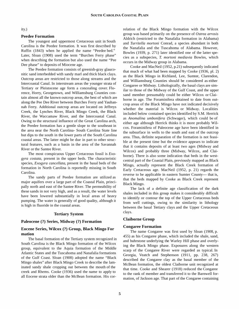
Stop 4 – Lower Bridge – Black Mingo formation
The following section, described by Cooke (1936, p. 4as representing the Black Mingo formation, crops out alothe south bank of Black River at Lower Bridge, approxmately 6.5 miles south of Kingstree at the crossing of StHighway 377:Penholoway (?) formation (Pleistocene?): Fe
3. Coarse orange- colored sand with pebbles and broshells at base; extends downward over bed 2 to bethe overlapping part crossbedded; to top of hill, abo
6-20UnconformityBlack Mingo formation (Eocene):
2. Very fine grained thin- bedded gray and red saweathering brick- red and yellow; appears to contaa little glauconite 0-13
1. Light- gray to dark slate-colored hard fuller’s earth shale; base concealed. A few loose slabs contain ainch bed of silicified shells (not determinable). Tolow- water mark in Black River 15
Representative exposures of the Black Mingo formtion, containing both type lithology and type fauna, are neasy to find. The typical section is best seen therefore icombination of localities. The Lower Bridge localitytogether with that along the left bank of the Black River Upper Browns Ferry and at the junction of State Highwa37 and 17 in the northwestern part of Georgetown Counafford fairly good representation of the lithology. Faunal colections may be made along an unpaved county road, mile east of Salters where a thin bed of fuller’s earth is ovlain by a coarse red sand containing the type species Coelo-helia wagneriana Vaughan, Haimesistraea confertaVaughan, and Cucullaea transversa Rogers. Excavations forirrigation ponds in the area between Salters and Kingsthave revealed more specimens of the above fauna an
6
SOUTH CAROLINA COASTAL PLAIN
isy
exi-
gh-oot-n.
1011asalel-ed col-
cklsthatt toehat
t
ionhis
the 8
ca-is
blyandy;
addition, Ostrea arrosis Aldrich, another guide fossil of tWilcox.
Alternate stop 4 – Irrigation pond southwest of Kingstree- Warley Hill formation (?)
Several irrigation ponds in the area southwest of Kinstree have been excavated in material considered to be BMingo. The pond of Mr. E.C. Baker, located 4 ½ milesouthwest of Kingstree on U.S. Highway 52, was excavain black and gray laminated clay and fine white sanCoquina- like aggregations scattered throughout the uncontained gastropods very similar to those found at SalterBlack Mingo locality.
Two irrigation ponds owned by Mr. Terrell Jacobs arlocated about 3 miles farther south and one mile west of Baker pond. These ponds were excavated in a different tof rock and the spoil banks contain a dissimilar fauna frthe first pond.
From the excavated material of one pond, the wriobtained several species tentatively identifies as Ostrea lis-bonensis Harris and Ostrea smithvillensis Harris, both ofwhich are typical of the lower Lisbon of Alabama and corrative with the Warly Hill marl in South Carolina. Additionamegafossils from the locality includeOstrea divaricataLea, identified by Dr. H.G. Richards. This specie is assoated with slightly younger beds in the Gulf Coast and equalent to McBean or Santee formations in South CarolinThe presence of these fossils at comparatively shaldepths would indicate that the Black Mingo was quite thin the immediate area.
Stop 5 – Florence County – Peedee formation
Approximately 2.5 miles southwest of Effingham an0.25 miles southeast of Elim, on U.S. Highway 301, thPeedee formation crops out on the north bank of SparrSwamp as it joins the Pee Dee River. The unit consistsdark gray to black clay or marl interbedded with white finsand, in places indurated. Species of Trigonia thoracia, Exo-gyra costata and Ostrea sp. are quite common. At this pointhe formation occurs at an altitude of about 70 feet above(altimeter) which is nearly its highest point in this State. Thfollowing foraminifera obtained from the black clay weridentified by S.M. Herrick as Navarro in age:
Robulus pseudo-secan Cushman (also found in SnowHill of N.C.)
Gaudryina rudita SandridgeAnomailna pseudopapillosa CarseyGuembelina globulosa (Ehrenberg) EggerLexostomum plaitum (Carsey)Gyroidina depress (Alth) CushmanNonionella cretacea Cushman Planulina correcta (Carsey) CushmanBulimina reussi Morrow, var. navarroensis Cushman and
1
he
g-lackstedd.its, a
etheypeom
ter
el-l
ci-iv-a.
lowin
deow ofe
t msle
e
ParkerVaginulina navarroana CushmanCibicides harperi (Sandridge) CushmanAnomalina nelsoni W.BerryFrom Cooke’s locality 38, 1 ½ miles upstream from th
site, the following additional species were identified: (bHerrick)
Robulus munsteri (Roemer) CushmanHaplophragmoides excavata Cushman and Water
Stop 6 – Mars Bluff – Black Creek formation
This locality, described by Sloan (1908) and Cook(1936), is on the right bank of the Pee Dee River, appromately 12 miles east of Florence and on the old U.S. Hiway 76. The section, as given by Cooke, shows a 17- fbed of yellow to bluish sandy clay (Wicomico formationPleistocene) overlying 52 feet of the Black Creek formatioThe Black Creek formation consists from top to bottom of feet of fine yellow sand, 4 feet of dark gray to black clay, feet of fine buff, pink and gray crossbedded sand and a b27 feet of dark gray to black clay interbedded with fine ylow sand, which is indurated in part, and contains silicifishells. From a nearby outcrop of the same bed the authorlected specimens of Nuclana sp., Isocardia sp. Striarca sp.,Tellina sp., Ostrea blackensis Stephenson, Anomia olmsteadiStephenson? and fish vertebra. This suite compares favor-ably with the fauna of the Snow Hill member of the BlaCreek formation, although the lithology of the materiaexposed here, and the structure, suggest the possibility these beds are older than Snow Hill, possibly equivalenthe Blufftown formation or to the Tombigbee sand of thEutaw formation. Stephenson (1923, p 43) indicates tAnomia olmsteadi Stephenson, Arca (Barbatia) lintea (Con-rad), and Cymbophora trigonali Stephenson, all present athis locality, range elsewhere into the lower part of the Exo-gyra ponderosa zone. The species, Anomia olmsteadiStephenson and Cymbophora trigonalis Stephenson (ques-tionably), range into the basal beds of the Eutaw formatin the Chattahoochee region. Microfauna obtained from toutcrop have been rather sparse.
Alternate stop 6- Mechanicsville- Black Creek and Tuscaloosa formations.
Where State Highway 34 descends to the swamp of Pee Dee River, 1 mile northeast of Mechanicsville, andmiles northeast of Darlington, the Black Creek and Tusloosa formations are exposed. The following section of thlocality is taken from Cooke (1936, p.27):Bed No. Feet
3. Sunderland formation (Pleistocene): Coarse pebcompact sand at base, passing upward into finer slaminated with clay; reddish-yellow to red and grato top of hill, about 35
7
GEORGE E. SIPLE
84,
l.
the
, p.
arly
the, p.
na:
S.
9.eol.
of28.nd
0-C,
ndm
a:
th-
r’s
us
in:
onuth
andinap.
. 3,
tleey
nssts
nd
l.
urect):
Unconformity2. Black Creek formation (Upper Cretaceous): Da
brown to black sandy clay 301. Tuscaloosa formation (Upper Cretaceous): Coa
light gray argillaceous sand 15
Stop 7 – State Highway 102, Darlington County
An excellent outcrop of the bedded white clays of tTuscaloosa formation occurs on State Highway 102, Dalington County, 0.3 mile south of the Chesterfield Countline.
A generalized section obtained recently by the writeras follows:Bed No. Feet
4. Fine white to tan quartz sand containing gray clay nules and lenses. Shows leaching effect near surfac
3. Coarse red, brown, and tan, micaceous quartz sand2. Cherry red and white mottled clay 61. Light gray laminated, micaceous, fine quartz san
compact and indurated. Brecciation of bedding inorth end.
The Tuscaloosa at this locality exhibits lithology simlar to that occurring in several areas along U.S. Highwayfrom Aiken County to Chesterfield County. Perhaps the mcontinuous bed of the Tuscaloosa formation, the red and gmottled clay, is included here.
Stop 8 – Middendorf – Tuscaloosa formation
The railroad cut on the Seaboard Air Line Railway, the crossing of the Hartsville- Ruby Road, 2 miles northeof Middendorf, Chesterfield County, was designated bSloan (1904) as the type locality of the Middendorf formtion. He considered these beds to be of Lower Cretaceage. On the basis of fossil plants, Berry (1914) transferthe Middendorf beds to the Upper Cretaceous as the Midddorf arkose member of the Black Creek formation. In 19Cooke, on the basis of previous correlation, substituted name “Tuscaloosa formation” for “Middendorf formationin describing the beds at this locality. Tan and gray to piarkosic sands with lenses of light-colored clay are characistic. According to Cooke, there was a 4-foot lens of clacontaining many well-preserved leaf impressions, extendfrom a point near the bridge westward about 100 feet. Eward from the bridge the clay grades into tough gray argilceous sand.
From a reanalysis of the floras at Middendorf, Do(1952) concluded that the plant- bearing Middendorf bewere equivalent in age to the plant- bearing lower part of undifferentiated Black Creek formation of North Carolina.
REFERENCES
Berry, E.Wilber, 1914, The Upper Cretaceous and Eocene flora
1
rk
rse
her-
y
is
od-e6 1
d,n
i- 1
ostray
atastya-ousreden-
36the”nkter-y
ingast-la-
rfdsthe
s of
South Carolina and Georgia: U.S. Geol. Survey Prof. Paperp. 68-72.
Bonini, E. Willard, 1948, North Carolina Coastal Plain floor: GeoSoc. America Bull., v. 59, p. 87-89.
Bowles, Edgar, 1939, Eocene and Paleocene Turritellidae ofAtlantic and Gulf
Coastal Plain of North America: Jour. Paleontology, v. 13, no. 3267-336, pls. 31-34.
Canu, Ferdinand, and Bassler, R.S., 1920, North American eTertiary Bryozoa: U.S. Nat. Mus. Bull. 106, 879 p.
Cooke, C.W., 1926, Correlation of the basal Cretaceous beds ofSoutheastern States: U.S. Geol. Survey Prof. Paper 140-F137-139.
________ 1936, Geology of the Coastal Plain of South CaroliU.S. Geol. Survey Bull. 867, 196 p.
________ 1943, Geology of the Coastal Plain of Georgia: U.Geol. Survey Bull. 941, 121 p.
________ 1945, Geology of Florida: Florida Geol. Survey Bull. 2________ 1954, Carolina bays and the shapes of eddies: U.S. G
Survey Prof. Paper 254-I, p. 195- 205.Cooke, C.W., and MacNeil, F.S., 1952, Tertiary stratigraphy
South Carolina: U.S. Geol. Survey Prof. Paper 243-B, p. 19-Cooke, C.W., and Shearer, H.K., 1918, Deposits of Claiborne a
Jackson age in Georgia: U.S. Geol. Survey Prof. Paper 12p. 41-81.
Dorf, Erling, 1952, Critical analyses of Cretaceous stratigraphy apaleobotany of Atlantic Coastal Plain: Am. Assoc. PetroleuGeologists Bull., v. 36, no. 11, p. 2161-2184.
Dall, W.H., 1892, Contributions to the Tertiary fauna of FloridWagner Free Inst. Sci. Trans., v.3, pt.2, p.209.
________ 1896, Diagnoses of new Tertiary fossils from the souern United States: U.S. Nat. Mus. Proc., v.18, p. 40.
Eardley, A.J., 1951, Structural geology of North America: HarpeGeoscience Series, Harper & Brothers, 624p.
Eargle, D.H., 1955, Stratigraphy of the outcropping Cretaceorocks of Georgia: U.S. Geol. Survey Bull. 1014, 101 p.
Flint, R.F., 1940, Pleistocene features of the Atlantic Coastal PlaAm. Jour. Sci., v. 238, no. 11, p. 757-787.
Herrick, Stephen M., and Wait, Robert L., 1955, Interim report results of test drilling in the Savannah area, Georgia and SoCarolina: U.S. Geol. Survey open- file report.
Hersey, J.B., and others, 1955, Seismic observations in deepshallow water southeast of North Carolina and South Carol(Abstract): Geol. Soc. America Bull., v. 66, no. 12, pt.2, 1573.
Johnson, L.C., 1888, The structure of Florida: Am. Jour. Sci., serv. 36, p. 230-236.
Kellum, L.B., 1926, Paleontology and stratigraphy of the CasHayne and Trent marls in North Carolina: U.S. Geol. SurvProf. Paper 143, 56 p.
LeGrand, H.E., 1955, Brackish water and its structural implicatioin the Great Carolina Ridge: Am. Assoc. Petroleum GeologiBull., v. 39, no. 10
Lyell, Charles, 1845, Observations of the White Limestone aother Eocene or older
Tertiary formations of Virginia, South Carolina, and Georgia: GeoSoc. London Quart. Jour: v. 1, p. 429- 442.
MacCarthy, G.R., 1936, Magnetic anomalies and geologic structbetween Charleston, S.C., and Cape Fear, N.C. (Abstra
8
SOUTH CAROLINA COASTAL PLAIN
, A atrip the
Geol. Soc. America Bull., v. 66, no. 12, pt. 2, p. 1597.MacNeil F.S., 1950, Pleistocene shore lines in Florida and Georg
U.S. Geol. Survey Prof. Paper 221-F, p. 95-107, pls. 19-25.Meyer, R.P., 1955, Seismic studies of offshore geologic struct
between Charleston, S.C., and Cape Fear, N.C. (AbstraGeol. Soc. America Bull, v. 66, no.12, pt. 2, p. 1597.
Miller, B.L., 1910, Erosion intervals in the Tertiary of North Carolina and Virginia: Geol. Soc. America Bull., v.20, p. 673-678.
________ 1912, The Coastal Plain of North Carolina; the Tertiaformations: North Carolina Geol. Survey, v.3, p. 171-258.
Richards, H.G., 1943, Pliocene and Pleistocene mollusks fromSantee- Cooper area, S.C.: Notulae Naturae of the Acad. NSci. Philadelphia, no. 118.
________ 1945, Subsurface stratigraphy of Atlantic Coastal Plbetween New Jersey and Georgia: Am. Assoc. Petroleum Gogists Bull. 29, p. 885 –955
Richards H.G., 1950, Geology of the Coastal Plain of North Calina: Am. Philos. Soc. Trans., new ser., v. 40, pt.1, 83 p.
Ruffin, Edmund, 1843, Report of the commencement and progrof the agricultural survey of South Carolina for 1843, p. 2Columbia, S.C.
Siple, George E., 1947, Progress report on ground-water investtions in South Carolina: S.C. Research, Plan. And DevBoard, Bull. 15.
_________ 1954, Some geologic and hydrologic concepts of western section of the South Carolina Coastal Plain (AbstraGeol. Soc. America Bull., v. 65, no. 12, pt. 1.
_________ 1957, Geology and ground water in parts of AikeBarnwell, and Allendale Counties, S.C.: U.S. Geol. Survopen- file report.
_________ Brown, P.M., and LeGrand, H.E., 1956, Stratigrapsignificance of Foraminifera from an outcrop of the Tuscalooformation at Cheraw, S.C.: Geol. Soc. America Bull., v. 67.
Sloan, Earle, 1904, A preliminary report on the clays of SouCarolina: South Carolina Geol. Survey, ser. 4, Bull 1.
_________ 1907, Geology and mineral resources: S.C. Dept. Aculture, Handbook of South Carolina, p. 77-145.
_________ 1908, Catalogue of the mineral localities of South Calina: S.C. Geol. Survey, ser. 4, Bull. 2, 505 p.
Smith and Johnson, 1887, Tertiary and Cretaceous strata of the caloosa, Tombigbee, and Alabama Rivers: U.S. Geol. SurvBull. 43, 189 p.
Spangler, Walter, 1950, Subsurface geology of Atlantic CoasPlain of North Carolina: Am. Assoc. Petroleum GeologisBull, v. 34, p. 100-132.
Spencer, J.W. W., 1890, “Southern drift” and its agricultural retion: Agr. Ept. Sta. Bull. 6, p. 90-94.
Stephenson, L.W., 1914, A deep well at Charleston, S.C.: UGeol. Survey Prof. Paper 90, p. 69-94.
_________ 1923, Cretaceous formations of North Carolina: NoCarolina Geol. and Econ. Survey, v. 5, pt. 1, p. 596.
Taber, S.W., 1954, Address to the annual meeting of SoutheasSection, Geol. Soc. American, Columbia, S.C.
Tuomey, Michael, 1848, Report on the geology of South Carolivi, 293 p., Columbia, S.C.
Veatch, Otto, and Stephenson, L.W., 1911, Geology of the CoaPlan of Georgia: Georgia Geol. Survey Bull. 26, 466 p.
Vernon, Robert O., 1942, Geology of Holmes and WashingtCounties, Fla.: Florida Geol. Survey Bull. 21, 161 p.
1
ia:
urect):
-
ry
theat.
aineol-
ro-
ess7,
iga-el.
thect):
n,ey
hicsa
th
gri-
ro-
Tus-ey
talts
la-
.S.
rth
tern
na,
stal
on
Vernon, Robert O., Puri, Harbans S., and Calver, James L., 1956summary of the geology of the panhandle of Florida andguidebook to the surface exposures: Prepared for the field of the Tallahassee meeting of the southeastern section ofGeological Society of America, March.
9