Embed Size (px)
Citation preview

BIM & VDC
Case Study about BIM on GIS platform development project with the standard model
- 2013.5.28
KICT
Ph.D, Tae wook, kang. Senior Researcher, KICT Interests – BIM, GIS, Interoperability
[email protected] www.facebook.com/laputa999

KICT
Introduce
Name - Tae Wook, Kang Ph.D, Senior Research, ICT Lab, KICT Email – [email protected] Interests – BIM, GIS, CAD, PLM, Interoperability (Standard, Query Language, Open API etc) Specialty – Civil Engineering, Software Engineering Experiences BIM on GIS R&D (1, 2) Project, KICT BIM-based Railway System Planning Project, MLIT VDC Support System Development Planning Project, KICT World Best Software BIM Modeler and Check Development, Ministry of Knowledge Economy (2012) BIM Division Head Manager, Hangil IT (2011) Adjunct Professor, Chung-Ang University (2010) Civil Project 3D - Civil Engineering Modeler Development and Management
CONTENTS
2 BIM on GIS with Standard
1
Overview
Lesson & Learn

1
Overview
KICT
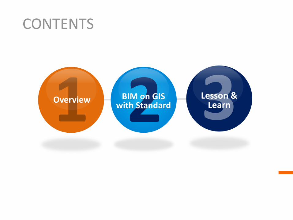
BIM on GIS project overview
To realize BIM on GIS technology for productivity of AEC industry, we should have some questions like these.
Questions • What is the benefit from the fusion between BIM and GIS as the viewpoint of the public sector • What do we should do first? • What is the barrier to realize it? • How to develop it?
Research and try to • find the useful use-cases • define the technology and the organization including people etc • survey the issues and define the considerations • collaborate and research it with the institutes and the industries

KICT
BIM on GIS project overview
Layer 2013 2014 2015 2016 Application Use-cases and scenario
ex – O&M Develop it Validate it Improve it
SW Platform Interoperability Support Platform Design between BIM and GIS
Develop it Validate it using the pilot project
Improve it
Standard File IFC4 analyze and Infra-BIM IFC design
Support Tool Development and Design
Infra-BIM IFC completion
Infra-BIM IFC Standardization
Policy system IPDish design IPDish development IPDish validation Collaboration System like IPD Suggestions for Public Sector
Survey the technology and the solution
Research and Development
R&D Results Validation and Feedback
Commercialization and Standardization
-Developing BIM on GIS platform which has interoperability, application including various usecases, standard/policy platform. Resource 9 M $ for 5 years (2012 – 2016). KICT with Gaia3D, SeokYoung system etc

KICT
BIM on GIS project overview
Policy PLATFORM / INFRA BIM information model standard (Law / Delivery system-IPD, Estimation, drawing system. Standard information,
Validation/RULE SET)
SW Platform / BIM GIS interoperability platform (3D VIZ, QUERY ENGINE, ADP LOD, GEO SERVER, IFC-CITYGML CONVERTER, Web Service)
Ex - ONUMA or GERMANIUM3D
Application Operation System
Application support to realize each use-cases (USECASE model and scenario support including facility management HW/SW, IFC VIEWER…)
Project management with B/C analyze
CM / alternative analysis
Env, energy mngt
(LID, Sewage)
Urban facility management (INFRA / FM)
Public sector
OPEN API (SDK)
VDC center (maybe)
Actor
BIM GIS SERVER
Standard IFC
model
Usecase?
Information Exchange Flow to realize usecase
1 4
2
3
Serv
ice
Applic
ation O
S
SW
Pla
tform
Sta
ndard
Pla
tform
4 1

KICT
BIM on GIS project overview
BIM/GIS Service Operation System Language (Service Module)
Road / energy / env
(LID, water utility)
BIM-based Urban facility mngt (INFRA / FM)
Urban Facility Manager …
Usecase
OPEN API (Web-Service, Query Language)
SW Platform
FM / USN service
Data model & logic
External DBMS
Navigation (Indoor – Outdoor)
Navigation service
Data model & logic
Model validation & management ex> Core-net
Submit / check service
Rule set & logic
UI with style (CityGML / IFC Viewer, Open API, Script Language)
Project service
Data model & logic
Interface / Protocol (Web-service, Lightweight BIM/GIS Format etc)
BIM GIS SERVER
Serv
ice
UX
App O
S b
ase
Sta
ndard
Pla
tform
Serv
ice O
S
Ex> Inventory = {ID, Name, Format, Value, Survey sheet, Performance Model}
VDC center
Public sector
Guideline and Neutral Format with Infra-BIM Information Validation Support to the useful information from Private Sector

KICT
BIM on GIS project overview
BIM GIS SERVER (Geoserver, BIM server etc)
Serv
er
Geographic Information Modeler
Building Information Modeler
Converter & Mapper
(Ontology Dictionary & Parser)
Information = serviceA() def serviceA(Input, Output) query = queryModel(Input) calculate(query) return description(query)
Service manager (Load/Unload, Execute query, Transaction etc)
Service#1 Service#2 Service#n
Query Interface with Open API (Python, Lua, Ruby etc)
Model Viewer with style(layer etc) / metadata
Model Propertylizer
Model Service Executor
…
Model File (Compression / binary format)
Property File (XML, JSON, Binary etc)
Query Language Script (Python, NoSQL etc)
Solid Engine
(CSG, OCC etc)
Spatial Indexing /
VMM
LOD creator (Static / Dynamic)
Model manager
Model database
Rendering Engine
(OSG etc)
Light weight processing
Mesh / Geometry
process
Data Resource manager
Session manager
Server manager
Modeler
User
Clie
nt
SW P
latf
orm
CityGML
IFC, Vendor Format(Automation) etc
Ontology rule Modeler Ontology Dic & Rule set
<<De
pend
ency
>>
Usecase

KICT
BIM on GIS project overview
BIM on GIS Platform - KICT
Standard Format - OGC & building SMART
BIM-based Railway System
Planning Project - KRRI
VDC Support System
Development Planning Project
- ICT in KICT
Pilot Project - ICT in KICT
•Strategy to develop it

2
BIM on GIS with Standard

KICT
BIM on GIS with Standard
GIS Use-cases
BIM Use-cases
Com
mon
U
se-c
ases
Defining Use-cases for BIM on GIS First Pilot Project
BIM-GIS based FM in KICT

KICT
BIM on GIS with Standard
Legacy FM System in KICT
Drawings Papers Excel …

KICT
BIM on GIS with Standard
FM EM CM OM
Obj- Ject Tree
Prop- ty Filter Query
Menu| Plug-In
BIM Viewer
Urban Facilty Detail Performance
Obj- Ject Tree
Prop- ty Filter Query
Menu| Plug-In
Revit plugin
Civil3D plugin
Inroad plugin
자체개발 모델러
META DATA Designer
UI/REPORT STYLE Designer
Urban Facility Perfor-mance
PROTOCOL(QUERY LANGUAGE)
FM Server
DB
BIM DATA SOURCE Linkage Middleware
BIM PLATFORM (OPEN API, META DATA, STYLE …)
BIM PLATFORM
USER INTERFACE
DATA SOURCE CONNECTER
IFC LANDXML MODEL …
BIM UI FRAMEWORK
BIM DB
Part 4 Part 3 Part 2 Part 1
Information Validation System
Modeler or Engineer
DATA SOURCE
EM Server
DB ID | DW DB
Scenario and consideration about the use-cases about BIM-GIS based FM
BIM-GIS Modeling & Upload Explore BIM object
Pro
cess
SW
Pla
tform
Standard Format Use

KICT
BIM on GIS with Standard
•Building smart technology - IFC
Building smart
technology
IFC
IFD IDM
Process map Exchange Requirement Funtion part
Concept diagram
• ISO/PAS 16739
IFD(International Framework for Dictionaries, ISO 12006-3) IDM(Information Delivery Manual, ISO 29481-1:2010)

KICT
BIM on GIS with Standard
Fig. IFC (http://www.iai-tech.org/)
IfcProject – Activity to make product IfcProcess – Process and activity in project IfcResource – Used resource object definition in process IfcActor – Human resource definition in process IfcProduct – Physical representation object IfcControl – Control object IfcGroup – Object set
Kernel 3개 기본 확장 패키지 5개 AEC/FM 공통 패키지 AEC/FM 도메인별 9개의 패키지 26개의 리소스 패키지
IFC2x3 Building Oriented Format IFC4 GIS CRS NURBS … but Heavy Complex Ambiguous

KICT
BIM on GIS with Standard
•Developed by OGC •Open 3D urban object model for interoperability(ISO TC211) •Shape, material, feature information support •Focusing city Infrastructure object model •Model abstraction support(LOD) Version 2.0
CityGML GIS Oriented Format LOD Features But Detailed Building Information

KICT
BIM on GIS with Standard
•Developed by Autodesk & US DOT EAS-E •Integrated as LandGML(Geography Markup Language) in OGC(Open Geospatial Consortium, 1994) •Civil engineering Industry Standard •Engineering object(DTM, Alignment, Profile, X-section etc) model support •Open API SDK and converter(ex - LandXML to SVG) support
DTM surface(Autodesk Civil 3D)
Schema 1.2 (2008.8)
IHSDM(Interactive Highway Safety Design Model , FHWA )
KICT
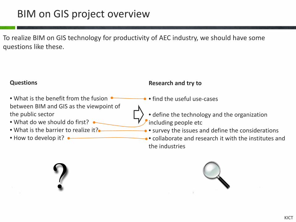
BIM on GIS with Standard
Parameter set
Civil engineering object
Detailed object information related to civil engineering ex - superelevation
LandXML Civil Engineering Oriented Format But Detailed Building Information GIS Topology Element

KICT
BIM on GIS with Standard
Item IFC LandXML CityGML
Use Architecture Engineering 3D urban object representation
Limitation Architectural Object Model No asset information BIM & engineering
information shortage
Development BuildingSmart Autodesk OGC
Characteristic Detailed arhictectural element / material /
parameter set
Civil engineering information
representation
GIS object information representation as LOD
Support object
Product, Process, Organization object(ex - Wall, Door, Beam, Relationship etc.)
Digital Terrain model, Alignment, Profile, X-Section, superelevation
etc.
CityModel, Abstact Building, Tin, Road, Surfaces(ex - Wall,
Floor) etc.
Format STEP, XML XML GML
Issue based on file format specification • Information usage viewpoint dependency • Performance(ex - Heavy size) • Commercial product compatibility

KICT
BIM on GIS with Standard
Site Building
Element
Story
WallFloorRoof
Infrastructure
Road Bridge Tunnel
City
IfcProduct
IfcElement
IfcObject
+ObjectType: IfcLabel
IfcProductRepresentation
IfcObjectPlacement
IfcObjectDefinition IfcRelAssigns
IfcRelDecomposes
+RelatedObjects: IfcObjectDefinition[n]+RelatingObject: IfcObjectDefinition
decomposes
+hasAssignments
+isDecomposedBy
IfcBuilding IfcBuildingStorey
IfcSpatialStructureElement
IfcSpatialElement
IfcProject
IfcSite
+RefLatitude+RefLongitude+RefElevation+SiteAddress
+RelatedObjects*
*
IfcBuildingElement IfcElectricalElementIfcFurnishingElement IfcDistributionElement
IfcFeatureElement
IfcPropertyDefinition
IfcPropertySetDefinition
Extension with metadata
Model Fusion =
= {GUID, Model Reference, Coordination system, Style, etc}
{Geometry,Service,Topology, Property}
Outdoor
Indoor
Unified BIM-GIS Format is
Heavy Complex Ambiguous in perspective
Unified BIM-GIS-Engineering Format?

KICT
BIM on GIS with Standard
• Perspective Definition(LOS) Needs with LOD about use-cases
Perspective
Meta data Library Specification
Standard Format (IFC, KMZ, CityGML), Lightweight Format, Data from heterogeneous System using ETL

KICT
BIM on GIS with Standard
BIM on GIS
Platform
Owner
Manager
Heterogeneous System
GIS
BIM Ex - IFC
Light-weight Format
ETL Geo-Data
Meta-Data
Meta-Data
• Information Exchange Methodology to realize UC

KICT
BIM on GIS with Standard
User
Manage facility
Manage energy
Navigate 3D topology
Render BIM and GIS object
Execute application
Load BIM and GIS object from server
Login server
Decide the user perspective
Logout server
Load KMZ Load Shape file
Convert IFC to Shape file
Query information related to object
Load Shp
• Designing the use-cases

KICT
BIM on GIS with Standard
Use-cases Description
Login server
1. Login server with the account which has the perspective meta data 2. Perspective Decision 3. Load GIS and BIM objects (converted format with the performance
consideration) from the server
Render BIM and GIS object Rendering the objects on the client program
Query information related to object
Obtain the properties by using Open API and Query Language
Execution application Such as FM, EM, OM plugin application module etc
Logout server Logout server
• Description about the use-cases

KICT
BIM on GIS with Standard
LOD
-Level
Mesh
-Name-MBR
Property
-Category-Name-ValueType-Value
FaceList FaceVertexIndex
-ID
+getPoint(): Point
PointList
Point
-X-Y-Z
*
*
*
SurfaceModel
-Name
5
* 3
•We - don’t need to consider the modeling with parametric the viewpoint of O&M use-cases •Remove the heavy information from the IFC •Extract the O&M property and the shape from the IFC •Transform IFC to Lightweight File Format

KICT
BIM on GIS with Standard
Format and Performance Sample
#1 Sample
#2 Sample
#3
IFC
Data Volume(MB) 67 26 12
Loading Time (Second)
22.05 217.22 5.99
Memory(MB) 499 1,029 156
LBSF
Data Volume(MB) 32 213 11
Loading Time (Second)
1.28 8.69 0.44
Memory(MB) 177 890 75
LBSF with the exter- nal surf-
ace
Data Volume(MB) 7 66 4
Loading Time (Second)
0.30 2.59 0.20
Memory(MB) 56 286 43
•Comparison between IFC and Lightweight File Format
25 times
3.5 times

KICT
BIM on GIS with Standard
Maker = “LG” Model = “VET” Price = “$1,000,000” Buy date = “2010.2.1” Placement code = 101010 Maintenance date = “…..”
ETL
Extract
Transform
Load
Maker = “LG.VET” Price = “1000,000,000 원” Buy year = “2010” Buy month = “2” Place = Building-1.Story-3.MeetingRoom Maintenance date = “…..”
Data Source
DW
Source #1
Source #n
User
…
• Considering Data or Property from Heterogeneous system using ETL
Heterogeneous systems such as CMMS, OM, EM - don’t support the Standard File

KICT
BIM on GIS with Standard

KICT
BIM on GIS with Standard
GeoServer<<GIS server>>
BIM server<<BIM server>>
WWJ<<Client>>
BIM-GIS Platform<<Platform>>
DBMS<<Heterogeneous System>>
BIM Explorer<<Viewer>>
Talend<<ETL>>
• Component Architecture with the considerations

KICT
BIM on GIS with Standard
Stereo type Compoent Description Viewer BIM Explorer BIM object shape and properties rendering
Client WWJ Geographic Information Rendering
BIM-GIS Platform BIM-GIS Platform Handling the sub modules with Open API and Query Language
ETL Talend ETL with Open source Talend
GIS Server GeoServer GIS information service to client
BIM Server BIM server BIM object information service to client
Heterogeneous System DBMS External system to realize UC
• Component Architecture with the considerations

KICT
BIM on GIS with Standard
Owner Perspective Facility Manager Perspective Facility Subcontractor Perspective
• Screen shot from the pilot project results
KICT
BIM on GIS with Standard
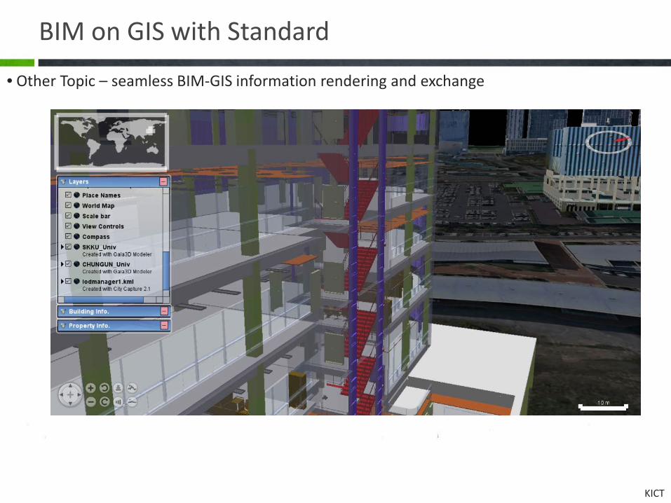
• Other Topic – seamless BIM-GIS information rendering and exchange

Lesson & Learn
KICT
Lesson & Learn
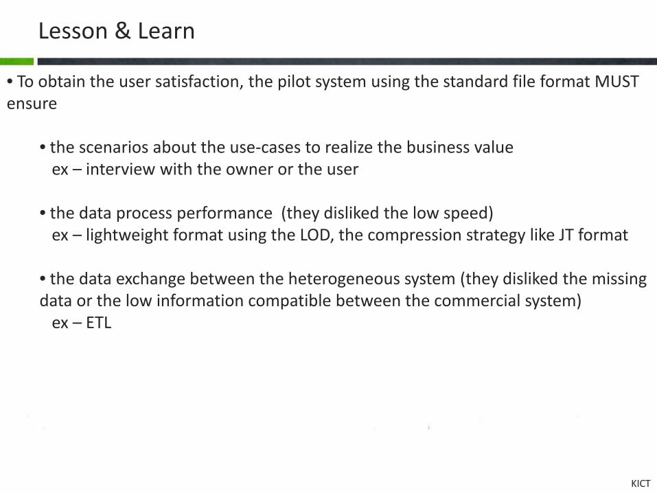
• To obtain the user satisfaction, the pilot system using the standard file format MUST ensure
• the scenarios about the use-cases to realize the business value ex – interview with the owner or the user • the data process performance (they disliked the low speed) ex – lightweight format using the LOD, the compression strategy like JT format • the data exchange between the heterogeneous system (they disliked the missing data or the low information compatible between the commercial system) ex – ETL

KICT
Lesson & Learn
National Standard Policy Platform
Project Delivery System
Software Platform
Application Operating System
Usecase #1 Application Usecase #2 Application Usecase #3 Application
Code system Library Motivation
policy Maturity
model Education
System
Hardware Platform
Validation System
Usecase Stakeholder
VDC center
Official
Market
Query language

KICT
Lesson & Learn
Roadmap
Validation System
Education System
교육 홍보 촉진 환경
POLICY PLATFORM
VDC 한국형 통합 발주 체계 ex) IPD(Integrated Project Delivery).
• BIM on GIS 성숙도 수준 평가 체계
ex) BIM Maturity Model (미, CIFE) • 생산성 성과 지표 마련
• 프로젝트 결과물 납품 / 검증 / 관리 체계 마련
• 납품 결과물 검증
해외 건설 경쟁력 강화 목표에 부합하는 VDC 로드맵 및 실행 체계
Performance Measurement
Service Compensation
System
Project Delivery System
• Functions of VDC

프레젠테이션 주제 Thanks for your interest
KICT
2013.5.28. Tae Wook, Kang(www.facebook.com/laputa999)
KICT
Ecosystem for AEC industry
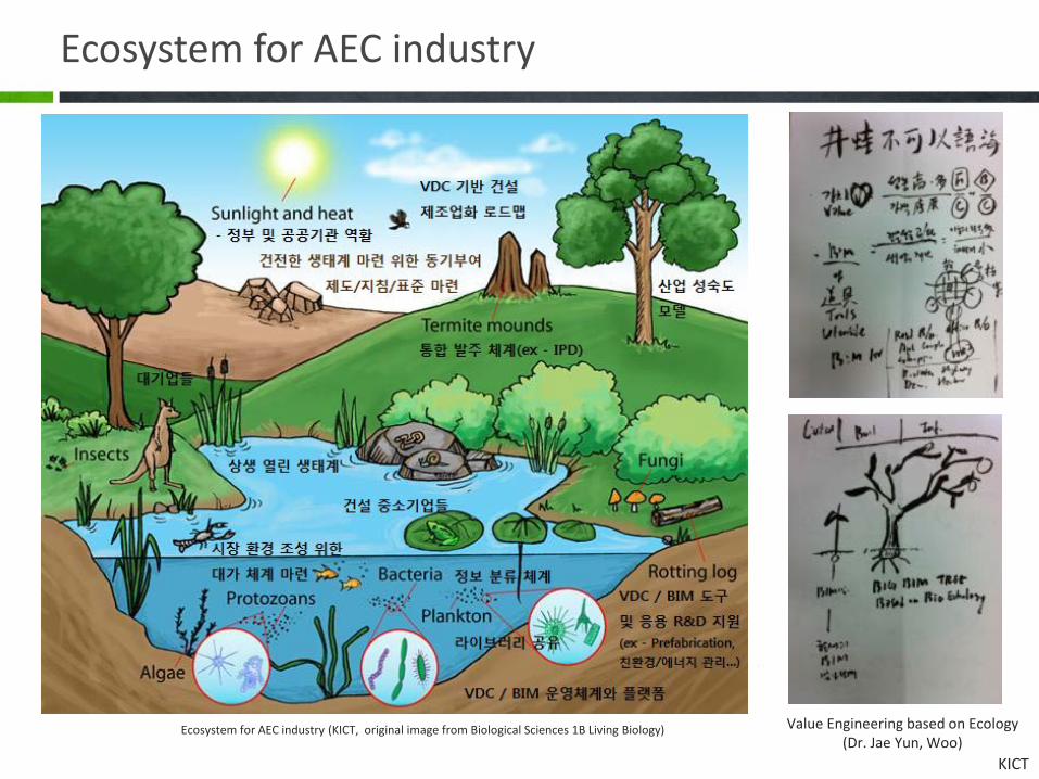
Ecosystem for AEC industry (KICT, original image from Biological Sciences 1B Living Biology) Value Engineering based on Ecology (Dr. Jae Yun, Woo)
KICT
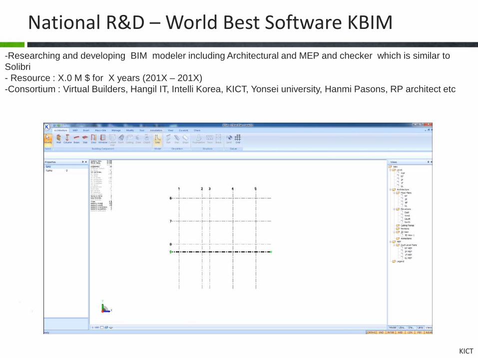
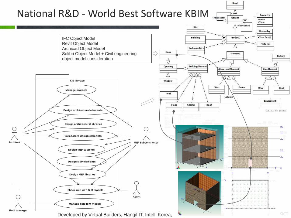
National R&D – World Best Software KBIM -Researching and developing BIM modeler including Architectural and MEP and checker which is similar to Solibri - Resource : X.0 M $ for X years (201X – 201X) -Consortium : Virtual Builders, Hangil IT, Intelli Korea, KICT, Yonsei university, Hanmi Pasons, RP architect etc
KICT
ICommand
+Execute(application, message, elements)
IExternalApplication
+OnStartup(application: UIControlledApplication)+OnShutdown()
KbUiApplication
+CreateRibbonPanel(Name)
RibbonPanel
+AddItem(ButtonData)()
PushButton
* RibbonItem
BitmapImage
AddinModule Menifest
ExternalCommandData
Applicatoin
+CopyModel()+GetType()+NewFamilyDocument()+OpenDocumentFile()
Project
+FamilyTemplatePath+Librarypaths+LocalServerName+Username+VersionBuild
<<virtual>>+Changed()<<virtual>>+Created()<<virtual>>+Opened()<<virtual>>+Saved()<<virtual>>+FileExported()+LoadLibrary(fileName)+Save()+Load()
ProjectSet
*
Site
+Name+Latitude+Longitude+TimeZone+WeatherStation
FilteredElementCollector
+WherePasses(LogicalAndFilter)
LogicalAndFilter<<enumeration>>
ElementLayerFilter
+ElementLayerFilter(LayerType)
ElementTypeFilter
+ElementClassFilter(ObjectType)
MyExternalCommand
UIControlledApplication
ElementSet
ComboBox
Units
+Length+Angle+Mass+Time+ElectricCurrent+Temperature+LuminousIntensity
Categories
+get_Item()
Category
+Parent+Visible
*
Dimension
Grid
Settings
LibrarySet
SystemLibrarySet ComponentLibrarySet
Element
+Name+Layer+Document+Level+Location
Level
ParameterSet
Selection
+PickObject()+PickObjects(ObjectType, ISelectFilter, command: string)+PickElementsByRectangle(command: string)+PickPoint(ObjectSnapTypes, command: string)
IList<Element> hasPickSome = choices.PickElementsByRectangle("Select by rectangle");
ObjectSnapTypes<<enumeration>>
+Endpoints+Intersections;
ObjectType<<enumeration>>
+Vertex+Edge+Face
Parameter
+Category+Name: string+StorageType+Value: string+ReadOnly
*
Math
+Transform()+Intersect()
Library
+Type: string
*
View
+Level+Camera
Wall
+WallType+CurtainGrid
Relationships
+vector<KBID>
GeometryElement
Material
+Function: {Finish1, Finish2, Structure}+Color+RenderAppearance+CutPattern+SurfacePattern
GeometryObjectArray
*
GeometryObject
+Visibility
*
*
*
B-Rep & 2D Sketch objects
GraphicsStyle
GraphicsStyleType<<enumeration>>
+Projection+Cut
MaterialSet
Solid
Face
+Surface
*Edge
+CurveVertex
**
ModelCurveCurveElement
Mesh
Loop*
*
Curve2d
Surface
* *
MeshElement*
Line2d
+point1+point2
Arc
+CenterPoint+StartAngle+EndAngle+Radius
Level
Building
TBD_Relationship
Product
+ID+Type: string+Name+BoundingBox
<<virtual>>+CreateSolid()
Product
+ID+Type: string+Name+BoundingBox
<<virtual>>+CreateSolid()
GeometryElement
Object
<<virtual>>+Persist(Archive)
ExtrudedSolid
Opening
Window Door
Hatch
MaterialPattern
RenderAppearance Texture
Library
+Type: string
Hatch
Geometry2DObject
Geometry3DObject
Curve3d
void CreateWall() // Script code{ Project* pProject = Application::GetObject().GetProject(); Library* pLib = pProject->LoadLibrary("WallLibrary"); // pLib = pProject->FindLibrary("WallLibrary"); Element* pElement = pLib->CreateObject(); Wall* pWall = (Wall*)pElement; ParameterSet* pParameters = pWall->GetParameterSet(); Parameter* pPara = pParameters->Get("upper level"); pPara->SetValue("level2"); pWall->CreateSolid();}
Wall::Draw(Graphic){ hLine = Graphic.Line hArc = Graphic.Arc hCircle = Graphic.Circle}
Wall::CreateSolid(Sketch sketch){ Level l1 = _ParameterSet.GetValue("Upper Level"); foreach(e in sketch.ObjectArray) { // e = circle, line, arc Solid = SolidEngine.Extrude(e, axis, level.height); GeometryObjectArray.Add(Solid); }}
Beam
Command
+Category+Name
<<virtual>>+Execute(Event)
KbUiView
View
+Level+Camera
KbUiChildFrame
KbUiMainFrame
*
KbUiDocument
* CommandSet
*
KbViewBase
KbDocumentBase
KbVizBase
+RenderMode+Background+ShadeMode
+ZoomWorld()
KbVizModel
+Key
Draft version 0.7
Namespace
KbCheck : Checker.KbMep : MEP.KbArch : Architect.kbServer : ---------------------------------------------------------------------------------KbDrawing : TBD KbReport : Report, Quantity Estimation. KbCore : Object model.KbFramework : UI, Selection, Snap...*TBD KbViz : Graphic, HOOPS, Spatial IndexingKbSolid : Parasolid KbParametric : D-cubed*TBD KbMath : Math, Calculation.*TBD KbBase : Algorithm, Datastruct---------------------------------------------------------------------------------KbGlobal : Global vars memeber. KbCommon : Common utility function.KbDefine : Define member.
KbUiMainFrame
UndoManager
Snap
Archive
FileArchive NetworkArchive
Archive
Object
<<virtual>>+Persist(Archive)
RuntimeClass
Factory
*
Predefine runtime information
Container define.ListHashSet : Add, Remove, Find, Iterator, Clear
Manager : Set + alpha
KbVizListener
Event
Space
SpatialElement
Contour
Owner
OwnerHistory
+CreatedDate+ChangedDate
*
Group
*
Footing
Pile
Plate
???? ????? ?? ??? ??, ??.?? ?? Proxy pattern ? ????.
Parasolid.LineParasolid.Solid
class GeometryObject{private: Handle _EntityHande; // Parasolid* _pParasolid;};
class Geometry2DObject : GeometryObject;
class Curve2d : Geometry2DObject{public: Point2d GetFirstPoint(); virtual void Regen(); // Render(), Create solid object. virtual void Draw(); void Update();};
ArchitecturalElementMepElement
Slab
Roof
Column
BeamStair
Floor
Object
<<virtual>>+Persist(Archive)
*
CommandStack
+Top
<<stack>>*
VariableSet
Handle
+GetPointer()
EventType<<enumeration>>
+Begin+End+PickPoint+Selection
KbUiView
KbUiDocument
KbUiApplication
+CreateRibbonPanel(Name)
Camera
+ProjectionMode+Eye+Direction
+GetProjectionMatrix()
< Property >Space.ParameterSet("Tag").IsValue("???")Space.ParameterSet("Tag").IsValue("???")Space.Type.IsValue("?")Space.ParameterSet("Area").Double();
< Object >1. Property2. Method3. Relationship
< Method>1. Topology: 2. Geometry: Area, Volume, Distance, Intersect3. Special method
< Rule check system. expert system >1. Python scriptfunction RuleExitPath() // ?) ????{ if(Project.Group("??").Space.ParameterSet("Area") < This.Parameter("CriteriaArea")) return true; return false;}
2. OWL, RDF, XML: TBD<ObjectA.IsIn(ObjectB)> <CaseIf("True")> <Return("Success")> </CaseIf> <CaseIf("False")> <Return("Failure")> </CaseIf></>
< Etc >Rule.
Space.Group.Space.Group.Space
Space +---- Space
IFD(Dictionary) ???? ??? ??? ???? ?. ?) ??, ???.Dictionary["??"].Add("???");Dictionary["??"].Add("???1");Dictionary["??"].Add("???3");Dictionary["??"].Add("???2");
Method
+Name
+Execute()
*
PythonMethod
Rule
RuleSet
*
ParameterSet
Product
+ID+Type: string+Name+BoundingBox
<<virtual>>+CreateSolid()
Dictionary
+Name
DictionaryItem
+Name *
TBD_UndoItem
*
namespace KbCore{ class Project; class Product;}
EnvironmentFolder structure
Truck Product Check Arch Mep Server Lib Viz ...
Build Cfg ...
Unit Test
CRUD Wall, Window, Door, Slab Solid, Body, Vertex, Edge, Face Parametric
KbVizGraphic
+SetProjectionType()+Line(): Handle+Arc(): Handle+Polyline(): Handle+Circle(): Handle+Face(): Handle
Vector Matrix
Point
Sketch
for(int i = 0; i < Element.Relationships.GetCount(); i++){ KBID id = Element.Relationships.GetAt(0); Relationship rel = Project.GetRelationshipManager().GetObject(id); RelVoid* pVoid = RelVoid::cast(rel); if(pVoid) { } RelConnect* pConnect = }
Relationship
+KBID
RelationshipConnect
+vector<KBID>+Point
RelationshipManager *
RelationshipVoid
+WallID+vector<KBID>
aaa
K-BIM system
Architect
Design architectural elements
Design architectural libraries
MEP Subcontractor
Design MEP systems
Design MEP elements
Manage projects
Check rule with BIM models
Agent
Collaborate design elements
Field manager
Manage field BIM models
Design MEP libraries
IFC Object Model Revit Object Model Archicad Object Model Solibri Object Model + Civil engineering object model consideration
National R&D - World Best Software KBIM
Developed by Virtual Builders, Hangil IT, Intelli Korea,

KICT
National R&D - Virtual Construction -Developing virtual construction platform such as CPLM(Construction Project Lifecycle Management), IFC server (ORDB), quantity estimator, temporary work modeler(ABIM Temp), education program, consulting program related to BIM, BIM execution guideline etc -Resource : XXX.0 M $ for 5 years (2006 – 2011) -Consortium : Dual tech, Hangil IT, GeoNT, SungkyunKwan univeristy, Hanyang university, Yonsei university etc
BIM T/K
2011 BIM Society Academy conference
Korea BIM society Civil BIM Forum
Research
P.R.
Industry
2011 10.28 ▼
2006 12.29 ▼
▲ 2007
▲ 2008
▲ 2009
▲ 2010
▲ 2011
1 year 2 year 3 year 4 year 5 year
Civil Expo 2009
Civil Expo 2008
Arch expo KAFF 2011
2011 Green Tech Forum
CAU BIM education MOU
2010 Land Marine
expo
Korea Arch Society MOU
Con tech edu center BIM edu MOU
Foreign BIM project delivery consulting
BIM Forum
Assembly Public hearing
2010 BIM Camp
2009 BIM Camp
PPS, BIM from 2012 4 rivers BIM project
Test bed execution System development Organizing research group Developing prototype system
Introduce and educate BIM concept
Pilot test execution
MUST BIM RP architect IDM
BIM tech spread
Policy development Oversee project contract
KICT
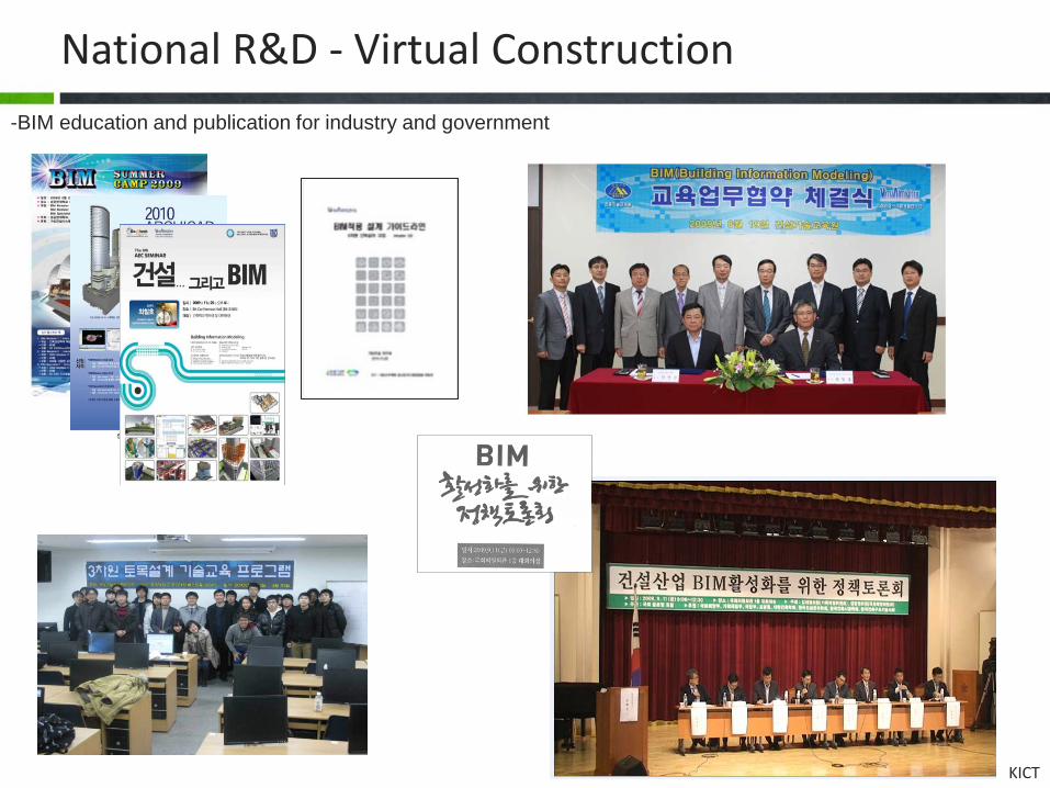
National R&D - Virtual Construction -BIM education and publication for industry and government
KICT
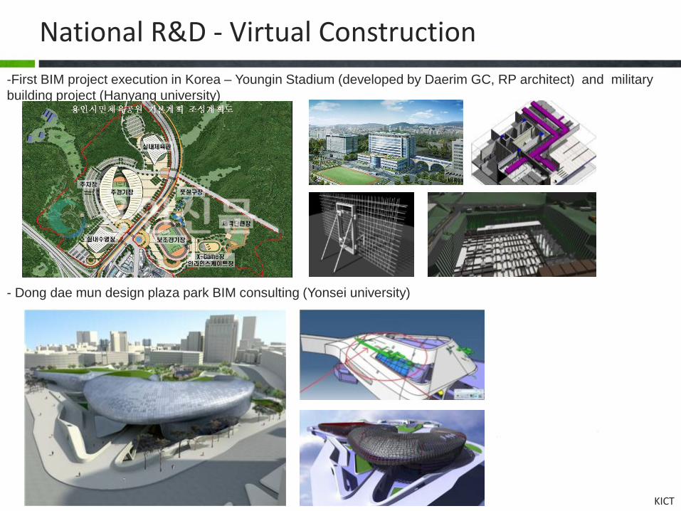
National R&D - Virtual Construction -First BIM project execution in Korea – Youngin Stadium (developed by Daerim GC, RP architect) and military building project (Hanyang university)
- Dong dae mun design plaza park BIM consulting (Yonsei university)

KICT
National R&D - Virtual Construction - Software: Estimation system (BE-Estimator), 4D simulator, CPLM (Collaboration system), IFC server, Civil engineering drawing generation program, BIM guideline e-book
IFC Schema Converter(자체개발)
IFC Model Importer(자체개발)
IFC Model Exporter(자체개발)
DBMS (큐브리드)
ㆍIFC 스키마 분석ㆍORDB 테이블 구조 생성
ㆍ IFC 파일데이터베이스저장ㆍ OID 생성
ㆍ DBMS로부터 IFC 파일 추출ㆍ IFC 부분집합 생성

KICT
National R&D – 4D system -Insuk, kang - Gyeongsang National University and GeoNT
Setting the sequence Schedule
generation
Milestone Schedule Simulation
1 2 3 Optimization of Facility Location
Layer 구현 순서 선택
②
③
④ ⑤
①
After 6 Months After 12 Months
After 18 Months After 24 Months
Layout Simulation
Phase Function
Schematic activity analysis
Review schedule and activity sequence through simulation per each month
Concept design simulation
Review landscape by using 3D simulation of bridge structure
Structure installation plan
Supporting the optimized installation plan
Structure type validation
Analysis and selection of slab, pier etc by generating 3D model of structure library

KICT
Korea BIM Society -Korea BIM Society Foundation at 11.24. 2010
Founder - 김재준, 최철호, 이광명, 신태송, 강인석, 김길채, 심창수, 윤석헌, 전한종, 조영상, 진상윤, 김용한, 지상복, 황규환 etc
창립총회 (2010. 11. 24) 2011년 정기학술발표대회