Embed Size (px)
Citation preview

SaciWATERs
Illustrative Cases for Teaching IWRM
(Volume I)
A Compendium of Ten Illustrative Cases from South Asia
A gust 2010
August 2010

Illustrative Cases for Teaching IWRM
(Volume I) A Compendium of Ten Illustrative Cases from South Asia
August 2010
Copyright © SaciWATERs, Hyderabad, India
Any part of this volume may be reproduced for non-commercial purpose without prior permission.
However, the source should be clearly acknowledged and a copy of the published document and/or
clear statement mentioning the purpose of usage should be sent to SaciWATERs at
Crossing Boundaries commissioned Illustrative Cases for Teaching IWRM (Volume I), prepared by
Tata Institute of Social Sciences, Mumbai
Designed by:
Zoheb Khan
Acknowledgement:
SaciWATERs gratefully acknowledges the financial support of the Netherlands government (DGIS
Directorate General for International Cooperation, Ministry of Foreign Affairs) for the Crossing
Boundaries – Regional Capacity Building on IWRM and Gender & Water in South Asia project, for
which this teaching toolkit was prepared.
Published by:
SaciWATERs
South Asia Consortium for Interdisciplinary Water Resources Studies
Plot No 125 & 126, SP Colony, Trimulgherry, Secunderabad 500 015, Andhra Pradesh, India
Telephone: +91 40 2799 0139, +91 40 4221 5174, Telefax: +91 40 2779 6721
Email: [email protected]. Website: www.saciwaters.org

i Illustrative Cases for Teaching IWRM
Preface
Crossing Boundaries (CB) Project of the organization saciWATERs is a multi-activity project
around the substantive theme of Integrated Water Resources Management (or IWRM) and
Gender in South Asia. The project is focused on capacity building through education, research,
and training in the IWRM area, especially in engineering institutions in South Asia. The CB
Project involves collaborative efforts of four premier engineering institutions from South Asian
countries (Sri Lanka, Nepal, India, and Bangladesh) and other supporting institutions. One of
the main thrust areas of the CB project is to develop ‗pedagogic material‘ for teaching IWRM in
the engineering institutions, especially at the master‘s level. The project had a component
which focused on developing ‗case studies‘ around the themes of IWRM for teaching the IWRM
courses at the master‘s level. Tata Institute of Social Sciences worked on this project
component with faculty members from the three partner engineering institutions, viz., (a) Nepal
Engineering College, Kathmandu, Nepal, (b) Postgraduate Institute of Agriculture, University of
Peradeniya, Sri Lanka, and (c) Centre for Water Resources (CWR), Anna University, Chennai,
Tamil Nadu, India. This compendium of ten case narrations is output of the efforts under the
component.
This set of case narrations is the result of the team effort by a host of individuals, mainly faculty
and staff from the three engineering institutions, saciWATERs, and TISS. The ten faculty
members from the three institutions who wrote the case narrations are the primary architects of
this product. The support provided by Dr. N. C. Narayanan and Dr. Dibya Ratna Kansakar, the
Project Directors of CB Project needs to be appreciated. Dr. Narayanan continued to be
supportive of work under this component, even after he joined IIT Bombay. Prof. Biswas from
Institute of Rural Management, Anand (IRMA) conducted a few sessions in the teaching
workshop as the Primary Resource Person. Equally important was the critical support provided
by the team of faculty members and Research Officers from TISS, which needs to be duly
acknowledged. Dr. Sai Thakur and Dr. Laxmi Thummurru provided critical analytical support,
while Ms. Sharmila Joshi, among other things, provided editorial support. Mr. Yacoub Kuruvilla
and Mr. Mohankumar Bera also provided support during the workshops. Cooperation from Prof.
Lakshmi Lingam, who has been coordinating the project from TISS side, is also appreciated.
Finally, the work on this component would not have reached its conclusion without consistent
support and guidance from Prof. Parasuraman, Director of TISS.
Preparation of these pedagogic cases has been a rich learning experience to all of us. It was a
shared feeling in the concluding session of the last workshop that this effort to prepare case
narrations need to be continued, even beyond the framework of the CB project.
Prof. Subodh Wagle, Tata Institute of Social Sciences

ii Illustrative Cases for Teaching IWRM
About SaciWATERs
The South Asia Consortium for Interdisciplinary Water Resources Studies, SaciWATERs, is
committed to bringing about structural change in the dominant water resources management
paradigm in South Asia. Within that, SaciWATERs focuses on transforming water resources
knowledge systems. Key ideas are an interdisciplinary approach to understanding water
resources issues, from a pro-poor, human development perspective, with an emphasis on
exchange, interaction and collaboration at South Asia level. The longer term aim is to establish
a South Asian "virtual water university".
SaciWATERs feels the need for a paradigm shift in the overall framework for water
management in South Asia. It aims at contributing to this paradigm shift by means of various
partnership-based programmes for capacity building of water professionals through higher
education, innovation and social learning focused research, 'research with an impact',
knowledge based development and networking. SaciWATERs is active in three domains:
education, research and advocacy, by implementing Projects.
About Crossing Boundaries Project
The Crossing Boundaries (CB) project aims to contribute to the paradigm shift in water
resources management in South Asia, summarized in the concept of IWRM (Integrated Water
Resources Management), by means of a partnership-based programme for capacity building of
water professionals on IWRM and gender & water through higher education, innovation and
social learning focused research (‘research with an impact’), knowledge base development and
networking.
The project has received financial support from DGIS (Department of International
Cooperation), Government of The Netherlands. SaciWATERs, Hyderabad, India and the
Irrigation and Water Engineering group at Wageningen University, are implementing the
project with six South Asian Partner Institutions (PIs) namely;
1) Bangladesh Centre for Advanced Studies (BCAS), Dhaka, Bangladesh, in collaboration with
2) Institute of Water and Flood Management (IWFM), Bangladesh University of Engineering
and Technology (BUET), Dhaka, Bangladesh
3) Centre for Water Resources (CWR), Anna University, Chennai, Tamil Nadu, India
4) Postgraduate Institute of Agriculture, University of Peradeniya, Peradeniya, Sri Lanka
5) Nepal Engineering College (NEC), Kathmandu, Nepal
6) Tata Institute of Social Sciences (TISS), Mumbai, India
The activities of the project take place at two levels, the national and the South Asian. The
university partner institutions implement the national level activities. The regional South Asia
level activities are coordinated and implemented by SaciWATERs.
iii Illustrative Cases for Teaching IWRM
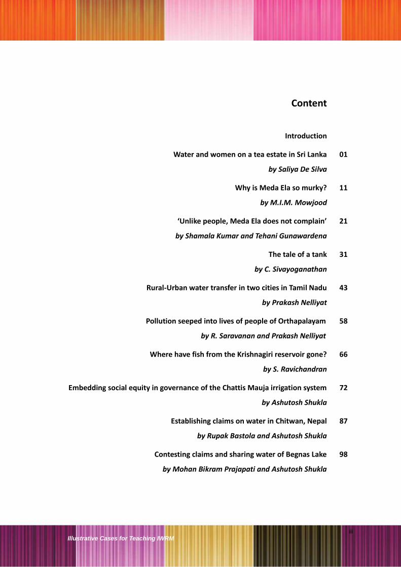
Content
Introduction
Water and women on a tea estate in Sri Lanka
by Saliya De Silva
01
Why is Meda Ela so murky?
by M.I.M. Mowjood
11
‘Unlike people, Meda Ela does not complain’
by Shamala Kumar and Tehani Gunawardena
21
The tale of a tank
by C. Sivayoganathan
31
Rural-Urban water transfer in two cities in Tamil Nadu
by Prakash Nelliyat
43
Pollution seeped into lives of people of Orthapalayam
by R. Saravanan and Prakash Nelliyat
58
Where have fish from the Krishnagiri reservoir gone?
by S. Ravichandran
66
Embedding social equity in governance of the Chattis Mauja irrigation system
by Ashutosh Shukla
72
Establishing claims on water in Chitwan, Nepal
by Rupak Bastola and Ashutosh Shukla
87
Contesting claims and sharing water of Begnas Lake
by Mohan Bikram Prajapati and Ashutosh Shukla
98

iv Illustrative Cases for Teaching IWRM

v Illustrative Cases for Teaching IWRM
Introduction
In the very beginning, the title of the compendium—Illustrative Cases for Teaching
IWRM—needs some explanation. During the initial work, it was realized that what was
envisaged under the project was fundamentally different from the pedagogic case-
studies used in the management institutions.
First of all, the pedagogic cases used in management schools are primarily aimed at
training future managers in learning the art and science of decision-making; as a result,
these case-studies are generally short and essentially describe the problem about
which the decision is to be made. These case-studies are expected to generate
vigorous and intense debates among students in the class, bringing out multiple view-
points and options for solution in order to arrive at appropriate and optimal decisions
for resolving the problems posed in the case-studies. Such discussion tends to be
adversarial and competitive; one participant posing a better option than the previous
ones.
As against this, the main objective of developing the pedagogic cases under the CB
project was to expose students to relevant real-life experiences, in order to facilitate
better understanding of the issues, concepts, and theories taught in the IWRM classes.
This objective required that the narrations in the pedagogic cases proposed in the
project have to be fundamentally different from those of the management case-
studies, which are often short and posing the problem begging a decision. In contrast,
the envisaged IWRM cases need to contain the narration of real-life situations or
conditions—in a vivid and elaborate manner—in order to facilitate experiential
learning. Hence, more appropriate term for these cases, it was felt, would be the
‘illustrative case narrations’. Further, The discussion in the class, based on these case
narrations, would be aimed not at adversarial competition to bring out diverging view-
points or better options, but on helping each other in unraveling the case narration to
bring out different nuances and details of the ground situation that do or do not
complement the concepts and theories of IWRM taught in the class.
In this sense, the learning gained through these case narrations is supplementary or
supportive to teaching of theory. As against this, many management institutions
prefer to substitute theoretical teaching (through lecture / presentation) by case study
method. The last and most practical difference that was brought out during the
workshop was that there is significant difference in the make-up of students from
management programs and engineering programs, at least in the South Asian
situation. While management students tend to be more outspoken and ready and

vi Illustrative Cases for Teaching IWRM
willing for group discussions right from their admission stage, the engineering
students—trained more through the medium of lectures—are less prepared to readily
engage in nuanced discussions with the teacher in the class. This makes the task of the
teacher—using these case narrations—both critical and challenging. This also indicates
that more work is needed for preparing engineering teachers to use such innovative
tools. To this end, the participating faculty also prepared support material for teachers.
This compendium contains ten illustrative case narrations from the three South Asian
countries, viz., Nepal, Sri Lanka, and India. They cover different themes under the
rubric of IWRM such as gender dimension of water sector, pollution of water, and
traditional institutional and governance arrangements, and contestation and claims on
water. They could be used by engineering or other institutions teaching the IWRM-
related courses in South Asia or even from other parts of the world.
At the end, it needs to be mentioned that these case narrations are developed by the
faculty from engineering colleges—and not by specially hired consultants—as teaching
material for their own use. The CB project was very clear in laying emphasis on this
aspect of building capacity of teachers.
@ @ @

1 Illustrative Cases for Teaching IWRM
Case 1:
Water and women on a tea estate in Sri Lanka
Saliya De Silva
1. Malathi’s day at the tea estate
On a tea plantation near Pussallawa town, Malathi carries two heavy cans of
water from a public tap to her barrack-type room. She makes this trip twice every
day, each time carrying a 20 kilo load of 20 litres of water, her back bent with the
effort.
Her day begins at 4 a.m. Water is supplied only from 6.30 to 9 in the morning,
and Malathi must collect enough for the family‘s morning needs during this time.
The early morning hours are spent in preparing breakfast and lunch, feeding and
sending the children to school, and cleaning. If her husband, Moorthi, who is an
estate labourer, has to work that day, he has to report to work at 6.00 a.m.
Malathi prepares his breakfast and sends it to the field. She has to go to the tea-
plucking field at 7.30 a.m., after leaving her two-year-old daughter on the way at
the Child Development Centre, the tea estate‘s crèche. At 9.30 a.m. she gets a
half hour break to eat breakfast. At noon, Malathi weighs her collection, picks up
her daughter from the crèche, has lunch and returns to work at 1.30 p.m.
Moorthi usually completes his work by 12.30 p.m. While resting, he keeps their
two daughters, aged eight and two, at home. If he cannot do that, Malathi takes
her younger daughter back to the crèche and works till 4.30 p. m or till 5.30 p.m.
at peak harvesting time. When she reaches home after weighing the tea leaves,
it is almost 6 in the evening. She collects firewood on the way back. She has to
hurry before it gets dark, to have a bath and bathe the children, wash clothes and
collect drinking water. She spends the next few hours preparing dinner, washing
and cleaning the house. She goes to sleep by 10.00 or 11.00 p.m. Her husband

2 Illustrative Cases for Teaching IWRM
has adequate time for leisure and alcohol, whereas Malathi gets barely six hours
of sleep.
Like other women on the tea estates, Malathi has to work 365 days a year.
Weekends and public holidays are not granted to women workers on the estates.
Every day of the year, about 10 hours are spent on the estate and about six
hours doing housework. The facilities provided to the workers are minimal.
Numerous women on the estates relentlessly work to produce tea that is globally
renowned and the principal plantation crop of Sri Lanka. For over a century, tea
has significantly contributed to the Sri Lankan economy, particularly in foreign
exchange earnings. In 2007, it was the second largest export commodity,
contributing Rs. 114 billion from 312 million kilos of tea exports.1 Thus, the
women working on the estates are the lifeline of the economy.
2. Low education, low incomes and poor living conditions
The majority of the workers living on the upcountry estates today are second or
third generation immigrants; their parents or grandparents were brought to Sri
Lanka by the British after 1827. The early migrants were mainly ―lower‖ caste
Hindus from South India. Some of them still do not have Sri Lankan citizenship.
Various socio-economic parameters indicate acute deprivation among the
upcountry workers. A survey done on two plantations near Pussallawa town
showed that a fair proportion of both men and women had never been to school.
The majority (57 percent) of those who did go to school, studied only up to Grade
5. Amongst these, 31 percent found it difficult to write and read. These
percentages are significantly lower than those of other rural areas in Sri Lanka.
Compulsory education was introduced on the plantations in 1907, but was never
enforced. Plantation owners and managers have always discouraged formal
education, which they perceive as a potential threat to a stable supply of labour.
The survey also showed that in a majority of families (76 percent), both husband
and wife are engaged in income-earning activities. In Sri Lanka, women are
expected and encouraged to do extra-domestic remunerative work. The average
monthly income of a working couple was calculated at Rs. 12800,2 but their take-
1 Central Bank of Sri Lanka (2008), Annual Report 2007
2 Sri Lanka‘s per capita GNP at current market prices in 2007 was US $1,599 (about Rs. 15,000
per month)

3 Illustrative Cases for Teaching IWRM
home salary3 was reported as only Rs. 4000 (1 US$ = SL Rs. 114). The average
monthly savings for emergencies such as health problems was Rs. 350.
There are two types of houses on the tea estates: (a) line rooms or a barrack-like
structure with a row of attached small houses, and (b) separate houses or
cottages. The construction of separate houses was started in 1985 under a
housing programme, but a majority of families (78 percent) still live in line rooms.
The shabby living conditions of these rooms are similar to the conditions in urban
slums. The lack of sanitary latrines is a major problem. Pour-flush latrines or pit
latrines are sometimes shared by three-four families, and a secure water source
is rarely nearby. The toilets are located about 20-30 metres away from the
houses, and they are often dirty and choked. Open drains full of stagnant water,
heaps of garbage and smoke-filled rooms are common sights.
In terms of assets, 42 percent of the families own the house and the land on
which they live. A majority have radios (79 percent) and television sets (63
percent). Many do not possess any kind of vehicle; only four percent men own a
bicycle or a motorcycle. Private transportation is very important in this area,
where public transportation is inadequate and unpredictable.
The average monthly expenditure of a family is Rs. 11,800.4 Of this, nearly 55
percent is spent on food. The monthly income is used to ensure the family‘s
survival and maintenance (for example, for food, clothes and healthcare) but not
for upward mobility (that is, for purposes such as education and vocational
training). Only five percent of the income is spent on education. According to the
Estate Medical Assistant (EMA), alcohol is consumed in 90 percent of the
families, and by 70 percent of the women on the estates drink.5 On an average,
Rs. 1600 per month are spent on alcohol.
3. Adding discrimination to deprivation
The social status of women on the estates is inferior. This gives them little
access to and control over resources and services. Women get less education
than men; the survey showed that as many as 70 percent women (but only 44
3 A portion of household staple foods including rice, flour, tea, and dal is supplied as ―advance‖ by
the management and the cost is deducted from the workers‘ salaries. 4 The expenditure includes the advance taken away by the management and their personal
expenses. Note of caution is that usually in surveys of this nature income is underreported while expenditure is exaggerated. 5 Although women consume alcohol, they are not addicted and consume large quantities on regular
basis like the men do.

4 Illustrative Cases for Teaching IWRM
percent men) had studied till less than the primary level. Women form the
majority who cannot, or find it difficult to, write and read.
The wages of women workers on the estate are Rs. 269 per day,6 Rs. 117 less
than the wages of men. Although the gender gap in wages was removed with
the enactment of the equal wages for equal work rule by the Wage Boards
Ordinance in 1984, differential wages persist due to a perceived difference
between ―women‘s work‖ and ―men‘s work‖. Women are not permitted to work if
they arrive late; they are paid significantly less if they fail to reach the daily norm
of 19 kilos of plucked tea leaves, and so on. Although women earn only 61
percent of the income earned by men, they save more (Rs. 408) than men (Rs.
316) for family emergencies and healthcare. Illnesses are frequent. Either
mothers or elder daughters have the responsibility of looking after the sick.
The excessive use of alcohol is a major problem on the estates. According to the
EMA, domestic violence, including verbal and physical harassment7 of wives and
children, is common. The plantation management perceives women as part of a
family labour unit and not as independent wage earners. Men are permitted to
collect women‘s wages and even their maternity benefits, which they often spend
as they wish. The women complain bitterly that their wages have been spent on
alcohol by their husbands.8 The loss of an already inadequate income affects
their children‘s education, nutrition and health (particularly of daughters), which
are regarded as the mother‘s responsibilities. A considerable number of families
are indebted, and the women‘s only asset, jewellery, is often pawned to meet
family needs.
3.1. Bare homes, barely any water
A majority of the families live in line rooms, where the women in particular face
various difficulties. The average size of a line room is smaller than a room in a
separate house. In a majority of the line rooms (65 percent), the kitchen is
outside. When the women are at home, they spend most of their time in the
kitchen, and spend a lot of time and energy moving to and from the kitchen and
the main room.
6 It is one of the lowest wage rates among similar occupations in Sri Lanka, even after 38%
increase of minimum daily wage to Rs. 269 from Rs. 189 in June 2007 by HE the President of Sri Lanka (Central Bank, 2008). 7 In an incident reported by an EMA, an alcoholic father sexually harassed his young daughter.
8 Jayaweera, S (1991), Women in the Estate Sector, Working Paper No. 1, Centre for Women‘s
Research (CENWOR), Sri Lanka.

5 Illustrative Cases for Teaching IWRM
The line rooms are not solid constructions; most of them (72 percent) are
plastered with clay or have wattle and daub walls, dung or earth floors (42
percent), and galvanized sheet roofs, which often leak. The women maintain the
dung floors, re-plastering them occasionally. The line rooms have walls on both
sides and only one small window each in the front and the back; as a result the
ventilation inside is poor. The layout offers no privacy.
Most of the families use kerosene for lighting and firewood for cooking. The
hearth is either three stones (49 percent) or mud (30 percent), and it consumes
energy inefficiently. The use of firewood and its inefficient utilization adds to the
work of women, who also have to collect the firewood along with the men.
Most of the families (48 percent) get water for drinking and cooking from a pipe
located outside their line room.9 In most cases, the water comes from
unprotected springs or a small tank constructed a few hundred meters away by
the estate management. People who do not have a separate pipeline collect
water from a public tap (27 percent). The public taps usually serve two rows of
line rooms or about 20 families. Water is available on these taps only for one-two
hours a day. The women have to bathe using the only tap available outside their
houses. In interviews with them, the women said that the lack of privacy inside
and outside the rooms is very stressful.
Some of the pipes, usually diversions from small tanks constructed around a
spring, do not function properly due to poor maintenance; sometimes the pipes
are stolen. During most of the year, the pipe-borne water is just enough for
drinking and cooking. Various other sources of water—streams, ponds, and
protected and unprotected common wells—have to be used for laundry and
bathing.
The supply of water in Sri Lanka is handled by the local municipal council or the
National Water Supply and Drainage Board. A majority of households are
supplied with piped water. The two government agencies however provide a
water connection only up to the point where private property begins. Within the
property, water supply is the responsibility of the owner of the property. Most of
the land on which estate workers live is owned by the workers themselves; the
estate management therefore believes that securing water is the workers‘
9 Appendix 2 shows the water sources used for different purposes.

6 Illustrative Cases for Teaching IWRM
responsibility. On the other hand, the workers believe that water supply is the
responsibility of the government or the estate management. Many efforts made
by the estate management to provide and maintain a supply of water with a
nominal contribution (Rs. 10 per month) from the estate workers have failed in
the past.
The women face various difficulties in accessing water and 45 percent of them
said that the quality of water they have access to was unacceptable. They said
that the water that they collect is discoloured (26 percent), contaminated with
solid matter (13 percent) and chemicals (4 percent), or smelly (2 percent). One
group of people said the water was contaminated with human faeces. The
unprotected spring from which they get water is located near the toilets of a
community living closer to that spring. To make the water safe for drinking for the
family, the women have to boil it, often on firewood that could be used to prepare
meals. If anyone in the family gets sick due to the contaminated water, it is the
women‘s responsibility to take care of them.
Women living in separate houses use improved stoves, which are more energy
efficient. Most families in these houses have tap water inside the house. More
space and facilities such as hygienic toilets, and a kitchen inside or attached to
the house, provide some degree of relief to the women living in separate houses.
3.2. Juggling multiple tasks
Women like Malathi have multiple roles. They constitute about 65 percent of the
labour force on tea plantations, and play a major role as income earners by
contributing 40 percent to the family income.1 However, notions of the ―male
breadwinner‖ and ―dependent housewife‖ persist on the estates. Most of the
women work as tea-pluckers. Their working conditions are amongst the hardest
on the plantations; they work on hilly terrain travelling across dangerous routes
with 20-30 kilos on their backs. The estates are located in the upcountry wet
zone, and most of the time the women work in the rain and cold, without
adequate protection.
A majority (92 percent) of the women on the estates are married and they play
multiple roles as mothers, wives and household managers (See Appendix 1).
They contribute to all the reproductive work in the family. Their involvement in
fetching water, preparing meals, bathing children, feeding children, washing

7 Illustrative Cases for Teaching IWRM
utensils and doing laundry is more than 85 percent. The women spend, on an
average, 106 minutes a day in the kitchen preparing meals for the family. If they
cook twice a day, the time spent on cooking can extend to three hours per day.
The only activity that men share equally is collecting firewood.
Women also spend a lot of time in collecting water (72 minutes on an average
per day); this task is done at least twice a day. On an average, women on the
estates walk 77 metres to collect drinking water; the distance varies from two
metres to 500 metres. If there is piped water inside or just outside the house, the
time spent in filling water is only a few minutes. Sometimes during the dry
season, women have to travel a few kilo-meters for spend a few hours to collect
drinking water. They travel longer distances for laundry and bathing, averaging
153 metres and 235 metres respectively. Some families walk two kilometres to
bathe, particularly during the dry seasons. All water-related tasks—bathing and
feeding children, laundry, washing utensils—consume the limited time available
to women on the tea estates.
Most of the women believe that they have to do these reproductive tasks
because their husbands are involved in income-generating work (34 percent);
they seem to forget that they themselves also earn wages. Only two percent of
the women believe they have special skills that men don‘t possess, which qualify
them to engage in reproductive tasks. For 24 percent of the women, this division
of labour is the family custom. When the children are not at school (which is
frequent), the girls help with various household tasks, while the boys play with
their friends. Girls (sometimes as young as five years) go to collect water from
the public taps. When their mothers and elder sisters are working on the estates,
the girls look after the domestic work. Men undertake domestic tasks only in
emergency situations, when no woman is available for such work.
3.3. Water, sanitation and the status of women
Good water supply and sanitary conditions influence the health, productivity and
overall socio-economic conditions of the estate workers. Sanitation is an
indicator of social development, it is important for maintaining personal and
family hygiene. The cleaning of toilets is not a common practice on the estates.
Using water that has been collected after a lot of effort to clean toilets may be
regarded as wasteful; this may also be due to low awareness about hygiene.
Open defecation and the use of pit latrines near the streams are serious

8 Illustrative Cases for Teaching IWRM
problems in controlling waterborne diseases not only on the estates, but also in
the nearby downstream Pussallawa town.
When toilets do get cleaned, in most of the families, this task is done by either
the mother or daughters. However, a minimum amount of water is used for
cleaning toilets, drains and kitchen utensils. Personal hygiene is also neglected.
Washing hands after using the toilet and before eating are unusual practices. If
water were not so difficult for the women to access, it is likely that they would
implement more hygienic practices for the household.
According to the EMAs, outbreaks of communicable diseases like hepatitis,
cholera, and typhus occur from time to time on the estates and in Pussallawa
town. Cold-fever, diarrhoea and skin diseases are common. The connection
between these diseases and contaminated water is well-established. The survey
indicated that about 39 percent of family members who had a disease during the
last one year were mothers, 26 percent were fathers, and 23 percent were
daughters; sons, at 12 percent, showed the highest resistance to diseases.
A greater degree of physical and mental stress makes women more susceptible
to illnesses. Cultural practices require women to eat last and, in low income
families, the least. The physical strain and exhaustion caused by long hours of
tea plucking, carrying heavy baskets of tea and cans of water two times a day
over hilly terrain and uneven ground, and other household chores, make women
more prone to diseases. Abortions, still birth, pains in the joints and back,
abrasions, callosities of the soles and abnormalities and degenerative changes in
the spine are common. Malathi occasionally gets severe back pain after she had
a Caesarean section for her second child. When the bouts of pain begin, she has
to stay at home, at times for a month or two, and cannot go to work. However,
her arduous work—walking 200 metres twice a day with heavy cans continues.
The consequences of such health problems are serious for the family as well as
for the estate management: 71 percent of the respondents indicated that their
illnesses prevented them working on the estates, 18 percent said they were not
able to carry out their routine household work during periods of sickness.
Medical care usually draws a fair proportion of their limited income. Although
medical facilities are provided free on the estates (as in other parts of Sri Lanka),
some prefer to visit private doctors. The average expenditure on healthcare is
Rs. 2133 per year, but, at times, this increases to exorbitant amounts depending

9 Illustrative Cases for Teaching IWRM
on the condition. The health of the family most closely affects women, who have
to attend to the health problems of other family members.
A major factor that contributes to the deprived living conditions of women on the
estates is the lack of secure access to water and safe sanitation. Women travel
long distances to fetch water, thereby sacrificing their time and using energy.
The extra time needed to collect water and to maintain family hygiene prevents
estate women from accessing education and more remunerative work, which are
means to achieve higher social status. Low family incomes, poor sanitary
practices, and the practice of women eating last and least means insufficient
nutrition, which make women more prone to illnesses. Better access to good
quality water and proper housing facilities would only be a first step in improving
the socio-economic conditions of women on the tea estates of Sri Lanka.
4. Summary
Women on the tea plantations near Pussallawa town in Sri Lanka are the lifeline
of the national tea economy. However, they are located at multiple disadvantages
along the class and gender axes. Most of the workers on the plantations live in
shabby rooms, work hours are long, healthcare facilities are limited, alcoholism is
common. Within this context of deprivation, women have the additional burden of
doing remunerative work on the plantations for wages that are lower than those
paid to men, as well as being responsible for multiple time-consuming and tiring
household tasks, including cooking, cleaning and looking after the children.
Their already heavy workload is aggravated by poor access to water. Most of
them have to collect water, over several trips every day, from pubic taps located
some distance away from their homes, where water is available only for a few
hours. Bathing at the public taps means little privacy; washing clothes and
utensils often requires further trips. The water often comes from unprotected
springs, and is sometimes contaminated. Sanitation and hygiene are inadequate
due to inadequate water. All of this contributes to frequent illnesses in the family.
Long-term solutions to the water problem on the tea estates remain elusive.
@ @ @

10 Illustrative Cases for Teaching IWRM
Appendix 1: Reproductive tasks in a family
Activity
Family member involved (%)
Average time taken to complete the task
(min)
Number of times involved per week
Male Female Average Maximum Average Maximum
Collecting water 10 90 72 420 15 60
Cooking 10 90 106 180 11 21
Bathing children 4 96 67 180 7 7
Feeding children 4 96 52 90 21 21
Washing utensils 3 97 52 180 6 7
Laundry 13 88 54 180 8 21
House cleaning 16 84 41 120 7 14
Washing toilets 19 81 23 30 4 7
Attending to children‘s health
16 84 29 60 4 7
Collecting fuel wood 48 52 196 300 1 4
Participation in Hindu Temple Committee
46 5 31 60 6 12
Participation in Death Benevolence Society
36 3 90 90 5 12
Appendix 2: Sources of water for different purposes
Drinking/Cooking Source
Pipe (Inside)
17%
PubT
27%
UnS
4%
Pipe (Out
side)
48%
Com. PW
2%TubeW
2%
Bathing Source Pipe (Inside)
12%
Pipe (Out
side)
14%
PubT
6%
TubeW
2%
Pond
8%
Stream
12%
Com. PW
17%
Com. UnPW
21%
UnS
8%
Washing Source
Pipe (Inside)
13%
Pipe (Out
side)
24%
PubT
13%
Com. PW
11%
Com. UnPW
17%
TubeW
4%
UnS
7%Pond
7%
Stream
4%
*PubT: public tap; TubeW:
Tube well; UnS: Unprotected
Spring; Com PW: Common
protected well.

11 Illustrative Cases for Teaching IWRM
Case2:
Why is Meda Ela so murky?
M.I.M. Mowjood
1. Pollution of the Meda Ela
Kandy, the largest city in the hilly region of Sri Lanka, is abundant in scenic
beauty. The city is a world heritage site of religious and cultural importance. It
offers many tourist attractions, including Kandy Lake and the world famous
Buddhist pilgrimage site, the temple of the ‗tooth relic‘, popularly known as the
Dalada Maligawa.
The Meda Ela originates as an outflow of Kandy Lake and flows about eight
kilometres along the southern boundary of Kandy city before it merges with the
Mahawelli River at Gatambe (See Figure 1). The canal is essentially a natural
stream whose headwater is confined to the south-eastern foothills of the Kandy
Lake watershed.
Figure 1: Geographical illustration of the Meda Ela and sources of pollution
Restauran
ts
Laundries House
s
House
s
House
s
Hospital
Bus
stands
Kandy Lake
Prison
Marke
t
Meda
Ela
Mahawelli
river School

12 Illustrative Cases for Teaching IWRM
The Meda Ela is being indiscriminately polluted. Solid waste floats everywhere in
the murky water, and wastewater from various sources is discharged into the
river. The water smells bad and its colour ranges from brown to black depending
on the wet and dry season. The nitrate loading and high concentration of coliform
in the canal are attributed to biogenic waste such as human and animal excreta.
The nitrate concentration in the Meda Ela increased from 0.2 to 12.39 mg/l
between 1982 and 2008. The total coliform, the bacteria that cause hepatitis,
was around 10 200 cfu/100ml in 2008. This indicates that the canal receives
human excreta.
As a result, the people around the Meda Ela are living through a nightmarish
experience. The strong foul smells and the brown murky water are unattractive to
tourists and unbearable for people who live close by. As a natural stream running
in the middle of a historically important and sacred city, the role of the Meda Ela
in terms of aesthetics, the ecosystem, and health and sanitation is vital.
2. Polluters and victims
The pollution of the Meda Ela causes several problems for the people and the
ecosystem. The environment along the Meda Ela has become unsuitable for
human habitat. People in the area are affected by vector borne diseases. The
Meda Ela is a breeding place for mosquitoes. Children are frequently affected by
dengue and malaria fever. The windows and doors of the houses have to be kept
closed for 24 hours due to the bad smells and mosquitoes. The costs of medical
treatment are a burden for the people living in this area.
People living downstream are more affected because of activities in the upstream
areas. The discharge of wastewater and dumping of garbage has created
tensions amongst the communities, between people living upstream and
downstream, and with government officials. People have lost confidence in
official agencies and the officials have lost their drive to implement the
regulations.
The biodiversity of the Meda Ela has been badly affected, as the canal has
changed from a natural stream to wastewater. Aquatic life is endangered, and the
number and abundance of aquatic species in the Meda Ela have been affected.
Fish and water spiders can be found at the beginning of the Meda Ela, but only
worms that can survive in low levels of dissolved oxygen are found downstream.

13 Illustrative Cases for Teaching IWRM
The Meda Ela adds a substantial amount of EColi bacteria to the Mahawelli river,
where the intake of water is located downstream of the meeting point. The Meda
Ela is polluted by several sources of organic and biological waste. Point sources
and non-point sources contribute significantly to the deterioration in the quality of
the water
3. Multiple sources of pollution
The quality of the water of Kandy Lake has been maintained to a certain
standard due to its close proximity to the Dalada Maligawa site. There are many
hotels for tourists, restaurants and private hospitals around the lake. The
discharge of wastewater into the lake from these establishments is monitored in
order to protect the lake. The water that spills from Kandy Lake into the Meda Ela
is therefore comparatively less polluted.
The contamination of the Meda Ela begins from the market in Kandy, which is
maintained by the Kandy Municipal Council (KMC). More than 20 meat and fish
stalls are located in the complex. Wastewater from the meat, fish and vegetable
stalls and restaurants is added to the water that flows from Kandy Lake. This
wastewater carries a high organic load. The Kandy Bogambera prison, located
adjacent to the market, also releases its wastewater into the Meda Ela.
Kandy is one of the focal points of public transport in Sri Lanka. According to the
traffic police, more than 30,000 vehicles enter the city every day. Numerous
centres for healthcare, education, business, cultural and ritual interests are
located in Kandy. All of these attract a large commuting population of about
125,000-175,000 people every day. The runoff from the bus stands, which carries
oils, grease and suspended particles attached with heavy metals, flows into the
Meda Ela that runs underneath the bus stands.
The main hospital in Kandy is a large teaching hospital maintained by the
Ministry of Health with modern facilities for medical treatment. Its wastewater
goes through a treatment facility within the hospital and is then discharged into
the Meda Ela. However, occasionally, the treatment plant does not function, and
untreated wastewater is discharged into the Meda Ela. Hospital wastewater
carries contaminants that can cause infectious diseases.

14 Illustrative Cases for Teaching IWRM
Commercial laundries (dobby communities) along the canal also discharge
untreated water used for washing, into the Meda Ela. The dobby community has
been living at this location for more than a hundred years. Clothes that have
been used even in the operation theatres and wards of the hospital are washed
in these laundries. This enhances the possibility of the water being polluted with
pathogens and other microbes. The high concentration of phosphate in the Meda
Ela may be due to the detergent used in the laundries.
Solid waste in the Meda Ela has become a routine sight. Solid waste
management is a serious problem for the municipal corporation. The central
collection system covers a limited number of areas due to the financial
constraints; the land available for dumping is also limited. The KMC does not
have a sanitary landfill site and open dumping along the streams is common. The
dumping of solid waste into the Meda Ela becomes an easy way of solving the
problem of solid waste, but not of the pollution of Meda Ela.
Figure 2: Multiple sources of pollution of the Meda Ela
3.1. Development and water pollution
The population of the Kandy city is growing fast; it was 110, 049 in 2001. The
number of hotels and restaurants is increasing to cater to the increasing numbers
of foreign and domestic tourists. Private hospitals and clinics have also increased
to provide more medical facilities. New supermarkets, vehicle service stations,
Pollution
in the
Meda Ela
Market
Hospital
Bus stands
Prison Domestic
houses
Laundries
Soil erosion Hotels and
restaurants

15 Illustrative Cases for Teaching IWRM
commercial venues and houses also indicate the rapid development of Kandy.
These developments increase the physical and aesthetic impact on the Meda
Ela.
A highway was constructed in 1988 alongside the Meda Ela, running parallel to
the existing old road in order to reduce traffic congestion. The allocation of land
for the development of the highway and the relocation of people also influenced
the pollution of the Meda Ela. The rehabilitation package of the government failed
to effectively relocate the people. Land was acquired for road expansion in
1988 and some of the people relocated to small plots near the banks of the Meda
Ela. As a result houses were constructed in the riparian zone of the Meda Ela
with or without prior approval from the KMC.
The high cost of construction perhaps acted as a deterrent for constructing
proper sewage-disposal facilities. The limited land and shallow groundwater also
created problems for construction of septic tanks and soaking pits; as a result,
wastewater from the toilets and bathrooms flows directly into the Meda Ela. The
count of coliform in the Meda Ela clearly indicates discharge of human excreta in
its water.
Other recent developments along the Meda Ela, such as the Kandy court
complex, supermarkets, channelling centres, several restaurants, fire brigade
depots and new houses make the canal even more vulnerable to further
pollution.
4. Multiple laws, acts and institutions
The pertinent questions in this context are: whether there are any restrictions or
regulations related to pollution of streams? Whether there is any mechanism to
monitor implementation of these regulations? The situation gets very convoluted
due to multiplicity of sources of pollution, diversity and complexity of the
problems and impacts created by pollution on environment and public health, and
multiplicity of the possible victims. This complexity and multiplicity in diverse
factors pulls a score of government agencies into the task of protecting the
natural streams like Meda Ela. The complexity and multiplicity also attracts
provisions of various laws. Further, diverse nature of these laws and criss-
crossing jurisdictions of these institutions further complicates the situation. More
than fifty legal enactments and government agencies deal with the water sector

16 Illustrative Cases for Teaching IWRM
in Sri Lanka. Some of these laws and institutions pertain to the control of
pollution and related issues.
4.1. The KMC and the UDA
The Kandy Municipal Council (KMC) is governed by the Mayor, members elected
by the people, and the Commissioner appointed by the government. The KMC
consists of different departments responsible for maintaining different aspects of
Kandy city. The departments of Health, Environment and Buildings play a major
role in enforcing the policies and regulations related to the problems affecting
Meda Ela. Local government acts, municipal and urban councils‘ ordinances, the
Pradesha Shaba act, Land Development Ordinances (No. 19 of 1935, No. 3 of
1946), the Land Acquisition Act and the Crown Land Ordinance (No.8 of 1947, 9
of 1947 and 13 of 1949) are prescribed in the government policy for land
development and rehabilitation, and to maintain the reservation area of the Meda
Ela.
The KMC and the Urban Development Authority (UDA), a body entrusted with the
function of planning of major cities in Sri Lanka, are responsible for the
resettlement of people displaced by the construction of the highway that runs
parallel to the Meda Ela. There are differences in the levels of interests and
influence of the political leadership and administrative leadership in different
cases. Most of the institutions are regional bodies, which come under national
ministries. The KMC, however, is a local body and it can make decisions
independently under its political leadership. Opinions and views on policies at the
local and national levels are likely to differ or clash.
The KMC is responsible for the collection and disposal of solid waste. The
provisions related to solid waste management in the municipal council ordinance
says that all street refuse, house refuse, night soil, and other similar matter
collected shall be the property of the council and the council shall have full power
to sell or dispose of all such matter. The ordinance also prescribes that the
municipal council shall, from time to time, provide places convenient for the
proper disposal of all street refuse, house refuse, night-soil or other similar
matter.
The Urban Development Authority (UDA) deals with the major development plan
of Kandy city. The Urban Development Authority Act (No. 4 of 1982) states that

17 Illustrative Cases for Teaching IWRM
―any development activity should obtain a development permit from the relevant
local authorities.‖ The Buildings Department has the task of approving plans for
building houses and look into giving approval according to the specific
reservation limits on building houses near waterways. The Act also specifies that
waste generated within any premises shall be collected and disposed of in a
manner which the authority considers essential, so as to safeguard the health of
the inhabitants.
Figure 2: Institutions and departments linked to the Meda Ela
The building department of the KMC grants a certificate of conformity after the
construction work is completed. This certifies that the work has been completed
as per the approved plans and permit. This certificate is required for obtaining
water supply from the National Water Supply and Drainage Board (NWSDB), and
electricity supply from the Ceylon Electricity Board. Water and electricity may be
provided, if necessary, during construction, but at higher rates. The rates are
reduced after the certificate of conformity is produced. Illegal buildings or
premises are not supposed to get water and electricity from the respective
institutions.
The UDA Act, in Schedule IV (Form E-Regulation 18) also provides for the
reservation of ‗no-construction areas‘ along waterways. This reservation of area
is meant to protect the waterways and facilitate the flow of water, particularly
during floods. The reservation line is drawn at a certain distance away from the
edge of the high water level of the Meda Ela. This distance is three meters for the
Water pollution
in Meda Ela
Kandy Municipal
Council
Urban
Development
Authority
Central
Environmental
Authority
National Water Supply
& Drainage Board
Mahawelli Authority
of Sri Lanka
Health
Department
Irrigation
Department
Forest
Department

18 Illustrative Cases for Teaching IWRM
portion of Meda Ela between the Kandy Lake and to Heerassagala junction, and
six meters for the portion between Heerassagala Junction and Mahawelli River.
In spite of these restrictions, houses have been constructed entirely or partially in
the reserved areas along Meda Ela. The reservation limit is also meant for
restraining discharge of wastewater and dumping of solid waste in the
waterways. However, several pipes open directly into the Meda Ela, despite
existence of reservation lines.
The UDA act also provides detailed norms for disposal of sewerage to be
followed to obtain a development permit. It says: ―All sewerage and wastewater
outlets shall be connected to an existing sewerage system and the authority may
in any particular case require the sewerage and wastewater to be pre-treated to
bring them to acceptable standards before being connected on to a public
sewerage system.‖ In the case of the Meda Ela, where a public sewerage system
does not exist, the Act prescribes that the outlets cannot be connected to the
natural stream, which sewerage must be disposed through a septic tank, and that
wastewater should be suitably disposed through a soaking pit. The bacterial
contamination of Meda Ela confirms that the contents of septic tanks are
discharged into the canal, despite the regulations.
The UDA and other departments have to work in coordination for successful
implementation of legal provisions related to the development permit. According
to Section 4 (vii) of the UDA Act, in case low lying areas are to be filled up, the
UDA must seek approval from the Commissioner of the Department of Agrarian
Development, the Chairman of the Sri Lanka Land Reclamation and
Development Cooperation and the Head of the Department of Irrigation. The
reservation and other linked areas along Meda Ela (valley) are low lying and
were used for paddy cultivation in the past. The filling of paddy fields for
constructing houses was recently banned, in view of the importance of the
reserved areas along waterways, which enable water storage, groundwater
recharge, and protection from floods.
4.2. Sectoral agencies dealing with the issues involved
The National Environment Act (No. 47 of 1980) prescribes that ―No person shall
discharge, deposit or emit waste into the environment or carry on any prescribed
activity determined by an order made of the Act in circumstances which cause or
are likely to cause pollution or noise pollution, otherwise than license issued by
19 Illustrative Cases for Teaching IWRM
CEA and in accordance with the standards and criteria specified.‖ The Central
Environmental Authority (CEA) is empowered to give an Environment Protection
Licence (EPL) for medium and large industries and processing plants, to monitor
the effluent discharge and to take necessary legal action to safeguard the
environment. The CEA has set a standard for wastewater discharge. Both the
CEA and the Public Health Department have to monitor wastewater discharge.
The CEA and the Health Department of the KMC are responsible for monitoring
wastewater discharge into the Meda Ela from the hospital and prison in Kandy.
The National Water Supply and Drainage Board is responsible for the supply of
safe drinking water and proper drainage facilities. A law of the Water Supply and
Drainage Board (No.2 of 1974) provides for pumping water from the intake at
Mahawelli River, operating and maintaining a water treatment facility, distributing
water and collecting payments from customers. The Board must also ensure
proper drainage in order to protect the water resources. The Board does not
allow water supply for houses and other premises built illegally, without prior
approval or a certificate of conformity.
According to a public health ordinance, the Health Department is responsible for
the cleanliness of all roads, drains, markets and the environment in general.
Responsibilities of the Health Department includes: implementation of the health
policy, monitoring effluent discharge of small scale operations (markets,
hospitals and restaurants), creating public awareness regarding health issues
and taking legal action if necessary when it comes to public health and
sanitation. The Public Health Inspectors (PHIs) are ground-level implementing
officers of the Health Department. Legal actions for non-compliance can be taken
by the PHI, but actions against polluters, particularly government establishments
like the prison and hospital, are a challenge for the PHIs.
The Mahawelli Authority Act (No 23 of 1979) of the Mahawelli Authority of Sri
Lanka (MASL) prescribes the development of the Mahawelli river basin for
agriculture and hydro-power generation. The Irrigation Department is responsible
for water bodies other than the Mahawelli River. Kandy Lake comes under the
Irrigation Department according to an Irrigation Ordinance (No 32 of 1946). The
forest department is responsible for implementing the Forest Ordinance (No. 13
of 1966) and the Fauna and Flora Protection Ordinance.

20 Illustrative Cases for Teaching IWRM
4.3. Overlaps and gaps
The ownership and responsibility for the drainage area of the Meda Ela falls in
multiple jurisdictions, since it comes under the Mahawelli river basin, and
originates from a lake and forest reservation. The overlap in terms of
responsibilities requires effective coordination among the institutions to protect
the Meda Ela from pollution.
All the departments linked with the Meda Ela are, in one way or another,
responsible for its present situation. These institutions come under different
ministries of the government. Regional centres of the institutions implement the
national policies in the region. The Acts and Ordinance related to the Meda Ela
are institution-specific. Most of the laws and Acts were formulated in pre-
independence era, and a few amendments were later added. The challenges and
issues in the present context are not the same as they were in past decades. The
gaps and weaknesses in policy related to approving, monitoring and evaluating
human activities that indiscriminately pollute the Meda Ela have to be identified
and rectified.
5. Summary
The Meda Ela is polluted at multiple locations by multiple sources. The
complexity of this problem is only added to by the multiple laws, regulations and
government institutions responsible for maintaining the Meda Ela and its
surrounding areas. Official agencies and the people have attempted several
times to clean the canal, but the situation has not improved. Instead, the pollution
now poses a threat to the environment, to livelihoods and to public health.
Serious concerns have been raised by policy makers, water and environment
regulators, and the people about the Meda Ela and its deteriorating condition. A
government initiative to solve the problem through a Centralised Sewage
Treatment Plant has been opposed by some sections of the community for
various reasons, such as the location of the plant, investment and recovery of
costs, and doubts about the proposed technology and management of the plant.
People have suggested that they themselves can take measures at the
household level to solve the problem.
@ @ @

21 Illustrative Cases for Teaching IWRM
Case 3:
‘Unlike people, Meda Ela does not complain’ 10
Shamala Kumar and
Tehani Gunawardena
1. The Meda Ela and Kandy
Meda Ela, a natural water-stream, begins from Kandy Lake in the centre of
Kandy city. Kandy is one of the larger cities in Sri Lanka, with a population of
a little over 100,000 people. It is historically significant and designated as a
world heritage site. It is a charming city, situated amid lush natural beauty.
Along its eight kilometre journey through Kandy, the Meda Ela is a sore point
in this scenario. It flows underground for about a kilometre from the Kandy
Lake watershed, after which it surfaces and moves parallel to the William
Gopallawa Road, one of the main roads that enter Kandy city. On either side
of the Ela is residential housing that stretches quite high up onto the
surrounding hills. The water from these hills flows down to the Ela in small
streams. A network of drains, some of which are managed by the municipal
council, connects the city‘s drainage system to the Ela. A highly polluted Ela
finally enters the Mahawelli, a river that has social, cultural and environmental
significance to Sri Lankans.
Such is that state of the canal that research indicates it has no aquatic life.
The Ela emanates a strong stench, which, at times, is unbearable. The water
looks murky; and plastic bags, empty coconut shells, and other solid waste
float on the surface or stick to the banks. On certain days, the water turns a
dull red and on other occasions it becomes deep blackish grey. The changes
in colour are probably due to pollution from various sources along the Ela,
10
A statement made by an official during an interview with the author

22 Illustrative Cases for Teaching IWRM
such as a slaughter house and the major food market of Kandy. Garbage and
sewage from many houses along the canal are also dumped into the Ela. The
canal receives waste directly from tourist hotels, schools, hospitals, markets,
slaughter houses, garages and laundries. The drains connected to the Ela,
which are managed by the municipal council, look dirty and smell bad.
1.1. Peoples’ perceptions of the Ela
Residents living around the canal seem to be wary of the Meda Ela. In
interviews we conducted in 2008 with the community, only one of the 13
respondents living along the Meda Ela did not report some issue associated
with the canal as a negative characteristic of the location of their home.
Specifically, seven reported flooding, six reported unbearable odours
emanating from Ela, and four reported mosquitoes as the negative attributes
of their location.
The other consistent characteristic was congestion, which was reported by
three respondents. These characteristics were listed without our introducing
the Meda Ela as the focus of the survey. When asked if their perception of the
Ela was positive, negative or neutral, all respondents said that it was
negative.
Similar responses emerged amongst people living about 100 meters away
from the Ela. One woman, whose house adjoins the Ela, told a story of a man
who, she said, had died while trying to collect worms as bait from the canal.
She said that the man died because the water was so polluted. Her home, a
temporary shack, in which she and her daughter live, floods during heavy
rains. She attributed an illness that her daughter got after a flooding incident
to the polluted water; in another instance, she got a skin rash due to, she
said, contact with the water when she rescued a kitten from the Ela. People
living close to the Ela view it a pervasive negative influence on their living
environment.
Despite these perceptions, some people indirectly use water from the canal
or from tributaries of the Meda Ela. They use water from wells close to the
canal. The water from a tributary, the Nagasthanna stream, is used by
laundry workers; worms are collected from the Meda Ela to be sold in
Colombo as bait for recreational fishing.

23 Illustrative Cases for Teaching IWRM
2. The story of Malini
Adjoining the Meda Ela stands a somewhat new building. Signboards
advertise two eateries and other products for sale. As you approach the
building from the side of the William Gopallawa Road, a bad smell emanates
from the vicinity. For the ignorant, the smell may signal unhygienic food and a
need to find food elsewhere. To others, it is simply a troubling reminder of the
Meda Ela flowing by silently.
This building belongs to Malini. Like others we interviewed, Malini was
unhappy about living so close to the Meda Ela because of the smell and the
flooding. According to her, the main reason for the flooding is the violation of
the river reservation limit of six metres set by the municipal council. A major
supermarket and restaurant in the area and a paint shop altered the natural
course of the Ela during the construction of their building. ―The Meda Ela
didn‘t flood like this before,‖ Malini reminisces. She got the land some time
ago, but built her complex after her husband‘s death only three years before,
with the help of a loan and income she earned working abroad. Her complex
seems to be successful, going by the constant stream of customers.
Malini lives on a plot adjoining the retail outlet, in a small half-built structure,
with her 17-year-old daughter and 64-year-old mother. She acquired the plot
from her previous neighbour, who was also relocated, just as she was, when
the William Gopallawa road was built about 20 years ago. The neighbour sold
her the property because of financial difficulties. According to Malini, he was a
quiet and ―scared‖ sort of person who let others push him around, which
might explain why another member of the Meda Bowala village set up a
‗Cushion Works‘ service on the premises. The municipality confirmed that the
‗Cushion Works‘ was illegally built.
Malini feels she is viewed as an intruder or even as someone who usurped
property belonging to the Meda Bowala village. The village is a cohesive
community with historical roots in the area. As a result, they have a feeling of
ownership of the local land. Malini said that when she and others were
relocated to this area, the community looked upon them as outsiders.
‗Cushion Works‘ is owned by long time residents of Meda Bowala. Although,
the owners illegally acquired the land, they have the support of the

24 Illustrative Cases for Teaching IWRM
community; Malini says she gets little support from the Meda Bowala
community.
Malini‘s brother, who works with the Mayor of the city, helped her get the
approval to build the business complex. However, on at least one occasion,
these connections have been a liability. When she went to complain about
the activities of her neighbours to the Buildings Department, she said that she
was ―scolded‖ and asked if she felt that she could just push them around
because of her brother‘s connections. Malini was critical of the municipality
and its inability to help her. She seemed to think that if only they did their
jobs, her problems would be over.
3. The official view: A system in need of repair
The municipality, however, seems to have its own problems, which the
officers involved are quick to point out. It has a multiplicity of institutions;
three major institutions are directly responsible for curbing pollution. Each of
these institutions has field level officers who are responsible for implementing
the policies and laws designed to control pollution and manage water
drainage: the Public Health Inspector (PHI), the Central Environment
Authority (or CEA) Officer, and the officers from the Buildings Department.
The CEA officer, Chandanie,11 is responsible for giving an Environmental
Protection License (EPL) for medium and large industries and processing
plants, monitoring effluent discharge and conducting awareness programmes
about environmental pollution and possible solutions to these problems. The
Buildings Department is in charge of approving plans for building houses.
According to this department, construction around the Meda Ela must be six
meters away from the canal where Malini lives. All buildings must have
soakage pits for disposing wastewater and sewage, and the drainage system
must only be used to deposit rain water and not waste. The Health
Department has to monitor the residents of the community and prevent
unlawful disposal of waste into the Ela, using the same code applied by the
Buildings Department. The PHIs are expected to first warn violators but can
also take legal action against them. Bandara, the PHI in charge of the Meda
Ela, admitted that it was of the low priority for him. Unlike people, he said,
―The Meda Ela does not complain.‖
11
Names have been changed.
25 Illustrative Cases for Teaching IWRM
Poor coordination hinders effective functioning of the system. Ananda,
another PHI, said, ―We don‘t even get documentation about this approval
process, but then it is up to us to make sure that these same buildings do not
pollute after the building is constructed. How can we do that?‖ Technically, a
copy of the approved plan should be sent to the office of the Medical Officer
of Health, where the PHI works. However, according to Ananda, these copies
are often not sent.
The field officers say they are burdened with work. Bandara, who has been at
this position for eight months, has a diverse set of responsibilities such as
providing health education, inspecting schools, conducting legal proceedings,
eradicating illegal substances, disposing of waste and building material, and
dealing with environment problems. The officer of the Central Environment
Authority, who is in charge of three districts, agreed that there is an overload.
Perhaps as a result of the workload, the officers seem to work in a somewhat
ad-hoc manner. Bandara said that he receives around four-five complaints
about illegal activities every day from citizens; sometimes these complaints
are related to the Meda Ela. He attends to other complaints much of the time
instead of those directly related to the Meda Ela because of time constraints,
he said. Records of complaints are also kept in an ad-hoc manner and are
not revisited, except when another complaint is lodged. Nor has he followed
up on his predecessor‘s cases or even had a briefing of ongoing activities
with his predecessor.
To some extent, however, the PHIs do have some consensus about priority in
terms of pursuing industrial rather than domestic non-compliance. Ananda
said that he was primarily interested in big institutions that do not comply with
the regulations. ―It‘s not the small people who are the problem but the rich
people who come to argue with us when we try to do our job.‖ According to
him, the bigger institutions are the biggest polluters and they are the cases
that the judges have said should preferably be brought to them. Because
licensing from the Central Environmental Authority must be renewed
regularly, enforcement is done in a more regular manner.

26 Illustrative Cases for Teaching IWRM
3.1. The problems in dealing with pollution
For the field officers, the incentives to effectively implement policy seem to be
few. Field visits, according to Bandara, are difficult, because he only get US$
8.41 per month as petrol allowance. The current price of petrol per litre is
US$ 1.47. The red tape involved in getting the $ 8.41 is so cumbersome, that
Bandara says he uses his own funds for travel most of the time.
The PHIs don‘t feel compelled to legally pursue cases because they do not
get batta (a daily allowance) for the time they spend in court, unlike police
officers, who get an allowance even when they work within city limits. ―So
why should we waste our time in the courts, spending our own money to get
them convicted?‖ Bandara asks. He also complained about the time lag
involved in pursuing offenders through the legal system, which can take
several months. ―It would be nice,‖ he said, ―if like the police we could just
issue tickets to wrong-doers.‖
Both Bandara and Chandanie, the officer from the Central Environmental
Authority, talked about the lack of funds. Chandanie said that although they
would like to conduct programmes such as awareness campaigns, there is
no money and at times they even use their own funds.
The system sucks initiative out of its workforce. Bandara said that he
attempted to institute a recycling campaign along the Meda Ela for 250
houses. Non-degradable waste would be taken to recycling centres and other
waste would be left to decompose naturally. However, he gave up this
programme because it was difficult for him to implement it. After writing the
proposal, he had to pursue people to get the proposal and funding approved.
It took so long that he stopped pursuing the project.
Perhaps because of the lack of incentives, officers need added pressure to
pursue a particular case. ―The only time I take the trouble to file a case is
when the (erring) resident has attitude problems,‖ Ananda said. He is
particularly reluctant to get involved with problems initiated with an intention
to settle personal scores between neighbours. He categorically said, ―I do not
pursue them when I feel that we are being used to further their personal
agendas.‖

27 Illustrative Cases for Teaching IWRM
Bandara was also dismissive. He said that Malini and the owners of the
‗Cushion Works‘ had a personal disagreement, which they were trying to deal
with by involving officials. ―Why should we get involved with their personal
problems?‖ he asked; he is not intervening in this case. His attitude indicates
that the PHIs have substantial discretion in doing their work. Their
perceptions and bias may determine when they intervene. A statement
Bandara made further indicates biases. When asked who he thought were
the main polluters he said ―rich Muslims‖.
Practical issues associated with their work make matters worse; the near-
impossibility of detecting illegal sewage outlets, for example, which are only
opened during heavy rains. This is corroborated by an extremely pungent
smell that pervades the area whenever it begins to rain. Residents are
expected to build soakage pits on their land to dispose of this water. Bandara
said that because the soil is quite saturated in this area, soakage pits have a
tendency to overflow. ―Many residents don‘t have the money or space to build
them anyway,‖ he said.
The PHIs indicated that the Department of Health does not have a licensing
system, unlike the Central Environmental Authority, that would help them to
systematically monitor unlawful activity. Although Chandanie of the Central
Environmental Authority denied this, Ananda said that licensing made service
stations more compliant. Chandanie said that the hoteliers normally listened
to their advice but not the service station owners and workers.
It would be incorrect however to say that the officers are completely
ineffective. Bandara said that he is not completely neglecting the Meda Ela.
He said, ―The major contributor to the high pollution level of the Meda Ela is
solid waste,‖ and labourers are regularly employed to collect the solid waste
dumped and piled up along the Ela. ―The people only see how much the Ela
is polluted. Yet they do not see how much work is already done to keep the
Ela in its present condition. If we stopped doing what we are doing now
people will not be able to even walk through Kandy because of the
accumulated garbage.‖
3.2. How corruption affects the Ela
Corruption is also a feature of the system. Our efforts to talk to the officials of

28 Illustrative Cases for Teaching IWRM
the Buildings Department were unsuccessful; they were reluctant to
cooperate. When discussing this issue with others who have been involved
with the same department, questions about corruption arose. A member of
the staff, when approached after office hours, said that the department was
sensitive about public scrutiny because it was engaged in an ongoing
national-level investigation into allegations of the mishandling of funds by
staff members. The Minister of Public Affairs was reportedly overseeing the
investigation.
About a year ago, Malini had to deal with corrupt garbage collectors. With no
alternative method of solving the problem of waste disposal for her business,
she said she constructed a compartment for collecting garbage using her
own money. The former PHI in charge of the Ela advised her on how to carry
out this task. She said, ―I even invited him to the opening ceremony.‖ For
some time, her tenants complied with this system and put their garbage into
the compartment. However, the municipality workers who came to collect the
garbage asked from her renters a monthly ―unofficial fee,‖ which she rejected.
She launched many complaints when the garbage started piling up. The PHI
advised them not to use the bins because they would not be collected again.
Now the garbage is dumped into the Ela, and people seem to be uninterested
in finding solutions to the problem.
Malini said that she also rejected the contractor‘s offer to build her a
mechanism to directly dump her sewage into the Meda Ela. She feels that
residents bribe the officers; she has observed officers receiving free services
and food from boutiques and houses. She has seen the ‗Cushion Works‘
owners and officers ―laughing and talking with each other.‖ She is unhappy
with the slowness with which the matter of the ‗Cushion Works‘ shop is being
dealt with by the municipality, and complains that the owners must be bribing
the municipal officers (PHIs).
Based on a court case, a judge had apparently ordered the municipality to
remove this building. Malini said that each time the officials came to give
notice, the owners disappeared. She suggested that the owners were
informed prior to the visit of the officials. This case has dragged on for a long
time. Malini is hopeful that in the near future the judge would intervene; but it
has been several months since the judicial order, and the shop is still
functioning.

29 Illustrative Cases for Teaching IWRM
3.3. Political pressure and pollution
Amidst these difficulties lies the pervasive influence of politicians. Much of the
Meda Ela is within Kandy city limits and is therefore under the purview of the
Kandy Municipality. The Kandy Municipality is steered by a legislative body
headed by the Mayor. It is responsible for creating the laws and policies
relevant to the Municipality—including those related to the Meda Ela. The
Mayor and other members of the council are elected through local elections.
The members of the council represent the governing party and the
opposition. The council comprises 14 members of the governing party, the
United National Party (UNP) and 10 members in the opposition. Although the
UNP governs the Kandy Municipality, it is part of the opposition in the national
government.
The national government can influence local pollution. The policies
developed by the municipal council are administered through the Sri Lanka
Administrative Service. At the municipal level, the Commissioner heads this
administrative structure. Through the Commissioner the minister can also
influence how policies are implemented. Under the Commissioner are many
heads of department, such as the Medical Officer of Health, who heads the
Department of Health and Sanitary Services. The Commissioner of Kandy is
attached to the Ministry of Public Administration and Home Affairs, currently
under Sarath Amunugama (Ministry of Public Administration and Home
Affairs, 2008), representing the United National Freedom Alliance (UNFA),
the party in power at the national level, and often at loggerheads with the
UNP.
Chandanie said that their work is made difficult by political interference.
Political influence seems to help at times and at times it hinders citizens in
getting their voices heard. Political considerations probably explain why the
municipality would allow structures to be built without space for sewage pits.
Malini and her friend Menike both got legal approval to build that went against
the policy directive. In both cases, political intervention seems to have been
used to get special permission for their buildings. Menike‘s building and the
adjoining house were approved after they were built on illegally acquired
land. As a result, the building did not even go through the approval process.

30 Illustrative Cases for Teaching IWRM
Yet, when Malini applied for permission to construct a retaining wall along the
Ela to deal with the flooding, she said an approval was granted but later
withdrawn. She said that this was because the ‗Cushion Works‘ owners, who
supported the UNFA, sent a petition to the President stating that the Mayor
was unfairly favouring her because she supported the UNP. She said, ―I know
the Mayor well, but now the Mayor is too scared to help me.‖
When Malini went along with her neighbours to complain to the Mayor and
the President‘s special squad about a house on the Ela, which according to
her is illegally built on reservation land, no action was taken. Malini also
described a large house close to her home that she said a minister had built,
also on reservation land, which was corroborated by another member of the
community. A relatively larger structure does exist further upstream.
Although Malini is critical of individuals who build on the reservation land
along the Ela, her building is also partly built on this land. She had met the
planning committee, which approves all structures built in Kandy municipality,
and got a special concession on grounds of sympathy. She said that she had
to give 26 perches (units) of land to the government when the new road was
built, and in exchange received this piece of land that was only five feet wide.
The 26 perches of land the government acquired was her on a ―temporary
basis‖—a euphemism that means her family illegally settled on that site. She
could not do much with the land and was therefore allowed to build on the
reservation land. Thus, she too has contributed to the flooding.
4. Summary
This case has examined how policies related to the Meda Ela are
implemented from the perspective of those responsible for the
implementation, as well as from the point of view of the community. Systemic
problems pervade this process. Unfair political and financial manipulation is
viewed as the norm. Everybody involved in the Meda Ela seems to be
frustrated. Multiple interconnected issues have to be addressed through
interventions to curb pollution. The story of the Meda Ela and the solutions it
generates could be relevant in other contexts.
@ @ @

31 Illustrative Cases for Teaching IWRM
Case 4:
The tale of a tank
C. Sivayoganathan
1. Minor irrigation tanks in Sri Lanka
The Divullewa Mahawewa tank is a recently renovated minor tank in the
district of Kurunagela. It has a command area of 15 hectares and is part of a
cascade system managed largely by the villagers. Of the 11257 minor
irrigation tanks in Sri Lanka, 4192 or 37 percent are in Kurunagela district; 22
percent of the command area of the recently rehabilitated minor tanks is in
this district.
Sri Lanka is divided into two major dry and wet agro-climatic zones, based on
the amount of annual rainfall received during the two rainy seasons, Maha
and Yala. The northern and eastern parts of the country are predominantly in
the dry zone. The wet zone covers the south western region, including the
central hill country. The dry zone receives an average annual rainfall of less
than 1750 mm. The Maha season (October to April) brings heavy rains to this
dry zone, which covers nearly two-thirds of the country. This makes irrigated
agriculture an important aspect of Sri Lankan agriculture in the dry zone.
The irrigation tanks are classified as major, medium and minor on the basis of
the command area they serve. Minor irrigation tanks have a command area
of 80 hectares or less. However, in terms of the total extent and the number
of farmers served in the country, minor village-level irrigation tanks play an
important role. The Divullewa Mahawewa is one such minor irrigation tank. It
is believed to have been originally constructed in King Mahasena‘s era. The
Divullewa Mahawewa is one of the 16 tanks of the cascade system that
receives water from a main tank called Magallewewa.

32 Illustrative Cases for Teaching IWRM
The minor tanks in the dry zone of Sri Lanka are mainly water storage
facilities created by people as elements of cascade systems of
interconnected tanks. The minor tanks provide water for irrigation and are
also the centre of village life. The tanks are the meeting point for bathing,
washing clothes, fishing and work on water-based industries. The tanks are
thus regarded as crucial support for sustainable livelihoods for households
and the village, through increased agricultural production, employment and
income. The tanks recharge and regulate the local groundwater table, and
are therefore also vital for ensuring the supply of drinking water. The local
community generally claims to ―own‖ the tanks, though the major
responsibility of rehabilitating the tank lies with the government.
1.1. Maintaining the minor irrigation tanks
In the past, the tanks were maintained by the people from surrounding
villages under the supervision of the Mahagamurala (village leader) and the
Wel Vidane (irrigation leader). This system, called Rajakari, effectively
managed the minor tanks. The villagers cleaned the tank and the surrounding
areas during the dry season every year in August, under the leadership of the
village leader.
The British administration abolished the Rajakari system without introducing
an alternative system for the maintenance of the tanks; consequently, the
tanks were abandoned. In 1958 the Sri Lankan government introduced
cultivation committees to manage the tanks. The small tanks subsequently
became the responsibility of the Department of Agrarian Services, which was
later renamed the Department of Agrarian Development. Even after the
Department of Agrarian Services took over, the minor tanks were not properly
managed, mainly because the local people had by then been displaced due
to economic, political, environmental and security reasons.
In the recent past, many of these deteriorated and abandoned tanks have
been renovated by the government, international development agencies and
non-governmental organisations. The tanks were renovated to increase the
availability of water for irrigation and for other purposes. However, the
villagers have not received the expected benefits from the renovated tanks,
and the operation and maintenance of the tanks is not satisfactory.

33 Illustrative Cases for Teaching IWRM
2. The village and its people: beneficiaries of the tank
The beneficiaries of the tank mainly consist of two groups: 45 title-owners of
paddy fields and 30 other villagers who are engaged in part-time farming and
off-farm activities, though they do not own the land. The owners of the paddy
fields are the main beneficiaries of the tank, and use its water mainly for
cultivating paddy. Highland crop-growers or people engaged in brick-making,
who form the other group of 30, are not eligible to use the tank water for their
purposes. However, they use the water draining out from the spills and turn-
outs. The farmers here cultivate paddy and other field crops by directly using
tank water; vegetables and betel are grown as highland crops. The tank also
provides water to another small tank. A farmer appointed as a jalapalaka
(water flow controller) oversees the distribution of water in the village.
In the village where the beneficiaries of the Divullewa Mahawewa tank live,
only a few houses near the main road have electricity. Transportation in most
parts of the village is poor. A majority (83. 9 percent) of the beneficiary
households who have legal titles are traditional settlers and the others (16.1
percent) are new settlers. Most of the people are Sinhalese Buddhists and
there are no distinct caste differences among the villagers.
Our survey conducted in 2008 showed that the male heads of households
had higher levels of education (average grade 7.9) than their wives (average
grade 5.8). Although a somewhat comparable percentage of men (32.3
percent) and women (35.5 percent) amongst the respondents had studied
beyond the ninth grade, 29 percent of the wives reported not attending school
at all as compared to only 3.2 percent of the husbands (See Table 1 in the
Appendix section).
The men (average age 49 years) were significantly older than their spouses
(average age 33 years); 41.9 percent of the male respondents were between
41 to 60 years old, whereas exactly a same 41.9 percent of the women were
between 23-40 years old. And 22.6 percent men and 6.5 percent of their
spouses were over 60 years old (See Table 2 in the Appendix section). The
family size of the respondents ranged from 1-7 members, and nearly one-
third (32.3 percent) families had four members (See Table 3 in the Appendix
section). Most of the respondents (90 percent) were engaged in farming as

34 Illustrative Cases for Teaching IWRM
their main enterprise. Some were also engaged in brick making, fishing and
off-farm employment.
2.1. Uses of tank water
The tank water is used by the households for various activities (See Table 4
in the Appendix section). It is however apparent that the tank water is mainly
used for paddy cultivation (90.3 percent), followed by bathing and washing
(48.4 percent). The other activities for which the water is used are brick
making, for livestock and their grazing, and cultivation of perennial and other
field crops. No respondents reported using tank water for drinking, because
they use well water for this purpose. According to a previous study, only one
percent of the villagers were engaged in inland fisheries in this tank. The
farmers‘ organisation leased out the tank for fishing to the villagers and
charged a tax of five percent from the fish harvest.
2.2 Land ownership and use
The farmers generally have three types of lands: highland, lowland and
chena land, which is used for shifting cultivation. On an average, farmers
owned 1.30 acres of lowland, 1.60 acres of highland areas, and 0.30 acres of
chena land. Most of the land was owned by the households, with only a small
portion of the lowland (0.13 percent) rented out for cultivation (See Table 5 in
the Appendix section).
Paddy is the main crop. During Maha, most of the lowland is used for paddy
cultivation, whereas during the Yala season only half of the lowland is planted
with the same crop. Small amounts of other crops are cultivated on the
highland during both Yala (average 0.35 acres) and the Maha (average 0.55
acres) seasons. No other field crops are cultivated in the lowland either in the
Maha or the Yala seasons. Some perennial crops such as mangoes, jak,
coconuts and citrus are grown in the highland (See Table 6 in the Appendix
section).
2.3. Reported inequity in use of the tank
In terms of the use of tank water for various purposes, almost all the
respondents indicated that water was used mainly for irrigation during paddy

35 Illustrative Cases for Teaching IWRM
cultivation rather than for any other activities. A majority of respondents who
are farmers (51.6 percent) said the use of the tank was inequitable, but a
close minority (45.2 percent) perceived no inequities. Of those who reported
inequities in irrigation (25.8 percent), everyone indicated that the head-
enders along a channel, who had fields closer to the tank, benefited more
than the tail-enders.
Over three-fourths did not report any inequity in water use with respect to the
sex of the farmer, duration of settlement in the village (that is, whether they
were traditional settlers or new settlers) and scale of farming (See Table 7 in
the Appendix section). It should be noted that more land can be brought
under cultivation by enhancing the capacity of the tank. The survey did not
collect any information from non-beneficiaries, either general or specific to
inequities in the use of water.
2.4. Who really owns the tank?
The ownership of Mahawewa tank is not clearly defined. It is likely that many
parties share the ownership. The resources within the tank such as fish and
plants are owned by the Divisional Secretariat, while administration and
maintenance activities such as conducting kanna (seasonal) meetings and
water distribution are undertaken by the Agrarian Services Centre. However,
the villagers had different opinions: ―We all own it‖; ―The government owns it‖;
―The government and villagers both own it‖. A majority of 54.8 percent said
that they themselves owned the tank, whereas 29 percent said the farmers‘
organisation was the owner. Only 9.7 percent said that the government
owned the tank. These different perceptions of who owns the tank may be
impacting the levels of participation.
3. Taking care of the tank
The management of the irrigation tanks includes three major tasks:
rehabilitation, operation and maintenance. All these tasks involve planning,
implementation and evaluation. Many stakeholders are involved in the
management of the tank, and their participation in the whole process is vital
for the success of the programme. The Department of Agrarian Development
plays a major role, because funds from the government or from other
agencies are generally channelled through this department. It is also

36 Illustrative Cases for Teaching IWRM
responsible for coordinating the activities of the various agencies engaged in
the management of the minor tanks.
3.1. Rehabilitation activities
Over the past decade, the Mahawewa tank was rehabilitated three times.
During 1996-98, the bund and the sluice were reconstructed and the lower
tank area was developed with Rs. 12 lakhs given by the Asian Development
Bank. In 2004, under a project to develop 10,000 tanks, the tank bed was
deepened at a cost of Rs. 4 lakhs. In 2006 the third tank rehabilitation project,
which included improving infrastructure in the village, was implemented with
funds from the Asian Development Bank.
Farmers were brought in to work on the rehabilitation by using a combination
of food-for-work and cash-for-work approaches. Farmers were engaged as
unskilled labour mainly for earthwork related to deepening the tank bed,
improving the tank bund and constructing or repairing channels. Over 90
percent of the farmers participated in these activities. This seems natural
because the farmers draw direct, tangible and significant benefits from the
tank. It is expected that farmers who volunteer for and assume
responsibilities as office-bearers of farmers‘ organisation are more aware and
committed.
Participation in rehabilitation work is expected to promote ownership, leading
to proper maintenance of the tank after the rehabilitation. According to the
data (see Table 8 in the Appendix section), the men participated more than
women in all the rehabilitation activities. This could be due to prevailing
perceptions about the differential abilities of men and women, which may
determine what kind of work is allocated to whom. Both men and women
contributed to activities such as deepening the tank bed,
constructing/repairing spills, channels and turnouts. Skilled labour was largely
employed for constructing /repairing spills and turnouts. Unskilled labour
received food for their work, whereas the skilled workers got both food and
cash. A few men said they contributed cash instead of labour for the
rehabilitation work; no woman reported any cash contribution. The overall low
level of contribution in cash could be due to the low economic status of the
villagers. In conventional South Asian societies, women in rural areas
additionally have little access to and control over money; their work is often

37 Illustrative Cases for Teaching IWRM
regarded as non-productive and therefore non-remunerative, and payments
in kind (food) are often deemed more suitable.
3.2. Operation and maintenance activities
The president of the farmers‘ organisation said that a 20 percent contribution
was expected from the villagers, either in the form of labour or cash, for the
maintenance of the tank. The cash collected was deposited into the
organisation‘s fund, from which money was drawn for expenses related to the
maintenance of the tank.
The data clearly show that both the office bearers and the beneficiaries
(ordinary members) of the farmers‘ organisation took responsibility for
activities related to the operation and maintenance of the rehabilitated tank
(See Table 9 in the Appendix section). Men seemed to play a more active role
than women in all these activities, such as earthwork, cutting shrubs,
removing anthills and weeding channels. The power to make decisions, as
the table indicates, is also more with men than with women: deciding
cultivation dates and preparing the schedule for delivering water for
cultivation, for example.
Although government officers are involved to a small extent in maintenance
activities such as earthwork and weeding, their primary role appears to be
deciding cultivation dates and preparing the schedule for delivering water for
cultivation. According to the respondents, government officers as well as the
office bearers of the farmers‘ organisation (president, secretary and
treasurer), were involved in these decisions.
The maintenance work on tank bunds and irrigation channels was done by
the villagers usually as shramadana (collective voluntary labour). Most of the
respondent villagers (93.5 percent) saw themselves as being knowledgeable
about the activities related to the maintenance of the tank. According to the
Agrarian Development Officer, political interference in the management of the
tank was low.

38 Illustrative Cases for Teaching IWRM
3.3. Levels of participation
According to the Agrarian Research and Production Assistant, there was
harmony in the village, the villagers were enthusiastic and their participation
in the tank management activities was high. The president of the farmers‘
organisation reportedly facilitated this; he is highly respected by the villagers
as a responsible and unbiased middle-aged bachelor who had few family
responsibilities.
The level of the stakeholders‘ participation was also assessed by finding out if
they attended meetings and gave ideas, whether these ideas were favourably
considered in making decisions, and whether the decisions made based on
the ideas given were implemented. Although the Agrarian Research and
Production Assistant reported that participation was uniformly high, the data
show that men participated a lot more than the women in all phases
(planning, implementation and evaluation) of the tank management process
(rehabilitation, operation and maintenance) (See Table 10 in the Appendix
section).
Over two-thirds of the respondents reported that male beneficiaries, office
bearers of the farmer organisation and government officers attended the
meetings and expressed their ideas. However, office bearers of the farmers‘
organisation and government officers together had a greater role and
influence than ordinary male beneficiaries. Less than 50 percent of the
respondents reported that women beneficiaries attended meetings and
expressed their ideas. Most of the men indicated that their ideas were used
for decisions and that the decisions based on their ideas were implemented.
Overall, the participation of the beneficiaries in the evaluation process was
reported to be low. However, the office bearers of the farmers‘ organisation
seemed to participate in evaluation in addition to planning and
implementation. The government officers were reported to have participated
the most in the planning phase of the rehabilitation process.
4. Summary
Minor irrigation tanks like the Divullewa Mahawewa play a vital role in Sri
Lanka. They provide water for irrigation, recharge groundwater tables, and

39 Illustrative Cases for Teaching IWRM
serve as a centre of village life. When effective and traditional systems of
managing the tanks were discontinued, the tanks decayed. In recent years,
several attempts have been made to resurrect the tanks, with varying
degrees of success in terms of availability of water and its equitable
distribution.
As primary beneficiaries of the Divullewa Mahawewa, owners of paddy fields
command greater access to the tank‘s water; disparities also exist in the
water available to head-enders and tail-enders. The ownership, formal and
informal, of the tank, is perceived differently by different people. This, along
with the socio-economic dynamics, impacts access to the tank‘s water and
the levels of participation in the management of the tank.
Management activities such as rehabilitation and operation and maintenance
are underlined by gender differentials, in terms of the wages received and
types of work done by men and women, and the power to decide cultivation
dates and distribution schedules. Men participate more than women in all
phases of the management process. Other hierarchies exist in the form of
government officers and office bearers of the farmers‘ organisation having a
greater say in making decisions and getting their opinions through in
meetings.
@ @ @
Appendix
Table 1: Education levels of heads of households and spouses
Grade Head Spouse
No. % No. %
0 1 3.2 9 29.0
1-5 5 16.1 4 12.9
6-8 10 32.3 1 3.2
9-13 10 32.3 11 35.5
Non-response 5 16.1 6 19.4
Total 31 100 31 100
Mean 7.9 5.8
Range 0-13 1-11
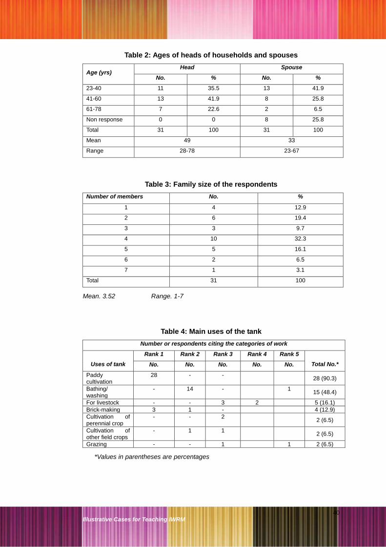
40 Illustrative Cases for Teaching IWRM
Table 2: Ages of heads of households and spouses
Age (yrs) Head Spouse
No. % No. %
23-40 11 35.5 13 41.9
41-60 13 41.9 8 25.8
61-78 7 22.6 2 6.5
Non response 0 0 8 25.8
Total 31 100 31 100
Mean 49 33
Range 28-78 23-67
Table 3: Family size of the respondents
Number of members No. %
1 4 12.9
2 6 19.4
3 3 9.7
4 10 32.3
5 5 16.1
6 2 6.5
7 1 3.1
Total 31 100
Mean. 3.52 Range. 1-7
Table 4: Main uses of the tank
Number or respondents citing the categories of work
Uses of tank
Rank 1 Rank 2 Rank 3 Rank 4 Rank 5
Total No.* No. No. No. No. No.
Paddy cultivation
28 - - 28 (90.3)
Bathing/ washing
- 14 - 1 15 (48.4)
For livestock - - 3 2 5 (16.1)
Brick-making 3 1 - 4 (12.9)
Cultivation of perennial crop
- - 2 2 (6.5)
Cultivation of other field crops
- 1 1 2 (6.5)
Grazing - - 1 1 2 (6.5)
*Values in parentheses are percentages

41 Illustrative Cases for Teaching IWRM
Table 5: Ownership of land
Type Total area accessed
(in acres)
Area of land owned
(in acres)
Area of rented land
(in acres)
Mean Range Mean Range Mean Range
Lowland 1.44 0-5.00 1.30 0-5.00 0.13 0-1.50
Highland 1.60 0-12.00 1.60 0-12.00 0 0
Chena 0.30 0-4.00 0.30 0-4.00 0 0
Table 6: Area of land mainly under crops
Crops
cultivated
Highland Lowland
Yala (acres) Maha (acres) Yala (acres) Maha (acres)
Mean Range Mean Range Mean Range Mean Range
Paddy 0.01 0-0.25 0.05 0-1.50 0.82 0-4.00 1.25 0- 4.50
Other field crops
0.35 0-4.00 0.55 0-40 0 0 0 0
Perennials Mean 0.93, Range 0-9.00 0
Table 7: Inequities reported in use of tank
Type Reporting inequity Not reporting inequity
No. % No. %
Farmers 16 51.6 14 45.2
Persons involved in other occupations
1 3.2
Head enders 8 25.8 23 74.2
Tail enders 0
Small scale 4 12.9 23 74.2
Large scale 4 12.9
Traditional settlers 4 12.9 26 83.9
New settlers 1 3.2
Males 3 9.7 28 90.3
Females 0
Table 8: Involvement of beneficiaries in rehabilitation activities
* male ** female
Activity
Food for work
Cash for work Contribution in cash
M* F** Both M F Both M F Both
Deepening tank bed 10 1 8 9 - - - - 2
Improvement to tank bund
8 8 - 12 - 1 1 - 2
Construct/ repair spill 3 - 6 11 - 1 - - 2
Construct/ repair channel
4 - 7 3 - 9 - - 1
Construct/ repair turnouts
3 1 6 6 - 2 2 - -
Other - - - - - - - - -

42 Illustrative Cases for Teaching IWRM
Table 9: Participation of stakeholders in operation and maintenance
activities
Number of respondents reporting participation in these activities
Activity Male beneficiaries
Female beneficiaries
Office bearers of farmers’
organisation
Govt. officers
Others
Earth work on bund 20 10 16 4 3
Cutting shrubs on bunds 19 7 11 - 3
Removing anthills on bunds 20 4 8 - 2
Maintaining the sluice 13 2 11 2 5
Earth work on channels 18 7 6 - 2
Weeding channels 20 12 8 1 3
Deciding cultivation dates 16 3 22 12 4
Preparing water delivery schedule for cultivation
11 5 24 12 4
Operating sluice 7 - 18 2 6
Distributing water along the channels
12 4 18 2 3
Table 10: Levels of participation of stakeholders in different phases
Number of respondents reporting
Level of Participation
Planning Implementation Evaluation
Me
n
Wo
men
FO
off
ice
be
are
rs
Go
vt.
o
ffic
ers
Me
n
Wo
men
FO
off
ice
be
are
rs
Go
vt.
o
ffic
ers
Me
n
Wo
men
FO
off
ice
be
are
rs
Go
vt.
o
ffic
ers
Attending meetings
26 10 25 23 24 14 20 18 15 6 20 16
Giving ideas 23 7 15 16 20 16 16 13 13 5 17 14
Ideas used for decisions
20 5 15 14 16 9 14 12 12 4 11 10
Implementation of decisions based on given ideas
18 4 14 14 14 8 12 11 10 3 10 10
@ @ @

43 Illustrative Cases for Teaching IWRM
Case 5:
Rural-Urban water transfer in two cities in Tamil Nadu
Prakash Nelliyat
1. Chennai’s thirst for water
Chennai is the fourth-largest metropolitan city in India; it is also one of the rapidly
urbanising centres of South Asia. From 1951 to 2001, Chennai‘s population grew
from 1.5 million to more than 7 million. The Chennai metropolitan area comprises
a total area of 1189 km.2 It consists of Chennai city (176 km2), 16 municipalities
(240 km2), 20 town panchayats (156 km2), and 216 village panchayats (617 km2).
The Chennai metropolitan area encompasses Chennai district and parts of
Tiruvallur and Kanchepuram districts. The peri-urban municipalities and town
panchayats have, in recent times, have seen a higher growth in population than
the city corporation (See Appendix 1). Besides the permanent residents, the
number of migrants and itinerant population in Chennai are also high. In 2001,
there were an estimated 0.93 million migrants to the city, and 1.60 million to the
urban agglomeration.
Chennai gets an average annual rainfall of 1290 mm, which is much more than
the state and national average. In the urban areas, only about five percent of the
rainfall seeps into the ground. Today 80 percent of Chennai‘s groundwater has
been depleted, and any further extraction could lead to further degradation in
quality, including the intrusion of salt water.
The Chennai river basin consists of a group of small rivers such as the Araniyar,
Kusathalayar, Cooum and Adyar, which supplied fresh water to the city. Chennai
currently does not have access to a perennial river and has to depend primarily
on three major reservoirs (former irrigation tanks) and one small reservoir across
a river that flood only for a few days during the monsoon.12 The northeast
12
Janakarajan S, John Butterworth, Patrick Moriarty and Charles Batchelor. 2007. ‗Strengthened City,
Marginalized Peri-urban Villagers: Stakeholder Dialogues for Inclusive Urbanization in Chennai, India‘. In
44 Illustrative Cases for Teaching IWRM
monsoon and surface run-off from the Araniyar and the Kortalaiyar rivers
replenish the Poondi, Cholavaram and Red Hills reservoirs (the three major
drinking water sources for the city). These reservoirs are shallow and are spread
over a total catchment area of 3.513 km.2. On an average, the total freshwater
yield from these three sources is 200 million litres a day (mld). To reduce this
shortage, the Water Board draws about 100 mld of groundwater from the well
fields of the Araniyar-Kortalaiyar basin (A-K Basin).
All these sources, together, supply about 300 mld in a year with average rainfall,
which is nowhere near the city‘s requirement. The gap between supply and
demand, for the last two decades or so, has been met from groundwater pumped
from agricultural wells in peri-urban villages. Wells supply about 125 mld of
water, which is roughly equal to the shortage in normal years for the city‘s water
supply. Together with the 300 mld from the A-K basin, the total supply is about
425 mld.
The scarcity of water in Chennai is not a new phenomenon. The city has been
historically water deficit due to a lack of perennial rivers. Rapid urbanisation and
the expansion of residential areas and industrial and business establishments
have put pressure on the water resources of the city and its periphery. The
surface and groundwater available in most parts of the city is not of good quality
and unsuitable for drinking and other domestic purposes.
Successive governments in the state of Tamil Nadu have spent over Rs. 40
billion on various measures to augment the supply of drinking water in Chennai.
In recent times, two large scale water supply schemes have been implemented:
the Telugu-Ganga project and the New Veeranam project, to take water from the
Veeranam tank at a distance of over 250 kilometres.
However, the Water Board has not been able to supply an adequate quantity of
water. In times of scarcity, the peri-urban villages around Chennai are important
sources of groundwater to cater to the demand for water in the urban area. A
large amount of groundwater is supplied by tankers, pipelines and sealed water
cans and bottles to supplement the supply of water to the city.
Despite these measures, water scarcity persists in Chennai. The per capita water
supply in the city is hardly 76 litres a day, which is lower than in any other city in
John Butterworth (Ed), ‗Peri-urban Water Conflicts‘, IRC Technical Working Paper- 50, The Netherlands.

45 Illustrative Cases for Teaching IWRM
India. Even this supply is irregular and, if conveyance losses are taken into
account, the point-of supply figure is nearer to 50 lpcd (litre per capita per day).
Only in exceptionally good monsoon years is there an uninterrupted supply of 76
lpcd.13
2. Drawing water from surrounding villages
The Metro Water Board started pumping groundwater from peri-urban villages to
supplement the city‘s water requirements as early as 1965 when it identified rich
aquifers in the A-K and Palar basins. The first well field identified was in Minjur
(A-K basin) about 40 kilometres north of Chennai. The Board identified about 180
private agricultural wells from which raw water was purchased. From each well
at least 10 to 18 loads of water were pumped (0.1 to 0.2 mld). Another 40 mld
was pumped from the Palar basin.
The Water Board has established a network of wells from which water is drawn.
Giant bore wells in these well fields were installed for round-the-clock pumping.
During peak seasons, the Metro Water Board transports at least 6,000 tankers of
water each day to the city from these well fields. The price of water paid to the
well owners varies with the season and quality of groundwater. The total
estimated cost of hiring these agricultural wells is Rs. 85 million per year.
The quality of water available in the village, the distance to the villages and their
connectivity by road were the main criteria for including these wells into the
network of the Water Board. Private tanker operators constitute a key set of non-
state actors who supply water, and who draw water from various peri-urban
villages to supply water to commercial establishments, hotels, construction sites
and hospitals.
In July 2000, for example, the piped water supply was only able to provide 59
lpcd to the city. In response, the Metro Water Authority installed 4,525 water
tanks in various part of the city and hired many tankers to deliver water to under-
served areas. It was estimated that the quantity of water mined from the
surrounding farmlands, would be equal to the capacity of about 13,000 tankers;
and, every day, at least 3,000 tanker loads of water went into the city to meet the
needs of multi-storied apartments, hotels, hospitals, other commercial
13
Ruet J, Saravanan V S and Zerah M. 2002. ‗Water and Sanitation Scenario in Indian Metropolitan
Cities‘. CSH, French Institute of India. Occasional Paper Serious No 6. Delhi.

46 Illustrative Cases for Teaching IWRM
establishments, and construction activities. During peak summer months, this
number shoots up steeply. Acute water scarcity, coupled with the ineffectiveness
of government action, has made the water supply business through tankers a
lucrative industry over a short span of time.
Other than the tanker owners, packaged water companies are also extracting a
huge volume of groundwater from rural areas and transferring it to urban areas.
According to a proprietor of a packaged water company in Chennai, around 350
packaged water companies operate in the Chennai metropolitan area and many
of them also do business from the peri-urban areas.
3. The consequences of water transfer
Water has been transported from peri-urban villages to Chennai city for more
than four decades; the practice started in the early 1960s. In proportion to the
booming demands of the city, the water transferred from the peri-urban villages
has also increased, which has affected agriculture. When groundwater starts to
decline/deplete in the coastal areas, sea water enters the aquifer and occupies
the places where fresh water was present. As a consequence, the groundwater
turned saline and affected agriculture in this region.
During the initial period of water extraction from the peri-urban villages, no
significant impact either in the form of groundwater depletion or degradation was
noticed. Perhaps the extraction rate was below the recharge rate or within the
limits of a sustainable yield. Over a period of time, as the extraction rate has
increased considerably in proportion to the water requirements of the city, the
groundwater table and the village economy have been affected in various ways.
For example, the estimated sustainable yield from the A-K basin was 100 million
cubic meters (mcm) per year, but the current total extraction is 300 mcm per
year, three times the sustainable yield.1 This over-extraction from the A-K basin
leads to intrusion of sea water into the aquifer, especially in areas like Minjur.
Some peri-urban villages have faced continuous droughts. In certain places,
conflicts and law and order problems have been reported.
Due to the transfer of water, the peri-urban villages of Chennai face serious
livelihood problems. Many farmers have become heavily indebted due to their
large investments in developing wells for irrigation, which did not bring them

47 Illustrative Cases for Teaching IWRM
adequate returns. This has seriously affected agricultural activity in the peri-
urban villages, resulting in decimated agricultural incomes and considerably
reduced employment opportunities. Many people had purchased tractors on loan
but, in some cases, these remain unused because of a lack of agricultural
activity. Unemployment is now emerging as a major problem in the villages.
Many landless agricultural labourers and marginal farmers have started migrating
to other villages, towns and cities looking for employment; this moving population
adds to the pressure on an already stressed urban infrastructure.
Many studies14,15 have highlighted the socio-economic impacts of water
extraction in the peri-urban areas of North Chennai. The majority of the villages
in the peri-urban areas have suffered from a lack of assured and gainful
employment, whether on-farm or non-farm. Even water sellers who benefited
greatly by supplying to the city began to feel the pinch after their bore wells
started drying up. Quite a number of water sellers started constructing houses
when business was good; many of these houses remain incomplete. The drying
up of aquifers has led to the cancellation of contracts between the water sellers
and the Metro Water Board.
4. Impact on Somangalam village
Somangalam is a peri–urban village of Chennai. Located about 30 kilometres
from the city, it was formerly a primarily agrarian village. The Somangalam tank
and its sophisticated irrigation network provided adequate water for agricultural
activities. The groundwater potential in the village was also good. Over some
time, however, agriculture in the village has considerably reduced, and most of
the fields are no longer being cultivated. Since Somangalam is near the City,
most of its inhabitants are able to get some work in Chennai. For them,
employment in the city is more remunerative than agriculture. This makes
agricultural labour scarce in the villages. Farmers feel agriculture is not profitable
any more.
In 2002, a water scarce period, almost the entire village was involved in the
business of selling water. Most of the farmers sold an average of 20 tankers
14
Janakarajan S. 2005. ‗Dying Agriculture, Weakening Environment and Fading Institutions: Draft‘.
Chennai.
15 Nisha Khanam. 2008. ‗Building an Enable Environment of Drainage Course to Meet the Rural and
Peri-urban Needs‘. ME (IWRM) Thesis, Centre for Water Resources, Anna University, Chennai.

48 Illustrative Cases for Teaching IWRM
(12,000-13,000 litres) per day. Brokers facilitated the process by getting orders
for water and making the necessary arrangements for extracting water from
different locations in the village. Virtually, the entire village supplied water from
irrigation wells with pumping facilities, which were facilitated by free electricity.
According to a villager, ―the government itself ordered us to provide water to the
city with the help of irrigation pumping systems.‖
The selling price of water was Rs. 50 per tanker; this means that every farmer
who was involved in the water supply business earned Rs. 1,000 per day or Rs.
30,000 per month. According to a farmer, ―It was a golden opportunity for us. We
never earned Rs. 30,000 per month with agriculture. We are still eagerly waiting
for such opportunities‖. The villagers said that the water sold during 2002 did not
affect either the groundwater table or the village eco-system. This might be
because the overall extraction of groundwater in the village was less than its
regeneration.
However, after the boom year of 2002, when the demand for water was high due
to scarcity in Chennai and other areas, the Somangalam water business
slumped. Continuously transporting water in tankers over long distances from the
village to Chennai became economically unsustainable.
5. Impact on Valliyur village
The situation is different in villages where water extraction is continuous,
especially in the A-K basin. In these villages, a significant impact is evident due
to the depletion or degradation of water resources. In villages like Valliyur,
frequent conflicts over water also occur.
Valliyur is located 30 kilometres from the city, in the A-K basin of North Chennai.
Groundwater was historically the primary source of irrigation here, and the main
crops cultivated were paddy and groundnut. During the 1980s about 280
agriculture wells existed in the village at depths of 50-80 feet. When pumping of
groundwater for sale began on a large scale, the water table in the village
gradually declined. Farmers deepened their wells up to 130-160 feet; and 60 dug
wells were abandoned due to the falling water table in 1990. Nine of the 11 bore
wells of the Metro Water Board, used for supplying 16 mld water to the city both
for the domestic and industrial purposes, also failed.

49 Illustrative Cases for Teaching IWRM
The Board then started to purchase water from farmers in the village. In the initial
period, about 40 mld water was purchased from 75 farmers; this came down to
16.84 mld in 2004 due to depletion of the groundwater. The Tamil Nadu Water
Supply and Drainage Board also started to pump water from Valliyur for
supplying Thiruvallur town. Over-extraction of the water gradually reduced the
groundwater table, and the people in the village now face various problems of
water scarcity including a fall in agricultural activity and inadequate water for
domestic use.
Till 1995, the people of Valliyur did not resist the pumping and transfer of water
from the common lands of the village. But when the water table in the village
started to decrease, agriculture was affected and the livelihood of marginal
farmers and agricultural labourers was hit. The farmers had to spend a
considerable amount of money to deepen their wells.
Local self-help groups (SHGs) started opposing the transfer of water out of the
village during 1995. By then, the water scarcity in Chennai had escalated due to
low rainfall and the drying up of other major sources of water. The extraction of
water from villages such as Valliyur therefore became even more vigorous. The
SHGs insisted that the village panchayats pass a resolution banning the sale of
water from the village. But the panchayat refused, saying that groundwater was
being pumped only from land owned by the government.
When the purchase of water from the farmers started in 2000, the people
protested again. This time also the panchayat refused to pass a similar resolution
on the ground that the farmers were selling water from their own land. Because
the ownership of groundwater remains contested, nothing much could be done.
Some people from the village subsequently filed court cases to ban the sale of
water from the village. However, the Metro Water Board succeeded in getting
stay orders.
A violent conflict broke out on August 15, 2004 when more than 400 people
gathered near the Metro Water pumping station. Officials of Metro Water and of
the revenue department arrived on the spot. To stem the crisis, a ―peace
committee‖ was formed. The committee consisted of water sellers, non-sellers,
officials and members of SHGs. The sale of water by farmers to the Metro Water
Board was to be stopped according to a decision taken by the committee. It did
stop on September 15, 2004.

50 Illustrative Cases for Teaching IWRM
But the ―treaty‖ did not hold, and the selling of water continued in the village.
Metro Water argued that the purchase of water should not be stopped. Water
sellers in the village were also keen to continue selling sell water. On September
16, 2004, villagers gathered near the Metro Water Board‘s huge tank, from which
water is pumped to the city, blocked the road and broke the pipelines. The police
arrested 44 persons for damaging public property and remanded them in judicial
custody for 15 days. The sale of water resumed in Valliyur village.
6. The case of Tiruppur
Tiruppur is known as the ―knitwear capital‖ of India. It is located on the banks of
the Noyyal river in Coimbatore district of Tamil Nadu. Tiruppur is a special grade
municipality, consisting of an area of 27.20 km2 divided into 52 wards. According
to the census the total population of Tiruppur was 2,35,666 in 1991 and it had
increased to 2,98,853 in 2001. However, the migrant/ itinerant population in
Tiruppur is high; it is estimated to be two lakh.
6.1. The textile industry’s demand for water
The export-oriented industries related to cotton knitwear in Tiruppur have grown
tremendously over the last two decades. At present more than 9000 small scale
units are functioning in this city. The city produces 56 percent of the total cotton
knitwear exported from India. It provides employment to more than 3,00,000
people. Different varieties of hosiery products, which are in demand in domestic
and international markets, are manufactured in Tiruppur. The hosiery industries
in Tiruppur entered the export market in the early 1980s. During the 1980s, the
exports grew at a moderate rate, but after 1990, with economic liberalisation,
exports recorded faster growth and reached about Rs. 11,000 crore by 2007.
Textile processing, that is, bleaching and dyeing, is an intermediate segment of
the hosiery industry, for which water is an important input. The availability of
good quality water in adequate quantities was one of the reasons that the
bleaching and dyeing industry grew in the Tiruppur area. In the initial stages of
industrial development, units pumped the water they required from the Noyyal
river. When the water scarcity and pollution of the Noyyal subsequently grew, the
industries used well water; most of the units have open wells in their premises.

51 Illustrative Cases for Teaching IWRM
After the export boom started in the 1980s, the number of processing units as
well as their water requirements rapidly increased. In 1980, there were only 26
textile processing units in Tiruppur; by 1997, this number had reached 866. Due
to pressure from the Tamil Nadu Pollution Control Board (TNPCB) to stop the
discharge of untreated effluents, 164 units were closed, and at present 702
textile processing units are functioning. As a result of the growth of textile
processing units, the volume of water used in the industrial sector also increased
(See Appendix 2). The current water requirement is 86.4 million litres per day
(mld).
The continuous discharge of untreated effluents on land led to the contamination
of local aquifers. From the early 1990s onwards, most of the water in the
industrial wells became unsuitable for use. This compelled the units to transport
water from the peripheral villages of Tiruppur. The water market started during
the early 1990s and has continued ever since.
6.2. Local sources of water
Tiruppur city historically relied largely on groundwater for domestic water
requirements. With the growth of the textile industry, a growing migrant
population, and industrial pollution, the pressure on water resources had led to
deterioration in the quality and quantity of water.
The first water supply scheme (the Kovilvazhi head work scheme) which was
implemented for Tiruppur in 1932, supplied only 0.17 mld of water. In 1968,
Mettupalayam Scheme I was completed at a cost of Rs. 1.08 crore. It supplied 6
mld of water from the River Bhavani. In 1993 Mettupalayam Scheme II was
completed at a project cost of Rs. 20.34 crore. It supplied 26 mld of water. After
this, the total public supply of water was around 33 mld. In addition, around 6
mld of water was supplied by private lorries.
The total water supply, however, was not sufficient for the growing domestic and
industrial water requirements. The Tiruppur municipality made the following
observation about the need for a third scheme in a report dated January 12,
2000: ―The groundwater within Tiruppur town is highly polluted and unfit for
drinking purposes. The supply through the existing two schemes is inadequate

52 Illustrative Cases for Teaching IWRM
to meet the requirement. As such another scheme to cater to the need of the
public is inevitable.‖16
6.3. The industrial water market
A detailed study was carried out in the late 1990s and again in 2004-05 about the
functioning and nature of the water market for Tiruppur‘s textile industries. It
highlighted that private water supply catered to about 85 percent of the industrial
water demand. It is difficult to estimate the actual number of tankers involved in
the business of supplying water. Researchers have quoted figures ranging from
250 to 1000 tankers. But only 205 water tankers are registered at the Tiruppur
Regional Transport Office (RTO). Most of the industries in Tiruppur have their
own tankers. Based on available figures, we estimated that about 250 tankers
(lorries) with an average capacity of 12,000 litres were engaged in the water
business, making an average of seven trips per day.
The bore wells which supply water to industries are located at a radius of 5 to 30
kilometres from Tiruppur. From November to March, the industries get water
from the wells that are located 5-10 kilometres away from the town, but from April
to October water is pumped from wells as far away as 10-30 kilometres.
Tankers usually collect water from the wells located proximate to the seven major
corridors (Palladam road, Dharapuram road, Mangalam road, Uthukuli road,
Perumanallur road, Avinashi road and Kangayam road) leading to Tiruppur.
Bore wells located adjacent to Palladam road do better business than the wells
located along any other corridor, primarily due to the accessibility of wells
through road networks and better quality of water.
Bore wells selling water for industrial purposes are included in the ‗Tariff 4‘
category of the Tamil Nadu Electricity Board (TNEB). But in suburban Tiruppur a
sizeable number of agriculture wells, which are outside the purview of TNEB‘s
industrial tariffs, are also involved in the sale of water. A study carried out in
Pollikallipalayam South (a TNEB sub-division which provides water to Tiruppur)
showed that of the 84 wells supplying water, only 27 had secured service
connections. That means the majority were supplying water to the industry
without the knowledge of the TNEB, or with the help of irrigation pumping
facilities where electricity is free.
16
Tiruppur Municipality 2000. ‗Water Supply and Street Light Report‘. Tiruppur Municipal Office, Tiruppur.

53 Illustrative Cases for Teaching IWRM
Based on 1994-95 prices, the buying price of water from wells ranged between
Rs. 25 to Rs. 65 per tanker depending upon the season and availability. The
selling price for a 12,000 litre capacity tanker varies from Rs. 225 to Rs. 475 with
an average of Rs. 293 (Rs. 24.42/kl), and at the rate of Rs. 450 (Rs. 37.50/kl)
from June to September. The selling price includes the cost of transport and the
profit margin of the tankers. In 2004 industries paid Rs. 400 to Rs. 600 for a
12,000 litre capacity tanker with an average of Rs. 41.70 /kl.
In 2004-05, industries transported 85 percent of their required water, that is, 73.4
mld, from neighbouring villages. The average price of water was estimated to be
Rs. 41.7 per kilolitre. The daily expenditure incurred by the industrial units would
therefore be approximately Rs. 30.6 lakh per day. If the processing units in
Tiruppur function for 27 days per month or 324 days a year, the annual
expenditure for purchasing water would be approximately Rs. 100 crore.
In the peripheral villages of Tiruppur only rich farmers were able to sell water,
since the water business required substantial capital investment. The owners of
bore wells have land holdings which vary from two to eight acres, with an
average land holding of about four acres. The majority of the owners used water
for agriculture and selling. Most of the bore wells were dug after 1990. The water
drawn from these wells is first let out into huge tanks constructed at ground level,
which have a capacity of 0.5 to 1 lakh litres. Another motor is used (either
electric or diesel) to pump water from these tanks to the tankers. This practice is
more effective than directly pumping the water to the tankers, because less time
is required for filling the water.
6.4. Impact of trading water on the nearby villages
The continuous pumping of water from villages to Tiruppur has depleted the
groundwater in many villages. The depletion of the water table has affected
agriculture and allied activities in all the villages involved in water trading. The
impact has been more severe for marginal and poor farmers and agricultural
labourers. When the aquifer starts to deplete most of the rich farmers, who are
also actively involved in the water business, sell the water from their wells. Poor
farmers are not financially secure enough to invest in deepening the wells. The
sharp decline in water levels in villages, and of water available for domestic and
irrigation purposes, ultimately affects the livelihood of the rural poor, including

54 Illustrative Cases for Teaching IWRM
agricultural labourers. Many young and middle-aged men have migrated to work
in textile units at Tiruppur. The estimated annual loss in agriculture to marginal
farmers is Rs. 11.7 lakh.17
The supply of drinking water has also been severely affected in these villages.
Since groundwater is the major source of drinking water, the drying up of wells is
a major concern. Collecting the required water from available sources is a great
challenge, particularly for women. Continuous water supply to industries has led
to conflicts in the villages. Adversely affected communities have often stopped
tankers; many violent incidents have been reported.
6.5. Solutions that fell short
From mid-2000 onwards, realising the problems in getting fresh water from the
sub-urban villages of Tiruppur, the industries entered into a Public Private
Partnership (PPP) with the Tamil Nadu government to implement a water supply
scheme for Tiruppur. Under this scheme, water was to be pumped from the
Kaveri river, 55 kilometres away. An investment of Rs.1028 crore made costs
high and difficult to recover.
The Tiruppur Area Development Project (TADP) was implemented through the
New Tiruppur Area Development Corporation Limited (NTADCL), a group of
public and private entities. NTADCL acts as a Special Purpose Vehicle operating
on a Build-Own-Operate-Transfer basis with a 30-year time stipulation. It is the
first PPP in the water sector in South Asia, inaugurated in February, 2006. It was
supposed to bring 185 mld of water from the Cauvery river with the price of water
set at Rs. 45/kl for the industry.
It was assumed that after the project commenced the tankers would disappear
and industry would prefer TADP water. The Tiruppur municipality had also
announced that no private or informal water supply would be allowed to operate
in Tiruppur. However, some of the industries are not happy with TADP water
because of its high price as compared to tanker water. The private tanker owners
responded by reducing the price from Rs. 40 to Rs. 35 per kilolitres. In short,
even with water supply from the TADP, the private water market is active in the
Tiruppur due to the tankers.
17
Palanisamy, K. 1995. ‗―Rural and Urban Interaction: Water Market in Tiruppur, Coimbatore District, Tamil Nadu‘. In Proceedings of the Second Water Congress, Centre for Water Resources
and Centre for Environmental Studies, Anna University, Chennai.

55 Illustrative Cases for Teaching IWRM
7. Emerging issues in rural to urban water transfer
The State has attempted to legally address the issues in the Chennai and
Tiruppur cases, which involve the transfer of groundwater from rural areas to
cities. The Chennai Metropolitan Area Groundwater (Regulation) Act, 1987,
―envisages control, regulation, abstractions and transportation of groundwater in
the notified area through (i) regulation of existing wells, (ii) regulation of sinking of
new wells, (iii) issues of licenses to extract water for non domestic use and (iv)
issues for licenses for transportation through goods vehicles.‖
The Tamil Nadu Groundwater (Development and Management) Act, aims ―to
protect groundwater resources to provide safeguards against hazards of it‘s over
exploitation and to ensure its planned development and proper management in
the state of Tamil Nadu and matters connected therewith or incidental thereto.‖
This Act extends to the entire state except the area covered by the Chennai
Metropolitan Area Groundwater (Regulation) Act, 1987.
Notwithstanding these Acts, over-exploitation of resources continues. Water
trading in Chennai and Tiruppur violates the conditions prescribed in these Acts.
Government agencies are also not strictly enforcing the laws or taking any
serious action whenever norms are violated.
These case studies also highlight issues of power and rights to water. The
economically powerful in the villages are generally involved in the water
business. They are able to manage pressure from local people against the
extraction of water by using money and political influence. When a water
―market‖ starts to operate, water becomes a commodity and prices start to play a
significant role. For farmers who sell water, the price of water is better than using
the water for agriculture.
Costs related to the depletion of water become external costs to marginal
farmers and agricultural labourers. The environmental sustainability in the region
also suffers. The economically strong in urban areas are demanding a major
share of the traded water. They are willing to pay. In this process, a substantial
share of water goes to higher income groups while the poor in the cities also lose
out.

56 Illustrative Cases for Teaching IWRM
8. Summary
This case study examines the socio-economic aspects of transferring
groundwater from rural to urban areas in two cities, Chennai and Tiruppur, in
Tamil Nadu state. The case of Chennai case primarily focuses on domestic
water supply while the case study of Tiruppur focuses on industrial supply. The
Chennai case covers the demographic expansion of the city, current status of
water supply, significance of rural and peri-urban groundwater to the city‘s water
supply, problems faced by the villagers and peri-urban communities, and
conflicts. The Tiruppur case includes a description of the textiles-led industrial
growth and demand for water, features of the industrial water market, impact of
the water market in the villages and the Tiruppur Area Development Project. This
study concludes with a brief discussion of emerging issues concerning rural to
urban water transfer.
The case studies of Chennai and Tiruppur clearly demonstrate the significance
groundwater can acquire for economic activities (in urban areas), as well as the
consequences (to rural areas) if the resource is over extracted. Can urban need
be met without affecting village economic activities? How can the extraction and
transfer of groundwater from the villages be done within the limit of its
regeneration? These remain persistent challenges.
@ @ @

57 Illustrative Cases for Teaching IWRM
Appendix 1: Growth of population in the Chennai Metropolitan Area
(in millions)
No. Area 1971 1981 1991 2001
1 Chennai city 2.64 3.28 3.84 4.34
2 Municipalities 0.48 0.81 1.18 1.58
3 Town panchayats 0.12 0.16 0.27 0.39
4 Village panchayats 0.26 0.34 0.52 0.73
Total 3.50 4.59 5.81 7.04
Source: Chennai Metropolitan Development Authority (2007)18
Appendix 2: Industrial water requirements in Tiruppur
4.411.4
40.8
101.8
86.4
0
20
40
60
80
100
120
1980 1985 1990 1995 2000
Years
Wate
r R
equ
irem
en
t (M
LD
)
Source: Nelliyat, 200519
18
Chennai Metropolitan Development Authority. 2007. ‗Draft Master Plan II for Chennai Metropolitan
Area‘. Chennai.
19 Nelliyat Prakash. 2005. ‗Industrial Growth and Environmental Degradation: A Case Study of
Industrial Pollution in Tiruppur‘. Ph D Thesis, University of Madras, Chennai (unpublished).

58 Illustrative Cases for Teaching IWRM
Case 6:
Pollution seeped into lives of people of Orthapalayam
R. Saravanan and Prakash Nelliyat
1. Tiruppur: The industrial city
Tiruppur is the centre of India's cotton knitwear industry. This town in Tamil Nadu
is known by various names, such as ‗The Manchester of South India‘, ‗Dollar
City‘, ‗Knit City‘ and ‗Cotton City‘. It is located near Coimbatore city, on the banks
of the Noyyal river in Coimbatore district.
About 2000 units in Tiruppur manufacture a variety of garments such as vests,
briefs, panties, tracksuits, sweatshirts, pullovers, blouses, shirts, leggings,
pyjamas, sportswear, beachwear, and shorts. The Tiruppur industrial cluster has
made a significant contribution to the growth in the production and export of
textiles. A whole range of ancillary industrial units manufacturing cartons,
polythene bags, zips, buttons, tapes and packing material have also flourished in
this area.
Yet, at the first glance, nothing about Tiruppur can make an observer believe that
this town earns US$720 million in foreign exchange every year. The large-scale
industrial activity involves significant levels of chemical processing, and it
produces 85 million litres a day (or mld) of effluents after exports started in
1980s. This waste is discharged into the Noyyal river, untreated or partially
treated. Most of the effluents accumulate at Orthapalayam reservoir, about 30
kilometres downstream. In the shadow of the hectic industrialization that made
Tiruppur an important industrial town lies its decaying environment and
ecological balance.

59 Illustrative Cases for Teaching IWRM
2. The Orthapalayam reservoir
The Noyyal is a sacred river in Tamil history; its original name was Kanchinadi.
The Noyyal starts from the Vellingiri hills in the Western Ghats and flows east. It
creates a total area of 3,600 km². Noyyal is a seasonal river, fed by the
monsoon. The Noyyal basin has 23 anicuts, 30 system tanks, 20 channels and
two reservoirs (viz., Orthapalayam and Authupalayam). The average rainfall in
the basin is about 700 mm. Rainfall in the basin is highly variable due to the
orographic effects of the Western Ghats. The mountains form a rain shadow area
over the plain, which consequently has a dry climate. As a result, the basin
receives relatively low rainfall, which is generally insufficient for agriculture and
allied activities. Due to the low rainfall, the groundwater recharge is low and the
groundwater level only varies from 3.08m to 31.9m during winter and summer
respectively.
In 1992, a reservoir was constructed across the Noyyal, downstream of Tiruppur
at Orthapalayam village in Erode district of Tamil Nadu. It was meant to store
occasional floodwater to meet the demand during periods of scarcity. The
reservoir was originally used to store floodwater for irrigating about 4050 ha of
dry land in Perundurai, Kangeyam and Karur talukas of Erode.
Thus, the 180 households in Orthapalayam village, located downstream,
benefited economically from the dam. The left and right main canals from the
dam helped to irrigate dry lands and increased the productivity of crops. This
helped to increase the farmers‘ incomes.
The sources of surface water (fresh water) in the basin had been fully exploited,
primarily for irrigation. The groundwater availability in some parts of the basin
was also good and the groundwater was used extensively for domestic,
industrial and irrigation purposes. In other words, before they became polluted,
the water resources in the Noyyal basin were important for enhancing the
livelihood of the people. This was also true for socially vulnerable groups like
scheduled castes and scheduled tribes, which used to get wage labour in the
irrigated agriculture and also water required for other livelihoods activities.
The reservoir continuously received textile industrial effluents from the Tiruppur
area. In course of time, it became highly polluted and the stored water was
rendered unfit for irrigation and fisheries due to the high total dissolved salts

60 Illustrative Cases for Teaching IWRM
(TDS) and other pollutants. As a result, the quality of the groundwater in the
areas surrounding the reservoir has deteriorated. This critically affects economic
activities in the villages. Continuous exposure to poor quality groundwater also
leads to harmful diseases.
3. Causes of pollution in the reservoir
An analysis of the data on water quality shows very high levels of pollution
around the reservoir and accumulation of pollutants in the groundwater and soil
of Orthapalayam village. Based on the intensity of pollution, a village can be
classified into different zones; Orthapalayam is located in a highly polluted zone.
The water resources downstream of the dam and its surrounding villages are
severely affected by the effluent discharge from the textile industries of Tiruppur.
Among the downstream villages the magnitude of pollution is especially acute at
Orthapalayam because highly contaminated effluents have been continuously
accumulating in the reservoir for nearly a decade.
Textile industries use huge quantities of salt and different dyes. The pollution
shows up in the form of dissolved solids, which is often called as TDS (or Total
Dissolved Solids). This makes the water taste odd and causes serious health
problems. The maximum average concentration of TDS in the Orthapalayam
reservoir water is 10938.50 mg/l (or milligram per liter). This data is based on a
recent testing of 54 samples. This is considered as very high level of pollution.
The normal range is about 500 mg/l for drinking water and about 1500 mg/l for
irrigation water. Since most of the effluents drain into the river, the groundwater
in the areas adjacent to the river, in a radius of five kilometres on each side, is
affected by means of infiltration and percolation. Though the water release from
the reservoir is closed most of the time, the pollution in the area has not reduced.
This is because water seeping from the reservoir continues to spread into the
groundwater.
4. Impact of Pollution
As mentioned before, the concentration of TDS in the groundwater around
Orthapalayam village is extremely high. It has affected local livelihood activities
like agriculture, livestock rearing and fisheries. Since agriculture and allied
activities are the major source of income for the people here, the loss of

61 Illustrative Cases for Teaching IWRM
productivity in terms of crops, fish and livestock, and its effect on household
income, are significant. In some cases, farmers and agricultural laborers have
abandoned their farms and migrated to urban areas. Apart from this impact on
livelihoods, pollution has also affected satisfaction of different livelihood needs
for which water is required.
4.1 Water for domestic needs
In the past, the groundwater in the village was good and villagers depended on it
for domestic uses and used it as drinking water. But after the pollution increased
in the Orthapalayam dam, the quality of well water has deteriorated. It cannot
now be used for any domestic purpose. No one in the villages drinks the local
groundwater because of its high concentration of salt.
The people complained that it is very difficult to bathe or wash clothes with the
groundwater since the soap does not produce detergent effects. The villagers
also face huge problems in obtaining drinking water. The panchayat is providing
drinking water through the rural water supply program. The water is brought from
Kumarapuram, a neighboring village, where the quality of water is relatively
good. But the people in Orthapalayam are not happy with the quantity and
frequency of supply. Accessing water from the limited number of stand-posts
(i.e., common water taps) is also a major problem.
The quantity of water supplied is sometimes insufficient during festivals or
emergencies. At such times, the people bring water from distant sources such as
the common bore wells of Pandiannagar, Thippanpm, or Ramalingapuram, which
are pollution-free areas. These are two-three kilometres away from the village.
Water is usually transported by trucks or cycles.
The economic and social costs of obtaining water have become very high. Time
that could be spent in working on agriculture or livestock is lost in collecting
freshwater from distance sources. A few young people in the village have
stopped going to school (after class 10 or 12) to focus on their water collection
duties. Collecting and storing water for domestic use is the responsibility
primarily of women in rural areas; women therefore bear the greatest brunt of
this impact of pollution. Fetching water from long distances is arduous and
comes with security risks at night. The time and labour invested in this activity
drains time and energy away from other household tasks and agricultural

62 Illustrative Cases for Teaching IWRM
activities.
Households are compelled to incur extra costs to purchase fresh water or to
purify the available water. This can be called ―defensive expenditure‖. Some
people in the village have had to buy fresh water, spending considerable
amounts; for example, 6000 litres of fresh water costs about Rs. 300.
According to Kandasamy Rengasamy Goundar, a resident of the village, people
from other villages are now unwilling to send young women in marriage to
Orthapalayam village because of the scarcity of water. Many of the men of
Orthapalayam are now getting married only after the age of 30, well beyond the
average age of marriage in these parts.
4.2. Health issues
Economically and socially deprived people from scheduled castes and scheduled
tribes continue to use the local, contaminated surface water and groundwater for
their non-drinking domestic purposes such as washing and bathing. Some
people in the village, who cannot access fresh water or local groundwater,
depend on the highly polluted river and reservoir for bathing and washing. The
frequent use of this polluted water causes gastritis, hypertension, joint pains,
respiratory problems, heart disease and complications during pregnancy. A
majority of the people in Orthapalayam said that their skin itched after bathing in
the well water. Some people get frequent allergies.
Initially, the local people were not aware about the risks of using the polluted
water; diarrhea was frequent in the village. Most of them are now aware of the
risks of using the contaminated local water. They are cognizant of the long-term
health problems of living near the Orthapalayam reservoir. Most of them are
trying to safeguard themselves by avoiding the local water, but this is done at a
high cost, and not everyone can totally avoid this water.
4.3 Agriculture and livestock
Orthapalayam was primarily an agrarian village. Different varieties of crops were
cultivated, like paddy, sugarcane, banana, turmeric, coconut, grapes, cotton,
vegetables, cereals and pulses. The major source of irrigation was groundwater.
The drainage effects of the Noyyal helped to improve the groundwater potential

63 Illustrative Cases for Teaching IWRM
in the village. Even the proposal to construct the Orthapalayam reservoir was
considered a landmark by the villagers, because it made irrigated agriculture
possible with its left and right main canals.
After the construction of the dam, the farmers used the reservoir for irrigation for
about three years. The pollution gradually increased and spread to neighboring
areas. The farmers used groundwater till the pollution reached even higher
levels. The quality of the soil in the village deteriorated; eventually, the
productivity of rain-fed crops also decreased.
Now the farmers cannot use the reservoir water or groundwater for irrigation
because of high levels of salinity. They have developed coping mechanisms by
changing the cropping pattern and using more inputs like fertilizers. Most of the
salt-sensitive crops like paddy, sugarcane and banana have completely
disappeared from the village, and been replaced by salt-tolerant crops such as
corn, cotton and coconut. The yield of the existing crops has considerably
reduced. The farmers said that even the taste of tender coconut water has
changed due to the pollution.
The animals of the village have also been seriously affected by pollution. The
number of cattle and goats has reduced after the pollution escalated. According
to the villagers, this has happened mainly because it is not possible to grow
enough feed for the animals when water is so scarce. Milk production has
reduced by 30 percent and the quality of milk has deteriorated.
4.4 Impact on fisheries
Like agriculture and domestic water, fisheries have also been seriously affected.
Before the reservoir was constructed, the people of Orthapalayam used the
Noyyal river for fishing. The construction of the reservoir was a turning point in
the fishing history of the village. Immediately after the reservoir was completed,
in 1993, the fisheries department started fisheries activities. The stock of
fingerlings in Orthapalayam was 385,000 in 1993; it was increased to 700,000 in
1993-94 and to 801,000 in 1996-97. In subsequent years however, no stocking
took place in the polluted reservoir.
Towards the end of 1997, fish died in huge numbers in the Orthapalayam
reservoir. In early December, due to the discharge of untreated effluent, dead

64 Illustrative Cases for Teaching IWRM
fish—a potentially serious health hazard—were floating near the dam site. The
district Collector made arrangements to bury the several tons of dead fish. The
government also ordered the fisheries department to immediately remove all the
fish in the reservoir to avoid further fish mortality and health hazards. The public
works department requested the fisheries department to stop fisheries activities
in Orthapalayam. The Director of fisheries stopped fisheries at Orthapalayam in
March 1998.
This event was a great loss for a number of fishing families in the village. Still,
some informal fishing continues in the reservoir. Only one type of fish (talapia) is
caught. The fishermen used to catch about 30-40 kilos of fish every day in the
past when the pollution was low; now they get only 3-4 kilos of fish.
4.5 Unemployment and migration
When the dam was constructed, landowners got compensation from the
government of Tamil Nadu (though they were not satisfied with the Rs. 36, 000
per ha). Marginal farmers and agriculture laborers—who depended on
agriculture wage for their livelihoods—were the most severely affected. Because
they had little or no land, they could get small or no compensation; though they
lost their livelihoods completely.
With limited opportunities for employment in Orthapalayam village, many people
have migrated to neighboring areas, looking for better livelihood options. About a
hundred people from the village go to Tiruppur‘s industries every day as daily
wage laborers.
5.0 How the government responded?
In 2001, some people filed a writ petition against the industries, asking them to
stop discharging the effluents. The court ruled that industries had to set up either
individual or common treatment plants and follow effluent discharge norms and
water quality standards. As a result of this ruling, the government and the
industries have set up effluent treatment plants. There are now about 300
individual and eight common effluent treatment plants in Tiruppur. But the
treatment plants have not reduced the environmental problems, because they
are not functioning properly.

65 Illustrative Cases for Teaching IWRM
The pollution of the water of the Noyyal River, which is stored at Orthapalayam,
continues. The water has been rendered unfit for irrigation and fisheries due to
high TDS and other pollutants in the industrial effluent. This has been highlighted
in various reports of the Central Ground Water Board and the Tamil Nadu
Pollution Control Board.
5. Summary
The dependence on groundwater, particularly in developing counties like India,
has increased due to the increase in population, industrialization and new
agricultural practices. However, domestic and industrial wastes, disposed off
both in liquid and solid forms in land and water bodies, percolate into the
groundwater. Different pollutants in the groundwater system threaten water
quality, which ultimately affects the socio-economic life of the people who directly
depend on groundwater for various purposes.
The people living in Orthapalayam village, downstream of Tiruppur along the
Noyyal River, extensively used the groundwater available at different locations in
the basin for domestic and irrigation purposes. With the construction of the
reservoir at Orthapalayam, fisheries also became an important source of
livelihood. Over the years, the pollution has drastically altered this scenario.
Fishing has dwindled, agriculture has been affected, drinking and domestic water
has become extremely difficult to access, people face health problems due to the
pollutants in the water, and unemployment and migration have escalated.
This case highlights conflicts—between industrialization and ecological
sustainability, between industrial development and people‘s livelihoods—and the
need to achieve a balance.
@ @ @

66 Illustrative Cases for Teaching IWRM
Case 7:
Where have fish from the Krishnagiri reservoir gone?
S. Ravichandran
1. The Krishnagiri reservoir
The Krishnagiri reservoir, constructed in 1954, is one of the oldest dams across
the Ponnaiyar River, near Krishnagiri town in the north-western part of Tamil
Nadu. It is a medium-scale reservoir, with a storage capacity of 66 million cubic
metres of water at its full level. Water is supplied for direct irrigation through two
canals on the right and left sides of the reservoir. The reservoir also supplies
water to 26 small tanks, which, in turn, distribute the water for irrigation.
The reservoir is located in Perumuthupalayam village. The other hamlets in the
vicinity include, Bolwarpatti, Turinjipatti and Pazhiya Paeanapalli. This area was
regarded as the abode for a deity and it remains the venue of cultural
ceremonies. The reservoir serves the irrigation needs of 3462 hectares of land.
Indirect benefits of the reservoir include supply of drinking water to many towns,
fisheries, and a recreation facility consisting of parks, swimming pools, and
pathways, which attracts people living nearby as well as from the entire district.
The Krishnagiri reservoir was highly productive; it gave a good yield of fish and
had a wide range of varieties of native and exotic fish, introduced by the fisheries
department of the government of Tamil Nadu. In the past, more than 600 families
from the surrounding villages made their livelihood from fishing in the reservoir.
The fisheries department, which controls the fishing activity in the reservoir,
awards licenses to catch fish. The department has a hatchery unit below the dam
and stocks the reservoir with fingerlings every year. It releases fingerlings of
different varieties of fish reared in the hatchery. People licensed by the
department are eligible to harvest; and have to share 50 percent of the catch with

67 Illustrative Cases for Teaching IWRM
the department. However, the quantity as well as the variety of fish caught has
significantly reduced.
2. Mahendran’s story
Mahendran, aged 35, is a fish farmer living near the reservoir. He comes from
one of the 27 families in Perumuthupalayam which still depend on fishing for a
livelihood. Every day, at 5 a.m., he sets off in a small boat called a parisal to
collect the net laid in the reservoir. By 9 a.m. he goes to the fisheries office with
the catch. Back home after lunch, he has to mend the net, repair floats and dry
other items. At 5 p.m, he again sets out in the parisal to put up his net, and
returns home by 7-8 p.m
He catches an average of four to six kilos of fish every day. The catch is mostly
jilei, a local variety. This gets him a maximum market price of Rs. 20 per kg. The
more expensive carp delicacies like rohu, catla, and mirgal have become rare
and are available for only a few months in the year. These varieties now
constitute less than 10 percent of the catch. During summer, when the water
level is low, Mahendran gets a better catch of other native fish like keluthi,
aaralmeen, panchalai, and arinchaan. Mahendran remembers that for his father,
also a fisherman, every trip to the reservoir was rewarding and would fetch 10 to
12 kilos of a wide variety of fish. The carp varieties also sold at a better rate in
those days.
Despite the hard work and low returns, Mahendran continues to do this work
because he does not have any other livelihood option. His wife helps him in his
work. After a session of fishing, she cleans the net, puts it to dry in the sun and
repairs any damage. In some families, women also help to sell the fish. The
fishing is often done by two people using a parisal, the boat made of bamboo and
local material. One person paddles and sails the parisal while the other person
operates the fishing net. In most cases, but not always, this is a fisherwoman, the
wife of the fisherman. The catch is taken to the fisheries office at the site of the
dam, from where it is bought by traders. The fish produce registered at this office
have decreased over the years.
Many of Mahendran‘s neighbours have stopped fishing because it is no longer
economically viable. According to him, about 100 fishing families used to get
adequate catch 30 years ago; now even 27 families have to struggle to survive.
68 Illustrative Cases for Teaching IWRM
3. Why did the catch decrease?
Like many others, Mahendran believes pollution and the resultant decline in the
quality of the water are the main problems, and are the main reason underlying
decreased fish catch. Many a times, he gets skin rashes and itches after work.
He remembers seeing dead fish in a large number in the reservoir, which is
called as ‗fish-kill,‘ some years ago during the summer.
The quality of the water in a reservoir depends on the nature of the inflow, the
condition of the catchment from where the inflow comes and the discharge of
effluents, if any, by industries into the river.
3.1 Industrial pollution
Mahendran recalls that, in the 1980s, an alcoholic beverages factory started
about 10 kilometres upstream of the reservoir. The factory used molasses as raw
material to produce beverages, and released effluents into the Ponnaiyar River
upstream for about 15 years. This contributed to the deteriorating quality of the
water. The effluents from the factory had high levels of biological oxygen demand
and total suspended solids, indicating a very high level of water pollution. This
caused biological oxidation of the water in the reservoir, leading to reduction in
the oxygen available in the lake water. As a result, the habitat conditions for fish
culture and sensitive fauna have been severely affected, and would account for
the changes in the types and variety of fish in the reservoir over the years.
Even after the factory closed in 2002, this problem continues to persist. The
quality of water in the reservoir at present is rated as medium to average for
drinking purposes, with total dissolved solids in the higher range. The closing of
the factory is a step forward in improving the quality of the water of the reservoir.
It has helped stop the ―fish kills‖.
‗Fish-kills‘ are caused by several factors related to the condition of water in the
reservoir. One important cause is the sudden release of a large quantity of
effluents by an industry, which has a drastic impact on the availability of oxygen
in the surface layers. The effluents demand a large amount of oxygen for
biological oxidation. Under normal circumstances this process may take place
gradually, so that the availability of oxygen for other organisms is not affected. A

69 Illustrative Cases for Teaching IWRM
sudden decrease in oxygen levels will make all organisms biologically (fish are
more susceptible) inactive and it will kill them. The high concentration of
pollutants may also become lethal to higher forms of organisms like fishes in the
water. The ‗fish-kills‘ noticed in the reservoir by Mahendran during the 1990s may
have been due to the impact of a sudden release of effluents in the summer.
Such ‗fish-kills‘ have not been seen in the last few years, which may be because
the factory has closed.
However, the quality of water in the reservoir may not have immediately
improved, because the accumulated pollutants in the sediments require more
time for natural attenuation. Besides, other sources of pollution need to be
arrested. The pollution load accumulated in the sediments of the reservoir may
slowly release the pollutants back to the water even after the inflow of polluted
water has stopped. Therefore, there may be incremental improvement in water
quality, but the major benefit of closing the factory may only be limited to
prevention of ‗fish-kills‘.
3.2 Sewage and poaching
There are other reasons for the pollution. Sewage flows into the Ponnaiyar River
near Hosur town, which is located at about 85 kilometres upstream. The spill-
over of polluted water from the lakes situated near Bangalore also comes into the
Ponnaiyar upstream. Many people illegally ―poach‖ fish in the reservoir. They
fish either as a hobby or for a small income at different locations in the
reservoir—in the canals, downstream below the dam and in the upper part of the
water spread area. This may also be affecting the amount of fish available to the
legally licensed fishermen.
3.3 Accelerated soil erosion
The decreasing fish catch from the reservoir may also be related to
developments on the upstream side of the lake. Many areas on the upstream
side have come under irrigated agriculture in the last few decades, which has
accelerated soil erosion. Soil erosion occurs due to the action of wind and/or
water; it is a natural, general process, but can become a serious problem if it
exceeds certain levels. With soil erosion, topsoil is removed, which reduces
fertility, eventually making the soil unfit for agriculture. Ecological productivity is
also affected when the soil that is eroded flows into rivers and reservoirs. The

70 Illustrative Cases for Teaching IWRM
water absorbs the nutrients and pollutants present in the soil, as well as any
agrochemicals used in agriculture, which affect the quality of the water.
The soil to the north and north-western parts of the Krishnagiri reservoir
catchment area was naturally more prone to erosion compared to other areas.
This problem has been aggravated further due to development and spread of
agriculture over the last three decades. The severe soil erosion in the north-
western part delivers about 30,000-40,000 tons of eroded soil every year. The
reservoir, therefore, slowly lost its capacity by more than 30 percent in the last
three decades.
3.4 Fewer fingerlings
Despite closing of the factory, the yield of fish has not improved. Mahendran‘s
friends, Srinivasan and Thangavelu, were of the opinion that the stocking of the
reservoir—a process of releasing the fingerlings—itself has reduced; only 2.5
lakh fingerlings are released per year at present, whereas it used to be about 10
lakh per year in the past. The hatchery in the Krishnagiri reservoir has not been
functional for some years. The fingerlings are brought from the hatcheries in the
Mettur dam for release in the Krishnagiri reservoir. The fisheries department
says that the stocking rate is sufficient; but it admits that the quality of the water
has declined and this may be impacting the growth of fish.
4. Coping with the changes
The socio-economic profile of Perumuthupalayam village suggests that fishing is
no longer the main occupation of the people. The village has 900 households,
and there are 300 houses in Pazhayapayenapalli hamlet. Only about 27 families,
mostly from this hamlet, now depend on fishing.
With the steady fall in the fish catch, many people have moved on to other jobs to
earn a living. The most affected are the people who live in the smaller (caste-
specific) hamlets away from the main village. Most of them have become daily
wage agricultural labourers, or they work in dairies or as casual labourers in
Hosur and Bangalore. The women in these hamlets are the most affected,
because the men drink and waste their meagre earnings. Many women work as
maids or construction workers in Hosur or Bangalore to support the family.

71 Illustrative Cases for Teaching IWRM
Agriculture-related activities have become the main avenue of work in the village,
employing about 60 percent of the people. Of this, about 20 percent are landless
labourers, while about 40 percent are landowners. The people who own land are
mostly downstream of the reservoir and have managed to sustain agriculture.
About 20 percent of the people are involved in the dairy business. Floriculture
has emerged as a new employment option in the last decade; about 20 percent
of the people in the village grow malli, kakra, and saamanthi flowers, mainly for
export.
Seasonal activities like a mango juice factory and pulp factories offer
employment to some people for three-four months in a year. Flower-cutting and
spinning mills are also a source of seasonal income for a small number of daily
wage earners.
In one way or the other, the people seem to have coped with the impact of the
decline of fishing. Alternative livelihoods opportunities have been generated in
the village and some people have found work by migrating. However, a few
families in the village still depend on fishing. The fish catch from the Krishnagiri
reservoir has reduced drastically, seriously affecting the way of life for fisher-folk
of this village.
5. Summary
Changes taking place upstream have severely impacted fishing in the Krishnagiri
reservoir. The quality of the water in the reservoir is dependant on upstream
activities. Upstream inflows and changes in quantity or quality of inflowing water,
over a time, affect the quality of water in the reservoir and determine the rate of
sedimentation. The growth and culture of fishes is mainly dependant on these
two factors, which control the quantum of fish catch and the variety of fish that
can survive. The livelihood of the people who fish in the reservoir depends on all
these factors. The links between pollution, the impact on livelihoods and the
response of the people, which this case study highlights, can point to ways in
which the economic and ecological viability of the Krishnagiri reservoir might be
preserved.
@ @ @

72 Illustrative Cases for Teaching IWRM
Case 8:
Embedding social equity in governance of the Chattis
Mauja irrigation system
Ashutosh Shukla
1. The locale and historical context
The Chattis Mauja irrigation system is a large ‗farmer managed irrigation system‘
(FMIS) located in the western Terai region of Nepal (See Figure 1). The system
was developed by the Tharus, the original inhabitants of the area, some 170
years ago. The system was named Chattis Mauja because it was originally
meant to provide irrigation to a total of 36 maujas (villages/settlements). The
number of villages served by the system has increased to 56 since the original
construction, due to the increase in population that started after 1950. Most
settlers who moved to the area were from the adjoining hills. They acquired land
by clearing forest and also by purchasing cultivated lands from the Tharu
landlords. The Tharus, who constructed the system, gradually lost control on the
system after 1960, and by 1970s the migrants completely took over its
management.
The source of water in Chattis Mauja is Tinau River, which is a perennial stream
originating from the mid-hills and fed by surface runoff and groundwater, though
water flow in the dry season is very small. The river leaves the hills and enters
the plains of Terai at Butwal, the place where the intake of the system is located.
Five canals off-take from the location of the current intake of the system and
compete for water at the source. Three of them take water to the right bank of the
main river channel. On the left bank, there used to be two separate intakes for
Sorah Mauja and Chattis Mauja irrigation systems until 1959.
The government took the initiative of constructing the Tinau irrigation scheme in
1959 with a major diversion weir, located just above the intake of Sorah Mauja.

73 Illustrative Cases for Teaching IWRM
This construction resulted in the permanent closure of the intake of Sorah Mauja.
The users of Sorah Mauja filed a petition with the then zonal commissioner of
Lumbini Zone. With the mediation of the zonal commissioner, another intake in
Tanau river was provided to Sorah Mauja, located upstream of the existing intake
of Chattis Mauja. A link canal from the new intake was also developed to bring
water to the main canal of Chattis Mauja. Since then, the two intakes and the
main canal, up to the point of division of water between the two systems, became
common infrastructure for both the systems. A proportional structure was
constructed to divide the water in the proportion of 40:60 in Sorah and Chattis
Mauja.
Figure 1: Layout of the Chattis Mauja irrigation system
74 Illustrative Cases for Teaching IWRM
The diversion structures at the two intakes are of the temporary brushwood type.
The feeder canal bringing water to the point of water division between the two
systems passes through a river course that gets almost filled by sand and gravel
after every monsoon. The main canal of Chattis Mauja, after the point of division,
is 11 km long. It serves 3,500 ha of land and 2,500 households in 56 villages in
the irrigation command. Water is distributed through 44 branch canals, with one
branch canal serving a single village in most cases. Inlets to the branch canals,
in most cases, are temporary structures with only wooden posts driven into the
canal bed to define the opening width.
As stated earlier, the social composition of the users in the command area
dramatically changed after the 1960s with migrants coming to settle in the area.
The data on irrigator households reveal that a majority (89.7 per cent) are
migrants from the hills. These include Brahmins (65.5 per cent) followed by
Chhettris (14.8 per cent), people of Mongoloid origin (12 per cent), and Tharus,
Madhesis and other minorities (7.7 per cent).
The migration that started in 1950, and continued until the late 1990s, had a
significant impact on the governance of Chattis Mauja. The most significant
change has been that the social composition of the area dramatically changed.
The leadership of the irrigation organisation was completely taken over by the
migrants. The original maujas (villages) of the head location became the tail-end
maujas with the reclamation of land from forest in the head end. Another change
included codification of the traditional rules, with modifications brought to address
the changed context.
The migrants were familiar with cropping systems other than those for rice and
saw the need for winter and spring irrigation as well. Cultivation of winter crops,
such as wheat, was introduced to the area only after 1965. With increased
access to border towns along the Indo-Nepal border in the south, and with the
connection of this area to other parts of Nepal, market opportunities for exporting
surplus agricultural products gradually opened up. This resulted in increasing
urbanisation of the economy. The head and middle portions of the command
area have greatly urbanised in the last two decades.
2. Governance structure
A four tiered governance structure has evolved in the Chattis Mauja irrigation
system, comprising: (a) the Sorah-Chattis Joint Committee, (b) the System Level

75 Illustrative Cases for Teaching IWRM
Sorah-Chattis Joint Committee
Functionaries: 13 (6 from CM and 5 from SM)
Appointees: Mah Mukhtiyar and Chukidar
Joint General Assembly
88 members (55 from CM and 33
from SM)
Mool Samiti (Main Committee)
Functionaries: 12 (Chairperson, Vice-Chairperson,
Secretary and 9 Members)
Appointees: Meth Mukhtiyars (2) and Chaukidar
(2)
Sadharan Sabha (General Assembly)
Kulara representatives: 177
Aam Sabha (General Meeting)
Kchetra Samiti (Regional Committee)
Functionary: Kchetradhyaksha (Regional Committee
Chairperson)
Regional General Assembly
Mauja Level General Assembly
Members: All users in mauja
Mauja Committee (Village Committee)
Functionary: Village Committee Chairperson
Appointees: Mauja Mukhtiyar and Mauja Chaukidar)
Committee, (c) Regional Committees and (d) Mauja (Village) Level Committees
(See Figure 2).
Figure: 2. Governance structure of the Chattis Mauja irrigation system
The final authority for decision making is vested in the Sadharan Sabha (General
Assembly), which comprises the commensurate number of representatives with
voting rights from each mauja, depending upon the kulara entitlement of the
respective mauja. Kulara, in local parlance in Chattis Mauja, indicates the unit for
sharing of water in proportion to land under irrigation. The same unit (i.e., kulara)
is used to ascertain water entitlement, obligations to mobilise resources, and
voting right of users.

76 Illustrative Cases for Teaching IWRM
At present, the total area under irrigation in the system is considered equivalent
to 177 kulara. Therefore, 1 kulara is equivalent to about 25 bigha of land under
irrigation (1 bigha = 0.67 hectare). Thus, a mauja with area of irrigation
equivalent to 5 kulara has an entitlement of 5/177 portion of total water available
in the main canal. It is also responsible for contributing 5/177 portion of total unit
of resources needed for repair and maintenance of the main system and has five
out of total 177 votes in the important decision making process in the general
assembly.
The general assembly is the forum where every representative has the
opportunity to articulate the system level and mauja level problems and actively
contribute to making decisions. The Aam Sabha (General Meeting) is another
forum for making decisions about important recurrent events. The
representatives in the General Meeting are functionaries of all the branch-level
committees and executives of the main committee.
The mauja committee is the lowest tier in the governance structure, responsible
for all the operation and management functions at the branch canal level. These
include: acquisition of entitled water from the main canal, allocation of water to
the farmers, planning and execution of repair and maintenance works within the
branch canal, mobilisation of resources for repair and maintenance of the main
system, assessing fines and conflict resolution within the branch canal.
The number of functionaries in the mauja committee is not uniform across the
system. However, in all cases, the irrigators nominate a leader (other than the
elected/nominated functionaries), called Mauja Mukhtiyar, who functions as the
village-level official in the mauja committee. This official is responsible for
distribution of water among the irrigators, conflict resolution, mobilisation of
resources for repair and maintenance and dissemination of the main committee‗s
decisions. Though not uniform to all maujas, the irrigators also appoint a Mauja
Chaukidar (village-level watchman) who assists the Mauja Mukhtiyar in
disseminating information.
The second tier in the irrigation organisation is the Regional Committee (Kchetra
Samiti), which functions as a link between the mauja committee and the main
committee. The entire command area of Chattis Mauja has been divided into
nine regions, with one Regional Committee constituted in each region. The
Regional Committee is composed of chairpersons of the Mauja Committees who

77 Illustrative Cases for Teaching IWRM
then nominate a Kchetradhyaksha (Chairperson of the Regional Committee). The
Regional Committee is instrumental in coordinating operation and management
at the regional level.
The Mool Samiti (Main Committee) is the upper tier in the irrigation organisation,
consisting of 12 functionaries. Of them, the chairperson, vice-chairperson and
secretary are elected by ballot for a two-year term by members with voting rights
(kulara representatives from each mauja) in the general assembly. In addition,
there are nine general members who are ex-officio chairpersons of the Regional
Committee. The Main Committee is responsible for allocation of water into the
branch canals, repair and maintenance of main canal infrastructures,
coordination with Sorah Mauja for water sharing, coordination with government
and external agencies and upgrading of irrigation infrastructures.
The Main Committee has power to appoint two Meth Mukhtiyars (Chief Official of
the System) to coordinate and supervise day-to-day operation and management
of the main canal and related infrastructures. They are responsible for assigning
works to each mauja at the time of annual repair and maintenance of the system,
monitoring of repair and maintenance works to ensure the quality of work and
their completion within the stipulated time, recording absentees at repair and
maintenance, allocation of water to different maujas as per their entitlement and
dissemination of decisions of the main committee to mauja level committees. The
Meth Mukhtiyars are assisted by two messengers (chaukidars).
Given the fact that Sorah and Chattis Mauja started sharing water from a
common intake, under a water sharing arrangements beginning in 1959, a joint
committee was constituted to look after the operation and management of
infrastructure and services in the portion under the joint control of the two
systems. The Sorah and Chattis Mauja irrigation systems have made
constitutional provisions for election/nomination of functionaries in the joint
committee. At present, Chattis Mauja nominates six members and Sorah Mauja
nominates five members from their system-level executive committee. The
chairman, vice-chairman, secretary and treasurer in the joint committee are
elected/ nominated from among the 11 nominated representatives of the two
systems in a combined general meeting where all Mukhtiyars (54 from Chattis
Mauja and 33 from Sorah Mauja) represent the irrigators. The chairmen of Sorah
and Chattis Mauja work as ex-officio members in the joint committee. The
committee appoints a Mah Mukhtiyar (Chief Official of Joint System) and a

78 Illustrative Cases for Teaching IWRM
Chaukidar (watchman-cum-messenger) for delivering operation and
management functions.
3. Operation and management activities
3.1. Water allocation and distribution
Irrigation to each branch canal (mauja) is allocated based on the kulara
entitlement of the respective mauja. As discussed in the previous section, kulara
defines the proportion of total perennial discharge flowing in the main canal to
which each mauja is on a fraction. The need for the number of kulara of water in
each mauja is decided by the Mauja Committee depending upon the number of
users and land area to be irrigated. Other considerations in decisions are type of
land and soil, availability of labour to meet the repair and maintenance
obligations, proximity to main canal and access to drainage water. The type of
soil at the head reach of the system is porous, with high seepage and percolation
losses, while at the soil at the tail reach is predominantly clayey in nature, which
holds water for longer duration. Many of branches at the tail reach also have
access to drainage water; therefore the kulara entitlement to the branch canals in
the tail reaches is generally lower than those at the head reaches.
The size of the inlet to a branch canal is decided by the Main Committee
depending upon the kulara entitlement of the respective branch. Accordingly the
Meth Mukhtiyars make adjustments in the length, width and height of the inlet
opening. Though the fixing of the size of the inlet to the branch canal is based on
observed judgment and does not follow strict hydraulic principles, this is
generally perceived as reliable by the farmers. The temporary nature of the inlet
to the branch canals makes the canals vulnerable to tampering; as a result, strict
monitoring is needed. The Meth Mikhtiyars monitor the size of the inlet to each
branch, and if found tampered with, they adjust the inlet in the presence of
branch level Mukhtiyars.
The water flows continuously to all the branches during the monsoon, when there
is abundance of water at the source and the main canal. During the dry season
and during periods of prolonged dry spells in the monsoon, a rotational schedule
in water distribution is practiced. The chairman and Meth Mikhtiyars of the main
system together with several village level Mukhtiyars evaluate the water available
at the source and the main canal to decide upon the rotational schedule. Usually,

79 Illustrative Cases for Teaching IWRM
the rotation begins with a group of branch canals getting water for a fixed
duration and then shifting the turn to another group of branches. When the
available supply diminishes further, the schedule of rotation may be a single
branch getting water at a time for a fixed duration. The kulara entitlement of the
branch canal is used as the basis to work out the duration that water is available
to a branch canal.
Once the water flows within the boundary of the mauja, the Mauja Mukhaiyar,
with the advice of the mauja level committee, works out the schedule to distribute
water to the farmers at different locations of the branch. The distribution of water
to the farmers within the branch canal is always by time, regardless of
abundance or scarcity of water. During periods of serious water scarcity, each
farmer may get water for only a few hours in each turn. The Mauja Mukhtiyra and
Mauja Chaukidar communicate to the farmers at different locations their irrigation
turn as well as the duration of irrigation available to them. They are also
responsible for monitoring the water distribution within the mauja.
3.2. Repair and maintenance
The repair and maintenance tasks in the system include emergency repair of the
diversion structure after each flood damage, annual de-silting of the main and
branch canals, de-silting of the canal above the point of water division between
Sorah and Chattis Mauja, and regular preventive maintenance when the system
is in operation.
The responsibility of repair and maintenance of the two diversion structures and
the portion of the main canal above the point of water division is with the Sorah-
Chattis Joint Committee. The Joint Committee‘s Mah Mukhtiyar and messenger
have the responsibility of monitoring the diversion structure and issuing a call for
labour and materials when maintenance is required. In case of emergency repair
and maintenance, a message is sent to the Meth Mukhtiyars or the Chairperson
of Sorah and Chattis Mauja to mobilise the required amount of labour and
materials. For emergency repair and maintenance, users from head end
branches of both the systems are usually called more frequently due to their
proximity to the intake. They are compensated by exempting them during the
annual de-silting of the main canal to balance the labour they contribute for the
emergency maintenance.

80 Illustrative Cases for Teaching IWRM
The basis of labour mobilisation for Sheer Kulahi, which is the repair and
maintenance of the two intakes and joint-operated section of canal, is based on
kulara, which, as stated earlier, means one person day of labour per 25 bigha of
land. Both Sorah and Chattis Mauja follow a system of labour mobilisation for
Sheer Kulahi matching with the intensity of repair and maintenance needs. These
are Sabik (one person day for 25 bigha of land) when the need for labour
mobilisation is not large. However, in the situation of larger quantum of work,
Duna (two labour per 25 bigha of land), Tirble (three labour per 25 bigha of land)
or Chauble (four labour per 25 bigha of land) labour may be mobilised
proportional to the quantum of repair and maintenance work needed to be done.
In the event of extraordinary work at the intake and the joint canal, there may be
exhortation from the executive committees of both the systems to compulsorily
send one labour per household, which is called Jharuwa in local parlance.
Jharuwa used to be the usual practice of labour mobilisation for repair and
maintenance of the system until the point of time that the Tharus were in a
majority and controlled the operation and management of the system. The
system included Sidhabandi (labour contribution with foodstuff packed for the
night halt until the works would be completed) and Bhujabandi (labour
contribution with tiffin packed to work for the full day until the work would be
completed). These systems of compulsory labour mobilisation are no longer in
practice after the migrants took over the operation and management of the
system. They found the Jharuwa system of labour mobilisation exploitative
because the small holders were required to mobilise as much labour as those
with larger land holdings.
The annual repair and maintenance of the main canal in Chattis Mauja involves
removal of silt deposited in the canal bed, removal of weeds and vegetation
growing in the bed and banks and strengthening the canal bank. Earlier, annual
repair and maintenance used to be carried out during April-June, just before the
onset of the monsoon. In 1988, a decision was made to undertake the annual
repair and maintenance during February, when the temperature is low and more
favourable for physical work.
On the day the annual repair and maintenance starts, all Mauja Mukhtiyars, main
committee functionaries and Meth Mukhtiyars meet at Satkule, which is
considered the termination point of the main canal. The Meth Mukhtiyars then
assign the Maujan Nath to each mauja, which is the measured length of the main
81 Illustrative Cases for Teaching IWRM
canal assigned to each mauja for de-silting. It is then the responsibility of each
mauja to clean the canal in the assigned portion by mobilising labour
proportionate to landholding size.
The Meth Mukhtiyars usually give three assignments to each mauja based on
their kulara entitlement to ensure equity in the allocated work. The main canal
near the head reach is wider, the canal banks are high, and the depth of silt and
gravel deposited in the canal is usually larger than the tail reach. In the first
assignment a section of the tail and middle reach of the canal is assigned to all
the maujas. In the second and third assignment, sections in the head reaches
are assigned where the works are more difficult. Once the work is assigned, it is
the responsibility of the Mauja Mukhtiyar to ensure that the all irrigators from the
respective maujas mobilise labour proportionate to their landholding size in
accomplishing the assigned work.
The usual pattern of labour mobilisation by the irrigators in most maujas is on the
basis of landholding size. However, in some maujas, where the Tahrus are in a
majority, labour mobilisation is still on the basis of Jharuwa, where all able-bodied
men in the household come to work on the canal. The Mauja Mukhtiyar records
the absentees, who are fined for their absence from work. The Meth Mukhtiyars
need not worry about each day‘s attendance of people at work. His responsibility
is only to monitor that each mauja completes the assigned work properly and on
time. If a mauja fails to mobilise labour to complete the assigned work on time
and of an expected quality, the Meth Mukhtiyar fines the concerned mauja; this is
called khara. The fine is determined based on the response of the concerned
mauja. In the event of a mauja ignoring the assigned khara, the non-compliance
may result in denial of water allocation for the given year.
Each mauja is independent in deciding the timing and approach for the annual
repair and maintenance of the branch and tertiary canals in their portion. A village
level meeting is called by the Mauja Mukhtiyar to decide the timing of annual de-
silting. The labour mobilisation for annul repair and maintenance is either on the
basis of landholding or on a household basis. In the tail end maujas, a majority of
the households are Tharus who still practice Jharuwa system, whereby each
household mobilises one labour irrespective of their landholding size. Most
households in the middle and head reach are migrants from the hills who
mobilise labour proportional to landholding.

82 Illustrative Cases for Teaching IWRM
The irrigators in all maujas have the option to pay khara in cash instead of
providing labour. The payment in cash exempts irrigators from all labour
mobilisation obligations in main canal de-silting, emergency repair and
maintenance or repair and maintenance works within the mauja. The cash raised
through khara every year is the major source of revenue to pay for the appointed
staff and to meet the operation and management costs. Many farmers in Chattis
Mauja are subsistence farmers and prefer doing the maintenance works on their
own rather than paying khara. The farmers paying khara in cash are those who
have other jobs that conflict with demands of the repair work.
3.3. Resource mobilisation
Resource mobilisation in Chattis Mauja includes: (i) labour mobilisation for
emergency repair and maintenance, (ii) labour mobilisation for annual repair and
maintenance, (iii) cash mobilised from among the users, from time to time, for
system improvement and upgrading, (iv) cash mobilised as khara for exemption
from labour obligations, (v) occasional grants received from the government and
non-governmental organisations in cash, and (vi) fines in cash collected for
defaults from the irrigators.
The mauja-level organisations raise most of their cash resources through labour
exemptions. Fines imposed on individuals for absence from work or for other
defaults are another source of income. The regular source of cash income to the
Main Committee or Sorah-Chattis Joint Committee are fines for absence from
emergency and annual repair and maintenance, fines collected for stealing water,
and periodic cash contribution raised from among the users.
The periodic cash contribution, called Bighatti, raised from among the farmers on
the basis of their landholding size, is used for rehabilitating and upgrading the
system, when construction materials are to be purchased from outside. In
addition, the mauja level organisations are required to pay an annual fee of Rs.
55 per kulara, which is used towards paying the appointed staff. In case of a
need to increase kulara allocation to a specific mauja, the mauja level
organisation is required to pay the Main Committee a fee of Rs. 500.00 per
kulara for each additional kulara of water. Increasing kulara entitlement to a
mauja requires the prior approval of the Main Committee.

83 Illustrative Cases for Teaching IWRM
3.4. Decision making and communication of decisions
The decision making in Chattis Mauja involves different entities at different
stages of decision making. The Joint General Assembly, composed of 54 Mauja
Mukhtiyars from Chattis Mauja and 22 Mauja Mukhtiyars from Sorah Mauja, is
the highest level decision making body of the joint system.
Within Chattis Mauja, there are two levels of decision making bodies: the General
Assembly (Sadharan Sabha) and General Meeting (Aam Sabha). All users are
welcome to participate in the General Assembly, called two times in a year,
though only designated representatives can vote on important decisions and for
the election of the functionaries. Two-thirds of the representatives must be
present for required quorum. The General Meeting is called whenever important
operation and management issues have to be decided. However, the General
Meeting does not have the authority to make policy decisions affecting the users,
such as rates of fines and sanctions, annual fees and cash mobilised for
improving and upgrading the system.
The Main Committee is authorised to make decisions about the day to day
operation and management of the system. In case a decision is likely to influence
many irrigators, the chairman calls the meeting of the executive committee to
make the decision. Any decisions, beyond recurrent operation and management
and likely to influencing a large number of irrigators, made by the Main
Committee, need to be approved in the General Assembly.
At the mauja level, the mauja committees can independently decide on operation
and management activities within the mauja. For major decisions about operation
and management within the mauja, a meeting of all irrigators is called. However,
for day to day operation of the system, the Mauja Mukhtiyars are authorised to
make and execute decisions.
Communicating the decisions, which are made at different levels and in top-down
or bottom-up manner, constitutes an important element of the operation and
management activities in Chattis Mauja. For prompt communication of decisions
at different levels, messengers (chaukidars) are appointed. The main task of the
joint system messenger is to guard the two intake points at the river, at the joint
canal and at the proportional weir for water division between Sorah and Chattis
Mauja. Any damage caused to the intake during a flood is promptly reported to

84 Illustrative Cases for Teaching IWRM
the Joint System Chairperson.
In case of the need for repairs, the Mah Mukhtiyar calls the Meth Mukhtiyars of
Sorah and Chattis Mauja to assess the resources required to accomplish the
repair and maintenance. The system level messengers are then responsible for
informing the Mauja Mukhtiyars about the intensity of the damage and the labour
to be mobilised from each mauja for the repair and maintenance of the damaged
portion. In Chattis Mauja, the two main system messengers are provided
bicycles, a bag to carry letters, an attendance register, a raincoat and a flashlight
to be able to carry out their duties even in the night.
Decisions made at the general assembly and general meeting are communicated
to the irrigators by the voting representatives in the general assembly from each
mauja. The decisions made at the Main Committee meeting are communicated
to the Mauja Mukhtiyars by the system messengers. The Mauja Mukhtiyars are
then responsible for communicating the decisions to the concerned irrigators
within the mauja.
The system for bottom-up communication is equally strong as that for the top-
down communication. For example, the decisions made by mauja-level
committees are communicated to the Meth Mukhtiyar or Main Committee
Chairperson by the Mauja Mukhtiyars. The nine Kchetradyakshas (Regional
Representatives) also work as the link of communication between the mauja and
the Main Committee. When the farmers are confronted with serious problems
within the mauja, unsolved or unaddressed by the Mauja Committee, the issue is
referred to the Main Committee by Mauja Mukhtiyar for resolution. The
Chairperson of the Main Committee then calls either the Meth Mukhtiyar or the
main system messenger to verify the information and takes corrective action.
The decisions made by the Main Committee, likely to influence the operation and
management of the Sorah-Chattis Joint System, are promptly communicated to
the Mah Mukhtiyar or Chairperson of the Joint Committee. Depending upon the
seriousness of the problems/issues, formal (through written letters) or informal
(verbal) means of communication are used. The decisions of the Joint Committee
are also communicated to the Main Committees of the respective systems in
formal or informal ways.

85 Illustrative Cases for Teaching IWRM
3.5. Conflict management
The farmers in Chattis Mauja have developed mechanisms to deal with different
situations of defaults and conflicts emerging as a result of the defaults. Both
formal and informal mechanisms are employed to deal with infractions of rules.
Considering the spatial extent and structural complexity of the system, the
conflicts may arise at the portion of the system jointly managed by Sorah and
Chattis Mauja (inter-system conflict), among maujas acquiring irrigation from the
main canal (inter-mauja conflict) or among the farmers irrigating from a branch
canal (intra-mauja conflict). The rules developed to deal with the possible
defaults at each of these levels and the mechanisms for conflict resolution are
unique.
The joint committee is responsible for resolving any outstanding issue or conflicts
resulting from the sharing of water between Sorah and Chattis Mauja. In over 50
years of experience of joint management, both the systems have realised the
need of mobilising enormous resources for the maintenance and upkeep of the
intake and joint canal. This has built trust and solidarity among the two systems,
which brings about consensus decisions in the event of conflict.
The inter-mauja conflicts generally occur in periods of water scarcity. This is more
frequent during paddy nursery preparation, which is generally done by most
farmers in May when the available supply at the source is limited. During this
period, the usual tendency is to steal water and tamper with the size of the inlet
to the branch canals in an attempt to increase the quantity of inflow. Stealing
water by increasing the mohada (inlet to the branch canal from the main canal) is
considered a serious offence because only Meth Mukhtiyars have the authority to
set the mohada. In Chattis Mauja, a graded compensatory fine, depending on the
seriousness of the offence, is imposed on the mauja found tampering with the
mohada. For the first time the fine is usually Rs. 1,000, for the second time Rs.
1,500 and Rs. 3,000 for the third time. If a particular mauja continues to not
comply, it may result in closing the mohada for a season or for the entire year.
The same levels of fines are also imposed on the mauja involved in maujani palo
(stealing water during the irrigation turn of other maujas).
If a mauja cannot finish the assigned nath at the time of annual repair and
maintenance of the main canal, the concerned mauja is fined Rs. 250 per kulara
for each day. This fine is to be paid to the Main Committee for the number of
86 Illustrative Cases for Teaching IWRM
days required for completing the assigned nath. The concerned mauja has to
clear all the khara of the previous year prior to accepting the nath in the
succeeding year. The rate of khara for the absence at work to be paid by an
individual irrigator is decided by the General Assembly.
Within a mauja, the kinds of usually occurring conflicts comprise violation of
irrigation turn among the farmers located at the head, middle and tail reaches,
and water theft during others‘ turn. Water theft within a mauja is more frequent
during the period of paddy nursery preparation and during the flowering stage of
maize (March-April). A one time fine for water theft within the mauja is generally
Rs. 500.00, provided the default is established. Once an event of water theft
occurs, the case is reported to the Mauja Mukhtiyar, who makes an on the spot
observation to verify the complaint. During the period of observation by the Mauja
Mukhtiyar the conflicting parties are allowed to present their arguments.
Witnesses are also called to present their opinions. Once the complaints of the
conflicting parties and the opinions of the witnesses are heard, the Mauja
Mukhtiyar persuades the conflicting parties to resolve the conflict. Failing this the
case is brought to a mauja level mass meeting where an elaborate discussion on
the issue takes place. The persons involved in the infractions have to accept the
decision of the mass arbitration, including the level of compensatory fine decided
upon.
Water theft seems to be the most frequent for maize irrigation during March-April.
The crop during this period is at the flowering stage and one round of irrigation at
this stage is valuable to produce a good crop. The farmers in the area grow
maize to produce green cobs, which are high in demand in the market. The
farmers deliberately attempt to steal water from others, knowing that they will be
fined if caught. One farmer in the area said, ―The farmers are ready to pay the
fine of Rs. 500 if caught stealing water because one round of irrigation at the
flowering stage of maize can produce green cobs worth of Rs. 7000 to Rs. 8,000
per bigha.‖ In order to check this trend, the Mauja Mukhtiyar intensifies
monitoring during periods of water scarcity.
@ @ @

87 Illustrative Cases for Teaching IWRM
Case 9:
Establishing claims on water in Chitwan, Nepal
Rupak Bastola and Ashutosh Shukla
1. The locale and historical context
The three irrigation systems, viz., Pampa, Chipleti and Kyampa, which are
discussed in this study, are located in the eastern part of Chitwan district. The
district is located in the south-western part of Nepal, in Chitwan valley, between
the Mahabharat range of mountains to the north and the Shiwalik hills to the
south.
The eastern part of Chitwan district has a dense network of irrigation systems
managed by farmers (or ‗farmer-managed irrigation systems or FMISs), and
developed by them during different periods of time (See Figure 1). The Rapti
River is the major source of water in eastern Chitwan; it flows from the north-east
to the south-west before joining the Narayani River. Lothar and Manhari are
perennial rivers flowing through the eastern boundary, while the Khageri River
flows through the western boundary. Several other seasonal and perennial
streams originating in the Mahabharat range of hills flow through the valley; these
include Kair Khola, Pampa Khola, Tanhi Khola, Chatra Khola and Martal Khola.
Dhongre Khola and Budhi Rapti are perennial spring-fed streams, flowing east to
west, almost parallel to the Rapti River.
All these seasonal and perennial streams have been tapped by the farmers in the
area for their irrigation needs. An irrigation resource inventory carried out in the
area in 1993 identified the existence of 88 FMISs in the area, of different sizes
and origin, which brought 10,704 ha under irrigation. The area south of the
Narayanghat-Hetauda section of the east-west highway had a higher
concentration of FMISs. The FMISs located to the north of the highway are
generally seasonal, with irrigation only possible in the monsoon. The possibility of
irrigation with the network of FMISs in the area makes East Chitwan agriculturally
prosperous.

88 Illustrative Cases for Teaching IWRM
The Chitwan valley is a recently-settled area of Nepal. Until 1953, a major part of
the valley was under forest. There were only scattered settlements of Tharus and
Darais, the original inhabitants of the area. The valley was known for its Malaria
epidemics. In 1953, the government initiated Malaria eradication programmes
and planned resettlement programmes in the valley under Rapti-Doon
Development Project. In the same year, floods and landslides washed away
hundreds of villages on the adjoining hills. The government decided to encourage
the victims of the flood and landslides to settle in the valley, and to clear and
cultivate the land. They were given land titles. From 1953 to 1970, people from
all parts of the country came to settle in the area, but the major influx was from
the adjoining hill districts. The migration of people that started in 1953
accelerated throughout 1960-1980. The rate of migration slowed thereafter, but it
continues due to the high agricultural potential of the area, its central location and
accessibility from different parts of Nepal.
Figure 1: Farmer managed irrigation systems in East Chitwan

89 Illustrative Cases for Teaching IWRM
2. The quest for a stable source of water
Figure 2: Schematic diagram of the Pampa, Chipleti and Kyampa irrigation systems
2.1. The origin of the irrigation systems
The Pampa, Chipleti and Kyampa irrigation systems are located in Birendranagar
in East Chitwan, to the north of the Narayanghat-Hetauda section of the east-
west highway (See Figure 2). The source of water in the three systems is Pampa
Khola, which is a seasonal stream with a large monsoon flow and a small dry
season flow. During monsoon the stream brings massive amounts of coarse
sediments; this has accelerated the process of sedimentation in the river bed in

90 Illustrative Cases for Teaching IWRM
recent years, probably due to increased erosion resulting from deforestation and
cultivation expanding to the steep hill slopes.
The area of the three irrigation systems is among the recently settled areas in
Chitwan valley. In 1961, ex-army personnel, from the Nepalese and Indian forces
were brought to settle in this area. They were earlier settled across the Rapti
River, but the settlement was acquired by the Chitwan National Park. At the time,
the forests in the area were being cleared by the Timber Corporation of Nepal
(TCN). Tree stumps and roots were left in the area. The ex-army personnel
brought to settle in the area requested the late King Birendra, during his visit to
Bharatpur (the headquarters of Chitwan district), to permit them to use the
leftover stumps and roots. They were given permission, and they sold the leftover
forest products as firewood. This raised Rs. 1.5 million, which they used to form a
cooperative fund. This fund was utilised in later years for the development of
roads, schools and drinking water and irrigation schemes in the area. This
cooperative fund, generated from the sale of the leftover forest products, was the
initial source of funding for the development of the three irrigation schemes.
2.2. The quest for water by Pampa beneficiaries
The Pampa irrigation system, developed in 1967, is the oldest of the three
irrigation systems. Before it was constructed, the entire area under the command
of the three irrigation systems was essentially rain-fed and under maize and
millet farming. To initiate work of this system, the ex-army men‘s cooperative
provided Rs. 40,000. All the potential users provided free labour to dig the canal.
This money was used to contract out the work of cutting the rocks to pass the
canal through a rocky terrain near the water intake point on Pampa Khola.
The initial construction of this system was completed in 1969, and water was
obtained to irrigate 20 ha of land in the head reach, through a brushwood weir
built for diverting water at the intake point. The intake was found to be unsuitable
because the brushwood weir built for diversion would get damaged after every
flood in the river. In 1970, the users decided to move the intake further upstream
Pampa Khola, in search of a more suitable intake. Even this new intake was
found to be unsuitable; the diversion structure used to get damaged after every
flood. Although the farmers continued using this intake, it involved frequent repair
of the brushwood diversion structure, adversely affecting reliability of irrigation
until 1976.

91 Illustrative Cases for Teaching IWRM
In 1976, the users decided to move the intake further upstream in search for a
more stable site, and decided to dig a 20 m long tunnel through the rocky terrain
near the intake. It was decided to dig the tunnel because the cross-section of the
canal dug earlier through the rock was limiting the volume of water acquired. The
users obtained the support of the Community Surface Irrigation Program (CSIP)
of the Agricultural Development Bank of Nepal (ADB/N) in 1991. This was used
to dig the tunnel, construct a permanent intake at the source and strengthen the
canal. The total cost of this development was Rs. 246,000, of which 60 percent
was a government grant, 30 percent was provided by ADB/N as group credit and
10 percent equivalent of labour was mobilised by the users. This improvement
increased the irrigated area to 70 ha. In subsequent years, the command area of
the scheme expanded to 105 ha.
2.3. The quest for water by Chipleti beneficiaries
The Chipleti irrigation system was initiated in 1971 with an intake in Pampa
Khola, upstream of the earlier intake (as in 1970) of the Pampa irrigation system.
However, water could not be acquired with the alignment of the canal developed.
In 1973, the farmers decided to build another intake in Kali Khola, a seasonal
tributary of Pampa Khola, to acquire water for irrigation during the monsoon. The
farmers provided free labour to dig the canal along the new alignment and the
ex-army men‘s cooperative provided Rs. 90,000, which was used to build the
intake, canal crossing and to dig the canal through rocky terrain.
Both these early attempts could not succeed and the system remained defunct
from 1973 to 1981. During this period, the farmers in Chipleti continued growing
maize and millet, while the farmers in the Pampa irrigation system, just across
the river, were growing rice, thanks to availability of irrigation. This was
humiliating to the farmers in Chipleti, because prosperity in the Nepalese
household is valued in terms of the number of months for which rice is eaten in
the household.
In 1981, a farmer from Chipleti, who had worked in the engineering corps of the
Indian Army, re-initiated the construction of the canal. It took 44 days of
continuous work by 86 men who dug the canal along the new alignment to obtain
water from Kali Khola and the earlier intake in Pampa Khola. The farmers
succeeded in acquiring water from the two intakes in the same year to irrigate 48

92 Illustrative Cases for Teaching IWRM
ha of land. Three years later, in 1984, the District Development Committee (DDC)
of Chitwan provided a grant of Rs. 12,000 and 11 gabion panels (for building the
diversion structure), which were used to improve the intake in Kali Khola. This
investment increased the reliability of irrigation from Kali Khola in the monsoon.
After the construction of a permanent intake in the Pampa irrigation system in
1991 with CSIP assistance, which was located upstream of the intake of Chipleti,
the available supply at the intake of Chipleti got significantly reduced. The intake
in Kali Khola was good only for irrigation during monsoon. For irrigation in the dry
season, the farmers depended on the intake in Pampa Khola. They were in dire
need of a dependable source for dry season irrigation.
A few Chepang households were irrigating five ha of land through a small canal,
named Jiudi Kulo, with an intake in Jethar Khola. This area is upstream of the
command area of Chipleti. The farmers in Chipleti were obtaining the drainage
from Jiudi Kulo for dry season irrigation and also to augment the available supply
during the monsoon. In 1975, the Chepang households obtained a group credit
of Rs. 9,000 from the Small Farmers‘ Development Project (SFDP) of ADB/N.
This was used to improve the canal and the intake of Jiudi Kulo in Jethar Khola.
In the same year, a Community Water Supply Scheme was developed in the
area that tapped water from Jethar Khola, upstream of the intake of Jiudi Kulo.
Since the development of the scheme reduced the available supply at Jiudi Kulo,
the Chepang households decided to build an intake in Pampa Khola in 1978,
upstream of the intake of Pampa Kulo. As a result of this change in intake, the
available supply in Jiudi Kulo increased significantly in the monsoon as well as in
the dry season.
Due to limited supply from the two intakes in Pampa Khola and Jethar Khola,
from 1985, the farmers in the Chipleti irrigation system began obtaining water for
dry season irrigation by requesting the Chepang households in Jiudi Kulo. The
users of Chipleti had realised the value of this water for dry season irrigation. On
the other hand, the Chepang households were not in a position to pay back the
loan that they had obtained from SFDP in 1975. By this time, the amount of
outstanding loan, including interest, had reached Rs. 20,000. Failure to clear the
loan would mean auction of the land mortgaged against the loan.
In 1990, the Chepang households entered into an agreement with Chipleti that

93 Illustrative Cases for Teaching IWRM
resulted in the merger of Jiudi Kulo with Chipleti. In turn, the farmers of Chipleti
raised Rs. 20,000 to pay the Chepang households to clear the outstanding loan.
After this merger, in 1991, the Chepang households became regular users of the
combined Jiudi-Chipleti irrigation system.
2.4. The quest for water by Kyampa beneficiaries
The Kyampa irrigation system was initiated in 1969. At the time of construction of
the Pampa irrigation system, the users of Kyampa had also contributed cash and
labour with the hope of getting irrigation. However, after the initial construction of
the Pampa system was completed in 1969, they were denied access to irrigation.
A prominent farmer from the area decided to invest his own money for the
construction of the Kyampa irrigation system. He invested Rs. 12,000 and the
users of Kyampa mobilised labour for the construction of the canal. It took nearly
one month for 45 men to dig the canal and construct an intake in Pampa Khola,
downstream of the intake of the Chipleti irrigation system. They succeeded in
obtaining water to irrigate 53 ha of land. In 1970, the ex-army men‘s cooperative
provided Rs. 6,000, which was used to further improve the intake and the canal.
With the availability of irrigation, the command area increased in subsequent
years to 90 ha.
3. Emergence of conflict and conflict management
3.1. Pampa versus Chipleti irrigation systems
In 1971, when the initial construction of the Chipleti irrigation system took place,
its intake was downstream of the earlier intake of the Pampa irrigation system.
The Pampa system continually moved its intake upstream in Pampa Khola, in
search for a more stable intake. This continued from 1970 to 1976. In 1991,
significant amount of financial support was received for rehabilitation and
improvement of the system from CMISP-ADB/N, which was spent to construct a
permanent intake facility and to improve the canal. The objective was to divert
the maximum possible water from Pampa Khola.
Until 1990, the available supply of water in Chipleti, despite its two intakes in
Pampa Khola and Kali Khola, was very limited. The major constraint on irrigation
used to arise in the dry season. The only supply available for dry season

94 Illustrative Cases for Teaching IWRM
irrigation was the drainage of Jiudi Kulo, and whatever limited supply the people
could obtain from the intake in Pampa Khola. Their negotiations resulted in a
merger of Chipleti in Jiudi Kulo in 1990; it gave them access to a more
dependable source in Pampa Khola for dry season irrigation.
On July 7, 1992, when the new intake of the Pampa irrigation system,
constructed with CMISP-ADB/N assistance, was being inaugurated, the users of
Pampa organised a feast at the intake. During the feast, the users of Pampa
decided to break the upstream intake of Jiudi-Chipleti combined. The position
taken by the users of Pampa system was that the intake by the Chipleti system
from Jiudi Kulo would reduce the available supply of water in Pampa Kulo. They
also claimed that they had prior appropriation right at the source, and, therefore,
Chipleti‘s negotiation with Jiudi, to get access to water through an intake
upstream, was unauthorised.
When the intake was damaged, the farmers in Chipleti were busy transplanting
monsoon rice. As the water in the canal ceased, the users went to the intake to
inquire into the matter and found the intake broken. The users‘ committee of
Jiudi-Chipleti combined system sent a written message to the users‘ committee
of Pampa to inquire into the matter. When they got no response from the users‘
committee of Pampa Kulo, they filed a written complaint at the Birendranagar
VDC‘s office, claiming compensation of Rs. 52,820 for four days of delays in
transplanting rice, due to the damage done to the intake by the users of Pampa
Kulo.
The functionaries of Birendranagar VDC failed to arbitrate and the issue was
referred to the District Administration Office (DAO) of Chitwan district. The DAO
organised several hearings from both the disputing parties. While the case was
still pending at the DAO, the users of Pampa filed a legal case against Chipleti at
the District Court of Chitwan. Their position was that Pampa Kulo had prior
appropriation rights in Pampa Khola. Therefore, the negotiation of Chipleti with
Jiudi Kulo to access river water was a violation of their prior appropriation right.
The District Court gave its verdict on June 17, 1994, in favour of Pampa Kulo.
The verdict stated: ―Until 1978, the intake of Jiudi Kulo was from Jethar Khola
and that it was moved to Pampa Khola only after 1978. Since this change in
intake was made after construction of Pampa Kulo and likely to reduce available
supply in Pampa Kulo, this would be violation of prior appropriation right.‖

95 Illustrative Cases for Teaching IWRM
The users of Jiudi-Chipleti combined challenged this verdict of the District Court
in the Appellate Court, where the verdict went in favour of Jiudi-Chipleti
combined. The new verdict stated: ―The existing intake of Jiudi-Chipleti in Pampa
Khola is 1.5 km upstream of the existing intake in Pampa Kulo, therefore the
claim made by the users of Pampa irrigation system that this would reduce the
available supply cannot be justified.‖
This verdict of the Appellate Court was challenged by the users of the Pampa
irrigation system in the Supreme Court of Nepal. The Supreme Court reinstated
the judgement made by the District Court that debarred Chipleti Kulo from using
water from the upstream intake as negotiated with Jiudi Kulo. However,
considering the limitation of water sources for dry season irrigation in Chipleti, the
court issued a ruling to allow Chipleti to use this intake for one week for winter
irrigation of wheat.
3.2. Pampa versus Kyampa irrigation systems
At the time of the initial construction of the Pampa irrigation system, the users of
Kyampa had also contributed cash and labour. However, they were denied
access to irrigation when the construction was completed. The users of Kyampa
decided to dig a new canal only after being denied access to irrigation in Pampa
Kulo.
The conflict between Pampa and Kyampa arose when the construction of a
permanent intake structure was initiated in the Pampa irrigation system with
CSIP-ADB/N‘s assistance in 1991. Until this time, the Pampa irrigation system
had a brushwood diversion structure at the intake that was allowing significant
flow downstream. When the construction of the new intake was in progress, the
users of Kyampa filed a written complaint to the Birendranagar VDC and District
Administration Office of Chitwan. When we asked why the users of Kyampa filed
the complaint, they said, “We saw a cement-concrete diversion structure being
built with almost six feet deep foundation. A structure of this nature was sure to
reduce the downstream flow of water in Pampa Khola, sure to reduce our share
of water at the source‖.
The functionaries of Birendranagar VDC involved the officials of ADB/N in the
process of arbitration of the dispute between the Pampa and Kyampa irrigation

96 Illustrative Cases for Teaching IWRM
systems. On March 10, 1992, the dispute was settled with the mediation of the
Birendranagar VDC and ADB/N. Both the parties reached an agreement that
instead of using cement-concrete for a diversion structure in Pampa Khola, the
structure would be built of gabion boxes. The Pampa irrigation system would
provide access to dry season irrigation in Kyampa.
Since then, if there is a need for dry season irrigation, the users‘ committee in
Kyampa gives a written application to the users‘ committee in Pampa, stating the
area to be irrigated and actual irrigation time required. The users‘ committee of
Pampa, upon validating the request made, provides dry season irrigation in
Kyampa. This arrangement is respected by both the parties, though the users of
Kyampa complain that the amount of water made available by Pampa has never
been adequate.
4. Summary
The three irrigation systems, Pampa, Chipleti and Kyampa, which are discussed
in this case study, are located in the eastern part of Chitwan district. The source
of water in the three systems is Pampa Khola, which is a seasonal stream with a
large monsoon flow and a small dry season flow. When the initial construction of
the Chipleti irrigation system took place, its intake was downstream of the earlier
intake of the Pampa irrigation system. The Pampa system continually moved its
intake upstream in Pampa Khola, in search for a more stable intake. Until 1990,
the available supply in Chipleti, despite its two intakes, was seriously limited. The
major constraint arose in dry season irrigation. The only supply available for dry
season irrigation was the drainage of Jiudi Kulo, and whatever limited supply the
people could obtain from the intake in Pampa Khola. Their negotiations resulted
in a merger of Chipleti in Jiudi Kulo in 1990; it gave them access to a more
dependable source in Pampa Khola for dry season irrigation.
In 1992, the users of Pampa decided to break the upstream intake of Jiudi-
Chipleti combined. The position taken by the users in Pampa was that with the
access of Chipleti in Jiudi Kulo, this would reduce the available supply of Pampa
Kulo. They also claimed that they had prior appropriation right at the source and
therefore Chipleti‘s negotiation with Jiudi, to get access to water through an
intake upstream, was unauthorised. At the time of the initial construction of the
Pampa irrigation system, the users of Kyampa had also contributed cash and
labour. However, they were denied access to irrigation when the construction

97 Illustrative Cases for Teaching IWRM
was completed. The users of Kyampa decided to dig a new canal only after being
denied access to irrigation in Pampa Kulo. The conflict between Pampa and
Kyampa arose when the construction of a permanent intake structure was
initiated in the Pampa irrigation A structure of this nature was sure to reduce the
downstream flow of water and reduce Kyampa‘s share of water at the source.
While the first conflict went up to the Supreme Court of Nepal, the second conflict
was successfully arbitrated at the Birendranagar VDC‘s office. Different conflicts
over irrigation systems built and managed by farmers can be resolved in different
ways, which require a context-specific approach that considers local history as
well as changes over time.
@ @ @

98 Illustrative Cases for Teaching IWRM
Case 10:
Contesting claims and sharing water of Begnas Lake
Mohan Bikram Prajapati and Ashutosh Shukla
1. The locale and geographical context
Begnas Tal is a highland freshwater lake located in Pokhara valley, in the
western mid-hills of Nepal. The lake falls in the administrative jurisdiction of the
Lekhnath municipality, which is a growing township close to the Pokhara sub-
metropolis. Pokhara is an important tourist destination and commercial centre.
The total area of Begnas Tal is 373 ha; this includes shallow areas associated
with the marshes and rice fields located on the eastern, western, and northern
shorelines of the lake. The elevation of the lake is 650 m amsl (i.e., above mean
sea level). The major inlet stream into the lake is Syankhudi Khola, a seasonal
stream flowing only during the monsoon. The outlet stream is Khudi Khola. The
average depth of water in the lake is estimated to be 6.6 m, with the level of
water surface at 655.7 m amsl. The total area of the Begnas watershed is 2000
ha (see Figure 1). It feeds water and sediment to Begnas Lake. This watershed
contains ecologically and culturally diverse landscapes, natural resources, and
settlements of people. This region is very rich in different species of flora and
fauna.
The population in the settlements around the lake significantly increased after
1970s. Many of these settlements came into existence after construction of the
Kathmandu-Pokhara highway in 1973 and the Talchowk-Tal Bensi link road in
1982, which passes by the Begnas Lake. There are also settlements to the north
of the lake, but the population in these settlements is not dense. A trend of
migration of people from the hills in the north to the valley floor has been
continuing since the 1960s.

99 Illustrative Cases for Teaching IWRM
2. The quest for natural resources at Begnas Lake
2.1 Development of irrigation infrastructure
In 1988, Khudi Khola, the outlet stream of Begnas Tal, was blocked by
constructing an earthen dam, 160 m in length and 10 m in height. An irrigation
canal off-taking from the dam through a gated orifice-intake was also
constructed, which led to development of the Begnas irrigation scheme. The
scheme was designed to serve a total of 600 ha of land in the valley floor, with a
9.36 km long main canal and four branch canals. The financial support for the
dam and the irrigation system was provided by the Asian Development Bank.
Figure 1: The Begnas watershed area
The dam and the irrigation infrastructure on the downstream side of the lake
were under the control of the Department of Irrigation. A water users‘ association
(WUA) was constituted for operating and managing the irrigation scheme under
the participatory irrigation management policy of the government.

100 Illustrative Cases for Teaching IWRM
The construction of dam and the irrigation scheme led to changes in Begnas Tal,
which have important implications for arrangements for sharing water in the lake.
While the dam raises the water level in the lake, it also maintains environmental
sustainability of the lake.
The lake level of environmental degradation was serious prior to construction of
the dam, mainly due to silt deposition and encroachment on the areas along the
lake-shore for cultivation of rice. There were large areas with shallow water and
dense growth of water plants near the inlet and outlet of the lake. In 1992, during
assessment of the lake‘s biodiversity and productivity, the World Conservation
Monitoring Centre (WCMC) found the lake degraded to the extent that it
warranted efforts for conservation and restoration. The increase in storage and in
the depth of water in the lake, which was made possible due to construction of
the dam, created opportunities for fishery and use of the lake for boating,
recreation, and tourism. On the other hand, use of water from the lake for
irrigation on the downstream side led to creation of a new set of claims on water
stored in the lake, which were in conflict with fishery and recreational uses of the
lake.
2.2 Migration from the hills to the valley
With opening of the Kathmandu-Pokhara highway during the 1960s, people
began migrating from the hills to the valley floor. Construction of this highway
accelerated urbanisation in and around Pokhara. Urbanisation in Pokhara and
development of settlements around the lake during this period led to denudation
of primeval forests around Begnas Lake. The area was deforested to meet the
growing demands of rapidly urbanising Pokhara. The loss of forest cover affected
the local economy, by limiting the availability of fuel wood and supply of organic
manures and biomass for farming and animal husbandry.
It is important to understand here that farming in the hills of Nepal is
characterised by a symbiotic relationship between forest and agriculture. When
the forest-cover declines, this traditional symbiosis begins to break. Agricultural
enterprise throughout the watershed, and especially in the hills to the north of the
lake, is traditional and predominantly rain-fed. Only a few scattered ‗farmer-
managed irrigation canals‘ supply water to limited areas; therefore, intensive crop
cultivation is limited only to these areas. As such, the households‘ economy
depends heavily on raising livestock for sustenance as well as supplemental

101 Illustrative Cases for Teaching IWRM
income. The loss of forest cover that started during the 1960s, and continued, at
accelerated pace, throughout 1970-1980 led to serious environmental
degradation and impact on livestock rearing.
After the mid 1980s, the concept of community forestry was reintroduced in the
Begnas Lake area. Reforestation and watershed management activities were
pursued by government agencies. The organised community forest users‘ groups
(FUGs) started protecting and managing the forest resources. This helped to
restore the forest-cover and fodder-blocks in the area, and also regenerated the
ecosystem in the area.
In contrast to the situation on the ridges and hill-slopes to the north of the lake,
the valley floor is agriculturally prosperous due to its fertile soil and possibilities
for irrigation. This area was traditionally under irrigation using drainage-water
from the Begnas Lake and the adjoining Rupa Lake. Development of the Begnas
irrigation scheme in 1988 created an opportunity for year-round cultivation in
most pockets in this area. The flat terrain and fertile soil of the valley floor created
an opportunity for increasing irrigated agriculture. This further prompted migration
of people from the uplands to the valley.
2.3 Transfer of drinking water from upland to lowland
The floor of the valley does not have economically-exploitable groundwater
reserves. The only sources of drinking water for the settlements in the valley are
springs and streams in the watershed are upstream of the lake from where water
is transported to the valley floor. As stated earlier, the number of settlements in
the valley and population in these settlements has been increasing continuously
since the 1960s. Most of these settlements depend on the drinking water
schemes that tap water from the numerous streams and springs on the upstream
side. These schemes to access water from springs and streams have been
developed by the users of water themselves. Investments for development of
these schemes have come from different sources, including contributions from
the community. For many of the schemes, the pipelines have been laid across
the lake. Many such community drinking water schemes now exist in the valley,
transporting water from the watershed on upstream side of the lake.
No information is available about the quantum of water transported by these
schemes from the upstream watershed to the valley floor, or about how this

102 Illustrative Cases for Teaching IWRM
transfer is affecting water supply to the lake. The water thus diverted is definitely
cutting down the water supply reaching the lake through surface and sub-surface
flow. The effect of this diversion is likely to be more critical for recharge of the
lake during the dry season.
2.4. Promotion of fishery in Begnas Lake
The Nepal Agricultural Research Council (NARC) established a fishery research
centre in 1980 adjacent to the dam on the Begnas Tal. The council intended to
promote open and enclosure fishery in the lakes in the Pokhara valley to
enhance livelihood opportunities of the people who depended on fishing. The
project introduced exotic fish species in the lakes, brought in the plank boats, and
provided technical support to promote cage and enclosure fishery, especially of
hybrid species.
The promotion of fishery in the lake had a significant effect on the livelihoods of
the people depending on the lake. The fishing communities in Begnas lake
region, locally called Jalharis, live along the lakeshore; their livelihoods depend
entirely on fishing. They catch fish in the lake and also rare fishes in cages and
enclosures in the lake. In addition, there are many other local inhabitants
engaged in cage and enclosure fishery in the lake. The cages and enclosures
created in the lake cover approximately two ha of the lake. These cages and
enclosures are private properties within the lake, while the lake fishery continues
to function as common pool resource.
The households whose livelihood depends on fishery in the lake have organised
a cooperative to regulate fish production and management in the lake and to
organise marketing. The catch from the lake, and from the cages and enclosures,
is brought to the cooperative, which fixes the rate and also makes arrangement
for marketing with some taxes. In addition, the middlemen/contractors purchasing
fish from the cooperative are required to pay some money on the total amount of
sale. This fund is used by the cooperative for purchasing fingerlings to renew the
fish stock in the lake and to manage the cooperative. The cooperative also
issues licenses to the Jalharis to develop cages and enclosures in the lake.
2.5. Tourism and recreational use of the lake
The current tourism and recreational use of the lake is limited to boating and

103 Illustrative Cases for Teaching IWRM
people coming for day-long picnics on the lakeshore. A majority of the visitors are
from adjoining cities and towns. The flow of tourists from foreign countries has
been almost negligible unlike at the Phewa Lake. Many plank boats operate in
the lake, which are used for fishing and also for boating by the visitors. Visitors
come to the lake throughout the year, though the frequency is higher during
September to November.
Table 1: The actors, activities and impacts
Upland
Actor
Activity
Impact on
Ecology Users
Upland Farmers
Chemical flow Sediment flow
Contamination of the lake
Dying fish affect fishing communities and the lake
Forest Users‘ Groups
Reforestation Increased recharge of the lake
Livelihoods improvement for lake water users
Lake
Actor
Activity
Impact on
Ecology Users
Fishing communities Boat
operators
Fishery Boating
Not remarkable Sustains daily life
Recreation
Authority WUA
Taxation Dam
construction
Lake maintenance
Feeling responsible
Valley floor
Actor
Activity
Impact on
Ecology Users
Inhabitants, residents
Water tapping for drinking, domestic, irrigation
Reduced water level
Suffering of fishing communities and boat operators
The current level of tourism activity is very low and hence the pressure on the
lake due to tourism is almost negligible. This is mainly due to the lack of
infrastructure and facilities for tourism and promotional activities. The proximity of
this lake to Pokhara and the tranquil environment has enormous potential for
tourism. Begnas Lake can be a good place for tourists who want to be away from
the crowds while being near the city‘s amenities. In order to profit from this
opportunity, a local entrepreneur has proposed to build a resort with luxury

104 Illustrative Cases for Teaching IWRM
houseboats in Begnas. However, this proposal has not been sanctioned by the
government due to the possible adverse impact on the lake environment and the
socio-economics of the area.
2.5. The issue of rights to the lake’s resources
The dam and irrigation infrastructure that has been developed in Begnas are
controlled by the Ministry of Water Resources and Department of Irrigation. A
water users‘ association (WUA) was constituted to operate and manage the
Begnas irrigation scheme. Though a registered organisation under the Water
Resources Act, it is yet to establish the rights for resource use of water from the
lake.
The Local Self-Governance Act (1998) empowers local authorities with
ownership rights over natural resources within their territory. This applies to
lakes, ponds and other water bodies that are within the administrative boundaries
of the municipalities and village development committees (VDCs). Under this
provision of the Act, ownership of the lake would go to Lekhnath municipality. The
Aquatic Life Act (1961) delegates the harvest and management of lakes to the
Ministry of Agriculture, with some autonomy to the VDCs. So, all these acts and
legislative instruments create contestation with regards to rights to the lake
resources.
3. Emergence of contestation due to multiple uses of the lake’s resources
The claims on lake water in Begnas and the contestations that emerge can be
seen at two levels: (i) at the level of Begnas watershed wherein the hill slopes to
the north, the water body of Begnas Tal, and the valley floor are integral
components, and (ii) at the level of the lake itself wherein the current users/
appropriators of water involve irrigators downstream, the Fish Research Centre,
the fishing community, and the boat operators. The dimensions and magnitude of
conflicts at these two levels are narrated in this section.
3.1 Contestation at the watershed level
The hydrologic characteristics of the watershed controlling the total quantum of
water reaching the reservoir would be crucially linked to the land use and types
of land cover in the watershed. A good forest cover would help in reducing the

105 Illustrative Cases for Teaching IWRM
surface runoff, enhancing the process of groundwater recharge that would
recharge the lake through sub-surface flow links. So, in the rainy season, the
lake is fed by water from sub-surface infiltration and springs and streams flowing
towards the lake. In the dry season, from November to March, seasonal streams
dry off and the sub-surface flow of water is not significant. On top of that, the
communities in the valley withdraw water from the lake for irrigation and water
from springs and streams upland for drinking and domestic purposes. So, the
water level in the lake reduces and conflicts arise among the users of the lake
water.
The activities involving use of land and/ or water in the upstream watershed,
which compete and/or complement the water production in the lake are
presented in Table 2. Community forestry in the watershed has definitely
contributed to water storage in the lake. The forest cover in the community
forestry area is expected to reduce the intensity of surface runoff and sediment
transport from the watershed, while enhancing the groundwater recharge to
maintain dry season recharge of the lake. The use of water in irrigated farming
and diversion of water to community drinking water schemes in the settlements,
in the upstream watershed and on the valley floor, are expected to significantly
reduce the flow of water in the lake in the dry season.
Table 2: Land / Water use in the upstream watershed that compete
and/or complement water storage in Begnas Tal
Land / Water use in upstream
watershed
Effect on water availability in lake
Remarks
Wet season
Dry season
Community forestry
Negative
Positive
Good forest cover reduces wet season flow but enhances recharge to maintain dry season flow
Crop land: i. Irrigated ii. Rain fed
Negative Negative
Negative None
Irrigation would mean water withdrawal, reducing the amount of water reaching the lake
Drinking water Negative
Negative
Withdrawal of water in community drinking water schemes can reduce the dry season supply to the lake
Livestock Negative
Negative
Water consumption for livestock raising is not very high
The growing use of agricultural chemicals and pesticides in irrigated farming in
the upstream watershed is another significant land-use related activity. It is a

106 Illustrative Cases for Teaching IWRM
major concern because it is likely to have a serious effect on quality of reservoir
water and environmental sustainability of the lake. These are the areas which are
subjected to year-round crop cultivation with a high intensity of use of chemical
fertilisers and pesticides. The growth of population and of commercial activities in
the valley have created a demand for vegetables. In the irrigated areas in the
upstream watershed, due to the suitability for year-round vegetable cultivation,
the farmers have switched from cereal-based farming to vegetable-based
farming.
The intensity of the use of chemical fertilisers and pesticides has also
significantly increased. The required data is not available to analyse the relation
between the use of chemicals in agriculture in the upstream watershed and the
quality of lake water; though the fishermen have started noticing instances of fish
mortality. There was large scale fish mortality during 1993 and 1994 due to a fish
disease called ―ulcerative epizootic syndrome,‖ which especially affected the
local fish species. The disease persisted for two months, probably due to water
pollution from the increased organic and chemical activities in agriculture
upstream.
3.2. Shaping of contestation over water utilisation
The construction of the dam and irrigation infrastructure of the Begnas irrigation
scheme was started in 1985, though irrigation was started from the monsoon
season of 1988. As discussed earlier, construction of the dam led to the
restoration and rejuvenation of the lake that was seriously degraded due to
continued siltation, shrunk storage area and water volume, heavy growth of
aquatic weeds near the inlet and outlet, and encroachment by the people. After
the construction of the lake, the storage area of the lake increased significantly.
The irrigation scheme was meant to provide year-round irrigation on 600 ha to
the farmers in the valley, to the south and south-west of the lake. Prior to
construction of the dam, the farmers in this area were diverting water from Khudi
Khola—the outlet stream drawing water from the overflow and drainage from the
lake—into a ‗farmer-managed irrigation system‘. At the time of the construction of
the dam and the irrigation infrastructure, this traditional use of water was not
taken into account. Since the construction of the dam reduced the water supply
in Khudi Khola, these prior users of lake water for irrigation raised objections,
which were accommodated by providing them the access to irrigation through a

107 Illustrative Cases for Teaching IWRM
new branch canal.
The Begnas irrigation scheme was under the administrative and management
control of the District Irrigation Office, which is handed over to the WUA after
2002. The control of WUA over the scheme is as per the participatory irrigation
management policy of the Department of Irrigation.
In order to release water for downstream irrigation use, the reservoir level is
monitored on a daily basis and the overseer and dhalpas (supervisor)
responsible for the operation of the intake maintain daily records of the reservoir
level. A minimum acceptable reservoir level is always ensured, while deciding the
quantum of water to be released from the dam for downstream irrigation. The
release of water for irrigation during the monsoon is not a problem because the
area receives a high amount of rainfall and the lake is almost full throughout this
period. However, the utilizable volume of water for downstream irrigation is
seriously constrained during the dry season, which starts from November.
Irrigation during the dry season also creates difficulties for the Jalharis
(fishermen) and boat operators.
The Jalharis and the boat operators are generally not consulted while deciding
the quantum of water to be released for irrigation; however the minimum water
level in the lake is always ensured during the release. The Jalharis and boat
operators are not possibly consulted for two reasons: the need to maintain the
minimum water level in the lake is always respected, and the Jalharis and boat
operators are not organised to collectively influence reservoir operation. There is
no record of any conflicts over the existing arrangement of operating the
reservoir or the release of water for downstream irrigation. However, the Jalharis
and boat operators occasionally do make verbal complaints to the irrigation
officials and WUA functionaries about the decreasing water level due to irrigation
releases.
4. Summary
Begnas Tal exists as a natural resource, creating distinct economic opportunities
to a range of lake users: (i) forest users‘ groups in the upstream watershed (ii)
irrigation water users in the valley floor (iii) community drinking water users in the
settlements both in the upstream watershed and the valley floor (iv) Jalharis
engaged in lake fishery (v) boat operators (vi) tourism entrepreneurs operating

108 Illustrative Cases for Teaching IWRM
hotels and restaurants in the around the lakeshore (vii) local government and
(viii) development agencies. The lake continues to exist as a common pool
resource, though claims on the lake ownership are fuzzy in the absence of
distinct legislations.
This case study looks into the different dimensions of conflicts resulting from
resource use by multiple stakeholders in Begnas Lake. Though the lake exists as
a common pool resource contributing significantly to economic gains made by
multiple stakeholders, there is no clearly defined institutional arrangement for
lake governance. This is a situation of ―free riding‖ and, if allowed to continue, it
would result into serious degradation of the lake and its resources.
References
i) Ferro, W and DB Swar (1978). Bathometric maps from three lakes in
Pokhara valley, Nepal. J. Institute of Science, Vol. I, pp 177-188
ii) Oli, KP (1996). Environmental study of Nepal‘s Begnas and Rupa Lake.
Study report commissioned by National Planning Commission for National
Conservation Strategy Implementation Project. NPC and IUCN, Kathmandu,
Nepal.
iii) Rai, AK, BC Shrestha, PL Joshi, TB Gurung and M Nakanishi (1993).
Bathometric analysis of Lake Phewa, Begnas and Rupa in Pokhara valley,
Nepal. Unpublished report.
iv) Sharma, KR (2009). Linking community-based water and forest management
for sustainable livelihoods of the poor in fragile upper catchments of the
Indus-Ganges basin. Presentation made at an invited lecture series on
November 19, 2008, at Nepal Engineering College, Changunarayan,
Bhaktapur, Nepal.
@ @ @

SaciWATERs
Illustrative Cases for Teaching IWRM (Volume I)A Compendium of Ten Illustrative Cases from South Asia
The South Asia Consortium for Interdisciplinary Water Re-sources Studies, is committed to bringing about structural changes in the dominant water resources management para-digm in South Asia. Within that, SaciWATERs focuses on transforming water resources knowledge systems. Key ideas are an interdisciplinary approach to understanding water re-sources issues, from a pro-poor, human development perspective, with an emphasis on exchange, interaction and collabora-tion at South Asia level. The Crossing Boundaries (CB) proj-ect presently implemented by six partners from four South Asian countries is a partnership-based programme for capacity building of water professionals on IWRM and Gender & Water. The idea is to strengthen integrated and gender-sensitive water resources management policy and practice South Asia through a regional, collaborative, partnership-based capacity building programme for active water profes-sionals through higher education, innovation-focussed re-search ‘research with an impact’, knowledge base develop-ment, and outreach and advocacy. For more details visit the website www.saciwaters.org