Embed Size (px)
Citation preview

precinct boundaryresidentialconvenience centreproposed regional Casey Fields
developmentlocal passive open space (encumbered)
drainage open space (encumbered)broiler farm recommended
separation distance 288mprimary arterial road (6 lanes)secondary arterial road (4 lanes)
connector roadaccess level 1
access level 2 - Casey Fields interfaceaccess level 2 - green link
future urbanexisting urban
rail line
plan 2_future urban structurecasey �elds south precinct structure plan
1:10,000 @ A4
800600
400200
0
1,000
V140227
broiler farm
CLYD
E FI
VE W
AYS
RD.
BALLARTO ROAD
CASEY FIELDS SOUTH PRECINCT STRUCTURE PLAN FEBRUARY 2014

CRA
NBO
URN
EEA
ST P
RECI
NCT
TO D
AN
DEN
ON
GTO
NA
RRE
WA
RREN
TO B
ERW
ICK
&PR
INCE
S FR
EEW
AY
TO T
OO
RAD
IN &
WES
TERN
PO
RT
1:50
,000
@ A
4
800
400
020
00
V140
227
loca
l con
text
case
y �e
lds
sout
h pr
ecin
ct s
truc
ture
pla
n
Prec
inct
Str
uctu
re P
lan
Are
a
Railw
ay L
ine
& E
xist
ing
Stat
ion
Maj
or R
oad
Net
wor
k
Act
ivity
Cen
tre
Gre
en W
edge
Lan
d
Futu
re U
rban
Are
a
Exis
ting
Urb
an A
rea
Educ
atio
n/Co
mm
unity
Fac
ilitie
s
Sign
i�ca
nt O
pen
Spac
e
O’S
HEA
RD
C21
BUSI
NES
SPA
RK P
RECI
NCT
OFF
ICER
EMPL
OYM
ENT
PREC
INCT
CARDINIA CREEK
POUND RD
CHIS
HO
LM
INST
ITU
TE O
F TA
FE
SALV
ATI
ON
ARM
Y CH
URC
H
CASE
Y FI
ELD
S
AM
STEL
GO
LF C
OU
RSE
CRA
NBO
URN
EG
OLF
CO
URS
E
CRA
NBO
URN
ETE
RMIN
AL
STA
TIO
N
RAN
FURL
IEG
OLF
CO
URS
E
THO
MPS
ON
S
RD
BERW
ICK
- CRA
NBO
URN
E R
D
BERWICK - CRANBOURNE RD
CRA
NBOURN
E - FR
ANKSTO
N RD
NARRE WARREN - CRANBOURNE RD
CLYDE - FIVE WAYS RD
SOUTH GIPPSLAND HWY
CAMERON ST
SLA
DEN
ST
EVANS RD
GLA
SSCO
CKS
RD
GLA
SSCO
CKS
RD
WESTERN PORT HWY (FUTURE FREEWAY)
CAM
MS
RD
CEN
TRA
L PA
RKW
AY
ROYA
L BO
TAN
ICG
ARD
ENS
CRA
NBO
URN
E
BOTA
NIC
RID
GE
PREC
INCT
JUN
CTIO
NVI
LLA
GE
CLYD
ETO
WN
SHIP
HU
NT
CLU
BES
TATE
BRIN
DA
LEE
ESTA
TE
CRA
NBO
URN
EN
ORT
H P
RECI
NCT
CL
YDE
NO
RTH
PREC
INCT
CASE
Y CE
NTR
AL
TOW
N C
ENTR
EPR
ECIN
CT
COLL
ISO
NES
TATE
CASC
AD
ESO
N C
LYD
E
CRA
NBO
URN
ETR
AIN
ING
CO
MPL
EX
CRA
NBO
URN
E RA
CECO
URS
E&
REC
REA
TIO
N R
ESER
VE
CRA
NBO
URN
ETO
WN
CEN
TRE
CRA
NBO
URN
ERA
IL S
TATI
ON
FUTU
RECR
AN
BOU
RNE
EAST
RAIL
STA
TIO
N
MER
IND
A P
ARK
RAIL
STA
TIO
N
CRA
NBO
URN
EW
EST
PREC
INCT
SETT
LERS
RU
NG
OLF
CO
URS
E
GREENVALE CENTRAL PRECINCT STRUCTURE PLAN
ii CASEY FIELDS SOUTH PRECINCT STRUCTURE PLAN

CONTENTS
1.0 INTRODUCTION 31.1 How to read this document 31.2 Land to which this PSP applies 51.3 Development Contributions Plan 51.4 Background information 5
2.0 OUTCOMES 72.1 Vision 72.2 Objectives 72.3 Summary Land Budget 9
3.0 IMPLEMENTATION 113.1 Image, character, and housing 11
3.1.1 Image & character 113.1.2 Housing 11
3.2 Town centres 133.2.1 Town centres 133.2.2 Local Convenience centre 13
3.3 Open Space & Community Facilities 153.3.1 Open Space 153.3.2 Community Facilities 17
3.4 Biodiversity, Threatened Species & Bushfire Management 193.4.1 Biodiversity & Threatened Species 193.4.2 Bushfire Management 19
3.5 Transport & Movement 233.5.1 Public Transport 233.5.2 Walking & Cycling 233.5.3 Road Network 27
3.6 Integrated Water Management & Utilities 313.6.1 Integrated Water Management 313.6.2 Utilities 33
3.7 Infrastructure Delivery & Staging 343.7.1 Precinct Infrastructure Plan 343.7.2 Development Services Strategy 343.7.3 Development Staging 353.7.4 Subdivision Works by Developers 35
GREENVALE CENTRAL PRECINCT STRUCTURE PLAN
iiiCASEY FIELDS SOUTH PRECINCT STRUCTURE PLAN

Reference to the Metropolitan Planning Authority (MPA) in this document is a reference to the Growth Areas Authority (GAA).
GREENVALE CENTRAL PRECINCT STRUCTURE PLAN
iv CASEY FIELDS SOUTH PRECINCT STRUCTURE PLAN

4.0 APPENDICES 394.1 Precinct Infrastructure Plan 394.2 Property Specific Land Budget 414.3 Town Centre Design Principles 434.4 Street Cross Sections 464.5 Service Placement Guidelines 614.6 Open Space Category Guide 62
PLANS Plan 1 Local context 2Plan 2 Precinct area 6Plan 3 Future urban structure 8Plan 4 Land use budget 10Plan 5 Image, character & housing 14Plan 6 Open space and natural systems 18Plan 7 Native vegetation 20Plan 8 Road network 24Plan 9 Public transport & walking trails 28
TABLES Table 1 Summary Land Use Budget 9Table 2 Lot Size and Indicative Housing Type 14Table 3 Town Centre Hierarchy – Casey Fields South/Clyde Area 15Table 4 Anticipated Employment Creationin precinct 15Table 5 Open Space Delivery Guide 17Table 6 Retarding Basins 35
GREENVALE CENTRAL PRECINCT STRUCTURE PLAN
1CASEY FIELDS SOUTH PRECINCT STRUCTURE PLAN

plan 1_precinct featurescasey �elds south precinct structure plan
1:10,000 @ A4
8006004002000 1,000
V140212
precinct area
residential area
existing roads
existing urban
future urban
contours (0.5m)
ridge line
high point
low point
broiler farm recommended separation distance 288m
registered aboriginal cultural heritage place
existing vegetation / scattered trees
direction of slope
existing dams
AHD 29
AHD 14.5
45
44
45
454646
45
45
4546
46
47
47
45
44
45
45
44
44
4342
42
41
43
43
44
41
4041
40
40
41
4242
41
43
42
41403938
373635
3837
39
38
37
39
49
48
47
46
45
44
43
42
41
40
39
4241
43
44
41 4039
38
3737
37
3637
3738
39
39
4041
42
43
44
4344
45
46
47
48
AHD 41.5
AHD 36.5
AHD 36.5
AHD 47.5
AHD 49
AHD 48
AHD 44
AHD 46.6
AHD 44.5
AHD 41.5
AHD 40
broiler farm
CLYD
E FI
VE W
AYS
RD
.
BALLARTO ROAD
GREENVALE CENTRAL PRECINCT STRUCTURE PLAN
2 CASEY FIELDS SOUTH PRECINCT STRUCTURE PLAN

1.0 INTRODUCTIONThe Casey Fields South Residential Precinct Structure Plan (the PSP) has been prepared by the Metropolitan Planning Authority (MPA) with the assistance of the Casey City Council, Government agencies, service authorities and major stakeholders.
The PSP is a long-term plan for urban development. It describes how the land is expected to be developed, and how and where services are planned to support development.
The PSP:
• Sets out plans to guide the delivery of quality urban environments in accordance with the Victorian Government guidelines.
• Enables the transition of non-urban land to urban land.
• Sets the vision for how the land should be developed and the outcomes to be achieved.
•Outlines the projects required to ensure that future residents, visitors and workers within the area can be provided with timely access to services and transport necessary to support a quality and affordable lifestyle.
• Sets out objectives, requirements and guidelines for land use, development and subdivision.
• Provides Government agencies, the Council, developers, investors and local communities with certainty about future development.
•Addresses the requirements of the Environment Protection and Biodiversity Conservation (EPBC) Act 1999 in accordance with the endorsed program and the relevant action approval for Melbourne’s growth corridors under Part 10 of that Act.
The PSP is informed by:
• The State Planning Policy Framework set out in the Casey Planning Scheme; and
• The Growth Corridor Plans: Managing Melbourne’s Growth (Growth Areas Authority, June 2012); and
• The Local Planning Policy Framework of the Casey Planning Scheme; and
• The Biodiversity Conservation Strategy and Sub Regional Species Strategies for Melbourne’s Growth Areas (Department of Environment and Primary Industries 2013); and
• The Precinct Structure Planning Guidelines (GAA, 2009); and
• Background studies undertaken in the preparation of the PSP.
The following planning documents have been developed in parallel with the PSP to inform and direct the future planning and development of the Precinct:
• The Clyde Development Contributions Plan (DCP) requires development proponents to make a contribution toward infrastructure required to support the development of the Precinct.
• The Casey Fields South Residential Background Report (Background Report).
1.1 How to read this documentThis Precinct Structure Plan (PSP) guides land use and development where a planning permit is required under the Urban Growth Zone (Clause 37.07 of the Casey Planning Scheme), or any other provision of the planning scheme that references this structure plan.
A planning application and a planning permit must implement the outcomes of the PSP.
Each element of the PSP contains requirements, guidelines and conditions as relevant.
Requirements must be adhered to in developing the land. Where they are not demonstrated in a permit application, requirements will usually be included as a condition on a planning permit whether or not they take the same wording as in this structure plan. A requirement may reference a plan, table or figure in the structure plan.
Guidelines express how discretion will be exercised by the responsible authority in certain matters that require a planning permit. If the responsible authority is satisfied that an application for an alternative to a guideline implements the outcomes the responsible authority may consider the alternative. A guideline may include or reference a plan, table or figure in the PSP.
GREENVALE CENTRAL PRECINCT STRUCTURE PLAN
3CASEY FIELDS SOUTH PRECINCT STRUCTURE PLAN

This page has been left intentionally blank
0 300m20010050
GREENVALE CENTRAL PRECINCT STRUCTURE PLAN
4 CASEY FIELDS SOUTH PRECINCT STRUCTURE PLAN

Conditions must be included in a planning permit.
Meeting these requirements, guidelines and conditions will implement the outcomes of the PSP.
Development must also comply with other Acts and approvals where relevant e.g. the Environment Protection and Biodiversity Conservation Act 1999 in the case of biodiversity or the Aboriginal Heritage Act 2006 in the case of cultural heritage, amongst others.
Not every aspect of the land’s use, development or subdivision is addressed in this structure plan. A responsible authority may manage development and issue permits as relevant under its general discretion.
1.2 Land to which this PSP appliesThe CaseyFieldsSouthResidentialPSP 1057.1 adjoins PSP 1054 to the west, and comprises that part of Precinct 1057 north of Ballarto Road. It occupies an area of approximately 110 ha in the City of Casey. The precinct extends from Clyde-Five Ways Road in the east to Casey Fields Boulevard in the west; and north from Ballarto Road to the southern boundary of Casey Fields Sportsgrounds in the north. PSP 57.1 has a Net Developable Area (NDA) of approximately 91 hectares.
Plan 1 identifies the key features of the land contained within the precinct boundaries.
1.3 Development Contributions PlanDevelopment proponents within the Casey Fields South Residential Precincts will be bound by the Clyde Development Contributions Plan (the DCP). The DCP sets out requirements for infrastructure funding across this and two other precincts.
The DCP is a separate document incorporated in the Casey Planning Scheme.
1.4 Background InformationDetailed background information on the precincts is available including their local and metropolitan context, history, biodiversity, landform and topography, open space and community facilities. This information is summarized in the Casey Fields South PSP 1057.1 Background Report and has informed the preparation of the PSP.
GREENVALE CENTRAL PRECINCT STRUCTURE PLAN
5CASEY FIELDS SOUTH PRECINCT STRUCTURE PLAN
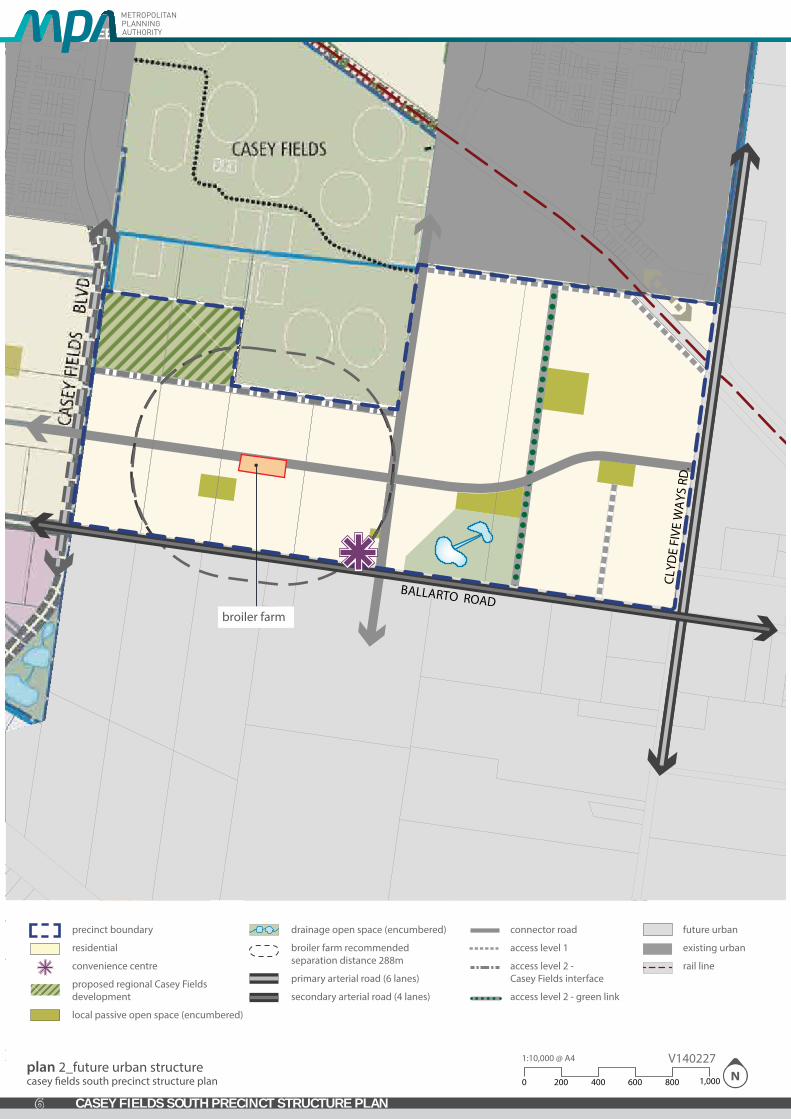
precinct boundary
residential
convenience centre
proposed regional Casey Fields development
local passive open space (encumbered)
drainage open space (encumbered)
broiler farm recommended separation distance 288m
primary arterial road (6 lanes)
secondary arterial road (4 lanes)
connector road
access level 1
access level 2 - Casey Fields interface
access level 2 - green link
future urban
existing urban
rail line
plan 2_future urban structurecasey �elds south precinct structure plan
1:10,000 @ A4
8006004002000 1,000
V140227
broiler farm
CLYD
E FI
VE W
AYS
RD
.
BALLARTO ROAD
GREENVALE CENTRAL PRECINCT STRUCTURE PLAN
6 CASEY FIELDS SOUTH PRECINCT STRUCTURE PLAN

2.0 OUTCOMES
2.1 VisionCaseyFieldsSouthResidentialPrecinct occupies an area of approximately 110 ha in the City of Casey. The precinct extends from Clyde-Five Ways Road in the east to Casey Fields Boulevard in the west; and to the southern boundary of Casey Fields Sportsgrounds in the north.
The Casey Fields South PSP is predominantly residential, with a local convenience centre planned for Ballarto Road, and will ultimately support a residential community of approximately 1460 dwellings and a population of around 4,100 people.
The precinct will provide an urbanised link between existing development to the west of Casey Fields Boulevard, and proposed new residential areas to the east of Clyde-Five Ways Road.
Casey Fields South PSP will be a community well connected to regional playing fields, building units close proximity to the existing Clyde Township and the Ballarto Road major town centre, and the potential future Clyde Railway Station. The topography of the PSP area provides for attractive views and vistas.
2.2 ObjectivesThe following objectives describe the desired outcomes of the precinct’s development, and guide the implementation of the vision.
IMAGE.CHARACTER,HERITAGEANDHOUSING
O1 Achieve a diversity of streetscape and open space outcomes to enhance local character and amenity, establishing a landscape of connecting canopies along streets, parks and waterways.
O2 Deliver a minimum of 1460 new homes (16 dwellings net developable hectare overall precinct average).
O3 Identify areas of European and Aboriginal Cultural Heritage elements within the precinct.
O4 Ensure medium and high density development is prioritised in locations proximate to high amenity and/or high activity areas.
O5 Promote housing choice through the delivery of a range of lot sizes capable of accommodating a variety of dwelling types.
TOWNCENTRES&EMPLOYMENT
O6 Encourage the provision of local convenience retail without compromising the functions and roles of nearby town centres.
OPENSPACE&COMMUNITYFACILITIES
O7 Deliver an integrated and linked network of local passive parks, active recreation reserves, and community infrastructure that meets the needs and aspirations of the new community.
BIODIVERSITY,THREATENEDSPECIES&BUSHFIREMANAGEMENT
O8 Plan for the long-term conservation and enhancement of areas of biodiversity.
O9 Ensure that bushfire protection measures are considered in the layout and design of development and the local street network.
TRANSPORT&MOVEMENT
O10 Provide strong external connections to the surrounding road network to foster accessibility of the precinct.
O11 Develop a slow-speed and permeable connector road network.
INTEGRATEDWATERMANAGEMENT&UTILITIES
O12 Deliver an integrated water management system that reduces reliance on reticulated potable water, increases the re-use of alternative water, minimises flood risk, ensures waterway health, and contributes towards a sustainable and green urban environment.
PRECINCTINFRASTRUCTUREPLAN&STAGING
O13 Ensure pre-development property structure does not impede the realisation of cohesive and integrated neighbourhoods.
O14 Ensure that development staging is co-ordinated with the delivery of key local and state infrastructure.
GREENVALE CENTRAL PRECINCT STRUCTURE PLAN
7CASEY FIELDS SOUTH PRECINCT STRUCTURE PLAN

plan 3_land budgetcasey �elds south precinct structure plan
1:10,000 @ A4
8006004002000 1,000
V140227
1
precinct boundary
residential
convenience centre
proposed regional Casey Fields development
local passive open space (encumbered)
drainage open space (encumbered)
broiler farm recommended separation distance 288m
primary arterial road (6 lanes)
secondary arterial road (4 lanes)
connector road
access level 1
access level 2 - Casey Fields interface
access level 2 - green link
future urban
existing urban
rail line
property boundary & number
1 2
3 4
65
7
broiler farm
CLYD
E FI
VE W
AYS
RD
.
BALLARTO ROAD
GREENVALE CENTRAL PRECINCT STRUCTURE PLAN
8 CASEY FIELDS SOUTH PRECINCT STRUCTURE PLAN

2.3 Summary land budgetThe Net Developable Area (NDA) is calculated by deducting the land requirements for major roads, servicing, community facilities and open space from the overall Precinct area. The estimated NDA for the precinct is 91 hectares representing approximately 82% of the PSP area.
State Planning Policy currently aims to achieve a minimum of 15 dwellings per hectare of NDA. This PSP is expected to exceed the minimum dwelling density and yield delivering approximately 1,460 dwellings with an average density of 16 dwellings per hectare of NDA.
An average household size of 2.8 persons for conventional density housing (based on Victoria in Future 2012) is used to estimate the future population of the PSP area. On this basis the future population of the PSP is estimated to be approximately 4,100 residents.
The table below sets out the land area and summary lot yield for various uses in the future urban structure.
Table 1 Summary land use budget
HECTARES % OF TOTAL % OF NDA
TOTAL PRECINCT AREA (ha) 110.17 100.0%
TransportRail Corridors / Easements 5.66 0.49% 6.39%
Sub‐total Transport 5.66 5.1% 6.39%
Open Space
Encumbered Open Space Available for Recreation
Waterway Corridor/Wetland / Retarding 4.60 4.17% 5.19%
Sub‐total Encumbered Open Space Available for Recreation 4.60 4.17% 5.19%
Unencumbered Local Open Space
Local Sportsfields (active open space) 0.00 0.0% 0.00%
Local Parks (passive open space) 3.54 0.3% 4.00%
Sub‐total Unencumbered Local Open Space 3.54 3.2% 4.00%
Other Unencumbered Open Space
Existing local Parks (passive open space) 0.00 0.0% 0.00%
Regional Sportsfields (active open space) 7.76 7.0% 8.76%
Sub‐total 7.76 7.05% 8.76%
Sub‐total other Unencumbered Open Space 11.31 10.3% 12.76%
Subtotal Open Space Available for Recreation 15.90 14.4% 17.95%
Other
Existing Clyde Township RZ1 Area 0.00 0.00% 0.00%
Sub Station 0.00 0.00% 0.00%
Sub‐total 0.00 0.00% 0.00%
TOTAL NET DEVELOPABLE AREA ‐ (NDA) Ha 88.61 80.43%
NET DEVELOPABLE AREA ‐ RESIDENTIAL (NDAR) Ha 88.61 80.43%
DescriptionPSP 1057.1 Casey Fields South ‐ Residential
NET DEVELOPABLE AREA ‐ RESIDENTIAL (NDAR) Ha 88.61 80.43%
Description
Residential Local Open Space (expressed as % of NDAR) Hectares
Local Sportsfields (active open space) 0.00
Local Parks (passive open space) 3.54
Regional Sportsfields (active open space) area not provided through clause 52.01 Open Space Delivery
7.76
Sub‐total 11.31
Employment Local Open Space (expressed as % of NDAE) Hectares
Total Open Space 11.31
Description
Residential NDA (Ha) Dwell / NDHa Dwellings
Standard Density 88.61 16 1,418
Convenience Town Centre 2 0 0
Totals Residential Yield Against NDA 88.61 16.00 1,418
Anticipated population @ 2.8 persons per dwelling 3,970
PSP 1057.1 Casey Fields South ‐ Residential
% of NDAR
0.00%
12.76%
% of NDAE
4.00%
8.76%
PSP 1057.1 Casey Fields South ‐ Residential
12.76%
GREENVALE CENTRAL PRECINCT STRUCTURE PLAN
9CASEY FIELDS SOUTH PRECINCT STRUCTURE PLAN

This page has been left intentionally blank
GREENVALE CENTRAL PRECINCT STRUCTURE PLAN
10 CASEY FIELDS SOUTH PRECINCT STRUCTURE PLAN

HECTARES % OF TOTAL % OF NDA
TOTAL PRECINCT AREA (ha) 110.17 100.0%
TransportRail Corridors / Easements 5.66 0.49% 6.39%
Sub‐total Transport 5.66 5.1% 6.39%
Open Space
Encumbered Open Space Available for Recreation
Waterway Corridor/Wetland / Retarding 4.60 4.17% 5.19%
Sub‐total Encumbered Open Space Available for Recreation 4.60 4.17% 5.19%
Unencumbered Local Open Space
Local Sportsfields (active open space) 0.00 0.0% 0.00%
Local Parks (passive open space) 3.54 0.3% 4.00%
Sub‐total Unencumbered Local Open Space 3.54 3.2% 4.00%
Other Unencumbered Open Space
Existing local Parks (passive open space) 0.00 0.0% 0.00%
Regional Sportsfields (active open space) 7.76 7.0% 8.76%
Sub‐total 7.76 7.05% 8.76%
Sub‐total other Unencumbered Open Space 11.31 10.3% 12.76%
Subtotal Open Space Available for Recreation 15.90 14.4% 17.95%
Other
Existing Clyde Township RZ1 Area 0.00 0.00% 0.00%
Sub Station 0.00 0.00% 0.00%
Sub‐total 0.00 0.00% 0.00%
TOTAL NET DEVELOPABLE AREA ‐ (NDA) Ha 88.61 80.43%
NET DEVELOPABLE AREA ‐ RESIDENTIAL (NDAR) Ha 88.61 80.43%
DescriptionPSP 1057.1 Casey Fields South ‐ Residential
NET DEVELOPABLE AREA ‐ RESIDENTIAL (NDAR) Ha 88.61 80.43%
Description
Residential Local Open Space (expressed as % of NDAR) Hectares
Local Sportsfields (active open space) 0.00
Local Parks (passive open space) 3.54
Regional Sportsfields (active open space) area not provided through clause 52.01 Open Space Delivery
7.76
Sub‐total 11.31
Employment Local Open Space (expressed as % of NDAE) Hectares
Total Open Space 11.31
Description
Residential NDA (Ha) Dwell / NDHa Dwellings
Standard Density 88.61 16 1,418
Convenience Town Centre 2 0 0
Totals Residential Yield Against NDA 88.61 16.00 1,418
Anticipated population @ 2.8 persons per dwelling 3,970
PSP 1057.1 Casey Fields South ‐ Residential
% of NDAR
0.00%
12.76%
% of NDAE
4.00%
8.76%
PSP 1057.1 Casey Fields South ‐ Residential
12.76%
GREENVALE CENTRAL PRECINCT STRUCTURE PLAN
11CASEY FIELDS SOUTH PRECINCT STRUCTURE PLAN

plan 4_image, character, heritage & housingcasey �elds south precinct structure plan
1:10,000 @ A4
8006004002000 1,000
V140227
primary arterial road
secondary arterial road
connector road
access level 1
access level 2 - Casey Fields interface
precinct boundary
residential
convenience centre
proposed regional Casey Fields development
local passive open space (encumbered)
drainage open space (encumbered)
broiler farm recommended separation distance 288m
key high points
view lines
access level 2 - green link
future urban
existing urban
rail line
core walking catchment (400m)
local convenience centre
broiler farm
CLYD
E FI
VE W
AYS
RD
.
BALLARTO ROAD
GREENVALE CENTRAL PRECINCT STRUCTURE PLAN
12 CASEY FIELDS SOUTH PRECINCT STRUCTURE PLAN

3.0 IMPLEMENTATION
3.1 Image, character, heritage and housing
3.1.1 Image, character and heritage
IMAGE AND CHARACTER
REQUIREMENTS
R1
Street trees must be provided on both sides of all roads and streets (excluding laneways) at regular intervals appropriate to tree size at maturity and not exceeding the guidance below unless otherwise agreed by the responsible authority:
AVERAGEINTERVAL TREESIZE8 – 10 metres Small trees (less than 10 metre canopy)10 – 12 metres Medium trees (10 – 15 metre canopy)12 – 15 metres Large trees (Canopy larger than 15 metres)
R2 Trees in parks and streets must be:• Suitable for local conditions; and• Planted in modified and improved soil as required to support tree longevity.
R3 Street tree planting must use locally appropriate species and be consistent with any guidance provided on the relevant cross section within this Precinct Structure Plan unless otherwise approved by the responsible authority.
R4 Key Green streets must be provided generally where shown on Plans 2, 4 and 8.
GUIDELINES
G1 Street networks within subdivisions should be designed to maximise the number of connections and direct views to waterways, open space, and town centres.
G2 Significant elements of the landscape and built form should be used as focal points for view lines along streets. Elements may include items such as public buildings and landmarks.
G3 Retained windrows and significant trees should be located within the public domain, including parks and road reserves, unless otherwise approved by the responsible authority.
G4 Street trees should be used consistently across neighbourhoods to reinforce movement hierarchy and local character.
G5 A consistent suite of lighting and furniture should be used across neighbourhoods, appropriate to the type and role of street or public space, unless otherwise approved by the responsible authority.
G6 Trees in streets and parks should be larger species wherever space allows (to facilitate continuous canopy cover).
3.1.2 Housing
HOUSINGREQUIREMENTS
R5 Residential subdivisions must deliver a broad range of lot sizes capable of accommodating a variety of housing types.
R6 Development must appropriately respond to the potential future Clyde railway station site (located in the adjoining PSP area) and the future Principal Public Transport Network through the creation of opportunities for high-density residential development.
R7
Lots must front or side:• Waterways and public open space.• Local access streets.• Connector roads.• Arterial roads.
GREENVALE CENTRAL PRECINCT STRUCTURE PLAN
13CASEY FIELDS SOUTH PRECINCT STRUCTURE PLAN

R8
Subdivision applications must include indicative concept layouts for any lots identified for the future development of medium density, high density , or integrated housing that suitably demonstrate:Active interfaces with adjacent streets, open spaces and waterways.
• Active interfaces with adjacent streets, open spaces and waterways.
• Safe and effective vehicle and pedestrian access and internal circulation, as appropriate.
GUIDELINES
G7 Development should demonstrate how the proposed subdivision will deliver a variety of housing types and lot sizes.
G8 Residential subdivision stages should provide across neighbourhoods a broad range of lot sizes capable of accommodating a variety of housing types as described in Table 2.
G9 Subdivision of land within a walkable distance of town centres (including the Clyde Major Town Centre and the potential future Clyde rail station in the adjoining Clyde Creek PSP), and designated public transport routes, should create a range of lot sizes suitable for the delivery of medium and higher density housing types listed in Table 2.
G10
Specialised housing forms such as retirement living or aged care should be:
• Integrated into the wider urban structure.
• Located in close proximity to town centres and community hubs.
• Accessible by public transport.
CONDITIONS
C1
EnsuringtheSmallLotHousingCodeisanapprovedbuildingenvelopeunderPart4oftheBuilding Regulations 2006The Small Lot Housing Code incorporated into the Casey Planning Scheme is endorsed under this planning permit.
The Small Lot Housing Code must be shown as a restriction (on a plan of subdivision certified under the Subdivision Act 1988) that is recorded on the register under the Transfer of Land Act 1958 in relation to an allotment that is less than 300 square metres in area.
Table 2 Lot size and housing type guide
The following table provides an indication of the typical range of lot sizes that support the delivery of a broad range of housing types.
HOUSING TYPES THAT MAY BE SUPPORTEDLOT SIZE CATEGORY (m2)
LESS THAN 300m2 301-600m2 MORE THAN
600m2
Small Lot Housing including townhouses and attached, semi-detached and detached houses
Dual occupancies, duplexes
Detached houses
Multi-unit housing sites including terraces, row houses and villas
Stacked housing including apartments, shop top living and walk up flats
GREENVALE CENTRAL PRECINCT STRUCTURE PLAN
14 CASEY FIELDS SOUTH PRECINCT STRUCTURE PLAN

3.2 Town centres and employment
3.2.1 Town Centres
Table 3 Town centre hierarchy - Casey Fields/Clyde Creek area
TOWN CENTRE RETAIL FLOOR SPACE
COMMERCIAL FLOOR SPACE
LOCATION AND USES
Clyde Road Major Town Centre (in PSP 1054)
40-50,000 m2 40-50,000 m2 Located to service both PSP 1054 and the Casey Fields South Residential PSP population. Should include a full range of community uses, business, and residential.
Tuckers Road Local Town Centre (in PSP 1054)
5,000 m2 1,000 m2 Centrally located to service residents in PSP 1054, as well as residents of Casey Fields South Residential PSP.
Ballarto Road Local convenience centre (in PSP 1057.1)
1,500 m2 - Meets the local needs of residents of Casey Fields South Residential PSP.
Table 4 Anticipated employment creation
LAND USE MEASURE JOBS QTY IN PSP EST JOBS
Local convenience centre 1 job/30 m2 50 1 50
Home based business Jobs/dwelling 0.05 1,460 70
Community Centre Jobs/centre 10 1 10
TOTALESTIMATED 130
3.2.2 Local Convenience Centres
REQUIREMENTS
R9 A Local Convenience Centre may be developed proximate to the location shown on Plan 2 and must be consistent with the guidance provided in Table 3. Any Local Convenience Centre development must be located on a connector road.
R10 Provision of retail floor space within a local convenience centre must not exceed 1,500m2 (without a planning permit).
R11 Subdivision and development within Local Convenience Centres must have regard to the design principles and performance criteria for Local Convenience Centres outlined in Appendix 4.3, as appropriate.
GUIDELINES
G11 Development of any Local Convenience Centre should be proximate to an open space area or community hub.
G12
The design of any Local Convenience Centre must:
• Provide for a mix of tenancies.
• Incorporate a range of uses including retail, offices and medium and high density housing.
• Locate any servicing infrastructure or car parking to the rear or centre of the allotment in a manner that protects the amenity of the surrounding neighbourhood.
G13 Residential densities within the core walkable catchment of the Local Convenience Centre (as shown on Plan 4) should demonstrate that the development responds to the zone objectives of the applied Residential Growth Zone.
GREENVALE CENTRAL PRECINCT STRUCTURE PLAN
15CASEY FIELDS SOUTH PRECINCT STRUCTURE PLAN

plan 5_open space & community facilitiescasey �elds south precinct structure plan
1:10,000 @ A4
8006004002000 1,000
V140227
POS #
precinct boundary
residential
passive open space catchment 400m
proposed regional Casey Fields development
local passive open space (encumbered)
park ID
primary arterial road (6 lanes)
secondary arterial road (4 lanes)
connector road
access level 1
access level 2 - Casey Fields interface
access level 2 - green link
future urban
existing urban
rail line
broiler farm
CLYD
E FI
VE W
AYS
RD
.
BALLARTO ROAD
P OS 1
P OS 2
P OS 3
P OS 4
P OS 5
GREENVALE CENTRAL PRECINCT STRUCTURE PLAN
16 CASEY FIELDS SOUTH PRECINCT STRUCTURE PLAN

3.3 Open Space, Community Facilities and Education
3.3.1 Open Space
Table 5 Open Space Delivery Guide
PARK ID AREA (HA) TYPE ATTRIBUTES Location RESPONSIBILITYPO1 0.59 Passive Open Space Neighbourhood As shown on plan 5 CCCPO2 0.06 Civic square Town Square/Urban Park As shown on plan 5 CCCPO3 1.03 Passive Open Space District As shown on plan 5 CCCPO4 1.26 Passive Open Space District As shown on plan 5 CCCPO5 0.59 Passive Open Space District As shown on plan 5 CCC
CC = City of Casey
REQUIREMENTS
R12 All public landscaped areas must be designed and constructed to enable practical maintenance and planted with species suitable to the local climate and soil conditions.
R13
All parks must be located, designed and developed in accordance with the relevant description in Table 5 unless otherwise approved by the responsible authority. The area of the park may vary so long as it remains inside the guidance for the relevant type of park. Where a park is smaller than that outlined in the table, the land must be added to another park or used to create a new park in addition to those outlined on Plan 5. Where a proposed park is larger than outlined in the table it may be accepted so long as it does not result in the removal of another park allocation.
R14 Where a passive open space shown on Plan 5 spans across multiple properties, the first development proponent to lodge a permit application must prepare an indicative concept master plan for the entire park unless otherwise agreed by the responsible authority.
R15 Design and layout of waterway corridors and any other encumbered open space must maximise the potential for integration of recreation uses where this does not conflict with the primary function of the land.
R16 Parks and squares within town centres must be delivered via the Clause 52.01 passive open space contributions, as appropriate.
R17 Any fencing of open space, whether encumbered or unencumbered, must be low scale and visually permeable to facilitate public safety and surveillance.
GUIDELINES
G14 Lots directly fronting open space must provide for a primary point of access from a footpath or shared path proximate to the lot boundary.
G15 Subject to being compatible with Table 5 and Appendix 4.6 parks and open space should contain extensive tree planting.
G16 A proponent delivering a master plan for a local passive park that traverses multiple property ownerships should consult with the landowners of parcels covered by the park to ensure an integrated design.
CONDITIONS
C2
ConditionsforsubdivisionorbuildingandworkspermitswherelandisrequiredforpublicopenspaceLand required for public open space as a local or district park, as set out in the Casey Fields South Residential Precinct Structure Plan or the Clyde Development Contributions Plan, must be transferred to or vested in Council at no cost to Council unless the land is funded by the Clyde Development Contributions Plan or contributes to satisfaction of required provision under Clause 52.01.
GREENVALE CENTRAL PRECINCT STRUCTURE PLAN
17CASEY FIELDS SOUTH PRECINCT STRUCTURE PLAN

This page has been left intentionally blank
GREENVALE CENTRAL PRECINCT STRUCTURE PLAN
18 CASEY FIELDS SOUTH PRECINCT STRUCTURE PLAN
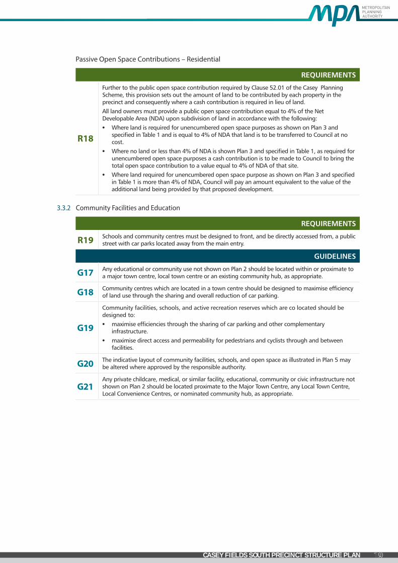
Passive Open Space Contributions – Residential
REQUIREMENTS
R18
Further to the public open space contribution required by Clause 52.01 of the Casey Planning Scheme, this provision sets out the amount of land to be contributed by each property in the precinct and consequently where a cash contribution is required in lieu of land.
All land owners must provide a public open space contribution equal to 4% of the Net Developable Area (NDA) upon subdivision of land in accordance with the following:
• Where land is required for unencumbered open space purposes as shown on Plan 3 and specified in Table 1 and is equal to 4% of NDA that land is to be transferred to Council at no cost.
• Where no land or less than 4% of NDA is shown Plan 3 and specified in Table 1, as required for unencumbered open space purposes a cash contribution is to be made to Council to bring the total open space contribution to a value equal to 4% of NDA of that site.
• Where land required for unencumbered open space purpose as shown on Plan 3 and specified in Table 1 is more than 4% of NDA, Council will pay an amount equivalent to the value of the additional land being provided by that proposed development.
3.3.2 Community Facilities and Education
REQUIREMENTS
R19 Schools and community centres must be designed to front, and be directly accessed from, a public street with car parks located away from the main entry.
GUIDELINES
G17 Any educational or community use not shown on Plan 2 should be located within or proximate to a major town centre, local town centre or an existing community hub, as appropriate.
G18 Community centres which are located in a town centre should be designed to maximise efficiency of land use through the sharing and overall reduction of car parking.
G19
Community facilities, schools, and active recreation reserves which are co located should be designed to:
• maximise efficiencies through the sharing of car parking and other complementary infrastructure.
• maximise direct access and permeability for pedestrians and cyclists through and between facilities.
G20 The indicative layout of community facilities, schools, and open space as illustrated in Plan 5 may be altered where approved by the responsible authority.
G21 Any private childcare, medical, or similar facility, educational, community or civic infrastructure not shown on Plan 2 should be located proximate to the Major Town Centre, any Local Town Centre, Local Convenience Centres, or nominated community hub, as appropriate.
GREENVALE CENTRAL PRECINCT STRUCTURE PLAN
19CASEY FIELDS SOUTH PRECINCT STRUCTURE PLAN
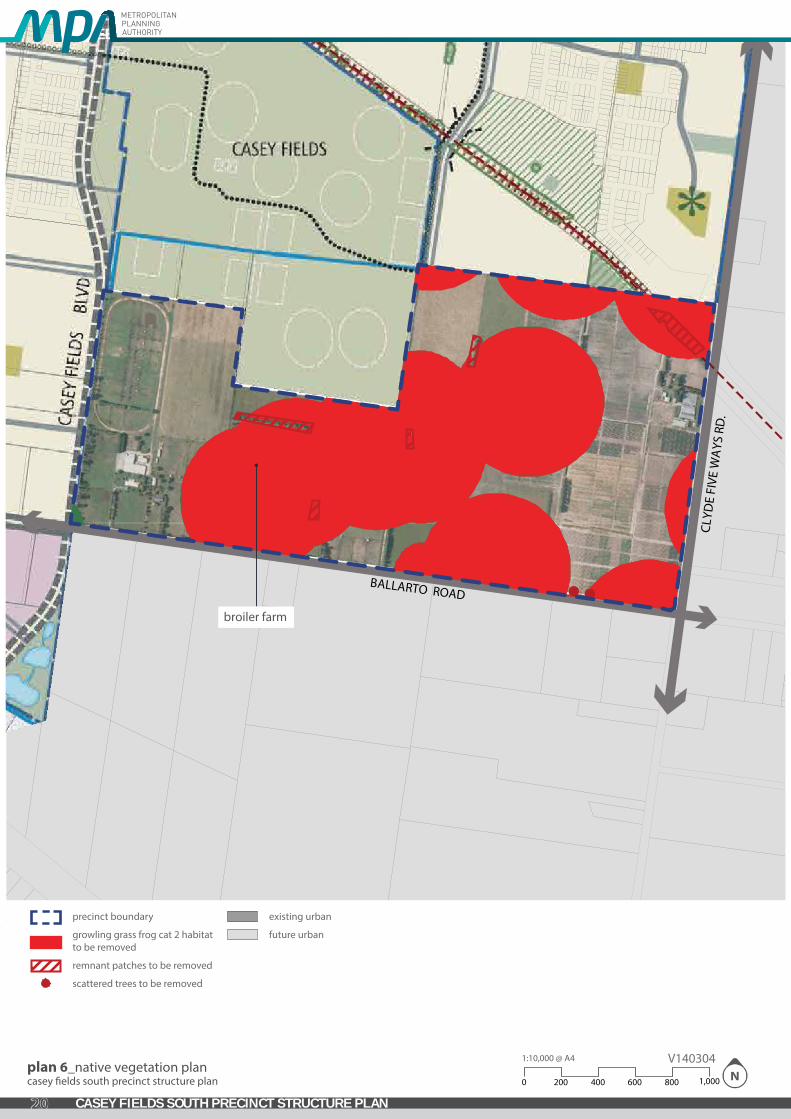
plan 6_native vegetation plancasey �elds south precinct structure plan
1:10,000 @ A4
8006004002000 1,000
V140304
precinct boundary
growling grass frog cat 2 habitatto be removed
remnant patches to be removed
scattered trees to be removed
existing urban
future urban
broiler farm
CLYD
E FI
VE W
AYS
RD
.
BALLARTO ROAD
GREENVALE CENTRAL PRECINCT STRUCTURE PLAN
20 CASEY FIELDS SOUTH PRECINCT STRUCTURE PLAN

3.4 Biodiversity, Threatened Species and Bushfire Management
3.4.1 Biodiversity and Threatened Species
GUIDELINES
G22 Where located adjacent or nearby each other, maximise the integration of linear and conservation open space with parks.
G23 The layout and design of the waterways, wetlands and retarding basins (including the design of paths, bridges and boardwalks and the stormwater drainage system) should integrate with biodiversity and natural systems to the satisfaction of responsible authorities.
G24 Landscaping adjacent to retained indigenous vegetation and waterways should be complementary to conservation objectives and should use indigenous planting where appropriate.
G25 Street trees and public open space landscaping should contribute to habitat for indigenous fauna species, in particular arboreal animals and birds, where practical.
CONDITIONS
C3
KangarooManagementPlanPrior to the commencement of any works in a stage of subdivision a Kangaroo Management Plan must be submitted for approval to the Department of Environment & Primary Industries. The plan must include:a. Strategies (e.g. staging) to avoid land locking Kangaroos; andb. Management solutions and action to respond to their containment in an area with no
reasonable likelihood of their continued safe existence.
C4
Habitatcompensation
• Before subdivision, the construction of a building or the construction or carrying out of works on land starts, offsets for the loss or deemed loss of native vegetation and threatened species habitat must be secured in accordance with the Biodiversity Conservation Strategy for Melbourne’s Growth Corridors (Department of Environment and Primary Industries, 2013) and Habitat compensation under the Biodiversity Conservation Strategy (Department of Environment and Primary Industries, 2013), to the satisfaction of the Secretary to the Department of Environment and Primary Industries.
C5
SalvageandtranslocationThe Salvage and Translocation Protocol for Melbourne’s Growth Corridors (Melbourne Strategic Assessment) (Department of Environment and Primary Industries, 2013) must be implemented in the carrying out of development to the satisfaction of the Secretary to the Department of Environment and Primary Industries.
3.4.2 Bushfire Management
REQUIREMENTS
R20
For the purpose of Clause 56.06-7, the requirements of the relevant fire authority are, unless otherwise approved by the CFA:
• Constructed roads must be a minimum of 7.3m trafficable width where cars park on both sides, or: » A minimum of 5.4m in trafficable width where cars may park on one side only. » A minimum of 3.5m width no parking and 0.5m clearance to structures on either side, and
if this width applies, there must be passing bays of at least 20m long, 6m wide and located not more than 200m apart.
• Roads must be constructed so that they are capable of accommodating a vehicle of 15 tonnes for the trafficable road width.
• The average grade of a road must be no more than 1 in 7 (14.4% or 8.1º).
• The steepest grade on a road must be no more than 1 in 5 (20% or 11.3º) with this grade continuing for no more than 50 metres at any one point.
• Dips on the road must have no more than 1 in 8 grade (12.5% or 7.1º) entry and exit angle.
• Constructed dead end roads more than 60 metres in length from the nearest intersection must have a turning circle with a minimum radius of 8m (including roll over curbs if they are provided).
GREENVALE CENTRAL PRECINCT STRUCTURE PLAN
21CASEY FIELDS SOUTH PRECINCT STRUCTURE PLAN

This page has been left intentionally blank
GREENVALE CENTRAL PRECINCT STRUCTURE PLAN
22 CASEY FIELDS SOUTH PRECINCT STRUCTURE PLAN

R21
Before the commencement of works for a stage of subdivision, a Construction Management Plan that addresses Bushfire Risk Management must be submitted to and approved by the responsible authority and the CFA. The Construction Management Plan must specify, amongst other things:
• Measures to reduce the risk from fire within the surrounding rural landscape and protect residents from the threat of fire.
• A separation buffer, consistent with the separation distances specified in AS3959-2009, between the edge of the development and non-urban areas.
• How adequate opportunities for access and egress will be provided for early residents, construction workers and emergency vehicles.
GREENVALE CENTRAL PRECINCT STRUCTURE PLAN
23CASEY FIELDS SOUTH PRECINCT STRUCTURE PLAN

1:10,000 @ A4
8006004002000 1,000
V140227plan 7 _street networkcasey �elds south precinct structure plan
access level 2
access level 2 - casey �elds interface
connector street
access level 2 - green link
access level 1
future urban
existing urban
signalised intersection
pedestrian signals
left in / left out intersection
service street
precinct boundary
roundabout
two way intersection
broiler farm recommendedseparation distance 288m
primary arterial road (6 lanes)
secondary arterial road (4 lanes)
CLYD
E FI
VE W
AYS
RD
.
BALLARTO ROADbroiler farm
GREENVALE CENTRAL PRECINCT STRUCTURE PLAN
24 CASEY FIELDS SOUTH PRECINCT STRUCTURE PLAN

3.5 Transport and Movement
3.5.1 Public Transport
REQUIREMENTS
R22 A road nominated on Plan 8 as a potential bus route is to be constructed (including partial construction where relevant) in accordance with the corresponding cross section in the PSP and in accordance with the Public Transport Guidelines for Land Use and Development.
R23 Any roundabouts on roads shown as ‘bus capable’ on Plan 8 must be constructed to accommodate ultra-low-floor buses in accordance with the Public Transport Guidelines for Land Use and Development.
R24 Bus stop facilities must be designed as an integral part of town centres and activity generating land uses such as schools, sports fields and employment areas.
CONDITIONS
C6
Unless otherwise agreed by Public Transport Victoria, prior to the issue of a Statement of Compliance for any subdivision stage, bus stops must be constructed, at full cost to the permit holder, as follows:
• Generally in the location identified by Public Transport Victoria;
• In accordance with the Public Transport Guidelines for Land Use and Development with a concrete hard stand area, and in activity centres a shelter must also be constructed;
• Be compliant with the Disability Discrimination Act – Disability Standards for Accessible Public Transport 2002; and
• Be provided with direct and safe pedestrian access to a pedestrian path.
All to the satisfaction of Public Transport Victoria and the responsible authority.
3.5.2 Walking and Cycling
REQUIREMENTS
R25
Design of all streets and arterial roads must give priority to the requirements of pedestrians and cyclists by providing:
• Footpaths of at least 1.5 metres on both sides of all streets and roads unless otherwise specified by the PSP.
• Shared paths or bicycle paths where shown on Plan 8 or as shown on the relevant cross-sections in Appendix 4.4 or as specified by another requirement in the PSP.
• Safe, accessible and convenient crossing points of connector roads and local streets at all intersections, key desire lines and locations of high amenity (e.g. town centre and open space).
• Safe pedestrian crossings of arterial roads at all intersections, at key desire lines, and on regular intervals appropriate to the function of the road and public transport provision.
• Pedestrian priority crossings on all slip lanes.
• Safe and convenient transition between on and off-road bicycle networks.
All to the satisfaction of the coordinating roads authority and the responsible authority.
R26 On a construction or engineering plan approved under a subdivision permit, specification of any bicycle path on a connector road must also be to the satisfaction of Public Transport Victoria.
R27
Shared and pedestrian paths along waterways must:
• Be delivered by development proponents consistent with the network shown on Plan 8
• Be above 1:10 year flood level with any crossing of the waterway designed to be above the 1:100 flood level to maintain hydraulic function of the waterway.
• Be constructed to a standard that satisfies the requirements of Melbourne Water. Where a shared path is to be delivered on one side of a waterway as outlined in Plan 8, a path is also to be delivered on the other side of the waterway but may be constructed to a lesser standard such as granitic gravel or similar granular material.
All to the satisfaction of the Melbourne Water and the responsible authority.
GREENVALE CENTRAL PRECINCT STRUCTURE PLAN
25CASEY FIELDS SOUTH PRECINCT STRUCTURE PLAN

This page has been left intentionally blank
GREENVALE CENTRAL PRECINCT STRUCTURE PLAN
26 CASEY FIELDS SOUTH PRECINCT STRUCTURE PLAN

R28 Shared and pedestrian paths as shown on Plan 8 must be delivered by development proponents.
R29 Bicycle parking facilities are to be provided by development proponents in convenient locations at key destinations such as parks and activity centres.
R30 The alignment of the off-road bicycle path must be designed for cyclists travelling up to 30 km/hr.
R31 Bicycle priority at intersections of minor streets and connector roads with dedicated off-road bicycle paths must be achieved through strong and consistent visual and physical cues and supportive directional and associated road signs.
GUIDELINES
G26 Lighting should be installed along shared, pedestrian, and cycle paths linking key destinations, unless otherwise approved by the responsible authority.
GREENVALE CENTRAL PRECINCT STRUCTURE PLAN
27CASEY FIELDS SOUTH PRECINCT STRUCTURE PLAN

1:10,000 @ A4
8006004002000 1,000
V140227plan 8_public transport & path networkcasey �elds south precinct structure plan
precinct boundary
railway line
arterial road (bus capable)
other road (bus capable)
2 way o�-raod bike lane & pedestrian path
principal bike network (o� -road)
signalised intersection
left in / left out intersection
future urban
existing urban
broiler farm recommended separation distance 288m
CLYD
E FI
VE W
AYS
RD
.
BALLARTO ROADbroiler farm
GREENVALE CENTRAL PRECINCT STRUCTURE PLAN
28 CASEY FIELDS SOUTH PRECINCT STRUCTURE PLAN

3.5.3 Road Network
REQUIREMENTS
R32
The connector road network must:
• Provide for slow speed and permeable links.
• Connect across arterial roads and traverses through the core of each square mile.
• Facilitate efficient and direct pedestrian, cyclist, bus and vehicle movement.
• Efficiently link pedestrians and cyclists to jobs and the public transport system.
R33 Subdivision layouts must form a permeable street network that provides convenient access to local open space and allows for the effective integration with neighbouring properties.
R34
Approximately 30% of local streets (including connector streets) within a subdivision must apply an alternative cross section to the ‘standard’ cross section for these streets outlined in Appendix 4.4.
Examples of potential variations are provided in Appendix 4.4, however others are encouraged including but not limited to:
• Varied street tree placement;
• Varied footpath or carriageway placement;
• Introduction of elements to create a boulevard effect;
• Varied carriageway or parking bay pavement; and
• Differing tree outstand treatments.
For the purposes of this requirement, changes to street tree species between or within streets do not constitute a variation.
Alternative cross sections must ensure that:
• Minimum required carriageway dimensions are maintained to ensure safe and efficient operation of emergency vehicles on all streets as well as buses on connector streets.
• The performance characteristics of standard cross sections as they relate to pedestrian and cycle use are maintained.
• Relevant minimum road reserve widths for the type of street (illustrated in Appendix 4.4) are maintained, unless otherwise approved by the responsible authority.
R35
Where a single street spans across multiple properties that street may consist of multiple cross sections so long as a suitable transition has been allowed for between each. Where that street has already been constructed or approved for construction to a property boundary, the onus is on the development connecting into that street to adopt a consistent cross-section until that suitable transition can be made.
R36 Convenient and direct access to the connector road network must be provided through neighbouring properties where a property does not otherwise have access to the connector network or signalised access to the arterial road network, as appropriate.
R37 Vehicle access to lots fronting arterial roads must be provided from a service road, local internal loop road or rear lane only, to the satisfaction of the coordinating road authority.
R38 Configuration of vehicle access to lots from a public street must ensure that there is sufficient separation between crossovers to allow for a minimum of one on-street car park for every two residential lots.
R39 Vehicle access to a lot that is six metres or less in width must be via rear laneway, unless otherwise approved by the responsible authority.
GUIDELINES
G27 Street layouts should provide multiple convenient routes to major destinations such as the potential future Clyde railway station site and Ballarto Road major town centre and the arterial road network.
G28 Street block lengths should not exceed 240 metres to ensure a permeable and low speed environment for pedestrians, cyclists and vehicles is achieved.
G29 Culs-de-sac should not detract from convenient pedestrian, cycle and vehicular connections.
GREENVALE CENTRAL PRECINCT STRUCTURE PLAN
29CASEY FIELDS SOUTH PRECINCT STRUCTURE PLAN

This page has been left intentionally blank
GREENVALE CENTRAL PRECINCT STRUCTURE PLAN
30 CASEY FIELDS SOUTH PRECINCT STRUCTURE PLAN

G30 Slip lanes should be avoided in areas of high pedestrian activity and only be provided at any other intersection between connector roads and arterial roads where they are necessitated by high traffic volumes, to the satisfaction of the coordinating roads authority.
G31
The frequency of vehicular crossovers on widened verges (a verge in excess of six metres) should be minimised through the use of a combination of:
• Rear loaded lots with laneway access.
• Vehicular access from the side of a lot.
• Combined or grouped crossovers.
• Increased lot widths.
CONDITIONS
C7
ConditionsforsubdivisionorbuildingandworkspermitswherelandisrequiredforroadwideningLand required for road widening including right of way flaring for the ultimate design of any
intersection within an existing or proposed local road must be transferred to or vested in Council at no cost to the acquiring agency unless funded by the Clyde Development Contributions Plan.
GREENVALE CENTRAL PRECINCT STRUCTURE PLAN
31CASEY FIELDS SOUTH PRECINCT STRUCTURE PLAN

1:10,000 @ A4
8006004002000 1,000
V140227plan 9_integrated water managementcasey �elds south precinct structure plan
precinct boundary
local passive open space (unencumbered )
drainage open space (encumbered )
access level 2 - green link
future urban
existing urban
Stormwater quality treatment of retardation assets shown on the plan are subject to con�rmation through preparation of MWC Development Service Schemes and through detailed design, to the satisfaction of Melbourne Water.
broiler farm recommended separation distance 288m
retarding basin located on muddy gates lane and manks road - not to scale.
North RB area Whilst all due skill and attention has been used Melbourne Water Corporatshall not be liable in anyway for loss of any kind including damages, costsinterest, loss of profits or special loss or damage, arising from any errorinaccuracy, incompleteness or other defect in this information. By receivand accepting this information the recipient acknowledges that MelbournWater Corporation makes no representations as to the accuracy or comof this information and ought carry out its own investigation if appropriate.
Borehole
Natural waterway
Water supply main
Sewer main
• Drain alignment
Drainage and waterways boundary
Storage reservoir
MWC owned land
1
2
3
6
7
4
8
3
1.5
3.54.5
6.5
7.5
8.5
11.5
0.5
2.5
3.5
6.5
7.5
8.5
8.5CL
YDE
FIVE
WA
YS R
D.
BALLARTO ROADbroiler farm
GREENVALE CENTRAL PRECINCT STRUCTURE PLAN
32 CASEY FIELDS SOUTH PRECINCT STRUCTURE PLAN

3.6 Integrated Water Management & Utilities
3.6.1 Integrated Water Management
REQUIREMENTS
R40 Consistent with Clause 56.01-2 and Clause 56.07 of the Casey Planning Scheme, VPP Practice Note 39, and any requirements or guidelines in this PSP, a subdivision of 60 or more lots must include an Integrated Water Management Plan.
R41 Development must meet or exceed best practice stormwater quality treatment standards prior to discharge to receiving waterways and as outlined on Plan 9, unless otherwise approved by Melbourne Water and the responsible authority.
R42 Final design and boundary of constructed waterways, waterway corridors, retarding basins, stormwater quality treatment infrastructure, and associated paths, boardwalks, bridges, and planting, must be to the satisfaction of Melbourne Water and the responsible authority.
R43
Development staging must provide for the delivery of ultimate waterway and drainage infrastructure, including stormwater quality treatment. Where this is not possible, development proposals must demonstrate how any interim solution adequately manages and treats stormwater generated from the development and how this will enable delivery of an ultimate drainage solution, all to the satisfaction of Melbourne Water and the responsible authority.
R44 Stormwater conveyance and treatment must be designed in accordance with the relevant Development Services Scheme to the satisfaction of Melbourne Water.
GUIDELINES
G32 The design and layout of roads, road reserves, and public open space should optimise water use efficiency and long-term viability of vegetation and public uses through the use of Water Sensitive Urban Design initiatives.
G33 Where practical, development should include integrated water management initiatives to diversify water supply, reduce reliance on potable water and increase the utilisation of storm and waste water contributing to a sustainable and green urban environment.
G34 Development should have regard to relevant policies and strategies being implemented by the responsible authority, Melbourne Water and South East Water, including any approved Integrated Water Management Plan.
G35 Where practical, integrated water management systems should be designed to:
• Maximise habitat values for local flora and fauna species.
• Enable future harvesting and/or treatment and re-use of stormwater, including those options or opportunities outlined in Plan 9.
G36
Where practical, and where primary waterway, conservation or recreation functions are not adversely affected, land required for integrated water management initiatives (such as stormwater harvesting, aquifer storage and recharge, sewer mining) should be incorporated within the precinct open space system as depicted on Plan 5, subject to the approval of the responsible authority.
GREENVALE CENTRAL PRECINCT STRUCTURE PLAN
33CASEY FIELDS SOUTH PRECINCT STRUCTURE PLAN

1:10,000 @ A4
8006004002000 1,000
V140227plan 10_utilitiescasey �elds south precinct structure plan
NOTES:
• The alignment and size of utilities shown on this plan are indicative and subject to confirmation by the relevant service authority
precinct area
proposed sewer
proposed sewer alignment pumping station (indicative location)
broiler farm recommended separation distance 288m
CLYD
E FI
VE W
AYS
RD
.
BALLARTO ROADbroiler farm
GREENVALE CENTRAL PRECINCT STRUCTURE PLAN
34 CASEY FIELDS SOUTH PRECINCT STRUCTURE PLAN

3.6.2 Utilities
REQUIREMENTS
R45 Trunk services are to be placed along the general alignments shown on Plan 10, subject to any refinements as advised by the relevant service authorities.
R46
Before development commences on a property, functional layout plans are to be submitted of the road network showing the location of all:
• Underground services
• Driveways/crossovers
• Street lights
• Street trees
A typical cross section of each street is also to be submitted showing above and below ground placement of services, street lights and trees.
The plans and cross sections must demonstrate how services, driveways and street lights will be placed so as to achieve the road reserve width (consistent with the road cross sections outlined in this PSP) and accommodate the minimum level of street tree planting (as outlined in this PSP). If required, the plan and cross sections will nominate which services will be placed under footpaths or road pavement. The plans and cross sections are to be approved by the responsible authority and all relevant service authorities before development commences.
R47 Delivery of underground services must be coordinated, located, and bundled (utilising common trenching) to facilitate the planting of trees and other vegetation within road verges.
R48 All existing above ground electricity cables of less than 66kv voltage must be placed underground as part of the upgrade of existing roads.
R49 All new electricity supply infrastructure (excluding substations and cables of a voltage of 66kv or greater) must be provided underground.
R50 Where existing above ground electricity cables of 66kv voltage are retained along road ways, underground conduits are to be provided as part of the upgrade of these roads to allow for future undergrounding of the electricity supply.
R51
Above ground utilities must be identified at the subdivision design stage to ensure effective integration with the surrounding neighbourhood and to minimise amenity impacts, and be designed to the satisfaction of the relevant authority. Where that infrastructure is intended to be located in public open space, the land required to accommodate that infrastructure will not be counted as contributing to open space requirements classified under Clause 52.01 or within the Clyde Development Contributions Plan.
R52 Utilities must be placed outside any conservation areas shown on Plan 6. Utilities must be placed outside of natural waterway corridors or on the outer edges these corridors to avoid disturbance to existing native vegetation, significant landform features (e.g. rock outcrops) and heritage sites, to the satisfaction of Melbourne Water and the responsible authority.
GUIDELINES
G37 Above-ground utilities should be located outside of key view lines and screened with vegetation, as appropriate.
G38 Design and placement of underground services in new or upgraded streets should utilise the service placement guidelines outlined in Appendix 4.5.
G39 Utility easements to the rear of lots should only be provided where there is no practical alternative.
Table 6 Retarding Basins
ID Description Location
Area (Ha) &/or Corridor
Widths ResponsibilityOutfall 4 WLRB TBC north of Ballorto Road 0.50 MWC
CC = City of Casey, DEPI = Department of Environment & Primary Industries, MWC= Melbourne Water Corporation
GREENVALE CENTRAL PRECINCT STRUCTURE PLAN
35CASEY FIELDS SOUTH PRECINCT STRUCTURE PLAN

3.7 Infrastructure delivery & Staging
3.7.1 Precinct Infrastructure Plan
The Precinct Infrastructure Plan (PIP) at Appendix 4.1 (refer to Clyde DCP document) sets out the infrastructure and services required to meet the need of the proposed development within the precinct. The infrastructure items and and services are to be provided through a number of mechanisms including:
• Subdivision construction works by developers.
•Agreement under S173 of the Planning and Environment Act 1987.
•Utility service provider requirements.
• The Clyde Development Contributions Plan, including separate chare areas for local items.
• Relevant development contributions from adjoining areas.
• Capital works projects by Council, State government agencies and non-government organizations.
•Works in Kind (WIK) projects undertaken by developers on behalf of Council or State government agencies.
3.7.2 Development Services Strategy
Drainage for the precinct is not covered by the Clyde Development Contributions Plan as the relevant authority for outfall drainage is Melbourne Water. Melbourne Water has prepared a Development Services Scheme (DSS) which applies to the precinct. Under the DSS developers are required to pay a levy for each developable hectare of land which is included in a planning permit application. The contribution will be used by Melbourne Water to cover the cost of constructing drainage assets provided for in the DSS and also land required for the drainage assets. Melbourne Water has advised that the DSS has been costed as follows:
• Civil works are based on engineering estimates of the costs of the various drainage works; and
•As a principle, land costs are based on the same land values as the Clyde Development Contributions Plan for consistency.
Like the Clyde Development Contributions Plan, the DSS is subject to indexation and adjustments. Civil works will be adjusted by the adjustment methodology explained in the DSS to keep pace with rising costs and land values will move in line (upwards or downwards) with movement in land values provided for in the Clyde Development Contributions Plan.
Alternative stormwater quality treatments may be provided subject to agreement with Melbourne Water and Council.
GREENVALE CENTRAL PRECINCT STRUCTURE PLAN
36 CASEY FIELDS SOUTH PRECINCT STRUCTURE PLAN

3.7.3 Development Staging
REQUIREMENTS
R53
Development staging must provide for the timely provision and delivery of:
• Arterial road reservations.
• Connector streets and connector street bridges.
• Street links between properties, constructed to the property boundary.
• Connection of the on- and off-road pedestrian and bicycle network.
R54 Streets must be constructed to property boundaries where an inter-parcel connection is intended or indicated in the structure plan, by any date or stage of development required or approved by the responsible authority.
GUIDELINES
G40
Staging will be determined largely by the development proposals on land within the precinct and the availability of infrastructure services. Within this context, the following should be achieved:
• Development staging should, to the extent practicable, be integrated with adjoining developments, through the timely provision of connecting roads and walking/cycling paths.
• Where development does not directly adjoin the urban edge, local open space should be provided in early stages to provide new residents with amenity.
• Access to each new lot must be via a sealed road.
G41 The early delivery of active open space, community facilities, local parks and playgrounds is encouraged within each neighbourhood and may be delivered in stages.
3.7.4 Subdivision Works by Developers
REQUIREMENTS
R55
Subdivision of land within the precinct must provide and meet the total cost of delivering the
following infrastructure:
• Connector roads and local streets.
• Local bus stop infrastructure (where locations have been agreed in writing by Public Transport Victoria).
• Landscaping of all existing and future roads and local streets.
• Intersection works and traffic management measures along arterial roads, connector streets, and local streets (except those included in the DCP).
• Council approved fencing and landscaping (where required) along arterial roads.
• Local shared, pedestrian and bicycle paths along local arterial roads, connector roads, utilities easements, local streets, waterways and within local parks including bridges, intersections, and barrier crossing points (except those included in the DCP).
• Bicycle parking as required in this document.
• Appropriately scaled lighting along all roads, major shared and pedestrian paths, and traversing public open space.
• Basic improvements to local parks and open space (refer open space delivery below).
• Local drainage system.
• Local street or pedestrian path crossings of waterways unless included in the DCP or outlined as the responsibility of another agency in the Precinct Infrastructure Plan.
• Infrastructure as required by utility service providers including water, sewerage, drainage (except where the item is funded through a Development Services Scheme), electricity, gas, and telecommunications.
R56 Any subdivision adjacent to the rail reservation should provide fencing, at full cost to the proponent, to the satisfaction of Public Transport Victoria.
GREENVALE CENTRAL PRECINCT STRUCTURE PLAN
37CASEY FIELDS SOUTH PRECINCT STRUCTURE PLAN

R57
OPENSPACEDELIVERYAll public open space (where not otherwise provided via the DCP) must be finished to a standard that satisfies the requirements of the responsible authority prior to the transfer of the public open space, including:
• Removal of all existing and disused structures, foundations, pipelines, and stockpiles.
• Clearing of rubbish and weeds, levelled, topsoiled and grassed with warm climate grass (unless conservation reserve requirements dictate otherwise).
• Provision of water tapping, potable and recycled water connection points. Sewer and gas and electricity connection points must also be provided to land identified as an active reserve or district-level passive open space.
• Planting of trees and shrubs.
• Provision of vehicular exclusion devices (fence, bollards, or other suitable method) and
• maintenance access points.
• Installation of park furniture including barbeques, shelters, furniture, rubbish bins, local scale playground equipment, local scale play areas, and appropriate paving to support these facilities, consistent with the type of public open space listed in the open space delivery guide (Table 5).
R58
Active open space required to be set aside by the DCP must be vested in the relevant authority in the following condition:
• Free from surface / protruding rocks and structures.
• Reasonably graded and / or topsoiled to create a safe and regular surface (with a maximum 1:6 gradient).
• Bare, patchy and newly graded areas seeded, top-dressed with drought resistant grass.
R59
With respect to the public open space contribution required by Clause 52.01 of the Casey Planning Scheme, this provision sets out the amount of land to be contributed by each property in the precinct and consequently where a cash contribution is required in lieu of land.
All land owners must provide a public open space contribution equal to 4% of the Net Developable Area (Residential and Town Centres) (NDAR) upon subdivision of land in accordance with the following:
• Where land is required for unencumbered open space purposes as shown on Plan 3 and specified in Table 1 and is equal to 4% of NDAR that land is to be transferred to Council at no cost.
• Where no land or less than 4% of NDAR is shown on Plan 3 and specified in Table 1, as required for unencumbered open space purposes a cash contribution is to be made to Council to bring the total open space contribution to a value equal to 4% of NDAR of that site.
• Where land required for unencumbered open space purposes as shown on Plan 3 and specified in Table 1 is more than 4% of NDAR, Council will pay an amount equivalent to the value of the additional land being provided by that proposed development.
GREENVALE CENTRAL PRECINCT STRUCTURE PLAN
38 CASEY FIELDS SOUTH PRECINCT STRUCTURE PLAN

4.0 APPENDICES
4.1 Precinct Infrastructure PlanRefer to the Clyde DCP document.
GREENVALE CENTRAL PRECINCT STRUCTURE PLAN
39CASEY FIELDS SOUTH PRECINCT STRUCTURE PLAN

This page has been left intentionally blank
GREENVALE CENTRAL PRECINCT STRUCTURE PLAN
40 CASEY FIELDS SOUTH PRECINCT STRUCTURE PLAN
41CASEY FIELDS SOUTH PRECINCT STRUCTURE PLAN
Prop Spec Budget
Railw
ay Corrid
or /
Easemen
t
Waterway
Corridor/W
etland
/
Retarding
Sportsfie
lds (activ
e op
en sp
ace) N/A
Local parks (p
assive
open
space)
Region
al parks (a
ctive
open
Spa
ce)
Net Devpt Area % of
Precinct
Local Spo
rtsfields
(acitve op
en sp
ace) %
NDA
Local Parks (p
assive
open
space) % NDA
Total Clause 52.01 Open
Space Delivery Target %
DifferenceEquiv Land
Area
Local town centre / Local
Convenience Centre
Total Net Residential Area Ha (NRA)
NDHa Dwell / NRHa Dwellings
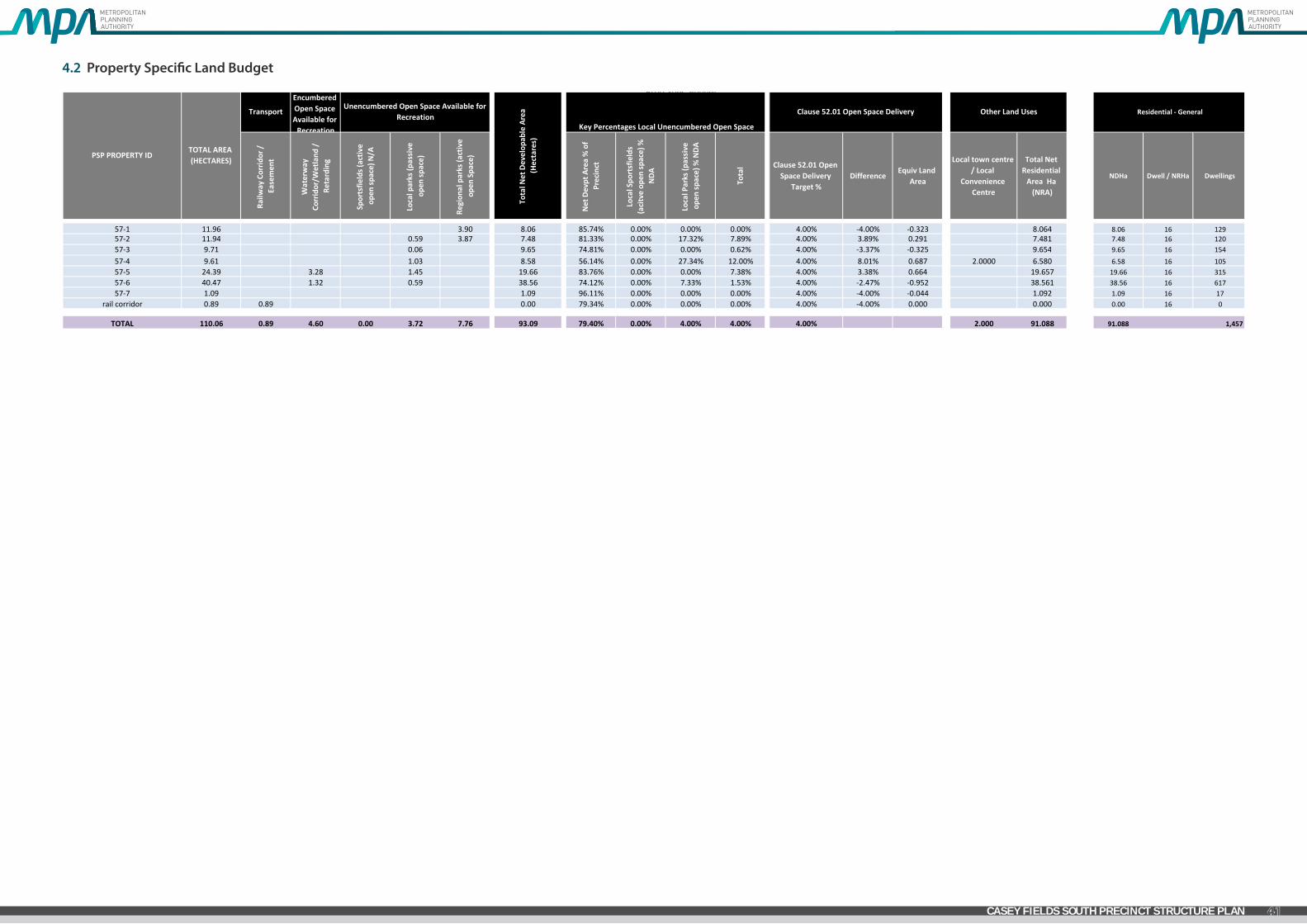
57‐1 11.96 3.90 8.06 85.74% 0.00% 0.00% 0.00% 4.00% ‐4.00% ‐0.323 8.064 8.06 16 12957‐2 11.94 0.59 3.87 7.48 81.33% 0.00% 17.32% 7.89% 4.00% 3.89% 0.291 7.481 7.48 16 12057‐3 9.71 0.06 9.65 74.81% 0.00% 0.00% 0.62% 4.00% ‐3.37% ‐0.325 9.654 9.65 16 15457‐4 9.61 1.03 8.58 56.14% 0.00% 27.34% 12.00% 4.00% 8.01% 0.687 2.0000 6.580 6.58 16 10557‐5 24.39 3.28 1.45 19.66 83.76% 0.00% 0.00% 7.38% 4.00% 3.38% 0.664 19.657 19.66 16 31557‐6 40.47 1.32 0.59 38.56 74.12% 0.00% 7.33% 1.53% 4.00% ‐2.47% ‐0.952 38.561 38.56 16 61757‐7 1.09 1.09 96.11% 0.00% 0.00% 0.00% 4.00% ‐4.00% ‐0.044 1.092 1.09 16 17
rail corridor 0.89 0.89 0.00 79.34% 0.00% 0.00% 0.00% 4.00% ‐4.00% 0.000 0.000 0.00 16 0
TOTAL 110.06 0.89 4.60 0.00 3.72 7.76 93.09 79.40% 0.00% 4.00% 4.00% 4.00% 2.000 91.088 91.088 1,457
Encumbered Open Space Available for Recreation
Other Land UsesUnencumbered Open Space Available for
RecreationClause 52.01 Open Space Delivery
PSP PROPERTY IDTOTAL AREA (HECTARES)
Residential ‐ GeneralTransport
Total N
et Develop
able Area
(Hectares)
Key Percentages Local Unencumbered Open Space
Page 1 of 1Page 1 of 1
4.2 Property Specific Land Budget

4.3
Tow
n Ce
ntre
Des
ign
Prin
cipl
es
PR
INC
IPL
ES
LOC
AL
TOW
N C
ENTR
ES
Prin
cipl
e 1
Prov
ide
ever
y ne
ighb
ourh
ood
with
a v
iabl
e Lo
cal T
own
Cent
re a
s a
focu
s of
the
com
mun
ity w
ith a
fine
gra
in,
clos
ely
spac
ed d
istr
ibut
ion
patt
ern.
• D
eliv
er a
fine
gra
in d
istrib
utio
n pa
tter
n of
hig
hly
acce
ssib
le L
ocal
Tow
n Ce
ntre
s gen
eral
ly o
n a
scal
e of
one
Loc
al To
wn
Cent
re fo
r eve
ry n
eigh
bour
hood
of 8
,000
to 1
0,00
0 pe
ople
.•
Loca
te L
ocal
Tow
n Ce
ntre
s with
a d
istrib
utio
n pa
tter
n of
aro
und
one
Loca
l Tow
n Ce
ntre
for e
very
squa
re m
ile (2
.58k
m2)
of r
esid
entia
l dev
elop
men
t.•
Del
iver
a n
etw
ork
of e
cono
mic
ally
via
ble
Loca
l Tow
n Ce
ntre
s in
clud
ing
a su
perm
arke
t and
sup
port
ing
com
petit
ive
loca
l sho
ppin
g bu
sines
s, m
edic
al, l
eisu
re, r
ecre
atio
n an
d co
mm
unity
nee
ds w
hile
al
low
ing
oppo
rtun
ities
for l
ocal
spec
ialis
atio
n.
Prin
cipl
e 2
Loca
te L
ocal
Tow
n Ce
ntre
s on
a c
onne
ctor
str
eet
inte
rsec
tion
with
acc
ess
to a
n ar
teria
l roa
d an
d tr
ansi
t st
op.
• Lo
cate
the
Loca
l Tow
n Ce
ntre
on
an a
rter
ial/c
onne
ctor
inte
rsec
tion
and
ensu
re th
at th
e Lo
cal T
own
Cent
re is
cen
tral
to th
e re
siden
tial c
atch
men
t tha
t it s
ervi
ces w
hile
opt
imisi
ng o
ppor
tuni
ties f
or
pass
ing
trad
e.•
Loca
te th
e Lo
cal T
own
Cent
re w
ith fu
ture
railw
ay st
atio
ns o
r oth
er fo
rms o
f tra
nsit
stop
s to
bene
fit th
e Lo
cal T
own
Cent
re a
nd to
offe
r con
veni
ence
for p
ublic
tran
spor
t pas
seng
ers.
• O
ther
Loc
al To
wn
Cent
re lo
catio
ns m
ay b
e co
nsid
ered
whe
re th
e lo
catio
n re
sults
in th
e Lo
cal T
own
Cent
re b
eing
cen
tral
to th
e re
siden
tial c
atch
men
t tha
t it s
erve
s and
/or t
he lo
catio
n in
corp
orat
es
natu
ral o
r cul
tura
l lan
dsca
pe fe
atur
es su
ch a
s riv
ers a
nd c
reek
s, tre
e ro
ws,
topo
grap
hic
feat
ures
or o
ther
her
itage
stru
ctur
es w
hich
ass
ist in
cre
atin
g a
sens
e of
pla
ce.
Prin
cipl
e 3
Loca
te L
ocal
Tow
n Ce
ntre
s in
an
attr
activ
e se
ttin
g so
th
at m
ost p
eopl
e liv
e w
ithin
a w
alka
ble
catc
hmen
t of a
Lo
cal T
own
Cent
re a
nd re
late
to th
e ce
ntre
as
the
focu
s of
the
neig
hbou
rhoo
d.
• En
sure
that
80-
90%
of h
ouse
hold
s are
with
in a
1km
wal
kabl
e ca
tchm
ent o
f a lo
cal o
r hig
her o
rder
Tow
n Ce
ntre
.•
Loca
te L
ocal
Tow
n Ce
ntre
s in
attr
activ
e se
ttin
gs a
nd in
corp
orat
e na
tura
l or c
ultu
ral la
ndsc
ape
feat
ures
such
cree
ks a
nd w
ater
way
s, lin
ear o
pen
spac
e, p
edes
tria
n an
d cy
cle
links
and
are
as o
f hig
h ae
sthe
tic
valu
e.•
The
desig
n of
the
Loca
l Tow
n Ce
ntre
shou
ld re
spec
t exi
stin
g vi
ews a
nd v
istas
to a
nd fr
om th
e Lo
cal T
own
Cent
re lo
catio
n.
Prin
cipl
e 4
Prov
ide
a fu
ll ra
nge
of lo
cal c
omm
unity
and
oth
er
faci
litie
s in
clud
ing
a su
perm
arke
t, sh
ops,
med
ical
and
recr
eatio
n us
es.
• La
nd u
ses s
houl
d be
loca
ted
gene
rally
in a
ccor
danc
e w
ith th
e lo
catio
ns a
nd g
ener
al la
nd u
se te
rms i
dent
ified
on
the
Loca
l Tow
n Ce
ntre
Con
cept
Pla
n.•
The
desig
n of
the
Loca
l Tow
n Ce
ntre
shou
ld fa
cilit
ate
deve
lopm
ent w
ith a
hig
h de
gree
of c
omm
unity
inte
ract
ion
and
prov
ide
a vi
bran
t and
via
ble
mix
of r
etai
l, rec
reat
ion
and
com
mun
ity fa
cilit
ies.
• Th
e cr
eatio
n of
land
use
pre
cinc
ts w
ithin
the
cent
re is
enc
oura
ged
to fa
cilit
ate
the
clus
terin
g of
use
s. Fo
r exa
mpl
e a ‘
med
ical
pre
cinc
t’ w
here
sim
ilar o
r syn
ergi
stic
use
s sho
uld
be si
ted
toge
ther
to p
rom
ote
stro
nger
trad
ing
patt
erns
.•
The
desig
n of
the
Loca
l Tow
n Ce
ntre
shou
ld a
lso e
ncou
rage
a p
atte
rn o
f sm
alle
r sca
le in
divi
dual
tena
ncie
s and
land
ow
ners
hip
patt
erns
with
in th
e Lo
cal T
own
Cent
re to
att
ract
inve
stm
ent a
nd e
ncou
rage
gr
eate
r div
ersit
y an
d op
port
uniti
es fo
r loc
al b
usin
ess i
nves
tmen
t.•
The
Loca
l Tow
n Ce
ntre
shou
ld g
ener
ally
be
anch
ored
by
one
full
line
supe
rmar
ket a
nd su
ppor
ted
by sp
ecia
lty st
ores
unl
ess o
ther
wise
not
ed o
n th
e Lo
cal T
own
Cent
re C
once
pt P
lan.
• Su
perm
arke
ts a
nd o
ther
com
mer
cial
or c
omm
unity
anc
hors
or s
econ
dary
anc
hors
with
in th
e Lo
cal T
own
Cent
re sh
ould
be
loca
ted
diag
onal
ly o
ppos
ite o
ne a
noth
er a
cros
s the
mai
n st
reet
and
/or t
own
squa
re to
pro
mot
e de
sire
lines
that
max
imise
ped
estr
ian
mov
emen
t with
in th
e pu
blic
real
m.
• A
smal
l acc
ess m
all t
hat a
ddre
ss a
supe
rmar
ket/
othe
r ‘lar
ge b
ox u
ses’
may
be
cons
ider
ed a
s par
t of t
he o
vera
ll des
ign.
Suc
h ac
cess
mal
ls m
ay h
ave
a lim
ited
num
ber o
f int
erna
lised
shop
s. Th
e pr
imar
y acc
ess
to th
e m
all s
houl
d be
from
the
mai
n st
reet
and
/or t
he to
wn
squa
re.
• Ac
tive
build
ing
front
ages
shou
ld a
ddre
ss th
e m
ain
stre
et a
nd to
wn
squa
re to
max
imise
exp
osur
e to
pas
sing
trad
e, a
nd p
rom
ote
pede
stria
n in
tera
ctio
n.•
Shop
front
s sho
uld
have
var
ying
wid
ths a
nd fl
oor s
pace
are
as to
pro
mot
e a
dive
rsity
of t
radi
ng o
ppor
tuni
ties t
hrou
ghou
t the
Loc
al To
wn
Cent
re.
• Fl
exib
le fl
oor s
pace
s (in
clud
ing
floor
to c
eilin
g he
ight
s) sh
ould
be
inco
rpor
ated
into
bui
ldin
g de
sign
to e
nabl
e lo
calis
ed c
omm
erci
al u
ses t
o lo
cate
am
ongs
t the
act
ivity
of t
he L
ocal
Tow
n Ce
ntre
. •
Mix
ed U
se p
reci
ncts
shou
ld p
rovi
de re
tail
and/
or o
ffice
at g
roun
d le
vel, a
nd o
ffice
, com
mer
cial
and
resid
entia
l abo
ve g
roun
d le
vel.
• Ch
ildca
re, m
edic
al c
entre
s and
spec
ialis
ed a
ccom
mod
atio
n (e
.g. a
ged
care
/nur
sing
hom
e, st
uden
t acc
omm
odat
ion,
and
serv
iced
apa
rtm
ents
) sho
uld
be lo
cate
d w
ithin
the
Loca
l Tow
n Ce
ntre
and
at t
he
edge
of t
he L
ocal
Tow
n Ce
ntre
to c
ontr
ibut
e to
the
activ
ity o
f the
cen
tre a
nd so
thes
e us
es a
re c
lose
to th
e se
rvic
es o
ffere
d by
the
cent
re.
• Ca
r par
king
are
as sh
ould
be
loca
ted
cent
rally
to th
e sit
e an
d to
the
rear
and
or s
ide
of st
reet
bas
ed re
tail
front
ages
.•
Car p
arki
ng a
reas
shou
ld b
e de
signe
d to
acc
omm
odat
e fle
xibl
e us
es a
nd a
llow
for l
ong
term
dev
elop
men
t opp
ortu
nitie
s.•
Publ
ic to
ilets
shou
ld b
e pr
ovid
ed in
loca
tions
whi
ch a
re sa
fe a
nd a
cces
sible
and
with
in th
e m
anag
ed a
rea
of th
e pr
oper
ty.
APP
END
IX A
- LO
CAL
TOW
N C
ENTR
E G
UID
ELIN
ES
GREENVALE CENTRAL PRECINCT STRUCTURE PLAN
43CASEY FIELDS SOUTH PRECINCT STRUCTURE PLAN

Prin
cipl
e 5
Focu
s on
a p
ublic
spa
ce a
s th
e ce
ntre
of c
omm
unity
life.
• A
publ
ic sp
ace
whi
ch a
cts a
s the
cent
ral m
eetin
g pl
ace
with
in th
e Lo
cal T
own
Cent
re m
ust b
e pr
ovid
ed. T
his p
ublic
spac
e m
ay ta
ke th
e fo
rm o
f a to
wn
squa
re, t
own
park
, pub
lic p
laza
spac
e, p
ublic
mar
ket
plac
e or
a si
mila
r loc
ally
resp
onsiv
e op
tion.
• Th
e pu
blic
spac
e sh
ould
be
loca
ted
in a
pos
ition
whe
re th
e ke
y us
es o
f the
Loc
al To
wn
Cent
re a
re d
irect
ly fo
cuse
s on
this
publ
ic sp
ace
to e
nsur
e th
at it
is a
dyn
amic
and
act
ivat
ed sp
ace.
• Th
e pu
blic
spac
e sh
ould
be
desig
ned
to fu
nctio
n as
the
iden
tifiab
le ‘c
entre
’ or ‘h
eart
’ with
a d
istin
ctiv
e lo
cal c
hara
cter
for b
oth
the
Loca
l Tow
n Ce
ntre
and
the
broa
der r
esid
entia
l cat
chm
ent.
• Th
e pu
blic
spac
e sh
ould
be
desig
ned
as a
flex
ible
and
ada
ptab
le sp
ace
so th
at a
rang
e of
use
s can
occ
ur w
ithin
this
spac
e at
any
one
tim
e. S
uch
uses
may
incl
ude
peop
le a
cces
sing
thei
r dai
ly sh
oppi
ng a
nd
busin
ess n
eeds
as w
ell a
s pro
vidi
ng a
spac
e w
here
soci
al in
tera
ctio
n, re
laxa
tion,
cel
ebra
tions
and
tem
pora
ry u
ses (
such
as s
talls
, exh
ibiti
ons a
nd m
arke
ts) c
an o
ccur
.•
The
publ
ic sp
ace
shou
ld b
e w
ell i
nteg
rate
d w
ith p
edes
tria
n an
d cy
cle
links
aro
und
and
thro
ugh
the
Loca
l Tow
n Ce
ntre
so th
at th
e pu
blic
spac
e ac
ts a
s a ‘g
atew
ay’ to
the
activ
ity o
f the
cen
tre.
• Th
e m
ain
publ
ic sp
ace
or to
wn
squa
re w
ithin
the
Loca
l Tow
n Ce
ntre
shou
ld h
ave
a m
inim
um a
rea
of 5
00sq
m. S
mal
ler p
ublic
spac
es w
hich
are
inte
grat
ed w
ithin
the
built
form
des
ign,
are
surro
unde
d by
ac
tive
front
ages
and
faci
litat
e hi
gh le
vels
of p
edes
tria
n m
ovem
ent a
re a
lso e
ncou
rage
d.•
Foot
path
wid
ths w
ithin
and
aro
und
the
publ
ic sp
ace
as w
ell a
s alo
ng th
e m
ain
stre
et sh
ould
be
suffi
cien
t to
prov
ide
for p
edes
tria
n an
d m
obili
ty a
cces
s as w
ell a
s pro
vide
for o
utdo
or d
inin
g an
d sm
alle
r ga
ther
ing
spac
es.
Prin
cipl
e 6
Inte
grat
e lo
cal e
mpl
oym
ent a
nd s
ervi
ce o
ppor
tuni
ties
in a
bus
ines
s fr
iend
ly e
nviro
nmen
t.
• A
varie
ty o
f em
ploy
men
t and
bus
ines
s opp
ortu
nitie
s sho
uld
be p
lann
ed th
roug
h th
e pr
ovisi
on o
f a b
road
mix
of l
and
uses
and
com
mer
cial
act
iviti
es.
• A
rang
e of
opt
ions
and
loca
tions
for o
ffice
bas
ed b
usin
esse
s sho
uld
be p
rovi
ded
with
in th
e Lo
cal T
own
Cent
re.
• Se
rvic
es a
nd fa
cilit
ies t
o su
ppor
t hom
e ba
sed
and
smal
ler b
usin
esse
s are
enc
oura
ged
with
in th
e Lo
cal T
own
Cent
re.
• Ap
prop
riate
loca
tions
for s
mal
l offi
ce/h
ome
office
(‘SO
HO
’) ho
usin
g op
tions
whi
ch m
axim
ise th
e ac
cess
and
exp
osur
e to
the
activ
ity o
f the
Loc
al To
wn
Cent
re sh
ould
be
cons
ider
ed a
s par
t of t
he d
esig
n pr
oces
s.
Prin
cipl
e 7
Incl
ude
a ra
nge
of m
ediu
m a
nd h
igh
dens
ity h
ousi
ng
and
othe
r for
ms
of re
side
ntia
l use
s w
ithin
and
surr
ound
ing
the
Loca
l Tow
n Ce
ntre
.
• M
ediu
m a
nd h
igh
dens
ity h
ousin
g in
and
aro
und
the
Loca
l Tow
n Ce
ntre
is re
quire
d to
pro
vide
pas
sive
surv
eilla
nce,
con
trib
ute
to th
e lif
e of
the
cent
re a
nd to
max
imise
the
amen
ity o
f the
cen
tre.
• M
ediu
m a
nd h
igh
dens
ity h
ousin
g sh
ould
est
ablis
h in
loca
tions
of h
igh
amen
ity a
roun
d th
e Lo
cal T
own
Cent
re a
nd b
e co
nnec
ted
to th
e ac
tivity
of t
he L
ocal
Tow
n Ce
ntre
thro
ugh
stro
ng p
edes
tria
n an
d cy
cle
links
.•
A ra
nge
of h
ousin
g ty
pes f
or a
cro
ss se
ctio
n of
the
com
mun
ity (s
uch
as re
tirem
ent l
ivin
g) sh
ould
be
incl
uded
in a
nd a
roun
d th
e Lo
cal T
own
Cent
re.
• Sp
ecia
lised
acc
omm
odat
ion
(suc
h as
age
d/nu
rsin
g ca
re, s
tude
nt a
ccom
mod
atio
n an
d se
rvic
ed a
part
men
ts) i
s enc
oura
ged
at th
e ed
ge o
f Loc
al To
wn
Cent
res w
ith st
rong
ped
estr
ian
and
cycl
e lin
ks to
th
e ce
ntra
l act
ivity
are
a of
the
Tow
n Ce
ntre
. •
The
Loca
l Tow
n Ce
ntre
des
ign
shou
ld a
void
pot
entia
l lan
d us
e co
nflic
ts b
etw
een
resid
entia
l and
com
mer
cial
use
s by
focu
sing
on re
tail
oper
atio
ns o
n th
e m
ain
stre
et a
nd a
roun
d th
e to
wn
squa
re a
nd
loca
ting
resid
entia
l use
s pre
dom
inan
tly a
t the
edg
e of
the
Loca
l Tow
n Ce
ntre
and
/or o
n up
per l
evel
s.•
Refe
r to
the
Smal
l Lot
Hou
sing
Code
for f
urth
er in
form
atio
n ab
out h
ousin
g re
quire
men
ts fo
r sm
all l
ots a
roun
d Lo
cal T
own
Cent
res.
Prin
cipl
e 8
Des
ign
the
Loca
l Tow
n Ce
ntre
to b
e pe
dest
rian
frie
ndly
an
d ac
cess
ible
by
all m
odes
incl
udin
g pu
blic
tran
spor
t,
whi
le e
nabl
ing
priv
ate
vehi
cle
acce
ss.
• Th
e Lo
cal T
own
Cent
re sh
ould
be
easil
y, di
rect
ly a
nd sa
fely
acc
essib
le fo
r ped
estr
ians
, cyc
lists
, pub
lic tr
ansp
ort m
odes
, priv
ate
vehi
cles
, ser
vice
and
del
iver
y ve
hicl
es w
ith p
riorit
y gi
ven
to p
edes
tria
n m
ovem
ent,
amen
ity, c
onve
nien
ce a
nd sa
fety
.•
The
Loca
l Tow
n Ce
ntre
shou
ld p
rovi
de a
per
mea
ble
netw
ork
of st
reet
s, w
alkw
ays a
nd p
ublic
spac
es th
at p
rovi
de li
nkag
es th
roug
hout
the
cent
re a
nd d
esig
nate
d pe
dest
rian
cros
sing
poin
ts.
• Th
e m
ain
stre
et sh
ould
be
desig
ned
to c
ompl
y w
ith th
e re
leva
nt c
ross
sect
ions
foun
d w
ithin
the
Prec
inct
Str
uctu
re P
lan.
• A
spee
d en
viro
nmen
t of 4
0km
/h o
r les
s sho
uld
be d
esig
ned
for t
he le
ngth
of t
he m
ain
stre
et.
• Pu
blic
tran
spor
t inf
rast
ruct
ure/
faci
litie
s sho
uld
be p
lann
ed fo
r com
mut
er fr
iend
ly/c
onve
nien
t loc
atio
ns w
ithin
the
Loca
l Tow
n Ce
ntre
.•
Bus s
tops
shou
ld b
e pr
ovid
ed in
acc
orda
nce
with
the
Dep
artm
ent o
f Tra
nspo
rt P
ublic
Tran
spor
t Gui
delin
es fo
r Lan
d U
se a
nd D
evel
opm
ent,
to th
e sa
tisfa
ctio
n of
Pub
lic Tr
ansp
ort V
icto
ria.
• Bi
cycl
e pa
rkin
g sh
ould
be
prov
ided
with
in th
e st
reet
net
wor
k an
d pu
blic
spac
es in
hig
hly
visib
le lo
catio
ns a
nd c
lose
to p
edes
tria
n de
sire
lines
and
key
des
tinat
ions
.•
Supe
rmar
ket a
nd o
ther
‘larg
e fo
rmat
’ bui
ldin
gs sh
ould
not
impe
de o
n th
e m
ovem
ent o
f peo
ple
arou
nd th
e Lo
cal T
own
Cent
re.
• Ke
y bu
ildin
gs w
ithin
the
Loca
l Tow
n Ce
ntre
shou
ld b
e lo
cate
d to
enc
oura
ge p
edes
tria
n m
ovem
ent a
long
the
leng
th o
f the
stre
et th
roug
h pu
blic
spac
es.
• Th
e de
sign
of b
uild
ings
with
in th
e Lo
cal T
own
Cent
re sh
ould
hav
e a
rela
tions
hip
with
and
shou
ld in
terfa
ce to
the
publ
ic st
reet
net
wor
k.•
Car p
arki
ng a
reas
shou
ld b
e de
signa
ted
to e
nsur
e pa
ssiv
e su
rvei
llanc
e an
d pu
blic
safe
ty th
roug
h ad
equa
te p
ositi
onin
g an
d lig
htin
g.•
Car p
arki
ng a
reas
shou
ld b
e de
signe
d to
pro
vide
ded
icat
ed p
edes
tria
n ro
utes
and
are
as o
f lan
dsca
ping
.•
On
stre
et c
ar p
arki
ng sh
ould
be
prov
ided
eith
er a
s par
alle
l or a
ngle
par
king
to e
ncou
rage
shor
t sta
y pa
rkin
g.•
Car p
arki
ng in
gres
s and
egr
ess c
ross
over
s sho
uld
be g
roup
ed a
nd li
mite
d.•
Car p
arki
ng in
gres
s or e
gres
s and
car
par
king
are
as a
ccom
mod
atin
g he
avy
vehi
cle
mov
emen
ts sh
ould
be
desig
ned
to li
mit
the
pede
stria
n/ve
hicl
e co
nflic
t.•
Hea
vy v
ehic
le m
ovem
ents
(i.e
. load
ing
and
deliv
erie
s) sh
ould
be
loca
ted
to th
e re
ar a
nd o
r sid
e of
stre
et b
ased
reta
il fro
ntag
es•
Stre
ets,
publ
ic sp
aces
and
car
par
ks sh
ould
be
wel
l lit
to A
ustr
alia
n st
anda
rds a
nd w
ith p
edes
tria
n fri
endl
y (g
ener
ally
whi
te) l
ight
. Lig
htin
g sh
ould
be
desig
ned
to a
void
unn
eces
sary
spill
to th
e sid
e or
ab
ove.
• Al
l pub
lic sp
aces
shou
ld re
spon
d ap
prop
riate
ly to
the
desig
n fo
r mob
ility
acc
ess p
rinci
ples
.
GREENVALE CENTRAL PRECINCT STRUCTURE PLAN
44 CASEY FIELDS SOUTH PRECINCT STRUCTURE PLAN

Prin
cipl
e 9
Crea
te a
sen
se o
f pla
ce w
ith h
igh
qual
ity e
ngag
ing
urba
n de
sign
.
• D
evel
opm
ent s
houl
d co
mpl
emen
t and
enh
ance
the
char
acte
r of t
he su
rroun
ding
are
a by
resp
ondi
ng a
ppro
pria
tely
to k
ey v
isual
cue
s ass
ocia
ted
with
the
topo
grap
hy o
f the
Loc
al To
wn
Cent
re lo
catio
n an
d its
surro
unds
.•
The
Loca
l Tow
n Ce
ntre
des
ign
shou
ld se
ek to
min
imise
am
enity
and
noi
se im
pact
s res
ultin
g fro
m th
e m
ix o
f use
s by
mai
ntai
ning
sepa
ratio
n an
d tr
ansit
iona
l are
as b
etw
een
reta
il an
d ho
usin
g ac
tiviti
es,
such
as o
pen
spac
e, ro
ad n
etw
orks
and
com
mun
ity fa
cilit
ies.
• Th
e de
sign
of e
ach
build
ing
shou
ld c
ontr
ibut
e to
a c
ohes
ive
and
legi
ble
char
acte
r for
the
Loca
l Tow
n Ce
ntre
as a
who
le.
• Si
tes i
n pr
omin
ent l
ocat
ions
(suc
h as
at k
ey in
ters
ectio
ns, s
urro
undi
ng p
ublic
spac
es a
nd te
rmin
atin
g ke
y vi
ew li
nes a
nd v
istas
) sho
uld
be id
entifi
ed fo
r sig
nific
ant b
uild
ings
or l
andm
ark
stru
ctur
es.
• Th
e de
sign
of b
uild
ing
front
ages
shou
ld in
corp
orat
e th
e us
e of
a c
onsis
tent
cov
ered
wal
kway
or v
eran
dah
to p
rovi
de fo
r wea
ther
pro
tect
ion.
• Th
e bu
ilt fo
rm sh
ould
defi
ne th
e m
ain
stre
et a
nd b
e al
igne
d w
ith th
e pr
oper
ty b
ound
ary.
• St
reet
faca
des a
nd a
ll vi
sible
side
or r
ear f
acad
es sh
ould
be
visu
ally
rich
, inte
rest
ing
and
wel
l art
icul
ated
and
be
finish
ed in
suita
ble
mat
eria
ls an
d co
lour
s tha
t con
trib
ute
to th
e ch
arac
ter o
f the
Loc
al
Tow
n Ce
ntre
. •
Corn
er si
tes,
whe
re th
e m
ain
stre
et m
eets
an
inte
rsec
ting
and/
or a
rter
ial r
oad
shou
ld:
• Be
des
igne
d to
pro
vide
bui
lt fo
rm th
at a
ncho
rs th
e m
ain
stre
et to
the
inte
rsec
ting
road
. Thi
s can
be
achi
eved
thro
ugh
incr
ease
d bu
ildin
g he
ight
, sca
le a
nd a
rtic
ulat
ed fr
onta
ges;
• In
corp
orat
e ei
ther
2 st
orey
bui
ldin
g or
2 st
orey
ele
men
ts (s
uch
as a
wni
ngs a
nd ro
of li
nes)
; •
Be d
evel
oped
to h
ave
a gr
ound
floo
r act
ive
front
age
and
activ
e flo
or sp
ace
com
pone
nt to
the
mai
n st
reet
fro
ntag
e; a
nd•
Not
be
deve
lope
d fo
r sta
ndar
d sin
gle
stor
ey fa
st fo
od o
utco
mes
. •
Mat
eria
ls an
d de
sign
elem
ents
shou
ld b
e co
mpa
tible
with
the
envi
ronm
ent a
nd la
ndsc
ape
char
acte
r of t
he b
road
er p
reci
nct.
• Th
e su
perm
arke
t and
seco
ndar
y an
chor
s sho
uld
have
fron
tage
s tha
t dire
ctly
add
ress
the
mai
n st
reet
and
/or t
own
squa
re so
that
the
use
inte
grat
es w
ith a
nd p
rom
otes
act
ivity
with
in th
e m
ain
stre
et a
nd
publ
ic sp
aces
/tho
roug
hfar
es.
• Su
perm
arke
ts o
r lar
ge fo
rmat
reta
il us
es w
ith a
fron
tage
to th
e m
ain
stre
et sh
ould
use
cle
ar g
lazi
ng to
allo
w v
iew
line
s int
o th
e st
ore
from
the
stre
et. (
Plan
ning
per
mits
for b
uild
ings
and
wor
ks sh
ould
co
nditi
on a
gain
st th
e us
e of
whi
te w
ashe
d w
indo
ws,
exce
ssiv
e w
indo
w a
dver
tisin
g an
d ob
trus
ive
inte
rnal
shel
ving
or ‘f
alse
wal
ls’ o
ffset
from
the
glaz
ing)
.•
Seco
ndar
y ac
cess
to th
e su
perm
arke
t fro
m c
ar p
arki
ng a
reas
shou
ld b
e co
nsid
ered
whe
re it
faci
litat
es c
onve
nien
t tro
lley
acce
ss a
nd d
oes n
ot d
imin
ish th
e ro
le o
f the
prim
ary
acce
ss fr
om th
e m
ain
stre
et
and
or to
wn
squa
re.
• Th
e de
sign
and
sitin
g of
supe
rmar
kets
and
oth
er ‘la
rge
form
at re
tail
uses
’ sho
uld
prov
ide
an a
ppro
pria
te re
spon
se to
the
entir
e pu
blic
dom
ain.
Thi
s inc
lude
s but
is n
ot li
mite
d to
car
par
king
are
as,
pred
omin
antly
rout
es a
nd st
reet
s.•
Reta
il us
es a
long
stre
et fr
onta
ges s
houl
d ge
nera
lly in
clud
e ac
cess
poi
nts a
t reg
ular
inte
rval
s to
enco
urag
e ac
tivity
alo
ng th
e le
ngth
of t
he st
reet
.•
Reta
il an
d co
mm
erci
al b
uild
ings
with
in th
e Lo
cal T
own
Cent
re sh
ould
gen
eral
ly b
e bu
ilt to
the
prop
erty
line
.•
Publ
ic sp
aces
shou
ld b
e or
ient
ed to
cap
ture
nor
th su
n an
d pr
otec
t fro
m p
reva
iling
win
ds a
nd w
eath
er.
• La
ndsc
apin
g of
all
inte
rface
are
as sh
ould
be
of a
hig
h st
anda
rd a
s an
impo
rtan
t ele
men
t to
com
plem
ent t
he b
uilt
form
des
ign.
• U
rban
art
shou
ld b
e in
corp
orat
ed in
to th
e de
sign
of th
e pu
blic
real
m.
• St
reet
furn
iture
shou
ld b
e lo
cate
d in
are
as th
at a
re h
ighl
y vi
sible
and
clo
se to
or a
djoi
ning
ped
estr
ian
desir
e lin
es/g
athe
ring
spac
es a
nd d
esig
ned
to a
dd v
isual
inte
rest
to th
e Lo
cal T
own
Cent
re.
• W
rapp
ing
of c
ar p
arki
ng e
dges
with
bui
lt fo
rm, t
o im
prov
e st
reet
inte
rface
, sho
uld
be m
axim
ised.
• Ca
r par
king
are
as sh
ould
pro
vide
for a
ppro
pria
te la
ndsc
apin
g w
ith p
lant
ing
of c
anop
y tre
es a
nd d
edic
ated
ped
estr
ian
thor
ough
fare
s.•
Scre
enin
g of
cen
tral
ised
was
te c
olle
ctio
n po
ints
shou
ld m
inim
ise a
men
ity im
pact
s with
adj
oini
ng a
reas
and
use
rs o
f the
cen
tre.
• W
here
serv
ice
area
s are
acc
essib
le fr
om c
ar p
arks
, the
y sh
ould
pre
sent
a w
ell d
esig
ned
and
secu
re fa
cade
to p
ublic
are
as.
• M
echa
nica
l pla
nt a
nd se
rvic
e st
ruct
ure
roof
s sho
uld
be in
clud
ed w
ithin
roof
line
s or o
ther
wise
hid
den
from
vie
w.
Prin
cipl
e 10
Prom
ote
loca
lisat
ion,
sus
tain
abili
ty a
nd a
dapt
abili
ty.
• Th
e Lo
cal T
own
Cent
re sh
ould
pro
mot
e th
e lo
calis
atio
n of
serv
ices
whi
ch w
ill c
ontr
ibut
e to
a re
duct
ion
of tr
avel
dist
ance
to a
cces
s loc
al se
rvic
es a
nd le
ss d
epen
denc
e on
the
car.
• Th
e Lo
cal T
own
Cent
re sh
ould
be
desig
ned
to b
e sy
mpa
thet
ic to
its n
atur
al su
rroun
ds b
y:•
Inve
stig
atin
g th
e us
e of
ene
rgy
effici
ent d
esig
n an
d co
nstr
uctio
n m
etho
ds fo
r all
build
ings
;•
Incl
udin
g W
ater
Sen
sitiv
e U
rban
Des
ign
prin
cipl
es su
ch a
s int
egra
ted
stor
mw
ater
rete
ntio
n an
d re
use
(e.g
. toi
let fl
ushi
ng a
nd la
ndsc
ape
irrig
atio
n);
• Pr
omot
ing
safe
and
dire
ct a
cces
sibili
ty a
nd m
obili
ty w
ithin
and
to a
nd fr
om th
e Lo
cal T
own
Cent
re;
• In
clud
ing
optio
ns fo
r sha
de a
nd sh
elte
r thr
ough
a c
ombi
natio
n of
land
scap
e an
d bu
ilt fo
rm tr
eatm
ents
;•
Ensu
ring
build
ings
are
nat
ural
ly v
entil
ated
to re
duce
the
relia
nce
on p
lant
equ
ipm
ent f
or h
eatin
g an
d co
olin
g;•
Prom
otin
g pa
ssiv
e so
lar o
rient
atio
n in
the
confi
gura
tion
and
dist
ribut
ion
of b
uilt
form
and
pub
lic sp
aces
;•
Gro
upin
g w
aste
col
lect
ion
poin
ts to
max
imise
opp
ortu
nitie
s for
recy
clin
g an
d re
use;
• Pr
omot
ing
sola
r ene
rgy
for w
ater
and
spac
e he
atin
g, e
lect
ricity
gen
erat
ion
and
inte
rnal
and
ext
erna
l lig
htin
g; a
nd
• In
vest
igat
ing
othe
r opp
ortu
nitie
s for
the
built
form
to re
duce
gre
enho
use
gas e
miss
ions
ass
ocia
ted
with
the
occu
patio
n an
d th
e on
goin
g us
e of
bui
ldin
gs.
• En
cour
age
build
ing
desig
n w
hich
can
be
adap
ted
to a
ccom
mod
ate
a va
riety
of u
ses o
ver t
ime.
• En
sure
the
Loca
l Tow
n Ce
ntre
has
an
inbu
ilt c
apac
ity fo
r gro
wth
and
cha
nge
to e
nabl
e ad
apta
tion
and
the
inte
nsifi
catio
n of
use
s as t
he n
eeds
of t
he c
omm
unity
evo
lve.
Prin
cipl
e 11
Prom
ote
publ
ic tr
ansp
ort u
se..
• Fa
cilit
ate
safe
and
effi
cien
t ope
ratio
n of
pub
lic tr
ansp
ort a
nd b
us se
rvic
es.
• En
cour
age
use
of p
ublic
tran
spor
t by
loca
ting
bus s
tops
in lo
catio
ns w
hich
are
acc
essib
le, s
afe
and
conv
enie
nt.
GREENVALE CENTRAL PRECINCT STRUCTURE PLAN
45CASEY FIELDS SOUTH PRECINCT STRUCTURE PLAN

4.4
Stre
et C
ross
Sec
tions
GREENVALE CENTRAL PRECINCT STRUCTURE PLAN
46 CASEY FIELDS SOUTH PRECINCT STRUCTURE PLAN

GREENVALE CENTRAL PRECINCT STRUCTURE PLAN
47CASEY FIELDS SOUTH PRECINCT STRUCTURE PLAN

GREENVALE CENTRAL PRECINCT STRUCTURE PLAN
48 CASEY FIELDS SOUTH PRECINCT STRUCTURE PLAN

GREENVALE CENTRAL PRECINCT STRUCTURE PLAN
49CASEY FIELDS SOUTH PRECINCT STRUCTURE PLAN

GREENVALE CENTRAL PRECINCT STRUCTURE PLAN
50 CASEY FIELDS SOUTH PRECINCT STRUCTURE PLAN

GREENVALE CENTRAL PRECINCT STRUCTURE PLAN
51CASEY FIELDS SOUTH PRECINCT STRUCTURE PLAN

GREENVALE CENTRAL PRECINCT STRUCTURE PLAN
52 CASEY FIELDS SOUTH PRECINCT STRUCTURE PLAN

GREENVALE CENTRAL PRECINCT STRUCTURE PLAN
53CASEY FIELDS SOUTH PRECINCT STRUCTURE PLAN

GREENVALE CENTRAL PRECINCT STRUCTURE PLAN
54 CASEY FIELDS SOUTH PRECINCT STRUCTURE PLAN

GREENVALE CENTRAL PRECINCT STRUCTURE PLAN
55CASEY FIELDS SOUTH PRECINCT STRUCTURE PLAN

GREENVALE CENTRAL PRECINCT STRUCTURE PLAN
56 CASEY FIELDS SOUTH PRECINCT STRUCTURE PLAN
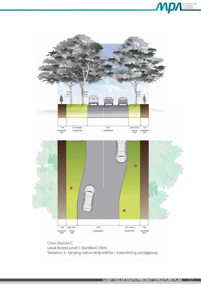
GREENVALE CENTRAL PRECINCT STRUCTURE PLAN
57CASEY FIELDS SOUTH PRECINCT STRUCTURE PLAN

GREENVALE CENTRAL PRECINCT STRUCTURE PLAN
58 CASEY FIELDS SOUTH PRECINCT STRUCTURE PLAN
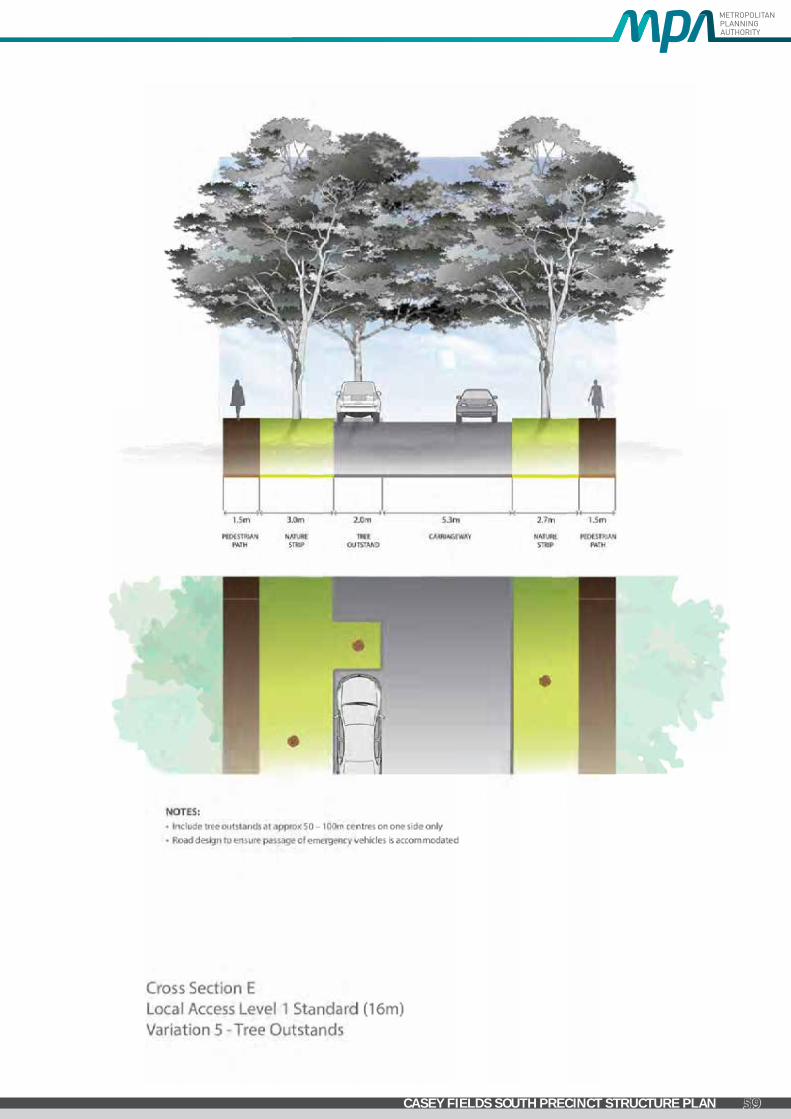
GREENVALE CENTRAL PRECINCT STRUCTURE PLAN
59CASEY FIELDS SOUTH PRECINCT STRUCTURE PLAN

GREENVALE CENTRAL PRECINCT STRUCTURE PLAN
60 CASEY FIELDS SOUTH PRECINCT STRUCTURE PLAN

4.5 Service Placement Guidelines STANDARDROADCROSSSECTIONS
Figures 003 and 004 in the Engineering Design and Construction Manual for Subdivision in Growth Areas (April 2011) outline placement of services for a typical residential street environment. This approach is appropriate for the majority of the ‘standard’ road cross sections outlined in Appendix C containing grassed nature strips, footpaths and road pavements.
NON-STANDARDROADCROSSSECTIONS
To achieve greater diversity of streetscape outcomes in Melbourne’s growth areas, which enhances character and amenity of these new urban areas, non-standard road cross sections are required. Non-standard road cross sections will also be necessary to address local needs, such as fully sealed verges for high pedestrian traffic areas in town centres and opposite schools. This PSP contains suggested non-standard ‘variation’ road cross sections, however other non-standard outcomes are encouraged.
For non-standard road cross sections where service placement guidance outlined in Figure 003 and 004 in the Engineering Design and Construction Manual for Subdivision in Growth Areas (April 2011) is not applicable, the following service placement guidelines will apply.
UNDER PEDESTRIAN PAVEMENT
UNDER NATURE STRIPS
DIRECTLY UNDER TREES1
UNDER KERB
UNDER ROAD
PAVEMENT
WITHIN ALLOTMENTS
NOTES
SEWER Preferred Possible Possible No Possible Possible3
POTABLE WATER
Possible4 Preferred Preferred No No NoCan be placed in combined trench with gas
RECYCLED WATER
Possible4 Preferred Preferred No No No
GAS Possible4 Preferred Preferred No No No
Can be placed in combined trench with potable water
ELECTRICITY Preferred4 Possible Possible No No No
Pits to be placed either fully in footpath or nature strip
FTTH/TELCO Preferred4 Possible Possible No No No
Pits to be placed either fully in footpath or nature strip
DRAINAGE Possible Possible Possible Preferred Preferred Possible3
TRUNK SERVICES
Possible Possible Possible Possible Preferred No
NOTES 1 Trees are not to be placed directly over property service connections 2 Placement of services under road pavement is to be considered when service cannot be accommodated
elsewhere in road reserve. Placement of services beneath edge of road pavement/parking bays is preferable to within traffic lanes
3 Where allotment size/frontage width allows adequate room to access and work on a pipe 4 Where connections to properties are within a pit in the pedestrian pavement/footpath
GENERALPRINCIPLESFORSERVICEPLACEMENT
• Place gas and water on one side of road, electricity on the opposite side
• Place water supply on the high side of road
• Place services that need connection to adjacent properties closer to these properties
• Place trunk services further away from adjacent properties
• Place services that relate to the road carriageway (eg. drainage, street light electricity supply) closer to the road carriageway
•Maintain appropriate services clearances and overlap these clearances wherever possible
GREENVALE CENTRAL PRECINCT STRUCTURE PLAN
61CASEY FIELDS SOUTH PRECINCT STRUCTURE PLAN

4.6 Open Space Category GuideCITYOFCASEYCITYDRAFTPARKCLASSIFICATIONS&EMBELLISHMENTLIST
PASSIVERECREATIONPARK
A park that provides opportunities for a variety of recreational and social activities in a green space setting. Passive Recreation park’s come in a variety of landforms, and in many cases provide opportunities to protect and enhance landscape amenity.
NEIGHBOURHOOD
• Passive recreation park suitable for local recreation/social activities
• Junior play emphasis
•Attracts users from the local area (ie 400m catchment)
• Recreational/social facilities suitable for local activities/events.
•Minimal support facilities (seats, bin etc)
• Footpath/bikeway links
DISTRICT(1HAORGREATER)
• Passive recreation park suitable for district-level recreation/social activities
• Junior and youth play emphasis
•Attracts users from the district (ie 2km catchment)
• Recreational/social facilities suitable for district activities/events.
• Basic support facilities eg. amenities, BBQ, Picnic tables, shelters, seats etc)
• Footpath/bikeway links
MUNICIPAL(5HAORGREATER)
•Major passive recreation park suitable for Citywide recreation/social events
•Attracts users from municipality and adjacent municipalities
• Capacity to sustain high level recreational/social use (5000+) over long periods
•High level recreational/social facilities suitable for Citywide events.
• Junior and youth play emphasis
•High level support facilities eg parking, amenities (toilets), signage
• Footpath/bikeway links
• Public transport
• Car spaces (on and off street)
• Bus Spaces (on and off street)
REGIONAL
•Major passive recreation park suitable for regional recreation/social events
• Capacity to sustain high level recreational/social use (10000+) over long periods
•High level recreational/social facilities suitable for regional events.
• Junior and youth play emphasis
•High level support facilities eg parking, amenities, signage
• Footpath/bikeway links
• Public transport
• Car spaces (off street)
• Bus Spaces (off street)
GREENVALE CENTRAL PRECINCT STRUCTURE PLAN
62 CASEY FIELDS SOUTH PRECINCT STRUCTURE PLAN

LINEARPARK
To provide pedestrian/cyclist links in a parkland setting.
A park that is developed and used for pedestrian and cyclist access, both recreational and commuter, between residential areas and key community destinations such as recreational facilities, schools and other community facilities, public transport and places of work. Linear Reserves are generally linear in nature and follow existing corridors such as water courses and roads. They usually contain paths or tracks (either formal or informal) that form part of a wider path/track network. While the primary function of Linear Reserve is pedestrian & cyclist access, these parks may serve additional purpose such as storm water conveyance, fauna movement and ecological/biodiversity protection.
NEIGHBOURHOOD
• Park corridor that provides local link
•Attracts users from the local area (ie 400m catchment)
• Capacity to sustain low level accessibility over short periods
•Minor access facilities eg path
• Footpath/bikeway links
DISTRICT
•Major park corridor that provides district link
•Attracts users from the district (ie 2 km catchment)
• Capacity to sustain moderate level accessibility over long periods
• Basic access facilities eg path, signage
• Footpath/bikeway links
MUNICIPAL
•Major park corridor that provides metropolitan link
•Attracts users from municipality and adjacent municipalities
• Capacity to sustain high level accessibility over long periods
•High level access facilities eg paths, signage, shade, water fountains
• Footpath/bikeway links
• Public transport
• Car spaces (on street)
• Bus Spaces (on street)
REGIONAL
•Major park corridor that provides regional link
• Capacity to sustain high level accessibility over long periods
•High level access facilities eg paths, signage, shade, water fountains
• Footpath/bikeway links
• Public transport
• Car spaces (on and off street)
• Bus Spaces (on and off street)
TOWNSQUARE/URBANPARK
(Area equal to or less than 0.3ha or unless otherwise designated)
A passive recreation park providing opportunities for a variety of recreational and social activities in an urban setting. They are located predominantly in medium to high density residential area and mixed use centres or corridors. They provide an important role in meeting the passive recreation needs of residents, workers and visitors in activity centres and/or medium to high density residential areas.
Town squares are to be predominately hard landscaped, while urban parks have less hardstand than town squares, but more than traditional neighbourhood passive recreation parks. Urban parks also offer the opportunity for low key kick and throw activities a small turfed area.
GREENVALE CENTRAL PRECINCT STRUCTURE PLAN
63CASEY FIELDS SOUTH PRECINCT STRUCTURE PLAN