Embed Size (px)
Citation preview
Presented at the Joint Salmonid Restoration Federation and California-Nevada Chapter of the American Fisheries Society 2010 Conference 1
Caspar Creek FishwaysCaspar Creek FishwaysLabyrinth Spillway Gates, Removable Weirs, Labyrinth Spillway Gates, Removable Weirs,
Subterranean View Ports and More…Subterranean View Ports and More…
Michael Love P.E.Michael Love P.E.Michael Love & AssociatesMichael Love & AssociatesEureka CAEureka [email protected]@h2odesigns.com
Steve Allen P.E.Steve Allen P.E.WinzlerWinzler & Kelly& KellyEureka CAEureka CAEureka CAEureka CASteveAllen@[email protected]
South Fork Caspar Creek
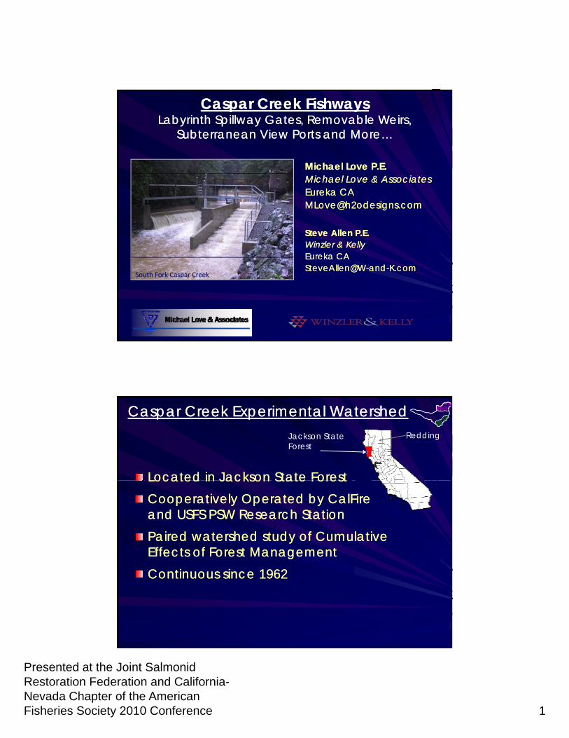
Caspar Creek Experimental WatershedCaspar Creek Experimental WatershedJackson StateForest
Located in Jackson State ForestLocated in Jackson State Forest
Redding
Located in Jackson State ForestLocated in Jackson State ForestCooperatively Operated by CalFire Cooperatively Operated by CalFire and USFS PSW Research Stationand USFS PSW Research StationPaired watershed study of Cumulative Paired watershed study of Cumulative Effects of Forest ManagementEffects of Forest ManagementContinuous since 1962Continuous since 1962
Presented at the Joint Salmonid Restoration Federation and California-Nevada Chapter of the American Fisheries Society 2010 Conference 2
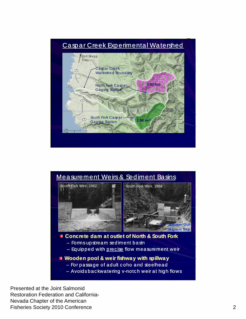
Fort Bragg 5 mi.
Caspar Creek Experimental WatershedCaspar Creek Experimental Watershed
Caspar CreekWatershed Boundary
North Fork CasparGaging Station
1.87 mi2
South Fork CasparGaging Station 1.86 mi2
Measurement Weirs & Sediment BasinsMeasurement Weirs & Sediment BasinsSouth Fork Weir, 1962 South Fork Weir, 1964
Concrete dam at outlet of North & South ForkConcrete dam at outlet of North & South Fork–– Forms upstream sediment basinForms upstream sediment basin
Summer Out-Migrant Trap
Forms upstream sediment basinForms upstream sediment basin–– Equipped with Equipped with preciseprecise flow measurement weirflow measurement weir
Wooden pool & weir fishway with spillwayWooden pool & weir fishway with spillway–– For passage of adult coho and steelheadFor passage of adult coho and steelhead–– Avoids backwatering vAvoids backwatering v--notch weir at high flowsnotch weir at high flows
Presented at the Joint Salmonid Restoration Federation and California-Nevada Chapter of the American Fisheries Society 2010 Conference 3
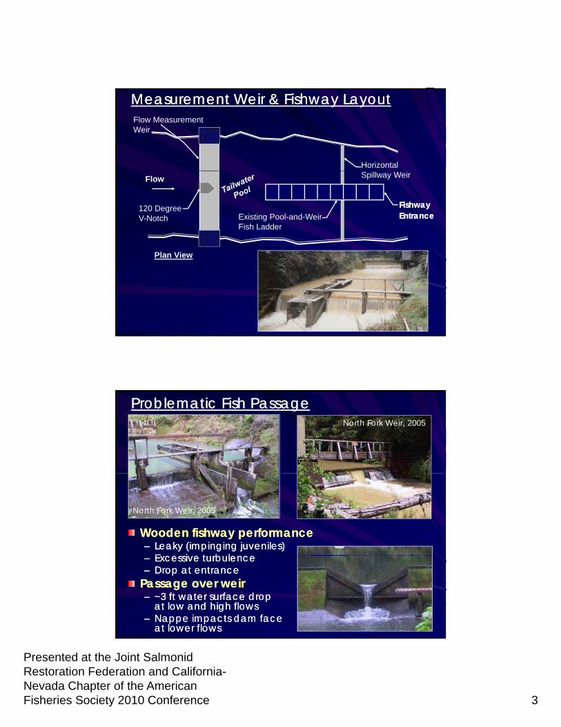
Flow Measurement Weir
Horizontal
Measurement Weir & Fishway LayoutMeasurement Weir & Fishway Layout
Flow
120 Degree V-Notch
Spillway Weir
Existing Pool-and-Weir Fish Ladder
Plan View
Fishway Fishway EntranceEntrance
Plan View
Problematic Fish PassageProblematic Fish PassageNorth Fork Weir, 2005
Wooden fishway performanceWooden fishway performance–– Leaky (impinging juveniles)Leaky (impinging juveniles)
E i t b lE i t b l
North Fork Weir, 2005
–– Excessive turbulenceExcessive turbulence–– Drop at entranceDrop at entrance
Passage over weirPassage over weir–– ~3 ft water surface drop ~3 ft water surface drop
at low and high flowsat low and high flows–– Nappe impacts dam faceNappe impacts dam face
at lower flowsat lower flows
Presented at the Joint Salmonid Restoration Federation and California-Nevada Chapter of the American Fisheries Society 2010 Conference 4
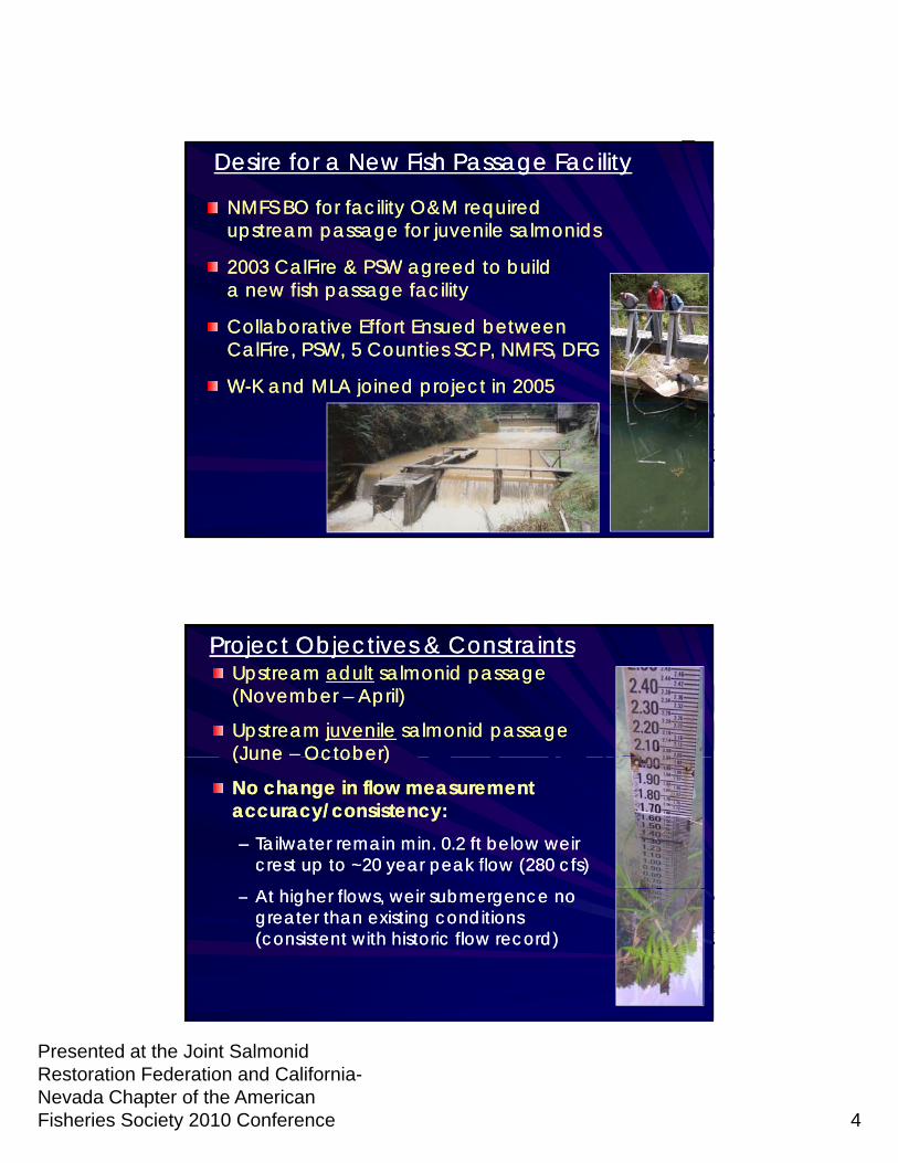
Desire for a New Fish Passage FacilityDesire for a New Fish Passage Facility
NMFS BO for facility O&M required NMFS BO for facility O&M required upstream passage for juvenile salmonidsupstream passage for juvenile salmonids
2003 CalFire & PSW agreed to build 2003 CalFire & PSW agreed to build 2003 CalFire & PSW agreed to build 2003 CalFire & PSW agreed to build a new fish passage facilitya new fish passage facility
Collaborative Effort Ensued between Collaborative Effort Ensued between CalFire, PSW, 5 Counties SCP, NMFS, DFGCalFire, PSW, 5 Counties SCP, NMFS, DFG
WW--K and MLA joined project in 2005K and MLA joined project in 2005
Project Objectives & ConstraintsProject Objectives & ConstraintsUpstream Upstream adultadult salmonid passage salmonid passage (November (November –– April)April)
Upstream Upstream juvenilejuvenile salmonid passage salmonid passage (June (June –– October)October)(June (June October)October)
No change in flow measurement No change in flow measurement accuracy/consistency:accuracy/consistency:–– Tailwater remain min. 0.2 ft below weir Tailwater remain min. 0.2 ft below weir
crest up to ~20 year peak flow (280 cfs)crest up to ~20 year peak flow (280 cfs)
–– At higher flows, weir submergence no At higher flows, weir submergence no greater than existing conditions greater than existing conditions (consistent with historic flow record)(consistent with historic flow record)
Presented at the Joint Salmonid Restoration Federation and California-Nevada Chapter of the American Fisheries Society 2010 Conference 5
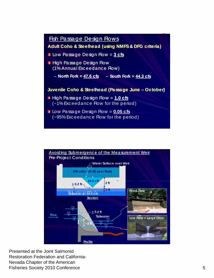
Fish Passage Design FlowsFish Passage Design FlowsAdult Coho & Steelhead (using NMFS & DFG criteria)Adult Coho & Steelhead (using NMFS & DFG criteria)
Low Passage Design Flow = Low Passage Design Flow = 3 cfs3 cfs
High Passage Design FlowHigh Passage Design Flow(1% Annual Exceedance Flow)(1% Annual Exceedance Flow)–– North Fork = North Fork = 47.6 cfs47.6 cfs
Juvenile Coho & Steelhead (Passage June Juvenile Coho & Steelhead (Passage June –– October)October)
High Passage Design Flow High Passage Design Flow 1 0 cfs1 0 cfs
–– South Fork = South Fork = 44.3 cfs44.3 cfs
High Passage Design Flow = High Passage Design Flow = 1.0 cfs1.0 cfs(~1% Exceedance Flow for the period)
Low Passage Design Flow = 0.05 cfs(~95% Exceedance Flow for the period)
120120oo
280 cfs (~10-20 year flow)
24 5 cfs
Avoiding Submergence of the Measurement WeirAvoiding Submergence of the Measurement WeirPrePre--Project ConditionsProject Conditions
Water Surface over WeirWater Surface over Weir
120120oo24.5 cfs 2 ft
SectionSection
Flood FlowFlood FlowTailwater at 280 cfsTailwater at 280 cfs
> 0.2 ft
> 0 2 ft
Tailwater at 24.5 cfsTailwater at 24.5 cfs1 ft
ProfileProfile
Low Flow = Large DropLow Flow = Large Drop
> 0.2 ftFlowFlow TailwaterTailwater
~3 ft~3 ft
Presented at the Joint Salmonid Restoration Federation and California-Nevada Chapter of the American Fisheries Society 2010 Conference 6
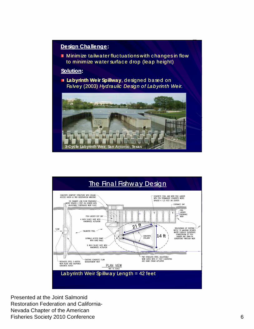
Design ChallengeDesign Challenge::Minimize tailwater fluctuations with changes in flow Minimize tailwater fluctuations with changes in flow to minimize water surface drop (leap height)to minimize water surface drop (leap height)
SolutionSolution::Labyrinth Weir SpillwayLabyrinth Weir Spillway, designed based on , designed based on Falvey (2003) Falvey (2003) Hydraulic Design of Labyrinth Weir. Hydraulic Design of Labyrinth Weir.
33--Cycle Labyrinth Weir, San Antonio, TexasCycle Labyrinth Weir, San Antonio, Texas
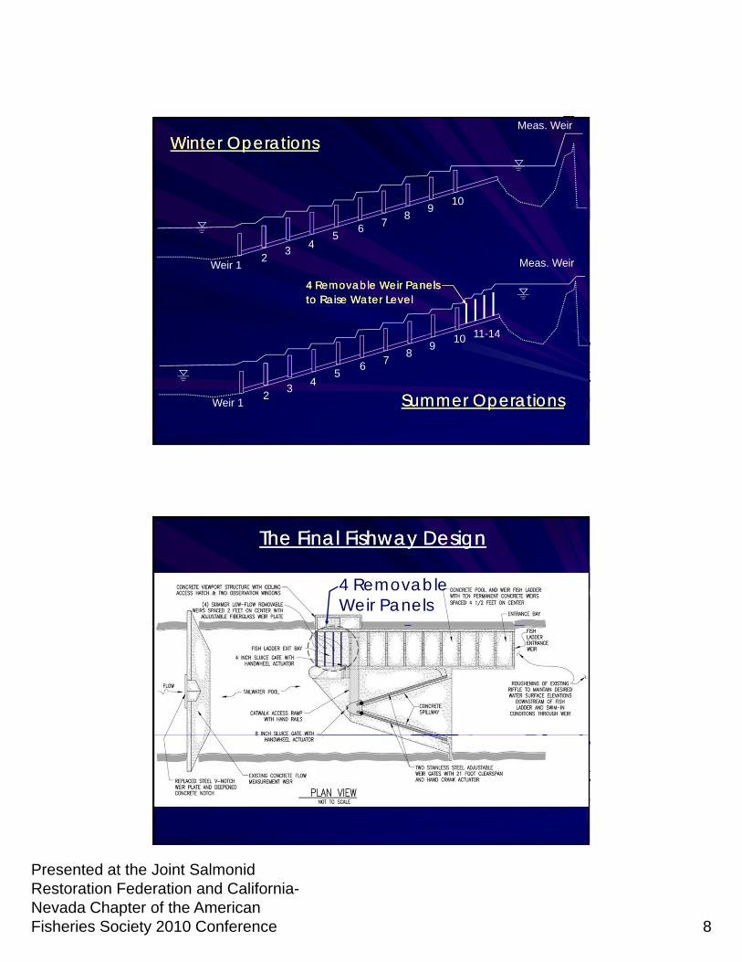
The Final Fishway DesignThe Final Fishway Design
14 ft
Labyrinth Weir Spillway Length = 42 feet Labyrinth Weir Spillway Length = 42 feet
Presented at the Joint Salmonid Restoration Federation and California-Nevada Chapter of the American Fisheries Society 2010 Conference 7
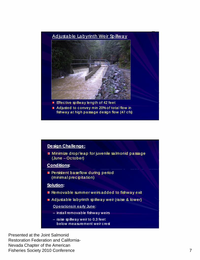
Adjustable Labyrinth Weir SpillwayAdjustable Labyrinth Weir Spillway
Effective spillway length of 42 feetEffective spillway length of 42 feetAdjusted to convey min 20% of total flow in Adjusted to convey min 20% of total flow in fishway at high passage design flow (47 cfs)fishway at high passage design flow (47 cfs)
ConditionsConditions: :
Design Challenge:Design Challenge:Minimize drop/leap for juvenile salmonid passage Minimize drop/leap for juvenile salmonid passage (June (June –– October)October)
Persistent baseflow during period Persistent baseflow during period (minimal precipitation)(minimal precipitation)
SolutionSolution: : Removable summer weirs added to fishway exitRemovable summer weirs added to fishway exit
Adj t bl l b i th ill i ( i & l )Adj t bl l b i th ill i ( i & l )Adjustable labyrinth spillway weir (raise & lower)Adjustable labyrinth spillway weir (raise & lower)Operations in early JuneOperations in early June: :
–– install removable fishway weirs install removable fishway weirs
–– raise spillway weir to 0.3 feet raise spillway weir to 0.3 feet below measurement weir crestbelow measurement weir crest
Presented at the Joint Salmonid Restoration Federation and California-Nevada Chapter of the American Fisheries Society 2010 Conference 8
6 78
910
Meas. Weir
Winter OperationsWinter Operations
Weir 12
34
56 7
10
Meas. Weir
11-14
4 Removable Weir Panels4 Removable Weir Panelsto Raise Water Levelto Raise Water Level
Weir 12
34
56 7
89
10 11 14
Summer OperationsSummer Operations
The Final Fishway DesignThe Final Fishway Design
4 Removable Weir Panels
Presented at the Joint Salmonid Restoration Federation and California-Nevada Chapter of the American Fisheries Society 2010 Conference 9
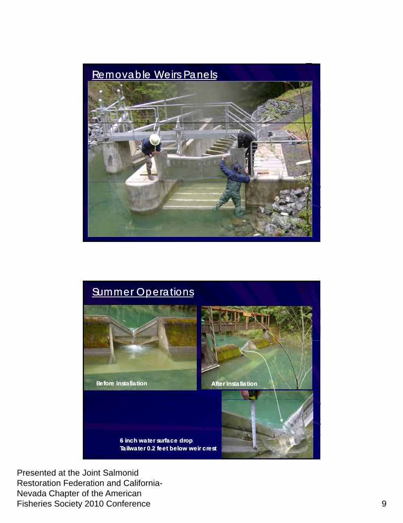
Removable Weirs Panels Removable Weirs Panels
Summer Operations Summer Operations
Before InstallationBefore Installation After InstallationAfter Installation
6 inch water surface drop6 inch water surface dropTailwater 0.2 feet below weir crest Tailwater 0.2 feet below weir crest
Presented at the Joint Salmonid Restoration Federation and California-Nevada Chapter of the American Fisheries Society 2010 Conference 10
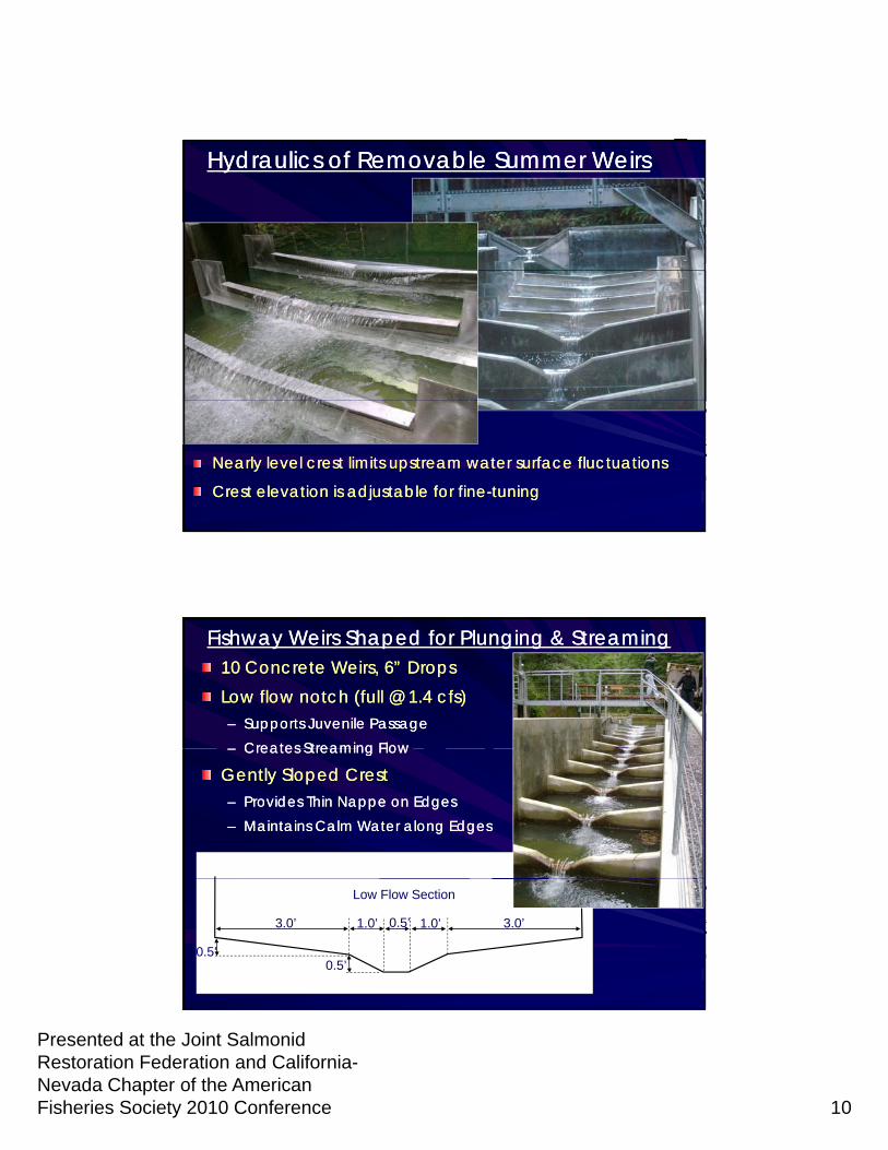
Hydraulics of Removable Summer WeirsHydraulics of Removable Summer Weirs
Nearly level crest limits upstream water surface fluctuationsNearly level crest limits upstream water surface fluctuations
Crest elevation is adjustable for fineCrest elevation is adjustable for fine--tuningtuning
Fishway Weirs Shaped for Plunging & StreamingFishway Weirs Shaped for Plunging & Streaming10 Concrete Weirs, 6” Drops10 Concrete Weirs, 6” DropsLow flow notch (full @ 1.4 cfs)Low flow notch (full @ 1.4 cfs)–– Supports Juvenile PassageSupports Juvenile Passage
Creates Streaming FlowCreates Streaming Flow–– Creates Streaming FlowCreates Streaming Flow
Gently Sloped CrestGently Sloped Crest–– Provides Thin Nappe on EdgesProvides Thin Nappe on Edges–– Maintains Calm Water along EdgesMaintains Calm Water along Edges
1.0’1.0’ 0.5’3.0’ 3.0’
0.5’0.5’
Low Flow Section
Presented at the Joint Salmonid Restoration Federation and California-Nevada Chapter of the American Fisheries Society 2010 Conference 11
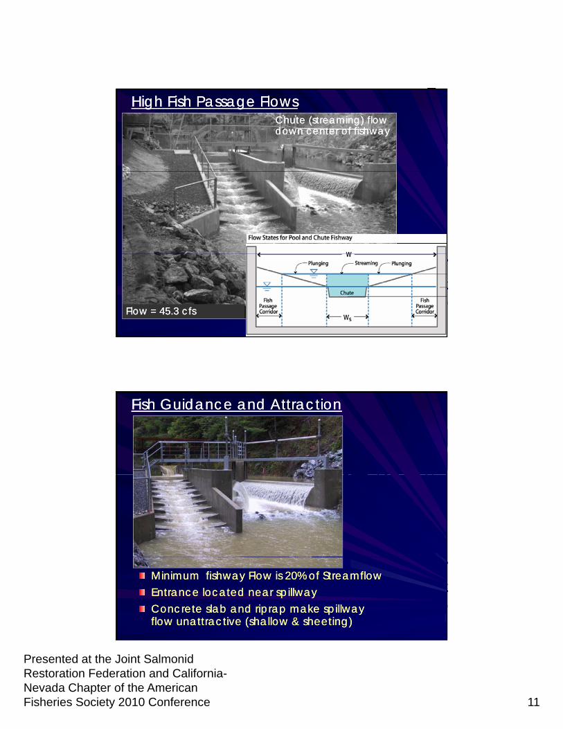
Chute (streaming) flow Chute (streaming) flow down center of fishwaydown center of fishway
High Fish Passage FlowsHigh Fish Passage Flows
Flow = 45.3 cfsFlow = 45.3 cfs
Fish Guidance and AttractionFish Guidance and Attraction
VIDEOVIDEO
Flo 20 cfsFlo 20 cfsMinimum fishway Flow is 20% of StreamflowMinimum fishway Flow is 20% of StreamflowEntrance located near spillwayEntrance located near spillwayConcrete slab and riprap make spillway Concrete slab and riprap make spillway flow unattractive (shallow & sheeting)flow unattractive (shallow & sheeting)
Flow = 20 cfsFlow = 20 cfs
Presented at the Joint Salmonid Restoration Federation and California-Nevada Chapter of the American Fisheries Society 2010 Conference 12
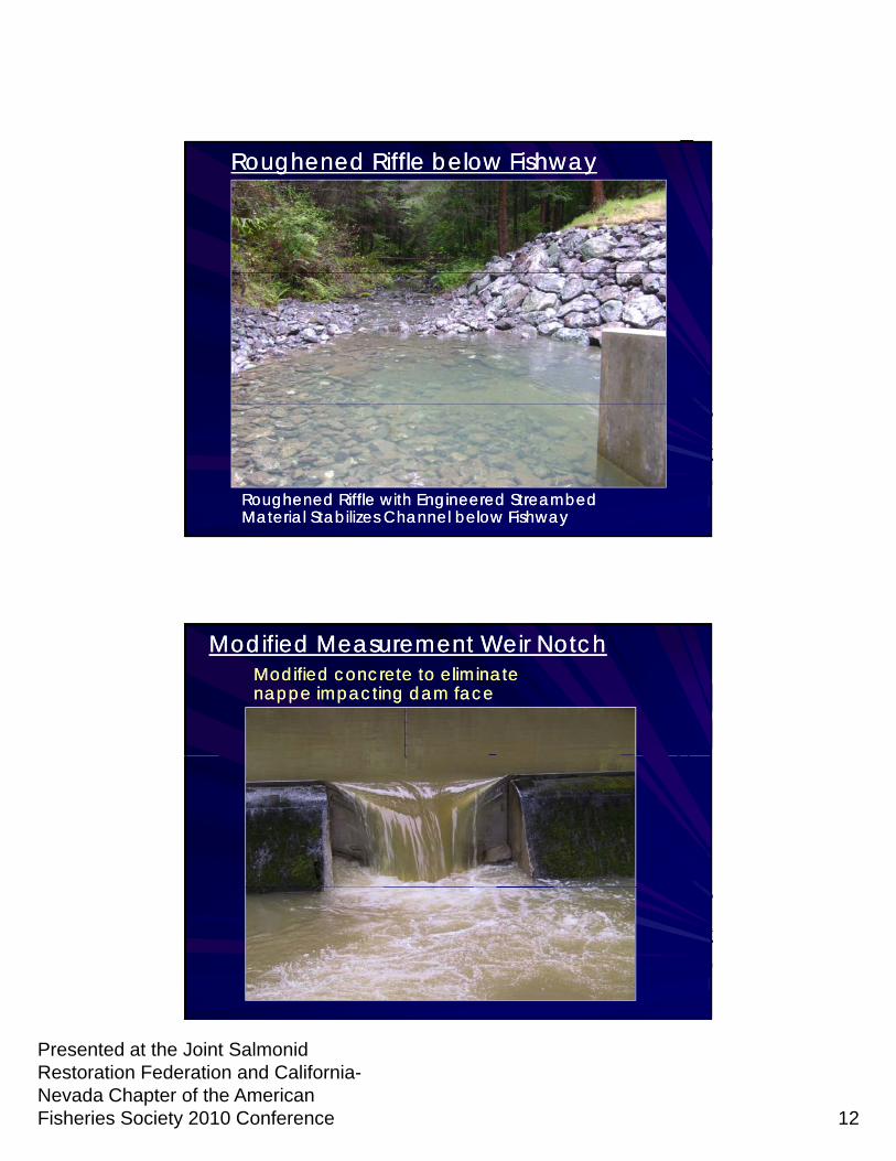
Roughened Riffle below FishwayRoughened Riffle below Fishway
Roughened Riffle with Engineered Streambed Roughened Riffle with Engineered Streambed Material Stabilizes Channel below FishwayMaterial Stabilizes Channel below Fishway
Modified Measurement Weir NotchModified Measurement Weir NotchModified concrete to eliminate Modified concrete to eliminate nappe impacting dam facenappe impacting dam face
Presented at the Joint Salmonid Restoration Federation and California-Nevada Chapter of the American Fisheries Society 2010 Conference 13
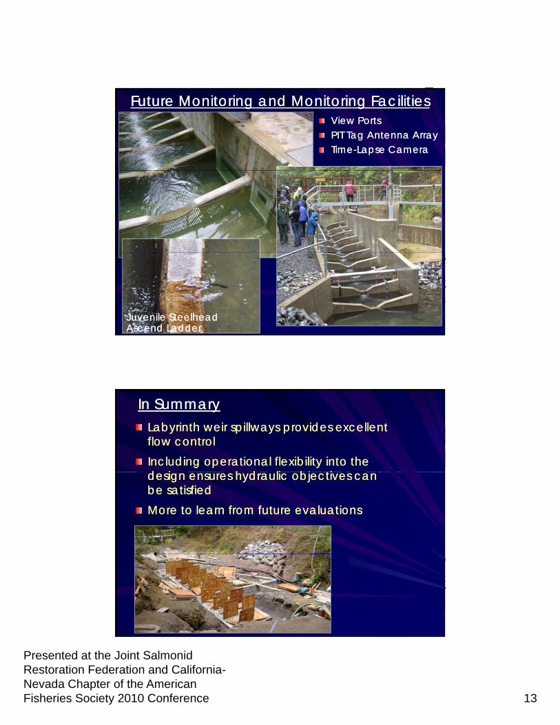
Future Monitoring and Monitoring FacilitiesFuture Monitoring and Monitoring FacilitiesView PortsView PortsPIT Tag Antenna ArrayPIT Tag Antenna ArrayTimeTime--Lapse CameraLapse Camera
Juvenile Steelhead Juvenile Steelhead Ascend LadderAscend Ladder
In SummaryIn SummaryLabyrinth weir spillways provides excellent Labyrinth weir spillways provides excellent flow control flow control Including operational flexibility into the Including operational flexibility into the d i h d li bj ti d i h d li bj ti design ensures hydraulic objectives can design ensures hydraulic objectives can be satisfied be satisfied More to learn from future evaluationsMore to learn from future evaluations