Embed Size (px)
Citation preview

CASS COUNTY, NEBRASKA - COMPREHENSIVE DEVELOPMENT PLAN - SEPTEMBER 1998
1
PROJECT PARTICIPANTS County Commissioners Boyd Linder Hilton Rogers Richard Stone Planning Commission Raymond Althouse Eugene Eikerman Dale Everett Gordon Ganz Dennis Keil Roy Smith Charles Spangler, Chairman George Tesar Jr. Gene Wehrbein Planning and Zoning Office Randy Wilkins, Zoning Administrator Don Garnett, Asst. Administrator Cass County Barbara Wohlers, County Clerk Edward Brink, County Attorney Thomas Huston, Attorney at Law - Cline Williams Principal Planners - Johnson-Erickson-O'Brien and Associates, Inc Keith A. Marvin, AICP Kenneth D. Smith David L. Potter This Comprehensive Development Plan along with the Zoning and Subdivision Regulations were developed in conjunction with the Cass County Planning Commission, Planning and Zoning Staff and the Citizens of Cass County.
CASS COUNTY, NEBRASKA - COMPREHENSIVE DEVELOPMENT PLAN - SEPTEMBER 1998
2
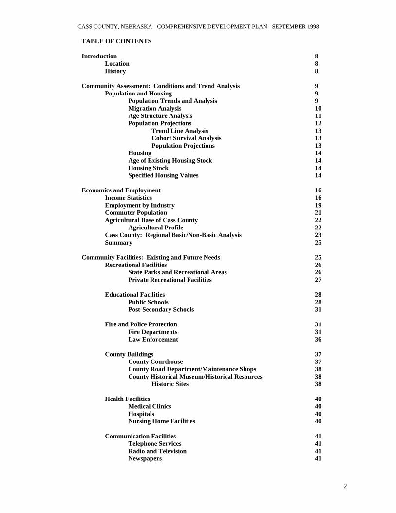
TABLE OF CONTENTS Introduction 8 Location 8 History 8 Community Assessment: Conditions and Trend Analysis 9 Population and Housing 9 Population Trends and Analysis 9 Migration Analysis 10 Age Structure Analysis 11 Population Projections 12 Trend Line Analysis 13 Cohort Survival Analysis 13 Population Projections 13 Housing 14 Age of Existing Housing Stock 14 Housing Stock 14 Specified Housing Values 14 Economics and Employment 16 Income Statistics 16 Employment by Industry 19 Commuter Population 21 Agricultural Base of Cass County 22 Agricultural Profile 22 Cass County: Regional Basic/Non-Basic Analysis 23 Summary 25 Community Facilities: Existing and Future Needs 25 Recreational Facilities 26 State Parks and Recreational Areas 26 Private Recreational Facilities 27 Educational Facilities 28 Public Schools 28 Post-Secondary Schools 31 Fire and Police Protection 31 Fire Departments 31 Law Enforcement 36 County Buildings 37 County Courthouse 37 County Road Department/Maintenance Shops 38 County Historical Museum/Historical Resources 38 Historic Sites 38 Health Facilities 40 Medical Clinics 40 Hospitals 40 Nursing Home Facilities 40 Communication Facilities 41 Telephone Services 41 Radio and Television 41 Newspapers 41

CASS COUNTY, NEBRASKA - COMPREHENSIVE DEVELOPMENT PLAN - SEPTEMBER 1998
3
Transportation Facilities 41 Highways 41 Truck Line Service 41 Railroad Service 41 Bus service 41 Airports 41 Public Utilities 42 Electricity 42 Gas 42 Rural Water 42 Rural Sanitary Sewer 42 Recreational Recommendations 43 Educational Recommendations 43 Fire and Law Enforcement Recommendations 43 County Building Recommendations 44 Health Facilities Recommendations 44 Commercial Facilities Recommendations 44 Transportation Facilities Recommendations 44 Public Utilities Recommendations 44 Environmental and Natural Resources 45 Soil Types 45 Soil Slope 46 Prime Farmland 46 Soil Suitability for Septic Systems 46 Soil Suitability for Lagoons 47 Flood Hazard Areas 48 Conclusion 49 Goals, Objectives and Issues 49 What are Goals, Objectives and Issues 50 Cass County Goals and Objectives 50 Goals for Cass County's Future 50 Improvement of Government Service Throughout the Entire County 51 Enhance the Economic Development and Business Development in Cass County 52 Improve Cass County's Quality of Life 54 Summary 55 Land Use Plan 55 Land Use Plan 55 Land Use Plan Objectives 56 Agricultural 56 Agricultural/Mining 56 Transitional Agricultural 56 Rural Residential 57 Residential 57 General Commercial District 57 Light Industrial 57 Public/Semi-Public Use Districts 58 Parks and Recreation 58 Conservation District 58 Land Use Suitability Criteria 58

CASS COUNTY, NEBRASKA - COMPREHENSIVE DEVELOPMENT PLAN - SEPTEMBER 1998
4
Land Use Transitions 58 Extraterritorial Jurisdictions 58 Transportation Plan 59 Introduction 59 Street and Road Classification 59 Existing Road System 60 Future Circulation System 60 Future Trails Development 61 Plan Implementation Achieving Cass County's Future 61 Plan Maintenance 62

CASS COUNTY, NEBRASKA - COMPREHENSIVE DEVELOPMENT PLAN - SEPTEMBER 1998
5
TABLE OF TABLES Table 1: Population Trends of Cass County Community 1970 to 1994 9 Table 2: Migration Analysis 1960 to 1994 Cass County, Nebraska 11 Table 3: Age-Sex Population Compositions 1980 and 1990 Cass County, Nebraska 12 Table 4: Community Housing Trends 1970, 1980 and 1990 Cass County, Nebraska 15 Table 5: Specified Housing Values 1980 and 1990 Cass County, Nebraska 16 Table 6: Family Income Statistics 1980 and 1990 Cass County, Nebraska 17 Table 7: Income Statistics 1970, 1980, 1990 and 1994 Cass County, Nebraska 18 Table 8: Transfer Payments 1970 to 1990 Cass County, Nebraska 19 Table 9: Employment by Industry 1980 and 1990 Cass County, Nebraska 20 Table 10: Commuter Population 1960 to 1990 Cass County, Nebraska 21 Table 11: Travel Time to Work in 1980 and 1990 Cass County, Nebraska 22 Table 12: Agricultural Profile Cass County, Nebraska 22 Table 13: Basic/Non-Basic Employment 1990 Cass County, Nebraska 24

CASS COUNTY, NEBRASKA - COMPREHENSIVE DEVELOPMENT PLAN - SEPTEMBER 1998
6
Table 14: Regional and State Labor Force Comparisons 1990 Cass County, Nebraska 24 Table 15: Parks and Recreational Areas Cass County, Nebraska 27 Table 16: School Enrollment 1997 and 1998 Cass County, Nebraska 30 Table 17: Fire Districts Property Tax Rates 1997 and 1998 Cass County, Nebraska 32 Table 18: Soil Association and Suitability Reasons Cass County, Nebraska 48

CASS COUNTY, NEBRASKA - COMPREHENSIVE DEVELOPMENT PLAN - SEPTEMBER 1998
7
TABLE OF FIGURES Figure 1: Population Trends and Projections 1930 to 2020 Cass County, Nebraska 10 Figure 2: Age of Existing Housing Stock Cass County, Nebraska 14 Figure 3: Community Facilities Map Cass County, Nebraska +++ Figure 4: Rural Fire District Areas-Map Cass County, Nebraska +++ Figure 5: Rural Water Districts-Map +++ Figure 6: SID Map +++ Figure 7: Flood Hazard Area Cross Section 62 Figure 8: Future Land Use Plan Map +++ Figure 9: Transportation Plan Map +++ +++ All maps are at the end of the Appendix Section

CASS COUNTY, NEBRASKA - COMPREHENSIVE DEVELOPMENT PLAN - SEPTEMBER 1998
8
Introduction The characteristics, size and growth of the general population are primary factors influencing and influenced by the comprehensive planning process. The ability to provide adequate housing, infrastructure, employment, commercial enterprises and services will determine the success residents will have in achieving a desired quality of life in Cass County. These GOALS must include the general ideas of residents for support. I n order to provide for future needs of the community, past trends in population are examined and key factors identified. Past trends give a sense of what the population might be in the year 2000, 2010 and 2020, so changes and adaptions can be managed. The following data provides an overview of past socio-economic trends in Cass County. This overview includes: 1. Population and Housing 2. Employment and Economics And are examined to identify recurring patterns which may effect change. By analyzing these patterns, projections of future population and economic conditions can be estimated. Population projections and forecasts are useful tools in examining the future; however, these tools are not exact and can change due to unforeseen factors. Also, the data contained in past trends can be skewed or inaccurate, creating a distorted picture of the past and future. Therefore, it is important for the county to carefully monitor population and other factors effecting the county. Through periodic monitoring, the county can adapt and adjust to changes. Adapting to changes allows the county to maintain an effective plan and to enhance the quality of life. The following graphic and data tables provide a basis for developing short and long range goals and objectives. These goals and objectives will be shaped into a Plan that can act as a road map, guiding the county through desired change. POPULATION AND HOUSING General population and housing trends are examined from 1980 and 1990. Population trends are investigated and used to project future needs. EMPLOYMENT AND EXCONOMICS Key factors of the local economy are examined and employment analyzed to spot any positive or negative trends, as well as the make-up of the local education system. LOCATION Cass County is located in eastern Nebraska. Cass County is bordered on the east by the Missouri River and Iowa, on the north by the Platte River and Sarpy County, on the south by Otoe County and on the west by Lancaster and Saunders Counties. Located within Cass County are three U.S. Highways and an Interstate Route. The three U.S. Highways are U.S. Highway 75, U.S. Highway 34 and U.S. Highway 6. The interstate route which passes through the county is Interstate 80. Interstate 80 and U.S. Highway 6 cross the county in the northwest corner. Besides the U.S. Highways, Cass County has 6 State Highways within or passing through the county. HISTORY Cass County's history goes back to the beginning of Nebraska's history as a territory. Cass County was one of the eight original counties of the Nebraska Territory. The County was also one of the first to receive a fixed population. The County was surveyed by the U.S. Government in 1856. This was the same year as the first settlers organized the town of Granada along Rock Creek. The area within Cass County and along the Missouri and Platte Rivers was originally established with trading posts. The trading posts served the Mormons and other settlers moving west, as well as the Native Americans which still occupied the area. The first trading post was established by Samuel Martin, from Glenwood, Iowa. Mr. Martin operated a ferryboat across the Missouri from the Iowa side to the Nebraska side of the river. This trading post was erected near the convergence of the
CASS COUNTY, NEBRASKA - COMPREHENSIVE DEVELOPMENT PLAN - SEPTEMBER 1998
9
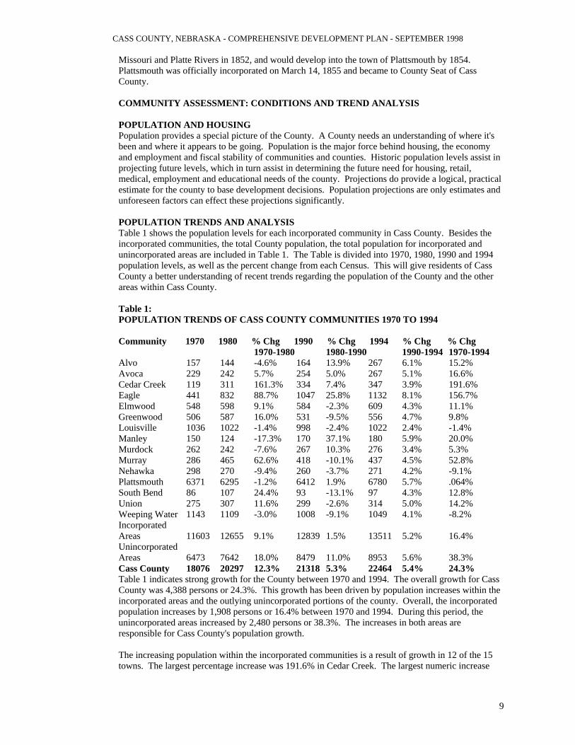
Missouri and Platte Rivers in 1852, and would develop into the town of Plattsmouth by 1854. Plattsmouth was officially incorporated on March 14, 1855 and became to County Seat of Cass County. COMMUNITY ASSESSMENT: CONDITIONS AND TREND ANALYSIS POPULATION AND HOUSING Population provides a special picture of the County. A County needs an understanding of where it's been and where it appears to be going. Population is the major force behind housing, the economy and employment and fiscal stability of communities and counties. Historic population levels assist in projecting future levels, which in turn assist in determining the future need for housing, retail, medical, employment and educational needs of the county. Projections do provide a logical, practical estimate for the county to base development decisions. Population projections are only estimates and unforeseen factors can effect these projections significantly. POPULATION TRENDS AND ANALYSIS Table 1 shows the population levels for each incorporated community in Cass County. Besides the incorporated communities, the total County population, the total population for incorporated and unincorporated areas are included in Table 1. The Table is divided into 1970, 1980, 1990 and 1994 population levels, as well as the percent change from each Census. This will give residents of Cass County a better understanding of recent trends regarding the population of the County and the other areas within Cass County. Table 1: POPULATION TRENDS OF CASS COUNTY COMMUNITIES 1970 TO 1994 Community 1970 1980 % Chg 1990 % Chg 1994 % Chg % Chg 1970-1980 1980-1990 1990-1994 1970-1994 Alvo 157 144 -4.6% 164 13.9% 267 6.1% 15.2% Avoca 229 242 5.7% 254 5.0% 267 5.1% 16.6% Cedar Creek 119 311 161.3% 334 7.4% 347 3.9% 191.6% Eagle 441 832 88.7% 1047 25.8% 1132 8.1% 156.7% Elmwood 548 598 9.1% 584 -2.3% 609 4.3% 11.1% Greenwood 506 587 16.0% 531 -9.5% 556 4.7% 9.8% Louisville 1036 1022 -1.4% 998 -2.4% 1022 2.4% -1.4% Manley 150 124 -17.3% 170 37.1% 180 5.9% 20.0% Murdock 262 242 -7.6% 267 10.3% 276 3.4% 5.3% Murray 286 465 62.6% 418 -10.1% 437 4.5% 52.8% Nehawka 298 270 -9.4% 260 -3.7% 271 4.2% -9.1% Plattsmouth 6371 6295 -1.2% 6412 1.9% 6780 5.7% .064% South Bend 86 107 24.4% 93 -13.1% 97 4.3% 12.8% Union 275 307 11.6% 299 -2.6% 314 5.0% 14.2% Weeping Water 1143 1109 -3.0% 1008 -9.1% 1049 4.1% -8.2% Incorporated Areas 11603 12655 9.1% 12839 1.5% 13511 5.2% 16.4% Unincorporated Areas 6473 7642 18.0% 8479 11.0% 8953 5.6% 38.3% Cass County 18076 20297 12.3% 21318 5.3% 22464 5.4% 24.3% Table 1 indicates strong growth for the County between 1970 and 1994. The overall growth for Cass County was 4,388 persons or 24.3%. This growth has been driven by population increases within the incorporated areas and the outlying unincorporated portions of the county. Overall, the incorporated population increases by 1,908 persons or 16.4% between 1970 and 1994. During this period, the unincorporated areas increased by 2,480 persons or 38.3%. The increases in both areas are responsible for Cass County's population growth. The increasing population within the incorporated communities is a result of growth in 12 of the 15 towns. The largest percentage increase was 191.6% in Cedar Creek. The largest numeric increase

CASS COUNTY, NEBRASKA - COMPREHENSIVE DEVELOPMENT PLAN - SEPTEMBER 1998
10
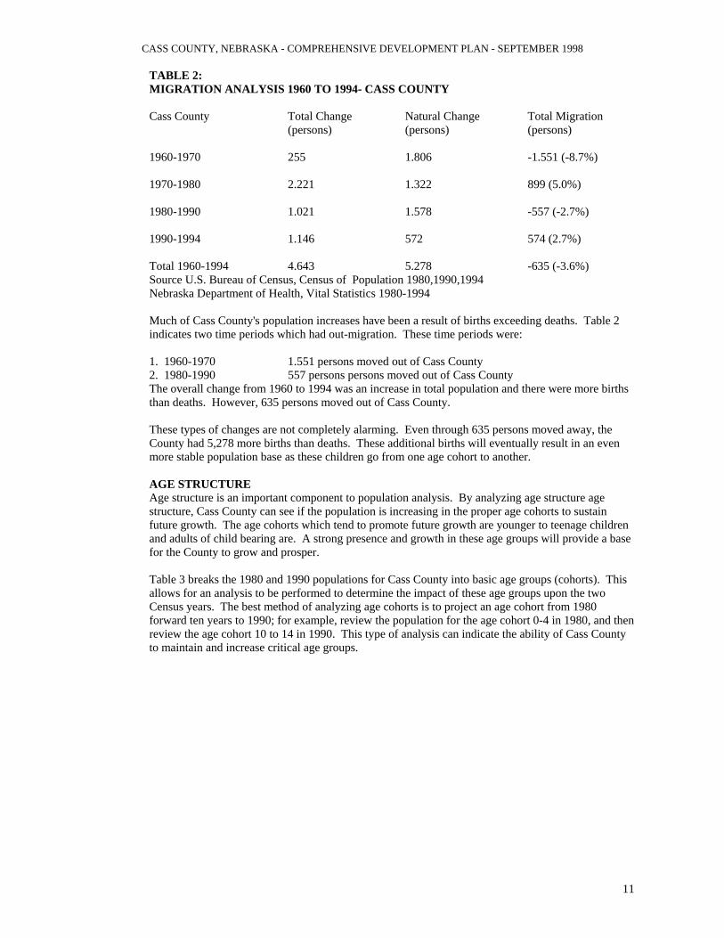
was in Eagle with 691 new persons. The unincorporated increases have been due to increased interest in acreage development and the availability of Rural Water Districts. In addition, during this time period over 3,000 lots were platted in eight rural subdivisions. Figure 1: POPULATION TRENDS AND PROJECTIONS 1930-2020-CASS COUNTY YEAR POPULATION 1930 17684 1940 16992 1950 16361 1960 17821 1970 18076 1980 20297 1990 21318 1994 22164 2000 EST 23242 LOW SERIES 23430 MEDIUM SERIES 25155 HIGH SERIES 2010 EST 24583 LOW SERIES 26861 MEDIUM SERIES 29683 HIGH SERIES 2020EST 26002 LOW SERIES 30529 MEDIUM SERIES 35026 HIGH SERIES Source Bureau of Business Research Figure 1 shows the population changes for Cass County from 1930 to 194, as well as, population projections for the years 2000,2010 and 2020 for Cass County indicates steady growth. Since 1950, Cass County has seen an increase in population trend. This has not been the normal occurrence for a number of Nebraska Counties. The 1930 population trend, for Cass County, indicates steady growth. During this time period, Cass County has seen an increased in population, this has not been the normal occurrence for a number of Nebraska counties. With a few exceptions, most counties had their peak population occur during the 1930 or 1940 U.S. Census. The continued growth for Cass County has been due primarily to its proximity to the Omaha and Lincoln metropolitan areas. The population projections indicate that this growth will continue. The projections indicate a population of 24,270 persons in 2000 and 26,597 persons in 2010. The population projections suggest that this trend will continue beyond the 2010 U.S. Census. This anticipated growth for 2000, 2010 and beyond is due to the age groups containing children and adults (child bearing age) increasing throughout the projection period. MIGRATION AND ANALYSIS Migration Analysis allows a county to understand what specific dynamics are influencing the population. Migration is the remaining portion of the population after the natural change is subtracted from its total change in population. Table 2 shows the total change in population for Cass County from 1960-1970, 1970-1980, 1980-1990 and 1990-1994. The Table also indicates the natural change (total births minus deaths) and the total migration. A negative number in the total Migration column indicates population moving away and a positive indicates population moving into the County
CASS COUNTY, NEBRASKA - COMPREHENSIVE DEVELOPMENT PLAN - SEPTEMBER 1998
11
TABLE 2: MIGRATION ANALYSIS 1960 TO 1994- CASS COUNTY Cass County Total Change Natural Change Total Migration (persons) (persons) (persons) 1960-1970 255 1.806 -1.551 (-8.7%) 1970-1980 2.221 1.322 899 (5.0%) 1980-1990 1.021 1.578 -557 (-2.7%) 1990-1994 1.146 572 574 (2.7%) Total 1960-1994 4.643 5.278 -635 (-3.6%) Source U.S. Bureau of Census, Census of Population 1980,1990,1994 Nebraska Department of Health, Vital Statistics 1980-1994 Much of Cass County's population increases have been a result of births exceeding deaths. Table 2 indicates two time periods which had out-migration. These time periods were: 1. 1960-1970 1.551 persons moved out of Cass County 2. 1980-1990 557 persons persons moved out of Cass County The overall change from 1960 to 1994 was an increase in total population and there were more births than deaths. However, 635 persons moved out of Cass County. These types of changes are not completely alarming. Even through 635 persons moved away, the County had 5,278 more births than deaths. These additional births will eventually result in an even more stable population base as these children go from one age cohort to another. AGE STRUCTURE Age structure is an important component to population analysis. By analyzing age structure age structure, Cass County can see if the population is increasing in the proper age cohorts to sustain future growth. The age cohorts which tend to promote future growth are younger to teenage children and adults of child bearing are. A strong presence and growth in these age groups will provide a base for the County to grow and prosper. Table 3 breaks the 1980 and 1990 populations for Cass County into basic age groups (cohorts). This allows for an analysis to be performed to determine the impact of these age groups upon the two Census years. The best method of analyzing age cohorts is to project an age cohort from 1980 forward ten years to 1990; for example, review the population for the age cohort 0-4 in 1980, and then review the age cohort 10 to 14 in 1990. This type of analysis can indicate the ability of Cass County to maintain and increase critical age groups.
CASS COUNTY, NEBRASKA - COMPREHENSIVE DEVELOPMENT PLAN - SEPTEMBER 1998
12
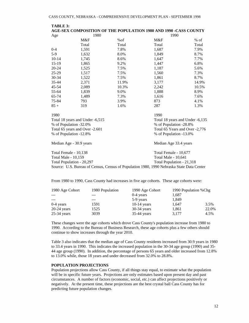
TABLE 3: AGE-SEX COMPOSITION OF THE POPULATION 1980 AND 1990 -CASS COUNTY Age 1980 1990 M&F %of M&F % of Total Total Total Total 0-4 1,591 7.8% 1,687 7.9% 5-9 1,632 8.0% 1,849 8.7% 10-14 1,745 8.6% 1,647 7.7% 15-19 1,865 9.2% 1,447 6.8% 20-24 1,525 7.5% 1,187 5.6% 25-29 1,517 7.5% 1,560 7.3% 30-34 1,522 7.5% 1,861 8.7% 35-44 2,371 11.9% 3,177 14.9% 45-54 2,089 10.3% 2,242 10.5% 55-64 1,839 9.0% 1,888 8.9% 65-74 1,489 7.3% 1,616 7.6% 75-84 793 3.9% 873 4.1% 85 + 319 1.6% 287 1.3%
1980 1990 Total 18 years and Under -6,515 Total 18 years and Under -6,135 % of Population -32.0% % of Population -28.8% Total 65 years and Over -2.601 Total 65 Years and Over -2,776 % of Population -12.8% % of Population -13.0% Median Age - 30.9 years Median Age 33.4 years Total Female - 10,138 Total Female - 10,677 Total Male - 10,159 Total Male - 10,641 Total Population - 20,297 Total Population - 21,318 Source: U.S. Bureau of Census, Census of Population 1980, 1990 Nebraska State Data Center From 1980 to 1990, Cass County had increases in five age cohorts. These age cohorts were: 1980 Age Cohort 1980 Population 1990 Age Cohort 1990 Population %Chg --- --- 0-4 years 1,687 --- --- 5-9 years 1,849 0-4 years 1591 10-14 years 1,647 3.5% 20-24 years 1525 30-34 years 1,861 22.0% 25-34 years 3039 35-44 years 3,177 4.5% These changes were the age cohorts which drove Cass County's population increase from 1980 to 1990. According to the Bureau of Business Research, these age cohorts plus a few others should continue to show increases through the year 2010. Table 3 also indicates that the median age of Cass County residents increased from 30.9 years in 1980 to 33.4 years in 1990. This indicates the increased population in the 30-34 age group (1990) and 35-44 age group (1990). In addition, the percentage of persons 65 years and older increased from 12.8% to 13.0% while, those 18 years and under decreased from 32.0% to 28.8%. POPULATION PROJECTIONS Population projections allow Cass County, if all things stay equal, to estimate what the population will be in specific future years. Projections are only estimates based upon present day and past circumstances. A number of factors (economic, social, etc.) can affect projections positively or negatively. At the present time, these projections are the best crystal ball Cass County has for predicting future population changes.

CASS COUNTY, NEBRASKA - COMPREHENSIVE DEVELOPMENT PLAN - SEPTEMBER 1998
13
Trend Line Analysis Trend line analysis is a process of projecting future populations based upon specific changes during a specified period of time. In this analysis of Cass County, two different trend lines were reviewed; 1960 to 1994 (est) and 1990 to 1997 (est). From 1960 to 1994 (estimates), Cass County's population grew on average 0.77% per year or 7.7% per decade. The 1990 to 1997 (estimates)* had an average increase of 1.8% per year or 18% per decade. The following are projections based upon the two trend lines: 1960 to 1994 1990 to 1997 1990 21,318 21,318 1994 (est) 22,464 22,464 2000 23,242 25,155 2010 24,583 29,683 2020 26,002 35,026 Based upon the recently released 1997 population estimates for counties, the 1990 to 1997 trend line appears to be achievable. Cohort Survival Analysis Cohort survival analysis reviews a population by different age groups and sex. The population age groups are then projected forward by decade using survival rates for the different age groups. This projection model also accounts for average birth rates by sex and adds the new births into the future population. Reviewing different age groups by sex and projecting these forward to the years 2000, 2010, and 2020, indicates that Cass County's total population will continue to grow. Using this modeling technique, the following projections were derived: 1990 21,318 1994 est 22,464 2000 21,890 2010 23,780 2020 25,908 *As of March 1998, the 1997 population estimates for counties were released. However, estimates for municipalities were not available for this same period. Cass County's estimated population for 1997 was 24,002. These projections are increasing; however, the cohort survival model does not account for migration. During the 1990's Cass County is averaging 1,540 persons moving into the county per decade. Accounting for this average in-migration, the following projections are an adjusted cohort survival model: 1990 21,318 1994 est 22,464 2000 23,430 2010 26.861 2020 30,529 These projections are more realistic than those in the previous cohort survival model. However, in both cases, the indication is that Cass County will continue to grow at significant rates. Population Projections Using the modeling techniques discussed in the previous paragraphs, the following is a summary of the population projections for Cass County through the year 2020. There has been a Low Series, Medium Series and a High Series projection established in order to indicate different growth patterns which may be encountered in the next 22 years. The following are the populations for each year and included are the populations for 1990 and 1994:

CASS COUNTY, NEBRASKA - COMPREHENSIVE DEVELOPMENT PLAN - SEPTEMBER 1998
14
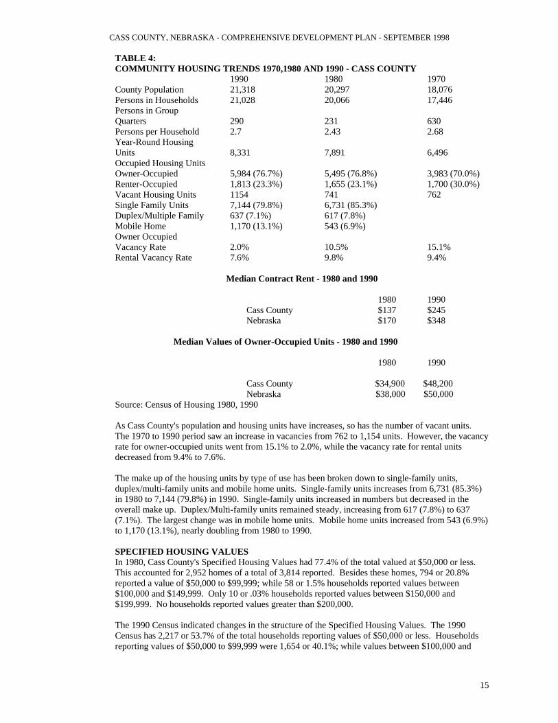
Low Series Medium Series High Series Year 1990 21,318 persons 21,318 persons 21,318 persons Year 1994 22,464 persons 22,464 persons 22,464 persons Year 2000 23,242 persons 23,430 persons 25,155 persons Year 2010 24,583 persons 26,861 persons 29,683 persons Year 2020 26,002 persons 30,529 persons 35,026 persons Cass County residents must monitor the future population estimates and U.S. Census releases carefully in order to be educated on the growth of their community. HOUSING The Housing element of the Comprehensive Development Plan identifies existing housing characteristics and projected housing needs in Cass County. A primary goal of the County should be to provide safe, decent and sanitary housing for every family and individual residing with Cass County. To project future housing needs, several factors must be considered. These factors include: Population changes, family income, employment, land use and resident's attitudes. Age of Existing Housing Stock The age of a county's housing stock can indicate a great deal about population and economic conditions of the past. The age of the housing stock can also indicate any needed repairs or needed replacements within the county. The category is important in understanding the overall quality of housing and the quality of life in the county Figure 2 Age of Existing Housing Stock - Cass County 1939 or earlier 2,918 1950 477 1959 719 1970 1,181 1979 2,233 1985 696 1988 496 1989 201 1995 533 Source: 1990 U.S. Census HOUSING STOCK The housing stock of the County is analyzed as to its make up of owner-occupied, renter-occupied and vacant units. This data provides a picture of the housing composition and can be broken down in many additional ways. Besides these data units, it is important to compare data regarding median value of owner-occupied and median contract rent for housing units. Table 4 reviews housing statistics regarding household population, persons per household, types of housing units and housing make up. Also included are vacancy rates and the median value of owner-occupied and median contract rent for housing units. These data are compared for 1970, 1980 and 1990. Table 4 indicates that the household population of Cass County grew from 17,446 in 1970 to 21,028 in 1990, an increase of 20.5%. However, the same period saw the number of persons living in group quarters decrease from 630 to 290, a change of 54.0%. As the county's overall population increased, the increase was felt in household populations rather than in group quarters population. During this period, the ratio of persons per household held steady, changing from 2.70 persons to 2.68 persons. This was not a typical trend for Nebraska communities between 1970 and 1990. The number of units classified as owner-occupied increased from 3,983 (70.0%) in 1970 to 5,984 (76.7%) in 1990. During this time period, renter-occupied units went from 1,700 (30.0%) to 1,813 (23.3%). The majority of the new population appears to be moving into owner-occupied units as opposed to renter-occupied units.
CASS COUNTY, NEBRASKA - COMPREHENSIVE DEVELOPMENT PLAN - SEPTEMBER 1998
15
TABLE 4: COMMUNITY HOUSING TRENDS 1970,1980 AND 1990 - CASS COUNTY 1990 1980 1970 County Population 21,318 20,297 18,076 Persons in Households 21,028 20,066 17,446 Persons in Group Quarters 290 231 630 Persons per Household 2.7 2.43 2.68 Year-Round Housing Units 8,331 7,891 6,496 Occupied Housing Units Owner-Occupied 5,984 (76.7%) 5,495 (76.8%) 3,983 (70.0%) Renter-Occupied 1,813 (23.3%) 1,655 (23.1%) 1,700 (30.0%) Vacant Housing Units 1154 741 762 Single Family Units 7,144 (79.8%) 6,731 (85.3%) Duplex/Multiple Family 637 (7.1%) 617 (7.8%) Mobile Home 1,170 (13.1%) 543 (6.9%) Owner Occupied Vacancy Rate 2.0% 10.5% 15.1% Rental Vacancy Rate 7.6% 9.8% 9.4%
Median Contract Rent - 1980 and 1990
1980 1990
Cass County $137 $245 Nebraska $170 $348
Median Values of Owner-Occupied Units - 1980 and 1990
1980 1990 Cass County $34,900 $48,200 Nebraska $38,000 $50,000 Source: Census of Housing 1980, 1990 As Cass County's population and housing units have increases, so has the number of vacant units. The 1970 to 1990 period saw an increase in vacancies from 762 to 1,154 units. However, the vacancy rate for owner-occupied units went from 15.1% to 2.0%, while the vacancy rate for rental units decreased from 9.4% to 7.6%. The make up of the housing units by type of use has been broken down to single-family units, duplex/multi-family units and mobile home units. Single-family units increases from 6,731 (85.3%) in 1980 to 7,144 (79.8%) in 1990. Single-family units increased in numbers but decreased in the overall make up. Duplex/Multi-family units remained steady, increasing from 617 (7.8%) to 637 (7.1%). The largest change was in mobile home units. Mobile home units increased from 543 (6.9%) to 1,170 (13.1%), nearly doubling from 1980 to 1990. SPECIFIED HOUSING VALUES In 1980, Cass County's Specified Housing Values had 77.4% of the total valued at $50,000 or less. This accounted for 2,952 homes of a total of 3,814 reported. Besides these homes, 794 or 20.8% reported a value of $50,000 to $99,999; while 58 or 1.5% households reported values between $100,000 and $149,999. Only 10 or .03% households reported values between $150,000 and $199,999. No households reported values greater than $200,000. The 1990 Census indicated changes in the structure of the Specified Housing Values. The 1990 Census has 2,217 or 53.7% of the total households reporting values of $50,000 or less. Households reporting values of $50,000 to $99,999 were 1,654 or 40.1%; while values between $100,000 and

CASS COUNTY, NEBRASKA - COMPREHENSIVE DEVELOPMENT PLAN - SEPTEMBER 1998
16
$149,999 had 229 or 5.6% households. In addition, there were 52 or 1.3% homes valued between $150,000 and $199,000. Finally 7 or .2% households were valued at $200,000 or more. The median housing values provide an indication of how the housing market has performed. Cass County had a median value of $34,900 in 1980 and $48,200 in 1990. This was a change of 38.1% over ten years or 3.8% per year. During the same period, the Consumer Price Index (CPI) changes by 60.7%. therefore, the average change due to inflation was greater than the change in Cass County. This means that the average Specified Housing Value in Cass County did not keep up with the inflationary increases nationwide. In order for Cass County homeowners to get a comparable value to national changes, they need to find ways to make housing more attractive and increase the demand. Between 1980 and 1990, the median contract rent of renters in Cass County went from $137 to $245 a change of 78.8%. This increase was considerably greater than the increase in the CPI of 60.7%. Renters in Cass County saw their rent increase faster than inflationary pressures nationwide. However, rents may have been low enough in 1980, that this was merely an adjustment within Cass County. TABLE 5: SPECIFIED HOUSING VALUES 1980 AND 1990 - CASS COUNTY Cass County 1980 1990 Less than $50,000 2,952 77.4% 2,215 53.7% $50,000 to $99,999 794 20.8% 1,654 40.1% $100,000 to $149,999 58 1.5% 229 5.6% $150,000 to $199,999 10 .3% 52 1.3% $200,000 or more 0 .0% 7 .2% Total Units 3,814 4,157 Median Value $34,900 $48,200 Source: U.S. Bureau of Census, Census of Population and Housing 1980 and 1990 The overall housing conditions and values within Cass County appear to be improving through the years. There has been strong growth in the number of Owner-Occupied units, as well as reasonable growth in perceived housing values. As Cass County's population continues to increase, housing issues will also continue to improve. ECONOMICS AND EMPLOYMENT Economic data are collected in order to better understand area markets, changes in economic activity and employment needs and opportunities. In this section, individual income statistics are reviewed for Cass County and Nebraska. Employment by Industry, Location Quotients, Basic/Non-Basic Analysis, Primary Retail Trade Area, Net Taxable Sales and Retail Trade Area, are also included in this review. INCOME STATISTICS Income Statistics for families are important in telling the earning power of the families in a community. These data indicate at what level families are earning, compared to the State. In addition, these data are reviewed for purposes of determining if the families are seeing income increases at a rate at least comparable to the Consumer Price Index (CPI).

CASS COUNTY, NEBRASKA - COMPREHENSIVE DEVELOPMENT PLAN - SEPTEMBER 1998
17
TABLE 6: FAMILY INCOME STATISTICS 1980 AND 1990- CASS COUNTY AND NEBRASKA 1980 1990 Family Income Cass Co.(%) State (%) Cass Co.(%) State(%) Less than $5,000 286 (5.2%) 27,188(6.6%) 91(1.6%) 11,794(2.8%) $5,000-$9,999 632(11.3%) 52,984(12.8%) 217(3.6%) 21,616(5.2%) $10,000-$14,999 966(17.3%) 67,769(16.3%) 487(8.2%) 33,491(8.0) $15,000-$24,999 2,016(36.1%) 137,124(33.1%) 1,204(20.2%) 83,855(20.0%) $25,000-$34,999 1,131(20.2%) 75,516(18.2%) 1,435(24.1%) 85,580(20.5%) $35,000-$49,999 408(7.3%) 35,773(8.6) 1,410(23.7%) 92,981(22.2%) $50,000 & UP 147(2.6%) 18,239(4.4%) 1,105(18.6%) 89,124(21.3%) Median Income $19,562 $19,122 $31.924 $31,634 No. of Families 5,586 414,503 5,949 418,471 No. Below Poverty Level 334 33,340 344 33,509 %Below Poverty Level 6.0% 8.0% 5.8% 8.0% Source:U.S. Bureau of Census, Census of Population and Housing 1980,1990 In 1980, family income statistics for Cass County indicated that 49.7% of those reporting had incomes less than $25,000 while the State of Nebraska had 68.8% earning less than $25,000. This shows that families in Cass County were earning better than the State as a whole. This is further shown in the poverty rates of 6.0% for Cass County and 8.0% for the State. By 1990 Cass County had 66.4% of its families earning $25,000 or more (42.3% earning $35,000 or more). The State of Nebraska had 64.0% of families earning $25,000 or more (43.5% earning $35,000 or more). Cass County had better growth in the $25,000 or more category but lagged slightly behind in the $35,000 or more range. This was further seen in the poverty rates for 1990. Cass County had a 5.8% rate and the State maintained the 8.0% rate. The median family income for Cass County in 1980 was $19,562. By 1990 the median income increased to $31,924. This was a 63.2% increase over ten years. The State of Nebraska had a median family income of $19,122 in 1980 and $31,634 in 1990. The State's change was 65.4%. The CPI increased by 60.7% for the same period. Both Cass County and the State of Nebraska did well compared to the CPI. Cass County families had better income increases compared to the entire United States but did not grow as great as the entire state. Reasons for this increase in median family income can be attributed to these main causes: 1. Better jobs with better wages 2. Families saw good increases in their present jobs 3. The national trend of more two income households The latter may be the primary contributor to the increased median family income. However, the first two items did play a role in the overall increases.

CASS COUNTY, NEBRASKA - COMPREHENSIVE DEVELOPMENT PLAN - SEPTEMBER 1998
18
TABLE 7: INCOME STATISTICS 1970,1980,1990 AND 1994-CASS COUNTY 1970 1980 1990 1994 %Chg %Chg/yr. Total Personal Income $65,711,000 $180,086,000 $343,637,000 $443,248,000 574.5% 23.9% Non Farm Income $57,140,000 $170,787,000 $320,258,000 $414,890,000 626.1% 26.1% Farm Income $8,571,000 $4,263,000 $19,564,000 $28,358,000 230.9% 9.6% Per Capita Income $3,663 $9,013 $16,083 $19,731 438.7% 18.3% Average Earnings Per Job $5,904 $10,392 $16,285 $19,126 224.0% 9.3% Source: Bureau of Economic Analysis-REIS report 1996 Income levels for Cass County, as a whole, were very good during the 24-year period from 1970 to 1994. Cass County residents went from a total of $65,711,000 earned in 1970 to $443,248,000 earned in 1994. This accounts for a 574.5% increase. During the same period the CPI increased by 286.8%. The increase within Cass County was twice as much as the increase in the cost of living nationally. This may be attributed to a combination of: 1. Better paying jobs within Cass County 2. Better paying jobs in the Omaha and Lincoln metropolitan areas 3. An increase in two income households had a greater impact on income vs. additional expenses 4. Cass County was earning less on average than the nation in 1970, and the 1994 figures brought
the County more in line By 1970, non-farm income accounted for $57,140,000 (87%) of the total personal income for Cass County. By 1994 non-farm income had increases by 626.1% to $414,890,000. The 1994 non-farm income accounted for 93.6% of Cass County's total personal income. This indicates that non-farm income was increasing at a greater rate than farm income. The percent change further supports this, since non-farm income increased 626.1% between 1970 and 1994, and farm income rose only 230.9% for the same period. Non-farm income increased 2.7 times more than farm income. This was likely due to the decreasing number of farms and acreage for approximately the same period. Cass County lost 22.7% of its farms from 1969 to 1992 and lost 9.2% of its farm acreage. Table 7 shows the Per Capita Income (PCI) for Cass County for 1970, 1980, 1990 and 1994. In 1970, Cass County had a PCI of $3,663 and in 1994 the PCI was $19,731 and increase of 438.7%. Once again, the change from 1970 to 1994 exceeded the increase in the CPI. Thus, further indicating residents of Cass County had greater increases in their income on average than the nation as a whole. Table 8 contains information regarding Transfer Payments. Transfer payments are monies sent to individuals by the federal government meeting certain criteria. These payments include: food stamps, medical payments, veteran's benefits, aid to families with dependent children and more.

CASS COUNTY, NEBRASKA - COMPREHENSIVE DEVELOPMENT PLAN - SEPTEMBER 1998
19
TABLE 8: TRANSFER PAYMENTS 1970 TO 1990 - CASS COUNTY Payment Type 1970 1980 1990 %Chg %Chg/yr Government Payments To Individuals $5,858,000 $22,102,000 449,915,000 752.1% 37.6% Retirement and Disability Ins. Benefits $4,121,000 $14,518,000 $32,042,000 677.5% 33.9% Medical Payments $893,000 $4,459,000 $13,865,000 1452.6% 72.6% Income Maintenance Benefits(SSI,AFDC, Food Stamps, etc) $183,000 $915,000 $1,768,000 866.1% 43.3% Unemployment Insurance Benefits $154,000 $872,000 $505,000 227.9% 11.4% Veterans Benefits $474,000 $1,196,000 $1,435,000 202.7% 10.1% Federal Education And Training Assistance $0 $140,000 $287,000 - - Payments to Non Profit Institutions $326,000 $827,000 $267,000 288.7% 14.4% Business Payments $136,000 $512,000 $1,125,000 727.2% 36.4% Total $6,320,000 $23,441,000 $52,307,000 727.6% 36.4% Transfer Payments Per Capita $347 $1,159 $2,215 538.3% 26.9% Total Per Capita Income $3,663 $9,013 $16,083 339.1% 17.0% Per Capita Transfer Payments to Total Per Capita Income 9.5% 12.9% 13.8% Source: Bureau of Economic Analysis Between 1970 and 1994, the total dollars sent to Cass County residents increased from $6,320,000 to $52,307,000, an increase of 1,067.4%, or an average of 44.5% per year. The categories with the largest increases were: 1. Medical payments - 2,442.0% an average of 101.7% per year 2. Income maintenance - 1,489.0% an average of 62.0% per year 3. Retirement and disability insurance benefits - 932.0% an average of 38.8% Of the areas listed in Table 8, veteran's benefits had the smallest increase; this was 313.3% or an average of 9.6% per year. These increases are significant and have a considerable impact on Cass County's economy. Table 8 also analyzes Transfer Payments on a Per Capita basis and the percent of total Per Capita Income. From 1970 to 1994 Transfer Payments Per Capita increased from $347 to $2,876, an increase of 728.8%, or an average of 30.4% per year. The portion of total Per Capita Income that is Transfer Payment Per Capita increased from 9.5% in 1970 to 14.6% in 1994. Over the past 24 years, the amount Per Capita which is Transfer Payments vs. income has decreased significantly. At this rate, residents of Cass County have become considerably more dependent on Transfer Payments on average. The impact of these increases will be negative once the United States Government is forced to cut spending to some or all of these programs. EMPLOYMENT BY INDUSTRY Employment by Industry assists in painting a picture of Cass County's labor force. This topic will begin to indicate what type of jobs the local residents have, and will assist in identifying those jobs which may be attracting residents of Cass County to leave the community during work hours. Table 9 contains data on Employment by Industry aged for residents of Cass County. These are not solely the jobs within Cass County, but the number of residents 16 and over employed within and outside the County. From 1980 to 1990, the total number of persons employed increased from 8,406

CASS COUNTY, NEBRASKA - COMPREHENSIVE DEVELOPMENT PLAN - SEPTEMBER 1998
20
to 9,877 or 17.5%. Of the 15 industries listed, 11 industries had increases in employment. These industries were: 1. Other Professional and Related Services 182.2% Business and Repair Service 117.1% Construction 68.3% Finance, Insurance and Real Estate (fire) 47.5% Communication and Other Public Utilities 32.5% Retail Trade 29.1% Health Services 21.8% Transportation 20.2% Educational Services 17.7% Entertainment and Recreational Services 14.1% Wholesale Trade 1.2% Most of these increases are due to the indirect impact of Douglas, Sarpy and Lancaster Counties. However, some of these increases were directly tied to the growth of business within Cass County. TABLE 9: EMPLOYMENT BY INDUSTRY - 1980 & 1990-CASS COUNTY & NEBRASKA 1980 1990 1980 1990 Cass County Nebraska Employed persons 16yrs & Over 8,406 9,877 716,633 772,813 Agriculture, Forestry, Fisheries & Mining 1,115 13.3% 879 8.9% 78,840 11.0% 66,476 8.6% Construction 521 6.2% 877 8.9% 43,296 6.0% 40,821 5.3% Manufacturing, Nondurable goods 644 7.7% 521 5.3% 45,269 6.4% 47,720 6.2% Manufacturing, Durable goods 854 10.3% 752 7.6% 53,777 7.5% 50,624 6.6% Transportation 471 5.6% 566 5.7% 40,771 5.7% 37,478 4.9% Communication & Other Public Utilities 243 2.9% 322 3.3% 26,063 3.6% 25,032 3.2% Wholesale Trade 405 4.8% 410 4.2% 33,961 4.7% 35,726 4.6% Retail Trade 1,245 14.8% 1,607 16.3% 120,958 16.9% 138,179 17.9% Finance, Insurance & Real Estate 505 6.0% 745 7.5% 44,014 6.1% 52,137 6.7% Business & Repair 217 2.6% 471 4.8% 24,929 4.8% 35,089 4.5% Personal Services Entertainment & Recreational Services 305 3.6% 348 3.4% 27,836 3.9% 30,928 4.0% Health Services 550 6.5% 670 6.8% 58,363 8.1% 66,275 8.6% Educational Services 638 7.6% 751 7.6% 63,328 8.8% 68,165 8.8% Other Professional & Related Services 180 2.1% 508 5.1% 27,084 3.8% 48,154 6.2% Public Administration 504 6.0% 450 4.6% 28,144 3.9% 30,009 3.9% Source: U.S. Bureau of Census, Census of Population 1980 and 1990 The industries indicating decreases were: 1. Agriculture, forestry, fisheries and mining -21.2% 2. Manufacturing, non-durable goods -19.1% 3. Manufacturing, durable goods -11.9% 4. Public Administration -10.7% The first three are not unexpected considering the economic dynamics at work in Cass County. The decreases in agriculture, forestry, fisheries and mining have been driven by the decreasing farm population. While the manufacturing employment was likely driven by losses in industries or down sizing by industries, as a national trend.

CASS COUNTY, NEBRASKA - COMPREHENSIVE DEVELOPMENT PLAN - SEPTEMBER 1998
21
COMMUTER POPULATION Data regarding commuter population allows a county to identify several issues: 1. Where is the county's population employed 2. What percent of the county's population is employed in an identified location, and 3. How has the county fared over a 30-year period compared to the other identified counties. These
data assist in painting a more accurate picture for the economic forces at work on Cass County. TABLE 10: COMMUTER POPULATION 1960-1990-CASS COUNTY Resident Work County 1960 1970 1980 1990 # Chg %1960 %1990 Total Total Cass Mills Ia 0 7 158 101 101 .0% 1.0% Pottawatt- amie Ia 11 28 63 70 59 .2% .7% Cass Ne 4,057 3,247 4,158 4,094 37 65.3% 39.9% Douglas 793 1,115 1,654 2,438 1,645 12.8% 23.8% Lancaster 236 513 1,138 1,493 1,257 3.8% 14.6% Otoe 68 81 269 187 119 1.1% 1.8% Sarpy 671 900 1,076 1,640 969 10.8% 16.0% Saunders 42 33 134 78 36 .7% .8% Elsewhere 34 130 125 160 126 .5% 1.6% Not Responding 297 516 0 0 (297) 4.8% .0% Total 6,209 6,570 8,775 10,261 4,052 %chg 5.8% 33.6% 16.9% 65.3% #Commuting 2,152 3,323 4,617 6,167 %Commuting 34.7% 50.6% 52.6% 60.1% %Chg 54.4% 38.9% 33.1% 186.6% Source: Bureau of Economic Analysis-REIS 1996 Table 10 indicates the commuter population for 1960, 1970,1980 and 1990 for residents of Cass County; plus shows which county the commuters were employed. Additional items indicated are: 1. Total employed 2. Percent change decade to decade 3. Number of residents commuting out of the county 4. Percentage of residents commuting 5. The ratio of Cass County residents employed in Cass County compared to number commuting
out of the County These data set factually show what most people probably suspect a large amount of Cass County residents working in the Douglas, Lancaster and Sarpy County areas. Table 10 shows that the number of Cass County residents employed within Cass County increases slightly between 1960 and 1990. The total change was 37 employees or a .9% increase. However, the overall population of the County increased significantly more. Between 1960 and 1990, the percent of Cass County residents working within the County decreased from 65.3% in 1960 to 39.9% in 1990. The counties employing a larger portion of Cass County residents were: 1. Douglas County 12.8% in 1960 23.8% in 1990 2. Lancaster County 3.8% in 1960 14.6% in 1990 3. Sarpy County 10.8% in 1960 16.0% in 1990 These three counties accounted for 3,871 of the 4,052 (95.5%) new employees residing in Cass County. Between 1960 and 1990, the total number of commuters increased from 2,152 to 6,167, an increase of 186.6%. These figures translate into the percent of Cass County residents which commute. This percentage went from 34.7% in 1960 to 60.1% in 1990. The largest increase occurred between 1960

CASS COUNTY, NEBRASKA - COMPREHENSIVE DEVELOPMENT PLAN - SEPTEMBER 1998
22
and 1970; the change accounted for an increase of 54.4%. The data indicate only residents of Cass County and where they travel for employment. While there is a large number of residents leaving the County for employment, there were residents of other counties traveling into Cass County for employment opportunities. Table 11: TRAVEL TIME TO WORK 1980 AND 1990 - CASS COUNTY Time 1980 1990 %chg Less than 5 minutes 518 579 11.8% 5 to 9 minutes 1,340 1,266 -5.5% 10 to 19 minutes 1,924 2,118 10.1% 20 to 29 minutes 1,473 1,757 19.3% 30 to 44 minutes 1,759 2,446 39.1% 45 to 59 minutes 797 1,121 40.7% 60 minutes or more 386 378 -2.1% Worked At Home 208 596 186.5% Total 8,405 10,261 22.1% Mean travel time 22.5 minutes 24.3 minutes 8.0% Source: U.S. Census STF 3A 1980 and 1990 The data in Table 10 is further supported by data in Table 11, travel time to work. Table 11 indicates strong increases in those individuals traveling between 30 to 44 minutes and 45 to 59 minutes to work. Those traveling 30 to 44 minutes increased by 39.1% from 1980 to 1990, while those traveling 45 to 59 minutes increased by 40.7% for the same period. The largest increase came from those working at home; this area had a 186.5% increase from 1980 to 1990. Finally, the mean (average) travel time increased from 22.5 minutes in 1980, to 24.3 minutes in 1990. AGRICULTURAL BASE OF CASS COUNTY AGRICULTURAL PROFILE The agricultural profile enables a county to understand the influences of agriculture on the area economy. Since most Nebraska counties were formed around county seats and agriculture, the agricultural economy, historically, has been the center of the County. However, the U.S. Census Bureau has tracked agricultural statistics on different years than the decimal census, thus making it difficult to compare between census data. TABLE 12: AGRICULTURAL PROFILE - CASS COUNTY 1969 1978 1987 1992 %Chg Number of Farms 1,086 977 900 840 -22.7% Land in Farms (acres) 326,172 324,588 338,390 296,016 -9.2% Average size of Farms (acres) 300.3 332.0 371.0 411.0 36.9% Total land area for Cass County (acres) 356,505 356,505 356,505 356,505 Percentage of land in Farm production 91.5% 91.0% 94.90% 83.0% Total crop land/ 270,062/ 261,408 292,217 257,741 -4.6% Harvested crop 178,527 218,927 225,736 225,912 26.5% Land (acres) Estimated market Value of land and $102,958 $340,288 $367,813 $257,741 150.3% Buildings (farm/acre) $970 $954 $952 $1,233 27.1% Source: U.S. Census of Agriculture 1969,1978,1987 and 1992

CASS COUNTY, NEBRASKA - COMPREHENSIVE DEVELOPMENT PLAN - SEPTEMBER 1998
23
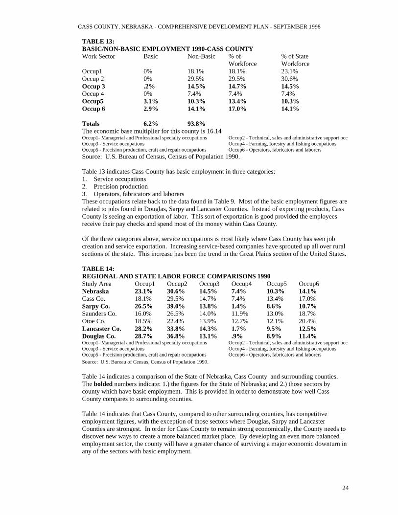
Table 12 examines agricultural indicators including: 1. Number of Farms 2. Land in farms (acres) 3. Average size of Farms (acres) 4. Percent of crop area vs harvested crop land (acres) 5. Estimated market value of land and buildings Each data category is examined for the Agricultural Census of 1969, 1978, 1987 and 1992. From 1969 to 1992, Cass County lost a total of 246 farms for a change of -22.7%. However, the same time period saw a change in acres of farmland of -9.2%. While the prior two categories were decreasing, the average size of farms increased by 11.0 acres or a change of 36.9%. These changes in Cass County were typical of agriculture statewide. The trend has been for fewer farmers farming more acres. The decrease in farmland was most likely caused by the increasing population, and land areas of the incorporated communities throughout Cass County. From 1969 to 1992, the total cropland in Cass County decreased from 270,062 acres to 257,741 acres, a change of -4.6%. While total cropland was decreasing, the amount of harvested cropland increased from 178,527 in 1969 to 225,912 acres in 1992 a change of 26.5%. This indicates that less cropland exists but a larger percentage has been placed into production. The estimated market value of land and buildings indicates how well the land values and building values are performing compared to the CPI. From 1969 to 1992, the estimated market value grew from $102,958 to $257,741, a change of 150.3%. However, the same time period saw the CPI increase a total 285.9%. Therefore, the estimated market value of land and buildings did not grow as rapidly as the national economy. Table 12 also indicates the average estimated value per acre for farm land. These figures indicate that land values, on average, rose from $970 per acre to $1,233 per acre, a change of 27.1%. This value also grew at a rate less than the CPI. CASS COUNTY: REGIONAL BASIC/NON-BASIC ANALYSIS The following data look at six occupational areas that were established by the US Bureau of the Census. Basic employment and Non-Basic employment are defined by Edward J. Blakely in "Planning Local Economic Development: Theory and Practice" as follows: Basic employment= Associated with business activities that provide services primarily outside the area via sales of goods and services, but whose revenue is directed to the local area in the form of wages and payments to local suppliers. Non-Basic employment is primarily the sale of good and services within the local area with the revenues recirculating in the form of wages and payments. This analysis is used to further understand which occupational areas may be supplying goods and services outside the study area, thus importing dollars into the local economy. This analysis is performed for Cass County with a comparison to the surrounding entities. The six occupational areas are listed below: Occup1 Managerial and Professional specialty occupations Occup2 Technical, sales and administrative support occupations Occup3 Service occupations Occup4 Farming, forestry and fishing occupations Occup5 Precision production, craft and repair occupations Occup6 Operators, fabricators and laborers The bolded occupations in Table 13 indicate areas which are apparently basic as opposed to non-basic. The economic base multiplier designates the number of non-basic jobs created by every basic job in the area. The occupational groups are based on the percentage of people employed as compared to the total Workforce. The basic employment figures are the percentage points left over after subtracting the non-basic from the percent of State Workforce. If the study area is less than the State percentage, then the entire percentage for the study area is non-basic.
CASS COUNTY, NEBRASKA - COMPREHENSIVE DEVELOPMENT PLAN - SEPTEMBER 1998
24
TABLE 13: BASIC/NON-BASIC EMPLOYMENT 1990-CASS COUNTY Work Sector Basic Non-Basic % of % of State Workforce Workforce Occup1 0% 18.1% 18.1% 23.1% Occup 2 0% 29.5% 29.5% 30.6% Occup 3 .2% 14.5% 14.7% 14.5% Occup 4 0% 7.4% 7.4% 7.4% Occup5 3.1% 10.3% 13.4% 10.3% Occup 6 2.9% 14.1% 17.0% 14.1% Totals 6.2% 93.8% The economic base multiplier for this county is 16.14 Occup1- Managerial and Professional specialty occupations Occup2 - Technical, sales and administrative support occ Occup3 - Service occupations Occup4 - Farming, forestry and fishing occupations Occup5 - Precision production, craft and repair occupations Occup6 - Operators, fabricators and laborers Source: U.S. Bureau of Census, Census of Population 1990. Table 13 indicates Cass County has basic employment in three categories: 1. Service occupations 2. Precision production 3. Operators, fabricators and laborers These occupations relate back to the data found in Table 9. Most of the basic employment figures are related to jobs found in Douglas, Sarpy and Lancaster Counties. Instead of exporting products, Cass County is seeing an exportation of labor. This sort of exportation is good provided the employees receive their pay checks and spend most of the money within Cass County. Of the three categories above, service occupations is most likely where Cass County has seen job creation and service exportation. Increasing service-based companies have sprouted up all over rural sections of the state. This increase has been the trend in the Great Plains section of the United States. TABLE 14: REGIONAL AND STATE LABOR FORCE COMPARISONS 1990 Study Area Occup1 Occup2 Occup3 Occup4 Occup5 Occup6 Nebraska 23.1% 30.6% 14.5% 7.4% 10.3% 14.1% Cass Co. 18.1% 29.5% 14.7% 7.4% 13.4% 17.0% Sarpy Co. 26.5% 39.0% 13.8% 1.4% 8.6% 10.7% Saunders Co. 16.0% 26.5% 14.0% 11.9% 13.0% 18.7% Otoe Co. 18.5% 22.4% 13.9% 12.7% 12.1% 20.4% Lancaster Co. 28.2% 33.8% 14.3% 1.7% 9.5% 12.5% Douglas Co. 28.7% 36.8% 13.1% .9% 8.9% 11.4% Occup1- Managerial and Professional specialty occupations Occup2 - Technical, sales and administrative support occ Occup3 - Service occupations Occup4 - Farming, forestry and fishing occupations Occup5 - Precision production, craft and repair occupations Occup6 - Operators, fabricators and laborers Source: U.S. Bureau of Census, Census of Population 1990. Table 14 indicates a comparison of the State of Nebraska, Cass County and surrounding counties. The bolded numbers indicate: 1.) the figures for the State of Nebraska; and 2.) those sectors by county which have basic employment. This is provided in order to demonstrate how well Cass County compares to surrounding counties. Table 14 indicates that Cass County, compared to other surrounding counties, has competitive employment figures, with the exception of those sectors where Douglas, Sarpy and Lancaster Counties are strongest. In order for Cass County to remain strong economically, the County needs to discover new ways to create a more balanced market place. By developing an even more balanced employment sector, the county will have a greater chance of surviving a major economic downturn in any of the sectors with basic employment.

CASS COUNTY, NEBRASKA - COMPREHENSIVE DEVELOPMENT PLAN - SEPTEMBER 1998
25
SUMMARY Cass County has seen an increasing population base for several decades. This growing population has been primarily driven by growth in Douglas, Sarpy and Lancaster Counties. During the period 1960 to 1994, Cass County has seen positive growth in births vs deaths, but has had varying levels of in-migration and out-migration. These population trends have been projected to continue through 2020. Housing in the County has seen some positive growth. However, the increases seen in the median value of owner-occupied units did not equal the increase in the nations CPI. Therefore, housing values increased but owners were not gaining at a pace similar to the national increase in the cost of living. The median contract rent potentially depleted renters cash flow even more than the national average. Family income in Cass County grew between 1980 and 1990. There were more families earning at the upper end of Table 6 in 1990 than in 1980. In addition, the median family income increased by 63.2% and exceeded the growth of the CPI (60.7%). Families began earning more than in prior years. In some cases, this increase in median family income was a result of more two income families, either by choice or by necessity. Besides earning more money, it appeared that employees were driving further, on average, to earn a living. As Cass County continues to grow, there will be a greater need for housing and job opportunities. However, most jobs will likely be located in Douglas, Sarpy and Lancaster Counties. Cass County will become more of a bedroom community to the Omaha-Lincoln metropolitan areas while maintaining its agricultural dependence. COMMUNITY FACILITIES: EXISTING AND FUTURE NEEDS COMMUNITY FACILITIES:EXISTING AND FUTURE NEEDS State and local governments provide many goods and services for their citizens. The people, buildings, equipment and land used by the county in the process of providing these goods and services, are referred to as public facilities. Public facilities represent a wide range of buildings, utilities and services that are built and maintained by many government agencies. Such facilities are provided to insure the safety, well being and enjoyment of the residents of Cass County. These facilities and services provide the County residents with social, cultural, educational, law enforcement, fire protection and recreational opportunities designed to meet area needs. A county must anticipate the future demand for their goods and services if it is to remain strong and vital. The sequential step is to evaluate the ability of the county to meet that future demand and determine at what level services will be provided. The analysis of existing facilities, and of future goods and services, is known as the Facilities Plan. The Facilities section of the Cass County Comprehensive Plan will determine present capacities of all public facilities and services, evaluate the capacities with current demands and accepted standards to determine whether the capacity is adequate, determine future adequacy of these facilities and services to meet future demands within the planning period, and recommend improvements where public facilities are not considered adequate for present or future needs. The Facilities Plan for Cass County is divided into the following categories: 1. Recreational Facilities 2. Educational Facilities 3. Fire and Police Protection 4. County/Community Buildings 5. Transportation 6. Communication Facilities 7. Public Utilities 8. Health Facilities
CASS COUNTY, NEBRASKA - COMPREHENSIVE DEVELOPMENT PLAN - SEPTEMBER 1998
26
RECREATIONAL FACILITIES STATE PARKS & RECREATION AREAS There are a variety of recreational areas located throughout Cass County. These areas specifically include Mahoney State Park, located immediately off Interstate 80 in extreme northwestern Cass County. This park features swimming, water slides, hiking, horse-back riding, nature trails, skiing, tobogganing, fishing, a restaurant, cabins, a theater, playground equipment, bathhouses and camping equipped with pads, electrical hook-ups, water fill and waste dump facilities and bathhouses. The following recreational facilities are located on the map in Figure 3. The Louisville State Recreation Area, located in north central Cass County, features swimming, fishing and camping equipped with pads, electrical hook-ups, water fill and waste dump facilities and bathhouses. The facility is operated and owned by the Nebraska Game and Parks Commission. The total area of the facility is 193.63 acres (1.26 acres are located within Sarpy County, Nebraksa). The area is made up of 50 acres of water and 143.63 acres of land. The Platte River State Park, located in northwest Cass County features swimming, hiking, horseback riding, nature trails, restroom facilities, a restaurant and cabins. The facility is owned and operated by the Nebraska Game and Parks Commission. The total area of the facility is 417.73 acres. The area is made up of 5.0 acres of water and 412.73 acres of land. The Eugene T. Mahoney State Park is located in the northwest corner of Cass County, along Interstate 80 and the Platte River. The facilities available at Mahoney State Park include: Recreational Vehicle Camping, tent camping, picnic shelters, horseback riding, a swimming pool, dining and lodging. Also included is an observation tower, theater, toboggan run and playground. Mahoney State Park contains a total of 675.65 acres. This area is divided into 15.8 acres of water and 659.85 acres of land. Cedar Creek Island is a Nebraska Game and Parks Commission property which is used as a Wildlife Management Area (WMA). At present, this WMA exist solely on paper. The island was originally in the Platte River and no longer exists. The area is located in north central Cass County. The WMA contained 4.40 acres of property. All of the acreage is land. Rakes Creek is located 3 miles west and 2 miles north of Murray in eastern Cass County. The area is a Nebraska Game and Parks Commission WMA covering 316.0 acres, but containing no water. Randall Schilling Wildlife Management Area is located northeast of Plattsmouth along the Missouri River. This WMA contains a total of 1,309.6 acres, with 29 acres in water and 1,280.6 acres in land. Rhoden WMA is located 1-mile north and 1 mile east of Plattsmouth. The WMA borders Randall Schilling WMA on the south and the Missouri River along the east. The WMA contains 48.0 acres consisting entirely of land. NRD Dame Site Recreational Area is proposed for an area adjacent to Elmwood and extending to the northeast. The official project is designated by the name 7-g Recreational Area. The project is being developed by the Lower Platte South Natural Resources District. The facility, when completed, will contain: 1. Picnic areas with shelters, restrooms and playgrounds 2. Fishing 3. A trailhead for the MO-PAC Trail 4. Boating with ramps 5. Horse trails and fishing trail 6. Fishing habitat 7. Primitive campground, including pads for recreational vehicles

CASS COUNTY, NEBRASKA - COMPREHENSIVE DEVELOPMENT PLAN - SEPTEMBER 1998
27
PRIVATE RECREATIONAL FACILITIES The Strategic Air Command (SAC) Museum is located in the northwest corner of Cass County, next to the Eugene T. Mahoney State Park. The facility is home to 33 aircraft and 6 missiles dating back to the Cold War era. This collection is contained within a 300,000 square foot facility. Besides the display, the museum has a state-of-the-art children's gallery, a restoration gallery with a large viewing area, a 200-seat theater, glass atrium, a Museum store and snack bar. The facility opened on April 1, 1998. Henry Doorly Zoo Wildlife Safari Park is locates east of the Interstate 80/Mahoney Interchange. The facility is owned and operated by Henry Doorly Zoo in Omaha. The Safari Park opened in May 1998. The Safari Park is a 360-acre nature center in the Platte River hill country containing North American plants and animals. Throughout Safari Park, visitors have the opportunity to be face-to-face with elk, white-tailed deer, bison, pronghorn antelope and waterfowl. Included in the Safari Park are a Visitors Center, interpretive nature exhibits, small plant and animal displays, a gift shop, restrooms, concession area and a small convenience store. The Safari Park is divided approximately in half, with one half being used for conservation and breeding purposes for rare and endangered wildlife. The other half is being developed into gardens, prairies and wetlands for the animals. A large wetland area will be the home to pelicans, herons and many other species of waterfowl. The Park's roadways and foot trails allow visitors to experience different aspects of the area. TABLE 15 PARKS AND RECREATION AREAS - CASS COUNTY The data contained in Table 15 are for seven known Nebraska Game and Parks Commission facilities: Recreational Facility Land Area (acres) Water Area (acres) Total Area (acres) Louisville State Recreational Area 142.37 50.00 192.37 Platte River State Park 412.73 5.00 417.73 Eugene T. Mahoney State Park 659.85 15.80 675.65 Cedar Creek Island 4.40 0.00 4.40 Rakes Creek 316.00 0.00 316.00 Randall Schilling Wildlife Management Area 1,280.60 29.00 1,309.6 Rhoden Wildlife Management Area 48.00 0.00 48.00 Total of Recreational Uses 2,863.95 99.80 2,963.75 Desired acres by Nebraska Parks Standards 898.56 Surplus or (deficiency) of Recommended area 2065.19 Source: Nebraska Game and Parks and various other sources Quarry Oaks Golf Course is an 18-hole Championship course. The course includes a Par-3 hole at number 15 which is over an old quarry. The back nine holes are located along a ridge overlooking the Platte River. The course also includes a clubhouse with dining facilities for 150 persons. The course is located east of the Interstate/Mahoney Park exit. Bay Hills Golf Course at Buccaneer Bay is located north and west of Plattsmouth in the Buccaneer Bay Subdivision. The course is an 18-hole Championship course. The course has a full service Pro Shop with professional instruction available. Plattsmouth Country Club is an 18-hole course situated on rolling hills. The course is semi-private and is located off U.S. Highway 75, north of Plattsmouth. Grandpa's Woods Golf Course is a 9-hole executive course. The course has a clubhouse with meeting rooms available. The course contains meandering creeks and numerous trees and traps. The course is located on Nebraska State Highway 1, North of Elmwood.

CASS COUNTY, NEBRASKA - COMPREHENSIVE DEVELOPMENT PLAN - SEPTEMBER 1998
28
Ashland Country Club is located three miles south of Ashland along U.S. Highway 6. The course is a 9-hole grass green course and contains approximately 100 acres. The Country Club is open to the public. In addition to golf, the Ashland Country Club offers tennis courts and an Olympic size swimming pool. Other Golf Courses were being constructed at the time of the planning process. There are currently two 9-hole courses under construction. The location of these new courses is off U.S. Highway 75 near Murray. Trails Located in southwestern Cass County is the MO-PAC trail extending on the abandoned Missouri Pacific Rail Line from Lincoln to just past the Village of Wabash. Future plans for this trail include connecting it to the Omaha trail system (Wabash to Springfield Trail, approximately 18.8 miles). This would be accomplished by connecting to an old Rock Island Railroad bridge across the Platte River near South Bend. Both the MO-PAC Trail and the Omaha Trail System would connect at this bridge. The Nebraska Trails Plan Called "A Network of Discovery, A Comprehensive Trails Plan for the State of Nebraska" was completed in July 1994. This Trails Plan identifies future trails within Cass County. These trails will either pass through Cass County or will connect different aspects of Cass County together, or to other parts of Nebraska. Besides the MO-PAC Trail the following trails have been identified for the future: 1. Ashland to Louisville via Mahoney and Platte River State Parks - This would be a multi-use trail
using Nebraska State Highway 66 and East Park Highway rights-of-way to tie the parks to neighboring communities. This trail would total 14.8 miles
2. U.S. 75 Platte Ricer to Nebraska City - This would be a multi-use trail connecting Nebraska City with the Papio Trail System. The intent would be to incorporate the trail design into the design of the future expressway. This trail would total 25.0 miles.
3. Missouri River Trail, Blair to Nebraska City - This would be a multi-use trail with greenways. The trail system has been worked into and is consistent with the U.S. Army Corps of Engineers Corridor Plan. This trail would total 64.8 miles.
4. Nebraska State Highway 50, Louisville to Syracuse - This would be a trail connecting the two communities primarily using shoulders along Nebraska State Highway 50. This trail would total 26.0 miles.
5. U.S. Highway 6 and Nebraska State Highway 31, Lincoln to Elkhorn - This trail would pass through Cass County on U.S. Highway 6 and would primarily use the shoulders of the highway. This trail would total 52.0 miles.
EDUCATIONAL FACILITIES Public Schools The residents of Cass County are served by seven county based public school districts based outside the county. The school districts based within Cass County include: 1. Plattsmouth, District 1 2. Stull, District 22 3. Louisville, District 32 4. Conestoga, District 56 5. Manley, District 96 6. Elmwood-Murdock, District 97 The school districts which are based outside Cass County but serve a portion of the Cass County population are: 1. Saunders County (Ashland-Greenwood), District 01 2. Otoe County (Nebraska City), District 111 3. Otoe County (Syracuse), District 027 4. Lancaster County (Waverly), District 145

CASS COUNTY, NEBRASKA - COMPREHENSIVE DEVELOPMENT PLAN - SEPTEMBER 1998
29
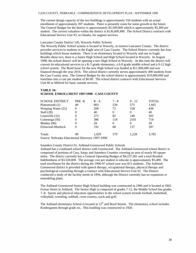
The seven Cass County based school districts serve a total 3,785 students. Of this total 1,228 students were in grades 9-12; 579 students were in grades 7-8; 1,929 were in grades K-6; and 49 students were in Pre-Kindergarten. The district with the largest student census was Plattsmouth, a total of 1,665 students. The district with the smallest student population was Manley which is strictly a K-6 facility, the enrollment was 28 students. Besides Manley there was one additional K-6 school district, Stull, with a student population of 40 students. The following review examines the nine school districts serving students in grades K through 12: Plattsmouth Public Schools Plattsmouth Public Schools operates three elementary facilities and one Junior/Senior High School facility. The 1997-98 General Budget was $8,791,360.00 which translated to a cost of $5,244.51 per student. The district presently has a bonded indebtedness of $19,275,000. The district recently opened a new High School facility. In addition, a complete remodel of the old High School was completed in order to convert this facility to a Middle School. Finally, these projects included an addition to the old High School which houses a new Elementary School. The enrollment was 1,665 students for all grades Pre-Kindergarten to 12th grade. The School District has a current valuation of $225,433,059 within its boundaries. The School District contracts for support services from Educational Service #3 in Omaha. Weeping Water Public Schools Weeping Water Public Schools operate one facility for K through 12th grade. The present year General Budget is $2,528,407 which is approximately $5,293 per student. The district expanded the facility in 1990. However, the district has seen larger than anticipated growth within its boundaries and has already seen the facility reach its capacity. The facility has a design capacity of 400 students, while the current enrollment is approximately 438 students. The School District is presently making use of modulars in order to handle the additional students. The current valuation for the school district is $108,665,386. The School District contracts for support through Educational Service Unit #3 in Omaha. Louisville Public Schools The Louisville Public Schools operate one facility which houses students k through 12th grade. The current General Budget is $2,370 ,872 which is approximately $4997 per student. The facility is presently above the design capacity of 500 students with an enrollment of 502 students. The School District placed a bond issue on the ballot March 10, 1998, which passed. The bond will provide $4,900,000 of a total $4,100,000 addition and renovation project. The current valuation of the district is $179,357,859. The School District contracts with Educational Service Unit #3 in Omaha for support services. Conestoga Public Schools The Conestoga Public Schools is a consolidated school system with three facilities, including; a k through 3rd grade in Murray, a 4th through 6th grade facility in Nehawka and a Junior/Senior High School in Murray. The k-3 facility has a design capacity of approximately 175 students and an enrollment of 203 students (this facility is currently using modulars to accommodate this enrollment). The 4-6 facility in Nehawka has a design capacity of 175 students and an enrollment of 186 students (this facility is also utilizing modulars to accommodate this enrollment). The Junior/Senior High School has a design capacity of between 300-350 students, the present enrollment is 335 students (this facility is also utilizing modulars to lessen crowding). The General Budget for the district is $3,876,350 or approximately $5,108 per student. The district has a valuation of $218,837,224 within the boundaries of the School District. The School District contracts with Educational Service Unit #3 in Omaha for support services. Elmwood-Murdock Public Schools The Elmwood-Murdock Public School system is a consolidation of two former school districts, Elmwood and Murdock. The School District has 2 buildings which house students. The first is a K through 6 facility located in Elmwood and the second is a 7 through 12 facility located in Murdock.
CASS COUNTY, NEBRASKA - COMPREHENSIVE DEVELOPMENT PLAN - SEPTEMBER 1998
30
The current design capacity of the two buildings is approximately 550 students with an actual enrollment of approximately 397 students. There is presently room for some growth in the future. The General Budget for the district is approximately $2,500,000 which is approximately $5,300 per student. The current valuation within the district is $136,600,490. The School District contracts with Educational Service Unit #3, in Omaha, for support services. Lancaster County District 145, Waverly Public Schools The Waverly Public School system is located in Waverly, in eastern Lancaster County. The district provides services to students in the Eagle area of Cass County. The School District currently has four buildings which house students. There is an elementary located in Waverly and one in Eagle. Besides these two, there is a Junior High School and High School located in Waverly. In August 1998, the school district will be opening a new High School in Waverly. At this time the district will convert its educational services to a K-5 grade elementary, a 6-8 grade middle school and a 9-12 high school system. The Bond Issue for the new High School was funded at $11,900,000 and was financed through the year 2016. The school district currently serves approximately 400 students from the Cass County area. The General Budget for the school district is approximately $10,000,000 and translates into a cost per student of $0.00. The school district contracts with Educational Services Unit #6 in Milford for basic outside services. TABLE 16: SCHOOL ENROLLMENT 1997/1998 - CASS COUNTY SCHOOL DISTRICT PRE -K K - 6 7 - 8 9 - 12 TOTAL Plattsmouth (1) 49 803 239 575 1.665 Weeping Water (22) 0 208 72 158 438 Stull (28) 0 40 0 0 40 Louisville (32) 0 272 82 148 502 Conestoga (56) 0 386 118 2101 714 Manley (96) 0 28 0 0 28 Elmwood-Murdock 0 192 68 137 397 Totals 49 1,929 579 1,228 3,785 Source: Nebraska Educational Directory 1997-1998 Saunders County District 01, Ashland-Greenwood Public Schools Ashland has a combined school district with Greenwood. The Ashland-Greenwood school district is comprised of portions of Cass, Sarpy and Saunders Counties covering an area of nearly 60 square miles. The district currently has a General Operating Budget of $4,237,581 and a total Bonded Indebtedness of $3,530,000. The average cost per student to educate is approximately $5,400. The total enrollment for the district during the 1996-97 school year was 815 students. The Ashland-Greenwood district is provided with speech therapy, occupational therapy, physical therapy and psychological counseling through a contract with Educational Service Unit #2. The District conducted a study of the facility needs in 1994, although the District currently has no expansion or remodeling plans. The Ashland-Greenwood Senior High School building was constructed in 1966 and is located at 1842 Furnas Street in Ashland. The Senior High is composed of grades 7-12, the Middle School has grades 7 -8. Sports and physical education opportunities in the school system include football, basketball, volleyball, wrestling, softball, cross country, track and golf. The Ashland elementary School is located at 12th and Boyd Streets. The elementary school includes Kindergarten through grade six. This building was constructed in 1920.

CASS COUNTY, NEBRASKA - COMPREHENSIVE DEVELOPMENT PLAN - SEPTEMBER 1998
31
Otoe County District 027, Syracuse Public Schools The Syracuse Public School system is located in Syracuse in northern Otoe County. The district provides services to students in south central Cass County. The School District currently has 2 buildings which house students. There is an Elementary/Middle School located in Syracuse built in the 1930's. In addition, there is a Senior High School located in Syracuse, constructed in 1966, with an addition completed in 1997. The school district currently serves approximately 645 students. The General Budget for the school district is $3,761,820 and translates into a cost per student of $5,526.00. The district currently has Bonded Indebtedness of $2,140,000. The present Assessed Valuation of the school district is approximately $221,376,000. The school district contracts with Educational Services Unit #4 in Auburn for basic outside services. Otoe County, District 111, Nebraska City Public Schools The Nebraska City Public School system is located in east central Otoe County. The district provides services to students in the southeastern portion of Cass County. The School District currently has 5 buildings which house students. There are three Elementary Schools, including on facility dedicated to Kindergarten only. In addition, there is a Senior High School and a Middle School located in Nebraska City. The school district currently serves approximately 1,460 students. The General Budget for the school district is $7,022,939 and translates into a cost per student of $4,877.91. The district currently has Bonded Indebtedness of $7,095,000, due to a recently completed Middle School and addition to the Senior High School. The present Assessed Valuation of the school district is approximately $338,229,000. The school district contracts with Educational Services Unit #4 in Auburn for basic outside services, plus, audiology, payroll and other disbursements. POST-SECONDARY SCHOOLS Post-secondary school is close proximity to the residents of Cass County include: 1. University of Nebraska at Lincoln 2. University of Nebraska at Omaha 3. Bellevue University 4. Southeast Community College (Lincoln) 5. College of St. Mary's (Omaha) 6. Nebraska Wesleyan University (Lincoln) 7. Union College (Lincoln) 8. Peru State College (Peru) 9. Creighton University (Omaha) 10. Metropolitan Community College (Omaha) The Post-secondary schools available to Cass County residents are excellent. Depending upon a persons location within Cass County, most of these facilities are in commuting range. Besides the institutions listed above, there are a number of Vocational Schools located in the Omaha and Lincoln Metropolitan areas. These facilities will specialize in areas like business, computers etc. FIRE AND POLICE PROTECTION Fire Departments Fire Protection in Cass County is provided by twelve fire districts. All fire departments in Cass County are served by volunteer firefighters. Each district provides regular training for firefighters and are continuing to add certified Emergency Medical Technicians personnel as needed. Fire Districts serving Cass County include the Ashland Rural Fire Protection District, Greenwood Rural Fire Protection District, Ealge-Alvo Rural Fire Protection District, Elmwood Rural Fire Protection District, Murdock Rural Fire Protection District, Louisville Rural Fire Protection District, Weeping Water Rural Fire Protection District, Avoca Rural Fire Protection District, Nehawka Rural Fire Protection District, Murray Rural Fire Protection District, Plattsmouth Rural Fire Protection District and the Union Rural Fire Protection District. Figure 4 illustrates the coverage of the eight rural fire districts serving Cass County, while Table 17 gives the amount of property tax valuation for each district.
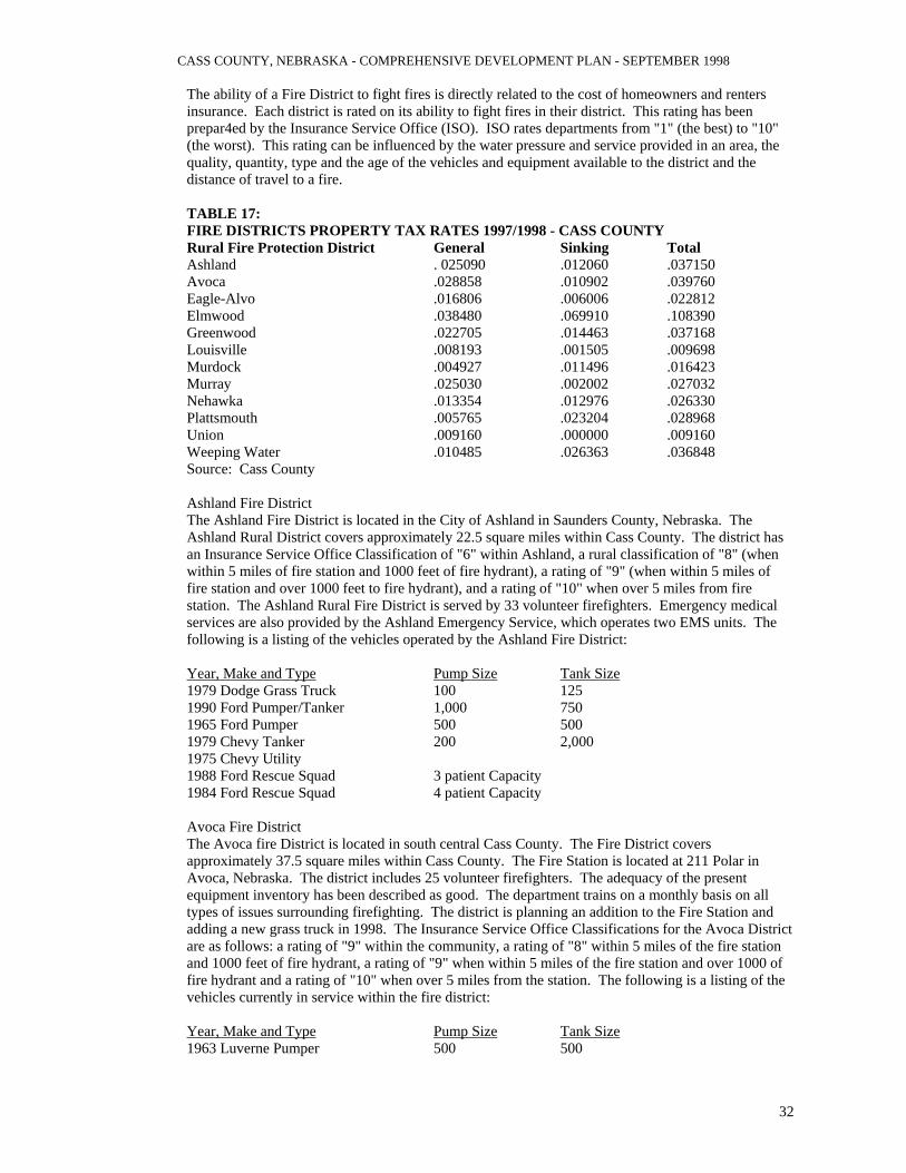
CASS COUNTY, NEBRASKA - COMPREHENSIVE DEVELOPMENT PLAN - SEPTEMBER 1998
32
The ability of a Fire District to fight fires is directly related to the cost of homeowners and renters insurance. Each district is rated on its ability to fight fires in their district. This rating has been prepar4ed by the Insurance Service Office (ISO). ISO rates departments from "1" (the best) to "10" (the worst). This rating can be influenced by the water pressure and service provided in an area, the quality, quantity, type and the age of the vehicles and equipment available to the district and the distance of travel to a fire. TABLE 17: FIRE DISTRICTS PROPERTY TAX RATES 1997/1998 - CASS COUNTY Rural Fire Protection District General Sinking Total Ashland . 025090 .012060 .037150 Avoca .028858 .010902 .039760 Eagle-Alvo .016806 .006006 .022812 Elmwood .038480 .069910 .108390 Greenwood .022705 .014463 .037168 Louisville .008193 .001505 .009698 Murdock .004927 .011496 .016423 Murray .025030 .002002 .027032 Nehawka .013354 .012976 .026330 Plattsmouth .005765 .023204 .028968 Union .009160 .000000 .009160 Weeping Water .010485 .026363 .036848 Source: Cass County Ashland Fire District The Ashland Fire District is located in the City of Ashland in Saunders County, Nebraska. The Ashland Rural District covers approximately 22.5 square miles within Cass County. The district has an Insurance Service Office Classification of "6" within Ashland, a rural classification of "8" (when within 5 miles of fire station and 1000 feet of fire hydrant), a rating of "9" (when within 5 miles of fire station and over 1000 feet to fire hydrant), and a rating of "10" when over 5 miles from fire station. The Ashland Rural Fire District is served by 33 volunteer firefighters. Emergency medical services are also provided by the Ashland Emergency Service, which operates two EMS units. The following is a listing of the vehicles operated by the Ashland Fire District: Year, Make and Type Pump Size Tank Size1979 Dodge Grass Truck 100 125 1990 Ford Pumper/Tanker 1,000 750 1965 Ford Pumper 500 500 1979 Chevy Tanker 200 2,000 1975 Chevy Utility 1988 Ford Rescue Squad 3 patient Capacity 1984 Ford Rescue Squad 4 patient Capacity Avoca Fire District The Avoca fire District is located in south central Cass County. The Fire District covers approximately 37.5 square miles within Cass County. The Fire Station is located at 211 Polar in Avoca, Nebraska. The district includes 25 volunteer firefighters. The adequacy of the present equipment inventory has been described as good. The department trains on a monthly basis on all types of issues surrounding firefighting. The district is planning an addition to the Fire Station and adding a new grass truck in 1998. The Insurance Service Office Classifications for the Avoca District are as follows: a rating of "9" within the community, a rating of "8" within 5 miles of the fire station and 1000 feet of fire hydrant, a rating of "9" when within 5 miles of the fire station and over 1000 of fire hydrant and a rating of "10" when over 5 miles from the station. The following is a listing of the vehicles currently in service within the fire district: Year, Make and Type Pump Size Tank Size1963 Luverne Pumper 500 500
CASS COUNTY, NEBRASKA - COMPREHENSIVE DEVELOPMENT PLAN - SEPTEMBER 1998
33
1984 Pierce Pumper/Tanker 750 1,000 1965 Ford Tanker 1,500 Eagle-Alvo Fire District The Eagle-Alvo Fire District covers the southwest corner of Cass County. The Fire District contains approximately 49 square miles of the County. The department has two stations, one at Eagle and one at Alvo. Between the two stations there are a total of 35 firefighters and 19 Emergency Medical Technicians (EMT'S). The Eagle Fire Station was completed in 1989. The Insurance Service Office Classification for Eagle-Alvo is a "7" within Eagle and a "9" within Alvo. The rating for within 5 miles and less than 1,000 feet from a hydrant is a "9" and a "9" within 5 miles and over 1,000 feet to a fire hydrant. The rating for service over 5 miles was rated a "10". The overall adequacy of the vehicles and equipment was described as good. The department trains on a monthly basis on all types of issues related to firefighting. The following list contains the vehicles owned by the Eagle-alvo Fire District: Year, Make and Type Pump Size Tank Size1992 Chevy Grass Truck 125 1992 Ford Pumper 750 750 1992 Ford Tanker 250 1,000 1992 IHC Pumper/Tanker 1,000 3,000 1997 Pumper 1,250 100 1996 Ford Rescue Squad 2 patient Capacity 1986 Ford Rescue Squad 4 patient Capacity 1963 Ford Pumper (Alvo) 500 300 1964 Ford Tanker (Alvo) 500 1,000 1973 Rescue Squad (Alvo) 2 patient Capacity 1979 Type III (Alvo) 3 patient Capacity Elmwood Fire District The Elmwood Fire District is located along the southern edge of Cass County. The Fire District covers approximately 43 square miles of Cass County. The district has 25 volunteer firefighters and 15 EMT'S. The Fire Station is located at 108 South 4th in Elmwood. The building was constructed in 1972 and the district has a new building under construction. The overall adequacy of the vehicles and equipment was described as very good. The department does hold monthly training sessions. The Insurance Service Office Classification for Elmwood is an "8" within the municipality. Outside the municipality and within 5 miles of the fire station the ratings are "8" within 1,000 feet of a fire hydrant and "9" over 1,000 feet to a fire hydrant. The rating for over 5 miles is a "10". The following is a listing of the vehicles used by the fire district: Year, Make and Type Pump Size Tank Size1977 Ford Grass Truck 150 200 1991 GMC Pumper/Tanker 1,000 900 1972 Chevy Pumper 500 500 1980 Ford Tanker 1,600 1952 Studebaker Tanker 1,500 1948 Ford Pumper 400 500 1989 Ford Rescue Squad 2 patient Capacity Greenwood Fire District The Greenwood Fire District is located along the west edge of Cass County. The Fire District covers approximately 38.5 square miles of Cass County. The Fire Station is located in Greenwood. The department consists of 22 volunteer firefighters. The Insurance Service Office Classification for the Greenwood Fire District is a "8" rating within Greenwood, a rating of "8" within 5 miles and within 1,000 feet of a fire hydrant, a rating of "9" within 5 miles and over 1,000 to a fire hydrant and a rating of "10" for over 5 miles. The following is a listing of the vehicles in service at the present time:
CASS COUNTY, NEBRASKA - COMPREHENSIVE DEVELOPMENT PLAN - SEPTEMBER 1998
34
Year, Make and Type Pump Size Tank Size 1964 IHC Pumper/Tanker 750 800 1979 Ford Tanker 350 1,000 1978 Ford Tanker 350 1,200 1983 Chevy Utility Truck 1984 Ford Rescue Squad 2 patient Capacity 1983 Ford Rescue Squad 2 patient Capacity Lousiville Fire District The Louisville Fire District is located along the north central edge of Cass County. The Fire District covers approximately 58 square miles within Cass County. This area also includes the area of Cedar Creek. Presently, there is a fire station located in Cedar Creek. The Fire Station is located in the downtown area of Louisville and was completed in 1997. The department is made up of 26 volunteer firefighters. The Insurance Service Office Classification rated the municipal service a "7". The areas within 5 miles were rated an "8" with fire hydrants within 1,000 feet and a "9" with fire hydrants over 1,000 feet. The rating for over 5 miles was a "10". The following is a listing of vehicles owned and operated by the Fire District in 1998: Year, Make and Type Pump Size Tank Size 1987 Ford Grass Truck 150 260 1977 Chevy Pumper 750 750 1991 Chevy Pumper 1,000 750 1998GMC Tanker 150 1,600 1968 Ford Tanker 150 1,000 1996 Chevy Grass Truck 150 250 1979 Chevy Rescue Squad 4 patient Capacity 1996 Chevy Rescue Squad 4 patient Capacity 1978 Dodge Grass Truck (Cedar Creek) 150 150 1968 Dodge Pumper (Cedar Creek) 500 750 1971 Ford Tanker (Cedar Creek) 250 1,200 Murdock Fire District The Murdock Fire District is located in the approximate center of Cass County. The Fire District covers approximately 55.5 square miles of area within Cass County. The district has 25 firefighters and no EMT'S. The fire Station is located at 315 Nebraska Street in Murdock. There appears to be a need for a bigger facility to accommodate the vehicles and equipment presently used by the district. The department does conduct monthly training exercises. The vehicles and equipment were described in top-notch condition. The Insurance Service Office Classification system has rated service in Murdock as a "9". The areas up to 5 miles away have been rated a "9" with fire hydrants within 1,000 feet and a "9" with fire hydrants over 1,000 feet away. All service outside of 5 miles has been rated a "10". The following is a listing of vehicles currently owned and operated by the district: Year, Make and Type Pump Size Tank Size 1974 Ford Pumper 750 500 1976 Chevy Tanker 250 2,000 1983 Chevy Grass Truck 250 300 1956 IHC Tanker 250 1,700 1997 Pumper 1,000 900 1978 Chevy Equip. Can and Portable Cascade Murray Fire District The Murray Fire District is located along the central east side of Cass County. The Fire District contains approximately 63 square miles of area within Cass County, including the Beaver Lake Subdivision. The Fire Station is located in Murray. The Fire District has 34 volunteer firefighters. The Insurance Service Office Classification system rates service within Murray as a "7". The service area outside of Murray but within 5 miles is rated as a "7" (with fire hydrants within 1,000 feet) and a

CASS COUNTY, NEBRASKA - COMPREHENSIVE DEVELOPMENT PLAN - SEPTEMBER 1998
35
"9" (with fire hydrants over 1,000 feet away). Beyond 5 miles the rating decreases to a "10". The following is a listing of the vehicles owned and operated by the Murray Fire District: Year, Make and Type Pump Size Tank Size1978 GMC Grass Truck 100 250 1963 Dodge Pumper 500 500 1984 Chevy Pumper/Tanker 750 1,000 1968 Chevy Tanker 200 1,000 1980 Chevy Suburban 1977 Ford Utility 1991 Ford Rescue Squad 2 patient Capacity 1981 Ford Rescue Squad 2 patient Capacity Nehawka Fire District The Nehawka Fire District is located near the southeast corner of Cass County. The Fire District covers approximately 41.5 square miles within Cass County. The Fire Station is located at 102 Main Street in Nehawka. The Firehouse was completed around 1968 with a Community Building completed in 1978. The Fire District conducts training sessions approximately three times a year. There is a desire to construct a new Firehouse in the near future for the District. The Fire District is served by 17 volunteer firefighters and 7 EMT'S. The Insurance Service Office Classification system rated service within Nehawka as a "9". Areas up to 5 miles were rated as a "9" (with fire hydrant within 1,000 feet) and a "9" (with fire hydrants over 1,000 feet). Other areas outside of 5 miles were rated a "10". The following is a listing of the vehicles currently owned and operated by the Nehawka Fire District: Year, Make and Type Pump Size Tank Size1973 Chevy Pumper 1,000 1989 Chevy Tanker 1,000 1984 Chevy Tanker 1,000 1978 Ford Van Utility Truck 1989 Ford Rescue Squad 1978 Ford Rescue Squad 2 patient Capacity Plattsmouth Fire District The Plattsmouth Fire District is located at the northeast corner of Cass County. The Fire Station is located at 127 N 5th Street in Plattsmouth. The facility was constructed in 1969 with a rural station constructed in 1993. Presently the facilities are full and have no open bays for additional equipment. The Fire District has 39 volunteer firefighters and 25 EMT'S. These firefighters and EMT'S cover approximately 60 square miles of area within Cass County. The Fire District conducts training on several occasions during a month. Future plans include the purchase of a new pumper in 1998 and possibly a new tanker in 1998. The Fire District is connected to Sarpy County agencies on an 800 MHZ system and to Iowa Mutual Aid. The Insurance Service Office Classification system rates service within Plattsmouth as a "6". The ratings outside the city and within 5 miles are "7" (with fire hydrants within 1,000 feet) and a "9" with fire hydrants over 1,000 feet. The rate for outside 5 miles is a "10". The following is a listing of the vehicles presently owned and operated by the Plattsmouth Fire District: Year, Make and Type Pump Size Tank Size1992 Dodge Grass Truck 125 225 1983 Pierce Pumper 1,000 500 1964 IHC Pumper 750 500 1989 Ford Pumper 1,000 750 1979 Chevy Tanker 350 1,250 1993 Smeal 105' Aerial 1,500 150 1996 FL70 Heavy Rescue 1984 Ford Command Vehicle Trevor 40 Mercury 1 16ft Rescue Boat with 3 water rescue packs

CASS COUNTY, NEBRASKA - COMPREHENSIVE DEVELOPMENT PLAN - SEPTEMBER 1998
36
1995 Ford Rescue Squad 2 patient Capacity 1991 Ford Rescue Squad 2 patient Capacity 1990 Chevy Rescue Squad 1 patient Capacity Union Fire District The Union Fire District is located on the southeast corner of Cass County. The fire District covers approximately 30 square miles within Cass County. The district has 31 volunteer firefighters and no EMT'S. The Fire Station is located in Union. The Insurance Service Office Classification for the Union Fire District is an "8" within Union. The areas outside Union and within 5 miles are rated as "10" with fire hydrants within 1,000 feet and a "10" with fire hydrants over 1,000 feet. Plus, the areas outside 5 miles are rated a "10". The following is a listing of the vehicles presently owned and operated by the Union Fire District: Year, Make and Type Pump Size Tank Size1952 Dodge Grass Truck 50 200 1978 Chevy Pumper 500 900 1953 IHC Pumper 300 300 1985 Chevy Tanker 120 1,600 1952 GMC 6X6 Tanker 120 1,200 Chevy Tanker 750 1975 Chevy Rescue Squad 4 patient Capacity 1983 Ford Rescue Squad 4 patient Capacity Weeping Water Fire District The Weeping Water Fire District is located near the exact center of Cass County. The Fire District covers approximately 55.5 square miles of Cass County. The Fire District has 47 volunteer firefighters and 20 EMT'S. The Fire Station is located in Weeping Water with a small station located in Manley. The Insurance Service Office Classification system rates service within Weeping Water as a "6" and within Manley a "9". The areas outside Weeping Water and within 5 miles were rated a "6" (with fire hydrants within 1,000 feet) and a "9" (with fire hydrants over 1,000 feet). The area beyond 5 miles was rated as a "10". The following is a listing of vehicles owned and operated by the Weeping Water Fire District: Year, Make and Type Pump Size Tank Size1947 Ford Pumper 500 300 1989 Chevy Pumper/Tanker 750 1,000 1976 Chevy Pumper 750 500 1970 Chevy Tanker 120 1,100 1954 GMC 6X6 Tanker 120 1,500 1975 Chevy Tanker 250 1,500 1979 Ford Utility Van 1990 Ford Rescue Squad 2 patient Capacity 1989 Ford Rescue Squad 2 patient Capacity Law Enforcement The Sheriff's Office and Jail are situated immediately adjacent to the County Courthouse. The Sheriff's Office and Jail are in desperate need of additional space and update at that location due to the increase in the size of the agency and increase in overall law enforcement activity and age of the present facility. Future plans include the construction of a Law Enforcement Center which will house the Sheriff's Office and Jail, Plattsmouth Police Department and 911 Communications. The Sheriff's Office staffing consists of the Sheriff, one Chief Deputy, one Lieutenant, Three Sergeants, thirteen full-time Deputies, three part-time Deputies, one Corrections Supervisor, four full-time Corrections Officers, one part-time Corrections Officer, two clerical positions, one Communications Supervisor and seven Dispatchers. The Sheriff's Office is responsible for county-wide law enforcement and is also under a law enforcement contract with five Municipalities in the
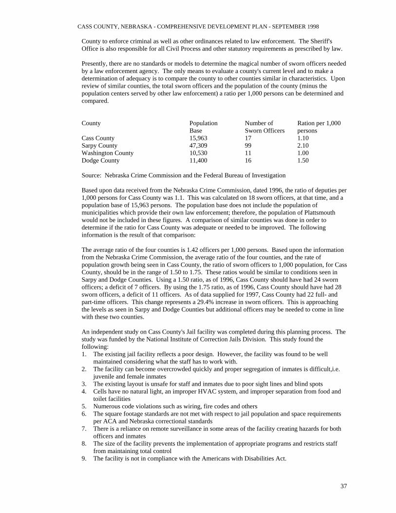
CASS COUNTY, NEBRASKA - COMPREHENSIVE DEVELOPMENT PLAN - SEPTEMBER 1998
37
County to enforce criminal as well as other ordinances related to law enforcement. The Sheriff's Office is also responsible for all Civil Process and other statutory requirements as prescribed by law. Presently, there are no standards or models to determine the magical number of sworn officers needed by a law enforcement agency. The only means to evaluate a county's current level and to make a determination of adequacy is to compare the county to other counties similar in characteristics. Upon review of similar counties, the total sworn officers and the population of the county (minus the population centers served by other law enforcement) a ratio per 1,000 persons can be determined and compared. County Population Number of Ration per 1,000 Base Sworn Officers persons Cass County 15,963 17 1.10 Sarpy County 47,309 99 2.10 Washington County 10,530 11 1.00 Dodge County 11,400 16 1.50 Source: Nebraska Crime Commission and the Federal Bureau of Investigation Based upon data received from the Nebraska Crime Commission, dated 1996, the ratio of deputies per 1,000 persons for Cass County was 1.1. This was calculated on 18 sworn officers, at that time, and a population base of 15,963 persons. The population base does not include the population of municipalities which provide their own law enforcement; therefore, the population of Plattsmouth would not be included in these figures. A comparison of similar counties was done in order to determine if the ratio for Cass County was adequate or needed to be improved. The following information is the result of that comparison: The average ratio of the four counties is 1.42 officers per 1,000 persons. Based upon the information from the Nebraska Crime Commission, the average ratio of the four counties, and the rate of population growth being seen in Cass County, the ratio of sworn officers to 1,000 population, for Cass County, should be in the range of 1.50 to 1.75. These ratios would be similar to conditions seen in Sarpy and Dodge Counties. Using a 1.50 ratio, as of 1996, Cass County should have had 24 sworn officers; a deficit of 7 officers. By using the 1.75 ratio, as of 1996, Cass County should have had 28 sworn officers, a deficit of 11 officers. As of data supplied for 1997, Cass County had 22 full- and part-time officers. This change represents a 29.4% increase in sworn officers. This is approaching the levels as seen in Sarpy and Dodge Counties but additional officers may be needed to come in line with these two counties. An independent study on Cass County's Jail facility was completed during this planning process. The study was funded by the National Institute of Correction Jails Division. This study found the following: 1. The existing jail facility reflects a poor design. However, the facility was found to be well
maintained considering what the staff has to work with. 2. The facility can become overcrowded quickly and proper segregation of inmates is difficult,i.e.
juvenile and female inmates 3. The existing layout is unsafe for staff and inmates due to poor sight lines and blind spots 4. Cells have no natural light, an improper HVAC system, and improper separation from food and
toilet facilities 5. Numerous code violations such as wiring, fire codes and others 6. The square footage standards are not met with respect to jail population and space requirements
per ACA and Nebraska correctional standards 7. There is a reliance on remote surveillance in some areas of the facility creating hazards for both
officers and inmates 8. The size of the facility prevents the implementation of appropriate programs and restricts staff
from maintaining total control 9. The facility is not in compliance with the Americans with Disabilities Act.

CASS COUNTY, NEBRASKA - COMPREHENSIVE DEVELOPMENT PLAN - SEPTEMBER 1998
38
This study was completed in a through manner and the comments above represent the findings of the study. If more detail on this study is needed then the Sheriff's Department should be contacted in order to review the report. County Buildings County Court House The Cass County Court House is located at 346 Main Street in Plattsmouth. The courthouse was constructed in 1892 and is considered to be in poor condition, but meeting all ADA compliance standards. The facility is considered to be inadequate for current and future needs, with no space for expansion on the existing site. Currently, there are no future plans for the courthouse that would involve relocation or construction. The Courthouse in Cass County employs 130 persons conducting various functions of the County. Offices located in the courthouse include the County Clerk, Treasurer, Assessor, School Superintendent, County and District Courts, Veteran Service Office, Planning Commission Office and Extension Office. County Road Department/Maintenance Shop(s) Cass County has maintenance and/or material and equipment storage facilities in or near Avoca, Elmwood, Greenwood, Manley, Murdock, Murray, Nehawka and Plattsmouth. The facilities, constructed in the period of 1950 to 1980 are generally considered to be inadequate for future needs. There is no historical significance to any of the facilities. Additional space is available at some sites if expansion is necessary. Future plans include the construction of a new maintenance shed with the upgrading of existing facilities. County Historical Museum/Historical Resources The Cass County Museum is located at 646 Main Street in Plattsmouth and is operated by the Cass County Historical Society. The museum has a variety of displays and is open by appointment only. The building was constructed in 1960 and is in good condition. The building is considered to be inadequate in size for future needs, with no space at the current location for expansion. Land for a new building has been purchased elsewhere for future needs. Cass County has a wealth of historical resources including historic structures and sites located throughout the County and in the various cities and villages. Specific sites and buildings are listed below: Historic Sites Ashland Site - Several episodes of native American occupation have been documented at this site. Excavations uncovered both square and circular earthlodge ruins and a diverse assortment of native and European artifacts. The earliest occupation was by a late prehistoric (A.D. 1000-1400) group, followed by very early historic (around 1650-1750) Oto and Pawnee villages. Etinne Veniard de Bourgmont mentions an occupied Oto village at or near this location during his 1714 visit to the region. Waler Gilmore Site - Successive layers of cultural deposits exposed in the cut bank of Sterns Creek are the remains of one of the most important prehistoric cultures in the eastern Great Plains. The Sterns Creek Phase, dating A.D. 800-12-- is an early group which relied heavily for food on wild plants, animals and the cultivation of gourds and squash. Archeological work at the site has recovered an abundance of food refuse, stone, bone, ceramic artifacts and evidence of both thatched roof dwellings and food drying or processing racks. Nehawka Flint Quarries - Early archeologists observed nearly 300 unusual depressions in the flint-rich areas of Pennsylvania limestone formation along Weeping Water Creek. These features proved to be quarry pits dug by prehistoric Nebraskans to depths of over ten feet. The massive amount of labor expended to obtain flint testifies to the importance of chipped stone to prehistoric people. The

CASS COUNTY, NEBRASKA - COMPREHENSIVE DEVELOPMENT PLAN - SEPTEMBER 1998
39
group most responsible for the mines is the Nebraska Phase, a farming and hunting culture that flourished in eastern Nebraska from A.D. 1100-1400. Theodore Davis Site - On a prominent natural terrace of Weeping Water Creek, the Davis village is the most extensively studied community of the Nebraska Phase. This culture flourished along the Missouri Ricer and its tributaries from A.D. 1100-1400, and represents the beginning of a new life way for eastern Plains Indians typified by construction of substantial timber-frame, earth-covered dwellings; a sedentary settlement pattern; and increased reliance on domestic plant foods, particularly corn. Historic Buildings Kehlbeck Farmstead - The Kehlbeck Farmstead is a remarkably well-preserved farmstead composed of twenty- three buildings illustrating an early twentieth century general farm operation. Noteworthy buildings include the two-story frame house, built in 1907, and the large barn, constructed around 1910 to house both horses and cattle. Several of the buildings, as well as the landscaping, reflect the German background of Henry Frederick Kehlbeck, who immigrated to the United States in 1885. One of the most striking features of the farmstead is the system of alleys created by cedar tree plantings framing the main farmland and the front yard. The Elms (Bess Streeter Aldrich House) - Located in Elmwood, "The Elms" was the home and study of Bess Streeter Aldrich, a prominent writer born at Cedar Falls, Iowa in 1888. After a teaching career in Iowa and Utah, she moved to Elmwood, Nebraska in 1909. Mrs. Aldrich's novels and short stories depict life on the Nebraska prairie in the late nineteenth and early twentieth centuries and provide authentic interpretations of midwestern small towns. The two-story frame dwelling was constructed in 1922. McLaughlin-Waugh-Dovey House - The McLaughlin-Waugh-Dovey House was built in 1883 for A.W. McLaughlin, an early cashier of the First National Bank in Plattsmouth. The property served as the home for succeeding cashiers of the bank ( Samuel Waugh, Horatio Dovey) for nearly forty-five years and became known to area residents as the "Bankers House". A fine example of the Queen Anne style, the house has long been a Plattsmouth Landmark. Plattsmouth Main Street Historic District - The Plattsmouth Main Street Historic District includes forty-five late nineteenth and early twentieth century buildings located along Main Street in Plattsmouth, the county seat of Cass County. The district is composed primarily of two-story buildings of commercial Italianate design and also includes several exceptional examples of governmental architecture. The 1892 County Court House is the focal point for the district and is set back from Main Street on a gently sloping hill. Designed by William Gray, an architect from Lincoln, who was known for his court house designs, the Cass County building is of the same County Capitol form of Gray's earlier designs but is notable for it Romanesque Revival detailing. Plattsmouth, incorporated in 1855, has one of the oldest commercial streets in Nebraska. Naomi Institute(Rock Bluff School) - Situated on a slope overlooking Rock and Squaw Creeks in the Missouri River bluffs, the one-story brick school is a remnant of the defunct Village of Rock Bluff. Established by Joseph Diven Patterson and built in 1870 as the Naomi Institute, the building was originally a two-story structure. The Naomi Institute was known as one of the leading educational institutions in the state and the first institution in the county to offer secondary-level education. The school served as the Naomi Institute for only two years, and in the fall of 1872, the building became known as the Rock Bluff School. The building, purportedly the oldest schoolhouse in Cass County, is owned by the Cass County Historical Society and is used as a museum. Gibson House - The Gibson House is an excellent example in Nebraska of Georgian architecture. The house also incorporates Italianate features in its design. The two-story brick dwelling was built for Mary Gibson, the wife of a local attorney, some time in the late 1880's or early 1890's.

CASS COUNTY, NEBRASKA - COMPREHENSIVE DEVELOPMENT PLAN - SEPTEMBER 1998
40
Weeping Water Historic District - The town of Weeping Water was incorporated in December 1870. It was known as the "stone city" because of the town's prosperous limestone industry. The first quarry operations began in the 1860's. The Congregational Church, built in 1870-71, and the parsonage, built about 1865, was constructed of locally quarried limestone. The district also contains an 1880's false-front commercial building of frame construction, which was the office and clinic of Dr. Jesse C. Fate, an early physician. Health Facilities Medical Clinics There are four medical clinics in Cass County, one in Weeping Water and three in Plattsmouth. Besides the clinics located within Cass County, the residents have numerous options available to them in neighboring Lancaster, Sarpy and Douglas counties. The Weeping Water Family Practice is privately owned and is located at 204 N Randolph. The clinic was completed in April 1981. The clinic is staffed with one physician and has students available on rotations from the University of Nebraska Medical Center. Other personnel include one LPN and one medical assistant. Special equipment includes and X-ray machine and EKG machine. Special care arrangements can be made through Midlands Hospital in Papillion, Nebraska. Also within the clinic, Tabatha Home Health Care has an office. One clinic in Plattsmouth is operated by University Medical Associates of the University of Nebraska Medical Center. The clinic is located at 2380 W 8th Avenue. Alegent Health, in Omaha, also operates the Alegent Health Heart Center. The facility is located at 117 N 6th Street. Clarkson Primary Care has a facility located in Plattsmouth at 1938 Highway 34. All three facilities in Plattsmouth are affiliated with larger corporate facilities located in Omaha. These facilities provide the necessary staffing to meet the needs of the service area. Additional or more specialized care is available through facilities in Omaha. Hospitals The nearest hospitals are located in Omaha, Papillion, Lincoln, Syracuse and Nebraska City. These facilities include: Midlands Community Hospital located at 11111 S 84th Street in Papillion, Nebraska Bergan Mercy Medical Center located at 7500 Mercy Road in Omaha Immanuel Medical Center located at 6901 N 72nd Street in Omaha Methodist Hospital located at 8303 Dodge Street in Omaha Children's Hospital located at 8301 Dodge Street in Omaha University of Nebraska Medical Center at 600 S 42nd Street in Omaha St. Joseph's Hospital located at 601 30th Street in Omaha Nursing Home Facilities There are two Nursing Home Facilities located within Cass County. The first is located in Plattsmouth and the other is located in Louisville. Besides these two facilities, there are numerous facilities available in the Omaha and Lincoln Metropolitan areas. Plattsmouth Manor is located at 602 S 18th Street in Plattsmouth. The facility was constructed in 1967 and is owned and operated by Beverly Enterprises in Fort Smith, Arkansas. The facility is licensed for 113 beds including a 14 bed Alzheimer's Unit. The facility is staffed by 30 RN's and LPN'S, 35 Nursing Aids and a Medical Director on site. Besides these staff members, the facility has Occupational Therapy, Physical Therapy and Speech Therapy available on site. The facility is a licensed Medicare provider.

CASS COUNTY, NEBRASKA - COMPREHENSIVE DEVELOPMENT PLAN - SEPTEMBER 1998
41
Louisville Care Center is located at 410 West 5th Street in Louisville. The facility is licensed by the State of Nebraska as a nursing facility with 61 beds. It was built in 1972 by the Village of Louisville, with a major addition having been completed in 1991. Seven rooms are licensed as private rooms, with 55 beds being certified for Medicaid. The staff of 66 full and part-time employees include: 41 Nursing; including 10 Registered Nurses (RN'S) and Two Licensed Practical Nurses (LPN'S). Services of various consultants including a Registered Dietician, Medical Records and Pharmacy Consultant complement the staff. Physical, Occupational and Speech Therapies are available to all residents. Laboratory, X-Ray Services and podiatry services are available on site. The nursing facility does not have any special care units, however, Hospice care is provided through contracts with both Tabatha Hospice and Hospice of Nebraska. Nebraska Masonic Home is located in Plattsmouth at 1300 avenue D. The Nebraska Masonic Home was founded in 1903 and is a retirement community that offers 35 apartments for independent living with assisted living as needed. The facility also has a 100 bed, 24 hour care center that offers minimum to maximum nursing care. The Home currently employs 115 people from Plattsmouth and the surrounding communities. The medical staff includes an on-call Medical Director, and professional nurses who are on duty 24 hours a day. Nebraska Masons and their wives, widows, sisters and daughters are eligible to apply for admission. WoodBridge Assisted Living facility is located in Plattsmouth at 1913 Highway 34. The facility is an Assisted Living Facility with accommodations for 34 to 38 residents in 29 apartments. Currently, the staff includes 3 LPN'S, 9 CMA'S and 2 consulting RN'S. COMMUNICATIONS FACILITIES Telephone Services All local telecommunications services in Cass County are provided by Aliant Communications of Lincoln. The service is considered adequate for current and future needs. Radio and Television There are currently no television stations located in Cass County. However, there is one radio station located within Cass County, KOTD AM/FM, in Plattsmouth. Besides KOTD there are a number of regional radio and television stations located in Omaha and Lincoln which carry local news and programming. Newspapers Various newspapers of local and regional circulation are available throughout Cass County. The Plattsmouth Journal is the legal newspaper for the County government TRANSPORTATION FACILITIES Highways Cass County is served by Interstate 80 and U.S. Highways 34,and 75. In addition there are several Nebraska State Highways serving Cass County. These are Nebraska 50,43,63,66,67 and 1. Cass County is served by approximately 900 miles of County maintained hard surface and gravel roadways. Truck Line Service Cass County is served by various intrastate and interstate carriers originating out of Cass County, Omaha and Lincoln Railroad Service The Burlington Northern Santa Fe and Union Pacific Railroads serve Cass County. The nearest rail terminal is located in both Omaha and Lincoln.

CASS COUNTY, NEBRASKA - COMPREHENSIVE DEVELOPMENT PLAN - SEPTEMBER 1998
42
Bus Service There is no bus service to or from locations in Cass County. The nearest bus terminal is located in Omaha. Airports The nearest passenger and freight service airports are Eppley Airfield in Omaha and the Municipal Airport in Lincoln. Local private service is offered at the Plattsmouth Airport and also the Weeping water Airport. Plattsmouth Municipal Airport is located south and west of Plattsmouth. The airport is at an elevation of 1,201 feet above sea level. The runway designation is at 34 and 16. The runway is hard surfaced with dimensions of 100 feet in width and 4,100 feet in length. The hours of operation are during normal daylight hours. Fuel types include 100LL and Jet A. Weeping Water Airport is known as Browns Airport. The airport elevation is 1,183 feet above sea level. There are two runways which are rock surfaced. The runway designations are 29/11 and 35/17. The 29/11 runway is 50 feet in width and 1,400 feet in length. The 35/17 is 60 feet in width and 2,200 feet in length. The hours of operation are from dawn to dusk. Fuel types include 100LL. PUBLIC UTILITIES Electricity Electric service is provided by both Omaha Public Power District and Nebraska Public Power District Gas Generally, gas distribution service is provided by Peoples Service which is based in Omaha. Rural Water There are three rural water districts serving Cass County. Cass County Rural Water District Number 1, Cass County Rural Water District 2, and Cass County Rural Water District 3. Figure 5 illustrates the district boundaries and major storage tank locations. Rural Sanitary Sewer The following Sanitary Improvement Districts (SID) and other residential subdivisions are located in Cass County, See Figure 6 for general location. SID 1 - Lake Wa Con Da which is located in southeast Cass County. The residents of this lake development are on private septic systems. There was a total of 215 lots originally platted and 212 homes located in the SID. Sid 3 - Greenwood Interchange which is located along Interstate 80. This SID serves primarily commercial development SID 4 - Eagle Lake which is located in Southwest Cass County near the community of Eagle. The SID was platted with 65 lots, and currently has 49 lots sold with 49 homes constructed. SID 5 - Buccaneer bay which is located approximately 2 miles west of U.S. Highway 75 adjacent to the Platte River. The final design for the SID is 789 total platted lots. Currently the SID has 485 lots platted. Presently, there are 164 homes constructed. The SID also has a golf course located adjacent to the development. The SID is currently at one-half of total capacity and has been upgrading the wastewater facilities as new homes and/or lots are added to the SID. SID 7 - On The Green which is located adjacent to the north corporate limits of the City of Plattsmouth. The SID is presently connected to the City of Plattsmouth for services. Copper Dollar cove is located approximately four miles west of Plattsmouth. The development was platted with 136 lots and had approximately 76 lots sold with 70 homes constructed.

CASS COUNTY, NEBRASKA - COMPREHENSIVE DEVELOPMENT PLAN - SEPTEMBER 1998
43
North Lake is located north of South Bend along the Platte River. Beaver Lake development is run as a Homeowners Association. The original development was platted with 2,100 lots. Presently, there are 670 homes constructed in the development. There have been approximately 70 lots lost to property owners doubling up lots. The development is served by a wastewater system. The development surrounds a lake which covers 325 water acres. Equestrian Hills which is located along the Cass County/Saunders County border. The development has a total of 10 lots platted with 5 lots within Cass County. RECREATION RECOMMENDATIONS Table 15 shows the supply of recreation areas owned/managed by the State and the Natural Resources District in Cass County. With the inclusion of the Missouri and Platte Rivers, recreational land in the unincorporated areas in the county is in abundance and will be sufficient acreage for Cass County throughout the planning period. EDUCATIONAL RECOMMENDATIONS The following recommendations are made regarding Educational Facilities: 1. Continue providing services and make needed changes or expansions as changes in programs and
services occur, and funding and budget funds allow 2. Continue to maintain facilities and identify alternatives to meet future attendance demand and
space restraints experienced in each individual district 3. Continue to proactive position in terms of technology for each district FIRE AND LAW ENFORCEMENT RECOMMENDATIONS The following recommendations are made regarding Fire and Police Protection: 1. Continue to develop plans and maintain a proactive approach to the construction of a new Law
Enforcement Center, as the current facility is inadequate for both current and future needs 2. The County needs to follow the recommendations noted within the Jail Assessment by the
National Institute of Corrections Jails Division, completed January 1998 3. The location and type of fire stations in each community is based primarily upon the character of
the area to be served and upon the need for speed and dependability in answering alarms or calls for service. Further standards depend on the population density of the area served, types of land uses in the District, and the topography characteristics of the land itself
4. As additional residential development occurs within Cass County, the fire districts need to upgrade aging equipment and purchase additional equipment to meet the demands of the development within the fire district
5. As development occurs, and if the Rural Water District continues to expand, the fire district and Rural Water District should work together to provide the proper pressure and fire hydrants at the more densely populated areas. In addition, this should occur in areas where there is a larger commercial and industrial development present.
6. As Cass County's population continues to increase, the County will need to increase the size of the Sheriff's Department. The information provided in the description will be useful in determining future needs. An annual review of the number of sworn officers, population base and ratios will assist in making this decision.
Maximum distances between fire stations and area served recommended by the National Board of Fire Underwriters are as follows: Type of Area Served Maximum Distance From Fire Station Major industrial and commercial concentrations (five or more structures) 3/4 mile Built-up residential areas (three or more dwelling Units per acre 1-1/4 miles

CASS COUNTY, NEBRASKA - COMPREHENSIVE DEVELOPMENT PLAN - SEPTEMBER 1998
44
Schools, hospitals, churches and other places Of public assembly 2 miles Rural homes and farms or low density urban areas 4 miles Further standards pertaining to the location of municipal fire stations include: 1. Fire stations should be within the center (time of travel) of the districts which they serve 2. Movement of fire fighting equipment from fire stations should not be impaired by physical or
topographic barriers 3. Fire stations should be located with direct access for fire fighting equipment and to the
thoroughfare networks of the city. Movement of equipment must not be impaired or be a danger to other traffic
4. Fire station design should recognize the surrounding area so that buildings fit into the character of the neighborhood. Space should be provided on station sites for adequate parking, landscaping and maneuvering area
COUNTY BUILDINGS RECOMMENDATIONS In planning for the future needs of the residents of Cass County, the following recommendations are made regarding County Buildings: 1. Begin to study the options available for the renovation and expansion of the courthouse 2. Continue efforts to construct a new Law Enforcement Center 3. Support area historical and cultural activities HEALTH FACILITIES RECOMMENDATIONS The following recommendations are made regarding Health Facilities: 1. Expand medical clinic locations and services throughout the County. Work with either private
physicians or the corporate alliances to expand medical facilities throughout Cass County as the population increases in the future
2. Expand nursing home facilities and Senior services in the County COMMUNICATION FACILITIES RECOMMENDATIONS There are no specific recommendations for communications facilities and services in Cass County at this time. The primary providers of Communications Facilities will expand their operations in order to meet the future demand within Cass County. TRANSPORTATION FACILITIES RECOMMENDATIONS There are no specific recommendations for transportation facilities and services in Cass County at this time. PUBLIC UTILITIES RECOMMENDATIONS Public Utilities in Cass County, for the most part, will strive to meet the demand of the general population. However, a pro-active approach should be undertaken with regard to the Rural Water Districts. As residential development demands increase, the demand for both water service and waste disposal will be even greater. Therefore, the following recommendations are made for the rural water system: 1. Study the possibilities and costs of upgrading the existing systems to handle the future demand
along established property lines 2. Study the possibilities and costs of expanding the system into portions of Cass County presently
not served 3. Policies need to be developed which will minimize the possibility of contamination of water
supplies by septic systems. This can be accomplished by requiring engineered water and septic layouts on new rural lots; certain rural subdivisions to develop centralized wastewater collection systems; and discourage development near wellhead protection areas not just within (unless the lots are on rural water or a centralized waste collection system).

CASS COUNTY, NEBRASKA - COMPREHENSIVE DEVELOPMENT PLAN - SEPTEMBER 1998
45
ENVIRONMENT AND NATURAL RESOURCES This chapter will review the different environmental and natural resource issues which will provide opportunities and constraints upon future development within Cass County. The following issues will be reviewed in this section: 1. Soil Types 2. Soil Slopes 3. Prime farm land locations 4. Soil Suitability for Septic Systems 5. Soil Suitability for Lagoons 6. Flood Plain Each of these issues will have some impact on potential future development within Cass County. Most of the issues are related directly to soils found within the county. These issues, as well as, other pertinent issues will be reviewed and overlaid in order to determine the best possible locations for future development. This chapter will examine these issues on a topic by topic basis. In 1987, the United Nation's World Commission on the Environment and Development defined the term "sustainable development". This phrase states that our environment must be protected and resources used in an efficient and logical manner if the world's economy is to fully develop and society's present and future need are to be satisfied. This means that present day development should occur without jeopardizing the ability of future generations to satisfy their needs and desires. This chapter will address the issue of "sustainable development" by examining the issues listed above and determining their impact on future development within Cass County. SOIL TYPES The type of soils found throughout a county can be a major factor on what types of activity will be present in an area. Certain soils are more compatible to dryland crop production, while some soils do not lend themselves well to any type of crop production and others are compatible to handle the demands of residential, commercial and industrial developments. This section will provide a description of each Association 9as provided by the United States Department of Agriculture, Soil Conservation Service and the University of Nebraska Conservation and Survey Division). Kennebec-Colo-Zook- Association Deep, nearly level, moderately well drained to poorly drained silty and clayey soils that formed in alluvium; on bottom lands Nodaway-Judson-Colo Association Deep, nearly level to gently sloping, well drained to poorly drained, silty soils that formed in alluvium and colluvium; on bottom lands and foot slopes Hayne-Sarpy-Onawa Association Deep, nearly level and very gently sloping, somewhat poorly drained to excessively drained, silty, clayey, and sandy soils that formed in alluvium; on bottomlands Sharpsburg Association Deep, nearly level to moderately steep, moderately well drained, silty soils that formed in loess; on uplands Sharpsburg-Fillmore Association Deep, nearly level to strongly sloping, moderately well drained and poorly drained, silty soils that formed in loess; on terraces Marshall Association Deep, gently sloping to moderately steep, well drained, silty soils that formed in loess; on uplands

CASS COUNTY, NEBRASKA - COMPREHENSIVE DEVELOPMENT PLAN - SEPTEMBER 1998
46
Wymore Association Deep, nearly level to strongly sloping, moderately well drained, silty soils that formed in loess; on uplands Mayberry-Nodaway-Pawnee Association Deep, nearly level to strongly sloping, moderately well drained, silty and loamy soils that formed in glacial deposits and alluvium, on uplands and bottomlands Monona Association Deep, gently sloping to very steep, well drained, silty soils that formed in loess; on uplands Sharpsburg-Sogn Association Deep and shallow, gently sloping to steep, moderately well drained and somewhat excessively drained, silty soils that formed in loess and material weathered from limestone; on uplands Summary There are a variety of soil types found throughout Cass County. The majority of the County has either Sharpsburg Association or Marshall Association. These two soil associations were formed in loess. Both soil associations tend to be moderately well drained, well-drained and poorly drained, silty soils on uplands and terraces. These areas contain the majority of prime farmland within Cass County (see section Prime Farmland). For a more detailed description refer to the Appendix of the Comprehensive Development Plan. SOIL SLOPE The slope of soils within a county can have an impact on the types of uses performed. Cass County has a wide variety of slopes located throughout the county. The County has steep slopes on one extreme and nearly level slopes on the other. This variety is due to geographic location of the county. Cass County has steep sloping soils along the Platte River and the Missouri River. These slopes tend to form a boundary along the north county line and the State line on the east. The slopes tend to be setback approximately one-half mile to one-mile from the two rivers. These steep soils are found in the Monona Association and cover approximately 9 per cent of the County's total area. Due to the steepness of the slopes, farming operations tend to be limited to the ridgetops and the gently and strongly sloping areas. The steepest areas generally have grass and trees. The areas between the steeper slopes and the Platte and Missouri Rivers are nearly flat and are a part of the river valleys. The majority of the County is covered with nearly level to moderately steep areas. For a map indicating the different slopes in Cass County, refer to the Appendix of the Comprehensive Development Plan. PRIME FARMLAND The Prime Farmland within Cass County is determined by the type of soils found in an area, the slopes of the soils and the ability for the soil to drain properly. The largest concentration of Prime Farmland in Cass County can be found in the Sharpsburg Association. There are additional smaller areas scattered throughout the county. The smaller areas are located mostly in the Marshall Association. Both of these areas are considered to be moderately well drained, well drained to poorly drained. These data are provided to assist in identifying locations where agricultural activities might be preserved. However, this does not mean that all these areas must be preserved, nor does it indicate that only these areas in Cass County are suitable for preservation. These data may be instrumental in the development of future land uses and growth policies for Cass County. See the Appendix of the Comprehensive Development Plan for a map identifying the location of these soils. SOILS SUITABILITY FOR SEPTIC SYSTEMS Soil suitability for septic systems is critical in determining those areas of Cass County where septic systems can be installed without presenting a contamination risk to the local environment. With the growth Cass County has seen in population and rural residential development, these data are

CASS COUNTY, NEBRASKA - COMPREHENSIVE DEVELOPMENT PLAN - SEPTEMBER 1998
47
important for determining future residential, commercial and industrial developments. Larger development of these types should be discouraged if septic systems are the only means of waste disposal. The primary location for soils which present a severe condition for septic systems are along the Platte and Missouri Rivers, and in the Eagle vicinity east along the Cass and Otoe County line. As development occurs throughout Cass County, caution needs to be taken in the severe areas; however, these data are generalized and septic systems may be acceptable in some locations. In order to determine if an area is acceptable or not, the proper testing, as prescribed by the Nebraska Department of Environmental Quality, should be performed. Where soil types present problems for septic systems, there may be means available to accommodate development, this may include a central waste collection system with a treatment facility or lagoon. However, lagoons may present a potential problem which will be discussed in the next section. Soils which have a severe condition regarding septic systems may have any number of contributing factors involved with this determination. Examples of this include: 1. The soils have too much clay and will not allow the septic system to percolate fast enough. This
could cause the wastewater system to backup in the development 2. The soils are too sandy and allow the waste to drain off too fast, not allowing the proper
biological processes to occur. This condition could create problems with soil and/or water contamination
3. The soils have too much slope which creates problems with the waste system draining to one end of the lateral field, thus limiting its usefulness. Special or alternative systems may be allowed by the Nebraska Department of Environmental Quality based on specific site conditions
4. The soil type may be located within a floodplain causing potential contamination during high water and flood years
Soil types with regard to septic systems can have a major impact on future development in certain areas of Cass County. As development occurs, developers and county officials should work to identify those particular areas which will not be detrimental to the Health, Safety and Welfare of the Cass County population and the environmental concerns of the county. Refer to the Appendix of the Comprehensive Development Plan for a map identifying these soil locations. SOIL SUITABILITY FOR LAGOONS Soil suitability for lagoon systems is similar to those for septic systems. These data can be used to determine if lagoons are suitable in a particular area. In areas where severe conditions are present, steps need to be undertaken to assure that wastewater is handled in an adequate manner. Specific guidelines and regulations are administered by the Nebraska Department of Health and Human Services and the Nebraska Department of Environmental Quality. Some of the conditions which will affect the construction of lagoon systems are: 1. Soil types 2. Slope 3. Floodplains and floodways The conditions listed above have a tremendous impact on lagoon systems. The wrong soil type will limit what can be constructed. In most cases, soils containing clay are adequate to handle lagoons while sandy soils are undesirable. Sandy soils are undesirable due to the potential for wastewater to seep into the ground and ground water before proper biological processes occur and the treated water is discharged. Areas in Cass County where the soils has steep slopes creates some concern for the construction of lagoon systems. This is primarily due to the difficulty associated with the engineering and construction of the lagoon. However, some strong sloping and steep sloped areas do not have the proper soils as indicated in the above paragraph. Lagoons should be placed in a level to moderately sloping area in order to minimize complicated engineering and construction.

CASS COUNTY, NEBRASKA - COMPREHENSIVE DEVELOPMENT PLAN - SEPTEMBER 1998
48
Construction of lagoon systems within a floodplain and/or floodway fringe should occur only as a last resort. Construction in these areas is governed by laws regulated by the Nebraska Department of Environmental Quality, Nebraska Department of Health and Human Services and the Nebraska Natural Resources Commission as well as the United States Environmental Protection Agency (US EPA) and the Federal Emergency Management Agency (FEMA). Construction of a lagoon system within a flood plain can create problems during years when flooding is present. Flood waters can either harm the integrity of the lagoon containment structure, or overflow into the lagoon. When the integrity of the lagoon structure is jeopardized, the potential for the lagoon dike to collapse and the discharging of untreated wastewater becomes greater, thus contaminating the downstream waters and soils. Allowing floodwaters to inundate or overflow into the lagoon system creates a potential for dislodging untreated wastewater and solids, in to downstream waters and soils. Under no circumstances will a lagoon system be allowed to be constructed within the floodway. Review the following section on Flood Hazard Areas. A majority of Cass County's soils has a severe condition with regard to lagoon systems. The first impression would suggest that development is difficult or impossible in Cass County. However, there are ways to overcome these severe conditions, a few steps are as follows: 1. Soil testing in these areas may find small pockets of soils which are adequate for lagoons 2. Lagoons can be constructed provided that the proper soils are transported into Cass County for
the construction of the lagoon system 3. Lagoons can/might be constructed in these areas if the proper liners (synthetic or natural) are
installed along the floor and walls of the lagoon Areas with severe limitations do not indicate where development must not occur, only where special consideration and actions need to be undertaken when constructing a lagoon system for any type of development. Refer to the map in the Appendix of the Comprehensive Development Plan for locations of these conditions. FLOOD HAZARD AREAS Flood Hazard Areas represent another set of environmental issues which need to be dealt with in Cass County. Floodplains includes the channel, the Floodway and the Floodway Fringe (the flat area adjacent to the channel of a stream or river that has been covered with floodwater). The Floodway includes the main channel of the stream or river and the area which handles the additional flows during times of flooding. The Floodway Fringe is the relatively flat area adjacent to the Floodway. The Fringe area includes the total area engulfed by flood waters plus an additional 25% of the regulatory base flood discharge. The Floodway Fringe when combined with the Floodway is known as the 100-year Floodplain. Other floodplains can consist of a 10-year, 50-year and 500 year storm event. The 100-year floodplain represents an area which has a 1% chance of flooding every year or a 100% chance of flooding at least once in a 100-year period. It is the 100-year floodplain which is used as a guide for development areas within counties and communities. Cass County has a considerable amount of land within a Flood Hazard Area. The primary area for this is along the Platte River, North Folk Little Nemaha River and the Missouri River. Besides these three rivers, the main areas where Flood Hazard Areas are present include several major creeks (Weeping Water Creek, Greenwood Creek, etc). Within these areas, special construction and development criteria must be undertaken in order to eliminate the potential for extreme damage and loss of life during a flood event. The laws governing these Flood Hazard Areas are administrated through the Nebraska Natural Resources Commission and the Federal Emergency Management Agency (FEMA). Specific restrictions in the Flood Hazard Area include: 1. Finished Floor elevations on structures must be at least one foot above the base flood elevation
within the Floodway Fringe. Habitable basements are not allowed within the 100-year floodplain, however, uninhabitable basements may be below the 100-year base flood elevation
2. Structures constructed within the Floodway are prohibited when they create an increase in the base flood elevation. In this case, a no-rise certification must be completed. A no-rise certificate states that the proposed development in the floodway will not raise the water surface more than 0.00 feet.

CASS COUNTY, NEBRASKA - COMPREHENSIVE DEVELOPMENT PLAN - SEPTEMBER 1998
49
TABLE 18: SOIL ASSOCIATIONS AND SUITABILITY REASONS-CASS COUNTY Soil Name Limitations for Septic Systems Limitations for Lagoon Systems Kennebec Severe; flooding and wetness Severe; flooding and wetness Colo Severe; wetness, flooding and percs slowly Severe; wetness and flooding Zook Severe; percs slowly, wetness and flooding Severe; wetness and flooding Nodaway Severe; flooding and wetness Severe; Flooding and wetness Judson Slight Moderate, seepage and slope Haynie Severe; flooding Severe; flooding Sarpy Severe; flooding and poor filter Severe; seepage and flooding Onawa Severe; wetness and flooding Severe; wetness, seepage &flooding Sharpsburg Moderate; percs slowly and slope Moderate; seepage and slope Fillmore Severe; percs slowly and ponding Severe; ponding Marshall Slight; Moderate; seepage and slope Moderate; slope Severe; slope Wymore Severe, wetness, percs slowly &flooding Slight; Moderate; slope Severe; slope, wetness and flooding Mayberry Severe; wetness and percs slowly Severe; slope Pawnee Severe; percs slowly and wetness Severe; slope Monona Slight; Moderate; seepage and slope Moderate; slope Severe; slope Sogn Severe; depth of rock and slope Severe; depth of rock and slope Source: Soil Survey of Cass County, Nebraska USDA Soil Consercation Service 1983 Each development should be reviewed for how it meets the criteria in the table above and all the previous sections. The soil designations are set up in a generalized format and conditions may vary slightly from site to site. The developers wanting to work within Cass County should provide the specific soil data to the County regarding each particular development and any special engineering which will be required to overcome any soil limitations. CONCLUSIONS Within Cass County there are a considerable number of environmental and natural resource issues which will affect future development. The data in this chapter are intended to provide the County a guide to making quality development and land use decision in the future. This data can be overlaid in order to analyze the impacts each component has on the others an on future development. The data are intended to provide a foundation for decision making but a strict interpretation is not necessary. As stated in several sections, the maps indicate a general overview of Cass County, and certain areas may have suitable conditions or may have suitable solutions to overcome severe conditions. Decisions need to be made which are in the best interest of all Cass County residents and taxpayers. The environmental and natural resource issues contained will aid in: 1. Protecting the environment for future generations 2. Protecting agriculture and other economic conditions 3. Protecting the health, safety and welfare of the residents of Cass County. GOALS AND OBJECTIVES, AND ISSUES Goals, Objectives and Issues contains information collected in a variety of ways. This chapter represents the opinions and desires of Cass County and its residents, as well as policies which may be established and implemented to address these items. The chapter is divided into sections which will: 1. Define Goals, Objectives and Issues 2. Identify different issues facing Cass County in the present and which may face the County in the
future 3. Identify future desires in the County and provide a list of potential projects and activities which
will assist in achieving these desires

CASS COUNTY, NEBRASKA - COMPREHENSIVE DEVELOPMENT PLAN - SEPTEMBER 1998
50
4. Identify specific objectives which will assist Cass County in protecting certain resources and
economies 5. Identify specific objectives which need to be implemented in order to address certain concerns
and negatives of Cass County. The intent of this chapter is to provide Cass County and its residents some insight into the opinions and thoughts of the citizens. In addition, this chapter will provide a set of steps to be undertaken in order to address the concerns of the County. WHAT ARE GOALS, OBJECTIVES AND ISSUES? Goals and objectives are important elements in the future development of a county. The goals and objectives assist in establishing future desires policies and needs for the county. These should represent the basic beliefs and feelings of the county at large. Therefore, these goals and objectives are established by a group of people with vast backgrounds, from the county. Goals are desires, necessities and issues which should be attained in the future. A goal should be established in a manner than can be accomplished. Goals are the end state of a desired outcome, and goals plat a factor in the establishment of policies within a county. In order to attain certain goals, policies within the local governments may need to be modified or changed. Objectives are steps which are performed in order to attain specific goals. Objectives must be an action and must be measurable through both specific degrees of achievement and in terms of time. Objectives can be established in a way which assigns specific activities to specific individuals. Issues are items, either positive or negative, and can be in the past, present or future. Issues may represent present concerns which need to be continued or even discontinued in the future. In all cases, issues are items which affect the quality of life within Cass County. For specific issues refer to the Appendix Section. Each of these four topics will play a roll in shaping the future of Cass County. In the following sections, the issues will be first identified, followed by the Goals and Objectives of the County. CASS COUNTY GOALS AND OBJECTIVES It is important for communities to establish their goals and objectives in a fashion which will allow for long-term accomplishments and short-term accomplishments. The short-term goals and objectives serve several functions: 1. Allow for immediate feedback and success, which fuels the desire to achieve additional goals and
objectives 2. Allow for the distribution of resources over time thus assuring a balanced use of public
investment. 3. Some goals will naturally take longer to accomplish than others, therefore the appropriate time
frame should be allocated The following set of goals and objectives are organized by specific Goals representing a desired end state. The Objectives listed after each Goal are project oriented and are intended for interested groups within Cass County to work on and accomplish. By achieving the different Objectives, the County will eventually see each of the Goals accomplished. This process is intended to be an ever evolving process. As the listed Goals and Objectives are accomplished the residents of Cass County should continue to develop new Goals and Objectives for the future. By continuing this process, the Comprehensive Development Plan will be an evolving and living document in the future. GOALS FOR CASS COUNTY'S FUTURE At the time of this plan there were several issues at the forefront of the County. The primary concerns were: 1. Location of future Residential, Commercial and Industrial development

CASS COUNTY, NEBRASKA - COMPREHENSIVE DEVELOPMENT PLAN - SEPTEMBER 1998
51
2. Development of strategies in order to feasibly handle the rapid growth filtering in from the
Omaha and Lincoln Metropolitan Areas 3. Future residential development which is sensitive to the land and environment 4. Continually developing area around Mahoney State Park Interchange 5. Continually developing recreational facilities, especially those by the Nebraska Game and Parks
Commission Along with the goals and objectives, a listing of participants, possible funding sources, and a time frame for completion will be formulated and addressed for accomplishing each goal. The following goals and objectives will need specific policies and defined actions placed on them, the County, in order to achieve each issue. The Planning Commission should review these goals and objectives and recommend which take priority regarding concentration of funding and energy. Improvement of Government services throughout the entire County Goal: Develop strategies and programs which will allow the Cass County governmental agencies to improve their service and accessibility to the residents of the county. Objectives: 1. Continue to study and implement a plan for a new jail facility in Cass County. The facility will
need to meet current and future demands for detainees. The facility will need to meet all codes governing such facilities. The project is currently underway and completion should be scheduled for as early a time as possible in the future. Potential funding for this facility will be limited to local taxes and/or bonded indebtedness.
Participants which will need direct involvement include (but are not limited to): a. Cass County Board of Commissioners b. Cass County Officials c. Nebraska Department of Corrections d. Engineers and Architects e. Sheriff's Department f. Local land owners 2. Improve communication and representation throughout Cass County by implementing a
communication's program. The program would establish a county wide communication system via a web page on the Internet. This web page would communicate a current schedule for specific meetings throughout Cass County. This web page could be used to supply agendas to the public as well as other forms of information. The web page would be easily connected through "hot Keys" to the Nebraska Department of Economic Development and other government web sites in Nebraska. This form of communication will become more valuable as more people own computers and are connected to the Internet. This project should be started in the near future in order to more easily inform the public. Funding for this project would likely come from general tax funds. However, other forms of assessments or grants may be available to fund this project.
Participants which need to be directly involved include (but are not limited to): a. Cass County Board of Commissioners b. Cass County Officials c. Computer and web site consultants d. Nebraska Department of Economic Development e. Aliant Communications 3. The Cass County Board of Commissioners, in order to further improve communications in the
County, should implement a schedule for holding meetings in the various communities throughout Cass County. This type of meeting would not be intended to conduct normal business
but to collect input from the residents of Cass County on what needs to be addressed. This
CASS COUNTY, NEBRASKA - COMPREHENSIVE DEVELOPMENT PLAN - SEPTEMBER 1998
52
process would primarily require time on the part of the elected officials. In addition, this type of meeting would also further the bond between the County Board and each of the governments in the communities. This process should be initiated as soon as possible. Participants which need to be directly involved include (but are not limited to): 1. Cass County Board of Commissioners 2. Cass County Officials 3. Cass County residents 4. Town Boards and City Councils of each community 5. Continue to expand the staff of the County Sheriff's Department as the population of Cass County
continues to grow. This increase in staff should be driven by additional residents in the county. As more people move to Cass County, there will be additional calls to respond to throughout the county. In order to combat this issue, additional staff will need to be hired and more deputies will need to be on duty at the same time to respond to this increased demand. This issue should be monitored regularly in order to assure the residents that Cass County will be a safe place to live in the future. The funding will come from additional tax revenues generated from newly developed properties.
Participants which need to be directly involved include (but are not limited to): a. Cass County Board of Commissioners b. Cass County Officials c. Cass County Sheriff d. Nebraska Crime Commission Enhance the Economic Development and Business Development in Cass County Goal: Focus marketing efforts towards programs which will enhance Cass County's economic well being. Objectives: 1. Identify possible commercial and industrial sites throughout Cass County. These sites can be in
existing agricultural areas and/or within existing communities of the County. This will allow the County to begin marketing different high tech firms to locate within the County. Even if these firms are located within existing communities, the economic development impact would affect Cass County as a whole. In addition, these firms would also aid in strengthening the smaller communities of the county. Some examples of different commercial entities include: a. Additional eating establishments b. Motels c. Additional medical facilities d. Any types of businesses which will expand the local merchandise and service industries.
This step should begin with the Future Land Use Plan Map of this Comprehensive Development Plan.
Participants which need to be directly involved include (but are not limited to):
a. Cass County Board of Commissioners b. Nebraska Department of Economic Development c. Cass County Planning Commission d. Residents of Cass County e. Nebraska Public Power District f. Omaha Public Power District g. Utilicorp h. Aliant Communications
2. Recruit new business and industries which work to meet the skills of the present work force and will fill leakages in the current economic base. The following activities need to be accomplished in order to achieve these two conditions:

CASS COUNTY, NEBRASKA - COMPREHENSIVE DEVELOPMENT PLAN - SEPTEMBER 1998
53
a. A survey of the present labor force needs to be undertaken to determine specific skills which may be under utilized or unknown.
b. A survey of the present employers in Cass County need to be conducted in order to
determine what skills are already required c. Based upon the current analysis of the Economic Base, new businesses and industries (in
order to fill holes in the present economy) should be related to: Complementary businesses providing goods and services to existing companies in Cass County.
Participants which need to be directly involved include (but are not limited to) a. Cass County Board of Commissioners b. Nebraska Department of Economic Development c. Cass County Planning Commission d. Residents of Cass County e. Nebraska Public Power District f. Omaha Public Power District g. Utilicorp h. Aliant Communications
3. Begin efforts to create a position for a full-time Cass County Economic Development Director.
This individual should have skills which will allow them to market Cass County and its amenities to potential business and industries. This individual should have the necessary support staff in order for this position to work. Involved participants should include the following (but are not limited to): a. Cass County Board of Commissioners b. Local Municipal Governments c. Local and County Economic Development Organizations d. Existing entities with an interest (i.e. SAC Museum, Henry Doorley Zoo, Game and Parks
Commission etc.) e. Nebraska Department of Economic Development f. Aliant Communications g. Nebraska Public Power District h. Omaha Public Power District i. Utilicorp j. Rural Water Districts
4. Guide the development of a regional Recreational/Tourism Hiker-Biker trail system. This project
should be developed over the next one-to five-years. The location of these trails should remain along existing State and U.S. Highway Routes in Cass County. Efforts should be made to limit the amount of land removed from the county's tax roles. Any opportunities for further development, i. e. Nebraska Department of Roads highway construction, should be taken advantage of while they are in design and construction. This system would connect Cass County to other Recreational and Tourism amenities of Douglas, Lancaster, Sarpy and Cass Counties. This trail system would build off of existing trails being developed, throughout the area.
Participants which need to be directly involved include (but not limited to): a. Cass County Board of Commissioners b. Governments of Saunders, Sarpy, Lancaster and Douglas Counties c. All Cass County municipalities, Ashland, Nebraska City, Syracuse, Lincoln d. Lower Platte North Natural Resources District e. Lower Platte South Natural Resources District f. Consultants g. Real Estate agents and brokers h. Developers and Contractors i. Burlington Northern Railroads j. Union Pacific Railroad k. Nebraska Department of Roads

CASS COUNTY, NEBRASKA - COMPREHENSIVE DEVELOPMENT PLAN - SEPTEMBER 1998
54
l. Adjacent property owners m. Nebraska Parks and Recreation Department n. Nebraska Department of Economic Development, Tourism Division
5. Besides expanded trail facilities, begin to develop additional tourism and recreational facilities in
Cass County. The new facilities should be similar to and build upon the existing types of recreation and tourism. These facilities should be concentrated around appropriate amenities, such as the Platte River, the Missouri River, existing State Parks, and the Mahoney State Park Interchange. In conjunction with this process, the County should begin the implementation of an entertainment tax (ticket surcharge) on applicable amenities in order to fund the activities involved with this objective. Besides funding further tourism/recreation projects, this surcharge could be used, in part, to compensate for the loft revenue due to land taken off the tax roles. This process should begin immediately and become an on-going part of the tourism and recreation entities of the Cass County area.
Participants which need to be directly involved include (but not limited to): a. Cass County Board of Commissioners b. All Cass County Municipalities c. Lower Platte North Natural Resources District d. Lower Platte South Natural Resources District e. Consultants f. Real Estate agents and brokers g. Developers and Contractors h. Nebraska Department of Roads i. Adjacent property owners j. Nebraska Parks and Recreation Department k. Nebraska Department of Economic Development, Tourism Division
6. Attempts should be made to change current State Statutes to allow for an In Lieu of Tax payment
to the County, when any taxable land which is developed into Trails, Recreational or other tax exempt uses for the public. This will lessen the burden seen in the past with the development of the State Parks, State Recreational Areas and State Wildlife Management Areas throughout Cass County. In nearly all cases these lands have been taken off the tax rolls and the local governments realize no benefit to compensate for the loss in tax revenue. Efforts need to be undertaken immediately to make this legislative change.
Participants which need to be directly involved include (but are not limited to): a. Cass County Board of Commissioners b. State Senators c. All Cass County Municipalities d. Lower Platte North Natural Resources District e. Lower Platte South Natural Resources District f. Nebraska Game and Parks Commission
Improve Cass County's Quality of Life Goal: Begin and continue projects which will affect the existing and future resident's quality of life. Objectives: 1. Review infrastructure recommendations and project from Town Hall Meetings. Those projects
identified include but are not limited to: a. County bridge improvements b. Clean county road ditches c. Improve the road system in Cass County d. Construction of a new bridge across the Missouri River in Plattsmouth e. New Sanitary Landfill f. Upgrade and expand the rural water system
CASS COUNTY, NEBRASKA - COMPREHENSIVE DEVELOPMENT PLAN - SEPTEMBER 1998
55
g. Better computers in county facilities Those projects requiring engineering will add to the current quality of life by upgrading services to existing residents and providing the necessary services to attract future industry and residents. In a few of the projects listed above, Cass County can act as an advocate and attempt to influence certain decisions, i.e. the new bridge across the Missouri River (this project will be determined by the Nebraska Department of Roads). The time frame for this objective is on-going beginning immediately. Participants which need to be directly involved include (but are not limited to): a. Cass County Board of Commissioners b. Cass County governmental representatives c. Consultants d. Bond Counsel e. Real Estate agents and brokers f. Developers and Contractors g. Nebraska Department of Roads h. Nebraska Department of Economic Development i. All three Rural Water Districts j. Various SID's across Cass County k. Nebraska Department of Health and Human Services
2. The County should act as a catalyst for developing quality affordable housing. The County could
act as an agent for getting Community Development Block Grant dollars and then establishing a low-interest revolving loan program. In this program, residents in Cass County which indicate a need for income assistance would receive a loan which could go either to rehabilitation of existing structures, or used as down payment assistance for a house purchase. Since this would be a grant, the up front costs to Cass County would be approximately 25% of the total amount desired to start up the program (i.e. if the County wanted a total to start of $30,000, then the County would need to match this with $7,500).
Participants which need to be directly involved include (but are not limited to): a. Cass County Board of Commissioners b. Local Municipal Governments c. Local residents d. Consultants e. Nebraska Department of Economic Development f. Real Estate agents and brokers g. Developers and Contractors
SUMMARY As the residents and government officials of Cass County progress into the next century, these goals and objectives, as well as the issues which were identified as both negative and positive, need to be reviewed regularly. Through regular review, the County will be able to stay on top of the issues facing them in the present and future. Towards the end of the planning period, a completely new set of issues may be present and need to be addressed. The information in the previous pages of this chapter is intended to initiate a thinking process on the part of the residents and County officials. It is not intended to be an all-inclusive means of accomplishing the issues discussed in the Town Hall meetings. LAND USE PLAN This chapter deals with the Future Land Uses in Cass County. The Land Use Plan will be a means of implementing uses within the identified development areas. The Land Use Plan is intended to be a snapshot of how the County will be towards the end of the Planning period. The Land Use Plan will divide portions of the County into districts identifying the intent of each district.

CASS COUNTY, NEBRASKA - COMPREHENSIVE DEVELOPMENT PLAN - SEPTEMBER 1998
56
LAND USE PLAN The Land Use Plan assists the County in determining the type, direction and timing of future growth. The criteria established in this Land Use Plan reflects several things, including: 1. The current use of land within and around the County 2. The desired types of growth, including location of growth 3. Physical characteristics and strengths and constraints to future growth 4. Current population and economic trends affecting the County Land Use Plan Objectives 1. Identify past trends in demand for various land use categories (agricultural, residential,
commercial, industrial, recreational and public). Determine which are working and which may need modification.
2. Combine County goals with estimated future demands to project future land use needs 3. Establish policies and land use suitability standards to:
a. Protect and enhance current and future building/land use b. Provide reasonable alternatives and locations for various land uses c. Promote efficient use of public facilities and utilities
The future Land Use in Cass County will center around ten primary use categories, which are: 1. Agriculture 2. Agriculture/Mining 3. Transitional Agriculture 4. Residential 5. Rural Residential 6. General Commercial 7. Light Industrial 8. Recreations' 9. Conservation 10. Public/Semi-Public Each of these Land Use categories will be discussed in full detail in the following paragraphs. Each section will address the intent of the Land Use District and what general development guidelines should be applied in the future. Agriculture (AG) The AG district is intended to protect and promote the continuation of Agricultural operations whenever possible. These areas are predominately located in the areas where the soil suitability for prime farmland is greatest. Other areas are located throughout the county. The following items are examples of what is intended for this land use classification 1. Residential development in this district is highly discourages 2. Farmsteads and necessary structures associated with the farming operations are permitted 3. Larger Industrial Livestock Confinement operations will be regulated in order to minimize affect
on the environment and other natural resources. Limitations on the proximity of these operations to other land uses will be highly encourages.
Agricultural/Mining The A/M district is intended to protect and promote the continuation of Agricultural and Mining operations. These areas are predominately located around Weeping Water and Louisville. Another area is located east of Weeping Water along the Weeping Water Creek. The following items are examples of what is intended for this land use classification: 1. Residential development in this district will be highly discouraged 2. Areas for future underground and strip mining of mineral deposits need to be protected for future
extraction 3. Farmsteads and necessary structures associated with the farming operations are permitted 4. Larger Industrial Livestock Confinement operations will be regulated in order to minimize affect
on the environment and other natural resources. Limitations on the proximity of these operations to other land uses will be highly encouraged.

CASS COUNTY, NEBRASKA - COMPREHENSIVE DEVELOPMENT PLAN - SEPTEMBER 1998
57
Transitional Agriculture (TA) The TA district represents a transitional area in the county where agricultural functions are protected. The location of these districts will be near jurisdictional intersections and near established Sanitary Improvement Districts and Homeowner Associations. The district is intended to provide a location where agriculture can continue to thrive but at some point in the future be influenced by growth in the municipalities of Cass County. This provides an agricultural buffer between more intensive agricultural activities and the growth areas of the municipalities. The types of uses and activities intended for this district include: 1. Agriculture, primarily row crop agriculture 2. Controlled Residential Development 3. Farmsteads and necessary structures associated with the farming operations 4. Livestock confinements are highly discouraged to locate or expand in this district 5. Support services, i.e. churches Rural Residential (RR) This district is intended to accommodate residential development which lies in undeveloped or underdeveloped areas of Cass County. These developments will be supported by either centralized water and wastewater, or each lot will have independent wells and septic tank absorption fields. In the case of septic tank absorption fields, the soil suitability of the area should be reviewed for potential limitations. All proposed septic systems will be required to have soil tests. Where soils are determined to be incompatible for septic systems, special Nebraska Department of Environmental Quality (NDEQ) and Nebraska Department of Health and Human Services (NDHHS) approved engineering solutions will be required. In the case of a centralized wastewater disposal system, soil suitability should also be reviewed for potential limitations. The appropriate certified soil testing should be undertaken and appropriate NDEQ and NDHHS engineering solutions should be implemented to minimize impacts on the environment. The intended uses for this district include: 1. Flexibility in density along flood plains 2. Single-family units on smaller acreages 3. Including support services such as churches Residential (RES) This Land Use district is intended to accommodate denser residential development. The location of these districts will be near existing residential developments located within a municipal jurisdiction or adjacent to existing Sanitary Improvement Districts or Homeowner Associations. This land use category is intended to accommodate future residential development and expansion associated with larger tracts of land. Areas designated as RES will eventually be an expansion development or will be annexed into a municipality in the future. The intended uses in this district will be required to be serviced by new or expanded water and wastewater systems: 1. Flexibility in density along flood plains 2. Single-family units on smaller lots 3. Including support services such as churches General Commercial District (GC) This Land Use district is intended to accommodate commercial uses at various locations throughout Cass County. The designated areas are intended to be near existing municipalities, at major intersections of Highways and Major County roads, near established or proposed developments, as part of a Planned Unit Development, and at interchanges of Interstate 80. Allowable uses in this district would include: 1. Larger commercial developments requiring on site parking 2. Businesses and services supplying retail products 3. Office for professional employment 4. Governmental facilities 5. Automobile Race Tracks 6. Businesses supplying goods and services to residents in need of fast transactions, i.e. convenience
stores, Laundromats, Small restaurants

CASS COUNTY, NEBRASKA - COMPREHENSIVE DEVELOPMENT PLAN - SEPTEMBER 1998
58
7. Auto and travel related uses such as Service Stations, Motels, Fast Food Restaurants, Automobile
dealerships 8. Agricultural related commercial services such as Nurseries, Implement Dealerships, Orchards 9. Residential Development is highly discouraged Light Industrial (LI) This district is intended to accommodate smaller, less intensive manufacturing companies. These facilities will be located along major transportation routes in order to minimize damage and upgrading of the existing county road system. These districts will be located in close proximity to municipalities, major Highway intersections and along interchanges on Interstate 80. The types of uses intended for this district include: 1. Small scale production 2. Production with minimal odors, noise and other pollution and water useage 3. Full scale wholesaler/distributors 4. Residential Development is highly discouraged Public/Semi-Public Use Districts (PUB) This district is located at areas where a large amount of land is required for public uses. These areas include the Public School building sites, municipality and county facilities and cemeteries. There are other public facilities scattered around the county and these will be accommodated in the particular land use districts. Future allowable uses in this district include: 1. Continuation of existing Public uses: Public and Parochial Schools, Municipal and county
properties, etc. Parks and Recreation (REC) This district accommodates the existing Parks and Recreational facilities throughout Cass County and expands these facilities to begin the development of a recreational corridor within the County. The proposed recreational corridor will build upon the recreational facilities already established or proposed in Cass County. These are located primarily in the northwest corner of Cass County. This land use district will connect the Ashland Extraterritorial Jurisdiction with the State Parks System, SAC Museum, Quarry Oaks Golf Course and other amenities, while improving the County's quality of life, and will conclude on the east at Louisville's Extraterritorial Jurisdiction. The types of uses intended for this land use designation are: 1. Businesses and services which are subordinate to the recreational uses 2. Entertainment activities, including museums, golf courses, outdoor concert facilities 3. Parks and zoological operations 4. Lodging and dining facilities when subordinate to the primary uses and when included within a
Planned Unit Development 5. Trails and trailhead development 6. Fishing and hunting preserves when remotely located from other major activities 7. Residential Development is highly discouraged Conservation District (CONS) This land use district may accommodate several different types of uses. However, the intention of the conservation district is to preserve as much of the natural environment, primarily wooded areas along the bluffs of the rivers. New development would be limited to the amount of wooded area that could be disturbed. The types of uses intended for this land use designation are: 1. Rural Residential Subdivision 2. Limited Commercial Development LAND USE SUITABILITY CRITERIA How will this plan be implemented? The major assumption of this plan is: "specific development criteria will be adopted to help guide builders, investors and County leaders in making good decisions concerning Cass County's future." These criteria will be specific statements that: 1. Describe the relationship between/among land uses

CASS COUNTY, NEBRASKA - COMPREHENSIVE DEVELOPMENT PLAN - SEPTEMBER 1998
59
2. Establish criteria or design standards that new development must meet LAND USE TRANSITIONS New development should provide, if needed, any screening, buffers, or extra setback when located next to existing uses. Screening or buffers can be plant material, low earthen berms, solid fences, or any combination of the above. Boundaries between different land uses are done along roads, highways, and/or natural features (streams, railroads, etc.) whenever possible. However, new development should, to the greatest extent possible, be contiguous to existing development or services. This would allow for logical and cost effective maintenance of roads and highways and utility services. EXTRATERRITORIAL JURISDICTIONS The municipalities of Cass County which enforce planning and zoning are entitled to maintain either a one-mile or two-mile extraterritorial jurisdiction. Plattsmouth, at the time of this plan, was the only municipality eligible to enforce a two-mile boundary. The two-mile boundary, in Plattsmouth, has been established according to a metes and bounds description. The other municipalities electing to enforce planning and zoning, in Cass County, have a one-mile area beyond the City limits in the form of the one-mile arc system. The territory within these extraterritorial jurisdictions is governed by the municipalities' land use plans and zoning ordinances. As the municipalities grow in land area, these boundaries may expand. When these municipal extraterritorial boundaries expand, the county loses control of the area taken by the municipality. This is the primary reason for Cass County's Land Use Plan to be relatively consistent with the different municipalities at the jurisdictional boundary. Consistency will allow for better transitions from county land uses to municipal land uses. It is recommended, but not required, for land use and zoning change requests along these jurisdictional boundaries, that the county and municipalities have open communication about said requests. This communication should include either governmental entity asking for input from the other party. This process will insure that consistency in thinking along these boundaries will be maximized. Additional Criteria and Future Land Use Additional criteria which should be considered is the future land use plans of those communities in Cass County which currently have a Comprehensive Development Plan. Efforts should be made to create a smooth transition between the municipal jurisdictions and Cass County's jurisdiction. Where these jurisdictions meet, the type of land uses should be similar in intent and requirements (as much as possible) as well as the actual uses allowed. TRANSPORTATION PLAN INTRODUCTION The Transportation Plan identifies the future transportation system needs for Cass County. Consideration in this plan is given two primary functions: vehicular movement of people throughout the County and development of a future trails plan (especially in recreational land use areas). The Transportation Plan is developed in order to identify and develop efficient and effective transportation systems as related to the future land use plan of Cass County. The primary sources of information utilized in the development of the Circulation Plan were (1) Cass County's "One and Six Year Plan" (1998), (2) Nebraska Department of Roads "One and Five Year Plan" and (3) community input. Cass County's "One and Six Year Plans" is reviewed and adopted by the local unit of government to address the issues of proposed roads and road maintenance. This process is undertaken on an annual basis. Upon approval of these plans by the Board of Public Road Classification and Standards, the county is eligible to receive highway-user revenue from the State Highway Department.
CASS COUNTY, NEBRASKA - COMPREHENSIVE DEVELOPMENT PLAN - SEPTEMBER 1998
60
The "One and Five Year Plan" developed by the Nebraska Department of Roads, establishes present and future programs for development and improvement of State Highways. The one-year plan includes highway projects scheduled for immediate implementation, while the five-year plan identifies highway projects to be implemented within five years, or possibly sooner if schedules bids and work for one-year projects cannot be awarded and constructed. STREET AND ROAD CLASSIFICATION Nebraska Highway Law (Chapter 39, Article 21, Revised Reissue Statutes of Nebraska 1943) proposes the functional classification of both rural and municipal roads and streets and public highways. Chapter 39, Article 21 lists rural highway classifications as: 1. Interstate: Federally-designed Nation System of Interstate and Defense Highways 2. Expressway: Second in importance to Interstate. Consists of a group of highways following
major traffic desires in Nebraska, and ultimately should be developed to multiple divided highway standards
3. Major Arterial: Consists of the balance of routes which serve major statewide interests for highway transportation in Nebraska. Characterized by high speed, relatively long distances, travel patterns
4. Other Arterial: Consists of a group of highways of less importance as through-travel routes. Serve places of smaller population, and smaller recreation areas not served by the higher systems
5. Collector: Consists of a group of highways which pick up traffic from the local or land-serviced roads and transport community centers, or to the arterial systems. Main school bus routes, mail routes and farm to market routes
6. Bridges: Structures crossing a stream twenty feet or more in width or channels of such a stream having combined width of three hundred feet or more
It is noted in article 39-2103 that the combined rural highways classified under subdivisions (1) and (3) should serve every incorporated municipality having a minimum population of one hundred inhabitants or sufficient commerce, a part of which will be served by stubs or spurs, and the major recreational areas of the State. EXISTING ROAD SYSTEM Cass County's Highway Department has targeted all outdated and narrow bridges for updating and/or replacement over the next five years. Besides targeting bridgework throughout the County, county roads will continue to be paved as funds become available. FUTURE CIRCULATION SYSTEM Cass County's Proposed Improvements On February 17, 1998, the Cass County Board of Commissioners adopted the County's proposed "One and Six Year Plan." The proposed projects for the One-Year Plan will end on March 31, 1999 and the Six-Year Plan projects will end on March 31, 2004. During the One-Year Plan, there were 37 projects identified. The Six-Year Plan had 18 projects identified. The total proposed budget in Cass County's "One and Six Year Plans" is $10,778,400.00. Of the total proposed budget $1,372,000.00 is proposed to be completed within the One Year Plan (refer to Cass County's "One and Six Year Plan" for specific projects). The budget for fiscal year ending March 31, 1999 is approximately 11.6% greater than in the previous fiscal year. Fiscal year ending March 31, 1998 has an estimated budget of $1,229,700.00 of which $408,500 was delayed and included in the present budget. Nebraska Department of Roads Improvements The Nebraska Department of Roads publishes an annual list of proposed projects for the current fiscal year, for fiscal years one to five years from the present, and twenty and beyond. Cass County is divided into two different Districts, District One (Lincoln) and District Two (Omaha). The Nebraska Department of Roads' one and five-year plan lists fifteen projects in the one to five fiscal programming. District One lists nine projects and District Two lists six projects. The total estimated cost for all projects listed by the Nebraska Department of Roads is $53,762,000.00. These projects include widening U.S. 75 to four-lane, between Plattsmouth and Union, sometime after the year 2004.

CASS COUNTY, NEBRASKA - COMPREHENSIVE DEVELOPMENT PLAN - SEPTEMBER 1998
61
This four-lane project would be a major step towards connecting the Omaha Metropolitan area to Nebraska City/Nebraska Highway 2/Interstate 29 with an expressway. Future Road Development As Cass County grows in population and traffic flow, the roads identified in the County's "One and Six Year Plan" and the State of Nebraska's "One and Five Year Plan" will be sufficient according to what can be seen at this time. However, the County should closely monitor the growth and development in order to determine if any additional roads would be necessary. As rural subdivisions are allowed to locate throughout the County, there will be a greater demand for hard surfaced roads. The County should examine if the hard surfacing should be assessed against property owners, paid for by the County, or paid in a joint effort between residents and County. This is a policy which should be established and maintained in order to avoid any unfair treatment or the appearance of such unfair treatment. FUTURE TRAILS DEVELOPMENT Recent years have seen an increased interest in another form of transportation, hiking/biking trails. There is a large demand for such entities in rural areas. The demand is primarily from urban residents wanting to escape the City. With the development of the State Parks system and other recreational entities in Cass County, there will be even greater demand for trails in the future. Trails in Cass County, have historically been developed along abandoned railroad Rights-of Way and have been eliminated from the County's tax roles. Trail development has usually been initiated by the Natural Resources District. In order to meet future demands for trails, and to avoid the elimination of additional taxable land from the county's tax roles, the County government should take a pro-active approach. A Pro-active approach would allow the County Government to propose the direct future trails development to land which is already tax exempt, or to areas which will maintain their taxable status. One approach to using land which is already tax exempt would be to coordinate with the Nebraska Department of Roads to construct wider surfaced shoulders along major state highways to accommodate this recreational traffic. The use of county roads would be another way to utilize existing tax exempt land for trails development. If trails development is approached properly, it can mean a great deal of money in economic development for the county and its municipalities. The following is a listing of proposed trail routes in Cass County. These were previously discussed in the Recreation Section of the County Facilities Profile. These routes were proposed in the Nebraska Trails Plan, called "A Network of Discovery", "A Comprehensive Trails Plan for the State of Nebraska" and was completed in July 1994. This Trails Plan identifies future trails within Cass County. These trails will either pass through Cass County or will connect different aspects of Cass County together or to other parts of Nebraska. 1. Ashland to Lousiville via Mahoney and Platte Ricer State Parks - This would be a multi-use trail
using Nebraska State Highway 66 and East Park Highway rights-of-way to tie the parks to neighboring communities. This trail would total 14.8 miles
2. U.S. 75 Platte River to Nebraska City - This would be a multi-use trail connecting Nebraska City with the Papio Trail System. The intent would be to incorporate the trail design into the design of the future expressway. This trail would total 25.0 miles
3. Missouri River Trail, Blair to Nebraska City - This would be a multi-use trail with greenways. The trail system has been worked into, and is consistent with, the U.S. Army Corps of Engineers Corridor Plan. This trail would total 64.8 miles
4. U.S. Highway 6 and Nebraska State Highway 31, Lincoln to Elkhorn - This trail would pass through Cass County on U.S. Highway 6, and would use primarily the shoulders of the highway. This trail would total 52.0 miles.

CASS COUNTY, NEBRASKA - COMPREHENSIVE DEVELOPMENT PLAN - SEPTEMBER 1998
62
PLAN IMPLEMENTATION ACHIEVING CASS COUNTY"S FI\UTURE Successful county plans have the same key ingredients: 2% inspiration and 98% perspiration." This section of the plan contains the inspiration of the many County officials and residents who have participated in the planning process. However, the ultimate success of this plan remains in the dedication offered by each and every resident. There are numerous goals and objectives in this plan. We recommend reviewing the relevant goals during planning and budget setting sessions. However, we also recommend that the County select three elements of the plan for immediate action; the goals of highest priority. This is to provide the County and its residents a good jump-start on implementing the new Comprehensive Development Plan in a successful way. Support Programs for the Comprehensive Development Plan Four programs will play a vital role in the success of Cass County's plan. These programs are: 1. Capital improvements Financing - an annual predictable investment plan that uses a six-year
planning horizon to schedule and fund projects integral to the plan's action agenda 2. Zoning Regulations - updated land use districts can allow the County to provide direction for
future growth 3. Subdivision Regulations - establish criteria for dividing land into building areas, utility easements
and streets. Implementing the Transportation Plan is a primary function of subdivision regulations
4. Plan Maintenance - an annual and five year review program will allow the County flexibility in responding to growth and a continuous program of maintaining the plan's viability
PLAN MAINTENANCE Annual review of the Plan A relevant, up to date plan is critical to the on-going planning success. To maintain both public and private sector confidence, evaluate the effectiveness of planning activities. Most importantly, make mid-plan corrections on the use of community resources; the plan must be current. The annual review should occur during the month of January. After adoption of the comprehensive plan, opportunities should be provided to identify any changes in conditions that would impact elements or policies of the plan. At the beginning of each year a report should be prepared by the Planning Commission which provides information and recommendations on: 1. Whether the plan is current in respect to population and economic changes 2. The recommended policies which are still valid for the County and its long term growth The Planning Commission should hold a public hearing on this report in order to: 1. Provide citizens and/or developers with an opportunity to present possible changes to the plan 2. Identify any changes in the status of projects call for in the plan 3. Bring forth any issues, or identify any changes in conditions which may impact the validity of the
plan If the Commission finds that major policy issues or major changes in basis assumptions or conditions have arisen which could necessitate revisions to the plan, they should recommend changes or further study of those changes. This process may lead to identification of amendments for the plan which would be processed as per the procedures in the next section.

CASS COUNTY, NEBRASKA - COMPREHENSIVE DEVELOPMENT PLAN - SEPTEMBER 1998
63
Plan Amendment Procedures It is anticipated that each year individuals and groups may come forward with proposals to amend the plan. We would recommend that those proposals be compiled and re-evaluated once a year at the annual review. By reviewing all proposed amendments at one time, the effects of each proposal can be re-evaluated for impacts on other proposals and all proposals can be reviewed for their net impact on the Comprehensive Development Plan. Unanticipated Opportunity If major review, innovative development opportunities arise which impact several elements of the plan and which are determined to be of importance to the County, a plan amendment may be proposed and considered separate from the annual review and other proposed plan amendments. County Staff shall compile a list of proposed amendments received during a year, prepare a report providing pertinent information on each proposal, and recommend action on the proposed amendments. The comprehensive plan amendment process should adhere to the adoption process specified by Nebraska law, and should provide for organized participation and involvement of interested citizens. Methods for Evaluating Development Proposals The interpretation of the plan should be composed of a continuous and related series of analyses, with references to the goals, objectives and policies, the overall land use plan, and specific land use policies. Moreover, when considering specific proposed developments, interpretation of the plan should include a thorough review of all sections of the plan. If a development proposal is not consistently supported by the plan, serious consideration should be given to making modifications to the proposal, or the following criteria should be used to determine if a comprehensive plan amendment would be justified: 1. The character of the adjacent neighborhood 2. The zoning and uses on nearby properties 3. The suitability of the property for the uses allowed under the current zoning designation 4. The type and extent of positive or detrimental impact that may affect adjacent properties, or the
county at large, if the request is approved 5. The impact of the proposal on public utilities and facilities 6. The length of time that the subject and adjacent properties have been utilized for their current
uses 7. The benefits of the proposal to the public health, safety and welfare compared to the hardship
imposed on the applicant if the request is not approved 8. Comparison between the existing land use plan and the proposed change regarding the relative
conformance to the goals and policies 9. Consideration of professional staff recommendations

CASS COUNTY, NEBRASKA - COMPREHENSIVE DEVELOPMENT PLAN - SEPTEMBER 1998
64
APPENDIX Introduction 2 Environmental and Natural Resources 2 Soil Types 2 Kennebec-Colorado-Zook Association 3 Nodaway-Judson-Colorado Association 3 Haynie-Sarpy-Onawa Association 5 Sharpsburg Association 6 Sharpsburg-Fillmore Association 7 Marshall Association 7 Wymore Association 8 Mayberry-Nodaway-Pawnee Association 8 Monona Association 9 Sharpsburg-Sogn Association 10 Summary 11 Soil Slope 11 Prime Farmland 11 Soil Suitability for Septic Systems 11 Soil Suitability for Lagoons 17 Flood Hazard Areas 17 Goals, Objectives and Issues 17 Issues in Cass County 17 Attitudes 18 Impact 19 Economic Development 20 Dollars (priorities) 21 Identified Negatives in Cass County 22 Identified Positives in Cass County 24 Identified Projects to be undertaken in Cass County 25

CASS COUNTY, NEBRASKA - COMPREHENSIVE DEVELOPMENT PLAN - SEPTEMBER 1998
65
APPENDIX INTRODUCTION The Appendix section of the Cass County Comprehensive Development Plan is intended to provide the Planning Commission, County Board and the Public with supplemental information. The supplemental information contained in this section was used in developing certain concepts and policies within the Comprehensive Development Plan. It will be important to review this information when making certain decisions regarding future land use and zoning issues. This section contains additional information regarding Environmental and Natural Resources as well as Goals and Objectives. The Environmental and Natural Resources Section will: 1. Provide a more detailed description of the different soil types within Cass County 2. Provide color maps relating to different soil capacities 3. Discuss and graphically indicate issues regarding different development criteria within Cass
County The Goals and Objectives Section will: 1. Identify the different issues discussed at two town hall meeting (Murdock and Conestoga School) 2. Ranks the top issues identified within a survey distributed at the town hall meetings 3. Organizes the different positives, negatives and projects brought out in the town hall meetings ENVIRONMENTAL AND NATURAL RESOURCES This section has expanded information from the primary chapter in the Comprehensive Development Plan. In addition, color soil compatibility maps are included for reference. These maps will include: 1. Soil Types 2. Soil Slopes 3. Prime Farm land locations 4. Soil Suitability for Septic Systems 5. Soil Suitability for Lagoons 6. Flood Plain Each of these issues will have some impact on potential future development within Cass County. Most of the issues are related directly to soils found within the county. Soil Types The type of soils found throughout a county can be a major factor on what types of activity will be present in an area. Certain soils are more compatible to dryland crop production, while some soils do not lend themselves well to any type of crop production and others are compatible to handle the demands of residential, commercial and industrial developments. This section will provide a map of Cass County showing the generalized locations of certain Soil Associations. In addition, this section will provide a map of Cass County showing each Association (as provided by the United States Department of Agriculture, Soil Conservation Service and the University of Nebraska Conservation and Survey Division). Kennebec-Colo-Zook Association Deep, nearly level, moderately well drained to poorly drained silty and clayey soils that formed in alluvium, on bottom lands This association is mainly on flat bottom lands of Salt Creek and includes the foot slopes of the adjacent terraces and uplands. This association occupies 3,050 acres, or about 1 percent of the county. It is about 34 percent Kennebec soils, 28 percent Colo soils, 18 percent Zook soils and 20 percent minor soils. Kennebec soils are on the higher parts of the bottom lands. They are nearly level and moderately well drained. The surface layer is very dark gray, friable silt loam and 6 inches thick. The subsurface layer is black, friable silt loam about 9 inches thick. The underlying material is stratified black, very dark gray and very dark grayish brown silt loam to a depth of 60 inches.
CASS COUNTY, NEBRASKA - COMPREHENSIVE DEVELOPMENT PLAN - SEPTEMBER 1998
66
Colo soils are on lower parts of the landscape. They are nearly level and somewhat poorly drained or poorly drained. The surface layer is very dark gray, friable silty clay loam about 7 inches thick. The subsurface layer is friable silty clay loam about 19 inches thick; the upper part is black and the lower part is very dark gray. The subsoil is very dark gray, firm silty clay loam about 11 inches thick. The underlying material is black silty clay loam to a depth of 60 inches.
Colo soils are on bottom lands. They are nearly level and somewhat poorly drained or poorly drained. The surface layer is very dark gray, friable silty clay loam about 7 inches thick. The subsurface layer is friable silty clay loam about 19 inches thick; the upper part is black and the lower part is very dark gray. The subsoil is very dark gray, firm silty clay loam about 11 inches thick. The underlying material is black silty clay loam to a depth of 60 inches. Zook soils are on the lower parts of the bottom lands. They are nearly level and poorly drained. The surface layer is black, friable silty clay loam or silty clay about 6 inches thick. The subsurface layer is about 26 inches thick; the upper part is black, firm silty clay. The subsoil is very dark gray and dark gray, very firm silty clay about 12 inches thick. The underlying material is very dark gray silty clay to a depth of 60 inches. The most important minor soils are Nodaway soils, which are adjacent to the drainageways. Nodaway soils are moderately well drained and are occasionally or frequently flooded. Farms in this association are mainly the cash grain types. Grain sorghum, soybeans and corn are the principal corps. Some soils are irrigated where ground water or streamflow is adequate. Some of the grain is used on the farms as cattle and hog feed. Grain for cash sale is marketed mainly at local elevators. Flooding is common during years of above-normal precipitation. Soil wetness from the seasonal high water table affects planting and tilling. Soils in this association have severe limitations for dwellings and sanitary facilities because of the flooding and wetness. Nodaway-Judson-Colo Association Deep nearly level to gently sloping, well drained to poorly drained, silty soils that formed in alluvium and colluvium; on bottom lands and foot slopes. This association is mainly on bottom lands of major creeks and gently sloping foot slopes of the uplands. This association occupies 20,340 acres, or about 6 percent of the county. It is about 44 percent Nodaway soils, 19 per cent Judson soils, 18 percent Colo soils and 19 percent minor soils. Nodaway soils are commonly adjacent to drainageways. They are nearly level and moderately well drained. The surface layer is very dark grayish brown, friable silt loam about 7 inches thick. The underlying materials are stratified very dark grayish brown silt loam to a depth of 60 inches. Judson soils are at high positions in the valleys and on foot slopes of the uplands. They are nearly level to gently sloping and well drained. The surface layer is very dark brown, friable silt loam about 7 inches thick. The subsurface layer is about 22 inches thick. The upper part of the subsurface is very dark brown, friable silt loam; the middle part is very dark grayish brown, friable silty clay loam and the lower part is dark brown, friable silty clay loam. The subsoil is friable silty clay loam about 20 inches thick. It is dark brown in the upper part and dark yellowish brown in the lower part. The underlying material is dark yellowish brown silty clay loam to a depth of 60 inches.
Minor soils in this association are Kennebec, Sharpsburg and Zook soils. Nearly level, moderately well drained Kennebec soils are on the slightly higher parts of the bottom lands. Sharpsburg soils are on uplands. Nearly level to slightly concave, poorly drained Zook soils are on slightly lower parts of the bottom lands. Farms in this association are mainly the cash grain type. Grain sorghum, corn, soybeans and wheat are the main crops. Some of the grain is used on the farms as cattle and hog feed. Grain grown for cash sale is marketed mainly at local elevators. A few areas along drainageways are in trees and grass and are used for grazing or wildlife habitat.

CASS COUNTY, NEBRASKA - COMPREHENSIVE DEVELOPMENT PLAN - SEPTEMBER 1998
67
Flooding and wetness are the main problems in this association. Maintaining content of organic matter, soil fertility and soil structure are also concerns. Most soils in this association have severe limitations for dwellings and sanitary facilities because of the flooding and wetness. Hayne-Sarpy-Onawa Association Deep, nearly level and very gently sloping, somewhat poorly drained to excessively drained, silty, clayey and sandy soils that formed in alluvium on bottom lands This association is mainly on low nearly level bottomlands of the Platte River and Missouri River valleys. Some areas are dissected by shallow swales and channels, and a few areas have gently undulating topography. The areas are subject to occasional flooding and water ponds in the lowest areas. This association occupies 15,150 acres or about 4 percent of the county. It is about 27 percent Haynie soils, 17 percent Sapry soils, 14 percent Onawa soils and 42 percent minor soils. Haynie soils are deep, moderately well drained, and nearly level. The surface layer is very dark grayish brown, very friable, calcareous silt loam about 7 inches thick. The underlying material is stratified, calcareous silt loam and very fine sandy loam to a depth of 60 inches. It is mostly dark grayish brown with thin strata of very dark grayish brown and dark brown. Sarpy soils are at the higher positions. These soils are deep and excessively drained. They are nearly level and very gently sloping, undulating soils. The surface layer is very dark grayish brown loamy fine sand and about 6 inches thick. The underlying material, to a depth of 60 inches, is stratified very dark grayish brown and dark grayish brown fine sand, loamy fine sand and very fine sandy loam. Onawa soils are at the somewhat lower positions. They are deep, somewhat poorly drained and nearly level. The surface layer is very dark grayish brown, firm silty clay about 8 inches thick. The upper 19 inches of the underlying material is stratified very dark gray very grayish brown clay and silty clay. The lower part of the underlying material to a depth of 60 inches is stratified dark grayish brown silty clay loam, silt loam and very fine sandy loam. Minor in this association are Albaton, Judson, Kennebec and Nodaway soils. Albaton soils contain more clay and are on lower parts of the landscape. Nodaway soils are moderately well drained and are at the higher positions. Pits and dumps make up nearly 1,400 acres of this association. Farms are mostly the cash grain type. Corn and soybeans are the main crops. Some areas are irrigated; ground water of good quality is generally abundant. Some of the grain is used on farms as cattle and hog feed. Grain for cash sale is marketed mainly at local elevators. In areas not protected by dikes, there are small tracts of trees. Flooding is a hazard unless the soils are protected by dikes. Another concern in management is wetness in swales and during periods when the water table is high. Soils in this association are severely limited for swellings and sanitary facilities because of the flooding and wetness. Sharpsburg Association Deep, nearly level to moderately steep, moderately well drained, silty soils that formed is loess; on uplands This association is made up of soils on alternating divides and side slope of uplands. It includes a few soils on foot slopes, bottomlands and stream terraces adjacent to steep side slopes. Soils on the divides are nearly level to gently sloping. Soils on the side slopes are gently sloping to moderately steep. Slope ranges from 0 to 15 percent. This association occupies 148,500 acres or about 42 percent of the county. It is about 83 percent Sharpsburg soils and 17 percent minor soils. Sharpsburg soils are on uplands. They are very deep, moderately well drained and nearly level to moderately steep. The surface layer is very dark brown, friable silty clay loam about 6 inches thick. The subsurface layer is very dark grayish brown, friable silty clay loam about 8 inches thick. The subsoil is about 31 inches thick. The upper part of the subsoil is dark brown, friable silty clay loam and silty clay; the middle part is dark yellowish brown, friable silty clay loam. The underlying material is yellowish brown and grayish brown silty clay loam to a depth of 60 inches. In some places the surface layer is thinner and lighter colored. Minor in this association are Colo, Judson,

CASS COUNTY, NEBRASKA - COMPREHENSIVE DEVELOPMENT PLAN - SEPTEMBER 1998
68
Nodaway and Wymore soils. Colo soils are poorly drained and are on bottom lands. Judson soils have a thicker, darker surface layer and are on foot slopes. Nodaway soils are nearly level and are on the bottom of upland drainageways. Wymore soils are on uplands and contain more clay in the profile. Farms are mainly the cash grain type with a few livestock enterprises. Several farmsteads are located on the high ridges. In most places, the supply of ground water is limited, but it generally is adequate for domestic use. Some farms have water supplied through pipelines by rural water districts. Nearly all of this association is used for cultivated crops. Corn, soybeans, grain sorghum and wheat are the main crops. Some alfalfa and clover are also grown. Some small tracts are planted to introduce grasses. Most of the cash grain is marketed in local communities before it is shipped to larger terminals. Water erosion is the main problem in this association. Maintaining organic matter content and soil structure and selecting crops that are most suitable for the soils are also concerns in management. Some farms have a complete conservation management system including terraces, contour farming, grassed waterways and conservation tillage. Soils in this association are generally moderately to severely limited for septic tank absorption fields because of the moderately slow permeability and slope. The soils are limited for dwellings, roads and streets because of the high shrink-swell potential and high frost action potential. Sharpsburg-Fillmore Association Deep, nearly level to strongly sloping, moderately well drained and poorly drained silty soils that formed in loess; on terraces. This association consists of soils on stream terraces along Salt Creek. This association occupies 5,225 acres or about 2 percent of the county. It is about 73 percent Sharpsburg soils, 11 percent Fillmore soils and 16 percent minor soils. Sharpsburg soils are on the upper parts of the landscape. There are nearly level to strongly sloping and moderately well drained. The surface layer is very dark brown, friable silty clay loam about 10 inches thick. The subsoil is friable silty clay loam about 35 inches thick. The upper part is dark brown, the middle part is dark yellowish brown and the lower part is yellowish brown. The underlying material is yellowish brown silty clay loam to a depth of 60 inches. Fillmore soils are in shallow depressions on stream terraces. They are poorly drained. The surface layer is very dark gray, friable silt loam about 9 inches thick. The subsurface layer is dark gray, very friable silt loam about 10 inches thick. The subsoil is about 29 inches thick; it is very dark grayish, very firm silty clay in the upper part and dark grayish brown, very firm silty clay in the lower part. The underlying material is dark grayish brown silty clay to a depth of 60 inches. Minor in this association are Colo, Judson, Kennebec and Nodaway soils. Solo soils are poorly drained and occasionally flooded. Judson soils are on colluvial foot slopes. Kennebec soils are moderately well drained and are on bottomlands. Nodaway soils are in areas dissected by deeply entrenched meandering streams and are occasionally or frequently flooded. Farms are mostly the cash grain type. Grain sorghum, corn and wheat are the main crops. Some alfalfa is also grown. Grain grown for cash sale is marketed mainly at local elevators. Controlling erosion, maintaining the content of organic matter and keeping fertility high are the main concerns in managements in this association. Ponding in the depressions is the main problem on the Fillmore soils. Conservation tillage practices that leave crop residue on the surface conserve moisture and reduce erosion. Soils in this association are moderately to severely limited for septic tank absorption fields because of moderately slow to slow permeability. Some areas are severely limited because of wetness and ponding in the depressions. These soils are severely limited for dwelling sites because of high shrink-swell potential and wetness in the depressions. Marshall Association Deep, gently sloping to moderately steep, well drained, silty soils that formed in loess; on uplands

CASS COUNTY, NEBRASKA - COMPREHENSIVE DEVELOPMENT PLAN - SEPTEMBER 1998
69
This association is mainly on uplands that have narrow divides and side slopes. The ridgetops are gently sloping, and the side slopes are moderately steep. Narrow valleys of both perennial and intermittent streams drain this dissected landscape. This association occupies 82,480 acres, or about 23 percent of the county. It is about 80 percent Marshall soils and 20 percent minor soils. Marshall soils are gently sloping on the ridgetops and strongly sloping to moderately steep on the side sloops and near the upper end of the drainageways. The surface layer is very dark brown, friable silty clay loam and about 6 inches thick. The subsurface layer is very dark grayish brown, friable silty clay loam about 8 inches thick. The subsoil is friable silty clay loam about 31 inches thick; the upper part is dark brown, and the lower part is dark yellowish brown. The underlying material is yellowish brown silty clay loam to a depth of 60 inches. Minor in this association are Colo, Nodaway, Judson, Monona and Sharpsburg soils. Colo and Nodaway soils are on bottomlands. Colo soils are somewhat poorly drained. Nodaway soils are moderately well drained but are subject to flooding. Judson soils are on foot slopes and on side sloops of narrow drainageways. Monona soils have less clay in the profile. Sharpsburg soils have more clay in the subsoil. Farms are mainly the cash grain type with a few livestock enterprises. In most places, the supply of ground water is limited, but it generally is adequate for domestic use. Some farms have water supplied through pipelines by rural water districts. Nearly all of this association is used for cultivated crops. Some small tracts are planted to introduce grasses. Corn, soybeans, grain sorghum and wheat are the main crops. Some alfalfa and clover are grown. Most of the cash grain is marketed at local elevators. Water erosion is the main problem in this association. Maintaining organic matter content and soils structure and selecting crops that are most suitable for the soils are also concerns in management. Some farms have a complete management system including terraces, contour farming, grassed waterways and conservation tillage. Strongly sloping to moderately steep soils in this association are moderately limited for septic tank absorption fields. These soils are moderately limited for dwelling sites and roads because of the moderate shrink-swell potential. Wymore Association Deep, nearly level to strongly sloping, moderately well drained, silty soils that formed in loess; on uplands This association consists of divides and side slopes along upland drainageways. The divides are nearly level to gently sloping, and the side slopes are gently sloping to strongly sloping. This association occupies about 36,470 acres or about 10 percent of the county. It is about 82 percent Wymore soils and 18 percent minor soils. Wymore soils are on both divides and side slopes. The surface layer is very dark brown, friable silty clay loam about 9 inches thick. The subsoil is about 39 inches thick. The upper part of the subsoil is very dark grayish brown, firm silty clay loam, the middle part is dark grayish brown, firm silty clay and the lower part is grayish brown, firm silty clay. The underlying material is grayish brown silty clay loam to a depth of 60 inches. Minor in this association are Colo, Judson, Mayberry, Nodaway, Pawnee and Sharpsburg soils. Colo soils are on bottomlands, are poorly drained and are occasionally flooded. Judson soils are nearly level to gently sloping and are on colluvial foot slopes. Mayberry and Pawnee soils are on side slopes and formed in glacial deposits. Nodaway soils are on bottomlands and are frequently flooded. Sharpsburg soils are on divides and side slopes and have less clay in the subsoil. Farms in this association are mainly the cash grain type. Grain sorghum and wheat are the principal crops. Soybeans and alfalfa are also grown. Most of the crops are dryfarmed because ground water supplies are generally adequate for irrigation. Some of the grain is used on the farm as cattle and hog feed. Grain grown for cash is marketed mainly at local elevators. Water erosion is the main problem on the sloping cultivated soils in this association. Low moisture supply to plants is a limitation during periods of drought. Conserving moisture is a concern if these soils are cultivated. The soils in this association are severely limited for septic tank absorption fields because of slow permeability and slope. These soils are severely limited for dwelling sites and roads because of wetness and high shrink-swell potential.

CASS COUNTY, NEBRASKA - COMPREHENSIVE DEVELOPMENT PLAN - SEPTEMBER 1998
70
Mayberry-Nodaway-Pawnee Association Deep, nearly level to strongly sloping, moderately well drained, silty and loamy soils that formed in glacial deposits and alluvium, on uplands and bottomlands. This association consists of strongly sloping side slopes and bottomlands along the more entrenched upland drainageways. This association occupies 4,960 acres or about 1 percent of the county. It is about 29 percent Mayberry soils, 20 percent Nodaway soils, 13 percent Pawnee soils and 38 percent minor soils. Mayberry soils are strongly sloping ridgetops and side slopes. Erosion has removed much of the original dark surface layer over most of the area. Typically, the surface layer is dark brown, friable silty clay loam about 6 inches thick. The subsoil is about 44 inches thick; the upper part is dark brown, firm silty clay and the lower part is dark brown, firm clay. The underlying material is yellowish brown clay loam to a depth of 60 inches. Nodaway soils are on nearly level bottomlands commonly adjacent to intermittent drainageways. They are moderately well drained. The surface layer is very dark grayish brown, friable silt loam about 7 inches thick. The underlying material is stratified very dark grayish brown and dark grayish brown silt loam to a depth of 60 inches. Pawnee soils are on strongly sloping ridgetops and side slopes generally in the higher parts of the landscape. Erosion has removed much of the original dark surface layer over most of the area. Typically, the surface layer is very dark grayish brown, friable clay loam about 6 inches thick. The subsoil is firm clay about 36 inches thick; the upper part is brown, the middle part is olive brown and the lower part is light olive brown. The underlying material is light olive brown and is clay in the upper part and clay loam in the lower part to a depth of 60 inches. Mottles are present in the low part of the subsoil and below. Minor in this association are mainly Colo, Judson, and Wymore soils. Colo soils are poorly drained, nearly level and occasionally flooded. Judson soils are nearly level to gently sloping and are on colluvial foot slopes. Wymore soils are on divides and side slopes, formed in loess, and have less coarse material than Mayberry or Pawnee soils. Farms in this association are mainly the cash grain type with a few livestock enterprises. The broader, nearly level bottomlands and gently sloping side slopes are used mainly for cultivated crops. The strongly sloping side slopes and narrow bottomlands support grass and trees and are used for grazing and wildlife habitat. Wheat, grain sorghum and legumes are the main crops. Erosion by water is the main problem in this association. Maintaining soil fertility is a concern in management. The major soils in this association may need lime if alfalfa is grown. Soils in this association are severely limited for septic tank absorption fields because of slow permeability and slope. The Mayberry and Pawnee soils are severely limited for dwelling sites and roads because of wetness and high shrink-swell potential, and Nodaway soils are severely limited because of flooding. Monona Association Deep, gently sloping to very steep, well drained silty soils that forms in loess; on uplands This association consists mainly of ridges, hillsides and narrow valleys on uplands bordering the two major river systems. The rounded ridges are gently sloping. The side slopes vary in length and slope; most are long and smooth but some are abrupt and very steep. This association occupies 31,280 acres or about 9 percent of the county. It is about 75 percent Monona and 25 percent minor soils. Monona soils are gently sloping on the ridgetops and steep on the side slopes and near the upper end of drainageways. The surface layer is very dark grayish brown, friable silt loam about 6 inches thick. The subsurface layer also is very dark grayish brown, friable silt loam about 6 inches thick. The subsoil is friable silt loam about 23 inches thick; it is dark brown and very grayish brown in the upper part and dark yellowish brown in the lower part. The underlying material is yellowish brown silt loam to a depth of 60 inches. Minor in this association are Colo, Ida, Judson, Marshall and Nodaway soils. Colo and Nodaway soils are on bottomlands of narrow drainageways. Colo soils are somewhat poorly drained. Nodaway soils are moderately well drained and stratified. Ida soils have a thinner

CASS COUNTY, NEBRASKA - COMPREHENSIVE DEVELOPMENT PLAN - SEPTEMBER 1998
71
surface layer, contain carbonates at shallower depths and are steeper than Monona soils. Judson soils are on foot slopes or on side slopes of narrow drainageways and have a thicker, darker surface layer. Marshall soils have more clay in the subsoil. Farms in this association are diversified, being mainly a combination of cash grain and livestock enterprises. Farmsteads occur throughout the association and are usually on the ridgetops. Well water is limited, but it is usually sufficient for households. Most of the gently sloping and strongly sloping areas are cultivated. Most of the steeper areas are in grass or trees, but some are cultivated. The steepest areas are in grass and trees and serve as habitat for wildlife. The main crops are corn, soybeans, wheat and alfalfa. Most of the cash grain is marketed in local communities before it is shipped to larger terminals. Water erosion is the main problem in this association. Maintaining organic matter content and fertility are concerns in management when the soils are cultivated. Areas used for pasture require proper stocking rates and rotation grazing to maintain or improve the stand and vigor of the grasses. Strongly sloping and moderately steep soils in this association are moderately limited for septic tank absorption fields. The soils in this association are moderately limited for dwelling sites because of the shrink-swell potential, and the steep soils are severely limited because of the slope. These soils are also severely limited for roads because of low strength and frost action. Sharpsburg-Sogn Association Deep and shallow, gently sloping to steep, moderately well drained and somewhat excessively drained, silty soils that formed in loess and material weathered from limestone; on uplands This association consists mainly of valleys and side slopes along upland drainageways. The side slopes are moderately steep to steep, and the soils are shallow or very shallow to limestone rock. In places, limestone crops out of vertical escarpments. There are many abandoned quarries where building stone was removed in pioneer days. Sharpsburg soils are on side slopes next to drainageways. They are deep and moderately well drained and are gently sloping to moderately steep. Erosion has removed much of the original dark surface soil over most of the area. The surface layer is dark brown, friable silty clay loam about 6 inches thick. The subsoil is friable silty clay loam about 24 inches thick; it is dark yellowish brown in the upper part and yellowish brown in the lower part. The underlying material is yellowish brown silty clay loam to a depth of 60 inches. Sogn soils are on side slopes and next to drainageways. They are shallow, somewhat excessively drained and moderately steep to steep. The surface layer is black, friable silty clay loam about 5 inches thick. The subsurface layer is very dark grayish brown, friable silty clay loam about 5 inches thick. Below this is limestone bedrock. Minor in this association are Geary, Judson and Nodaway soils which are all deep. Geary soils are browner and are closely intermingled with the major soils. Judson soils are on foot slopes below the Sogn soils. Nodaway soils are on gently sloping bottomlands in narrow valleys of the upland drainageways. Several limestone quarries occupy large areas in this association. Nearly all of the farms in this association are the grain-livestock type. The moderately steep and steep areas are in trees and native grass. These areas are used for wildlife habitat and range and as a source of limestone rock. The gently sloping and strongly sloping areas generally are cultivated. Grain sorghum, corn, soybeans and wheat are the principal crops. Some alfalfa is also grown. Erosion is the main problem in this association. Conserving moisture, organic matter and fertility in the cropped areas and maintaining a desirable permanent plant cover in the steep areas and areas of shallow soils are concerns in management. The Sharpsburg soils in this association are moderately limited for septic tank absorption fields because of moderately slow permeability. The Sogn soils are severely limited for septic tank absorption fields because of shallow depth to bedrock.

CASS COUNTY, NEBRASKA - COMPREHENSIVE DEVELOPMENT PLAN - SEPTEMBER 1998
72
Summary There are a variety of soil types found throughout Cass County. The majority of the county has either Sharpsburg Association or Marshall Association. These two soil associations were formed in loess. Both soil associations tend to be moderately well drained, well-drained and poorly drained, silty soils on uplands and terraces. These areas contain the majority of prime farmland within Cass County, see section Prime Farmland. Soil Slope The slope of soils within a county can have an impact on the types of uses performed. Cass County has a wide variety of slopes located throughout the county. The county has steep slopes on one extreme and nearly level slopes on the other. This variety is due to the geographic location of the county. Cass County has steep sloping soils along the Platte River and the Missouri River. These slopes tend to form a boundary along the north county line and the State line on the east. The slopes tend to be setback approximately one-half mile to one-mile from the two rivers. These steep soils are found in the Manona Association and covers approximately 9 percent of the county's total area. The different slopes throughout the county are identified on the Slope Map provided in this Appendix. Prime Farmland The Prime Farmland within Cass County was determined by the type of soils found in an area, the slopes of the soils and the ability for the soil to drain properly. The largest concentration of Prime Farmland in Cass County can be found in the Sharpsburg Association. The green area on the Prime Farmland indicates those areas where Prime Farmland can be found. Soil Suitability for Septic Systems Soil suitability for septic systems is critical in determining those areas of Cass County where septic systems can be installed without presenting a contamination risk to the local environment. The primary location for soils which present a severe condition for septic systems are along the Platte and Missouri Rivers and in the Eagle vicinity east along the Cass and Otoe county line. The areas are identified in red on the Septic Suitability Map in this Appendix. Soil Suitability for Lagoons Soil suitability for lagoon systems is similar to those for septic systems. These data can be used to determine if lagoons are suitable in a particular area. In areas where severe conditions are present, steps need to be undertaken to assure that wastewater is handled in an adequate manner. The red areas on the Lagoon Suitability Map in this Appendix indicate where soil types present a severe condition for the construction of lagoon systems. Flood Hazard Areas Flood Hazard Areas represent another set of environmental issues which need to be dealt with in Cass County. Floodplains includes channels, the Floodway, the Floodway Fringe (the flat area adjacent to the channel of a stream or river that has been covered with floodwater), see the Floodplain Map included in this Appendix. Future Development Criteria focus on the issues which will hinder future development or those issues which make development more conducive. Cass County, due to that rapid increase in populations, is seeing an increasing demand for residential and commercial development throughout the county. In addition, the county is seeing an even greater pressure for recreational development near the Mahoney and Platte River State Parks. GOALS, OBJECTIVES AND ISSUES Issues in Cass County Cass County, as discussed in the County Assessment chapter, is one of the fastest growing counties in Nebraska. This rapid growth has initiated discussion on several existing and future issues which face Cass County residents. During two Town Hall meetings, one conducted in Murdock and the other at Conestoga School, participants were asked to identify their thoughts on several existing issues. In addition, these participants were asked to identify other items which are either negative or positive about Cass County. Once the negatives and positives were identified, the participants were asked to

CASS COUNTY, NEBRASKA - COMPREHENSIVE DEVELOPMENT PLAN - SEPTEMBER 1998
73
identify future projects which they, as residents, would like to see completed in Cass County. The following paragraphs will identify the results of this process. The participants of the two Town Hall meeting were asked if their impressions toward 36 existing or discussed issues in the county. The participants were asked to rate these issues as positive, negative or nor opinion for the following: 1. Their personal attitudes toward the issue 2. Their thoughts regarding the impact of the issue on the county 3. Their thoughts on the economic development impact of each issue Finally, the participants were asked to prioritize these issues. Participants were asked the question, "If you were given $10 million and could spend the money on five of the issues listed (minimum amount $500 thousand dollar increments), which ones would you select for funding and how much money would it receive?" This exercise directs people to focus on the issues they felt are the most important to Cass County. The issues given to the participants included: 1. Acreage Development 18. U.S. 75 2. Agriculture 19. Outlet Malls 3. Amphitheater 20. Platte River 4. Confined Feeding Operations 21. Quarry Oaks 5. Conservation 22. Recreation Trails 6. County Government (Location) 23. Recreation (general) 7. Eagle Raceway 24. Riverfront Development 8. Henry Doorley Zoo 25. Rural Water Districts 9. I-80 Speedway 26. Sanitary Improvement Districts 10. Interstate 80 27. School Consolidation 11. Lincoln 28. Sheriff Department 12. Mahoney State Park 29. Tax Lids 13. Mining 30. These Park 14. Missouri River 31. U.S. 34 15. Natural Resources District 32. Other 16. Nebraska Game and Parks 17. Omaha Metro Attitudes The Town Hall participants were asked to review the issues list on page 82 and then to rate their personal attitude toward the issue as either "+" for positive, "-" for negative or "0" for no opinion. During the Town Hall meetings, 52 persons responded to this exercise. The results were tabulated by assigning a score of 1 for every positive, a score of -1 for every negative and a score of 0 for every no opinion. Once this category was tabulated, the following can be derived from the results: Five most positive Issue Tabulated Score Percent of total possible points Conservation 48 92.3% Agriculture 48 92.3% Mahoney State Park 45 86.5% Henry Doorley Zoo 41 78.8% Interstate 80 36 tie 69.2% Amphitheater 36 tie 69.2% Through the tabulated score, the five most positive issues resulted in a tie for fifth between Interstate 80 and the proposed amphitheater near the Mahoney Interchange. Conservation had 49 (94.2%) participants respond to the issue as positive, 2 (3.8% participants responded with no opinion and 1 (2%) participants rating this as a negative. Agriculture had 48 (92.3%) participants responding to this issue positively and 4 (7.7%) participants had no opinion. Mahoney State Park had 47 (90.4%) participants positively toward this issue, 2 (3.8%) participants
CASS COUNTY, NEBRASKA - COMPREHENSIVE DEVELOPMENT PLAN - SEPTEMBER 1998
74
responded negatively to this issue and 3 (5.8%) participants responded with no opinion. Henry Doorley Zoo had 44 (84.6%) participants indicating a positive attitude toward this issue, 3 (5.8%) participants indicated a negative attitude toward this issue and 5 (9.6%) had no opinion on the issue. Interstate 80 had 40 (76.9%) participants indicate a positive attitude toward this issue, 4 (7.7%) participants were negative toward this issue and 8 (15.4%) had no opinion. Finally, the proposed amphitheater had 40 (76.9%) participants indicate a positive attitude toward this issue, 4 (7.7%) participants were negative toward this issue and 8 (15.4%) had no opinion. Top Five Negatives Issue Tabulated Score 1. Planning -1 2. Libraries -1 3. Adult Bookstores -1 4. Trailer Houses -1 5. Confined Feeding Operations -14 Of the issues listed as the most negative, the first 4 issues were listed under Other. These include poor planning, libraries, adult bookstores, and trailer houses. Only Confined Feeding Operations were a listed issue. In addition, these five issues are the only ones which scored a negative tabulated score. The first four issues above all had one participant indicating a negative attitude and no positive or no opinions listed in the final tabulations. Confined Feeding Operations had 12 (23.1%) participants indicating a positive attitude, 26 (50.0%) indicating a negative attitude toward this issue, and 14 (26.9%) participants which indicated no opinion. Besides reviewing the final tabulations for the different issues, the final scores of each participant was tabulated. Of the 52 participants, 45 (86.5%) participants had total reflecting a fairly positive attitude towards these issues. Within those participants with a positive attitude, 3 (5.8%) participants viewed more than 1/2 the issues with a positive attitude. Of the remaining participants 6 (11.5%) participants had a negative attitude towards these issues and only 1 (2%) participant had no opinion overall. Impact The next topic the Town Hall participants were asked to review was the type of impact the same issues had on Cass County. Again, the participants were asked to rate these as either "+" for positive, "-" for negative and "0" for no opinion. Again 52 persons responded to this exercise. The results were tabulated by assigning a score of 1 for every positive, a score of -1 for every negative, and a score of 0 for every no opinion. Once this category was tabulated, the following can be derived from the results: Five most positive Issue Tabulated Score Percent of total possible points Agriculture 47 90.4% Conservation 46 88.5% Mahoney State Park 45 86.5% Henry Doorley Zoo 41 78.8% Interstate 80 39 75.0% Through the tabulated score, the five most positive issues, regarding impact on Cass County, were the same as those identified in the Attitudes ratings. The only change in the top five positives, compared to Attitudes ratings, is that Agriculture and Conservation have traded places. Agriculture had 47 (90.4%) participants responding to this issue positively and 5 (9.6%) participants had no opinion. Conservation had 47 (90.4%) participants respond to the issue as positive, 4 (7.7%) participants responded with no opinion and 1 (2%) participant rating this as negative. Mahoney State Park had 47 (90.4%) participants respond positively to this issue, 2 (3.8%) participants responded negatively to this issue and 3 (5.8%) participants responded with no opinion. Henry Doorley Zoo had 43 (82.7%) participants indicate a positive attitude toward this issue, 2 (3.8%) participants indicated a

CASS COUNTY, NEBRASKA - COMPREHENSIVE DEVELOPMENT PLAN - SEPTEMBER 1998
75
negative attitude toward this issue and 7 (13.5%) had no opinion on this issue. Interstate 80 had 41 (78.8%) participants indicate a positive attitude toward this issue, 2 (3.8%) participants were negative toward this issue, and 9 (17.3%) had no opinion. Top Five Negatives Issue Tabulated Score Industrial Development 1 SAC Museum 1 Trailer Houses 1 Libraries -1 Confined Feeding Operations -17 Of the issues listed as the most negative, the first 4 issues were listed under Other. These include industrial development, the new SAC Museum, trailer houses and libraries. Only Confined Feeding Operations were a listed issue. In addition, three of the five issues are the only ones which scored a negative tabulated score. The first four issues above all had one participant indicating a negative attitude and no positive or no opinions listed in the final tabulations. Confined Feeding Operations had 10 (19.2%) participants indicating a positive attitude, 26 (50.0%) indicating a negative attitude toward this issue, and 14 (26.9%) participants which indicated no opinion. Besides reviewing the final tabulations for the different issues, the final scores of each participant was tabulated. Of the 52 participants, 46 (88.5%) participants had totals indicating that these issues had a fairly positive impact on Cass County. Within those participants with a positive attitude, 2 (3.8%) participants viewed more than half the issues with a positive attitude. Of the remaining participants 6 (11.5%) participants viewed these issues as having a negative impact on Cass County. Economic Development Town Hall participants were then asked to review issues relating to economic development in Cass County and identify the positive or negative nature of each. Again, the participants were asked to rate these as either "+" for positive, "-" nor negative and "0" for no opinion. Again, 52 persons responded to this exercise. The results were tabulated by assigning a score of 1 for every positive, a score of -1 for every negative and a score of 0 for every no opinion. Once this category was tabulated, the following can be derived from the results: Five most positive Issue Tabulated Score Percent of total possible points Interstate 80 45 86.5% Mahoney State Park 45 86.5% Henry Doorley Zoo 44 84.6% U.S. 75 41 78.8% Recreational (general) 40 76.9% Through the tabulated score, the five most positive issues, regarding economic development in Cass County were slightly different than those found in the previous two topics. Interstate 80 had 45 (86.5%) participants responding to this issue positively and 7 (13.5%) participants had no opinion. Mahoney State Park had 46 (88.5%) participants respond to the issue as positive 5 (9.6%) participants responded with no opinion and 1 (2%) participant rating this as negative. Henry Doorley Zoo had 44 (84.6%) participants respond positively to this issue, 8 (15.4%) participants responded with no opinion. U.S. 75 had 43 (82.7%) participants indicate a positive attitude toward this issue, 2 (3.8%) participants indicated a negative attitude toward this issue, and 7 (13.5%) had no opinion on this issue. Recreational (general) had 41 (78.8) participants indicate a positive attitude toward this issue, 1 (2.0%) participants were negative toward this issue and 10 (19.2%) had no opinion.

CASS COUNTY, NEBRASKA - COMPREHENSIVE DEVELOPMENT PLAN - SEPTEMBER 1998
76
Top five negatives Issue Tabulated Score Tax Lids 1 SAC Museum 1 Support for existing schools 0 Trailer Houses -1 Confined Feeding operations -22 Of the issues listed as the most negative, three were listed under Other. These include the SAC Museum, trailer houses and support for existing schools. Only Tax Lids and Confined Feeding Operations were tabulated with negative scores. The first issue above was Tax Lids. Tax Lids had 19 (36.5%) participants indicated that this issue was positive, 18 (34.6%) participants indicated that tax lids were negative and 15 (28.8%) participants indicated no opinion on this issue. The new SAC Museum had only 1 participant indicate that it had a positive impact on economic development and there were no other opinions expressed. Support for existing schools had 1 participant indicate no opinion on the issue and there were no other opinions expressed. Trailer houses had 1 participant indicate a negative towards this issue and economic development with no additional opinions expressed. Finally, confined feeding operations had 7 (13.5%) participants express that this issue was positive towards economic development, 29 (55.8%) participants indicated that this issue had a negative impact on economic development in Cass County and 16 (30.7%) participants indicated no opinion. Besides reviewing the final tabulations for the different issues, the final scores of each participant were tabulated. Of the 52 participants, 49 (94.2%) participants had totals indicating that these issues had a fairly positive affect on Cass County's economic development. Within these participants with a positive attitude, 3 (5.8%) participants viewed more than half the issues with a positive attitude. Of the remaining participants, 3 (5.8%) participants viewed these issues as having a negative affect on Cass County. Dollars (Priorities) The Town Hall participants were next asked to select their five most important issues and to assign a value to each. The participants were asked to divide $10 million among these five using a minimum of $500,000 increments. The dollar amounts given to each were tabulated and sorted to determine the importance. Once this category was tabulated, the following can be derived from the results: Five greatest dollar amounts Issue Tabulated Dollars Agriculture $28.5 Million Conservation $26.5 Million Road and Bridges $25.0 Million County Government (location) $23.5 Million Sheriff's Department $23.0 Million Through the tabulated dollar score of the five most positive issues, two reflect a need to preserve the agricultural economy and the land of Cass County. The other three reflect issues dealing with infrastructure and services provided by the county government. Item 4 on the list indicates a need for county government to be closer to the entire county rather than just is location in Plattsmouth. The final issue reflects two possible needs, a need for better law enforcement coverage throughout the county and/or a need for better conditions related to the County Sheriff's Department. Agriculture had 15 (28.8%) participants assign some sort of value to this issue: the average per participant was $1.9 million. Conservation had 15 (28.8%) participants assign some sort of value to this issue; the average dollar amount per participant was $1.8 million. Road and Bridges had 7 (13.5%) participants assign some fort of value to this issue; with 1 participant giving this issue $8 million and 1 other giving it $5 million. County government location had 10 (19.2%) participants assign some sort of value to this issue, with 1 participant giving this issue $8 million. The average

CASS COUNTY, NEBRASKA - COMPREHENSIVE DEVELOPMENT PLAN - SEPTEMBER 1998
77
dollar amount per participant on County government was approximately $2.4 million. The Sheriff's Department had 12 (23.1%) participants assign some sort of value to this issue; the average per participant was approximately $1.9 million. Reviewing the final amounts spent by the participants, 20 (38.5%) spent the entire $10 million, 15 (28.8%) participants did not spend any dollar amount in the exercise and 17 (32.7%) participants spent between $1 million and the $10 million. Identified Negatives in Cass County During the two Town Hall meetings, the participating individuals were asked to identify negatives in Cass County. The negatives will assist in identifying additional issues which may need addressing in the new Comprehensive Development Plan. The negatives have been arranges by category when possible. The different categories are: Highway/Road Condition, Government management issues, environment, Taxes and Land Values, Technology and Business developments, Growth/Economic Development, Population and Other. Highway/Road Conditions: 1. Intersections around county roads 2. County road conditions 3. Undersized bridges 4. Winter conditions of Hwy 1 between 34 & 50 5. Church Road conditions 6. Quality of county roads 7. Distance for traveling on county roads due to minimum maintenance roads 8. Safety of access from and onto major roads/highways south of Plattsmouth 9. Traffic control of gravel trucks/cars coexistence 10. Railroad crossing for buses Government management issues: 1. Unregulated growth 2. Location of county government 3. No County Administrator 4. Lack of county sales tax 5. Number of county commissioners ( 3 instead of 5) 6. Subdivision regulations 7. Over regulations 8. Failure to quantify the impact of growth 9. Failure to promote who and where Cass County is 10. Understaffed and under trained law enforcement 11. Lack of uniformity across county lines 12. Urban/rural sprawl is haphazard 13. Development occurs without any architectural standards Environment: 1. Lack of farmer cooperation in areas of runoff 2. Surface/ground water quality 3. Missouri River - flooding & natural wetlands 4. Lack of knowledge of sustainable development 5. Lack of sanitary landfill 6. Illegal dumping 7. Lack of farmer conservation efforts required to payments Taxes and Land Values: 1. Amount of land coming off tax rolls for parks and recreation 2. Equalization of land values 3. High density residential with low value in tax revenue 4. Real estate taxes too high
CASS COUNTY, NEBRASKA - COMPREHENSIVE DEVELOPMENT PLAN - SEPTEMBER 1998
78
5. Lack of knowledge on State aid for county Technology and Business Developments: 1. Lack of technology in county offices 2. Not enough industrial development 3. Businesses must promote positive growth 4. Attitudes towards promotion is passive 5. Lack of competitive salaries for youth to return 6. Attitudes towards growth 7. Lack of economic development incentives 8. Lack of technological infrastructure Growth/Economic Development: 1. Further school consolidation 2. Affordable housing in small towns and county 3. Declining population in smaller communities 4. Attitudes toward growth 5. Lack of infrastructure Population: 1. Commuter population 2. Lack of interest in attending public meetings 3. Aging population Other: 1. Uninformed voting public 2. Too many high powered rifles permitted in the area for hunting 3. The number of road hunters 4. Garbage collection 5. Everybody should be doing a better job Identified Positives in Cass County During the two Town Hall meetings, the participating individuals were asked to identify positive features or issues in Cass County. The positives will assist in identifying issues which may need to be protected in the new Comprehensive Development Plan. The positives were grouped by similar categories, which are: Growth/Economic Development, Tourism, Infrastructure/Roads/Highways, Environment, Government, General Population/Communities, Agriculture and Other. Growth/Economic Development: 1. Growth increases tax incentives 2. Economic growth 3. Location of the county 4. Quality living and quiet environment 5. Infrastructure grants 6. Availability of rock and gravel from quarries 7. Housing rehab programs 8. Employment opportunities in small towns 9. I-80 development 10. Timing towards economic development regarding interest rates Tourism: 1. Proposed amphitheater 2. Growth and number of tourist attractions 3. Three state parks 4. Great bike trails including county roads 5. Lofte Theater 6. Job opportunities

CASS COUNTY, NEBRASKA - COMPREHENSIVE DEVELOPMENT PLAN - SEPTEMBER 1998
79
Infrastructure/Roads/Highways: 1. State and Federal highway system 2. Rural Water Districts 3. Road maintenance 4. Local airports 5. Toll-free Internet connections 6. Bridge to Iowa 7. Largest fiber optic lines across the county Environment: 1. Flood control with NRD dams 2. Rivers 3. Natural springs 4. Trees 5. Number of bird species Government: 1. Good quality school systems and educational opportunities 2. Fire and rescue district/protection 3. County government is responsive and will listen 4. Sheriff's Department kids program General Population/Communities: 1. The number of small towns 2. The people 3. Work ethic in Midwest 4. Friendliness 5. Youth 6. Helpfulness towards others in disastrous times Agriculture: 1. Agriculture in general 2. Conservation efforts 3. Farm to market access 4. Relatively cheap land 5. Ability of land to produce 6. Well known agricultural practitioner Other: 1. Newspaper coverage by local papers 2. History and historic preservation 3. Low crime rate 4. Arts effort 5. Architecture 6. County and Village histories Identified Projects to be Undertaken in Cass County During the Town Hall meetings, the participating individuals were asked to identify certain projects they would like to see undertaken in Cass County. These projects will assist in identifying additional issues which may need addressing in the updated Comprehensive Development Plan. These issues have been grouped into similar categories including: Education, Government, Infrastructure/Roads/Highways, Economic Development/Business Development, Agriculture, Future Development/Growth, Recreation and Other. Education:

CASS COUNTY, NEBRASKA - COMPREHENSIVE DEVELOPMENT PLAN - SEPTEMBER 1998
80
1. Keep school districts from consolidating further 2. Make open enrollment work 3. Education of the public-at-large Governmnet: 1. Improve Sheriff's Department and expand coverage 2. Satellite County offices in western part of Cass County 3. Build courthouse in center of Cass County 4. New jail 5. Sarpy County to Cass County transition (zoning between both counties) 6. Better cooperation between local/county/state governments 7. Language in zoning regulations to address sustainable development 8. Flood Plain study 9. Lobby legislature to pass an in-lieu of tax bill 10. Libraries need to be open more hours 11. Better political system Infrastructure/Roads/Highways: 1. Computers in County facilities 2. Local/County/state cooperation of Highway 66 extension across Mill Creek 3. County bridge improvements 4. Clean County Road ditches 5. Improved roads 6. New bridges on U.S. Highway 34 and across Missouri River 7. New bridge at Plattsmouth 8. New sanitary landfill 9. Deal with culverts on road projects/on-going training for public workforce 10. Upgrade and expand rural water systems Economic Development/Business Development: 1. More affordable housing 2. Utilize County's location to attract high tech companies for jobs 3. Motels 4. Improved eating establishments 5. Increased employment opportunities for the youth 6. Partnership effort with Metro area organization's to eliminate exporting of people from both
Metro areas 7. Comprehensive housing effort (look at type of housing needs) 8. Better medical facilities 9. Business development with County support as a whole 10. New businesses to broaden tax base 11. More tourism 12. Get legislation approved giving County's additional tools for Economic Development 13. Paid Economic Development personnel 14. County-owned business park 15. Strengthen rural communities Agriculture: 1. Greater presence of Extension Office 2. Creating greenbelts within the County 3. Maintain agriculture by creating relationships between Agriculture and new developments Future Development/Growth: 1. Develop guidelines for future rural residential developments 2. Better development guidelines 3. More community centers
CASS COUNTY, NEBRASKA - COMPREHENSIVE DEVELOPMENT PLAN - SEPTEMBER 1998
81
Recreation: 1. Another State Park further east on the Platte River 2. Further recreational development 3. Improved recreational facilities 4. More parks and recreation within communities 5. Embrace funding for trails Other: 1. Protection for land owners 2. Regionalize the effort of solving problems on a regular basis 3. Better information of existing programs The issues identified in the Negatives, Positives and Future Projects sections were collected in order to gather information on special interests within the county. The information provided will be used in the next section of this chapter to develop specific Goals and Objectives. Some of the goals and objectives will require the Cass County Planning Commission and County Board to establish policies for the future. These policies and issues will aid in the establishment of the Future Land Use and Transportation Plans for Cass County. However, some of the Goals and Objectives will be directed towards improving and maintaining certain aspects of Cass County's Quality of Life.

CASS COUNTY, NEBRASKA - COMPREHENSIVE DEVELOPMENT PLAN - SEPTEMBER 1998
82