Embed Size (px)
Citation preview

Castle Way Taunton
Somerset
Archaeological Evaluation
for Pegasus Group and Harlequin Group Ltd
on behalf of
Openreach
CA Project: 880144 CA Report: 16498
October 2016

Castle Way
Taunton Somerset
Archaeological Evaluation
CA Project: 880144 CA Report: 16498
Document Control Grid Revision Date Author Checked by Status Reasons for
revision Approved
by A 6 October
2016 Simon Sworn
Derek Evans Internal review
– John Dillon
B 1 November
2016
Simon Sworn
Derek Evans Client review
Revisions to paras. 1.2, 1.3, 4.1 & 5.5 in line
with client comments
John Dillon
C 10 November
2016
Simon Sworn
Derek Evans Client review
(2)
Revisions to paras. 4.1, 5.2 & 5.5 in line with
client comments
John Dillon
This report is confidential to the client. Cotswold Archaeology accepts no responsibility or liability to any third
party to whom this report, or any part of it, is made known. Any such party relies upon this report entirely at their own risk. No part of this report may be reproduced by any means without permission.
© Cotswold Archaeology

© Cotswold Archaeology
1
Castle Way, Taunton, Somerset: Archaeological Evaluation
CONTENTS
SUMMARY ..................................................................................................................... 2
1. INTRODUCTION ................................................................................................ 3
2. ARCHAEOLOGICAL BACKGROUND ................................................................ 4
3. AIMS AND OBJECTIVES ................................................................................... 4
4. METHODOLOGY ............................................................................................... 5
5. RESULTS .......................................................................................................... 5
6. THE FINDS ........................................................................................................ 6
7. DISCUSSION ..................................................................................................... 7
8. CA PROJECT TEAM .......................................................................................... 7
9. REFERENCES ................................................................................................... 7
APPENDIX A: CONTEXT DESCRIPTIONS .................................................................... 8
APPENDIX B: THE FINDS .............................................................................................. 9
APPENDIX C: OASIS REPORT FORM .......................................................................... 10
LIST OF ILLUSTRATIONS Fig. 1 Site location plan (1:25,000)
Fig. 2 Trench location plan (1:200 & 1:1,500)
Fig. 3 Plan and section (1:20 & 1:20)
Fig. 4 Photographs
© Cotswold Archaeology
2
Castle Way, Taunton, Somerset: Archaeological Evaluation
SUMMARY
Project Name: Castle Way
Location: Taunton, Somerset
NGR: ST 22567 24528
Type: Evaluation
Date: 5 September 2016
Location of Archive: To be deposited with the Somerset Museums Service
Site Code: CWTS 16
An archaeological evaluation was undertaken by Cotswold Archaeology in September 2016
at Castle Way, Taunton, Somerset. The site is within the bounds of Taunton Castle
Scheduled Monument. A single trench was excavated.
The evaluation recorded a pit and a grave at a depth of 0.6m below the present ground level.
This indicates that the site is within the bounds of a Saxon cemetery which pre-dated
Taunton Castle and which is known from previous archaeological works in the area.

© Cotswold Archaeology
3
Castle Way, Taunton, Somerset: Archaeological Evaluation
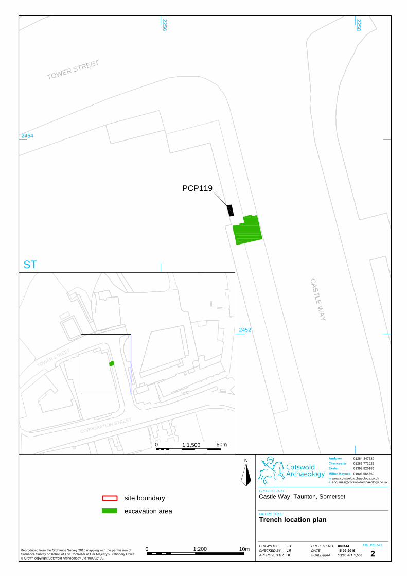
1. INTRODUCTION
1.1 In September 2016, Cotswold Archaeology (CA) carried out an archaeological
evaluation for Pegasus Group and Harlequin Group Ltd, on behalf of Openreach, at
Castle Way, Taunton, Somerset (centred on NGR: ST 22567 24528; Fig. 1).
1.2 Castle Way lies within part of a Scheduled Monument (National Heritage List Ref.
1013541: Shell keep castle, part of the associated outer bailey, ninth century
cemetery and a Civil War siegework at Taunton Castle). A Scheduled Monument
Consent (SMC) application has been made for the installation of two
DSLAM/PCP119 cabinets at the site. The new PCP119 cabinet has already been
installed, along with an associated (and immediately adjacent) manhole containing
the plastic ducting which will be used to run future cables into the PCP119 cabinet.
This evaluation was requested by Mel Barge (Inspector of Ancient Monuments,
Historic England) in order to inform an archaeological assessment of the impact of
the new cabinets and ducting on the Scheduled Monument. The evaluation was
undertaken as a Class 7 Consent under the existing SMC application.
1.3 The evaluation was carried out in accordance with a Written Scheme of Investigation
(WSI) produced by CA (2016) and approved by Hugh Beamish (Assistant Inspector
of Ancient Monuments, Historic England). The fieldwork also followed Standard and
guidance for archaeological field evaluation (CIfA 2014), Management of Research
Projects in the Historic Environment (MoRPHE) PPN 3: Archaeological Excavation
(Historic England 2015) and Management of Research Projects in the Historic
Environment (MoRPHE): Project Manager’s Guide (Historic England 2015).
The site
1.4 Castle Way is a short, north-north-west/south-south-east aligned thoroughfare in the
centre of Taunton. The evaluation trench was excavated across the width of the
pavement on the western side of Castle Way, adjacent to the newly-installed
PCP119 cabinet (Fig. 2).
1.5 The solid geology of the site is mapped as Mercia Mudstone Group of the Triassic
Period, overlain by alluvial clays, silts, sands and gravels (BGS 2016).

© Cotswold Archaeology
4
Castle Way, Taunton, Somerset: Archaeological Evaluation
2. ARCHAEOLOGICAL BACKGROUND
2.1 Castle Way lies within part of a Scheduled Monument (National Heritage List ref.
1013541: Shell keep castle, part of the associated outer bailey, ninth century
cemetery and a Civil War siegework at Taunton Castle). The following section is
summarised from the details included in the National Heritage List entry.
2.2 Taunton had a Minster from at least AD 904. The exact location of this church
building is unknown, but it is thought to have stood within the area of the later outer
bailey (see below). Previous archaeological investigations at Castle Green, which
lies to the immediate north-east of Castle Way, have recorded burials dating to the
9th–11th centuries and it is likely that these lay within the Minster cemetery
(Somerset Historic Environment Record Refs. PRN 44397 and PRN 44407).
2.3 The existing fabric of the castle dates from the 13th century, although it is thought to
have developed from an earlier motte and bailey castle. The castle site was defined
by an external moat, which enclosed two areas: an inner ward to the north and a
larger outer bailey to the immediate south. Castle Way is within the area of the
former outer bailey.
2.4 The outer bailey is known from historical sources to have accommodated storage
facilities and various auxiliary buildings, including apartments and chambers, barns,
a cowshed, a chapel, stables, a dairy, a dovecote, a press and a store for surplus
building materials. The area of the outer bailey is now extensively built over;
however, the foundations and lower levels of internal structures, together with other
features such as pits and postholes and the outer ditch, are likely to survive as
buried deposits.
3. AIMS AND OBJECTIVES
3.1 The objective of the evaluation was to provide more information about the nature
and significance of the archaeological resource within the site, in order to inform an
archaeological assessment of the impact of the new cabinets and ducting on the
Scheduled Monument.

© Cotswold Archaeology
5
Castle Way, Taunton, Somerset: Archaeological Evaluation
4. METHODOLOGY
4.1 The evaluation comprised the excavation of a single trench across the width of the
pavement, immediately adjacent to the newly-installed PCP119 manhole (Fig. 2).
The trench measured approximately 2.6m by 2.4m in plan. It was not possible to
excavate the trench immediately adjacent to the PCP119 cabinet itself (as specified
in the WSI (CA 2016)) due to the presence of this manhole. The small area to the
immediate west of the manhole (between the manhole and the adjacent building)
was not excavated due to constricted space; it is anticipated that most of this area
would have been disturbed by the construction cut for the building and the
continuation of the ceramic drains recorded in the western side of the trench (see
Section 5, below).
4.2 Modern overburden was removed from the trench using a mechanical excavator. All
machining was conducted under constant archaeological monitoring and ceased
when the first significant archaeological horizon was revealed. Where archaeological
deposits were encountered, they were investigated and recorded by hand in
accordance with CA Technical Manual 1: Fieldwork Recording Manual.
4.3 Deposits were assessed for their palaeoenvironmental potential in accordance with
CA Technical Manual 2: The Taking and Processing of Environmental and Other
Samples from Archaeological Sites. No deposits were identified that required
sampling. All recovered artefacts were processed in accordance with CA Technical
Manual 3: Treatment of Finds Immediately after Excavation.
4.4 The project archive is currently held by CA. The artefacts (subject to the agreement
of the legal landowner) and the archive will be deposited with the Somerset
Museums Service. A summary of information from this project, as set out in
Appendix C, will be entered onto the OASIS online database of archaeological
projects in Britain.
5. RESULTS
5.1 This section provides an overview of the evaluation results. Detailed summaries of
the recorded contexts and finds are to be found in Appendix A and Section 6,
respectively. Figures 3 and 4 present a plan, section and photographs of the trench
and the recorded features.

© Cotswold Archaeology
6
Castle Way, Taunton, Somerset: Archaeological Evaluation
5.2 The natural mudstone substrate was exposed in the trench at a depth 0.6m below
present ground level and was cut by possible sub-oval pit 108 (unexcavated).
Possible pit 108 was truncated by north/south aligned grave 106, which contained
the remnants of a human burial. As per the WSI (CA 2046), this burial was not
excavated but was cleaned and recorded in plan and left in situ. The bones had
been disturbed (apparently in antiquity) and the majority were absent; however, the
right ulna and radius were present (and appeared to be articulated), as well as a
fragment of the cranium and the proximal end of the right femur.
5.3 The grave was sealed by 0.15m of reddish brown clayey sand 102, which may
represent buried topsoil. Four sherds of medieval pottery were recovered from this
deposit.
5.4 Layer 102 was sealed by a 0.35m-thick layer of redeposited natural mudstone 101.
Due to the limited area of investigation, it was unclear if layer 101 derived from the
upcast of an adjacent feature or from deliberate efforts to raise the ground level in
this location. This layer was undated artefactually.
5.5 The layers described above had been disturbed by a ceramic storm drain, an
electric cable and the new PCP119 manhole. The manhole also cut down through
layers 101 and 102 to truncate the northern end of grave 106. The manhole was
opened and was observed to extend well below the base of the evaluation trench; it
had had therefore been excavated through the layers and the grave and into the
natural substrate.
5.6 The trench was sealed by the existing pavement and associated make-up layers.
6. THE FINDS
6.1 The artefactual material recovered during the evaluation is summarised below;
further details are given in Appendix B.
Pottery
6.2 Four body sherds (43g), representative of parts of two vessels, were recorded from
buried soil layer 102. The condition is good; the surfaces are unabraded and three

© Cotswold Archaeology
7
Castle Way, Taunton, Somerset: Archaeological Evaluation
sherds preserve an external carbonaceous residue suggestive of use as a cooking
vessel. All sherds occur in the same unglazed coarseware fabric. The primary
inclusion of this fabric is well-rounded quartz and there are lesser quantities of
ironstone and angular chert. As such, the fabric compares with the chert-tempered
wares common to the Somerset and East Devon areas and likely produced in the
Blackdown Hills of south Somerset. Broad dating across the 12th to 14th centuries is
suggested on this basis.
7. DISCUSSION
7.1 The evaluation recorded a pit and a grave at a depth of 0.6m below the present
ground level. This indicates that the site is within the bounds of a Saxon cemetery
which pre-dated the castle and which is known from previous archaeological works in
the area (see Archaeological background, above). The burial had been partially
truncated by the manhole associated with the new PCP119 box.
8. CA PROJECT TEAM
Fieldwork was undertaken by Simon Sworn. The report was written by Simon
Sworn. The finds report was written by Jacky Somerville. The illustrations were
prepared by Lorna Grey. The archive has been compiled and prepared for
deposition by Jessica Cook. The project was managed for CA by Derek Evans.
9. REFERENCES
BGS (British Geological Survey) 2016 Geology of Britain
Viewer http://www.bgs.ac.uk/discoveringGeology/geologyOfBritain/viewer.html
Accessed 26 August 2016
CA (Cotswold Archaeology) 2016 Castle Way, Taunton, Somerset: Written Scheme of
Investigation for an Archaeological Watching Brief

© Cotswold Archaeology
8
Castle Way, Taunton, Somerset: Archaeological Evaluation
APPENDIX A: CONTEXT DESCRIPTIONS
Trench no.
Context Type Fill of Context interpretation
Context description Length (m)
Width (m)
Depth/ thickness
(m)
Spot date
1 100 Layer Modern pavement
Concrete paving slabs and tarmac surface on a sand bedding
0.12
1 101 Deposit Redeposited natural
Compact brownish red mudstone with occasional sub-angular stones and charcoal flecks
0.35
1 102 Layer Buried soil horizon
Loose reddish brown clayey sand with frequent small sub-rounded pebbles and occasional charcoal flecks
0.15 Medieval
1 103 Deposit Natural Compact reddish brown mudstone 1 104 Fill 106 Grave fill Loose mid red brown clayey sand with
occasional charcoal flecks and disarticulated human bone
1 105 Burial 106 Human burial North/south aligned, extended, supine. Lower part truncated. Heavily disturbed. Cranium, R ulna, R radius and R femur head visible
1 106 Cut Grave cut Heavily truncated north/south cut with steep sides. Not fully excavated
>1.5 >0.6 >0.1
1 107 Fill 108 Pit Loose mid reddish brown silty sand with occasional charcoal and sub-rounded stones
0.58 0.5 U
1 108 Cut Pit Truncated ovoid pit, extended north/south 0.58 0.5 U 1 109 Fill 109 Construction
backfill Loose brick and rubble deposit
1 110 Cut Modern construction cut
North/south aligned construction cut for building to west. Steep sides, not fully excavated
>2.4 >0.52 >0.3

© Cotswold Archaeology
9
Castle Way, Taunton, Somerset: Archaeological Evaluation
APPENDIX B: THE FINDS
Context Class Description Ct. Wt.(g) Spot-date
102 Pottery Ch 6 43 C12–C14

© Cotswold Archaeology
10
Castle Way, Taunton, Somerset: Archaeological Evaluation
APPENDIX C: OASIS REPORT FORM
PROJECT DETAILS Project Name Castle Way, Taunton, Somerset: archaeological evaluation Short description An archaeological evaluation was undertaken by Cotswold
Archaeology in September 2016 at Castle Way, Taunton, Somerset. A single trench was excavated. The evaluation recorded a pit and a grave at a depth of 0.6m below the present ground level. This indicates that the site is within the bounds of a Saxon cemetery which pre-dated the castle and which is known from previous archaeological works in the area.
Project dates 5 September 2016 Project type Field evaluation Previous work None Future work Unknown PROJECT LOCATION Site Location Castle Way, Taunton, Somerset Study area (M2/ha) 6.24m² Site co-ordinates ST 22567 24528 PROJECT CREATORS Name of organisation Cotswold Archaeology Project Brief originator Historic England Project Design (WSI) originator Cotswold Archaeology Project Manager Derek Evans Project Supervisor Simon Sworn MONUMENT TYPE None SIGNIFICANT FINDS None PROJECT ARCHIVES Intended final location of archive Content Physical Somerset Museums Service Ceramics Paper Somerset Museums Service Trench record sheets, survey
sheets, site drawings Digital Somerset Museums Service Database, digital photos BIBLIOGRAPHY Cotswold Archaeology 2016 Castle Way, Taunton, Somerset: Archaeological Evaluation CA typescript report 16498

THE VALE OFGLAMORGAN
CARDIFF
NORTHSOMERSET
BATH ANDNE SOMERSET
CITY OFBRISTOL
B
DEVON
SOMERSET
DORSET
B
BATH ANDNE SOMERSET
CotswoldArchaeology
N
PROJECT TITLE
FIGURE TITLE
FIGURE NO.
0 1km
Reproduced from the 2016 Ordnance Survey Explorer map with the permission of Ordnance Survey on behalf of The Controller of Her Majesty's Stationery Office Crown copyright Cotswold Archaeology Ltd 100002109
c 1
Castle Way, Taunton, Somerset
Site location plan
PROJECT NO.DATESCALE@A4
DRAWN BYCHECKED BYAPPROVED BY
88014415-09-20161:25,000
LGLMDE
Andover 01264 347630
Cirencester 01285 771022
Exeter 01392 826185
Milton Keynes 01908 564660
w www.cotswoldarchaeology.co.uk
ST
270270
240240
242242
250250
230230
C
A
S
T
L
E
W
A
Y
T
O
W
E
R
S
T
R
E
E
T
PCP119
2256
2258
2452
2454
ST
C
O
R
P
O
R
A
T
IO
N
S
T
R
E
E
T
T
O
W
E
R
S
T
R
E
E
T
Reproduced from the Ordnance Survey 2016 mapping with the permission of
Ordnance Survey on behalf of The Controller of Her Majesty's Stationery Office
© Crown copyright Cotswold Archaeology Ltd 100002109.
N
PROJECT TITLE
FIGURE TITLE
FIGURE NO.
site boundary
excavation area
DRAWN BY
CHECKED BY
APPROVED BY
LG
LM
DE
PROJECT NO.
DATE
SCALE@A4
880144
15-09-2016
1:200 & 1:1,500
Castle Way, Taunton, Somerset
Trench location plan
2
Andover
Cirencester
Exeter
Milton Keynes
www.cotswoldarchaeology.co.uk
w
e
01264 347630
01285 771022
01392 826185
01908 564660
10m0
50m0
1:200
1:1,500

pit108
grave106
modernconstruction cut
110
modernconstruction cut
110
construction cut110
natural103
natural103
E W18mAOD
pavement100
pavement100
buried soil102
buried soil102
109
moderndrain
projected lineof electicity cable
natural103
natural103
pavement bedding
100
redeposited natural
101
redeposited natural
101 redeposited natural
101
redeposited natural
101
redeposited natural
101
redeposited natural
101
backfill109
backfill109
mod
ern
drain
modernmanhole
electricitycable
CotswoldArchaeology
N
PROJECT TITLE
FIGURE TITLE
FIGURE NO.
3
Castle Way, Taunton, Somerset
Plan and section
PROJECT NO.DATESCALE@A3
DRAWN BYCHECKED BYAPPROVED BY
88014415-09-20161:20
LGLMDE
Andover 01264 347630
Cirencester 01285 771022
Exeter 01392 826185
Milton Keynes 01908 564660
w www.cotswoldarchaeology.co.uk
human remains
s1s1
1:20
0 1m
1:20
0 1m
Section 1

CotswoldArchaeology
PROJECT TITLE
FIGURE TITLE
FIGURE NO.PROJECT NO.DATESCALE@A4
DRAWN BYCHECKED BYAPPROVED BY
Andover 01264 347630
Cirencester 01285 771022
Exeter 01392 826185
Milton Keynes 01908 564660
w www.cotswoldarchaeology.co.uk
4
Photographs
Castle Way, Taunton, Somerset
88014415-09-2016N/A
SOLMDE
General view of the trench, showing location of the installed green new PCP119 cabinet agaist the Mecca Bingo building, looking north-west
Excavated trench showing grave cut 106 with heavily disturbed burial 105. Newly installed PCP119 cabinet ducting manhole is visible to the top of the photograph. Also showing ceramic storm drains to the left and the electric cable to the right. Looking north (0.5m scale)

11