Embed Size (px)
Citation preview

AnniversaryCelebration
Cave Research Foundation
50 th
October 19 - 21, 2007
Ken
neth
Sto
rey
20
07
CRF-Mammoth Cave National Park — 50 years of Project Caving
AnnuAl RepoRt2006 - 2007
CAve ReseARCh FoundAtion


CAve ReseARCh FoundAtion
AnnuAl RepoRt2006 - 2007
Cave Research Foundationvi - Annual Report
The Cave Research Foundation was formed in 1957 under the laws of the Commonwealth of Kentucky. It is a private, non-profit organization dedicated to facilitating research, management and interpretation of caves and karst resources, forming partnerships to
study, protect and preserve cave resources and karst areas, and promoting the long-term conservation of caves and karst ecosystems.
ISBN 978-0-939748-69-3
CAVE BOOKS4700 Amberwood Drive
Dayton, OH 45424-4602, U.S.A.www.cavebooks.com
CAVE BOOKS is the publications affiliate of the Cave Research Foundation.
Permission is granted to reproduce this material for scientific and educational use. For information contact
R. Scott House1606 Luce St.
Cape Girardeau, MO 63701-5208
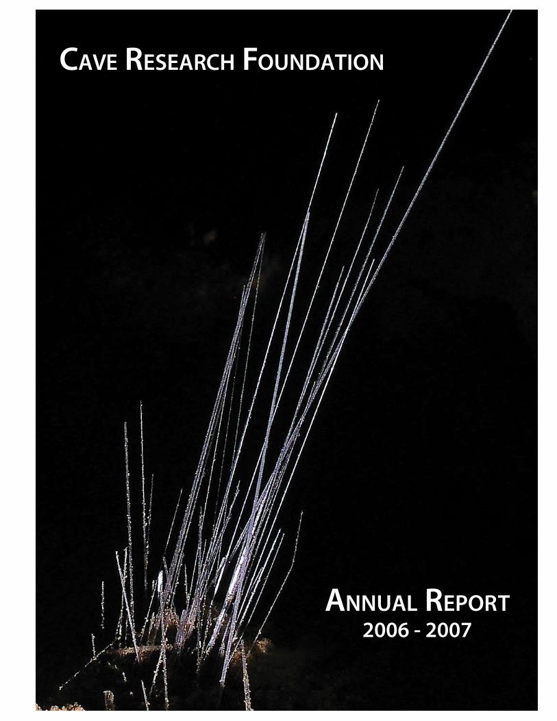
Front cover design by Diana R. Tomchick. Kenneth Storey designed this original poster for the CRF 50th Anniversary celebration held
at the Hamilton Valley facility in October 2007.
Previous page: photo by Peter and Ann Bosted of selenite needles in New Discovery section of Mammoth Cave, October 2007
Back cover lineplot and topographic map overlay by Aaron Addison and Bob Osburn.Aaron and Bob prepared this poster for the CRF 50th Anniversary celebration.
Cave Research Foundation 2006-2007 Annual Report Copyright © 2008 by the Cave Research Foundation.
Editor and Layout: Diana R. TomchickPublishers: Roger E. McClure, Paul J. Steward
The text of this book is composed in Warnock Pro with the display set in Myriad Pro.

vii- Annual ReportCave Research Foundation
Contents
2006 CRF Highlights x
2007 CRF Highlights xi
Celebrating 50 Years of the CRF xii
CRF 50th Anniversary Celebration xiv
opeRAtions AReA RepoRts
Eastern Operations 6 2
Hamilton Valley 6 5
Lava Beds Operations 6 8
Lava Beds Operations 6 10
Ozarks Operations 6 14
Sequoia-Kings Canyon Operations 6 22
Southwest Region 6 24
Eastern Operations 7 28
Lava Beds Operations 7 30
Sequoia-Kings Canyon Operations 7 36
Ozarks Operations 7 40
suRvey, CARtogRAphy And gisRoppel Cave 6-7 50

Cave Research Foundationviii - Annual Report
Cartography and GIS Report 2006-2007 Mammoth
Cave National Park 59
Lava Beds National Monument GPS Location and
Monumenting 74
Lava Beds National Monument Cave Mapping 75
Lava Beds National Monument Cave Reconnaisance 77
Cartography of Caves in Redwood Canyon 78
Mojave Cave Survey 80
sCienCe
Geology of Mammoth Cave 84
Structural Geology of the Redwood Mountain Pendant,
Sequoia and Kings Canyon National Parks 91
Lava Beds National Monument Ice Level Monitoring
Project 95
RestoRAtion And eduCAtion
The Making of “A Virtual Tour of Valentine Cave” 100
Lilburn Restoration Project 2007 104
CAve Books
Cave Books 2006 - 2007 108
CRF Library and Archive 111

ix- Annual ReportCave Research Foundation
Eastern Operations AreaDave West
Mammoth Cave National ParkCumberland Gap National Historical
Park
Lava Beds Operations AreaBruce Rogers and Pat Helton
Lava Beds National Monument
Sequoia/Kings Canyon & Mineral King Operations Area
John TinsleySequoia/Kings Canyon National Park
Southwest Operations AreaBarbe Barker
Carlsbad Caverns National ParkLincoln National Forest
Ozarks Operations AreaMick Sutton
Mark Twain National ForestOzark National Scenic Riverways
Missouri Department of ConservationMissouri State Parks
Buffalo National Scenic River
opeRAtions AReAs And MAnAgeRs
George Crothers, Ph.D.Fellowships & Grants
Phil DiBlasiNational Personnel Office
William PayneNewsletter Editor
Ralph EarlandsonNewsletter Layout & Photos
peRsonnel
2006 diReCtoRs
Chris GrovesPresident
Roger SmithTreasurer
Pat SeiserSecretary
Patricia KambesisHamilton Valley Director
George CrothersJoel Despain
Richard MaxeyMick Sutton
Bern SzukalskiDiana Tomchick
R. Scott HousePresident
Joel DespainVice President
Robert HokeTreasurer
Bern SzukalskiSecretary
Patricia KambesisHamilton Valley Director
George CrothersCharles Fox
Joyce HoffmasterPatricia Seiser
Diana Tomchick
2007 diReCtoRs
Cave Research Foundationx - Annual Report
Katie Schneider $2,500 Ph.D. Fellowship
Department of Biology, University of Maryland
The Stoichiometry of Cave Invertebrates: Adaptation to a Limiting Environment.
Matthew Medeiros$2,000 Grant
Department of Integrative Biology, University of California-Berkeley
Evolution of cave-living in Hawaiian Schrankia (Lepidoptera: Noctuidae) with
description of a remarkable new cave species.
Megan Curry$1,300 Grant
Department of Earth and Environmental Studies, New Mexico Institute of Mining
and Technology A Geomicrobiological and Geochemical
Approach to the Biogenicity of Moonmilk Formation: Spider Cave and Pahoehoe
Cave, New Mexico; Thursday Morning Cave, Colorado; Thrush Cave, Alaska.
Jennifer Lippmann$1,300 Grant
Department of Earth and Planetary Sciences, Washington University
Reworked Loess and Red Clays in Missouri Caves.
Aaron AddisonFrank J. EverittKevin Glover
Tim KohtzJohn DeLongCheryl Pratt
The year 2006 was a busy one for the Cave Research Foundation. The CRF Annual Meeting was held October 6-8th at the new Research facility at Lava Beds National Monument. Chris Groves stepped down as CRF President, and Scott House stepped up to fill the position. The new position of Vice President was created in order to focus on public relations and management. Joel Despain has been tapped to fill this new role. It was duly noted that 2007 would be the 50th
anniversary of the CRF, and preparatons had already begun for the gala event to be held at the Hamilton Valley facility in Kentucky. The achievements of the CRF would not be possible without the efforts of the multitude of volunteers that comprise the organization. The reports in this volume outline many of the major projects, and illustrate well the goals and ideals of the Cave Research Foundation.
2006 CRF highlights
2006 CRF ReseARCh Fellowships And gRAnts
2006 Fellows 2006 CeRtiFiCAtes oF MeRit
Frank J. EverittEd Knetsch
Georganne PayneWilliam Payne
xi- Annual ReportCave Research Foundation
Matthew L. Niemiller $3,000 Ph.D. Fellowship
Department of Ecology and Evolutionary Biology, University of Tennessee, Knoxville
Linking Habitat Disturbance to Hybridization between Surface and Cave-
Adapted Salamanders.
Matthew Medeiros$3,000 Ph.D. Fellowship
Department of Geology, University of California, Davis
Sierra Nevada Speleothems: Potential as High-Resolution Archives of Atmospheric Circulation over Western North America.
Jeffrey “Spike” CrewsAndy Free
Ed KlausnerEdwin KnetschTracey Knetsch
Dan LampingJimmie D. Worrell
Fifty years ago in 1957 the Cave Research Foundation was officially launched as a truly unique organization. The CRF Annual Meeting was held on October 19-21st in conjunction with the 50th Anniversary Celebration at the Hamilton Valley Research facility near Mammoth Cave National Park. Over 150 people attended the event and were treated to various tours, both in-cave and on the surface. It was a great opportunity to meet old friends and make new ones, and was truly an event not to be missed. Two reports, originally published in
The Windy City Speleonews, The National Speleological Society News and the Cave Research Foundation Quarterly Newsletter, are reproduced here on the following pages. While it was wonderful to review the achievements of the CRF over the last 50 years, it was also clear that the CRF is still a very active and dynamic organization. We look forward to the next 50 years of cave research, exploration, management and restoration. Read on for more detailed descriptions of CRF projects and achievements.
2007 CRF highlights
2007 CRF ReseARCh Fellowships And gRAnts
2007 Fellows

Cave Research Foundationxii - Annual Report
Over 150 people converged on the Cave Research Foundation Center at Hamilton Valley for the CRF 50th Anniversary Celebration. The main event ran Friday to Sunday, but there were caving trips to the Mammoth Cave system beginning on Wednesday. Trips included the New Discovery, the Flint Ridge to Mammoth connection, and Roppel. The goal of the connection trip was to re-enact the original 1972 Flint-Mammoth connection, but the Tight Spot proved too much for several people, and the nearby second connection route was done instead. I arrived at Hamilton Valley on Friday afternoon. A new sign, only a month old and reading CAVE RESEARCH FOUNDATION
HAMILTON VALLEY RESEARCH STATION, greeted participants as they made the final turn toward the center. A large white tent had been erected on the grounds for the Saturday night banquet. Rather than spend two out of the three
days driving from Chicago, I booked a cheap flight to Nashville and rented a car, leaving only a 90-minute drive to Hamilton Valley. As the bunk houses and camping space at HV had already filled by the time I registered, I took advantage of a special CRF rate at the Park Mammoth Hotel in Park City. I got to HV in time to go to Caverna Elementary School in Cave City for the exhibition of the 50-by-60-foot master map of the Mammoth Cave system, showing all known passages of the 370-mile-long system, the world’s longest. It was all laid out on the gym floor, and everyone was required to remove their shoes before stepping out on the map. It was quite a scene, with cavers milling about on the cave map. This map was first displayed, in the same manner, at this year’s NSS Convention in Indiana. Friday evening was a time for socializing, and there was plenty of food. In addition to many people I’ve known from CRF expeditions over the years, I saw several I hadn’t seen in 30 years or more. Attendance by Windy City Grotto members was light, however. In addition to myself, only Laura Lexander and her daughter Evelyn, plus Don Kerouac, were there. On Saturday morning I joined a tour group that visited the historic Collins House and ticket office near the entrance to Floyd Collins Crystal Cave, one of the major entrances to the Flint Ridge part of the Mammoth Cave system. These two buildings had been restored and re-painted. For a long time the Collins House served
CeleBRAting 50 yeARs oF the CRFRalph Earlandson
Peter and Ann Bosted
Group on Tom Poulson’s biology trip to Great Onyx.

xiii- Annual ReportCave Research Foundation
as the bunkhouse for CRF expeditions, with the kitchen and meeting rooms in the nearby Austin House, which has since been removed. It was here that I stayed during the first few years after I first became involved with CRF in 1987. We then walked about a quarter mile down the road to the site of the Spelee Hut, where CRF was first based. The Spelee Hut has been moved to Hamilton Valley and restored. The tour group next went on a short tour of Floyd Collins Crystal Cave, but I was signed up for the afternoon CRF tour of Mammoth Cave, so I caught a ride back to HV to get a quick lunch before joining the first group at the Historic Entrance. Due to park policy limiting group size, there were two groups of CRF members of about 60 each. The trip was a three-mile lantern tour starting at the Historic Entrance and ending at Violet City. There were stops that featured short talks by CRF members on their specialties in research or exploration. This was intended to replace an afternoon of speeches and slide presentations, while giving people an opportunity to see an impressive section of Mammoth Cave. We first saw the saltpeter works dating back to the War of 1812, and then we stopped at the Methodist Church, just beyond the saltpeter works. There, geologist Art Palmer gave a short presentation on the cave system’s geology. At Booth’s Amphitheater, Rick Olson talked about saltpeter mining. At the Star Chamber we took seats on long benches, while several presenters gave their talks. Patty Jo Watson talked about cave archaeology. At Wright’s Rotunda, Mick Sutton and Sue Hagen spoke about the Mammoth Cave Gazetteer as a repository for place names. At St. Catherine’s City, Tom Brucker, Bob Osburn and Aaron Addison gave an overview of the evolution of CRF cave surveying.
Because many of the original surveys did not meet current standards, much of today’s activity is devoted to re-surveying. Most notably lacking in the early surveys were clinomenter readings and backsights. We saw some very large and impressive rooms, including Chief City and the 100-foot-high Elizabeth’s Dome. At Violet City, just before we exited the cave, we saw a large flowstone display. Once everyone had returned from the cave, we all converged on the great tent for the banquet. There were two serving lines, and entrees included pork and chicken. There was plenty of wine. Following dinner, CRF president Scott House gave a speech
Scott House giving the CRF 50th Annual President’s Report in
Historic Mammoth Cave.
Peter and Ann Bosted
Peter and Ann Bosted
Tommy Brucker lighting a lantern in Historic Mammoth
Cave.
Cave Research Foundationxiv - Annual Report
The Cave Research Foundation celebrated its 50th year anniversary the weekend of October 19-21 at the Hamilton Valley Facility just outside Mammoth Cave National Park. Though I didn’t go caving, I still thoroughly enjoyed visiting with my friends and meeting several prominent figures of the organization’s past. What can a person do during an 8 hour drive? Physically, not much besides controlling the car, but mentally … well, that’s a lot of time for a mind to wander. I didn’t have the entire time to myself since my 11 month old daughter was with me, but
while she slept, which was for several hours, I found myself with ample time to think. For every expedition I go to, on the way there my anticipation grows to the point where it’s barely containable by the time I exit the highway onto the winding, narrow roads of the rural Kentucky countryside. On the way home I am usually overwhelmed with mixed emotions because while I hate leaving I know I’ll be back again. During that long stretch of time, I am usually able to resolve the turmoil in my head. The weather for both days was perfect, the air cool and crisp, with the sun’s
CRF 50th AnniveRsARy CeleBRAtion
Laura J. Lexander
and presented awards, including the naming of several new CRF Fellows. Then he called on about a dozen prominent CRF members to give short talks on their experiences in CRF. Following the banquet we adjourned to the main hall for a 3-D slide show by Peter
and Ann Bosted, two of the most famous cave photographers in the country. Their first show was about Mammoth Cave itself, and their photos really gave life to the cave’s passages, and gypsum flowers appeared to literally pop out of the screen. Then they gave a show on New Mexico’s Lechuguilla Cave. The three-dimensional views of the cave’s unique formations were truly awesome. Following the Bosteds’ program, historical (2-D now) slides of CRF activities were shown. Here we could see some of the old timers when they were much younger. Partying continued well into the night. Sunday morning was a time of saying good-byes and beginning the various journeys home. The weather for the weekend was very good, and was conducive to a great celebration. This was certainly the largest event of its kind for CRF, dwarfing the 40th Anniversary in 1997. A great time was had by all!
Pat Kambesis
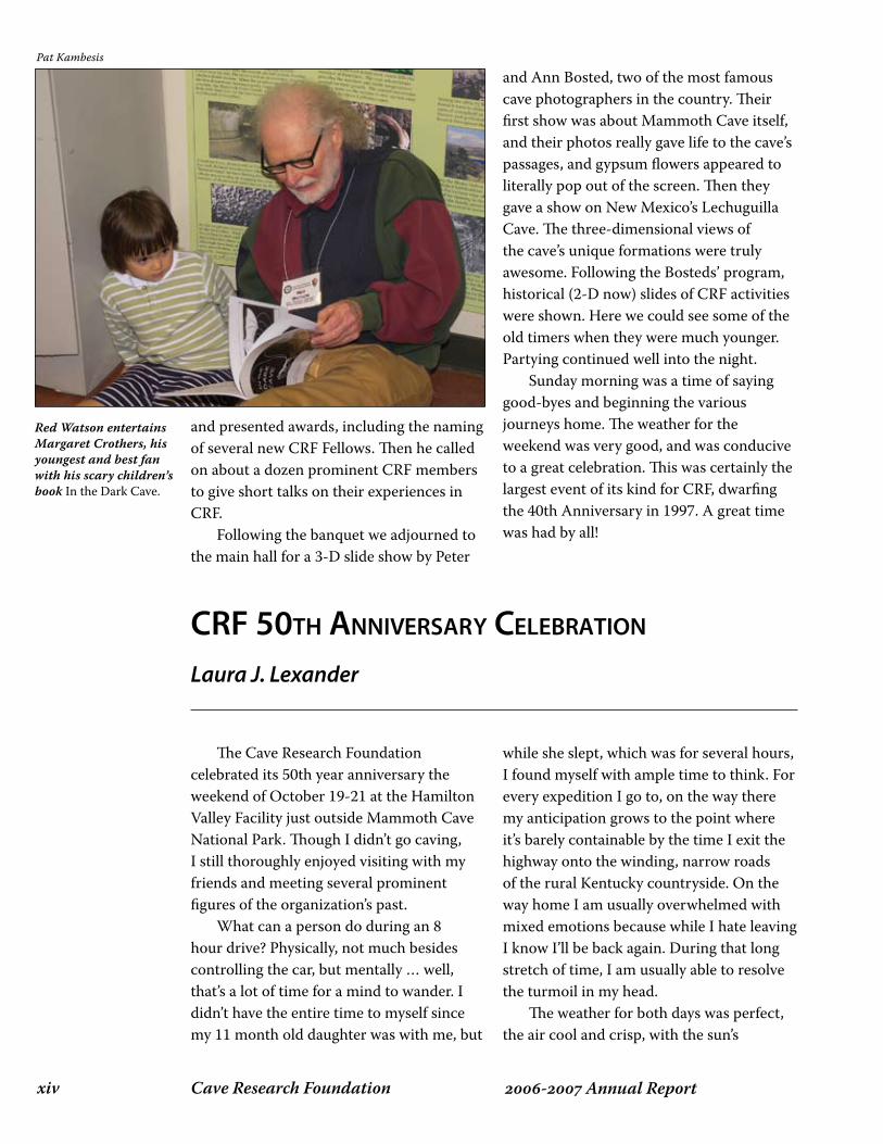
Red Watson entertains Margaret Crothers, his youngest and best fan with his scary children’s book In the Dark Cave.
xv- Annual ReportCave Research Foundation
rays warm. Soon after I arrived Friday afternoon, we headed over to a nearby elementary school where the huge map of the Mammoth Cave System was spread out across the gymnasium floor. Friday evening I learned about the history of the Hoffmaster House and Saturday morning I saw it and the Spelee Hut for the first time! On Saturday afternoon, for about 5 hours, two large groups of us went into Mammoth Cave a half hour apart through the Historic Entrance and walked the tourist paths to the Violet City Entrance. We listened to several people talk about their respective research in areas such as geology, archeology, and cartography. We even heard Roger Brucker’s story about his first visit to Mammoth Cave. He told us about it at the very place where he became enraptured with cave’s mysteries. By the time we left the cave, instead of being tired, I was full of energy. That evening we all banqueted together under a huge white tent erected on the grounds. I’ve never seen so many people gathered together at the Hamilton Valley Facility! During the banquet, several people were recognized and awarded, especially those who were fundamental elements of the CRF. Scott House was the main speaker and he also told us some short caving stories that had everyone wildly laughing.I found myself overpowered by the camaraderie that was palpable in the air. Afterward, two amazing 3D slideshows were played in the main building and everyone conversed late into the night. Meeting and spending time with some of the people responsible for the existence of the organization and who over the years were essential to its survival was an amazing experience. It was also wonderful to spend time with the friends I already have, getting to know a few of them a little better. When I saw how that mix of people interacted I
realized that the rich history of the Cave Research Foundation is interwoven into the present. But more than that, I saw how the organization is a family. And while I’ve only been attending expeditions for 2 years, it’s already become an integral part of my life. The Hamilton Valley Facility is a second home to me and I feel like I am also part of that family. For more information about the Cave Research Foundation, please visit http://www.cave-research.org and/or read The Caves Beyond, The Longest Cave, and Beyond Mammoth Cave.
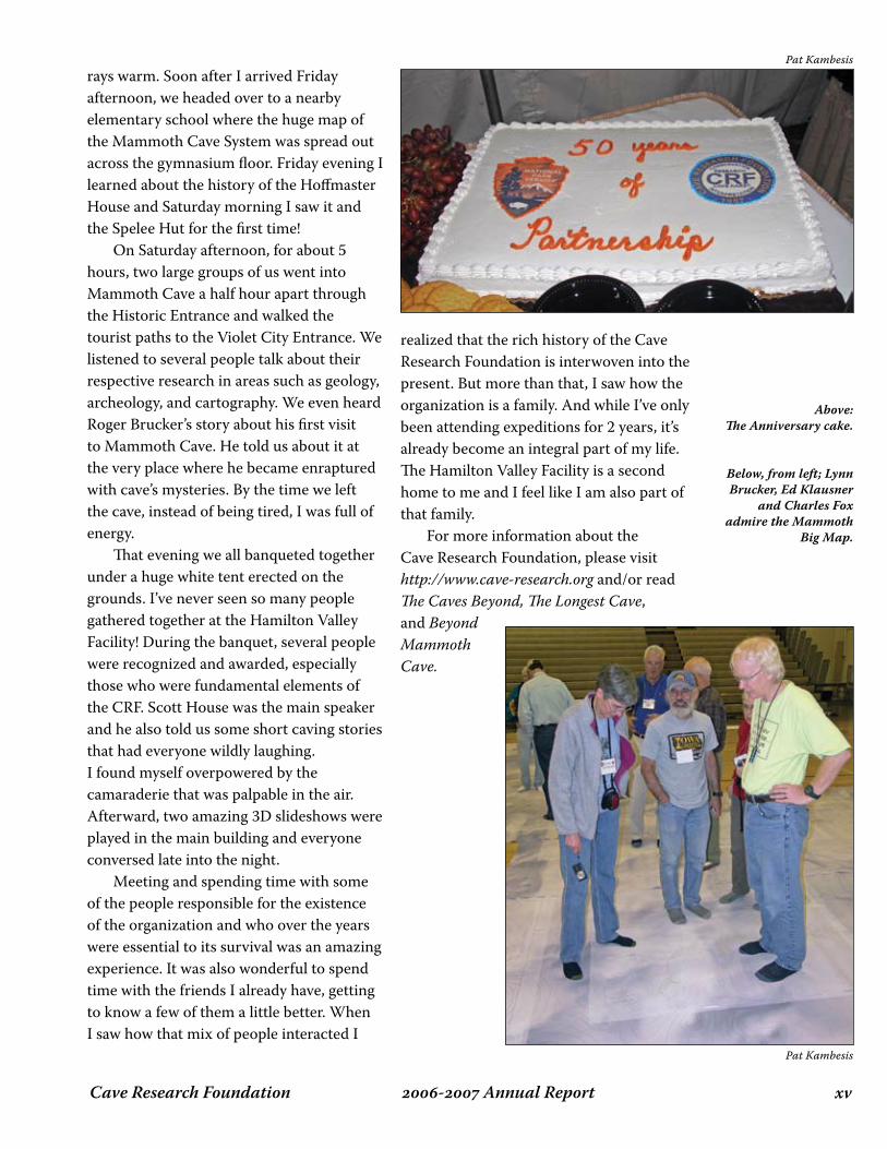
Above: The Anniversary cake.
Below, from left; Lynn Brucker, Ed Klausner
and Charles Fox admire the Mammoth
Big Map.
Pat Kambesis
Pat Kambesis
Cave Research Foundationxvi - Annual Report
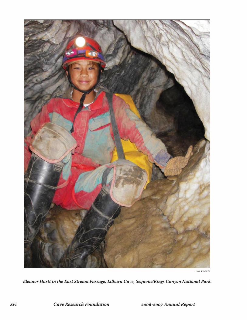
Eleanor Hurtt in the East Stream Passage, Lilburn Cave, Sequoia/Kings Canyon National Park.
Bill Frantz
�- Annual ReportCave Research Foundation
OperatiOn area repOrts 6

Cave Research Foundation� - Annual Report
eAsteRn opeRAtions 6
During this period, Eastern Operations at Mammoth Cave National Park fielded 140 parties, devoting over 11,554 hours to the park, and another 1,663 to the Biosphere Reserve outside the park in support of various projects as follows:
In Park
MCNP Cartography – 93 partiesSmall Cave Inventory – 27 partiesCave Art Documentation - 5 partiesPhoto Documentation - 2 partiesGeology - 6 partiesArchaeology - 5 partiesBiology - 1 partyHydrology - 1 partySediment Study - 1 partySafety Video - 1 party
Biosphere Reserve
Roppel Cave - 19 partiesHamilton Valley - 1 partyHidden River Survey – 1 partyStan’s Well - 3 partiesJames Cave Cleanup - 1 partySide’s property ridge walk - 1 party
Many trips supported multiple objectives. Aaron Addison has agreed to coordinate the continuing Small Cave Inventory, relieving Scott House, whose efforts have set a high standard. Parties have inventoried and mapped Cathedral Domes Pit, multiple caves in Cotton Gin Hollow, Doyel Cave, Hunt Sinks Pit, Pardue Cave, Saucer Cave, and Jam Cave. Work continued with two parties in Wilson Cave, one in White Lightening Cave, and no less than twelve parties worked in Great Onyx Cave. Fifty parties worked in Mammoth Cave, as efforts to complete all sheets for the main tourist routes continue to be a focal point. In other parts of the system, fifteen parties worked in Unknown Cave, ten in Crystal Cave, six in Salts Cave, four in Colossal Cave and two in Proctor Cave. Efforts are continuing to move the database into Walls, the currently preferred data reduction software for the Cartography project, as it more easily complements the increasing use of Adobe Illustrator in map production. The February expedition was dedicated to consolidating data from the various cartographers into a single standard
Dave West
October 1, 2005 - September 30, 2006
Mike Freeman
Jeff (Spike) Crews in Grund Trail off of Lower Gravel Avenue in Unknown Cave.
�- Annual ReportCave Research Foundation
format to ensure compatibility. Elizabeth Winkler continues to make progress on the Trip Report Database consolidation effort. Michael Carter has taken the lead on the photo documentation to support cartography. Charles Fox continues work on the Safety Video for use as a training tool by CRF and the park. Charles Swedlund and George Crothers continue their work documenting historic and pre-historic cave art throughout the system. Outside the park, support for the CKKC survey in Roppel Cave has continued. Work also continues in the caves owned by Hamilton Valley neighbor and CRF member Stan Sides. Another unnamed small cave in Hamilton Valley was mapped as well. Much work remains in Hidden River Cave, site of the ACCA Museum in Horse Cave, KY, and one member took time from the Labor Day expedition to assist in the ACCA coordinated cleanup at James Cave, located at Park Mammoth Resort. This cave is an important site for the Rafinesque bat, and debris was removed to permit reliable access for continuing bat counts this coming winter. CRF Cumberland Gap Project Cartographer Bob Gulden has updated the Gap Stat spreadsheet and it is posted on his website. Make sure you click through the sheets beyond the individual survey stats. We can be particularly proud of the volunteer time (more than 4,000 hours) and driving distance (more than 125,000 miles) invested with our partners Cumberland Gap National Historical Park and Lincoln Memorial University. We can also be proud that the project has been open to a wide range of cavers. The leading distance survey party member to date is Cheryl Pratt. She is hardly typical. She grew up near Oak Ridge and started caving as a Girl Scout. Since raising several children to beyond the age of consent she
has taken up caving with added passion and has openly said her goal is to see “the whole cave” ... and that applies to almost any cave she enters. At Cumberland Gap she shows up for nearly every event and supports her survey party. She is well known for her agility and stamina. She also has an eagle eye for inventory and loves photography. The spreadsheet is evidence that Cheryl has been joined by others in this effort and should read like a roll of honor. We need more like them. The August 2006 Expedition information is not yet included on the spreadsheet. On August 26, 2006 a survey team led by Dan Henry and Scott McCrea
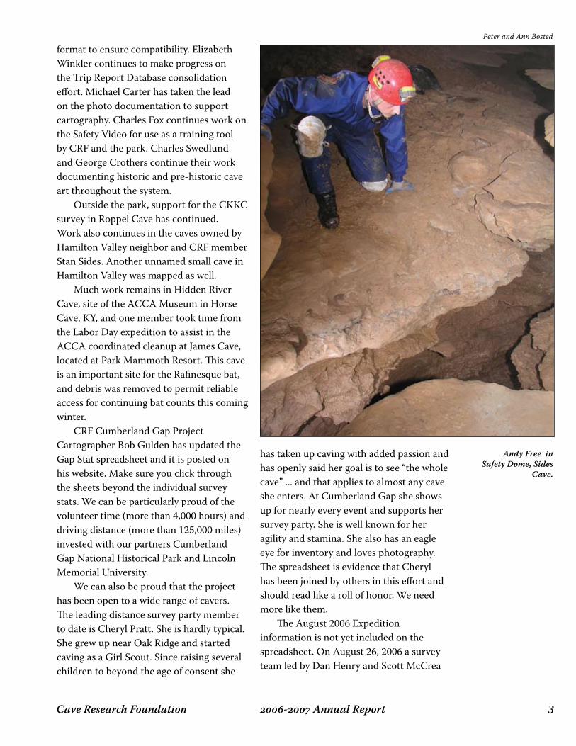
Peter and Ann Bosted
Andy Free inSafety Dome, Sides
Cave.

Cave Research Foundation� - Annual Report
that included Andy Shoun and Cheryl Pratt connected the survey line brought down from the Big Saltpeter Cave entrances to the survey line brought upstream from the Gap Cave entrances. The team entered at Big Saltpeter Cave and exited at Gap Cave. The through trip should take about 6 hours from entrance to entrance if a lunch break is included. After the initial drops no vertical gear is needed. A shallow slosh through the stream is required along with a few short stretches of crawling. The Big Saltpeter Cave entrances are now closed for the season but teams can continue the survey by coming up from the Gap. There is still plenty of cave to survey. About half the old lineplot survey has been covered and the total length stands at 8.254 miles. A couple of miles of virgin cave have been found. It is worth noting that the distance surveyed during this project is deceptive. The project has restrictive standards for cartography and operations. The nature of the cave adds to the level of difficulty. Many passages are large and
complex by any comparison and more difficult to map. We also invest in inventory and photography. But it is not always so hard. Sometimes we find the “easy” button. During the August 2006 Expedition Mike Crockett, Stuart Daw and Carrie Crockett surveyed off into going virgin passage. Checking leads near Hell Hole the team went up to the top wall then took off down a breakdown slab “backcrack” to the south. After passing some exceptional flow formations they turned around after reaching a room (60’ L x 40’ W x 20’ H) with several going leads to the NW, SE, and S. They reversed field after booking only 225 feet having run out of paper, tape for trail and fragile marking, and sketcher skill. Survey and photo in this area is on tap for September. Hell Hole is close, a little over an hour from the Gap Cave entrance. There are many leads just a couple of hours or less into the cave so support cavers of all endurance levels are needed, especially those willing to learn to sketch.
Peter and Ann Bosted
Dick Market climbs near Roppel Junction, Roppel Cave.

�- Annual ReportCave Research Foundation
Management of CRF’s Hamilton Valley property is conducted by an Operations Committee (Pat Kambesis, Janice Tucker, Joyce Hoffmaster, Daniel Gregor and Rick Hockstetter), and the Land Management Committee (Roger McClure, Dave Hanson and a host of CRF volunteers). The Operations Committee does the scheduling of the facility, takes care of stocking basic supplies, completes minor repairs and maintenance in the main facility and bunkhouses, and completes a walkthrough of the facilities after each use. The Land Management Committee does the major upkeep, maintenance, repairs of the building, utility shed and bunkhouses, and also manages, does upkeep and preserves the property. This includes trail maintenance, gate and fence maintenance, and mowing in the valley and areas that can’t be mowed with the small mower.
Land Management/Facilities Maintenance Report (from Roger McClure)
The Land Management Committee continues to actively work on the upkeep, management and responsible preservation of our Hamilton Valley property. The entire HV property is classified as “Highly Erodible Land” (HEL). Over the years, efforts were made to use the land for farming, but the results were not very successful, and a lot of erosion and loss of topsoil resulted. In a number of areas the
soil is so thin that the underlying rock is showing through. We continue to work on reducing areas of erosion, and are attempting to renew and add soil to the land by a “grow and cut, grow and cut plan.” The decaying mulched vegetation will begin to build the soil base if erosion is not induced. In an effort to derive some income from the property, programs with the USDA Farm Service Agency, the Conservation Service, hunting leases as well as tobacco payments have produced over $3,000 this past year. All of the expenses encountered by the Land Management Committee in maintaining the property have been provided by Cave Books. All income from the property as noted above has been turned over to the CRF Treasurer for disposition. We have had two work weekends this past year, one in the spring and one in the fall. Each was attended by a very hard working devoted core of about 20 people interested in the health and preservation of our HV property. Work projects and maintenance was accomplished on both the land and the buildings. Cave Books supplied the cost of food and supplies for these work weekends. In addition to the work weekends, approximately 25-30 person workdays have been expended maintaining CRF property. A few of the projects/type of work accomplished this year include:
the removal of an “out building” in front •
hAMilton vAlley 6Pat Kambesis
Cave Research Foundation� - Annual Report
of the trailer. a continuing project to renovate the Spelee Hut in preparation for the 50th Anniversary of CRF in 2007. All the siding has been replaced and painting is near completion. Interior renovation is about to start and interior photos from the early days are needed.new floor mats and mirrors have been added to the bunkhouse rooms as well as some new mats to the main building.
water has been connected to the refrigerator icemakers, and work has continued on a project to replace/upgrade some main building lighting. The workers donated much of the parts/
•
•
•
supplies for this project. we continue general building maintenance, repair and cleaning.trailer maintenance and security enhancement (installation of deadbolts, additional fences and gates).maintenance of a boundary fence and trail, and interior trails were kept mowed for the pleasure of hikers.
Pat Kambesis does the mowing around the buildings in exchange for trailer rent. Mowing “season” is from April through October on a weekly basis. It takes 5-6 hours each mowing session to do all of the mowing around the buildings (for a total of at least 150 hours of mowing each year). Many additional hours are expended by members of the Land Management Committee on mowing/bush-hogging the open areas in the valley and throughout the property. Well over 650 person hours have been expended on care and feeding of our property this past year. I can’t say enough about the Land Management Committee and the core of workers that have given of their time, effort and money to care for the HV property. They are to be commended and encouraged. With your support, we will continue to maintain and manage your property in an environmentally responsible manner.
--Roger E. McClure, ChairLand Management Committee
Operations Management
Operations Management has set up a calendar on the Yahoo web site so that Janice Tucker and Pat Kambesis can effectively schedule facility use. So far, the use of the calendar has been invaluable. Janice Tucker, who has been the main scheduler of the facility, plans to resign as
•
•
•
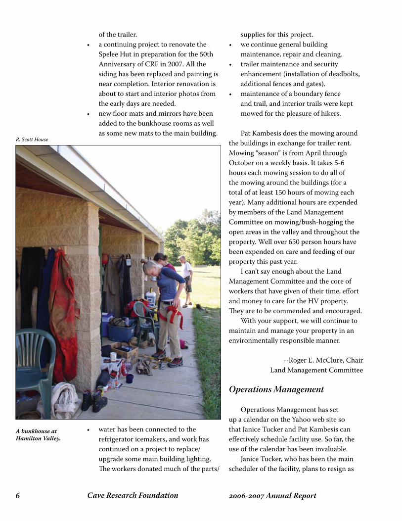
R. Scott House
A bunkhouse at Hamilton Valley.
�- Annual ReportCave Research Foundation
soon as we find a replacement for her. Rick Hockstetter has been working on changing out the light bulbs in the main building and repairing the alarm system. He also takes care of minor plumbing issues. In the year 2006, the Facility has seen monthly use as follows:
CRF Expeditions
Monthly, November 2005-October 2006
CRF Work Weekends
December 2005, March 2006
University Field Trips
Morehead College (February)Miami University (March)University of Florida (April)Clemson University (May) University of Illinois (May)
Mammoth Cave
The park continues to use our facility for some of their workshops and for researchers.Workshops (Feb, July). Researchers: May, June, July
Other Users
Bat Conservation International (Jan-Feb, April, August)Western Kentucky University classes (month of June)Central Kentucky Karst Coalition (March, May, July)
Archives/Books Initiative
Roger McClure is pressing for us to consider constructing another building on site to house a CRF library and archive and to serve as the future operations center of Cave Books. No action has taken place on this initiative as of yet.
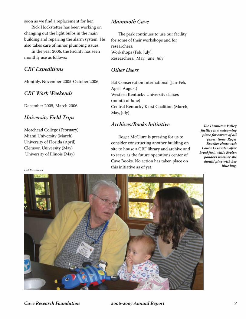
Pat Kambesis
The Hamilton Valley facility is a welcoming place for cavers of all
generations. Roger Brucker chats with
Laura Lexander after breakfast, while Evelyn
ponders whether she should play with her
blue bug.
Cave Research Foundation� - Annual Report
This past year 49 people worked on different projects in over 30 expeditions while contributing 1,416 hours of work in the Monument. There were 118 person/trips compared to 78 the prior year. Additional hours were logged by those drafting cave maps and coordinating the CRF Board of Directors meeting. Also not included in these numbers are travel time, time to repair equipment, Research Center upkeep, report writing, phone calls and e-mails. CRF Projects
Below are brief summaries of CRF’s projects listed with the National Park Service. The attached report by field operations manager Bill Devereaux provides more detail on the status of each project, as well as some additional activities.
Cave Reconnaissance Inventory
Led by Bill Devereaux, the purpose of this project is to provide reconnaissance-level documentation of every cave, no matter how small. Data include a sketch map and profile of the cave and a checklist of contents and features. This year we made three new cards, and fixed 32 older ones.
Cave Location and Monumenting
Led by Bill Devereaux, in this project we install a brass marker at the cave entrance and locate it with GPS. Each cave or ‘feature’
that is recorded in the files or database receives a LABE number by lava flow and sequential number. That number is stamped on the marker and the cave entrance is photographed. This year we did 14 new GPS fixes. We installed three monuments, compared to 16 the year before. There are no ‘stamped’ monuments left to install. The newly discovered caves of the last several years have not been numbered, and therefore monuments are not made for them.
Cave Mapping
Led by Iris Heussler and Janet Sowers, work continues on our backlog of drafting, but there was also time for a few new cave surveys. Bill Broeckel also continued to survey small caves. This Project year brought more opportunity to concentrate on completing cave surveys and working with exciting data to finish cave maps. At this point the backlog has decreases substantially, numerous surveys have been completed and with the help of Bruce Rogers and John Tinsley, several more cave maps have been finished and filed in the flat drawers at the Monument. One major accomplishment was the remapping effort in Catacombs Cave. The re-survey took 8 days in-cave and 14 people, who worked 305.75 hours, to map 8,435.9 feet of passage. Liz Wolff led the effort, and has drafted the map. John Tinsley worked on the digital cartography. The map won
lAvA Beds opeRAtions 6Janet M. Sowers and William C. Deveraux
November 2005 - September 2006

�- Annual ReportCave Research Foundation
an Honorable Mention ribbon in the Map Salon at the 2006 NSS Convention! Bill Broeckel has continued with the survey of caves in The Modoc National Forest outside the Monument boundaries.
Ice Level Monitoring
In eight caves that contain permanent ice, we are monitoring the height of the ice floor. Since 1988 Bill Devereaux and crew have taken these measurements twice a year. We measure with a fiberglass tape the distance from a stainless steel screw mounted in the cave wall to the surface of the water and to the ice surface in 1/100th of a foot. David Haskell recently compiled all the ice level data into an Excel spreadsheet with graphs so that we can begin examining and analyzing the data. Data show a net loss of ice since 1988, though some caves gained ice. Between the two Labor Day expeditions, the ice floors in Merrill, Frozen River, Incline, Big Painted, Caldwell, Cox, and Crystal have declined or disappeared, while the floor in Skull has held steady for 3 years. Heppe returned after being water/iceless for exactly six years. As of March, the pool is 26’x 33’. Cpt Jack’s is still iceless. In Merrill the hole has gotten bigger. Ice is now only on two sides of the hole, pin #1 is above the breakdown and is 10’ overhead. The catwalk has been moved, and the cave is open to visitor traffic. The two ice rivers have largely disappeared. In Frozen River, the floor and pool are gone. The pin is directly above the breakdown now.
Valentine Virtual Cave Tour
Touring Valentine Cave without having to actually enter it is the objective of this computer-simulation project conducted by Bill and Peri Frantz. Completed in June of
2004, the simulation is now installed at the new Visitor Center. Visitors can manipulate the joystick to move through the cave, turn around, choose passages, or zoom in on objects of interest. Meanwhile, an electronic tour guide (Peri’s voice) describes the geology, biology, and history at each station.
Research Center
The Research Center is operational and habitable. In February 2005, we occupied it for the first time. We, and other researchers across several disciplines and organizations, have used it throughout this year. They have expressed surprise and delight at the utility of the facility. This reflects well on the vision, determination, persistence, and teamwork by the CRF volunteers and the Monument staff to bring the building into existence and operation. The lab has actually been used as a lab, and the meeting room has been used for meetings and classes for groups not associated with CRF or caving. We also hosted the CRF Board for its annual meeting in 2006.
Because of the many skylights in Tichnor
Cave, the fauna and flora of this tube is
extensive. This brown millipede with black
“fender skirts” is usually found in the dry forest litter, but
plentiful food supplies in the cave encourages visits. Being at the join
between the Cascade, Sierra-Klamath, and
Great Basin provinces, Lava Beds has an
unusually varied flora and fauna, both above
ground and below.
Bruce Rogers
Cave Research Foundation�0 - Annual Report
lAvA Beds opeRAtions 6
Selected Projects
William C. Deveraux
Our project year begins October 1st and ends September 30th of each year. This allows us to make our annual report to the Lava Beds NM (LABE) staff for the Thanksgiving weekend annual meeting. The period also coincides with the weather patterns that dictate our research rhythms. This report will detail the projects for which I am responsible or worked on this year, plus the Mapping project, and detailed numbers from a spreadsheet that I use to keep track of people, projects, and expeditions. This year, I expanded the sheet back to 1990. I expanded the sheet to track people who came here to work, and quantified the number of trips for which they were present. I have numbers for 1990-2006. The year we call 2006 saw 49 people work on 7 different projects on 30 expeditions while contributing 1,416 hours of work in the Monument. There were 118 person/trips compared to 78 the year before. Those hours do not include the hours the people spend getting to and from LABE, and at home drafting maps, working on COMPASS files, building or repairing equipment, attending to the Research Center’s needs, writing reports, and composing or responding to e-mail messages from each other, the CRF or LABE staffs, or attending CRF Board meetings. Those hours do not reflect the hours spent by Park staff (both permanent and seasonal), SCA’s, and volunteers who went on trips with us to support our work. There are
also local NSS cavers (principally from the Shasta Area Grotto) who gave us materials and assistance. The success of this project belongs to people who care about this Monument and the caves herein. We have begun to log travel and offsite hours on time sheets and in the journal. I do not have those totals built into the matrix that I keep. The projects that I worked on this last year were Ice Level Monitoring, GPS Location and Monument Installation, General Inventory, and Cave Reconnaissance Inventory (which includes the cave entrance photography project). I completed a partial file review of the cave files by updating the Book of Caves.
Ice Level Monitoring
This project has been going on since the 1970’s under the guidance of Mike Sims. I have helped him since about 1988 when it became a CRF project. I have now taken on the job of Principal Investigator, with Mike assisting me in the final report writing for the year. This last year we made 17 measurements in 9 caves during 3 expeditions. We use a digital thermometer that measures in 1/10ths of a degree. We measure with a fiberglass tape the distance from a stainless steel screw mounted in the cave wall to the surface of the water and to the ice surface in 1/100th of a foot. We record the date, the measurements and brief remarks on quality of the ice, dead critters, or conditions of the room at each measuring

��- Annual ReportCave Research Foundation
station. Between the two Labor Day expeditions, the ice floors in Merrill, Frozen River, Incline, Big Painted, Caldwell, Cox and Crystal have declined or disappeared, while the floor in Skull has held steady for 3 years. Ice returned in Heppe after being water/iceless for exactly six years. As of March, the pool is 26 feet by 33 feet. Cpt Jack’s is still iceless. We have two pins in Upper Ice Cave but can only find one. In Merrill the hole has gotten bigger. Ice is now only on two sides of the hole, pin #1 is above the breakdown and is 10’ overhead. The catwalk has been moved, and the cave is open to visitor traffic. The two ice rivers have largely disappeared. In Frozen River, the floor and pool are gone. The pin is directly above the breakdown now. The spreadsheet and graphs created by David Haskel show the trends in ice levels and water going back to 1990.
GPS Location and Monument Installation
This project has been going on since the fall of 1994. Each cave or ‘feature’ that is recorded in the files or database receives a LABE number by lava flow and sequential number. The staff marks a brass monument, and then we install it at the cave entrance. The location is written and drawn on the Reconnaissance Card. The
cave monument becomes the site for the GPS location session. We record three different sessions at a point two meters above the brass monument. We use a tripod for the sub-meter antenna that is connected to the Magellan “rover” unit. We have the base station running simultaneously with the rover unit. The file name on the rover session is labeled one, two, and three for the cave name. Later, the three files are compared with the base station to get a differential location. The software makes a scatter plot, and a printout is viewed to see if the diagram is tight enough to make the location within a 1 cm circle. If the answer is yes, then we declare it good. If not, we go back and start over. When the UTM coordinates of the three sessions are accepted, then the Monument staff put the location into the GIS system. One of the new wrinkles in both GIS data gathering and cave mapping here is to tie the brass monument and the GPS location one meter above it to the published cave map. Many cave maps are dated from the
Bruce Rogers
Far from being barren, black holes in the
ground, lava tubes are often heavily
decorated with secondary minerals.
These coralloids, flowstone, and
draperies in Hopkins Chocolate (Cup) Cave
in Lava Beds National Monument are highly
colored with both organic soil compounds
and iron oxides. The calcite or cristobalite
speleothems cover basalt speleothem-like forms on the ceiling of
Penny Lane, named for a one cent piece
dropped by a previous visitor.

Cave Research Foundation�� - Annual Report
1930’s to last year. They obviously don’t have the monument or GPS location on them. We are trying to do that as we go. This year we did 14 new GPS fixes. We installed 3 monuments, compared to 16 the year before. There are no ‘stamped’ monuments left to install. The newly discovered caves of the last several years have not been numbered, and therefore monuments are not made for them. GPS locations for those caves have been made by a handheld Garmin 76S unit, and not by the Magellen/3-session protocols with printed sheets placed in the file folder.
Cave Reconnaissance Inventory
This project also started long before CRF became a player at Lava Beds NM. In 1988 when the project and its standards were defined, a card/form was created. Our people were trained to use the form, and we worked with the Monument staff to apply it. Many of the other projects use the ‘card’ as a starting point for their work. It is the most basic document that must be completed when a cave is found, recorded, studied, or marked. Mike Sims created the project, invented the form, and trained most of us (both CRF and park staff) in its use. The form is a joint form called LABE, CRF 5/93. The “card” comes in two forms. The two-sided card is 5”x7”. The one-sided version is 8 ½” x 11”. We found that the card version often did not get the flip side filled out, so the single sheet with both card sides on the front meant that all the data got filled in the first time to the cave. The “short” inventory consists of 19 specific items in four categories that the field researcher looks for in the cave during their first visit. They can circle the Yes or No symbol, and make remarks to the side of the entry. They look for bats, pictographs, access problems, formations, ice, etc. The card is a living
document. It is filled out in pencil, and is updated as new information comes to light. This year we made three new cards, and fixed 32 older ones. One component of the Cave Reconnaissance project that saw no activity this year was the entrance photo piece. The idea is to take a digital photo of each cave entrance with at least one person at the entrance pin, the ‘meter’ sticks for scale, and the cave number written in large black letters on a white board. The location of the photo is at the brass monument with one stick placed on it so you can see where it is. The location of the camera operator is noted on the recon card so that it can be replicated later if needed.
General Inventory
No General Inventory was requested or completed this year. I did not conduct an annual cave file review. This project came out of an agreement early in CRF’s relationship with the Monument. We agreed that certain items must be in the file folders, with corresponding consistency of information recorded on forms, in surveys, on maps, and annotated on photos. There are a total of at least 10 items that I look for in every folder. There is an annotated cave printout from the database that I use to record notes of missing items. I also make notations in red pen in the Book of Caves as we update material. As maps get made, recon cards get completed; GPS and monuments get validated and installed; and entrance photos get taken, printed and inserted into files. The list of shortfalls gets shorter each year. I spent one weekend updating the Book of Caves with this last year’s information. Another unofficial project is the security check we make of the gates at Upper Post Office and Lower Post Office entrances.

��- Annual ReportCave Research Foundation
We check the gates for signs of molestation or tampering, and report the results to the Chief Ranger after the trip. This year the gates showed no sign of tampering. This is both good and unusual. I hope the trend continues. Bats are intensively using the lower entrance gate, based on evidence of moth wings and guano deposits at the nearside of the gate. The upper gate shows no such traffic evidence. No report would be complete without credit given to some of the CRF JV’s who make the projects happen. Dr. Janet Sowers is the overall PI who makes the projects stay on track and keeps me focused. Dr. Bill Broeckel and his family have stepped forward and taken on a lot of mapping and recon duties. He established a CRF/USFS MOA with the Modoc National Forest to study the caves on their lands. Bill and Peri Frantz have completed their virtual cave tour for the new Visitor Center. Last, but not least, Dr. John Tinsley was essential to get the Research Center project completed. He attended meetings, made phone calls, and wrote countless e-mail messages to us, Superintendent Dorman, and the contractor to make the building happen. The Research Center is operational and habitable. In February 2005, we occupied it for the first time. We, and other researchers across several disciplines and organizations, have used it throughout this year. They have expressed surprise and delight at the utility of the facility. This reflects well on the vision, determination, persistence, and teamwork by the CRF volunteers and the Monument staff to bring the building into existence and operation. The lab has actually been used as a lab, and the meeting room has been used for meetings and classes for groups not associated with CRF or caving. Minor access or operational problems are fixed or solved as time goes along.
Cave Mapping
Iris Heusler is Co-PI for the mapping project. The Mapping Project reports that this year brought more opportunity to concentrate on completing cave surveys and working with exciting data to finish cave maps. At this point the backlog has decreased substantially, numerous surveys have been completed and with the help of Bruce Rogers and John Tinsley, several cave maps have been finished and filed in the flat drawers at the Monument. One major accomplishment was the remapping effort in Catacombs Cave. The re-survey took 8 days in-cave by 14 people, who worked 305.75 hours, to map 8,435.9 feet of passage. Liz Wolff led the effort, and has completed the map. The effort also took many offsite work hours by her, with the cooperation of Iris Heusler, John Tinsley, Janet Sowers and Bruce Rogers. Dr. John Tinsley worked on the digital cartography and produced the map you see hanging on the Research Center laboratory wall. The map won an Honorable Mention ribbon in the Map Salon at the 2006 NSS Convention. Dr. Bill Broeckel has continued with the survey of caves in the Modoc National Forest outside the Monument. As in previous years, his efforts will be described in a separate report. Iris would like to thank all the members of the Cave Research Foundation who spend countless hours and many holiday weekends surveying above and below ground. Without them, the mapping project would not be possible.
Cave Research Foundation�� - Annual Report
ozARks opeRAtions 6 Scott House and Mick Sutton
In 2006, CRF made progress on a wide variety of ongoing projects, and added several new projects to our work list.
Buffalo National River – Fitton Cave Survey
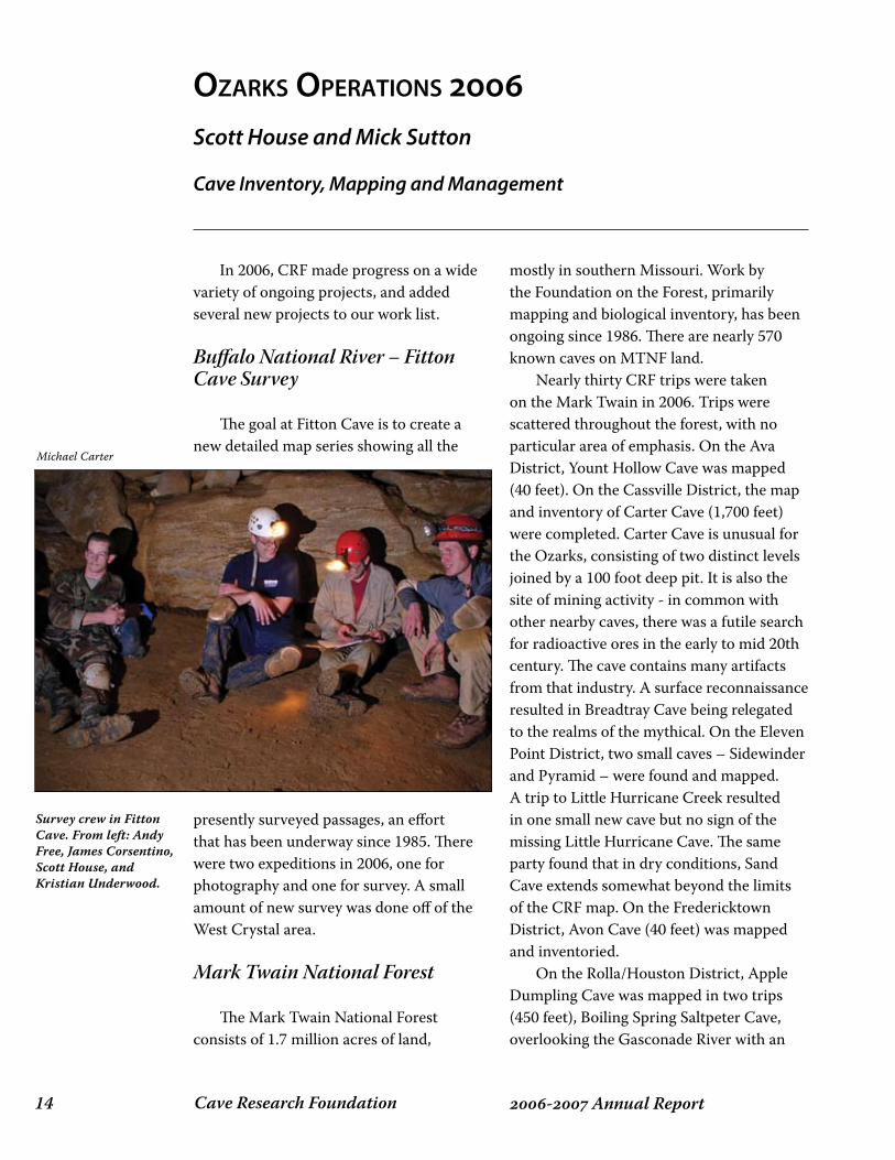
The goal at Fitton Cave is to create a new detailed map series showing all the
presently surveyed passages, an effort that has been underway since 1985. There were two expeditions in 2006, one for photography and one for survey. A small amount of new survey was done off of the West Crystal area. Mark Twain National Forest
The Mark Twain National Forest consists of 1.7 million acres of land,
mostly in southern Missouri. Work by the Foundation on the Forest, primarily mapping and biological inventory, has been ongoing since 1986. There are nearly 570 known caves on MTNF land. Nearly thirty CRF trips were taken on the Mark Twain in 2006. Trips were scattered throughout the forest, with no particular area of emphasis. On the Ava District, Yount Hollow Cave was mapped (40 feet). On the Cassville District, the map and inventory of Carter Cave (1,700 feet) were completed. Carter Cave is unusual for the Ozarks, consisting of two distinct levels joined by a 100 foot deep pit. It is also the site of mining activity - in common with other nearby caves, there was a futile search for radioactive ores in the early to mid 20th century. The cave contains many artifacts from that industry. A surface reconnaissance resulted in Breadtray Cave being relegated to the realms of the mythical. On the Eleven Point District, two small caves – Sidewinder and Pyramid – were found and mapped. A trip to Little Hurricane Creek resulted in one small new cave but no sign of the missing Little Hurricane Cave. The same party found that in dry conditions, Sand Cave extends somewhat beyond the limits of the CRF map. On the Fredericktown District, Avon Cave (40 feet) was mapped and inventoried. On the Rolla/Houston District, Apple Dumpling Cave was mapped in two trips (450 feet), Boiling Spring Saltpeter Cave, overlooking the Gasconade River with an
Cave Inventory, Mapping and Management
Michael Carter
Survey crew in Fitton Cave. From left: Andy Free, James Corsentino, Scott House, and Kristian Underwood.
��- Annual ReportCave Research Foundation
excavated back entrance, was mapped (250 feet) and inventoried. Bowlman Cave, a relatively new find, was relocated. There were three trips to map and inventory Hamilton Cave – a pit and some small leads remain to be completed. Follow-up inventory was done in Onyx Cave, the former show cave recently acquired by MTNF. The long muddy southern passage, off the old tour route, was examined and found to be rather sparsely populated. Pederson Cave, a small tectonic feature, was mapped, and Bushwhacker Cave was mapped (180 feet) and inventoried. On the Salem/Potosi District, Bounds Branch Cave was inventoried. The fauna included abundant millipedes, which appear not to be one of the common Ozark cave adapted species – follow-up work is needed on this. On the Willow Springs District, surface reconnaissance resulted in four new caves near the large and well-known Turnbull Cave. The survey of Sloan Cave was completed with two trips (1,300 feet), and the survey of North Fork Bear Cave, which features a small-scale upper level maze, continued with two trips. Coldwater Spring is a privately owned cave on property adjoining the Greasy Creek tract of the Fredericktown District. The cave was of interest because an Indiana bat had been trapped nearby within the Fredericktown district, a long way from any known hibernaculum, and the cave was known to have a pit entrance. District biologist Lynda Mills speculated that the cave might therefore be an Indiana bat site. The cave was examined on 2/6/06, at which time approximately 250 Indiana bats were present in a series of small clusters, the largest with about 30 bats. The cave was revisited in early September for mapping and general bioinventory. At that time, a cluster of bats of about 0.1 square meters occupied a high dome but was too distant to
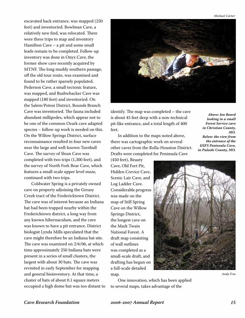
identify. The map was completed – the cave is about 45 feet deep with a non-technical pit-like entrance, and a total length of 400 feet. In addition to the maps noted above, there was cartographic work on several other caves from the Rolla-Houston District. Drafts were completed for Peninsula Cave (450 feet), Beauty Cave, Old Fort Pit, Hidden Crevice Cave, Scenic Lair Cave, and Log Ladder Cave. Considerable progress was made on the map of Still Spring Cave on the Willow Springs District, the longest cave on the Mark Twain National Forest. A draft map consisting of wall outlines was completed as a small-scale draft, and drafting has begun on a full-scale detailed map. One innovation, which has been applied to several maps, takes advantage of the
Michael Carter
Andy Free
Above: Jon Beard looking in a small
Forest Service cave in Christian County,
MO. Below: the view from
the entrance of the USFS Peninsula Cave,
in Pulaski County, MO.

Cave Research Foundation�� - Annual Report
��- Annual ReportCave Research Foundation
layering feature of the drafting program to establish a separate layer for biological information. Maps can be printed with this feature either turned on or off. Depending on the particular cartographer, some maps are also being produced as color versions, which are somewhat easier to interpret than orthodox black and white maps – traditional black and white versions of these color maps are also provided, as they are more convenient for certain purposes, such as copying for field-work drafts. This again takes advantage of the layering feature in the drafting software – a color overlay can be either switched on or off. Funding from the Mark Twain National Forest supported these efforts. Ozark National Scenic Riverways
The Ozark National Scenic Riverways consists of approximately 80,000 acres along the Current and Jacks Fork Rivers in southeast Missouri. A long term CRF and Missouri Speleological Survey project here has increased the number of known caves
from 80 in 1980 to over 300 today, over 250 of which have also been surveyed. A shorter-term project was completed – establishing baseline biological surveys for a set of caves receiving relatively heavy public
use. Each cave was visited over multiple seasons. To complete the project, follow-up trips were taken to Jam-Up, Round Spring, Bluff, Bunker Hill, Lost Man, and Branson Caves. The most interesting result was the discovery in Round Spring Cave of the rare troglobitic trechine beetle that we had previously discovered in Branson Cave. Two specimens were found in Round Spring, together with an additional specimen in Branson Cave. Until these collections, trechine beetles (Pseudanophthalmus sp.) were believed to be absent from Ozark caves. CRF personnel also helped with a one-time gray bat hibernaculum census done by US Fish and Wildlife Service and state agency personnel. This is part of a re-evaluation of the gray bat’s status. CRF also participated in a weeklong cave ecology course from Southeast Missouri State University. Over twenty caves in the park were inventoried and
Michael Carter
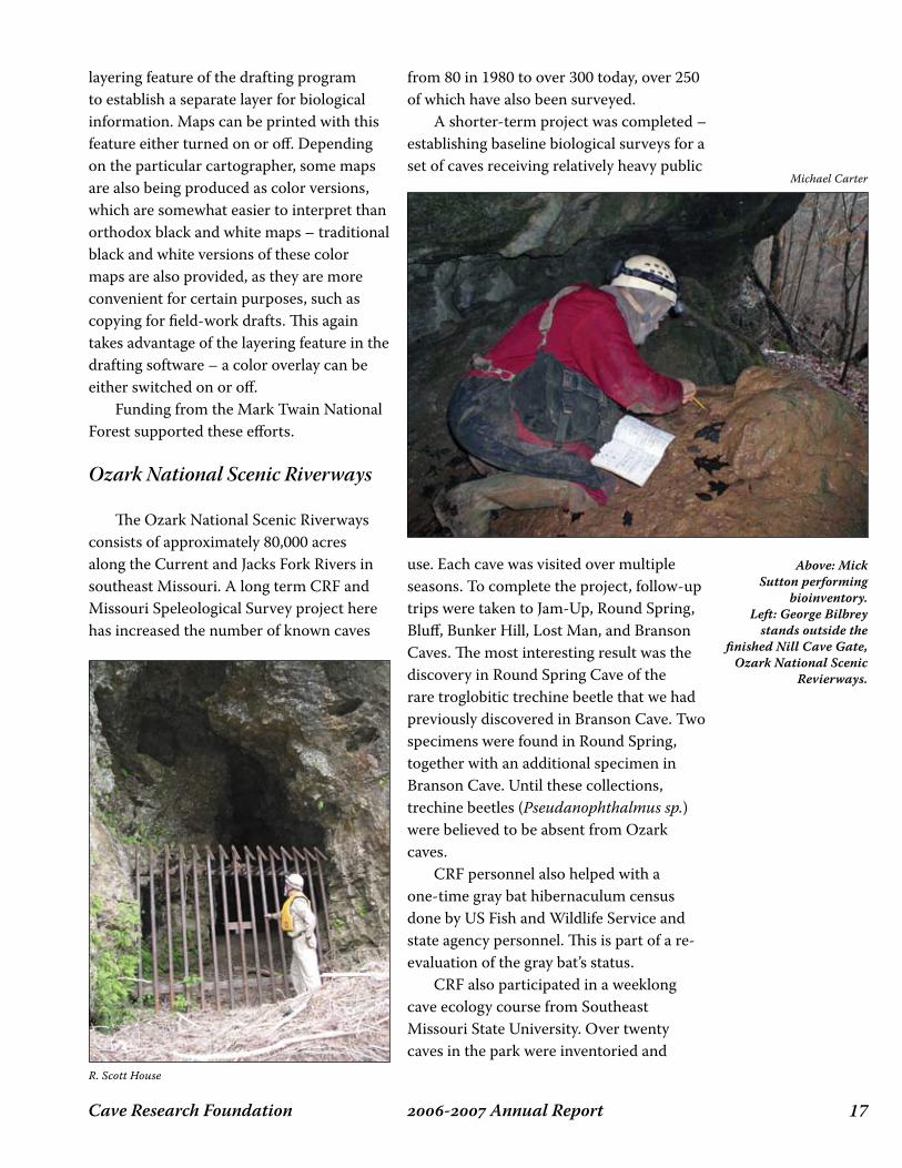
Above: Mick Sutton performing
bioinventory.Left: George Bilbrey
stands outside the finished Nill Cave Gate,
Ozark National Scenic Revierways.
R. Scott House
Cave Research Foundation�� - Annual Report
students were able to participate in real cave management activities. CRF was again contracted to provide certain cave management services to the NPS in the Riverways. Scott House was employed approximately half-time over the year, with others either employed or having expenses paid for performing certain types of management work. Duties range from writing management plans, to performing biotic surveys, to installing cave signs, and so forth. The funding also allows us to help attract volunteer groups to the park. Volunteers throughout the year monitored numerous park caves. As a result of some active fieldwork by
CRF members and partners a number of new caves have been found across the park. Most of these were in areas not previously checked. Some of the active partners include Meramec Valley Grotto, Springfield Plateau Grotto, and Mid-Mississippi Valley Grotto. Due to the law of diminishing returns the new caves found were the result of hard work and detailed searching. One of the most impressive of the new caves was named Sextus Mille in honor of Missouri reaching 6,000 documented caves. Although less than 200 feet in length, the cave features a variety of delicate formations in pristine condition. Survey work began on new maps for
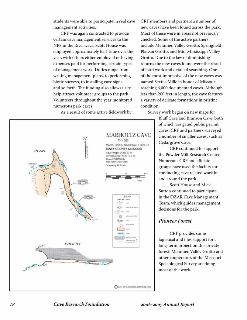
Bluff Cave and Branson Cave, both of which are gated public permit caves. CRF and partners surveyed a number of smaller caves, such as Cedargrove Cave. CRF continued to support the Powder Mill Research Center. Numerous CRF and affiliate groups have used the facility for conducting cave related work in and around the park. Scott House and Mick Sutton continued to participate in the OZAR Cave Management Team, which guides management decisions for the park. Pioneer Forest
CRF provides some logistical and files support for a long-term project on this private forest. Meramec Valley Grotto and other cooperators of the Missouri Speleological Survey are doing most of the work.
��- Annual ReportCave Research Foundation
Missouri Department of Conservation
CRF continues to map and help inventory caves owned by the Missouri Department of Conservation, an agency that manages state forest lands and wildlife. We also continue to provide services to the Department in the form of cooperative data management and consultation. Two survey trips and a photography and inventory trip were taken to Marvel Cave, a complex bat cave within Ozark National Scenic Riverways, but owned by MDC. Two new MDC-funded projects were undertaken in Perry County, home to the largest caves and the largest number of caves in Missouri, all of them in private ownership. The first is a project headed by Scott House to generate GIS data for the densely packed caves. As part of this project a number of new and greatly revised cave locations were obtained. CRF partners with members of Little Egypt Grotto and Southeast Missouri Grotto in doing fieldwork, providing support in the form of expenses and equipment. The revised locations will be one aspect of GIS cave layers. Another series of layers will show cave maps, digitized and projected into place. The second project, headed by Mick Sutton, is to develop a detailed biological inventory for Missouri’s longest cave, Crevice Cave (ca. 28 miles). The notion is to examine as much as the cave as practical, and to tie biological information to geography. The cave is home to a diverse fauna, including a population of grotto sculpins. One preliminary trip was taken in 2006, to examine the First Mile stream from the historic entrance.
Missouri Department of Natural Resources: Division of Geology and Land Survey
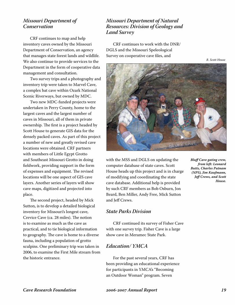
CRF continues to work with the DNR/DGLS and the Missouri Speleological Survey on cooperative cave files, and
with the MSS and DGLS on updating the computer database of state caves. Scott House heads up this project and is in charge of modifying and coordinating the state cave database. Additional help is provided by such CRF members as Bob Osburn, Jon Beard, Ben Miller, Andy Free, Mick Sutton and Jeff Crews.
State Parks Division
CRF continued its survey of Fisher Cave with one survey trip. Fisher Cave is a large show cave in Meramec State Park.
Education/ YMCA
For the past several years, CRF has been providing an educational experience for participants in YMCA’s “Becoming an Outdoor Woman” program. Seven
R. Scott House
Bluff Cave gating crew, from left: Leonard
Butts, Charles Putnam (NPS), Jim Kaufmann,
Jeff Crews, and Scott House.
Cave Research Foundation�0 - Annual Report
participants were taken to Susan Cave, a large muddy stream cave, with the emphasis on cave biology and conservation.
Missouri Speleological Survey
The MSS works to collect all cave information in the state. We cooperate fully:
Maps and reports are turned in to the MSS and are archived by the Missouri Department of Natural Resources.
•
We continue to financially support, maintain, and house the state cave database. CRF members continue to contribute maps and reports in great quantity.
Personnel and Management
We continue to work hard at attracting new talent. This year, as last, funding from Ozark National Scenic Riverways and Mark Twain National Forest enabled us to do a great deal of work.Statistical summary of work:Trips/parties: >49People/days: >152
Ozarks Operation Area
Operations Manager, MTNF Project, Crevice Cave project – Mick SuttonMSS liaison, cave files, Perry County GIS project, ONSR projects – Scott HouseGeologist - Bob OsburnFitton Cave Project – Andy FreeCave Gater – Jim Kaufmann
•
•
Michael Carter
R. Scott House
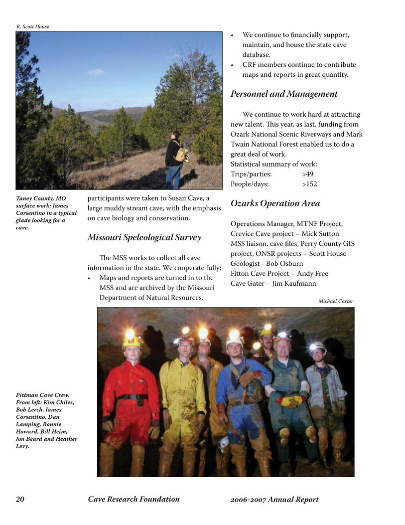
Taney County, MO surface work: James Corsentino in a typical glade looking for a cave.
Pittman Cave Crew. From left: Kim Chiles, Bob Lerch, James Corsentino, Dan Lamping, Bonnie Howard, Bill Heim, Jon Beard and Heather Levy.

��- Annual ReportCave Research Foundation
Cave Research Foundation�� - Annual Report
sequoiA-kings CAnyon opeRAtions 6John C. Tinsley
This past year has been extremely fruitful for CRF SEKI Operations. Despite the Operations Manager blowing out his knee in March, project personnel carried on and have successfully put 2006 in the record books. Below is a summary of the project during 2006.
Cave Passage Location and Documentation
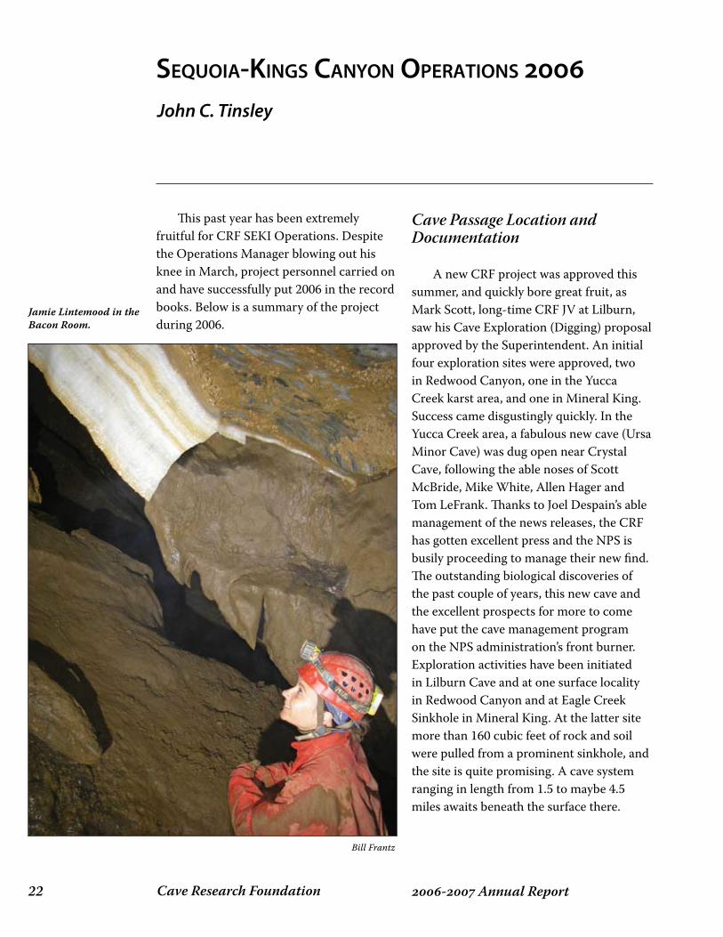
A new CRF project was approved this summer, and quickly bore great fruit, as Mark Scott, long-time CRF JV at Lilburn, saw his Cave Exploration (Digging) proposal approved by the Superintendent. An initial four exploration sites were approved, two in Redwood Canyon, one in the Yucca Creek karst area, and one in Mineral King. Success came disgustingly quickly. In the Yucca Creek area, a fabulous new cave (Ursa Minor Cave) was dug open near Crystal Cave, following the able noses of Scott McBride, Mike White, Allen Hager and Tom LeFrank. Thanks to Joel Despain’s able management of the news releases, the CRF has gotten excellent press and the NPS is busily proceeding to manage their new find. The outstanding biological discoveries of the past couple of years, this new cave and the excellent prospects for more to come have put the cave management program on the NPS administration’s front burner. Exploration activities have been initiated in Lilburn Cave and at one surface locality in Redwood Canyon and at Eagle Creek Sinkhole in Mineral King. At the latter site more than 160 cubic feet of rock and soil were pulled from a prominent sinkhole, and the site is quite promising. A cave system ranging in length from 1.5 to maybe 4.5 miles awaits beneath the surface there.
Jamie Lintemood in the Bacon Room.
Bill Frantz
��- Annual ReportCave Research Foundation
Fire Ecology
This project under the direction of Dan Doctor, John Tinsley, and Joel Despain is proceeding well. All instrumentation is now in place and samples are being obtained and frozen for future analysis. We have one more year of funding from the initial grant of $146,000; after that, Joel expects that the Cave Management Program will be able to pick up the costs of continuing the study another three years as more of Redwood Canyon is progressively burned and we continue to observe the impacts of those controlled burns on karst features of Redwood Canyon. Dan Doctor has taken a job with the USGS in Reston, VA, helping to compile the national karst map with Eastern Earth Surface Processes Team. He’ll be flying out to SEKI periodically to take charge of equipment tweaking and so forth, but Tinsley has agreed to take over as nominal head of the research project during its final NPS-USGS-funded year. Of special value to this project has been and continues to be the availability and technical expertise of Ben Tobin, who is Joel’s aide-de-camp at SEKI, and who has expended much time and energy visiting the samplers, schlepping/swapping batteries, and hauling samples from the canyon to the freezer at Ash Mountain. Ben probably knows more about automated data collection than the rest of us put together; we are delighted to have his expertise at hand.
Cave Restoration
Bill Frantz has renewed his Cave Restoration Project and will be un-doing the impacts of caver traffic in selected well-decorated
parts of Lilburn Cave and other Park caves as time and opportunity permit.
Cartography
Jed Mosenfelder has done an exemplary job as Chief Cartographer, having taken over from Peter Bosted in 2004. Lilburn continues to grow in the dimension of length, and is approaching 21 surveyed miles.
Sedimentology of Redwood Canyon Karst
John Tinsley has rolled his sediment study into the fire ecology project, and likely will keep it there for the next several years. No point in having to fill out more than the requisite number of Investigators Annual Reports.
Bill Frantz
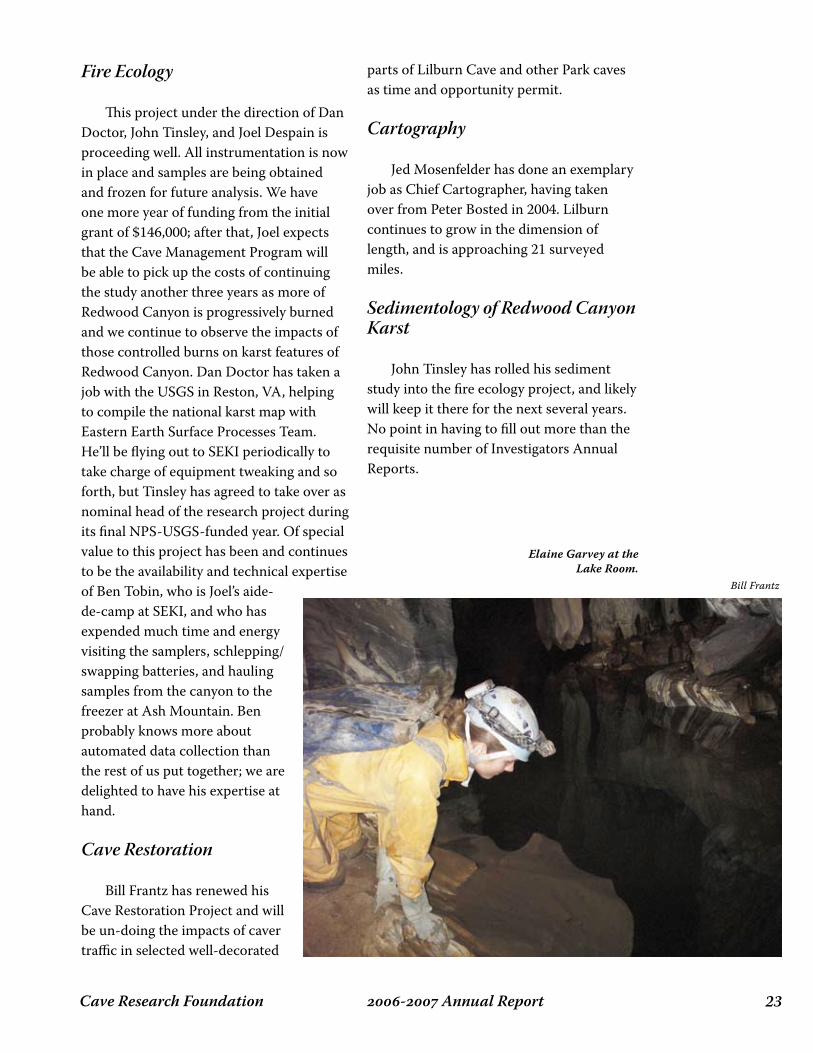
Elaine Garvey at the Lake Room.

Cave Research Foundation�� - Annual Report
Facility and Research Instrumentation Maintenance
Maintaining the cabin facility and the research project instrumentation has been a major undertaking. The cabin’s roof is about at the end of its natural life, and the area around the chimney is beginning to leak with distressing profusion. A trio of electronic nerds, specifically Howard Hurtt,
Paul Nelson, and Dan Doctor, has been the principals active in the installation of new equipment, new and larger photovoltaic panels and testing and maintenance of the cabin infrastructure during the past year and a half. They’ve had much help from many individuals and many quarters. We still have a couple of expeditions yet to happen in 2006, and we anticipate further achievements between now and the end of the calendar year.
New Projects
Several additional prospects for future projects remain under evaluation and a couple of ideas are nearing the proposal stage. I am not at liberty to elaborate on these at this time, but our future prospects seem quite bright, given that this is a small and therefore rather fragile undertaking.
southwest Region 6
CRF Southwest has had a very productive year thus far, working on a variety of areas and projects.
National Park ServiceCarlsbad Caverns National Park
Four Expeditions were held at CCNP
Barbe Barker
Guadalupe Escarpment & Fort Stanton Range
November 2005 - October 2006
Redwood Canyon at sunset.
Bill Frantz

��- Annual ReportCave Research Foundation
this last year during the usual three and four day holiday weekends. The breakdown of survey and restoration projects is determined and planned according to the expertise of the group on each expedition. Survey has continued in Lower Cave with ongoing projects headed by the approved sketchers of the Park. We are still in Lower Cave and, not surprisingly, continue to find virgin passage as we check tie-in and loop closures. Future survey projects will be awarded to approved sketchers rather than groups. Restoration projects continue in Lake of the Clouds, The Guadalupe Room and The Dome Room. Longfellow’s Bathtub is 95% finished and a presentation of the completed project will be presented during the 50th Anniversary Celebration of CRF next year. We also began a new project, “Rookery II”, which is an extension of a 5-year project finished over a year ago.
Bureau of Land ManagementFort Stanton and Torgac Caves
Restoration, photo monitoring, combination changes, guide training, leading trips and conservation/restoration training of groups has been the main focus of work in Fort Stanton as well as Torgac Caves. The last of our Challenge Cost Share funds, $2,150, was turned in on 9/29/06, before the end of their fiscal year. The BLM has requested $12,500 for the upcoming year but have not heard whether it has been approved. They also requested $15,000 for the next year. Bill Murray has been appointed Recreation/Cave Specialist within the Roswell Field Office and we have an excellent relationship with him. Frank Everitt, CRF Restoration Manager for the BLM, RFO, has continued to do an
outstanding job of representing CRF and both of us continue to work with Bill Murray and Paul Happel with regard to administrative as well as long term planning for FSC and Torgac.
Summary
Things are great at CCNP. We work well with Dale Pate and Stan Allison in the Cave Resource Office. They continue to have faith in our ability to carry out the tasks we have been entrusted. We continue to have a good working relationship with the BLM, Roswell Field Office. They are very appreciative of our efforts and volunteer hours.
CRF Southwest Region
Area Manager: Barbe BarkerCCNP Survey Manager: Kevin GloverBLM, RFO, Restoration Manager: Frank J. Everitt
Total volunteer hours for the SW Region of CRF for this year: 4,700.

Cave Research Foundation�� - Annual Report
Scott House in West Crystal Room, Fitton Cave, Buffalo National River.
Michael Carter

��- Annual ReportCave Research Foundation
OperatiOn area repOrts 7
Cave Research Foundation�� - Annual Report
During this period, Eastern Operations at Mammoth Cave National Park fielded 133 parties, devoting over 10,888 hours to the park, and another 2,389 to the Biosphere Reserve outside the park in support of various projects as follows:
In Park
MCNP Cartography – 76 partiesSmall Cave Inventory – 12 partiesCave Art Documentation - 3 partiesGeology - 1 partyHydrology - 1 partyArchaeology - 2 partiesTrail Lighting - 2 partiesNarrative Description - 1 party
Biosphere Reserve
Roppel Cave - 23 partiesHidden River Survey – 5 partiesStan’s Well - 1 partyDiamond Caverns - 3 partiesWildcat Hollow - 3 partiesChurch’s Pit - 1 party
Small Caves work continued with one party in Wilson Cave, one in Haunted, one in Dennison, and nine parties in Great Onyx Cave. Forty-four parties worked in Mammoth Cave, as efforts to complete all sheets for the main tourist routes continue to be a focal point. In other parts of the system, seven parties worked in Unknown Cave, three in Crystal
Cave, five in Salts Cave, fifteen in Colossal Cave, four in Proctor Cave, and one in New Discovery. Exciting new discoveries were made in the Bishop’s Pit area near the Carmichael entrance. Tom Brucker’s adoption of the Colossal Cave map sheet has brought about a flurry of activity in that area. Efforts are continuing to move the database into a single Walls database, the currently preferred data reduction software for the Cartography project, as it more easily complements the increasing use of Adobe Illustrator in map production. The February expedition was again dedicated to consolidating data from the various cartographers into a single standard format to ensure compatibility, and still more was accomplished to this end during the July week-long expedition. An enormous map sheet compilation was assembled for presentation at the annual NSS convention. Elizabeth Winkler continues to make progress on the Trip Report Database consolidation effort, now nearing completion. Charles Fox continues work on the Safety Video for use as a training tool by CRF and the park. Charles Swedlund and George Crothers continue their work documenting historic and prehistoric cave art throughout the system. Outside the park, support for the CKKC survey in Roppel Cave has continued. During the July expedition, support was provided to a major diving effort in upstream Logsdon River. While much survey was accomplished between Sump 1
eAsteRn opeRAtions 7Dave West
October 1, 2006 - September 30, 2007

��- Annual ReportCave Research Foundation
and Sump 2, the divers were unable to fully penetrate Sump 2. Work also continues in the caves owned by Hamilton Valley neighbor and CRF member Stan Sides. Church’s Pit is located on another of our neighbor’s properties. Much work remains in Hidden River Cave, site of the ACCA Museum in Horse Cave, KY. The project at Gap Cave in Cumberland Gap National Historical Park is now in year 5 with the length of the surveyed cave at 12.6 miles. Production of the map has stayed current. Travel to primary objectives is challenging. The round trip time is approaching eight hours. Much of the passage is large and complex. Virgin passage continues to be found off old survey lines. There have been no significant accidents, injuries, or incidents. Survey continues the last weekend of each month. Capable cavers, particularly skilled and experienced sketchers, are needed. An exciting development in Eastern Operations is the beginning of work in West Virginia, where CRF is leading the way in
the exploration and mapping of the Cave Hollow - Arbogast Cave System, situated in the Monongahela National Forest. The system is used as a hibernaculum and maternity site by the federally endangered Virginia Big-Eared bat, and is also used as a hibernaculum by the federally endangered Indiana bat. This project is being conducted in cooperation with the U.S. Forest Service, the U.S. Fish & Wildlife Service, the West Virginia Division of Natural Resources, the West Virginia Association of Speleological Surveys, the Baltimore Grotto of the National Speleological Society, and other local groups active in the survey and mapping of West Virginia caves. As of this writing, a draft agreement is in hand, three weekends of surface work have been conducted, and work is expected to begin in earnest this year prior to the end of the access season of mid-September to mid-November. Of course, CRF will support other research efforts at the site as they are developed.
Ann Bosted climbing through a waterfall in
Salts Cave.
Peter and Ann Bosted
Cave Research Foundation�0 - Annual Report
Major expeditions in National Park Service (NPS) fiscal year 2007 were held over Columbus Day, Thanksgiving Holiday, President’s Day, Memorial Day, July 4th, and Labor Day with shorter trips over other weekends. In all, 18 trips were made to Lava Beds. During the 111 person-day visits, 2,583 hours were logged by CRF at Lava Beds. A total of 57 CRF members were present on these trips. In addition, many more hours were spent offsite in administrative duties and map drafting by the Operations Managers Pat Helton and Bruce Rogers, Onsite Manager Bill Devereaux, Chief Cartographer Rich Steiger, and cartographer Liz Wolff. The Annual CRF meeting was held at Lava Beds over the Columbus Day holiday in October of 2006; 24 people were in attendance. In addition to the CRF meeting, there was a meeting with NPS staff and the retiring Superintendent Craig Dorman. Dorman was singled out as having been a steadfast supporter of CRF operations at the Monument, particularly in the construction of the Research Center (commonly referred to as the “RC”). Survey parties were fielded to several newly discovered caves and substantial progress made towards new maps for these caves. Judged by the comments overheard, the meeting and mini-field camp were a success. In recognition of constant support and encouragement by out-going Superintendent Dorman, on the Thanksgiving Expedition a large format
black and white photograph taken by CRF’s Bill Frantz was presented to Craig on behalf of all CRF personnel, present and past. CRF has several ongoing projects at Lava Beds as well as several short-term projects. The following is an abstract of each project; individual reports may be found elsewhere in this volume.
Cave Reconnaissance Inventory
Led by Bill Devereaux, the purpose of this project is to provide reconnaissance-level documentation of every cave, no matter how small. Data include a sketch map and profile of the cave and a checklist of contents and features. Only perhaps 10% of the Monument has been adequately covered so we look forward to many more caves being located, GPS’d and an initial Reconnaissance Information card filled out. Devereaux’s cave inventory project still is making steady progress. Whenever possible, an inventory person is added to each survey party entering the Monument’s caves. Again, relatively few of the caves have been inventoried since the initial effort in the 1980’s and 90’s led by Bill Devereaux and Janet Sowers. A revision of the inventory form is underway as a cooperative effort with Shane Fryer of the NPS staff. The need to have inventory personnel identify features in a uniform manner has necessitated an illustrated gazetteer showing those features. Marc Hasbrouck and Brian “Beej” Hall are in the initial stages of designing a compact
lAvA Beds opeRAtions 7Pat Helton, Bruce Rogers and William Deveraux
October 1, 2006 - September 30, 2007
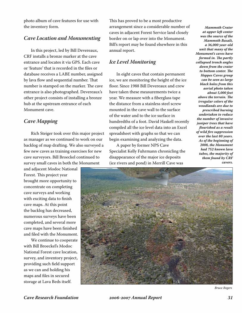
��- Annual ReportCave Research Foundation
Bruce Rogers
Mammoth Crater at upper left center
was the source of the Mammoth Basalt, a 36,000 year-old
unit that many of the Monument’s caves have
formed in. The partly collapsed trench angles
down from the crater to bottom center. The Heppes Caves group can be seen as large
black holes from this aerial photo taken
about 5,000 feet above the terrain. The irregular colors of the woodlands are due to
prescribed burning undertaken to reduce
the number of invasive juniper trees that have
flourished as a result of wild fire suppression
over the last 80 years. As of the beginning of 2008, the Monument had 752 known lava
tubes, the majority of them found by CRF
cavers.
photo album of cave features for use with the inventory form.
Cave Location and Monumenting
In this project, led by Bill Devereaux, CRF installs a bronze marker at the cave entrance and locates it via GPS. Each cave or ‘feature’ that is recorded in the files or database receives a LABE number, assigned by lava flow and sequential number. That number is stamped on the marker. The cave entrance is also photographed. Devereaux’s other project consists of installing a bronze hub at the upstream entrance of each Monument cave.
Cave Mapping
Rich Steiger took over this major project as manager as we continued to work on our backlog of map drafting. We also surveyed a few new caves as training exercises for new cave surveyors. Bill Broeckel continued to survey small caves in both the Monument and adjacent Modoc National Forest. This project year brought more opportunity to concentrate on completing cave surveys and working with exciting data to finish cave maps. At this point the backlog has decreased, numerous surveys have been completed, and several more cave maps have been finished and filed with the Monument. We continue to cooperate with Bill Broeckel’s Modoc National Forest cave location, survey, and inventory project, providing such field support as we can and holding his maps and files in secured storage at Lava Beds itself.
This has proved to be a most productive arrangement since a considerable number of caves in adjacent Forest Service land closely border on or lap over into the Monument. Bill’s report may be found elsewhere in this annual report.
Ice Level Monitoring
In eight caves that contain permanent ice, we are monitoring the height of the ice floor. Since 1988 Bill Devereaux and crew have taken these measurements twice a year. We measure with a fiberglass tape the distance from a stainless steel screw mounted in the cave wall to the surface of the water and to the ice surface in hundredths of a foot. David Haskell recently compiled all the ice level data into an Excel spreadsheet with graphs so that we can begin examining and analyzing the data. A paper by former NPS Cave Specialist Kelly Fuhrmann chronicling the disappearance of the major ice deposits (ice rivers and pond) in Merrill Cave was
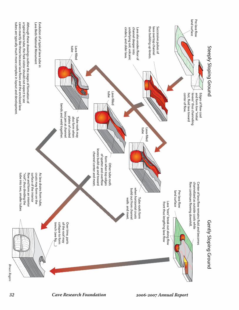
Cave Research Foundation�� - Annual Report
Center of lava �ow rem
ains �uid and becomes
channelized as outside cools while
�ow continues �ow
ing downhill.
Pre-lava �ow
land surface
Lava "toes" break out along �ow front thus lengthing lava �ow
Edges of �ow cool
and form low
"initial levees" thus channeling hot, �uid lava tow
ard center of �ow
.
Successive pulses oflava overtop channel thus building up levees.
As lava drains from
tube, crusts m
ay form on the
surface of the interior �ow
and form an interior
"roof", thus dividing the tube into tw
o, smaller tubes
Over tim
e, parts of the roof m
ay collapse to form
trench (see �g.__)
Evolution of a typical lava tube inLava Beds N
ational Monum
ent
Although these draw
ings outline the stages of formation of
a typical lava tube, the Park visitor should not expect to see caves exactly like these because lava �ow
s and the enclosed lava tubes are typically m
uch more com
plex in layout and development.
Lava also erodes �oor of channel deeper into underlying soil, volcanic cinders, and older lava.
Tube roofs form
when horizontal crusts
build out from channel
walls and m
eet.
Pre-lava �ow
land surface
Steeply Sloping Ground
Gently Sloping G
round
Lava-�lled tube
Lava-�lled tube
Other tube roofs
form w
hen top edges of spatter and over�ow
levees build up and tow
ard channel center and m
eet.
Tube roofs may
also form w
hen plates of cooled
lava jam at channel
bends and weld together.
Lava-�lled tube
Bruce Rogers
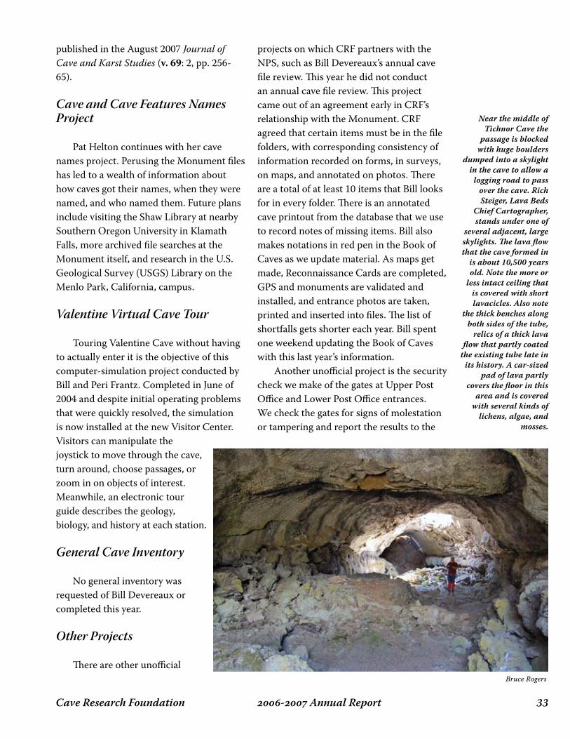
��- Annual ReportCave Research Foundation
published in the August 2007 Journal of Cave and Karst Studies (v. 69: 2, pp. 256-65).
Cave and Cave Features Names Project
Pat Helton continues with her cave names project. Perusing the Monument files has led to a wealth of information about how caves got their names, when they were named, and who named them. Future plans include visiting the Shaw Library at nearby Southern Oregon University in Klamath Falls, more archived file searches at the Monument itself, and research in the U.S. Geological Survey (USGS) Library on the Menlo Park, California, campus.
Valentine Virtual Cave Tour
Touring Valentine Cave without having to actually enter it is the objective of this computer-simulation project conducted by Bill and Peri Frantz. Completed in June of 2004 and despite initial operating problems that were quickly resolved, the simulation is now installed at the new Visitor Center. Visitors can manipulate the joystick to move through the cave, turn around, choose passages, or zoom in on objects of interest. Meanwhile, an electronic tour guide describes the geology, biology, and history at each station.
General Cave Inventory
No general inventory was requested of Bill Devereaux or completed this year.
Other Projects
There are other unofficial
projects on which CRF partners with the NPS, such as Bill Devereaux’s annual cave file review. This year he did not conduct an annual cave file review. This project came out of an agreement early in CRF’s relationship with the Monument. CRF agreed that certain items must be in the file folders, with corresponding consistency of information recorded on forms, in surveys, on maps, and annotated on photos. There are a total of at least 10 items that Bill looks for in every folder. There is an annotated cave printout from the database that we use to record notes of missing items. Bill also makes notations in red pen in the Book of Caves as we update material. As maps get made, Reconnaissance Cards are completed, GPS and monuments are validated and installed, and entrance photos are taken, printed and inserted into files. The list of shortfalls gets shorter each year. Bill spent one weekend updating the Book of Caves with this last year’s information. Another unofficial project is the security check we make of the gates at Upper Post Office and Lower Post Office entrances. We check the gates for signs of molestation or tampering and report the results to the
Bruce Rogers
Near the middle of Tichnor Cave the
passage is blocked with huge boulders
dumped into a skylight in the cave to allow a
logging road to pass over the cave. Rich Steiger, Lava Beds
Chief Cartographer, stands under one of
several adjacent, large skylights. The lava flow that the cave formed in
is about 10,500 years old. Note the more or
less intact ceiling that is covered with short lavacicles. Also note
the thick benches along both sides of the tube,
relics of a thick lava flow that partly coated
the existing tube late in its history. A car-sized
pad of lava partly covers the floor in this
area and is covered with several kinds of
lichens, algae, and mosses.

Cave Research Foundation�� - Annual Report
Chief Ranger after the trip. This year the gates showed no sign of tampering. This is both good and unusual; we hope the trend continues. Bats are intensively using the lower entrance gate, based on evidence of moth wings and guano deposits at the near side of the gate. The upper gate shows no such traffic evidence.
Research Center
While not a CRF LABE Project, the Research Center continues to be another major focus of CRF activity in Lava Beds National Monument. In February 2005, CRF occupied it for the first time. We, and other researchers across several disciplines and organizations, have used it throughout this year. They have expressed surprise and delight at the utility of
the facility. This reflects well on the vision, determination, persistence, and teamwork by the CRF volunteers and the Monument staff to bring the building into existence and operation. The lab has actually been used as a lab, and the meeting room has been used for meetings and classes for groups not associated with CRF or caving. Work on the Research Center Operations Manual by Helton and Rogers proceeded slowly due to the nearly overwhelming need to field cave survey parties. A Trip Leader and Expedition Leader Manual were also started. Rogers and Helton also donated two Weber BBQs for use at the Research Center. Many other CRF “regulars” provided cookware, crockery, flatware and dishes to the RC. Helton and Rogers also provided another 4-drawer filing cabinet and finished wood secured storage cabinets for CRF administrative supplies and cave
As part of our continuing efforts to operate in concert with the Lava Beds staff, the CRF cavers provided a welcome lunch to the 2007 seasonal NPS employees who arrived at Lava Beds in mid-May of 2007. It appears everyone was well fed. Sharp eyes will pick out CRF Co-Ops manager Pat Helton (lower left), Peri Frantz (left side of rear table), and Ray Beach (on left end of sofa). The Research Center was the site of the Western Region, NSS, spring Speleo-Ed seminar held the weekend before Memorial Day weekend. Note the large aerial color photo of the Monument on the north wall of the Research Center, a caver funded and built facility now operated by the NPS for all kinds of research in the Monument and surrounding Klamath Basin.
Bruce Rogers
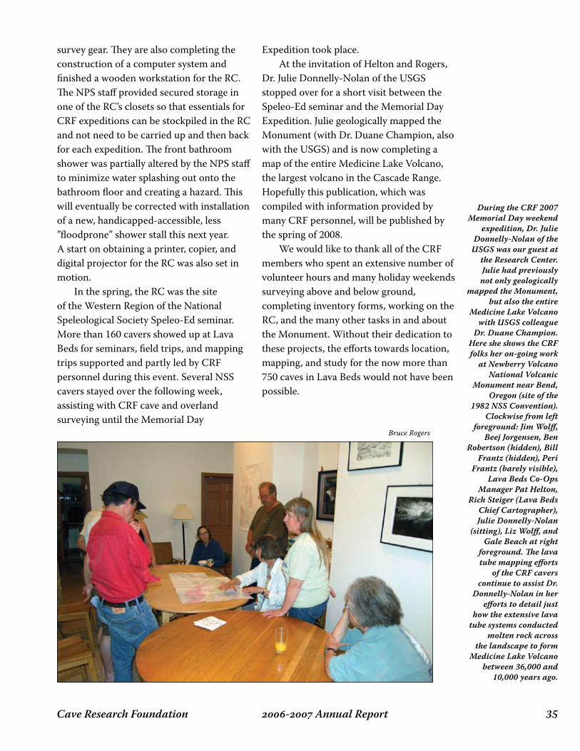
��- Annual ReportCave Research Foundation
Expedition took place. At the invitation of Helton and Rogers, Dr. Julie Donnelly-Nolan of the USGS stopped over for a short visit between the Speleo-Ed seminar and the Memorial Day Expedition. Julie geologically mapped the Monument (with Dr. Duane Champion, also with the USGS) and is now completing a map of the entire Medicine Lake Volcano, the largest volcano in the Cascade Range. Hopefully this publication, which was compiled with information provided by many CRF personnel, will be published by the spring of 2008. We would like to thank all of the CRF members who spent an extensive number of volunteer hours and many holiday weekends surveying above and below ground, completing inventory forms, working on the RC, and the many other tasks in and about the Monument. Without their dedication to these projects, the efforts towards location, mapping, and study for the now more than 750 caves in Lava Beds would not have been possible.
survey gear. They are also completing the construction of a computer system and finished a wooden workstation for the RC. The NPS staff provided secured storage in one of the RC’s closets so that essentials for CRF expeditions can be stockpiled in the RC and not need to be carried up and then back for each expedition. The front bathroom shower was partially altered by the NPS staff to minimize water splashing out onto the bathroom floor and creating a hazard. This will eventually be corrected with installation of a new, handicapped-accessible, less ”floodprone” shower stall this next year. A start on obtaining a printer, copier, and digital projector for the RC was also set in motion. In the spring, the RC was the site of the Western Region of the National Speleological Society Speleo-Ed seminar. More than 160 cavers showed up at Lava Beds for seminars, field trips, and mapping trips supported and partly led by CRF personnel during this event. Several NSS cavers stayed over the following week, assisting with CRF cave and overland surveying until the Memorial Day
During the CRF 2007 Memorial Day weekend
expedition, Dr. Julie Donnelly-Nolan of the
USGS was our guest at the Research Center. Julie had previously not only geologically
mapped the Monument, but also the entire
Medicine Lake Volcano with USGS colleague
Dr. Duane Champion. Here she shows the CRF folks her on-going work
at Newberry Volcano National Volcanic
Monument near Bend, Oregon (site of the
1982 NSS Convention). Clockwise from left
foreground: Jim Wolff, Beej Jorgensen, Ben
Robertson (hidden), Bill Frantz (hidden), Peri
Frantz (barely visible), Lava Beds Co-Ops
Manager Pat Helton, Rich Steiger (Lava Beds
Chief Cartographer), Julie Donnelly-Nolan
(sitting), Liz Wolff, and Gale Beach at right
foreground. The lava tube mapping efforts
of the CRF cavers continue to assist Dr.
Donnelly-Nolan in her efforts to detail just
how the extensive lava tube systems conducted
molten rock across the landscape to form
Medicine Lake Volcano between 36,000 and
10,000 years ago.
Bruce Rogers
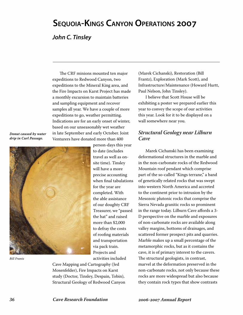
Cave Research Foundation�� - Annual Report
The CRF minions mounted ten major expeditions to Redwood Canyon, two expeditions to the Mineral King area, and the Fire Impacts on Karst Project has made a monthly excursion to maintain batteries and sampling equipment and recover samples all year. We have a couple of more expeditions to go, weather permitting. Indications are for an early onset of winter, based on our unseasonably wet weather in late September and early October. Joint Venturers have donated more than 400
person-days this year to date (includes travel as well as on-site time). Tinsley will have a more precise accounting when final tabulations for the year are completed. With the able assistance of our doughty CRF Treasurer, we “passed the hat” and raised more than $2,000 to defray the costs of roofing materials and transportation via pack train. Projects and activities included
Cave Mapping and Cartography (Jed Mosenfelder), Fire Impacts on Karst study (Doctor, Tinsley, Despain, Tobin), Structural Geology of Redwood Canyon
(Marek Cichanski), Restoration (Bill Frantz), Exploration (Mark Scott), and Infrastructure/Maintenance (Howard Hurtt, Paul Nelson, John Tinsley). I believe that Scott House will be exhibiting a poster we prepared earlier this year to convey the scope of our activities this year. Look for it to be displayed on a wall somewhere near you.
Structural Geology near Lilburn Cave
Marek Cichanski has been examining deformational structures in the marble and in the non-carbonate rocks of the Redwood Mountain roof pendant which comprise part of the so-called “Kings terrane,” a band of genetically related rocks that was swept into western North America and accreted to the continent prior to intrusion by the Mesozoic plutonic rocks that comprise the Sierra Nevada granitic rocks so prominent in the range today. Lilburn Cave affords a 3-D perspective on the marble and exposures of non-carbonate rocks are available along valley margins, bottoms of drainages, and scattered former prospect pits and quarries. Marble makes up a small percentage of the metamorphic rocks, but as it contains the cave, it is of primary interest to the cavers. The structural geologists, in contrast, marvel at the deformation preserved in the non-carbonate rocks, not only because these rocks are more widespread but also because they contain rock types that show contrasts
sequoiA-kings CAnyon opeRAtions 7John C. Tinsley
Bill Frantz
Donut caused by water drip in Curl Passage.
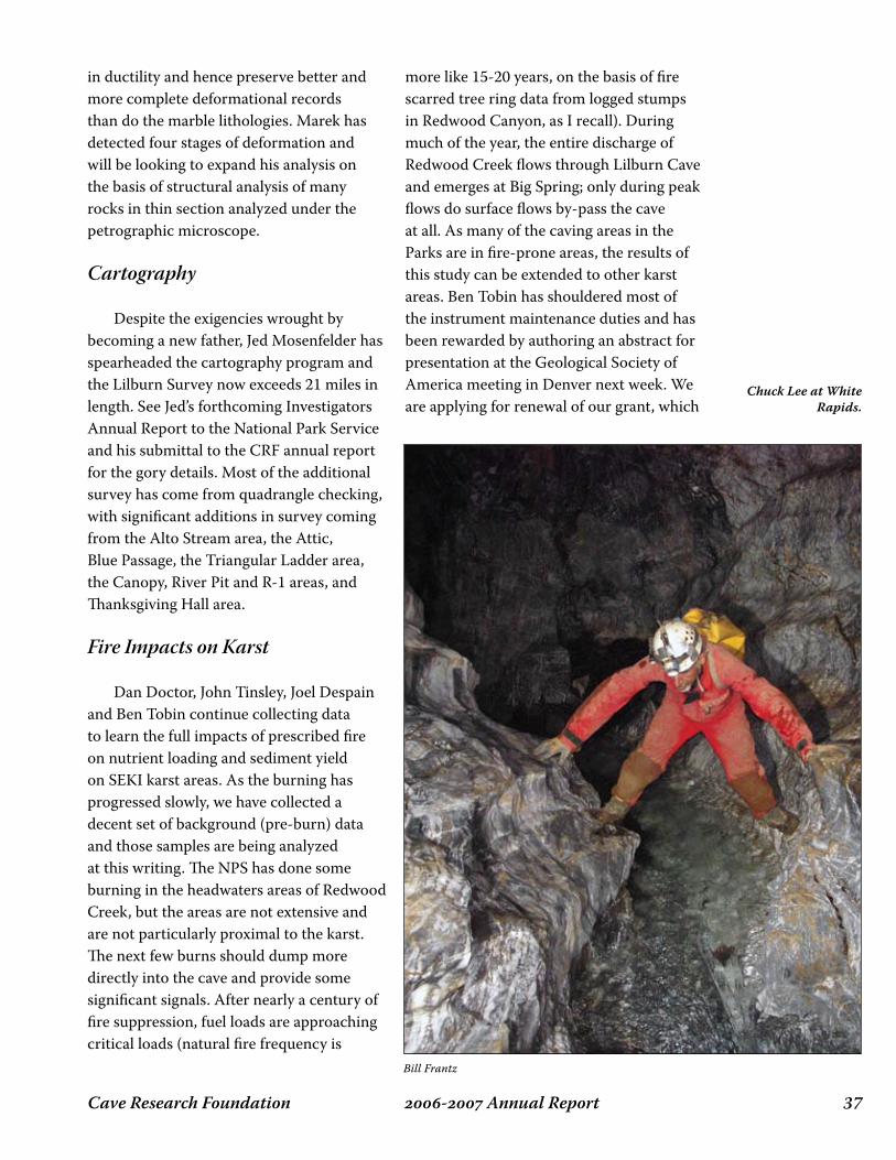
��- Annual ReportCave Research Foundation
in ductility and hence preserve better and more complete deformational records than do the marble lithologies. Marek has detected four stages of deformation and will be looking to expand his analysis on the basis of structural analysis of many rocks in thin section analyzed under the petrographic microscope.
Cartography
Despite the exigencies wrought by becoming a new father, Jed Mosenfelder has spearheaded the cartography program and the Lilburn Survey now exceeds 21 miles in length. See Jed’s forthcoming Investigators Annual Report to the National Park Service and his submittal to the CRF annual report for the gory details. Most of the additional survey has come from quadrangle checking, with significant additions in survey coming from the Alto Stream area, the Attic, Blue Passage, the Triangular Ladder area, the Canopy, River Pit and R-1 areas, and Thanksgiving Hall area.
Fire Impacts on Karst
Dan Doctor, John Tinsley, Joel Despain and Ben Tobin continue collecting data to learn the full impacts of prescribed fire on nutrient loading and sediment yield on SEKI karst areas. As the burning has progressed slowly, we have collected a decent set of background (pre-burn) data and those samples are being analyzed at this writing. The NPS has done some burning in the headwaters areas of Redwood Creek, but the areas are not extensive and are not particularly proximal to the karst. The next few burns should dump more directly into the cave and provide some significant signals. After nearly a century of fire suppression, fuel loads are approaching critical loads (natural fire frequency is
more like 15-20 years, on the basis of fire scarred tree ring data from logged stumps in Redwood Canyon, as I recall). During much of the year, the entire discharge of Redwood Creek flows through Lilburn Cave and emerges at Big Spring; only during peak flows do surface flows by-pass the cave at all. As many of the caving areas in the Parks are in fire-prone areas, the results of this study can be extended to other karst areas. Ben Tobin has shouldered most of the instrument maintenance duties and has been rewarded by authoring an abstract for presentation at the Geological Society of America meeting in Denver next week. We are applying for renewal of our grant, which
Bill Frantz
Chuck Lee at White Rapids.
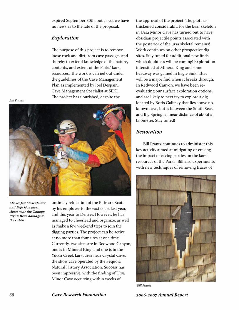
Cave Research Foundation�� - Annual Report
expired September 30th, but as yet we have no news as to the fate of the proposal.
Exploration
The purpose of this project is to remove loose rock and dirt from cave passages and thereby to extend knowledge of the nature, contents, and extent of the Parks’ karst resources. The work is carried out under the guidelines of the Cave Management Plan as implemented by Joel Despain, Cave Management Specialist at SEKI. The project has flourished, despite the
untimely relocation of the PI Mark Scott by his employer to the east coast last year, and this year to Denver. However, he has managed to cheerlead and organize, as well as make a few weekend trips to join the digging parties. The project can be active at no more than four sites at one time. Currently, two sites are in Redwood Canyon, one is in Mineral King, and one is in the Yucca Creek karst area near Crystal Cave, the show cave operated by the Sequoia Natural History Association. Success has been impressive, with the finding of Ursa Minor Cave occurring within weeks of
the approval of the project. The plot has thickened considerably, for the bear skeleton in Ursa Minor Cave has turned out to have obsidian projectile points associated with the posterior of the ursa skeletal remains! Work continues on other prospective dig sites. Stay tuned for additional new finds which doubtless will be coming! Exploration intensified at Mineral King and some headway was gained in Eagle Sink. That will be a major find when it breaks through. In Redwood Canyon, we have been re-evaluating our surface exploration options, and are likely to next try to explore a dig located by Boris Galitsky that lies above no known cave, but is between the South Seas and Big Spring, a linear distance of about a kilometer. Stay tuned!
Restoration
Bill Frantz continues to administer this key activity aimed at mitigating or erasing the impact of caving parties on the karst resources of the Parks. Bill also experiments with new techniques of removing traces of
Bill Frantz
Bill Frantz
Above: Jed Mosenfelder and Fofo Gonzalez clean near the Canopy.Right: Bear damage to the cabin.
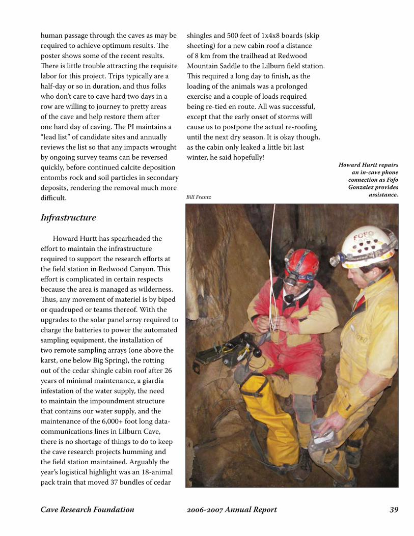
��- Annual ReportCave Research Foundation
human passage through the caves as may be required to achieve optimum results. The poster shows some of the recent results. There is little trouble attracting the requisite labor for this project. Trips typically are a half-day or so in duration, and thus folks who don’t care to cave hard two days in a row are willing to journey to pretty areas of the cave and help restore them after one hard day of caving. The PI maintains a “lead list” of candidate sites and annually reviews the list so that any impacts wrought by ongoing survey teams can be reversed quickly, before continued calcite deposition entombs rock and soil particles in secondary deposits, rendering the removal much more difficult.
Infrastructure
Howard Hurtt has spearheaded the effort to maintain the infrastructure required to support the research efforts at the field station in Redwood Canyon. This effort is complicated in certain respects because the area is managed as wilderness. Thus, any movement of materiel is by biped or quadruped or teams thereof. With the upgrades to the solar panel array required to charge the batteries to power the automated sampling equipment, the installation of two remote sampling arrays (one above the karst, one below Big Spring), the rotting out of the cedar shingle cabin roof after 26 years of minimal maintenance, a giardia infestation of the water supply, the need to maintain the impoundment structure that contains our water supply, and the maintenance of the 6,000+ foot long data-communications lines in Lilburn Cave, there is no shortage of things to do to keep the cave research projects humming and the field station maintained. Arguably the year’s logistical highlight was an 18-animal pack train that moved 37 bundles of cedar
shingles and 500 feet of 1x4x8 boards (skip sheeting) for a new cabin roof a distance of 8 km from the trailhead at Redwood Mountain Saddle to the Lilburn field station. This required a long day to finish, as the loading of the animals was a prolonged exercise and a couple of loads required being re-tied en route. All was successful, except that the early onset of storms will cause us to postpone the actual re-roofing until the next dry season. It is okay though, as the cabin only leaked a little bit last winter, he said hopefully!
Bill Frantz
Howard Hurtt repairs an in-cave phone
connection as Fofo Gonzalez provides
assistance.

Cave Research Foundation�0 - Annual Report
ozARks opeRAtions 7
Buffalo National River
Fitton Cave Survey: The long-term project to complete a detailed map of Fitton Cave advanced with three field trips in January, April and September. A complication arose owing to loss of the Steel Creek building. For the first field trip, participants stayed instead at the privately owned Beckham Creek Cave House. For the second and third trips, accommodation
was at the Chestnut Cabin and a privately owned Broadwater Hollow campsite. In January, the four survey crews worked on profiles along existing survey lines in Crystal Passage and Gypsum Flats. In April, four survey parties focused on doing profiles and upgrading sketches in the Gypsum Flats and Schemerhorn Shortcut sections. In
addition, there was a survey trip to a satellite cave, Devils Den Pit. In September, work in Gypsum Flats continued, and a survey was started down the drain in Lost Passage towards Lower East Passage. Andy Free took over from Bill Steele as project manager. The problem with accommodation for survey crews has not yet been solved, and the project is temporarily on hold. A resolution seems likely in the near future.
Mark Twain National Forest
Cave gating: Jim Kaufmann continued a project to gate or re-gate caves on the Mark Twain. Bat Cave (Ozark County), a gray bat maternity cave, received a new gate to replace an inadequate and deteriorating rebar contraption. Knife Cave (Pulaski County) was gated to protect a small Indiana bat hibernaculum recently discovered by CRF crews. Survey and biological inventory: Thirty field trips took place, covering 22 caves over a broad geographic area but with the main efforts on the Ava and Rolla/Houston Districts. On the Ava District, survey and inventory were completed for Blowing Spring Cave and Guthrie Glade Collapse (Taney Co.). There were follow-up biological surveys in Cowdry Cave and Huffman Cave (Ozark Co.). Eric Herzler started a survey in Hercules Lookout Cave (Taney Co.) and David Ashley’s classes from Western Missouri State University carried out a detailed biological survey. Maps were also
Mick Sutton
Cave Inventory, Mapping and Management
Michael Carter
Fitton Cave.

��- Annual ReportCave Research Foundation
started by Scott House in Heuszel Cave (Taney Co.), by Bob Taylor in Zoo Cave (Taney Co.), and by Jon Beard in Math Branch Cave (Ozark Co.). Zoo and Heuszel Caves received biological inventories. Zoo Cave is a well-known paleontological site, but also contains a wide diversity of living fauna. By contrast, neighboring Heuszel Cave is extremely muddy and is very sparsely populated. On the Cassville District, Fairy Cave was relocated. On the Rolla/Houston District, Little Bowlman Cave was mapped and inventoried by Jeffrey Crews and a map was started for Bowlman Cave (Texas Co.); a biological survey was done in Onyx Cave (Pulaski Co.) in concert with restoration trips (see below); Western Turkey Cave was relocated and assessed. Two survey crews led by Dan Lamping and James Corsentino and a biology crew worked on Pittman Cave, a long stream cave in Laclede County. Earlier survey work was continued, resulting in completion of the main stream passage and about half of the major right hand side passage. The biological survey focused on collecting specimens of the stygobitic flatworms found during the earlier survey, and of inventorying the right hand side passage. Both of these objectives were achieved. Flatworms were collected for both standard taxonomy and for DNA analysis. There was a survey trip to map a dead-end pit and some other leads in Hamilton Cave (Phelps Co.), leaving only two small leads left to complete this rather large cave. On the Eleven Point District, a cluster of caves at Tunnel Bluff, on the border between Carter and Ripley Counties, were
determined to be most likely in Carter County, hence on Ozark National Scenic Riverways, not MTNF land. On the Salem/Potosi District, there was a follow-up trip to collect additional millipede specimens in
Randy Long
Mick Sutton at the entrance of Heuszel Cave, Mark Twain
National Forest.

Cave Research Foundation�� - Annual Report
ESTESCA
VE
WS
H035
MAR
KTW
AINN
ATION
ALFO
REST
WASH
ING
TON
CO
UN
TY,MISSO
UR
I
Nmag 2007: 0.5 Eo
Mapped
2007by
MichaelSutton,Susan
Hagan,
RachelBurkholder,R
uthJarrett,R
aeR
obertson&
Emm
aShields
Cave
length:934ft./285
mVerticalrange:40
ft./12m
Cartography:M
.Sutton
0010
m
2040
ft.
A
A
B
B
excavation
excavation
En
tran
ce
En
tran
ce
Exte
nd
ed
pro
file
TheToadstool
Mud
Alley
Main
Room
Main
Room
6
8
3
2
71
1.5
1.5
10
10
10
14
4
1
7
7
2 8
13
Legen
d
drip
line
passag
ew
alls;co
ntin
uatio
nto
osm
all
ledg
e
ceiling
break
slop
e
silt,clay
gravel
cob
bles
rocks
directio
no
fviewfo
rcross
section
up
do
wn
hig
h
low
up
do
wn
flow
ston
ep
lan
pro
file
colu
mn
stalactites
do
lom
iteb
edro
ck(p
rofile)
bed
rock
pillar(p
lan)
interm
ittent
stream
po
ol,liq
uid
mu
d
airflow
2ceilin
gh
eigh
tin
feet
CA
VE
RESEA
RC
HFO
UN
DA
TION
,20
07
c
End
Room
End
Room
ToadstoolRoom
-junctionw
ithM
udA
lley0 10 20ft.
50ft.
40302010
pro
file
directio
no
fviewfo
rcross
section
flow
ston
ep
lan
pro
file
colu
mn
stalactites
do
lom
iteb
edro
ck
airflow
liqu
idm
ud
interm
ittent
streams
and
po
ols

��- Annual ReportCave Research Foundation
Bounds Branch Cave (Shannon Co.) – this is a potentially interesting species that does not closely resemble other troglobitic millipedes of the Ozarks. Nearby Bounds Branch Spring Cave, low and wet, was mapped for 170 feet and inventoried. A large crew led by Bob Osburn and Bob Criss mapped and inventoried Twenty-three Degree Cave (Crawford Co.). A resurvey of Estes Cave (Washington Co.) was completed – this replaces an earlier map that looked reasonably detailed for its era (1967). Initially we planned to simply add detail and profiles to the existing map until discovering that the earlier effort had skewed the inner half of the cave by 90 degrees! On the Willow Springs District, the survey of the moderately sized but complicated North Fork Bear Cave was completed with three trips (for a total of six survey trips). The total length was 1,106 feet (337 meters). The low survey length per trip ratio was accounted for by a dense, tight upper level maze that required some persistence to complete. Additional biological observations were also made. The most unusual findings were additional occurrences of drowned or drowning fireflies deep into the dark zone, a phenomenon we have not observed elsewhere. Neighboring North Fork Bear Cave Annex was mapped, inventoried and tied into the main cave survey. There were two trips led by Ben Miller to begin a survey of Turnbull Cave, a large (at least 3,000 feet) stream cave. Although the entrance is on private property, a large majority of the cave underlies MTNF land. A total of 1,600 feet has been mapped so far. Cartography: The main cartographic project for MTNF was completion of the Still Spring map. At more than 3.6 miles, Still Spring is the longest cave in the MTNF. The survey was completed back in 1993, but cartography had stopped at Doug
Baker’s highly detailed pencil draft. Mick Sutton took a scan of that draft together with a newly generated Walls lineplot and completed the map in Illustrator. The map – at 50 feet per inch – occupies two 40-inch wide sheets. A series of small maps were also completed in 2007 for caves in Pulaski and Taney Counties, mainly drafted by Scott House. Restoration: This is a new aspect of our MTNF work. Jon Beard led a project to do restoration in Onyx Cave (Pulaski Co.). Debris from the previous show cave operation was removed, trash from further along the main passage was collected, graffiti was cleaned up, and a start was made on setting stepping-stones to mitigate swampy and spreading stream crossings.
Ozark National Scenic Riverways
The Ozark National Scenic Riverways consists of approximately 80,000 acres along the Current and Jacks Fork Rivers in southeast Missouri, and includes 364 known caves within the statutory boundary. CRF and Missouri Speleological Survey crews are responsible for locating and mapping
Dan Lamping
Kim Chiles and Tony Schmitt in Pittman Cave, Mark Twain
National Forest.
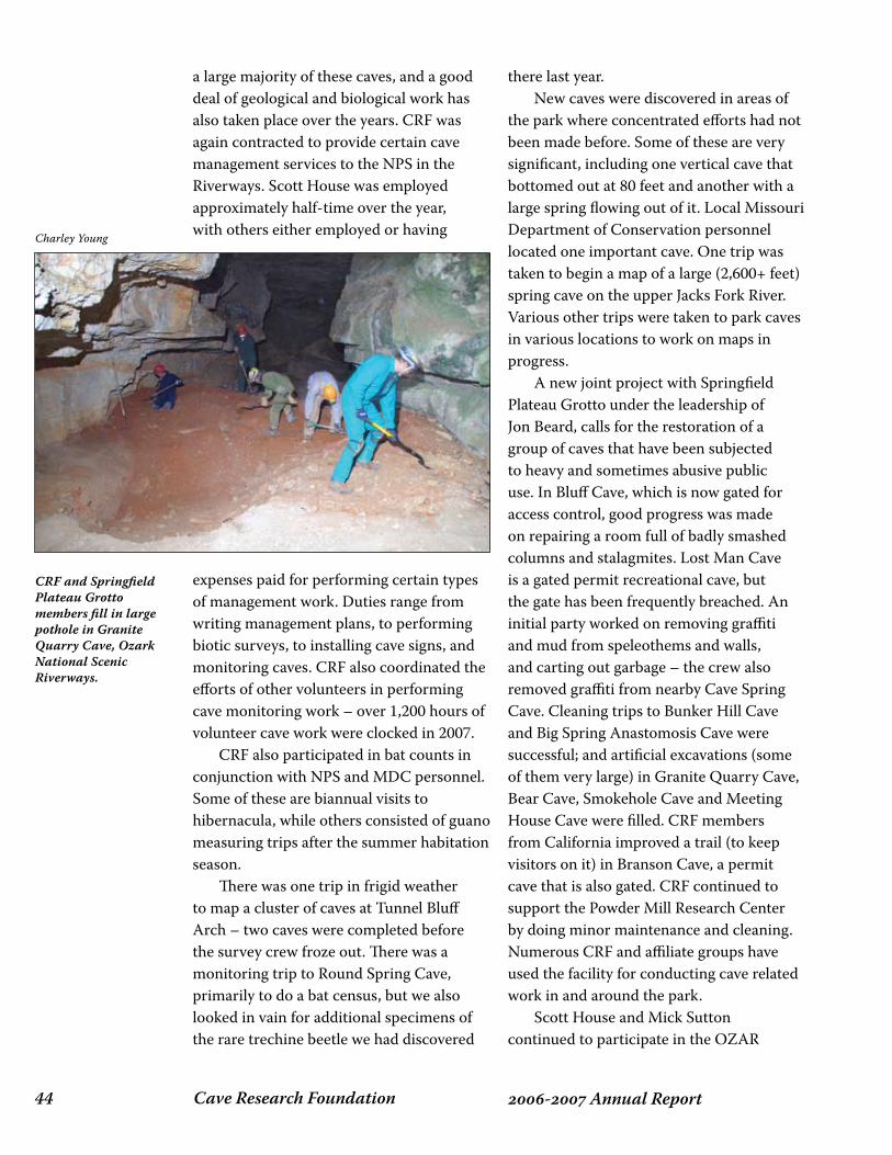
Cave Research Foundation�� - Annual Report
a large majority of these caves, and a good deal of geological and biological work has also taken place over the years. CRF was again contracted to provide certain cave management services to the NPS in the Riverways. Scott House was employed approximately half-time over the year, with others either employed or having
expenses paid for performing certain types of management work. Duties range from writing management plans, to performing biotic surveys, to installing cave signs, and monitoring caves. CRF also coordinated the efforts of other volunteers in performing cave monitoring work – over 1,200 hours of volunteer cave work were clocked in 2007. CRF also participated in bat counts in conjunction with NPS and MDC personnel. Some of these are biannual visits to hibernacula, while others consisted of guano measuring trips after the summer habitation season. There was one trip in frigid weather to map a cluster of caves at Tunnel Bluff Arch – two caves were completed before the survey crew froze out. There was a monitoring trip to Round Spring Cave, primarily to do a bat census, but we also looked in vain for additional specimens of the rare trechine beetle we had discovered
there last year. New caves were discovered in areas of the park where concentrated efforts had not been made before. Some of these are very significant, including one vertical cave that bottomed out at 80 feet and another with a large spring flowing out of it. Local Missouri Department of Conservation personnel located one important cave. One trip was taken to begin a map of a large (2,600+ feet) spring cave on the upper Jacks Fork River. Various other trips were taken to park caves in various locations to work on maps in progress. A new joint project with Springfield Plateau Grotto under the leadership of Jon Beard, calls for the restoration of a group of caves that have been subjected to heavy and sometimes abusive public use. In Bluff Cave, which is now gated for access control, good progress was made on repairing a room full of badly smashed columns and stalagmites. Lost Man Cave is a gated permit recreational cave, but the gate has been frequently breached. An initial party worked on removing graffiti and mud from speleothems and walls, and carting out garbage – the crew also removed graffiti from nearby Cave Spring Cave. Cleaning trips to Bunker Hill Cave and Big Spring Anastomosis Cave were successful; and artificial excavations (some of them very large) in Granite Quarry Cave, Bear Cave, Smokehole Cave and Meeting House Cave were filled. CRF members from California improved a trail (to keep visitors on it) in Branson Cave, a permit cave that is also gated. CRF continued to support the Powder Mill Research Center by doing minor maintenance and cleaning. Numerous CRF and affiliate groups have used the facility for conducting cave related work in and around the park. Scott House and Mick Sutton continued to participate in the OZAR
CRF and Springfield Plateau Grotto members fill in large pothole in Granite Quarry Cave, Ozark National Scenic Riverways.
Charley Young

��- Annual ReportCave Research Foundation
Cave Management Team, which guides management decisions for the park. CRF members led two environmental education trips to Round Spring Cavern on behalf of the park.
Missouri Department of Conservation
Crevice Cave Survey: A project to do a detailed biological survey of Crevice Cave was started in late 2006. The project, which is funded by the Missouri Department of Conservation, continued through 2007. Crevice Cave is a major dendritic stream cave draining a section of the Perry County,
Missouri karst plain. With a total passage length of greater than 28 miles, it is the longest cave in Missouri. Passages exist on several levels. Headwaters of tributary streams tend to have high gradients, while there is also a parallel network of high and dry abandoned drains. Water input is via more or less open sinkholes. There are three humanly usable entrances, two of them at the heads of major components of the stream, the other a pit that intersects another major stream passage. Owing to the open sinkholes, nutrient input – including coarse forest and agricultural debris – is high. The karst plain drained by the cave contains patches of woodland, but is

Cave Research Foundation�� - Annual Report
primarily agricultural. The City of Perryville overlies part of the headwaters of one branch of the cave. With agricultural and urban runoff at high levels, there is concern for the cave’s water quality and its effect on the groundwater fauna. The notion is to examine as much as the cave as practical, and to tie biological information to geography. A total of eight field trips took place in 2007, half via the Historic Entrance and half via the Pipistrelle Entrance. Each entrance leads to the upstream reaches of a different major stream passage – Mile Stream in the case of the Historic Entrance, Merlin’s Stream in the case of Pipistrelle. The stream make-up was broadly similar in both cases, and both showed interesting differences in community from upstream to downstream. Upstream reaches tended to be dominated by a common stygobitic isopod (Caecidotea antricola) and stygophilic amphipods of two species. Downstream, the stygophilic amphipods are gradually replaced by a common stygophile (C. brevicauda) and grotto sculpins are encountered. The latter are troglomorphic forms of banded sculpin (Cottus carolinae). They appear to either constitute a distinct species, or are populations in the process of speciation. Troglomorphic sculpins are known only from Perry County, Missouri. Other major components of the stream community include a common troglophilic snail (Fontigens aldrichi) – tiny, but present in vast numbers – and a large stygobitic flatworm (Sphalloplana evaginata). Terrestrial wildlife initially seemed surprisingly sparse, considering the large quantities of flood debris, but pitfall trapping with baited traps revealed a fairly high diversity. The cave’s detritivore community is dominated by a troglophilic millipede (Austrotyla specus), together with a high diversity of springtails and
flies. Earthworms (not yet identified) form another major component of the terrestrial community where banks of loamy silt cover extensive areas of stream bank. Bat use of the cave is relatively limited, and is dominated by hibernating pipistrelles. We have found only limited evidence of small roosts attributable to colonial bats. The inventory project is being done in collaboration with Paul Hauck’s Crevice Cave survey, and personnel are frequently interchanged between mapping and biology components of each trip. Perry County GIS Project: This is an MDC-funded project headed by Scott House, Jeffrey Crews and Aaron Addison to generate GIS data for the densely-packed caves in Missouri’s most cavernous county, home to not only the most caves but also the 1st, 3rd, 4th, and 5th longest caves. A good deal of progress was made during 2007. The entire list of cave locations was analyzed and broken down into five categories of exactitude. Those with GPS locations were ranked first while those locations known to be wrong were ranked as fifth. A number of better and new cave locations were obtained. Existing maps of priority caves were digitized and placed into ArcGIS for use by MDC and cave researchers alike. The layers will be used to analyze population patterns for the rare grotto sculpin as well as to help with other water quality issues in the county. CRF is partnering with local cave groups Little Egypt Grotto, Southeast Missouri Grotto, and others from the Missouri Speleological Survey in getting this work done.
Pioneer Forest
Pioneer Forest is a 160,000 acre private forest in Missouri with a mission of sustainable forestry and land management.
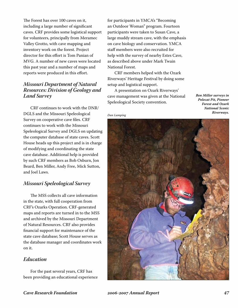
��- Annual ReportCave Research Foundation
The Forest has over 100 caves on it, including a large number of significant caves. CRF provides some logistical support for volunteers, principally from Meramec Valley Grotto, with cave mapping and inventory work on the forest. Project director for this effort is Tom Panian of MVG. A number of new caves were located this past year and a number of maps and reports were produced in this effort.
Missouri Department of Natural Resources: Division of Geology and Land Survey
CRF continues to work with the DNR/DGLS and the Missouri Speleological Survey on cooperative cave files. CRF continues to work with the Missouri Speleological Survey and DGLS on updating the computer database of state caves. Scott House heads up this project and is in charge of modifying and coordinating the state cave database. Additional help is provided by such CRF members as Bob Osburn, Jon Beard, Ben Miller, Andy Free, Mick Sutton, and Joel Laws.
Missouri Speleological Survey
The MSS collects all cave information in the state, with full cooperation from CRF’s Ozarks Operation. CRF-generated maps and reports are turned in to the MSS and archived by the Missouri Department of Natural Resources. CRF also provides financial support for maintenance of the state cave database; Scott House serves as the database manager and coordinates work on it.
Education
For the past several years, CRF has been providing an educational experience
for participants in YMCA’s “Becoming an Outdoor Woman” program. Fourteen participants were taken to Susan Cave, a large muddy stream cave, with the emphasis on cave biology and conservation. YMCA staff members were also recruited for help with the survey of nearby Estes Cave, as described above under Mark Twain National Forest. CRF members helped with the Ozark Riverways’ Heritage Festival by doing some setup and logistical support. A presentation on Ozark Riverways’ cave management was given at the National Speleological Society convention.
Dan Lamping
Ben Miller surveys in Polecat Pit, Pioneer
Forest and Ozark National Scenic
Riverways.
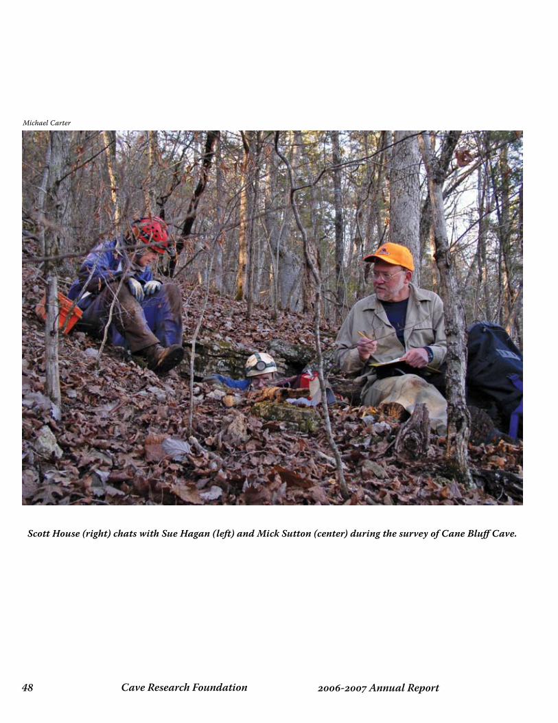
Cave Research Foundation�� - Annual Report
Scott House (right) chats with Sue Hagan (left) and Mick Sutton (center) during the survey of Cane Bluff Cave.
Michael Carter
��- Annual ReportCave Research Foundation
survey, CartOgraphy and gis
Cave Research Foundation�0 - Annual Report
Roppel CAve 6-7
The Pushing of the Boundaries
The familiar shape of the Roppel map has generally remained unchanged for twenty-five years. Although the length of the cave has nearly doubled, this has largely been due to surveying more of the high-density passages for which the cave is known. The boundaries of the cave remain largely unchanged. To the Northeast, we are still no closer to the Fisher Ridge Cave System (and a connection is no more likely); the eastern flank has only been penetrated by the single, long passage Katie Jane Way (part of Hoover Cave, since connected); the southern flank is still tantalizingly close to breaking into south Toohey Ridge; to the southwest is Proctor Cave; and to the Northwest lay the “gap” between Roppel Cave and Salts Cave. Reaching the frontiers of the system requires very long travel times, and as a result our “assault” style of trips continues to evolve and be refined. These trips range from 24-30 hours in length – sometimes longer – and have been successful with the addition of carrying compact bivouac equipment. Typical trip scenarios include working to the “low energy time” (around 3:00 a.m.), having a hot meal (freeze dried camp meals, hot chocolate, etc.), then a power nap of three-to-five hours (utilizing a small sleeping pad, space blanket, etc.). This is enough to get past that low-energy period and regain sufficient energy to be productive for a few more hours before heading out of
the cave later that next evening. In 2006 and 2007, we had a number of the “assault” style trips working the system boundaries. However, there was a lot of other good work going on supporting cartography and in surveying some of the complexity in the middle of the system.
Beyond the Northwest End
Pre-2006
In the early, grand days of Roppel Cave exploration, some of our earliest pushes were out the long Elysian Way, which stretched out on the map like an arm pointing toward Salts Cave. These were heady times. Elysian Way was big and spectacular, and seemed infinite; there was nothing to stop us. Or so we thought. After several kilometers, Elysian Way “bottomed out” on the chert, and the grand passage morphed into a baffling tangle of overflow tubes, piracies, and distributaries that halted our march west. Our furthest penetration – the finger on the hand – was Arrowhead Dome, just 850 m from the eastern end of Salts Cave. We did not give up, yet we were not successful either (this was the time when we began to first talk about the real possibility of connections). We would find that the chert was porous and you could wiggle through below it to lower levels. These lower level passages were large and led to a nice segment of river passage, but unfortunately it ended in
James Borden
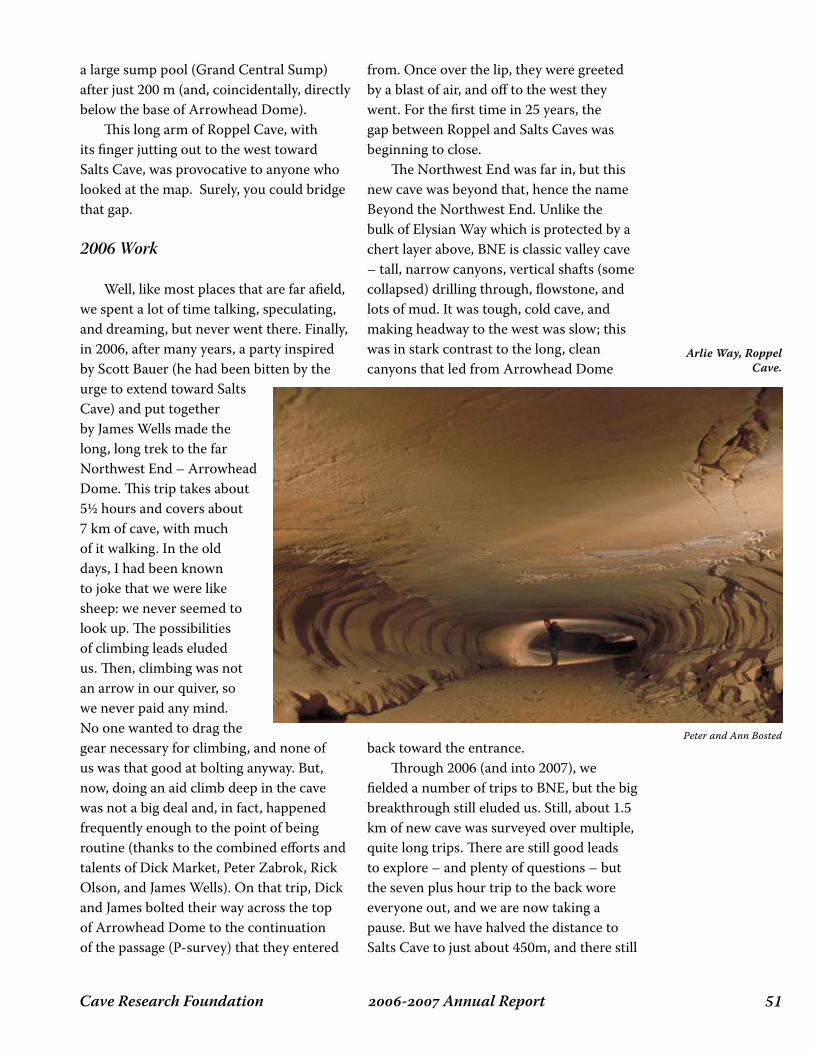
��- Annual ReportCave Research Foundation
a large sump pool (Grand Central Sump) after just 200 m (and, coincidentally, directly below the base of Arrowhead Dome). This long arm of Roppel Cave, with its finger jutting out to the west toward Salts Cave, was provocative to anyone who looked at the map. Surely, you could bridge that gap.
2006 Work
Well, like most places that are far afield, we spent a lot of time talking, speculating, and dreaming, but never went there. Finally, in 2006, after many years, a party inspired by Scott Bauer (he had been bitten by the urge to extend toward Salts Cave) and put together by James Wells made the long, long trek to the far Northwest End – Arrowhead Dome. This trip takes about 5½ hours and covers about 7 km of cave, with much of it walking. In the old days, I had been known to joke that we were like sheep: we never seemed to look up. The possibilities of climbing leads eluded us. Then, climbing was not an arrow in our quiver, so we never paid any mind. No one wanted to drag the gear necessary for climbing, and none of us was that good at bolting anyway. But, now, doing an aid climb deep in the cave was not a big deal and, in fact, happened frequently enough to the point of being routine (thanks to the combined efforts and talents of Dick Market, Peter Zabrok, Rick Olson, and James Wells). On that trip, Dick and James bolted their way across the top of Arrowhead Dome to the continuation of the passage (P-survey) that they entered
from. Once over the lip, they were greeted by a blast of air, and off to the west they went. For the first time in 25 years, the gap between Roppel and Salts Caves was beginning to close. The Northwest End was far in, but this new cave was beyond that, hence the name Beyond the Northwest End. Unlike the bulk of Elysian Way which is protected by a chert layer above, BNE is classic valley cave – tall, narrow canyons, vertical shafts (some collapsed) drilling through, flowstone, and lots of mud. It was tough, cold cave, and making headway to the west was slow; this was in stark contrast to the long, clean canyons that led from Arrowhead Dome
back toward the entrance. Through 2006 (and into 2007), we fielded a number of trips to BNE, but the big breakthrough still eluded us. Still, about 1.5 km of new cave was surveyed over multiple, quite long trips. There are still good leads to explore – and plenty of questions – but the seven plus hour trip to the back wore everyone out, and we are now taking a pause. But we have halved the distance to Salts Cave to just about 450m, and there still
Peter and Ann Bosted
Arlie Way, Roppel Cave.

Cave Research Foundation�� - Annual Report
Bey
on
d t
he
No
rth
wes
t En
d
The
Flee
cew
ay
Yah
oo
Ave
nu
e
Kat
ie J
ane
Way
Low
er E
lysi
an W
ay
Swic
ego
od
Ave
nu
e
Logsd
on Riv
erA
bra
cad
abra
Gu
nn
iso
n C
reek
Viv
ian
Way
Ho
bb
it T
rail
No
rth
Do
wn
eyA
ven
ue
Cru
ella
De
Vil
Wel
ler
Entr
an
ce
Da
leo
En
tra
nce
Kh
an
En
tra
nce
Bu
nn
ell A
ven
ue
The
Att
ic
Ou
twar
d B
ou
nd
Dea
th T
rap
Son
of
Kh
an
Geng
his Ri
ver
Fish
er R
idg
e Sp
ecia
l
Mu
dd
y Tu
be
Mis
smas
ter A
ven
ue
New
Ho
pe
Cre
ek
Oz
Emer
ald
Cit
y
Cla
p C
anyo
n
Pete
's L
un
ch
Pass
age
Yellow Brick Road
BW
OB
No
rth
wes
t En
d
Arr
ow
Can
yon
S Su
rvey
Tyle
no
l Tra
il
Great White
North
Fort
Wild
ern
ess
Pin
g-P
on
g
Cra
wl
The
Rift
Lun
atic
Fri
ng
e
Wo
un
ded
An
imal
Ave
nu
e
Log
sdo
n R
iver
Dix
ie
Co
on
s
Ro
om
Co
smo
dro
me
Ast
rod
om
e
Petr
ified
Wo
od
Pass
age
Bar
nya
rd M
aze
Pira
tes
Pot
Kan
gar
oo
Trai
l
Lexi
ng
ton
Ave
nu
e
Arl
ie
Way
Wal
ter
Way
Ath
ena
Trai
l
Wol
f Tre
e C
ave
Sam
my
Mon
roe
Cav
e
Mer
edit
hC
ave
Bo
rden
's L
ost
Pass
age
C C
raw
l
BV
M
Bla
ck
Riv
er
Rop
pel C
ave
~ A
Sec
tion
of
the
Ma
mm
oth C
av
e Sy
stem
~
HU
P D
om
e
060
012
0018
00
Feet
Ro
pp
el C
ave
--
85.9
mile
s
Wild
cat
Ho
llow
Cav
e --
0.
63 m
iles
Sam
my
Mo
nro
e C
ave
--
0.50
mile
s
Mer
edit
h C
ave
--
0.
38 m
iles
Wo
lf Tr
ee C
ave
--
0.
35 m
iles
Surv
eys
by th
e C
entr
al K
entu
cky
Kars
t Coa
litio
n, In
c.
1973
-200
8
(Rev
isio
n o
f 15
Mar
ch 2
008)
Gra
nd
Ju
nct
ion
WK
P
Gre
en E
gg
s D
om
e
Sam
I A
m
Can
uck
Can
yon
Red
Tag
Sp
ecia
l
Free
do
m
Trai
l
Ro
pp
el E
ntr
an
ce
Wild
cat H
ollo
w C
ave
Ho
over
En
tra
nce
Arr
ow
hea
d D
om
e
Sain
t M
ark'
s C
anyo
n
Son
of B
ob
Sou
ther
n
Co
mfo
rtTh
e G
ran
d
Can
al
Co
nn
ecti
on
Are
a
An
tim
atte
r Do
me
Wo
lf W
ay
Ro
pp
el-H
oov
er C
on
nec
tio
n
Tom
my'
s B
igg
est
Do
me
Mam
mot
h Ca
ve
e
e
e
e
Mo
jo D
om
e
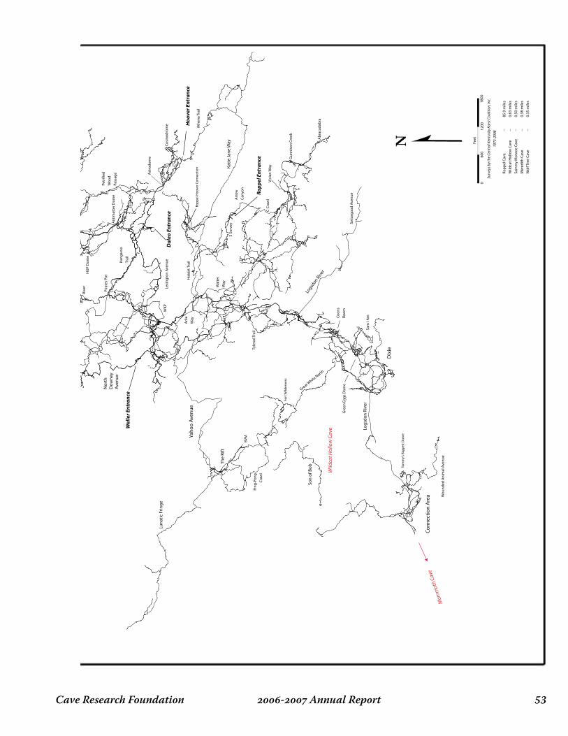
��- Annual ReportCave Research Foundation
Bey
on
d t
he
No
rth
wes
t En
d
The
Flee
cew
ay
Yah
oo
Ave
nu
e
Kat
ie J
ane
Way
Low
er E
lysi
an W
ay
Swic
ego
od
Ave
nu
e
Logsd
on Riv
erA
bra
cad
abra
Gu
nn
iso
n C
reek
Viv
ian
Way
Ho
bb
it T
rail
No
rth
Do
wn
eyA
ven
ue
Cru
ella
De
Vil
Wel
ler
Entr
an
ce
Da
leo
En
tra
nce
Kh
an
En
tra
nce
Bu
nn
ell A
ven
ue
The
Att
ic
Ou
twar
d B
ou
nd
Dea
th T
rap
Son
of
Kh
an
Geng
his Ri
ver
Fish
er R
idg
e Sp
ecia
l
Mu
dd
y Tu
be
Mis
smas
ter A
ven
ue
New
Ho
pe
Cre
ek
Oz
Emer
ald
Cit
y
Cla
p C
anyo
n
Pete
's L
un
ch
Pass
age
Yellow Brick Road
BW
OB
No
rth
wes
t En
d
Arr
ow
Can
yon
S Su
rvey
Tyle
no
l Tra
il
Great White
North
Fort
Wild
ern
ess
Pin
g-P
on
g
Cra
wl
The
Rift
Lun
atic
Fri
ng
e
Wo
un
ded
An
imal
Ave
nu
e
Log
sdo
n R
iver
Dix
ie
Co
on
s
Ro
om
Co
smo
dro
me
Ast
rod
om
e
Petr
ified
Wo
od
Pass
age
Bar
nya
rd M
aze
Pira
tes
Pot
Kan
gar
oo
Trai
l
Lexi
ng
ton
Ave
nu
e
Arl
ie
Way
Wal
ter
Way
Ath
ena
Trai
l
Wol
f Tre
e C
ave
Sam
my
Mon
roe
Cav
e
Mer
edit
hC
ave
Bo
rden
's L
ost
Pass
age
C C
raw
l
BV
M
Bla
ck
Riv
er
Rop
pel C
ave
~ A
Sec
tion
of
the
Ma
mm
oth C
av
e Sy
stem
~
HU
P D
om
e
060
012
0018
00
Feet
Ro
pp
el C
ave
--
85.9
mile
s
Wild
cat
Ho
llow
Cav
e --
0.
63 m
iles
Sam
my
Mo
nro
e C
ave
--
0.50
mile
s
Mer
edit
h C
ave
--
0.
38 m
iles
Wo
lf Tr
ee C
ave
--
0.
35 m
iles
Surv
eys
by th
e C
entr
al K
entu
cky
Kars
t Coa
litio
n, In
c.
1973
-200
8
(Rev
isio
n o
f 15
Mar
ch 2
008)
Gra
nd
Ju
nct
ion
WK
P
Gre
en E
gg
s D
om
e
Sam
I A
m
Can
uck
Can
yon
Red
Tag
Sp
ecia
l
Free
do
m
Trai
l
Ro
pp
el E
ntr
an
ce
Wild
cat H
ollo
w C
ave
Ho
over
En
tra
nce
Arr
ow
hea
d D
om
e
Sain
t M
ark'
s C
anyo
n
Son
of B
ob
Sou
ther
n
Co
mfo
rtTh
e G
ran
d
Can
al
Co
nn
ecti
on
Are
a
An
tim
atte
r Do
me
Wo
lf W
ay
Ro
pp
el-H
oov
er C
on
nec
tio
n
Tom
my'
s B
igg
est
Do
me
Mam
mot
h Ca
ve
e
e
e
e
Mo
jo D
om
e
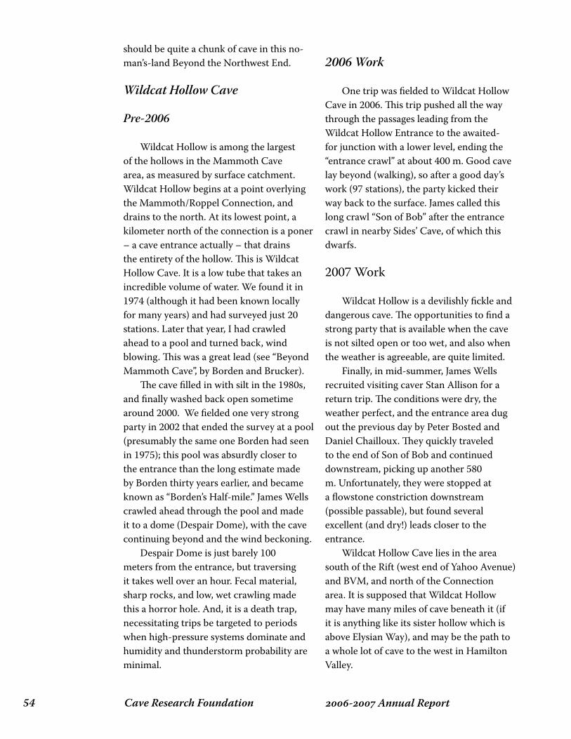
Cave Research Foundation�� - Annual Report
should be quite a chunk of cave in this no-man’s-land Beyond the Northwest End.
Wildcat Hollow Cave
Pre-2006
Wildcat Hollow is among the largest of the hollows in the Mammoth Cave area, as measured by surface catchment. Wildcat Hollow begins at a point overlying the Mammoth/Roppel Connection, and drains to the north. At its lowest point, a kilometer north of the connection is a poner – a cave entrance actually – that drains the entirety of the hollow. This is Wildcat Hollow Cave. It is a low tube that takes an incredible volume of water. We found it in 1974 (although it had been known locally for many years) and had surveyed just 20 stations. Later that year, I had crawled ahead to a pool and turned back, wind blowing. This was a great lead (see “Beyond Mammoth Cave”, by Borden and Brucker). The cave filled in with silt in the 1980s, and finally washed back open sometime around 2000. We fielded one very strong party in 2002 that ended the survey at a pool (presumably the same one Borden had seen in 1975); this pool was absurdly closer to the entrance than the long estimate made by Borden thirty years earlier, and became known as “Borden’s Half-mile.” James Wells crawled ahead through the pool and made it to a dome (Despair Dome), with the cave continuing beyond and the wind beckoning. Despair Dome is just barely 100 meters from the entrance, but traversing it takes well over an hour. Fecal material, sharp rocks, and low, wet crawling made this a horror hole. And, it is a death trap, necessitating trips be targeted to periods when high-pressure systems dominate and humidity and thunderstorm probability are minimal.
2006 Work
One trip was fielded to Wildcat Hollow Cave in 2006. This trip pushed all the way through the passages leading from the Wildcat Hollow Entrance to the awaited-for junction with a lower level, ending the “entrance crawl” at about 400 m. Good cave lay beyond (walking), so after a good day’s work (97 stations), the party kicked their way back to the surface. James called this long crawl “Son of Bob” after the entrance crawl in nearby Sides’ Cave, of which this dwarfs.
2007 Work
Wildcat Hollow is a devilishly fickle and dangerous cave. The opportunities to find a strong party that is available when the cave is not silted open or too wet, and also when the weather is agreeable, are quite limited. Finally, in mid-summer, James Wells recruited visiting caver Stan Allison for a return trip. The conditions were dry, the weather perfect, and the entrance area dug out the previous day by Peter Bosted and Daniel Chailloux. They quickly traveled to the end of Son of Bob and continued downstream, picking up another 580 m. Unfortunately, they were stopped at a flowstone constriction downstream (possible passable), but found several excellent (and dry!) leads closer to the entrance. Wildcat Hollow Cave lies in the area south of the Rift (west end of Yahoo Avenue) and BVM, and north of the Connection area. It is supposed that Wildcat Hollow may have many miles of cave beneath it (if it is anything like its sister hollow which is above Elysian Way), and may be the path to a whole lot of cave to the west in Hamilton Valley.
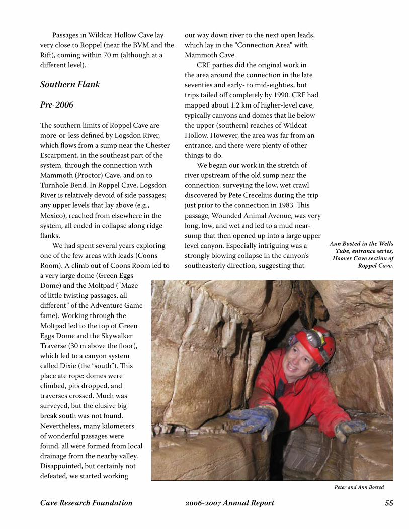
��- Annual ReportCave Research Foundation
Passages in Wildcat Hollow Cave lay very close to Roppel (near the BVM and the Rift), coming within 70 m (although at a different level).
Southern Flank
Pre-2006
The southern limits of Roppel Cave are more-or-less defined by Logsdon River, which flows from a sump near the Chester Escarpment, in the southeast part of the system, through the connection with Mammoth (Proctor) Cave, and on to Turnhole Bend. In Roppel Cave, Logsdon River is relatively devoid of side passages; any upper levels that lay above (e.g., Mexico), reached from elsewhere in the system, all ended in collapse along ridge flanks. We had spent several years exploring one of the few areas with leads (Coons Room). A climb out of Coons Room led to a very large dome (Green Eggs Dome) and the Moltpad (“Maze of little twisting passages, all different” of the Adventure Game fame). Working through the Moltpad led to the top of Green Eggs Dome and the Skywalker Traverse (30 m above the floor), which led to a canyon system called Dixie (the “south”). This place ate rope: domes were climbed, pits dropped, and traverses crossed. Much was surveyed, but the elusive big break south was not found. Nevertheless, many kilometers of wonderful passages were found, all were formed from local drainage from the nearby valley. Disappointed, but certainly not defeated, we started working
our way down river to the next open leads, which lay in the “Connection Area” with Mammoth Cave. CRF parties did the original work in the area around the connection in the late seventies and early- to mid-eighties, but trips tailed off completely by 1990. CRF had mapped about 1.2 km of higher-level cave, typically canyons and domes that lie below the upper (southern) reaches of Wildcat Hollow. However, the area was far from an entrance, and there were plenty of other things to do. We began our work in the stretch of river upstream of the old sump near the connection, surveying the low, wet crawl discovered by Pete Crecelius during the trip just prior to the connection in 1983. This passage, Wounded Animal Avenue, was very long, low, and wet and led to a mud near-sump that then opened up into a large upper level canyon. Especially intriguing was a strongly blowing collapse in the canyon’s southeasterly direction, suggesting that
Peter and Ann Bosted
Ann Bosted in the Wells Tube, entrance series,
Hoover Cave section of Roppel Cave.

Cave Research Foundation�� - Annual Report
trips, as many do not go as do go, due to the high flood risk.
2007 Work
Surprisingly, there were no trips in 2006 due to high water conditions and the distractions of the Northwest End (Beyond the Northwest End). During summer 2007, a party returned to a north-trending lead heading off just west of the connection. Not visited since 1983, the trip reports detailed several canyons and large domes, and several good leads. These leads were heading north, parallel and to the west of Wildcat Hollow. Over two trips, nearly a kilometer of nice walking passages and wide crawls were surveyed, at one point getting within 160 m of the entrance to Wildcat Hollow
Cave. Several good leads remain, but even by way of the Doyle Valley Entrance, trips to the back of this area exceed seven hours of travel, each way. As described in the preamble, Logsdon River emerges from a sump near the Chester Escarpment, flows 500 m, and then sumps again. After 100 m, this sump (“1st Upstream Sump”) emerges at the foot of the ramp at Cumquat Causeway (route from the Weller Entrance) and flows in open passage for nine kilometers. The route through the 1st Upstream Sump was pioneered in
1984 by the late Ron Simmons and the late Roberta Swicegood, with one subsequent trip in 1993 (Ron Simmons and John Schweyen). About a kilometer of cave
the sought for cave of south Toohey Ridge could be nearby. This fact, coupled with the relative abundance of cave fired up a number of trips in 2006. Indeed, there was a lot of cave – surveys snaked through countless canyons and large domes, eventually connecting to the upper levels surveyed earlier by CRF (validating Roger Brucker’s theory that the sump would be bypassed in these upper levels and would lead to a connection with Roppel Cave). We finally ran a survey line into the long known “Tommy’s Biggest Dome,” suggested to be one of, if not the largest, vertical shafts known in Mammoth Cave. However, as seemed usual to us by this point, the cave did not deviate far from the main line of Logsdon River. This was frustrating, but it was not hopeless. The number of indicators of southeasterly trending cave (toward
the promised land of south Toohey Ridge) climbed. The Connection Area’s mysteries have been barely probed. Trips are long and wet, and subject to flooding; among planned
Brian Williams
Second Upstream Sump in Logsdon River. This is the farthest penetration upstream in Logsdon River. Sump is at least 600 feet long.
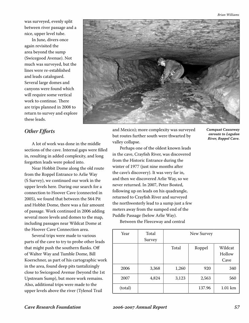
��- Annual ReportCave Research Foundation
was surveyed, evenly split between river passage and a nice, upper level tube. In June, divers once again revisited the area beyond the sump (Swicegood Avenue). Not much was surveyed, but the lines were re-established and leads catalogued. Several large domes and canyons were found which will require some vertical work to continue. There are trips planned in 2008 to return to survey and explore these leads.
Other Efforts
A lot of work was done in the middle sections of the cave. Internal gaps were filled in, resulting in added complexity, and long forgotten leads were poked into. Near Hobbit Dome along the old route from the Roppel Entrance to Arlie Way (S Survey), we continued our work in the upper levels here. During our search for a connection to Hoover Cave (connected in 2005), we found that between the S64 Pit and Hobbit Dome, there was a fair amount of passage. Work continued in 2006 adding several more levels and domes to the map, including passages near Wildcat Dome at the Hoover Cave Connection area. Several trips were made to various parts of the cave to try to probe other leads that might push the southern flanks. Off of Walter Way and Tumble Dome, Bill Koerschner, as part of his cartographic work in the area, found deep pits tantalizingly close to Swicegood Avenue (beyond the 1st Upstream Sump), but more work remains. Also, additional trips were made to the upper levels above the river (Tylenol Trail
Year TotalSurvey
New Survey
Total Roppel WildcatHollow
Cave
2006 3,368 1,260 920 340
2007 4,824 3,123 2,563 560
(total) 137.96 1.01 km
and Mexico); more complexity was surveyed but routes further south were thwarted by valley collapse. Perhaps one of the oldest known leads in the cave, Crayfish River, was discovered from the Historic Entrance during the winter of 1977 (just nine months after the cave’s discovery). It was very far in, and then we discovered Arlie Way, so we never returned. In 2007, Peter Bosted, following up on leads on his quadrangle, returned to Crayfish River and surveyed the northwesterly lead to a sump just a few meters away from the sumped end of the Puddle Passage (below Arlie Way). Between the Fleeceway and central
Brian Williams
Cumquat Causeway enroute to Logsdon River, Roppel Cave.

Cave Research Foundation�� - Annual Report
Freedom Trail, the connecting upper level link was finally surveyed, adding another survey path to better lock down the northern part of the map (Lower Elysian Way, BWOB, etc.). Also in Freedom Trail (southern section), near the connection to the southern BWOB, more complexity was surveyed in this already passage-dense area, and more leads were uncovered. This area abuts the BWOB map, being drawn by Bill Koerschner. Ed Klausner took cartographic responsibility for the South Downey Avenue
quadrangle (also known as Central Core), which includes the most commonly known passages of the cave: Arlie Way, North Crouchway, Lexington Avenue, South Downey Avenue, Yahoo Avenue, Black River, etc. In support of this, several trips were made to Lower Level Arlie Way and Pleiades Junction. South Arlie Way was replaced in
support of Peter Bosted’s quadrangle (South Arlie Way). Mick Sutton and Sue Hagen also continued their work near the Daleo Entrance, in support of their map quadrangle.
Conclusion
Work in Roppel Cave in 2006 and 2007 continued its steady pace, with lots of progress in the areas of cartography and general survey improvements (some replacement, clean up of loose ends,
survey of “internal” and long-ignored leads, etc.). Long ignored leads on the outskirts of the system have been paying dividends in new cave discovered, and this will continue to be a focus area in the future: we continue to be lured by the promise of lots of cave in south Toohey Ridge, and an eventual connection to Salts Cave to the west. In 2008, we plan on additional trips in the Connection Area, plus other areas on the southern front. And one neglected area where we plan on visiting is Cosmodrome, which we hope will help us push out along the Eastern Flank into
Eudora Ridge. The CKKC wishes to acknowledge the strong support of the Cave Research Foundation in our efforts in Roppel Cave. Without this support, we would have been far less successful. CRF has generously provided us access to facilities and equipment, and have provided personnel support for many of our trips.
Peter and Ann Bosted
Jim Borden in the Hoover Entrance to Roppel Cave.
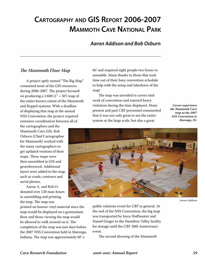
��- Annual ReportCave Research Foundation
CARtogRAphy And gis RepoRt 2006-2007 MAMMoth CAve nAtionAl pARk
Aaron Addison and Bob Osburn
The Mammoth Floor Map
A project aptly named “The Big Map” consumed most of the GIS resources during 2006-2007. The project focused on producing a 1:600 (1” = 50’) map of the entire known extent of the Mammoth and Roppel systems. With a deadline of displaying that map at the annual NSS Convention, the project required extensive coordination between all of the cartographers and the Mammoth Cave GIS. Bob Osburn (Chief Cartographer for Mammoth) worked with the many cartographers to get updated versions of their maps. These maps were then assembled in GIS and georeferenced. Additional layers were added to the map, such as roads, contours and aerial photos. Aaron A. and Bob O. donated over 120 man-hours in assembling and printing the map. The map was printed on banner vinyl material since the map would be displayed on a gymnasium floor and those viewing the map would be allowed to walk around on it. The completion of the map was just days before the 2007 NSS Convention held in Marengo, Indiana. The map was approximately 60’ x
60’ and required eight people two hours to assemble. Many thanks to those that took time out of their busy convention schedule to help with the setup and takedown of the map! The map was unveiled to cavers mid-week of convention and enjoyed heavy visitation during the time displayed. Many present and past CRF personnel commented that it was not only great to see the entire system at the large scale, but also a great
public relations event for CRF in general. At the end of the NSS Convention, the big map was transported by Joyce Hoffmaster and Daniel Greger to the Hamilton Valley facility for storage until the CRF 50th Anniversary event. The second showing of the Mammoth
Cavers experience the Mammoth Cave
map at the 2007 NSS Convention in
Marengo, IN.
Aaron Addison
Cave Research Foundation�0 - Annual Report
“big” map was at the CRF 50th Anniversary held in October 2007. Pat Kambesis arranged for CRF to use the gymnasium at the elementary school in Cave City, KY for display of the map. Several cavers made the drive from HV to town to see the map along with many NPS staff and locals. Many thanks again to those that helped to setup and take down the map. The big map project would have never been possible without the support of CRF members. The world’s largest cave map comes with the bill for the most expensive cave map ever produced. Several folks stepped up in a big way to financially support the purchase of the vinyl plotter media and other assorted costs of the map. We’ll need your help again in 2009 when the map will be redone for the 15th International Congress of Speleology to be held in Kerrville, TX! Thank you to the donors for the big map project:
Cartographers with one or more map sheets or data sets used in the composition of the Mammoth Cave map:
Another interesting spin-off of the big map project was an attempt to list everyone that has assisted with the survey and exploration of the Mammoth and Roppel cave systems. A very big thanks must go to Karen Wilmes for sifting through the trip database to pull the bulk of the names. Additionally, this list was posted at the NSS Convention and the CRF 50th for additions and corrections. The list is shown here as a thank you to everyone that made the map possible; if you have revisions, please feel free to forward them to [email protected]. Over 2,000 people have contributed to CRF and CKKC exploration and survey of Mammoth Cave in the last 50 years. We would like to thank them along with the many that contributed by managing expeditions and facilities, providing logistical support, by giving permission to enter private land and in many other ways.
John LovaasRoger E. McClureJoyce E. HoffmasterTom BruckerStanley D. & Kay SidesRickard A. & Colleen OlsonMelburn R. ParkAlicia F. HenryGeorge R. DasherEdward KlausnerMatt Mezydlo
Douglas HynesRickard ToomeyElizabeth WinklerKaren WilmesGordon BirkhimerPreston & Shari ForsytheBob OsburnMax WhiteMartin SlukaFred SchumannJohn DeLongAaron Addison
Aaron AddisonDoug BakerJames BordenTom Brucker
Jeff CrewsKevin DownsCharles FoxJim Greer
Bob GuldenPaul Hauck Scott HousePat KambesisEd KlausnerBill Koerschner
Bob OsburnArt PalmerPeg PalmerMick SuttonDave WestJohn Wilcox
Peter AbramsEd AcreeRaphael AcunaJane AdamsLarry AdamsRuss AdamsGreg AdamsonTiffani AddingtonAaron AddisonDarrell AdkinsMarion AkersTony AkersGino AlbertDoug AldermanDoug Alderman Jr.Bob AldersonDon AlexanderJim AlexanderR. Alexander
Amanda AlfredBeth AlfredJanet AlfredTom AlfredAl GhaithiJohn AlgorJohn AllShelley AllanJ. AllardTom AllinDave AlluredLydia AlvarezJohn AmmonCarlene AmsburyWayne AmsburyBob AndersonDavid AndersonEric AndersonJeff Anderson
��- Annual ReportCave Research Foundation
Jennifer AndersonRichard AndersonTerry AndersonPeter AndertonGary AndreasDale AndreattaGeorge AndrewsJeff AndrewsJerry AndrewsBrian AndrichMark AndrichGary AngermeirDaryle AnselBrian AnthonyDarlene AnthonyKen ApschunikatDarell ArmentroutCharles Armstrong, Jr.Jason ArnoldJay ArnoldJeff ArpRichard Van ArsdelMike ArtzDavid AschNancy AschGordon AtkinsonHeike AtkinsonLee AuckermanLisa AurandBill AustinJacqueline AustinJoe AustinVirginia AustinKirk BabcockNeil BackstromThor BahrmanC. BakerDoug BakerLinda BakerRobert BakerBill BalfourPhil BalisterAlan BallCaro BallLawrence BallKatherine BallantineCarolina BallmannHans-Ruedi BallmannGeorge BanesJim BankheadMarie Cathey BanksSimon BanksRick BanningMike BantherAnton BarbashinIan BarenTim BarkerBetsy BarnesJohn BarnesKeith BarnesScott BarnesTom Barr
Andrea BarrettPeter BarrettVernon BarringerLance BarronJohn BartleyHazel BartonJohn BassettThomas BastienScott BauerBill BausS. BeakmanBruce BeardRon BeattyJessie BebbChris BeckJenny Mirza BeckerBud BeesonMatt BeesonMike BeesonLaura BeilMelody BeilerCharlie BeimaMark BeldingLori BellRichard BellBernice BeningtonFred BeningtonMichael BeningtonPhyllis BeningtonKent BennettR. BennettSteve BennettTammy BenningtonBrian BentonGary BerdeauxDonna BerglundFrithjof BergmannEric BerkEllen BerlinMark BernsteinBill BersheimSarah BettingerKeshab BhattachargaLew BickingJames BigelowDick BigginsGeorge Richard BilbreyVincent BilelloPat BinghamFrank BinneyGordon BirkhimerBill BishopCharlie BishopEd BishopSarah BishopSteve BishopStephen BishopSue BishopDon BittleKay BittleSean BittleDavid Black
Don BlackGreg BlackHerbert BlackHolly BlackMary BlackPaul BlackRobert BlackRuth BlackTom BlackBill BlackburnBob BlackburnBrad BlackburnAudrey BlakesleyDiane BlankenshipLee BlazekGeorge BlissM. G. BlochDi BlumTom BlumBill BockstiegelPhil BodanzaBud BogardusFrank BogleAlfred BogliPhillip BohlBob BondurantBob BonnerJim BordenKathleen BordenThomas BordenTracy BorgerdingCharlie BorinJason BorrorRachel BoschAnn BostedPeter BostedShelly BouganCarl BoutonAly BowenJerry BowenKen BowersDave BoyleFrank BoyleLee-Gray BozeDixon BrackettPaul BradleyShanna BradleyKarla BradshawJeff BradybaughLacie BraleyJenny BramstedtCatherine BrandelJohn BranstetterMike BreidingRichard BreischG. BremenPhilip Von BretzelPat BrianJohn BridgeRon BridgemonHal BridgesDerek Bristol
I. BroerMark BrooksKenna BropheyJeff BrotzgeDavid BrowmanCharles BrownMichael BrownRay BrownScott BrownT. BrownC. N. BruceWilliam BruceEllen BruckerEmily BruckerJane BruckerJoan BruckerLynn Weller BruckerNathan BruckerRoger BruckerTom BruckerDan BrunnerKevin BrunoEric BuckelewRon BuckholtzJean BuckleySteve BuckmelterJoel BucknerDebbie BuecherRobert BuecherCharles BughRob BultmanDiane BumgardnerRick BurdinAyleen BurnsBob BurnsDenver BurnsNoel BurnsPam BurnsRichard BurnsRoberta BurnsTim BurnsDave ButheruskBonnie ButlerJim ButlerKathleen ButoryakLeonard ButtsDoug ByersKen ByrdJonas BystromDonald CahallMarna CakeStephen CakeJoseph CaldwellKaren CaldwellFrancois CallotYann CallotJohn CameronFrank CampbellJoshua CamvlosCameron CannaleyChris CannaleyMonica Cannaley

Cave Research Foundation�� - Annual Report
Paul CannaleyAlan CanonJohn CantwellDonna CappsSteve CappsDawn CardaceMike CareyKeith CarltonH. Joseph CarmazziScott CarmineLes CarneyMary CarpenterDoug CarrollVickie CarsonKen CarstensJim CarterMichael CarterMark CartwrightRoy CarwileJanet CaseMarc CasslarChris CaswellKathyrn CaswellWilliam CateRita CatesLou CatozziMaureen CavenaughRandy CecilRobert CetersDaniel ChaillouxDamon ChakyStu ChalinSteve ChambersRichard ChappellJeff CharezMarty CharletRoyce CharltonDale ChaseTom ChesnickJames ChesterChildsworthKim ChilesKenner ChristensenMargaret ChristensenAndy ChristiansonCarrie ChristopherC. Robert ClarkChris ClarkJohn ClarkGreg ClemmerPaul CliffordTom CliftonElkanah ClineFred CoatesCalla CochnerAlexis CochranFord CochranP. CochranWilliam CoeJ. CoffmanBob CohenMike Cohen
Mona ColburnNate CollierFloyd CollinsGary CollinsSteve CollinsJas. ColsonJohn ColsonPeggy ColsonStewart ColsonColstonEdward ComesEric CompasNick ConardTony ConardTom ConlanMartin ConnallyMike ConnallyRussell ConnerSteve ConnerChris ConwayBob CookHolly CookJon CookeDon CoonsJ. E. CooperJeremy CooperGeorge CorrieMarco CorviTom CottrellJ. CoulsonRhoda CoulsonDonald CournoyerC. W. CowanDavid CowanJulian CowardJenny CoyleBen CraceTom CradickBill CraftonConnie CraigDiana CraigMike CramTodd CramerBenjy Van CramonLynn CrankshawOwen CrankshawDavid CrannCarl CraverJim CrawfordNick CrawfordPete CreceliusAmy CrewsJeffrey (Spike) CrewsMike CrockettCasper CronkJean CronkAndrea CroskreyRay CrossCindy CrossleyGeorge CrothersGeorge CrowtherLaura Crowther
Patricia CrowtherSandy CrowtherWalter CrowtherWill CrowtherDan CrutcherDavid CulverNaomi CulverCummingsScott CundiffT. J. CunninghamRane CurlShirley CurlDeborah CurrensJim CurrensSamantha CurrensBob CurrieBill CurrySue CurtisWilliam CurtsingerCushmanLyman CutliffDave DailyM. DailyKimberly DaleRenato Dale-MuleJohn DanovichGeorge DasherDiana DauntJonathan DauntElizabeth DavidsonJack DavidsonJohn DavidsonJoseph DavidsonScott DavidsonD. DavisDon DavisDoug DavisE.T. DavisJerry DavisJohn DavisJudith DavisNevin DavisRoy DavisSamuel DavisPatty DawStuart DawVirginia DayDwight DealSandra DealDavid DeamerJohn DeamerLori DebardelabenTom DebevoiseSuzanne DeBloisTom DechurchLaura DeckerSeamus DeckerChuck DeCroixMark DeebelB. DegrossGeorge DeikeGinger Deike
Mickey DeikeRuth DeikeSelena DeikeNancy DelancyDelandJohn DeLongSophie DemaioJay DennisCarlene DennyDon DentonDuane DePaepeVeda DePaepeMark DepoyDavid DeRoestDavid DesMaraisShirley DesMaraisSusan DesMaraisJoel DespainJim DetterlineEd DevineGilbert DewartBilly DialDonald DialM. DiazPhil DiBlasiDanny DibleLou DickensonJohn DickersonRobin DickersonFred DickeyRichard DicksonBud DillonGeorge DistlerMike DiTontoM. DittemoreHerbert DobsonDavid DockstaderMike DoeDave DoerschukGeorge DoggettToby DogwilerDonaldsonDave DoolinS. DoonanJeff DoraleDonna DoughtyFred DouglasHenry DouglasMike DowdenPeter DownesDavid DowneyMargaret DowneyKevin DownsJohn DrakeMiles DrakeDennis DrumMary DrumIan DrummondAndrew DuboisHarvey DuCheneKip DuchonBill Duemmel
��- Annual ReportCave Research Foundation
Lathel DuffieldAndy DuftRandy DughL. DukemanKevin DumontPam DuncanSteve DuncanGary DunkleyAnne DuricaDave DuttonMike DyasDavid DyeJames DyerJune DyerRobert DyerLouis DymondJane DysonJenny EarlandsonRalph EarlandsonCheryl EarlyKaren EarlyRichard EasterdayJohn EatonR. EbdonDave EcklundSue EcklundJim EcksteinKevin EcockJudy EdmondsRobert EggersSteve EggersTed EgglestonBurnell EhmanCarol EhmanDoris EhmanMichael EhmanMickey EhmanLinda EichengreenDonald EidemillerBill EidsonTammy EifertHolly EinrichDavid EkJ. EksteinJake ElberfeldP. Gary EllerRick EllingtonBen ElliottBeth ElliottMark ElliottJames EllisSonny EllisAnne ElmoreStephanie ElmoreMichael EmerickDiana Harter EmersonWalt EmeryJohn EmlenCarl Von EndeAnnette Summers EngelScott EngelThom Engel
Gary EnghGwenne EnghShari EnglerSteve ErvineS. ErwinD. EssigLorlie EsterlyBeth EstesBill EstesGerry EstesRalph EstesWayne EstesNina EtkinKerrylea EtterKeith EvansKen EvansMicaela EvansLinda EwersRalph EwersStanley FagerlinAdolph FallerJerry FantBill FarrJeff FarrGlen FarrarHoward FarrisTab FarthingMarshall FausoldBurton FaustNed FederScott FeeThom FehrmannJohn FeilLee FeldmanC. FensterM. FensterM. Brook FentonLee FergusonMark FergusonMike FiccoErnie FingerAmy FinkelDon FinkelLiza FinkelChris FinlanLori FinneyRichard FirthDianne FischerFred FischerJohnnie FishVern FishJames FisherLarry FisherAlan FiskeRobin FitchJohn FitzsimonsFizerBill FletcherCarl FliermansSandy FlintLee FloreaFloyd
Alicia FlynnRich FlynnWard FoellerMary FollisRuth FooteWayne FooteJeff ForbesAnna FordDerek FordArmand ForsterPreston ForsytheShari ForsytheCharles FortScott FosterDarrin FowlerRandy FowlerRick FowlerCharles FoxS. FoxShirley FoxDon FraleyKirk FrancisEd FrankH. FrankeDavid FrazierAndy FreeArielle FreemanJack FreemanMike FreemanJohn FreemontVeronica FrielRobert FriesEugene FrileyRichard FrithTom FritschSam FrushourEric FryJohn FryStephanie FryShane FryerMike FullerRandy FullingD. FurruAgnes GajewskaJoe GalewskiBen GallagherRandy GallowayGamerDoug GanterH. C. GanterAnn GardinerTom GardnerRon GariepyJason GarrettMike GarrettErnie GarzaLinda GashGrant GatrellMartin GedeonJohn GehringBob GeilEarl Geil
Albert Geiser_Jr.Julia GekeresSteven GelfiusJ. GellerSteve GentryAngelo GeorgeDiana GeorgeDonald GeorgeChris GeraceMary GeraghtyAlan GereckeJohn GerwigNorman GibbetLeonard GiblerJames GiesekeDave GilfertTom GillelandDon GlascoJohn GlascockRoy GlaserGwenne GlasserAlan GlennonElizabeth GlockLoretta GodfreyMike GodfreyKeith GogginPaul GoldbergHarold GoldsteinRobert GolikiLuis GonzalezRodolfo GonzalezJim GoodbarFiona GoodchildMichael GoodchildCollier GoodletMargaret GoodmanMark GoodmanMike GoodyCarol GordonK. GordonTony GormanL. GorskiMatt GoskaJames GosneyMark GottliebRobert GourleyTomaslav GracaninFred GradyB. GrahamDick GrahamLarry GramJon GrampDarryl GrangerJeff GrantStephen GrantTom GrantBev GravesB. GrayPeter GrayMindy GraysonPaul GreavesEdward Green
Cave Research Foundation�� - Annual Report
Ernie GreenRichard GreeneTerry GreenlayAna GreerJim GreerDaniel GregerRandy GreshamDavid GriffithHugh GriffithJeannette GriffithTravis GriggsTim GrissomBeth GroverBud GroverBuz GroverHarry GroverHenry GroverJack GroverJoan GroverRandy GroverRichard GroverJohn Grover, IIIJohn Grover, Jr.Chris GrovesDarwin GrovesDeana GrovesTony GrovesTed GrudowskiThomas GrunwaldDan GruppSteve GuercioBob GuldenDusty GuldenIrma GuldenJanice GuldenRussell GurneeChester GuyVeda HackellChris HackerAlison HadleySue HaganMark HaggardJustin HaggermanBarbara HainesRené HaldemannM. HaleRick HaleyBrian HallDenise HallJames HallM. HallRobert HallThomas HallWilliam R. HallidayWalter HallmanRobert HalmiBill HalversonBrian HamRichard HamLiz Hamilton-ByrdNeil HammondTerri Hammond
Chris HampelCathy HandConnie HandRichard HandRobert HandleyRobert HanersDavid HannaCarl HansonCoy HansonDavid HansonErik HansonRoman HapkaDoug HardinJohn HardingRichard HardisonJim HardyC. HargroveEugene HargroveDonald HarkerMeta HarkerKaren HarmonRussell HarmonBrian HarriganBob HarrisWill HarrisMargarete HarrisonWayne HarrisonMike HarrodEdward HarshaPhilip HarshamCathy HartScot HarterTim HarterAndreas HartleRalph HartleyTed HartmanTim HartmanDirk HaskinValerie HaskinsBruce HatcherEric HatlebergR. HattenDee HauckDenine HauckDoug HauckPaul HauckPete HauerBob HaughSusan HaughJames HauserWilliam HawesAmos HawkinsWeldon HawkinsEdward HawkinsonBrian HaydenHaynesTony HaywarCarter HaywardConor HeaneySue HeazelChet HeddenJames Hedges
Jeff HedgesA. HedonskyScott HedricksonDonald HeinzeJon HelfmanSheldon HelfmanKim HellerPaul HellerJimbo HeltonJan Marie HembergerGrant Van HemmertJon HendersonMelissa HendricksonThomas HennessyMike HennionAlicia HenryDan HenryDaryle HenselRobert HenshawKenneth HensleyK. HensonR. HensonHerbertCharlotte HerbstCarolyn HerelEdward HerelDirk HershanJohn HessLetitia HessI. HewittAlex HicksJohn HiettEric HigbieCharles Scooter HildeboltLouise HildeboltAlan HillCarol HillDavid HillLarry HillLinda HillMike HillKit HilliardBill HinsonHissongPenny HitchcockWalter HixsonJames HobbinsJerry HobbsM. HobbsSusan HobbsHorton Hobbs, IIIAngelika HodonskyChris HoechstetterEd HoechstetterRick HoechstetterKathy HoeyDavid HoffmanJoyce HoffmasterRichard HoffmasterArlie HoganCarol Hogan
Kay HoganMarilyn HohBob HokeGreg HolbrookJohn HolbrookBill HollandBob HollandJohn HollandM. HollandKato HollerEd HollidayHenry HolmanPaul HomanRobin HookChip HopperBob HopsonTem HornadayJessica HorneBarbara HoskenWilliam HoskenTom HouchenRoya HoudeiRobert HoughSusan HoughPatti HouseR. Scott HouseJerry HousemanConnie HouserRobert HouserAlan HowardBill HowcroftDwight HoxieJanelle HoxieDorothy HubbleDavid HubbsDavid HuberChris HudsonSteve HudsonJudith HuffortLynne HughesCurt HullAlfred HulstrunkWilliam HulstrunkBob HummerCathy HuntClaude HuntClaude HuntLeo HuntWillie HuntYoung HuntKaren HunterGuy HuseBen HutchinsR. HuttenHong HuynhBoris HysekSylvia HysekH. HyungMasafumi IaiMickey IngelsK. InghamHolly Irick
��- Annual ReportCave Research Foundation
Orlin IroncloudSteven IrvineEthel IrwinR. IrwinSandra IrwinPat JablonskyBernard JacksonDavid JacksonGail JacksonGreg JacksonRandy JacksonC. JacobsenDavid JagnowRebecca JagnowCecilia JamesJulia JamesMark JancinIssam Bou JaoudeDestry JarvisJon JasperMatt JenkinsB.C. JenningsBruce JenningsDusty JenningsK. JenningsDennis JerzC. JianAlan JohnsonBen JohnsonBob JohnsonBrant JohnsonClay JohnsonSteve JohnsonTracy JohnsonWalter JohnsonJudy JohnstonDavid JonesEllis JonesGreg JonesJim JonesKenneth JonesMark JonesW. JonesMark JoopCharles KacsurMax KaemperJoe KafflGreg KahreHoward KalnitzNg KamPat KambesisDebra KaneThomas KaneJackie KaplanRobert KaplanS. KaplanJames KappelerLaszlo KardosErnst KastningKaren KastningMarjorie KastningJim Kaufman
Ray KeelerKenneth KeesterJames KeithThom KellemBen KellerBeth KellerRobert KellerDavid KelleyBetsy KelsonJohn KendallDennis KendrickKennedyMary KennedyAnn KenslerStephen KenworthyDon KerouacChris KerrJennie KertestonSandra KesslerThomas KesslerJohn KeyMarcus KeyDavid KeysPeter KeysJ. KeyserDavid KezerleBob KheneRichard KibbeyChuck KieferKienucDeane KiharaBen KimRuth KimpelKeith KirkRandy KisslingLogan KistlerEd KlausnerHannah KlausnerRalph KlawitterKaren KleinMarguerite KleinC. Thomas KlekampBill KlimackAlexander KlimchoukRich KlineRolf KlippertAnna KlisMariola KlisWieslav KlisD. KluthJay KnappRichard KnappAndy KnightJohn KnightJames KnudstadSteve KnutsonPaul KoenemanE. KoerlinBill KoerschnerKathryn KoerschnerRobyn KoerschnerNick Koervaar
Jason KolbeJohn KolmKevin KomisarcikMartha KonadarisJohn KorabikJohn Neal KorabikNancy KorabikNick KorevaarJohanna KovarikKen KramerRaymond KraussJohn KreitzburgJohn KriskoAdrianne KrollJoseph KuleszaPeter KurzTamas KutasChris KuzawaWalid LabakyMike LaceDavid LaGrueJenny LakePeggy LambNicholas LambertDan LampingChuck LandisChris LangShari LarasonRobert LasiewskiJames LavoieKathy LavoieTom LavoieJoseph LawrenceMike LawrenceJoel LawsWilliam LawsonToni LeavittStephen LeblancDevon LeeHenry LeeKathy LeeLute LeeBrice LeechCandice LeekDan LegniniRobert LehmanJohn Lehrberger, Jr.Yvonne LeichtGary LeindeckerArthur LeissaTerry LeitheuserGregg LeMastersDave LembergEdward LeochlerLeonardBill LeproRuss LeskoAndy LeverWayne LevinJoe LevinsonEllen LevyHeather Levy
Janet LevyFranklin LewisJerry LewisMarie LewisPhil LewisTerry LewisLaura LexanderR. LichtensteinRalph LindbergJohn LindsayMike LindsayJodie LindseyKaren LindsleyMarty LindsleyPete LindsleyRobert LindsleySteven LindsleyAnn LingenfelterMark LinkMike LinkJ. LinnC. LinoDan LinsJenny LippmannBarbara LiptonRobert LiptonWalter LiptonLeon LiscombEd LisowskiSam LitzingerB. LloydFrances LloydG. LloydMary Jane LloydN. LloydRobert LloydBob LodgeDale LoflandMadison LongRichard LongRyan LongJim LongbothamCharles LongsworthBob LordBrenda LordTheodore LotzWilliam LouchJohn LovaasGeoffrey LoweJoe LoweryBetty LoydSamuel LoydVinny LoyeAnn LucasMolly LucierC. LuddingtonRalph LukenJeff LuomaRobert LutzUlysses LutzBill LuysterJ. Lynch

Cave Research Foundation�� - Annual Report
Kate LysaghtRick MaceBarbara MacLeodRoss MacLeodBruce MacmillanSteve MaegerleinGlay MaggardMike MagillBill MaitlandLarry MalloryChristopher MaloneLarry ManhartCharlotte MannWilliam MannAndrea ManzoScott MaphisM. MardagaDick MarketKevin MarketFranklin MarksWilliam MarquardtHugh MartinJim MartinJacque MartiniJeff MartsMichelle MartzChris MarwoodEric MastKelly MathisBilly MatlinDave MattesonLarry MatthewsP. MatthewsJ. M. MattletTerry MaurerJohn MavityDick MaxeyAnna MaxwellMallory MayeuxLeland MayneWalter MayneJonathan MaysRaymond McAdamsRoger McAdamsMonica McAndrewsLarry McCartyJohn McCleanKatherine McClureRoger McClureGerry McCollumAllen McCradyScott McCreaWilliam McCuddyCherie McCurdyRobert McDonaldB. McGheeCharles McGheeR. McGheeEmily McGillSue McGillMac McInnesJeff McInski
John McIntoshBruce McKayMike McKeeLeonard McKenzieIvy McLaneCharles McLarnanJohn McLeanJohn McLeonSteve McLuckieK. McMillanRoger McMillanGreg McNamaraC. McNuttJim McPhaddenMike McThomasBill McWilliamsJeff MeadowsA. MebaneJ. MebaneRobert MebaneDouglas MedvilleHazel MedvilleMike MegmarR. MeierJoe MeimanBarry MelloanKerry MelloanHarold MeloyL. MeloyCarl MeltonG. MeltonScott MeltonDean MerchantI. MergensMichael MergensDonna MerrickRob MerrickRonny MerrickMerweisM. MesmarRod MetcalfeWanda MetcalfeChris MetzgerRadley MetzgerRoy MevinMike MezmarMatt MezydloMike MichalackA. MichelsonK. MichelsonJohn MichenerMike MiessenRobin MiessenLisa MillayBen MillerD. MillerEdward MillerElizabeth MillerF. MillerIlya MillerJ. MillerKeith Miller
Luther MillerMark MillerMitzi MillerRobert MillerRoger MillerRon MillerRuss MillerTom MillerTony MillerWilliam MillerPaul MillsFranz-dieter MiotkeMichel MixCharles MohrSteve MollettDave MolyneauxBob MolzonPaul MonacoGerald MoniE. MonroeTony MonroeMichael MoodyDave MooreKate MooreRolland MooreRyan MoranE. MorgaitEric MorganJoe MorganKeith MorganRobyn MorganPatrick MoriartyTom MorleyDavid MorrisJon MorrisReid MorrisRod MorrisTich MorrisTrevor MorrisG. MorriseyAnn MorrisonFred MorrisonMary MorrisonB. MorrowD. MorrowWilliam MorrowLinda MoschlitzJed MosenfelderDwight MosesAlbert MuellerMargaret MuellerJean MuirL. MuleJane MulkewichFrank MullettLawrence MullettJane MullinsJohn MummeryLeonard MunsonPat MunsonCecilia MurphyK. Murphy
Thomas MurphyLloyd MurrayL. MuschlltzCarrie MusickDelbert MyersJohn MylroieFred MyszBill NapperMike NardacciJohn NeackDaryl NeffKeven NeffJames NeidnerTod NeidtDelores NelsonMike NelsonRichard NelsonT. NelsonWayne NelsonW. NethertonMike NewsomeGeoffrey NewtonJ. NewtonRobert NicollDouglas NiemeyerKarl NilesDan NilsBeth NixDan NolfiD. NorrisJason NorrodMike NorrodDiana NorthrupRussell NortonH. NottsLillian NovellaColleen O’ConnerKathy O’DellPhil O’DellTim O’DellFrank O’HaraDennis O’LearyRobert O’LearySharon O’LearyNancy O’MalleyTom O’NeilJim OberliesGary OchsenbeinEric OcomOdenkirkAlbert OgdenThomas OgleMarc OhmsJoe OliverP. OlsonRick OlsonTabitha OlsonOto OndrousekStepan OrevkovJudy OrmeroidStephen OrmeroidKeith Ortiz
��- Annual ReportCave Research Foundation
Bob OsburnJoanne OsburnMaggie OsburnBill OsinskiTzvetan OstromskyW. OttTerry OzbunMike PaceNorman PaceDrew PackmanBret PainterArthur PalmerCarl PalmerDavid PalmerHeather PalmerMargaret PalmerRobert PalmerHans PapenbergDon PaquetteBetsy ParkCarrie ParkDenise ParkGeoff ParkGreg ParkJ. ParkMel ParkJohn ParkerJudith ParkerChristopher ParrishRobert ParrishAndy ParseleyJohn ParsinsAmy ParvinScott ParvinPascattJim PateraMichael PattonGoldie PaulAndrew PaveyKathryn PaynePam PayneTim PayneMike PearsonCharles PeaseStewart PeckMartin PeloquinMike PerezKenneth PerryLuther PerryDonald PetersButch PetersonCharlie PetersonGeorgia PetersonGilbert PetersonGilman PetersonTed PetranoffSteve PetruniakDave PetryKarl PettersonJim PettitK. PettitLouis Pfau
P. PhilipsJohn PhillipsK. PhillipsMark PhillipsColes PhinizyBlu PicardJohn PickleM. PimlottCleve PinnixKarl PittsJ. PlackErwin PohlE. Robert PohlRuth PohlRodney Poindexter, IIIDon PollockPenelope PoolerAndrew PorterDave PorterLori PorterMegan PorterPatti PorterFrank PotterElizabeth PoulsonKeith PoulsonThomas PoulsonGuy PoultonRaymond PovirkBetty PowellBruce PowellDick PowellJudy PowellRalph PowellCheryl PrattDavid PrattJane PrendegastDave PrenticeLionel PrescottMartha PrescottVirginia PrescottTerry PrestonVivian PrestonGraham PriceKelley PriceL. Greer PriceM. PriceNarcisa PricopeMike PriddyTom PrideSteve PriestLisa PringleMike PringleDave PrivalChris PugsleyDale PurchaseCharlie PursellKen PursellLarry PursellEarl PurvisGregory PurvisBill PutnamJ. Pyson
Dan QuinlanJames QuinlanPatricia QuinlanKathy QuintChuck RacineBen RadcliffeKathy RaderMike RadfordMary Ann RaffleS. RahmenJacque RameyBru RandallJames Dan RaqueEllen RaschKevin RasmusHenry RauchJohn RauschBill RayJack RecciusChris RecielskiScott ReckerMarc RecklinKen RedekerCharles RedmanLinda RedmanJ. Lesley RedpathJulie ReeseJan ReichelderferFrank ReidD. ReifMike ReillyKay ReinartzDoug ReishK. RenwickJean ReplingerRandall ReplingerGary ReschSam ReynoldsDouglass RhodesLinda Starr RhodesRichPaul RichardsTammy RichardsonRobert RichterJoe RicklesGlen RidgewayLarry RidgewayRichard RiggBob RightmireJames Rightmire, IIDan RilesWilliam RindtParker RitterLouise RobbinsGary RobersonAlicia RobertsonJohn RobertsonWilliam RobertsonCarolyn RobeyMeinhard RobinowJ. RobinsonJohn Robinson
Marie RobnettEdward des RochersMark RocklinBonnie RodcayJim RodemakerS. RoeDavid RoebuckDave RoemerJ. RogersJean RogersKen RogersNancy RogersNorm RogersPete RogersWilliam RogersKay RohdeEdmund RoleffSandra RoleffMartha RolingsonJerry RoppelRobert RoseClaude RossPaul RossQuentin RossEdwin RothfussG. RoubalCharles RoudabushCraig RovereDavid RowellBill RoyCharles RoyKathleen RoyS. RoyPaul RubinRichard RubinRichard RuderRandy RumerKen RussellTerri RussinClaude RustKarl RusterholtzRobert RutfordJohn RutherfordR. RutherfordAaron RyanDawn RyanMarty RyanJenny SabieHareb Ol SaidBrian SakofskyBob SalikaH. SalmanJ. SandersRichard SandersSheila SandsJean SanfordSaniBrennon SappJim SaundersJoe SaundersIda SawtelleBill Schacht

Cave Research Foundation�� - Annual Report
Gary SchaecherTom SchafferMarty SchaffnerTim SchafstallJohn SchaumburgAlfred ScheideJerome SchillerGeary SchindelSue SchindelMike SchmidtTony SchmidtVal SchmidtStephen SchmittElizabeth SchneiderMatt SchneiderMike SchneiderBarb SchomerJeff SchottRandy SchriberBlaine SchubertCaleb SchultenWilliam SchulzeBarry SchumanFred SchumannSandra SchumannA. SchusterA. SchwabBeverly SchwartzHenry SchwartzJonathan SchwerWilliam SchweriJohn SchweynTony SchwinghamerDavid ScottHerb ScottJohn ScottTed ScottTim ScottArt SeaburyCindi SeanorFelix SeiserEdna SellGary SellMarvin SellTom SemmesBob SergesketterPaul SettyK. SeviersHubbard SewardDennis SextonMike ShackletteT. ShafferDavid ShamelRoger ShamelSusan ShamelJames SharpK. ShawMike SheachklelteBill SheelyAl SheideCarl SheligaJohn Sheltens
Hubert ShenBruce SherdBetty SherrellJim SherrellBruce SherrillPeter ShifflettTom ShifflettTina ShirkPeter ShirleyJeff ShnureDave SholarGreg ShollyA. Glenn ShoptaughRobert ShroyerRobert ShufeldtAnne ShusterEvan ShusterLisa SiddensScott SidenerDavid SidesKay SidesStan SidesStephen SidesFrederick SiegelBryan SignorelliM. SikkemaCourtney SikoraErik SikoraJoe SikorskiJan SilverRon SimmonsLou SimpsonMorris SimpsonNicola SimpsonJeff SimsRichard SimsBarbie SingletonGary SingletonS. SirensAlan SizemoreWes SkilesJerry SkinnerJoe SkipworthThom SkooyJenny SlaterErwin SloaneLawrence SmileyRachel SmileyA. Richard SmithBriant SmithChuck SmithCindi SmithCresant SmithDalene SmithDavid SmithGary SmithGordon SmithJ. SmithJan SmithJeffrey SmithJoanne SmithJonathan Smith
Judith SmithLawrence SmithLinda SmithMarion SmithPam SmithPhilip SmithRoger SmithScott SmithShannon SmithSheryl SmithSidney SmithTom SmithTrey SmithScott SmithsonSteve SmithsonLee SneadCarole SneedJoel SneedAlden SnellDavid SnellRobert SniderWilliam SniderJohn SnivelyHenry SorellAlicia SorensonShirley SotonaJulie SotskyCady SoukupSouthwoodJanet SowersTed SpackCarl SpauldingGregory SpauldingBert SpeedDavid SpenceJohn SpenceJan SpencerRoger SperkaNeila SpradlinMary Ann StaffordR. StaffordDave StahlEric StahlElliot StahlEdith StairsMike StanfillLinda StarrPaul StarrPhil StatlerJoe SteckoC. William SteeleMarla SteeleJohn StellmackBill StephensJames StephensNick StephensPat StephensWilliam StephensonJames SterbenzKris SterbenzIrv SterlingLee Stevens
Paul StevensPaul StewardRobert StewartSteve StewartLoni SteyerGary StilesSteve StiplesRobert StittCharlotte StockMark StockReggie Van StockumDebbie StoesselGreg StokkerMichael StoltzRalph StoneLara StormGary StorrickForrest StortsLouise (Mickey) StortsGeorge Stout StrasburgBarbara StreibRaymond StreibE.H. StudierJames SturrockTony StyerMike SudhoffNicholas SullivanMike SummerDwayne SumnerG. Gardner SumnerKenneth SumnerMick SuttonWilliam SwannJohn SwartzCharles SwedlundFrances SwedlundJohn SweetA. SwensonRoberta SwicegoodDave SwoffordRobert SynderBarna SzabadosJulia SzekelesGeorge SzentesBernie SzukalskiSandy SzukalskiAlbertine TalisRichard TangelKen TankersleyKenneth TateBob TaylorChris TaylorRob TaylorSteve TaylorDuvé Taylor-WarrenElizabeth TellAbby TemplerEarl TheirryBill ThomanB. Lewis ThomasChuck Thomas
��- Annual ReportCave Research Foundation
G. ThomasGreg ThomasShawn ThomasSteve ThomasBruce ThompsonDuane ThompsonGareth ThompsonMargit ThompsonMichael ThompsonPeter ThompsonR. ThornDave ThorpeDavid ThorsellJohn ThrailkillEdward ThrockmortonMia ThurgateBob ThurnerMaria TilfordGary TinkerJohn TinsleyGary TobiasBen TobinDiana TomchickSteven ToombsRick ToomeyMargaret TownsendBob TraceyCarol TrexlerTom TrudeauHauviette TruelJean TruelSteve TuckAlan TuckerJanice TuckerMaggie TuckerHenry TunkDoris TurnerEdmund TurnerGina TurnerRichard TurnerRobert TurnerG. TuttonJan TysonJim UberStan UfedtMichael UlakyJeff UlrichCheryl UmsteadDennis UptegraftVancouverTony VanderLeedenJ. VanderstockCynthia VannDaniel VannJeff VansantMary VansoenenJennifer VanValkenburgEszter VargaGary VarnerEster VarrgonPhil VeluzatGeorge Veni
Mary VermilionRichard VernierDavid VernotCarol VeselyCrissy VincentRoland VinyardBarbie VoegtleJoseph VoigtGail WagnerJerry WagnerCyndie WalckKurt WaldronRobert WaldropJohn WalkerSteven WalkerRichard WallaceFrieda WallisRonald WallisBill WalterWilliam WaltersTony WalthamJason WalzWangHalvard WangerWilliam WangerA. WardBob WardSteven WardNorman WarnellGary WarnerMike WarnerJessica WarrenMichelle WarrenWhitney WarrenBruce WarthmanStewart WatermanD. WatersonWilliam WatkinsAnna WatsonPatty Jo WatsonRichard Allan WatsonScott WattsB. WavesR. Fleet WeaverB. WebbBeth WebbRowan WebbStewart WebbMichelle WebberLicia WeberTom WeberDavid WebsterMadeline WebsterCurtis WeedmanFrederick WeferBob WegnerJames WeimerSteve WeinzapfelP. WeissnerCal WelbournNorbert WelchChip Weller
David W. WellerDavid L. WellerJean WellerSheri WellerDavid Weller, Jr.Alan WellhausenBeth WellsEddie WellsJ. WellsJames WellsStephen WellsSteve WellsChris WelshGeorge WelshJohn Van der WerfC. WernerChris WernerMarlin Spike WernerDave WestWilliam WestCarol WestermanRichard WheelerJackie WheetGary WhitbyJenny WhitbyB. WhitcombBruce WhiteDarla WhiteDave WhiteElizabeth L. WhiteJohn WhiteKarli WhiteRobert WhiteRonald WhiteTravis WhiteWilliam WhiteBrian WhiteleyJim WhylandMarek WierzbowskiPauline WiessnerJim WigginsTom WigleyLaJuana Goatley WilcherJohn WilcoxPatricia Crowther WilcoxWilliam WilderMike WilesFrank WilhelmRod WillardCharles WilliamsDan WilliamsDennis WilliamsKeith WilliamsLia WilliamsMandi WilliamsRick WilliamsSarah WilliamsSuzanne WilliamsSuzanne WilliamsonCharles WillinghamKaren WillmesEdwin Wilmsen
Bill WilsonDavid WilsonEric L. WilsonEric B. WilsonGeorge WilsonHarry WilsonKeith WilsonKent WilsonMary Alice WilsonRoger WilsonRonald WilsonStephen WilsonTerri WilsonTheodore WilsonWilliam WilsonH. Bernard WiltGary WinebrightElizabeth WinklerG. A. WintschMichael WischmeyerJemma WiseDean WisemanJohn WisherBob WitzkeShelly WolfDouglas WolfeNancy WolfeThomas WolfeRich WolfertMark WolinskyKathleen WomackRalph WomackChris WomakSteve WonnClaire WoodGeorge WoodJack WoodChris WoodleyEd WooleryD. WorkmanSteve WorthingtonAlice WoznackDave WrightHerbert WrightMichele WrightRichard WrightWinfield WrightJenny WurtzRobert WykesBob YarboroughJean YarnellRichard YarnellBarbara YasneyBill YettM. YngveMike YocumCornelia YoderDiane YoderNaoko Yokoyama-CrothersChas YongeRichard Young

Cave Research Foundation�0 - Annual Report
errors in the processing of data. The Mammoth-Roppel survey data is stored and processed in a cave survey program called Walls. Walls is the brainchild of Texas caver David McKenzie and has been maintained for over 30 years. David has gone to great lengths to incorporate survey algorithms to process data and isolate errors as best possible. However, CRF was not allowing the Walls program to manage the data in this way, since there were many artificially “fixed” survey points throughout the system. Additionally, a local grid was being used for the data – leading to uncertainty when translating data acquired by GPS or from other sources that typically use either UTM or State Plane projections. Scott House together with several cartographers devoted the February 2006 expedition to data entry and processing. At the expedition and over the next several months various data managers worked toward consolidating sections of Mammoth into larger data sets. It quickly became obvious that there were local problems. Entrance locations were identified as one problem area that now could be readily addressed by GPS technology. Previous entrance locations had relied on a variety of data types including CRF transit surveys, data from USGS, GPS locations, etc. These data had been in several formats and all been translated to the MACA local grid. The data translations were a suspect source of error and it was decided to adapt to the UTM projection NAD83 datum commonly used for GPS work and the standard for the National Park system. This was now practical with all current drawing done by computer. In the summer of 2006 it was decided that high-grade (~5 cm-10 cm accuracy) GPS locations would be taken at as many of the Mammoth and Roppel entrances as possible. Since most of the surface around
High Grade GPS Project
Another significant milestone project occurred in late 2006. While compiling survey data, it was realized that too many survey stations throughout the Mammoth system were “fixed” and causing potential
Peter ZabrokGeorge ZachariasenA. ZeiglerEdward ZellerLiz ZenkerBruce ZerrJohn ZidianWilliam Ziegler
Marion ZiemonsMike ZimmermanRobert ZimmermanJonathan ZimmermannMagda ZopfMary Campbell ZopfRichard Zopf
Bob Osburn
Aaron Addison and Dick Market collect a GPS location at the Historic Roppel Entrance.

��- Annual ReportCave Research Foundation
the entrances is characterized by either deep valleys or wooded areas, it was determined that winter would be the best conditions for collecting the data. Between Christmas and the New Year’s expedition, CRF cavers Bob Osburn, Dick Market, Aaron Addison, Rick Haley and Preston Forsythe visited 26 entrances and several USGS control points in a three-day period. The results of the project were very encouraging, as we now have the best control ever between the entrances of Mammoth and Roppel. The control points have allowed data managers and cartographers to focus in on several survey anomalies that have haunted them for years. Several observations can immediately be made from the new entrance data.
Older CRF transit surveys had been suspected of causing errors but entrance locations by GPS were in fact accurate, as the surveyors had always maintained. In particular, the Woodson Adair entrance plotted greater than 350 feet away from the surveyed point. A reconsideration of the survey data (forced by the new location agreeing with the old) found a survey that most likely had been recorded backwards in the survey book (the party was inexperienced and using a quadrant Brunton). The closure error between Proctor Cave and the rest of Hawkins River, by which it is connected to the system, decreased from 350 feet to about 30 when new locations were used for Doyle Valley and Proctor entrances. An incorrect data translation is suspected.Roppel Cave and Logsdon River join the survey lineplots but miss by about 250 feet. This error was unaffected by new coordinates and a resurvey of a section of Roppel is underway as the most likely
•
•
•
remaining suspect.
At present the Mammoth data is in better shape than it has ever been. Over 340 miles of cave can be compiled as one Walls project with confidence that the fixed points are accurate. This line plot was the survey line plotted on the big Mammoth Cave map and the following diagram. There are still several sections of the cave that are not part of this set including Mystic River, a section of SE Mammoth Ridge and east Salts Cave. Thus we are still unable to give a precise update of the actual length of Mammoth Cave beyond saying that 365 miles – the number currently handed around – is possible. Sometime in late 2008 we should have an updated and accurate value. The data management had heretofore been done by the cartographer drawing individual area maps. The system is divided into 64 sheets that are 2,000 x ~4,000 feet in size (40 x 80 inches at 50 ft/inch). Passage loops often cover more than one map sheet and during the work above the data was consolidated into four main portions: Flint Ridge under the management of Jeff Crews, Mammoth Ridge under the management of Ed Klausner, Hawkins River/Proctor managed by Bob Osburn and Roppel Cave managed by Jim Borden. There are still 64 map sheets but only four data sets. The expectation is that this arrangement should ensure data integrity for the future.
Additional Projects
Both GIS and cartography contribute to additional projects almost continually. Some requests come from cavers, some from the research community, and many from NPS staff working to manage the world-class resource that is Mammoth Cave. Here some of these projects are summarized.
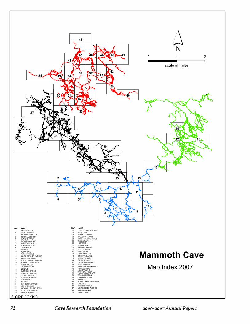
Cave Research Foundation�� - Annual Report
38
87
6
2
1
0
9
18
19
3
4
34
24
5
22
31
55
5150
45
40
37 33
1716
15
1312
10
47 46 44 42 41
20
25
58
11
36
23
39
5449
32
59
28
5756
52 5335
21
2914
48
27
43
26
0 1 2
scale in miles
MAP NAME0 HAWES CREEK1 FROST AVENUE2 HISTORIC PROCTOR3 RIGHT HAND FORK4 HAWKINS RIVER5 KAEMPER AVENUE6 BRIDGE AVENUE7 MORRISON CAVE8 LEE AVENUE9 NO NAME10 INDIAN CAVE11 FRITCH AVENUE12 SOUTH DOWNEY AVENUE13 DALEO ENTRANCE14 NORTH DOWNEY AVENUE15 ROPPEL CONNECTION16 DOYLE VALLEY17 LOGSDON RIVER18 NO NAME19 EAST BRANSFORD20 KENTUCKY AVENUE21 FROZEN NIAGRA22 EAST COCKLEBUR23 FERGUSON .24 BIG RIFT25 CATHEDRAL DOMES26 BISHOPS DOMES27 SNOWBALL DINING ROOM28 CLEVELAND AVENUE29 MARION AVENUE
MAP NAME30 BLUE SPRING BRANCH31 MAIN CAVE32 ALBERTS DOMES33 WOODSON ADAIR34 NORTHWEST PASSAGE35 CARLOS WAY36 HISTORIC.37 ECHO RIVER38 NEW DISCOVERY39 MYSTIC RIVER40 EAST SALTS41 LOST PASSAGE42 CRYSTAL CAVE 243 MUMMY VALLEY44 CRYSTAL CAVE 145 GREAT ONYX CAVE46 POHL AVENUE47 BRUCKER BREAKDOWN48 POWELL TRAIL49 GRAVEL AVENUE50 HANSEN LOST RIVER51 ARGO JUNCTION52 COLOSSAL CAVE53 BEDQUILT.54 TURNER MATHER AVENUE55 LINK RIVER56 ILLINOIS AVENUE57 LEHRBERGER AVENUE58 INDIAN AVENUE59 SALTS CAVE
Mammoth CaveMap Index 2007
© CRF / CKKC

��- Annual ReportCave Research Foundation
Historic Section Monitoring
In November 2006 the NPS asked for a plot illustrating the elevation of various passages around the Historic entrance to Mammoth Cave. The request was in response to monitoring of water contamination in the entrance area. CRF GIS and Cartography worked closely together to produce a map to meet the request.
Small Caves
The survey and inventory of small caves in the Park continued in 2006-07. Many cave maps were also produced, including Martin Cave, Saucer Cave, several small caves in
Facing page: The Mammoth – Roppel
line plot is now based on high quality GPS
entrance locations spread throughout the
system.
Below: Map produced by CRF for NPS
resource managers to help identify possible
source(s) for pollution in the Historic section
of the cave.
Cotton Gin Hollow and a handful of others. Survey continued in Wilson Cave and White Lighting as well. Data from the small caves project is continually updated to the GIS, which creates a composite picture of all the Park caves.
Ozarks
Several projects were supported in the Ozarks operation area of CRF. Projects included collecting improved GPS locations for caves in Perry County, MO, and scanning and geo-registration of cave maps in conjunction with the above. Work continued on the cartography of Fitton Cave, located within the Buffalo National River in Arkansas and some smaller caves in the vicinity.
600
592
580
462
568574569
554
609
620
619
621
620
622
583559
518
538538540
531
530527525
528530
536
535
524524
524
524524524
537
530
544
562
573
559
557
523
532
538538
536
514
521
519
517
506
490
569564
495
523518
512478
491
490483
480479
502503
498480
467 475483
474
473473495
445
605
649621
620613
617
617
610
591
568
607
590
597
592
596590
616
615 600
591
583593
579
577
581
584
589
589588
618
578595
596
598594
586
587
586
586586
585
482 481
487
482
446444451459
477
510
508
512509511509
508508469
437
434
433433
431
433
435
440
447
454
469473
456
479486
490484
485
489
486484482
484479
487
480
485
535
539
512
523 524
525
524
504
514
554549553552550
504
490
496488 468
466462499
504
508
508
509
517517
515
516
524
540
524522526
540
524500
501526
527530
528529
536
526 537536540
531530
532
535
532
528
545
531528533
535529530
540538
534
535528533
531533
536
535533
530531
562
571
569
572
572
538540547
556563
575574
568
567
571
568567
561
561
564
560
559
567
574604
620614
617
611
611616616
614530
555574
552
562556
0 400 800 1,200200
SCALE IN FEET
Historic Entrance
Historic Section of Mammoth CaveNovember 2006 Lineplot
North
Elevation (ft)
0 - 400
400 - 450
450 - 500
500 - 550
550 - 600
600 - 650
650 - 750
Main CaveMap Sheet
Historic Map Sheet
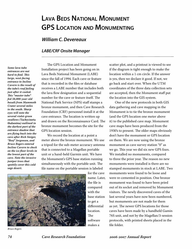
Cave Research Foundation�� - Annual Report
The GPS Location and Monument Installation project has been going on in Lava Beds National Monument (LABE) since the fall of 1994. Each cave or feature that is recorded in the files or database receives a LABE number that includes both the lava flow designation and a sequential number for the cave or feature itself. The National Park Service (NPS) staff stamps a bronze monument, and then Cave Research Foundation (CRF) personnel install it at the cave entrance. The location is written up and drawn on the Reconnaissance Card. The bronze monument becomes the site for the GPS location session. We record the location at a point a meter above the bronze monument. We use a tripod for the sub-meter accuracy antenna that is connected to a Magellan portable unit or a hand-held Garmin unit. We have the Monument’s GPS base station running simultaneously with the portable unit. The file name on the portable session is labeled
for the cave name. Later, the file is compared with the base station to get a differential location. The software makes a
scatter plot, and a printout is viewed to see if the diagram is tight enough to make the location within a 1 cm circle. If the answer is yes, then we declare it good. If not, we go back and start over. When the UTM coordinates of the three data collection sets are accepted, then the Monument staff put the location into the GIS system. One of the new protocols in both GIS data gathering and cave mapping in the Monument is to tie the bronze monument (and the GPS location one meter above it) to the published cave map. Monument cave maps have been produced from the 1930’s to present. The older maps obviously don’t have the monument or GPS location on them. We are now using the bronze monument as cave survey station “0” as we go. This year we did six new GPS fixes. We installed no monuments, compared to three the prior year. The reason no new monuments were installed is there are no stamped monuments in stock at LABE. Two monuments were found to be loose and were re-cemented in position. One bronze monument was found to have been pried out of its socket and removed by Monument visitors. The newly discovered caves of the last several years have now been numbered, but monuments are not made for them as yet. The newer GPS locations for those caves have been made by a handheld Gamin 76S unit, and not by the Magellan/3-session protocols, with printed sheets placed in the file folder.
lAvA Beds nAtionAl MonuMent gps loCAtion And MonuMenting
William C. Devereaux
LABE/CRF Onsite Manager
Some lava tube entrances are not hard to find. This large, west-facing entrance to Incline Cavern is the result of the tube’s roof failing just after it cooled. This “master tube” fed 38,000-year-old basalt from Mammoth Crater several miles to the south. Sharp eyes will note the several violet-green swallows (Tachycineta thalassina) outlined in the darkest part of the entrance shadow that are flying back into the cave after Rich Steiger, “Beej” Jorgensen, and Bruce Rogers entered Incline Cavern to check on the ice floor levels in the lowest part of the cave. Note the invasive juniper trees that spottily cover this cold sage desert.
Bruce Rogers
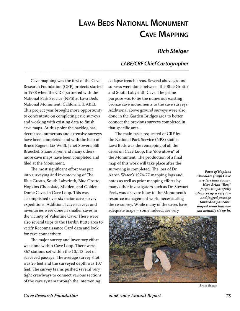
��- Annual ReportCave Research Foundation
Cave mapping was the first of the Cave Research Foundation (CRF) projects started in 1988 when the CRF partnered with the National Park Service (NPS) at Lava Beds National Monument, California (LABE). This project year brought more opportunity to concentrate on completing cave surveys and working with existing data to finish cave maps. At this point the backlog has decreased, numerous and extensive surveys have been completed, and with the help of Bruce Rogers, Liz Wolff, Janet Sowers, Bill Broeckel, Shane Fryer, and many others, more cave maps have been completed and filed at the Monument. The most significant effort was put into surveying and inventorying of The Blue Grotto, South Labyrinth, Blue Grotto, Hopkins Chocolate, Midden, and Golden Dome Caves in Cave Loop. This was accomplished over six major cave survey expeditions. Additional cave surveys and inventories were done in smaller caves in the vicinity of Valentine Cave. There were also several trips to the Hardin Butte area to verify Reconnaissance Card data and look for cave connectivity. The major survey and inventory effort was done within Cave Loop. There were 367 stations set within the 10,113 feet of surveyed passage. The average survey shot was 25 feet and the surveyed depth was 107 feet. The survey teams pushed several very tight crawlways to connect various sections of the cave system through the intervening
collapse trench areas. Several above ground surveys were done between The Blue Grotto and South Labyrinth Cave. The prime purpose was to tie the numerous existing bronze cave monuments to the cave surveys. Additional above ground surveys were also done in the Garden Bridges area to better connect the previous surveys completed in that specific area. The main tasks requested of CRF by the National Park Service (NPS) staff at Lava Beds was the remapping of all the caves on Cave Loop, the “downtown” of the Monument. The production of a final map of this work will take place after the surveying is completed. The loss of Dr. Aaron Water’s 1974-77 mapping logs and notes as well as prior mapping efforts by many other investigators such as Dr. Stewart Peck, was a severe blow to the Monument’s resource management work, necessitating the re-survey. While many of the caves have adequate maps – some indeed, are very
lAvA Beds nAtionAl MonuMent CAve MApping
Rich Steiger
LABE/CRF Chief Cartographer
Parts of Hopkins Chocolate (Cup) Cave
are less than roomy. Here Brian “Beej”
Jorgensen painfully advances up a very low
and jagged passage towards a pancake-
shaped room that one can actually sit up in.
Bruce Rogers
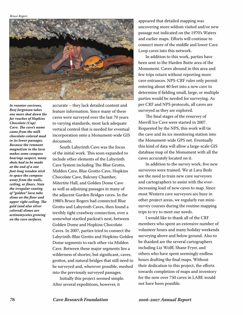
Cave Research Foundation�� - Annual Report
accurate – they lack detailed content and feature information. Since many of these caves were surveyed over the last 70 years to varying standards, most lack adequate vertical control that is needed for eventual incorporation onto a Monument-wide GIS document. South Labyrinth Cave was the focus of the initial work. This soon expanded to include other elements of the Labyrinth Cave System including The Blue Grotto, Midden Cave, Blue Grotto Cave, Hopkins Chocolate Cave, Balcony Chamber, Mitertite Hall, and Golden Dome Cave as well as adjoining passages in many of the adjacent Garden Bridges caves. In the 1980’s Bruce Rogers had connected Blue Grotto and Labyrinth Caves, then found a terribly tight crawlway connection, over a somewhat startled packrat’s nest, between Golden Dome and Hopkins Chocolate Caves. In 2007, parties tried to connect the Labyrinth-Blue Grotto and Hopkins-Golden Dome segments to each other via Midden Cave. Between these major segments lies a wilderness of shorter, but significant, caves, grottos, and natural bridges that still need to be surveyed and, wherever possible, meshed into the previously surveyed passages. Initially this project seemed simple. After several expeditions, however, it
appeared that detailed mapping was uncovering more seldom visited and/or new passage not indicated on the 1970’s Waters and earlier maps. Efforts will continue to connect more of the middle and lower Cave Loop caves into this network. In addition to this work, parties have been sent to the Harden Butte area of the Monument. Caves abound in this area and few trips return without reporting more cave entrances. NPS-CRF rules only permit entering about 40 feet into a new cave to determine if fielding small, large, or multiple parties would be needed for surveying. As per CRF and NPS protocols, all caves are surveyed as they are explored. The final stages of the resurvey of Merrill Ice Cave were started in 2007. Requested by the NPS, this work will tie the cave and its ice monitoring station into the Monument-wide GPS net. Eventually this kind of data will allow a large-scale GIS database map of the Monument with all the caves accurately located on it. In addition to the survey work, five new surveyors were trained. We at Lava Beds see the need to train new cave surveyors and cartographers to assist with the ever-increasing load of new caves to map. Since most Western cave surveyors are busy in other project areas, we regularly run mini-survey courses during the routine mapping trips to try to meet our needs. I would like to thank all of the CRF members who spent an extensive number of volunteer hours and many holiday weekends surveying above and below ground. Also to be thanked are the several cartographers including Liz Wolff, Shane Fryer, and others who have spent seemingly endless hours drafting the final maps. Without their dedication to this project, the efforts towards completion of maps and inventory for the now over 750 caves in LABE would not have been possible.
In roomier environs, Beej Jorgenson takes one more shot down the far reaches of Hopkins Chocolate (Cup) Cave. The cave’s name came from the milk chocolate-colored mud in its lower passages. Because the remnant magnetism in the lava makes some compass bearings suspect, many shots had to be made at the end of a one foot-long wooden stick to space the compass away from the walls, ceiling, or floors. Note the irregular coating of “golden” lava tube slime on the floor and upper right ceiling. The gold (and also silver colored) slimes are actinomycetes growing on the cave surfaces.
Bruce Rogers

��- Annual ReportCave Research Foundation
This project started long before Cave Research Foundation (CRF) became a player at Lava Beds National Monument (LABE) by Western cavers visiting the Monument. At the start of the CRF presence at the Monument in 1988 we defined this project, created standards, designed a card/form, trained our people how to use the form, and worked with the Monument staff to apply it. Many of the other projects use the card as a starting point for their work. It is the most basic document and must be completed when a cave is found, recorded, studied, or marked. Mike Sims created the project, invented the form, and trained most of us (both CRF and park staff) in its use. The form is a joint form called LABE, CRF 5/93. The initial card was designed as a two-sided, 5”x7” card stock form. Because we found the field investigator tended to forget to fill out the backside of the card, we began using a single-sided, 8.5” x 11” page-sized sheet instead. Using the single sheet format meant that all the data was filled on the first trip to the cave. This short inventory consists of 19 specific items in 4 categories that the field researcher looks for in the cave during their first visit. They circle the Yes or No symbol, and make remarks to the side of the entry. They look for bats, pictographs, access problems, decorations, ice, etc. The card is a living document. It is filled out in pencil, and is updated as new information comes
to light. This year we made 6 new cards, but fixed no older ones. Another component of the Cave Reconnaissance Project was started a few years ago. The concept was to take a digital photo of each cave entrance with at least one person over the entrance pin, a meter stick for scale, and the cave number written in large black letters on a white board. The location of the photo is at the brass monument with one stick placed on it so one can see where it is. The location of the camera operator is noted on the recon card so that the photograph can be replicated later if needed. This facet of the project saw only a little activity this year with a few training photographs taken to familiarize new CRF personnel.
lAvA Beds nAtionAl MonuMent CAve ReConnAisAnCe
William C. Devereaux
LABE/CRF Onsite Manager
Bob Mark sits in the southern entrance
alcove looking out of the entrance of Fern Cave, the site of the largest collection of
pictographs in the Monument. The lava
tube is also one of the most sacred sites for the Modoc tribe that formerly lived within
the Lava Beds. A CRF study of the large ferns found that their closest relatives are now found
along the California coast some 120 miles
west. Thus these up-to-4 foot-long ferns are
relics of the last Ice Age in the Monument.
Bruce Rogers
Cave Research Foundation�� - Annual Report
CARtogRAphy oF CAves in Redwood CAnyon
Jed Mosenfelder
Although survey and exploration of Lilburn – California’s longest cave – have slowed down since the dramatic breakout into the “Low Hanging Fruit” area in 2002, several small but significant finds have pushed the cave to a current length of 21.085 miles (33.941 km). My goal is to get an updated quadrangle book published in time for the 15th International Congress of Speleology in 2009. Systematic quadrangle checking and resurvey tasks have proved quite useful in fixing the map, and resulted in finding significant “leads” that were not shown on the existing quadrangles. An example is shown in the new M2L quadrangle, featuring about 300 feet of new passage that was found by noticing a small drain hole in the floor – not marked as a lead – on the quad above (M2M). Highlights of exploration in the last few years include (roughly north to south in the cave):
Several leads in the vicinity of the Alto Stream were surveyed for 475 feet, while trips to the nearby Badminton Room yielded another 112 feet of new passage.A very tight constriction southwest of the Blue Passage was pushed by a team of “world-class tiny cavers,” resulting in about 60 feet of new passage. Several leads with strong air were left, headed off the map. Nearby, a dome was climbed approximately 70 feet to a dead end.
•
•
Various trips to the Triangular Ladder and Schreiber Complex netted about 350 feet of new passage. A previously unknown lead was discovered during routine quad-checking in the vicinity of the Canopy, giving us 130 feet of well-decorated virgin walking passage. A new area was found near the start of Crevice Way, up a short climb that must have been known for decades. This lead yielded 213 feet of mostly walking, virgin passage just five minutes from the entrance! An upper level directly above River Pit was surveyed for about 300 feet in three trips. Just a little ways down River Pit Avenue, a small “breakout” on an upper level above River Pit Avenue yielded 384 feet of new passage. Meanwhile, five other trips totaled 380 feet more of passage in lower and intermediate levels near River Pit Avenue. While on a routine resurvey/resketch task at the south end of River Pit Avenue, a small drain hole was found in the floor that the chief cartographer boldly proclaimed couldn’t possibly be a real lead. A couple months later a survey team returned to this hole and surveyed almost 300 feet of new, apparently virgin passage directly below where hundreds of boots have stomped on their way to the far south end of the cave. A mazy breakdown area was surveyed at the upper end of Thanksgiving Hall
•
•
•
•
•
•

��- Annual ReportCave Research Foundation
Author contact info:Jed MosenfelderDivision of Geological and Planetary SciencesCalifornia Institute of TechnologyM/C 170-25Pasadena, CA 91125
for 116 feet. This area is inching steadily closer to the south end of the stream passage down River Pit, where the river sumps. An enticing (dry) lead remains at the very south end of the cave for anyone who feels like swimming across the South Seas!
-228
0-2
300
-232
0-2
340
-236
0-2
380
-240
0-2
420
-244
0-2
460
-248
0-2
500
60 0
010
2040
Feet
N31
.5
m
LILB
UR
N C
AVE
: MA
P M
2L
BEL
OW
RIV
ER P
IT A
VE
CO
PYR
IGH
T 20
03 C
AVE
RES
EAR
CH
FO
UN
DA
TIO
N
160
140
120
100 80 20 -20 -226
0Li
lbur
n C
ave
Atla
s Pa
ge 8
1
LAST
UPD
ATE:
11/
07D
RAW
N B
Y: M
OSE
NFE
LDER
A
B
C
A
B
C
Bre
akd
own
wal
l,co
nnec
ts u
p
to p
hone
line
? N
arro
w p
its
?
? su
rvey
ed ?
??
??
?
??
? tig
ht
?
? P
ossi
ble
low
er le
vel ?
**C
heck
sk
etch
near
ra7
**
??
ra14
-356
ra13
-358
ra18
-324
ra11
-363
ra9
-360
ra5
-296
ra7
-316
ra2
-296
U2
U1
3015

Cave Research Foundation�0 - Annual Report
April 20 – 23, 2007 Mojave National Preserve &Providence Mountains State Recreation Area ExpeditionProvidence Mountains, CA
The expedition was the first CRF project trip to California’s Mojave National Preserve and Providence Mountains State Recreation Area, and represented a joint effort by the CRF and the Mojave Cave Survey. A total of eleven cavers attended the weekend-long
expedition. The goals for the project were to locate, survey, and inventory several previously recorded caves in the area, as well as ridgewalking in search of new caves. Nine caves were mapped, including Petroglyph Cave, Wishbone Cave, and newly relocated Car-Mel Cave, a small vertical
cave that had been discovered in the 1960s but remained elusive to modern day cavers until recently. In addition to the mapped caves, six previously unrecorded caves and cave features were added to the MOJA database, including the survey of Keyhole Crevice Cave, a new find in the area. Several
MojAve CAve suRvey
Bern Szukalski
Expedition Coordinator

��- Annual ReportCave Research Foundation
other leads were noted including two potential digs. Most of those in attendance also enjoyed a trip into Cave Of The Winding Stair, one of the historic caves in the area, first bottomed by Southern California Grotto members in 1949 and formerly California’s deepest cave. The group successfully bottomed the cave and returned in an 11-hour trip. A total of 231 volunteer person-hours were logged.
Clockwise from top: Dick Maxey reaching for the entrance of Keyhole Crevice Cave; Cheryl Early at
the top of the entrance pit of Car-Mel Cave;Betty Veelik at the scenic entrance of Petroglyph
Cave.
Facing page, far left: Dick Maxey pushing onwards into Wishbone Cave.
Facing page, near left: John Woods and Betty Veelik adjust the rigging, while Dick Maxey
prepares to descend Car-Mel Cave.
All photos by Bern Szukalski.
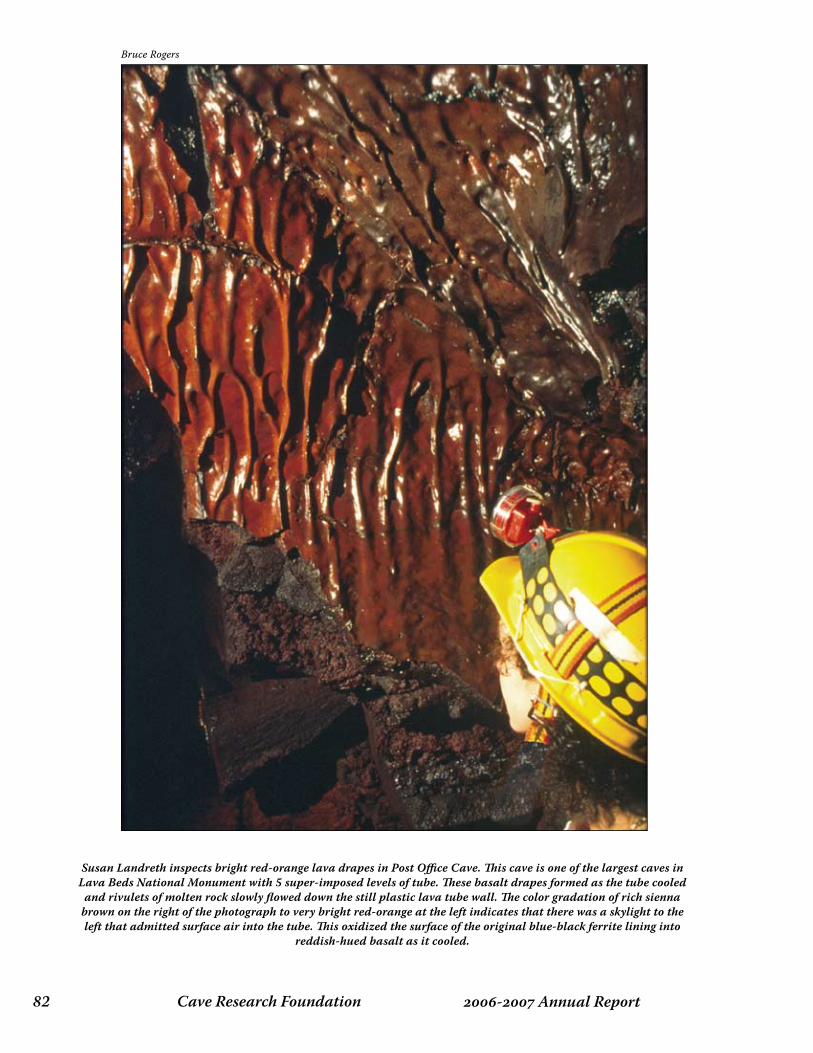
Cave Research Foundation�� - Annual Report
Susan Landreth inspects bright red-orange lava drapes in Post Office Cave. This cave is one of the largest caves in Lava Beds National Monument with 5 super-imposed levels of tube. These basalt drapes formed as the tube cooled
and rivulets of molten rock slowly flowed down the still plastic lava tube wall. The color gradation of rich sienna brown on the right of the photograph to very bright red-orange at the left indicates that there was a skylight to the left that admitted surface air into the tube. This oxidized the surface of the original blue-black ferrite lining into
reddish-hued basalt as it cooled.
Bruce Rogers

��- Annual ReportCave Research Foundation
sCienCe

Cave Research Foundation�� - Annual Report
geology oF MAMMoth CAve
Introduction
The Geology of Mammoth Cave has been a formal NPS project and part of the CRF science program since the early 1970s. Our initial goal was to determine the influence of stratigraphy and geologic structure on the location and pattern of cave passages. Since then it has expanded to include the geologic history of the cave. Results based on the project have appeared in print over several decades, but current readers will probably not be familiar with it. For that reason this report briefly summarizes the history as well as the current status of the project.
Leveling surveys
Prior to the late 1960s, CRF compass-and-tape surveys did not include vertical angles, because the inaccuracy of inclinometer readings was thought to exceed the passage gradients. Although the Walker transit survey of the main routes in Mammoth Cave was accurate, the survey points were too sparse to provide information about passage levels, gradients, and geologic control. A few trial surveys with a hand level and rods in the Flint Ridge system in 1967-69 showed that it was possible to obtain this information in a rapid and inexpensive way. On the first leveling trip we made a several-mile loop through Colossal and Bedquilt Caves that closed within a couple of inches, as calculated
on the spot by an independent note-taker. Later, the entire route from the Grand Canyon to the Lost Passage in Crystal Cave was hand-leveled on a single trip.
Geologic mapping
We quickly realized that we were overlooking critical geologic information. No stratigraphy had yet been mapped in the cave, and it was unknown whether individual strata were continuous enough to warrant tying the vertical survey to prominent beds. In 1970 we began a stratigraphic column in the Turnpike Room of Crystal Cave and traced several dozen beds through much of the cave. This showed that the strata are continuous enough to be traced over large areas and that they must have a significant influence on the cave development. Later mapping extended the vertical range of the geologic column to about 380 feet from the base of the sandstone cap-rock down to the lowest accessible limestone bed in Logsdon-Hawkins River. This column spanned the entire Girkin Formation and Ste. Genevieve Limestone, as well as 125 feet of the St. Louis Limestone (Fig. 1). Despite variations in thickness and rock character, more than 100 individual beds can be correlated through the entire area of Flint Ridge and Mammoth Cave Ridge. Reconnaissance trips to Procter, Long, Roppel, and Fisher Ridge showed that
Arthur N. Palmer and Margaret V. Palmer

��- Annual ReportCave Research Foundation
broad correlations were still valid, but some individual beds were lost or gained, and that certain others changed their character over that distance. In the late 1990s we extended the stratigraphic column to Hidden River Cave, on the American Cave Conservation Association property, and extended the column about 50 feet deeper into the St. Louis. The study of these beds and their correlation with those in the Mammoth Cave System are still underway. Dr. E.R. Pohl of Horse Cave, a geologist, CRF member, and former manager of Crystal Cave, had made a detailed stratigraphic survey of central Kentucky but had apparently relied mainly on surface outcrops for his study (Pohl, 1970). Farther north, in Indiana and Illinois, the main limestones had been subdivided into several members, and Pohl extended that nomenclature into central Kentucky. We applied Pohl’s member names to our own column and added many informal sub-units that can be recognized in the caves (Fig. 1). They are difficult to recognize at the surface, owing to scattered and discontinuous exposures. The exact placement of some of the Girkin members was at first uncertain, but consultations with Dr. Garland Dever of the Kentucky Geological Survey steered us toward the placement that appears in Figure 1. Throughout this study our primary focus has been on Crystal Cave. It spans a large part of the geologic column, and it also includes very clear passage levels, mainly because it is so close to the Green River, which serves as the local base-level control. The cave includes the highest (and oldest) major level in the Mammoth Cave System. The cave is so complex that there are multiple examples of all types of passages, intersections, and levels. It’s also a short walk to the entrance.
Geologic influence on cave passages
Our original goal was to determine the influence of geologic structure on the cave pattern, if any. This part of the project
Figure 1.

Cave Research Foundation�� - Annual Report
worked fairly well. It became obvious that the structural contours on the geologic map bore little relation to the structure of the limestone beds in the cave. This is no reflection on the quality of surface mapping, because in the cave we have continuous exposures of every bed, whereas at the surface the exposures are scattered and discontinuous. Structural contours on the Mammoth Cave Quadrangle were drawn at the base of the Big Clifty Formation, which is easy to map but has poor relation to the detailed structure. Some of the underlying limestone beds are missing in places because of erosion soon after they were deposited, and in other places interstratal dissolution has removed much of the limestone. The sandstone also tends to slump downslope, and although a competent geologist can spot this problem, it certainly complicates the mapping. Each limestone bed varies in thickness from place to place according to its original depositional environment. This causes each bedding plane to have a unique dip and strike at each point. Each bedding plane has irregularities that vary from insignificant wiggles to minor bumps and hollows a few centimeters to meters across, and to broad variations on the scale of tens to hundreds of meters. Broader ones are overwhelmed by gentle warping of the strata by tectonic stresses within the crust. These structures tend to be much broader than the depositional ones and are generally the ones that dominate the geologic maps. From the standpoint of a cave passage, however, it is the combination of local and regional structure that counts. Even the small irregularities can affect the flow direction of a small trickle of groundwater, whereas progressively larger amounts of flow are affected by proportionally larger structures. We found that even in the almost
horizontal beds of the region (dip < 0.5 degree) the vadose canyons and perched vadose tubes tended to follow the dip very faithfully. The wiggly pattern of the passages is controlled by irregularities in the dip that are imperceptible to the eye. They showed up well in the leveling surveys. In places, canyons that seemed to be heading up the dip were actually following local dip reversals. Likewise, tubular passages such as Cleaveland Avenue tend to follow the strike of the beds, although with some major deviations. Echo River, for example, heads more or less down the dip, because that happened to be the most favorable path to the Green River. Some examples are described in Palmer (1977, 1981, and 1989a).
Geomorphic interpretation
In 1970-71, Franz-Dieter Miotke, of Hanover, Germany, was pursuing a Ph.D. dissertation on geomorphology of the Mammoth Cave region. He proposed that we co-author a paper that combined his surface observations with our cave leveling. This was a bit premature, as we had only begun to sort out the meaning of the various cave levels, and the interpretation of erosion levels at the surface was still rather sketchy (it has been superseded since then). But the little monograph that resulted (Miotke and Palmer, 1972) gave a boost to the geomorphic interpretation of Mammoth Cave. An example of the geologic portrayal of cave levels in that publication is shown in Figure 2. We later revised the interpretation, so that the estimated dates were older. This re-interpretation was based on paleomagnetic dating of cave sediments by Victor Schmidt (1982). His measurements showed a magnetic reversal at the Cleaveland Avenue level, which indicates an age greater than
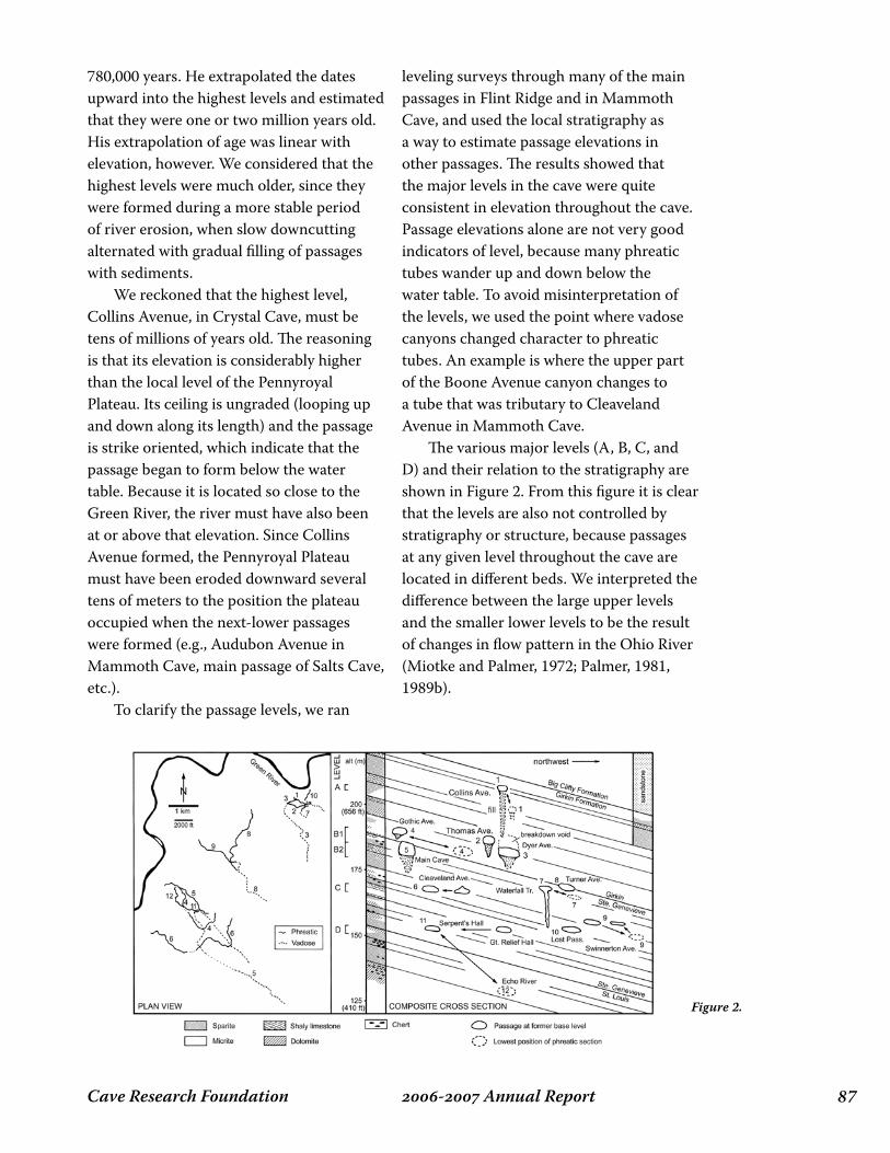
��- Annual ReportCave Research Foundation
780,000 years. He extrapolated the dates upward into the highest levels and estimated that they were one or two million years old. His extrapolation of age was linear with elevation, however. We considered that the highest levels were much older, since they were formed during a more stable period of river erosion, when slow downcutting alternated with gradual filling of passages with sediments. We reckoned that the highest level, Collins Avenue, in Crystal Cave, must be tens of millions of years old. The reasoning is that its elevation is considerably higher than the local level of the Pennyroyal Plateau. Its ceiling is ungraded (looping up and down along its length) and the passage is strike oriented, which indicate that the passage began to form below the water table. Because it is located so close to the Green River, the river must have also been at or above that elevation. Since Collins Avenue formed, the Pennyroyal Plateau must have been eroded downward several tens of meters to the position the plateau occupied when the next-lower passages were formed (e.g., Audubon Avenue in Mammoth Cave, main passage of Salts Cave, etc.). To clarify the passage levels, we ran
leveling surveys through many of the main passages in Flint Ridge and in Mammoth Cave, and used the local stratigraphy as a way to estimate passage elevations in other passages. The results showed that the major levels in the cave were quite consistent in elevation throughout the cave. Passage elevations alone are not very good indicators of level, because many phreatic tubes wander up and down below the water table. To avoid misinterpretation of the levels, we used the point where vadose canyons changed character to phreatic tubes. An example is where the upper part of the Boone Avenue canyon changes to a tube that was tributary to Cleaveland Avenue in Mammoth Cave. The various major levels (A, B, C, and D) and their relation to the stratigraphy are shown in Figure 2. From this figure it is clear that the levels are also not controlled by stratigraphy or structure, because passages at any given level throughout the cave are located in different beds. We interpreted the difference between the large upper levels and the smaller lower levels to be the result of changes in flow pattern in the Ohio River (Miotke and Palmer, 1972; Palmer, 1981, 1989b).
Figure 2.

Cave Research Foundation�� - Annual Report
Mitchell Plain of Indiana (and therefore also the Pennyroyal Plateau of Kentucky) had formed in two stages: an erosional phase followed by a period of thick sediment accumulation, especially in the vicinity of river valleys (Palmer and Palmer, 1975). The sediment dates clearly supported this idea and gave a concrete date as well. All the major passages in the Mammoth Cave System show evidence for thick sediment accumulation, which has been partly excavated from most of them by later cave-stream erosion. The reason for this period of sedimentation is not yet known, but it probably relates to a temporary drying of the climate.
Chemical interpretations
Chemical measurements of cave water were also part of the cave geology study. Some of the results are reported in Palmer and Palmer (1995) and Palmer (2004). Some of the conclusions are as follows: Carbon dioxide levels in the cave are extremely low (about 0.07%). These are the lowest we have ever recorded in a cave (although it is likely that other caves in the region beneath the sandstone caprock have similar values). The reason seems to be that inputs of high-CO2 water are limited to areas where the sandstone cap has been eroded away. Furthermore, water that seeps through the sandstone starts dissolving the limestone beneath the cap, where CO2 cannot be replenished from the soil. Dissolution of limestone in these essentially closed conditions causes the CO2 to drop to almost negligible values. Meanwhile the pH of the water rises to 9 or even 10. When this water finally emerges into the cave, it quickly absorbs CO2 from the cave air and becomes solutionally aggressive again. Some results of this process are etching of the limestone bedrock where water seeps in,
Cosmogenic dating In the mid-1990s, Darryl Granger of Purdue University was developing a technique for dating quartz-rich sediment in caves using cosmogenic radionuclides, expanding from his Ph.D. work at the University of California at Berkeley. At the surface, sediment is bombarded by cosmic radiation, which produces tiny amounts of radioactive aluminum and beryllium isotopes in quartz sand and pebbles. When the quartz sediment is carried underground, it is shielded from cosmic rays, and the two isotopes begin to decay without being replenished. The isotopes decay at different rates, so their ratio in the sediment can be used to determine the time that has elapsed since the sediment was first carried underground. The limit of the technique is about 5 million years. We invited Darryl to study the sediments in Mammoth Cave, which are ideal for this sort of study because of their rich quartz content. The results (Granger and Palmer, 1997; Granger et al., 2001) showed that sediment in level B was up to 4 million years old. In levels C and D the dates clustered around 1.5 million years and 1.0 million years, respectively (see Figure 2). These dates correlate well with the suspected dates for the diversions in the Ohio River. In fact, this kind of information is helping to sort out the complex drainage history of the entire east-central U.S. (see also Anthony and Granger, 2004). An odd result of the dating was that near the river valley, almost all the dates in levels A and B were about 2.6 million years. This made no sense at first because level A and the two parts of level B are clearly sequential and not contemporary. Then we remembered a paper that we had published back in 1975, based mainly on studies by M.V. Palmer, which proposed that the

��- Annual ReportCave Research Foundation
and replacement of limestone by gypsum. Nearly all of the cave streams are undersaturated with limestone and are dissolving. This may not seem unusual, but in many caves the water is supersaturated and is able to enlarge the caves only during high flow. The most undersaturated streams in Mammoth Cave are those that are perched on resistant beds. The highest levels of saturation are in base-level streams and pools at or near the Green River elevation. In separate studies, Chris Groves and Darlene Anthony (Western Kentucky University) and Joe Meiman (National Park Service) monitored the chemistry of the main Logsdon River in Mammoth Cave. Their studies show that most of the solutional enlargement of the passage takes place during highest 5-10% of the flow.
Present status of the project
Over the past decade we have channeled much of our effort into remapping, resketching, and redrawing the three panels of the CRF map of Mammoth Cave that are covered by Crystal Cave. In the process, we are reassessing the development of the cave in view of cosmogenic dating, chemical measurements, and relation to the geology. A revision of the small book A Geological Guide to Mammoth Cave National Park is in progress. In March 2006, we prepared a summary of the geology of the Park for a meeting led by Bob Lillie of Oregon State University, to enhance geologic presentations by the interpretive staff. At the last minute an injury prevented us from attending, but Rick Olson and Rick Toomey presented the PowerPoint summary. In June 2006 we participated in a Geology Scoping Session at Mammoth Cave National Park led by Bruce Heise of the U.S. Geological Survey. We reported on the
status of geologic studies in the Park. There was a focus on opportunities for integrating the geologic mapping into an interactive 3-D map, in cooperation with the CRF cartographers. This sort of interaction with the Park Service staff is especially meaningful, because it gives validity to all the scientific work that has been done in the Park and is a way of acknowledging the encouragement that the Park Service has given us over the years.
References Cited
Anthony, D.M., 1998, Seasonal effects on the geochemical evolution of the Logsdon River, Mammoth Cave, Kentucky: M.S. thesis, Western Kentucky University, Bowling Green, Ky., 140 pp.
Anthony, D.M., and Granger, D.E., 2004, A Late Tertiary origin for multilevel caves along the western escarpment of the Cumberland Plateau, Tennessee and Kentucky, established by cosmogenic 26Al and 10Be: Journal of Cave and Karst Studies, v. 66, no. 2, pp. 46–55.
Granger, D.E., and Palmer, A.N., 1997, A proposed method for determining the age and evolution of the Mammoth Cave System: Mammoth Cave National Park, Proceedings of 6th Science Conference, pp. 145-150.
Granger, D.E., Fabel, D., and Palmer, A.N., 2001, Pliocene-Pleistocene incision of the Green River, Kentucky, determined from radioactive decay of cosmogenic 26Al and 10Be in Mammoth Cave sediments: Geological Society of America Bulletin, v. 113, no. 7, pp. 825–836.
Groves C.G., and J. Meiman, 1996, Speleogenesis of Mammoth Cave: What are we learning at Hawkins River? Proceedings of 5th Mammoth Cave Science Conference, Mammoth Cave, Ky.,
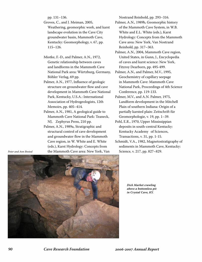
Cave Research Foundation�0 - Annual Report
pp. 131–136.Groves, C., and J. Meiman, 2005,
Weathering, geomorphic work, and karst landscape evolution in the Cave City groundwater basin, Mammoth Cave, Kentucky: Geomorphology, v. 67, pp. 115–126.
Miotke, F.-D., and Palmer, A.N., 1972, Genetic relationship between caves and landforms in the Mammoth Cave National Park area: Würtzburg, Germany, Böhler Verlag, 69 pp.
Palmer, A.N., 1977, Influence of geologic structure on groundwater flow and cave development in Mammoth Cave National Park, Kentucky, U.S.A.: International Association of Hydrogeologists, 12th Memoirs, pp. 405–414.
Palmer, A.N., 1981, A geological guide to Mammoth Cave National Park: Teaneck, NJ, Zephyrus Press, 210 pp.
Palmer, A.N., 1989a, Stratigraphic and structural control of cave development and groundwater flow in the Mammoth Cave region, in W. White and E. White (eds.), Karst Hydrology: Concepts from the Mammoth Cave area: New York, Van
Nostrand Reinhold, pp. 293–316.Palmer, A.N., 1989b, Geomorphic history
of the Mammoth Cave System, in W.B. White and E.L. White (eds.), Karst Hydrology: Concepts from the Mammoth Cave area: New York, Van Nostrand Reinhold, pp. 317–363.
Palmer, A.N., 2004, Mammoth Cave region, United States, in Gunn, J., Encyclopedia of caves and karst science: New York, Fitzroy Dearborn, pp. 495-499.
Palmer, A.N., and Palmer, M.V., 1995, Geochemistry of capillary seepage in Mammoth Cave: Mammoth Cave National Park, Proceedings of 4th Science Conference, pp. 119-133.
Palmer, M.V., and A.N. Palmer, 1975, Landform development in the Mitchell Plain of southern Indiana: Origin of a partially karsted plain: Zeitschrift für Geomorphologie, v. 19, pp. 1–39.
Pohl, E.R., 1970, Upper Mississippian deposits in south-central Kentucky: Kentucky Academy of Sciences, Transactions, v. 31, pp. 1-15.
Schmidt, V.A., 1982, Magnetostratigraphy of sediments in Mammoth Cave, Kentucky: Science, v. 217, pp. 827–829.Peter and Ann Bosted
Dick Market crawling above a bottomless pit in Crystal Cave, KY.
��- Annual ReportCave Research Foundation
Overview:
This geological study is being performed in conjunction with the CRF Lilburn Cave project in the Sierra Nevada of California. The purpose of the study is to understand the metamorphic and deformational history of the body of metamorphic rock that hosts Lilburn Cave. This body of rock is a small remnant of the rock that made up the majority of the Sierra Nevada mountain belt before the intrusion of the granitic rocks that now form most of the range. Studying the tectonic history of the Sierra Nevada is an exercise in dealing with missing evidence. Magma, which intruded the crust and cooled to become the granitic rocks of the Sierra Nevada, obliterated most of the rocks that once existed in this area. These older rocks would have recorded the history of deposition, metamorphism, and deformation that occurred in this part of North America as it interacted with the plates of the Pacific Ocean basin. Thanks to the intruding magma, however, only scattered remnants of these non-granitic rocks remain, and Lilburn Cave is hosted in one of them – the Redwood Mountain pendant (the term ‘pendant’ indicates that these masses of pre-granitic rock have long been envisioned as masses that would appear to hang down into the bodies of granitic rock).
The Redwood Mountain pendant consists mostly of quartz-biotite schist, with minor quartzite, marble, and metaconglomerate (Sisson and Moore, 1994). The marble hosts Lilburn Cave. Previous workers have divided the pre-granitic rocks of the Sierra Nevada into several domains, and the Redwood Mountain pendant is thought to be part of a belt called the ‘Kings Terrane’ (Nokleberg, 1983). The rocks of this belt are envisioned by many workers to have been originally formed as marine sedimentary rocks deposited on the outer edge of the North American continental shelf.
Objectives:
I seek to elucidate the history of deformational and metamorphic events that affected the rocks of the Redwood Mountain pendant. Numerous workers have conducted studies like this in other pre-granitic rocks of the Sierra Nevada (c.f. Girty, 1977, Saleeby and Busby, 1993), and my study aims to extend this work into the area around Lilburn Cave. The events that I seek to study are, for the most part, not strictly related to speleogenesis or other topics that traditionally fall under the heading of ‘speleology’. I am interested
stRuCtuRAl geology oF the Redwood MountAin pendAnt, sequoiA And kings CAnyon
nAtionAl pARksDr. Marek Cichanski
De Anza CollegeCupertino, CA
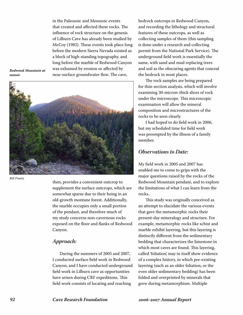
Cave Research Foundation�� - Annual Report
in the Paleozoic and Mesozoic events that created and affected these rocks. The influence of rock structure on the genesis of Lilburn Cave has already been studied by McCoy (1982). These events took place long before the modern Sierra Nevada existed as a block of high-standing topography, and long before the marble of Redwood Canyon was exhumed by erosion or affected by near-surface groundwater flow. The cave,
then, provides a convenient outcrop to supplement the surface outcrops, which are somewhat sparse due to their being in an old-growth montane forest. Additionally, the marble occupies only a small portion of the pendant, and therefore much of my study concerns non-cavernous rocks exposed on the floor and flanks of Redwood Canyon.
Approach:
During the summers of 2005 and 2007, I conducted surface field work in Redwood Canyon, and I have conducted underground field work in Lilburn cave as opportunities have arisen during CRF expeditions. This field work consists of locating and reaching
bedrock outcrops in Redwood Canyon, and recording the lithology and structural features of these outcrops, as well as collecting samples of them (this sampling is done under a research and collecting permit from the National Park Service). The underground field work is essentially the same, with sand and mud replacing trees and soil as the obscuring agents that conceal the bedrock in most places. The rock samples are being prepared for thin-section analysis, which will involve examining 30-micron-thick slices of rock under the microscope. This microscopic examination will allow the mineral composition and microstructures of the rocks to be seen clearly. I had hoped to do field work in 2006, but my scheduled time for field work was preempted by the illness of a family member.
Observations to Date:
My field work in 2005 and 2007 has enabled me to come to grips with the major questions raised by the rocks of the Redwood Mountain pendant, and to explore the limitations of what I can learn from the rocks. This study was originally conceived as an attempt to elucidate the various events that gave the metamorphic rocks their present-day mineralogy and structure. For example, metamorphic rocks like schist and marble exhibit layering, but this layering is distinctly different from the sedimentary bedding that characterizes the limestone in which most caves are found. This layering, called ‘foliation’, may in itself show evidence of a complex history, in which pre-existing layering (such as an older foliation, or the even older sedimentary bedding) has been folded and overprinted by minerals that grew during metamorphism. Multiple
Redwood Mountain at sunset.
Bill Frantz
��- Annual ReportCave Research Foundation
such episodes of folding and metamorphic mineral growth are common in rocks like those that comprise the Redwood Mountain pendant. Outcrops of metamorphic rock often show multiple generations of overprinting deformational and metamorphic events, and I have sought to find and document such a history in the rocks around Lilburn Cave. Unfortunately, however, field work in 2007 showed that outcrops of sufficient quality almost certainly do not exist in the Redwood Mountain pendant. Although a surprisingly large number of outcrops are present, despite being in an old-growth forest, these outcrops are almost uniformly covered with reddish-brown weathering varnish and/or thick encrustations of lichen. Large outcrop surfaces would be necessary in order to work out, say, a sequence of folding events, and such surfaces simply do not appear to be present. The only really useful outcrops are along Redwood Creek, which flows along the bottom of Redwood Canyon, and in Lilburn Cave. Most of the marble in Lilburn Cave is a banded marble with planar, steeply-dipping foliation, and shows only scattered exposures of folding or other structural elements. As a result of the field work in 2005 and 2007, I now know that a detailed investigation of outcrop-scale structures is not likely to be feasible. There remains the possibility that the thin sections may tell a microstructural story. Examination of thin sections from rocks collected in 2005, however, has been delayed by issues with the thin-section preparator. His lab has been very overloaded with work, and the preparation of the sections is several months behind schedule. I hope to have thin sections to examine in early- to mid-2008. Rocks collected in 2007 and later may have their thin sections prepared by my students or myself in the coming years, depending
on funding and acquisition of the necessary equipment.
Direction of Future Research:
Despite the unfortunate lack of suitable outcrops of the pendant’s non-carbonate rocks, the marble of Lilburn Cave still holds the promise of answering some questions about the structural history of the metamorphic rocks. For example, the marble contains numerous inclusions of non-carbonate rock, and the contrast between brittle deformation of the inclusions and the simultaneous ductile deformation of the marble may provide constraints on the conditions of metamorphism. While the field work to date has shown that a detailed structural story may not be forthcoming from the pendant rocks, there may be interesting questions yet to be answered related to the role of fluids during the metamorphism of the rocks. Each of the three main types of rock in the Redwood Mountain pendant – schist, quartzite, and marble – appears to have its own unique features related to the movement of fluids during metamorphism. For example, the schist is characterized by abundant quartz (+/- feldspar and mica?) veins, and abundant calcite veins characterize the marble. I hope to answer questions raised by these veins, and the lack of each vein type outside of its host rock. For example, is the confinement of the quartz (possibly granitic?) veins to the schist a sign that it formed at a very different location and/or time than the quartzite and marble? Or did each rock unit simply produce its own fluid-related features during metamorphism? Is it possible that the veins in the schist are, in fact, granitic, and thus potentially datable by radiometric means? These are the sorts of questions that I hope to answer during the remainder of
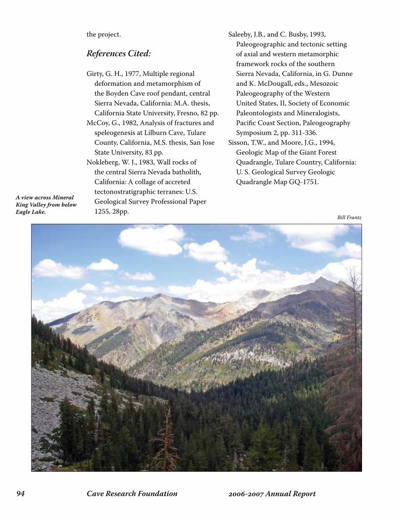
Cave Research Foundation�� - Annual Report
the project.
References Cited:
Girty, G. H., 1977, Multiple regional deformation and metamorphism of the Boyden Cave roof pendant, central Sierra Nevada, California: M.A. thesis, California State University, Fresno, 82 pp.
McCoy, G., 1982, Analysis of fractures and speleogenesis at Lilburn Cave, Tulare County, California, M.S. thesis, San Jose State University, 83 pp.
Nokleberg, W. J., 1983, Wall rocks of the central Sierra Nevada batholith, California: A collage of accreted tectonostratigraphic terranes: U.S. Geological Survey Professional Paper 1255, 28pp.
Saleeby, J.B., and C. Busby, 1993, Paleogeographic and tectonic setting of axial and western metamorphic framework rocks of the southern Sierra Nevada, California, in G. Dunne and K. McDougall, eds., Mesozoic Paleogeography of the Western United States, II, Society of Economic Paleontologists and Mineralogists, Pacific Coast Section, Paleogeography Symposium 2, pp. 311-336.
Sisson, T.W., and Moore, J.G., 1994, Geologic Map of the Giant Forest Quadrangle, Tulare Country, California: U. S. Geological Survey Geologic Quadrangle Map GQ-1751.
A view across Mineral King Valley from below Eagle Lake.
Bill Frantz
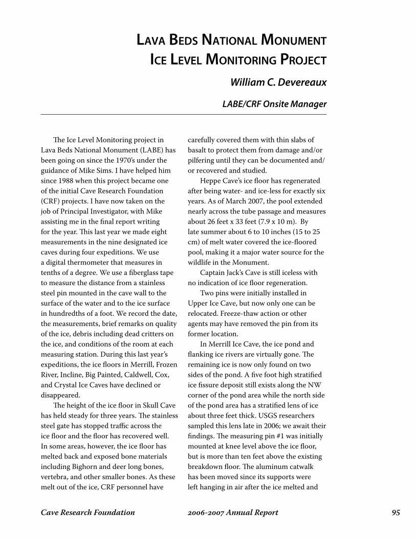
��- Annual ReportCave Research Foundation
The Ice Level Monitoring project in Lava Beds National Monument (LABE) has been going on since the 1970’s under the guidance of Mike Sims. I have helped him since 1988 when this project became one of the initial Cave Research Foundation (CRF) projects. I have now taken on the job of Principal Investigator, with Mike assisting me in the final report writing for the year. This last year we made eight measurements in the nine designated ice caves during four expeditions. We use a digital thermometer that measures in tenths of a degree. We use a fiberglass tape to measure the distance from a stainless steel pin mounted in the cave wall to the surface of the water and to the ice surface in hundredths of a foot. We record the date, the measurements, brief remarks on quality of the ice, debris including dead critters on the ice, and conditions of the room at each measuring station. During this last year’s expeditions, the ice floors in Merrill, Frozen River, Incline, Big Painted, Caldwell, Cox, and Crystal Ice Caves have declined or disappeared. The height of the ice floor in Skull Cave has held steady for three years. The stainless steel gate has stopped traffic across the ice floor and the floor has recovered well. In some areas, however, the ice floor has melted back and exposed bone materials including Bighorn and deer long bones, vertebra, and other smaller bones. As these melt out of the ice, CRF personnel have
carefully covered them with thin slabs of basalt to protect them from damage and/or pilfering until they can be documented and/or recovered and studied. Heppe Cave’s ice floor has regenerated after being water- and ice-less for exactly six years. As of March 2007, the pool extended nearly across the tube passage and measures about 26 feet x 33 feet (7.9 x 10 m). By late summer about 6 to 10 inches (15 to 25 cm) of melt water covered the ice-floored pool, making it a major water source for the wildlife in the Monument. Captain Jack’s Cave is still iceless with no indication of ice floor regeneration. Two pins were initially installed in Upper Ice Cave, but now only one can be relocated. Freeze-thaw action or other agents may have removed the pin from its former location. In Merrill Ice Cave, the ice pond and flanking ice rivers are virtually gone. The remaining ice is now only found on two sides of the pond. A five foot high stratified ice fissure deposit still exists along the NW corner of the pond area while the north side of the pond area has a stratified lens of ice about three feet thick. USGS researchers sampled this lens late in 2006; we await their findings. The measuring pin #1 was initially mounted at knee level above the ice floor, but is more than ten feet above the existing breakdown floor. The aluminum catwalk has been moved since its supports were left hanging in air after the ice melted and
lAvA Beds nAtionAl MonuMent iCe level MonitoRing pRojeCt
William C. Devereaux
LABE/CRF Onsite Manager
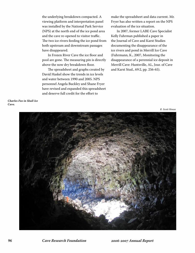
Cave Research Foundation�� - Annual Report
the underlying breakdown compacted. A viewing platform and interpretation panel was installed by the National Park Service (NPS) at the north end of the ice pond area and the cave re-opened to visitor traffic. The two ice rivers feeding the ice pond from both upstream and downstream passages have disappeared. In Frozen River Cave the ice floor and pool are gone. The measuring pin is directly above the now dry breakdown floor. The spreadsheet and graphs created by David Haskel show the trends in ice levels and water between 1990 and 2005. NPS personnel Angela Buckley and Shane Fryer have revised and expanded this spreadsheet and deserve full credit for the effort to
make the spreadsheet and data current. Mr. Fryer has also written a report on the NPS evaluation of the ice situation. In 2007, former LABE Cave Specialist Kelly Fuhrman published a paper in the Journal of Cave and Karst Studies documenting the disappearance of the ice rivers and pond in Merrill Ice Cave (Fuhrmann, K., 2007, Monitoring the disappearance of a perennial ice deposit in Merrill Cave: Huntsville, AL, Jour. of Cave and Karst Stud., 69:2, pp. 256-65).
R. Scott House
Charles Fox in Skull Ice Cave.

��- Annual ReportCave Research Foundation
R. Scott House
Steve Samoray in the entrance to Cookstove Cave, Pioneer Forest, Shannon County, MO.
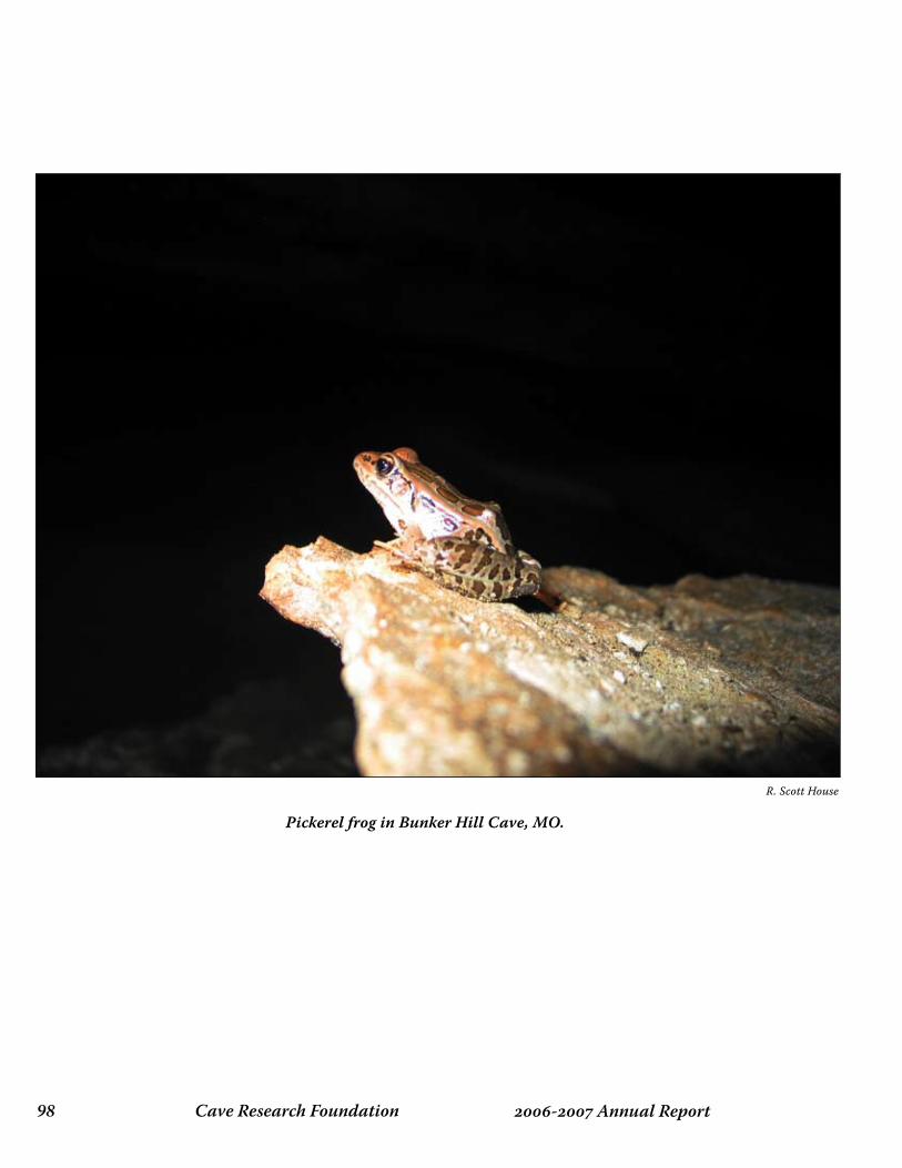
Cave Research Foundation�� - Annual Report
Pickerel frog in Bunker Hill Cave, MO.
R. Scott House

��- Annual ReportCave Research Foundation
restOratiOn and eduCatiOn

Cave Research Foundation�00 - Annual Report
the MAking oF “A viRtuAl touR oF vAlentine CAve”
In the mid 1990s, Apple Computer released a technology called QuickTime Virtual Reality, or QTVR. This technology allowed a developer to create a virtual world from panoramas in which the user could rotate through 360 degrees of view, look up and down, and zoom in and out on objects of interest. In addition, parts of the panorama could be designated as hot spots that could be used to link to other panoramas, and cause other actions. Unlike a video, in which the order of presentation
is predetermined, the user can choose between multiple paths, view as little or as much of the scene as desired, and even revisit places if so desired. All it took was one demo, and the idea of making a virtual cave tour was irresistible. Little did we guess how large this project would grow, and how many different activities it would encompass. The first step was to learn how to produce panoramas and link them together, a process called QuickTime VR authoring. We picked Valentine Cave in Lava Beds National Monument, because it is mostly easy walking passage, but has enough
crawlways and complexity to be interesting. Furthermore, the cave is clean and dry, allowing us to avoid typical caving problems while we were trying to work through the photographic problems. During our first in-cave session we shot five panoramas. These were soon assembled into a prototype tour that we could show to cavers and to the Monument staff. Their reactions were positive, and the staff was quite excited about the potential for developing it into an interpretive exhibit for the new Visitor Center. As we watched people use this first prototype, it quickly became obvious that it was a lot easier to become disoriented and get turned around in the virtual reality environment than in a real cave. To mitigate this problem we decided to try connecting a map of the cave with the user’s progress through the virtual tour. A small flashlight would track the explorer’s progress on the map, and indicate the direction being viewed. Linking the VR, the map and the flashlight required programming, and so one of us (Bill) developed the first version of the VRMap program. When we showed this expanded prototype to the Monument’s staff, they became even more enthusiastic, and approved an official project, with the goal of building a display for the Visitor Center. From this new effort, the monument staff wanted a state of the art exhibit that would offer a “caving experience” to the physically limited and provide all visitors with a wide-ranging interpretation of lava
Bill and Peri FrantzBi
ll Fr
antz
Valentine splash screen.

�0�- Annual ReportCave Research Foundation
tubes and of the National Monument. We wanted to learn to create and deploy virtual reality cave tours. Because the potential of the technology extended far beyond a single cave tour, we decided to build an extensible and reusable software environment that put the user in charge while maintaining a visual relationship between the VR and the cave map. By the time we finished this project, we had developed six major components. In addition to a vastly enhanced version of the VR movie, with twenty-five stations, and a greatly expanded version of the VRMap program, there was the cave map itself, an audio narration for the computer to play as the user moves through the tour, and extensive spot photography to highlight selected features of the cave. Last, and by no means least, we needed a way of coordinating all of these components, and pulling the presentation together into an integrated whole. Each station in the cave consists of a VR movie, or panorama, plus associated spot photographs and audio narratives. For the photography we used a Nikon SLR camera, color negative film, a tripod, lots of flash gear, and a panoramic tripod head. The panoramic tripod head allowed us to rotate the camera by precise increments from shot to shot, while keeping the center of the lens on the axis of rotation to avoid distortion. Each panorama consists of either twelve or eighteen 35 mm photographs that are stitched together into a single panoramic image. To minimize the amount of equipment we had to carry into the cave, we developed a technique that involved moving the flash units between each of the pictures. After some experimentation, we learned to do this without creating anomalous shadows in the overlapping areas of the photographs. Most of the photography for the VRs was done in four cave trips, however
there were numerous return trips to re-photograph flawed images and make spot photographs. If we were doing this project today, we would use a digital camera. However, when we started the project in 1999, the digital age was just dawning, and print film was our preferred medium. Our local camera store provided us with a photo-CD of the images along with the developed film. Once we had the digitized images, we used Apple’s QuickTime/VR Authoring Studio to stitch them together into panoramas and to link the panoramas into a QTVR movie. The first stitching operation, involving eighteen high-quality images, took 11 hours of computer time. The application of money, in the form of additional computer memory, reduced this time to less than an hour per panorama. The VRMap program, which runs the QTVR movie and coordinates it with the map, is written using QuickTime for Java. It will run on both Macintosh and Windows computers, and is available under the Gnu Public License. Keith Johnson kindly helped us debug the software in a Windows environment.
Bill Frantz
Opening scene.
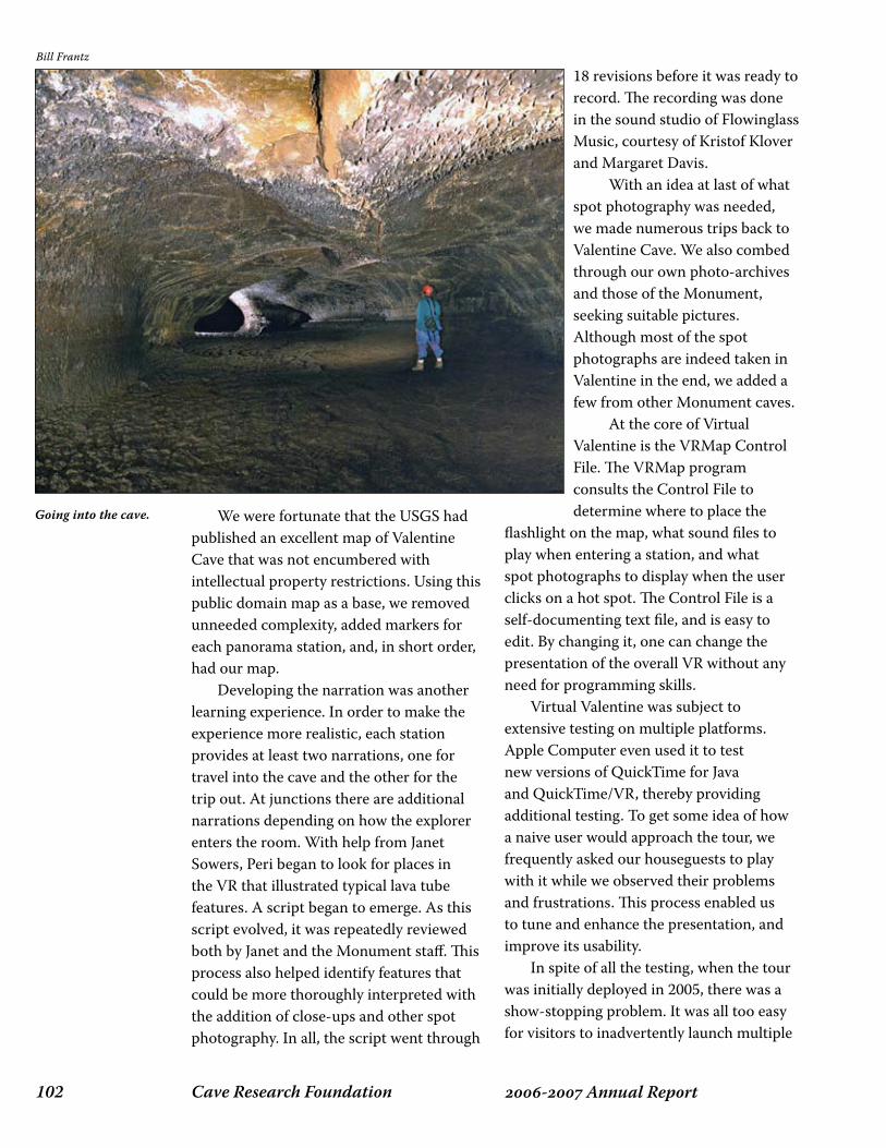
Cave Research Foundation�0� - Annual Report
We were fortunate that the USGS had published an excellent map of Valentine Cave that was not encumbered with intellectual property restrictions. Using this public domain map as a base, we removed unneeded complexity, added markers for each panorama station, and, in short order, had our map. Developing the narration was another learning experience. In order to make the experience more realistic, each station provides at least two narrations, one for travel into the cave and the other for the trip out. At junctions there are additional narrations depending on how the explorer enters the room. With help from Janet Sowers, Peri began to look for places in the VR that illustrated typical lava tube features. A script began to emerge. As this script evolved, it was repeatedly reviewed both by Janet and the Monument staff. This process also helped identify features that could be more thoroughly interpreted with the addition of close-ups and other spot photography. In all, the script went through
18 revisions before it was ready to record. The recording was done in the sound studio of Flowinglass Music, courtesy of Kristof Klover and Margaret Davis. With an idea at last of what spot photography was needed, we made numerous trips back to Valentine Cave. We also combed through our own photo-archives and those of the Monument, seeking suitable pictures. Although most of the spot photographs are indeed taken in Valentine in the end, we added a few from other Monument caves. At the core of Virtual Valentine is the VRMap Control File. The VRMap program consults the Control File to determine where to place the
flashlight on the map, what sound files to play when entering a station, and what spot photographs to display when the user clicks on a hot spot. The Control File is a self-documenting text file, and is easy to edit. By changing it, one can change the presentation of the overall VR without any need for programming skills. Virtual Valentine was subject to extensive testing on multiple platforms. Apple Computer even used it to test new versions of QuickTime for Java and QuickTime/VR, thereby providing additional testing. To get some idea of how a naive user would approach the tour, we frequently asked our houseguests to play with it while we observed their problems and frustrations. This process enabled us to tune and enhance the presentation, and improve its usability. In spite of all the testing, when the tour was initially deployed in 2005, there was a show-stopping problem. It was all too easy for visitors to inadvertently launch multiple
Bill Frantz
Going into the cave.

�0�- Annual ReportCave Research Foundation
copies, rapidly consuming all available memory and bringing the tour to a halt. This required intervention by the Visitor Center staff, making the tour unusable. The exhibit was temporarily removed from the Visitor Center, and we then worked to harden the software. To speed the process, the Monument loaned us the PC that eventually would be used in the exhibit. With this in hand, and after considerable reprogramming, we were able to develop a “kiosk mode,” where a user could not escape the program to access the operating system. This version of VRMap seems to have solved the problems experienced at the Visitor Center,
and Virtual Valentine is now once again running in the Visitor Center. Judging from the comments in its logbook, visitors are enjoying it. Future plans include a further revision of the script based on 3-6 months of actual use, additional tours of other caves both in the monument and elsewhere, a CD for sale in the Visitor Center, and encouraging others to use VRMap for their own tours. One other tour that is available today is a tour of Hurricane Crawl Cave included with the 2003 NSS Convention Guidebook. For information about using VRMap for your own projects, contact us at [email protected].
Bill Frantz
Passage to the entrance.

Cave Research Foundation�0� - Annual Report
The long running exploration and scientific research activities in the caves of Redwood Canyon, dating back to the late 1940s, have had adverse impacts on the caves. In particular, sediment and mud have been tracked and dropped onto previously clean formations. The primary goal of the Redwood Canyon Cave Restoration project is to mitigate human-caused impacts in Lilburn Cave and other caves in Redwood Canyon. Soiled formations are cleaned using water spray, water flooding and scrubbing with soft brushes. In severe cases, as a last resort, physical or chemical removal of
thin layers of calcite may be used to release detrital particles from the surface of the cave’s secondary formations. Restoration begins with techniques that produce the least adverse impacts on the cave. More aggressive techniques may be employed
as required to achieve a visually improved result. In addition, trails in frequently traveled areas, and in those that traverse decorated reaches of the caves, may be flagged to designate routes that minimize the potential impact on formations, substrates, and cave habitats. During 2007, fifteen people participated in seven restoration trips, all in Lilburn Cave. Several people participated in multiple trips. Most of these trips had specific restoration goals, while a few included additional objectives such as newcomer orientation and survey. The major areas of the cave that were cleaned were:
The Canopy Area (cleaning and trail flagging),The Ice Formations (cleaning),BX passage near BX4 (cleaning and trail flagging), andThe Bacon Rind Room (cleaning and delicate area flagging).
There are still a number of areas that need work. They will be visited in future years. I would like to thank this year’s participants:
•
••
•
lilBuRn RestoRAtion pRojeCt 2007Bill Frantz
Kristen AnkiewitzMishka Balunova
Elaine GarveyFofo GonzalezKeith HubbardLynne Jesaitis
Chuck Lee
Jaimie LintemoodPeter Lufti
Shannon MatheyDiana MihaescuJed Mosenfelder
Paul NelsonNatalie Uomini
Bill Frantz
Diana Mihaescu cleaning at BX4.

�0�- Annual ReportCave Research Foundation
Clockwise from upper left: Elaine
Garvey, Kristen Anklewits, and
Mishka Balunova in the Bacon Rind
Room; Elaine Garvey and Chuck Lee clean
the Ice Formations; Paul Nelson and
Elaine Garvey clean near the Canopy
Area.
All photos by Bill Frantz
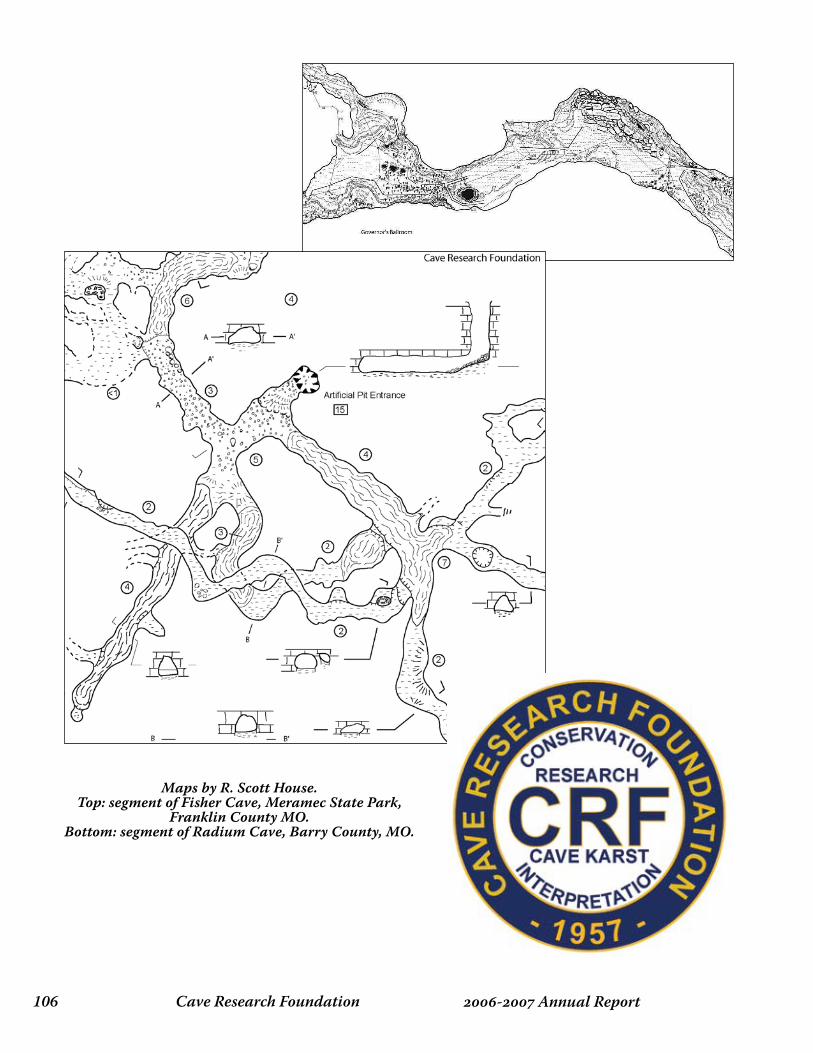
Cave Research Foundation�0� - Annual Report
Maps by R. Scott House.Top: segment of Fisher Cave, Meramec State Park,
Franklin County MO.Bottom: segment of Radium Cave, Barry County, MO.
�0�- Annual ReportCave Research Foundation
Cave BOOks
Cave Research Foundation�0� - Annual Report
CAve Books 2006 - 2007
In 1981, several cavers combined their money, knowledge, and their love of books to form CAVE BOOKS, a non-profit press devoted to the publishing of cave and karst related material. Who better to publish books about caves than cavers? The first book was The Grand Kentucky Junction, a companion to The Longest Cave. Since that first book, CAVE BOOKS has gone on to become the largest publisher of cave and karst books in the world. We also publish CRF annual reports, newsletters, research monographs, historical reprints, and cave maps. Solicitation of manuscripts is an ongoing endeavor and new items are continuously being added to the inventory. Publishing books is expensive. To keep costs down and prices low, we depend entirely on a staff of volunteers. At present, CAVE BOOKS staff consists of Roger McClure, Publisher; Paul Steward, Managing Editor; Elizabeth Winkler, Editor; Pete Lindsley, Web Design; David Hanson, Sales, and many other CRF volunteers who help with shipping. Revenue from this effort provides the primary support for many Foundation programs. Books published by CRF under CAVE BOOKS (ISBN prefix 0-93978) are listed in Books In Print. CAVE BOOKS is also listed in the standard directories as a publishing house with interests in nonfiction and fiction having to do with caves, karst, and speleology.
Find us on the web at: www.cavebooks.com
Please send inquires to: Paul Steward, Editor Cave Books 277 Clamer Road Trenton, NJ 08628 [email protected]
CAVE BOOKS Publications through 2007
Alpine Karst, 2004, Volume 1Tina Oliphant, editor. 2004. Illustrated. 130 pp.
Alpine Karst, 2006, Volume 2Tina Oliphant, editor. 2006. Illustrated. 170 pp.
Archeology of the Mammoth Cave AreaPatty Jo Watson, editor. 1997. Illustrated. 255 pp.
The Art of CavingLinda Heslop. 1996. Illustrated. 50 pp.
Atlas of the Great Caves of the WorldPaul Courbon, Claude Chabert, Peter Bosted, Karen Lindsley. 1989. Illustrated. 376 pp.
Carlsbad, Caves, and a CameraRobert Nymeyer. 1978. Illustrated. 318 pp.
Cave GeologyArthur Palmer. 2007. Illustrated. 454 pp.
Paul Steward
�0�- Annual ReportCave Research Foundation
Cave Research Foundation: Origins and the First Twelve Years 1957-1968Richard A. Watson, editor. 1981. Illustrated. 495 pp.
Cave Research Foundation Personnel Manual, 3rd edition.Diana O. Daunt-Mergens, editor. 1981. 176 pp.
Cave Research Foundation Personnel Manual for Eastern OperationsKaren Willmes, editor. 1999. 290 pp.
Caverns Measureless to ManSheck Exley. 1994. Illustrated. 325 pp.
The Caves Beyond: The Story of the Floyd Collins’ Crystal Cave ExplorationJoe Lawrence, Jr., Roger W. Brucker. 1975. Illustrated. 318 pp.
CavingRichard Watson. 1994. 17 pp.
The Darkness BeckonsMartyn Farr. 1991. Illustrated. 280 pp.
The Darkness Beckons, revised editionMartyn Farr. 2000. Illustrated. 304 pp.
The Darkness Beckons Supplement: Postscript, The 1990sMartyn Farr. 2000. Illustrated. 23 pp.
Deep Secrets: Discovery and Exploration of Lechuguilla CaveStephen Reames, Lawrence Fish, Paul Burger, Patricia Kambesis. 1999. Illustrated. 381 pp.
Diamond Caverns: Jewel of Kentucky’s UndergroundStan Sides. 2007. Illustrated. 22 pp.
Emergence, a novelMarian McConnell. 1999. Illustrated. 173 pp.
A Geological Guide to Mammoth Cave National ParkArthur N. Palmer. 1981. Illustrated. 210 pp.
The Grand Kentucky JunctionPatricia P. Crowthers, Cleveland F. Pinnix, Richard B. Zopf, Thomas A. Brucker, P. Gary Eller, Stephen G. Wells, John P.
Wilcox. 1984. 96 pp.A Guide to Speleological Literature of the
English Language 1794-1996Diana E. Northup, Emily Davis Mobley, Kenneth L. Ingham III, William W. Mixon, editors. 1998. 539 pp.
Guide to the Surface Trails of Mammoth Cave National ParkStanley D. Sides. 1991. Illustrated. 100 pp.
Hidden Beneath the Mountains: The Caves of Sequoia and Kings Canyon National Parks Joel Despain. 2003. Illustrated. 128 pp.
The Jewel Cave Adventure: Fifty Miles of Discovery Under South DakotaHerb and Jan Conn. 1981. Illustrated. 240 pp.
The Life and Death of Floyd Collins,by Homer Collins as told to John J. Lehrberger. 2001. Illustrated. 206 pp.
Memoirs of a Speleologist: The Adventurous Life of a Famous French Cave ExplorerRobert de Joly. 1975. Illustrated. 200 pp.
The Mammoth Cave National Park Research Center, A Cave Research Foundation Study.Richard A. Watson, Philip M. Smith. 1963. Illustrated. 50 pp.
Prehistoric Cavers of Mammoth CaveColleen O’Connor Olson. 2004. Illustrated. 64 pp.
Rambles in the Mammoth Cave, During the Year 1844, by a VisitorAlexander Clark Bullitt. 1985. Illustrated. 134 pp.
Scary Stories of Mammoth CaveColleen O’Connor Olson, Charles Hanion. 2002. Illustrated. 92 pp.
South China CavesRondal R. Bridgemon, Karen B. Lindsley. 1991. Illustrated. 62 pp.
Speleological Research in the Mammoth Cave Region, Kentucky, Elements of an Integrated Program.Philip M. Smith. 1960. 18 pp.

Cave Research Foundation��0 - Annual Report
Annual Reports 1969-1973, Richard A. Watson, editor. Illustrated. 265 pp.Annual Reports 1974-1978, Richard A. Watson, editor. Illustrated. 341 pp.Annual Report 1979, Thomas L. Poulson, Bethany J. Wells, editors. Illustrated. 74 pp.Annual Report 1980, Margaret V. Palmer, editor. Illustrated. 51 pp.Annual Report 1981, Karen B. Lindsley, editor. Illustrated. 55 pp.Annual Report 1982, Margaret V. Palmer, editor. Illustrated. 45 pp.Annual Report 1983, Kathleen H. Lavoie, editor. Illustrated. 42 pp.Annual Report 1984, Karen B. Lindsley, editor. Illustrated. 60 pp.Annual Report 1985, Karen B. Lindsley, editor. Illustrated. 48 pp.Annual Report 1986, Karen B. Lindsley, editor. Illustrated. 51 pp.Annual Report 1987, Karen B. Lindsley, editor. Illustrated. 74 pp.Annual Report 1988, Karen B. Lindsley, editor. Illustrated. 91 pp.
Speleology: Caves and the Cave EnvironmentGeorge W. Moore, Nicholas Sullivan. 1997. Illustrated. 176 pp.
Subterranean Climbers: Twelve Years in the World’s Deepest ChasmPierre Chevalier. 1975. Illustrated. 248 pp.
Ten Years Under the EarthNorbert Casteret. 1975. Illustrated. 320 pp.
True Tales of Terror in the Caves of the WorldPaul Jay Steward. 2005. 141 pp.
Under Plowman’s Floor (reprint)Richard Watson. 2006. 224 pp.
Wilderness Resources in Mammoth Cave National Park: A Regional ApproachJoseph K. Davidson, William P. Bishop. 1971. Illustrated. 34 pp.
Wupatki National Mounment Earth Cracks.Rondal R. Bridgemon, et al. 1976. Illustrated. 59 pp.
Yochib: The River CaveC. William Steele. 1985. Illustrated. 164 pp.
Annual Report 1989, Karen B. Lindsley, editor. Illustrated. 79 pp.Annual Report 1990, Karen B. Lindsley, editor. Illustrated. 80 pp.Annual Report 1991, Karen B. Lindsley, editor. Illustrated. 76 pp.Annual Report 1992, Karen B. Lindsley, editor. Illustrated. 68 pp.Annual Report 1993, Karen B. Lindsley, editor. Illustrated. 68 pp.Annual Reports 1994-1997, Paul Cannaley, Patricia Kambesis, editors. Illustrated. 136 pp.Annual Reports 1998-2000, Patricia Kambesis, Elizabeth Winkler, editors. Illustrated. 129 pp.Annual Reports 2001-2003. Patricia Kambesis, Elizabeth Winkler, editors.Illustrated. 128 pp.Annual Reports 2004-2005. Diana Tomchick, editor. Illustrated. 90 pp.
Cave Research Foundation Annual Reports

���- Annual ReportCave Research Foundation
CRF has officially reached “middle age.” We have nice homes in our field stations but need closet space. So a proposal for a combined library/archive/storage building at Hamilton Valley was presented to the BOD and the annual meeting in 2007 and approval to proceed was granted. We have amassed a huge amount of data in 50 years. We have collections of books bequeathed to us, including historical papers of the organization, maps, photographs, slides, microfiche, and over 4,000 original survey books. All this is presently scattered among the homes of our members. It is safe, but most of it is not readily available. The proposed structure will have fire-resistant storage for survey books and other irreplaceable items. There will be a circulating library for many of the books and journals and an archive for more fragile or sensitive items. We hope to cooperate with other cave and karst institutions in the sharing of much our information.
There will be storage for the bulk of the inventory of Cave Books. A working inventory will be maintained in Ohio where the daily business of Cave Books transpires. The library will double as a meeting room for smaller groups. A copier, computers and accouterments, and wireless capabilities will also be available. Designs and details are under consideration but the overall appearance will be similar to the existing structures. Cave Books proposes to provide most of the funding for the structure. Please contact Roger McClure or Joyce Hoffmaster for more information.
CRF liBRARy And ARChive
Joyce Hoffmaster


Mam
moth
CaveSystem
Mam
moth
Cave
NationalPark,K
entucky
Ro
ppelC
av
e
Flint
Rid
ge
Pro
cto
rC
av
e
Ma
mm
ot
hR
idg
e
Jo
pp
a
Ri
dg
e
CK
KC
CK
KC
CentralK
entuckyK
arstCoalition
01
Mile
Thism
aprepresents
over50years,and
+365m
iles,ofdedicatedexploration
byC
RF
andC
KK
CA
lldata(c)C
RF
andC
KK
C-O
ctober2007
ISBN 978-0-939748-69-3