Embed Size (px)
Citation preview

SYZYGY REVIEW OF EXPERIENCE WITH ECOLOGICAL NETWORKS, CORRIDORS AND BUFFER ZONES 1
CBD Programme of Work on Protected Areas
Goals 1.2 and 1.3
REVIEW OF EXPERIENCE WITH ECOLOGICAL REVIEW OF EXPERIENCE WITH ECOLOGICAL REVIEW OF EXPERIENCE WITH ECOLOGICAL REVIEW OF EXPERIENCE WITH ECOLOGICAL
NETWORKS, CORRIDORS AND BUFFER ZONESNETWORKS, CORRIDORS AND BUFFER ZONESNETWORKS, CORRIDORS AND BUFFER ZONESNETWORKS, CORRIDORS AND BUFFER ZONES
October 2005

SYZYGY REVIEW OF EXPERIENCE WITH ECOLOGICAL NETWORKS, CORRIDORS AND BUFFER ZONES 2
CONTENTS
Acknowledgements 4
1 Introduction 6
2 Central and Eastern Europe 15
3 Western Europe and Other Countries 29
4 Asia and the Pacific 48
5 Latin America and the Caribbean 62
6 Africa 77
7 Meeting the Challenge 88
Literature 102

SYZYGY REVIEW OF EXPERIENCE WITH ECOLOGICAL NETWORKS, CORRIDORS AND BUFFER ZONES 3
1111 INTRODUCTION
At their meeting In Kuala Lumpur in February 2004, the Seventh Conference of the Parties
of the Convention on Biological Diversity adopted through Decision VII/28 a detailed
Programme of Work on Protected Areas. The overall purpose of the Programme of Work is
“to support the establishment and maintenance by 2010 for terrestrial and by 2012 for
marine areas of comprehensive, effectively managed and ecologically representative
national and regional systems of protected areas that collectively, inter alia through a
global network, contribute to achieving the three objectives of the Convention and the
2010 target to significantly reduce the current rate of biodiversity loss at the global,
regional, national and sub-national levels and contribute to poverty reduction and the
pursuit of sustainable development”.
The first of the four substantive programme elements in the Programme of Work
concerns direct actions for planning, selecting, establishing, strengthening and managing
protected-area systems and sites – in other words, what protected areas need to
conserve, where and how. Five specific goals are established:
1.1 To establish and strengthen national and regional systems of protected areas
integrated into a global network as a contribution to globally agreed goals.
1.2 To integrate protected areas into broader land- and seascapes and sectors so as to
maintain ecological structure and function.
1.3 To establish and strengthen regional networks, transboundary protected areas and
collaboration between neighbouring protected areas across national boundaries.
1.4 To substantially improve site-based protected area planning and management.

SYZYGY REVIEW OF EXPERIENCE WITH ECOLOGICAL NETWORKS, CORRIDORS AND BUFFER ZONES 4
1.5 To prevent and mitigate the negative impacts of key threats to protected areas.
Each goal is elaborated into a specific target as a tangible indicator of the achievement of
that goal. A series of suggested activities of the Parties and supporting activities of the
Executive Secretary are then listed as steps to be taken in moving towards the target.
Decision VII/28 also established a follow-up mechanism in order to support and review
the implementation of the Programme of Work, namely an Open-Ended Working Group on
Protected Areas. One of the tasks of the Working Group is to contribute to the further
development of tool kits for the identification, designation, management, monitoring and
evaluation of national and regional systems of protected areas, including ecological
networks, ecological corridors and buffer zones. In order to be able to develop these tool
kits in relation to Goals 1.2 and 1.3, the CBD Secretariat identified a need for a review of
experience in developing ecological networks, corridors and buffer zones. This document
constitutes that review of experience.
SUBJECT AND SCOPE OF THE REVIEW
The requirements for the review were, first, to prepare case studies illustrating experience
in each of the five UN regions on the development of ecological networks, corridors and
buffer zones and, second, to draw conclusions on their suitability for biodiversity
conservation, sustainable use, poverty alleviation as appropriate and the contribution to
the 2010 biodiversity target. The scope of the review is therefore exceptionally broad: it is
not only global in its coverage, it also covers a wide range of conservation measures that
range from a single ecoduct to intercontinental, interconnected networks of protected
areas. Of the thousands of programmes and projects that fall within the scope of the
review, only a small proportion can be assessed in detail. The conclusions are therefore
based on both the experiences illustrated by the case studies and relevant literature.
However, before discussing global experience, it is necessary to clarify the concepts that
are the subject of the review: that is, ecological networks, corridors and buffer zones.
Ecological Networks
The ecological network is a model that has developed over the past 20–30 years with the
broad aim of maintaining the integrity of environmental processes. Although the way in
which the model is elaborated and applied reflects certain conceptual and methodological
variants and is subject to local and regional circumstances, the approaches that are
usually classified as ecological networks share two generic goals, namely (1) maintaining
the functioning of ecosystems as a means of facilitating the conservation of species and
habitats and (2) promoting the sustainable use of natural resources in order to reduce the
impacts of human activities on biodiversity and/or to increase the biodiversity value of
man-managed landscapes (Bennett and Wit, 2001).
In achieving these goals, a number of elements can be discerned which together
characterize all ecological networks. These are:
– a focus on conserving biodiversity at the landscape, ecosystem or regional scale

SYZYGY REVIEW OF EXPERIENCE WITH ECOLOGICAL NETWORKS, CORRIDORS AND BUFFER ZONES 5
– an emphasis on maintaining or strengthening ecological coherence, primarily through
providing for connectivity
– ensuring that critical areas are buffered from the effects of potentially damaging
external activities
– restoring where appropriate degraded ecosystems
– promoting the sustainable use of natural resources in areas of importance to
biodiversity conservation.
Ecological networks also share a common understanding of how this model should be
applied on the ground, namely through the allocation of specific functions to different
areas depending on their ecological value and their natural-resource potential (Bennett,
2004). These functions are reflected in a coherent system of areal components:
– CORE AREAS, where the conservation of biodiversity takes primary importance, even if
the area is not legally protected
– CORRIDORS, which serve to maintain vital ecological or environmental connections by
maintaining physical (though not necessarily linear) linkages between the core areas
– BUFFER ZONES, which protect the network from potentially damaging external influences
and which are essentially transitional areas characterized by compatible land uses
– SUSTAINABLE-USE AREAS, where opportunities are exploited within the landscape mozaic
for the sustainable use of natural resources together with the maintenance of
ecosystem functions.
A diagrammatic representation of this spatial arrangement is shown in Figure 1.1.

SYZYGY REVIEW OF EXPERIENCE WITH ECOLOGICAL NETWORKS, CORRIDORS AND BUFFER ZONES 6
Figure 1.1. Diagrammatic representation of the spatial configuration of an ecological network.

SYZYGY REVIEW OF EXPERIENCE WITH ECOLOGICAL NETWORKS, CORRIDORS AND BUFFER ZONES 7
One feature of ecological-network programmes that can lead to some confusion is the
variation in terminology. The term “ecological network” gained favour in Europe in the
early 1990s and has been used in the most important international mechanisms in recent
years, including IUCN’s World Conservation Congresses, the World Summit on Sustainable
Development’s Plan of Implementation and the CBD Conferences of the Parties, including
the Programme of Work on Protected Areas. In regional and national settings, however,
different terms are used to describe the model. These include “territorial system of
ecological stability”, “reserve network”, “bioregional planning”, “ecoregion-based
conservation” and various language-specific variants, but also “corridor”. As a result, it is
not always obvious from the title of a programme or project whether the approach
reflects the ecological-network model.
Further information on the origins of the approaches and the conceptual, methodological
and terminological variations is provided in the regional case studies.
Corridors
Corridors – in the sense of functional linkages between sites – are essentially a device to
maintain or restore a degree of coherence in fragmented ecosystems. In principle, linking
isolated patches of habitat can help increase the viability of local species populations in
several ways:
– by allowing individual animals access to a larger area of habitat – for example, to
forage, to facilitate the dispersal of juveniles or to encourage the recolonization of
“empty” habitat patches
– by facilitating seasonal migration
– by permitting genetic exchange with other local populations of the same species
(although this generally requires only very occasional contact)
– by offering opportunities for individuals to move away from a habitat that is
degrading or from an area that is under threat (which may become increasingly
important if climate change proves to have a serious impact on ecosystems)
– by securing the integrity of physical environmental processes that are vital to the
requirements of certain species (such as periodic flooding).
Corridors vary enormously in scale: from a tunnel to allow amphibians to pass under a
road to intercontinental flyways for migrating birds. They also take many different forms.
In general, three broad kinds of landscape corridor can be distinguished:
– a linear corridor (such as a hedgerow, forest strip or river)
– “stepping stones”, that is, an array of small patches of habitat that individuals use
during movement for shelter, feeding and resting
– various forms of interlinked landscape matrices that allow individuals to survive
during movement between habitat patches.
Corridors have been the subject of growing interest for about 20 years and are
increasingly being included in biodiversity conservation programmes around the world.
Their practical conservation value has nevertheless been the subject of fierce debate (see,
for example, Dawson, 1994; Rosenberg et al., 1997; Beier and Noss, 1998). Fortunately,

SYZYGY REVIEW OF EXPERIENCE WITH ECOLOGICAL NETWORKS, CORRIDORS AND BUFFER ZONES 8
carefully designed corridor experiments and growing experience with connectivity
projects is generating a substantial body of data and providing a useful resource on how
corridors can most effectively be used so that a better understanding of the potential
value of coridors in particular situations is now developing (see, for example, Tewksbury
et al., 2002; Bennett, 2004).
As is the case with ecological networks, however, the terminology used to describe
corridors requires some clarification. The term “corridor” is used to describe many
different kinds of measures, including landscape linkages (both linear and non-linear),
recreational routes (also known as greenways) and entire ecological networks. Other
terms are therefore becoming more prominent in the conservation literature, such as
“linkage” for a corridor and “permeability” to indicate the general principle of
maintaining or enhancing ecological coherence across a landscape. “Connectivity” is also
widely used as a general term. In this review the term “corridor” will be retained in most
instances to connote a man-managed connection since it is used by the Conference of
Parties. The term “linkage” is used to signify a naturally existing connection that is the
focus of conservation action.
Buffer Zones
In contrast to ecological networks and corridors, the concept of a buffer zone is generally
subject to far less controversy. The prime purpose of a buffer zone is to insulate areas
where biodiversity conservation is the primary objective from potentially damaging
external influences, and particularly from those caused by inappropriate forms of land
use. This function therefore permits in principle a range of sustainable human activities.
The concept of a buffer zone was first proposed in the 1930s, but it rose to prominence
as a conservation instrument in the 1970s when it became an integral part of the
management approach in UNESCO’s Man and Biosphere Programme (UNESCO, 1974). In
fact, UNESCO introduced a two-tier hierarchy in buffering protected areas: a “buffer zone”
where land use is restricted to activities that are compatible with the protection of the
core area, and a “transition area” where appropriate economic activities are permitted and
where sustainable resource management practices can be developed, which today are
often called sustainable-use areas (see Figure 1.2.).
But although the concept of a buffer zone may be straightforward, its design in practice
raises many challenges. Adequately understanding the interaction between human
activities and species populations and the resulting dynamics is a complex issue;
determining appropriate land uses is therefore far from easy. Buffer zones may perform a
corridor function or in themselves harbour valuable biodiversity, such as species
populations that are dependent on certain traditional forms of agriculture. Decisions to
restrict human activities in buffer zones will also impose costs on the landowners and
users, raising the question of compensation. Land-use management is therefore a critical
factor in the degree to which buffer zones can in practice prove to be effective as a
conservation instrument.

SYZYGY REVIEW OF EXPERIENCE WITH ECOLOGICAL NETWORKS, CORRIDORS AND BUFFER ZONES 9
Figure 1.2. The Biosphere Reserve zoning system.
Other Issues
The Breadth of the Review
As the foregoing discussion on ecological networks, corridors and buffer zones suggests,
the task of identifying programmes and projects that fall within the scope of this review
is confronted with a substantial grey area. Due to information shortcomings, it is not
always readily apparent whether the conservation model that is applied by specific
initiatives can be regarded as an ecological network. This particularly applies to many of
the large-scale “ecoregion” programmes which have not yet progressed to the stage of
preparing a plan which specifies how biodiversity conservation and sustainable use will
be achieved on the ground. For example, many of these initiatives adopt a management
approach that is closer to the Biosphere Reserve model than that of the ecological
network – that is to say, the sites that are the subject of conservation action are relatively
large, integral areas within which zoning distinguishes between biodiversity conservation,
buffer zones and sustainable forms of land use; no explicit measures are taken to
enhance connectivity between sites. However, in the interests of presenting as complete a
review as possible, both ecoregion initiatives and Biosphere Reserves are included among
the programmes that are covered by the review since to a significant extent their
management approach overlaps that of the ecological-network model.
Although the network model was originally developed for application in terrrestrial
ecosystems, interest has grown in recent years in considering to what extent the same
principles might usefully be applied to marine ecosystems that are under pressure from
human activities such as oil and gas exploitation, fishing and coastal development. At the
oceanic scale, the homogeneous nature of the marine environment is clearly less suited to
the structural principles of the ecological network than terrestrial landscapes. However,

SYZYGY REVIEW OF EXPERIENCE WITH ECOLOGICAL NETWORKS, CORRIDORS AND BUFFER ZONES 10
there are several specific kinds of marine systems that offer comparable challenges to
terrestrial ecosystems. Four obvious examples are:
– MARINE LINKAGES (such as sea straits that are used by certain species during migration,
for dispersal or to move between spawning and feeding grounds)
– SEA-RIVER LINKAGES (that is, ecosystems that are formed by the interaction between a
river and the sea, such as those used by migratory fish)
– COASTAL SYSTEMS (where land and sea constitute an interacting system, such as where
turtles and seals depend on littoral shallows or the presence of a coastline)
– LOCATION-SPECIFIC MARINE BREEDING GROUNDS.
However, because of the special factors that affect marine conservation, this review is
limited to terrestrial, freshwater and coastal ecosystems.
The Ecosystem Approach
A conservation model that is closely related to the ecological network is the Ecosystem
Approach. The Ecosystem Approach can be regarded as a strategy for the management of
land, water and living resources that promotes conservation and sustainable use in an
equitable way. At the heart of the approach is the awareness that, without the effective
management of ecosystems, there can be no economic development that generates
sustainable human and social welfare; equally, without the full engagement of diverse
sectors in the economy and society in the management of ecosystems, there can be no
effective biodiversity conservation. In that sense, the Ecosystem Approach is a framework
for holistic decision-making and action. In 2000 the Conference of the Parties identified
the Ecosystem Approach as the primary framework for the implementation of the
Convention on Biological Diversity and recommended the application of its principles.
Realizing the Ecosystem Approach is to be achieved through the application of 12
principles and five points of operational guidance (see box). These show a high level of
correspondence with the characteristics of the ecological-network model: both focus on
maintaining ecosystem functions in the long term and securing the sustainable use of
land. The way in which the two models have evolved has nevertheless resulted in certain
differences in emphasis and application. Ecological networks emerged in the main as
national or regional responses to the challenges of biodiversity conservation and
sustainable development, in many cases with little knowledge of comparable approaches
elsewhere. As a result, ecological networks display a variety of methodological
approaches and management philosophies. But despite this diversity they have arrived –
often independently – at a common model of how the two objectives can best be
achieved. By contrast, the Ecosystem Approach was developed in the 1990s through a
broad-based, globally organized process. It therefore operates through generally
applicable principles which allow scope for elaboration to take account of local and
regional circumstances. It also gives greater emphasis to the application of common
management principles. A series of case studies that have been carried out in recent years
illustrate how this process operates in practice (see Smith and Maltby, 2003; Shepherd,
2004). These examples demonstrate that in practice the application of the Ecosystem

SYZYGY REVIEW OF EXPERIENCE WITH ECOLOGICAL NETWORKS, CORRIDORS AND BUFFER ZONES 11
Approach leads to a wide range of solutions on the ground which in many cases arrive at
a form of management that is comparable to an ecological network.
THE ECOSYSTEM APPROACH
Principles of the Ecosystem Approach
1. The objectives of management of land, water and living resources are a matter of societal choices. 2. Management should be decentralized to the lowest appropriate level. 3. Ecosystem managers should consider the effects (actual or potential) of their activities on adjacent and
other ecosystems. 4. Recognizing potential gains from management, there is usually a need to understand and manage the
ecosystem in an economic context. Any such ecosystem-management programme should: a) Reduce those market distortions that adversely affect biological diversity; b) Align incentives to promote biodiversity conservation and sustainable use; c) Internalize costs and benefits in the given ecosystem to the extent feasible.
5. Conservation of ecosystem structure and functioning, in order to maintain ecosystem services, should be a priority target of the ecosystem approach.
6. Ecosystems must be managed within the limits of their functioning. 7. The Ecosystem Approach should be undertaken at the appropriate spatial and temporal scales. 8. Recognizing the varying temporal scales and lag-effects that characterize ecosystem processes,
objectives for ecosystem management should be set for the long term. 9. Management must recognize that change is inevitable. 10. The Ecosystem Approach should seek the appropriate balance between, and integration of,
conservation and use of biological diversity. 11. The Ecosystem Approach should consider all forms of relevant information, including scientific and
indigenous and local knowledge, innovations and practices. 12. The Ecosystem Approach should involve all relevant sectors of society and scientific disciplines. Points of operational guidance 1. Focus on the relationships and processes within ecosystem. 2. Enhance benefit-sharing. 3. Use adaptive management practices. 4. Carry out management actions at the scale appropriate for the issue being addressed, with
decentralization to the lowest level, as appropriate. 5. Ensure intersectoral cooperation.
STRUCTURE OF THE REVIEW
The structure of the review of experience follows the UN regional classification. That is to
say, it is organized around five regions:
– Asia and the Pacific
– Africa
– Central and Eastern Europe
– Latin America and the Caribbean
– Western Europe and other countries.
The order in which the regions are discussed reflects the chronology of the development
and application of the ecological-network model. Thus, the first region covered by the
review is Central and Eastern Europe, where the ecological network was originally
conceived.
The experience of each region is presented through an introduction on the development
of ecological networks, an overview of the known programmes (including brief

SYZYGY REVIEW OF EXPERIENCE WITH ECOLOGICAL NETWORKS, CORRIDORS AND BUFFER ZONES 12
descriptions of between two and five examples), the presentation of two case studies, and
a concluding section that highlights the main characteristics of the programmes. The
examples and the case studies have been selected to cover as wide a range of
programmes as possible. They therefore illustrate comprehensive ecological-network
programmes at the one extreme through to individual corridors and buffer zones at the
other. But they also vary with respect to geographical scale, implementing phase, whether
a government or an NGO was the initiating organization and also the degree of success in
achieving their objectives.
In order to simplify the presentation of specific types of programme, agreements under
the Bonn Convention on the Conservation of Migratory Species of Wild Animals are
grouped together under Western countries (where the majority are located). Flyway
agreements are discussed under Asia and the Pacific, since a substantial proportion are
found in that region. All information presented is based as far as possible on original
sources.

SYZYGY REVIEW OF EXPERIENCE WITH ECOLOGICAL NETWORKS, CORRIDORS AND BUFFER ZONES 13
2222 CENTRAL AND EASTERN EUROPE
Programmes to develop and establish ecological networks were pioneered in Central and
Eastern Europe in the 1980s (Külvick, 2002). The first initiative to establish what is now
recognized as an ecological network was the Estonian Network of Ecologically
Compensating Areas. This programme, that originated as a concept in the mid-1970s and
was elaborated into a national proposal in 1983, was based to a large extent on the
polarized-landscape theory of the Russian geographer Boris Rodoman (Rodoman, 1974).
At around the same time several other countries in the region developed proposals that
were also based on the landscape-stabilization approach, most notably Lithuania and
former Czechoslovakia. All these programmes were characterized by an integrated
approach to land-use zoning and environmental management within a strong national
development-planning system.
The programmes continued to be elaborated throughout the 1980s. However, the
revolutionary political changes that overtook Central and Eastern Europe at the end of the
decade had huge impacts on the government institutions and administrative systems of
all the countries in the region. The changes were accompanied by a period of economic
decline and restructuring, with the result that the further development and
implementation of the ecological-network programmes was subordinated to more
pressing political priorities.
An impulse that reinvigorated the work on ecological networks in the region arrived in
1995 with the adoption of the Pan-European Biological and Landscape Diversity Strategy.
This international agreement includes the commitment to establish a Pan-European

SYZYGY REVIEW OF EXPERIENCE WITH ECOLOGICAL NETWORKS, CORRIDORS AND BUFFER ZONES 14
Ecological Network. Although the model underlying the Pan-European Ecological Network
owes more to the principles of landscape ecology that the theory of landscape
stabilization, the programme to develop and implement an ecological network from the
Atlantic to the Pacific provided enough impetus to persuade countries in Central and
Eastern Europe to revive their ecological-network programmes or develop new national
schemes. However, in line with the pan-European approach, in most cases the current
programmes feature a greater focus on biodiversity conservation rather than integrated
environmental planning.
OVERVIEW OF THE PROGRAMMES
Ecological networks in Central and Eastern Europe are being developed in three main
ways: through the collaborative framework of the Pan-European Biological and Landscape
Diversity Strategy, through national or (in Russia) regional government programmes and
through various NGO projects.
The most ambitious international ecological-network programme is the Pan-European
Ecological Network. In 1995 54 Eurasian countries endorsed the Pan-European Biological
and Landscape Diversity Strategy. The agreement operates to a large extent as a
coordinating framework within which national actions to conserve biological and
landscape diversity in the period to 2015 are being taken. However, the Strategy included
a range of ambitious actions that went beyond existing international agreements and
national policies. The most significant of these was the establishment of the Pan-
European Ecological Network (see box).
With regard to government-driven programmes, national ecological networks are under
development in 10 countries in Central and Eastern Europe, as follows:
– CZECH REPUBLIC: the Territorial System of Ecological Stability
– ESTONIA: the Green Network (see case study)
– HUNGARY: the National Ecological Network
– LATVIA: the Ecological Network
– LITHUANIA: the Ecological Network (see box)
– MOLDOVA: the National Ecological Network (see case study)
– ROMANIA: the National Network
– SLOVAKIA: the Territorial System of Ecological Stability
– UKRAINE: the National Ecological Network.
In addition, in Russia two regional ecological networks are being developed at the
initiative of an official research institute, namely the Ecological Network of the Orenbourg
Region and the Heart of Russia in the Moscow region.

SYZYGY REVIEW OF EXPERIENCE WITH ECOLOGICAL NETWORKS, CORRIDORS AND BUFFER ZONES 15
EURASIA: THE PAN-EUROPEAN ECOLOGICAL NETWORK IN CENTRAL AND EASTERN EUROPE
The aim of the Pan-European Ecological Network is to ensure: – the conservation of the characteristic ecosystems and the natural habitats and landscapes of European
importance across their traditional ranges – the sustainable use of semi-natural habitats and cultural landscapes of European importance – the maintenance of viable populations of species of European importance across their traditional ranges – the maintenance of the environmental processes on which these ecosystems, habitats, species and
landscapes depend. These objectives are to be achieved through the establishment of an ecological network that will be built up from three functionally complementary components: core areas that provide the optimum achievable quantity and quality of environmental space, corridors to ensure appropriate interconnectivity between the core areas, and buffer zones to protect the core areas and corridors from potentially damaging external influences. Many Eurasian countries, particularly in Central and Eastern Europe, were already developing national ecological network programmes when the Strategy was finalized, and many others have initiated comparable programmes since 1995. However, in order to strengthen the international coordination of these programmes, a supranational programme was initiated in 1999 with the aim of configuring the main lines of the network for Central and Eastern Europe. The resulting map, prepared by the European Centre for Nature Conservation (European Centre for Nature Conservation, 2002), indicates core areas of pan-European importance and broad areas within which associated corridors or stepping stones could be located.

SYZYGY REVIEW OF EXPERIENCE WITH ECOLOGICAL NETWORKS, CORRIDORS AND BUFFER ZONES 16
LITHUANIA: THE ECOLOGICAL NETWORK
The first proposal for an ecological network in Lithuania was developed in the early 1980s as the Nature Frame (Sepp and Kaasik, 2002). During the period up to 1993 the concept was elaborated at the national level and then for all 44 districts. The Nature Frame follows Central European practice in providing a broad planning framework for land management. In environmental terms the approach aims to integrate the management of three systems: watersheds, biodiversity and landscape linkages (both ecological and physical). About 60 per cent of Lithuanian territory falls within the Nature Frame, which has legal status through the Environmental Protection Act 1992 and the Protected Areas Act 1993. Substantial adaptations have been made in recent years to ensure closer correspondence with the approach adopted by the Pan-European Ecological Network and also to facilitate implemention of the EU’s representative system of protected areas, Natura 2000, and the Bern Convention. For example, the European importance of species populations, habitats and corridors was added as a design criterion, analyses of indicator species, species communities and habitats were given greater emphasis in determining the configuration of the network, and a clear functional distinction is now made between core areas, buffer zones, restoration areas, corridors and stepping stones. Accordingly, the term “ecological network” is usually used to describe the current programme. An IUCN project has tested implementation of the ecological network through a pilot project in the Klaip÷da district on the Baltic coast where 35 per cent of the district fell within the network.
Of the NGO projects that involve the development of ecological networks, WWF is most
active through its ecoregion conservation programme. Ecoregion programmes that were
underway at the time of writing include the following terrestrial and coastal regions:
– European-Mediterranean montane mixed forests (the Alps, the Carpathians and the
Dinaric Alps)
– Caucasus-Anatolian Hyrcanian temperate forests
– Mediterranean forests, woodlands and scrub (southwest Iberia and the northwest
Morocco lowlands, the Baetic-Atlas mountains and the Italian Peninsula)
– East-European broadleaf forest and forest-steppe

SYZYGY REVIEW OF EXPERIENCE WITH ECOLOGICAL NETWORKS, CORRIDORS AND BUFFER ZONES 17
– the Russian Far East (temperate forests and rivers and streams)
– Altai Sayan montane forests.
In addition, WWF is carrying out two large-scale non-ecoregion programmes in Central
and Eastern Europe:
– woodlands and the Danube river delta
– the middle-Asian montane steppe.
Examples of projects that are being carried out within the context of these ecoregion
programmes and that involve the development of an ecological network include the
Central European forest-steppe ecoregion (see box), the Far East ecoregion (see box) and
the Southern Ural Mountains (Shestakov and Krever, 2003).
RUSSIA: THE CENTRAL EUROPEAN FOREST-STEPPE ECOREGION
Following the preparation of its Global 200 Programme, which identified 233 priority ecoregions, WWF initiated a large number of projects with the aim of conserving biodiversity in these regions. The approach to be applied to this task is known as “Ecoregion-Based Conservation” (ERBC) and corresponds in many respects to the ecological-network model and the Ecosystem Approach, though with a major emphasis on process management. ERBC aims to achieve four fundamental conservation goals – representation of all distinct natural communities – maintenance of ecological and evolutionary processes – maintenance of viable populations of species – resiliency in the face of large-scale periodic disturbances and long-term change. An example of ERBC is the forest-steppe ecosystem in Central European Russia that is part of the East-European broadleaf forest and forest-steppe ecoregion. Covering 90,000 square kilometres at the confluence of the Volga, Dnepr and Don river basins, the area is primarily broadleaved forest with some southern taiga and a small area of steppe. A large proportion of the region is devoted to agriculture. The WWF project began in 1998 and includes an inventory of the region’s natural potential, field verification studies, ecological-network planning, model projects and developing proposals for new legislation. This resulted in the adoption of the regional Law on a System of Protected Nature Areas in 2002, which laid down the framework for allocating competences and also for planning, establishing, managing and protecting ecological networks.

SYZYGY REVIEW OF EXPERIENCE WITH ECOLOGICAL NETWORKS, CORRIDORS AND BUFFER ZONES 18
IUCN has also promoted and supported the development of ecological networks in
Central and Eastern Europe. The IUCN Office for Central Europe took the initiative to
develop a common regional approach (Liro, 1998) and to prepare proposals for national
ecological networks in Poland (Liro et al., 1995) and the Ukraine (Vakarenko, 1999).
Finally, it can be noted that UNESCO’s Man and Biosphere Programme includes 88
Biosphere Reserves in Central and Eastern Europe, including four transboundary reserves.
RUSSIA: THE FAR EAST ECOREGION
Located on Russia’s Pacific rim, the Far East ecoregion covers over 1.3 million square kilometres. The striking variation in landscapes and microclimates has produced a high level of biological diversity in the region’s prairies, mixed broadleaf forests, moraines, alpine tundra, intricate coastline and over 60,000 lakes. These temperate forests are among the richest in the world and endemism is exceptionally high. WWF initiated a biodiversity conservation project for the ecoregion in 1998, applying its Ecoregion-Based Conservation approach. Cooperating with experts and representatives from the Far East Academy of Sciences, government research institutes, the provincial administrations, environmental NGOs and international consultancies, biodiversity and socio-economic assessments were prepared. A biodiversity vision was then drawn up to establish qualitative long-term conservation objectives for the region in collaboration with the main stakeholders. Based on this work, a Conservation Action Plan was prepared in 2003 with measures organized around three action tracks: conserving biodiversity, strengthening institutions and management procedures, and creating a sustainable economy in the region. The finalization and implementation of the plan is supervised by the Ecoregional Council for Sustainable Nature Use, with participation by representatives of federal and provincial governments, scientists and NGOs. Although it was unrealistic to secure unanimous agreement on all the recommendations in the Conservation Action Plan, most of the recommendations enjoyed broad endorsement from the stakeholders. A provisional ecological network has been developed and is currently under consideration by the Council. The network is to be established primarily to conserve biodiversity and promote sustainable development in the forest and wetland areas. It is projected to be fully implemented by 2020, with the main areas being under protection or appropriate management by 2010.

SYZYGY REVIEW OF EXPERIENCE WITH ECOLOGICAL NETWORKS, CORRIDORS AND BUFFER ZONES 19
Case Study 1 ESTONIA: THE GREEN NETWORK
Estonia must be credited as the first country to develop the ecological network concept
and to elaborate the model into a comprehensive plan and implementation programme.
Today, despite the disruptions caused by the revolutionary changes of the early 1990s,
plans for implementing the network at county level throughout Estonia are now vitually
complete.
In comparison with Europe as a whole, biodiversity in Estonia is still rich. For example, 71
different forest types and almost 700 species of meadow flora have been identified.
Moreover, many species that are threatened at the continental or global scale are still
relatively abundant. These include the wolf, the lynx, the otter, the beaver, the black
stork, the corncrake, the lesser-spotted eagle and the crane. The main reasons for the
high level of habitat and species diversity are the long-standing traditional forms of land-
use combined with the multiple environmental gradients that characterize the region,
such as the long, relatively undisturbed coastline, the high soil differentiation, the varied
topography and the diverse water regimes.
During the period under Soviet rule from 1940 to 1991, Estonia remained relatively
underdeveloped in economic terms. This low level of economic development combined
with the low population density allowed an extensive system of protected areas to be
built up and maintained. However, important changes in the organization of agricultural
practices were effected which resulted in the replacement of much of the traditional
small-scale rural mozaic with large fields and extensive forests. In addition, a large
number of wetlands were drained for conversion to agricultural land, although many of
these areas were later abandoned.
The origins of the first proposal to develop an Estonian ecological network date back to
the 1970s (Sepp and Kaasik, 2002). In 1983 this proposal was finalized as a plan to
establish a “Network of Ecologically Compensating Areas”, a national scheme that aimed
to achieve far broader goals than biodiversity conservation. Indeed, in modern
terminology this plan would be described as a national sustainable development strategy.
Nine strategic objectives were explicitly identified:
– providing refuges for wildlife
– facilitating the migration of species
– buffering undesirable impacts
– efficiently ordering human settlements
– providing opportunities for recreation
– reducing pollution
– promoting the conservation of energy and materials
– promoting recycling.
In Estonia’s vision, the ecological-network concept is regarded as a means to integrate
land use with landscape functions in a model that can be incorporated into regional and
national planning processes. From its inception, therefore, the Estonian ecological

SYZYGY REVIEW OF EXPERIENCE WITH ECOLOGICAL NETWORKS, CORRIDORS AND BUFFER ZONES 20
network has been developed as a spatial-planning tool for the purpose of balancing and
integrating land uses.
With the broad framework established, the approach was elaborated using data on
geology, climate, soils, hydrology, forests and land uses. Simultaneously, a methodology
for applying the approach at the local level was developed, using districts in northwestern
and northeastern Estonia, the Tallinn region, Hiiumaa and the Saaremma islands, with the
intention of using the results in the development-planning process.
However, the independence of Estonia in 1991 and the initiation of political and
institutional reforms marked the start of a long period of severe economic difficulties,
particularly in the public sector. One of the results of this transitional phase was that
agriculture came under severe economic pressure, and this in turn is threatening many
valuable semi-natural habitats that have been managed through traditional agricultural
practices. Forest habitats are also coming under increasing pressure: almost half of
Estonia’s forests are now privately owned but effective regulatory regimes to promote
sustainable forms of forestry management are still lacking.
A new implementing framework for the Network of Ecologically Compensating Areas was
established through the reform of Estonian political institions and legislation. Through
these reforms, the network has been incorporated into new spatial planning and
environmental legislation: the 1995 Sustainable Development Act, the 1994 Protection of
Natural Features Act and the 1995 Planning and Building Act, which required all 15
counties to prepare a map of the ecological network for their territory. In addition, the
network has been the subject of policy papers such as the National Environmental
Strategy (which includes an indicative map), the Environmental Action Plan and Estonia –
Vision 2010. The National Agri-Environmental Programme further provides for the
development of ecological networks at the local level as a way of supporting extensive
farming practices. Since 1995, the development of the Pan-European Ecological Network –
with the active participation of Estonia – has further stimulated the process, as has an
IUCN project to support the further elaboration, integration and implementation of the
ecological networks in the three Baltic countries. These influences have led to the
development of a revised concept that focuses primarily on biodiversity conservation: the
Green Network.
As currently delineated, the Estonian Green Network covers about 50 per cent of the
country’s territory and is structured to achieve a variety of objectives:
– to shape the spatial structure of natural areas in order to meet ecological,
environmental, economic and social goals
– to establish a fully functioning network of protected areas that are an integral part of
a complete system with natural areas
– to protect valuable natural habitats and to preserve the migration routes of wild
animals and valuable landscapes
– to mitigate human impacts on biodiversity and promote sustainable development

SYZYGY REVIEW OF EXPERIENCE WITH ECOLOGICAL NETWORKS, CORRIDORS AND BUFFER ZONES 21
– to promote biodiversity-friendly management, lifestyles and recreation by ensuring
access to natural areas
– to promote biodiversity conservation outside protected areas
– to use spatial planning as a means to minimize conflicts between different sectors
– to guide human settlement and land use
– to maintain the natural environment’s self-regulatory capacity
– to promote international cooperation.
Figure 2.1. The Estonian Green Network.
Identifying and delineating the network’s national-scale core areas was carried out mainly
on the basis of the size of the natural areas and their conservation value. Of these core
areas, 12 are considered to be of international importance, each covering at least 100
square kilometres. Other core areas are at least 15 square kilometres in extent.
Under the national legislation, each county is required to prepare a map of the Green
Network at a scale of 1:50,000 as a framework for defining the conditions that are
necessary to ensure sustainable development in the region. The process through which
this is achieved involves local public hearings. In Järva County, for example, the map
delineates four levels of core area – varying from one or two kilometres to up to 50
kilometres across – and interconnecting corridors. These corridors are configured on the
basis of data indicating the needs of species for dispersal and migration and the existence
of natural linkages, including stepping stones in the landscape. Account is also taken of

SYZYGY REVIEW OF EXPERIENCE WITH ECOLOGICAL NETWORKS, CORRIDORS AND BUFFER ZONES 22
the 1995 Protection of Marine and Freshwater Coasts, Shores and Banks Act that provides
for corridors and buffer zones in relation to surface water.
Figure 2.2. Part of the Green Network as delineated in Järva County.
The network that is delineated in each county plan lays down the conditions that will
apply to the regulation of land use in the development-planning process. This is
particularly concerned with reducing conflicts between different land-use demands within
the network, with the appropriate intensity of land uses and with how serious conflicts of
interest – such as between a road and a wildlife linkage – should be resolved in a
structural way. The specific measures adopted in the final plan for Järva County were
approved by the national government in 2003, with the result that the plan now has the
force of law.
Case Study 2 MOLDOVA: THE NATIONAL ECOLOGICAL NETWORK
Moldova has a well-established system of protected areas. However, these sites have
historically been identified on the basis of national conservation priorities. It was only
with the ratification of the Ramsar Convention in 1999 that for the first time international
criteria were formally applied in delineating and managing valuable habitats. At the same

SYZYGY REVIEW OF EXPERIENCE WITH ECOLOGICAL NETWORKS, CORRIDORS AND BUFFER ZONES 23
time, Moldova’s endorsement of the Pan-European Biological and Landscape Diversity
Strategy in 1995 brought with it the commitment to contribute to the establishment of
the Pan-European Ecological Network.
Prior to these developments, however, some scientific work had already been carried out
that was closely related to the ecological-network approach. On the one hand, the
“biocoenotic-oases” model had been developed in the late 1980s with the aim of
optimizing the conservation value of a matrix of natural habitats and agricultural land.
More or less simultaneously, an approach comparable to the polarized-landscape model
was developed – the “ecological framework” – and elaborated in the 1991 Territorial
Complex Scheme for Nature Protection. Building on this work, the development of a
national ecological network that would also form the Moldovian part of the Pan-European
Ecological Network was undertaken by the BIOTICA Ecological Society with the support of
the National Ecological Fund of the Republic of Moldova (Andreev et al., 2001).
Established in 1993, the BIOTICA Ecological Society is an NGO dedicated to advancing
biodiversity conservation and environmental law and policy.
Developing the proposal for the National Ecological Network involved two main
challenges. In the first place, data on species, habitats and land use had to be reassessed
and expanded in order to be able to apply the ecological-network model. In addition the
legislative framework, that had always been structured to secure conservation on publicly
owned sites, had to be reframed in order to support conservation across the wider
landscape and in combination with other land uses.
As applied in Moldova, the ecological-network model is understood to consist of “a
totality of natural habitats that are interconnected physically and functionally through
populations of species and ecosystems, natural and historic landscapes, and natural and
cultural monuments which inherently belong to landscapes”. In functional terms, the
network is intended the achieve the following objectives:
– maintaining ecosystems, habitats, species and landscapes at the national, regional and
global scale
– maintaining and restoring the integrity of, and the connections between, core areas
– protecting and enhancing natural resources within ecological systems
– improving the stability of agricultural ecosystems, including where appropriate their
restoration
– stabilizing the effects of climate change
– maintaining and improving the recreational value of national ecosystems
– stimulating tourism, especially ecotourism
– encouraging public involvement in nature conservation
– developing a system of biological monitoring.
In line with the approach adopted by the Pan-European Ecological Network, the Moldovian
network comprises core areas, biological corridors, restoration areas and buffer zones.
These elements were identified and delineated with reference to 12 natural zones, mainly
steppe and forest-steppe habitats. An interesting feature of the network proposal is that

SYZYGY REVIEW OF EXPERIENCE WITH ECOLOGICAL NETWORKS, CORRIDORS AND BUFFER ZONES 24
the use of genetically modified organisms is prohibited in a three kilometre-wide zone
surrounding the network.
The design of the Moldovian National Ecological Network has currently progressed to the
stage of a strategic proposal. Elaborating this broad framework into a detailed,
implementable proposal requires an array of further actions, including the following:
– developing an operational checklist of threatened ecosystems
– elaborating the ecological network at the scale of natural zones and also at the local
level
– updating the national Red List
– developing a scientific methodology for weighing species richness and diversity
– developing methodological guidelines for environmentally appropriate land use
– identifying critically degraded areas that require urgent conservation action
– adopting policy instruments for designating restoration areas.
Figure 2.3. The Moldovian National Ecological Network.
SYZYGY REVIEW OF EXPERIENCE WITH ECOLOGICAL NETWORKS, CORRIDORS AND BUFFER ZONES 25
A special challenge concerns the reform of Moldova’s legislation in order to establish a
legal, policy and administrative framework and set of instruments that are suited to the
particular characteristics of the ecological-network approach to biodiversity conservation
and sustainable use. The most important needs are:
– extending regulations for designating and managing land in the interests of
biodiversity conservation and the sustainable use of private land
– introducing a broader range of instruments to promote appropriate forms of land use
and management
– introducing the possibility of compulsory purchase of land for conservation purposes.
A bill to introduce the most important amendments to the existing legislation is currently
before the Moldovian parliament.
CONCLUSIONS
As the region where the development of ecological networks was pioneered, the
experience of Central and Eastern Europe in elaborating the model into detailed proposals
and implementation programmes is instructive. The most striking aspect of this
experience is the long period that has elapsed between the original proposals and
implementation on the ground, which even in the most advanced country – Estonia – will
take many more years. However, as the examples show, there are good reasons why the
implementation process has proven to be so protracted.
Of course, as pioneers of ecological-network programmes, countries such as Estonia,
Lithuania and Czechoslovakia could not draw on experience elsewhere as a guide to how
to translate a model of environmental management into reality: no blueprints were
available as reference material, scarce resources had to be allocated, novel scientific and
methodological issues had to be resolved, other stakeholders had to be convinced of the
approach, pilot projects had to be carried out and an implementation programme had to
be devised.
A further complication followed from the characteristics of the particular ecological-
network model that was developed in Central and Eastern Europe. The key feature of the
landscape-stabilization concept is its integrated approach to environmental management.
To a large extent this model strives to achieve what subsequently became known as
sustainable development. It therefore requires far broader, complex and structural
measures than those that focus primarily on the conservation and sustainable use of
priority habitats.
It is also important to note that all the early ecological-network initiatives were developed
through government programmes. Moreover, given the prevailing dominance of planned
economies and powerful state institutions during the period when the networks were first
developed, their implementation inferred the adoption of a wide range of legislative and
planning measures. Such processes are necessarily time-consuming.

SYZYGY REVIEW OF EXPERIENCE WITH ECOLOGICAL NETWORKS, CORRIDORS AND BUFFER ZONES 26
However, this process was disrupted by the revolutionary political changes that took
place across the entire region at the end of the 1980s. Not only did the changes lead to a
radically different institutional and economic architecture in most countries in the region,
they were accompanied by economic decline and a drastic fall in the resources available
to the public sector. In these circumstances the continued development of ecological
networks was given a low priority. It was only after the agreement in 1995 to develop and
establish the Pan-European Ecological Network that the existing programmes were
revived, albeit with a greater focus on biodiversity conservation at the expense of the
broader sustainable-development framework. However, to this day resources and
weakened government institutions remain a severely limiting factor.
Interestingly, whereas one international agreement – the Pan-European Biological and
Landscape Diversity Strategy – stimulated the further development of ecological
networks in Central and Eastern Europe, another – the EU’s representative system of
protected areas known as Natura 2000 – obliged those countries in the region which
applied for membership of the EU to focus their limited biodiversity-conservation
resources on adapting their protected-area systems to comply with the new requirements.
Although Natura 2000 marks without doubt the most important advance in protecting
valuable sites and species populations in Europe, it has also obliged EU member states
and candidate countries, given their scarce resources, to direct their policies and a
substantial proportion of their biodiversity-conservation funds to ensuring its
implementation rather than developing broader, more integrated approaches to
biodiversity conservation and environmental management.
These many obstacles have combined to ensure that none of the early ecological-network
programmes has yet been fully implemented. Nevertheless, it is significant that progress
in developing ecological networks in Central and Eastern Europe is continuing, notably in
the Baltic countries. Most important, in addition to the networks that were under
development in the 1980s, several new programmes have been initiated by governments
within the framework of the Pan-European Ecological Network. Moreover, in Russia WWF
has launched a series of regional ecoregion-conservation projects that use the ecological-
network model as a strategic framework for conservation action. The fact that an NGO is
now an important driver in establishing ecological networks in the region is a significant
development, although it is clear that the task of managing the associated stakeholder
processes is proving to be a major challenge in each project.

SYZYGY REVIEW OF EXPERIENCE WITH ECOLOGICAL NETWORKS, CORRIDORS AND BUFFER ZONES 27
3333 WESTERN EUROPE AND OTHER COUNTRIES
In contrast to Central and Eastern Europe, the stimulus that led to the ecological-network
model in Western countries came primarily from developments in ecological theory. In
1967 Robert H. MacArthur and Edward O. Wilson published their equilibrium theory of
island biogeography (MacArthur and Wilson, 1967). MacArthur and Wilson concluded that
the number of species that can be found on an island is determined by the balance
between the rate at which new species colonize the island and the rate at which species
become extinct. Thus, islands closer to the mainland will harbour greater numbers of
species than remote islands because they are more accessible and therefore subject to
higher rates of immigration. Further, larger islands contain larger populations of species
than smaller islands, and these populations are therefore less vulnerable to extinction.
Equilibrium theory therefore predicts that, other things being equal, larger islands that
are closer to the mainland will contain more species.
The significance of island biogeography for biodiversity conservation was augmented in
the early 1970s with the introduction of the concept of metapopulations (see, for
example, Gilpin and Hanski, 1991). Rather than existing as stable, homogenous
populations, species are dynamic entities that are distributed unevenly across landscapes
in habitats of varying quality. Local populations are vulnerable to extinction, but as long
as individuals from other local populations can recolonize the empty habitat, the
metapopulation can continue to survive. These insights led in turn to the inference that
habitat fragmentation increases the vulnerability of species populations by reducing the
area of habitat available to local populations and limiting the opportunities for dispersal,
migration and genetic exchange.

SYZYGY REVIEW OF EXPERIENCE WITH ECOLOGICAL NETWORKS, CORRIDORS AND BUFFER ZONES 28
The realization that island biogeography and the concept of metapopulations offered
important lessons for biodiversity conservation was given practical form in the mid-1970s
when Jared Diamond and others proposed general rules for the configuration of nature
reserves (Diamond, 1975). In simple terms, these rules stated that nature reserves should
be as large as possible, as round as possible (in order to reduce damaging edge effects),
as close as possible to each other, and as far as possible connected with each other. The
impact of these rules was increased when the principles were included in IUCN’s World
Conservation Strategy (IUCN, 1980; see Figure 3.1).
Figure 3.1. Jared Diamond’s rules for the design of nature reserves.
Following these developments, interest grew in Western Countries in developing
conservation approaches that promoted ecological coherence at the landscape scale. In
Western Europe, the concept of wildlife corridors was introduced into regional planning
in Denmark, and in 1990 the Dutch government adopted a plan for a national ecological
network. From 1995 the agreement to establish the Pan-European Ecological Network
stimulated many new national programmes. In the US, various independent proposals to
establish linkages between protected areas were published in the 1980s and in 1991 the
Wildlands Project was launched with the goal of securing an interconnected system of
protected areas across North America that can ensure the survival of all native species in

SYZYGY REVIEW OF EXPERIENCE WITH ECOLOGICAL NETWORKS, CORRIDORS AND BUFFER ZONES 29
the context of fully functioning ecosystems. In Australia the value of maintaining
corridors in fragmented habitats became quite widely recognized in the 1980s, such as in
the 1989 code of practice that regulated logging in Victoria. More recently the broad-
based, nationwide WildCountry Project has been launched. The result is that, as in Central
and Eastern Europe, ecological-network programmes can be found in a substantial
proportion of Western countries.
OVERVIEW OF THE PROGRAMMES
Although virtually all the ecological-network programmes in Western countries are
framed within biodiversity conservation objectives rather than broader environmental
management strategies, a sharp distinction can be ascertained between Western Europe
and North America with regard to the context within which the networks are being
developed. Thus, virtually all the programmes in Western Europe are being developed and
implemented primarily through government policy processes. Only a small number –
primarily WWF’s ecoregion projects – are driven by NGOs, although even these initiatives
aim to achieve a significant part of their objectives through policy measures. In North
America, by contrast, the approach is almost the exact opposite: virtually all the
ecological-network programmes have been initiated by and are being managed by NGOs.
These programmes aim to achieve their objectives primarily through broad stakeholder
processes and private action, relying to an important extent on citizen support.
Australian experience lies more or less between these two extremes, with both regional
government measures and NGO programmes.
In Western Europe six countries have initiated nationwide ecological-network
programmes:
– THE NETHERLANDS (see box)
– DENMARK: through county-level plans (although implementation has been patchy) and
recently through an initiative for a national Nature Network by the Danish Society for
Nature Conservation
– SWITZERLAND: the National Ecological Network
– GERMANY: through state-level ecological networks under the Federal Nature
Conservation Act, 2002
– ITALY: the National Ecological Network, although the Italian network is currently in a
preliminary phase, research being limited to vertebrate species (see box).
There are, however, a larger number of regional programmes. These include the following:
– UNITED KINGDOM: the Forest Habitat Network in Scotland and the Cheshire ECOnetwork
– BELGIUM: the Flemish and Walloon Ecological Networks
– GERMANY: the Interwoven Biotope Systems in Rhineland-Palatinate and Bavaria
– ITALY: the PLANECO Project in the Central Appenines
– FRANCE/SPAIN: the Cantabric-Pyrenees-Alps Great Mountain Corridor, an initiative of
the Spanish Territory and Landscape Foundation
– SPAIN: RENPA, the Andalusian ecological network (see case study)

SYZYGY REVIEW OF EXPERIENCE WITH ECOLOGICAL NETWORKS, CORRIDORS AND BUFFER ZONES 30
THE NETHERLANDS: THE RENKUMSE POORT CORRIDOR
The aim of the Renkumse Poort project is to restore an ecological linkage that connects the raised wooded area known as the Veluwe in the central part of the Netherlands with the Rhine river to the south. When completed, the corridor will form part of the Dutch National Ecological Network that is scheduled for full realization in 2018. The linkage passes through open agricultural and and is traversed by two motorways and a railway. Initiated as part of a provincial conservation strategy for the period up to 2010, the restoration of the corridor will increase the habitat available to local populations of wild boar, red deer, small mammals, reptiles and amphibians. Three main linkages are under development, one running east- west and two running north-south. The establishment of these linkages will require the construction of five ecoducts across main roads and a railway line, and also accompanying measures to increase the natural value of the area, such as restoring dry, species-rich grassland and small streams.

SYZYGY REVIEW OF EXPERIENCE WITH ECOLOGICAL NETWORKS, CORRIDORS AND BUFFER ZONES 31
ITALY: REN, THE NATIONAL ECOLOGICAL NETWORK
In 1999 the Italian Ministry of Environment and Territorial Protection approved a document outling the general guidelines for the National Ecological Network (REN), the definition of its structure and its main objectives. The Ministry contracted the Department of Animal and Human Biology of La Sapienza University to carry out the first phase of a programme to develop the network. This programme was started in 2000 and has three main aims: – to outline the distribution patterns of all 431 Italian vertebrate species – to determine whether the protected-area system corresponds with these distribution patterns – to determine which actions would improve the effectiveness of the protected-area system and the
conservation of these species. Data on species distribution and habitat suitability were combined to produce a map that shows the degree of suitability for increasing numbers of vertebrate species. This map is intended to form the basis for the design of the ecological network. In general, it is concluded that mountain areas will be most suitable as core areas for all vertebrate species, especially the Alps and the Appenines.
At the international level in Europe, three ecological networks are under development: the
Pan-European Ecological Network (see Central and Eastern Europe for more information),
the Transnational Ecological Network (TEN, a cooperative project between regional
governments in the United Kingdom, the Netherlands, Germany and Denmark that is
focusing on wetlands and aquatic ecosystems) and the Green Belt (that is intended to
stretch along the entire border region of the former Iron Curtain – see box). It can also be
noted that the principle of connectivity is included in the EU’s most important
biodiversity conservation legislation, the 1992 Habitats Directive that provides for the
establishment of a representative system of protected areas throughout the EU. Article 10
provides that “Member States shall endeavour, where they consider it necessary … with a
view to improving the ecological coherence of the Natura 2000 network, to encourage the

SYZYGY REVIEW OF EXPERIENCE WITH ECOLOGICAL NETWORKS, CORRIDORS AND BUFFER ZONES 32
management of features of the landscape which are of major importance for wild fauna
and flora. Such features are those which, by virtue of their linear and continuous
structure (such as rivers with their banks or the traditional systems for marking field
boundaries) or their function as stepping stones (such as ponds or small woods), are
essential for the migration, dispersal and genetic exchange of wild species.” As is clear
from the text, however, the decision to take such measures lies at the discretion of each
country. In practice, few corridors have been established as a formal part of Natura 2000.
In North America the principal ecological-network driver is the Wildlands Project.
Launched in 1991, the initiative aims to protect and restore the natural heritage of North
America through the establishment of a connected system of “wildlands”, that is “reserve
networks” comprising core areas, corridors and buffer zones (Noss, 1992). This is to be
achieved through:
– conserving a representative system of native ecosystems
– maintaining viable populations of all native species in their natural habitats
– maintaining ecological and evolutionary processes
– ensuring adequate resilience of ecosystems and species.
The Wildlands Project operates by promoting the ecological-network concept, advancing
methodologies and providing support to regional and local initiatives. This support
comprises scientific research, conservation-planning methodologies and promoting
partnerships with grassroots and national conservation organizations, government
agencies, indigenous peoples, private landowners, naturalists, scientists and
conservationists (see, for example, Soulé and Terborough, 1999). The following Wildlands
projects have progressed to the preparation of a complete plan:
– HEART OF THE WEST WILDLANDS NETWORK DESIGN, located in the Rocky Mountains and
developed in collaboration with several other NGOs, including the Wild Utah Project
and the Biodiversity Conservation Alliance
– SOUTHERN ROCKIES WILDLANDS NETWORK DESIGN, developed in cooperation with the
Southern Rockies Ecosystem Project and the Denver Zoo (see box)
– NEW MEXICO HIGHLANDS WILDLANDS NETWORK DESIGN, located at the juncture of the Rocky
Mountains, the Great Plains, the Chihuahuan Desert and the Great Basin
– SKY ISLANDS WILDLANDS NETWORK DESIGN, covering parts of Arizona and New Mexico (in
collaboration with Naturalia, a Mexican NGO, work is underway to extend the network
into Sonora and Chihuahua as the Northern Sierra Madre Wildlands Network Design –
see below)
– SOUTHERN APPALACHIAN CONSERVATION PLAN
– OREGON COAST RANGE CONSERVATION PLAN, a plan that was completed in the early 1990s
and that covers a relatively small area.
SYZYGY REVIEW OF EXPERIENCE WITH ECOLOGICAL NETWORKS, CORRIDORS AND BUFFER ZONES 33
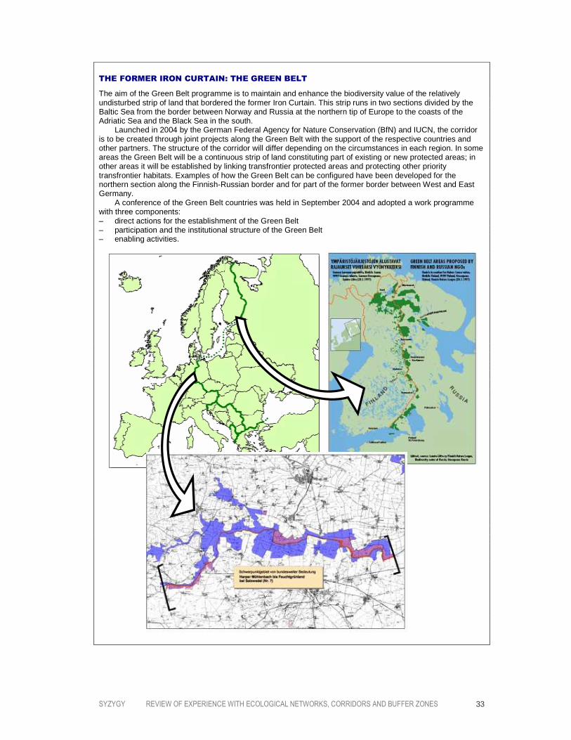
THE FORMER IRON CURTAIN: THE GREEN BELT
The aim of the Green Belt programme is to maintain and enhance the biodiversity value of the relatively undisturbed strip of land that bordered the former Iron Curtain. This strip runs in two sections divided by the Baltic Sea from the border between Norway and Russia at the northern tip of Europe to the coasts of the Adriatic Sea and the Black Sea in the south. Launched in 2004 by the German Federal Agency for Nature Conservation (BfN) and IUCN, the corridor is to be created through joint projects along the Green Belt with the support of the respective countries and other partners. The structure of the corridor will differ depending on the circumstances in each region. In some areas the Green Belt will be a continuous strip of land constituting part of existing or new protected areas; in other areas it will be established by linking transfrontier protected areas and protecting other priority transfrontier habitats. Examples of how the Green Belt can be configured have been developed for the northern section along the Finnish-Russian border and for part of the former border between West and East Germany. A conference of the Green Belt countries was held in September 2004 and adopted a work programme with three components: – direct actions for the establishment of the Green Belt – participation and the institutional structure of the Green Belt – enabling activities.

SYZYGY REVIEW OF EXPERIENCE WITH ECOLOGICAL NETWORKS, CORRIDORS AND BUFFER ZONES 34
Several more Wildlands initiatives are working to prepare a plan, as follows:
– YELLOWSTONE TO YUKON CONSERVATION INITIATIVE (Y2Y), extending along 3,200 kilometres
of the northern Rocky Mountains from Wyoming to the Arctic Circle and initiated in
collaboration with the Canadian Parks and Wilderness Society (although the project
has since become an independent entity)
– NORTHERN SIERRA MADRE WILDLANDS NETWORK DESIGN, a project launched in collaboration
with the Mexican NGO Naturalia
– GRAND CANYON, an initiative still in an early phase
– COLORADO PLATEAU, again an initiative that is in an early phase
– NORTHERN APPALACHIANS WILDLANDS NETWORK DESIGN, an initiative launched by a coalition
of US and Canadian partners covering the New England states, the Adirondack
Mountains of New York, Nova Scotia, parts of Newfoundland, Ontario and Quebec,
with a complete plan scheduled to be published by the end of 2005
– OCEANS OF GRASS WILDLANDS NETWORK, focusing on the plains of Alberta, Saskatchewan,
Montana, Wyoming and North and South Dakota
– FLORIDA CONSERVATION 2000, an initative that has been taken over and revised by the
Florida Nature Conservancy and the state of Florida.
The work of the Wildlands Project focuses primarily on North America’s “megalinkages”,
the continental-scale linkages that run north-south and east-west. Within each
megalinkage, initiatives are taken to develop a cluster of ecological networks. For
example, in the Spine of the Continent megalinkage running north to south from Alaska
through the Rocky Mountains to Central America, six contiguous networks are under
development: Yellowstone to Yukon, Heart of the West, the Southern Rockies, the New
Mexico Highlands, the Sky Islands and the Northern Sierra Madre.
In addition to the work by the Wildlands Project, several other regional ecological-network
initiatives are underway in North America. These include the following:
– CONCEPTION COAST PROJECT (California): the initiative covers a relatively small region
and is still in an early phase
– SOUTHERN CALIFORNIA COASTAL SAGE SCRUB NATURAL COMMUNITY CONSERVATION PLAN
(California): the initiative again covers a relatively small region with an emphasis on
strengthening connectivity
– KLAMATH-SISKIYOU BIOREGIONAL CONSERVATION PLAN (California and Oregon): the proposal
covers a relatively small region and the descriptive phase has been completed
– ECOSYSTEM RECOVERY PROJECT (Minnesota): an initiative that is still in an early phase
– CORRIDORS OF LIFE (Montana): carried out by the NGO American Wildlands, the initiative
is primarily focusing on connectivity planning and implementation and is located
within the Y2Y region
– SOUTHEASTERN WILDLANDS PROJECT (Florida)
– BIORESERVE NETWORK (Southern Appalachians): a plan has been prepared
– REGIONAL RESERVE NETWORK (British Columbia): plans have been prepared by the NGO
Round River Conservation Studies for the Great Bear Rainforest and the coastal forest
and mountains (in collaboration with the Transboundary Watershed Alliance, the
Nature Conservancy of Alaska and the Nature Conservancy of Canada).

SYZYGY REVIEW OF EXPERIENCE WITH ECOLOGICAL NETWORKS, CORRIDORS AND BUFFER ZONES 35
THE UNITED STATES: THE SOUTHERN ROCKIES WILDLANDS NETWORK
The Southern Rockies Wildlands Network is one of a series of six contiguous ecological networks that the Wildlands Project is developing along the Rocky Mountains. From alpine tundra to ponderosa pine forests and sagebrush grasslands, over 500 vertebrate species find their home in the Southern Rockies. A rich variety of plants and invertebrate species can also be found within its borders. Over 270 butterfly species and 5,200 moth species make the Southern Rockies the second leading hotspot in North America for the insect order Lepidoptera. One of the biggest threats to the region’s biodiversity is the exceptionally high population growth rate and the accompanying residential development. Scattered, low-density development is fragmenting habitat, particularly in many mountain valleys and foothill forests. A proposal for an ecological network has been prepared based on the principal design elements of large core areas, functional connectivity, keystone species and processes, ecological restoration, ecosystem representation, conserving special elements and focal species planning. The preparatory work was carried out by the Southern Rockies Ecosystem Project in collaboration with the Denver Zoo, with assistance from the Wildlands Project and support from 23 environmental organizations and private foundations. The Southern Rockies Wildlands Network encompasses federal, state and private land and is built up primarily from core wild areas, compatible-use areas and linkages. Establishing the network will require a mix of actions: government policy, private partnerships, public support and cooperation with tribes and pueblos. The current proposal includes an indicative programme of actions, but securing the necessary commitment from the wide range of stakeholders will clearly be a major challenge (Miller et al., 2003).

SYZYGY REVIEW OF EXPERIENCE WITH ECOLOGICAL NETWORKS, CORRIDORS AND BUFFER ZONES 36
CANADA: THE BOW VALLEY WOLF CORRIDOR
The Rocky Mountains are North America’s last remaining intact mountain ecoregion. However, local extinctions and endangered species are causing serious and increasing concern. Among the most striking of the species under threat is the wolf. In the central Canadian Rockies, the rugged nature of the terrain forces wolves to confine their movements to low-lying valley bottoms. Rivers and passes therefore function as natural linkages. This can clearly be seen in the Bow River Valley in Alberta’s Banff National Park, a linkage that offers the highest-quality habitat for wolves in the central Canadian Rockies and permits the movement of wolf packs between Canada and the US. In recent years, increasing development has severely disrupted the opportunities for wolves to move through the valley. The Cascade Corridor, one of three routes around the town of Banff that are available to wolves, offers the greatest potential for movement. Wolves made little use of the route before 1997 because of the moderate-to-high level of human intrusion in the linkage, which included a hotel, ski access road, buffalo paddock, barns, horse corrals, an airport and a military training facility. Because of the regional importance of the linkage in facilitating the movement of wolves, however, Parks Canada agreed to take action to reduce the intensity of human activities. As a result, in 1997 the buffalo paddock and several barns and horse corrals were removed and the airstrip was closed to all air traffic except emergency landings. The actions also reduced associated recreational activities and vehicle use in the linkage. Following these actions, monitoring showed that the relative movement of wolves through the Cascade Corridor increased sevenfold in the period 1997–1999 compared with the period 1993–1997, an increase substantially greater than had been hypothesized. Moreover, not only was the intensity of movement through the Cascade Corridor far greater, the improved connectivity seemed to allow the Cascade wolf pack to expand its range: the home range of the pack increased in extent to include four more valleys, expanding from 607 to 1,847 square kilometres (Duke et al., 2001; Duke, 2001).
A further 10–15 NGO ecological-network initiatives in the US have failed to progress
beyond the original proposal for lack of funding, a problem that has become exacerbated
for many US NGOs in recent years.
In Australia, programmes designed to retain and promote landscape connectivity in
Australia date back to the 1980s (several examples are described in Bennett, 1998). In the
main these programmes were directed at repairing the disruption caused by
fragmentation to specific habitats or local species populations on tracts of land that have
single or only a few owners, which in most cases is public land (Bennett and Lowe, 2002).
To date it has proved more difficult to expand these initiatives from local projects to
regional-scale networks in the heavily cleared agricultural environments where
biodiversity remains primarily as relicts and fragments. In 2000, however, a nationwide
initiative was launched by the Wilderness Society Australia in partnership with
government authorities, NGOs, business and private landowners – WildCountry (see case
study). The aim of the proposal is to halt the continuing degradation of the continent’s
biotic diversity through a science-based vision that integrates existing conservation

SYZYGY REVIEW OF EXPERIENCE WITH ECOLOGICAL NETWORKS, CORRIDORS AND BUFFER ZONES 37
programmes into a coherent, interconnected system of core areas and promotes the
appropriate management of other land and aquatic systems. The general approach and
methodology that is being applied by the Wilderness Society is based largely on that
developed by the Wildlands Project in North America.
With regard to related initiatives, WWF is carrying out the following terrestrial ecoregion
projects in Western countries:
– WESTERN EUROPE:
– the Alps
– the Dinaric Alps (Croatia/Bosnia-Herzegovina/Serbia)
– Mediterranean forests, woodlands and scrub (southwest Iberia and the
northwesten Morocco Lowlands, the Baetic-Atlas Mountains, the Italian Peninsula
and the South Thyrrenian Sea)
– NORTH AMERICA:
– the Northern High Plains
– the South Florida ecosystem
– the Klamath-Siskiyou coniferous forests
– southeastern rivers and streams
– AUSTRALIA:
– southwestern forests and scrub.
A large-scale non-ecoregion project is also underway in the Fenno-Scandian Alpine tundra
and taiga of northern Europe.
Actions to protect the transboundary linkages used by migratory species is the special
focus of the Convention on the Conservation of Migratory Species of Wild Animals (the
Bonn Convention). Under the Convention, a series of agreements and memoranda of
understanding have been adopted by range states with the aim of conserving threatened
migratory species or those with an unfavourable conservation status, including their
habitats. Four agreements concerning the conservation of terrestrial or coastal species
and birds have been adopted to date (which are grouped together here since a substantial
proportion of the range states are Western countries):
– European bats (48 European range states)
– seals in the Wadden Sea (three range states)
– African-Eurasian migratory waterbirds (117 range states in Africa, Europe, Canada,
Central Asia and the Middle East)
– albatrosses and petrels (25 range states in the Southern Hemisphere, including
European, African, Asian and South American countries).
In addition, memoranda of understanding have been concluded with the respective range
states with the aim of conserving the following species:

SYZYGY REVIEW OF EXPERIENCE WITH ECOLOGICAL NETWORKS, CORRIDORS AND BUFFER ZONES 38
– the Siberian crane (12 range states, primarily in Asia)
– the slender-billed curlew (30 range states in Southern and Eastern Europe, Northern
Africa and the Middle East)
– marine turtles of the Atlantic coast of Africa (26 range states along the Atlantic coast
of Africa
– marine turtles of the Indian Ocean and Southeast Asia (41 range states around the
Indian Ocean and Southeast Asia and adjacent seas)
– the middle-European population of the great bustard (17 range states in Central and
Eastern Europe)
– the Bukhara deer (four range states in Central Asia)
– the aquatic warbler (14 range states in Europe and Africa).
UNESCO’s Man and Biosphere programme has designated 155 sites in Western and other
countries as Biosphere Reserves, including one transboundary reserve.
Case Study 3 AUSTRALIA: WILDCOUNTRY
Australia is home to a remarkably diverse and unique natural heritage. However, over the
past two centuries more native species have been lost than in any other country. Today
over 1,500 species are threatened with extinction, and Australia has the greatest number
of threatened reptile and amphibian species. Despite this decline, the country remains
one of the world’s richest centres of biodiversity. For example, more endemic animal
species can be found in Australia than in any other country.
In response to these challenges, WildCountry is using landscape ecology to improve
understanding of the large-scale ecological connections that still remain in place across
huge areas of the continent and which will form the basis of the conservation approach.
Seven categories of ecological phenomena have been identified that require landscape
connectivity and which are crucial to biodiversity conservation (Soulé et al., 2004; Mackey
et al., 2005). These are:
– HIGHLY INTERACTIVE SPECIES. A priority is to maintain the dispersal and migration of
these species, such as water birds, pollinators and animal dispersers of seeds and
fungal spores.
– LONG-DISTANCE BIOLOGICAL MOVEMENT. For example, 30–60 per cent of Australian
woodland and open-forest birds are non-residents, and their persistence in a region
may depend on seasonal migration or episodic movement that is related to highly
irregular precipitation patterns.
– LOCAL AND REGIONAL DISTURBANCE EVENTS. Disturbance may be a natural process (such as
foraging by feral carnivores) or caused by human activities (such as logging).
Maintaining connectivity will facilitate the continuation of natural disturbance events
and permit escape from man-caused disturbances.
– CLIMATE CHANGE. Although the regional impact of climate change is difficult to predict,
it seems likely that climatically driven biome changes cannot be accommodated by
small or isolated protected areas. This infers the need for large, contiguous areas that
allow movement and flows at the regional scale.

SYZYGY REVIEW OF EXPERIENCE WITH ECOLOGICAL NETWORKS, CORRIDORS AND BUFFER ZONES 39
– HYDROECOLOGY. The scarcity of water over much of Australia makes it a critical natural
resource. The interruption of catchment processes can therefore have catastrophic
effects on regional and continental ecological phenomena.
– COASTAL-ZONE FLUXES. The concentration of human populations along Australia’s
coastline, combined with the sensitivity of many coastal systems such as estuaries
and coral reefs, is imposing considerable pressure on ecological and behavioural
processes.
– SPATIALLY DEPENDENT EVOLUTIONARY PROCESSES. These processes can require the
movement of organisms over long distances. Examples include new genetic variants
that evolve through range expansion and, in the longer term, speciation.
These considerations have led WildCountry to shape a conservation approach that aims
to integrate the needs of nature with the demands of human use by strengthening
ecological processes and environmental flows. The programme’s focus is therefore on
maintaining and restoring ecological connections in the landscape. Specifically, the
management approach will apply the following principles:
– networks of core areas will build upon the criteria of comprehensiveness, adequacy
and representativeness
– biodiversity conservation assessment and planning should aim for the maintenance
and restoration of large-scale ecological and evolutionary processes over the entire
landscape
– the network should be buffered from sources of disturbance and incorporate where
appropriate complementary land uses and management
– restoration of degraded landscapes will be necessary, particularly in the intensive
land-use areas
– facilitating long-term ecological connectivity, which will remain an ongoing research
and development challenge.
The WildCountry programme is currently working in five regions: northern Australia,
Cape York Peninsula, the Gondwana Link, the Western Wilderness and western Victoria.
The Gondwana Link is a good example of the approach. Southwestern Australia is
regarded as one of the world’s top 25 biodiversity hotspots. However, as a result of
agricultural expansion two thirds of the vegetation has been cleared, leaving less than 10
per cent of the original bushland. The removal of deep-rooted vegetation has left the
resulting agricultural land very fragile; moreover, over 30 per cent of the agricultural land
is threatened by salinity. It is now widely recognized that 30–40 per cent of this area
needs to be covered by perennial woody vegetation if it is to remain stable.
The five largest areas of high biodiversity value in the region are along the south coast,
where about six million hectares of public land were saved from the spread of agriculture
in the early 1980s. Together, these areas form the last remaining link between the wet
forests in the continent’s southwestern tip through to the dry inland. This connection
provided a vital opportunity for fauna species to move between seasonal feeding areas,
offering critical nectar and pollen during the dry late-summer and early-autumn period.

SYZYGY REVIEW OF EXPERIENCE WITH ECOLOGICAL NETWORKS, CORRIDORS AND BUFFER ZONES 40
However, the farmed areas form barriers to this movement with the result that
population levels of many species have fallen across the entire “wheatbelt”.
Figure 3.2. The five WildCountry projects.
Figure 3.3. The Gondwana Link proposal.

SYZYGY REVIEW OF EXPERIENCE WITH ECOLOGICAL NETWORKS, CORRIDORS AND BUFFER ZONES 41
Five NGOs – the Australian Bush Heritage Fund, the Fitzgerald Biosphere Group, the
Friends of the Fitzgerald River National Park, Greening Australia and the Wilderness
Society – are cooperating within the WildCountry framework to partially restore this vital
pattern of movement into and across south-coast plant communities. By doing so,
resilience to climate change will also be improved, since current predictions are for a
warming of the southwest region over the next 50 years with a significant decline in
winter rainfall. To achieve this goal, it is proposed to remove the least agriculturally
suited areas from production (which are already economically marginal or unviable) and
to develop and demonstrate the potential for other land-use options that have
commercial value, such as sandalwood growing, dry-country forestry (that is, bush poles
and brush fencing) and bush foods. One of the first actions is a cooperative project with
the state government to secure the Walpole Wilderness Area – over 200,000 hectares of
forest where the Gondwana Link corridor meets the wetter forest areas.
Case Study 4 SPAIN: THE GUADIAMAR GREEN CORRIDOR
On 25 April 1998 the retaining dam of the lagoon containing tailings from the Aznalcóllar
pyrite mine in Andalusia failed, releasing about six million cubic metres of toxic sludge
into the Agrio and Guadiamar River Basin. Significant flooding occurred along the
Guadiamar River and the spill threatened the nearby Doñana marshes – world famous as
a World Heritage Site, a Ramsar Site, a Biosphere Reserve and an Important Bird Area.
Fortunately the national park was not directly affected, but the aquatic fauna of the
Guadiamar River were almost totally exterminated and sludge deposits of up to three
metres thick were left along 40 kilometres of the watercourse.
Soon after the disaster, the regional government of Andalusia approved a proposal to
mitigate the impacts and restore the river ecosystem. A year later, in June 1999, the
Strategy for the Guadiamar Green Corridor was established at a specially organized
international seminar (Secretaría General Técnica, 2000). Interestingly, the goal of the
strategy was not only to remedy the damage caused by the spill but also to restore the
Guadiamar River as an ecological connection between the Sierra Morena mountains and
ecosystems along the Atlantic coast. The Guadiamar Green Corridor will also form part of
the Andalusian ecological network (RENPA) that is currently under development and
which aims to build the areas designated as EU Natura 2000 sites into an interconnected
network (Vázquez, 2003).
The Guadiamar River is one of the few rivers in Andalusia that still retains its natural
Mediterranean regime of high winter and low summer flows. Serious fragmentation of the
Guadiamar basin dates back many decades. However, the process has accelerated in
recent years, primarily as a result of the increasing predominance of arable farming at the
expense of old olive groves. An important consequence of this process was that the
former intricate land-use matrix became transformed into a far simpler and
homogeneous landscape. In addition, industrial and housing developments have caused
serious fragmentation in the central and lower parts of the river basin.

SYZYGY REVIEW OF EXPERIENCE WITH ECOLOGICAL NETWORKS, CORRIDORS AND BUFFER ZONES 42
Figure 3.4. Schematic representation of the main linkages in the Guadiamar river basin.
Recreating the regional ecological function of the river basin requires both direct
restoration of the areas directly affected by the spill and actions to increase connectivity
at local and regional scales. Five specific measures are being undertaken with the aim of
achieving these objectives (Arenas Cabello, 2003; see also Figure 3.5):
1. IMPROVING CONNECTIVITY. The priority is to reconnect the northern part of the Green
Corridor and the Sierra Morena mountains. Monitoring studies of small mammals
show relatively limited movement in this area. Restoration works are directed mainly
at reforestation and the replacement of eucalyptus stands with indigenous tree
species.
2. RESTORING STREAMS. The connectivity role of the smaller rivers is especially important
in the central area of the basin. In addition, priority will be given to the headwaters of
the Guadiamar River and the two western tributaries, the Alcarayón and the Agrio.
Attention is also being given to the Tinto River to the west because of its important
ecological relationship with the Guadiamar River.
3. RESTORING DROVERS’ ROADS. An extensive network of of drovers’ roads has existed in
Spain for centuries, enabling livestock to be moved seasonally both north–south and
between low- and high-lying ground. These tracks have come to provide an important
semi-natural corridor function, particularly with regard to the dispersal of herbaceous
species.

SYZYGY REVIEW OF EXPERIENCE WITH ECOLOGICAL NETWORKS, CORRIDORS AND BUFFER ZONES 43
4. IMPROVING CONNECTIVITY ACROSS THE TRANSPORT INFRASTRUCTURE. Several roads and
railways have created barriers to the movement of species, particularly the A49
motorway and the Seville-Huelva railway. The construction of ecoducts and other
measures to increase their permeability to ecological flows is under consideration.
5. RESTORING OR CREATING “STEPPING STONES”. Many areas of land that are under public
ownership or protected as part of the region’s cultural heritage offer the potential to
be developed as resting and feeding places.
Figure 3.5. The Green Corridor plan.
In order to support the formulation of effective measures, a special research programme
was established as part of the action plan. This Green Corridor Research Programme
(PICOVER) is multidisciplinary in structure and aims to apply the principles of the
Ecosystem Approach through its four main themes: remedying and monitoring the
contamination, the design of the Green Corridor, ecosystem restoration and integrating
natural and human systems (Arenas et al., 2003).

SYZYGY REVIEW OF EXPERIENCE WITH ECOLOGICAL NETWORKS, CORRIDORS AND BUFFER ZONES 44
The integration of natural and human systems is an explicit element of the Green
Corridor strategy. This is not only of significance in relation to the need to promote new
employment opportunities following the closure of the mines and the loss of 500 jobs,
but also to assist in the overall restructuring of the region’s economy. Priority here is
being given to developing sustainable forms of agriculture (which was seriously affected
by the disaster) and promoting recreational and tourist activities. Use is being made of
the funding made available through the EU Agri-Environment Regulation and the
Community Aid Scheme for Forestry Measures.
The administrative framework within which the measures are being taken is provided
through the designation of the Green Corridor as a Protected Landscape under national
legislation. Much of the land directly affected by the spill was also taken into public
ownership, amounting to about 5,000 hectares. Funding for developing the Guadiamar
Green Corridor programme and implementing the various actions is being provided
through four main sources: the national government, the Andalusian regional
government, the regional water authority and the administration of the Doñana National
Park.
Monitoring shows that important progress has been made in restoring the Guadiamar
ecosystem, although the results achieved are very variable. Recovery of fish and
amphibians has been generally good. The otter has also recovered well, being present
along the entire length of the river, as have some wetland bird populations in the
northern part of the basin. Other mammals, such as the badger, the genet and the
mongoose, have yet to return to the northern part of the basin in any numbers since they
depend on the recovery of vegetation. The wild cat remains limited to the outer margins
of the Green Corridor. Moreover it is clear that, given the scale of the pollution disaster
and the structural degradation of the ecosystem over many years, full restoration of the
basin’s ecology will require a long-term commitment and continuing action.
CONCLUSIONS
The large number of ecological networks that are being developed in Western countries
share a number of common features but also some striking differences. Most obvious is
the primary focus on biodiversity conservation rather than the broader goal of
sustainable development which characterized the early ecological networks in Central and
Eastern Europe. To be sure, securing biodiversity conservation through an ecological
network leads to a broad range of accompanying measures which have the aim of
reducing impacts on biodiversity, removing ecological barriers and promoting compatible
forms of land use. Nevertheless, it is biodiversity conservation that lies at the heart of
virtually all ecological networks in Western countries.
However, other factors combine to lead to markedly different approaches between
Western Europe on the one hand and North America and Australia on the other. First, in
contrast to Western Europe, large areas of wilderness still exist on both other continents.
As a result, wilderness areas are a prime focus for ecological networks in North America
and Australia. In North America, the priority accorded to wilderness areas is strengthened

SYZYGY REVIEW OF EXPERIENCE WITH ECOLOGICAL NETWORKS, CORRIDORS AND BUFFER ZONES 45
through the concern to conserve the continent’s remaining populations of wide-ranging
carnivores. In Western Europe, the most valuable areas in terms of biodiversity are
relatively small sites (that in general already enjoy a high level of protection) and semi-
natural landscapes that have been formed over a period of many centuries through
extensive forms of land use: grasslands, field mozaics and coppices, for example.
Devising ways of maintaining the traditional forms of management in these areas is a
major challenge in Europe.
Another striking distinction between Western Europe and the other two continents is the
organizational framework within which ecological networks are being developed. In
Western Europe, the traditionally prominent role of government in nature conservation
and spatial planning is reflected in the fact that virtually all ecological networks are policy
driven. Even where NGOs are taking a pro-active role in initiating ecological-network
programmes, they invariably aim to secure action in large part through new government
policies. By contrast, in North America and Australia the most important initiatives are
driven by NGOs who aim to achieve their goals through broad-based stakeholder
processes. At the regional level, where the implementing projects are being undertaken,
this includes collaboration with government authorities where possible in order to secure
the necessary action in conservation policy and public land management. Nevertheless, it
is clear that, to date, the realization of ecological networks in Western Europe has
benefited where governments have embraced the model and have used legislative and
other policy instruments to secure action on the ground.
It should be noted, however, that one significant advantage of the NGO-driven processes
in North America and Australia is that the initiatives can de directed at the ecosystem or
ecoregion scale within a continental context rather than being limited to administrative
boundaries. In practice this is invariably the case in both North America and Australia,
whereas in Western Europe the relatively small size of most countries often prevents the
national and regional ecological-network programmes from extending management
measures across entire ecosystems. The Pan-European Ecological Networks certainly aims
to work in this way, but it is being implemented through national government action and
relies on voluntary cooperation. The EU’s Natura 2000 scheme, although building an EU-
wide representative system of protected areas, has not yet provided for a significant level
of ecological coherence.
SYZYGY REVIEW OF EXPERIENCE WITH ECOLOGICAL NETWORKS, CORRIDORS AND BUFFER ZONES 46
4444 ASIA AND THE PACIFIC
The principles that underly ecological networks first generated broad interest in Asia
during the mid-1990s when developments in Western countries attracted the attention of
biodiversity conservation experts in South Korea and Japan. In South Korea the
government published a proposal for the nationwide Countryside Green Network Plan in
1995. In the same year the Ecosystem Conservation Society–Japan organized “The
Ecological Network Symposium” in Tokyo in order to present the model to a Japanese
audience, an initiative that led to the approach being included in several areas of
government policy from 1996. Being inspired by developments in Western countries,
these programmes adopted a comparable approach.
In recent years international NGOs have also become active in the region, initiating an
increasing number of ecological-network programmes and corridors. WWF has launched a
large number of landscape-scale and ecoregion projects in cooperation with governments
and international donors. Conservation International is also active through programmes
in Cambodia, China, Indonesia, Melanesia and the Philippines. A wide variety of corridors
have also been developed in several Asian countries, for example to help conserve
flagship species such as the Asian elephant and the giant panda.
OVERVIEW OF THE PROGRAMMES
South Korea’s Countryside Green Network Plan was first proposed in a government report
in 1995 (Ministry of Environment, 1995) and subsequently included in the country’s
National Biodiversity Strategy of 1997. The document – a presentation of the ecological-

SYZYGY REVIEW OF EXPERIENCE WITH ECOLOGICAL NETWORKS, CORRIDORS AND BUFFER ZONES 47
network concept rather than a detailed plan – set out the principles to be applied in
developing the ecological network, including explicit reference to Jared Diamond’s
indicative recommendations for the design of nature reserves, the Biosphere Reserve
management approach and a range of foreign examples. The Countryside Green Network
Plan foresees the establishment of a national ecological network with a special focus on
conserving and restoring the ecosystems associated with South Korea’s five major
mountain ranges. Interestingly, it is proposed to extend the concept to urban regions.
Following the publication of the original concept, the Countryside Green Network has
been incorporated into the Revised Nature Conservation Act and the Basic Guideline of
Nature Conservation. Since then, work has continued on a proposal to establish the
Ecological Network of the Korean Penisula and the Capital Region. A number of local
projects have also been carried out, particularly the establishment of corridors and the
construction of ecoducts across major highways.
In Japan a growing number of initiatives to develop ecological networks have been taken
in recent years at municipal, prefectural, regional and national levels (see box). For
example, in 1996 the government decided that, as part of the Third National Land-Use
Plan, it would “make efforts to network ecosystems in order to conserve biological
diversity”, and in the Fifth Comprehensive National Development Plan – Grand Design for
the 21st Century that was adopted in March 1998, the commitment was made to develop
a “national-scale ecological network”. Further, the New National Biodiversity Strategy of
2002 included the objective “to develop networks of fine quality ecosystems with
protected areas as their cores”. Currently the Ministry of Land Use, Infrastructure and
Transport, the Ministry of Environment, the Ministry of Agriculture and the Forestry
Agency are cooperating in developing the national plan for a Japanese ecological network.
Other than South Korea and Japan, the main initiator of landscape-scale conservation
programmes which incorporate ecological-network principles is WWF through the
organization’s ecoregion programmes. A large number of terrestrial programmes are
underway in Asia and the Pacific, as follows:
– the Annamites range moist forests
– the Eastern Himalayas
– the Lower Mekong dry forests
– the Borneo lowland and montane forests
– the New Caledonian dry forests
– the Western Ghats
– the Yangtze basin
– the southwestern Australian forests and scrub
– the Indus delta
– the Transfly savannas (Forest of New Guinea)
– the Mekong River.

SYZYGY REVIEW OF EXPERIENCE WITH ECOLOGICAL NETWORKS, CORRIDORS AND BUFFER ZONES 48
JAPAN: THE ARAKAWA RIVER ECOLOGICAL NETWORK
One example of an ecological network in Japan is the Arakawa River Ecological Network. The Arakawa River flows through lowlands in the Tokyo metropolitan area and the Saitama Prefecture. However, due to the pressure of human activities, including flood -control works, the stream flow has changed substantially from its natural state and the river basin habitat has degraded. A regional restoration programme that was developed by the national government identified key areas for conservation. This programme included the Arakawa River Biotope Project – with an area of 50 hectares the largest nature restoration project ever carried out in Japan – and Mitsumata Numa Swamp Biotope Project. However, these projects only targeted a part of the river, with the result that the restored habitats continued to be adversely affected by degraded upstream sections of the river, for example through the reduced levels of aggradation. At the initiative of the Ecosystem Conservation Society–Japan, a comprehensive programme to restore the Arakawa River was developed together with a wide range of stakeholders. The Arakawa River Ecological Network Plan has the main objective of re-establishing ecological continuity between the upper and lower reaches of the river. This is to be secured through enhancing the natural flows of water, nutrients and sand and gravel, and also by restoring ecological connectivity. This will involve establishing corridors between woodland and other high-lying habitats in the upper reaches of the river.

SYZYGY REVIEW OF EXPERIENCE WITH ECOLOGICAL NETWORKS, CORRIDORS AND BUFFER ZONES 49
Although the WWF projects take on a variety of forms, several explicitly apply the
ecological-network model, such as the Terai Arc Landscape in Nepal and India (see case
study). Other WWF landscape-scale projects outside the organization’s ecoregion
programme include the following:
– the peninsular Malaysia lowland and montane forests
– the Kayah Karen/Tenasserim moist forests (Malaysia and Thailand)
– the Sumatran Islands lowland and montane forests
– Nansei Shoto (Japan)
– the Sunderbans mangroves (India)
– the Tibetan plateau steppe.
Conservation International is also active in developing ecological networks in the region.
The NGO has established the Commonwealth Scientific and Industrial Research
Organization in order to focus scientific analysis on island biodiversity and ecological
networks (“conservation corridors”), particularly on the island of New Guinea. In the
northwest part of the Philippines, Conservation International has initiated the Sierra
Madre Biodiversity Corridor. The project has the aim of protecting and managing the
biological resources of the Sierra Madre mountain range by developing the whole Sierra
Madre mountain range into an ecological network. Proposed measures include the
strengthening of existing protected and community-based forest management. A
comparable initiative is being taken by the Philippine Eagle Conservation Program
Foundation in association with other partners in the southern Philippines in order to
establish the Eastern Mindanao Corridor. A prime goal of the initiative is to conserve the
habitat of the Philippine Eagle, the second-largest and rarest eagle in the world.
On Sumatra, Conservation International is working with local communities and local
government representatives to establish the Batang Gadis National Park as an integral
part of the Northern Sumatra Conservation Corridor that Conservation International,
other local organizations, communities and governmental representatives are working to
create with support from the Critical Ecosystem Partnership Fund.
In the same part of Sumatra, a four-year project managed by Fauna and Flora
International is underway to conserve globally important biodiversity in the forests of
northern Aceh by using internationally important Asian elephant populations as flagships
and indicators. Managed by a team of local staff, the project has two main objectives:
– to conserve biologically rich forest ecosystems in northern Aceh, focusing on the
lowland forests that are important wildlife linkages, especially for elephants
– to maintain linkages between the well-protected Gunung Leuser ecosystem and the
northern Aceh forests.
Elephant migration routes are the focus of several programmes. An important strategic
framework for these initiatives is the Asian Elephant Action Plan that was drawn up by
IUCN’s Species Survival Commission in 1990 (Santiapillai and Jackson, 1990). For
example, in Cambodia the Southern Cardamom mountain range is home to one of the last
seven remaining elephant corridors in Southeast Asia. However, relatively large numbers

SYZYGY REVIEW OF EXPERIENCE WITH ECOLOGICAL NETWORKS, CORRIDORS AND BUFFER ZONES 50
of elephants and tigers have been killed in recent years and 100–300 hectares of tropical
forest are being cleared each month. In response to these threats, WildAid is developing
the South West Elephant Corridor which combines ranger patrolling, community outreach
and wildlife monitoring to stop wildlife poaching and illegal logging along the migration
route and also to help develop income alternatives for surrounding communities.
In 2003 WWF, the UN Development Programme and the government of Bhutan agreed to
protect and manage a “Green Corridor” through the Himalayan country in a US$1.8-
million project. The corridor is intended to ensure the long-term conservation of the
country’s forest and mountain ecosystems that are home to the endangered Bengal tiger
and other species but threatened by overgrazing, poaching, illegal trading, deforestation
and destructive agricultural practices. It also aims to provide ecologically friendly
development opportunities through alternative energy sources, improved health services
and cottage industries, such as cheese-making, honey production and non-timber forest
products.
In Vietnam, the government-supported Central Truong Son Biodiversity Conservation
Initiative has been developed as a pilot project of the strategic goal to ensure effective
conservation across the Greater Truong Son Ecoregion – the ecological unit that covers
most of northern and eastern Vietnam (Ministry of Agriculture and Rural Development,
2004). The project has the objective of establishing an integrated mosaic of
complementary land-use and development practices to protect, manage and restore
natural resources and biodiversity in the Truong Son region while also contributing to
institutional development, good governance and raised standards of living for local
communities. The programme will be implemented in three phases:
– 2003–2010: creating the foundations for a sustainable landscape
– 2011–2015: expanding the priority landscapes
– 2016–2020: making the connections.
The project includes the conservation of vital ecological linkages, such as the Green
Corridor area between Bach Ma National Park and Phong Dien Nature Reserve (which is
the focus of a joint Vietnamese government/GEF/WWF/Netherlands Development
Organization project) and a tiger corridor funded by the US National Fish and Wildlife
Foundation.
A large number of corridor projects are also underway in China (see case study). These
include several corridors intended to reconnect the increasingly fragmented habitat of the
giant panda, such as in the Qinling Mountains where WWF and the Shaaxi Forestry
Department have initiated a collaborative project. The corridor will comprise five
components in Houzhenzi in Zhouzhi County, Dashuping in the Taibai Bureau, Erlangba
in Taibai County, Jiuchihe in Yangxian County and Canziping in the Ningxi Bureau. The
intention is to designate the linkages, improve the management of the existing forests,
reforest other areas, introduce fire-prevention measures, construct ecoducts and promote
appropriate forms of economic development in the local communities.

SYZYGY REVIEW OF EXPERIENCE WITH ECOLOGICAL NETWORKS, CORRIDORS AND BUFFER ZONES 51
Flyways constitute a specific type of linkage. Migratory birds depend on widely separated
areas for their survival. Measures designed to conserve these networks of sites focus on
the breeding grounds, overwintering areas and, for the species that migrate over longer
distances, feeding and resting places en route. In most cases these measures require
international cooperation. Globally, about 25 flyway agreements have been concluded
(including the agreements under the Bonn Convention – see also Western Europe and
Other Countries). About half of these flyways can be found in the Asia and Pacific region
(see Table 4.1). Some of the agreements date from the first half of the twentieth century
(Boere and Rubec, 2002). For example, in 1916 Canada and the United States signed a
bilateral Convention on the Conservation of Migratory Birds.
Finally, it can be noted that UNESCO’s Man and Biosphere Programme includes 77
Biosphere Reserves in 18 countries in the Asia and Pacific region.
– Asian-Pacific Waterbird Conservation Strategy – Asia-Pacific Migratory Crane Action Plan and North-East Asian Crane Site Network – Central Asian-Indian Flyway Programme – East Asian-Australasian Shorebird Reserve Network – China-Australia Migratory Birds Agreement – Japan-Australia Migratory Birds Agreement – Japan-Russia Migratory Birds Agreement – Japan-USA Migratory Birds Agreement – Republic of Korea-Russia Migratory Birds Agreement – Democratic People's Republic of Korea-Russia Migratory Birds Agreement – American-Pacific Flyway Programme – Convention Between the Government of the United States of America and the Government of Japan for
the Protection of Migratory Birds and Birds in Danger of Extinction, and Their Environment – USA-Russia Migratory Birds Agreement – Convention between the United States of America and Great Britain (acting for Canada) for the
Protection of Migratory Species – Convention between the United States of America and the Union of Soviet Socialist Republics
Concerning the Conservation of Migratory Birds and Their Environment – Convention Between the United States of America and the United Mexican States for the Protection of
Migratory Birds and Game Animals – Convention between Canada and the United States on the Conservation of Migratory Birds – North American Waterfowl Management Plan – Migratory Birds Convention – Western Hemisphere Shorebird Reserve Network – Bonn Convention: Agreement on the Conservation of African-Eurasian Migratory Waterbirds (AEWA) – Bonn Convention: Agreement on the Conservation of Albatrosses and Petrels – Bonn Convention: Memorandum of Understanding concerning Conservation Measures for the Slender-
Billed Curlew (Numensius tenuirostris) – Bonn Convention: Memorandum of Understanding concerning Conservation Measures for the Siberian
Crane (Grus leucogeranus) – Bonn Convention: Memorandum of Understanding concerning Conservation Measures for the Aquatic
Warbler (Acrocephalus paludicola) – Bonn Convention: Memorandum of Understanding on the Conservation and Management of the Middle-
European Population of the Great Bustard (Otis tarda)
Table 4.1. International flyway agreements.

SYZYGY REVIEW OF EXPERIENCE WITH ECOLOGICAL NETWORKS, CORRIDORS AND BUFFER ZONES 52
THE EAST ASIAN–AUSTRALASIAN SHOREBIRD SITE NETWORK
Launched in 1996, the East Asian–Australasian Shorebird Site Network aims to secure the long-term conservation of migratory shorebirds in the East Asian–Australasian Flyway through the recognition and appropriate management of a network of internationally important sites. It is estimated that over 400 such sites exist in the flyway. The flyway is used by over 65 populations of migratory shorebirds, including 11 species of special conservation concern and two endangered species (the spoon-billed sandpiper and the spotted greenshank). The network, which is coordinated by Wetlands International–Oceania, currently includes 29 designated sites in nine countries: Russia, South Korea, Japan, China, the Philippines, Indonesia, Papua New Guinea, Australia and New Zealand. As a voluntary collaborative framework, some consideration was given to regional geo-political considerations in deciding how to define national involvement along the eastern margin of the flyway. The Action Plan for the Conservation of Migratory Shorebirds in Asia Pacific was agreed in 1999 and an international advisory group meets once a year to review implementation of the plan. Core funding is provided by the Australian Government.

SYZYGY REVIEW OF EXPERIENCE WITH ECOLOGICAL NETWORKS, CORRIDORS AND BUFFER ZONES 53
Case Study 7 CHINA: CORRIDORS IN YUNNAN PROVINCE
Yunnan province lies in the south of China, bordering Myanmar, Laos and Vietnam. The
region is mountainous, which results in a range of climatic zones varying from temperate
through subtropical to tropical. Biodiversity in the province is exceptionally rich. For
example, 1,638 vertebrate species, over 10,000 insect species and over 17,000 higher
plant species have been recorded, equivalent to about 60 per cent of the species diversity
in China. Cultural diversity is also exceptionally high, with 26 ethnic groups.
As a result of high population densities and a rapidly growing economy this rich
biodiversity is coming under increasing pressure. Yunnan provincial government has
therefore designated a large number of new protected areas, the total number increasing
from 92 to 168 between 1998 and 2004. However, potential conflicts between biodiversity
conservation and local communities have led to most of these areas being limited to
former state forests. Moreover, administrative boundaries play an important role in the
configuration of the nature reserves since local governments are responsible for
proposing protected areas.
Given the need to strengthen the conservation of Yunnan’s biodiversity, a project was
launched in 1998 to formulate protected-area management plans and promote
sustainable community development in the province’s tropical and subtropical forest
zones. Funded jointly by the Chinese and Dutch governments, the Forest Conservation
and Community Development Project focused on six nature reserves: Caiyanghe,
Nuozhadu, Wuliangshan, Tongbiguan, Gaoligongshan and Xiaoheishan (Weimin and
Busstra, 2004).
The latter two protected areas lie in close proximity to each other in western Yunnan.
Gaoligongshan National Nature Reserve was established in 1983, and with an aggregate
area of 4,000 square kilometres it is the largest protected area in Yunnan province. In
1992 WWF recognized the reserve as a Grade A protected area of global importance and
in 1997 part of the protected area was listed as a Biosphere Reserve. The reserve
comprises three separate sites that harbour 10 different grassland, scrub and forest
vegetation types. About 5,000 species of vascular plants and 200 animal species have
been identified, including takin (Burdocas taxicolor), gibbons, the red panda and the
clouded leopard. Because Gaoligongshan extends across the boundary between Nujiang
prefecture and Baoshan city it is managed jointly by two agencies, one in each district.
About 360,000 people live in the Biosphere Reserve, including over 20 ethnic groups.
Economic development is relatively low, and the local communities therefore depend to
an important extent on the natural resources of the forest.
Xiaoheishan Provincial Nature Reserve lies just to the south of Gaoligongshan. The
reserve consists of four separate sites covering 16,000 hectares and is characterized by
tropical evergreen and temperate forest. Wild rice and tree ferns can be found in the
reserve. An important ecological feature of Xiaoheishan is that it acts as a linkage
between Tongbiguan and Gaoligongshan reserves. The local population of almost 80,000

SYZYGY REVIEW OF EXPERIENCE WITH ECOLOGICAL NETWORKS, CORRIDORS AND BUFFER ZONES 54
is very poor and the economic potential of the area is low: agriculture, livestock breeding
and non-timber forest products remain the most important sources of subsistence.
The management plans for Gaoligongshan and Xiaoheishan reserves recognize three
categories of area: a central core area with a high level of protection, a surrounding
“experimental zone” (equivalent to a buffer zone) and an outer “adjacent area” (a
transitional area that is also intended to have a buffering function). Moreover, because of
the ecological relationship between the separate sites, the project is supporting the
development of corridors between and within the two nature reserves.
The corridor linking the central and southern parts of the Gaoligongshan nature reserve
is intended to ensure continued movement of temperate and subtropical species between
the two sites. Gaoligongshan South was formally linked with the Guchengshan site in the
Xiaoheishan nature reserve in 2001 when a corridor was designated by Tengchong County
and Longyang District as a county-level protected area. The main purpose of the corridor
is to maintain a continuum of the vertically diverse habitats that characterize
Gaoligongshan and Xiaoheishan.
Figure 4.1. The locations of the corridors linking the nature reserves in Yunnan province.

SYZYGY REVIEW OF EXPERIENCE WITH ECOLOGICAL NETWORKS, CORRIDORS AND BUFFER ZONES 55
Within the Xiaoheishan Nature Reserve the Forest Conservation and Community
Development Project funded the preparation of a corridor development plan that aims to
link all four sites. The proposal, that encompasses 11,550 hectares, is currently under
consideration by the county government. Priority will be given in the first instance to
linking Guchengshan with the Xiaoheishan and Yiwanshui sites as part of a current
reforestation programme that is intended to expand the mixed-forest habitat that
characterizes the nature reserve. A particular concern is the limited area of habitat
currently available to the 30 mammal species in Xiaoheishan.
A further extension of the corridors to link Xiaoheishan Nature reserve with Tongbiguan
Nature Reserve is under consideration, and Tongbiguan itself may be expanded. However,
for such a corridor to be functionally viable, an ecological restoration programme will
first have to be carried out. An important obstacle to realizing these plans is that part of
the forest in the Tongbiguan area is community owned, which limits the scope for
introducing new forms of management. Further research is also necessary in order to
ensure that the projected corridors will meet the needs of local species populations.
Case Study 8 NEPAL: THE TERAI ARC LANDSCAPE
Nepal is home to some of the world’s most striking landscapes and valuable biological
diversity. Seven of the world’s 10 highest mountains are to be found in the country,
including Mount Everest, and the five major geomorphological zones host diverse
vegetation communities. Dense tropical monsoon Sal forests and exceptionally tall
grasslands predominate in the Terai zone, while in the Siwaliks, Chirpine forests
characterize the west and central regions up to about 1,600 metres, being replaced by
Schima-Castanopsis forests up to 2,000 metres. In the east, broadleaf hill forests are
found across the entire sub-tropical zone. The temperate zone between 2,000 and 3,000
metres is forested with evergreen oak in west Nepal and Quercus semecarpifolia, Q.
lamellosa and Q. glauca in central and east Nepal. At higher altitudes, the oak gives way
to forests with blue pine and, in the east, rhododendron. Fir and birch take over up to
4,000 metres, with rhododendrons at the tree line in the west and central regions and
sub-tropical mixed conifer forests with a fir upper treeline zone in the east. Above the
tree line a narrow zone of juniper and rhododendron scrub can be found, merging into
alpine shrub and meadows at higher altitudes. In all, forest covers about 35 per cent of
the country’s territory, but there are also extensive wetlands and river systems that
contribute up to 40 per cent of the total flow of the River Ganges.
This remarkable landscape harbours a rich diversity of flora and fauna. More than 6,500
higher plant species have been identified – 133 of which are endangered – and 157
mammal species, 28 of which are endangered, including the Indian rhinoceros, the Asian
elephant, the royal Bengal tiger, the snow leopard, the red panda and the blue sheep.
Other fauna include 858 bird species, 127 reptile species, 51 amphibian species, 182 fish
species and 643 butterfly species.

SYZYGY REVIEW OF EXPERIENCE WITH ECOLOGICAL NETWORKS, CORRIDORS AND BUFFER ZONES 56
Nepal is also one of the least developed countries in the world. With less than 20 per cent
of the working population employed in industry or trade and services, average income is
only about US$200 per annum. At the same time, Nepal’s population of over 25 million is
growing steadily. Most Nepalese are Hindu, but there are substantial minorities of
Buddhists and Muslims. These religious groupings harbour considerable cultural diversity
and about 20 languages are spoken in the country. Almost half of the population live in
the Terai zone, a belt of land along the foothills of the Himalayas about 35 kilometres
wide that stretches across southern Nepal and into India, Bhutan and Bangladesh. The
relations between the Nepalese and Indian parts of the Terai are strong and there is
considerable transboundary employment. However, about 20 per cent of the Nepalese
Terai population have no safe drinking water supplies and 80 per cent have no access to
health care. Nearly half the children in Nepal are underweight and average life expectancy
is relatively low at about 60 years for both men and women.
Through the exceptionally high human pressure, environmental impacts in the Terai
region are causing serious problems. The vegetation has become greatly degraded by
deforestation and fuel-wood collection. About a third of all the forests have been cleared,
with losses continuing at about four per cent a year. Surface waters are polluted by
untreated waste water, and irrigation and hydro-electric projects are threatening the
ecological integrity of the river basins still further. Poaching, which in the current political
climate is difficult to control, is a major threat to endangered species such as the
rhinoceros, the tiger and the elephant.
It is in response to these pressures that WWF initiated the Terai Arc Landscape
programme. The Terai Arc is included in WWF’s 25 Focal Ecoregions as part of the Global
200 list. It is also a priority area of the Save the Tiger Fund. Operational since 2001 as a
merger of two existing projects – the Bardiya Integrated Conservation Project and the
Western Terai Tiger, Rhino and Elephant Conservation Complex – the initiative became a
joint programme of Nepal’s Department of National Parks and Wildlife Conservation, the
Department of Forests, WWF’s Nepal Programme and local communities and NGOs.
However, although built on two existing conservation projects, the Terai Arc Landscape
has established far broader goals. These were formulated on the basis of a Root Causes
Analysis Workshop that identified the main causes of environmental degradation and loss
of biodiversity in the Terai. Expertise and local knowledge was provided by the Forestry
Department and the National Parks and Wildlife Conservation Department, WWF,
Resources Himalaya and other NGOs, such as the Wildlife Conservation Society.
Working within the framework of a long-term sustainable-development and conservation
vision for the region, the programme aims within a timeframe of 10 years to strengthen
the existing protected areas, conserve the remaining forests, restore degraded forests,
establish community forests, introduce effective management practices in the buffer
zones, create corridors between critical protected areas and introduce appropriate
management practices in buffer zones. The programme as a whole is formalized through
agreements with the Nepalese government which establish a legal basis for the various

SYZYGY REVIEW OF EXPERIENCE WITH ECOLOGICAL NETWORKS, CORRIDORS AND BUFFER ZONES 57
activities, and it is supported through funds provided by WWF, with US$6 million being
available for the first 10-year phase.
Four protected areas exist in the Nepalese part of the region – two as wildlife reserves
and two as national parks, one being a World Heritage site. However, it is clear that, with
their restricted extent and the current human pressures, these protected areas are
inadequate in themselves to secure the ecological integrity of the region, particularly in
relation to the populations of wide-ranging species. The Terai Arc Landscape has
therefore focused on five priority areas: three sites where serious barriers to ecological
continuity exist – Mahadevpuri, Lamahi and Dovan – and two corridors: Basanta and
Bardia-Katarniaghat.
Figure 4.2. The Terai Arc Landscape.
Additional corridors between seven protected areas in the adjacent Indian Terai are under
development, as are linkages with protected areas across the border with India, such as
the three-kilometre Khata corridor across the lowland savannah and grassland habitats
between the Royal Bardiya National Park in Nepal and Katarniyaghat Wildlife Reserve in
India. This linkage was identified as a critical area for restoration in 2000 and restoration
work commenced in 2001. The corridor consists of areas of good forest, degraded forest
and agriculture, and it is adjoined by 11 community forests. Around 300 families live in
the surrounding area. Nepal’s Department of National Parks and Wildlife Conservation
estimates that about 40 breeding tigers survive in the neighbouring Royal Bardia National
Park. Recent monitoring and reports from local villagers have confirmed that tigers and
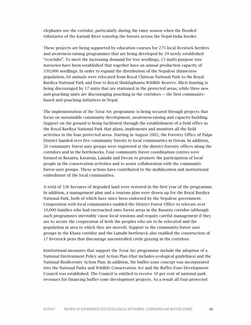
SYZYGY REVIEW OF EXPERIENCE WITH ECOLOGICAL NETWORKS, CORRIDORS AND BUFFER ZONES 58
elephants use the corridor, particularly during the rainy season when the flooded
tributaries of the Karnali River waterlog the forests across the Nepal-India border.
These projects are being supported by education courses for 275 local livestock herders
and awareness-raising programmes that are being developed by 39 newly established
“ecoclubs”. To meet the increasing demand for tree seedlings, 13 multi-purpose tree
nurseries have been established that together have an annual production capacity of
330,000 seedlings. In order to expand the distribution of the Nepalese rhinoceros
population, 64 animals were relocated from Royal Chitwan National Park to the Royal
Bardiya National Park and four to Royal Shuklaphanta Wildlife Reserve. Illicit hunting is
being discouraged by 17 units that are stationed in the protected areas, while three new
anti-poaching units are discouraging poaching in the corridors – the first community-
based anti-poaching initiatives in Nepal.
The implementation of the Terai Arc programme is being secured through projects that
focus on sustainable community development, awareness-raising and capacity-building.
Support on the ground is being facilitated through the establishment of a field office in
the Royal Bardiya National Park that plans, implements and monitors all the field
activities in the four protected areas. Starting in August 2002, the Forestry Office of Palpa
District handed over five community forests to local communities in Dovan. In addition,
26 community forest user groups were registered at the district forestry offices along the
corridors and in the bottlenecks. Four community forest coordination centres were
formed in Basanta, Katarnia, Lamahi and Dovan to promote the participation of local
people in the conservation activities and to assist collaboration with the community
forest-user groups. These actions have contributed to the mobilization and institutional
embedment of the local communities.
A total of 536 hectares of degraded land were restored in the first year of the programme.
In addition, a management plan and a tourism plan were drawn up for the Royal Bardiya
National Park, both of which have since been endorsed by the Nepalese government.
Cooperation with local communities enabled the District Forest Office to relocate over
10,000 families who had encroached onto forest areas in the Basanta corridor (although
such programmes inevitably cause local tensions and require careful management if they
are to secure the cooperation of both the peoples who are to be relocated and the
population in area to which they are moved). Support to the community-forest user
groups in the Khata corridor and the Lamahi bottleneck also enabled the construction of
17 livestock pens that discourage uncontrolled cattle grazing in the corridors.
Institutional measures that support the Terai Arc programme include the adoption of a
National Environment Policy and Action Plan (that includes ecological guidelines) and the
National Biodiversity Action Plan. In addition, the buffer-zone concept was incorporated
into the National Parks and Wildlife Conservation Act and the Buffer-Zone Development
Council was established. The Council is entitled to receive 50 per cent of national park
revenues for financing buffer-zone development projects. As a result all four protected
SYZYGY REVIEW OF EXPERIENCE WITH ECOLOGICAL NETWORKS, CORRIDORS AND BUFFER ZONES 59
areas are now buttressed by buffer zones. Community forests also enjoy a formal status
under Nepalese law.
The challenges involved in securing sustainable natural resource exploitation and
biodiversity conservation in a poor, culturally diverse and politically unstable country
such as Nepal are enormous. Given the lack of institutional capacity, progress in the
coming years will depend largely on external funding and on the ability to work closely
with local communities and demonstrate that sustainable development and biodiversity
conservation deliver tangible benefits in the short term while still offering a long-term
perspective. In this respect, the Terai Arc Landscape programme has already shown that
it can achieve important results.
CONCLUSIONS
Despite the high level of poverty and political and institutional problems in many Asian
and Pacific countries, a relatively large number of ecological networks and corridors are
under development in the region. These range from local corridor projects to national
ecological-network programmes. Flagship species such as the Asian elephant, the giant
panda and the tiger are an important focus for many of the corridor projects. To date,
however, the extensive application of the ecological-network model has not yet led to a
structured region-wide exchange of information and experience as has occurred in Europe
and in North America.
Notably, despite the extensive application of the model, only two ecological-network
programmes – in South Korea and Japan – are the product of national-government policy
processes. Both of these schemes share several key characteristics: they are national in
scope, their development is proving to involve a protracted process and implementation
to date has been limited to a series of pilot and local projects. They nevertheless
represent an important strategic development for the long-term direction in which
biodiversity conservation policy in South Korea and Japan is heading.
The most important driving force for establishing ecological networks and corridors in
most Asian and Pacific countries is therefore coming primarily from the NGO community
in cooperation with international donors and research institutes. WWF and Conservation
International are particularly active in promoting the approach across the region. Also, in
collaboration with a range of international financial institutions, foreign donors, private
foundations and the respective governments, they play an important role in funding the
early phases of many of the initiatives.
The scope of many of these programmes is necessarily bounded by the need to achieve
results in regions with weak institutional mechanisms. Another notable feature of many
of the initiatives, particularly in the poorer countries, is the incorporation of community-
development objectives into the programmes with the aim of providing sustainable
economic opportunities that go hand in hand with biodiversity conservation. Programmes
such as the Terai Arc Landscape are providing valuable lessons in this respect.

SYZYGY REVIEW OF EXPERIENCE WITH ECOLOGICAL NETWORKS, CORRIDORS AND BUFFER ZONES 60
5555 LATIN AMERICA AND THE CARIBBEAN
The ecological-network model was introduced to Latin America through the
Mesoamerican Biological Corridor in the mid-1990s. The idea for the network was
conceived by the US-based Caribbean Conservation Corporation and the Wildlife
Conservation Society as a means to re-establish a natural corridor in Central America for
the Florida panther under the name Paseo Pantera (Path of the Panther). Funds to support
the development of the concept were provided by the US Agency for International
Development (USAID) and in 1997 the proposal was formally adopted by the heads of
state of the eight countries, becoming the Mesoamerican Biological Corridor (see box).
In South America the first large-scale ecological network programme to be initiated was
the Vilcabamba–Amboró Conservation Corridor (see box) that grew out of a 1998
proposal to establish a transboundary Biosphere Reserve between Peru and Bolivia. Since
then, a remarkably large number of ecological-network initiatives have been launched. US
NGOs such as Conservation International and the World Resources Institute have been
active in promoting the approach and a wide range of international donors are working
with national and local governments and other stakeholders to support the programmes.
OVERVIEW OF THE PROGRAMMES
In the Latin American context, the relatively recent development of ecological networks
has not yet led to a common understanding of the approach. Different terms are also
used to describe the various initiatives, although the generic name “corridor” is preferred
following the example of the Mesoamerican Biological Corridor. Variations include

SYZYGY REVIEW OF EXPERIENCE WITH ECOLOGICAL NETWORKS, CORRIDORS AND BUFFER ZONES 61
biological corridor (corredor biológico, such as Bremen–Barbas in Colombia), ecological
corridor (corredor ecológico, such as Llanganates–Sangay in Ecuador), biodiversity
corridor (corredor biodiversidad, such as Central da Mata Atlántica in Brazil), conservation
corridor (corredor conservación, such as Patagonia in Argentina and Chile) and
biogeographical corridor (corredor biogeográfico, such as Madidi–Pilón Lajas–Manuripi–
Tambopata–Candamo–Bahuaja Sonene in Bolivia and Peru).
CENTRAL AMERICA: THE MESOAMERICAN BIOLOGICAL CORRIDOR
Although covering only one half per cent of the world’s land surface, Mesoamerica is home to about seven per cent of the planet’s terrestrial biodiversity. This biological wealth is the result not only of Mesoamerica’s particular environmental characteristics but also of its strategic position as a land bridge connecting the biotas of the two American continents. About 30 ecoregions have been identified, an exceptionally large number for such a small landmass. The plan for establishing the Mesoamerican Biological Corridor distinguishes four kinds of zones: core areas, buffer zones, corridors and multiple-use areas. Together these cover 208,000 square kilometres, or 27 per cent of Mesoamerican territory. Within this area can be found 26 indigenous groups and all the major Maya sites, such as Tikal, Chichén Itza and Copán. More detailed ecological-network maps are being developed at the national level. The basis of the Corridor’s core areas are the region’s 368 protected areas, 18 of which are larger than 100,000 hectares. Together they protect nearly 11 per cent of Mesoamerica’s land area. Building on this foundation, projects in the buffer zones, corridors and multiple-use areas encourage land users to test and adopt management practices that are both biodiversity-friendly and economically viable, using incentives such as environmental service payments. Many local projects are working to secure sustainable development and biodiversity conservation on the ground. For example, the 1,500-strong Small Farmers’ Association of Talamanca in Costa Rica is now producing 20 per cent of the world’s organic cocoa. An evaluation of the Corridor by the World Resources Institute in 2001 was broadly positive (Miller et al., 2001) but identified a number of issues that the programme needs to address if it is to achieve its objectives, such as reconciling stakeholder interests and addressing property rights and land-tenure issues. The evaluation nevertheless concluded that the initiative had built a strong foundation through actively solliciting the support of a wide range of stakeholders and actors. Its involvement of local groups – farmers, organizations of indigenous peoples, municipalities and local companies – offers the main key to the initiative’s success (Inter-American Development Bank and World Bank, 2001).

SYZYGY REVIEW OF EXPERIENCE WITH ECOLOGICAL NETWORKS, CORRIDORS AND BUFFER ZONES 62
PERU AND BOLIVIA: THE VILCABAMBA–AMBORÓ CONSERVATION CORRIDOR
The Vilcabamba–Amboro ecosystem extends from the Vilcabamba mountain range in south-central Peru southeast to Amboró National Park in central Bolivia. The region’s vegetation follows a gradient from tropical moist forests through cloud-forest formations to alpine grassland and scrubland. Other vegetation types, such as the unique dry Polylepis forests, are found at higher elevations. Species diversity is exceptional: in the 17,000-square-kilometre Manu National Park, over a thousand species of birds have been identified and in the Tambopata reserve approximately 1,200 species of butterfly (Critical Ecosystem Partnership Fund, 2000). About 40 different ethnic groups can be found in the region, including indigenous communities who reject the encroachment of modern civilization. Although population density is relatively low, human pressure is having a significant impact on the biodiversity. Direct threats include oil and gas exploitation, gold mining, uncontrolled logging, dam construction, road construction and the associated colonization. The fact that many protected areas are underfunded only increases their vulnerability. In 1998, the Organization of American States funded a proposal that involved the creation of a transboundary Biosphere Reserve. The proposal incorporated corridors and buffer zones into its configuration and complemented a similar idea that was being developed by Conservation International. These developments evolved into a more ambitious ecological network called the Vilcabamba–Amboró Conservation Corridor that is built up around large protected-area complexes composed of protected areas, multiple-use areas and indigenous peoples’ reserves. The programme now encompasses 16 protected areas, which are the core areas of a developing ecological network. Three of the areas are also indigenous reserves, and a series of Inca and pre-Inca archaeological sites are located in the network, including the world-famous Machu Picchu. The next phase in the programme is the preparation of detailed action plans. The majority of the funding for developing the Vilcabamba–Amboró Conservation Corridor comes from a range of international donors. These include – in addition to Conservation International – WWF, USAID and the Critical Ecosystem Partnership Fund (a joint initiative of Conservation International, the Global Environment Facility, the government of Japan, the MacArthur Foundation and the World Bank).

SYZYGY REVIEW OF EXPERIENCE WITH ECOLOGICAL NETWORKS, CORRIDORS AND BUFFER ZONES 63
Four key elements are shared by the initiatives in the region that fall within the scope of
this review. These elements are:
– integrating protected areas into a broader management approach
– promoting functional connectivity
– a primary focus on biodiversity conservation
– using land-use planning as a means to realize the goals.
On the basis of these defining characteristics, a recent inventory identified a total of 82
ecological-network initiatives in South America (Cracco and Guerrero, 2004; see also Table
5.1). In relation to specific countries, the highest number of programmes are underway in
Brazil and Colombia.
COUNTRY NUMBER
Argentina 7 Bolivia 3 Brazil 14 Colombia 17 Chile 3 Ecuador 9 Paraguay 3 Venezuela 8 Transboundary 18
Total 82
Table 5.1. Number of ecological-network and corridor initiatives in South American countries (adapted from Cracco and Guerro, 2004).
The inventory also collected information on 68 of these programmes (see Table 5.2). Both
governments and NGOs are active in launching the initiatives. Although biodiversity
conservation formed the original object of all these programmes, an increasing number of
the newer initiatives, such as Ecoaméricas, are following the example of the Mesoamerican
Biological Corridor and embracing broader sustainable development objectives.
WWF is also very active in Latin America and is currently developing the following
terrestrial and coastal ecoregion programmes:
– the Chihuahuan deserts and springs (Mexico)
– the Galapagos Islands
– the Northern Andean montane forests (Colombia)
– the southwestern Amazonian moist forest (Brazil/Bolivia/Peru)
– the Atlantic forests (Argentina/Paraguay/Brazil)
– the Valdivian temperate forests (Chile)
– the Amazon River and floodplain (Brazil/Peru)
– Choco-Darien (Colombia)
– Llanos (Venezuela/Colombia)
– Pantanal (Brazil/Bolivia).

SYZYGY REVIEW OF EXPERIENCE WITH ECOLOGICAL NETWORKS, CORRIDORS AND BUFFER ZONES 64
In addition, a non-ecoregion project to conserve the Guianan moist forests in Surinam is
underway.
UNESCO’s Man and Biosphere Programme includes 73 Biosphere Reserves in the region,
including two in French overseas territories (Atoll de Taiaro and Archipel de la
Guadeloupe – see box).
GUADELOUPE: ARCHIPEL DE LA GUADELOUPE BIOSPHERE RESERVE
Situated on Guadeloupe Island in the Caribbean Sea, this Biosphere Reserve comprises two geographically separate sites: – Basse-Terre, a tropical humid forest located in the west of the island, which is uninhabited and is home to
over 300 species of trees and shrubs. – Grand-Cul-de-Sac Marin, a bay of 15,000 hectares between Basse-Terre and Grande-Terre which
includes coral reefs, mud flats, a sea-grass bed and mangrove forests, freshwater swamps forests and marshes. The lagoon provides a habitat for turtles, giant sponges, soft corals, urchins and fish. The mangrove hosts many sedentary and migratory birds (pelicans, terns, moorhens, ducks, herons and kingfishers). Parts of the reserve also comprise a Ramsar site.
The transition areas of the Biosphere Reserve include numerous small towns and villages with many tourist facilities. About 225,500 inhabitants live permanently in the reserve and each year about 20,000 tourists visit the marine part of the area. Threats to the reserve include hurricanes, tourism, anchorage on coral reefs, deforestation and water pollution. Following designation as a Biosphere Reserve in 1992, a management plan was adopted in 1998 with the objectives of maintaining biodiversity and good water quality. The zonation into core areas, buffer zones and transition zones is a good example of the Biosphere Reserve management approach.

SYZYGY REVIEW OF EXPERIENCE WITH ECOLOGICAL NETWORKS, CORRIDORS AND BUFFER ZONES 65
Argentina – Iniciativa Corredor de Humedales del Litoral
Fluvial de la Argentina – Proyecto de Biodiversidad Costera Patagónica – Corrector de conservación del Cóndor Andino – Corredor de Interconexión entre los Parques
Nacionales, Parques Provinciales y Áreas Protegidas en la Región Triprovincial
– Corredor Biológico de Humedales del Centro-Oeste Argentino
Bolivia – Corredor Amboró–Madidi – Corredor Amboró–Tariquía – Corredor Chiquitano–Iténez–Mamoré Brazil – Corredor da Biodiversidade do Amapá – Corredor de Biodiversidad Central da Mata
Atlántica – Corredor Centro-Amazónico o Central da
Amazonía (CCA) – Corredor do Descobrimento – Corredor Norte-Amazónico – Corredor Oeste-Amazónico – Corredor Sul-Amazónico – Corredor Ecológico Cerrado–Pantanal – Corredor da Serra do Mar o Corredor Sul da Mata
Atlántica – Corredor do Ecótono Sul-Amazónico (Amazonía
Cerrado) – Corredor Ecológico Araguaia–Bananal – Corredor Ecológico do Cerrado – Corredor Ecológico Jalapão–Mangabeiras – Corredor JICA Colombia – Corredor Biológico Guácharos–Puracé – Corredor Biológico Bremen–Barbas – Corredor Guantiva–La Rusia–Iguaque de Bosques
Altoandinos de Roble o Iguaque–Guanentá o Guantiva–Iguaque
– Corredor Transandino–Amazónico – Corredor Páramo de Bordoncillo–Cerro Patascoy–
Laguna de la Cocha – Corredor Biológico de la Cordillera Central – Corredor Dagua–Calima–Paraguas – Corredor de Naya – Corredor Costero del manglar Proyecto Biopacífico – Corredor Amazonía Colombiana – Corredor Ecológico Abierto – Corredor Costero Urabá–Alto Sinú – Corredor Laguna de Fuquene y Laguna Palacio Chile – Corredor Nevados de Chillán–Laguna de la Laja – Corredor entre la cordillera de los Andes y la
Cordillera de la Costa
Ecuador – Corredor Chocó–Andino – Corredor Ecológico Llanganates–Sangay Paraguay – Corredores de conservación en la Reserva de
Biósfera del Bosque Mbaracayú y áreas de influencia
– Corredores ecológicos y culturales en el valle central de la cuenca del Plata y valles interconexos
Venezuela – Corredor en el Caribe entre Curaçao, Bonaire, Aves
y Los Roques – Corredor Biológico de la Sierra de Portuguesa – Biocorredor Ramal de Calderas – Corredor Canaima–Alto Orinoco (part of the
Guyana Shield proposal) – Corredor Nacional Fulquena – Corredor Papero – Corredor Caparo – Corredor Pueblos del Sur Transboundary Initiatives – Corredor Tariquía-Baritú o Corredor Regional de los
Yungas (Argentina/Bolivia) – Corredores Guaporé–Itenez (Bolivia/Brazil) – Corredor Vilcabamba–Amboró (Perú/Bolivia) – Corredor Cóndor Kutukú (Perú/Ecuador) – Corredor Chocó–Manabí (Ecuador/Colombia – Corredor verde de Misiones (Paraguay/Brazil/
Argentina) – Corredor Trinacional del bosque Atlántico del Alto
Paraná (Brazil/Argentina/Paraguay) – Propuesta de Corredor Biológico para el Huemul
Hippocamelus bisulcus (Argentina/Chile) – Corredores de Conservación en la Patagonia
(Argentina/Chile) – Corredor Chaqueño (Argentina/Bolivia/Paraguay) – Corredor Nor-Andino o Andes del Norte
(Venezuela/Colombia) – Área de manejo coordinado o Corredor Altoandino
o Humedales Altoandinos (Chile/Bolivia/Argentina) – Cielos de América (Argentina/Bolivia) – Proyecto Cooperación entre Reservas de Biosfera
Costeras (Uruguay/Argentina/Brazil) – Corredor Biogeográfico Madidi–Pilón Lajas–
Manuripi–Tambopata–Candamo–Bahuaja Sonene (Bolivia/Perú)
– Corredor Ecológico (Perú/Brazil) – Corredor Marino de Conservación del Pacífico Este
Tropical Oriental (Colombia/Ecuador/Panama/Costa Rica)
– Iniciativa de Conservación Escudo Caura–Guyana/the Guiana Shield (Venezuela/Guyana/ Surinam/French Guiana/Brazil/Colombia)
– Corredor Ecológico de las Américas: Ecoaméricas
Table 5.2. Ecological-network and corridor programmes in Latin America countries (adapted from Cracco and Guerro, 2004). Note: the inventory does not include initiatives in Central America such as the Mesoamerican Biological Corridor.

SYZYGY REVIEW OF EXPERIENCE WITH ECOLOGICAL NETWORKS, CORRIDORS AND BUFFER ZONES 66
Case Study 5 CORRIDORS IN THE BARBAS-BREMEN-CESTILLAL REGION
It has been claimed that the Tropical Andes is the most biologically diverse ecoregion in
the world. However, this ecoregion is losing its biodiversity because of habitat change and
fragmentation (Laurance and Bierregaard, 1997; Renjifo, 1999; Kattan and Murcia, 2003).
With over 30 million people living in the Colombian Andes system, human activities are
impacting more than 70 per cent of the region’s natural ecosystems (Etter, 1998; Etter and
Van Wyngaarden, 2000).
The Central mountain range is the most deforested region in Colombia, with only 10 per
cent of the original forest cover remaining. Of these remnants, less than three per cent
are protected. Almost all of the fragments are to be found in the upper reaches of the
mountain range (Arango et al., 2003). Habitat loss and fragmentation in the mountains
(and also the rest of the Colombian Andes) is more widespread and serious in lower and
medium elevations (1,500–2,500 metres). It is in these areas where biodiversity is richest
(Fjedsa and Krabbe, 1990; Renjifo et al., 1997). In the sub-Andes, with only seven per cent
of the land area, 54 per cent of the threatened bird species of the country are found
(Renjifo et al., 2002). In the past these zones were entirely covered by different forest
types. Today, pastures for livestock, coffee plantations, exotic tree plantations and urban
areas are the dominant elements of the landscape. Nonetheless, the rural parts of the
region still host a rich biodiversity, including a large number of threatened species and
those with a restricted distribution range.
Important patches of forest habitat still exist in some parts of the mountains. These
remnants are of high priority for the conservation of threatened and endemic species,
especially since the areas are the only remaining available habitat. However, because these
forest remnants are highly fragmented, a conservation strategy that is restricted to their
protection cannot guarantee the long-term survival of the species.
The subregion of the Central Andes Western Watershed covers over eight million
hectares. The Flora and Fauna Sanctuary Otún-Quimbaya, with an area of just 580
hectares, is the only reserve within the national protected-areas system that harbours
sub-Andean forests in the mountain chain (Arango et al., 2003). This sanctuary, together
with its neighbouring local and regional protected areas (Ucumarí and Campoalegre)
protects the only sub-Andean forest in the subregion.
An area where relatively large remnants of sub-Andean forests still exist is the Rio Barbas
canyon and its surroundings. This canyon contains a 790-hectare block of forest, which
historically was protected because of its steep topography. Located one kilometre south
of the Rio Barbas canyon is the Bremen Forest Reserve that was established in the early
1970s in order to protect the watersheds. Bremen contains 336 hectares of native forests
and 411 hectares of exotic conifer plantations. Since the 1990s, the Quindío Regional
Corporation (CRQ), the reserve’s owner, began removing conifer plantations and restoring
the native forest through natural regeneration. In the near future this reserve will

SYZYGY REVIEW OF EXPERIENCE WITH ECOLOGICAL NETWORKS, CORRIDORS AND BUFFER ZONES 67
encompass 747 hectares of natural forest and will be the only sub-Andean protected
forest in the Quindío region. A second large forest remnant is found along the Cestillal
canyon towards the northern section of the canyon, containing 296 hectares of forest.
Bremen, Barbas and Cestillal together cover 1,833 hectares. Although this area is small,
the reserve is the most important protected area in its altitudinal range of the Central
Andes Western Watershed since only 0.38 per cent of the original forest still exists in the
sub-ecoregion at this altitude in Barbas and Bremen (1,500–2,100 metres). Barbas–
Bremen–Cestillal has high topographic complexity, which creates a variety of
microhabitats with diverse species assemblages.
A biodiversity survey of the area covering ants, trees, shrubs and birds found 95 species
of ants belonging to 36 genera. Of these, six are newly discovered species and two were
registered for the first time in Colombia. The survey also found 409 species of trees and
shrubs. These include 22 species that at the national level are threatened, some being
endemic to Colombia. It is known that 199 species of birds – the best-studied group –
are found in the area. Of these, four species are threatened at the global level: Penelope
perspicax, Grallaria alleni, Chlorochrysa nitidissima and Dacnis hartlaubi (Renjifo et al.,
2002). Four other species with restricted ranges have populations in Barbas, 20 species of
birds found in Barbas are not present in Bremen and 16 species found in Bremen are not
found in Barbas.
The Barbas and Bremen watersheds provide a good source of quality water for about
175,000 people in eight municipalities and also a large number of businesses, coffee
plantations and two tourist thematic parks. Because of its landscapes, Quindío
department is the second most important tourist destination in Colombia, after the
Caribbean coast.
Recent studies have demonstrated that Bremen has lost around 20 per cent of its bird
species due to its prolonged isolation from other areas of similar habitat (Renjifo 1999).
In Barbas, however, the majority of the species populations that have disappeared from
Bremen can still be found. The establishment of a corridor reconnecting the forest blocks
could therefore facilitate the recolonization of these species in Bremen.
The proposal to strengthen connectivity in the region was initiated by the Instituto
Humboldt as part of the larger GEF/Netherlands Embassy/Colombian government project
Conservation and Sustainable Use of Biodiversity in the Colombian Andes. The ecological-
network proposal was elaborated during 1999 in collaboration with local and regional
environmental authorities and its implementation commenced in mid-2001. Socio-
economic studies concluded that local people have a high level of environmental
awareness and are keen to be involved in conservation efforts. The establishment of
corridors would also contribute to the scenic value of the landscape.
The goal of the project is to establish forests between the Bremen Natural Reserve, the
Barbas river canyon and the Cestillal canyon in order to connect these areas, both

SYZYGY REVIEW OF EXPERIENCE WITH ECOLOGICAL NETWORKS, CORRIDORS AND BUFFER ZONES 68
physically and functionally. The measures involved in establishing the corridors will
include:
– obtaining baseline data on existing biological and socio-economic conditions
(completed)
– developing a communication strategy to strengthen the level of participation by local
communities in the project (ongoing since 2003)
– economic analyses to determine the viability of economic and institutional incentives
that would help secure the project’s objectives (ongoing since 2003)
– concluding agreements to reduce the intensity of agricultural systems on private land
that could then function as a corridor (ongoing since 2003)
– land acquisition
– reforestation with native trees in order to attract fauna, and constructing fences in
order to prevent forest damage by livestock (ongoing since 2003)
– establishing landscape elements, such as hedgerows and windbreaks, that will
improve connectivity (ongoing since 2003)
– establishing a fauna tunnel under the main highway
– monitoring focal species and vegetation cover in relation to connectivity.
Figure 5.1. The location of Barbas–Bremen–Cestillal.

SYZYGY REVIEW OF EXPERIENCE WITH ECOLOGICAL NETWORKS, CORRIDORS AND BUFFER ZONES 69
Figure 5.2. The proposed locations of the corridors in of Barbas–Bremen –Cestillal (delineated in yellow, green, red and blue).
Potential sites for corridors between Barbas, Bremen and Cestillal have been identified on
the basis of studies, aerial photographs and data from the land registry. One potential
scenario is to establish five corridors of about 100 metres wide in order to connect
Bremen and Barbas forests, with two other corridors of the same width connecting Barbas
and Cestillal. Another scenario is to establish a single corridor 500 meters wide
connecting Barbas and Bremen and a second corridor of the same width connecting
Barbas and Cestillal. The latter scenario offers certain advantages because it would be
easier to establish and monitor and it would also have a shorter boundary length, thereby
reducing edge effects. However, the final result will be strongly influenced by the results
of negotiations with the landowners (although 100 metres is regarded as the minimum
acceptable width).
The physical establishment of the corridors started in 2003 and is progressing well. The
majority of the actions can be undertaken with the participation of local people. However,
the establishment of larger corridors will require the acquisition of land and taking
valuable agricultural land out of production.
The primary actors in the project are private landowners, the municipal government of
Filandia, the regional autonomous corporations, two logging companies and local
communities. Other parties include neighbouring municipalities that benefit from the
protection of the forests within the project area (through measures that serve to protect
the watershed, for example) and local environmental NGOs. All the main actors have
responded positively to the project, in some cases becoming active and committed
supporters. One municipality is providing initial financing for land acquisition and the
establishment of corridors. Bilateral agreements with municipalities that support the
project are a source of additional funds that can be directed to the protection of the
watershed. This reflects the well-established tradition of collaboration between

SYZYGY REVIEW OF EXPERIENCE WITH ECOLOGICAL NETWORKS, CORRIDORS AND BUFFER ZONES 70
municipalities and private landowners in promoting measures such as reforestation
programmes and hedgerows.
Case Study 6 BRAZIL: THE ATLANTIC FOREST CENTRAL CORRIDOR
The Atlantic Forest biome originally extended across 1.3 million square kilometres –
about 15 per cent of Brazilian territory – but today less than 100,000 square kilometres
remain. The biome is divided into two main ecoregions: the coastal Atlantic Forest and
the interior Atlantic Forest. Both run from sea level up to 1,800 metres, which results in
an exceptionally high degree of biological and landscape diversity. Approximately 20,000
species of vascular plants can be found – of which 6,000 are considered endemic – and
about 1,300 species of vertebrates (not including fish) of which over 500 are endemic.
This species richness places the biome as the sixth most important hotspot in the world.
At the same time the forest serves the crucial functions of regulating water run-off and
thereby preventing soil erosion.
A substantial part of the Atlantic Forest has been lost in recent times: between 1990 and
1995, for example, more than 500,000 hectares were deforested, largely through housing
development and the expansion of arable and livestock farming, but also industrial
activities. As a result much of the remaining area of Atlantic Forest is severely
fragmented.
Figure 5.3. The location of the Atlantic Forest.
SYZYGY REVIEW OF EXPERIENCE WITH ECOLOGICAL NETWORKS, CORRIDORS AND BUFFER ZONES 71
It was in these circumstances that a first proposal for the Atlantic Forest Central Corridor
was developed by the Brazilian Ministry of Environment in 1998. The ecological network
is located on the Atlantic coast in the states of Espiritu Santo and Bahia, extending for
more than 1,200 kilometres from north to south and covering a total area of 86,000
square kilometres. This tract of land is biologically diverse: it is one of the main centres
of endemism in the Atlantic Forest and supports several species threatened with
extinction. A study in a private reserve near Ilheus, Bahia, found 454 tree species in just a
single hectare of forest – the highest known diversity of tree species in the world.
Within the Atlantic Forest Central Corridor, the total area under protection (including
federal, state, municipal, privately owned and indigenous sites) represents just five per
cent of its total area. At the southern extreme of Bahia, one of the two most important
blocks of the Corridor includes four national parks. However, protected-area management
faces serious challenges. Human pressure on the sites is high and in most of the
surrounding areas land use is not sustainable. The most serious threats include hunting,
forest fires, uncontrolled tourism, illegal land occupation and palmetto cutting. Moreover,
within the protected areas about 95 per cent of the land is privately owned. A particular
conservation challenge in the states of Espiritu Santo and Bahia is that the average size of
the core areas is only 3,200 hectares, which is too small to provide sufficient habitat for
many of the species populations. In Espiritu Santo, for example, of the 372,862 hectares
of native forest only 72,263 hectares are formally protected (equivalent to three per cent
of the total area of the state forests).
The general objective of the Atlantic Forest Central Corridor is to improve the effective
conservation of the Atlantic Forest biodiversity. This is to be secured through establishing
an ecological network in combination with a participatory socio-environmental
management programme. Six specific types of measures are under development:
– formulating alternative strategies aimed at maintaining and/or increasing forest
ecosystem connectivity
– developing and implementing innovative and replicable models for biodiversity
conservation on private land
– developing technical, economic, legal and institutional tools to help secure the
integrity of the ecosystems and promote the restoration of ecosystems in priority
areas
– strengthening cooperative biodiversity conservation actions between public agencies,
the private sector and civil society
– developing and promoting the adoption of incentives that encourage sustainable use
in private and public economic sectors
– promoting the integration of conservation strategies and economic development
policies.
The organizational structure of the project involves four main elements: a General
Coordination Unit (which manages the relations between the implementing agencies), the
Management Committees (which monitor and evaluate project implementation), the State
Coordination Units (which provide operational support to the implementing agencies and

SYZYGY REVIEW OF EXPERIENCE WITH ECOLOGICAL NETWORKS, CORRIDORS AND BUFFER ZONES 72
the Management Committees) and local parties (including civil organizations, the private
sector, municipalities and other stakeholders).
Implementation of the programme commenced in 2002. The initial phase involves the
development of a management plan that specifies the strategies, actions and resources
for its implementation. The most important provisions are:
– developing a working proposal at the bioregional scale for the conservation of the
entire area of the ecological network
– specifying processes and tools that ensure the sustainability of the areas to be
conserved
– providing for the sustainable use of natural resources through socio-economic
development strategies outside the protected areas
– indicating productive activities that are appropriate for biodiversity conservation and
restoration, and also developing alternative forms of natural-resource exploitation
– developing an environmental, social, economic and institutional information system
that is integrated into a GIS, together with management procedures that allow the
periodic updating of the data
– establishing a monitoring system that generates the information necessary to devise
appropriate management measures
– establishing priority areas for the establishment of corridors.
Figure 5.4. The proposed Burarama–Pacotuba–Cafundó corridor within the Atlantic Forest Corridor.

SYZYGY REVIEW OF EXPERIENCE WITH ECOLOGICAL NETWORKS, CORRIDORS AND BUFFER ZONES 73
The development of the management plan was carried out in several phases. These
included:
– PREPARATORY PHASE: GIS and mapping work, database management etc.
– EVALUATION PHASE: thematic analysis of sectoral issues, assessment of the political,
administrative and socio-environmental structure, land-use trends and analysis of the
negative impacts in relation to the individual corridors
– FORMULATION OF ALTERNATIVE STRATEGIES: developing conservation scenarios for the
network, involving landscape modelling, selecting and prioritizing conservation areas
and developing the main elements of the action plan
– FINAL PROPOSAL: developing the general proposal for the implementation of the
corridor, including the social and institutional validation of the final management
plan.
The project is currently developing specific management plans for three priority areas
within the ecological network. These plans, that involve a more detailed analysis of
ecosystem functioning, will define strategies for site management within the broader
framework of the programme’s objectives.
CONCLUSIONS
Although the ecological-network model was introduced to Latin America just 10 years
ago, a remarkably large number of programmes are now underway. Indeed, at least one
programme is underway in every Latin America country.
A recent review of ecological networks in South America assessed the characteristics of
the various programmes and developed a typology that distinguishes between four
different approaches to the ecological-network model (which in Latin America is referred
to as “corridor”): “biological corridor”, “ecological corridor”, “conservation corridor” and
“sustainable-development corridor” (see Table 5.3). Although it was clear that the
typology reflects a continuum of approaches rather than four distinct models, the
classification illustrates some important features of how ecological networks are
developing across the continent.
To an important extent the typology also reflects a temporal evolution of ecological-
network thinking in South America. Most of the early networks focus predominantly on
biodiversity conservation at the landscape scale. However, through the realization that
the involvement of a wide range of stakeholders facilitates the achievement of
biodiversity conservation objectives and promotes community support, more recent
initiatives are building broader sustainable-development objectives into their
development. The different approaches also reflect the context of a particular initiative:
whether, for example, it is to be established in a sparsely populated region, such as
Vilcabamba–Amboró, or a more highly developed area, such as parts of Mesoamerica.

SYZYGY REVIEW OF EXPERIENCE WITH ECOLOGICAL NETWORKS, CORRIDORS AND BUFFER ZONES 74
Biological Corridor Ecological Corridor Conservation Corridor Sustainable-
Development Corridor
– Promotes genetic exchange
– Focus on conserving priority species
– Linear structure – Linear connectivity – Physical connection
between habitat fragments
– Facilitates movement of species
– Involves large-scale land planning
– Reflects ecosystem vision
– Physical and functional connectivity
– Incorporates principles of landscape ecology
– Involves large-scale land planning
– Strengthens ecological processes
– Incorporates sustainable use and conservation objectives
– Involvement of stakeholders
– Incorporates sustainable use
– Greater geographical scale
– Provides for connectivity between both protected and non-protected areas at the regional scale
– Incorporates both ecological and social objectives into corridor design
– Integration of political, social and environmental aspects
– Active involvement of political and economic stakeholders
– Connectivity also aims to produce economic benefits
– Emphasis in sustainable production
– Linkages take full account of ecosystem, infrastructure and broader policy objectives
Table 5.3. Typology of existing ecological network approaches in South America (adapted from Cracco and Guerro, 2004).
In addition to differences between approaches, the typology highlights a number of
interesting common features. Thus, apart from the obvious elements of ecosystem
management, connectivity and building on existing protected areas, it is notable that even
the “ecological corridors” and the “conservation corridors” take account of broader
sustainable development objectives in their programmes. Moreover, the use of land-use
planning as a key instrument to establish the ecological networks is a striking feature,
particularly given the relatively weak institutional structures in many regions and the
unusually large scale of many of the initiatives (although the expert and financial support
provided by international donors to many of the programmes is helping to strengthen
institutional capacity). Most programmes are also actively promoting the involvement of
stakeholders in their development and implementation.
Major challenges nevertheless remain for these programmes. Most initiatives, being
relatively recent, have not yet progressed to an advanced phase of implementation,
although valuable experience has been gained through a wide range of local projects.
Nevertheless, it is on the ground that the most serious obstacles will be met, such as the
illegal exploitation of natural resources (that characterizes many regions in Latin
America), property rights and land-tenure conflicts, the exceptionally high ethnic diversity
in many areas, and ensuring that measures directed at promoting sustainable
development also provide economic benefits to local communities in the short term.

SYZYGY REVIEW OF EXPERIENCE WITH ECOLOGICAL NETWORKS, CORRIDORS AND BUFFER ZONES 75
6666 AFRICA
Protected areas in much of Africa date back to the colonial period. For example, in
southern and eastern Africa, the British occupied present-day South Africa, Lesotho,
Swaziland, Botswana, Zimbabwe, Zambia, Malawi, Tanzania and Kenya. Namibia was
occupied by Germany but was later annexed to South Africa until its national
independence. Angola and Mozambique were under Portuguese rule until their national
independence in the mid-1970s.
The land tenure systems in most of these territories were such that prime productive land
was reserved for the settlers while native populations were confined to densely populated
and marginal lands of very low productivity. Later the colonial governments – partly
responding to international calls to set up special conservation areas and partly to arrest
the rapid depletion of wildlife caused by commercial hunting – began to set up national
parks, game reserves and other protected areas. In many cases, however, natives were
seen as poachers and game rangers were trained to keep them out of these “protected
areas”. Native populations therefore felt doubly expropriated – having lost both their
traditional agricultural lands and their rights and access to exploiting wildlife (Murphree,
1990). Not surprisingly, very few protected areas have been created in the post-
independence era.
Thus, the sites that were formally protected for conservation reasons were those areas
that were least habitable by the colonists, although that does not mean that there was no
human occupation of the areas: many of them were occupied by native populations who,

SYZYGY REVIEW OF EXPERIENCE WITH ECOLOGICAL NETWORKS, CORRIDORS AND BUFFER ZONES 76
in some cases, had to be moved to make way for the protected areas. However,
population growth, with its concomitant demand for land coupled with advances in
agricultural techniques and improved disease control, has led to steadily greater human
pressure on the protected areas. As a result, many of the protected areas have
increasingly become islands of nature where the boundaries have become more sharply
defined.
Over the past twenty years African conservationists have started to question the efficacy
of strict protected-area boundaries. This concern comes from the fact that many species
are mobile and freely move into and out of protected areas. In fact, some of the protected
areas tend to confine some wildlife species into areas smaller than their preferred ranges.
Intrusive human activities, such as the erection of fences to separate wildlife from
livestock for reasons of disease control, have also cut across established migration routes
for some species. These and other factors have led to a growing realization of the need to
extend conservation efforts into territories outside protected areas and to allow linkages
between and within protected areas.
A further impetus for the development of ecological networks is the emergence over the
past 10–15 years of the concept of transboundary natural-resources management (see,
for example, Van der Linde et al., 2001). This arose in part from the challenge posed by
the existence of a protected area in one country abutting a non-conservation area in the
adjacent country, but also from a desire to link protected areas across territorial borders.
These landscape approaches, as opposed to site-specific management measures, are
proving to be an important driver in the growing interest in the ecological-network model
in Africa.
OVERVIEW OF THE PROGRAMMES
The restoration or establishment of corridors that allow large game species to move
between protected areas has a long history in Africa. For example, in 1926 the Kibale
Forest Game Corridor was established in Uganda (see box). However, human pressure on
the land combined with poor management ensured that many of these corridors failed to
maintain the conditions that were necessary to provide connectivity.
Some protected areas remain linked with their surrounding landscapes. For example, the
Sapo National Park, that was created in 1983, was Liberia's first fully protected area. It
covers an area of 107,300 hectares, consisting of lowland rainforest, swampy areas and
dryland and riparian forests, and it represents the foremost intact forest ecosystem in
Liberia. The park nevertheless remains reasonably connected by forested corridors to
several other forest areas to the north, west and southeast, extending into Côte d’Ivoire.
Other programmes have focused on improving the management of land around protected
areas, with the aim of strengthening their biodiversity value and also serving as buffer
zones. These programmes include the Administrative Management Design for Game
Management Areas in Zambia, Wildlife Management Areas in Botswana and the

SYZYGY REVIEW OF EXPERIENCE WITH ECOLOGICAL NETWORKS, CORRIDORS AND BUFFER ZONES 77
Communal Areas Management Programme for Indigenous Resources in Zimbabwe.
Essentially, these programmes aim to mobilize and empower communities living close to
protected areas by giving them access rights to wildlife and rights of controlled
utilization of wildlife. The communities make decisions on hunting quotas, setting up
tourist facilities and joint-venture business enterprises with the private sector. Economic
benefits from the wildlife resources are intended to go directly to the communities who
decide themselves on how best to share the benefits. UNESCO’s Man and Biosphere
Programme has applied this broader management approach to 65 Biosphere Reserves in
29 African countries, the first reserve dating from 1976.
UGANDA: CONFLICTS IN ELEPHANT MIGRATION CORRIDORS
Biodiversity conservation in Uganda faces tremendous challenges: financial resources are extremely limited, institutional capacity is low and human pressure on natural resources is high. In practice this often leads to local resistance to establishing new protected areas and to the encroachment of existing sites. For example, the Kibale Forest Game Corridor in the southwest of Uganda was established in 1926 to allow large game mammals to move between the Kibale Forest and the Queen Elizabeth National Park. However, the corridor was poorly managed and by 1990 had lost almost all its special biodiversity value due to encroachment by 40,000 settlers and the clearing of most of the natural forest and elephant grass for cultivation. Monitoring showed that in 1991 the corridor was no longer used by elephants, Uganda kob, waterbuck or buffalo. Moreover, the number of elephants in the Kibale Forest and the Queen Elizabeth National Park had declined from 3,000 in 1973 to 500 by 1989 and their migration patterns had also changed. To rectify this situation, the Ugandan government evicted 30,000 settlers from the corridor in 1992 and a year later designated the corridor and the Kibale Forest as a national park. Although the designation of such sites enhances their protection, the root causes of human-biodiversity conflicts often remain and continue to hinder conservation measures. For example, in three areas elsewhere in Uganda where there is a need to maintain or restore landscape linkages for elephants, proposals for new corridors have been rejected by the local communities due to the need of the expanding populations for access to land.

SYZYGY REVIEW OF EXPERIENCE WITH ECOLOGICAL NETWORKS, CORRIDORS AND BUFFER ZONES 78
Linking existing protected areas and extending conservation management to surrounding
areas through transboundary natural-resources management has led to the establishment
of a number of transnational parks. Examples include the Kgalagadi Transfontier Park
between Botswana and South Africa and the Great Limpopo Transfrontier Park shared by
Mozambique, South Africa and Zimbabwe. The proposed Kavango-Zambezi Transfrontier
Conservation Area will span parts of Angola, Botswana, Namibia, Zambia and Zimbabwe.
The project, a collaborative effort between Conservation International, wildlife
organizations, government agencies, NGOs and several donors, represents the largest
contiguous wilderness, wetland and wildlife area in southern Africa. The initiative aims to
restore wildlife migration routes and relieve unsustainable pressures on habitats and
communities. Although transboundary natural-resources management is normally
understood to bridge international boundaries, the approach is also apparent within
countries where the management of natural resources may transcend other jurisdictional
boundaries, such as district or provincial boundaries where similar issues to national
borders arise.
Most recently, WWF’s ecoregion programmes are applying the ecological-network model
in a more consistent way to some large areas in Africa. The current terrestrial
programmes in Africa include the following:
– the East African coastal forests
– the Madagascar dry/spiny forests
– the western Congo basin moist forests, where five projects are being carried out (see
box)
– the Guinean moist forests
– Miombo (Central and Eastern Miombo woodlands and Zambezian woodlands and
savannas).
WWF is also managing the following large-scale non-ecoregion programmes in Africa:
– Fynbos (South Africa)
– the Rift Valley lakes
– the Niger river basin
– the northeast Congo basin moist forests/central Congo basin moist forests
– the Albertine Rift montane forests (Kenya).

SYZYGY REVIEW OF EXPERIENCE WITH ECOLOGICAL NETWORKS, CORRIDORS AND BUFFER ZONES 79
CAMEROON–GABON–CONGO: THE TRI-DOM ECOLOGICAL NETWORK
The moist forests of the Congo basin are part of WWF’s Global 200 ecoregions ( Kamdem Toham et al., 2001 and 2003). WWF is implementing five projects in this region: TNS, TRIDOM, Gamba, Salonga and Lac Tumba-Lac Tele. TRIDOM is one of the most advanced projects. The interzone rainforest around the junction of Cameroon, Gabon and Congo harbours one of the largest tracts of primary tropical rainforest in Africa with an area of 141,400 square kilometres. It is also host to biodiversity of global importance. This includes the world’s largest remaining populations of forest elephants, lowland gorillas, chimpanzees and forest buffalo. However, the rainforest is seriously threatened by human and economic activities, particularly hunting – a large and growing market exists for meat in the surrounding urban centres – and logging, which fragments the forest and increases the opportunities for hunting still further. The indigenous population comprises BaAka and BaKola pygmies. These peoples were formerly hunter-gatherers but are now becoming increasingly settled, both through their own choice and because of government policies. There are also a number of Bantu tribes with whom the pygmies have a complex, largely interdependent social relationship. Currently, almost 25 per cent of the forest lies within several protected areas. However, in all three countries severe limitations in institutional capacity are impeding effective management. These problems persuaded several conservation NGOs in the mid-1990s to launch an initiative to establish an ecological network across the region that can provide the framework for effective, long-term management. The discussions resulted in March 1999 in the adoption by the three governments of the Yaoundé Declaration, which established a framework for strengthening biodiversity conservation and the sustainable use of the forest’s resources through a broad stakeholder process. The focal points of the Global Environment Facility in the three countries have endorsed the project and a tri-lateral coordination unit is being established to facilitate cooperation. WWF and ECOFAC have been requested by the three governments to provide expert assistance in formulating and implementing the programme with financing through the Global Environment Facility and bilateral donors. The Declaration’s objectives will be realized through an ecological network that is to be established over a period of 10 years. The plans provide for the establishment of a physical network of 40,000 square kilometres in extent together with a complementary management strategy that will apply to a total of 130,000 square kilometres. The immediate priority for action will be the areas that lie between the existing protected areas of Ngoïla-Mintom (Cameroon), Ivindo-Karangoua-Djoua (Congo) and the Djoua (Gabon) which have a rich fauna, a sparse human population and a relatively low potential for logging. These circumstances offer a good opportunity for establishing corridors between critical unprotected sites and the existing protected areas. A second priority concerns the forest access roads that are under construction, since their presence will result in intensified hunting pressures. The creation of buffer zones and the strengthening of the land-use planning system will therefore take a prominent role in the network development strategy.

SYZYGY REVIEW OF EXPERIENCE WITH ECOLOGICAL NETWORKS, CORRIDORS AND BUFFER ZONES 80
Case Study 9 BOTSWANA, NAMIBIA, ZAMBIA AND ZIMBABWE: THE FOUR CORNERS TRANSBOUNDARY NATURAL-RESOURCES MANAGEMENT AREA (THE KAZUNGULA HEARTLANDS PROJECT)
The Four Corners Transboundary Natural-Resources Management Area stretches across
220,000 square kilometres at the junction of Botswana, Namibia, Zambia and Zimbabwe.
About half the area is formally protected: the Chobe National Park and Moremi Game
Reserve in Botswana, the Mudumo, Mamili and Bwabwata National Parks in Namibia,
Kafue, Mosi-oa-Tinya and Sioma Ngwezi in Zambia and the Hwange and Zambezi National
Parks in Zimbabwe. Several protected forest sites in Botswana and Zimbabwe also fall
within the Management Area. The land outside the protected areas is used for various
forms of arable and animal husbandry, but several projects aimed at enhancing
community-based natural-resources management with a primary focus on ecotourism are
underway.
The Four Corners project started in 2000 and is being implemented by the African
Wildlife Foundation with funding from the USAID Regional Office for Southern Africa.
Four objectives have been defined:
– to improve landscape management and the management of specific sites
– to develop or improve conservation business ventures and partnerships
– to support policy and the institutional environment in the Management Area
– to disseminate widely information on the Management Area.
Figure 6.1. The Four Corners Transboundary Natural-Resources Management Area.

SYZYGY REVIEW OF EXPERIENCE WITH ECOLOGICAL NETWORKS, CORRIDORS AND BUFFER ZONES 81
In order to achieve these objectives a number of activities have been planned, such as:
– the identification and mapping of game corridors where game species move between
protected areas (which include corridors linking Hwange National Park in Zimbabwe
with Chobe National Park in Botswana and Zambezi National Park in Zimbabwe)
– standardizing fishery monitoring methods
– regulating commercial river activities in the riparian states
– encouraging all the traditional chiefs within the Management Area to sign a
memorandum of understanding on collaboration in the management of natural
resources
– developing general land-use management plans within parts of the Management Area
– promoting community/private-sector joint-venture partnerships as conservation
business ventures.
Financial support from USAID for the the first three-year phase of the project has now
ended, but funding to continue the work is being provided by the European Union. The
current activities by the African Wildlife Foundation are focusing on a limited number of
priority areas within the Management Area, known collectively as the Kazungula
Heartlands. The main conservation targets in these sites, which cover a total of 8,900
square kilometres, are as follows:
– SYSTEMS:
– river systems
– wildlife migration corridors, particularly for elephants
– woodland/grassland mosaics
– COMMUNITIES:
– wetlands
– representative woodlands: teak, mopane and acacia
– SPECIES ASSEMBLAGES:
– flood-plain and semi-aquatic antelope (red lechwe, puku and water buck)
– predator/prey interactions: lions with ungulates, livestock and people
– cheetahs
– birds of prey
– giraffe/impala interactions with woodlands
– SPECIES:
– native fish (bream, tigerfish)
– declining or threatened species (tsessebe, rhino, wild dog, Chobe bush buck,
sitatunga, lion, leopard, cheetah, puku, sable and roan antelopes)
– medicinal plants, endemic plants.
At the end of the initial phase of this project the following achievements had been
secured:
– all chiefs in the Management Area had signed a memorandum of understanding to
collaborate on natural-resource management
– three wildlife corridors had been identified, two of which had been mapped
– an inventory of ecological monitoring systems had been developed
– standardized fisheries monitoring methods had been piloted

SYZYGY REVIEW OF EXPERIENCE WITH ECOLOGICAL NETWORKS, CORRIDORS AND BUFFER ZONES 82
– aquatic biodiversity surveys had been conducted for the Upper Zambezi during low-
and high-water periods
– a large carnivore research programme had been established
– Conservation International had awarded a grant for research on the status of elephant
populations
– a general land-use management plan had been developed for the Chobe Enclave
– a process to develop an agreement between Zambia and Zimbabwe to regulate
commercial river activities on the Zambezi had been initiated
– a survey of wattled cranes had been undertaken in the Okavango delta
– a working group comprising directors of wildlife from the Four Corners states had
been established.
Case Study 10 KENYA: THE WILDLIFE CONSERVATION LEASE PROGRAMME
Nairobi Park is home to a wide range of mammals including lions, zebra, wildebeest,
impala, giraffe, various types of buck and antelope. During the dry season both zebra and
wildebeest are concentrated in the park. With the onset of the wet season, the animals
migrate southwards to the wildebeest calving zones in Amboseli National Park, a distance
of about 200 kilometres. These migrations are crucial to the survival of the populations of
zebra and wildebeest in the park (Gichohi, 2002; see also Figure 6.2).
Twenty years ago, the area between Nairobi Park in the north and Amboseli National Park
in the south was not heavily used by humans. This has now changed, however, and an
increasing proportion of the land is now farmed (see Figure 6.3).
Figure 6.2. Wildlife and livestock movements in the Athi-Kapiti.
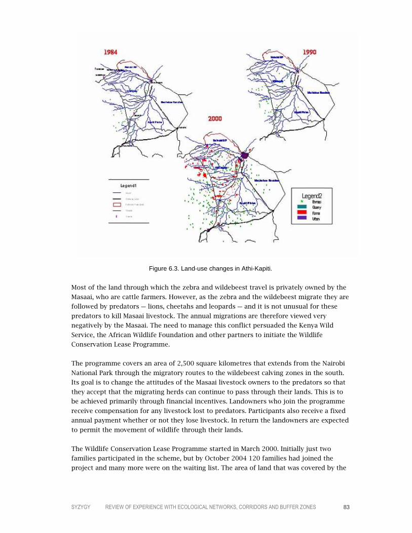
SYZYGY REVIEW OF EXPERIENCE WITH ECOLOGICAL NETWORKS, CORRIDORS AND BUFFER ZONES 83
Figure 6.3. Land-use changes in Athi-Kapiti.
Most of the land through which the zebra and wildebeest travel is privately owned by the
Masaai, who are cattle farmers. However, as the zebra and the wildebeest migrate they are
followed by predators – lions, cheetahs and leopards – and it is not unusual for these
predators to kill Masaai livestock. The annual migrations are therefore viewed very
negatively by the Masaai. The need to manage this conflict persuaded the Kenya Wild
Service, the African Wildlife Foundation and other partners to initiate the Wildlife
Conservation Lease Programme.
The programme covers an area of 2,500 square kilometres that extends from the Nairobi
National Park through the migratory routes to the wildebeest calving zones in the south.
Its goal is to change the attitudes of the Masaai livestock owners to the predators so that
they accept that the migrating herds can continue to pass through their lands. This is to
be achieved primarily through financial incentives. Landowners who join the programme
receive compensation for any livestock lost to predators. Participants also receive a fixed
annual payment whether or not they lose livestock. In return the landowners are expected
to permit the movement of wildlife through their lands.
The Wildlife Conservation Lease Programme started in March 2000. Initially just two
families participated in the scheme, but by October 2004 120 families had joined the
project and many more were on the waiting list. The area of land that was covered by the

SYZYGY REVIEW OF EXPERIENCE WITH ECOLOGICAL NETWORKS, CORRIDORS AND BUFFER ZONES 84
programme increased from 87 hectares in 2000 to over 8,400 hectares in 2004. The
current annual payment to landowners who “give away” land for wildlife is equivalent to
US$10 per hectare. On average, participating landowners receive US$400–800 per year
that is paid in three instalments. Cash compensation for livestock lost to predators is
about US$30 per animal. These payments are financed through funds that are raised by
the project team from donations. Partners that have donated funds to the project include
Friends of the Nairobi National Park, the Wildlife Trust, the International Fund for Animal
Welfare and the Wildlife Foundation. The project management has also set up an
endowment fund from which it hopes to continue to fund the project.
The long-term feasibility of the programme depends on the stability and sustainability of
the endowment fund. However, Nairobi National Park, which receives about 24,000
foreign visitors each month, raises about US$720,000 per month through the entry fee for
these tourists of US$30. There is therefore considerable potential for raising funds,
although according to an official of Kenya Wildlife Service this income goes to the
national treasury.
CONCLUSIONS
The challenge of maintaining landscape-scale ecological processes in the face of human
pressures was probably recognized in Africa before any other continent. For many
decades, however, it was associated solely with the conspicuous issue of long-distance
movements by game species. This was not only an issue of importance to a very limited
group, the actions taken to conserve these species and to protect valuable areas also
served to exacerbate the divisions between settlers and native populations – both
economically and geographically. In these circumstances, proposals to establish protected
areas that prevent access to natural resources or to take conservation action on land that
provides only a marginal livelihood to large numbers of natives inevitably came to be
associated with colonial methods that disadvantaged local populations still further.
Perhaps more than on any other continent, the support of local comunities for landscape-
scale conservation is a crucial issue in Africa, whereby the promise of sustainable
livelihoods becomes the central challenge. In most African countries, especially in
southern Africa, land in rural areas is either communally owned or state-owned, or both.
The number of “beneficiaries” from schemes such as wildlife corridors are usually so
large that the individual benefit is very small. There is also an increasing perception that
governments and conservation agencies are focusing more on wild nature than on human
needs. Setting aside land for corridors can therefore be perceived as a loss of land for
agriculture.
Given this historical legacy and the severe lack of resources, it is not surprising that
relatively few ecological-network initiatives, corridors and buffer zones have been
developed or that, where programmes exist, their implementation has been impeded by
intractable problems. Thus, corridors for game species often conflict with the subsistence
needs of local populations, and transboundary conservation management programmes
can be perceived as weakening the nation state and empowering communities across
SYZYGY REVIEW OF EXPERIENCE WITH ECOLOGICAL NETWORKS, CORRIDORS AND BUFFER ZONES 85
national or local government boundaries. This raises fundamental issues on the nature of
borders. Should natural-resource management objectives determine where boundaries
should be drawn? What is the status of national borders, which were imposed by
colonists who have since relinquished power but are now promoting new boundaries in
the form of protected areas and ecological networks?
At the same time, large areas are confronted with the over-exploitation of timber which,
in addition to its impacts on biodiversity, both reduces the natural resources available to
local populations and increases access to the remaining areas of forest and thereby
increases the opportunities for illegal hunting. Dealing with these kinds of problems is a
major task for large-scale conservation programmes, especially those modelled on
ecological-network principles.

SYZYGY REVIEW OF EXPERIENCE WITH ECOLOGICAL NETWORKS, CORRIDORS AND BUFFER ZONES 86
7777 MEETING THE CHALLENGE
If one overriding conclusion from this global review of experience can be drawn, it is that
programmes which aim to conserve biodiversity at the landscape, ecosystem or ecoregion
scale through interconnected and buffered systems of protected areas are moving into the
mainstream of conservation practice. Moreover, based on the number of such programmes
that have been initiated in recent years around the world, it would be fair to conclude that
the increasingly broad application of the ecological network represents one of the most
significant strategic developments in conservation planning over the past decade. A few
simple figures are sufficient to demonstrate the magnitude of the shift: this review,
although describing only a proportion on the initiatives that are currently underway,
nevertheless traced 168 ecological networks, corridors and comparable projects, plus 26
flyways, 459 Man and Biosphere Reserves and 11 Bonn Convention agreements to conserve
populations of migratory species. Bearing in mind that ecological networks and corridors
only began to generate broad interest in the mid-1990s, this is a remarkable development.
In fact, the changes that we are witnessing are more fundamental than simply the scale and
the configuration of the territories that are managed for conservation purposes: they
extend to the management objectives, competences, techniques and skills that are applied,
the perceptions that underly the programmes, the involvement of local communities and
the sources of funding. Ecological networks are above all a manifestation of an array of new
insights into how conservation needs can effectively be addressed. Indeed, when viewed in
a broader context these changes amount to a paradigm shift in protected-areas planning –
as Phillips (2003) has elegantly demonstrated (see Table 7.1; see also Crofts, 2004).

SYZYGY REVIEW OF EXPERIENCE WITH ECOLOGICAL NETWORKS, CORRIDORS AND BUFFER ZONES 87
AS IT WAS
Protected Areas Were:
AS IT IS BECOMING
Protected Areas Are:
Objectives – Set aside for conservation – Established mainly for spectacular
wildlife and scenic protection – Managed mainly for visitors and tourists – Valued as wilderness – About protection
– Run also with social and economic objectives – Often set up for scientific, economic and
cultural reasons – Managed with local people more in mind – Valued for the cultural importance of
“wilderness” – Also about restoration and rehabilitation
Governance – Run by central government – Run by many partners
Local people – Planned and managed against people – Managed without regard to local
opinions
– Run with, for, and in some cases by local people
– Managed to meet the needs of local people
Wider context – Developed separately – Managed as “islands”
– Planned as part of national, regional and international systems
– Developed as “networks” (strictly protected areas, buffered and linked by green corridors)
Perceptions – Viewed primarily as a national asset – Viewed only as a national concern
– Viewed also as a community asset – Viewed also as an international concern
Management techniques
– Managed reactively within short timescale
– Managed in a technocratic way
– Managed adaptively in long-term perspective – Managed with political considerations
Finance – Paid for by taxpayer – Paid for from many sources
Management skills
– Managed by scientists and natural resource experts
– Expert led
– Managed by multi-skilled individuals – Drawing on local knowledge
Table 7.1. The changing paradigm of protected areas (taken from Phillips, 2003).
MAIN CHARACTERISTICS OF THE PROGRAMMES
The main body of programmes that are described in this review were selected on the
basis of a shared body of conservation goals, management principles and a functional
configuration. That is to say, in general:
– they aim to conserve biodiversity by maintaining the functioning of ecosystems and
promoting the sustainable use of natural resources
– they secure these goals through working at the landscape, ecosystem or ecoregion
scale, strengthening ecological coherence, minimizing the effects of potentially
damaging external activities, restoring degraded ecosystems and promoting
complementarity between land uses and biodiversity conservation
– they apply a spatial model comprising core areas, corridors, buffer zones and
sustainable-use areas.
In addition to these initiatives, two other types of programme are also included because
of their close relationship to the ecological-network model: Biosphere Reserves and
agreements under the Bonn Convention on the Conservation of Migratory Species of Wild
Animals. Launched in 1970, UNESCO’s Man and Biosphere Programme introduced the
management hierarchy of core areas, buffer zones and transition areas into international
conservation practice, thereby establishing a significant precursor to the ecological
network. With 459 Biosphere Reserves designated in 97 countries, the programme has

SYZYGY REVIEW OF EXPERIENCE WITH ECOLOGICAL NETWORKS, CORRIDORS AND BUFFER ZONES 88
had a major impact on protected-areas management. The Bonn Convention, adopted in
1979, marked the first international recognition of the generic importance of maintaining
ecological linkages for migratory species (although several bilateral and multilateral
flyway agreements preceded the convention). A total of 13 species-specific agreements
and memoranda of understanding covering 89 countries have since been adopted.
One aspect of the programmes that is the source of some confusion is the wide variation
in terminology. As was noted in the introduction, programmes that apply the ecological-
network model use a variety of terms to describe the approach. The examples discussed
in this review carry the English or equivalent names of “ecological network”, “green
network”, “reserve network”, “wildlands network”, “interwoven biotope system”,
“territorial system of ecological stability”, “corridor”, “biological corridor”, “ecological
corridor”, “biodiversity corridor”, “conservation corridor”, “biogeographical corridor”,
“sustainable-development corridor”, “green corridor”, “ecoregion plan”, “transboundary
natural-resources management area” and “transfrontier conservation area”. Still other
names are undoubtedly used for programmes that have not been reviewed. Conservation
programmes that apply the principles of the Ecosystem Approach can also in many cases
be regarded as ecological networks (which include to some extent many freshweater
management programmes with a comparable approach). Complicating the terminology
issue further, not all programmes that use some of the names listed – such a proportion
of WWF’s ecoregion programmes and certain transboundary natural resources
management area in Africa – can be regarded as ecological networks (although most of
those that do not correspond to the model adopt an approach comparable to that found
in Biosphere Reserves).
This variation in terminology may cause confusion, but it also demonstrates that the
ecological-network model is a product of parallel evolution. A regional pattern in
terminology can nevertheless be discerned: across Europe and in international
governmental organizations, the term “ecological network” is now generally used, in
North America “reserve network” is preferred, while in South America and much of Asia
many programmes are known as “corridors”. In Africa a generally accepted term has yet
to evolve.
As the many examples of ecological networks show, the programmes may share certain
generic features, but the way in which the model is being applied varies in some
important respects. The most obvious variable is geographical scale. Ecological-network
programmes vary in scale from projects designed to conserve or re-establish linkages for
specific local species populations (such as corridors for the giant panda in China or
ecoducts for deer in the Netherlands) through regional programmes (such as North
America’s Wildlands Project, many of the programmes in Latin America and WWF’s
ecoregion projects) to continental strategies in the form of the Pan-European Ecological
Network and Australia’s WildCountry. However, although the geographical scale of these
programmes varies enormously, most share a focus on ecosystems (the forest-steppe
ecosystem of Central European Russia or the Guadiamar river basin in Spain), on larger
ecoregions (such as the link between the wet forests in Australia’s southwest tip through

SYZYGY REVIEW OF EXPERIENCE WITH ECOLOGICAL NETWORKS, CORRIDORS AND BUFFER ZONES 89
to the dry inland, North America’s “megalinkages” or the mountain systems between the
Amazon and the Orinovo rivers in northeastern South America) or on metapopulations
(carnivores in Italy or elephants in Africa and Asia). Even the smaller-scale projects,
although limited in terms of geographical scope, are usually framed within a broader
ecological context. However, geopolitical boundaries often determine the practical scope
of a programme. This is particularly the case in the government-driven programmes, such
as the national ecological networks in Europe and the Green Belt.
In this respect it is interesting to note that ecological networks are initiated not only by
governments but also by NGOs, and large numbers of both types of programmes are
underway. Some regional patterns are nevertheless discernible in the role taken by
governmental and non-governmental organizations. In Europe the majority of ecological-
network programmes have been initiated by national or, in a few instances such as in
Andalusia (Spain), Cheshire (UK) and Russia, by regional governments. The only NGO
programmes are a relatively small number of WWF ecoregion projects. In North America,
by contrast, virtually all the ongoing programmes have been initiated by NGOs, in most
cases within the framework of the the continental Wildlands Project. In Australia, the
nationwide WildCountry programme is also an NGO initiative, although the programme is
being implemented in collaboration with government bodies. In Latin America most
initiatives have come from NGOs, Conservation International being the primary driver; in
many cases, however, the programmes are being developed in close cooperation with
regional and national governments, such as the Mesoamerican Biological Corridor. In Asia
NGOs are again the most important initiators, with both WWF and Conservation
International playing an active role, but also some smaller NGOs that focus on specific
areas, such as the Philippine Eagle Conservation Program Foundation.
BIODIVERSITY CONSERVATION
It is clear from this broad experience that considerable work still needs to be done before
it can be demonstrated with confidence to what extent the potential biodiversity-
conservation value of ecological networks is realized on the ground and across a wide
range of conditions. Most programmes are clearly in too early a phase for firm
conclusions to be drawn. Those networks that are in a more advanced stage of
implementation are almost invariably to be found in the more developed countries and
therefore represent a limited sample of the conditions in which ecological networks are
being applied. Much of the experience recounted in this review is nevertheless of
sufficient substance and significance to justify some initial conclusions on progress to
date.
The first lesson that can be drawn is that the programmes are explicitly attempting to
establish and maintain the environmental conditions that are necessary to secure the
long-term conservation of biodiversity rather than limiting themselves to the in-situ
protection of valuable sites or threatened species populations. This involves, in the main,
safeguarding assemblages of habitat large enough and of sufficient quality to support
species populations, providing where necessary opportunities for movement between

SYZYGY REVIEW OF EXPERIENCE WITH ECOLOGICAL NETWORKS, CORRIDORS AND BUFFER ZONES 90
these reserves, buffering the network from potentially damaging human activities and
promoting sustainable forms of land-use in the contiguous landscapes.
That this model applies to species that require access to very large areas or need to
migrate across a landscape is obvious. However, a debate on the general effectiveness of
this approach in conserving a substantial proportion of biodiversity has been underway
for many years. For many species, extensive linked and buffered systems of core areas are
not, as such, immediately essential to their survival. For example, for most plant species
physical linkages with other habitat patches are not usually a critical short-term
necessity. For long-term viability, however, other factors become important, such as the
survival of a full complement of species within an ecosystem, the ability to recolonize
“empty” habitat patches, the opportunity to move away from an existing area that comes
under threat and the occurrence of periodic natural disturbances that may require some
form of linkage, such as flooding.
If it is accepted that these factors are indeed crucial to the conservation of biodiversity in
the long term, then the challenge for ecological networks is to demonstrate: (a) that the
programmes are succeeding in establishing the conditions on the ground, (b) that the
viability of species populations and communities is thereby improved in practice and (c)
that human communities have access to sustainable livelihoods.
In assessing the degree to which current programmes are meeting these challenges,
certain factors should be taken into account. First, the many examples of ecological
networks that are described in this review represent two classes of network design that
operate at different levels and with different degrees of specificity. The first group is a
strategic configuration – the initial phase in virtually all the examples – that is based on
a broad understanding of ecosystem processes, the needs of the species populations, the
threats that need to be resolved and the opportunities for sustainable forms of land use.
The second group comprises precisely delineated configurations with broad stakeholder-
oriented action plans that are being implemented on the ground. Most of the examples
reviewed, having been initiated in the past few years, clearly fall into the first group: that
is, they are still at the stage of a strategic programme. Many of these initiatives are in the
process of being elaborated into more detailed implementation programmes or a series of
local projects but have not yet led to action on the ground. Examples include the Guiana
Shield in South America, the Far East Ecoregion in Russia and WildCountry in Australia.
In terms of assessing the value of the ecological-network approach, the more interesting
examples are those where implementing actions have already been taken. Although no
ecological-network programme is at a sufficiently advanced stage of implementation to be
able to draw conclusions on their overall effectiveness – which in any case will only be
possible many years after their implementation when the measures have had full
opportunity to take effect – some valuable lessons can be drawn from specific
implementing actions and the research-and-development process.

SYZYGY REVIEW OF EXPERIENCE WITH ECOLOGICAL NETWORKS, CORRIDORS AND BUFFER ZONES 91
In terms of biodiversity conservation, ecological networks have the potential to offer
added value over more traditional approaches in three main ways:
– by directly relating conservation actions to ecosystem processes
– by linking sites together to create coherent assemblages of habitat patches
– by extending biodiversity conservation into the wider landscape through compatible
forms of land use.
The examples discussed in this review present a wide range of experience in how these
three aspects are given form and effect. As noted above, most programmes take one or
more ecosystems or the larger ecoregion as their operational framework. This requires
the programmes to address three major challenges: (a) to understand how the respective
ecosystems function, (b) to devise conservation measures that are effective in maintaining
ecosystem processes and (c) to secure and coordinate actions over large areas and by a
large number of stakeholders.
These are clearly enormously complex tasks, and few programmes have advanced to the
stage where it can be demonstrated that all three challenges have been met. With regard
to understanding how ecosystems function, most programmes are based on a
combination of habitat and species mapping (often using GIS) and an assessment of
threats. Examples that are currently in this phase include Moldova’s National Ecological
Network, the Italian National Ecological Network, the Four Corners Transboundary
Natural-Resources Management Area in Southern Africa, the Vilcabamba–Amboró
Conservation Corridor in Peru and Bolivia and many of WWF’s ecoregion programmes
(which commence with a biodiversity and socio-economic “reconnaissance”), such as the
Central European Forest-Steppe Ecoregion. In these and many similar examples an
indicative configuration of the projected ecological network has also been formulated.
Only when programmes move beyond this initial phase – which usually takes some years
– is it feasible to undertake more detailed analyses which can then form the basis of an
elaborated proposal that takes account of the interests of a broad array of stakeholders.
In some cases, an incremental approach is adopted for financial or political reasons or in
order to elaborate certain parts of the network through pilot projects. A common feature
of these programmes is the objective to conserve a representative array of habitats.
Examples include the Southern Rockies Wildlands Network in the US, some of the giant
panda corridors in China and the Atlantic Forest Central Corridor in Brazil.
Very few ecological-network programmes have progressed to the stage where
implementation on the ground has made substantial progress. Examples include the
Mesoamerican Biological Corridor, the Estonian Green Network, the Dutch National
Ecological Network and the Terai Arc Landscape. However, it will be many years before
even these ecological networks can be considered as “established”, and measures to
continue strengthening the quality of the networks will be necessary beyond that.
The fact that no ecological network has yet been fully realized – or that the measures
that have been implemented on the ground have not yet been functional for a long

SYZYGY REVIEW OF EXPERIENCE WITH ECOLOGICAL NETWORKS, CORRIDORS AND BUFFER ZONES 92
enough period to be able to demonstrate that they have improved the viability of the
respective species populations – prevents a comprehensive scientific assessment of the
value of the programmes. That is not to say, however, that no lessons can be drawn from
the experience to date on their likely long-term effectiveness.
First, it is worth noting that the ecological networks that have reached the
implementation phase are all based on comprehensive scientific assessments of the needs
of the habitats and species in relation to the threats to which they are exposed. These
assessments – such as those for the Southern Rockies Wildlands Network, the Estonian
Green Network, the Barbas–Bremen–Cestillal programme and many of the WWF
ecoregion projects – offer convincing evidence of the justification for applying the
ecological-network model. The checklist developed by the Wildlands Project gives an
indication of the concern for scientific rigour in developing the plans (see box).
A further source of evidence on the effect of ecological networks is the experience that
has been generated through corridor projects. Over the past decades, a substantial
literature on connectivity has been generated and many projects have produced
measurable results. Good examples are the Bow Valley corridor in Canada and various
elephant corridors in Africa and Asia. Although the concept of corridors has generated a
lively debate over many years, evidence from the increasing number of projects shows
that appropriately designed corridors generally meet the expectations of how they will
function in practice. Moreover, most of the documented examples of corridors suggest
that establishing or maintaining the linkage was the most cost-effective means of
achieving the conservation objective. Indeed, in many cases the corridor was
demonstrably the only feasible and practicable option to achieve the objective, while in
other cases alternative courses of action – such as enlarging a protected area – would
have involved intractable problems.
SUMMARIZED CHECKLIST FOR WILDLANDS NETWORK DESIGNS
1. Scientists and other experts are intimately involved throughout the planning process, from the initial formulation of goals and hypotheses to the completion of the design and, in some cases, its implementation.
2. The methodology is rigorous and systematic, within the constraints imposed by broad-scale conservation planning, and seeks to address the stated goals and questions.
3. Methodology includes the three tracks of special elements, representation and focal-species analysis. In addition, existing or potential threats to biodiversity are addressed.
4. Methodology is well documented and replicable; studies could be repeated by others. 5. Interpretation and application of results are congruent with principles (i.e., empirical generalizations) of
conservation biology, demonstrate a good command of relevant literature and theory, and apply the precautionary principle.
6. The project is thoroughly peer reviewed. In addition, the wildlands network design is available to the public for review. Review comments are thoughtfully considered and addressed.
7. At least some of the results are publishable in reputable, peer-reviewed journals, as well as other outlets.
8. The entire process, from developing research methods through implementation, is iterative and adaptive. There is no “final plan”; rather, the wildlands network design is continually refined and improved with feedback from research, monitoring, peer review and practice.
Taken from Noss (2003).

SYZYGY REVIEW OF EXPERIENCE WITH ECOLOGICAL NETWORKS, CORRIDORS AND BUFFER ZONES 93
It is important to emphasize in this respect that connectivity is essential not only for
certain species, it is fundamental to many ecosystem processes. Aquatic ecosystems are
the most obvious example. Inland water systems are probably the most fragmented of all
ecosystems, yet they depend for their functioning on physical connections between their
upper and lower catchments, including temporal fluxes such as flooding. Disrupting these
flows can impact the entire ecosystem. Maintaining the integrity of aquatic systems – for
example where sites are designated under the Ramsar Convention – therefore involves
management approaches that are complementary to the ecological-network approach, as
the extensive experience with river-basin management demonstrates (see, for example,
Ramsar Convention Secretariat, 2004).
An issue that is attracting growing attention is the question of whether ecological
networks offer a potentially useful conservation strategy for responding to climate
change. The ecological consequences of climate change are the subject of an increasing
number of studies (see, for example, Watson et al., 1998; Thomas et al., 2004). It is
projected that certain ecosystems are particularly vulnerable to climate change. These
include mangrove forests, boreal and tropical montane cloud forests, coastal marshes,
alpine and arctic ecosystems, wetlands overlying permafrost and coral reefs. Further,
monitoring studies of ecosystems and migratory species are identifying changes that
seem to be linked to rising temperatures, such as different migratory patterns for certain
bird species. However, to what degree ecological networks can assist in ameliorating the
impacts of climate change remains an open question. Corridors may offer populations of
animal species opportunities to move away from threatened habitats, but vegetation
communities cannot shift so readily and many ecosystems are inextricably linked to
geomorphological features, such as mountain ranges and estuaries. IUCN’s World
Commission on Protected Areas nevertheless recommends that three strategies for
adapting protected areas to global change are to link isolated core areas by corridors,
surround core areas with buffer zones, and surround clusters of core areas, corridors and
buffer zones with “biodiversity-friendly” land uses (World Commission on Protected
Areas, 2003).
Another feature of the examples in this review is that the majority of ecological networks
which are in an advanced stage of implementation are in developed countries where, in
most cases, ecosystems have become highly fragmented. In these circumstances, the
network approach is being applied to an important extent in order to restore ecological
coherence. The Guadiamar Green Corridor in Spain and WildCountry in Australia are good
examples of this approach. However, as some of the examples show, the ecological
network is also being applied in order to retain the coherence of large ecosystems or
ecoregions which are still relatively intact but are coming under increasing pressure –
often through a combination of development and underdevelopment – such as the Far
East Ecoregion and the Vilcabamba–Amboró Conservation Corridor. In these cases the
goal of the network is to guide the region’s development strategy so that conflicts with
ecosystem processes and valuable concentrations of biodiversity are as far as possible
avoided. It is clear that most of these programmes will require considerable further
SYZYGY REVIEW OF EXPERIENCE WITH ECOLOGICAL NETWORKS, CORRIDORS AND BUFFER ZONES 94
development if they are to be able to take on such a role. However, if they can succeed in
this ambition their potential conservation value would be enormous.
A final observation on the characteristics of ecological networks in relation to the
conservation of biodiversity concerns the issue of international cooperation. A large
number of the programmes discussed in this review are being developed across the
borders of two or more countries. Rivers are a common focus of transboundary
management efforts. Working at the international scale is an inevitable consequence of
focusing action on ecosystem processes. That, however, introduces further complications
into an already complex process. Yet in very few of the transboundary programmes does
the international dimension seem to be a significant barrier to progress (although for
practical reasons many of the implementing projects in these cases are limited to one of
the countries involved in the programme). What these examples demonstrate is that
operational methods are being found within which fruitful international cooperation on
biodiversity conservation can be realized.
SUSTAINABLE USE
The integration of biodiversity conservation and sustainable use is one of the defining
features of ecological networks. Thus, all the programmes covered by this review promote
an array of land-use functions which can range from strictly protected areas (equivalent to
IUCN’s Category Ia Strict Nature Reserve or Category Ib Wilderness Area) through to
multiple-use areas in which the landscape has an important productive role. In virtually all
cases this hierarchy of functions is based on an integral assessment of conservation
priorities and socio-economic needs. Inevitably, the scope of the assessment and the
rigour with which it is carried out vary considerably from programme to programme,
depending on the resources available or the working scale. A large number of programmes
have nevertheless developed comprehensive guidelines and plans for the sustainable use
of biodiversity. Thus, the older national ecological-network programmes in Central Europe
were based on an approach that would now be called sustainable development and
involved detailed elaboration at the local level through the comprehensive planning
systems in those countries (although, due to the political disruptions of the 1990s, not all
the programmes have progressed to that stage). Indeed, most government-driven
programmes also use the spatial-planning system – but also a range of other instruments
such as financial incentives – to promote the sustainable use of biodiversity. Support for
extensive forms of traditional farming in Europe is a common feature, such as in the
Andalusian ecological network. Purchase of land by government agencies or privately
funded nature conservation organizations in order to ensure that appropriate forms of
management are applied – which can include sustainable uses such as forestry and
recreation – is also common, such as in the Dutch National Ecological Network.
The NGOs that operate at the continental or international scale have developed more-or-
less standard methodologies that encompass sustainable use. For example, WWF’s
Annamites Conservation Plan, that extends across Vietnam, Lao and Cambodia and which
is used as a model for some other ecoregion projects, sets out 10 priority programmes
for conservation action in the region which explicitly integrate sustainable use into the

SYZYGY REVIEW OF EXPERIENCE WITH ECOLOGICAL NETWORKS, CORRIDORS AND BUFFER ZONES 95
plan. Similarly, the Wildlands Project in North America has developed a common
approach to preparing plans that includes sustainable use. For example, the Southern
Rockies Wildlands Network distinguishes between four kinds of compatible-use lands:
low-use lands, moderate-use lands, transportation lands and private lands (see box).
As the examples demonstrate, the variety of complementary land uses that are being
promoted is extremely wide. These include support for extensive farming practices
(Estonian Green Network), the sustainable harvesting of non-timber forest products and
the cultivation of organic cocoa (Mesoamerican Biological Corridor), ecotourism and
developing sustainable forestry in indigenous territories (Vilcabamba–Amboró
Conservation Corridor), the establishment of tree nurseries (Terai Arc Landscape),
promoting sandalwood growing, dry-country forestry and bush foods (Gondwana Link),
developing recreational opportunities (Heart of the West Wildlands Network) and
supporting livestock farming in corridors used by predatory species (Kenyan Wildlife
Conservation Lease Programme).
In order to encourage these land uses, an exceptionally diverse range of instruments are
applied by the programmes. These include legal protection, spatial planning, land reform,
the establishment of community forests, buying up logging concessions, compensating
livestock losses, organizing smallholders into producer associations, forest certification,
conducting awareness-raising campaigns and education programmes, offering training
courses, strengthening institutional capacity, and negotiating voluntary agreements,
environmental service payments and conservation easements with land owners.
TWO EXAMPLES OF SUSTAINABLE-USE PLANNING
The 10 priority programmes for conservation action in WWF’s Annamites Conservation Plan are: – protecting priority river basins – an effective protected-area network – three major landscape-scale initiatives – creating a constituency for conservation – understanding the Annamites – building the capacity for success – controlling unsustainable harvesting – promoting good infrastructure development – people, land and resources. The Southern Rockies Wildlands Network Vision proposes the following uses in “low-use compatible-use lands”: – Primitive recreation, including mountain bike and vehicle use on designated dirt roads only, with no
vehicle use off-road. Mountain bikes may be allowed on designated trails. – Low impact, small, developed campgrounds accessible by vehicle, and some dispersed camping areas. – Hunting and fishing, in so far as these are compatible with the full range of biological diversity. – Ecologically sensitive and predator-friendly livestock grazing, except in riparian areas or other highly
sensitive areas. – Limited low-intensity silviculture, such as light selective cutting of previously logged forest followed by
road obliteration and closure, and restoration thinning. Cutting of large trees should be prohibited and the goal should be to restore old-growth conditions and natural fire regimes.
– Limited habitat manipulation for focal plant and animal species. – Restorative management, including those measures listed for Wilderness Areas, but without wilderness
restrictions. – No road construction, vehicle use or resource extraction in roadless areas of 400 hectares or larger.

SYZYGY REVIEW OF EXPERIENCE WITH ECOLOGICAL NETWORKS, CORRIDORS AND BUFFER ZONES 96
Given the recent initiation of many of the programmes and the lengthy implementation
process, it is clearly too early to be able to demonstrate to what extent each particular
type of land use will prove in practice to be compatible with ecological sustainability in
the long term and how the various instruments will operate in practice. Moreover, some
of the projects cannot strictly be regarded as economically sustainable since they
currently depend for their viability on a degree of external funding, whether from
governments or donors.
Several other major challenges also need to be overcome if these programmes are to
secure sustainable use on the ground. Developing a comprehensive and coherent
proposal that is appropriate to its setting and can meet strategic objectives requires a
substantial investment in management resources and the adoption of an integrative
approach: a complex array of data need to be collected and assessed, long-term funders
have to be attracted, local communities should be fully involved, and all relevant
stakeholders have to be brought together and their commitment secured. Certainly, by no
means all the programmes have yet found workable and effective solutions in practice.
However, many of the programmes are becoming increasingly sophisticated in their
approach to implementation. Many WWF ecoregion programmes, for example, include
monitoring and evaluation plans which assess progress through indicators and the
achievement of quantitative targets.
The long-term process that characterizes the development and implementation of an
ecological network also has important implications for the necessary degree of political
stability. At the basic level this concerns the robustness of government and basic political
institutions. But at a higher level it is also important that a particular vision of
conservation and economic development be shared across the political spectrum and by
successive governments. These types of programme are therefore facing major challenges
in politically unstable countries and regions with weak institutional structures.
A particularly difficult issue that confronts all the initiatives is how to ensure that
dominant stakeholders can be persuaded to become fully involved in the programmes
and committed to achieving their goals. The examples suggest that it is in the more
developed countries, where institutions are stronger and where stakeholders are more
accustomed to working within these kinds of processes, that progress to date has been
most successful. Moreover, because the programmes are generally applied at the
landscape or regional level, involve a long-term process, operate across an array of
administrative units and embrace an exceptionally large number and wide range of
stakeholders, the development and realization of an ecological network place high
demands on the institutional framework and on process management. It is worth noting,
however, that many of the programmes are supported and managed by organizations
with substantial resources and extensive experience of implementing biodiversity
conservation programmes in cooperation with other stakeholders. In fact in many ways
large, internationally active organizations such as WWF and Conservation International
are better equipped for this task than many local and regional governments since they are
SYZYGY REVIEW OF EXPERIENCE WITH ECOLOGICAL NETWORKS, CORRIDORS AND BUFFER ZONES 97
well-funded, have developed sophisticated assessment methodologies and also possess
management resources that benefit from many years of experience.
POVERTY ALLEVIATION
Given the exceptionally wide range of circumstances in which ecological networks are
being developed – from advanced industrialized countries to some of the poorest regions
in the world – contributing to the alleviation of poverty is a concern of only a proportion
of the initiatives. The information available on these programmes shows that they are
predicated on the goal of establishing the conditions for sustainable livelihoods in
combination with biodiversity conservation. The examples give many illustrations of
measures designed to achieve these conditions. For instance, the Four Corners
Transboundary Natural-Resources Management Area in southern Africa is supporting the
establishment of conservation business ventures that will generate income for local
communities; the Green Corridor project in Bhutan is supporting new cottage industries
such as cheese-making and honey production; the Forest Conservation and Community
Development Project in southern China is supporting a large number of poverty-
alleviation measures such as improved drinking-water supplies, the construction of
biogas pits and training in agricultural techniques; the Terai Arc Landscape has provided
education courses for local livestock herders; and the Mesoamerican Biological Corridor is
promoting the cultivation of organic cocoa.
At the same time, it is clear that many of the programmes are confronted with intractable
problems that are closely related to extreme poverty. Many core areas, corridors and
buffer zones, for example, are under high pressure from poor communities, such as in
southern China where the buffer zones are densely populated and the protected forests
have traditionally been an important source of non-timber forest products. In the Congo
Basin, local hunters are threatening the rainforest ecosystem, encouraged by the large
market for dried meat in the surrounding urban centres and the increasing number of
access roads that are constructed by commercial logging companies. Corridors used by
large mammals in southern Africa are a source of conflict with local populations who
depend on the land for their subsistence.
The urgency of the poverty challenge has raised concerns that ecological networks
encourage too large a share of the available resources to be directed at the realization of
long-term conservation objectives at the cost of urgent poverty-alleviation and
biodiversity-protection measures. However, an interesting consequence of the broad-
based, integrative process that characterizes ecological networks is that it seems in
practice to be offering an increasingly attractive vehicle to donors for channelling
development aid. Thus, many of the examples suggest that the initiatives are attracting a
higher level of funding from a broader range of sources and over a longer period than
would have been the case if the programmes had been limited to isolated conservation or
development projects. The programmes in Vilcabamba–Amboró, Mesoamerica and the
Congo Basin are good examples of this phenomenon. The value of such initiatives seems
to be that they articulate politically necessary sustainability objectives within a coherent

SYZYGY REVIEW OF EXPERIENCE WITH ECOLOGICAL NETWORKS, CORRIDORS AND BUFFER ZONES 98
programme, while still offering opportunities for supporting clearly defined
complementary actions at the local level.
The question of to what extent this additional funding represents an increase in the total
funds that are being made available for biodiversity conservation and sustainable
development rather than a reallocation of existing financial support cannot be answered
by this review. However, there are strong indications that this is the case in some of the
examples, such as the Mesoamerican Biological Corridor and the Kenyan Wildlife
Conservation Lease Programme. Moreover, in underdeveloped regions or countries in
transition, the examples indicate that an ecological network can work pro-actively to
shape the policy agenda towards an integrated approach to securing conservation and
development as, for example, in Vietnam’s Greater Truong Son Ecoregion and, potentially,
Russia’s Far East Ecoregion.
MEETING THE 2010 TARGET
One of the most significant political commitments of recent years has been the
international consensus to achieve a significant reduction in the current rate of loss of
biodiversity by 2010 or even halt the loss altogether by that year. Specifically, in June
2001 the EU Heads of State committed themselves to halt the loss of biodiversity by 2010,
an objective that was reaffirmed in March 2005. In April 2002 the Parties to the
Convention on Biological Diversity adopted a Strategic Plan that includes the target of
achieving by 2010 a significant reduction in the current rate of biodiversity loss. In
September 2002 the UN World Summit on Sustainable Development endorsed the
achievement by 2010 of a significant reduction in the current rate of loss of biodiversity.
Finally, in May 2003 at the Fifth Environment for Europe Ministerial Conference, over 50
Eurasian states reiterated the objective to halt the loss of biodiversity at all levels by the
year 2010.
It is clear, given the rate at which biodiversity is being lost on all continents and the
imminence of the 2010 deadline, that these commitments infer a substantial upgrading of
conservation measures, a stronger focus on sustainability across a wide range of policy
sectors and a marked improvement in the effectiveness with which actions are
implemented on the ground. Meeting the 2010 target will therefore require not only
specific biodiversity-conservation measures but also structural changes in how natural
resources are exploited.
In that perspective, the management model that underlies ecological networks has much
to offer: it not only aims to conserve specific sites and species populations, it has the goal
of ensuring the maintenance of ecosystem functions and promoting the sustainable use
of natural resources. In other words, it aims to establish and maintain the conditions that
are necessary for the long-term conservation of biodiversity and to do so at the
landscape, the ecosystem or even the ecoregion scale. The 2010 target – significantly
reducing the current rate of, or even halting the loss of biodiversity – is therefore
intrinsic to the model.

SYZYGY REVIEW OF EXPERIENCE WITH ECOLOGICAL NETWORKS, CORRIDORS AND BUFFER ZONES 99
However, as the examples demonstrate, achieving this goal within a few years is beyond
the capability of most of the current programmes, if only because of the scale at which
they are being implemented and the recent commencement of most initiatives. To be
sure, important progress in halting the decline in biodiversity has been achieved in
limited areas and the sustainability of land use has been improved: examples that have
produced tangible results are the Terai Arc Landscape and Canada’s Bow Valley Corridor.
But even the older programmes which are in an advanced phase have not yet progressed
to the point where the measures have been fully implemented on the ground across their
geographical range, although a small number which are well advanced – Estonia and the
Netherlands are good examples – have succeeded in contributing to a significant
reduction in the rate of biodiversity loss in recent years. Ecological networks, if they
secure their goals, will certainly make an important contribution to achieving the 2010
target. In most cases, however, given the implementation timescales involved, this will
only be achieved some years after 2010.

SYZYGY REVIEW OF EXPERIENCE WITH ECOLOGICAL NETWORKS, CORRIDORS AND BUFFER ZONES 100
LITERATURE
Andreev, A., et al. (2001). Concept of National Ecological Network of Republic of Moldova. Chisinau: BIOTICA Ecological Society.
Arango, N., et al. (2003). Vacíos de Conservación del Sistema de Parques Nacionales Naturales desde una Perspectiva Ecoregional. Cali: Instituto de Investigación de Recursos Biológicos Alexander von Humboldt/WWF.
Arenas Cabello, J.M. (2003). “Current Situation and proposals for Improving Functionality in the Guadiamar Fluvial Corridor”. In: Dirección General de la RENP y Servicios Ambientales (ed.). Protected Areas in the Mediterranean Basin. Seville: Consejería de Medio Ambiente.
Arenas Cabello, J.M., Olmo, C.M. del, and Borja Barrera, F. (2003). The Guadiamar Green Corridor: From an Ecological Disaster to a Newly Designated Protected Area. Seville: Consejería de Medio Ambiente.
Beier, P., and Noss, R.F. (1998). “Do Habitat Corridors Provide Connectivity?” Conservation Biology 12 (6): 1241–1252.
Bennett, A.F. (1998). Linkages in the Landscape: the Role of Corridors and Connectivity in Wildlife Conservation. Gland/Cambridge: IUCN.
Bennett, A.F., and Lowe, K.W. (2002). From Design to Implementation: Insights From Ecological Networks in Southern Australia. Paper presented to the 16th Annual Meeting of the Society for Conservation Biology. Canterbury, 14–19 July.
Bennett, G. (2004). Integrating Biodiversity Conservation and Sustainable Use: Lessons Learned From Ecological Networks. Gland/Cambridge: IUCN.
Bennett, G. (2004). Linkages in Practice: a Review of Their Conservation Value. Gland/Cambridge: IUCN.
Bennett, G. and Wit, P. (2001). The Development and Application of Ecological Networks: a Review of Proposals, Plans and Programmes. Amsterdam: AIDEnvironment.
Boere, G.C., and Rubec, C.D.A. (2002). “Conservation Policies and Programmes Affecting Birds”. In: Norris, K., and Pain, D.J. (eds.). Conserving Bird Biodiversity: General Principles and Their Application. Cambridge: Cambridge University Press.
Cracco, M., and Guerrero, E. (2004). Aplicación del Enfoque Ecosistémico a la Gestión de Corredores en América del Sur: Memorias del Taller Regional, 3 al 5 de junio. Quito: UICN América del Sur.
Critical Ecosystem Partnership Fund (2000). Ecosystem Profile: Vilcabamba-Amboró Forest Ecosystem of the Tropical Andes Biodiversity Hotspot. Peru and Bolivia. Washington, DC: Critical Ecosystem Partnership Fund.
Crofts, R. (2004). “Linking Protected Areas to the Wider World: a Review of Approaches”. Journal of Environmental Policy and Planning 6 (2): 143–156.
Dawson, D. (1994). Are Habitat Corridors Conduits for Animals and Plants in a Fragmented Landscape? A Review of the Scientific Evidence. Research Report 94. Peterborough: English Nature.
Diamond, J. (1975). “The Island Dilemma: Lessons of Modern Biogeographic Studies for the Design of Nature Preserves”. Biological Conservation 7: 129–146.
Duke, D.L. (2001). Wildlife Use of Corridors in the Central Canadian Rockies: Multivariate Use of Habitat Characteristics and Trends in Corridor Use. Edmonton: University of Alberta.
Duke, D.L., et al. (2001). “Restoring a Large-Carnivore Corridor in Banff National Park.” In: Maehr, D.S., Noss, R.F., and Larkin, J.R. (eds.). Large Mammal Restoration: Challenges for the 21st Century. Washington, DC: Island Press.
Etter, A. (1998). “Mapa General de Ecosistemas de Colombia”. In: Chaves, M.E., and Arango, N. (eds.). Informe Nacional Sobre el Estado de la Biodiversidad, Colombia 1997. Bogotá: Instituto de Investigación de Recursos Biológicos Alexander von Humboldt.
Etter, A., and Van Wyngaarden, W. (2000). “Patterns of Landscape Transformation in Colombia, with Emphasis in the Andean Region”. Ambio 29: 432–439.
European Centre for Nature Conservation (2002). Indicative Map of the Pan-European Ecological Network for Central and Eastern Europe. Tilburg: European Centre for Nature Conservation.
Fjedsa, J., and Krabbe, N. (1990). Birds of the High Andes. Copenhagen: Apollo Books.
Gichohi, H. (2002). Direct Payments and Other Mechanisms for Ecosystem Conservation: the Tanzania Land Conservation Trust in the Masaai Steppe and the Wildlife Conservation Lease Programme in Kitengela. Paper presented at the Annual Meeting of the Society of Conservation Biology. Canterbury, 14–19 July.

SYZYGY REVIEW OF EXPERIENCE WITH ECOLOGICAL NETWORKS, CORRIDORS AND BUFFER ZONES 101
Gilpin, M.E., and Hanski, I. (eds.) (1991). Metapopulation Dynamics: Empirical and Theoretical Investigations. London: Linnaean Society/Academic Press.
Inter-American Development Bank and World Bank (2001). The Mesoamerican Biological Corridor as a Vector for Sustainable Development in the Region: the Role of International Financing. Analysis prepared for the IDB/World Bank seminar “Sustainable Natural Resource Management at the Regional Level”, Madrid.
IUCN (1980). World Conservation Strategy: Living Resource Conservation for Sustainable Development. Gland, IUCN.
Kamdem Toham, A., et al. (2001). Biological Priorities for Conservation in the Guinean-Congolian Forest and Freshwater Region. Libreville/Washington, DC: CARPO/WWF-US.
Kamdem Toham, A., et al. (2003). “Forest Conservation in the Congo Basin”. Science 299: 346.
Kattan, G.H., and Murcia, C. (2003). “A Review and Synthesis of Conceptual Frameworks for the Study of Forest Fragmentation”. In: Bradshaw, G.A., and Marquet, P.A. (eds.). How Landscapes Change. Ecological Studies 162. Berlin/Heidelberg: Springer-Verlag.
Külvick, M. (2002). Ecological Networks in Estonia – Concepts and Applications. Doctoral thesis. Tartu: University of Tartu.
Laurance, W.F., and Bierregaard, R.O. (eds.) (1997). Tropical Forest Remnants: Ecology, Management, and Conservation of Fragmented Communities. Chicago: University of Chicago Press.
Linde, H. van der, et al. (2001). Beyond Boundaries: Transboundary Natural Resources Management in Sub-Saharan Africa. Washington, DC: USAID Biodiversity Support Program.
Liro, A., et al. (1995). National Ecological Network EECONET–Poland. Warsaw: Foundation IUCN
Poland.
Liro, A. (ed.) (1998). Development of a Common Approach to the Design and Implementation of the national Ecological Networks in Central and Eastern Europe: Proceedings of International Workshop. Warsaw: IUCN Office for Central Europe.
MacArthur, R.H., and Wilson, E.O. (1967). The Theory of Island Biogeography. Princeton: Princeton University Press.
Mackey, B., et al. (2005). “Towards a Scientific Framework for the WildCountry Project”. In: Wu, J., and Hobbs, R.J. (eds.). Key Topics and Perspectives in Landscape Ecology. Cambridge: Cambridge University Press.
MacKinnon, J. (ed.) (1997). Protected Areas Systems Review of the Indo-Malayan Realm. Hongkong/Canterbury: Asian Bureau for Conservation Ltd.
Miller, B., et al. (2003). Southern Rockies Wildlands Network Vision. Boulder: Southern Rockies Ecosystem Project.
Miller, K., Chang, E., and Johnson, N. (2001). Defining Common Ground for the Mesoamerican Biological Corridor. Washington, DC: World Resources Institute.
Ministry of Agriculture and Rural Development (2004). The Central Truong Son Biodiversity Conservation Initiative 2004–2020. Hanoi: Ministry of Agriculture and Rural Development.
Ministry of Environment (1995). Concept of the Green Network at the National Level: Creating Nature for the Harmony of Living Organisms with Human Beings. Seoul: Ministry of Environment.
Murphree, M. (1990). In Campfire – a Zimbabwean Approach to Sustainable Development and Community Empowerment through Wildlife Utilization. Harare: University of Zimbabwe.
Noss, R.F. (1992). “The Wildlands Project: Land Conservation Strategy”. Wild Earth (special issue): 10–25.
Noss, R.F. (2003). “A Checklist for Wildlands Network Designs”. Conservation Biology 17 (5): 1270–1275.
Phillips, A. (2003). “Turning Ideas on Their Head – the New Paradigm for Protected Areas”. The George Wright Forum 20 (2): 8–32.
Ramsar Convention Secretariat (2004). River Basin Management: Integrating Wetland Conservation and Wise Use into River Basin Management. Ramsar Handbook for the Wise Use of Wetlands no. 4, 2nd edition. Gland: Ramsar Convention Secretariat.
Renjifo, L.M. (1999). “Composition Changes in a Subandean Avifauna After Long-Term Forest Fragmentation”. Conservation Biology 13: 1124–1139.
Renjifo, L.M., et al. (1997). “Patterns of Species Composition and Endemism in the Northern Neotropics: a Case for Conservation of Montane Avifaunas”. In: Remsen, J.V. (ed.). Studies in Neotropical Ornithology Honoring Ted Parker. Ornithological Monographs 48. Washington, DC: American Ornithologists’ Union.

SYZYGY REVIEW OF EXPERIENCE WITH ECOLOGICAL NETWORKS, CORRIDORS AND BUFFER ZONES 102
Renjifo, L.M., et al. (eds.) (2002). Libro Rojo de Aves de Colombia. Bogotá: Instituto de Investigación de Recursos Biológicos Alexander von Humboldt/Ministerio del Medio Ambiente.
Rodoman, B.B. (1974). “Polijarzacija Landsafta kak Sredstvo Sochraenija Biosfery I Rekreacionnych Resursov”. Resursy, Sreda, Raselenije. Moscow: Nauka.
Rosenberg, D., Noon, B.R., and Meslow, E.C. (1997). “Biological Corridors: Form, Function, and Efficacy.” BioScience 47 (10): 677–687.
Santiapillai, C., and Jackson, P. (eds) (1990). The Asian Elephant: an Action Plan for its Conservation. Gland: IUCN.
Secretaría General Técnica (2000). The Strategy for the Green Corridor of the Guadiamar River: Fundamentals of the Strategy. Conclusions of the International Seminar on Ecological Corridors and Restoration of Rivers and Riparian Zone. Seville: Consejería de Medio Ambiente.
Sepp, K., and Kaasik, A. (2002). Development of National Ecological Networks in the Baltic Countries in the Framework of the Pan-European Ecological Network. Warsaw: IUCN Office for Central Europe.
Shepherd, G. (2004). The Ecosystem Approach: Five Steps to Implementation. Gland/Cambridge: IUCN.
Shestakov, A., and Krever, V. (2003). Ecological Networks in Russia: an Ecoregional Approach. Moscow: WWF Russia.
Smith, R.D., and Maltby, E. (2003). Using the Ecosystem Approach to Implement the Convention on Biological Diversity: Key Issues and Case Studies. Gland/Cambridge: IUCN.
Soulé, M.E., and Terborough, J. (eds.) (1999). Continental Conservation: Scientific Foundations of Regional Reserve Networks. Washington, DC: Island Press.
Soulé, M.E., et al. (2004). “The Role of Connectivity in Australian Conservation”. Pacific Conservation Biology. December.
Tewksbury, J.J. (2002). “Corridors Affect Plants, Animals, and Their Interactions in Fragmented Landscapes”. Proceedings of the National Academy of Sciences 99 (20): 12923–12926.
Thomas, C.D., et al (2004). “Extinction Risk from Climate Change”. Nature 427: 145–148.
UNESCO (1974). Task Force on Criteria and Guidelines for the Choice and Establishment of Biosphere Reserves. MAB Report Series no. 22. Bonn: UNESCO.
Vakarenko, L. (1999). Development of the ECONET of Ukraine. Kiev: National Ecological Centre of Ukraine.
Vázquez, F.M. (2003). “Connectivity Within the Andalusian Network of Natural Protected Areas”. In: García Mora, M.R. (ed.). Environmental Connectivity: Protected Areas in the Mediterranean Basin. Seville: Consejería de Medio Ambiente.
Watson, R.T., et al. (eds.) (1998). The Regional Impacts of Climate Change: an Assessment of Vulnerability. Cambridge: Cambridge University Press.
Weimin, W., and Busstra, B. (eds.) (2004). Integrated Nature Reserve Management: an Innovative and Practical Experience. Kunming: Yunnan Science and Technology Press.
World Commission on Protected Areas (2003). A Guide to: Securing Protected Areas in the Face of Global Change. Options and Guidelines. Gland/Cambridge: IUCN.