Embed Size (px)
Citation preview
36
UrbanGrowth
Area
Low
density
residential
watershedONE
watershedTWO
VegetationPatch
Golfcourse
Waterbody
Wetlandfeatures
Building
280mContour
260mContour
UrbanGrowth
Boundary
Pipelinecorridor
Watercourse
Road
Legend
Elevation(m
asl)
Th
eC
AS
Ein
bri
ef
ISS
UE
S
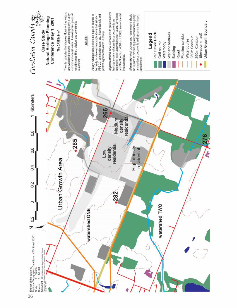
The
site
stradd
lestheMau
mee
Moraine
,has
wetland
andwoo
dlan
dfeatures,variabletopo
grap
hy,a
utility
corridor
andarterialroa
ds.Ade
velopm
entp
ropo
sal
wou
ldinclud
eHigh,
Med
iuman
dLo
wde
nsity
reside
ntial.
--wha
tpoliciesne
edto
beinplaceinorde
rto
beread
yforde
velopm
enta
pplications
that
satisfy
PPS2.3,
commun
itygo
als,etc.;h
owto
iden
tifyan
dprotectsignifican
tfea
turesinpo
licy?
--ho
wto
draw
lines
toprotectn
atural
heritag
esystem
;wha
tguida
ncedo
cumen
tsare
need
edforbo
thCom
preh
ensive
(1:300
00OPscale)
andSite
Spe
cific
(1:400
0or
1:10
000)
environm
ental
impa
ctstud
ies.
--wha
tprocess
andrequ
iremen
tsshou
ldbe
inplaceto
providea)
quality
assuranceto
policy
andgu
idan
cedo
cumen
tsan
db)
cumulativeimpa
ctassessmen
t.
Po
licy
Imp
lem
enta
tio
n
Mo
nit
ori
ng
CaseStudy
NaturalHeritagePlanning
Conference
May1,2001
Extractofthedata
set
NationalTopographicData
Base
Scale
1:
10000
Source
1:
50000
Copyright
©
NTSSheet43K7
HerMajestytheQueeninRightofCanada
Reproducedwiththeperm
issionofNaturalResourcesCanada.
wd:26Apr2001
0.2
00.2
0.4
0.6
0.8
1Kilometers
N
Highdensity
residential
Medium
density
residential
282
285 276
266

37
Case StudyGreenfields DevelopmentNatural Heritage PlanningConference May 1, 2001
Topography & Watersheds
Hydrology
surface water
Stormwater conduit
Bill: In the afternoon workshops we will work through the case studythat you have in your conference kit. Following an overview of theGreenfields Development Project, our panel of experts will comment onit from their respective points of view. Please take out your case studysheets and follow along with me as I take you through the several layersof the map.
In the south west quadrant of the Municipality of Townsend, theGreenfields Development Corporation is ready to pour concrete. IsTownsend ready? Based on record data, Greenfields brings this sketch tothe Townsend Planning Department. The planners and engineers concernthemselves with issues of urban density, transportation networks and thenew guy says something about compact urban form.
In the conventional development scenarios somere-allocation of earth’s resources would be neededto deal with the elevations, grading and storm watermanagement.
In 1997, the Province of Ontario reissued PolicyStatements on land use planning. The complexinterrelationships of environment, economic andsocial factors are recognized in this PolicyStatement. Common sense tells us that gettingthings right the first time avoids costly remedialmeasures to correct problems, or, as Hal would say,to provide palliative care. It is the Policy of theProvince of Ontario that natural heritage featuresand areas will be protected from incompatibledevelopment.
These features include, provinicially significant wetlands, habitat ofthreatened and endangered species, fish habitat, wetlands, woodlands,valley lands, wildlife habitat and areas of natural and scientific interest.Development may not have negative impacts on the natural features orthe ecological functions for which the area is identified. Evaluation ofwetlands for significance is necessary to determine that development isnot permitted in them and that adjacent lands may be developed if it isdemonstrated that there will be no negative impact on the natural features,or on ecological functions of the wetland. The quality and quantity ofground water and surface water and the function of sensitive ground waterrecharge or discharge areas, aquifers and head waters will be protected orenhanced. Likewise, woodlands, valleylands and the wildlife habitat mustalso be evaluated.
Panel Discussion on Case Study forPolicy, Implementation and Monitoring

38
Case StudyGreenfields DevelopmentNatural Heritage PlanningConference May 1, 2001
Issues
Wetland:evaluation
Watercourse:water qualitydownstream effects
Woodlands:qualitysignificanceanti-fragmentation
Corridors:Linkage
W etlan d Evaluation , com plexin g
?
W e tla nd Evaluation , com plexin g
?
W ood la nd, anti-
fra gm en tation , corridor, link ages
W etland a nd w aterco urse:
h ab ita t, q ua lity
W etlan d an d
wa terco urse:
h ab ita t,
q ua lity
Sto rm w ate r m a na ge m en t:
effe cts, qu ality
Issues -- Landscape Case StudyGreenfields DevelopmentNatural Heritage PlanningConference May 1, 2001
Corridorslinkages
* broader landscape context
* component of natural heritage system
Development may bepermitted in significantfeatures and areas or onadjacent lands if it has beendemonstrated that therewill be no negative impactson natural features or on theecological functions forwhich the area is identified.Significance for these is evaluated in terms of features, functions,representation or amount, and contributing to the quality and diversity ofan identifiable geographical area or natural heritage system.
The scoping that Brian described for development and for the projectevaluation must extend more broadly to the surrounding landscape. Thediversity of natural features in an area and the natural connections betweenthem should be maintained and improved, where possible. Significancefor these is based on a comparative evaluation in terms of amount, content,representation, or effect.
Putting it all together, in order to satisfy Provincial policy, there is a setof issues to be addressed before a municipality is able to consider theproject proposal from Greenfields Development. The Municipality ofTownsend needs to have language in its Official Plan to secure the naturalheritage system. It must have procedures and guidance documents tomanage the change in land use patterns while protecting the environmentand public health. For example, how to evaluate a woodland; or, how tocomplete an environmental impact study. To be cost effective and efficientin its resources, it seeks to do the right things right the first time.
******

39
The consultant team of William Pol, Gary Epp and Ken Ursic will nowhave a few minutes each to introduce their points of view which will beelaborated on in the afternoon workshops.
Sitting immediately on my left is William Pol. He is a Municipal andPlanning Advisor for Municipal Affairs and Housing, and he works out ofthe Municipal Services Office in Southwestern Ontario, here in London,Ontario. William is formerly with the City of London Planning Departmentand William was the lead Planner for the Stoneycreek Community Plan inthe City’s northeast.
In the middle is Gary Epp who is a PhD Ecologist who works for EarthTech (Canada) Inc. He lives in Waterloo with his wife, a young daughter,a son and step children. Gary is a Senior Ecologist with Earth Tech andhas been in the consulting business for the past 12 years. His clients include,developers, the London Development Institute, numerous conservationauthorities, and several municipalities including The City of London. Garyhas represented the Urban Development Institute at the table in the reviewof the Natural Heritage Technical Manual. Gary maintains objectivity infulfilling his role as an Ecologist, working both sides of the water divide,as it were.
Sitting beside Gary, on my far left, is Ken Ursic. Ken is an TerrestrialBiologist with forestry training. Ken has worked on more than 70 projectsin the private and public sectors in the past six years at Dougan & Associatesin Guelph, Ontario. These studies have included biological inventories ofwetlands and woodlands, watershed studies, impact assessments andecosystem analysis of green ways in urban and suburban areas. His speciallines of interest include ecosystem monitoring and analysis and also
The Expert Panel
William PolMinstry of MunicipalAffairs and Housing
Gary EppEarth Tech
Ken UrsicDougan &Associates

40
environmental impact assessments.William Pol: I will be speaking as a land use planner from a municipal
perspective and will take off my provincial hat for the moment.
My first expectation would be that the Municipality would haveestablished the goals and vision for their natural heritage system. Theywould have established and set out for their plan the objectives they aretrying to achieve over the course of the official plan life, which is a 20year perspective.
In terms of context, I would expect that the Municipality would haveinformation prior to entertaining the low density, medium density, highdensity proposals with respect to perhaps a sub-watershed study, a naturalheritage inventory, perhaps even some ground water evaluation so thatthey have established a baseline prior to development.
Within the official plan policies, I would expect, not only the objectiveson where they are trying to go, but when new applications come forward,the process by which they will consider changes to the policies. As wehave with all environments, including the natural environment, thingschange over time, the values of the community change, and the officialplan should have that mechanism where applications can be received,considered by the public and council, and decisions made on how thenatural environment will be protected.
Finally, in accordance, a good planning the policy should have afeedback loop, so that as development occurs over time, those changesare monitored and there is an opportunity for council and the public to re-evaluate where their natural heritage system has succeeded and wherethere are opportunities for improvement.
There may also be some policy or guideline documents with respect tothe evaluation and monitoring and, perhaps, I’ll let Gary and Ken speak to
establish a baselineprior to development
41
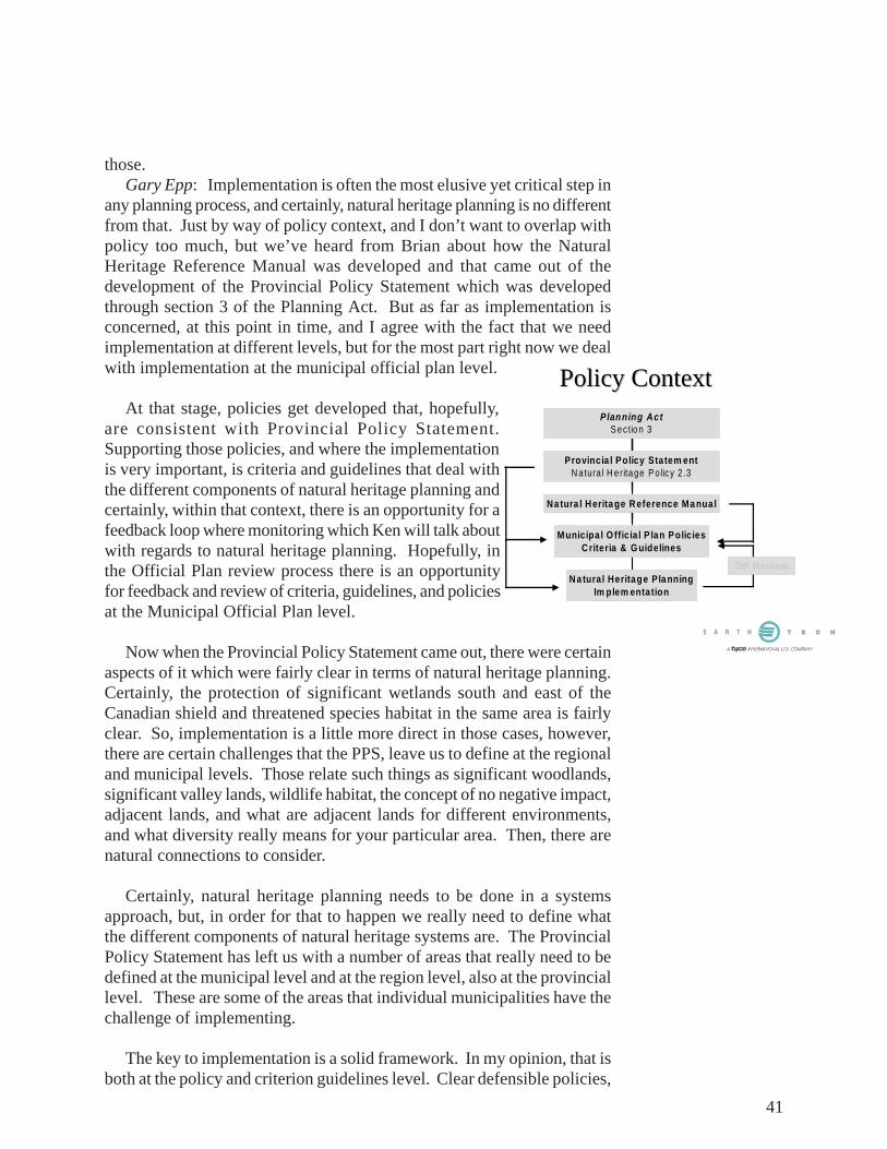
Policy ContextPolicy Context
Na tura l Heritage Pla nningIm plem entation
Municipa l O fficia l P lan PoliciesCriteria & G uidelines
Na tura l Herita ge Reference Ma nual
Provincia l Policy Sta tem entN atura l H e ritage P o licy 2 .3
Planning ActS ection 3
OP Review
those.Gary Epp: Implementation is often the most elusive yet critical step in
any planning process, and certainly, natural heritage planning is no differentfrom that. Just by way of policy context, and I don’t want to overlap withpolicy too much, but we’ve heard from Brian about how the NaturalHeritage Reference Manual was developed and that came out of thedevelopment of the Provincial Policy Statement which was developedthrough section 3 of the Planning Act. But as far as implementation isconcerned, at this point in time, and I agree with the fact that we needimplementation at different levels, but for the most part right now we dealwith implementation at the municipal official plan level.
At that stage, policies get developed that, hopefully,are consistent with Provincial Policy Statement.Supporting those policies, and where the implementationis very important, is criteria and guidelines that deal withthe different components of natural heritage planning andcertainly, within that context, there is an opportunity for afeedback loop where monitoring which Ken will talk aboutwith regards to natural heritage planning. Hopefully, inthe Official Plan review process there is an opportunityfor feedback and review of criteria, guidelines, and policiesat the Municipal Official Plan level.
Now when the Provincial Policy Statement came out, there were certainaspects of it which were fairly clear in terms of natural heritage planning.Certainly, the protection of significant wetlands south and east of theCanadian shield and threatened species habitat in the same area is fairlyclear. So, implementation is a little more direct in those cases, however,there are certain challenges that the PPS, leave us to define at the regionaland municipal levels. Those relate such things as significant woodlands,significant valley lands, wildlife habitat, the concept of no negative impact,adjacent lands, and what are adjacent lands for different environments,and what diversity really means for your particular area. Then, there arenatural connections to consider.
Certainly, natural heritage planning needs to be done in a systemsapproach, but, in order for that to happen we really need to define whatthe different components of natural heritage systems are. The ProvincialPolicy Statement has left us with a number of areas that really need to bedefined at the municipal level and at the region level, also at the provinciallevel. These are some of the areas that individual municipalities have thechallenge of implementing.
The key to implementation is a solid framework. In my opinion, that isboth at the policy and criterion guidelines level. Clear defensible policies,
42
criteria, and guidelines are required for significant features and functionswithin the context of a natural heritage system, and in order for that towork, it has to be done in collaboration between planners, scientists andthe public. In order for a natural heritage system to be meaningful to yourparticular area, it has got to have public buy in. We can throw all thescience we want at a particular issue, but if we don’t have public buy inand acceptance of what the natural heritage system means for that particulararea, it is a tough row to hoe to protect that area if you don’t have that kindof buy in.
Now, what are the steps to implementation? First, I think, for naturalheritage planning, you need some sort of a vision for your area, whereverthe bounds or whether it’s a municipality or a region. There has to besome buy in at each of the levels as to what the vision is for that area, andhow much you want to protect. Is it everything? Is it just what is significant?Do you want to deal with a systems approach? Then, that has to be formedinto some sort of a natural heritage system. Of course, we need to identifyand delineate areas; that is a critical point when we are dealing withimplementation. You need to know what it is you’re going to protect anddeal with, and where it is. There has to be some form of identification anddelineation. Once you have done so, there needs to be a mechanism inplace to designate those particular areas and zone them appropriately, suchthat the protection measures are in place, certainly to a certain level forprotection of natural heritage features and functions.
Then you need to deal with the threats. Environmental impact studyprocesses are needed and how do you deal with development pressures onthose areas, even once you have designated them and put them in place.How do you deal with the threats? We have heard about a number ofdifferent threats in Carolinian Canada, particularly for those areas that arealready designated. Then we need to know what the successes of what wehave implemented and monitor that in order to determine whether ourimplementation is effective and how we can improve on it, feed it back tothe official plan, and criterion guideline level in order to refine things,because our knowledge is ever evolving and certainly our knowledge ofhow to deal with natural heritage planning is evolving. Really, we are atan infant stage when it comes to natural heritage planning in this Provinceand we have got a long way to go.
What are the tools for implementation, and this appliesto hopefully most areas, certainly clear and defensiblepolicies. Your implementation can’t go anywhere unlessyou have got very clear and defensible policies, becauseyou will be challenged at the Municipal Board when itcomes to environmental management and protection. Youneed an identified natural heritage system so that all theplayers know what the rules are, where the extent of whatyou want to protect is, and in order for everybody to havea common knowledge of what the direction and vision isfor a particular area. Then you need criterion guidelinesto back that up, to identify it, to provide some scientific
Tools for ImplementationTools for Implementation
�� Clear and Defensible PoliciesClear and Defensible Policies
�� An Identified Natural Heritage SystemAn Identified Natural Heritage System
�� Criteria & Guidelines for NHS Components Criteria & Guidelines for NHS Components (Woodlands, Valleylands, Habitat, …)(Woodlands, Valleylands, Habitat, …)
�� Acquisition & Stewardship ProgramsAcquisition & Stewardship Programs
�� Environmental Impact Study ProcessEnvironmental Impact Study Process
�� Rehabilitation & Enhancement PlansRehabilitation & Enhancement Plans
collaborationbetween planners,scientists and the
public

43
background to the identification and protection of areas. They certainlyneed to be developed. In different areas a number of the differentcomponents of natural heritage systems, namely, significant woodlands,significant valley lands, habitat et cetera, and the concept of no negativeimpact must be defined. A lot of these things appear to be fine on surfacelevel, but then you start getting into defending what “no negative impact”is or defining what a significant woodland is. You really need very clearcriterion guidelines. The City of London is an example of an area that isgoing through the process of providing fairly concrete significant woodlandcriterion evaluation system, but I think this is lacking in quite a fewmunicipalities around the Province. We certainly have a lot of differentcomponents to deal with in the natural heritage system.
Acquisition and stewardship programs: what do we do with the naturalheritage system once we have identified it? Does the municipality want itacquired, or do we want to implement stewardship programs for thoseareas?
Then, of course, you need an environmental impact study process thatBrian talked about. Certainly, the scoping aspect is very important. Whenwe were talking about this within the Natural Heritage Review Manualprocess, environmental impact studies were the focus of a lot of discussionand scoping really seemed to be the answer in terms of how we deal withenvironmental impact studies and the process, because you can’t possiblycome up with a long wish list for an environmental impact study that canbe tailored to every situation. So, I think scoping of environmental impactissues, specific to an area, specific to a project, is the key to really providingan area with an effective means of protection and assessing real impactsfor a particular area. Rehabilitation and enhancement plans, certainly buildupon the framework of a natural heritage system, and, considering thesystems that we have in Ontario, there is a real need to have that componentintrinsic in the natural heritage planning process in order to provide uswith viable ecosystems that can carry us into the next century.
What are the keys to success for implementation? First, and foremost,is to set the rules early. There is nothing worse than trying to protect asignificant woodland after the fact, because the rules weren’t set earlyenough. It’s never too early. Now is really too late when you think aboutit. You need to develop policies that are comprehensive.They have to be linked to guidance documents, but theyhave to have policy backing at the provincial level andthere really needs to be a train of thought from theprovincial level through municipal official plans right intothe guidance documents where the real implementationhappens. They have to be specific to planningjurisdictions. I know there is a call for a certain level ofstandardization across the Province, but there are differenttypes of areas that require different levels of protection.Different targets should be set for different areas,depending on what you have within your area. Certainly,Carolinian Canada is different from Northern Ontario,
defending what“no negativeimpact” is
set the rules early
Successful ImplementationSuccessful Implementation
�� Set the Rules EarlySet the Rules Early
�� Develop Comprehensive PoliciesDevelop Comprehensive Policies
�� Specific to the Planning JurisdictionSpecific to the Planning Jurisdiction
�� Establish a Natural Heritage SystemEstablish a Natural Heritage System
�� Consult with ExpertsConsult with Experts
�� Consult with the PublicConsult with the Public
�� Review & UpReview & Up--datedate

44
and there are going to be different targets that need to be set. Certainly,within different municipalities and even within an urban context of aparticular municipality, you may want to set different targets that may beunrealistic in other municipalities, but have relevance to your particularmunicipality. That can apply to protection of locally significant wetlandsand significant woodlands or even areas that may or may not be consideredsignificant. You need to establish a natural heritage system. Everythingreally should be built upon that framework.
I think you need to always consult with experts because, when it comesto challenges you are going to be faced up against experts, so as much asthis is an advertisement, I think that it is true to form that you will bechallenged by experts at the Municipal Board. So, when you are developingyour guidance documents, your criterion guidelines, whatever, you needto involve experts, whether you have them on staff or not. That is the cruxof how far you will get with your natural heritage protection is the backingin terms of guidance documents.
Then consult with the public, always, because really we are the keepersand protectors, hopefully, of the natural heritage system within whatevermunicipality we are in. Really, the natural heritage system belongs toeverybody, and that is the public. You are part of the public, but in orderto sell the protection of natural heritage system, you really need to havethat public buy in. Of course, in order to be up with the times in terms ofhow you protect things and plan for areas you need to review and update.That can be done through the official plan process or simply throughupdating your own natural heritage system.

45
Ken Ursic: I was pretty impressed with the Round Robin session. Iwas jotting down questions and I’ve been thinking that it would be greatto have a second day just to sit down and to try to tackle those questions.A lot of insights coming from so many different backgrounds representedhere.
I was asked to speak about monitoring, but it seems like other peoplehave been talking about monitoring throughout the discussions, and notjust the nature of monitoring, it really does permeate and extend into everyaspect of good planning. I think of monitoring as just taking the blindersoff. If you’re not observing and collecting information and gatheringinformation, you are not monitoring. We do monitoring when we drive.We do monitoring when we plan for transportation and all these otheraspects, but when it comes to natural heritage we tend to put the blinderson. The Provincial Policy Statement, even if you look at the NaturalHeritage Training Manual, it does include monitoring, but there is only aparagraph on it towards the end, and then Section 6 that deals with largerscale monitoring issues, like performance indicators. There is just lipservice paid to it and the same is true when it comes to the implementationlevel which Gary just said was critically important for actually makingnatural heritage systems work.
I’m a terrestrial Ecologist, my training is in Botany. I am also not anEnvironmental Planner, so I don’t know all that much about policy otherthan what it takes to undertake impact assessments, sub-watershed studies,and secondary plans, those types of things. In terms of policy, I thinkthose planning documents, the policies, the guidelines for impactassessments, they really need to be beefed up in terms of monitoring.Monitoring actually begins at the inventory stage. As soon as you arecollecting your baseline data for any development, you are also undertakingmonitoring. So it is also valuable at that point in time to look forward andconsider what may potentially be on that piece of ground in the future bycontext, and relationship with the natural heritage system you are tryingto protect. You might as well be collecting data at that point in time toassist you with long term monitoring your goals and objectives.
Adaptive management and other techniques can be used to assistplanners in dealing with natural heritage systems. As an Ecologist, I knowthat natural systems can be extremely complex and extremely dynamic aswell, and it is very difficult to be able to predict which way an ecosystemwill develop. Even in the science of ecology, it hasn’t been that long sincewe have learned to deal with describing how two different organisms ortwo different environmental factors actually interact. It took us a longtime to actually come up with methods to test the interaction of two things.I guess it’s with the current level of sophistication in the science of ecology.It’s still difficult to determine how three things interact, properly; evenunder laboratory conditions this can be a challenge. So when you think ofan ecosystem with all its different components—all interacting at differentlevels with different scales, space and time—then you have the task ofactually planning for what this thing is going to become or for what you’dlike to turn it into. It’s a formidable challenge. The only way the planners
when it comes to naturalheritage we tend to put
the blinders on
monitoring is takingthe blinders off
guidelines for impactassessments need to bebeefed up in terms of
monitoring
it’s difficult to determinehow three things
interact...with differentscales, space and time

46
can actually start to deal with this uncertainty, the only thing they can dois actually monitor. You can’t just inventory this. You can’t be contentwith the fact that we actually know we have evaluated this feature. It’s asignificant wetland and we have planned for it. That’s not planning. Youhave to monitor, continuously, to be able to understand the system, whereit came from, where it’s going, what its future needs are. The only wayyou can collect that information is to constantly monitor what you have.Otherwise, we are going back to Hal’s analogy as a palliative care patientwho is being monitored using administered drugs. But even the palliativecare patient gets monitored on a daily basis. We are not doing that withour natural systems.
I heard a comment from naturalists in London about the state of theESA’s and how they have degraded over the years; this is true. Most ESA’sthroughout the province have degraded over the years because of theimpacts of urban development infringing on them. Very little has actuallybeen done to monitor the direction they are heading in and actually takesteps to improve conditions. Adaptive management is a new technique orexperimental framework that they are looking at where it’s combined withmonitoring and you actually collect information using a variety of methods.It is undertaken by a variety of stakeholders and it’s a much more responsivesystem to identify problems early on, and I understand MNR has delvedinto the world of adaptive management. It is still pretty theoretical, at thispoint in time, but it may be one solution, and this set of options needs to bewritten into the policies we have.
As most monitoring occurs at the impact assessment level and theimplementation phase, the way it gets written into polices and officialplans is often through impact assessment guidelines. Although it is noteven written into a great many impact assessment guidelines. There areonly a few municipalities that actually have monitoring written as a specificrequirement. Part of the problem is that municipalities don’t have theresources to undertake monitoring and so they are a little reluctant to putit in. At a larger scale, a landscape scale or, let’s say the scale of a planningjurisdiction or planning authority, the Provincial Policy Statement hasSection 6 which deals with performance indicators, and this is whatmunicipalities should be writing into their official plans in terms ofreviewing basically state of the environment type reporting. Performanceindicators could be the net loss of habitat per given time. This could bereviewed annually and would be very helpful to illustrate, to the politiciansand different stakeholders, how close to meeting your targets you are, orif you are heading in a completely opposite direction. Unless you aremonitoring and doing that accounting of how many natural features youhave in your landscape. Those are all natural features, not just the oneshighlighted for protection in the Provincial Policy statement. You shouldreally have a good understanding of how many habitats we are losingbecause, in the future, meadows may become significant and other marginalfeatures we have in the landscape today may be recognized as significant,so we shouldn’t be short sighted. We should account for everything wehave and everything we are losing, and document it and try to learn fromit and build it into a policy of responsiveness.
the only way theplanners can start to
deal with thisuncertainty, is to monitor
Most ESA’s throughoutthe province havedegraded over the
years because of theimpacts of urban
development infringingon them
Section 6 deals withperformance
indicators...the netloss of habitat per
given time

47
I think that performance indicators are a good technique to getmunicipalities to recognize what is happening in the landscape. I knowthere are a few areas in Ontario where they are doing state of watershedreporting or state of the environment reporting. They are basically reportcards, like Mike Harris’ report cards on the education system or otherfeatures. I believe each municipality should have some sort of standardizedreport card to indicate the state of its natural heritage resources, and, perhapsif you come up with a standardized system, or protocol, as I believe theWorld Wildlife Fund calls it, it could bridge the gap between the provincialgovernment and the local level and could actually start communicatingmore effectively in terms of planning.
I heard from the Round Robin discussion that the Aylmer office islooking at doing remote sensing natural heritage systems and doinganalyses on that. So there are resources available, it’s just that we are sofragmented, and a lot of us are isolated and focussed on specific paths,that there are rare opportunities to actually network and make these thingshappen. So, forums like this are much appreciated to be able to just informother people about what you are doing and what’s possible.
I think that state of environment reporting, on a municipal level to theProvince is a good step. The performance indicators can be very, verygeneral. They don’t have to be detailed. They don’t require a lot offieldwork and ground sweeping. They can just be simple things like howoften has the tree bylaw been enforced this year? How often have wecontaminated a stream? How often have we posted a fish eating advisory?Those types of really general things that don’t require going into the field,taking a detailed sampling that you would at a site level, but just generallygiving environmental practice reporting.
******Wil Pol: Just on the reporting issue: Has the Province initiated through
the Municipal Performance Measures Programme some naturalenvironment measures that municipalities are required to report andpublicize?
Sally Colman: We heard from our regional management training teamon state of the resource reporting which may be coming out in SouthernOntario as a way to comment on the state of the environment. On a locallevel one of the examples that I can throw out as a starting point for theagencies or community groups to say what data we have and can use formonitoring starting point. In our office, the GIS gurus were able to usethe OBM woodland layer and reflect that against the more recent satelliteimagery to compare woodlands that are still on the ground or that havebeen removed or some areas that have been reforested over the years.That would be over about a twenty year time frame and we can use that asa map. We can start a discussion on certain areas about how good themonitoring was and the environmental components that might be usefulto consider.
each municipalityshould have
standardized reportcard to indicate thestate of its naturalheritage resources
How often has the treebylaw been enforced ?
How often have wecontaminated a stream?
How often have we posteda fish eating advisory?
OBM woodland layer andmore recent satelliteimagery to compare
woodlands that are still onthe ground or that havebeen removed or someareas that have been
reforested over a twentyyear time frame

48
Hal Schraeder: The whole issue of monitoring is multidimensional.A lot of monitoring that occurs in government is efficiency-type monitoring.How much paper do we push per day per number of people employed.Then there is effectiveness monitoring, if anything changes out there, canwe see it. Finally, the new industry is efficacy monitoring—is the changedesirable, and is it helpful? That’s where science has got to go. Countingpaper and just watching things change is easy but it takes a lot of resourcesto do that, and, as a result, there are no resources available for efficacymonitoring. If we knew we were getting heealthier then we would knowif we need to better rehabilitate the landscape.
Ken: There are techniques you could use. I should back up and saythat there are two types of monitoring that Provincial Policy Statementidentifies and that’s compliance monitoring and effectiveness monitoring.The compliance monitoring basically looks at whether the proponent hasimplemented the mitigation measures, the promises they’ve made to theplan, and also looking at whether these implementation measures areactually working.
The effectiveness monitoring looks at how things are working over thelong term and they are usually specified where a new type of monitoringprotocol is being used or where it is suspected that some impacts maypotentially occur. So in marginal cases, I feel that monitoring is justcollecting information. It is just collecting information to determinewhether you have met your goals or objectives so you can’t just monitorfor the sake of monitoring. It has to be coupled with some objective. Alot of the official plans out there have good visions and a lot of them haveadopted what the Provincial Policy statement says in terms of their visionsfor natural heritage systems, but that the monitoring is not actually thereto check and provide the feedback to provide to the municipality todetermine whether it is working. That baseline information can be collectedfrom numerous studies, it just needs to be synthesized and something hasto be done with it, and, unfortunately a lot of the municipalities are toounderstaffed to be able to collect all the impact assessment and sub-watershed studies, try to review them, try to make some sense out of it andsee where it fits into official plan visions.
Gary: I had one point to make, and that has to do with the fact thatmonitoring is at the bottom-end of a series of steps in natural heritageplanning and it can only be as good as the steps ahead of it, these being theguideline documents, the planning for a natural heritage system, whichare then, again, based on solid policies, so really your monitoring canonly be as effective as everything that precedes it in terms of setting up
efficacy monitoring—is the change
desirable, and is ithelpful
compliance monitoringbasically looks at whether
the proponent hasimplemented the
mitigation measure
effectivenessmonitoring looks at
how things areworking over the long
term
monitoring can only beas good as the steps
ahead of it

49
the framework for monitoring and then I think there are two, or, at the riskof throwing more types of monitoring into more general types ofmonitoring. One is monitoring of the environment and environmentalhealth, whether it’s at a site specific level or the municipal level or theprovincial level. But, then there is monitoring of your policy and whetherit is effective and that can be monitored through tying into the site specificmonitoring, but also looking at things like official plan and challengesand the case’s success at the OMB based on the polices and guidelines.Are they solid enough to withstand the test challenges, and then you aremonitoring for policy should feedback to your official plan review processsuch that you have got the basis for review and revision of policies andguideline documents such that they are more effective in the future.
Comment from the floor: I have concerns about the number of timesthat we are challenged at the OMB which could be a function of the qualityof the municipal policy but it could also be a measure of the developmentpressure on a certain area.
Gary: Yes, certainly, and the amount of money that the proponent has.
Bill: Not to confuse things further, but, I think that the work Kendescribed was a long list of the things that we need to do with monitoring,but Gary kept using the same word monitoring when, I think that, Garymeant evaluation. What you do with the data that you’ve collected andhow do you make good use of it, and the kind of evaluation that you woulddo would depend on how well do you think the system is right now. Thenyou’d be asking the question, is the policy and are the guidance documentsdelivering what they promise to deliver? It is an accountability kind ofevaluation. Is it doing what it promised? Is it delivering? Another kindwould be advocacy, where we think that like Don that we need much moreon landscape. We need to create linkages, or have larger woodlots thatcan support interior species, and that will be an advocacy kind of evaluationand we would identify that we don’t have enough represented on thelandscape, and we would advocate for change.
******
the number of times thatwe are challenged at the
OMB could be afunction of the quality of
the municipal policy

50this page is intentionally blank


![CARING FOR OUR COAST - Carolinian Canada | Cover Collage pictures supplied by Parks Canada and Kathryn Arthur [1] TABLE OF CONTENTS 2009 FORUM SPONSORSHIP 3 IN-KIND CONTRIBUTIONS](https://img.pdfslide.net/doc/110x75/5ada51b07f8b9a6d7e8c8d8d/caring-for-our-coast-carolinian-canada-cover-collage-pictures-supplied-by-parks.jpg)