Embed Size (px)
Citation preview
CEA Biennial Certification Well Search Report Instructions
1. CEA Biennial Certification Well Search Instructions
A well search of the area surrounding a Classification Exception Area (CEA) is required as part of the biennial certification approval process. To obtain this information two reports are available, via the Department’s web site and Data Miner. Data Miner is a reporting tool used by the Department that can pull live data from the Department's primary database. The two reports are “CEA Biennial Certification Well Search by Atlas Grid" and “CEA Biennial Certification Well Search by Municipality”. These two reports have been designed to automatically filter out monitor well permits and some other types of well permits that are not pertinent to the CEA biennial certification well search process.
To begin this process click on http://www13.state.nj.us/Dataminer/Search/SearchByCategory?is External=y&catName=Site+Remediation select the desired report and follow the “Detailed Instructions” for data entry explained below.
Note - This process is intended for biennial certifications only. The Data Miner well search process is not intended for use when establishing a CEA. To review the process for establishing a CEA, please visit N.J.A.C. 7:26E Technical Requirements 8.3(b)4 on our web site.
2. Detailed Instructions
Detailed instructions for both reports are as follows:
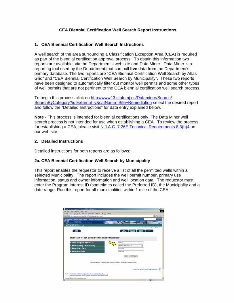
2a. CEA Biennial Certification Well Search by Municipality
This report enables the requestor to receive a list of all the permitted wells within a selected Municipality. The report includes the well permit number, primary use information, status and owner information and well location data. The requestor must enter the Program Interest ID (sometimes called the Preferred ID), the Municipality and a date range. Run this report for all municipalities within 1 mile of the CEA.
• Select the "CEA Biennial Certification Well Search by Municipality" via the
Institutional Controls category in the Site Remediation section of Data Miner • Enter the Program Interest ID (sometimes called the Preferred ID) in the
appropriate field. • Enter the Municipality. More than one municipality can be entered if desired. • Select the desired start date. The start date is the date the Department
established the CEA or the date of the last completed biennial review, whichever is more recent.
• Select the desired end date. • Select OK to review report results.
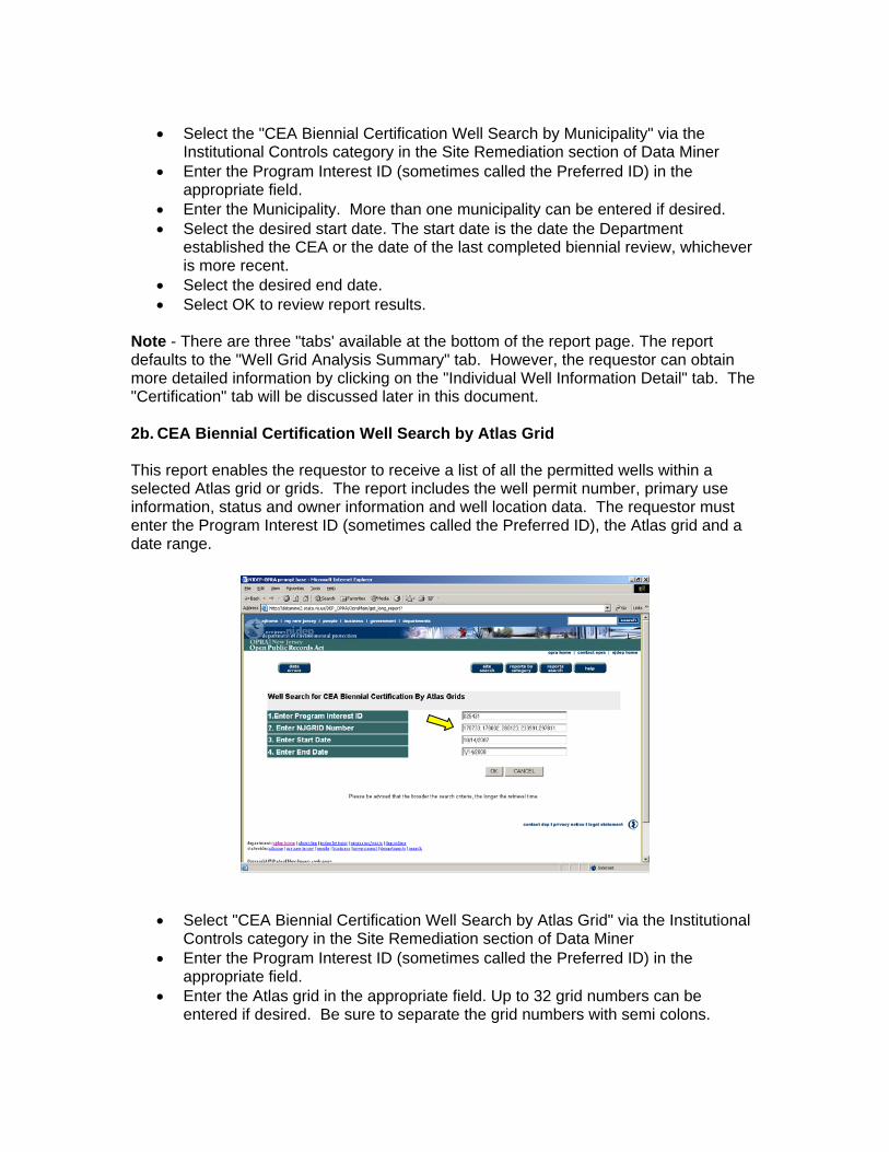
Note - There are three "tabs' available at the bottom of the report page. The report defaults to the "Well Grid Analysis Summary" tab. However, the requestor can obtain more detailed information by clicking on the "Individual Well Information Detail" tab. The "Certification" tab will be discussed later in this document. 2b. CEA Biennial Certification Well Search by Atlas Grid This report enables the requestor to receive a list of all the permitted wells within a selected Atlas grid or grids. The report includes the well permit number, primary use information, status and owner information and well location data. The requestor must enter the Program Interest ID (sometimes called the Preferred ID), the Atlas grid and a date range.
• Select "CEA Biennial Certification Well Search by Atlas Grid" via the Institutional Controls category in the Site Remediation section of Data Miner
• Enter the Program Interest ID (sometimes called the Preferred ID) in the appropriate field.
• Enter the Atlas grid in the appropriate field. Up to 32 grid numbers can be entered if desired. Be sure to separate the grid numbers with semi colons.
• Select the desired start date. The start date is the date the Department established the CEA or the date of the last completed biennial review, whichever is more recent.
• Select the desired end date. • Select OK to review report results.
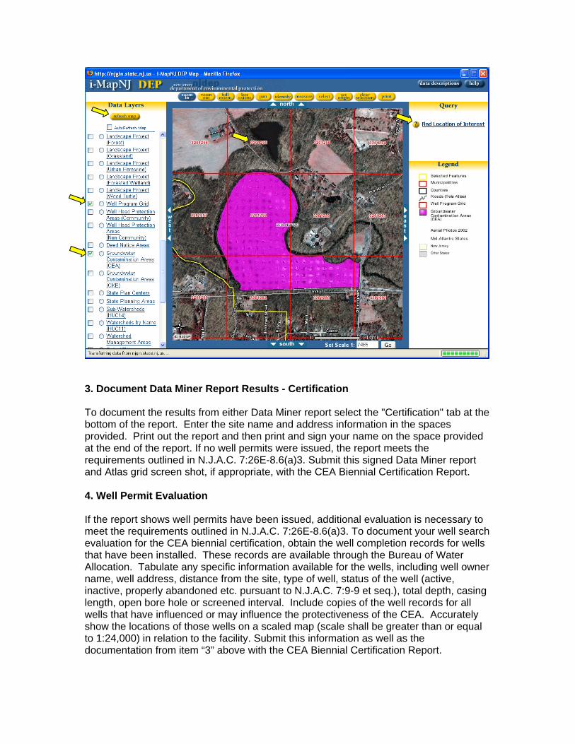
Note - There are three "tabs' available at the bottom of the report page. The report defaults to the "Well Grid Analysis Summary" tab. However, the requestor can obtain more detailed information by clicking on the "Individual Well Information Detail" tab. The "Certification" tab will be discussed later in this document. If the Atlas grids are not known, they can be identified by using IMap on the DEP web site. Click on http://www.nj.gov/dep/gis/depsplash.htm# and select “Launch iMapNJ DEP”
• Use the “Find Location of Interest” query to zoom into the location of the CEA. • Turn on the “Well Program Grid” data layer the “Ground Water Contamination
Areas (CEA)” data layer and the “Aerial Photos 2002” data layer by clicking on the adjacent boxes and clicking on the “refresh map” button.
• The Atlas grid number will be shown in the middle of the grid. Enter all the Atlas grid numbers within a 1-mile radius of the CEA, into the Data Miner data entry window. Capture and print out a screen shot that shows the site and surrounding Atlas grid numbers. Submit a copy of this screen shot along with the documentation identified below if you use the "CEA Biennial Certification Well Search by Atlas Grid" report to identify well permits.
• Currently, a maximum of 32 Atlas grid numbers can be entered into the Atlas grid data entry window. If more than 32 grid numbers are required to fulfill the criteria above, rerun the report, with the additional grid numbers, until all the required grid numbers have been entered.
3. Document Data Miner Report Results - Certification To document the results from either Data Miner report select the "Certification" tab at the bottom of the report. Enter the site name and address information in the spaces provided. Print out the report and then print and sign your name on the space provided at the end of the report. If no well permits were issued, the report meets the requirements outlined in N.J.A.C. 7:26E-8.6(a)3. Submit this signed Data Miner report and Atlas grid screen shot, if appropriate, with the CEA Biennial Certification Report. 4. Well Permit Evaluation If the report shows well permits have been issued, additional evaluation is necessary to meet the requirements outlined in N.J.A.C. 7:26E-8.6(a)3. To document your well search evaluation for the CEA biennial certification, obtain the well completion records for wells that have been installed. These records are available through the Bureau of Water Allocation. Tabulate any specific information available for the wells, including well owner name, well address, distance from the site, type of well, status of the well (active, inactive, properly abandoned etc. pursuant to N.J.A.C. 7:9-9 et seq.), total depth, casing length, open bore hole or screened interval. Include copies of the well records for all wells that have influenced or may influence the protectiveness of the CEA. Accurately show the locations of those wells on a scaled map (scale shall be greater than or equal to 1:24,000) in relation to the facility. Submit this information as well as the documentation from item “3” above with the CEA Biennial Certification Report.

Thank you for using Data Miner and iMapNJ DEP.