Embed Size (px)
Citation preview

CELEBRATING FOUNDATIONS OF URBAN AND REGIONAL INFORMATION SYSTEMS AND GEOGRAPHIC INFORMATION SYSTEMS AND SCIENCE
BARRY WELLAR, EDITORURISA PAST PRESIDENT (1978)
Slides for a plenary session presentation at URISA’s 50th anniversary conference
GIS-PRO 2012Portland Oregon,
September 30-August 14, 2012

Foundations Themes
2Barry Wellar

FOUNDATIONS THEMES, CHAPTER TITLES AND AUTHORS
1 Introduction to Foundations of Urban and Regional Information Systems and Geographic Information Systems and Science
Barry Wellar
3Barry Wellar

2 Bill Garrison Tells Us a Bit about His Friend and Colleague, Ed Horwood (Reprinted from URISA News, Issue 223, September/October 2009, pp. 8-9.)
Barry Wellar
3 Perspectives on URISA’s origin and on the emergence of a theory of urban and regional information systems (Reprinted from Information System Inputs to Policies, Plans, and Programs. Volume 1, Plenary Papers. Barry Wellar, editor. Chicago, IL: Urban and Regional Information Systems Association, 1977, pp.2-19.)
Edgar Horwood
4 Origin and Evolution of URISA
Ken Dueker
FOUNDATIONS THEMES, CHAPTER TITLES AND AUTHORS
4Barry Wellar
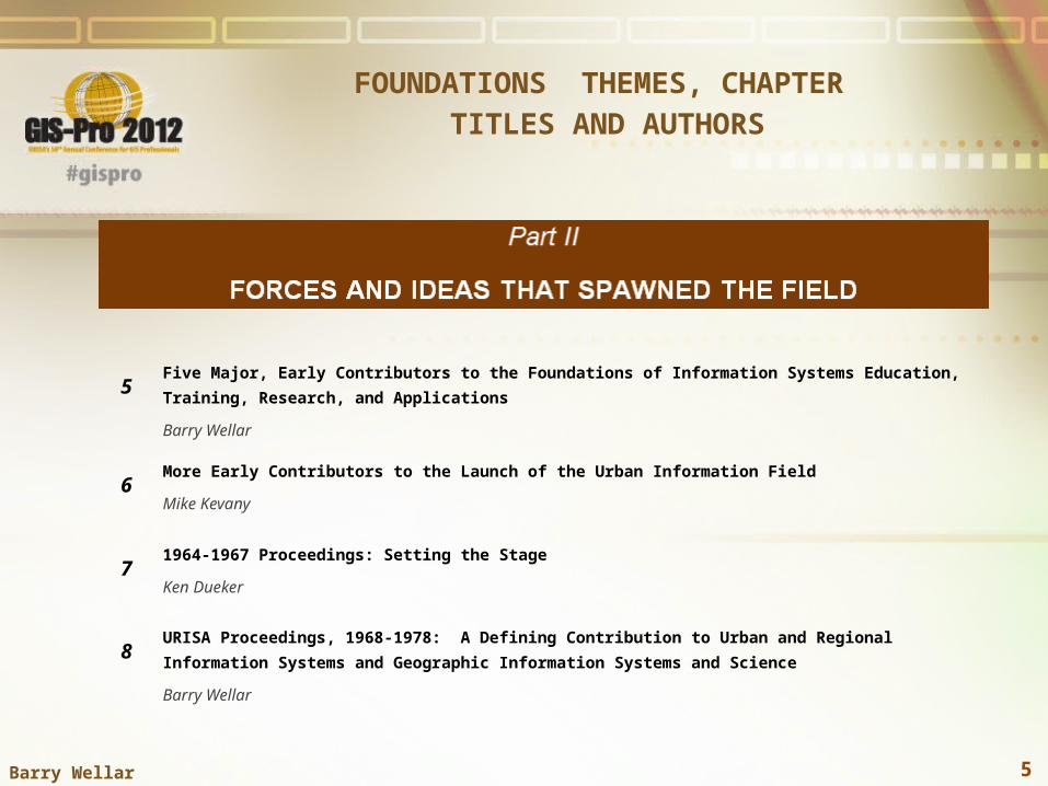
5Five Major, Early Contributors to the Foundations of Information Systems Education, Training, Research, and Applications
Barry Wellar
6More Early Contributors to the Launch of the Urban Information Field
Mike Kevany
71964-1967 Proceedings: Setting the Stage
Ken Dueker
8URISA Proceedings, 1968-1978: A Defining Contribution to Urban and Regional Information Systems and Geographic Information Systems and Science
Barry Wellar
FOUNDATIONS THEMES, CHAPTER TITLES AND AUTHORS
5Barry Wellar

9 IS/GIS/LIS and Public Policies, Plans, and Programs: Thirty Years in Perspective – Recalling a Major Benchmarking Project
Barry Wellar
FOUNDATIONS THEMES, CHAPTER TITLES AND AUTHORS
6Barry Wellar

10 Special Interest Groups (SIGs)
Peter Van Demark
11 Workshops and Workbooks: Leading the Way in Education and Training Based on Research and Applications Support
Barry Wellar
12 The URISA Exemplary Systems in Government (ESIG) Awards: Recognizing Information Systems Delivering Value
Gary Hunter and Dianne Haley
13 A Research Agenda Focused on Institutional Issues
Will Craig
14 URISA’s GISCorps: GIS Professionals Volunteering for a Better World
Shoreh Elhami and Dianne Haley
15 NCGIA: Its Origins and Impacts
Mike Goodchild
16 GIS Management: Major Initiatives and Lessons Learned
Pete Croswell
FOUNDATIONS THEMES, CHAPTER TITLES AND AUTHORS
7Barry Wellar
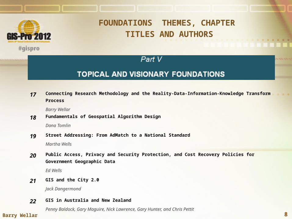
17 Connecting Research Methodology and the Reality-Data-Information-Knowledge Transform Process
Barry Wellar
18 Fundamentals of Geospatial Algorithm Design
Dana Tomlin
19 Street Addressing: From AdMatch to a National Standard
Martha Wells
20 Public Access, Privacy and Security Protection, and Cost Recovery Policies for Government Geographic Data
Ed Wells
21 GIS and the City 2.0
Jack Dangermond
22 GIS in Australia and New Zealand
Penny Baldock, Gary Maguire, Nick Lawrence, Gary Hunter, and Chris Pettit
FOUNDATIONS THEMES, CHAPTER TITLES AND AUTHORS
8Barry Wellar

23 Reflecting Upon the Foundations Project and Its ImplicationsBarry Wellar
FOUNDATIONS THEMES, CHAPTER TITLES AND AUTHORS
9Barry Wellar
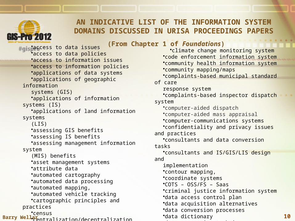
AN INDICATIVE LIST OF THE INFORMATION SYSTEM DOMAINS DISCUSSED IN URISA PROCEEDINGS PAPERS
•access to data issues•access to data policies•access to information issues•access to information policies•applications of data systems•applications of geographic information systems (GIS)•applications of information systems (IS)•applications of land information systems (LIS)•assessing GIS benefits•assessing IS benefits•assessing management information system (MIS) benefits•asset management systems•attribute data•automated cartography•automated data processing•automated mapping,•automated vehicle tracking•cartographic principles and practices•census•centralization/decentralization issues
•climate change monitoring system•code enforcement information system•community health information system•community mapping/maps•complaints-based municipal standard of care response system•complaints-based inspector dispatch system•computer-aided dispatch•computer-aided mass appraisal•computer-communications systems•confidentiality and privacy issues and practices•consultants and data conversion tasks•consultants and IS/GIS/LIS design and implementation•contour mapping,•coordinate systems•COTS – OSS/FS – Saas•criminal justice information system•data access control plan•data acquisition alternatives•data conversion processes•data dictionary•data generation techniques
(From Chapter 1 of Foundations)
10Barry Wellar

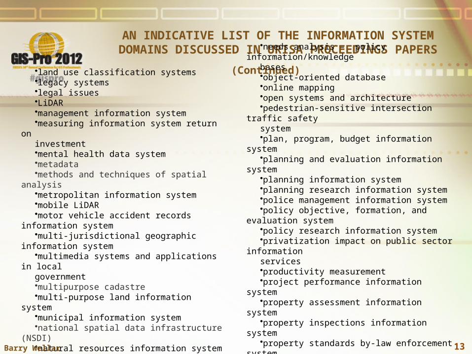
AN INDICATIVE LIST OF THE INFORMATION SYSTEM DOMAINS DISCUSSED IN URISA PROCEEDINGS PAPERS
(Continued)
•data layers/overlays•data maintenance•data models•data sharing issues/protocols•data sources and data acquisition/transfer caveats and protocols •data standards•decision support information system•development monitoring/tracking
information system•devolution impact on municipal government information services•digital elevation model•digital mapping•digital terrain model •dispatch Information system•“Doomsday Map” •economic development information system•electronic data processing•emergency response information system •enterprise geographic information system•environmental impact assessment information system
•environmental information system •environmental technical information system•evaluating information system performance•exemplary systems/best practices •expert and knowledge-based information system•facility management system•financial information system•fiscal impact analysis•fiscal information system•geocoding •geodatabase structures•geographic base file•geographically-referenced data storage and retrieval system•geographic concepts defining GIS•geographic information system (GIS)•geographic knowledge system •geomatics•georeferencing•geospatial technology•geostatistics•GIS planning and implementation•GIS trends
11Barry Wellar

AN INDICATIVE LIST OF THE INFORMATION SYSTEM DOMAINS DISCUSSED IN URISA PROCEEDINGS PAPERS
(Continued)
•global positioning systems•globalization impact on community information strategies•Google (street view, etc.) •hazard information systems•health information system•housing information system•human resources management information
system•imaging systems•impact assessment
principles/practices/techniques•indexes and other metrics for evaluating/grading/measuring performance •informatics•information and knowledge bases for decision-making•Information interchange protocols•information management systems•information research services•information science•information society•information system architecture•information system functionality•information system performance
•information systems and critical/essential infrastructure•information system trends•informational activity criteria•informing and listening to the public•infrastructure management and maintenance information system•in-house/out-source principles and practices•institutional and organizational factors•institutional maxims and conditions•integrating land records databases•integrated municipal information system•integrated system development•interactive GIS•interdependent infrastructures and information systems•intergovernmental information system•internet GIS •land information system•land market information system•land parcel information system •land records information system •land registration information system•land/structure/occupancy database
12Barry Wellar
AN INDICATIVE LIST OF THE INFORMATION SYSTEM DOMAINS DISCUSSED IN URISA PROCEEDINGS PAPERS
(Continued)
•land use classification systems•legacy systems•legal issues•LiDAR•management information system•measuring information system return on investment•mental health data system•metadata•methods and techniques of spatial analysis•metropolitan information system•mobile LiDAR•motor vehicle accident records information system•multi-jurisdictional geographic information system•multimedia systems and applications in localgovernment•multipurpose cadastre•multi-purpose land information system•municipal information system•national spatial data infrastructure (NSDI)•natural resources information system•needs analysis – data•needs analysis – information
•needs analysis – policy information/knowledge bases•object-oriented database•online mapping•open systems and architecture•pedestrian-sensitive intersection traffic safety system•plan, program, budget information system •planning and evaluation information system•planning information system•planning research information system•police management information system•policy objective, formation, and evaluation system•policy research information system•privatization impact on public sector information services•productivity measurement•project performance information system•property assessment information system•property inspections information system•property standards by-law enforcement system•prosecution management information system •public participation geographic information system
13Barry Wellar

AN INDICATIVE LIST OF THE INFORMATION SYSTEM DOMAINS DISCUSSED IN URISA PROCEEDINGS PAPERS
(Continued)
•public policy and IS/GIS/LIS inputs•quality assurance for GIS•quality control procedures and systems •real estate information system •regional information system•regional management information system•relational database-management system,•remote sensing systems•residential appraisal information system•resource allocation models•return on investment principles and practices•routing systems (vehicles, utilities, etc.)•school districting information system•small area data needs/issues•social indicators information system •spatial analysis for business•spatial analysis techniques
•spatial data infrastructures•spatial data transfer standard (SDTS)•spatial data warehouse•standard of care information obligations•standardization processes•street addressing•topology•traffic management information system •transferability concepts, principles, and practices•transit planning information system •transportation information system•water and wastewater information system•urban data models•urban development information system•urban information system•Urban Information System Inter-Agency Committee (USAC) project •zoning information system
14Barry Wellar

SPECIAL INTEREST GROUPS (SIGS) WITH START AND END DATES
(From Chapter 10 of Foundations)
Name Start Date End Date
AI-SIG 1988 After 1994
Cadastre 1977 After 1980
Criminal Justice Applications Before 1976 After 1980
Data Base Management Before 1976 After 1980
Decennial Census Before 1976 After 1980
Education and Technology Transfer 1988 After 1993
Education and Training Before 1976 After 1980
End-User 1989 After 1990
Environment & Natural Resources Before 1978 After 1997
Evaluation Before 1976 After 1980
Facilities Management & Mapping 1985 After 1988
Federal Information Systems Before 1976 After 1977
GBF 1971 After 1993
Human Service Systems Before 1976 After 1980
15Barry Wellar

SPECIAL INTEREST GROUPS (SIGS) WITH START AND END DATES
(From Chapter 10 of Foundations)(Continued)
Name Start Date End Date
Human Service Systems Before 1976 After 1980
Information Resources Management 1983 After 1989
Infrastructure Management 1987 After 1993
Integrated Systems 1989 After 1997
International Before 1976 After 1980
Land Records Modernization 1983 After 1994
Low Cost Technology Before 1978 After 1980
Mapping Lead Exposure 1993 After 1997
Metadata Between 1993 & 1997 After 1997
Microcomputers/MacSIG Between 1979 & 1983 After 1991
Minicomputer Technology Before 1976 After 1980
Multi-Media 1993 After 1997
Privacy & Confidentiality 1977 After 1978
Private Sector Before 1976 After 1977
16Barry Wellar

SPECIAL INTEREST GROUPS (SIGS) WITH START AND END DATES
(From Chapter 10 of Foundations)(Continued)
Name Start Date End Date
Public Administration 1983 After 1991
Public Information Access 1986 After 1997
Public Safety 1989 After 1994
Public Works 1984 After 1988
Regional Agencies Before 1988 After 1997
Remote Sensing Applications Before 1976 After 1980
Small Cities & Counties Before 1978 After 1980
Social Indicators Before 1976 After 1980
Spatial Decision Support Systems 1992 After 1992
Standards 1972 After 1977
State/Province 1989 After 1993
Student Before 1976 After 1978
Systems Integration 1985 After 1989
Technology Transfer Before 1976 After 1978
17Barry Wellar

SPECIAL INTEREST GROUPS (SIGS) WITH START AND END DATES
(From Chapter 10 of Foundations)(Continued)
Name Start Date End Date
Tiger Census 1995 After 1997
Transportation 1977 After 1997
Urban & Regional Analysis 1987 After 1993
User Access 1977 After 1980
Water/Water Waste Public Works 1993 After 1997
Barry Wellar 18

Table 4. Partial Listing of URISA Workshops in Alphabetical Order and Year of Initial
Presentation(From Chapter 11 of Foundations)
1. Addressing – 19952. Address Issues and IS/GIS Implementation – 19993. AI/Expert systems – 19884. AM/FM/GIS for Infrastructure Management – 19875. AM/FM/GIS for Public Works – 20006. AM/FM/GIS for Water/Wastewater – 19957. Assessment and Performance Measurement – 19778. Asset Management – 20049. Automated Data Processing –196810. Automated Mapping and Geoprocessing (Introduction)
– 198511. Benefits for Small Cities (Establishing Information) –
197112. Bridging the Geo Spatial Knowledge Gap – 1999 13. Building Files (Master) – 197414. Business Intelligence – 201115. Cartography & Map Design – 199116. Census Data and Census Use – 197317. Census Data in Information Systems (Extending Use)
– 197118. Census Data User Feedback and Interchange – 197119. Census Geography – 199820. Census TIGER Data – 198921. Census 1980 – 1977
22. Census 2000 – 199823. Civil Engineering and GIS/IT Integration – 200624. Clean Water Act – 199125. Communication Skills – 199726. Computer Graphics – 198327. Computers (Getting Started in) – 198328. Computers and Information Systems: A Financial Manager’s
Perspective –198029. Computers and Public Finance: Alternatives for the Future –
197630. Confidentiality – 1973 31. Consensus Building – 199332. Consultants and Vendors (Roles and Responsibilities) – 197733. Cost-Benefit Analysis in Municipal Information Systems – 197334. Crime Mapping – 200935. Curricula and Information Systems Programs (University) –
197736. Database Development and Conversion – 199937. Data Conversion – 199338. Data Distribution Policies, Costs, Indexes, Systems – 199939. Data Distribution Policies/E-Government – 199640. Data Generation Techniques – 196841. Data Management Systems – 197342. Data Standardization – 1973
19Barry Wellar

Table 4. Partial Listing of URISA Workshops in Alphabetical Order and Year of Initial
Presentation(From Chapter 11 of Foundations)
(Continued)
43. Desktop Mapping (Beyond) – 199544. Digital Orthophotography: Production and Application – 199945. Digital Orthophotos –199446. Disaster Preparedness – 200047. Disaster Strikes – 199748. Document Imaging & Integrating documents with GIS – 199949. Document Retrieval in Information Systems – 197150. E-Commerce for Local Governments – 199951. Electronic Data Processing and Its Application to Planning –
196452. Electronic Data Processing Systems – 196553. Emergency Preparedness – 201254. Enterprise Information Modeling – 199355. Evaluation – 197456. Federal Actions (How to Bring About) – 197157. Field Automation – 200458. Financial Manager’s Perspective (Computers and Information
Systems) – 198059. Financial Management Systems (Modernizing) – 1995Fire
Services – 197660. Freedom of Information – 197761. Functional Roles in Information System Design – 197662. Geocoding (User) – 197363. Geocoding (Techniques) – 1973
64. Geodetic Control – 197865. Geodetic Reference System – 198866. Geographic Base Files – 197567. Geographic Base File Developments – 197168. Geoprocessing – 197469. Geoprocessing (Advanced: A Database Approach)
– 198570. Geoprocessing for Local Government
(Introduction) – 198771. Geoscience Career Growth – 199872. GIS & Business – 199773. GIS & Document Imaging – 199474. GIS & Emergency Management – 199175. GIS & Geographic Imaging (Integrating) – 199976. GIS & Internet – 199577. GIS & Information Systems Integration – 199978. GIS & Natural Resource Management – 198979. GIS & Public Works – 199980. GIS & Real Estate – 199181. GIS & Transportation – 198982. GIS & Transportation: Introduction to GIS-T – 199283. GIS & Urban and Regional Planning – 199784. GIS (Advanced Topics) – 1987
20Barry Wellar

Table 4. Partial Listing of URISA Workshops in Alphabetical Order and Year of Initial
Presentation(From Chapter 11 of Foundations)
(Continued)
85. GIS Applications for Assessors – 199386. GIS Conceptual Data Model (Implementation) –
199387. GIS Database Construction (Advanced) – 199388. GIS for Data Processors – 198989. GIS Conversion Strategies (Optimizing) – 199090. GIS Database Design/Models – 199391. GIS Data Base Development – 198992. GIS Enterprise Architecture and System Integration
–199493. GIS Implementation (Managing) - 199994. GIS (Introduction) – 198495. GIS Management – 198896. GIS Partnerships (Consensus Building Techniques)
– 199397. GIS Procurement – 199998. GIS Program Management – 200499. GIS ROI – 2012100. GIS Strategic Planning – 2008101. Goals of URISA – 1971102. GPS – 1994103. GPS (Hands-on) – 1996104. GPS, Imagery, and GIS – 1997105. GPS (Introduction) – 1999106. Hardware Alternatives for GIS and Office Automation (Understanding) –1992
107. Highway Inventory and Maintenance – 1997108. Human Element in Information Systems – 1973109. IGIS Technology (Low Cost) – 1974110. Information at Your Fingertips – 1985111. Information Benefits for Small Cities (Establishing) – 1971112. Information Management – 1965113. Information Systems Technology Transfer – 1976114. Interactive Computer Graphics – 1982115. Intergovernmental Relations – 1977116. Integrated Information Systems – 1972117. International Exchanges – 1977118. International Information Systems – 1985119. International Information Technology for Development – 1976120. Internet GIS – 1998121. ISO Geostandards – 2011122. Land Classification Detection –1997123. Land Management Systems – 1984124. Land Records Modernization and the Multipurpose Cadastre –
1987125. Law and Public Information Policy – 1999126. Law Enforcement and Criminal Justice Information Systems –
1976
21Barry Wellar

Table 4. Partial Listing of URISA Workshops in Alphabetical Order and Year of Initial
Presentation(From Chapter 11 of Foundations)
(Continued)
127. Leadership – 1988128. LiDAR – 2006129. Low Cost IGIS Technology – 1974130. Low Cost Technology – 1977131. Management Topics in GIS Development – 1988132. Managing EDP Systems –1968133. Map design: Making Better Maps – 1992134. Mapping on the Macintosh – 1989135. Marketing Information Services and Products – 1985136. Marketing Management for Public Agencies – 1985137. Metadata – 1998138. Micros: How to Select and Procure – 1984139. Microcomputer Issues (Advanced) – 1984140. Microcomputers and Transit Management – 1984141. Microcomputers for Local Government – 1982142. Microcomputer Techniques for Growth Management – 1987143. Minicomputer Applications – 1978144. Minicomputers and Low-cost Data processing – 1976145. Minicomputers and State and Local Government Data
Processing – 1976146. Model Cities Applications and Developments – 1971147. Multimedia – 1991148. Multimedia GIS and the Web – 1997
149. Municipal Information Systems Research – 1966150. Municipal Mapping & Geoprocessing Systems – 1984151. NASA/NSF Remote Sensing Forum – 2000152. National Spatial Data Infrastructure framework – 1998 153. National Statistical Programs – 1977154. Natural Resources/Environmental Assessment: The
Minnesota Land Management Information System – 1982155. New Directions in Urban Management: Geoprocessing
and Data Base Management – 1982156. 911 (Next Generation) – 2012157. 1980 Census Data Processing – 1982158. Object-Oriented GIS Technology (Introduction) – 1999159. Object-Oriented Spatio-Temporal Modeling – 2006160. Open Source GIS – 2005161. Parcel Mapping Fundamentals – 1991162. Parcel Mapping/GIS for Assessors – 1989163. Permit Tracking and Development Monitoring – 1987164. Photogrammetric Methods – 1986165. Policy Processes – 1977166. Positioning Accuracy Standards (New) – 2000167. Presentation Skills – 1986
22Barry Wellar
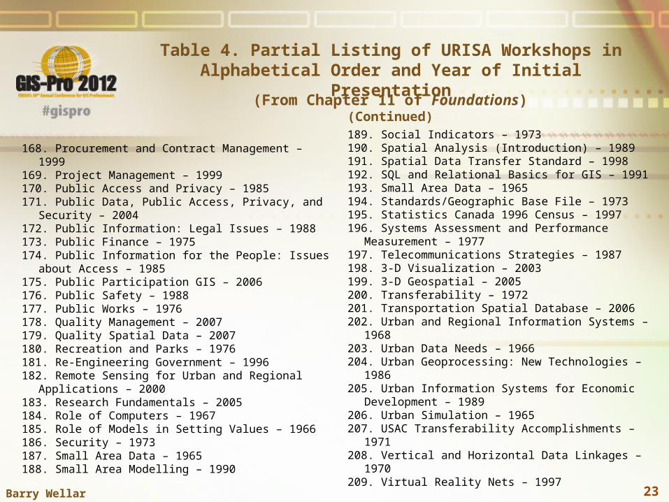
Table 4. Partial Listing of URISA Workshops in Alphabetical Order and Year of Initial
Presentation(From Chapter 11 of Foundations)
(Continued)
168. Procurement and Contract Management – 1999169. Project Management – 1999170. Public Access and Privacy – 1985171. Public Data, Public Access, Privacy, and Security – 2004 172. Public Information: Legal Issues – 1988173. Public Finance – 1975174. Public Information for the People: Issues about Access –
1985175. Public Participation GIS – 2006176. Public Safety – 1988177. Public Works – 1976178. Quality Management – 2007179. Quality Spatial Data – 2007180. Recreation and Parks – 1976181. Re-Engineering Government – 1996182. Remote Sensing for Urban and Regional Applications –
2000183. Research Fundamentals – 2005184. Role of Computers – 1967185. Role of Models in Setting Values – 1966186. Security – 1973187. Small Area Data – 1965188. Small Area Modelling – 1990
189. Social Indicators – 1973190. Spatial Analysis (Introduction) – 1989191. Spatial Data Transfer Standard – 1998192. SQL and Relational Basics for GIS – 1991193. Small Area Data – 1965194. Standards/Geographic Base File – 1973195. Statistics Canada 1996 Census – 1997196. Systems Assessment and Performance Measurement –
1977197. Telecommunications Strategies – 1987198. 3-D Visualization – 2003 199. 3-D Geospatial – 2005200. Transferability – 1972201. Transportation Spatial Database – 2006202. Urban and Regional Information Systems –1968203. Urban Data Needs – 1966204. Urban Geoprocessing: New Technologies – 1986205. Urban Information Systems for Economic Development –
1989206. Urban Simulation – 1965207. USAC Transferability Accomplishments – 1971208. Vertical and Horizontal Data Linkages – 1970209. Virtual Reality Nets – 1997
23Barry Wellar

CELEBRATING AND SALUTING URISA’S DOMAIN COVERAGE
The list of domains covered is extraordinary, and represents a
presence in virtually every foundation comprising the field of
urban and regional information systems and geographic
information systems and science.
24Barry Wellar

CELEBRATING AND SALUTING URISA’S SPECIAL INTEREST GROUPS
The list of special interest groups by name, time of inception,
and duration in points to an organization at the front end of
education, research, training, and applications in many of the
core aspects of urban and regional information systems and
geographic information systems and science.
25Barry Wellar

CELEBRATING AND SALUTING URISA’S WORKSHOPS
The list of workshops by name and time of inception in Table 4
testifies to an organization at the leading edge of defining,
designing, and implementing the foundations of education,
research, training, and applications in many of the core
aspects of urban and regional information systems and
geographic information systems and science.
26Barry Wellar

SALUTE TO URISA
It is appropriate to close this presentation by saluting URISA in
recognition of the role it played and continues to play in
providing the venue behind the domains, special interest
groups, and workshops, and the numerous other
accomplishments which are identified in chapters throughout
Foundations of Urban and Regional Information Systems and
Geographic Information Systems and Science.
27Barry Wellar

CLOSING WORDS OF
INSPIRATION
For those who sign on to sustain what this project started, I
take my departure by sharing these words of inspiration:
Relish the challenge, Seize the opportunity.
And, to end with a touch of flair in memory of Edgar Horwood,
a combination of French and Latin,
Savoure le défi, Oblatum occasionem tene.
28Barry Wellar