Embed Size (px)
Citation preview
1 of 36
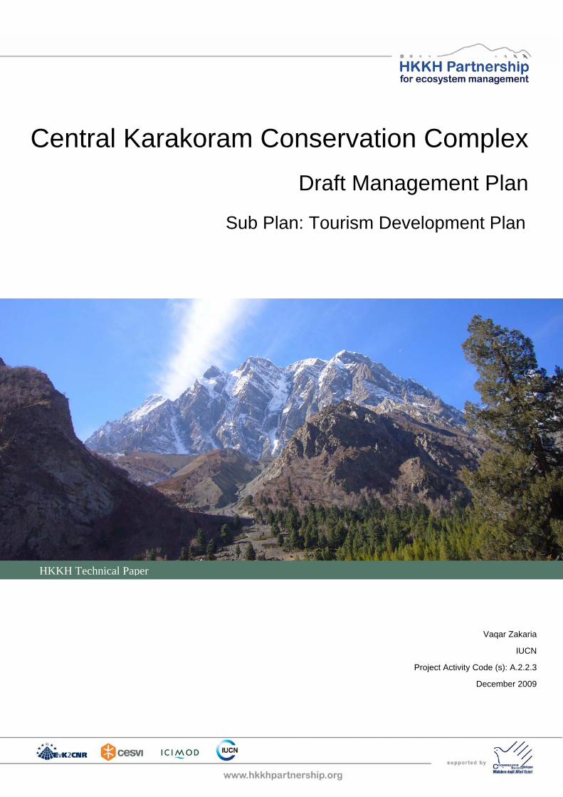
Central Karakoram Conservation Complex
Draft Management Plan
Sub Plan: Tourism Development Plan
HKKH Technical Paper
Vaqar Zakaria
IUCN
Project Activity Code (s): A.2.2.3
December 2009

2 of 36
This document was produced in the framework of the Project ‘Institutional Consolidation for the Coordinated and Integrated Monitoring of Natural Resources towards Sustainable Development and Environmental Conservation in the Hindu Kush-Karakoram-Himalaya Mountain Complex’ financed by the Italian Ministry of Foreign Affairs – DGCS. The presentation of material in this document and the geographical designations employed do not imply the expression of any opinion whatsoever on the part of any of the agencies involved, concerning the legal status of any country, territory, or area, or concerning the delimitation of its frontiers or boundaries or boundaries.
3 of 36
Contents
1. Introduction.........................................................................................5
2. Framework for Development of Tourism provided by the CKCC Management Plan.............................................................................10
3. Review of the Baseline ....................................................................15
4. Strategy for Development of Tourism in CKCC ............................24
5. Action Plan........................................................................................34
Exhibits
Exhibit 1.1: Boundary of the CKCC Proposed in the Management Plan....................6
Exhibit 1.2: Watershed Valleys in the CKCC.................................................................6
Exhibit 1.3: Selected Views of the Valleys ....................................................................7
Exhibit 2.1: Classification of CKCC According to IUCN Protected Area Categories12
Exhibit 2.2: Management Zones in CKNP....................................................................13
Exhibit 2.3: Management Prescriptions for Zones in the CKNP ...............................14
Exhibit 3.1: Tourism Resources in the G-B and CKCC..............................................16
Exhibit 3.2: Tourism Facilities and Relative Tourism Traffic in the CKCC...............22
Exhibit 3.3: Visitor Numbers for Mountaineering Expeditions and Trekking Parties23
5 of 36
1. Introduction
A Management Plan for the Central Karakorum Conservation Complex (CKCC) has been prepared under the regional project “Institutional Consolidation for the Coordinated and Integrated Monitoring of Natural Resources towards Sustainable Development and Environmental Conservation in the Hindu Kush-Karakoram-Himalaya Mountain Complex” (generally referred as the HKKH Project) by the IUCN in partnership with Ev-K2-CNR, the International Centre for Integrated Mountain Development (ICIMOD) and the Italian NGO Cooperazione e Sviluppo (CESVI)1. This Plan for Development of Tourism in the CKCC has been prepared by Hagler Bailly Pakistan as a part of the Management Plan for the CKCC (Management Plan), and conforms to the concepts, objectives, framework, and guidelines presented in the Management Plan.
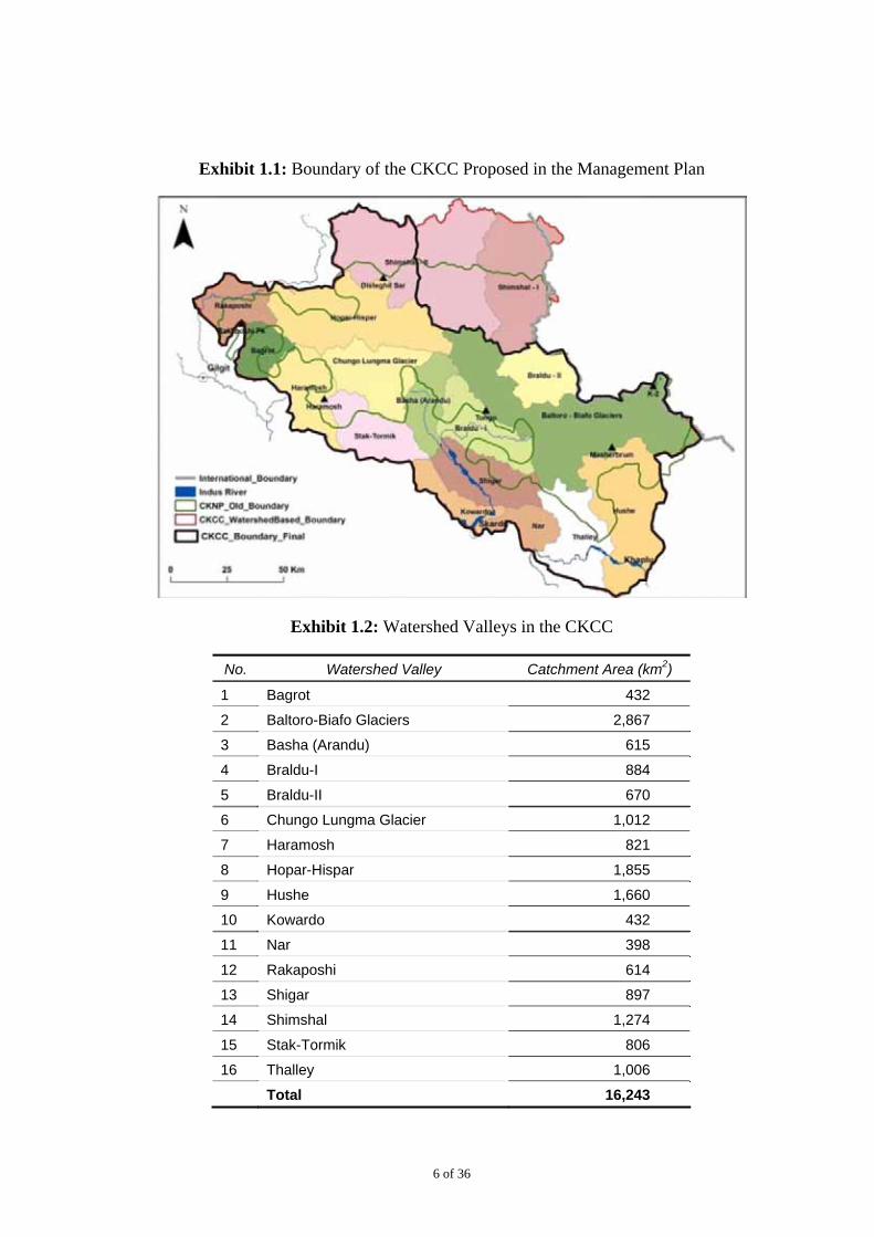
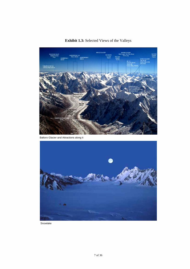
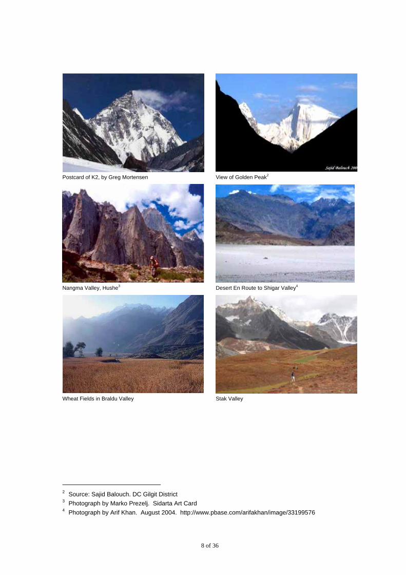
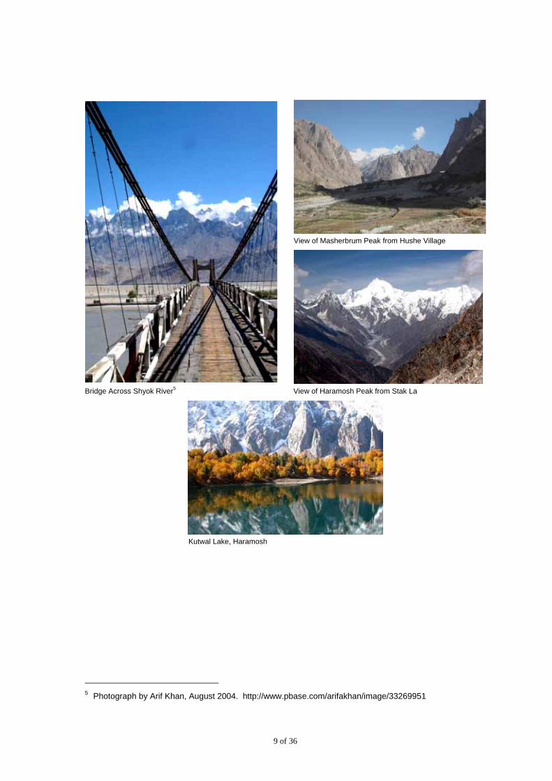
The boundary of the CKCC proposed in the Management Plan, based on natural watersheds, encompasses and area of 16,243 km2 (Exhibit 1.1). To the north, it is aligned with the international border (with the Chinese province of Sinkiang), and borders with the Khunjerab National Park in north-west. The Indus River marks the southern boundary of the CKCC. To the east it is separated from the disputed Siachen area and the cease-fire line by the Kondus and Saltoro Valleys of Ghanche District. The CKCC comprises of sixteen watershed valleys (Exhibit 1.2). Selected views of the valleys are included in Exhibit 1.3.
The report is organized in the following manner:
Section 2 summarizes the Framework for Development of Tourism provided by the CKCC Management plan
Section 3 provides a review of the tourism related baseline information on the CKCC
Section 4 provides a strategy for development of tourism in the CKCC by assessing the baseline conditions and presents the perspectives behind the near term and medium term strategies. It also provides the basis behind the tourism development action plan
Section 5 provides a listed action plan based on the strategy in Section 4
1 The HKKH Project is a multi-scale initiative, with a special focus on three Protected Areas, namely:
Sagarmatha National Park (SNP) in Nepal, Central Karakoram National Park (CKNP) in Pakistan and Qomolangma Nature Preserve (QNP) in the Tibet Autonomous Region of China (TAR-China). The HKKH project, partnering with Government of Pakistan in the PC-1 project (Participatory Management and Development of Central Karakoram National Park), has committed to contribute to the management planning of CKNP.
6 of 36
Exhibit 1.1: Boundary of the CKCC Proposed in the Management Plan
Exhibit 1.2: Watershed Valleys in the CKCC
No. Watershed Valley Catchment Area (km2)
1 Bagrot 432
2 Baltoro-Biafo Glaciers 2,867
3 Basha (Arandu) 615
4 Braldu-I 884
5 Braldu-II 670
6 Chungo Lungma Glacier 1,012
7 Haramosh 821
8 Hopar-Hispar 1,855
9 Hushe 1,660
10 Kowardo 432
11 Nar 398
12 Rakaposhi 614
13 Shigar 897
14 Shimshal 1,274
15 Stak-Tormik 806
16 Thalley 1,006
Total 16,243
7 of 36
Exhibit 1.3: Selected Views of the Valleys
Baltoro Glacier and Attractions along it
Snowlake
8 of 36
Postcard of K2, by Greg Mortensen View of Golden Peak2
Nangma Valley, Hushe3 Desert En Route to Shigar Valley4
Wheat Fields in Braldu Valley Stak Valley
2 Source: Sajid Balouch. DC Gilgit District 3 Photograph by Marko Prezelj. Sidarta Art Card 4 Photograph by Arif Khan. August 2004. http://www.pbase.com/arifakhan/image/33199576
9 of 36
View of Masherbrum Peak from Hushe Village
Bridge Across Shyok River5 View of Haramosh Peak from Stak La
Kutwal Lake, Haramosh
5 Photograph by Arif Khan, August 2004. http://www.pbase.com/arifakhan/image/33269951

10 of 36
2. Framework for Development of Tourism provided by the CKCC Management Plan
The CKCC Management Plan provides a comprehensive framework for development of tourism in the CKCC. Staging CKCC as an ideal tourism destination for eco, adventure and cultural tourism is recognized as one of the principal management objectives. Secondary management objectives include promotion and management of tourism in the CKCC to generate revenue for the local communities and the CKCC management on a sustainable basis.
The Management Plan places the land in the CKCC into the following two categories as illustrated in Exhibit 2.1:
Central Karakorum National Park (CKNP) in IUCN Protected Area Category II
Buffer Zone in IUCN Protected Area Category VI
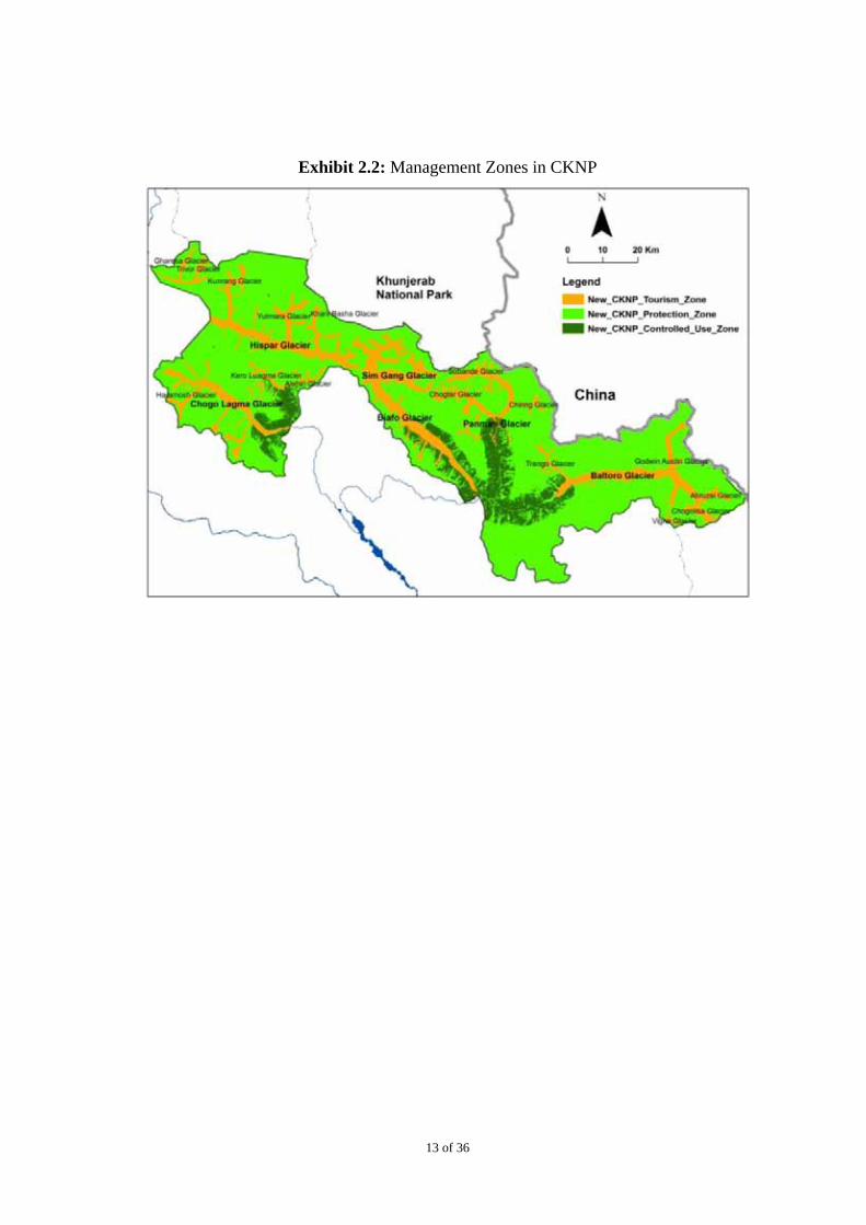
Based on the zoning typology of the HKKH for CKCC, formed in consultation with the stakeholders (described in Management Planning Framework6), the CKNP is subdivided into following three zones as illustrated in Exhibit 2.2:
Protection Zone (4,266 km2): Area for conservation, research, and education. The zone is designed purely for the protection of biodiversity and to maintain ecosystem integrity, therefore any kind of exploitation will be banned in principle.
Tourism Zone (1,046 km2): This zone encompasses major glaciers and trekking routes. Area for protection of wildlife with a high level of restrictions for other uses; certain activities are allowed after careful assessment, such as wildlife viewing for tourists, trekking, and mountaineering, but these will be subject to strict standards, especially those related to waste management and resource utilization. Such activities will be actively managed and monitored.
Controlled Use Zone (497 km2)7: This zone is to recognize community grazing rights as well as to regulate it. Vegetatively productive areas in the CKNP are very limited, therefore this zone should not be considered to promote/facilitate community use. Existing community use and rights need to be documented, and need to be frozen to control future expansion.
6 Management Planning Framework, Central Karakorum Cultural Complex, Hagler Bailly Pakistan, 2009 7 This zone was demarcated using spatial extent of three land cover classes and associated
areas; Closed to Open Herbaceous Vegetation, Dwarf Open Shrubland, Needleleaved Open Shrubland.
11 of 36
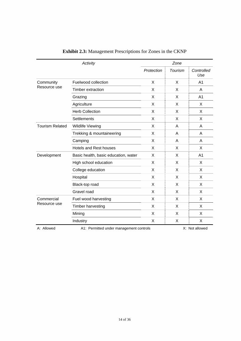
The management prescriptions for the zones within the CKNP8 are summarized in Exhibit 2.3.
The Buffer Zone includes land with settlements and land that is used by the communities as grazing lands and for fuel wood extraction. Environmental management in the buffer zone with the active participation of the local communizes will develop the ownership of the CKCC within the communities, and will play a central role in protection and management of the CKNP. Given the resource base of the CKCC, tourism can potentially play a major role in development of sustainable livelihoods and poverty reduction at the local level.
The Management Plan describes promotion of local, provincial, national, and international tourism at recreational and geo-tourism levels as an important objective for management of the buffer zone. Considering complexities in the buffer zone and additional data requirements, management prescriptions and guidelines for the buffer zone including those for tourism have not been included in the first phase of the Management Plan. Detailed management planning for each valley within the buffer zone will be achieved in the second phase management planning.
The following activities will be carried out in the second phase:
each valley will be surveyed to update information on the natural resource base, exploitation and potentials
a need assessment of local communities
development of Valley Management Plans (VMPs) in consultation with local communities
8 Central Karakorum Cultural Complex, Management Plan, Hagler Bailly Pakistan, 2009

12 of 36
Exhibit 2.1: Classification of CKCC According to IUCN Protected Area Categories
Note: According to the CKCC Management Plan, watersheds with predominantly natural conditions are assigned IUCN Protected Area Category II, and watersheds with diverse potentials (both natural and social) are assigned IUCN Protected Area Category IV.
13 of 36
Exhibit 2.2: Management Zones in CKNP
14 of 36
Exhibit 2.3: Management Prescriptions for Zones in the CKNP
Zone Activity
Protection Tourism Controlled Use
Fuelwood collection X X A1 Community Resource use
Timber extraction X X A
Grazing X X A1
Agriculture X X X
Herb Collection X X X
Settlements X X X
Wildlife Viewing X A A
Trekking & mountaineering X A A
Camping X A A
Tourism Related
Hotels and Rest houses X X X
Development Basic health, basic education, water X X A1
High school education X X X
College education X X X
Hospital X X X
Black-top road X X X
Gravel road X X X
Fuel wood harvesting X X X Commercial Resource use
Timber harvesting X X X
Mining X X X
Industry X X X
A: Allowed A1: Permitted under management controls X: Not allowed
15 of 36
3. Review of the Baseline
3.1 Overview of Attractions
As illustrated in Exhibit 1.3, the CKCC offers a number of tourist attractions ranging from natural beauty and wildlife to the rich and diverse cultures of the surrounding areas, as well as opportunities for adventurous excursions involving mountaineering and trekking.
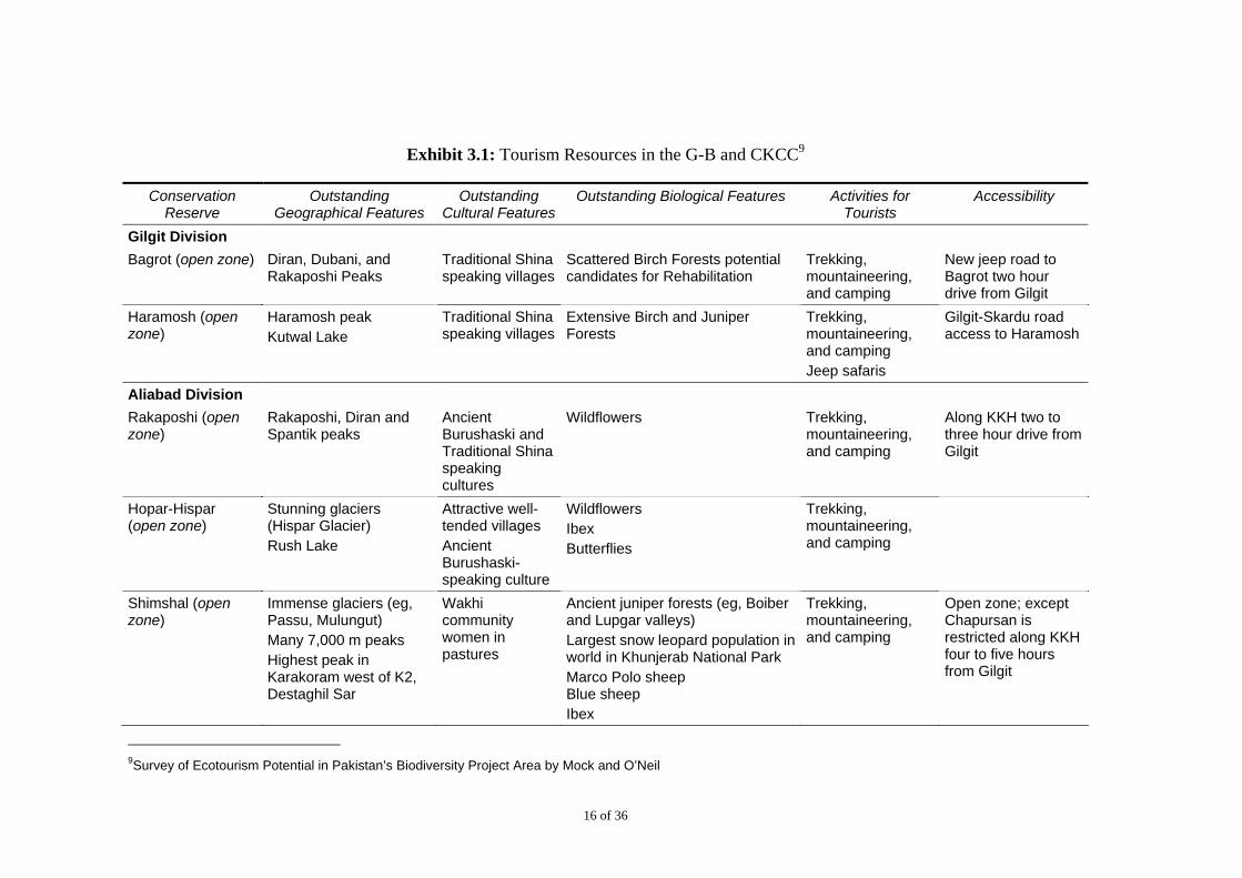
While assessing the tourism resource base for the CKPA the main considerations have to be, natural, cultural, biological features, possible tourist activities, and its accessibility (see Exhibit 3.1 on tourism resources, surveyed by John Mock and Kimberley O’Neil). According to the Management Plan, currently tourist activity in the CKCC is concentrated in the Hushe and Braldu regions, followed by the Rakaposhi and Hoper and Hispar areas. These areas mark the entry and exit points to the Ghondoghoro, Baltoro, Biafo, and Hispar glaciers, the Concordia and Snow Lake regions, and peaks such as K2, Broad Peak, Rakaposhi, Mashabrum, and Gasherbrums I, II, III, and IV. The communities in the CKCC are known for their friendly attitude towards the visitors. Crimes and attacks on tourists are rare. Conflicts of political or sectarian nature occasionally occur in the towns of Gilgit and Skardu, but there are no known instances in which the visitors were targeted.
16 of 36
Exhibit 3.1: Tourism Resources in the G-B and CKCC9
Conservation Reserve
Outstanding Geographical Features
Outstanding Cultural Features
Outstanding Biological Features Activities for Tourists
Accessibility
Gilgit Division
Bagrot (open zone) Diran, Dubani, and Rakaposhi Peaks
Traditional Shina speaking villages
Scattered Birch Forests potential candidates for Rehabilitation
Trekking, mountaineering, and camping
New jeep road to Bagrot two hour drive from Gilgit
Haramosh (open zone)
Haramosh peak Kutwal Lake
Traditional Shina speaking villages
Extensive Birch and Juniper Forests
Trekking, mountaineering, and camping Jeep safaris
Gilgit-Skardu road access to Haramosh
Aliabad Division
Rakaposhi (open zone)
Rakaposhi, Diran and Spantik peaks
Ancient Burushaski and Traditional Shina speaking cultures
Wildflowers Trekking, mountaineering, and camping
Along KKH two to three hour drive from Gilgit
Hopar-Hispar (open zone)
Stunning glaciers (Hispar Glacier) Rush Lake
Attractive well-tended villages Ancient Burushaski-speaking culture
Wildflowers Ibex Butterflies
Trekking, mountaineering, and camping
Shimshal (open zone)
Immense glaciers (eg, Passu, Mulungut) Many 7,000 m peaks Highest peak in Karakoram west of K2, Destaghil Sar
Wakhi community women in pastures
Ancient juniper forests (eg, Boiber and Lupgar valleys) Largest snow leopard population in world in Khunjerab National Park Marco Polo sheep Blue sheep Ibex
Trekking, mountaineering, and camping
Open zone; except Chapursan is restricted along KKH four to five hours from Gilgit
9Survey of Ecotourism Potential in Pakistan’s Biodiversity Project Area by Mock and O’Neil
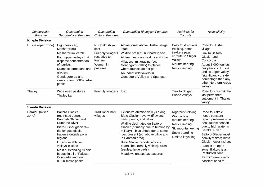
17 of 36
Conservation Reserve
Outstanding Geographical Features
Outstanding Cultural Features
Outstanding Biological Features Activities for Tourists
Accessibility
Khaplu Division Hushe (open zone) High peaks eg,
Masherbrum) Masherbrum icefall Four upper valleys that disperse concentration of tourists Dramatic formations and glaciers Gondogoro La and views of four 8000-metre peaks
Nur Bakhshiya sect Friendly villagers receptive to tourism Women in pastures
Alpine forest above Hushe village intact Wildlife present, but hard to see Alpine meadows healthy and intactVillagers limit grazing (eg, Gondogoro Valley) to places where tourists do not go Abundant wildflowers in Gondogoro Valley and Spangser
Easy to strenuous trekking, some trekkers pass enroute to Shigar Valley Mountaineering Rock climbing
Road to Hushe village Link to Baltoro Glacier and Concordia About 1,000 tourists per year visit Hushe and its upper valleys (significantly greater percentage than any other Northern Areas valley)
Thalley Wide open pastures Thalley La
Friendly villagers Ibex Trek to Shigar, Hushe valleys
Road to Khusmik the last permanent settlement in Thalley valley
Skardu Division Baraldu (mixed zone)
Baltoro Glacier (restricted zone), Panmah Glacier and Dumordo River Biafo-Hispar glaciers—the longest glacial traverse outside polar regions Extensive ablation valleys in Biafo Most outstanding Scenic beauty in all of Pakistan Concordia and four 8,000-metre peaks
Traditional Balti villages
Extensive ablation valleys along Biafo Glacier have wildflowers, birds, ponds, and lakes. Wildlife decimated on Baltoro Glacier (primarily due to hunting by military)—blue sheep gone, some ibex present (eg, above Liligo and in Panmah area) Biafo Glacier reports indicate bears, ibex (readily visible), birds (eagles, large birds) Meadows unused as pastures
Rigorous trekking World-class mountaineering Rock climbing Ski mountaineeringSnow boarding Limited kayaking
Road to Askole needs constant repair, problematic in peak tourist season due to high water in Baraldu River Baltoro Glacier most heavily visited; Biafo Glacier fewer visitorsBiafo is an open zone; Baltoro is a Restricted zone. Permit/bureaucracy hassles; need to
18 of 36
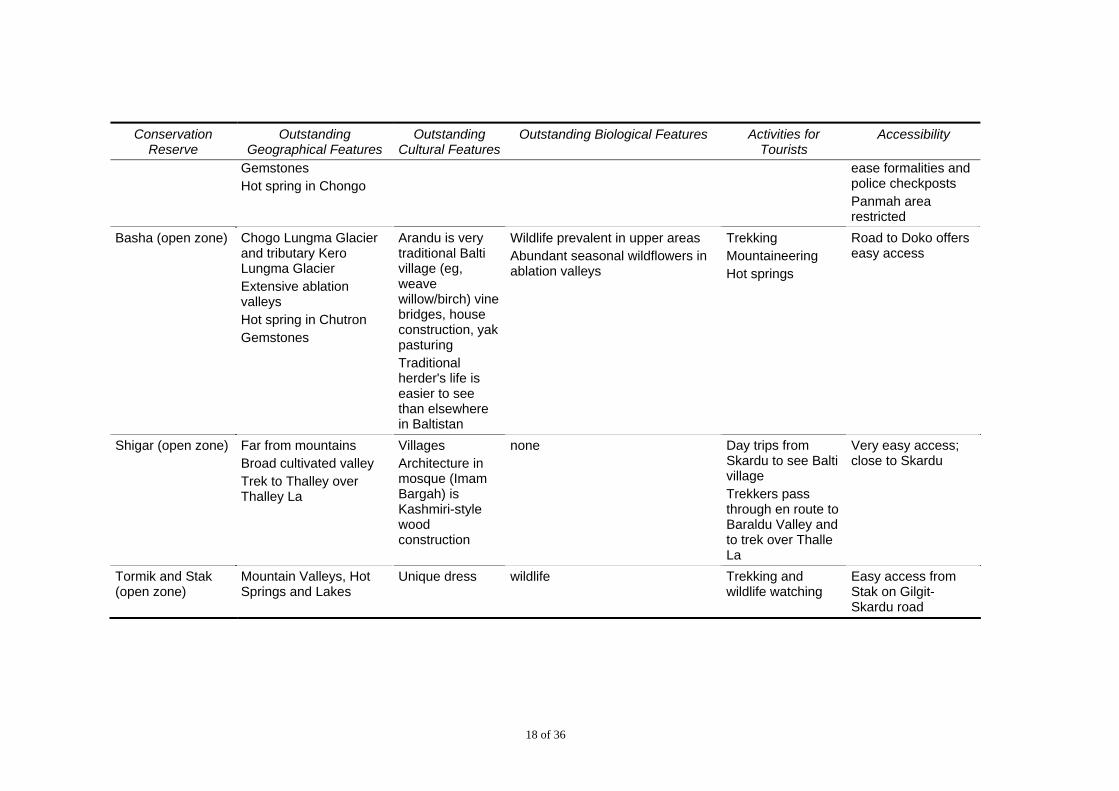
Conservation Reserve
Outstanding Geographical Features
Outstanding Cultural Features
Outstanding Biological Features Activities for Tourists
Accessibility
Gemstones Hot spring in Chongo
ease formalities and police checkposts Panmah area restricted
Basha (open zone) Chogo Lungma Glacier and tributary Kero Lungma Glacier Extensive ablation valleys Hot spring in Chutron Gemstones
Arandu is very traditional Balti village (eg, weave willow/birch) vine bridges, house construction, yak pasturing Traditional herder's life is easier to see than elsewhere in Baltistan
Wildlife prevalent in upper areas Abundant seasonal wildflowers in ablation valleys
Trekking Mountaineering Hot springs
Road to Doko offers easy access
Shigar (open zone) Far from mountains Broad cultivated valley Trek to Thalley over Thalley La
Villages Architecture in mosque (Imam Bargah) is Kashmiri-style wood construction
none Day trips from Skardu to see Balti village Trekkers pass through en route to Baraldu Valley and to trek over Thalle La
Very easy access; close to Skardu
Tormik and Stak (open zone)
Mountain Valleys, Hot Springs and Lakes
Unique dress wildlife Trekking and wildlife watching
Easy access from Stak on Gilgit-Skardu road
19 of 36
3.2 Infrastructure and Services
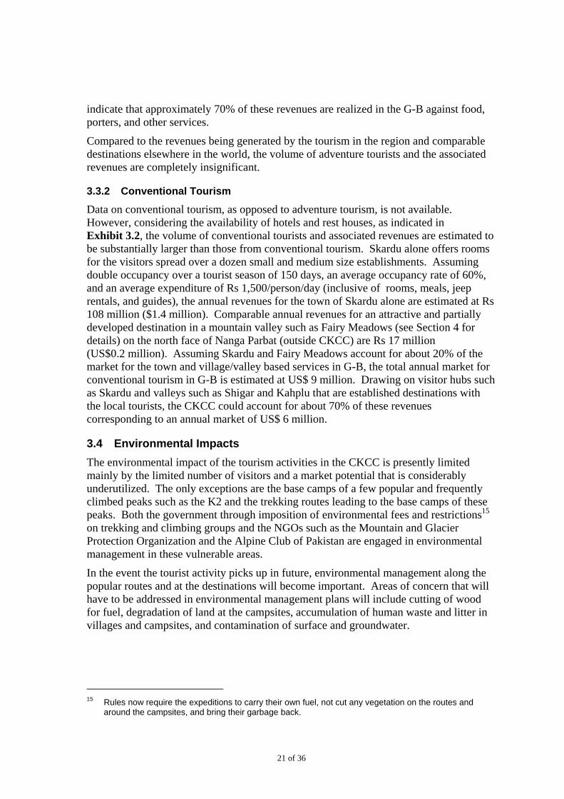
The opportunities for tourism in Gilgit Baltistan10 (G-B) are well recognized and documented in a number of travel books. Accommodation in the major towns such as Gilgit, Skardu, ranging from low budget basic to luxury, is available. A tourism resource map included in the Management Plan (Exhibit 3.2) shows tourism facilities and traffic of adventure tourists in CKCC. A number of tour operators and outfitters offer standard products to both international and national visitors. Trained guides that can speak foreign languages are also available. While accommodation is not available in most of the valleys and villages that constitute current and potential destinations for the tourists, the service providers can arrange tents and services for the visitors. The communities have also demonstrated a capacity to develop basic accommodation for the visitors where the market has developed. The following constraints, however, limit the realization of the tourism potential in G-B and consequently in the CKCC.
Road Access to G-B: The Karakorum Highway (KKH) is presently being upgraded. Travel time from Islamabad to Gilgit has increased from 12 hours to 16 hours. The upgrading will take 3-5 years to complete. An alternative travel route through the Kaghan valley over the picturesque Babusar pass at 3,600m is open from July through October. The travel time for this route from Islamabad to Gilgit is 16 hours.
Air Access to G-B: The probability of a flight to Gilgit or Skardu varies from 30% to 90% depending on the time of the year. It is low during the wet season in December through March and July and August. Most of the tourists in the high income groups that have a capacity to pay and contribute significantly to the tourism revenues prefer to fly11. The cost of flight cancellations for both the tourists and the service providers are significant.
Connecting Roads from Visitor Hubs to Destinations in the Valleys: High value destinations such as Haramosh, Hushe, and Nagar in the CKCC are generally located in valleys that can be accessed through jeep tracks. The quality of the tracks and the maintenance is generally poor, and the communities maintain the roads to support the traffic of passengers and transport of supplies. The journey in the lighter jeeps used by the tourists can be very uncomfortable, as well as dangerous and unsafe in the perception of the tourists. Breakdowns are also frequent, resulting in delays, and the risk of accident is also high.
Reliability and Safety of Local Transport: The jeeps and four-wheel drive vehicles available locally for transportation of tourists to the destinations in the valleys are generally old and poorly maintained. The drivers are also not properly trained. Combined with the poor quality of the dirt tracks that connect to the destinations and inadequate maintenance on the main hard top roads, the safety of the passengers and reliability of the travel is compromised.
10 Gilgit-Baltistan formerly known as the Northern Areas has recently been notified as a province in
Pakistan. 11 Compared to flight times of under an hour, a road journey to Gilgit currently takes over 15 hours and to
Skardu about 20 hours, with an overnight stay in case the vehicle is self driven.
20 of 36
3.3 Review of the Market
For the purpose of this plan, the market is categorized into adventure tourism and conventional tourism. Adventure tourism in the CKCC consists mainly of climbing and trekking12, and is presently limited to the peaks and glacier treks in the CKNP. Conventional tourism in this report is defined as tourism to fixed destinations that can be accessed by road and dirt tracks where accommodation is available. The visitors may undertake short hikes from a base station.
3.3.1 Adventure Tourism
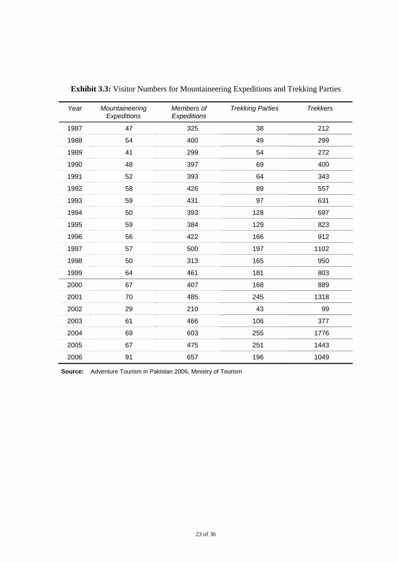
The statistics available in the official records include the number of foreign climbers and trekkers in the G-B13. These statistics can be assumed to reflect the market volume of adventure tourists in the CKNP, as bulk of the expeditions and treks covered by the statistics fall in the CKNP14. The number of visitors for mountaineering as well as trekking expeditions are summarized in Exhibit 3.3. An average cumulative yearly growth of 3.8% (1987-2006) in members of mountaineering expedition’s and8.8 % (1987-2006) in trekkers has been observed. The growth rates are relatively low, and respond to regional and local conflicts, security perceptions and the prevailing security environment. As an example, the numbers of trekkers and mountaineers dropped significantly in 2002 after September 11 - a drop of 57% and 92 % over the numbers in 2001 was observed for members of expeditions and trekkers respectively. Additionally, while the cumulative growth for mountaineers and trekkers was 3.8 % and 8.8 % respectively between 1987 and 2006, the cumulative growth rates taking 2009 estimates into account have dropped to a mere 0.5 % for mountaineers and 0.4% for trekkers.
While data on the local adventure tourists is not available, interviews with the service providers indicate that the local adventure tourists account for less than 5% of this market segment. Exhibit 3.2 shows that while the attractions are spread all over the CKCC, the traffic of adventure tourists in limited mainly to the Baltoro and Biafo glaciers in the CKNP.
Average annual expenditures by climbing expeditions, based on average figures for 2005 and 2006, are estimated at US$ 1.7 million, exclusive of international travel. Royalty fees for climbing peaks collected by the federal government for the same year are estimated at US$0.32 million. The corresponding figures for the trekkers in the same period are US$1.25 million for expenditures, and US$0.06 million for trekking fees. However, discussions with the service providers indicate that the current revenues have declined to about 50% of the peak levels achieved in 2005-06. This would imply combined revenues from expeditions and trekkers, exclusive of royalties and fees charged by the federal government, would amount to about US$ 1 million. Industry estimates
12 Other types of adventure tourism such as kayaking, rafting, and skiing is practically non-existent in the
CKCC. 13 Statistics provided by the Ministry of Tourism cover climbing and trekking expeditions. While all the
climbing expeditions are recorded, it is not clear if the data for the trekking expeditions includes only those expeditions that visit the areas where trekking permits are required, such as the Baltoro and Biafo glaciers, or open or non-restricted areas as well where permits are not required.
14 Exceptions are Nanga Parbat and Trich Mir that fall outside the CKNP.
21 of 36
indicate that approximately 70% of these revenues are realized in the G-B against food, porters, and other services.
Compared to the revenues being generated by the tourism in the region and comparable destinations elsewhere in the world, the volume of adventure tourists and the associated revenues are completely insignificant.
3.3.2 Conventional Tourism
Data on conventional tourism, as opposed to adventure tourism, is not available. However, considering the availability of hotels and rest houses, as indicated in Exhibit 3.2, the volume of conventional tourists and associated revenues are estimated to be substantially larger than those from conventional tourism. Skardu alone offers rooms for the visitors spread over a dozen small and medium size establishments. Assuming double occupancy over a tourist season of 150 days, an average occupancy rate of 60%, and an average expenditure of Rs 1,500/person/day (inclusive of rooms, meals, jeep rentals, and guides), the annual revenues for the town of Skardu alone are estimated at Rs 108 million ($1.4 million). Comparable annual revenues for an attractive and partially developed destination in a mountain valley such as Fairy Meadows (see Section 4 for details) on the north face of Nanga Parbat (outside CKCC) are Rs 17 million (US$0.2 million). Assuming Skardu and Fairy Meadows account for about 20% of the market for the town and village/valley based services in G-B, the total annual market for conventional tourism in G-B is estimated at US$ 9 million. Drawing on visitor hubs such as Skardu and valleys such as Shigar and Kahplu that are established destinations with the local tourists, the CKCC could account for about 70% of these revenues corresponding to an annual market of US$ 6 million.
3.4 Environmental Impacts
The environmental impact of the tourism activities in the CKCC is presently limited mainly by the limited number of visitors and a market potential that is considerably underutilized. The only exceptions are the base camps of a few popular and frequently climbed peaks such as the K2 and the trekking routes leading to the base camps of these peaks. Both the government through imposition of environmental fees and restrictions15 on trekking and climbing groups and the NGOs such as the Mountain and Glacier Protection Organization and the Alpine Club of Pakistan are engaged in environmental management in these vulnerable areas.
In the event the tourist activity picks up in future, environmental management along the popular routes and at the destinations will become important. Areas of concern that will have to be addressed in environmental management plans will include cutting of wood for fuel, degradation of land at the campsites, accumulation of human waste and litter in villages and campsites, and contamination of surface and groundwater.
15 Rules now require the expeditions to carry their own fuel, not cut any vegetation on the routes and
around the campsites, and bring their garbage back.
22 of 36
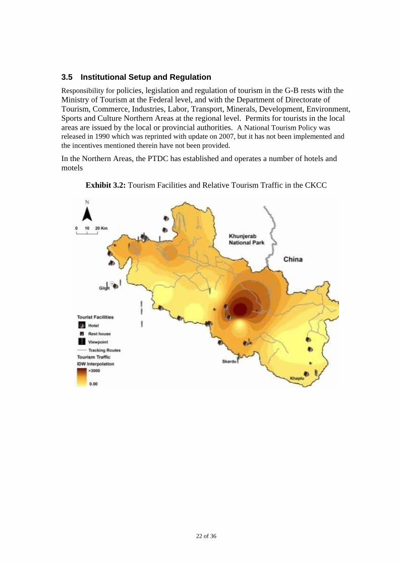
3.5 Institutional Setup and Regulation
Responsibility for policies, legislation and regulation of tourism in the G-B rests with the Ministry of Tourism at the Federal level, and with the Department of Directorate of Tourism, Commerce, Industries, Labor, Transport, Minerals, Development, Environment, Sports and Culture Northern Areas at the regional level. Permits for tourists in the local areas are issued by the local or provincial authorities. A National Tourism Policy was released in 1990 which was reprinted with update on 2007, but it has not been implemented and the incentives mentioned therein have not been provided.
In the Northern Areas, the PTDC has established and operates a number of hotels and motels
Exhibit 3.2: Tourism Facilities and Relative Tourism Traffic in the CKCC
23 of 36
Exhibit 3.3: Visitor Numbers for Mountaineering Expeditions and Trekking Parties
Year Mountaineering Expeditions
Members of Expeditions
Trekking Parties Trekkers
1987 47 325 38 212
1988 54 400 49 299
1989 41 299 54 272
1990 48 397 69 400
1991 52 393 64 343
1992 58 426 89 557
1993 59 431 97 631
1994 50 393 128 697
1995 59 384 129 823
1996 56 422 166 912
1997 57 500 197 1102
1998 50 313 165 950
1999 64 461 181 803
2000 67 407 168 889
2001 70 485 245 1318
2002 29 210 43 99
2003 61 466 106 377
2004 69 603 255 1776
2005 67 475 251 1443
2006 91 657 196 1049
Source: Adventure Tourism in Pakistan 2006, Ministry of Tourism
24 of 36
4. Strategy for Development of Tourism in CKCC
4.1 The Vision
The Management plan provides the following vision for the CKCC:
A resilient, sustainable and co-managed landscape delivering ecological and economic services, equitably benefiting nature, culture and people
The report “Studies and Recommendations for the Management Plan” (HBP 2005) makes the following vision statement for the development of tourism:
A place where the traditional owners, ie, the local communities, and the NAFWD staff manage the area together to the highest possible standard to conserve the natural and cultural heritage, and encourage tourists to understand, appreciate, and enjoy the park
Section 2, ‘The Framework for Development of Tourism’, of the CKCC Management Plan recognizes staging CKCC as an ideal tourism destination for eco, adventure and cultural tourism as one of the principal management objectives for the Tourism Management Plan. Secondary management objectives of the CKCC include promotion and management of tourism to generate revenue both for locals and CKCC management on sustainable basis.
The strategy and the plan for development of tourism in CKCC has been developed to realize the vision for the CKCC and to achieve the long term objectives formulated in consultation with the stakeholders.
4.2 General Approach
The strategy and recommendations presented in this section are based on the following approach:
An assessment of the existing or baseline conditions to develop an understanding of what the private sector, communities, government, and other stakeholders have already achieved and the constraints in development of the tourism market in the CKCC,
Identification of the critical issues that need to be addressed to achieve the objectives of the tourism management plan,
Development of a strategy and priorities that can address the critical issues identified, and
Presentation of an outline of an action plan specifying measures that can be taken in the near and the medium term to achieve the objectives of the tourism management plan, and the responsibilities for taking the measures.
4.3 Assessment of the Baseline Conditions
The following is a summary of the baseline conditions and their assessment as relevant to the objectives of this management plan:
25 of 36
Attractions: The CKCC presents world class attractions that can cater to the needs of a variety of tourism markets, including conventional tourism, and adventure tourism.
Access and Transportation: While the basic infrastructure, in terms of road and air connections from the tourism hubs in G-B to the population centers in the country is available, the reliability of the infrastructure is poor. In addition, the quality of access roads and vehicular transport that the visitors can use to access the attractions and popular destinations is generally poor.
Facilities: Presently, excess capacity exists at the tourism hubs of Gilgit and Skardu and along the KKH to accommodate tourists, ranging from luxury to smaller budget hotels. Camping services and facilities are commonly offered by service providers at all popular routes and destinations.
Services: The capacity to deliver services for tourism in G-B is well established, and there are a number of tour operators that offer a range of packages for the high end as well as budget visitors.
The Market: The market for adventure tourism with access treks and destinations in remote mountain areas has demonstrated a low level of growth and suffered frequently in response to the regional and local conflicts, and security perceptions. The market for conventional tourism associated with both foreign and local tourists has, however, suffered greatly on account of the prevailing security environment. Difficulties in access through both air and road connections and deterioration in the condition of the KKH in the recent past has further damaged the tourism business in G-B.
Contribution to the Local Economy: While published statistics are not available, estimates indicate that the revenues and consequential economic impact of conventional tourism in G-B is significantly higher than that for adventure tourism.
4.4 Priorities and Strategy
The attractions and destinations for visitors in the CKCC are well recognized, and products offered by the service providers in the market are already well established. Based on a review of the baseline conditions and the constraints identified, the following are the key elements of the proposed strategy for development of the market for tourism in CKCC within the framework of the management plan:
Focus on Domestic Tourists: The size of the market for adventure tourism in CKCC is limited mainly to foreign climbers and trekkers and has varied considerably with time. This market is determined mainly by the regional security considerations which can be considered as an ‘independent’ or a ‘scenario variable’ over which the planners have no control. Assuming the regional security conditions and the perceptions thereof are unlikely to change in the near future, the plan targets the market for conventional tourism focusing on the in-country visitors where there is considerable potential for growth and where a stable business base can be developed.
26 of 36
Priority to Community Based Tourism: The plan gives high priority to expanding the market in the community areas with the objective of providing livelihood support, poverty reduction, and building the stakes of the community in sustainable management of the CKCC. An example of this approach is described in the Box, Tourism and Conservation in Fairy Meadows.
Near and Medium term Perspective: The focus of this tourism development plan for the CKCC is near and medium term (up to six years) to revive the tourism businesses and activities and to develop a domestic market base on which the market for both domestic and foreign tourists can grow on a sustainable basis. Some low cost actions related to removing existing barriers related to the foreign trekkers and climbers are also proposed. The planning process should remain dynamic, and the plan can be reviewed and updated after about three years on the basis of results achieved to redefine the priorities and actions.
27 of 36
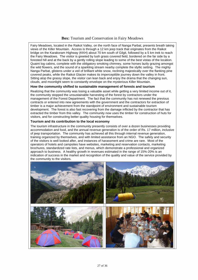
Box: Tourism and Conservation in Fairy Meadows
Fairy Meadows, located in the Raikot Valley, on the north face of Nanga Parbat, presents breath taking views of the Killer Mountain. Access is through a 12 km jeep track that originates from the Raikot bridge on the Karakoram Highway (KKH) about 70 km south of Gilgit, followed by a 5 km trek to reach the Fairy Meadows. The visitor is greeted by lush grass covered field, bordered on the far side by a forested hill and at the back by a gently rolling slope leading to some of the best vistas of the location. Quaint log cabins, complete with the obligatory smoking chimney, some horses lazily grazing amongst the wild flowers, and the sound of a sparkling stream nearby complete the idyllic setting. The mighty Nanga Parbat, glistens under a veil of brilliant white snow, reclining majestically over the flanking pine covered peaks, while the Raikot Glacier makes its imperceptible journey down the valley in front. Sitting atop the grassy slope, the visitor can lean back and enjoy the drama that the changing sun, clouds, and moonlight seem to constantly envelope on the mysterious Killer Mountain.
How the community shifted to sustainable management of forests and tourism
Realizing that the community was losing a valuable asset while getting a very limited income out of it, the community stopped the unsustainable harvesting of the forest by contractors under the management of the Forest Department. The fact that the community has not renewed the previous contracts or entered into new agreements with the government and the contractors for extraction of timber is a major achievement from the standpoint of environment and sustainable tourism development. The forest is also fast recovering from the damage inflicted by the contractor that has extracted the timber from this valley. The community now uses the timber for construction of huts for visitors, and for constructing better quality housing for themselves.
Tourism and its contribution to the local economy
The tourism infrastructure in the community presently consists of over a dozen businesses providing accommodation and food, and the annual revenue generation is of the order of Rs. 17 million, inclusive of jeep transportation. The community has achieved all this through internal revenue generation, training organized by themselves, and with limited assistance from an NGO. The safety and security of the visitors is well looked after, and instances of harassment and crime are rare. Most of the operators of hotels and campsites have websites, marketing and reservation contacts, marketing brochures, standardized rate lists, and menus, which demonstrate a professional and organized approach to business. A healthy growth in revenues estimated in the range of 15%-20% is an indication of success in the market and recognition of the quality and value of the service provided by the community to the visitors.
28 of 36
4.4.1 Near Term Perspective
In the near term (the first two years), the emphasis should be on removing the constraints that limit the existing demand for conventional tourism in the CKCC. The following action areas identified to achieve this near term objective:
A Tourism Policy with a Focus on the Local Market: Recognizing that in the medium term (4-6 years) the general perception of the security risks in the country is not likely to change, tourism planning should focus on the local tourists. Success in expanding the market for local tourists will also provide a foundation for building up the market for foreign tourists in the long term. A tourism policy for G-B that identifies the priorities and lists the incentives and support to be provided by the government needs to be developed.
Improving Reliability of Air Access: Upgrading of the KKH is already in progress, but is expected to take 3-5 years to complete. The alternative road connection through Kaghan is available only from late July through October. Improving air access to the tourist hubs in the G-B, namely Gilgit and Skardu, is therefore the critical area where immediate attention is needed.
Improving Road Access to Destinations with High Market Value: Improving road access to the valleys with high tourism potential is important for the development of local markets where the communities stand to benefit from the tourism economy.
Management of Risk Perceptions and Facilitation of Foreign Tourists: Management of risk perceptions and facilitation of foreign tourists can provide interim support for attracting foreign tourists.
4.4.2 Medium Term Perspective
The market for tourism in the CKCC can be developed and expanded through the actions in the near term by removing some critical constraints that are limiting the realization of the demand. To further build upon this base and to ensure sustainability, the quality of facilities and service standards will have to be improved to expand the market, and regulatory measures will have to be introduced to ensure that the environmental objectives of the CKCC are not compromised. Continued promotion of the opportunities offered by the CKCC will support the expansion of demand for tourism. The following action areas are identified to achieve these objectives in the medium term period of three to six years:
Measures to Develop the Infrastructure and Supply Side of the Market:
Further improvement in air access to attract visitors at a regional level
Expanding road access to destinations with high market value
Awareness and education on benefits of tourism at the local level
Development of facilities and infrastructure at the local level
Training of service providers
29 of 36
Regulatory Support:
Zoning and land use management of critical hubs, destinations, and access routes
Regulation of the tourism business (including waste management) and services
Control of deforestation and illegal hunting
Development of the Demand Side of the Market:
Sensitization of tourists
Promotion of the tourism potential
These actions areas are elaborated in the following discussion.
4.5 Near Term Actions
4.5.1 Development of a Tourism Policy for G-B
An action oriented policy is required, with clearly defined targets, strategy, incentives, and regulation. The following guidelines can be used for the development of the policy:
Structure of the Policy
The policy document should precisely state the objectives, the means to achieve the objectives, and the roles the stakeholders are expected to play in achieving the objectives. The basic policy statement should be a concise document, not more than a few pages, that gives an overall definition to the direction the government expects to take in development of tourism in the G-B. Since CKCC constitutes the bulk of the market for tourism in the G-B, the CKCC will stand to directly benefit from the policy.
Policy Process
The policy process should be interactive, consultative, and an evolutionary process with active engagement and participation of the key stakeholders including the local communities and the private sector. The policy should provide a formal platform for the stakeholders to jointly contribute to achievement of the common objectives of tourism in the CKCC.
Policy Targets
A simple set of targets should be set for the near term and the medium term. Key indicators that can be adopted to define the targets can include:
Number of tourists arriving annually by air and by road
Number of visitors paying entry fee or registering at the national parks and other entry points
Room nights at the tourism hubs such as Gilgit and Skardu
The number of registered service providers and services offered by them, such as hotels, rooms, and transport vehicles
30 of 36
The number of indicators should be kept at a manageable level to ensure that the data collected is reliable and cost for collection of data is low. It would be important to develop specific indicators such as number of visitors at community owned and operated facilities to differentiate between the contribution of the tourism to the economy of the G-B and towards strengthening of livelihoods and alleviating poverty at the local level. A system for collection, reporting, and distribution of information will have to be established.
Once the key indicators are defined and baseline information collected, the measurable performance targets can be defined in consultation with the stakeholders.
Policy Strategy
The strategy outlined in this document can be a starting point for the discussion. It would be important to clearly define the priorities in the near and the medium‐to‐long term, along with the responsibilities for actions.
Incentives and Investments
This is the critical area where the role of the government in supporting the development of tourism can be defined objectively. Examples of incentives that the government could consider include:
Subsidies: Further subsidies on flights to G-B, subsidized training opportunities for service providers
Investments: Upgrading the infrastructure for road and air access to G-B, promotion of tourism in the national and international media and forums
Financing: Microcredit for provisions of infrastructure and services at the local level, low interest loans for tourism related businesses.
Regulation
The government needs to protect the interest of the consumers as well as the service providers, and oversee the development of the market in an efficient, competitive, and sustainable manner. Areas where the government will have to give attention to include:
Establishment and enforcement of standards to ensure quality of service to the visitors
Codes of conduct for the service providers as well as the visitors, particularly in the environmentally and culturally sensitive areas, and community areas
Environmental assessment and permitting of development of tourism infrastructure and facilities, particularly in the sensitive areas
4.5.2 Improving Air Access
As discussed in Section 3, the probability of a flight to Gilgit or Skardu varies from 30% to 90% depending on the time of the year, and the cost of flight cancellations for both the tourists and the service providers are significant. Actions that can be taken to improve the success of the flights are summarized below:
31 of 36
Improving the reliability of the existing flights to G-B: The reliability of flights to Gilgit has somewhat improved after the introduction of a new set of aircraft about three years back. However, the reliability of flights to Skardu where aircraft with jet engines are used remains comparatively low. Shifting the timing of flights to Skardu to just after sunrise will help in improving the reliability of the flight. Operation of additional flights to clear the backlog of passengers will also help.
Introduction of direct flights from Lahore and Karachi to G-B in the season: Presently all the flights to the G-B originate at Islamabad. These flights operate in the morning in view of the changes in weather such as cloud buildup and wind storms that limit the flights through the day. The intending visitors from other cities in the country have to arrive in Islamabad a day ahead and stay overnight in Islamabad which adds to the cost of the trip. In case of cancellation of a flight in the morning, the intending visitors have a choice of extending their stay by another day, depart by road, or cancel their trip and return to the city of their origin. The cost and inconvenience is high, and for this reason the number of visitors gets limited. Introduction of direct flights from the major cities such as Lahore, Faisalabad, and Karachi during the peak visitor season from May through September can help in increasing the number of tourists visiting the G-B.
Evaluation of the feasibility of using instrument landing systems: Use of instrument landing systems at the Gilgit and Skardu airports could potentially enhance the reliability of the flights in poor weather. Technical feasibility of this option needs to be examined further in view of the special safety considerations dictated by the topography around the airports.
4.5.3 Improving Road Access to Destinations with High Market Value
High value destinations such as Haramosh, Hushe, and Nagar in the CKCC are generally located in valleys that can be accessed through jeep tracks. The quality of the tracks and the maintenance is generally poor. Improving the quality of access tracks to the selected valleys can open up the valleys for the tourists, reduce the travel times, and improve the road safety.
4.5.4 Management of Risk Perceptions and Facilitation of Foreign Tourists
Statistics compiled by the Federal Ministry of Tourism show that destinations in the CKCC have been popular with tourists from Europe, North America, and Japan16. While the risk perceptions of tourists from these countries are not likely to change in the near future, the government through the foreign missions can take a number of measures to market the destinations in the CKCC. Overseas Pakistanis and citizens of Pakistan origin can also be targeted as potential visitors. G-B can be presented as a destination with different risk profile compared to rest of the country, and visa procedures can be simplified for visitors from selected countries.
16 Adventure Tourism in Pakistan, Ministry of Tourism, 2006
32 of 36
4.6 Medium Term Actions
4.6.1 Development of Infrastructure and Supply Side of the Market
Further Improvement in air access: Following the near term actions for improving the reliability of air access to the G-B, attention should be given to introduction of direct flights from international hubs such as Bangkok, Dubai, and possibly London. The security perception of the visitors will improve as the visitors will be able to directly access the destinations without having to travel through areas that may be perceived as insecure. Construction of a new airport south of Gilgit which can handle larger aircraft and where the valley is wider17 will also improve access to Gilgit and provide an alternative landing site in case the planes cannot access the Skardu airport. Use of instrument landings systems is also likely to be more feasible at locations south of Gilgit.
Expanding road access to destinations with high market value: Building on the experience gained in the near term, tracks into additional valleys can be identified and upgraded to expand the market.
Development of facilities and infrastructure at the local level: Following the Fairy Meadows example, low cost and possibly energy efficient huts and facilities for accommodating the tourists can be designed and built using local materials, and conforming to the local construction practices.
Awareness and education on benefits of tourism at the local level: The functioning models of community operated tourism facilities can be used as demonstrations to encourage the communities to adopt sustainable tourism approaches.
Training of service providers: A wide range of skills are required for operation of tourism related businesses, from planning and design of facilities for tourists, to maintaining standards of service, and marketing. Rural support programmes such as the AKRSP and the NRSP can be engaged to deliver the training, and integrate tourism into their sustainable livelihood programmes.
4.6.2 Regulatory Support
Zoning and land use management of critical hubs, destinations, and access routes: There is a high risk of a shift to unsustainable land use practices following the initial success of tourism businesses. Such practices are triggered by increase in land values following conversion of land from rangeland, agriculture, and in some cases residential to commercial use. Haphazard and uncontrolled development can lead to loss in both environmental and market values. Setting the rules for land use at an early stage in consultation with the community and subsequent enforcement can help in preservation of land values and quality of experience for the visitors. Similarly, highways and access routes can get choked by encroachments which can slowdown the tourist traffic, increase the travel times, and cause a negative visual impact. Examples of such trends can be seen on the KKH as well as on the secondary highway connecting the KKH to Skardu. Maintaining appropriate distances for construction along the highways and routes
17 The approach to the Skardu airport which is the only other airport in G-B is presently through the Indus
gorge from the west which restricts landings I cloudy weather.
33 of 36
commonly used by the tourists can considerably add to the quality of experience of the visitors.
Regulation of tourism businesses and services: As the business base develops, the need for regulation to protect the interests of the visitors will arise. Service standards and procedures for certification and monitoring of compliance with the standards will be required. Areas to be covered will include accommodation, vehicles, and service staff such as cooks, drivers, hotel operators, outfitters, and guides.
Control of deforestation and illegal hunting: Environmental and tourism values can be enhanced by improving the landscape and protecting wildlife that can be a source of attraction for the visitors. Examples of such degradation in G-B can be seen in Naltar where the forests have been degraded following the opening up of the area for tourism. On the other hand, protection of the brown bear in Deosai National Park located south of Skardu has increased the interest in the park for the visitors, who want to see the animals. Plans for protection of forests in areas of high tourism value can be devised and implemented by the Northern Areas Forest Department (NAFD) in consultation with the local communities.
4.6.3 Development of the Demand Side of the Market
Sensitization of tourists: The most important aspect in the establishment and continuation of sustainable tourism is that both the visitors and the inhabitants should know what to do and how to do it. Likewise, the locals and the visitors have to interact in complete harmony for such a system to succeed. For these reasons a code of conduct for both the tourists and the locals is to be developed. In developing it all the stakeholders need to be included so that a workable code is developed that not only explains how one is supposed to act with respect to the sensitive nature of the place but also how to best facilitate each other when it comes to tourist and local cultural sensitivities.
Promotion of the tourism: The local service providers and facility operators already advertise their products and services through the media and the internet, and attend international tourism fairs to gain access to markets and clients. The local media including the news papers, magazines, and the television frequently carry programmes on destinations of interest. Discussions with the local tour operators indicate that additional support from the government through the foreign missions to publicize the attractions in the country and to facilitate the visitors can be very helpful in attracting visitors from other countries. Similarly, the government can sponsor or subsidize publicity campaigns within the country to attract the local visitors.
34 of 36
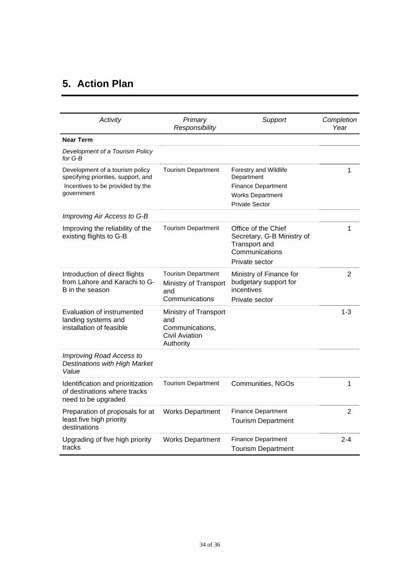
5. Action Plan
Activity Primary Responsibility
Support CompletionYear
Near Term
Development of a Tourism Policy for G-B
Development of a tourism policy specifying priorities, support, and
Incentives to be provided by the government
Tourism Department Forestry and Wildlife Department
Finance Department
Works Department
Private Sector
1
Improving Air Access to G-B
Improving the reliability of the existing flights to G-B
Tourism Department
Office of the Chief Secretary, G-B Ministry of Transport and Communications
Private sector
1
Introduction of direct flights from Lahore and Karachi to G-B in the season
Tourism Department
Ministry of Transport and Communications
Ministry of Finance for budgetary support for incentives
Private sector
2
Evaluation of instrumented landing systems and installation of feasible
Ministry of Transport and Communications, Civil Aviation Authority
1-3
Improving Road Access to Destinations with High Market Value
Identification and prioritization of destinations where tracks need to be upgraded
Tourism Department
Communities, NGOs 1
Preparation of proposals for at least five high priority destinations
Works Department Finance Department
Tourism Department 2
Upgrading of five high priority tracks
Works Department Finance Department
Tourism Department 2-4
35 of 36
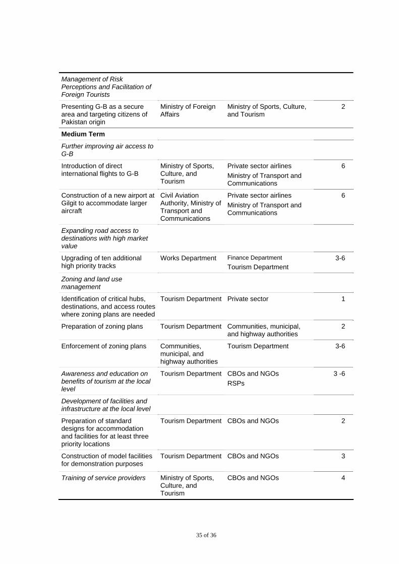
Management of Risk Perceptions and Facilitation of Foreign Tourists
Presenting G-B as a secure area and targeting citizens of Pakistan origin
Ministry of Foreign Affairs
Ministry of Sports, Culture, and Tourism
2
Medium Term
Further improving air access to G-B
Introduction of direct international flights to G-B
Ministry of Sports, Culture, and Tourism
Private sector airlines
Ministry of Transport and Communications
6
Construction of a new airport at Gilgit to accommodate larger aircraft
Civil Aviation Authority, Ministry of Transport and Communications
Private sector airlines
Ministry of Transport and Communications
6
Expanding road access to destinations with high market value
Upgrading of ten additional high priority tracks
Works Department Finance Department
Tourism Department 3-6
Zoning and land use management
Identification of critical hubs, destinations, and access routes where zoning plans are needed
Tourism Department Private sector 1
Preparation of zoning plans Tourism Department Communities, municipal, and highway authorities
2
Enforcement of zoning plans Communities, municipal, and highway authorities
Tourism Department 3-6
Awareness and education on benefits of tourism at the local level
Tourism Department CBOs and NGOs
RSPs
3 -6
Development of facilities and infrastructure at the local level
Preparation of standard designs for accommodation and facilities for at least three priority locations
Tourism Department CBOs and NGOs
2
Construction of model facilities for demonstration purposes
Tourism Department CBOs and NGOs
3
Training of service providers Ministry of Sports, Culture, and Tourism
CBOs and NGOs 4
36 of 36
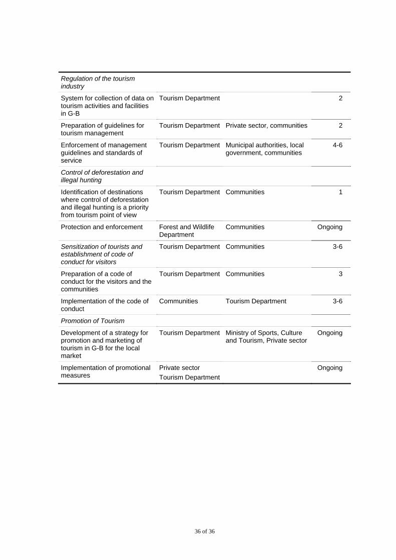
Regulation of the tourism industry
System for collection of data on tourism activities and facilities in G-B
Tourism Department 2
Preparation of guidelines for tourism management
Tourism Department Private sector, communities 2
Enforcement of management guidelines and standards of service
Tourism Department Municipal authorities, local government, communities
4-6
Control of deforestation and illegal hunting
Identification of destinations where control of deforestation and illegal hunting is a priority from tourism point of view
Tourism Department Communities 1
Protection and enforcement Forest and Wildlife Department
Communities Ongoing
Sensitization of tourists and establishment of code of conduct for visitors
Tourism Department Communities 3-6
Preparation of a code of conduct for the visitors and the communities
Tourism Department Communities 3
Implementation of the code of conduct
Communities Tourism Department 3-6
Promotion of Tourism
Development of a strategy for promotion and marketing of tourism in G-B for the local market
Tourism Department Ministry of Sports, Culture and Tourism, Private sector
Ongoing
Implementation of promotional measures
Private sector
Tourism Department
Ongoing