Embed Size (px)
Citation preview
CES Technical Report 128
TRAGEDY OF THE KAN SACRED FORESTS OF
SHIMOGA DISTRICT: NEED FOR URGENT POLICY
INTERVENTIONS FOR CONSERVATION
T.V.Ramachandra1,2 M.D.Subash Chandran1,3 Ananth Ashisar4
G.R. Rao1 Bharath Settur1 Bharath H.Aithal1
Sreekanth Naik1 Prakash N. Mesta1 1Energy & Wetlands Research Group, CES,IISc,
2Member, Western Ghats Task Force
3Member, Karnataka Biodiversity Board,
4Chairman, Western Ghats Task Force
Study carried out for Vriksha Laksha' Andolan, Sagar Taluk, Shimoga
Western Ghats Task Force, Government of Karnataka
CES Technical Report 128 June 2012
Energy & Wetlands Research Group Centre for Ecological Sciences,
Indian Institute of Science, Bangalore - 560012, INDIA Web: http://ces.iisc.ernet.in/energy/ http://ces.iisc.ernet.in/biodiversity Email: [email protected],
Kullunde
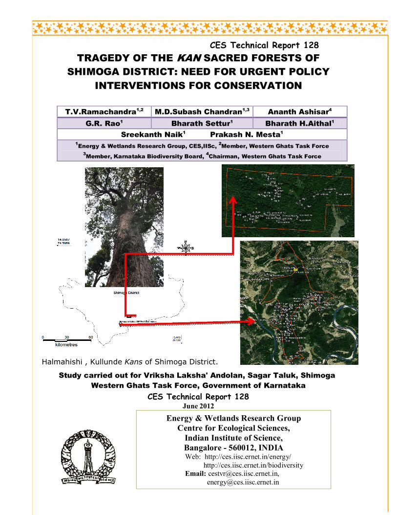
Halmahishi , Kullunde Kans of Shimoga District.
1
TRAGEDY OF THE KAN SACRED FORESTS OF SHIMOGA
DISTRICT: NEED FOR URGENT POLICY INTERVENTIONS FOR
CONSERVATION
(CASE STUDIES OF KURNIMAKKI-HALMAHISHI AND KULLUNDI KANS OF THIRTHAHALLI)
Study carried out for Vriksha Laksha' Andolan, Sagar Taluk, Shimoga
Western Ghats Task Force, Government of Karnataka
T.V.Ramachandra1,2 M.D.Subash Chandran1,3 Ananth Ashisar4
G.R. Rao1 Bharath Settur1 Bharath H.Aithal1
Sreekanth Naik1 Prakash Mesta1 1Energy & Wetlands Research Group, CES,IISc,
2Member, Western Ghats Task Force
3Member, Karnataka Biodiversity Board, GOK,
4Chairman, Western Ghats Task Force, GoK
CES Technical Report 128
June 2012
Energy & Wetlands Research Group
Centre for Ecological Sciences,
Indian Institute of Science,
Bangalore - 560012, INDIA
Web: http://ces.iisc.ernet.in/energy/
http://ces.iisc.ernet.in/biodiversity
Email: [email protected],
2
TRAGEDY OF THE KAN SACRED FORESTS OF SHIMOGA
DISTRICT: NEED FOR URGENT POLICY INTERVENTIONS FOR
CONSERVATION
(CASE STUDIES OF KURNIMAKKI-HALMAHISHI AND KULLUNDI KANS OF THIRTHAHALLI)
Study carried out for Vriksha Laksha' Andolan, Sagar Taluk, Shimoga
Western Ghats Task Force, Government of Karnataka
T.V.Ramachandra1,2 M.D.Subash Chandran1,3 Ananth Ashisar4
G.R. Rao1 Bharath Settur1 Bharath H.Aithal1
Sreekanth Naik1 Prakash Mesta1 1Energy & Wetlands Research Group, CES,IISc,
2Member, Western Ghats Task Force
3Member, Karnataka Biodiversity Board, GOK,
4Chairman, Western Ghats Task Force, GoK
EXECUTIVE SUMMARY
The kan forests of Central Western Ghats of Karnataka, were most often climax
evergreen forests, preserved through generations by the village communities of Malnadu
regions, as sacred forests, or sacred groves, dedicated to deities and used for worship
and cultural assemblage of the local communities. Various taboos and regulations on
usage of the kans were self-imposed by the local communities. In the normal course
trees were never to be cut, but the adjoining villagers enjoyed the privileges of taking
care and gathering of wild pepper, that was abundant in the kans, and many other non-
wood produce, demarcating portions of the kans informally between the different
families for collection purposes.
The kans functioned as important sources of perennial streams and springs used for
irrigation of crops and for domestic needs. They moderated the local microclimate
favouring the spice gardens in their vicinity, and were also fire-proof being evergreen in
nature.
The landscape of pre-colonial times had kans forming mosaic with secondary, timber
rich forests, grassland and cultivation areas, promoting also rich wildlife.
3
Kans were characteristic in the traditional land use of Shimoga, Uttara Kannada and
Chikmagalur districts specially, and were equivalent to the devarakadus of Kodagu
region.
With the domination of Central Western Ghats region of Karnataka by the British, the
State asserted its control over the kan lands, which were in thousands, each kan
measuring originally from few hectares to several hundred hectares in area. The
curtailment of community rights in the kans, including heavier taxation for collection of
forest produce resulted in the abandonment of many of them, causing various hardships
to the villagers.
Whereas most kans of Uttara Kannada got merged with the rest of the forests ensuring
the conservation of rare and endemic species of Western Ghats, in Shimoga district the
kans were not properly documented except in Sorab taluk and to some extent in Sagar
and Thirthahalli taluks. Moreover the Shimoga kans were brought under either the forest
or revenue departments. As communities lost their traditional biomass collection
privileges in secondary deciduous forests, in many places they resorted to kans for
fuelwood, timber and leaf manure, causing their decline.
As the kans were not of much timber value due to the growth of easily perishable
softwoods in them, the British thought it suitable to keep many such under the control of
the revenue department. The revenue authorities started allotting these precious
watershed areas and reserves of biodiversity for expansion of cultivation, especially of
coffee and garden crops, creating widespread fragmentation of the kans. The practice of
allotments ranging in area per applicant, individual or organization varied from one or
two acres to hundreds of acres each. As the kans under revenue department was given
more importance as land resources than as forests, the forests were cleared partially or
entirely for alternative land uses.
The rampant use of fire for clearing the evergreen vegetation for cultivation areas or
creating grassy areas caused change of climax evergreen vegetation to savannas, scrub
and secondary deciduous forests with diminished water flow in the streams and rivers,
4
which can be detrimental to the livelihoods of people in malnadu and beyond even in the
drier Deccan plains.
Large chunks of kan lands were allotted to the Mysore Paper Mills for raising of
pulpwood plantations, especially in Shimoga district.
Soil erosion, consequent on the clearance of kans, has adversely affected forest
regeneration and is also detrimental to cultivation as well as causing siltation of water
bodies, resulting in the abandonment of many irrigation tanks adjoining the kan lands.
Expressing deep concern on such dismal state of affairs, at a time when forest
conservation is of paramount need, the Vriksha-Laksha Andolan, Sagar and the Western
Ghat Task Force of the Government of Karnataka assigned us with the task of making a
rapid study of two of the kan forests, the Kurnimakki-Halmahishikan and Kullundikan
in the Thirthahalli taluk of Shimoga district, which are facing severe threats from
rampant allotments of large areas to private parties for non-forestry purposes and from
conflicting claims of ownership, with the forest department not enjoying adequate power
to save these kans from liquidation of their natural vegetation.
The study in the Kurnimakki-Halmahishi kan of about 1000 ha reveals the vegetation of
the kan, though heavily fragmented, due to ever increasing human impacts, nevertheless,
is a mosaic of various kinds of forests. The most significant is the discovery of swampy
areas within this kan which have few individuals of large sized threatened tree species
Syzygium travancoricum, classified in the IUCN Red List as “Critically Endangered”.
The tree is on the verge of extinction, and for the Shimoga district, the only occurrence
of this tree is the Kurnimakki-Halmahishi kan.
The Kullundikan of about 453 ha has a narrow belt of original tropical rainforest
dominated by the tree Dipterocarpus indicus, considered ‘Endangered’ by the IUCN.
The revenue department in control of this kan, being totally ignorant of its vegetation
richness has made several grants within the kan for cultivation of coffee and arecanut.
The grantees have also done encroachments within this climax forest area of high
5
watershed value. The cutting of the climax forest for raising coffee or any other crop is
totally unjustified.
We therefore recommend that the Government of Karnataka take immediate action to
arrest the degradation of kan forests on priority basis by:
Proper survey and mapping of boundaries of all kans;
Assign the kan forests to the Forest Department for conservation and sustainable
management;
Constituting Village Forest Committees for facilitating joint forest management
of the kan forests;
Taking speedy action on eviction of encroachers from the kans;
Giving proper importance to the watershed value and biodiversity of the kans;
Taking special care of threatened species and threatened micro-habitats within
the kans;
Heritage sites status to ‘kans’ under section 37(1) of Biological Diversity Act
2002, Government of India as the study affirms that kans are the repository of
biological wealth of rare kind, and the need for adoption of holistic eco-system
management for conservation of particularly the rare and endemic flora of the
Western Ghats. The premium should be on conservation of the remaining
evergreen and semi-evergreen forests, which are vital for the water security
(perenniality of streams) and food security (sustenance of biodiversity). There
still exists a chance to restore the lost natural evergreen to semi-evergreen forests
through appropriate conservation and management practices.
6
TRAGEDY OF THE KAN SACRED FORESTS OF SHIMOGA
DISTRICT: NEED FOR URGENT POLICY INTERVENTIONS FOR
CONSERVATION
(CASE STUDIES OF KURNIMAKKI-HALMAHISHI AND KULLUNDI KANS OF THIRTHAHALLI
TALUK)
I. INTRODUCTION
Most human societies, in the course of millennia of social and cultural evolution, had evolved
a variety of regulatory measures to ensure sustainable utilization of natural resources. These
measures included family-wise restricted quota of forest biomass, removal of only dead and
fallen plants, sharing of natural resources, prohibition on sale of forest biomass to outsiders
(all of which are to this day followed in the Halkar village in the outskirts of Kumta town in
Uttara Kannada district). The fishing families in the estuarine villages in the Kumta taluk of
Aghanashini River had shared among them traditional fishing privileges in the individual
‘kodis’ or estuarine channels. Traditional hunting was a taboo until Deepavali festival in the
forested villages of Uttara Kannada. To quote Madhav Gadgil (1992):
For local people, degradation of natural resources is a genuine hardship, and of all the
people and groups who compose the Indian society they are the most likely to be motivated
to take good care of the landscape and ecosystems on which they depend. The many
traditions of nature conservation that are still practiced could form a basis for a viable
strategy of biodiversity conservation.
Protection of forest patches as sacred has been reported from many parts of India and many
other countries in the recent decades. Trees were normally not to be cut in such forests as they
were dedicated to gods. Such sacred groves still persist in many parts of Asia and Africa
(Gadgil and Vartak, 1976; Frazer, 1935; Gadgil, 1987).
Most of Himalayas, the rain forest clad North East India, the Central Indian hills, parts of
Rajaputana region, many parts of Deccan and the Western Ghat-west coast regions of India
had witnessed through ages the strong tradition of conservation of patches of forests as sacred,
especially by village and forest dwelling communities. During the period of British
colonialism the government asserted its ownership over common lands, including sacred
forests, which the local communities had safeguarded and managed through generations.
Sweeping cultural changes concomitant with industrial and agricultural advancements also
changed traditional belief systems in which nature had a central role. Worship of gods
associated with natural sacred sites and ‘panchabhutas’ or the five elements, has in a major
7
scale given way to installing deities in man-made structures, causing neglect and even
exploitation of the precious heritage of natural sacred sites. Nevertheless, Malhotra et al.
(2001) have made an excellent compilation from the states like Andhra Pradesh, Arunachal
Pradesh, Assam, Chattisgarh, Himachal Pradesh, Jarkhand, Karnataka, Kerala, Madhya
Pradesh, Maharashtra, Manipur, Meghalaya, Mizoram, Orissa, western Rajasthan, Tamil
Nadu, Tripura, Uttaranchal etc., which have more forest wealth than other states, strong
evidences of nature conservation tradition, in the form of sacred groves. These sacred forests
are known by various names in peninsular India: such as devarakadu, devarubana or kan in
Karnataka, kavu in Kerala, kovilkadu in Tamil Nadu and devrai in Maharashtra.
D. Brandis (1897), the first Inspector General of Forests in India, was one of the first persons
to make commendation on the system of sacred groves in the country:
Very little has been published regarding sacred groves in India, but they are, or rather
were, very numerous. I have found them nearly in all provinces. As instances I may
mention the Garo and Khasi hills which I visited in 1879, the Devarakadus or sacred
groves of Coorg….and the hill ranges of the Salem district in the Madras
Presidency….These are situated in the moister parts of the country. In the dry region
sacred groves are particularly numerous in Rajputana. In Mewar, they usually consist of
Anogeissus latifolia, a moderate sized tree with small leaves, which fall early in the dry
season….Before falling the foliage of these trees turns a beautiful yellowish red, and at
that season these woods resemble our beech forests in the autumn. In the southernmost
States of Rajaputana, in Partabgarh and Banswara, in a somewhat moister climate, the
sacred groves, here called Malwan, consists of a variety of trees….These sacred forests, as
a rule, are never touched by the axe, except when wood is wanted for the repair of religious
buildings
Brandis also referred to a “ remarkable little forest of Sal (Shorea robusta)” near Gorakhpur
being maintained by a Muslim saint, Mian Sahib. The forest was in good condition and well
protected. Nothing was allowed to be cut except wood to feed the sacred fire and “this
required the cutting annually of a small number of trees which were carefully selected among
those that showed signs of age and decay.”
II. KANS AS SACRED GROVES
Francis Buchanan (1870): Alluding obviously to the system of sacredness of forests in the
Western Ghats-west coast of Uttara Kannada, Dr. Francis Buchanan, officer of the British
8
East India Company, who travelled through Uttara Kannada in 1801, soon after capturing
Canara region by the British stated:
The forests are the property of the gods of the village in which they are situated, and the
trees ought not to be cut without having leave from the Gauda (headman of the village)….
who here also is pujari (priest) to the temple of the village god. The idol receives nothing
for granting this permission; but the neglect of the ceremony of asking his leave brings his
vengeance on the guilty person.
Buchanan (1870 continued further: “Each village has a different god, some male, some
female, but by the Brahmins they are called Saktis, as requiring bloody sacrifices to their
appease their wrath”
From these statements may be inferred that the forests were virtually under the control of the
village communities with well defined territories and many had sacred values attributed to
them. Buchanan’s references to the then practice of slashing and burning of forests in the hills
for shifting cultivation, indicates the fact that all forests were not sacred, and the sacred forests
also bore the name kan or kanu.
W.A. Talbot (1909): In his monumental floristic work Forest Flora of the Bombay
Presidency and Sind Talbot referred to the sacredness of kans, a rare such remark from a
British officer:
In North Kanara and even as far east as the Hangal subdivision of the Dharwar
district along the Western Ghats under an annual rainfall of not less than 70”, isolated
irregularly distributed patches of rain-forest, locally called Kans and Rais are found
surrounded by cultivation or monsoon-forest. These are often the mere remnant of larger
areas and have in many instances been respected by the natives as the abode of a sylvan
deity.
Talbot’s statement makes it clear that even towards the drier east of Uttara Kannada district
bordering the Hangal taluk, with rainfall much lower, compared to the mountainous malnadu
part of Western Ghats, there existed evergreen forests equivalent to rain forests, the kans,
which were home to village deities. These kans were already on the decline as they were mere
“remnant of larger areas.”
The special protection given to the kans by the village communities of Sorab in Shimoga
district had won full praise from Peter Ashton (1988), renown tropical forest ecologist, who
considered kans as:
9
Prototypes of a technique currently being promoted as a new approach to forestry:
agroforestry. In a region dominated by deciduous forests (Sorab is bordering on the drier
Deccan Plateau) that were annually burned, the kans stood out as belts, often miles long,
of evergreen forest along the moist scrap of the Western Ghat hills. Assiduously
protected by the villagers, these once natural forests had been enriched by the inhabitants
through interplanting of jackfruits, sago and sugar palms, pepper vine, and even coffee, an
exotic.
Ashton (1988) justifies such kind of conservation in India seeking an explanation in its
culture:
The Indian sub-continent is without doubt the world centre of human cultural diversity…
The Hindus have inherited perceptions of a people who have lived since ancient times in a
humid climate particularly favourable for forest life. Settled people, they see themselves as
one with the natural world, as both custodians and dependents…. Forests of the mountains
and watersheds have been traditionally been sacred; springs and the natural landscape in
their vicinity have attracted special veneration. The Hindus learned from their
predecessors millennia ago, a mythology, sociology and technology of irrigation that has
enabled the most intensive yet sustainable agriculture humanity has so far devised.
In the above remarks, Ashton was referring to culture based conservation in India, and how
the veneration of watershed forests in the highlands facilitated “most intensive yet sustainable
agriculture humanity has so far devised.”
Area under the kans
It is difficult to get a consolidated account of the area under the kans, at the time of the
establishment of British authority over the forest resources of the malnadu regions of
Karnataka. It appears that survey and demarcation of the kans was an incomplete work.
Several kans of Uttara Kannada district got merged with rest of the state reserved forests and
lost their special identities. They are to be recognized today by their names, such as
Kathalekan, Karikan, Hulidevarukan etc. and also by the relics of primeval vegetation that
still might be persisting in them to some degrees. According to the earliest ever survey on the
kans conducted by Brandis and Grant (1868), Sorab taluk of Shimoga district had 171 kans
covering a total of 32,594 acres (about 13,000 ha). Halesorabkan, the largest of them covered
an area of about 400 ha. The kans were different from the secondary forests of deciduous
kinds. Such systematic documentation of kans was not conducted elsewhere. Cowlidurg
(present Thirthahalli taluk) was leading in the number of kans (436); Kadur district (present
Chikmagalur) had 128 kans (Brandis and Grant, 1868).
10
The Gazetteer of Mysore: Shimoga District (1920) merely refers to the kans as evergreen
forests of not much value, at a time when the hardwood timber yielding deciduous forests
were paid much more attention. The Gazetteer states on the kans of Sagar taluk:
Excepting the great Hinni forest, which lies to the south of the Gersoppa Falls, the
remainder are chiefly kans, or tracts of virgin evergreen forest, in most of which pepper
grows abundantly self-sown and uncared for, but little of the produce being collected owing
to the depredations of the monkeys.
The Gazetteer considers the kans towards the summits of ghats as not of much use owing to
inaccessibility. It admits to the decline of kans; yet had much in praise for the kans of Sorab:
The taluk of Sorab abounds with kans, many of which are cultivated with pepper vines and
sometimes coffee. The sago palm(Caryota urens) is also much grown for the sake of its
toddy. These kans are apparently the remains of the old forests, which appear once to have
stretched as far east as Anavatti. At the present day at Anavatti itself there is no wood,
and the surrounding country is clothed with either scrub jungle or small deciduous
forest….Kans are found also in Sagar, Nagar and other Malnad taluks, but those in
Sorab are, from their number, situation and accessibility the most valuable.
III. ROLE OF KAN FORESTS IN PRE-COLONIAL LAND USE SYSTEM
a. Kans as sacred groves: While they acted as decentralized, community-based system of
biodiversity conservation, these specially preserved forest patches played major roles as
important centres of local religion and culture. They, with or without any man-built
structures, functioned as abodes of village deities. Today most kans are under state
ownership; nevertheless their roles continue as centres of worship, as far as the local
communities are concerned. When we surveyed the kans of 10 villages of Sirsi taluk,
which were included in a forest working plan for firewood supply to Sirsi town
(Thippeswami, 1963), all of them were associated with sacred spots with deities, where
people gathered and worshipped, despite state ownership over the forests. Such is the case
with most other kans elsewhere too, in which matter, they are comparable to the
devarakadus of Coorg. Whereas the latter got recognition from the State as sacred forests,
and community rights were honoured, the same did not happen in Uttara Kannada and
Shimoga districts. Whereas ownership on the former were claimed by the forest
department of the Government of Bombay, the kans of Shimoga, in the erstwhile kingdom
of Mysore district, came under the jurisdiction of either the forest or revenue departments,
under the overlordship of the British, after the defeat of Tippu Sultan in 1799.
11
Timber felling was a taboo in the kans ensuring their preservation through ages as in the
devarakadus of Coorg, devrais of Maharashtra and kavus of Kerala. The deities of most
kans belong to the folk tradition of India and not to the Vedic tradition. To name a few
from Karnataka malnadu are Choudamma, Rachamma, Jataka, Birappa, Bhutappa,
Hulidevaru (tiger deity) etc. Occasionally are smaller groves called naagarabanas
dedicated to the serpents.
b. Kans as safety forests: The kan forests, well preserved in pre-colonial landuse system, in
many ways ensured safety and integrity of the rural landscapes of Western Ghats. From a
landscape ecological point of view these in tact forest patches formed a mosaic with other
elements such as secondary forests, scrub, shifting cultivation fallows, grasslands, farms
and water bodies to enhance landscape heterogeneity holding highest amount of species
diversity. As safety forests they performed the following functions as well:
i. Watershed protection: The kans are often found to be associated with water sources
like springs or ponds. The Government of Bombay (1923) highlighted the watershed
value of the kans of Uttara Kannada:
Throughout the area, both in Sirsi and Siddapur, there are few tanks and few deep
wells and the people depend much on springs …. If a heavy evergreen forest is felled in
the dry season the flow of water from any spring it feeds increases rapidly though no
rainwater may have fallen for some months.
ii. Keeping favourable microclimate: Wingate (1888), the forest settlement officer for
Uttara Kannada noted that the kans were of great economic and climatic importance as
they favoured the existence of springs, and perennial streams, and generally indicated
the proximity of valuable spice gardens, which derived from them both shade and
moisture- a scenario, that holds good to this day if the kan is good state.
iii. Kans for fire protection: Brandis and Grant (1868), in their report on the kans of
Sorab observed that during dry months jungle fires swept through every part of the dry
forest which was composed of deciduous trees and bamboo. But, “No fires enter the
evergreen forest, leaves, branches and fallen trees accumulate and gradually decay,
forming ultimately a rich surface layer of vegetable mould.” Not aware of the village
communities’ stakes in preservation of these kan safety forests, Brandis and Grant
wondered: “why a certain locality should be covered with evergreen, and another in its
immediate vicinity with dry forest.” The degradation of evergreen kans in Shimoga
district has increased from the rising threats from forest fires in the recent years.
iv. Protection from soil erosion: Rain forests are considered fragile places, their collapse
in highlands and slopes often associated with soil erosion, compaction and rockiness.
12
The kans -understood as heavy evergreen forests, the ground covered with “a rich
surface layer of vegetable mould” (Brandis and Grant, 1868) with very sharply defined
limits, alternating with bare grounds covered with laterite was a common spectacle of
malnadu area. “The real cause of this alternation of bare ground and densely wooded
patches is to be found in the laterite formation. Wherever the hard bed of laterite is
near the surface, wood refuses to grow” (Gazetteer of Mysore-Shimoga, 1920). Further
“In the kans the soil is rich and deep, but in most of the taluks (of Shimoga) the soil is
hard and shallow, with much laterite” (-ibid-).
v. Kans for subsistence: Despite grain crops and gardens, the malnadu people lived at
subsistence level, with much dependence on forests. Dependence on kans was mainly
for wild pepper, cinnamon (both were traded commodities), edible fruits and seeds,
medicinal plants, toddy and palm sugar from Caryota palm (bainy) etc. Combined
with a regulated form of hunting the common people, by and large, lived in harmony
with the rain forests. The landscape heterogeneity of grasslands and forests (including
the well preserved kans) would have favoured rich wildlife and many people hunted
for subsistence. The kans would act as buffers especially during times of drought and
famines by providing not only water but also various kinds of food from the wild.
vi. Biodiversity conservation: Kans ranging in size from part of an hectare to few hundred
hectares each and protected from time immemorial, may be considered as the best
samples of climax forests of the region. These sacred groves often served as good
refuges for arboreal birds and mammals, especially primates, and many other denizens
of deep forests. Thus Kathalekan in Siddapur taluk of Uttara Kannada is home to the
rare rain forest habitat called Myristica swamps with their threatened flora that
include Myristica magnifica, Gymnacranthera canarica, Dipterocarpus indicus,
Semecarpus kathalekanensis, Syzygium travancoricum etc. Karikan in the Honavar
taluk of Uttara Kannada has a rare and magnificent stand of the climax forest tree D.
indicus. S. travancoricum survives today in Mathigar kan and in Aralihonda of
Siddapur, which are sacred groves, small fragments of around one hectare each, in the
midst of otherwise an agricultural landscape. When a 2.5 sq. km area of Kathalekan
was surveyed about 35 species of frogs and their relatives were discovered there, a
number that is equal to almost the entire amphibian population of Maharashtra State.
Katalkean and its immediate vicinity harbor the northernmost population of the
Endangered primate Lion-tailed macaque.
vii. Care of pepper vines in the kans: Black pepper (Piper nigrum) was an important
item of trade through the west coast port for over 2000 years (Saletore, 1973). Pepper
grows wild in the wet evergreen forests of Western Ghats and is also cultivated in the
gardens. A 16th century queen of Gersoppa was popularly known as ‘Pepper Queen”
to the Portuguese (Campbell, 1883). From Buchanan’s writings it becomes clear that
13
in at least in some of the kans of coastal Uttara Kannada the villagers used to take care
of the wild pepper. Buchanan understood these as ‘myanasu canu’ meaning ‘menasu
kanu’ or kans with black pepper. Wild pepper required human attention for better
yield. Such kans with lofty evergreen trees were seen in the otherwise much denuded
coastal hills. The practice of tending to wild pepper in the kans may be older to pepper
cultivation in the arecanut gardens (Chandran and Gadgil, 1993). The amount of
pepper produced from kans, at one time was said to be “very great”.
c. Land tenure: The village communities of Karnataka malndu enjoyed various kinds of
forest privileges in the pre-colonial times. They had as such no rights to claim forest lands
as their own. The kans were entered in the revenue records as assessed lands held in
regular tenure by wargdars or landholders in the vicinity. These wargdars paid certain
taxes or warg to the state for use of the kans (for mainly collection of non-wood produce).
Some of the kans of Sorab were ‘unoccupied’ and yielded no revenue at the time of the
survey by Brandis and Grant (1868). They were deserted because of higher taxation by the
state, thereby implying that the ownership of kans was vested with the state despite the
people enjoying traditional privileges. Usually the kans had distinct boundaries marked by
old trenches or footpaths. Each holder or wargdar had a portion demarcated by some lines
or footpaths or other identification marks. Captain Someren (1871) found several
unoccupied kans in the Belandur area of Shimoga.
IV. DECLINE OF THE KANS
State domination over the forests, beginning in the British period in early 19th century,
resulted in the villagers losing their hold over forests, including the kans. Following the Indian
Forest Act of 1878 the kans of Uttara Kannada were mostly brought under the state reserved
forests. People’s rights in the kans of Uttara Kannada were curtailed to certain minor
concessions like collection of dry fuelwood as in eastern parts of Sirsi and Siddapur
(Government of Bombay, 1923). The kans of Shimoga district in the Mysore kingdom came
under the jurisdiction of the forest department or revenue department.
a. Introduction of contract system: Contract system was introduced in the kans of Uttara
Kannada for collection of non-timber forest produce. The contractors used to extract
products like pepper and cinnamon in a destructive fashion, cutting down the pepper
vines to collect their produce and hacking down the cinnamon trees for the bark, as for
example in Kallabbe kan of Kumta (Wingate, 1888).
b. Kans for meeting timber and fuel needs: Tree cutting in the kans, as in any other
sacred forests, was considered a taboo. In Uttara Kannada, following forest
reservation, communities lost their traditional hold over forests. Though degraded
14
forests around densely populated villages and towns were set aside as ‘minor forests’
for extraction of especially fuel and leaf manure, as the earlier community centred
management system had collapsed, there was rising pressure on these minor forests,
leading to their rapid degradation. Yielding to such demand from local people for
forest biomass, in eastern Sirsi and Siddapur, villagers were allowed to gather
firewood from the kans, which hitherto, the local communities had preserved as sacred
places. Collins (1922) reported that in eastern Sirsi and Siddapur the kans were getting
infested with the shrubby weed Lantana because of forest degradation. Similar was the
situation regarding the kans of Shimoga. Resource shortage faced by the common
people after reservations, especially of the timber rich forests, prompted people to fell
trees in the kans of Shimoga. According to M.S.N. Rao, a forest officer (1919) fellings
in the kans of Shimoga had disastrous effects, including the disappearance of the water
supply. Today we can see scores of canopy gaps in these kans, periodical fires burning
annually drier patches of woods, inviting once again more deciduous vegetation and
bamboo which have become potential fire hazards in otherwise evergreen forests. As
the kans were getting exposed to more intense sunlight through wider canopy gaps
many have turned too dry for pepper-vines, which was once a major product from the
kans, and a priced commodity for international trade from the dawn of history.
c. Logging in the kans: During 1940’s Dipterocarpus indicus from Kathalekan in Uttara
Kannada was supplied to the railways and a plywood company. A forest working plan
of 1966 for Sirsi and Siddapur taluks included 4,000 ha of kans for felling of industrial
timbers (Shanmukhappa, 1966). Another working plan for Sirsi included 670 ha of
kans for selection of firewood species for Sirsi town supply (Thippeswami, 1963).
Menasikan of Siddapur was clear-felled and converted into forest monoculture
plantation (Chandran and Gadgil, 1993).
d. Pressure from developmental processes: Towns and villages are expanding into even
the kan areas. For eg. In the neighborhood of Sorab a major road is passing through
Gundsettykoppakan. The Sorab town itself has expanded into Hiresekunikan of 20 ha.
e. Kans turn into coffee estates: Coffee introduced into the kans of Chikmagalur district
apparently made at least some of the local Wargadars into estate owners. Because of
the Revenue Department ownership of many of the kans in Shimoga district, lands
within these kans were indiscriminately allotted for coffee cultivation, ignoring their
ecological significance, sacredness, and village community based management
systems. The Forest Department of Shimoga is making fervent efforts to salvage 90
acres of kan granted to five persons from Survey no. 27 and 52 acres of kan land from
Survey no. 29 (both from Kullunde kan of Tirthahalli taluk) granted to three persons
for coffee cultivation. Such things have taken place throughout the kans of Shimoga
district.
15
f. Encroachment of kans: Kan encroachment in large-scale, especially for cultivation, is
widespread throughout Shimoga district. In Uttara Kannada district even Myristica
swamps associated with some of the kans were not spared by encroachers.
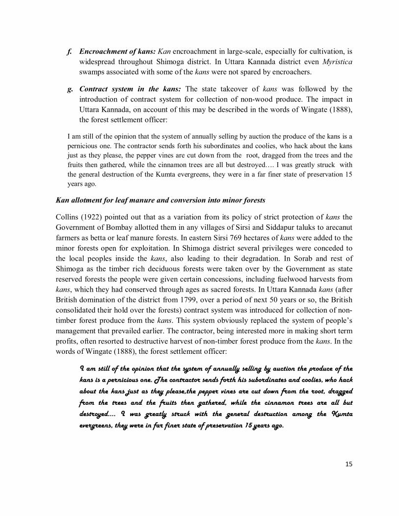
g. Contract system in the kans: The state takeover of kans was followed by the
introduction of contract system for collection of non-wood produce. The impact in
Uttara Kannada, on account of this may be described in the words of Wingate (1888),
the forest settlement officer:
I am still of the opinion that the system of annually selling by auction the produce of the kans is a
pernicious one. The contractor sends forth his subordinates and coolies, who hack about the kans
just as they please, the pepper vines are cut down from the root, dragged from the trees and the
fruits then gathered, while the cinnamon trees are all but destroyed…. I was greatly struck with
the general destruction of the Kumta evergreens, they were in a far finer state of preservation 15
years ago.
Kan allotment for leaf manure and conversion into minor forests
Collins (1922) pointed out that as a variation from its policy of strict protection of kans the
Government of Bombay allotted them in any villages of Sirsi and Siddapur taluks to arecanut
farmers as betta or leaf manure forests. In eastern Sirsi 769 hectares of kans were added to the
minor forests open for exploitation. In Shimoga district several privileges were conceded to
the local peoples inside the kans, also leading to their degradation. In Sorab and rest of
Shimoga as the timber rich deciduous forests were taken over by the Government as state
reserved forests the people were given certain concessions, including fuelwood harvests from
kans, which they had conserved through ages as sacred forests. In Uttara Kannada kans (after
British domination of the district from 1799, over a period of next 50 years or so, the British
consolidated their hold over the forests) contract system was introduced for collection of non-
timber forest produce from the kans. This system obviously replaced the system of people’s
management that prevailed earlier. The contractor, being interested more in making short term
profits, often resorted to destructive harvest of non-timber forest produce from the kans. In the
words of Wingate (1888), the forest settlement officer:
I am still of the opinion that the system of annually selling by auction the produce of the
kans is a pernicious one. The contractor sends forth his subordinates and coolies, who hack
about the kans just as they please,the pepper vines are cut down from the root, dragged
from the trees and the fruits then gathered, while the cinnamon trees are all but
destroyed…. I was greatly struck with the general destruction among the Kumta
evergreens, they were in far finer state of preservation 15 years ago.
16
CASE STUDIES ON TWO KAN FORESTS OF OF THIRTHAHALLI TALUK
I. INTRODUCTION
Thirthahalli taluk (area:1254 sq.km) is situated towards the south-west of Shimoga district
between lat. 13°27’22” to 13°55’27” and long. 75°01’57” to 75°30’42”. It is predominantly a
hilly taluk right in the middle of central Western Ghats at a mean altitude of 603 m above the
msl. Whereas most high rising hills are within 750 m, Heggargudda hill range, covered mostly
by Kurnimakki-Halmahishikan, has its summit at 850 m. The taluk is rich in water courses
and is drained mainly by the Tunga River and its smaller tributaries and streams. Most of the
forest clad hills are associated with such water courses which along their passages through
narrow valleys irrigate rice fields and arecanut gardens. The hill ranges of Thirthahalli, which
also include the Agumbe Ghat, famed as one of the highest rainfall areas of India, much of it
was clad in extremely rich rain forests of central Western Ghats is, is at the heart of the
watershed for good part of Karnataka because of the Tunga-Bhadra River. The taluk, as per
2001 Census, had a population of 143,207 persons. Majority of them (128,399 persons)
residing in rural areas. The livestock population (1993 census) was quite high at 144,299.
1) Abundance of tanks and streams: Thirthahalli taluk is rich in water resources,
especially in streams, compared to the drier eastern portions of Shimoga district.
Numerous streams which originate in the hills of the taluk rush through rugged terrain
before entering narrow valleys cultivated with gardens and rice fields. The Tunga
River that winds its way through in between hills receives most of these streams. In
addition there are 741 tanks, most of them built along the stream courses generations
back. Gross area irrigated by the tanks in the taluk amounts to 7328 ha, and net
irrigated area is 6911 ha. Net area irrigated in the taluk, from all sources, is 11537 ha
which highlights the richness of water resources.
2) Rainfall: Thirthahalli, is one of the rainiest taluks in Shimoga district. Agumbe
towards the south-west of Thirthahalli is one of the rainiest places in India. The taluk
has a normal average rainfall of 3042 mm/yr. It received 2938 mm of rainfall during
2010-11, as shown in the Table: 1
Table 1: Actual and normal rainfall in Thirthahalli taluk for 2010-11
Months Actual monthly
rainfall –mm
Normal monthly
rainfall-mm
January 1 6
February 2 0
March 5 7
April 35 37
May 100 62
17
June 562 521
July 1119 890
August 728 866
September 196 338
October 140 169
November 41 146
December 9 0
Total 2938 3042
3) Cultivation: Total cropped area in the taluk, in the year 2010-2011 was 25,879 ha,
approximately about 20% of the total area of the taluk. Most details on area under
various notable crops are given in the Table 2. Paddy occupies most of the cultivable
land. Arecanut, coconut, banana, sapota, pepper, cardamom and cashew are the
notable horticultural crops. Details regarding the output of various important crops are
given in the Table 3.
Table 2: Area under various crops in 2010-11
Crops Area (ha)
Foodgrains (mainly paddy
and just 3 ha of maize)
13820
Sugarcane 54
Fruit crops 1209
Pulses 53
Oil seeds 129
Horticultural crops 1209 ha (4.67%)
Table 3: Production details of horticultural crops (in tons) in Thirthahalli taluk
Crops Production in tons
Banana 16,310
Mango 210
Sapota 510
Coconut 69 lakh no.
Arecanut 9338
Pepper 65
Cardamom 8
Cashew 648
18
II. FOREST VEGETATION
With the high rainfall in the taluk one can expect tropical evergreen forests everywhere. But actually
we find mosaic of various kinds of forests. It is apparent that the original primary forests have given
way to secondary forests in most places because of human impact. Pascal et al (1982) considers the
main forest type of the taluk as Low elevation (disturbed) evergreen and semievergreen and their
various secondary and degraded stages. More towards the east of the district, because of relatively
less rugged terrain and larger cultivable areas associated with more populated villages and declining
rainfall the forests are more susceptible to desiccation. Secondary moist deciduous forests form a
mosaic with cultivation areas, savannas and scrub. Savanna type formations which are grassy lands
with isolated trees are created by humans through fire and felling, and used for cattle grazing and
meeting local biomass needs. Annual summer fires, often set on by humans, especially for burning
bushes and dry litter arrests regeneration of evergreen trees in the secondary moist deciduous forests.
The degraded stages of all the above types of forests in the form of scrub, isolated shrubby areas etc.
are found closer to human habitations.
Case stdy-1: KURNIMAKKI-HALMAHISHIKAN
Kurnimakki-Halmahishikan (kans are known locally usually by the name of the villages adjoining
them, unless there is any other recognized name) in the taluk of Thirthahalli in Shimoga district was
studied in the month of April, 2012, mainly from the vegetational angle and for cognizance of threats
facing it. The kan is said to be about 1000 hectares and situated between lat. 13.68°-13.73°N and
75.29°-75.35°E. It is not in a single piece but distributed in several survey nos. There is considerable
confusion on the demarcation of the boundaries of the kan due to encroachments, conflicting claims of
ownership and other practical problems. Looking at all the ancient maps available the kan boundaries
need to be more precisely demarcated. Shimoga and Chikmagalur districts were part of erstwhile
Mysore State. Kan lands were recognised by the State Forest Department till almost 1970. But
after that those survey numbers were merged in Reserved Forests and other kinds of forests
including Minor Forests, State forests and District forests (Gokhale et.al, undated). A Google
Earth image of the kan and associated landscape elements/villages is given in the Figure 1.
The study localities in Halmahishi, Bekshikenjigudda and Kesagaru villages are shown in
them. Evergreen to semi-evergreen forests and secondary moist deciduous forests were the
main forest types encountered. The geographical coordinates of study sites are shown in the
Table 4.
19
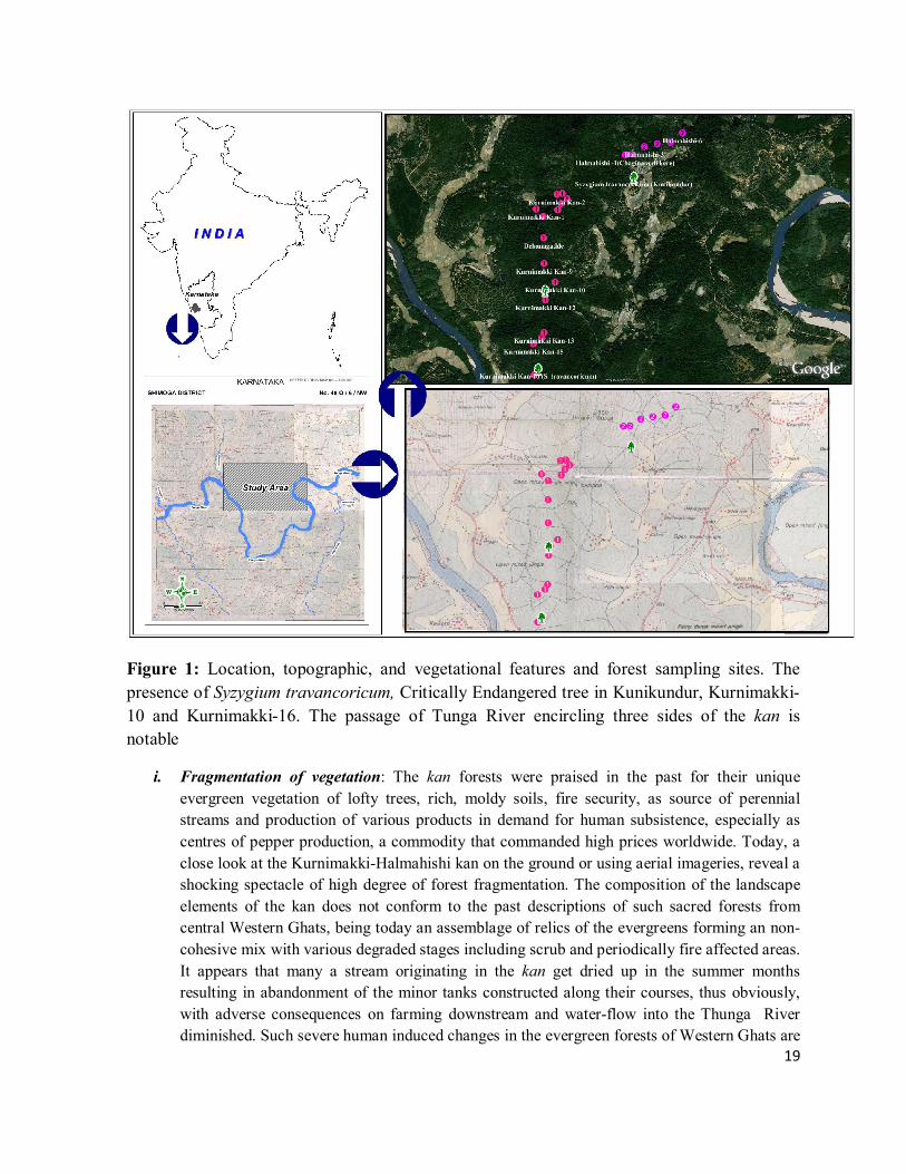
Figure 1: Location, topographic, and vegetational features and forest sampling sites. The
presence of Syzygium travancoricum, Critically Endangered tree in Kunikundur, Kurnimakki-
10 and Kurnimakki-16. The passage of Tunga River encircling three sides of the kan is
notable
i. Fragmentation of vegetation: The kan forests were praised in the past for their unique
evergreen vegetation of lofty trees, rich, moldy soils, fire security, as source of perennial
streams and production of various products in demand for human subsistence, especially as
centres of pepper production, a commodity that commanded high prices worldwide. Today, a
close look at the Kurnimakki-Halmahishi kan on the ground or using aerial imageries, reveal a
shocking spectacle of high degree of forest fragmentation. The composition of the landscape
elements of the kan does not conform to the past descriptions of such sacred forests from
central Western Ghats, being today an assemblage of relics of the evergreens forming an non-
cohesive mix with various degraded stages including scrub and periodically fire affected areas.
It appears that many a stream originating in the kan get dried up in the summer months
resulting in abandonment of the minor tanks constructed along their courses, thus obviously,
with adverse consequences on farming downstream and water-flow into the Thunga River
diminished. Such severe human induced changes in the evergreen forests of Western Ghats are
20
bound to have cascading consequences on human welfare in the Deccan plains mainly because
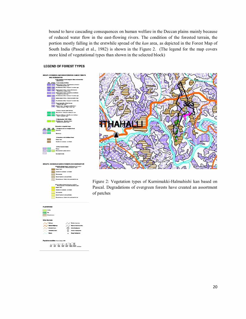
of reduced water flow in the east-flowing rivers. The condition of the forested terrain, the
portion mostly falling in the erstwhile spread of the kan area, as depicted in the Forest Map of
South India (Pascal et al., 1982) is shown in the Figure 2. (The legend for the map covers
more kind of vegetational types than shown in the selected block)
Figure 2: Vegetation types of Kurnimakki-Halmahishi kan based on
Pascal. Degradations of evergreen forests have created an assortment
of patches
21
i. Land use Land cover analysis of Select Kan forests in Shimoga Land use land cover (LULC) information of a region depicts the status of a landscape for
environmental progression and sustainable development. Land cover configuration is
stated as a unified reflection of the existing natural resources, dynamic natural processes
whereas land use refers to the human induced changes in the land cover. The main effects
of human activities on the environment are land use and resulting land cover changes.
Such changes impact the capacity of ecosystems to provide goods and services to the
human society. Human induced land cover change such as for agricultural expansions
have caused large scale deforestation leading to soil erosion, watershed degradation,
reduced biodiversity, and agrochemical pollution. In forest dominated landscapes
fragmentation issues of prominence seem to relate typically to deforestation and loss of
forest cover over a period of time. Monitoring these changes is essential for sustainable
management of the natural resources. It has become an essential to integrate the patterns of
land cover change with the processes of land use change by identifying various drivers for the
change process.
Tropical deforestation, rangeland modification, agricultural area shrink and urbanization
are the major land-use and land-cover changes around the globe (Geist and Lambin,
2001). The driving force of land-use/cover change vary and their dynamic interactions
result in diverse change and trajectories of change, depending upon the specific
environmental, social, political and historical context from which they arise (Meyer and
Tuner II, 1992). The resulting changes from these drivers exist as a complex between
subtle modification and total conversion as seen in a change in forest density and forest to
agricultural land or urban area (Geist and Lambin, 2001; Veldkamp and Lambin, 2001).
The complexity of land use land-cover changes is illustrated by functional differences
within types of land cover, structural variance between types of land-cover change, with
regards to spatial arrangement and temporal pattern of change (Giest and Lambin, 2001).
Availability of multi-resolution temporal remote sensing (RS) data has aided in
monitoring larger areas at various spatial and spectral resolutions. Remote sensing data
along with GIS (Geographical Information Systems), GPS (Global positioning system)
and other collateral data (spatial as well as statistical) help in effective land cover analysis
(Ramachandra & Kumar, 2004; Ramachandra et al., 2009). Mapping, quantifying, and
monitoring the physical characteristics of land cover has been widely recognized as a key
element in the study of regional and global changes (Nemani & Running, 1996). The
objectives of this work is
a) Classification of multi-temporal RS data to obtain LU LC map.
b) Multi-temporal analysis for characterise the type and extent of fragmentation or loss of
vegetation cover, Visualising the consequences of changes in the region.
22
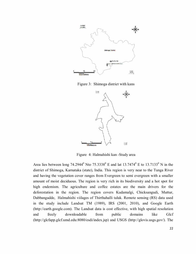
Figure 3: Shimoga district with kans
Figure 4: Halmahishi kan -Study area
Area lies between long 74.29440 Nto 75.33380 E and lat 13.74740 E to 13.71330 N in the
district of Shimoga, Karnataka (state), India. This region is very near to the Tunga River
and having the vegetation cover ranges from Evergreen to semi evergreen with a smaller
amount of moist deciduous. The region is very rich in its biodiversity and a hot spot for
high endemism. The agriculture and coffee estates are the main drivers for the
deforestation in the region. The region covers Kudamalgi, Chicksangudi, Muttur,
Dabbangadde, Halmahishi viilages of Thirthahalli taluk. Remote sensing (RS) data used
in the study include Landsat TM (1989), IRS (2001, 2010), and Google Earth
(http://earth.google.com). The Landsat data is cost effective, with high spatial resolution
and freely downloadable from public domains like Glcf
(http://glcfapp.glcf.umd.edu:8080/esdi/index.jsp) and USGS (http://glovis.usgs.gov/). The
23
summery characteristics of datasets used in the current study are summarized in Table 4.
Besides remote sensing data, many other data sources were used in the study. Topographic
maps provided ground control points to rectify remotely sensed images and scanned paper
maps.
Table 4: Data used in the study
Data Sensor Year Resolution (M)
Landsat TM 1989 28.5
IRS Lis3 2001 23
IRS Lis4 2010 5
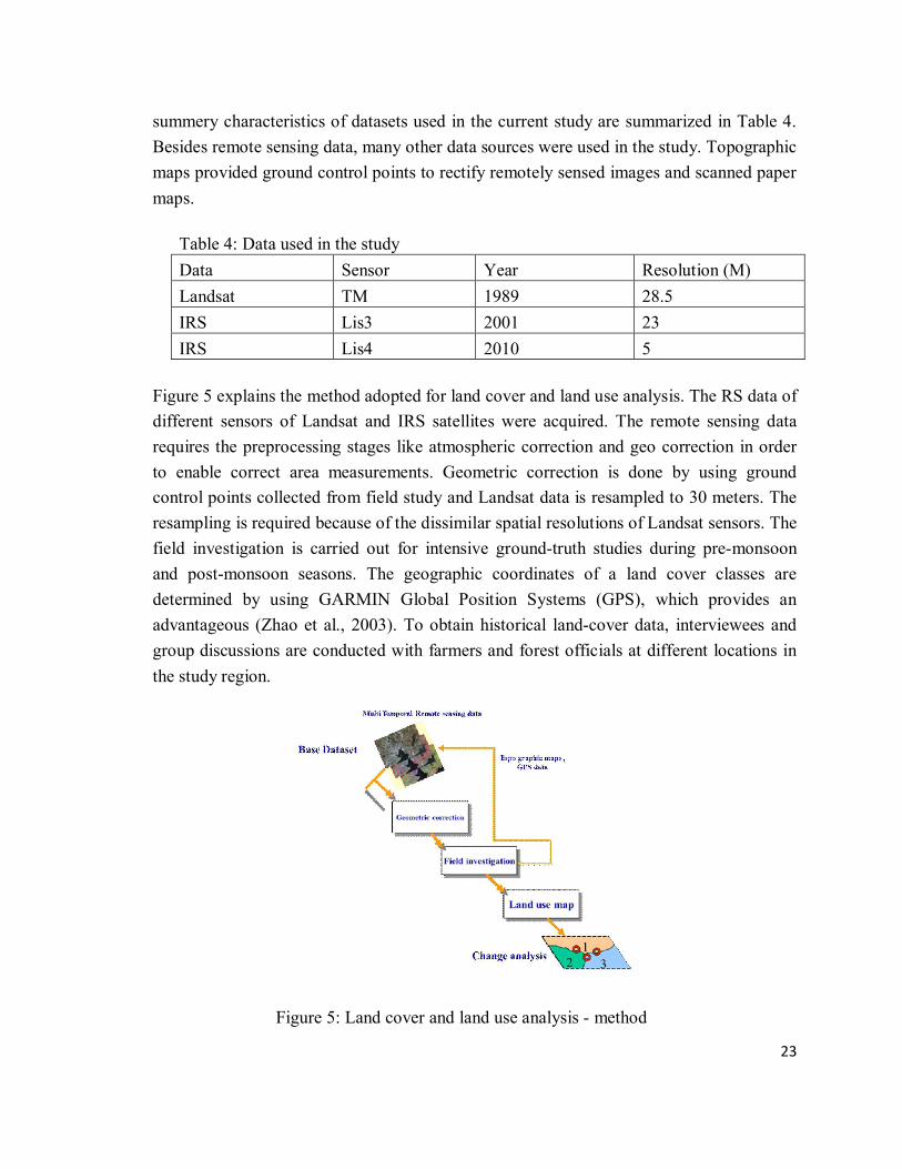
Figure 5 explains the method adopted for land cover and land use analysis. The RS data of
different sensors of Landsat and IRS satellites were acquired. The remote sensing data
requires the preprocessing stages like atmospheric correction and geo correction in order
to enable correct area measurements. Geometric correction is done by using ground
control points collected from field study and Landsat data is resampled to 30 meters. The
resampling is required because of the dissimilar spatial resolutions of Landsat sensors. The
field investigation is carried out for intensive ground-truth studies during pre-monsoon
and post-monsoon seasons. The geographic coordinates of a land cover classes are
determined by using GARMIN Global Position Systems (GPS), which provides an
advantageous (Zhao et al., 2003). To obtain historical land-cover data, interviewees and
group discussions are conducted with farmers and forest officials at different locations in
the study region.
Figure 5: Land cover and land use analysis - method
24
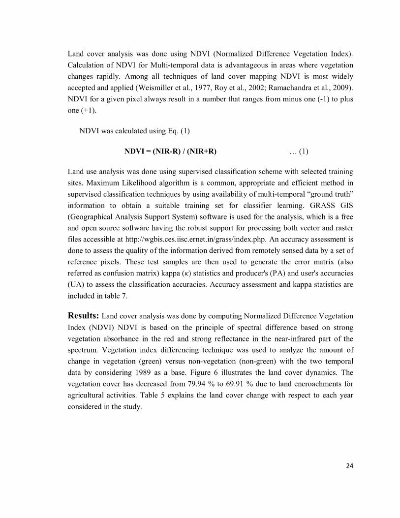
Land cover analysis was done using NDVI (Normalized Difference Vegetation Index).
Calculation of NDVI for Multi-temporal data is advantageous in areas where vegetation
changes rapidly. Among all techniques of land cover mapping NDVI is most widely
accepted and applied (Weismiller et al., 1977, Roy et al., 2002; Ramachandra et al., 2009).
NDVI for a given pixel always result in a number that ranges from minus one (-1) to plus
one (+1).
NDVI was calculated using Eq. (1)
NDVI = (NIR-R) / (NIR+R) … (1)
Land use analysis was done using supervised classification scheme with selected training
sites. Maximum Likelihood algorithm is a common, appropriate and efficient method in
supervised classification techniques by using availability of multi-temporal “ground truth”
information to obtain a suitable training set for classifier learning. GRASS GIS
(Geographical Analysis Support System) software is used for the analysis, which is a free
and open source software having the robust support for processing both vector and raster
files accessible at http://wgbis.ces.iisc.ernet.in/grass/index.php. An accuracy assessment is
done to assess the quality of the information derived from remotely sensed data by a set of
reference pixels. These test samples are then used to generate the error matrix (also
referred as confusion matrix) kappa (κ) statistics and producer's (PA) and user's accuracies
(UA) to assess the classification accuracies. Accuracy assessment and kappa statistics are
included in table 7.
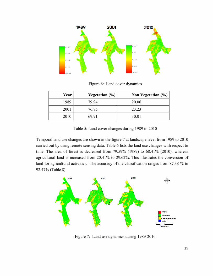
Results: Land cover analysis was done by computing Normalized Difference Vegetation
Index (NDVI) NDVI is based on the principle of spectral difference based on strong
vegetation absorbance in the red and strong reflectance in the near-infrared part of the
spectrum. Vegetation index differencing technique was used to analyze the amount of
change in vegetation (green) versus non-vegetation (non-green) with the two temporal
data by considering 1989 as a base. Figure 6 illustrates the land cover dynamics. The
vegetation cover has decreased from 79.94 % to 69.91 % due to land encroachments for
agricultural activities. Table 5 explains the land cover change with respect to each year
considered in the study.
25
Figure 6: Land cover dynamics
Year Vegetation (%) Non Vegetation (%)
1989 79.94 20.06
2001 76.75 23.23
2010 69.91 30.01
Table 5: Land cover changes during 1989 to 2010
Temporal land use changes are shown in the figure 7 at landscape level from 1989 to 2010
carried out by using remote sensing data. Table 6 lists the land use changes with respect to
time. The area of forest is decreased from 79.59% (1989) to 68.41% (2010), whereas
agricultural land is increased from 20.41% to 29.62%. This illustrates the conversion of
land for agricultural activities. The accuracy of the classification ranges from 87.38 % to
92.47% (Table 8).
Figure 7: Land use dynamics during 1989-2010
26
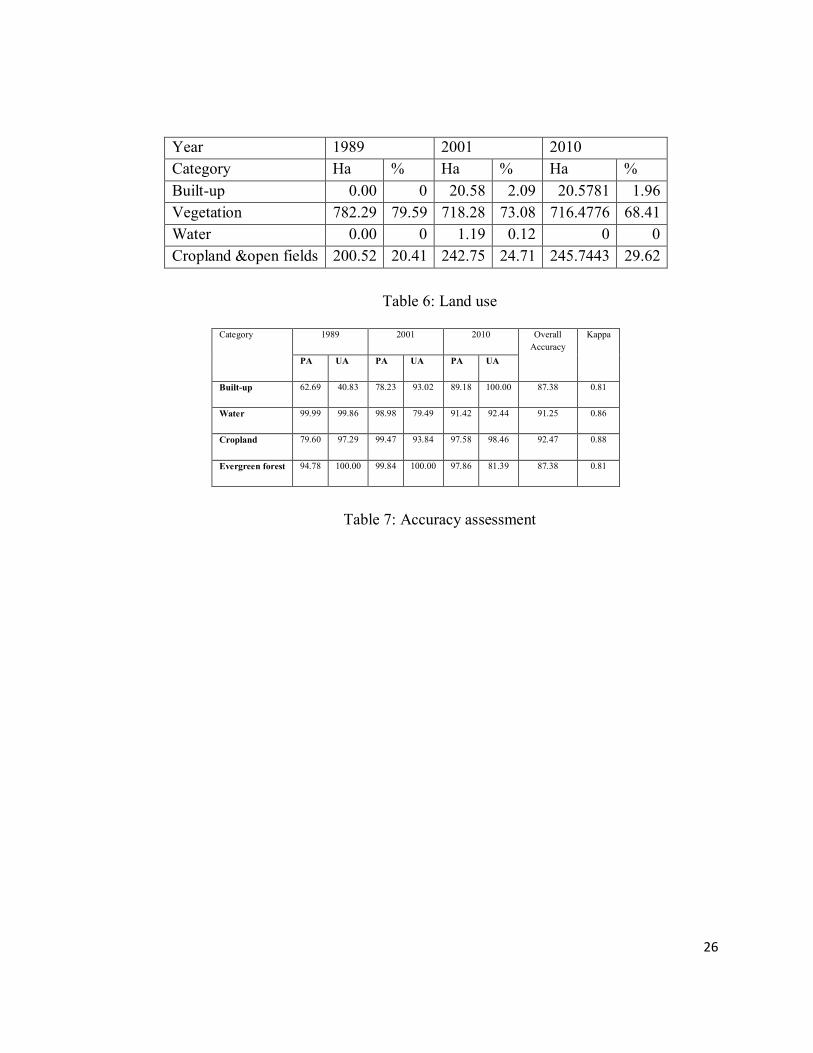
Year 1989 2001 2010
Category Ha % Ha % Ha %
Built-up 0.00 0 20.58 2.09 20.5781 1.96
Vegetation 782.29 79.59 718.28 73.08 716.4776 68.41
Water 0.00 0 1.19 0.12 0 0
Cropland &open fields 200.52 20.41 242.75 24.71 245.7443 29.62
Table 6: Land use
Category 1989 2001 2010 Overall
Accuracy
Kappa
PA UA PA UA PA UA
Built-up 62.69 40.83 78.23 93.02 89.18 100.00 87.38 0.81
Water 99.99 99.86 98.98 79.49 91.42 92.44 91.25 0.86
Cropland 79.60 97.29 99.47 93.84 97.58 98.46 92.47 0.88
Evergreen forest 94.78 100.00 99.84 100.00 97.86 81.39 87.38 0.81
Table 7: Accuracy assessment
27
ii. Vegetation studies
Vegetation was studied in 26 sampling localities within the kan using Point-centred quarter method.
The geographical coordinates of the localities sampled are shown in the Table 8.
Table 8: The localities within the kan chosen for quantitative sampling of forest
Sl Localities visited LONGITUDE LATITUDE 1 Kurnimakki Kan-1 75.3079 13.7075 2 Kurnimakki Kan-2 75.3102 13.7091 3 Kurnimakki Kan-3 75.3108 13.7092 4 Kurnimakki Kan-4 75.3113 13.7086 5 Kurnimakki kan-5 75.3107 13.7081 6 Kurnimakki kan-6 75.3103 13.7074 7 Kurnimakki kan-7 75.3087 13.7067 8 Kurnimakki kan-8 75.3107 13.7081 9 Kurnimakki Kan-9 75.3088 13.7017 10 Kurnimakki Kan-10 75.31 13.6997 11 Kurnimakki Kan-11 75.309 13.6989 12 Kurnimakki Kan-12 75.3089 13.6978 13 Kurnimakki Kan-13 75.3088 13.6943 14 Kurnimakki Kan-14 75.3085 13.6937 15 Kurnimakki Kan-15 75.3076 13.6931 16 Kurnimakki Kan-16 (S.
travancoricum) 75.3081 13.6905
17 Kurnimakki Kan-17 75.3077 13.6898 18 S. travancoricum (Wadape) 75.3089 13.6989 19 Debanagadde 75.3088 13.7044 20 Syzygium travancoricum
(Kunikundur) 75.3186 13.711
21 Halmahishi -1(Chaginakudi kere)
75.3177 13.7133 22 Halmahishi-2 75.3185 13.7134 23 Halmahishi-3 75.3198 13.7142 24 Halmahishi-4 75.3212 13.7145 25 Halmahishi-5 75.3227 13.7147 26 Halmahishi-6 75.324 13.7157
28
iii. Tree species in evergreen-semievergreen forest type
Lofty evergreen trees of 25 to 30 m height were quite many in the forest and belonged to
species such as Aphanantha cuspidata, Canarium strictum (Kan: Karidhupa), Mangifera
indica, Syzygium hemisphericum, S. travancoricum etc. Evergreen trees of the second level of
general heights from 15-25 m include Actinodaphne hookeri, Aglaia roxburghiana,
Anthocephalus kadamba, Beilsmeida fagifolia, Dimocarpus longan, Ficus callosa, Holigarna
ferruginea, Hopea ponga, Olea dioica, Syzygium cumini etc. Evergreen trees of still smaller
stature include Aporosa lindleyana, Ixora brachiata, Knema attenuata, Litsea wightiana,
Vepris bilocularis etc. We could list 46 tree species from this type of forest. Some deciduous
species are also found in this type viz. Careya arboa, Lagerstroemia microcarpa,
Stereospermum personatum, Terminalia paniculata, T. bellirica, Vitex altissima, Xylia
xylocarpa; Zanthoxylum rhetsa, etc. The secondary deciduous forests within the kan and their
peripheral areas are obviously due to forest fragmentation through cutting and burning. They
have, in addition to the leaf shedding trees mentioned above also have Madhuca latifolia,
Bombax ceiba, Terminalia paniculata, Firminia colorata etc. Altogether only 25 tree species
were found in the deciduous forests, which include a small number of tolerant evergreens such
as Olea dioica, Aporosa lindleyana, Syzygium cumini, Alstonia scholaris etc. Two patches of
forests, one of evergreen remains and the second of moist deciduous kind (secondary) are
shown in the Figure 8. The Shannon diversity index for trees was found to be higher (3.45)
for the evergreen dominated patches than for the deciduous (2.79) (Figure 9 Shannon
diversity). Details of tree species inventorised from the sample points of evergreen and
deciduous areas are given in Figure 10, along with estimated basal areas/ha in both.
Figure 8: Relic evergreen forest patch and a farmland below. Water input from the kan is vital
for cultivation; R. Vegetation survey in a secondary moist deciduous forest within the kan
29
Figure 9: Shannon diversity index for evergreen dominated and deciduous dominated areas
Figure 10: Tree species inventorised for evergreen sample points and deciduous areas and
basal area estimated/ha for both.
a. Tree density/ha: The evergreen-semi-evergreen forests had more tree numbers/ha in
the kan at 234/ha compared to the moist deciduous patches at 181/ha. The estimated
number was lower for both types of forests than any good low elevation Western Ghat
30
forests where the number could be >300 to 500/ha. The kan forest particularly,
belonging to the traditional category of sacred forest, is expected to have more number
of trees. Ever increasing human impact and conflicting claims on ownership, diluting
the authority of the Forest Department, may be a pertinent factor for less than expected
number of trees.
b. Basal area of trees: Basal areas of trees/ha was calculated based on the girth
measurements taken for the sampled trees. The basal area was found to be 39.93 m²/ha
for evergreen/semi-evergreen areas and 30.93 m²/ha for deciduous forest areas. This
lowered basal area of a sacred forest, which reflects particularly a thinning of the
forest in the catchment of the Tunga River, does not augur well for hydrology of the
region as a whole. The fate of the other kans in Thirthahalli taluk does not appear to be
better, as the category of kan forest itself is fading away from the face of the taluk,
which had once 436 kans on the record.
c. Evergreenness and endemism of trees
The Western Ghats, along with Sri Lanka, constitute one of the 34 Global
Biodiversity, on account of high species diversity, high degree of species endemism as
well as heavy human impact on the ecosystems. Endemism in any group of plant or
animal is typically linked to levels of tree endemism in the forests. If there is high
percentage of endemic trees in an area, endemism among lower plant groups and in the
animal community is also expected to rise. The rise in percentage of Western Ghat
endemism in relation to increase in percentage evergreen trees in the community is
evident from the Figure 11.
Figure 11: Tree endemism in evergreen-semi-evergreen forests versus deciduous forests
31
Figure 12 depicts that the evergreen-semi-evergreen forest patches considered collectively
for percentage of evergreen trees, showing a higher result (almost 85% individuals
belonging to evergreen type) account for higher Western Ghat tree endemism (32%),
compared to the predominantly deciduous patches collectively accounting for only 41%
evergreenness having barely 10% endemics. Some endemics survive there because these
deciduous forest patches occur in an evergreen zone of higher rainfall, and some of the
desiccation and large gap tolerant trees like Lagerstroemia microcarpa (deciduous) and
Taberna-montana coronaria, an understorey plant are considered endemics. One of the
first casualties of gross human interference with humid forest ecosystem of the Western
Ghats would be disappearance of the most sensitive endemic species. The kan forests, in
the pre-colonial days would have been important local centres of plant and animal
endemism, as they were considered sacred and there was strong taboo on tree cutting in
such forests. Notable among the endemic trees were Calophyllum apetalum, Cinnamomum
malabathrum, Holigarna arnottiana, H. ferruginea, Hopea ponga, Mastixia arborea,
Polyalthia fragrans etc.
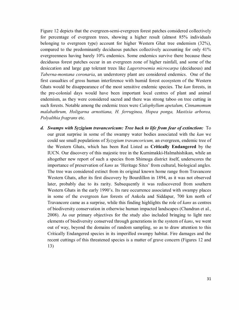
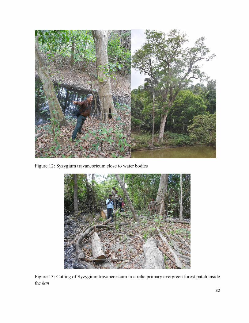
d. Swamps with Syzigium travancoricum: Tree back to life from fear of extinction: To
our great surprise in some of the swampy water bodies associated with the kan we
could see small populations of Syzygium travancoricum, an evergreen, endemic tree of
the Western Ghats, which has been Red Listed as Critically Endangered by the
IUCN. Our discovery of this majestic tree in the Kurnimakki-Halmahishikan, while an
altogether new report of such a species from Shimoga district itself, underscores the
importance of preservation of kans as ‘Heritage Sites’ from cultural, biological angles.
The tree was considered extinct from its original known home range from Travancore
Western Ghats, after its first discovery by Bourdillon in 1894, as it was not observed
later, probably due to its rarity. Subsequently it was rediscovered from southern
Western Ghats in the early 1990’s. Its rare occurrence associated with swampy places
in some of the evergreen kan forests of Ankola and Siddapur, 700 km north of
Travancore came as a surprise, while this finding highlights the role of kans as centres
of biodiversity conservation in otherwise human impacted landscapes (Chandran et al.,
2008). As our primary objectives for the study also included bringing to light rare
elements of biodiversity conserved through generations in the system of kans, we went
out of way, beyond the domains of random sampling, so as to draw attention to this
Critically Endangered species in its imperilled swampy habitat. Fire damages and the
recent cuttings of this threatened species is a matter of grave concern (Figures 12 and
13)
32
Figure 12: Syzygium travancoricum close to water bodies
Figure 13: Cutting of Syzygium travancoricum in a relic primary evergreen forest patch inside
the kan
33
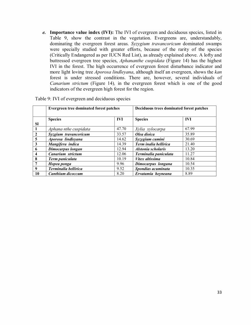
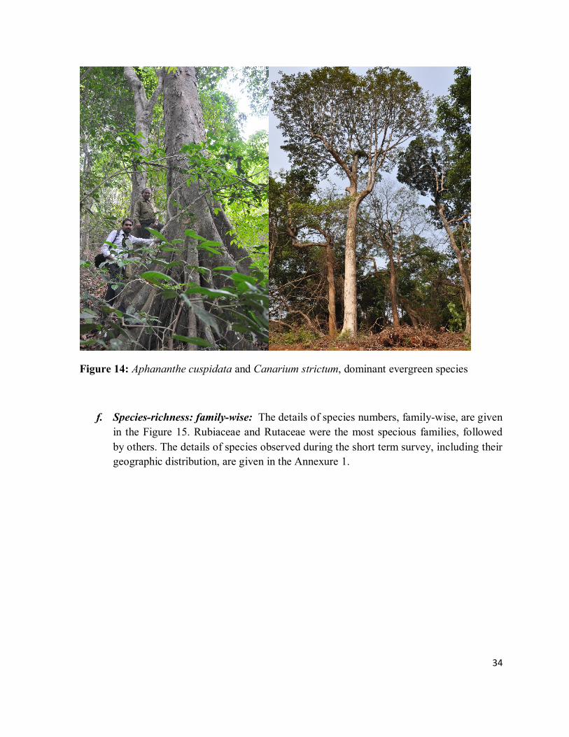
e. Importance value index (IVI): The IVI of evergreen and deciduous species, listed in Table 9, show the contrast in the vegetation. Evergreens are, understandably, dominating the evergreen forest areas. Syzygium travancoricum dominated swamps were specially studied with greater efforts, because of the rarity of the species (Critically Endangered as per IUCN Red List), as already explained above. A lofty and buttressed evergreen tree species, Aphananthe cuspidata (Figure 14) has the highest IVI in the forest. The high occurrence of evergreen forest disturbance indicator and more light loving tree Aporosa lindleyana, although itself an evergreen, shows the kan forest is under stressed conditions. There are, however, several individuals of Canarium strictum (Figure 14), in the evergreen forest which is one of the good indicators of the evergreen high forest for the region.
Table 9: IVI of evergreen and deciduous species
Evergreen tree dominated forest patches Deciduous trees dominated forest patches
Sl
Species IVI Species IVI
1 Aphana nthe cuspidata 47.70 Xylia xylocarpa 67.99
2 Syzgium travancoricum 33.57 Olea dioica 35.89 5 Aporosa lindleyana 14.62 Syzygium cumini 30.69 3 Mangifera indica 14.39 Term inalia bellirica 21.40 6 Dimocarpus longan 12.94 Alstonia scholaris 13.20 4 Canarium strictum 12.06 Terminalia paniculata 11.27 8 Term paniculata 10.19 Vitex altissima 10.84 7 Hopea ponga 9.96 Dimocarpus longana 10.54 9 Terminalia bellirica 9.52 Spondias acuminata 10.35 10 Canthium dicoccum 8.20 Ervatamia heyneana 8.89
34
Figure 14: Aphananthe cuspidata and Canarium strictum, dominant evergreen species
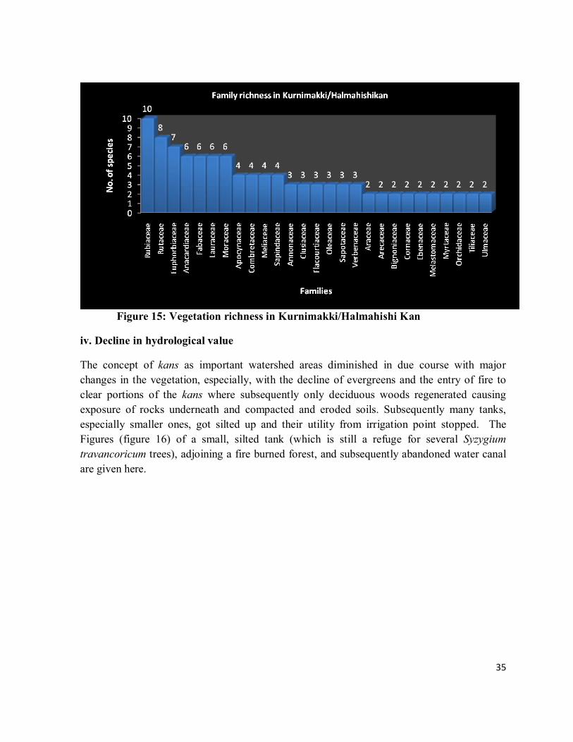
f. Species-richness: family-wise: The details of species numbers, family-wise, are given
in the Figure 15. Rubiaceae and Rutaceae were the most specious families, followed
by others. The details of species observed during the short term survey, including their
geographic distribution, are given in the Annexure 1.
35
Figure 15: Vegetation richness in Kurnimakki/Halmahishi Kan
iv. Decline in hydrological value
The concept of kans as important watershed areas diminished in due course with major
changes in the vegetation, especially, with the decline of evergreens and the entry of fire to
clear portions of the kans where subsequently only deciduous woods regenerated causing
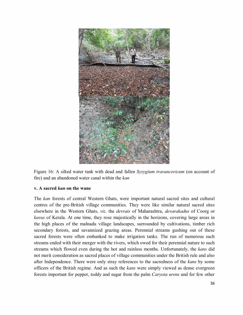
exposure of rocks underneath and compacted and eroded soils. Subsequently many tanks,
especially smaller ones, got silted up and their utility from irrigation point stopped. The
Figures (figure 16) of a small, silted tank (which is still a refuge for several Syzygium
travancoricum trees), adjoining a fire burned forest, and subsequently abandoned water canal
are given here.
36
Figure 16: A silted water tank with dead and fallen Syzygium travancoricum (on account of
fire) and an abandoned water canal within the kan
v. A sacred kan on the wane
The kan forests of central Western Ghats, were important natural sacred sites and cultural
centres of the pre-British village communities. They were like similar natural sacred sites
elsewhere in the Western Ghats, viz. the devrais of Maharashtra, devarakadus of Coorg or
kavus of Kerala. At one time, they rose majestically in the horizons, covering large areas in
the high places of the malnadu village landscapes, surrounded by cultivations, timber rich
secondary forests, and savannized grazing areas. Perennial streams gushing out of these
sacred forests were often embanked to make irrigation tanks. The run of numerous such
streams ended with their merger with the rivers, which owed for their perennial nature to such
streams which flowed even during the hot and rainless months. Unfortunately, the kans did
not merit consideration as sacred places of village communities under the British rule and also
after Independence. There were only stray references to the sacredness of the kans by some
officers of the British regime. And as such the kans were simply viewed as dense evergreen
forests important for pepper, toddy and sugar from the palm Caryota urens and for few other
37
items of commercial or subsistence values. In Shimoga district, particularly, many kans were
brought under the jurisdiction of the Revenue Department, which conveniently allotted kan
lands for meeting various non-forestry purposes such as for growing coffee, expansion of
cultivation, for grazing purposes and numerous others, inconsiderate and negligent of the rare
species they conserved and also of their crucial hydrological importance. The Government
also conceded large portions of kans on long leases to the Mysore Paper Mills for growing
industrial woods like Eucalyptus and Acacia spp. after clearing the natural vegetation
(Annexure 2).
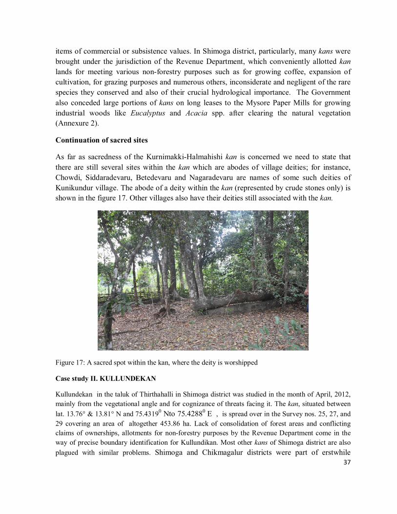
Continuation of sacred sites
As far as sacredness of the Kurnimakki-Halmahishi kan is concerned we need to state that
there are still several sites within the kan which are abodes of village deities; for instance,
Chowdi, Siddaradevaru, Betedevaru and Nagaradevaru are names of some such deities of
Kunikundur village. The abode of a deity within the kan (represented by crude stones only) is
shown in the figure 17. Other villages also have their deities still associated with the kan.
Figure 17: A sacred spot within the kan, where the deity is worshipped
Case study II. KULLUNDEKAN
Kullundekan in the taluk of Thirthahalli in Shimoga district was studied in the month of April, 2012,
mainly from the vegetational angle and for cognizance of threats facing it. The kan, situated between
lat. 13.76° & 13.81° N and 75.43190 Nto 75.42880 E , is spread over in the Survey nos. 25, 27, and
29 covering an area of altogether 453.86 ha. Lack of consolidation of forest areas and conflicting
claims of ownerships, allotments for non-forestry purposes by the Revenue Department come in the
way of precise boundary identification for Kullundikan. Most other kans of Shimoga district are also
plagued with similar problems. Shimoga and Chikmagalur districts were part of erstwhile
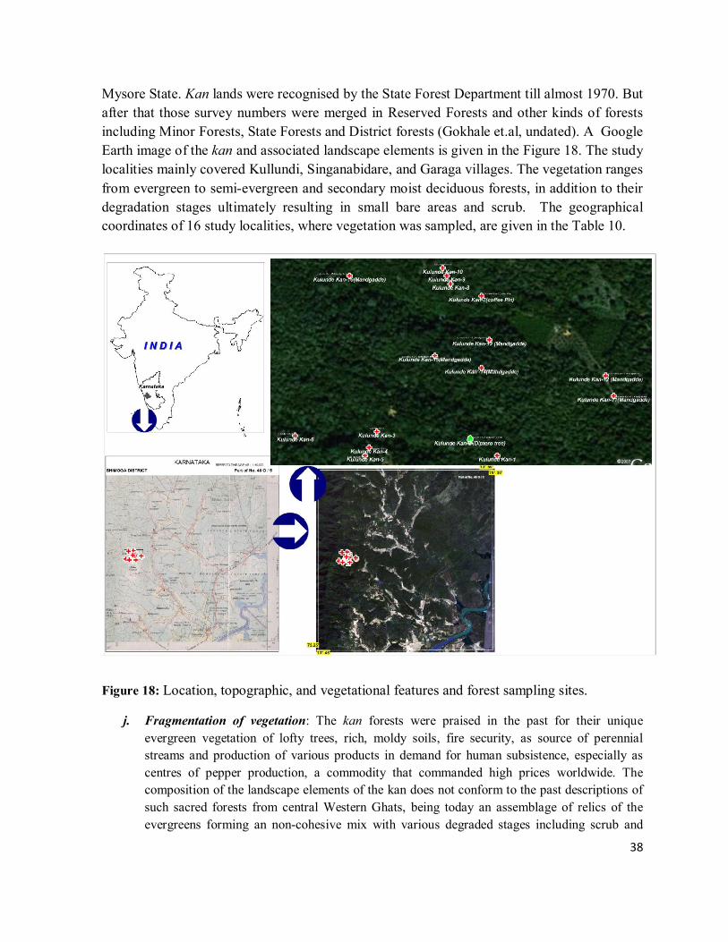
38
Mysore State. Kan lands were recognised by the State Forest Department till almost 1970. But
after that those survey numbers were merged in Reserved Forests and other kinds of forests
including Minor Forests, State Forests and District forests (Gokhale et.al, undated). A Google
Earth image of the kan and associated landscape elements is given in the Figure 18. The study
localities mainly covered Kullundi, Singanabidare, and Garaga villages. The vegetation ranges
from evergreen to semi-evergreen and secondary moist deciduous forests, in addition to their
degradation stages ultimately resulting in small bare areas and scrub. The geographical
coordinates of 16 study localities, where vegetation was sampled, are given in the Table 10.
Figure 18: Location, topographic, and vegetational features and forest sampling sites.
j. Fragmentation of vegetation: The kan forests were praised in the past for their unique
evergreen vegetation of lofty trees, rich, moldy soils, fire security, as source of perennial
streams and production of various products in demand for human subsistence, especially as
centres of pepper production, a commodity that commanded high prices worldwide. The
composition of the landscape elements of the kan does not conform to the past descriptions of
such sacred forests from central Western Ghats, being today an assemblage of relics of the
evergreens forming an non-cohesive mix with various degraded stages including scrub and

39
periodically fire affected areas. Severe human induced changes in the evergreen forests of
Western Ghats are bound to have cascading consequences on human welfare in the Deccan
plains mainly because of reduced water flow in the east-flowing rivers. The condition of the
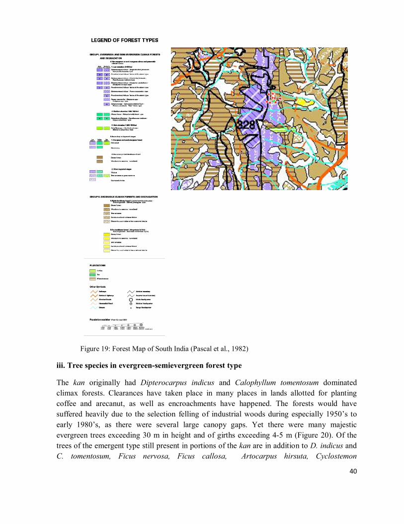
forested terrain, the portion mostly falling in the erstwhile spread of the kan area, as depicted
in the Forest Map of South India (Pascal et al., 1982) is shown in the Figure 19. (The legend
for the map covers more kind of vegetational types than shown in the selected block). Bulk of
the forest is evergreen and a portion was once dominated by Dipterocarpus indicus of the
climax evergreen type formation of the lower altitudes. However, many mighty trees of the
species were cut down for planting coffee and for forest based industries in the past. Many
changes appear to have taken place after the preparation of the vegetation map by Pascal, due
to land allotments for non-forestry purposes and due to other human interventions.
ii. Quantitative studies
Vegetation was studied in 16 sampling localities within the kan using Point-centred quarter
method. The geographical coordinates of the localities sampled are shown in the Table 10.
Table 10: Study localities of forest sampling
Sl NAME LONGITUDE LATITUDE
1 Kulundikan-1 75.4319 13.7911 2 Kulundikan-2 75.4312 13.7915 3 Kulundikan-3 75.4288 13.7917 4 Kulundikan-4 75.4286 13.7913 5 Kulundikan-5 75.4285 13.7911 6 Kulundikan-6 75.4267 13.7916 7 Kulundikan-7 75.4315 13.7951 8 Kulundikan-8 75.4307 13.7954 9 Kulundikan-9 75.4306 13.7956 10 Kulundikan-10 75.4305 13.7958 11 Kulundikan-11 75.4349 13.7926 12 Kulundikan-12 75.4347 13.7931 13 Kulundikan-13 75.4317 13.7940 14 Kulundikan-14 75.4315 13.7933 15 Kulundikan-15 75.4303 13.7936 16 Kulundikan-16 75.4281 13.7956
40
Figure 19: Forest Map of South India (Pascal et al., 1982)
iii. Tree species in evergreen-semievergreen forest type
The kan originally had Dipterocarpus indicus and Calophyllum tomentosum dominated
climax forests. Clearances have taken place in many places in lands allotted for planting
coffee and arecanut, as well as encroachments have happened. The forests would have
suffered heavily due to the selection felling of industrial woods during especially 1950’s to
early 1980’s, as there were several large canopy gaps. Yet there were many majestic
evergreen trees exceeding 30 m in height and of girths exceeding 4-5 m (Figure 20). Of the
trees of the emergent type still present in portions of the kan are in addition to D. indicus and
C. tomentosum, Ficus nervosa, Ficus callosa, Artocarpus hirsuta, Cyclostemon
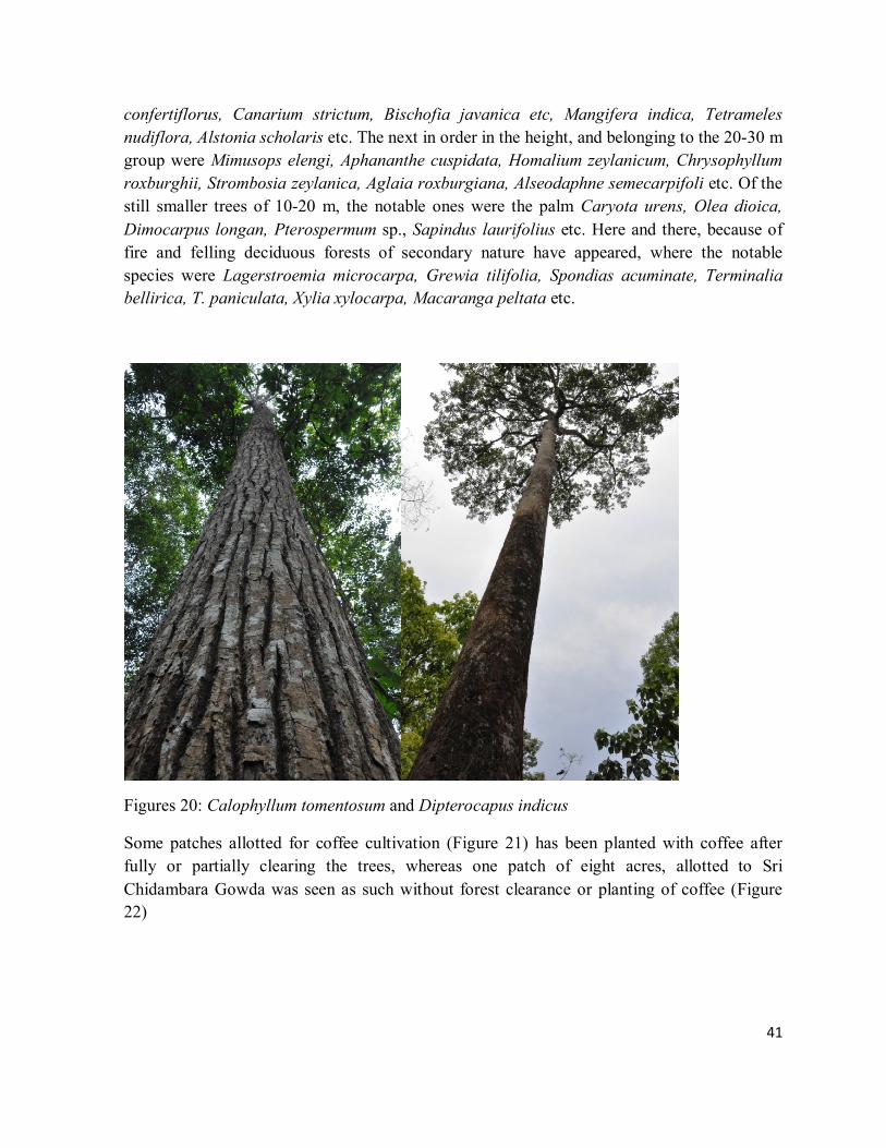
41
confertiflorus, Canarium strictum, Bischofia javanica etc, Mangifera indica, Tetrameles
nudiflora, Alstonia scholaris etc. The next in order in the height, and belonging to the 20-30 m
group were Mimusops elengi, Aphananthe cuspidata, Homalium zeylanicum, Chrysophyllum
roxburghii, Strombosia zeylanica, Aglaia roxburgiana, Alseodaphne semecarpifoli etc. Of the
still smaller trees of 10-20 m, the notable ones were the palm Caryota urens, Olea dioica,
Dimocarpus longan, Pterospermum sp., Sapindus laurifolius etc. Here and there, because of
fire and felling deciduous forests of secondary nature have appeared, where the notable
species were Lagerstroemia microcarpa, Grewia tilifolia, Spondias acuminate, Terminalia
bellirica, T. paniculata, Xylia xylocarpa, Macaranga peltata etc.
Figures 20: Calophyllum tomentosum and Dipterocapus indicus
Some patches allotted for coffee cultivation (Figure 21) has been planted with coffee after
fully or partially clearing the trees, whereas one patch of eight acres, allotted to Sri
Chidambara Gowda was seen as such without forest clearance or planting of coffee (Figure
22)
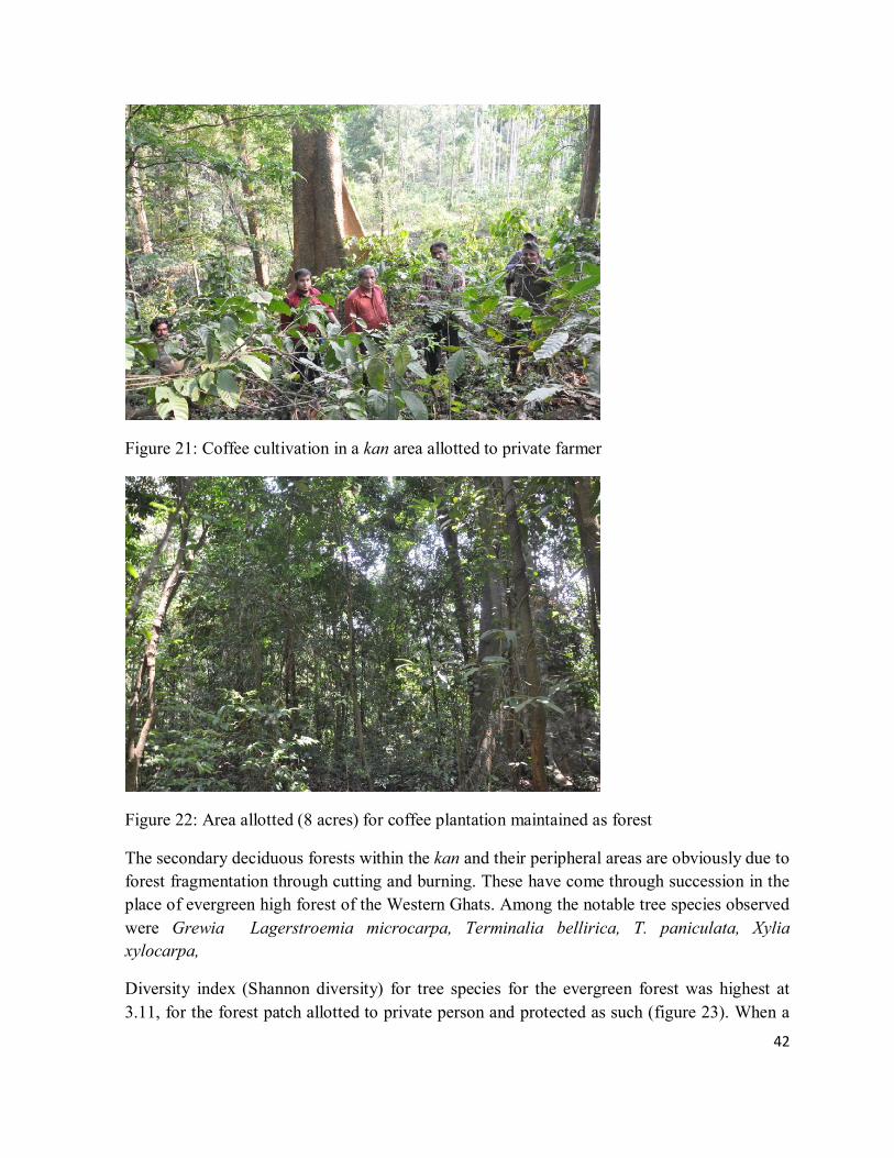
42
Figure 21: Coffee cultivation in a kan area allotted to private farmer
Figure 22: Area allotted (8 acres) for coffee plantation maintained as forest
The secondary deciduous forests within the kan and their peripheral areas are obviously due to
forest fragmentation through cutting and burning. These have come through succession in the
place of evergreen high forest of the Western Ghats. Among the notable tree species observed
were Grewia Lagerstroemia microcarpa, Terminalia bellirica, T. paniculata, Xylia
xylocarpa,
Diversity index (Shannon diversity) for tree species for the evergreen forest was highest at
3.11, for the forest patch allotted to private person and protected as such (figure 23). When a
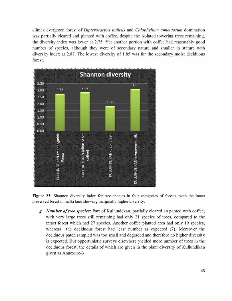
43
climax evergreen forest of Dipterocarpus indicus and Calophyllum tomentosum domination
was partially cleared and planted with coffee, despite the isolated towering trees remaining,
the diversity index was lower at 2.75. Yet another portion with coffee had reasonably good
number of species, although they were of secondary nature and smaller in stature with
diversity index at 2.87. The lowest diversity of 1.85 was for the secondary moist deciduous
forest.
Figure 23: Shannon diversity index for tree species in four categories of forests, with the intact
preserved forest in malki land showing marginally higher diversity.
g. Number of tree species: Part of Kullundekan, partially cleared an panted with coffee,
with very large trees still remaining had only 21 species of trees, compared to the
intact forest which had 27 species. Another coffee planted area had only 19 species,
whereas the deciduous forest had least number as expected (7). Moreover the
deciduous patch sampled was too small and degraded and therefore no higher diversity
is expected. But opportunistic surveys elsewhere yielded more number of trees in the
deciduous forest, the details of which are given in the plant diversity of Kullundikan
given as Annexure-3
44
h. Basal area of trees: Estimated basal areas/ha based on sample surveys of the four
patches referred to was highest at 47.2²/ha for the intact forest, followed by 40.34
m²/ha for the coffee area with large proportioned relic trees (Figure 24). Considering
the fact that this basal area was for the remnant patch of estimated 69 trees/ha, one
could visualize the fact if such a forest were not to be felled for coffee, with 300 plus
trees/ha, the basal area/ha could have exceeded 100 m², perhaps the highest for
Western Ghat vegetation. Next in importance was the normal coffee planted area
without such huge trees and the least was for the deciduous forest.
Figure 24: Tree species numbers and basal area/ha for the forest samples
i. Evergreenness and endemism among trees: Interesting trend is seen in the evergreenness of
the forest versus percentage of Western Ghat specific tree endemism (Figure 25). In general,
more evergreen a forest is higher is the tree endemism, with the deciduous forest showing zero
endemism. This reaffirms the fact clearances of well preserved evergreen forests with high
endemism can wipe out endemics altogether on clear-felling and burning, with practically little
scope for endemic species recovery in such areas.

45
Figure 25: Decline in evergreen trees in a forest causes decline of endemic tree species
IV. Importance Value Index
The IVI details of the five most dominant forest tree species from the four localities sampled
are given in Tables 11 and 14
Table 11: IVI of a climax relic forest vegetation partially cleared for coffee cultivation
KULLUNDI KAN -1
Sl Species IVI
1 Calophyllum tomentosum 59.29
2 Dipterocarpus indicus 54.15
3 Ficus nervosa 20.29
4 Homalium zeylanicum 19.75
5 Artocarpus hirsuta 19.15
46
Table 12: IVI of secondary type forest cleared for coffee
KULLUNDIKAN-2
Sl Species IVI
1 Alstonia scholaris 38.07
2 Cyclostemon confertiflorus 30.38
3 Tetrameles nudiflora 23.30
4 Sapindus laurifolius 20.33
5 Syzygium cumini 19.30
Table 13: IVI of Secondary moist deciduous forest
KULLUNDE KAN-3 (Deciduous forest)
Sl Species IVI
1 Terminalia paniculata 61.49
2 Xylia xylocarpa 56.42
3 Terminalia bellirica 55.62
4 Grewia tilifolia 53.21
5 Spondias acuminata 34.81
Table 14: IVI of a forest allotted for coffee planting but preserved by the allotted person
KULLUNDE KAN-4- evergreen
Sl Species IVI
1 Ficus microcarpa 33.37
2 Calophyllum tomentosum 26.32
3 Artocarpus hirsuta 22.04
4 Aglaia anamallayana 20.86
5 Olea diocia 18.70
The IVI tables clearly reveal that the relic forest has still some unique vegetation with
Dipterocarpus indicus and Calophyllum tometosum. The former is an Endangered tree
species according to IUCN. Destruction of the climax forest is bound to wipe out such
species, as the same is not seen in other forms of land use, including the forest
preserved in tact by the person who was granted the same for coffee cultivation. That
forest appears to be old growth forest on land cleared in the pre-colonial times,
probably for shifting cultivation.
47
References
Ashton, P.S. 1988. A question of sustainable use. In: Denslow, J.S. and Padock, C. (eds.) People of the
Tropical Rain Forest. University of California Press, Berkeley.
Brandis, D. 1897. Indigenous Indian forestry. Sacred groves. Indian Forestry-Working.
Brandis, D. and Grant, 1868. Joint Report No.33, dated 11th May 1868, on the kans in the Sorab taluka.
Forest Department, Shimoga.
Buchanan, F. 1870. A Journey from Madras through the Countries of Mysore, Canara and Malabar.
Vol 2. Higginbotham and Co. Madras.
Campbell, J.M. 1883. Gazetteer of the Bombay Presidency, Vol. 15 (parts 1 & 2). Government Central
press, Bombay.
Chandran, M.D.S. 2008. Discovery of two Critically Endangered tree species and issues related to relic
forests of the Western Ghats. The Open Conservation Biology Journal, 2, 1-8.
Chandran, M.D.S. and Gadgil, M. 1993. ‘Kans’ – Safety forests of Uttara Kannada. In: Brandl, H.
(ed.) Geschichte der Kleinprivatwaldwirtschaft Geschichte des Bauernwaldes. Abteilung
Betriebswirtschaft.Nr.40, Freiburg.
Frazer, J.G. 1935. The olden Bough: A Study in Magic and Religion, 12 vols. Macmillan, New York.
Gadgil, M. 1987. Diversity, cultural and biological. Trends in Ecology and Evolution vol 2(12), 369-
373.
Gadgil, M. 1992. Conserving biodiversity as if people matter: A case study from India. Ambio 21(3),
266-70.
Gadgil, M. and Vartak, V.D. 1976. The sacred groves of Western Ghats in India. Economic Botany,
30, 152-160.
Geist, H.J. and Lambin, E.F., (2001), Global Land-use and Land Cover change: what we have learnt so
far?, Global Change News letter, pp 27-30; International Journal of Applied Earth Observation and
Geoinformation 5: 249-261.
Gokhale, Y. Kushalappa, C.G., Bhat, H.R., Gadgil, M. Prioritizing traditional conservation practices
for Karnataka. (http://www.ces.iisc.ernet.in/biodiversity/sahyadri_enews/newsletter/issue4/article.htm)
Malhotra, K.C.,Gokhale, Y., and Chatterjee, S. 2001. Cultural and Ecological Dimensions of Sacred
Groves in India. Indian National Science Academy, New Delhi and IGRMS, Bhopal.
Meyer, W.B., Tuner B.L II, (1992), Human Population Growth and Global Land-use/ Land-Cover
Change. Annual Review of Ecology and Systematics, 23: 39-61.
48
Nemani & Running, 1996. Global vegetation cover changes from coarse resolution satellite data.
Journal of Geophysical Research. 101, 7157–7162.
Pascal, J.P., Sunder, S.S. and Meher-Homji, M.V. (1982), Forest Map of South-India Mercara –
Mysore. Karnataka and Kerela Forest Departments and The French Institute, Pondicherry.
Ramachandra T .V., Kumar, U., 2004. Geographic Resources Decision Support System for land use,
land cover dynamics analysis. Proceedings of the FOSS/GRASS Users Conference. 12-14 September
2004, Bangkok,Thailand.
Ramachandra T.V., Kumar, U., Diwakar, P. G., Joshi, N. V., 2009. Land cover Assessment using À
Trous Wavelet fusion and K-Nearest Neighbour classification Proceedings of the 25th Annual In-
House Symposium on Space Science and Technology, 29 - 30 January 2009, ISRO - IISc Space
Technology Cell, Indian Institute of Science, Bangalore.
Rao, M.S.N. 1919. Working plan report of Belandur State Forest, Ananthapur Range. Forest
Department, Shimoga.
Roy, D.P, P.E. Lewis and C.O. Justice., 2002. Burned area mapping using multi-temporal moderate spatial resolution data—a bi-directional reflectance model-based expectation approach, Remote Sensing of Environment, 83, 263–286.
Saletore, K.N. 1973. Early Indian Economic History, Curzon Press, London
Someren, C.J. (Conservator of Mysore and Coorg), 1871. Letter No. PWD, Rev. For. No. 1507 to the
Chief ommisioner of Mysore. Forest Department, Shimoga.
Talbot, W.A. 1909. Forest Flora of the Bombay Presidency and Sind. Vol.1. Photozicographic
Department, Poona Government.
Thippeswami, S.C 1963. Sirsi town firewood supply plan. Government of Mysore.
Weismiller, R.A., Kristof, S.J. and Scholtz, D.K., 1977. Change detection in coastal zone environments, Photogram. Eng. Remote Sensing, 43, 1533–1539.
Zhao, L., Ocheing, W.Y., Quddus, M.A., Noland, R.B., 2003. An Extended Kalman Filter algorithm for Integrating GPS and low-cost Dead reckoning system data for vehicle performance and emissions monitoring. The Journal of Navigation, 56, 257-275.
Annexures

49
ANNEXURE-1: CHECKLIST OF THE HIGHER PLANTS OF KURNIMAKKI-HALMAHISHIKAN IN THIRTHAHALLI & THEIR
DISTRIBUTION
HALMAHISHI KAN
NATURE OF PLANT
Western Ghats General distribution Habitats
Buchanania lanzan Anacardiaceae Medium tree
India, Myanmar Deciduous forests
Holigarna arnottiana Anacardiaceae Medium tree Western Ghats
Semievergreen forests
Holigarna ferruginea Anacardiaceae Large tree Western Ghats
Evergreen forests
Mangifera indica Anacardiaceae Tree
Indo-Malesia Evergreen-S.evergreen forests
Nothopegia colebrookeana Anacardiaceae Small tree
S. India-S. Lanka Evergreen-S.evergreen forests
Spondias pinnata Anacardiaceae Large tree
Indo-Malesia Moist deciduous forests
Artabotrys zeylanicus Annonaceae Woody climber
Penin. India-Sri Lanka Kurnimakki
Polyalthia fragrans Annonaceae Large tree Western Ghats
Evergreen-s.evergreen
Uvaria narum Annonaceae Climber
S. India-S. Lanka Semievergreen forests
Alstonia scholaris Apocynacae Large tree
Asia-Australia S.evergreen- moist deciduous
Chonemopha macrophylla Apocynaceae Liana
India, S. Lanka Evergreen-s.evergreen
Holarrhena pubescens Apocynacae Small tree
Indo-Malesia Deciduous forests
Tabernamontana heyneana Apocynacae Shrub/small tree Western Ghats
Forest gaps, scrub
Lagenandra toxicaria Araceae Herb Western Ghats
Marshes in forests
Pothos scandens Araceae Climber
Indo-Malesia, Madagascar Evergreen-s.evergreen
Schefflera venulosa Araliaceae Scandent shrub
South and S.E. Asia Evergreen-s.evergreen
Calamus thwaitesii Arecaceae Climbing palm
India, S. Lanka Evergreen-s.evergreen
Caryota urens Arecaceae Tree
Indo-Malesia Evergreen-s.evergreen
Chromolaena odorata Asteraceae Shrub
Pantropical weed Widespread
Pajanelia longfola Bignoniaceae Tree
India, Myanmar Kurnimakki-Vittage border
Stereospermum personatum Bignoniaceae Tree
Indo, China, Malesia S.evergreen- moist deciduous
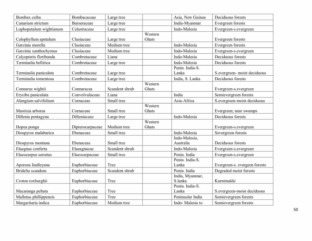
50
Bombax ceiba Bombacaceae Large tree
Asia, New Guinea Deciduous forests
Canarium strictum Burseraceae Large tree
India-Myanmar Evergreen forests
Lophopetalum wightianum Celastraceae Large tree
Indo-Malesia Evergreen-s.evergreen
Calophyllum apetalum Clusiaceae Large tree Western Ghats
Evergreen forests
Garcinia morella Clusiaceae Medium tree
Indo-Malesia Evergreen forests
Garcinia xanthochymus Clusiaceae Medium tree
Indo-Malesia Evergreen-s.evergreen
Calyopteris floribunda Combretaceae Liana
Indo-Malesia Deciduous forests
Terminalia bellirica Combretaceae Large tree
Indo-Malesia Deciduous forests
Terminalia paniculata Combretaceae Large tree
Penin. India-S. Lanka S.evergreen- moist deciduous
Terminalia tomentosa Combretaceae Large tree
India, S. Lanka Deciduous forests
Connarus wightii Connaracea Scandent shrub Western Ghats
Evergreen-s.evergreen
Erycibe paniculata Convolvulaceae Liana
India Semievergreen forests
Alangium salvifolium Cornaceae Small tree
Asia-Africa S.evergreen-moist deciduous
Mastixia arborea Cornaceae Small tree Western Ghats
Evergreen; near swamps
Dillenia pentagyna Dilleniaceae Large tree
Indo-Malesia Deciduous forests
Hopea ponga Dipterocarpaceae Medium tree Western Ghats
Evergreen-s.evergreen
Diospyros malabarica Ebenaceae Small tree
Indo-Malesia Severgreen forests
Diospyros montana Ebenaceae Small tree
Indo-Malesia, Australia Deciduous forests
Elaegnus conferta Elaeagnacae Scandent shrub
Indo-Malesia Evergreen-s.evergreen
Elaeocarpus serratus Elaeocarpaceae Small tree
Penin. India Evergreen-s.evergreen
Aporosa lindleyana Euphorbiaceae Tree
Penin. India-S. Lanka Evergreen-s. evergeen forests
Bridelia scandens Euphorbiaceae Scandent shrub
Penin. India Degraded moist forests
Croton roxburghii Euphorbiaceae Tree
India, Myanmar, S.lanka Kurnimakki
Macaranga peltata Euphorbiaceae Tree
Penin. India-S. Lanka S.evergreen-moist deciduous
Mallotus phillippensis Euphorbiaceae Tree
Peninsular India Semievergreen forests
Margaritaria indica Euphorbiaceae Medium tree
Indo- Malesia to Semievergreen forests
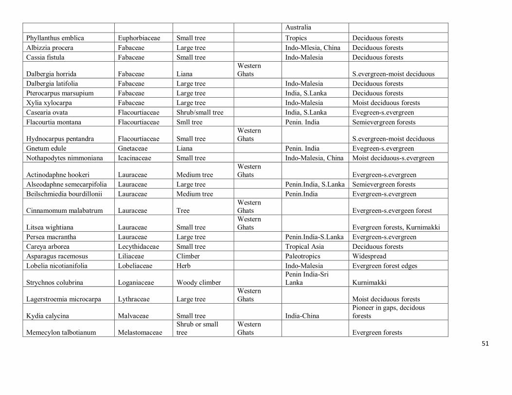
51
Australia
Phyllanthus emblica Euphorbiaceae Small tree
Tropics Deciduous forests
Albizzia procera Fabaceae Large tree
Indo-Mlesia, China Deciduous forests
Cassia fistula Fabaceae Small tree
Indo-Malesia Deciduous forests
Dalbergia horrida Fabaceae Liana Western Ghats
S.evergreen-moist deciduous
Dalbergia latifolia Fabaceae Large tree
Indo-Malesia Deciduous forests
Pterocarpus marsupium Fabaceae Large tree
India, S.Lanka Deciduous forests
Xylia xylocarpa Fabaceae Large tree
Indo-Malesia Moist deciduous forests
Casearia ovata Flacourtiaceae Shrub/small tree
India, S.Lanka Evegreen-s.evergreen
Flacourtia montana Flacourtiaceae Smll tree
Penin. India Semievergreen forests
Hydnocarpus pentandra Flacourtiaceae Small tree Western Ghats
S.evergreen-moist deciduous
Gnetum edule Gnetaceae Liana
Penin. India Evegreen-s.evergreen
Nothapodytes nimmoniana Icacinaceae Small tree
Indo-Malesia, China Moist deciduous-s.evergreen
Actinodaphne hookeri Lauraceae Medium tree Western Ghats
Evergreen-s.evergreen
Alseodaphne semecarpifolia Lauraceae Large tree
Penin.India, S.Lanka Semievergreen forests
Beilschmiedia bourdillonii Lauraceae Medium tree
Penin.India Evergreen-s.evergreen
Cinnamomum malabatrum Lauraceae Tree Western Ghats
Evergreen-s.evergeen forest
Litsea wightiana Lauraceae Small tree Western Ghats
Evergreen forests, Kurnimakki
Persea macrantha Lauraceae Large tree
Penin.India-S.Lanka Evergreen-s.evergreen
Careya arborea Lecythidaceae Small tree
Tropical Asia Deciduous forests
Asparagus racemosus Liliaceae Climber
Paleotropics Widespread
Lobelia nicotianifolia Lobeliaceae Herb
Indo-Malesia Evergreen forest edges
Strychnos colubrina Loganiaceae Woody climber
Penin India-Sri Lanka Kurnimakki
Lagerstroemia microcarpa Lythraceae Large tree Western Ghats
Moist deciduous forests
Kydia calycina Malvaceae Small tree
India-China Pioneer in gaps, decidous forests
Memecylon talbotianum Melastomaceae Shrub or small tree
Western Ghats
Evergreen forests
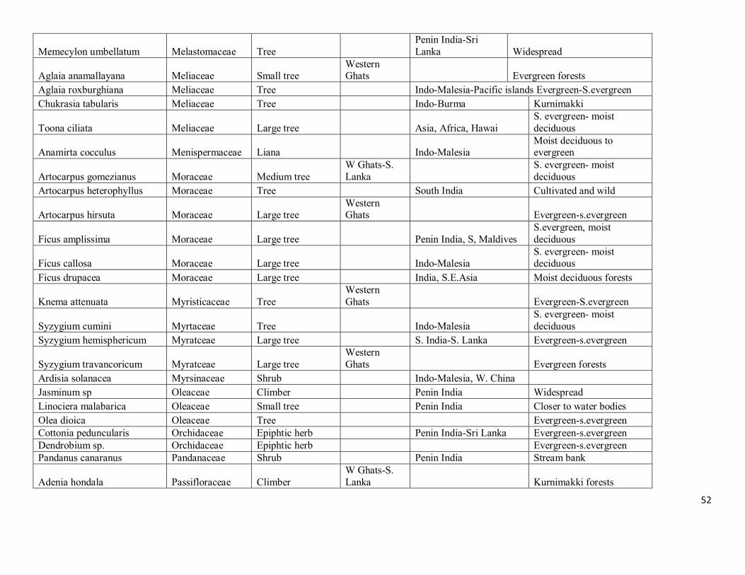
52
Memecylon umbellatum Melastomaceae Tree
Penin India-Sri Lanka Widespread
Aglaia anamallayana Meliaceae Small tree Western Ghats
Evergreen forests
Aglaia roxburghiana Meliaceae Tree
Indo-Malesia-Pacific islands Evergreen-S.evergreen
Chukrasia tabularis Meliaceae Tree
Indo-Burma Kurnimakki
Toona ciliata Meliaceae Large tree
Asia, Africa, Hawai S. evergreen- moist deciduous
Anamirta cocculus Menispermaceae Liana
Indo-Malesia Moist deciduous to evergreen
Artocarpus gomezianus Moraceae Medium tree W Ghats-S. Lanka
S. evergreen- moist deciduous
Artocarpus heterophyllus Moraceae Tree
South India Cultivated and wild
Artocarpus hirsuta Moraceae Large tree Western Ghats
Evergreen-s.evergreen
Ficus amplissima Moraceae Large tree
Penin India, S, Maldives S.evergreen, moist deciduous
Ficus callosa Moraceae Large tree
Indo-Malesia S. evergreen- moist deciduous
Ficus drupacea Moraceae Large tree
India, S.E.Asia Moist deciduous forests
Knema attenuata Myristicaceae Tree Western Ghats
Evergreen-S.evergreen
Syzygium cumini Myrtaceae Tree
Indo-Malesia S. evergreen- moist deciduous
Syzygium hemisphericum Myratceae Large tree
S. India-S. Lanka Evergreen-s.evergreen
Syzygium travancoricum Myratceae Large tree Western Ghats
Evergreen forests
Ardisia solanacea Myrsinaceae Shrub
Indo-Malesia, W. China Jasminum sp Oleaceae Climber
Penin India Widespread
Linociera malabarica Oleaceae Small tree
Penin India Closer to water bodies
Olea dioica Oleaceae Tree
Evergreen-s.evergreen Cottonia peduncularis Orchidaceae Epiphtic herb
Penin India-Sri Lanka Evergreen-s.evergreen
Dendrobium sp. Orchidaceae Epiphtic herb
Evergreen-s.evergreen Pandanus canaranus Pandanaceae Shrub
Penin India Stream bank
Adenia hondala Passifloraceae Climber W Ghats-S. Lanka
Kurnimakki forests
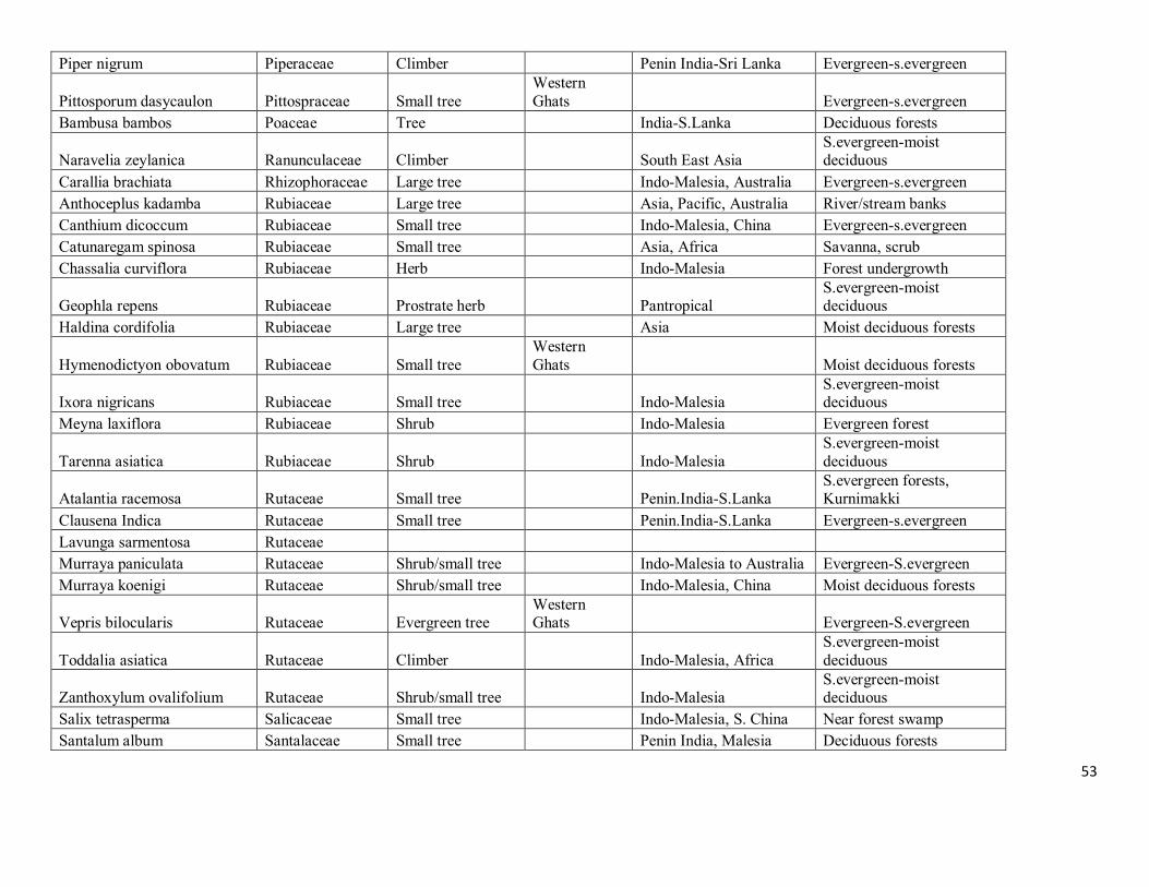
53
Piper nigrum Piperaceae Climber
Penin India-Sri Lanka Evergreen-s.evergreen
Pittosporum dasycaulon Pittospraceae Small tree Western Ghats
Evergreen-s.evergreen
Bambusa bambos Poaceae Tree
India-S.Lanka Deciduous forests
Naravelia zeylanica Ranunculaceae Climber
South East Asia S.evergreen-moist deciduous
Carallia brachiata Rhizophoraceae Large tree
Indo-Malesia, Australia Evergreen-s.evergreen
Anthoceplus kadamba Rubiaceae Large tree
Asia, Pacific, Australia River/stream banks
Canthium dicoccum Rubiaceae Small tree
Indo-Malesia, China Evergreen-s.evergreen
Catunaregam spinosa Rubiaceae Small tree
Asia, Africa Savanna, scrub
Chassalia curviflora Rubiaceae Herb
Indo-Malesia Forest undergrowth
Geophla repens Rubiaceae Prostrate herb
Pantropical S.evergreen-moist deciduous
Haldina cordifolia Rubiaceae Large tree
Asia Moist deciduous forests
Hymenodictyon obovatum Rubiaceae Small tree Western Ghats
Moist deciduous forests
Ixora nigricans Rubiaceae Small tree
Indo-Malesia S.evergreen-moist deciduous
Meyna laxiflora Rubiaceae Shrub
Indo-Malesia Evergreen forest
Tarenna asiatica Rubiaceae Shrub
Indo-Malesia S.evergreen-moist deciduous
Atalantia racemosa Rutaceae Small tree
Penin.India-S.Lanka S.evergreen forests, Kurnimakki
Clausena Indica Rutaceae Small tree
Penin.India-S.Lanka Evergreen-s.evergreen
Lavunga sarmentosa Rutaceae Murraya paniculata Rutaceae Shrub/small tree
Indo-Malesia to Australia Evergreen-S.evergreen
Murraya koenigi Rutaceae Shrub/small tree
Indo-Malesia, China Moist deciduous forests
Vepris bilocularis Rutaceae Evergreen tree Western Ghats
Evergreen-S.evergreen
Toddalia asiatica Rutaceae Climber
Indo-Malesia, Africa S.evergreen-moist deciduous
Zanthoxylum ovalifolium Rutaceae Shrub/small tree
Indo-Malesia S.evergreen-moist deciduous
Salix tetrasperma Salicaceae Small tree
Indo-Malesia, S. China Near forest swamp
Santalum album Santalaceae Small tree
Penin India, Malesia Deciduous forests
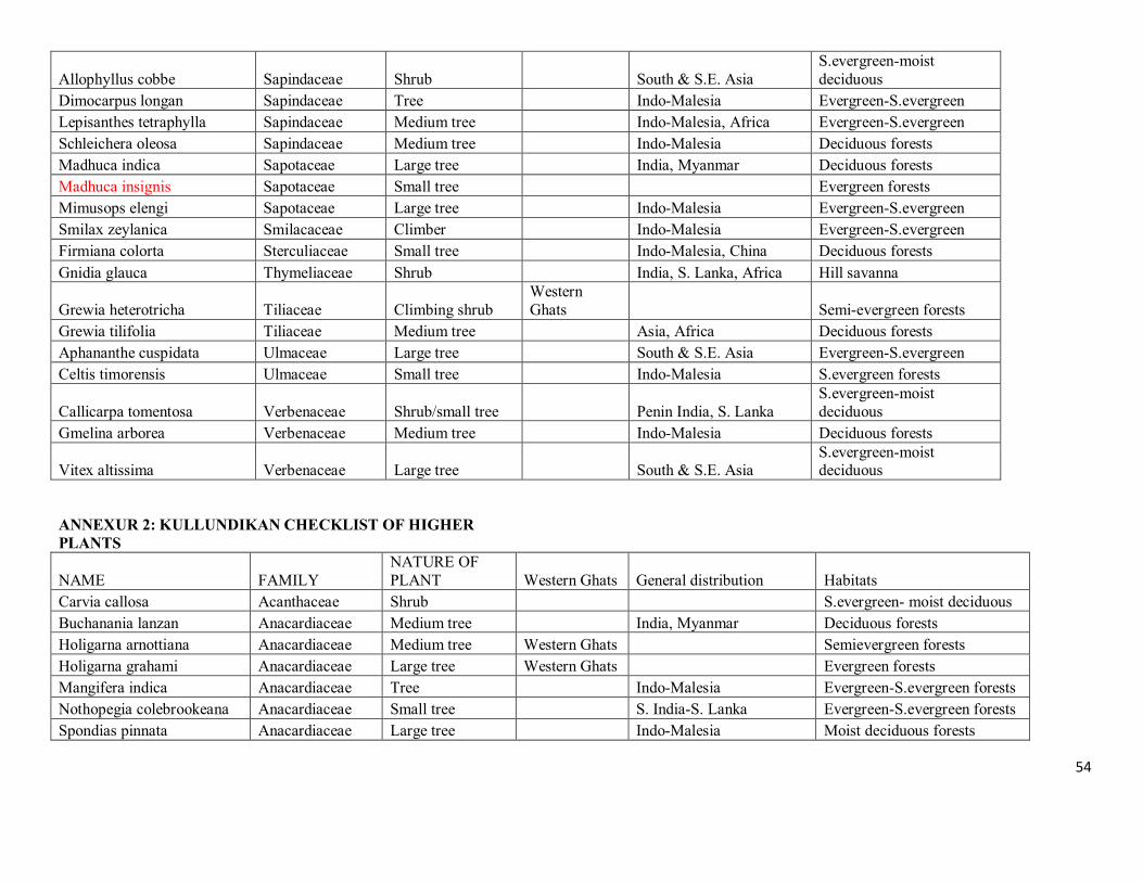
54
Allophyllus cobbe Sapindaceae Shrub
South & S.E. Asia S.evergreen-moist deciduous
Dimocarpus longan Sapindaceae Tree
Indo-Malesia Evergreen-S.evergreen
Lepisanthes tetraphylla Sapindaceae Medium tree
Indo-Malesia, Africa Evergreen-S.evergreen
Schleichera oleosa Sapindaceae Medium tree
Indo-Malesia Deciduous forests
Madhuca indica Sapotaceae Large tree
India, Myanmar Deciduous forests
Madhuca insignis Sapotaceae Small tree
Evergreen forests
Mimusops elengi Sapotaceae Large tree
Indo-Malesia Evergreen-S.evergreen
Smilax zeylanica Smilacaceae Climber
Indo-Malesia Evergreen-S.evergreen
Firmiana colorta Sterculiaceae Small tree
Indo-Malesia, China Deciduous forests
Gnidia glauca Thymeliaceae Shrub
India, S. Lanka, Africa Hill savanna
Grewia heterotricha Tiliaceae Climbing shrub Western Ghats
Semi-evergreen forests
Grewia tilifolia Tiliaceae Medium tree
Asia, Africa Deciduous forests
Aphananthe cuspidata Ulmaceae Large tree
South & S.E. Asia Evergreen-S.evergreen
Celtis timorensis Ulmaceae Small tree
Indo-Malesia S.evergreen forests
Callicarpa tomentosa Verbenaceae Shrub/small tree
Penin India, S. Lanka S.evergreen-moist deciduous
Gmelina arborea Verbenaceae Medium tree
Indo-Malesia Deciduous forests
Vitex altissima Verbenaceae Large tree
South & S.E. Asia S.evergreen-moist deciduous
ANNEXUR 2: KULLUNDIKAN CHECKLIST OF HIGHER PLANTS
NAME FAMILY
NATURE OF PLANT Western Ghats General distribution Habitats
Carvia callosa Acanthaceae Shrub
S.evergreen- moist deciduous
Buchanania lanzan Anacardiaceae Medium tree
India, Myanmar Deciduous forests
Holigarna arnottiana Anacardiaceae Medium tree Western Ghats
Semievergreen forests
Holigarna grahami Anacardiaceae Large tree Western Ghats
Evergreen forests
Mangifera indica Anacardiaceae Tree
Indo-Malesia Evergreen-S.evergreen forests
Nothopegia colebrookeana Anacardiaceae Small tree
S. India-S. Lanka Evergreen-S.evergreen forests
Spondias pinnata Anacardiaceae Large tree
Indo-Malesia Moist deciduous forests

55
Ancistrocladus heyneanus Ancistrocladaceae Climber
Evergreen-s.evergreen
Artabotrys zeylanicus Annonaceae Woody climber
Penin. India-Sri Lanka Kurnimakki
Polyalthia fragrans Annonaceae Large tree Western Ghats
Evergreen-s.evergreen
Alstonia scholaris Apocynacae Large tree
Asia-Australia S.evergreen- moist deciduous
Holarrhena pubescens Apocynacae Small tree
Indo-Malesia Deciduous forests
Tabernamontana heyneana Apocynacae Shrub/small tree Western Ghats
Forest gaps, scrub
Pothos scandens Araceae Climber
Indo-Malesia, Madagascar Evergreen-s.evergreen
Arenga wightii Arecaceae Small palm Calamus thwaitesii Arecaceae Climbing palm
India, S. Lanka Evergreen-s.evergreen
Caryota urens Arecaceae Tree
Indo-Malesia Evergreen-s.evergreen
Chromolaena odorata Asteraceae Shrub
Pantropical weed Widespread
Bombax ceiba Bombacaceae Large tree
Asia, New Guinea Deciduous forests
Canarium strictum Burseraceae Large tree
India-Myanmar Evergreen forests
Lophopetalum wightianum Celastraceae Large tree
Indo-Malesia Evergreen-s.evergreen
Calophyllum apetalum Clusiaceae Large tree Western Ghats
Evergreen forests
Calophyllum polyanthum Clusiaceae very large tree
Evergreen forests
Garcinia cambogea Clusiaceae Medium tree
Evergreen forests
Garcinia morella Clusiaceae Medium tree
Indo-Malesia Evergreen forests
Garcinia xanthochymus Clusiaceae Medium tree
Indo-Malesia Evergreen-s.evergreen
Calyopteris floribunda Combretaceae Liana
Indo-Malesia Deciduous forests
Terminalia bellirica Combretaceae Large tree
Indo-Malesia Deciduous forests
Terminalia paniculata Combretaceae Large tree
Penin. India-S. Lanka S.evergreen- moist deciduous
Terminalia tomentosa Combretaceae Large tree
India, S. Lanka Deciduous forests
Alangium salvifolium Cornaceae Small tree
Asia-Africa S.evergreen-moist deciduous
Tetrameles nudiflora Datisticaceae very large tree
Semievergreen forests
Dichapetalum gelonioides Dichapetalaceae Shrub
Semievergreen forests
Dillenia pentagyna Dilleniaceae Large tree
Indo-Malesia Deciduous forests
Dipterocarpus indicus Dipterocarpaceae Very large tree Western Ghats
Evergreen forests
Hopea ponga Dipterocarpaceae Medium tree Western Ghats
Evergreen-s.evergreen
Dracena ternatea Dracenaceae Small shrub
Evergreen forests
Diospyros assimilis Ebenaceae Large tree
Evergreen forests
Diospyros montana Ebenaceae Small tree
Indo-Malesia, Australia Deciduous forests
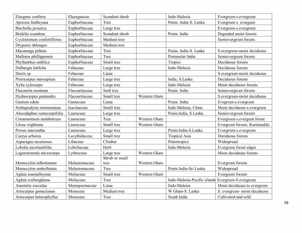
56
Elaegnus conferta Elaeagnacae Scandent shrub
Indo-Malesia Evergreen-s.evergreen
Aporosa lindleyana Euphorbiaceae Tree
Penin. India-S. Lanka Evergreen-s. evergeen
Bischofia javanica Euphorbiaceae Large tree
Evergreen-s.evergreen
Bridelia scandens Euphorbiaceae Scandent shrub
Penin. India Degraded moist forests
Cyclostemon confertiflorus Euphorbiaceae Medium tree
Semievergreen forests
Drypetes oblongus Euphorbiaceae Medium tree Macaranga peltata Euphorbiaceae Tree
Penin. India-S. Lanka S.evergreen-moist deciduous
Mallotus phillippensis Euphorbiaceae Tree
Peninsular India Semievergreen forests
Phyllanthus emblica Euphorbiaceae Small tree
Tropics Deciduous forests
Dalbergia latifolia Fabaceae Large tree
Indo-Malesia Deciduous forests
Derris sp Fabaceae Liana
S.evergreen-moist deciduous
Pterocarpus marsupium Fabaceae Large tree
India, S.Lanka Deciduous forests
Xylia xylocarpa Fabaceae Large tree
Indo-Malesia Moist deciduous forests
Flacourtia montana Flacourtiaceae Smll tree
Penin. India Semievergreen forests
Hydnocarpus pentandra Flacourtiaceae Small tree Western Ghats
S.evergreen-moist deciduous
Gnetum edule Gnetaceae Liana
Penin. India Evegreen-s.evergreen
Nothapodytes nimmoniana Icacinaceae Small tree
Indo-Malesia, China Moist deciduous-s.evergreen
Alseodaphne semecarpifolia Lauraceae Large tree
Penin.India, S.Lanka Semievergreen forests
Cinnamomum malabatrum Lauraceae Tree Western Ghats
Evergreen-s.evergeen forest
Litsea wightiana Lauraceae Small tree Western Ghats
Evergreen forests, Kurnimakki
Persea macrantha Lauraceae Large tree
Penin.India-S.Lanka Evergreen-s.evergreen
Careya arborea Lecythidaceae Small tree
Tropical Asia Deciduous forests
Asparagus racemosus Liliaceae Climber
Paleotropics Widespread
Lobelia nicotianifolia Lobeliaceae Herb
Indo-Malesia Evergreen forest edges
Lagerstroemia microcarpa Lythraceae Large tree Western Ghats
Moist deciduous forests
Memecylon talbotianum Melastomaceae Shrub or small tree Western Ghats
Evergreen forests
Memecylon umbellatum Melastomaceae Tree
Penin India-Sri Lanka Widespread
Aglaia anamallayana Meliaceae Small tree Western Ghats
Evergreen forests
Aglaia roxburghiana Meliaceae Tree
Indo-Malesia-Pacific islands Evergreen-S.evergreen
Anamirta cocculus Menispermaceae Liana
Indo-Malesia Moist deciduous to evergreen
Artocarpus gomezianus Moraceae Medium tree
W Ghats-S. Lanka S. evergreen- moist deciduous
Artocarpus heterophyllus Moraceae Tree
South India Cultivated and wild
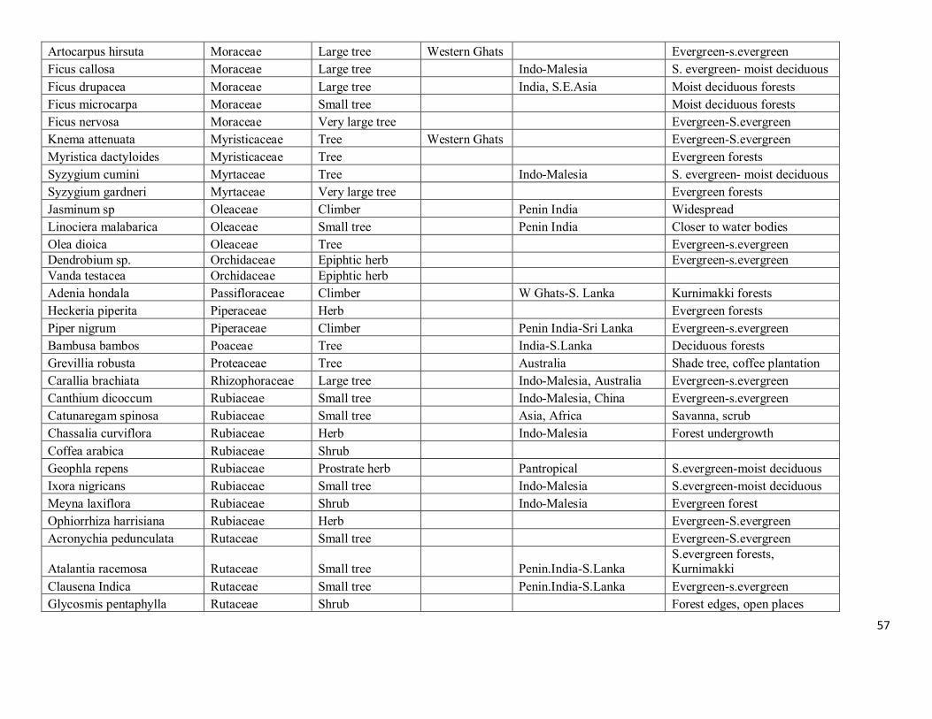
57
Artocarpus hirsuta Moraceae Large tree Western Ghats
Evergreen-s.evergreen
Ficus callosa Moraceae Large tree
Indo-Malesia S. evergreen- moist deciduous
Ficus drupacea Moraceae Large tree
India, S.E.Asia Moist deciduous forests
Ficus microcarpa Moraceae Small tree
Moist deciduous forests
Ficus nervosa Moraceae Very large tree
Evergreen-S.evergreen
Knema attenuata Myristicaceae Tree Western Ghats
Evergreen-S.evergreen
Myristica dactyloides Myristicaceae Tree
Evergreen forests
Syzygium cumini Myrtaceae Tree
Indo-Malesia S. evergreen- moist deciduous
Syzygium gardneri Myrtaceae Very large tree
Evergreen forests
Jasminum sp Oleaceae Climber
Penin India Widespread
Linociera malabarica Oleaceae Small tree
Penin India Closer to water bodies
Olea dioica Oleaceae Tree
Evergreen-s.evergreen Dendrobium sp. Orchidaceae Epiphtic herb
Evergreen-s.evergreen
Vanda testacea Orchidaceae Epiphtic herb Adenia hondala Passifloraceae Climber
W Ghats-S. Lanka Kurnimakki forests
Heckeria piperita Piperaceae Herb
Evergreen forests
Piper nigrum Piperaceae Climber
Penin India-Sri Lanka Evergreen-s.evergreen
Bambusa bambos Poaceae Tree
India-S.Lanka Deciduous forests
Grevillia robusta Proteaceae Tree
Australia Shade tree, coffee plantation
Carallia brachiata Rhizophoraceae Large tree
Indo-Malesia, Australia Evergreen-s.evergreen
Canthium dicoccum Rubiaceae Small tree
Indo-Malesia, China Evergreen-s.evergreen
Catunaregam spinosa Rubiaceae Small tree
Asia, Africa Savanna, scrub
Chassalia curviflora Rubiaceae Herb
Indo-Malesia Forest undergrowth
Coffea arabica Rubiaceae Shrub Geophla repens Rubiaceae Prostrate herb
Pantropical S.evergreen-moist deciduous
Ixora nigricans Rubiaceae Small tree
Indo-Malesia S.evergreen-moist deciduous
Meyna laxiflora Rubiaceae Shrub
Indo-Malesia Evergreen forest
Ophiorrhiza harrisiana Rubiaceae Herb
Evergreen-S.evergreen
Acronychia pedunculata Rutaceae Small tree
Evergreen-S.evergreen
Atalantia racemosa Rutaceae Small tree
Penin.India-S.Lanka S.evergreen forests, Kurnimakki
Clausena Indica Rutaceae Small tree
Penin.India-S.Lanka Evergreen-s.evergreen
Glycosmis pentaphylla Rutaceae Shrub
Forest edges, open places
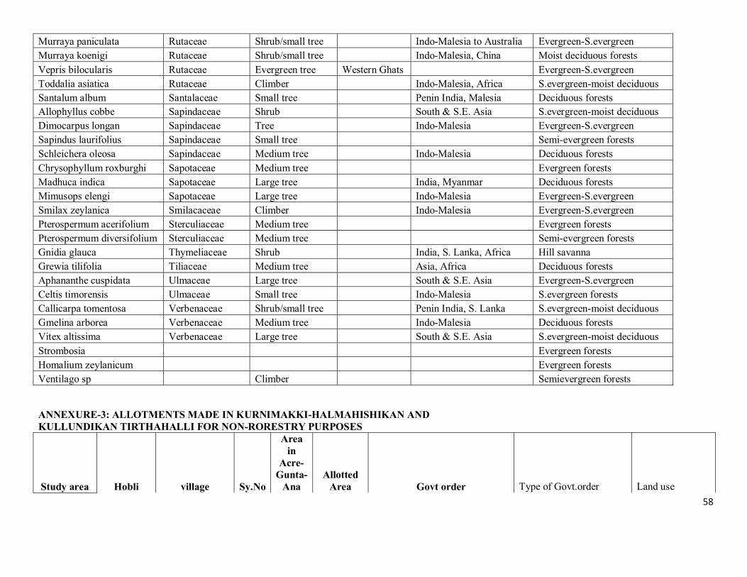
58
Murraya paniculata Rutaceae Shrub/small tree
Indo-Malesia to Australia Evergreen-S.evergreen
Murraya koenigi Rutaceae Shrub/small tree
Indo-Malesia, China Moist deciduous forests
Vepris bilocularis Rutaceae Evergreen tree Western Ghats
Evergreen-S.evergreen
Toddalia asiatica Rutaceae Climber
Indo-Malesia, Africa S.evergreen-moist deciduous
Santalum album Santalaceae Small tree
Penin India, Malesia Deciduous forests
Allophyllus cobbe Sapindaceae Shrub
South & S.E. Asia S.evergreen-moist deciduous
Dimocarpus longan Sapindaceae Tree
Indo-Malesia Evergreen-S.evergreen
Sapindus laurifolius Sapindaceae Small tree
Semi-evergreen forests
Schleichera oleosa Sapindaceae Medium tree
Indo-Malesia Deciduous forests
Chrysophyllum roxburghi Sapotaceae Medium tree
Evergreen forests
Madhuca indica Sapotaceae Large tree
India, Myanmar Deciduous forests
Mimusops elengi Sapotaceae Large tree
Indo-Malesia Evergreen-S.evergreen
Smilax zeylanica Smilacaceae Climber
Indo-Malesia Evergreen-S.evergreen
Pterospermum acerifolium Sterculiaceae Medium tree
Evergreen forests
Pterospermum diversifolium Sterculiaceae Medium tree
Semi-evergreen forests
Gnidia glauca Thymeliaceae Shrub
India, S. Lanka, Africa Hill savanna
Grewia tilifolia Tiliaceae Medium tree
Asia, Africa Deciduous forests
Aphananthe cuspidata Ulmaceae Large tree
South & S.E. Asia Evergreen-S.evergreen
Celtis timorensis Ulmaceae Small tree
Indo-Malesia S.evergreen forests
Callicarpa tomentosa Verbenaceae Shrub/small tree
Penin India, S. Lanka S.evergreen-moist deciduous
Gmelina arborea Verbenaceae Medium tree
Indo-Malesia Deciduous forests
Vitex altissima Verbenaceae Large tree
South & S.E. Asia S.evergreen-moist deciduous
Strombosia
Evergreen forests
Homalium zeylanicum
Evergreen forests
Ventilago sp
Climber
Semievergreen forests
ANNEXURE-3: ALLOTMENTS MADE IN KURNIMAKKI-HALMAHISHIKAN AND KULLUNDIKAN TIRTHAHALLI FOR NON-RORESTRY PURPOSES
Study area Hobli village Sy.No
Area in
Acre-Gunta-
Ana Allotted
Area Govt order Type of Govt.order Land use
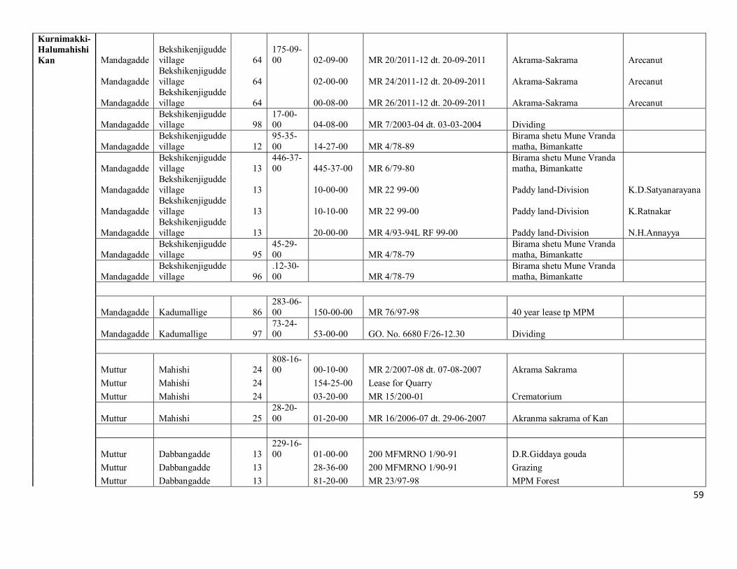
59
Kurnimakki-Halumahishi Kan Mandagadde
Bekshikenjigudde village 64
175-09-00 02-09-00 MR 20/2011-12 dt. 20-09-2011 Akrama-Sakrama Arecanut
Mandagadde Bekshikenjigudde village 64 02-00-00 MR 24/2011-12 dt. 20-09-2011 Akrama-Sakrama Arecanut
Mandagadde Bekshikenjigudde village 64 00-08-00 MR 26/2011-12 dt. 20-09-2011 Akrama-Sakrama Arecanut
Mandagadde Bekshikenjigudde village 98
17-00-00 04-08-00 MR 7/2003-04 dt. 03-03-2004 Dividing
Mandagadde Bekshikenjigudde village 12
95-35-00 14-27-00 MR 4/78-89
Birama shetu Mune Vranda matha, Bimankatte
Mandagadde Bekshikenjigudde village 13
446-37-00 445-37-00 MR 6/79-80
Birama shetu Mune Vranda matha, Bimankatte
Mandagadde Bekshikenjigudde village 13 10-00-00 MR 22 99-00 Paddy land-Division K.D.Satyanarayana
Mandagadde Bekshikenjigudde village 13 10-10-00 MR 22 99-00 Paddy land-Division K.Ratnakar
Mandagadde Bekshikenjigudde village 13 20-00-00 MR 4/93-94L RF 99-00 Paddy land-Division N.H.Annayya
Mandagadde Bekshikenjigudde village 95
45-29-00 MR 4/78-79
Birama shetu Mune Vranda matha, Bimankatte
Mandagadde Bekshikenjigudde village 96
.12-30-00 MR 4/78-79
Birama shetu Mune Vranda matha, Bimankatte
Mandagadde Kadumallige 86 283-06-00 150-00-00 MR 76/97-98 40 year lease tp MPM
Mandagadde Kadumallige 97 73-24-00 53-00-00 GO. No. 6680 F/26-12.30 Dividing
Muttur Mahishi 24 808-16-00 00-10-00 MR 2/2007-08 dt. 07-08-2007 Akrama Sakrama
Muttur Mahishi 24 154-25-00 Lease for Quarry
Muttur Mahishi 24 03-20-00 MR 15/200-01 Crematorium
Muttur Mahishi 25 28-20-00 01-20-00 MR 16/2006-07 dt. 29-06-2007 Akranma sakrama of Kan
Muttur Dabbangadde 13 229-16-00 01-00-00 200 MFMRNO 1/90-91 D.R.Giddaya gouda
Muttur Dabbangadde 13 28-36-00 200 MFMRNO 1/90-91 Grazing
Muttur Dabbangadde 13 81-20-00 MR 23/97-98 MPM Forest
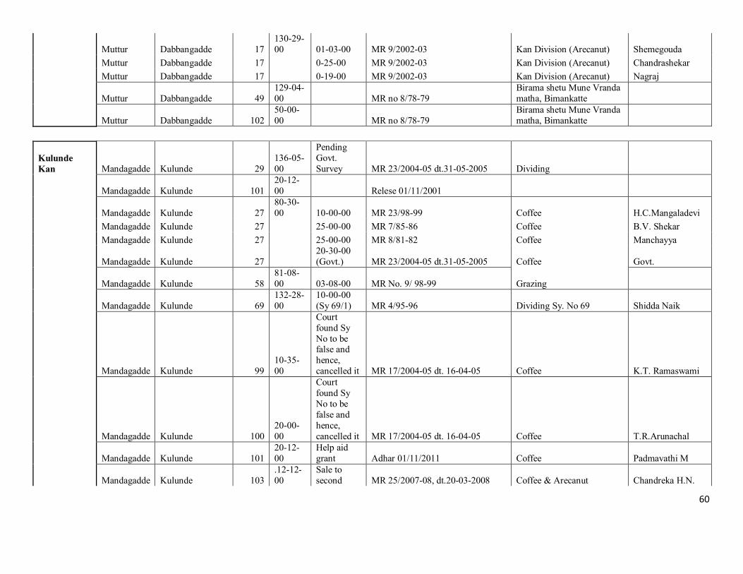
60
Muttur Dabbangadde 17 130-29-00 01-03-00 MR 9/2002-03 Kan Division (Arecanut) Shemegouda
Muttur Dabbangadde 17 0-25-00 MR 9/2002-03 Kan Division (Arecanut) Chandrashekar
Muttur Dabbangadde 17 0-19-00 MR 9/2002-03 Kan Division (Arecanut) Nagraj
Muttur Dabbangadde 49 129-04-00 MR no 8/78-79
Birama shetu Mune Vranda matha, Bimankatte
Muttur Dabbangadde 102 50-00-00 MR no 8/78-79
Birama shetu Mune Vranda matha, Bimankatte
Kulunde Kan Mandagadde Kulunde 29
136-05-00
Pending Govt. Survey MR 23/2004-05 dt.31-05-2005 Dividing
Mandagadde Kulunde 101 20-12-00 Relese 01/11/2001
Mandagadde Kulunde 27 80-30-00 10-00-00 MR 23/98-99 Coffee H.C.Mangaladevi
Mandagadde Kulunde 27 25-00-00 MR 7/85-86 Coffee B.V. Shekar
Mandagadde Kulunde 27 25-00-00 MR 8/81-82 Coffee Manchayya
Mandagadde Kulunde 27 20-30-00 (Govt.) MR 23/2004-05 dt.31-05-2005 Coffee Govt.
Mandagadde Kulunde 58 81-08-00 03-08-00 MR No. 9/ 98-99 Grazing
Mandagadde Kulunde 69 132-28-00
10-00-00 (Sy 69/1) MR 4/95-96 Dividing Sy. No 69 Shidda Naik
Mandagadde Kulunde 99 10-35-00
Court found Sy No to be false and hence, cancelled it MR 17/2004-05 dt. 16-04-05 Coffee K.T. Ramaswami
Mandagadde Kulunde 100 20-00-00
Court found Sy No to be false and hence, cancelled it MR 17/2004-05 dt. 16-04-05 Coffee T.R.Arunachal
Mandagadde Kulunde 101 20-12-00
Help aid grant Adhar 01/11/2011 Coffee Padmavathi M
Mandagadde Kulunde 103 .12-12-00
Sale to second MR 25/2007-08, dt.20-03-2008 Coffee & Arecanut Chandreka H.N.
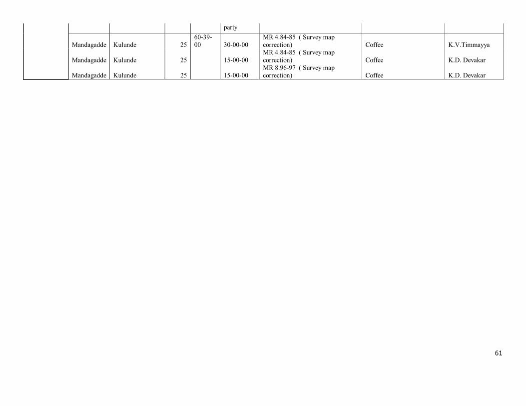
61
party
Mandagadde Kulunde 25 60-39-00 30-00-00
MR 4.84-85 ( Survey map correction) Coffee K.V.Timmayya
Mandagadde Kulunde 25 15-00-00 MR 4.84-85 ( Survey map correction) Coffee K.D. Devakar
Mandagadde Kulunde 25 15-00-00 MR 8.96-97 ( Survey map correction) Coffee K.D. Devakar
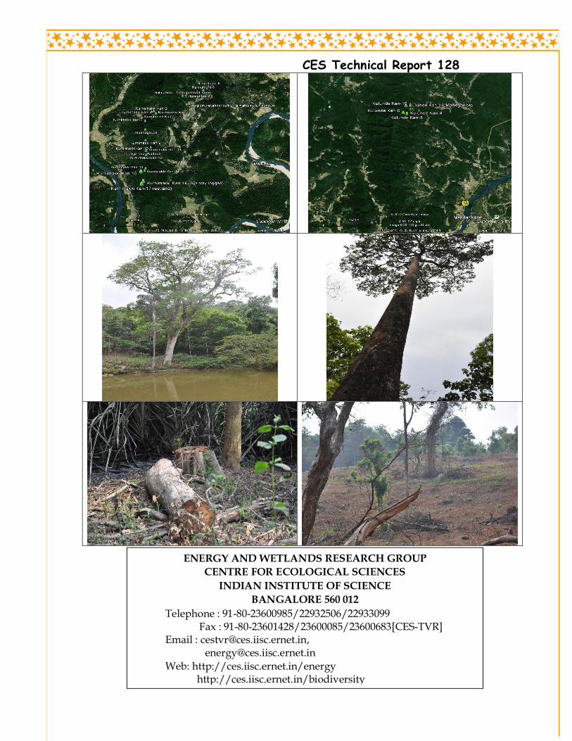
CES Technical Report 128
ENERGY AND WETLANDS RESEARCH GROUP
CENTRE FOR ECOLOGICAL SCIENCES
INDIAN INSTITUTE OF SCIENCE
BANGALORE 560 012
Telephone : 91-80-23600985/22932506/22933099 Fax : 91-80-23601428/23600085/23600683[CES-TVR]
Email : [email protected], [email protected]
Web: http://ces.iisc.ernet.in/energy http://ces.iisc.ernet.in/biodiversity