Embed Size (px)
Citation preview
4-1
Social and Economic Conditions
4.1 INTRODUCTION
Consistent with the 2004 FEIS, social and economic conditions for purposes of this Supplemental
EA are defined as those components of a community that influence its character. These conditions
include its population, economic base, land uses and the zoning and public policies that support
those land uses, important community and municipal facilities and parks, urban design, street grid
and other structural features, and those elements, examined in other chapters in this Supplemental
EA, such as traffic, pedestrian conditions, and noise, which also contribute to neighborhood
conditions.
The introduction of a major new transit line (i.e., the Second Avenue Subway) will affect many of
these components of neighborhood character, either temporarily (during construction) or
permanently (during operation). This chapter describes the conclusions of the 2004 FEIS with
respect to social and economic conditions (see Section 4.2), discusses the changes that have
occurred to background conditions (Section 4.3), and describes any changes in conclusions that
would result from the Modified Design (Section 4.4). The potential impacts related to residential
and business displacement are described in Chapter 6 of this Supplemental EA, “Displacement
and Relocation.”
The 2004 FEIS concluded that construction of the Project would result in significant adverse
impacts on social and economic conditions, and that once the Project is completed, it would result
in beneficial impacts on social and economic conditions. The Modified Design of Phase 2 would
not change the overall conclusions of the 2004 FEIS. However, with the Modified Design, the
construction of the new subway tunnel using a Tunnel Boring Machine (TBM) rather than the
previously planned cut-and-cover construction activities would substantially reduce surface level
impacts in this area.
4.2 FEIS FINDINGS
The 2004 FEIS examined social and economic conditions for the full-length of the Second Avenue
Subway, with the discussion divided into seven study areas based on overall neighborhoods. As
described in the 2004 FEIS, East Harlem is a moderate-density, largely residential area with some
industrial uses concentrated at its northern end and a growing commercial area concentrated on
125th Street. The housing structures vary from four- to six-story tenements and rowhouses built
on narrow lots to high-rise public housing developments built on superblocks surrounded by open
areas. The spaces throughout the superblocks and the predominance of lower-height buildings
elsewhere give a general feeling of openness with substantial views of the sky and promote a high
level of activity. Neighborhood commercial uses and ground-floor retail space line the north-south
avenues and the major crosstown (east-west) streets at 96th, 106th, 116th, and 125th Streets.
The 2004 FEIS stated that the southern portion of East Harlem, focused on 106th Street, is
considered Spanish Harlem and many retail stores in the area cater to this ethnic community. In
contrast, the northeastern corner of East Harlem contains mostly transportation and industrial uses,
Second Avenue Subway Phase 2
Supplemental Environmental Assessment
4-2
including bus facilities and surface parking lots, with little pedestrian traffic. The 2004 FEIS also
described that this corner of East Harlem has several transportation arterials, including approaches
to the Willis and Third Avenue Bridges, numerous approaches to the Triborough Bridge (now the
Robert F. Kennedy Bridge), the Harlem River Drive, and the FDR Drive along the riverfront.
The 2004 FEIS noted signs of new residential development and commercial investment that were
occurring in 2004, with some derelict buildings, vacant ground-floor retail spaces, and empty lots
being replaced by, or proposed for, new development. Through 2025, the 2004 FEIS projected
over one million square feet of new development, primarily retail and residential uses, including
up to 4,000 new residential units. It also noted that East 125th Street had seen a major retail
revitalization in recent years, with the addition of several large retail stores including national
chains.
The 2004 FEIS described the zoning in place in the East Harlem study area, including a Special
Transit Land Use District (STLUD) that was established in 1974 along the length of Second
Avenue to support construction of the Second Avenue Subway. The district was mapped on
Second Avenue where the future Second Avenue Subway stations were to be located in the 1970s
design. By encouraging transit entrances off of the sidewalk, it was intended to ease pedestrian
flows, provide light and air to underground transit facilities, encourage development that promotes
needed pedestrian amenities, coordinate present and future relationship of land uses within the
district, and conserve the value of land and buildings. At locations in the mapped special district,
developers of new buildings were required to coordinate with the New York City Department of
City Planning and MTA to determine whether MTA wished to obtain a transit easement, and if
so, the developer had to provide that easement. MTA obtained several easements in buildings that
were developed after the special district was mapped. However, the 2004 FEIS Design did not
include station entrances in entirely the same locations as the previous, 1970s plan for the new
subway, so the STLUD districts were not consistently located in appropriate places for the new
subway.
4.2.1 CONSTRUCTION IMPACTS
The 2004 FEIS noted that for all four phases of construction of the Second Avenue Subway,
potential temporary significant adverse impacts to land use and economic conditions could occur
during construction because of temporary disruption or modification of access to buildings, altered
viewscapes, limited visibility of businesses, and inconveniences for business deliveries. The 2004
FEIS stated that in the worst-case scenario, if a substantial number of businesses in an area were
to close during construction, leaving street-level retail space vacant for an extended period, the
character of the neighborhood could also be adversely affected. In most cases, safe access to
buildings, including street-level businesses, was to be maintained throughout the construction
period. However, the 2004 FEIS predicted that pedestrian and vehicular access may be altered at
certain locations using sidewalk sheds and the removal of curbside parking and/or closure of travel
lanes. The 2004 FEIS stated that retail establishments with outdoor activities on the sidewalk could
be particularly affected. Further, whereas East Harlem is the site of substantial growth and
development, the 2004 FEIS concluded that some developers may delay initiating projects in the
area to avoid conflicts with the subway construction, thereby temporarily slowing commercial
redevelopment. However, the 2004 FEIS anticipated that the Project would ultimately strengthen
the area’s attractiveness for businesses and development following completion of construction,
resulting in a long-term benefit.
Chapter 4: Social and Economic Conditions
4-3
The 2004 FEIS noted that where properties would be acquired, and businesses or residences
displaced temporarily, public sector revenues generated by those properties (e.g., real estate taxes,
water and sewer payments, etc.) would decrease. It concluded that this would result in adverse
fiscal effects that would be temporary, since these properties would likely be reoccupied after
completion of construction. In fact, according to the 2004 FEIS, the areas are likely to become
more desirable locations for business due to the presence of the subway and the resulting
improvements in transit service.
Specific to each station area for Phase 2, the following potential impacts were identified:
106th and 116th Street Station Areas: The area between 105th and 110th Streets (including
the proposed 106th Street Station) consists of a mix of low-rise buildings and large, high-rise
residential complexes. Cut-and-cover construction work was identified for this area, which
was to result in temporary land use and neighborhood character impacts. This was also to be
true for the area around the 116th Street station. While there would be access limitations and
alterations in these areas, the Project was to develop plans to ensure that access to businesses
and residents are maintained throughout the construction period.
125th Street Curve: Tunneling activities were to be below ground, but some construction
activities were to still be visible and disruptive due to the potential need to reinforce several
buildings at the curve. A construction staging area was also identified in the 2004 FEIS at the
125th Street curve.
125th Street Station Area: This is an area that sees substantial commercial activity and
depends on high levels of pedestrian activity. The 2004 FEIS noted that cut-and-cover
construction in this area was to result in limited pedestrian and vehicular access, which was
to be communicated to businesses in advance. Cut-and-cover construction was anticipated
along portions of 125th Street from Park Avenue to Third Avenue for up to five years. The
2004 FEIS identified that community facilities, such as a nursing home on 125th Street near
Park Avenue and the Manhattan Eye, Ear, and Throat Hospital on 125th Street between Park
and Madison Avenues, would need to have access maintained. MTA was to coordinate with
each facility to develop access plans. Construction could also limit economic revitalization
efforts of local Business Improvement Districts (BID), such as the 125th Street BID. MTA
was to work closely with the BID and other related business organizations, as well as other
community groups to disseminate information about construction activities and receive input.
125th Street Tail Tracks: The tunnel for the 125th Street tail tracks from Park Avenue to
west of Fifth Avenue was to be excavated with a TBM, but some cut-and-cover construction
was to potentially be needed for a TBM retrieval shaft within the 125th Street right-of-way.
The 2004 FEIS disclosed the potential economic benefits of subway construction for all
construction phases. As a result of direct expenditures, the direct employment from construction
activities of the full-length subway was an estimated 22,500 person-years of employment, based
on an overall construction cost of $13.0 billion in 2003 dollars. Specific to East Harlem, the
neighborhood was predicted to benefit from a large construction worker population in the area,
bringing new spending potential, which could result in additional sales for local businesses. The
completed Second Avenue Subway would result in greater economic activity due to increased
accessibility; however, the construction period would likely cause some temporary decline in
business for the area, particularly for businesses that rely on high visibility and steady pedestrian
and vehicular traffic.
Second Avenue Subway Phase 2
Supplemental Environmental Assessment
4-4
The 2004 FEIS reported that potential adverse effects to neighborhood character during
construction would include disruptions to access of residential and commercial buildings and
travel patterns, as well as increases in truck traffic, noise, vibration, and dust. At the time of the
2004 FEIS, the specific duration of construction had not been determined. In several locations,
longer term construction activities were identified in places where staging and managing of the
construction of the Project’s below-ground tunnels would occur, including locations along Second
Avenue north of 125th Street to the Harlem River for the potential storage tracks, and along 125th
Street between Park and Third Avenues. Temporary visual effects from barriers and construction
equipment (including nighttime lighting) were also expected to adversely affect the neighborhood
character and visual environment of the surrounding area during construction. To address potential
rodent infestation, a rodent control program was to be incorporated into construction contract
documents.
The 2004 FEIS described a variety of measures that would be employed during construction to
mitigate the adverse impacts on social and economic conditions associated with the project’s
construction activities. These included the following:
An extensive community outreach program with meetings, newsletters, and a web site. In
addition, the 2004 FEIS called for a project office to be established at one or more locations
along the alignment with a 24-hour telephone hotline;
A community task force to provide citizen input on construction effects;
The posting of subway construction information, possibly including detailed maps showing
locations where pedestrian, bicycle, or wheelchair access might be difficult;
Promoting high-quality design of sidewalk sheds, such as the addition of windows, better
lighting, and good store signage at the subway’s construction sites;
Coordination with businesses to address access/delivery issues and provide special loading
and unloading areas on nearby side streets to locations where access would be curtailed in
front of buildings during construction, which might result in the prohibition of parking on the
designated side streets;
Limiting certain disruptive activities, such as vertical blasting, at night;
Temporarily relocating spaces for displaced park activities, or other appropriate mitigation for
open spaces, as appropriate.
Erecting screens to limit nighttime lighting from construction areas; and
Managing trucking activities at construction sites to avoid unnecessary queues.
4.2.2 PERMANENT IMPACTS
The 2004 FEIS did not identify any significant adverse impacts along the Phase 2 alignment to
land use and economic conditions, neighborhood character, or populations that would result from
the completed Second Avenue Subway. It identified beneficial effects relating to supporting
economic growth as a result of improved transit access to East Harlem, as well as improved transit
access from East Harlem to other employment centers throughout the city.
4.3 UPDATE OF BACKGROUND CONDITIONS
Much of the development predicted in the 2004 FEIS has occurred, and there have also been many
completed or planned developments that were not foreseen in the 2004 FEIS. The 125th Street
Chapter 4: Social and Economic Conditions
4-5
corridor, in particular, has been and continues to be a focus of much of the new development and
continues to strengthen its position as a retail and economic hub in Harlem. In 2008, New York
City implemented a rezoning of the 125th Street corridor between Broadway and Second Avenue,
which allowed for large commercial development to enhance 125th Street’s viability as a retail
hub within Harlem. As a result of that rezoning, new retail development occurred along 125th
Street, including the introduction of stores housing national retailers.
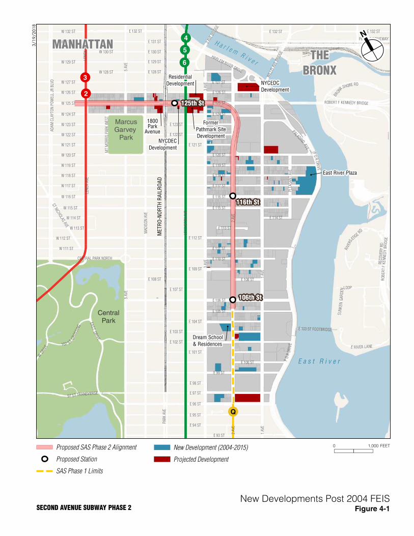
Figure 4-1 shows areas of new and planned development near the proposed alignment of Phase 2.
Major development has included a mix of mid- and high-rise residential buildings; large
commercial developments, such as the East River Plaza along the FDR Drive at 116th Street; and
institutional uses, such as the Dream School on Second Avenue at 104th Street and the Harlem
Children’s Zone & Promise Academy on 125th Street at Madison Avenue. Despite this
development, the overall land use pattern in East Harlem has not changed substantially but the
new residential and commercial development has resulted in population growth and increased
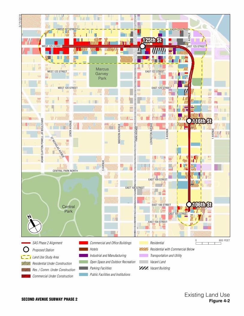
density. Current land use within the East Harlem neighborhood is shown in Figure 4-2.
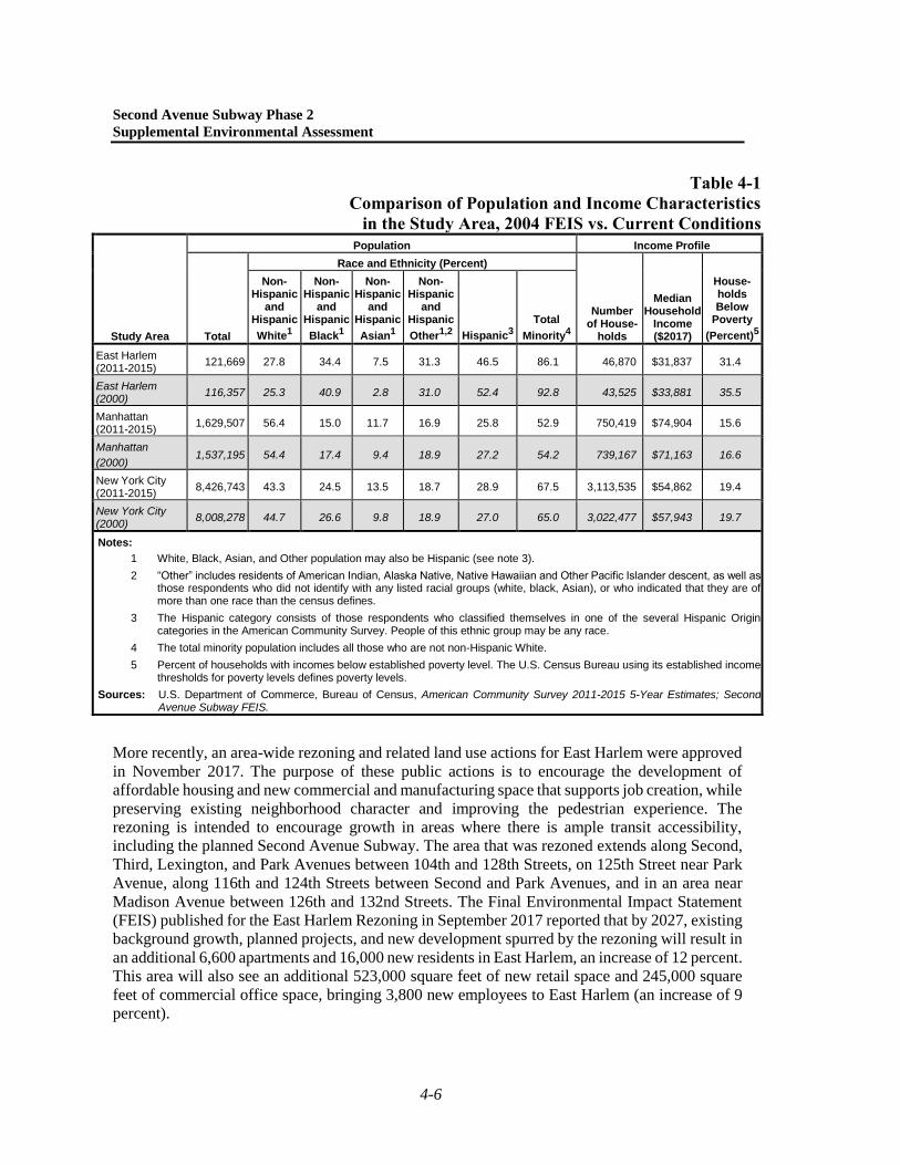
In conjunction with the new development, East Harlem has experienced population growth. As
shown in Table 4-1, the area’s population as reported in the 2004 FEIS (based on the 2000 U.S.
Census) was about 116,000. The population has increased approximately 4.4 percent to about
122,000 today (based on American Community Survey [ACS] 2011-2015 5-Year Estimates).
Table 4-1 also provides a comparison of socioeconomic characteristics of the neighborhood
between the 2004 FEIS and today. The population of East Harlem is 86.1 percent minority
(compared to 92.8 percent in 2000) and 31.4 percent of the population is identified as low-income
(compared with 35.5 percent in 2000).
Continued population growth and new development is expected in East Harlem. As shown on
Figure 4-1, major projects include a large residential and commercial structure at 1800 Park
Avenue between 124th and 125th Streets; a large development at Lexington Avenue and 125th
Street (at the site of a former, now vacant, Pathmark superstore); a large residential development
along 126th Street between Lexington Avenue and Third Avenue; a commercial building under
construction on 125th Street between Lenox Avenue and Adam Clayton Powell, Jr. Boulevard; a
redevelopment sponsored by the New York City Economic Development Corporation (NYCEDC)
of the full block between 126th and 127th Streets east of Second Avenue; and the conversion of a
former firehouse between Park and Lexington Avenues into a new headquarters for the Caribbean
Cultural Center African Diaspora Institute, also sponsored by NYCEDC. NYCDOT, in
conjunction with NYCEDC and the New East Harlem Merchants Association, will implement the
Park Avenue/125th Street Public Realm Project, which involves urban design and safety elements
in the area around the Metro-North Harlem-125th Street Station.
MarcusGarvey
Park
CentralPark
H a r l e mR i v e r
E a s t R i v e r
!2!3
!5!4
!6
!Q
!Q
NYCEDC
Development
East River Plaza
Dream School
& Residences
NYCDEC
Development
106th St
Former
Pathmark SiteDevelopment
Residential
Development
ME
TR
O-N
OR
TH
RA
ILR
OA
D
1800Park
Avenue
125th St
116th St3
AVE
BRID
GE
E 113 ST
W 129 ST
W 128 ST
HARLEM RIVER DRIVE
E 115 ST
E 104 ST
W 122 ST
E 105 ST
E 123 ST
W 131 ST
5 AV
E
W 125 ST
W 118 ST
E 99 ST
E 124 ST
SU
NK
ENG
AR
DEN
LOOP
W 130 ST
E 112 ST
CENTRAL PARK NORTH
W 127 ST
W 120 ST
E 128 ST
W 116 ST
W 112 ST
E 120 ST
W 113 ST
E 98 ST
W 119 ST
FD
RD
RIV
E
E 122 ST
W 126 ST
W 115 ST
W 132 ST
E 102 ST
W 123 ST
W 114 ST
W 111 ST
W 124 ST
E 109 ST
W 117 ST
W 121 ST
E 93 ST
E 100 ST
E 129 ST
E 106 ST
EAS
TDRIVE
E 116 ST
E 110 ST
E 95 ST
E 117 ST
E 96 ST
E 94 ST
E 108 ST
E 132 ST
E 111 ST
E 119 ST
E 121 ST
E 118 ST
E 130 ST
E 107 ST
E 103 ST
E 131 ST
E 127 ST
E 97 ST
E 125 ST
E 126 ST
97 ST TRANSVERSE
E 103 ST FOOTBRIDGE
WIL
LIS
AVE
BRID
GEE 108 ST
E 114 ST
ST NICHOLAS AVE
E 132 ST
PLE
AS
AN
T AV
E
MT
MO
RR
IS P
AR
K W
EST
102 ST
CRO
SSIN
G
E 101 ST
E 132 ST
PRIVATE DRIVEWAY
RO
BER
TF
KEN
NED
YB
RID
GE
3 AV
E3
AVE
1 AV
E1
AVE
2 AV
E2
AVE
LEX
ING
TON
AV
E
FD
RD
RIV
E
BRONX
SHORE RD
AD
AM
CLA
YTO
N P
OW
ELL
JR B
LVD
LEN
OX
AV
ELE
NO
X A
VE
ROBERT F KENNEDY BRIDGE
MA
DIS
ON
AV
E
PAR
K A
VE
5 AV
E
WDR
IVE
REC
OV
ERY
RD
PALADINOAV
E
RIVE
RS
EDGE
RD
E RIVER LANE
3/1
9/2
01
8
0 1,000 FEET
Figure 4-1
Proposed SAS Phase 2 Alignment
Proposed Station
SAS Phase 1 Limits
New Developments Post 2004 FEISSECOND AVENUE SUBWAY PHASE 2
MANHATTANTHE
BRONX
Projected Development
New Development (2004-2015)
3 A
VE
NU
E
1 A
VE
NU
E
EAST 104 STREET
WEST 122 STREET
LE
XIN
GT
ON
AV
EN
UE
EAST 105 STREET
WEST 125 STREET
CENTRAL PARK NORTH
WEST 127 STREET
AD
AM
CL
AY
TO
N P
OW
EL
L J
R B
OU
LE
VA
RD
WEST 120 STREET
EAST 122 STREET
EAST 109 STREET
EAST 106 STREET
PA
RK
AV
EN
UE
EAST 108 STREET
EAST 120 STREET
EAST 125 STREET
ST NICH
OLAS AVEN
UE
EAST 127 STREET
2 A
VE
NU
E
MA
DIS
ON
AV
EN
UE
LEN
OX
AV
EN
UE
5 A
VE
NU
E
125th St
116th St
106th St
3/1
9/2
01
8
0 800 FEET
Figure 4-2
SAS Phase 2 Alignment
Proposed Station
Land Use Study Area
Residential Under Construction
Res. / Comm. Under Construction
Commercial Under Construction
Commercial and Office Buildings
Hotels
Industrial and Manufacturing
Open Space and Outdoor Recreation
Parking Facilities
Public Facilities and Institutions
Residential
Residential with Commercial Below
Transportation and Utility
Vacant Land
Vacant Building
Existing Land Use
MarcusGarvey
Park
CentralPark
SECOND AVENUE SUBWAY PHASE 2
Second Avenue Subway Phase 2
Supplemental Environmental Assessment
4-6
Table 4-1
Comparison of Population and Income Characteristics
in the Study Area, 2004 FEIS vs. Current Conditions
Study Area
Population Income Profile
Total
Race and Ethnicity (Percent)
Number of House-
holds
Median Household
Income ($2017)
House-holds Below
Poverty
(Percent)5
Non-Hispanic
and Hispanic
White1
Non-Hispanic
and Hispanic
Black1
Non-Hispanic
and Hispanic
Asian1
Non-Hispanic
and Hispanic
Other1,2 Hispanic3
Total
Minority4
East Harlem (2011-2015)
121,669 27.8 34.4 7.5 31.3 46.5 86.1 46,870 $31,837 31.4
East Harlem (2000)
116,357 25.3 40.9 2.8 31.0 52.4 92.8 43,525 $33,881 35.5
Manhattan (2011-2015)
1,629,507 56.4 15.0 11.7 16.9 25.8 52.9 750,419 $74,904 15.6
Manhattan
(2000) 1,537,195 54.4 17.4 9.4 18.9 27.2 54.2 739,167 $71,163 16.6
New York City (2011-2015)
8,426,743 43.3 24.5 13.5 18.7 28.9 67.5 3,113,535 $54,862 19.4
New York City (2000)
8,008,278 44.7 26.6 9.8 18.9 27.0 65.0 3,022,477 $57,943 19.7
Notes:
1 White, Black, Asian, and Other population may also be Hispanic (see note 3).
2 “Other” includes residents of American Indian, Alaska Native, Native Hawaiian and Other Pacific Islander descent, as well as those respondents who did not identify with any listed racial groups (white, black, Asian), or who indicated that they are of more than one race than the census defines.
3 The Hispanic category consists of those respondents who classified themselves in one of the several Hispanic Origin categories in the American Community Survey. People of this ethnic group may be any race.
4 The total minority population includes all those who are not non-Hispanic White.
5 Percent of households with incomes below established poverty level. The U.S. Census Bureau using its established income thresholds for poverty levels defines poverty levels.
Sources: U.S. Department of Commerce, Bureau of Census, American Community Survey 2011-2015 5-Year Estimates; Second Avenue Subway FEIS.
More recently, an area-wide rezoning and related land use actions for East Harlem were approved
in November 2017. The purpose of these public actions is to encourage the development of
affordable housing and new commercial and manufacturing space that supports job creation, while
preserving existing neighborhood character and improving the pedestrian experience. The
rezoning is intended to encourage growth in areas where there is ample transit accessibility,
including the planned Second Avenue Subway. The area that was rezoned extends along Second,
Third, Lexington, and Park Avenues between 104th and 128th Streets, on 125th Street near Park
Avenue, along 116th and 124th Streets between Second and Park Avenues, and in an area near
Madison Avenue between 126th and 132nd Streets. The Final Environmental Impact Statement
(FEIS) published for the East Harlem Rezoning in September 2017 reported that by 2027, existing
background growth, planned projects, and new development spurred by the rezoning will result in
an additional 6,600 apartments and 16,000 new residents in East Harlem, an increase of 12 percent.
This area will also see an additional 523,000 square feet of new retail space and 245,000 square
feet of commercial office space, bringing 3,800 new employees to East Harlem (an increase of 9
percent).
Chapter 4: Social and Economic Conditions
4-7
As part of the East Harlem Rezoning, the New York City Department of City Planning coordinated
with MTA to revise the STLUDs mapped along Second Avenue to align with current plans for the
Second Avenue Subway. STLUD overlays are now mapped in the locations of the 106th Street,
116th Street, and 125th Street Stations. In addition, the text of the New York City Zoning
Resolution was revised as relates to the STLUD so that (1) floor area provided for any subway
transit-related uses such as subway entrances and ancillary facilities is not considered to be zoning
floor area, and therefore is not counted against the total amount of development allowed on a site;
and (2) greater flexibility is available in transit easement volumes to accommodate entrances
and/or ancillary facilities that meet ADA requirements, ventilation and access requirements. The
STLUD text also allows MTA to obtain transit easements on vacant lots that are needed for
development of the subway.
4.4 PHASE 2 MODIFIED DESIGN—CHANGES IN IMPACTS
4.4.1 CONSTRUCTION IMPACTS
The Modified Design includes ancillary facilities and entrances that would be larger than
presented in the 2004 FEIS Design, for a number of design and constructability considerations, as
discussed in Chapter 2, “Description of Phase 2 Modified Design.”
The Modified Design also reflects efforts to reduce surface construction impacts through reduced
cut-and-cover construction, particularly along 125th Street (as detailed in Chapter 2). Ancillary
facilities have also been relocated from 125th Street to 124th Street, which can serve as staging
areas and spoils removal sites during construction, and would also reduce construction vehicle
traffic along 125th Street, minimizing disruption to traffic and retail activities along this corridor.
Similar to what was described in the 2004 FEIS, these ancillary facilities would be designed to
blend into the surrounding urban context of the area.
As with the 2004 FEIS Design, construction activities of Phase 2 with the Modified Design would
be disruptive to the community. Construction of Phase 2 would require staging areas, cut-and-
cover construction for the 106th Street and 116th Street Stations, and truck traffic. For the
Modified Design, the sites of ancillary facilities would be used as construction staging sites to
reduce the disruption associated with using the street above the tunnel alignment for construction
staging as anticipated in the 2004 FEIS Design. While construction activities for some ancillary
facilities and entrances would be relocated with the Modified Design and these facilities would be
larger than what was presented in the 2004 FEIS, they would be in the same general vicinity as
indicated in the 2004 FEIS and would result in similar temporary impacts to land use and
accessibility to buildings. Temporary adverse impacts to businesses and residences during
construction of Phase 2 would be similar to those analyzed in the 2004 FEIS and similar mitigation
measures would be implemented. Therefore, no changes in adverse impacts with respect to land
use and economic conditions have been identified. In addition, modification of construction means
and methods from cut-and-cover to mining, particularly along 125th Street, would substantially
reduce surface impacts and disruption during construction to land uses and businesses in this
corridor.
MTA undertook extensive community outreach during the construction of Phase 1, and it will
apply the experience gained from that process as part of the planning and implementation of
construction for Phase 2. The reduced cut-and-cover construction required for the 125th Street
Station would reduce potential temporary impacts to neighborhood character along 125th Street.
Second Avenue Subway Phase 2
Supplemental Environmental Assessment
4-8
Additionally, the modified bellmouth structure at Second Avenue and 118th Street and elimination
of tail tracks along Second Avenue north to 129th Street would eliminate cut-and-cover
construction in this area. However, the Modified Design would involve more intensive
construction at Second Avenue near 120th Street for the new TBM staging site proposed there.
Reduced cut-and-cover construction would result in less surface disruption and fewer impacts to
traffic and pedestrian mobility.
While some changes in design have been proposed, no new adverse impacts to community
facilities, population, or employment have been identified. Along Second Avenue, impacts would
remain similar to those described in the 2004 FEIS, and the new locations of ancillaries would still
be compatible with the overall urban context of the existing neighborhood character. MTA
remains committed to the construction mitigation measures outlined in the 2004 FEIS and
described above. A preliminary outreach plan has been developed to engage the public prior to
construction, as well as during the construction period (see Chapter 20, “Public Outreach”).
4.4.2 PERMANENT IMPACTS
With the Modified Design, specific locations of some proposed entrances and ancillary facilities
have been revised due to constructability considerations or recent (or planned) development of
larger structures on previous sites that would increase displacements, complexity of construction,
and cost (see Chapter 2, “Description of Phase 2 Design Modifications”). While these locations
are different than shown in the 2004 FEIS Design, they would be in the same general locations
and continue to be designed to blend in with the surrounding urban context of the neighborhood.
Additionally, the recent rezoning and modifications of the STLUDs along the Phase 2 alignment
seeks to encourage development that is compatible with, and accommodating to, the new Second
Avenue Subway facilities.
4.5 CONCLUSIONS
As a result of the Phase 2 Modified Design, there will not be any new or different significant
adverse impacts on social and economic conditions not previously identified in the 2004 FEIS and
ROD. Consistent with the 2004 FEIS Design, construction activities would be disruptive and result
in adverse impacts to community character and may temporarily modify building access near the
construction zones. Mitigation measures, as outlined in the 2004 FEIS, would be implemented to
reduce adverse impacts.
While some new station entrances and ancillary facilities would be in different locations than
anticipated in the 2004 FEIS, they would still be in similar locations to those previously proposed
and set within the context of the urban environment of East Harlem, consistent with the
conclusions of the 2004 FEIS. The Project also remains consistent with and supportive of recent
local policy documents.