Embed Size (px)
Citation preview
1
Changes in residential tenure security in South Africa – shiftingrelationships between customary, informal and formal systems.
Draft Paper, April 2001
University of the Witwatersrand’s Graduate School of Public andDevelopment Management.

1
Changes in residential tenure security in South Africa – shiftingrelationships between customary, informal and formal systems.
Introduction
South African democracy promises the resolution of many disabilities faced by those who havesuffered under previous regimes. Since 1994 tremendous changes have taken place in manyaspects of South African life. There can be little doubt that there have been enormousenhancements of citizenship for the great majority, and that in many cases, access to somebasic services has also improved. For example, hundreds of thousands of households havebenefited from the distribution of national subsidy funds, mostly through private developers,resulting in the construction of a million new houses – however limited the resource mightappear to wealthier observers.
Yet, as in so many other countries, difficult problems remain. Among those is the question ofinsecurity of residential tenure coupled, often, with poor housing conditions. Every SouthAfrican settlement contains complex tenure patterns. Whilst some residents enjoy exceedinglysecure tenure, backed by survey, subdivision under law, registration of title and elaborateplanning, many do not. One reason why security remains elusive for so many is that theterrain changes continuously and sometimes dangerously.
The largest cities, mostly the ‘metros’ of South African local government parlance, contain mostobviously this range. From the centre of a large place like Durban, with something above 3million people in the area, where mostly formal tenure arrangements hold sway (interrupted byan occasional informal ‘favela’ type settlement), the complexities of life at the urban fringe arealmost unimaginable. At distances of, say, 20 kilometres from the city centre, or more, formal(old and new), informal (renting, subdivision and strong arm) as well as customary (that is, viachiefly allocation) forms of tenure are often inextricably intertwined. And, in the settlements ofsuch urban peripheries, what constitutes urban as opposed to rural life can also be impossibleto distinguish with any useful resonance.
More moderately sized cities, like Nelspruit and Pietersburg, the capitals of two of the nineprovinces, present many similar phenomena. Here, in sometimes dispersed urbanenvironments with several hundred thousand people, however, the spatial separations resultingfrom apartheid can be more severe, with urban economic space divided by swathes of ruralterritory clearly separating the more established towns and centres from segregated formal‘townships’, informal settlements, and traditionally-run areas. As one moves out towards theoutlying settlements which make up these urban-centred complexes, similar questions presentthemselves, but the environment becomes, if anything, particularly confusing if one seeks tounderstand it through categories of urban and rural. Whether the issues which confrontresidents and aspirant residents as they seek secure residential space are really the same asthose confronting metro residents, or different; whether the ways forward should or could bethe same or different; and how much (and how rapidly) those issues are changing, are thequestions posed in the research project, funded under a Franco-South African scientific co-operation agreement.

2
The brief for this paper is to examine tenure security and tenancy practices in some of SouthAfrica’s informal urban areas and thereby gain understanding of its interactions and relationshipwith formal settlement patterns within changing frameworks. Residential tenure security inSouth African informal settlements is often problematic, and depends on the interaction of theformal and informal tenure systems on the ground. Problems with tenure security have verylarge implications for development and democracy as well as for crime and personal safety.Currently, the degree of tenure security which residents enjoy to remain on the land on whichthey live is determined by complex interactions between practices which have origins indifferent ‘systems’. Preliminary observations would seem to suggest unsettling uncertaintiesaround whether residents in what appear to be mainly ‘informal’ or ‘customary’ settlements aremaking significant gains on tenure security, or are finding their positions increasingly becomingmore difficult. Further, it is not clear how ‘formal’ arrangements in various locations identified forstudy are affecting security – either to the benefit or the disadvantage of residents.
What is clear, though, is that the advent of democratisation in South Africa exerts significantimpacts on tenancy patterns and security of tenure on settlement patterns inherited from thepast. The removal of influx control measures and enshrining of right of movement for all SouthAfricans has opened up opportunities for people to relocate and settle freely. The upshot is thatlarge populations driven more by economic necessity have relocated into settlements designedfor smaller populations exerting pressure far beyond what existing infrastructure and serviceslevels can carry. Hence, the paper’ examination of these shifting relationships betweencustomary, informal and formal systems which do or do not secure residential land tenure1.Implicit in the above is the supposition that major changes are occurring in the relationshipsbetween these systems leading to new settlement patterns, and that they are having diverseeffects on individual and in some cases collective tenure security.
The paper will mainly focus on the articulation of the different systems, the overlap andintegration of customary, informal and formal practices is, however, at the core. Wefurthermore are interested to learn whether and the extent to which new formal processes aresucceeding or failing to grapple with the complexity of customary and informal practices andhow these impact on the prospects for tenure security.
Emphasis will be placed on;• Identification of key actors involved,• Strategies and practices of actors,• Informal and irregular land markets and sub-markets,• Land related conflict resolution procedures and mechanisms,
1 By ‘customary’ practices we refer mainly to allocation of land by traditional leaders andsecurity through common belief and practice.
By ‘informal’ practices we refer mainly to purchase and rental of land without any officialregistration, taxation, or similar legal practices.
By ‘formal’ practices we refer to activities in which land is secured through registration, oftenwith associated taxation. Transactions include market and ‘state’ allocation.

3
• Alternatives to formal rights for securing tenure, and• Local empowerment and capacity to work within different systems at local scale.
MethodologyResearch work for the paper has proceeded along the following two approaches;
• first phase involved mainly desk-top study characterised by pulling togetherdocumented reports and a review of conceptual approaches on the said topic,
• second phase comprised of development of case studies conducted within threeprovinces of South Africa, one around Mbombela District Council (formerly NelspruitTLC area), Dikgale area close to Pietersburg, and third within Durban MetropolitanArea.
Examination of case study areas is characterised by a juxtaposition of formal local authorityand traditional authority, new as well as older settlements, high degrees of participation (formalor informal) in urban economies. Formal tenure, informal tenure (such as informal landoccupation and informal rental arrangements) as well as customary or chiefly allocation of landis present in some of the case study areas. The specific nature of the case studies isnegotiated with local actors who are mostly interviewed.
The paper will hopefully yield understanding of the key operational and functional features ofthe systems involved, albeit in a symptomatic and indicative rather than comprehensivemanner; an assessment of positive features of existing systems and the level to which they cansuccessfully be integrated; key principles for new approaches to add to residential security; andsome level of feedback to those who inform the study, in communities and local authorities.
CONCEPTUAL OVERVIEW AND BACKGROUND
The process of peri-urbanization around the Metros and major regional towns of South Africahas gathered speed in recent years leading to increasing settlement density. In mainly majorregional towns this process has accelerated informalisation of settlements on the periphery offormal council borders of people largely drawn by the prospects of finding employment. Alongwith this process emerge changes in settlement patterns and demands for security of tenure.As demands for development and provision of services in this areas have increased andbecome formalised, traditional authority structures and administration have becomeproblematic and characterised by tensions. Accelerated informalisation of settlements a alsoraises serious questions of appropriate entry points for intervention and how such interventionmight be mediated for local governments. How, for instance, are local governments to dealwith the spiralling problem of informality and apparent illegality in human settlements withoutprojecting technocratic expert based solutions so characteristic of apartheid era mode of urbangovernance.
Increasingly densifying areas not traditionally under formal municipal jurisdiction are now takenover by newly formed local councils under the aegis of municipal demarcation planning. Theyhave thus fallen under the councillor system of local government chosen on proportionalrepresentation and hence are no longer actively under the control of traditional leaders.Uncertainty around the implications is affecting tenure in the border communities whileincreasing anxieties of traditional authority system.
Inside the local government boundaries, delivery of formal housing through the RDPprogramme is inexorably proceeding apace. For these areas, accompanying land and tenure
4
system should help to stabilize tenure for people living in informal settlements. However, forthe informal settlements already inside or on the fringes of municipal administration, uncertaintyand conflict over control of land and housing resources remains part of life. Some of the areasbeing upgraded with formal housing delivery do not seem to have access to a working formaltenure system, creating space for manipulation of housing and land resources by powerholders.
Generally speaking four different types of settlement areas characterise case study sitesidentified for purposes of this study, namely:
Proclaimed Towns: Proclaimed towns are characterised by high levels of services, well-established infrastructure and social facilities. Residents occupy land through ownership in theform of freehold title or they rent property through lease agreements. These towns arecharacterised by mono-functional land use areas ranging from agricultural, industrial,commercial and residential. Zoning regulations are relatively strictly enforced resulting inminimal interpolation of these various land uses. Examples of these in the context of our caseswould be areas that formed Nelspruit, Durban proper prior to 1994.
R 293 townships: These are townships of the former homeland areas and have beenestablished under Regulation 293 of 1962. They are marked by having a general plan andsurveyed stands. In contrast to proclaimed towns, however, they have more basic levels ofinfrastructure and significantly lower levels of services. Furthermore, these townships havelimited social infrastructure such as sports facilities, schools, retail and entertainment sites andparks. Zoning restrictions are less stringently applied resulting in more interactions betweenindustrial, commercial, residential and agricultural land uses. Residents of the R 293 townshipshold land in the form of Deeds of Grant or lease properties from Grant holders through formalor informal leasing arrangements. All residential sites were surveyed at the time ofproclamation but extensive sub-divisions, encroachments and occupations of public openspaces have occurred within the boundaries of the township over time.
R 188 denser settlements: Established under Regulation R 188 of 1969 are a number ofsettlements commonly referred to as R 188 denser settlements. There are a number of thesesettlements within the Polokwane/Pietersburg and Mbombela Districts including those thathave been subject to further detailed investigation in this study. Service levels in these areasare very low to non-existent as well as levels of bulk infrastructure and social facilities. R 188settlements were administered by Tribal Authorities who could allocate lands for residential,commercial and agricultural use by tribal members. Residents of these settlements occupiedland through the issuing of a Permission To Occupy (PTO) which granted the holder utilisationrights over the land. Generally these settlements were un-surveyed and unplanned and havecontinued to grow on an incremental basis as the need arose for more land for residential use.
New Settlement Areas/Greenfields Developments: There are another newer forms ofresidential settlements, which have recently emerged within sites identified for study. These aretownships proclaimed under the Less Formal Township Establishment Act, Act 113 of 1991. Inthese areas, residents generally occupy formal houses ranging from the basic RDP houses(two rooms) costing a maximum of R 17 000.00 to larger houses (four rooms) costing up toR80 000.00. Ownership of the property is held in terms of freehold title. Whilst residents ofthese two new forms of settlement are expecting to hold their residential land in freehold title itis anticipated that the standard of infrastructure and levels of service will compare more closely

5
with those which occur in the R 293 townships than the higher levels of service associated withproclaimed towns.
These different settlement areas therefore differ immensely in terms of the quality ofinfrastructure, service provision and amenities and secondly they differ in terms of thedemographic and socio-economic makeup of the residents. Lower income groups generallyrestricted to the R 293 and R 188 settlements whilst higher income groups are mostly foundwithin the proclaimed towns. This same differentiation applies in respect of security of tenure.More on this in the following section.
Review of Prevalent Tenure RegimesTo understand the prevailing modes of ownership and settlement patterns it is essential thatthe underlying legislative/policy framework, which governs the use, allocation andadministration of the various settlement areas, be outlined.
Three existing forms of recognised tenure rights within sites or areas identified for purposes ofdeveloping cases can be cited.
• The first relates to freehold title and is the prevalent form of land ownership withinProclaimed Towns. Freehold title is either held by an individual, a marital couple(In terms of the Matrimonial Properties Act of 1984, spouses who are married incommunity of property have joint ownership of assets), or by a legal entity (Trust,CPA, Close Corporation, Pty Ltd Company). In terms of land held in freehold title,land owners have the rights to develop or alienate their property in terms of theapplicable regulations laid down by the Municipality and other applicablelegislation.
The second form of recognised tenure in the District are known as Deeds of Grant. Deeds ofGrant were established by the previous Department of Development Aid to give recognition toresidential and occupational rights of Black people during the Apartheid Era. Deeds of Grantswere created as a separate Land Registration System to provide black people with some formof recognised occupational right on urban properties. Whilst land held under a Deed of Grant isstill classified as state land, the state has recognised the occupation of that land by anindividual or household. Deeds of Grant are recognised by banking institutions for purposes ofbond finance but until recently were reluctant to lend money to Grant holders since theadministrative costs associated with bond finance were too high when compared to the value ofthe housing to be financed. Deeds of Grant are the prevalent form of land ownership byindividuals or families within the R 293 areas.
The third form of tenure predominant in the areas identified refer to Permission To Occupy(PTO) which were issued either by a communal or tribal authority on state land within theformer Homelands. PTO’s provided the bearer with a recognised right of occupation andutilisation of an identified portion of land but the land remained the ownership of the state.PTO’s are not recognised for purposes of security by financial lending institutions. Thissituation is responsible for low levels of investment by the private sector in such areas. In 1994,however, with the coming into being of a new government and later a new constitution, landwas made a national competency. In terms of the administration of state land this function wasvested with the Minister for Agriculture and Land Affairs. To date most of the former homelandareas (South African Development Trust –SADT land) is vested with the National Department.In strict legal terms only the Minister may issue a valid and legally binding PTOs after 1994.PTOs furthermore provide holders with a recognised albeit informal right to land. These

6
occupational rights are protected however in terms of the Interim Protection of Informal LandRights Act, Act 31 of 1996 (IPILRA). IPILRA furthermore regulates decision makingsurrounding the formalisation or removal of such informal land rights as those of PTO Holdersand also protects the rights of “beneficial occupants” of state land. Beneficial occupants maynot have any recognised rights on state land saving for the fact that they have resided orutilised the land for an extensive period without interference. Within the R293 and R 188settlements in Mbombela District, for example, there are a large number of people who haveencroached on public open spaces and other parcels of state land who cannot be arbitrarilyremoved since they have enjoyed undisturbed beneficial occupational rights which areenforceable under IPILRA.
REVIEW OF THREE CASES STUDIES
Mbombela District Council
Description of Case Study AreaThe area first identified for the research case study and in which residents were interviewed isknown as the Mbombela District. Most of this area was formerly within the jurisdiction of theGreater Nelspruit Transitional Local Council. Additional areas previously administered by theWhite River and Hazyview TLCs were, following the December 5th , 2000 elections brought inthe Mbombela City Council. Mbombela District derives its name from an historical township,Mbombela Township formerly a part of Nelspruit but which was removed as a black spot in thelate 1960’s. Many of the residents of the R 293 townships of Kanyamazane and Matsulu wereformer residents of Mbombela Township. (See attached location map- Annexure A)
In total Mbombela District spans an area of 3420 Square kilometers and is home toapproximately 210 000 residents, the majority of whom reside in the so-called “EasternSection” which was previously part of the Kangwane Homeland (information courtesy of Mrs SWiggins -CADNET)
Mbombela District is situated in the Eastern section of South Africa’s Mpumalanga Provinceand shares its Western border with the Kruger National Park. Mbombela has over the pastdecade been considered a significant growth node and its establishment as both the ProvincialCapital and a regional service centre have helped stimulate further economic growth. It is amajor node identified for industrialisation and other economic activity along the MaputoDevelopment Corridor. Ironically the establishment of the Nkomazi Toll Plaza, as part of theMaputo Development Corridor, has effectively cut the Nkomazi District off from the rest of theProvince and many people who previously commuted from there to Nelspruit havesubsequently resettled in Mbombela District. This unanticipated urbanisation, attributed to thetoll roads, has had a major impact on the growth of unplanned informal settlements and urbandensification within the Mbombela District.
Mbombela has a diverse range of land uses which in terms of the IDP process are to be strictlyseparated through zonings. Land uses within the district include; high potential agricultural land(sugar cane, crops, citrus and Forestry), various industrial areas (Ngodwana, Rocky’s Drift,Karino and Nelspruit), service areas and residential areas. Mbombela is also fortunate to beblessed with magnificent scenic attractions and natural features making it a popular tourist areaas well. In terms of the proposed IDP for Mbombela, the District is divided into the Eastern andWestern Zone. This classification is nothing less than a soft way to describe the racial,economic, environmental, demographic and social differences in the way the district was

7
planned under Apartheid. Conditions in the “Western Zone” formerly South Africa varyimmensely with the so-called “Eastern Zone” formerly the Kangwane Homeland.
There have been a number of Land Reform Programmes within the District which have to someextent attempted to redress the racially skewed land ownership patterns in the District. Thereare currently 6 Redistribution projects underway within the District and a great many LandClaims have been submitted by people claiming they were subjected to forced removals in thepast. In addition the Department of Land Affairs has initiated and funded a tenure upgradeproject in parts of the former Kangwane homeland to formalise certain of the towns andupgrade the tenure rights of the residents. More will be said on this project later in this paper.
(Information obtained in “Integrated Spatial Development Framework” Prepared by LadumaProject Managers in co-operation with TAPP Town and Regional Planners and Urban Studies)
Generally speaking all four different types of settlement described previously characterizeMbombela District. These include:
• Proclaimed towns such as Hazyview, Nelspruit and Whiteriver,• R 293 townships: Within Mbombela there are three so-called R 293 townships
established under Regulation 293 of 1962, namely Kabokweni, Kanyamazane andMatsulu. These townships are characterized by firstly having a general plan andsurveyed stands, however they have more basic levels of infrastructure and lowerlevels of services than the proclaimed towns
• R 188 denser settlements established under Regulation R 188 of 1969 commonlyreferred to as R 188 denser settlements. These are R 188 settlements whichinclude Daantjie, Luphisi, Msogwaba, Mphakeni and Zwelitsha. R 188 settlementswere administered by Tribal Authorities who could allocate lands for residential,commercial and agricultural use by tribal members.
• New Settlement Areas/Greenfields Developments: There are two new forms ofresidential settlements, which have recently emerged within Mbombela District.The first refers to townships proclaimed under the Less Formal TownshipEstablishment Act, Act 113 of 1991. Tekwane South and Tekwane North are twosuch townships within Mbombela
These different settlement areas therefore differ immensely in terms of the quality ofinfrastructure, service provision and amenities and secondly they differ in terms of thedemographic and socio-economic makeup of the residents. Lower income groups withinMbombela are generally restricted to the R 293 and R 188 settlements whilst higher incomegroups are mostly found within the proclaimed towns. Levels of unemployed are similarlydifferentiated between these areas.
(Information in this section was supplied by Earthspace Development Planners Pty- “Evolutionof Settlement Patterns in South Africa under Different Planning Systems”)
Perceptions of Residents
TRAC-MP interviewed a variety of residents to record their views and understanding of theirtenure rights and residential environment. Informal interviews guided by a series of questionswere held between TRAC-MP and residents of both formal and less formal settlement areas. Intotal 10 residents were interviewed during this research project. Their tenure status differs both
8
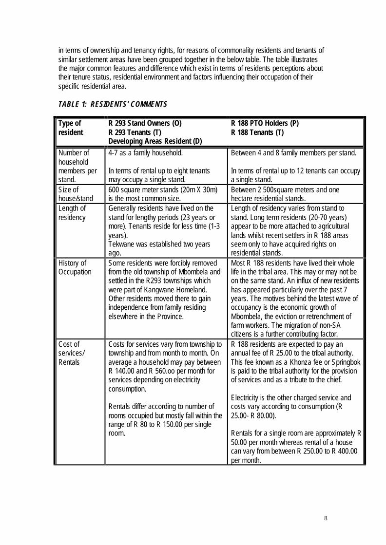
in terms of ownership and tenancy rights, for reasons of commonality residents and tenants ofsimilar settlement areas have been grouped together in the below table. The table illustratesthe major common features and difference which exist in terms of residents perceptions abouttheir tenure status, residential environment and factors influencing their occupation of theirspecific residential area.
TABLE 1: RESIDENTS’ COMMENTS
Type ofresident
R 293 Stand Owners (O)R 293 Tenants (T)Developing Areas Resident (D)
R 188 PTO Holders (P)R 188 Tenants (T)
Number ofhouseholdmembers perstand.
4-7 as a family household.
In terms of rental up to eight tenantsmay occupy a single stand.
Between 4 and 8 family members per stand.
In terms of rental up to 12 tenants can occupya single stand.
Size ofhouse/stand
600 square meter stands (20m X 30m)is the most common size.
Between 2 500square meters and onehectare residential stands.
Length ofresidency
Generally residents have lived on thestand for lengthy periods (23 years ormore). Tenants reside for less time (1-3years).Tekwane was established two yearsago.
Length of residency varies from stand tostand. Long term residents (20-70 years)appear to be more attached to agriculturallands whilst recent settlers in R 188 areasseem only to have acquired rights onresidential stands.
History ofOccupation
Some residents were forcibly removedfrom the old township of Mbombela andsettled in the R293 townships whichwere part of Kangwane Homeland.Other residents moved there to gainindependence from family residingelsewhere in the Province.
Most R 188 residents have lived their wholelife in the tribal area. This may or may not beon the same stand. An influx of new residentshas appeared particularly over the past 7years. The motives behind the latest wave ofoccupancy is the economic growth ofMbombela, the eviction or retrenchment offarm workers. The migration of non-SAcitizens is a further contributing factor.
Cost ofservices/Rentals
Costs for services vary from township totownship and from month to month. Onaverage a household may pay betweenR 140.00 and R 560.oo per month forservices depending on electricityconsumption.
Rentals differ according to number ofrooms occupied but mostly fall within therange of R 80 to R 150.00 per singleroom.
R 188 residents are expected to pay anannual fee of R 25.00 to the tribal authority.This fee known as a Khonza fee or Springbokis paid to the tribal authority for the provisionof services and as a tribute to the chief.
Electricity is the other charged service andcosts vary according to consumption (R25.00- R 80.00).
Rentals for a single room are approximately R50.00 per month whereas rental of a housecan vary from between R 250.00 to R 400.00per month.
9
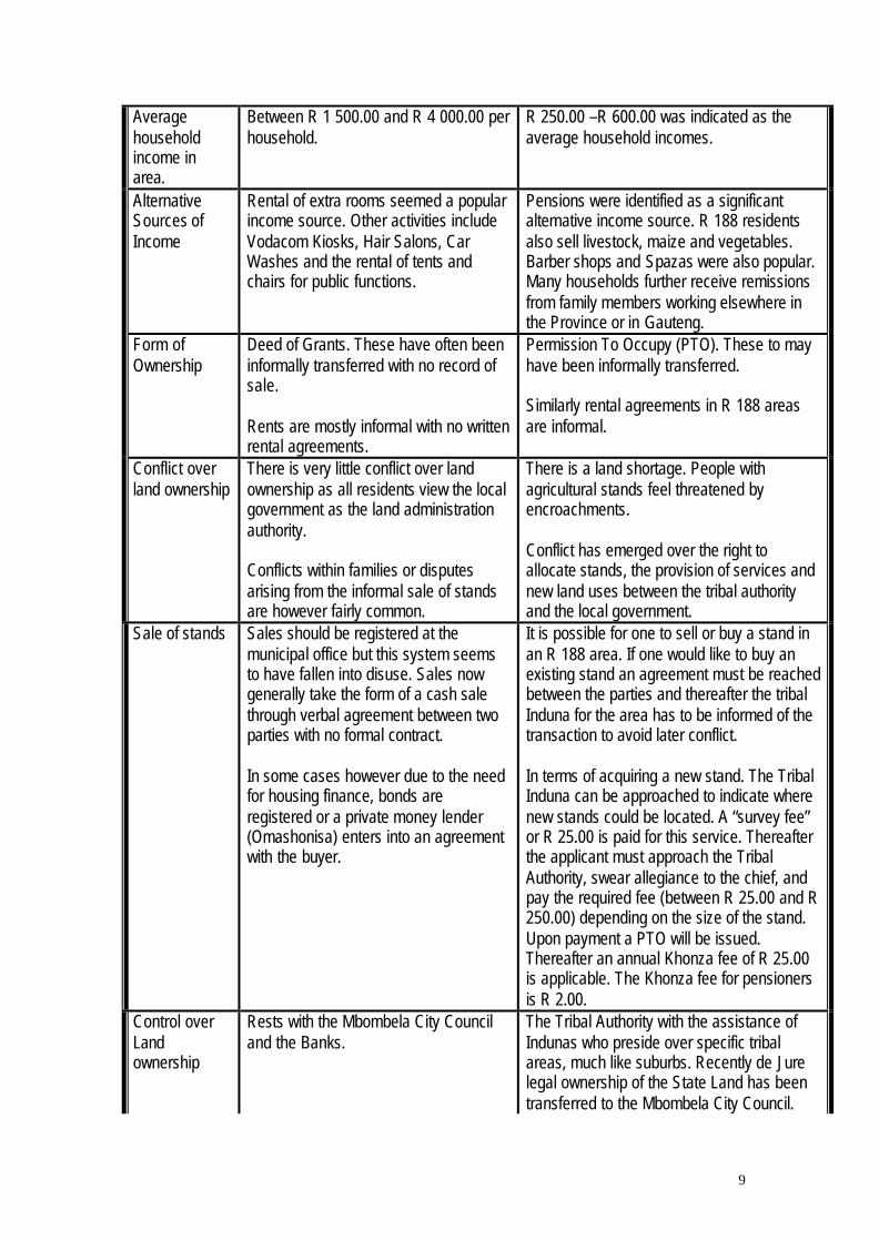
Averagehouseholdincome inarea.
Between R 1 500.00 and R 4 000.00 perhousehold.
R 250.00 –R 600.00 was indicated as theaverage household incomes.
AlternativeSources ofIncome
Rental of extra rooms seemed a popularincome source. Other activities includeVodacom Kiosks, Hair Salons, CarWashes and the rental of tents andchairs for public functions.
Pensions were identified as a significantalternative income source. R 188 residentsalso sell livestock, maize and vegetables.Barber shops and Spazas were also popular.Many households further receive remissionsfrom family members working elsewhere inthe Province or in Gauteng.
Form ofOwnership
Deed of Grants. These have often beeninformally transferred with no record ofsale.
Rents are mostly informal with no writtenrental agreements.
Permission To Occupy (PTO). These to mayhave been informally transferred.
Similarly rental agreements in R 188 areasare informal.
Conflict overland ownership
There is very little conflict over landownership as all residents view the localgovernment as the land administrationauthority.
Conflicts within families or disputesarising from the informal sale of standsare however fairly common.
There is a land shortage. People withagricultural stands feel threatened byencroachments.
Conflict has emerged over the right toallocate stands, the provision of services andnew land uses between the tribal authorityand the local government.
Sale of stands Sales should be registered at themunicipal office but this system seemsto have fallen into disuse. Sales nowgenerally take the form of a cash salethrough verbal agreement between twoparties with no formal contract.
In some cases however due to the needfor housing finance, bonds areregistered or a private money lender(Omashonisa) enters into an agreementwith the buyer.
It is possible for one to sell or buy a stand inan R 188 area. If one would like to buy anexisting stand an agreement must be reachedbetween the parties and thereafter the tribalInduna for the area has to be informed of thetransaction to avoid later conflict.
In terms of acquiring a new stand. The TribalInduna can be approached to indicate wherenew stands could be located. A “survey fee”or R 25.00 is paid for this service. Thereafterthe applicant must approach the TribalAuthority, swear allegiance to the chief, andpay the required fee (between R 25.00 and R250.00) depending on the size of the stand.Upon payment a PTO will be issued.Thereafter an annual Khonza fee of R 25.00is applicable. The Khonza fee for pensionersis R 2.00.
Control overLandownership
Rests with the Mbombela City Counciland the Banks.
The Tribal Authority with the assistance ofIndunas who preside over specific tribalareas, much like suburbs. Recently de Jurelegal ownership of the State Land has beentransferred to the Mbombela City Council.

10
Control overrentals
None. None, but if there is a dispute the TribalAuthority can be approached to mediate.
Motive behindremaining/moving
Most families have resided here for over20 years and are accustomed to theconditions. The proximity to roads is amajor factor for residents who commutedaily to Nelspruit for work purposes.
Motives for moving (to Tekwane or toNelspruit) include becomingindependent of the larger family or toavoid crime.
As most residents of the R 188 settlementhave stayed in the area for a long time they tohave become accustomed to theenvironment. They know the people. The costof living in the R 188 settlements are lowerthan elsewhere both in terms of landacquisition and service costs. Other reasonsfor remaining include access to naturalresources and less restrictions on their landuse activities. Unlike the township wheresome land uses (particularly light industrial)are restricted by zoning. This does not applyin the R 188 areas.
Levels ofservices
The Municipality provides purified waterand water borne sewerage. Eskomsupplies electricity. There are a fewtarred roads (main arterial roads), butirregular refuse removal and no streetlights.
No purified water. The chief pumps waterfrom the Crocodile River to a central reservoirwhich has a tap off point. Other areas rely onboreholes with hand pumps. Eskom supplieselectricity. Sanitation takes the form of PitLatrines and refuse remove is done throughSkips placed in certain areas.
Value ofProperty
Anywhere between R 25 000.00 and100 000.00.
A single room could cost R 4 000.00 topurchase.
Most people were unsure. One intervieweeoptimistically stated that his house was worthR 100 000.00.
Preferredresidentialarea
Nelspruit Suburbs as they are quieterand more free of crime.
The R 188 areas as they are cheaper.
Advantages/disadvantages
Advantages of the R 293 area includes;being near roads, clean water andaffordability.
Disadvantages include noise pollution,high levels of crime, poor roads, nocommunity facilities such as policestations, churches, clinics and shops.Certain areas have also been redlinedby the banks and it is impossible to sellstands there through formal housingfinance.
Advantages include big stands, affordability,access to natural resources.
Disadvantages include; noise pollution, highlevels of crime, no clean water and theabsence of community facilities.
Future trends Residents believe that the Municipalityshould develop better infrastructure inthe area for people. There is a sensethat this will happen in the future.
Residents say that they need developmentbut that the council must respect their cultureand must communicate and consult withthem. Government should protect their rightsand develop the area, but should alsocompensate them for land lost orinfrastructure lost during development.

11
Durban Metropolitan Area.
Description of the Study AreaThis case study reports on the situation in regard to residential tenure security in severalinformal settlements in the Durban Metropolitan Area, with special reference to tenancypractices. To this end, four informal settlements have been considered as part of thispreliminary study. Main points of results so far are given here.
Key questions include:• Identifying key actors,• Strategies and practices of actors,• Informal and irregular land markets and sub-markets,• Land related conflict resolution procedures and mechanisms,• Alternatives to formal rights for securing tenure, and• Local empowerment and capacity to work within different systems at a local scale.
The brief for this study focuses on changes in tenancy practices following the violence of themiddle 1990s. However, current developments appear to centre on the impact of changes inlocal government practice and the new municipal demarcation initiative.
Of the areas chosen, Adams Mission is located at the southern edge of the DMA, and isscheduled to come inside the Metro boundaries as a result of the municipal demarcationprocess. The tenure situation is therefore very fluid. Ohlange Informal is a large informalsettlement located on tribal land adjacent to the old Christian settlement of Dube’s Farm, on thewestern side of the very large Inanda informal settlement on private land north of the Durbancity centre. Mgaga and Malukazi are among the earliest to appear of the new informalsettlements which appeared in the 1990s, and are located close together and adjacent to thelarge Umlazi formal township to the south of Durban city centre. They are dealt with jointly inthe summary following.
The most dynamic areas appear to be Adams Mission and Malukazi. Ohlange has aninteresting but fairly stable situation, and Mgaga appears to be stagnating in a stable, anti-developmental situation. Consideration is given in greater depth to the areas where the tenuresituation is developing.
The account given here is based mainly on oral accounts from the interviews, due to limitedtime and resources for archival work with official and other written sources. Dates given maytherefore be approximate and events are narrated from the viewpoint of respondents in thecommunities.
OVERVIEW
Peri-urbanization processes around the Metro area have led to increasing density throughoutthe districts of former KwaZulu which lie to the south of the city, but mainly in the localities onthe city’s formal borders. Changes in tenure follow along with demands for development andservices, which help to make formal TA administration problematic.
Most of these densifying areas not already under municipal administration will now be takeninto the Metro under the municipal demarcation planning. When this happens they will fall
12
under the councillor system of local government chosen on proportional representation and willno longer be actively under the control of traditional leaders. Uncertainty around theimplications is affecting tenure in the border communities.
Inside the Metro boundaries, delivery of formal housing through the RDP programme is takingplace. The accompanying land and tenure system should help to stabilize tenure for peopleliving in informal settlements. However, for the informal settlements already inside the city,conflict over control of land and housing resources is made worse by uncertainty around thelocal government dispensation. Some of the areas being upgraded with formal housingdelivery do not seem to have access to a working formal tenure system, creating space formanipulation of housing and land resources by power holders.
MALUKAZI AND MGAGA
Current role players in Malukazi include:• The grouping within the area’s committee which is involved in criminal activity and
illegal selling of sites and renting out of public housing• The grouping within the area’s committee which is not involved in illegal activities• The designated local councillor for the area• A better-off, urban-origin constituency which supports the ANC and dominates Upper
Malukazi• A poorer, rural-origin constituency which supports the IFP and dominates Lower
Malukazi• A group of enforcers said to be hired by the illegal faction of the committee
Role players in Mgaga include:• The area’s committee which is shared with the adjacent township section• The designated local councillor for the area, shared with the adjacent township
sections, and• Informal plot owners, landlords and tenants
These two settlements lie on the west side of the large formal Umlazi township which wasestablished in the 1960s on former Tribal Authority (TA) land south of the formerly white centralcity. They are now part of the Metro and under municipal control.
The earlier landholding authority for Malukazi and Mgaga was the Cele Tribal Authority. Theexcision of the land for Umlazi created tension with the TA. The seat of the chief was movedfurther inland to the Ngonyameni tribal ward. The later establishment of the informalsettlements, and their assumption into the DMA, has made for more anger and a situation ofperceived competition between the TA, formerly part of the KwaZulu homeland and now underthe IFP-aligned provincial government, and the Durban metro, an urban area with ANCadministration and majority ANC support. This border zone is one in which the urban systemmarked by elective government is gradually expanding at the expense of the rural systemwhich includes traditional leaders.
Density built up on the demarcated border of the urban area through the 1960s. The formerKwaZulu government took over the area on the Umlazi border in 1973. At the same time,increasing numbers of rural-origin tenants were being accommodated in Umlazi itself withoutbeing able to get access to housing.

13
The two informal settlements were established around 1976-79. A land invasion took place atMalukazi, with Umlazi tenants spilling over into the densifying border areas where TAadministration was already weak. An Mgaga invasion followed.
Mgaga emerged later on land reportedly under the control of a prominent IFP functionary withan equivocal reputation. This leader is said to have been holding large tracts of land previouslyunder tribal control but formally earmarked for housing development, with the objective ofselling plots off privately. Because the area which became Mgaga was not being built on, largenumbers of informal settlers moved onto the land. People arrived in such numbers that theKwaZulu government could not consider evicting them, and the area remained under informalsettlement. Like Malukazi, it later came under municipal control, at an uncertain date.
Urban development of the Malukazi settlement dates from about 1979, when a housingupgrading scheme using a private developer was brought in. It appears to have been aroundthis time that administration of the area passed from former KwaZulu to the Durban metrogovernment.
A very large share of the existing Malukazi population was relocated to an outlyingdevelopment scheme at Folweni further south, so as to clear space for housing construction,roads and services in the Malukazi area. It appears that the people who were moved were toldthey would be returning when the houses were ready, but it is reported that the houses actuallywent to government workers, creating a higher-income category within the informal settlement.It is probably at this point that the Malukazi area was delimited into formal plots.
No similar development effort was made at Mgaga, and the settlement has never beendelimited into plots. Mgaga has continued to densify under its original informal landdispensation. To date there has been no organized effort to deliver housing on scale. Itappears the settlement is now too dense for further service interventions to be made withoutmajor disruptions to de facto tenure rights and possible social and political backlash. Effortsare being made to stabilize footpaths in the area.
The Mgaga settlement has close demographic and social links with the township sections towhich it is affiliated. As Umlazi expanded around the informal settlement onto TA land and newhousing was built, some of the people from the informal settlement moved into K and M sectionof the township. Others in the Mgaga settlement had more rural interests and left the informalsettlement for the more rural TA ward of Ngonyameni further inland. Other residents of K andM section moved into the informal settlement as they became unable to get housing in Umlazi.The settlement’s local committee draws members from both the township and the informal areaof Mgaga itself.
Around the time of the removal and the formal development, the Malukazi communityestablished a local micro-government committee. By the early 1980s political tension was highbetween the urban-oriented ANC-aligned UDF youth and the IFP and the KwaZulu Police, withsupport from many of the rural-origin in-migrants. Street committees emerged in opposition tothe established leader. Violent fighting took place at Malukazi, while Mgaga remained relativelypeaceful. The Malukazi leader fled as the area came further under the control of the streetcommittees and youth. In 1992 an exodus of large numbers of people from Malukazi tookplace because of the political violence. This outflow seems to have taken many of the IFPsupporters out of the area. It is thought that this outflow of people eased crowding and made

14
service delivery and later provision of RDP housing easier, and would therefore haveinfluenced the development of tenure institutions.
The prolonged political violence eventually led to the division of Malukazi into two sections, oneoccupied and dominated by IFP supporters and the other by ANC supporters. The ANC-aligned area is more developed and seems to be moving into formal tenure, while the IFPsection remains relatively poor and under informal tenure.
Fighting was winding down in Malukazi by 1993, and the local Peace Committee was able tobring about a truce in the settlement. The community formed a single Malukazi DevelopmentCommittee with representation from both political sides. This committee was initially verysuccessful in bringing about development, although it has now broken down seriously intocriminal rather than political violence.
A councillorship system of local government was introduced at Malukazi and Mgaga in 1996following the local government elections. Relative roles and responsibilities of the Malukaziarea committee and of the councillor were not well resolved, and the Malukazi councillor did notgain local support. A new councillor has now been designated. Mgaga’s councillor has beenbetter received and more effective.
Malukazi and Mgaga share their designated councillor with several of the sections of Umlazitownship in each case. Mgaga is administered from Umlazi’s administrative office, and thelocal committee works effectively with the councillor and with the K,M and L township sectionsto which it is affiliated. Malukazi is administered separately from the adjacent township,although the councillor for Malukazi is also responsible for three sections of Umlazi. There areno strong links between the Malukazi constituency and the township, and this arrangement hasnot worked well so far.
Tenure at Mgaga
Mgaga has received municipal water and electricity supply, but has no significant housing orroads development due to extreme overcrowding. The Mgaga population continues to live inself-built structures on rolling terrain, without formal tenure. It is thought that furtherupgrading would be physically very difficult unless the population could be temporarily movedout. Because subsidized public housing is not available as a contested resource, the tenuresystem appears to be stable at present. From interviews it does not appear that the localmicro-government committee has a strong role in tenure allocation and maintenance.
When Mgaga was originally invaded, land occupation was close to open access. Occupierswho arrived in the first wave of settlement took up plots on informal tenure without apparentreference to any particular leader or authority. Their claims have never been eitherquestioned or validated, and the upgrading process at Mgaga has not taken a form which couldgive a basis for tenure establishment or registration. No tenure documents of any kind are inuse at Mgaga other than possible handwritten receipts for transfer. Existing tenure appears tobe relatively secure, but does not support housing investment or other forms of development.
Tenancy, in the form of site-rental tenancy as found on private land at Inanda, does not appearto have been a very common form of landholding at Mgaga. That is, without a foundation inprivate tenure, site-renting – where new arrivals rent land to build shacks on a temporary basis– does not seem to have become an established practice. Instead, the forms of tenure which

15
have prevailed since the original land invasion seem to resemble what is commonly found onTA land as informal ownership and an informal land market develop.
The initial occupation in 1976-79 established a layer of informal land claims which allowedthese original occupiers to claim informal ownership not subject to any outside authority, and toact as landowners in relation to in-migrants arriving later. Most later arrivals seem to havebought land informally from the first occupiers, and become landholders in their own right.
Plots sold for R 1000-2000. Land seems to have been sold informally until densities reachedlevels which did not permit further densification. On a 1992 survey, most Mgaga residentsreported that they considered themselves plotholders in their own informal right, and could notsay who actually owned the land.
The rental market emerged in the form of room renting. Some earlier arrivals built structurescomprising clusters of single rooms with outside access, which were rented to individuals orfamilies as room tenants, a practice known as ‘renting cottages’. This practice expanded whenlocal faction fighting at Ngonyameni ward nearby produced streams of refugees in need oftemporary accommodation.
‘Owning cottages’ is the kind of rental practice often found in TA areas, where site rental isalmost unknown because the tenure rights do not vest in one person and land cannot beassigned to outsiders without going through several layers of institutional process. Room orcottage tenants are not usually recognized as full community members because they do notreceive a permanent right to settle tied to acquiring land.
Room rental rates at Mgaga without electricity range from R 50-R 80, and with electricity canrun up to R 150 per month. Many of the room or ‘cottage’ tenants are transient outsidersworking locally who have rural homes and do not necessarily want to establish permanentrights in the Mgaga settlement. Some of these are professional people.
It appears that Mgaga in effect has developed individualized informal tenure along the samelines as other densifying peri-urban areas under TA structures, which did not undergo landinvasions or explosive densification, or come under municipal administration. However, thecommunity oversight function usually found in TA areas seems to be weak or absent in Mgaga.Tenure seems to work at ground level through private transactions between informal rightsholders without much control from the local committee, but the more insecure forms of tenancyhave not developed as a large fraction of the housing sector. Given that the conditions are notin place for housing to be formally privatized, it looks unlikely that the tenure system will changeunless physical development delivery including higher-value housing is brought into the area.
Tenure at MalukaziThe development of RDP housing in the Malukazi area became an occasion for conflict whichhighlighted tenure insecurity in the light of institutional problems with local governmentstructures. By comparison with Mgaga, Malukazi is a highly turbulent area. Under presentconditions, the temporary freedom from violence which prevailed during the late 1990s seemsto have partly collapsed back into conflict, with the struggle over control of subsidised publichousing as a pivotal factor.
However, since the demarcation of the area into plots, the earlier informal character ofMalukazi is changing toward the characteristics of a formal township. As this happens, the
16
earlier informal occupiers appear to be leaving and returning to rural areas. This outflow ofolder residents is said to be partly due to making profits on selling their new land and housingassets, and partly due to physical insecurity.
Out-migration due to violence and lack of personal safety has been reported again, making thearea demographically unstable. Higher-income in-migrants are also arriving. Under theseconditions, tenure around subsidised private housing appears to be very unstable, and thisinsecurity may have spread into other areas of tenure. At the same time, the general trend forthe area appears to be toward full formalisation of tenure and privatisation of housing, with thehigher-income in-migrant population replacing the original rural-origin informal residentsthrough an informal market process.
Although formal housing delivery is in progress, it is reported that no title deeds have actuallybeen issued to people receiving RDP houses or to holders of any other kind of housing stock.A very active informal market in formal housing and serviced sites has developed, with housesbeing sold up to three times in two or three years, without formal documentation. Houses arereportedly sold for substantial amounts without any documents other than possible handwrittenreceipts. This lack of formal security is allowing extensive manipulation of the housing marketto take place, and appears to leave the original residents relatively insecure, while the new in-migrants with higher incomes may be less affected. At the same time, the structurally freeholdor private character of the land delimitation allows a strong market to develop.
Malukazi has full service delivery due to the availability of space for services development andto the efforts of the joint ANC/IFP local committee. The area is still substantially less crowdedthan Mgaga. The local micro-government committee is oriented toward development goals andhas been able to mobilize public works jobs and training for community members, as well as atleast one large public housing scheme. A large number of community residents have alsobeen allocated serviced sites for building. Access to this kind of land and housing asset hastriggered both market and extra-market competition over resources.
Effective delivery to community members appears to have broken down due to the involvementof criminal groups in the area, who have established links to some of the committee membersto get concealment of their activities. Committee members involved in intercepting subsidizedhousing allocation for their own benefit are reported to have used criminals to frighten orterrorize both uninvolved committee members and the community at large to prevent awkwardquestions about their activities. There are reported to have been a number of deaths, andresidents afraid for their lives are said to be moving out again in significant numbers.
These subsidized formal houses are specifically earmarked for community members, but arereported to be diverted to outsiders who are willing to pay. A significant share of completedRDP houses are said to be retained by committee members, who rent them to house tenantsfor profit instead of allocating them to community members on the list for RDP housing.
Formally, RDP houses should not be sold before a five-year initial occupation period haspassed, but this takes place regularly on the informal market: because of the lack of legaldocumentation, there is no de facto difference between houses being sold properly orimproperly in relation to the five-year moratorium on transfer.
At the same time, serviced sites are being sold by assigned owners to incoming families withhigher incomes, so that the higher-income families can build substantial houses with bank

17
mortgages. The allocated owners of the sites appear to be mostly long-time residents whohave retained rural ties, and who are taking their profit on the transaction and going home totheir original rural communities.
The rental market as either site-rental or room rental is reported to be declining as more higher-income households buy plots and houses in the area. The earlier system continues mainly inLower Malukazi, the IFP-aligned area still occupied by poorer and more rural people.
Dikgale-Solomondale Area
This case is about land tenure patterns and shifting relationships within Dikgale communalarea, situated in the Central Region of the Northern Province. This area is formerly part of theLebowa homeland area. The population is made up of Sepedi speaking people under Dikgaletribal authority. The study places special emphasis on understanding of land tenure patternsin the area from a range of divergent perspectives, including the history of land acquisition andsettlement, formal and informal ownership of land, structures of local authority, access to landand need for tenure reform.
The area under study is falls under jurisdiction of Dikgale Tribal Authority established in 1964with formal control of various categories of land. The oldest parts of the area have been undertribal authority without interruption since before arrival of whites. Under apartheid rule land inthe area fell under Tribal Authority. Formally, this is state land since allocated for use by thetribe but which is registered in the name of the Republic of South Africa. Between 1913 andthe establishment of the South African Native Trust in 1936, additional land was bought fromneighbouring white farms either by the community or by specific individuals. This land was thenheld in trust for the purchasers by the Ministry of Native Affairs. Generally referred to asbought farms, this land was never under direct control of either the SADT or Tribal Authority.Upon establishment of the SADT in 1936, additional land was bought and transferred to theDikgale tribe. Yet despite the history of ownership described above, its important to note thatde jure ownership of land is still with the state and not the occupants.
Administration of LandOverall, administration of the land largely resides with the Dikgale Tribal Authority which tovarying degrees delegated powers to communities (i.e., villages), village headmen (mantona)and Chief Dikgale. Powers to Tribal Authorities are largely derived from a mix of tradition andapartheid era legislation, especially the Black Authorities Act, 1951 under which TribalAuthorities were established.
Access to land is gained through membership to the tribe, but access process vary fromcommunity to community. Eligibility to accessing the land is generally based on considerationsof birth in the area and, in case of being from outside the area based on communityacceptance. A further requirement is that individuals remain loyal to the chief while regularlypaying their tribal levies. In this instance land is allocated to households, or heads ofhouseholds mainly for residential or agricultural purposes. Being a male dominated society,land is generally given to households headed by men, and women or households headed bywomen generally have difficulties justifying themselves as independent households.
On tribal and trust farms, households acquire land, i.e., residential stands through applicationsto Tribal Authority through the village headman. They may also apply for ploughing fields in thesame way, but ploughing land has been in very short supply in recent years. Both residential
18
and ploughing land are for exclusive use of the households concerned. Access to communalgrazing and other natural resources such as thatching grass and firewood, are open to allmembers.
On the bought farm of Doornfontein, residential stands are issued by village headman withoutreference to the Tribal Authority and ploughing land is obtained through negotiation withexisting plot holders. In recent years, community projects, funded from external sources,houses become an additional means by which members of the community, especially womenand the very poor, have been able to access arable land.
Permission to OccupyLike rural residents of trust and tribal farms elsewhere, those in Dikgale are able to obtainPermission to Occupy (PTO) certificates through Tribal Authority and Magistrate’s Offices. Asmentioned elsewhere inn the paper, under PTO system, households heads are grantedindefinite use right to residential and/or arable plots. On the bought farm of Doornfontein,residents enjoy similar rights but no certificates are issued. All land holders share the sameobligations, including payment of tribal levies and observance of traditional practices. Allmembers enjoy equal access to the communal areas and these rights are not documented.Exclusive rights to residential stands or arable plot cannot be sold and can only be exchangedwith the approval of the headman or the chief. Anyone wishing to leave the area may sell anyremaining structures to a new occupant, but the new occupant must have the stand allocated tothem by the Tribal Authority before taking occupation.
The great majority of people interviewed for this study felt that the current communal system,under the control of the traditional leaders, was appropriate to their needs, in terms of landownership, land allocation and land use. There was widespread support for the principle ofcommunity control over land, including over who can access land and the right of thecommunity control over how land is used. No support could be found within the community thatsupported privatisation of land. The only people who seemed to think otherwise were officialsfrom the Department of Agriculture and provincial Directorate of Traditional Affairs. For them,the transition from communal land tenure system to private, individual tenure was bothdesirable and inevitable.
Concerns were raised by women, however, because often they discriminated against. Forinstance, they are often excluded from community decision for a such as tribal councils. Theyare nonetheless able to own land with all attendant tenure rights their male counterparts enjoythrough some of the existing community structures. They can inherit land from husbands butare likely to lose land where in case of divorce.
Widespread evidence of confusion and uncertainty abound in the community around the legalstatus of land rights and practices under the communal system. The system of written PTOshas fallen into disuse, and many people have lost documentary evidence of their rights toresidential or agricultural land. The system of demarcating residential and arable plots hasbroken down along with the old Trust regulations for the control of grazing land. No effectivecommunity-based mechanism have yet emerged to replace the regulations of the apartheidstate leaving community members confused and unsure of their rights.
There is no indications that current tenure system has the effect retarding development in thearea of Dikgale. For instance, several forms of agriculture have evolved over the years rangingfrom extensive cropping, livestock grazing and intensive horticulture and, none of our

19
informants felt hampered by the lack of a title deed. The current land tenure system in Dikgale-Solomondale area allows for a flexible land use system making it accessible to people of allsocio-economic background including the very poor.
Once land has been obtained, it remains with the household indefinitely and can be passed onwithin the family. Dispossession is rare, occur only in cases of divorce or accusation ofwitchcraft, both which affect women more than men.
The greatest area of uncertainty based on system of land tenure relates to current debates inSouth Africa around whether local government or traditional leaders administration of land
SUMMARY OF EMERGING TRENDS
This section will provide summary of the trends, factors and conditions which based on casestudies discussed above emerge as key to changing residential tenure security systems.
• Findings reveal that the decision to locate or reside in a particular area is based on anumber of factors related to the costs of services, rentals or annual Khonza fees. People in thelower income groups ( i.e, R 200 – R 1 500 per month per household) still view their accessnatural resources for grazing, crop cultivation and gathering of fuel woods as very importantdeterminants of their decision to reside in one area or another.
• People in a higher income bracket (R 1 500 –R 4 000 per month per household) partlybecause they commute to work in other economic centres choose to reside in areas closer tomajor arterial routes for easier transportation. Their land use remains purely residential withlittle or no dependence on natural resources in the area to supplement their incomes.
• Crime, poor levels of services, the absence of community facilities and environmentaldegradation seem to be concerns of all township residents irrespective of tenure status andincome levels.
• By linking service charges to land ownership, some local councils inadvertentlydiscouraged people from supporting tenure upgrade initiatives. Residents of R 188 areas inparticular feel threatened that if they receive title deeds to their properties and they are furtherforced to make use of municipal services which they cannot afford, they will run into arrearsand be evicted from their properties. This phenomena leads to poorer residents seeking thesupport and protection of the Tribal Authority to prevent the provision of municipal services.
• Communication and co-ordination between role players involved in tenure upgrade andtownship formulation is very poor at present with very little in the way of shared approaches toland rights verification, township formalisation processes or service provision.
• Communication between role players (particularly the Municipality) and the residents ofthese areas is similarly poor. In many cases residents are not consulted or given an opportunityto give inputs into formalisation processes, rather they are approached once the deal is doneand the development is underway. Fir instance, the case of a new road being developed inDaantjie where residents front gardens are being destroyed is a good example of this top-downapproach. Instead of being consulted at the onset of the project residents were addressedwhen the road reached their doorstep. At this point they were told that the road is going to
20
happen anyway, that the land is state land and they have no say in the matter, thirdly they weretold that if they oppose the project now the council will loose money and will not build a road forthem in the future.
• Residents themselves feel very threatened by the agendas various role players purveyaround and are suspicious that new projects or programmes have sinister motives behind themwhich will result in them being dispossessed of land or having other rights infringed upon. Assuch many residents favour the status quo ante rather than a move towards more secure formsof tenure.
• In terms of addressing the housing needs of a growing urban population there is a backlogof houses and new programmes such as the DLA’s redistribution Programme, the Departmentof Housing’s RDP housing programme and private sector development will in no way be able tomeet the growing housing needs of the District. The influx of people into identified areascaused by a number of factors alluded to above will continue in the short to medium term. Theonly mechanism at present which can provide residential tenure security at present is theconversion of agricultural land into settlement areas through allocations made by tribalauthorities through PTOs. Whilst this process has been criticised for various environmental,political and social reasons it is at present the only system that affords poor people theopportunity to access land for settlement purposes.
Conclusion
Beyond the general points arising, as summarised above, the research which we are
conducting throws up a number of major questions concerning the way forward towards greater
residential tenure security at least in South Africa. As noted, the predominant means of
securing tenure have been presumed to lie in formal, private, individual forms. Yet our
research shows that many, many people probably find that the non-formal, to some extent
customary, and in general hybrid forms of tenure which they have, actually meet their needs.
In these circumstances new forms of planning will be required which are more able to take
seriously the conditions under which people seek and enjoy the varying forms of tenure and
associated security which actually characterise our settlements. But those are subjects for
further reports on our research.

21
REFERENCES
1. CADNET.2. Regulation 293 of 1962.3. Regulation R 188 of 1969.4. Matrimonial Properties Act of 1984.5. Less Formal Township Establishment Act, Act 113 of 1991.6. Interim Protection of Informal Land Rights Act, Act 31 of 1996.7. Laduma Project Managers in co-operation with TAPP Town and Regional Planners and
Urban Studies.8. Integrated Spatial Development Framework Report, 2000.9. Earthspace Development Planners Pty- “Evolution of Settlement Patterns in South Africa
under Different Planning Systems.