Embed Size (px)
Citation preview
Changing Roles of Planners in Smart Neighborhood
Practice: A Case Study of Sidewalk Toronto Project
A Thesis Presented to the Faculty of Architecture, Planning, and Preservation
COLUMBIA UNIVERSITY
In Partial Fulfillment of the Requirements for the Degree
Master of Science in Urban Planning
By
Danting Luo
May 2019
Advisor: Professor Leah Meisterlin
Reader: Professor Jonathan D. Martin

1
Copyright © 2019 Danting Luo
2
ABSTRACT
This paper examines how urban planners' roles change with the development of "smart"/digital technologies
within cities. Specifically, the study aims to examine urban planners' roles in Sidewalk Toronto/Quayside
project implementation process (in which Google Inc.'s sister company Sidewalk Labs serves a major
planning function), including new digital technologies and tools. The study is both empirical and qualitative,
scaling in the city of Toronto to compare the current planning process in Quayside project with
prior/traditional neighborhood planning methods and decision-making process in Toronto. Qualitative
information is generated through interviews with professional urban planners involved with the case study
project and/or with neighborhood-level planning projects broadly in Toronto to supplement the analysis of
official documentation about Quayside planning process. The result of this research has identified some
changes of urban planners’ roles in the early implementation and planning stage of Quayside project,
compared with the prior neighborhood planning projects. Sidewalk Toronto planners’ roles as technocrats
and information providers, negotiators and mediators, as well as design visualizers are emphasized in the
Quayside project, while their roles as specialists and generalists do not change at this early project
implementation stage. While in terms of city planners, their new roles as data privacy advisors and
governors as well as development coordinators and project advisors are generated in the Quayside project,
whose roles as regulators and examiners, however, do not seem to change much at this stage. Future
research on smart neighborhood project planning process and urban planners’ roles in such process are
needed to further examine whether the development of technologies and application of data would change
urban planning process, the roles of urban planners, and people who execute the planning activities and
functions. Moreover, further studies on the reasons causing these changes of the physical planning process
and urban planners’ roles are necessary, through which we can identify the factors having impacts on urban
planning practice and better predict the changes that would happen in the future planning field.
KEYWORDS
Smart City, Smart Neighborhood Planning, Urban Planning, Urban Planner Roles, Smart and Digital
Technologies
3
ACKNOWLEDGEMENTS
I would like to thank my advisor, Leah Meisterlin, for her continuous guidance, support and understanding
through the research process. Thank her for providing the inspiration for my research and the methods.
Professor Meisterlin has been an advocate in the fields of spatial justice, informational ethics, and digital
technologies’ effects on restructuring urban spatial politics. Without her experience and knowledge, I would
not have the confidence to pursue my own interest in the smart neighborhood development. Thank you to
Jonathan Martin, an Adjunct Professor in the Urban Planning Program at Columbia GSAPP who served as
my reader and has been an enthusiastic and supportive mentor. It is a great honor for me to have learned
from their expertise, which has significantly impacted my vision for this research. Especial thanks to my
off-campus mentor Shraddha Ramani, a GSAPP alumni and also a GIS Mitigation Program Manager at
NYC Emergency Management, for her generous help and advice on this research.
I must express my gratitude to the individuals and organizations that I interviewed for this research. Thank
you to those who shared their own experience and provided invaluable insights about urban planning
changes with the development of technologies. Especial thanks to my friends Shulin Zhang and Wei Jiang
who have been extremely supportive of me through this long research process; I am grateful to have their
presence and encouragement.
I owe a lot to my mom Jie Zhang and my dad Xuefeng Luo who have sacrificed their lives for me and
provided unconditional love and care. They encouraged and supported me at every stage of my personal
and academic life. I love them so much and completing this research would have been all the more difficult
without them.
Finally, I would like to thank myself for working hard and never giving up.
4
TABLE OF CONTENTS
Title pages
Abstract
Acknowledgement
Table of contents
Table of figures
List of Abbreviations
Chapter 1 Introduction and Background
Smart City and Smart Planning 8
Cities are experimenting “smart city” 9
“Smart city” changes urban planning and urban planners’ roles 9
Research Purpose 11
Research Significance 11
Research Design 12
Chapter 2 Literature Review
The roles of urban planners 16
Smart City Critiques 19
The methodology of previous research on the roles of urban planners 22
Chapter 3 Case Study
General neighborhood planning in Toronto 26
Sidewalk Toronto/Quayside Project 30
Chapter 4 Findings
Planners as specialists or generalists 38
Planners as data privacy advisors and governors 39
Planners as technocrats and information providers 40
5
Planners as project coordinators, examiners and advisors 40
Planner as negotiators and mediators with the public 43
Planner as design visualizers 43
Chapter 5 Discussions and Conclusion
46
Bibliography 54
Appendix: List of Contacted Interviews
60
6
TABLE OF FIGURES
Figure 1: Sidewalk Labs has released the vision and announce that they will work with the City government
to bring the latest digital technologies and urban innovations at Eastern Waterfront including Quayside and
the Port Lands. Source: Sidewalk Labs.
Figure 2: Collaborative Framework for Digital Governance between Waterfront Toronto and Sidewalk
Labs Source: Sidewalk Labs
7
LIST OF ABBREVIATIONS
Canadian Housing and Mortgage Corporation (CHMC).
Geographic Information Systems (GIS)
Information Communication Technologies (ICT)
Information Technology (IT)
Innovation and Funding Partner Framework Agreement (Framework Agreement)
Innovation and Development Plan (MIDP)
Internet of Things (IoT)
Integrated Planning Act 1997 (IPA)
Neighborhood Planning Offices (NPOs)
Ontario Municipal Board (OMB)
Sidewalk Labs LLC (Sidewalk Labs)
The Ontario Planning Act (the Act)
The Greater Toronto Area (GTA)
Toronto Waterfront Revitalization Corporation (Waterfront Toronto)
Waterfront Toronto Digital Strategy Advisory Panel (DSAP)
Waterfront Revitalization Initiative Intergovernmental Steering Committee (IGSC)
8
CHAPTER 1 INTRODUCTION AND BACKGROUND
Smart City and Smart Planning
Over the past decades, the drive towards using digital technology, information and analytic systems to
manage and plan the city leads the evolution of urban governance into a technocratic mode. The application
of all such “smart” technologies like Information Communication Technologies (ICT) and the Internet of
Things (IoT) has emerged to fulfill urban efficiency and development (Hollands, 2015). Urban problems
are believed to be solvable and optimizable through computation and all other technical solutions including
real-time analytics, which might be referred by Morozov (2013) as “solutionism” or what we now called -
“smart city solutions”.
According to Hollands (2008), the word ‘smart’ can also mean ‘wired’, ‘digital’ and ‘intelligent’. Smart
city is defined by Dirks and Keeling (2009) as a city that applies technologies to optimize urban system and
thus the implementation outcomes based on limited resources; by Viitanen and Kingston (2013, p. 1) and
Gabrys (2014: 44) as a city strategy that seek technological innovation solutions to deal with complicated
political, environmental and other urban issues; and by Washburn et al. (2010) as a city that takes advantage
of real-time analysis to make better and more efficient decisions for city. While smart planning is regarded
as a new dimension of urban planning involved with both procedural innovation and technological
innovation. The former refers to the innovation in territorial management, while the latter refers to creating
a new “digital environments” based on the generation, collection and application of big data (Papa, Fistola,
& Gargiulo, 2018). The characteristics of a smart city include using networked infrastructure and
Information and Communication Technologies (ICTs) to achieve urban connectivity and development;
focusing on businesses and entrepreneur-emphasized urban development (Hollands, 2008, p. 308); socially
inclusive urban development (Caragliu, Del Bo, & Nijkamp, 2011)); high-technical and creative industry-
9
focused urban development (Glaeser, 2005, p. 593); and social capital and environmental sustainability
development (Coe et al., p. 2001).
Cities are experimenting “smart city”
Cities have been treated as a relational system that must be considered as a whole rather than a composition
of space (Ingallina, 2007, cited in Stufano, Borri, Camarda, & Borgo, 2017). Planning, in between, tries to
manage the complexity of city through urban project, plan or strategy over time while maintaining identity
and uniqueness recognition (Gargiulo & Russo, 2018). Also, planning plays a significant role in the
governance and structure management of various possible urban actions (Marzukhi, 2017).
There is great interest around the world to explore technological innovations in planning and building smart
city or neighborhood, for which city managers and policymakers tend to transform abstract and elusive
smart city concepts into tangible strategies and actions, either for the purposes of enhancing city
management, governance democracy, service effectiveness, city competitiveness or quality of life (Taylor
& While, 2017). The wave of such explorations and experiments starts with governments looking for
qualified and capable private partners such as private companies and entities to promote technological
innovations and solve urban issues. They invest and integrate ICTs and IoTs into people’s daily life in
various ways, trying to create economic, social and political benefits (Chin et al., 2010; Viitanen & Kingston,
2013). Initiatives and programs like IBM’s global Smarter Cities Challenge (IBM, 2010), Cisco's City
Infrastructure Financing Acceleration Program (CIFAP) (Cisco, 2018) and Microsoft CityNext Initiative
(Microsoft, 2014) can be typical examples for these private sectors having significant impacts on smart city
experiments.
“Smart city” changes urban planning and urban planners’ roles
10
The urban environment has close a relationship to our ways of producing, commuting and communicating.
As the traditional industries were reoriented with the development of technology industry and the
emergence of various private technology companies, new kinds of infrastructure that helps process and
store information and bridges that create seamless connections between digital world and physical world
are introduced by the advanced digital technologies and electronic language, which significantly affects the
development of city and its society (Albrechts, 1991; Kitchin, 2014). As the industries of technology and
technical innovation boomed, the discourse of ‘smart city’ further sprouted in the urban planning field, in
which respect, urban design and planning have also made different responses, either for the purpose of
improving the quality of city life or creating a more efficient and sustainable living environment (Kitchin,
2014).
Before digital technology “overwhelms” various fields in the world, the city planners are not very much
exposed to the aggregation of the notions of scientists and technologists, instead, they use their own
evaluation, planning and design skills to assess socio-economic context and make a planning decision
(Kinsley, 2014). They are reminded of complicated social impacts and how those impacts should be
included and harmonized in dealing with the city problems. While in response to the development of digital
technology, a new spatial order has emerged when code, software and computational calculation are used
as modulators in the set of recreating space experience (Kinsley, 2014; Webber, 1963:54, cited in Harvey,
2009). Code is organized into a wide range of public, private and public-private sectors as well as logistics
and mobility systems (Graham, 2005, p. 562). Computational software, as pointed out by Amin and Thrift
(2002), runs in a variety of computing systems and devices to saturate the urban landscape, the functions
of which range from excessive Internet-based services to public transportation, water and sewage
management. While the algorithm has become the foundation of the computing system that provides action
grammar for automatic calculations, computational power and digital storage capacity enhancement (Agre,
1994). As such, the urban planning process and thus urban planner’s role certainly change when people
turn to digital technology for the answers of urban issues.
11
Research Purpose
The research purpose of this thesis is to examine how urban planners' roles change with the development
of "smart" technologies within cities. The term “planners” used in the research refers to both people who
are actually making plans and who are making decisions relating to these plans, including those planning,
negotiating, analyzing, researching, and surveying urban development projects. This research inspects the
changing roles (if any) of traditional urban planning including planning activities and functions that are
usually executed and filled by the traditional planners, rather than whether urban planners are replaced by
other professionals with other types of expertise other than planning expertise. Specifically, the study aims
to examine urban planners' roles in Sidewalk Labs’ Quayside project implementation process, including
new (if any) digital technologies and tools. The study compares the current planning process in this project
(in which Google Inc.'s sister company Sidewalk Labs serves a major planning function) with prior
neighborhood planning methods and decision making in Toronto.
Research Significance
For those previous research studies exploring urban planner’s roles and their changes in the nationwide and
citywide scales, or in the discourse of protecting cultural diversity, sustainability, water resources and
mitigating flood hazard, some of them applied theoretical approach, while some of them applied case study
and supplemented it with the interviews and surveys with professional planners. However, there are few
previous research studies exploring urban planner’s roles and their changes at the neighborhood planning
scale, especially in the discourses of technology innovations and “smart” neighborhood development. To
fill such gap and highlight the value of this research, the paper examines how urban planner's roles change
with the development of "smart" technologies within Sidewalk Labs' Quayside Project in Toronto,
compared with prior planning methods and decision making in Toronto.
Although there is a large number of research studies talking about the roles of urban planners in the large
scale, either nationwide or citywide; there are few previous research studies examining the urban planner’s
12
roles in the neighborhood planning context at the local level. In addition, even though there are fierce
theoretical debates arguing the changing roles of urban planners in the discourse of smart city development,
there is no solid evidence and specific study tied to a smart city or neighborhood project at the local level.
This research fills such gaps by inspecting whether the roles of urban planners are impacted or changed
with the development of smart technology and digital innovations applied for planning and building the
city.
As planning is about the vision of the future, alongside which there are continuing urban changes either in
terms of social, economic, political or environmental aspects, urban planners are required to always think
about the changes and adapt the plan to different situation caused by various and complicated relationship
between built environment and urban entities (Marzukhi, 2017). As digital technology emerging and
developing, no matter in the better or worse way, there are questions being raised: if the relationships
between city and technological innovations as well as private technology companies increase, what do city
planners need to be preparing for? What does that mean in terms of how we see urban planning and its
practice? Would urban planners still stand in the same position as in the past or would their roles in the
urban planning process change? What are the implications of such changes? All these questions are worth
to be answered. The reliable and integrated methodology is essential for the urban planners to transform
and impact the physical attributes or urban areas, which, however, differs between different countries, cities
and even neighborhoods (Formato &Russo 2014; Francini, et al., 2018; Gregotti 2004, cited in Stufano, et
al., 2017). Therefore, It is important for the planners to be open-minded and take potential changes of future
into account so that they will know in which ways, by which tools, for which systems they should be
working to adapt to different contexts and systems.
Research Design
This research is conducted based on the review of previous research studies on the evolution of technology
in the urban planning practice, the emergence of smart city development as well as the critiques about smart
13
city dialogues. The literature review also includes previous research studies on the roles of urban planners
with respect to neighborhood planning and technology. There are previous research studies on the roles of
urban planner in the scale of nation and city and in the context of protecting cultural diversity, sustainability,
water resources, flood hazard and public health. For the purpose of tracking back, historical planning
records, official documentation, papers and articles are selected and incorporated to provide a solid
foundation for this research.
In order to answer the research question of how urban planner's roles change with the development of
"smart" technologies within cities, the study is both empirical and qualitative, scaling in the city of Toronto
to compare the current planning process in Sidewalk Labs' Quayside Project with prior or traditional
neighborhood planning methods and decision making in Toronto. It firstly focuses on the review and
analysis of the traditional neighborhood planning process in the city of Toronto before Sidewalk Labs
started its smart neighborhood project in Quayside. Through examining a typical neighborhood planning
project called Bathurst Quay Neighborhood Planning project, this research describes the traditional
neighborhood planning process in Toronto including prior planning methods and decision-making process,
and provide background information for its later comparison with the planning process in Quayside project.
Secondly, the study is mainly based on the qualitative analysis of Sidewalk Lab's Quayside Smart
Neighborhood Project. Quayside, now at its early stage of development, will be a new planned
neighborhood located at Parliament Slip, adjacent to Downtown Toronto. The project is proposed and
implemented by the Sidewalk Toronto that is a joint platform by Toronto Waterfront Revitalization
Corporation (Waterfront Toronto) and an Alphabet’s company called Sidewalk Labs LLC (Sidewalk Labs).
According to the proposals and visions released since 2017, the project is a 12-acre piece of land of Toronto
waterfront, which will be a new type of mixed-use and complete neighborhood built from an undeveloped
area with the best people-centered urban design and the latest digital technology. It will not only adopt new
construction methods but also other urban technological innovations (Sidewalk Labs, 2017a). Quayside
14
project, as a new kind of smart city/neighborhood project, could be a typical example of applying
technology and urban innovations in urban planning. The publicly available official documentation,
previous journals and articles about the Quayside planning process are reviewed as part of the research to
examine urban planners' roles in this project’s implementation process, including new (if any) digital
technologies and tools.
Semi-structured interviews with professional urban planners who are involved with the case study project
and/or with neighborhood-level planning broadly in Toronto are conducted to supplement the analysis of
the official documentation about the urban planning process in Toronto as general and in the Quayside
project as well. Using the publicly available information on county and organization web pages, interview
subjects are contacted via email addresses listed and asked whether they would be willing to participate
interviews. Interviews are conducted either in-person, via telephone, or via Skype. Telephone or Skype
interviews obtain verbal consent (after supplying the consent form electronically), whereas in-person
interviews include written informed consent.
Facilitated by a brief questionnaire with follow-up questions, they are asked to talk about their roles in the
project or their positions in the Toronto City Planning Department. They are asked to talk about their
involvement with the project as well as any different experience they have had in this project compared
with prior neighborhood planning methods and decision making in Toronto. Their experience relating to
the conflicts between digital technologies and planning practices are asked during the interviews as well.
Follow-up questions are asked based on the positions and experience of the interview subjects, which differs
between different interview subjects, which, however, contains no sensitive information and only the
statement of fact.
In the findings section, the analysis of both Toronto’s prior neighborhood project and Quayside project,
including the analysis their published documentation, public-private partnerships, internal planning
15
decision making processes, public engagement processes, the planning procedures as well as the toolkits
and analysis methods used by their urban planners, lead to the comprehensive comparison between these
two. The research goes through these aspects respectively to identify the changes happening in the planning
process and corresponding roles of the planner with the development of smart technology. While in order
to figure out whether the changes identified in this research are a matter of accelerating or deconstructing
the planning processes, following the previous analysis, in the discussion section, the implications of those
differences and changes are analyzed in terms of what can be learned; how urban planning practice will be
affected if the relationships between city and technological innovations as well as private technology
companies increase; would urban planners still stand in the same position as in the past or would their roles
in the urban planning process change; and what do city planners need to be preparing for in the respect of
planning tool-kits. In the discussion and conclusion chapter, such investigations also serve as the ground
for a more in-depth discussion in further research as this research only examine the planning practice in the
early stage of the smart neighborhood project.
16
CHAPTER 2 LITERATURE REVIEW
The roles of urban planners
Talking about the roles of urban planners, there is a large number of previous research studies providing
insights into the urban planning system, analyzing the evolution of it and the changing roles of urban
planners. There are four main conceptions that summarize the changing roles of urban planners. The first
is the pluralist conception that regarded planning as a form of intervention (Dunleavy & O’Leary, 1987, p.
45) and planners as mediators and guardians of the public welfare who dealt with the imbalances between
different stakeholders (McGuirk, 2001). The second is the managerialist conception that treated planners
as bureaucrats who provided technical and professional advice of state interests (Beckman, 1964; Campbell
and Marshall, 2002). The third concept is the reformist conception that viewed planners as advocates who
secure the interests of marginalized groups and community. While the fourth one is the neoliberalist
conception that viewed planners as entrepreneurs who facilitate the interests of private sectors (MacLaran
& McGuirk, 2003).
The transformation of such conceptions about urban planner’s roles came together with the transformation
of economy and society. One of the most significant change happened in the last century was when the
economy transformed from Fordism emphasizing state intervention to Post-Fordism highlighting invisible
hands and the functions of the market's self-adjustment. As a consequence, the attitude about planning
system changed correspondingly - urban planning was regarded as being less effective, compatible and
excessive costly in terms of operation in the late 1980s (Albrechts, 1991; Piore & Sabel, 1984; Scott &
Storper, 1986). Planners, after experiencing huge macro-level socio-economic transformation and technical
development, have to change their ways and toolkits to deal with urban issues and think about how to plan
rather than what is the outcome of planning (Forrester, 1989). Traditional tools like welfare policies,
17
incentive strategies, and zoning regulations also became less effective in dealing with the changing and
complicated urban issues at the 1990s (Albrechts, 1991).
In the meantime, when emphasizing the market, private sectors started to be involved in the urban
development process and planning activities: public sectors consulted and cooperated with private sectors,
seeking for their expertise, skills, knowledge and cheaper consulting fee (Fordham, 1990; Healey, 1985;
Davoudi & Healey, 1990; Higgins & Allmendinger, 1999; Campbell & Marshall, 2002). As the social and
economic context transformed, the planning system had been restructured and decentralized to the private
sectors. The concept of planning changed from managerialism to entrepreneurialism, in other words, instead
of being the managers and regulators of the city, urban planners’ roles were likely to be weakened and
become the deal makers and entrepreneurs in the urban planning process (Fainstain, 1988).
In many countries, prominent development decisions concerning the physical environment are not
necessarily supported or influenced by the professional planning knowledge, which limited planner’s right
to provide advice and ability to address handle land development challenges. In many situations, the rights
for city’s land allocation, planning and building permits are beyond the rights of urban planners whose
expertise and profession ethic would be overshadowed by political factors (Cavrić, 2004). Additionally,
urban planners holding different positions at different organizations would also have different impacts on
the urban development and planning process, for example, planners of city government only have restricted
ability to initiate a new development project as they need to be very cautious about the regulations and
interests of authorities and organizations at the community level. While planners form community level
working for the community council or associations have more power to affect project decision makings and
planning through constituency support, but less administrating power as they still need the approvals from
the city and higher-level government sides.
18
The roles of planner have been switched among decision makers, administrators, urban managers,
technocrats, information providers, regulators, land development coordinators, negotiators, mediators,
facilitators, development initiators, advisors, designers, and advocators since the emergence of planning
concept in the early 20th century (Cavrić, 2004). Planners are expected to play different roles during the
planning practice process, including as generalists with all-round expertise or as specialists focusing on
particular aspects of urban development. While according to Batey (1994), recent planners who just started
their career are more likely to specialize in particular planning aspects like environmental planning, urban
design, economic development or housing development. In addition, current planning practice is required
to have a comprehensive understanding of the complicated social, economic, environmental and political
context so that it could apply more science-based methods.
In addition, the development of Information Technology (IT) and Geographic Information Systems (GIS)
have been supporting urban planners for decades, which changed the ways planner implement and present
planning activities. The technocrat is one of the most conventional roles that urban planner plays in the
urban development and planning process. They help provide information and data as solid evidence to
support and give advice to the decision makers, usually the council officials, and use it to persuade
community during the public meetings (Randolph, 2004).
Planners have also been acting the roles of considerably influencing and enhancing physical environment
and landscape through the formal process of study, analysis, design and other on-the-spot practice in the
complicated planning process (Petts & Brooks 2006). They help initiate urban development and, in the
meantime, facilitate the development process by building awareness among all interest parties and
organizing pubic participations orchestrating and encouraging discussions on planning problems and
challenges. Actually, one of the most crucial roles that urban planner play in the planning process is the
negotiator and mediator between different parties and interest holders. According to Hajer and Versteeg
(2005), good public participation would encourage a transparent, reciprocal and deliberative dialogue and
19
a mutual learning process that are accountable and open to all stakeholders with different interests. Planners
are often responsible for organizing and supporting public participation process concerning the planning
activities and project decision making, in which way they have a huge impact on the public participation
process (Tooke, 2003, Blicharska, et al. 2011). During the public participation process, urban planners
need to have the understanding about the relevant conservation and public participation in their planning
work, consider local knowledge relating to the social, economic and environmental concerns, and act as the
mediator between landowners and developers, decision makers and community representatives, and among
other different stakeholders. In the meantime, urban planners might need to represent the interests of the
organizations he/she has the obligation of, either it is the central, local government, private sectors or the
community (Cavrić, 2004, UNECE 1998).
While in terms of the urban design and beautification that have been the roots in the urban planning practice
and play as a bridge connecting architecture and urban planning (Cavrić, 2004), planner’s designing role is
highlighted. Urban design planners show physical environment and landscape through providing city image
and visioning, especially, through maps, figures, and other urban scene visualizations, which can help
visualize the idea of the project as well as the sense and value of community that project might try to create
(Forester, 1989). According to Randolph (2014, p. 32), many urban development projects in cities have lost
the design and image visual perspectives but focus more on the rationality and science-based approaches,
which results in the loss of creative personality and unique vision for the project and thus the community.
Urban design planner is required to combines the concerns of land use development at a small scale and
urban policies at a larger scale with urban scene design and visualizations that provide well-visualized
information.
Smart City Critiques
20
Along with the development of digital technologies, there is a fundamental change happening in the urban
planning process when the world’s largest software vendors and companies come on the scene and regard
city governance as a large, profitable and sustaining market for either their technical products or
professional services. These companies will usually have the partnership and collaborative relationship with
the government at different levels, However, in many circumstances, they are actually in the podium
position controlling everything since public administrators, city managers and urban planners can not until
they have substantial skills in using digital technology and all other resources to manage city networks
(David, McNutt, & Justice, 2018). As such, power shifts from government and community to business
companies (Hollands 2008, p. 315). In recent decades, neo-liberalization and marketization of political
economy and public services are foreseeable to give a new way for the marketing advertisement and profit
of private entities (Hollands, 2008). Technologies and systems behind these vendors’ services make them
stand in the monopoly positions, which is dangerous when this dependency that government upon can not
be reserved or undone (Bates, 2012; Hill, 2013)
There are tons of criticisms about such innovative public-private partnership in the smart city discourse. It
was criticized to be problematic due to different interests between public sectors who want to create public
welfare and private sectors who want to demonstrate their products and make a profit, there might be a
disconnection between their collaboration. The private sectors are likely to come up with universal
technological means while the local public sectors might need place-based solutions (Taylor & While,
2017). In addition, it is criticized that private sectors’ interests of pursuing profit might increase society
polarization as the nature of them will take resources with them and gather in richer areas (Hodson &
Marvin, 2010).
The lack of technical knowledge, skills and resources in public sectors will be challenged by such
technological transformation. They are likely to lose bargain chips on the negotiation table with skilled and
qualified private sectors and thus lose power (Monstadt, 2007; Brown & Potoski, 2003). As the “soft”
21
human capacity in the process of decision-making is underestimated, technology elites seem to be given
the power to control things where city decision makers do not have such capabilities (Taylor & While, 2017;
Viitanen and Kingston, 2013:13). According to Bianca Wylie (2007), an open government advocate and
associate at open north,
Big technologies are way ahead of the government in terms of understanding technology, working
on the technology, coming up with solutions, and most importantly, figuring out ways to make
money using technology.
As power shifting from the public sectors to technical private sectors, the outsourcing and privatization of
urban management will lead to unknown and uncontrollable consequences (Graham & Marvin, 2001;
McFarlane and Rutherford, 2008). Therefore, all technical weaknesses of public sectors discussed before
tend to restrict the city’s and thus planners’ capacities for intervening urban issues and implementing
powerful strategies in the discourse of smart city development.
Criticism about such development of technical innovation influencing urban planners’ roles has been fierce.
It has been argued that complicated social issues can not be easily measured and fragmented into pieces of
questions and dealt with by technologies based on limited dataset and wider problems and impacts behind
complex cultural, political, social capital aspects on people’s lives are not addressed deeply from the root
through such ways as well (Kitchin, 2014). Many of these technological solutions end up with the same
pattern while ignoring the uniqueness of cities and places as well as their culture and people. Such solutions,
in the meantime, create new issues for cities and leave them even more vulnerable and brittle sometimes
when viruses and hacks happen to people without such knowledge and skills (Kitchin & Dodge, 2011;
Townsend, 2013). Additionally, the technological innovations require city’s capacity to receive, process,
interact and output data and information among various carriers of different scales and natures, including
organizations, infrastructure, people, and living environment. Compared with the rapid evolution of
technology, urban planning lacks the capacity to understand and follow those changes. The invisible and
22
complex form of technology consists of infrastructure like underground cables and fiber optics, satellite-
guided telecommunication innovations and networks of the Internet is quite different with what urban
planning used to deal with – visible, tangible and organized infrastructure and environment. Therefore, such
innovations are hard to be handled by urban academics, designers, and planners. In other words, the
development of technology substantially affects the urban environment and challenges the roles of urban
planning in a radical and unprecedented way (Da-Mi & Zorica, 2008; Graham, 2001; Talvitie, 2003).
Governments at different levels around the world take cities as laboratories and experimental bases for
smart projects and benefit from technological innovations (Viitanen & Kingston, 2013). As such, city is
treated as a lab while most people never agree to be part of the urban research (Meisterlin, 2014). According
to Luque et al. (2014, p. 75), Evans and Karvonen (2014), and Vanolo (2013), the capability of technology
seems to be overstated, whose success, if any, is compromised in certain socio-economic context with well-
funded resources. That said, whether the substance of technological innovation will be sufficient for solving
urban issues in the reality and whether the integrated smart strategy can demonstrate the issues happening
in fragmented and complicated society are still questionable (Luque et al., 2014).
The methodology of previous research on the roles of urban planners
There is a large number of research studies examining the roles of urban planners in the larger scale, either
nationwide or citywide or in the context of mitigating flood hazard mitigation, advocating public health,
protecting cultural diversity, water recourses and sustainability. To understand how previous research
studied urban planner’s role and its changes in the urban planning process, papers and articles are reviewed,
with results being summarized as followed.
Luithlen (1998) in his article “The Gravity of Information: A New Order of Cities and the Role of Urban
Planners” explored a new informational mode of development in which city became a knowledge-
concentrated place for information production, innovation, and consumption, and under the impacts of such
23
mode, the changing purpose of planning and agenda for planners. He conducted theoretical approach to
analyze the technological forces and their impacts on the urban system including globalized spaces,
technically determined local places, and a new urban hierarchy due to the emergence of new industries and
communication system. The author also questioned the roles of urban planners in the circumstances of the
marketing and privatization of cities in a global market, and recommend changes to avoid making our urban
system fall apart because of the criteria of profit and multinational corporations. Likely, Qian (2016)
explored the transition of urban planner’s role by studying two cases in a typical developing country
(Bangladesh) and a typical developed country (UK) to conclude that the urban planners are becoming
organizers and mediators in the urban planning and decision making process. Additionally, Perlstein and
Ortolano (2015) also investigated three cases of plan-making in satellite city, industrial area, and open space
respectively to identify Chinese urban planners’ roles and their inputs into the local development projects
– negotiators between their expertise and government officials. They also conducted interviews with 12
professional planners at the Beijing Institute, 10 planners at local entities in other cities, 14 local planners
at departments of municipal governments and 19 planning academic and local government officials to
provide the in-depth context of China’s overall planning system and Chinese planner’s roles.
Although there has been a large number of discussions about the roles of planners from different theoretical
perspectives including the pluralist conception, the managerialist conception, the reformist conception and
the neoliberalist conception, rare studies have explored the self-perceptions of the urban planners and their
own views in terms of such discussions. To fill the gap, Fox-Rogers and Murphy (2016) conducted open-
ended and semi-structured interviews with 20 local urban planners from four different local authorities in
the Greater Dublin Area, Ireland to explore their views of their roles as urban planners. The interview results
suggested that 8 of these 20 urban planners regarded themselves as mediators who dealt with the conflicts
between different stakeholders, instead of advocates and facilitators of urban development.
In order to argue that the role for urban planners has become hybrid due to the high neo-liberalization of
contemporary Australian governance, Steele (2009) grounded the notion of hybridity in the real world
24
through a case study of Queensland, Australia to examine the performance-based planning under the
‘Integrated Planning Act 1997’ (IPA). The author also supplemented the research with 53 in-depth semi-
structured interviews with professional urban planners in South-East Queensland, asking their
understanding of the performance-based planning in Queensland and describing their experiences with the
IPA. She concluded the research that in Australia, urban planners became independent agents of public
value working across diverse entities of different interests and sharing public, private and community
responsibilities in the complicated ways because of the emphasis on the market principles in the planning
decision-making process.
Previous research investigating urban planners playing as market actors in UK’s urban regeneration practice
was conducted by Heurkens, Adams, and Hobma in 2015, the authors examined two city center
regeneration projects in Bristol and Liverpool to cross-compare urban planners’ conceptual and their
empirical roles and instruments in these two projects. By comparing two projects, they concluded that
planners did act inside markets since various planning instruments and tools enabled local planning
authorities and planners to influence the decision environment for the private sectors.
To explore planner’ roles in planning sustainability and their alternative roles in such process, Briassoulis
(1999) created a schema of the analysis. Firstly, he translated the notion of sustainable development into
operational questions, issues and parties involved in the sustainable development process; secondly, he
identified the political system, decision making system, planners’ actions and approaches that influenced
the planning outcomes; Finally, he also discussed the alternative roles for planners in such process.
Furthermore, to look at the role of city planners in dealing with cultural diversity, Sharifi Sadeghi (2015)
took a theoretical approach through reviewing previous literature. Five common models of handling
diversity, their policies and approaches were analyzed to identify the roles of the planner in the practices.
The interviews Jackson (2018) did for 14 urban planners in Toronto, asking about their experience in
planning and in general, what was important to them to understand how urban planners adjust to the

25
neoliberalism, were concluded with the statement that urban planners did understand the situation of
liberalism and rather than planners, it was actually the Federal tax policies and the pressure from developers
driving the development of city. Urban planners in Toronto were found to be able to learn and adapt to the
situation and kept living their lives as urban planners (Jackson, 2018).
26
CHAPTER 3 CASE STUDY
General neighborhood planning in Toronto
The Ontario Planning Act and Section 37. The province of Ontario used to adopt two-level government
system, where the upper-level government took charge of planning at the metropolitan scale, public
transportation and social strategies while the lower-level government focused on physical services and local
development (Frisken 1999). The Ontario Planning Act (the Act) is the provincial legislation that regulates
the basic rules for land use planning in Ontario. The Act safeguards provincial interests such as natural
resources protection, provides ground rules for official plans, policies and tools at lower government level,
offers municipals with local autonomy power, ensures the local citizens’ rights to be informed about the
planning, and encourages early public involvement in the planning process (Government of Ontario, 2018).
While Section 37, as a part of the Act, is authorized to permit the increase in local density and building
height, in return for the provision of public facilities and services, referred to as community benefits (The
City of Toronto, 2014a).
City-wide Official Plan. The municipals of State Ontario take responsibility for preparing local planning
documents like the Official Plan that articulates municipal’s general planning goals, and Zoning By-Laws
that sets the regulations controlling land uses, lot sizes, building heights, and development location, and
making sure these regulations are consistent with the Ontario Planning Act, Provincial Policy Statements1
and other provincial plans process (Government of Ontario, 2018). In Ontario, each of the 25 incorporated
municipalities of the Greater Toronto Area (GTA) has its own Official Plan in accordance with Ontario’s
provincial planning policy (Jackson, 2018).
1 Under the Planning Act, the Minister of Municipal Affairs may issue the Provincial Policy Statements on matters of provincial
interest. The Provincial Policy Statements contains provincewide policies on land use planning matters.
27
The most recent Toronto Official Plan taking effect in June 2015 aims to realize the full potential of the
city in terms of its transit system, land use, and environment. The first five chapters of the Plan articulate
future vision and development principles for the city of Toronto, regulate the development structure and
strategies for city growth and management, set out policies and designations for decision making and land
use development, and formulate guidelines for the implementation of the Plan and local development. In
the fifth chapter, it also contains policies and core principles ensuring sensitive development in
neighborhoods, community or districts of the city of Toronto, referring to the secondary plans, community
improvement plans, and development permits. These policies, together with a range of other policies, offers
various mechanisms suited to different local contexts and issues (The City of Toronto, 2017).
Neighborhood planning offices. To embrace the new model of place governance that coherently focused
on the place itself, Toronto city decentralizes the planning power into Neighborhood Planning Offices
(NPOs) located in the areas undergoing development pressure and changes. With the opening of the first
NPO in 1974, the City Planning Department continued to handle city-wide zoning and urban issues, while
most local problems were decentralized to the NPOs, the detailed regulations of which was guided by the
“secondary plan” for the neighborhood that was developed together by one or two planners in the office
and a neighborhood residents and businessman. NPOs became the places of contact and connection for the
community to engage with the plans implemented in the area, apply for development and seek for education
and other various services (Storring, 2016).
Secondary plans. Secondary Plans set out policies to guide the creation of new local development and
growth in a defined area of the City and in the meantime, and ensure adequate provision of public
infrastructure and appropriate protection of local environments. Secondary Plans also help realize the
overall objectives of the Official Plan through fitting policies, land use designations and approaches into
local contexts because they reflect the unique local background and offer suited policy framework for future
neighborhood development and growth (The City of Toronto, 2017). The preparation of secondary plans
28
will be consulted with the community, for vacant lots, investment-targeted areas, proposed areas or other
development sites identified by the Plan. Secondary Plans are determined to be necessary for the new
development, without the adoption of which, no amendment to the Zoning By-Law would be allowed (The
City of Toronto, 2017).
General Planning Decision Making in Toronto. In Canada, there is limited involvement of the federal
government in Canadian planning. Urban and regional planning is mostly legislated by the provincial
government while implemented by governments at the local level. Federal’s influences on issues related to
public housing, home ownership and funding for neighborhood planning are made through the Canadian
Housing and Mortgage Corporation (CHMC). Some of the senior planners started their planning careers in
the 1970s when the Federal government provided funding to respond to the barbaric commercial growth in
the city’s downtown neighborhoods (Grant, 2009).
Robust conversations with parties and stakeholders holding different interests and goals are regarded as the
core of the planning process by Toronto’s local authorities. City Planning Department collaborates with
these stakeholders and other city departments to set urban development objectives and policies and provide
advice to the city council to ensure that city development is consistent with the interests and benefits of the
local communities and Torontonians. City Planning Department is also responsible for reviewing,
processing and approving the urban development applications happening on the land of Toronto, based on
their professional planning and an urban design skills and knowledge (The City of Toronto, 2019a). Based
on the government annual report, in 2017, the city of Toronto has spent 9,455 hours on the Ontario
Municipal Board (OMB)2 development proposal appeals, dealt with 33 official plan amendments, held 10
design review panel meetings, and collected 1878 feedback comments from Facebook and 5992 comments
2 The OMB was an independent, quasi-judicial administrative tribunal that heard cases and made decisions on land use matters
such as official plans, zoning by-laws, subdivision plans and other land development issues designated by the Ontario statutes
(Environment & Land Tribunals Ontario, 2018).
29
from Twitter, the collaboration of which enables the city to implement the pillar development projects of
the Official Plan while in the meantime ensures the community interests are protected and strengthened as
well (The City of Toronto, 2019b)
Bathurst Quay Neighborhood Plan. The City of Toronto has been given the authority to implement a
Development Permit Area in the Central Waterfront (extends 3.5km along Lake Ontario and is located near
city’s downtown business district), which give the city rights to enact the development permit by-laws by
allying municipal approval, the zoning by-law, minor variance and site plan approval processes together.
The development within Central Waterfront Development Permit Area should show consistency with the
policies of the Central Waterfront Secondary Plan, facilitate the renewal and revitalization of the Central
Waterfront, provide certainty and flexibility for the development and planning projects, and take into
consideration of the public involvement in the project happening in the Central Waterfront (The City of
Toronto, 2014b)
In 2014, the city of Toronto initiated a traditional neighborhood plan for Bathurst Quay by collaborating
with Urban Strategies for project planning and design, BA Group for the transportation planning and
engineering tasks, PLANT Architect for the architecture and landscape architecture tasks, and Vermeulens
for construction cost and economics issues. The project is within the authority of Central Waterfront
Secondary Plan, the latest version of which was adopted by Toronto City Council in 2003, providing
framework and vision to support the decades-long revitalization process of Toronto Waterfront. The core
principles of this secondary plan include addressing disconnections of waterfront, building a consistent
system for public and green space, enhancing a greener and more sustainable environment and creating
more dynamic and diverse communities in Toronto waterfront (The City of Toronto, 2014b).
The Bathurst Quay neighborhood is a diverse and unique community benefiting the existing malting silos
heritage. The neighborhood is more residentially characterized as it provides various housing options but
30
few retails and public services (only has two co-located public schools, the Waterfront Neighborhood
Centre and St. Stephen’s Child Care Centre). In addition, The Bathurst Quay neighborhood has many open
spaces including parks for residents and other recreational sites for visitors. The project aims to create a
sustainable neighborhood and also a city destination as the western gateway of Toronto’s waterfront,
through promoting the existing malting silos heritage, expanding public space, improving existing
community infrastructure and adding new facilities. The masterplan of the Bathurst Quay project prioritized
the community interests before taking into consideration of Billy Bishop Toronto City Airport (BBTCA)
and the Tripartite Agreement that regulates airport operations, via three community consultation meetings
held in 2014, 2015 and 2016 respectively, two open houses and two community workshops held in 2015 as
well (The City of Toronto, 2014b; Urban Strategies, 2019).
Sidewalk Toronto/Quayside Project
Sidewalk Toronto and the Eastern Waterfront. To respond to a Request for Proposals (RFP) released in
March 2017 by Waterfront Toronto that looked for a development partner for the Eastern Waterfront
(starting from the pilot project called Quayside), an Alphabet company called Sidewalk Labs proposed and
committed 50 million USD funding to the initial phase of planning and pilot project development and was
eventually selected among a number of local and international firms who responded. Sidewalk Labs has
confirmed their collaborations with the City government to bring the latest digital technologies and urban
innovations at Quayside to scale in the Eastern Waterfront, one of North America’s largest areas of
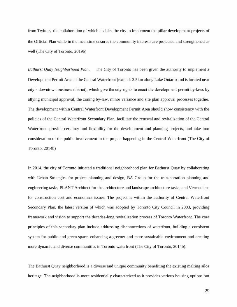
underdeveloped urban land (more than 325 hectares) owned by public entities (Figure 1). Additional $1.25
billion CAD funding invested by Canadian federal, provincial, and municipal governments will make food
protection, infrastructure provision and land revitalization in the project site possible (Sidewalk Labs,
2017b).
31
Figure 1 Sidewalk Labs has released the vision and announce that they will work with the City government to bring the latest
digital technologies and urban innovations at Eastern Waterfront including Quayside and the Port Lands. Source: Sidewalk Labs.
The revitalization and development of Eastern Waterfront including Quayside and the Port Lands is planned
to accommodate tens of thousands of people to learn, work and live, with advanced climate-positive energy
and waste systems, self-driving transit systems, and new models of building construction to improve
citizens’ life with more sustainable, more connected, more convenient, safer, and lower-cost and more
welcoming living environment (Sidewalk Labs, 2017b).
Quayside/Sidewalk Toronto project. Quayside/Sidewalk Toronto project is the starting pilot project for
the revitalization of the Eastern Waterfront. It is located at Parliament Slip in the southeast of Downtown
Toronto. It is about the development of a 5-hectare neighborhood that can house around 5000 residents.
This pilot project aims to update the urban innovation platform and create a combination of the physical
layers of buildings, mobility, public realm, infrastructure and the digital layers of accessibility, connectivity
and data integration. The new modes of digital layers would reimage the ways of delivering services,
building infrastructure, providing mobility services, and designing public space in the city (Sidewalk Labs,
32
2017a). An ideal Quayside would be a successful prototype addressing issues of sustainability, housing
affordability, transit system, building innovation, and economic development, which could also be scaled
across the entire Eastern Waterfront and even other cities all over the world.
Master Innovation and Development Plan. The development of Quayside project is guided by a Master
Innovation and Development Plan (MIDP)3 that will outline the vision for the site on the matters of housing
affordability, mobility, architecture, sustainability, public space, public facilities, and digital governance.
MIDP will be prepared together by Waterfront Toronto - a tri-government organization by the Government
of Canada, Province of Ontario and the City of Toronto as well as Sidewalk Labs who aims to improve city
life by developing and incubating urban technologies to address urban issues like cost of living, efficient
transportation and energy use. Specifically, Sidewalk Labs would be the main author of MIDP while
Waterfront Toronto plays more roles in reviewing the plan. Sidewalk Toronto is a joint platform by
Waterfront Toronto and Sidewalk Labs.
Innovation and Funding Partner Framework Agreement. A collaborative relationship of creating the
MIDP is included in the Innovation and Funding Partner Framework Agreement (Framework Agreement)
that will contemplate project budget and expenses, Eastern Waterfront development plan, public
engagement guidelines, movement of Google’s Canadian headquarters to the waterfront, innovative
approaches addressing housing affordability issues, investment opportunities in Canadian companies and
the establishment of an Urban Innovation Institute in the MIDP to provide anchor tenants for the area. When
the planning work included in the Framework Agreement is achieved, the result would be the MIDP as a
comprehensive and overlay plan for the project taking account of urban design, infrastructure and
technology strategies.
The Framework Agreement does not provide rights of land development but it offers up to US$10 million
funding provided by Sidewalk Labs before the stage of achieving any “initial plan milestones,” and up to
3 Quayside is the first pilot of which the technologies and planning strategies will be included in the MIDP.
33
an additional US$40 million funding provided by Sidewalk Labs between the stages of achieving any initial
plan milestones and the approval of the MIDP in the circumstances that the milestones succeed to have
governments’ commitment of CAN$1.25 billion for the Port Lands flood protection; re-affirmation of
Waterfront Toronto’s mandatory role for the development of the Eastern Waterfront; alignment of the
parties in terms of a Business and Implementation Plan required by City Council; alignment of the parties
in terms of the MIDP; and agreements by Waterfront Toronto and Sidewalk Labs on future actions standards
including openness and fairness in procurement (Sidewalk Labs, 2017b). In addition, the Framework
Agreement also allows the termination of the agreement by either party if the “initial plan milestones” are
not met within six months, or the MIDP is not approved within a year. Specifically, Waterfront Toronto
has a unilateral right to terminate the partnership before the completion of the first stage (Sidewalk Labs,
2017b).
Both Waterfront Toronto and Sidewalk Labs show their good faith in their partnership and collaboration
through jointly developed MIDP within the deadline included in the Framework Agreement. Any
subsequent implementation is subject to the parties’ mutual decisions and needs to be approved by MIDP
(Sidewalk Labs, 2017c).
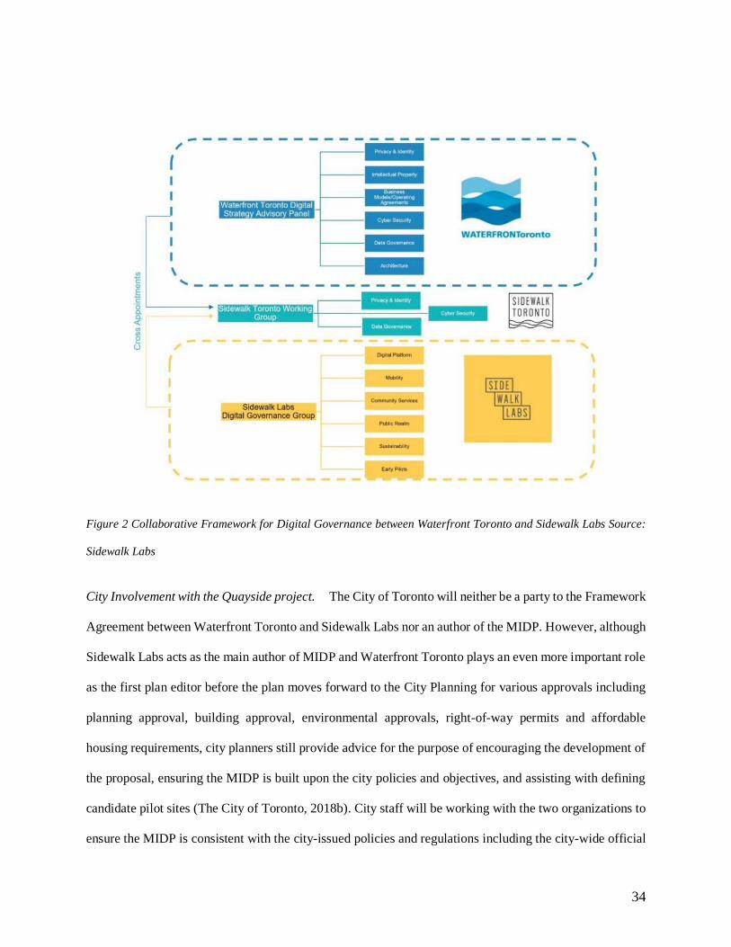
Collaborative Framework for Digital Governance. There is also a collaborative effort of Waterfront
Toronto and Sidewalk Labs to frame digital governance. As shown in Figure 2, Sidewalk Labs Digital
Governance Group will be preparing digital platform, designing mobility, community services and public
realm, improving sustainability, and assisting with the early pilots. While Waterfront Toronto Digital
Strategy Advisory Panel (DSAP) will be responsible for guiding and incorporating data privacy and
governance, intellectual property security, and cyber security in the next phase of waterfront revitalization.
It also advised Waterfront Toronto on the initial policies and strategies related to the Quayside project
announced in Fall 2017. All concerns and issues surfaced with regard to data in the Quayside project will
need to be presented to and discussed with the DSAP, the collaborative results of which will be further
developed into the MIDP.
34
Figure 2 Collaborative Framework for Digital Governance between Waterfront Toronto and Sidewalk Labs Source:
Sidewalk Labs
City Involvement with the Quayside project. The City of Toronto will neither be a party to the Framework
Agreement between Waterfront Toronto and Sidewalk Labs nor an author of the MIDP. However, although
Sidewalk Labs acts as the main author of MIDP and Waterfront Toronto plays an even more important role
as the first plan editor before the plan moves forward to the City Planning for various approvals including
planning approval, building approval, environmental approvals, right-of-way permits and affordable
housing requirements, city planners still provide advice for the purpose of encouraging the development of
the proposal, ensuring the MIDP is built upon the city policies and objectives, and assisting with defining
candidate pilot sites (The City of Toronto, 2018b). City staff will be working with the two organizations to
ensure the MIDP is consistent with the city-issued policies and regulations including the city-wide official
35
plan, Central Waterfront Secondary Plan, City issued Precinct Plans, and in-force Zoning By-laws (The
City of Toronto, 2018a). Specifically, while Sidewalk side breaks down the project in the traditional way
and has teams dealing with buildings, transportation, public ground (park and open space), technology,
sustainability and environment (garbage, waste, etc.), Toronto’s City Planning Department have
corresponding experts on its side as well. According to the interviews with an urban planner at Waterfront
Secretariat, City planners will have meetings and discussions with Sidewalk Labs teams together talking
about the project.
Although the City of Toronto does not have the actual relationship with Sidewalk Labs, they have formal
relationship with the Waterfront Toronto. For the most part of the project development process, City is in
the context of their relationship with Waterfront Toronto who is in charge of defaecating formal process
and building discussions. City’s year-long involvement in the project is facilitated by the Waterfront
Secretariat and supported by city divisions including the City Manager's Office, City Legal, City Planning,
Corporate Finance, Financial Planning, Real Estate Services and the Toronto Realty Agency (The City of
Toronto, 2018b). According to the interview with an urban planner at Waterfront Secretariat, Water
Secretariat’s role within City Planning is to advance waterfront revitalization on behalf of the city, where
city planners do work with different departments and agencies including city information and technology
group and take charge of the ways city want in the project. For example, when the development ideas come
back to City Planning, Waterfront Secretariat will give the team feedback on whether they are going to the
right direction or not based on strategy documents and vision plans including waste strategy, garbage
strategy, and urban design guidelines.
The project will eventually get evaluated through the city’s standard planning and evaluation process by
the city planners (The City of Toronto, 2018b). The first draft of the MIDP is expected to be released and
presented to the public and the City in early 2019, by then there will be additional public inputs to be
considered for the final MIDP prepared by both Sidewalk Labs and Waterfront Toronto. On receipt of the
submission of the MIDP, City planners will review the plan and hold public meetings with the communities
36
and different stakeholders, the results and recommendations of which will be reported to the Committee
and City Council (The City of Toronto, 2018a). Furthermore, the project will require various approvals at
community, city and governmental levels as its implementation process goes. (IBM., n.d.). Only If the
MIDP is approved by the Boards of Directors of Sidewalk Labs and Waterfront Toronto, and is subject to
numerous approvals of governments including the City of Toronto, the Province of Ontario, the Canadian
federal government, long-term relationship and development plan could start to realize the project vision
(Sidewalk Labs, 2017c). Both Waterfront Toronto and City Planning will need to consult with governments
at Federal and Provincial levels through the Waterfront Revitalization Initiative Intergovernmental Steering
Committee (IGSC).
Public Engagement. The Framework Agreement requires robust public engagement and inputs, which is
the high standard of project implementation so far. Sidewalk Toronto aims to incorporate people, private
companies, academic entities, and local organizations into the development of Eastern Waterfront, taking
advantages of Toronto’s already-thriving technology sectors and developing urban innovations. Since 2017
when partnerships were established, Waterfront Toronto and Sidewalk Labs have been having long-term
planning and extensive consultation with community and stakeholders in order to enhance the development
of public infrastructure, transportation systems, new models of affordable housing and retail uses, and the
legislation of data protection and privacy. Such bottom-up strategies started with a community Town Hall
held on November 1, 2017 (Sidewalk Labs, 2017b).
Sidewalk Toronto provides lots of different ways for people to get involved in the project, including
attending public talks (or get live stream online) on topics like sustainability, technology, accessibility,
mobility, and urban design; joining public roundtable meetings about the updated project process and
information; attending neighborhood meetings held by local organizations, visiting Sidewalk Toronto
Pavilion to learn technological innovations, visiting local pop-up station nearby, serving on a 36-member
Reference Panel to supervise the project process, attending design jam and CivicLabs to brainstorm possible
urban solutions, sending your children to YMCA-Sidewalk Toronto Summer Kids Camp, or applying for

37
Sidewalk Toronto Fellows Program etc (Sidewalk Labs, 2017d). All insights, perspectives and feedback
generated from these public meetings and events will help the development of Master Innovation and
Development Plan (MIDP) proposed by Sidewalk Labs (IBM., n.d.).
38
CHAPTER 4 COMPARISON ANALYSIS AND FINDINGS
The way of practicing urban planning have been changing over the decades and they are still developing
while we try to solve new urban issues and adopt new planning paradigms. That is being said, planning
today is not the same as the one in the past and it will not be the same as the one in the future as well.
According to Jackson (2018), Toronto Waterfront planners are changing from government-employed
planners into more entrepreneurial planners and site-specific planners, which is largely affected by the
increasing public-private project partnership. According to Cavrić (2004) who categorizes seven different
fundamental roles of physical planning that planners are involved in, six particular roles of urban planner
in the Quayside project are categorized below for the purpose of analyzing and comparing how urban
planners in this project and Toronto traditional neighborhood planning project act differently or similarly.
Some of the lessons learned through the comparison can be adapted to other smart city/neighborhood
development projects within the city and even around the world in the future.
Planners as specialists or generalists
The way Toronto’s City Planning works in conventional neighborhood planning project is that they have
specialized teams including transportation planning team, urban design team, as well as environmental and
sustainability team, and they also have planners who concentrate more generally and act as the generalists.
Beyond the City Planning Department, there are also planners and officers at the Waste Management
Department, Water Management Department, and Transportation Service Department who specialize in
certain types of planning activities. However, these teams will have many interactions and collaborations
with each other to ensure the city is functioning well. For example, according to the interview with the
urban planner at Waterfront Secretariat, City Planning will have the transportation-specialized person at the
meetings talking about sustainability in the circumstances that the stormwater has the impacts on the roads.
39
For the Quayside project, as the main author of the MIDP, Sidewalk Labs side does have certain people on
their team with professional planning background, but there are more people with mixed backgrounds
compared with the City Planning Department. Their demographics have more people working in
technology and development, who also don’t have professional planning training and have not been dealing
with the core of urban planning practice. However, the interview subject at Waterfront Secretariat thinks
that Sidewalk Labs team dedicated for the Quayside project is not more specialized than other conventional
neighborhood planning project teams in Toronto.
Planners as data privacy advisors and governors
In the Quayside project, Things are complicated in terms of thinking about how technologies can be
involved in the planning process. Compared with the traditional neighborhood planning project in Toronto,
the unusual thing in the Quayside project is the much more involvement with data and technologies. The
collaborative effort of Waterfront Toronto and Sidewalk Labs through Sidewalk Labs Digital Governance
Group and Waterfront Toronto Digital Strategy Advisory Panel to frame digital governance and incorporate
the intellectual property and cybersecurity in the project planning process shows project’s determination of
applying data and technologies.
Actually, the city has had a lot of works on data gathering and rules set in terms of how data can be collected,
stored and simulated. They have gathered data on the waterside and environmental sites before and planners
working on energy perceptions already had data protection procedures as well. In addition, the city has
already had planners deal with technologists in terms of how to manage things better and how to make
better decisions. But in terms of the data gathering in public space like shopping malls, courtyard and
building lobbies, it is still a discussion within city planning. Urban planners work collaboratively in terms
of different issues. Data governance and privacy are the new ones that both Quayside team and the City of
Toronto are figuring out to fit in the standard planning process right now and in the future. In the Quayside
project, the discussion about data governance and privacy is partnering across the city. According to the
40
interview with the urban planner at Waterfront Secretariat, in fact, part of Waterfront Secretariat planner’s
job on the Quayside project is to understand where should be the interactions between urban planning and
technology and whether integrating more technology discussion in the existing planning process matter?
There are discussions of how and to what extent technologies should be in their ways of managing the city
as the city does not have a lot of history and experience on talking about the technology policies and security
issues. And the Quayside team, in particular, is trying to have those discussions integrated with the project
development and planning process, the attempt of which includes considering what kinds of policies and
data they might want to capture, how they might use it, and what applications might be. At this early stage
of the Quayside project, the team might not get much involved with talking about the technology yet, but it
is a tricky challenge as the team is in their process of making sense to apply technologies to the Quayside
project.
In this respect, planners’ roles as data privacy advisors and governors are more emphasized in the Quayside
project. According to the interview subjects at Waterfront Secretariat: “It is definitely appropriate for urban
planners to be thinking about such matters and rules (about data security and governance) and whether they
need to be advanced or improved to fit better future planning process as the leading component.” However,
it is not the whole urban planning process given technology excuses, therefore, whether such thinking and
attempts will require planners to act differently or require guidelines and policies change in the future is
still unclear. Planners might need to define their formal relationship with information and technology in the
planning process on particular aspects or applications first before anything else.
Planners as technocrats and information providers
According to the interviews with a community planner at Toronto and East York District, all projects,
whether it is the Quayside project or the prior neighborhood planning projects in Toronto, are evidence-
based, and every project will need transportation analysis, engineering analysis, urban design analysis,
shadow and wind analysis. And in this respect, he believes there is not much difference between the
41
Quayside project and conventional planning projects. However, compared with the outputs including the
published documentation and public presentation materials of the traditional neighborhood planning project,
the Quayside team show some distinctions in terms of providing project planning information. One of the
conventional neighborhood planning projects called Bathurst Quay neighborhood project show only a few
quantitative analyses in its published documentation and public presentations materials in its three
community consultation meetings held in 2014, 2015 and 2016, two open houses and two community
workshops held in 2015. While Sidewalk Toronto team in the Quayside project uses a lager number of
colorful maps, image sets, and charts to show their massive quantitative analysis with a large amount of
information and data. Therefore, in this respect, it seems like Sidewalk Toronto team interprets their roles
as technocrats and information providers much harder, through which they are eager to show their science-
based and data-based approaches to the public and provide a solid basis for decision makers with direct
evidence to gain their support.
Planners as project regulators, coordinators, advisors and examiner
In the traditional neighborhood planning project like Bathurst Quay neighborhood project, the project land
is owned by the city of Toronto. Therefore, the project planning and building permits are issued and
managed by the City of Toronto, with planning and design tasks assigned to Urban Strategies; transportation
planning and engineering tasks assigned to BA Group; architecture and landscape architecture tasks
assigned to PLANT Architect; and construction cost and economics tasks assigned to Vermeulens. In this
respect, planners at city department play the roles as landowners, development regulators, project managers
and examiners for city-owned land to ensure that the project is designed and implemented in consistency
with the city plans and regulations. In addition, they also act as advisors for the decision makers when they
make approval decisions.
While things are different in the Quayside project. The Quayside project led by Sidewalk Lab and
Waterfront Toronto is not like a conventional public neighborhood planning project led by the City Planning.
42
The City has not signed the contract with Sidewalk Labs to be the public designer for the site yet, that is
being said, the city of Toronto is not part of the development. Therefore, the Quayside project is more
analogue to a developer developing a plan for a large-scale development project and holding public
meetings. Compared with the conventional neighborhood planning projects in Toronto which the city has
impacts on through the issued official plan, secondary plan, and precinct plans for even smaller geographic
areas, Quayside project will be more likely to go through the development project process where the city
council will do formal secondary plan process with public meetings and public approvals after the developer
– Sidewalk Labs completes their development plans for the project.
In addition, 12 acres of project land (Quayside Parcel) is owned together by Waterfront Toronto (Quayside
WT), the City of Toronto, CreateTO, TPLC and private landowners. The development on Quayside Parcel
guided by the MIDP requires it to provide business proposals related to these lands to the project Parties
for consideration purposes. Unlike planning document of conventional neighborhood project in Toronto,
MIDP is not a typical planning document. A lot of documentation like MIDP would be prepared by the
private entity and submit to the public entity, which is different than the neighborhood planning project run
by the government as well. In terms of this, even though the plan of Quayside project will later be moved
forward to the City Planning for further reviews and various approvals, just like the traditional
neighborhood planning project, city’s planning evaluation process for this project will be also not typical
and a little bit unique in this aspect, if not completely unique.
Besides that, the City Planning Department only collaborates with Waterfront Toronto and Sidewalk Labs
in terms of providing advice for project development and ensuring it is consistent with the city-wide and
community objectives. The involvement of the City with Quayside project is mainly facilitated and
supported by Waterfront Secretariat whose role is to advance waterfront revitalization on behalf of the city
interests. In this respect, planners at City Department and Water Secretariat not only play the roles as
development regulators, project managers, examiners and advisors for approval decisions, but also as the
43
development coordinators and advisors for the development of Quayside project as one of the main
stakeholders.
Planners as negotiators and mediators with the public
Both the Bathurst Quay neighborhood project and Quayside project hold certain types of public
participation events during the project development process. Through using the main public participation
method – submitted written comments and questions, public inputs are taken into account by the authority
before the final decision. According to the case study, the Bathurst Quay neighborhood project has had
three community consultation meetings in 2014, 2015 and 2016 respectively, two open houses and two
community workshops held in 2015. While compared with it, Quayside project introduces a lot of more
different ways for people to get involved with the project. They held much more public events with various
forms including public talks, design jams, local pop-ups, neighborhood meetings, roundtable workshops,
tech competitions, waterfront pavilion, fellowship programs, kid camps and civic labs, so that people with
different interests, backgrounds, and even ages can participate in the project in the ways that they prefer
and understand. In this respect, urban planner’s role as a negotiator and mediator with the public in the
Quayside project has been emphasized as the project focuses more on hearing the public voice and getting
them to participate in its development process. In addition, compared with the traditional Bathurst Quay
neighborhood project who pay less efforts in informing and collecting information from the public, it looks
like the various forms of public engagement events do ensure planners in the Quayside project get more
involvement with having real communications among different stakeholders and combining the knowledge
provided by “experts” and interests shown by the public. It also seems like the Quayside team shows the
greater interest of regarding these public meetings as the opportunities to collect more data that in certain a
way helps the team enhance their abilities to sell the project and move it forward.
Planner as design visualizers
44
Unlike the conventional neighborhood planning project, the Sidewalk Labs is doing in a similar way as the
developer, with the new ideas of buildings or complexes and the innovative concept of combing technology
and urban planning process. Different than other neighborhood development proposal and complete
development application for which city will get architecture plan and site plans with details showing a new
design or open space or a new vision of buildings, Sidewalk Labs, analogue to any developer showing their
visions, only shows what they think that building should look like – they are showing buildings but without
detail drawings of the buildings. The pictures of proposed buildings in their application are unreal
architecture drawings but only the concepts. Therefore, the degree of how these the visions and
visualizations can be realized in reality is unclear.
Compared with the prior neighborhood planning projects in Toronto that also use good-looking pictures to
show the idea of how something can work, Quayside project uses a large number of urban scene
visualizations including various kinds of pictures, photos and maps with strong architecture sense and
higher level of rendering performance in its published documentation and public presentations. These visual
alternatives other than plain words are supported by the use of level-of-detail software techniques that help
upgrade the visual quality of the images and other outputs. In the Quayside project, documentation and
public presentations are supported by a large amount of more quantitative analysis showing stronger
scientific-base approaches of analyzing, planning, designing and implementing process than the
conventional neighborhood planning project like the Bathurst Quay project. Instead of using words, many
of these quantitative analyses and qualitative analyses are visualized in two-dimensional or three-
dimensional figures in their presentations, studies and reports, showing a strong sense of a sustainable,
innovative and smart community and branding the uniqueness of the Quayside project as the new set of
innovative opportunities concerning open space, buildings and infrastructure, new economic engine for the
city of Toronto, new standard of affordable housing project, and new standard of data governance and
protection.
45
Therefore, compared with the conventional neighborhood projects in Toronto, Quayside project emphasizes
more on urban planner’s designing roles in the project development and planning process, where they not
only use the visualizations to inform parties and stakeholders with different objectives and interests but also
use them as an effective strategy to sell their ideas of creating a smart and innovative community to the
“consumers” – Toronto local governments, Torontonians and even cities and people around the world.
Sidewalk Labs wants to show their solutions and the ideas, make products and services that can be applied
in other cities and ensure their development in Quayside look good and convincible so that other cities can
work with them in the future, although they are still developing themselves and dealing with solutions for
the Quayside project. According to an urban planner at Toronto City Planning Department, “they (Sidewalk
Toronto team) are attempting to be positive about their design…They definitely have their interests and
want to make sure that they have the data and information there to back them up.” The Sidewalk team is
eager to present what they are believing and supporting for the project, including the ideas, scientific
approaches and technologies, and eager to convince people that their methods and solutions to urban issues
would be positive and better than before.
46
CHAPTER 5 DISCUSSION AND CONCLUSION
In the previous chapter, the changing roles of urban planner in the Quayside project were discussed,
compared with the traditional neighborhood planning project based on six categories: planners as specialists
or generalists; planners as data privacy advisors and governors; planners as technocrats and information
providers; planners as regulators, project coordinators, examiners and advisors; planners as negotiators and
mediators with the public; and planners as design visualizers.
Based on the findings of this research, planners’ roles as specialists or generalists do not change much in
the Quayside project compared with the prior neighborhood planning projects. Both Sidewalk team and
city planning team have the planning specialists who focus more on specific activities and the planning
generalists who have all-round expertise in the urban planning field. This does not match with the research
conducted in the late 20th century, which found the planners were more likely to specialize in particular
planning aspect including environmental planning, urban design, economic development or housing
development. Besides that, city planner’ role as project examiner for developments on the city land does
not change as all the visions and plans of Quayside project will later be moved forward to the City Planning
for further reviews and approvals before they are published to the public, just like the traditional
neighborhood planning project, even though they are not prepared by the City Planning Department and
thus will be involved with a slightly different city’s planning evaluation process.
While compared with the conventional neighborhood planning project in Toronto, planner’s roles in the
Quayside project as data privacy advisors and governors; technocrats and information providers; project
coordinators and advisors; negotiators and mediator with the public; and design visualizers are all to some
extent emphasized and accelerated. The essence of the Quayside project that aims to bring the latest digital
47
technologies and urban innovations to the project did have some impacts on its development and planning
process as well as urban planner’ roles in such process.
Privacy advisors and governors. In Quayside project, the collaborative framework for digital governance
implemented by both Waterfront Toronto and Sidewalk Labs leads to the discussion of how and to what
extent technologies should be in their ways of managing the city and what position should urban planner
stands for if data and technology are brought in the planning process. According to the findings, planners
at Waterfront Secretariat are already involved with such discussion about the interactions between urban
planning and technology, the new roles of whom as data privacy advisors and governors are generated
specially in the Quayside project compared with other prior neighborhood planning projects in Toronto.
This is a brand-new role of planners that no previous research has mentioned before, which add the new
responsibility of regulating and monitoring the city datascape throughout planners’ years of services in
physical planning.
Technocrats and information providers. Another planning role that has been more emphasized in the
Quayside project is planner’ roles as technocrats and information providers since Sidewalk team put much
more efforts for providing massive data and information and showing their large amount of quantitative
analysis as well as science-based and data-based approaches in their documentation and public
presentations. This is reflected in the previous research that confirmed the development of Information
Technology (IT) and Geographic Information Systems (GIS) have been supporting urban planners in terms
of providing information and solid evidence to give advice to the decision makers and persuade other
stakeholders. Two of the interview subjects said there are not many technologies involved in the current
project implementation stage, while Quayside’s published documentation and public presentation materials
actually show a large amount of quantitative analysis and the ideas of applying new technologies (Sidewalk
Toronto team are making presentations about energy efficiency and showing quantitative calculation about
things that they intend to build), which suggests that either there are changes of applying new technologies
48
and approaches in project implementation process but people just don’t realize it, or there are not changes
of technologies and approaches and it is just the way in which Sidewalk Toronto team present the project
to the public. The latter case leads to the public engagement questions as the project team are showing hard
numbers and evidence that do not facilitate public inputs but render the ideas instead of presenting
quantitative truth even in project’s early stage.
Project coordinators and advisors. City Planner’s roles as project coordinators and advisors are the new
roles generated from the Quayside project. Before the Quayside project, city planners are the project
manager and examiners for development on the city-owned land. While in this project, the city only owns
a small part of Quayside Parcel, with the most of which owned by the Waterfront Toronto (Quayside WT).
In addition, the city of Toronto is not part of the project yet as they have not signed the contract with
Sidewalk Labs, but only have the official relationship with Waterfront Toronto who has the Framework
Agreement with Sidewalk Labs. Therefore, instead of being project manager, city planner’s roles in the
Quayside project are project coordinators and advisors who will provide advice and recommendations for
project development and ensure it is consistent with the city-wide and community objectives. The interview
subject at Waterfront Secretariat regarded Sidewalk Labs as the developers while he/she believed it was
still the public sectors acting as the decision makers in the Quayside project. However, compared with the
previous neighborhood planning project in Toronto where City Planning set objectives, policies and
guidelines and conduct the project step by step based on the needs of city and public welfare, Sidewalk
Toronto team implements the Quayside project using their own innovative and scientific approaches, with
their own interests and purposes other than public welfare, though in consistence with the city objectives
in the large picture. In such a process, city planner’s roles as development managers and planners are
weakened while roles as development regulators, coordinators and advisors are emphasized. While in the
meantime, city planners still keep their roles as project examiners who will review the plan, hold public
meetings and offer various approvals before the project can be legally developed on land.
49
Such partnership with the private company for Quayside project seems to change the roles of city planners
from project managers to project coordinators and advisors, which is also confirmed by the previous
research that identified the trend of shifting government authorization and power to technical private sectors.
One of the criticisms of such privatization and outsourcing of urban management discussed in the previous
chapter is the different interests between public sectors who want to make site-specific solutions and create
public welfare; and private sectors who want to come up with universal technological and make profit
instead, the disconnection of which would have uncontrollable consequences as private sectors’ interests
of pursuing profit might increase society polarization and marginalize vulnerable population more.
Negotiators and mediators with the public. Through large more types of public participation events,
planner’s roles as negotiators and mediators with the public are increased and emphasized as well. They
tailor the forms of public participation to meet people with different backgrounds, ages and interests. For
example, they have Sidewalk Toronto Fellows Program designed to young Torontonian between the ages
of 19 and 24 who are interested in learning about waterfront revitalization and technology application within
the cities; they have YMCA-Sidewalk Toronto Summer Kids Camp aims to hear the voice of children of
9-12 years old who are interested in how cities work and grow; and they also have public round tables,
neighborhood meetings, and reference panels welcoming citizens and experts around the world to get
involved with the redevelopment of Toronto waterfront. Waterfront Toronto and Sidewalk team put a lot
of efforts on making sure the voice and opinions of different groups of stakeholders are taken into
consideration during the Quayside planning process. While in this early stage of the project, Sidewalk team,
in order to make sure their ideas of Quayside smart neighborhood would be accepted by the public, they
play more roles as the negotiators and mediators between decision makers, community representatives and
other stakeholders on behalf of the project itself, rather than only represents the interests of its company
they have the obligation of. The hope to convince Torontonians and people around the world of their
technological solutions and scientific approaches in creating a better living environment for a neighborhood
50
emphasizes the roles of planners in the planning process even more than the traditional urban development
projects.
Design visualizers. Sidewalk team puts lots of efforts on visualizing their large amount of quantitative
analysis, which is different with what city planners do for traditional neighborhood planning project like
Bathurst Quay neighborhood project but more like the ways developers for advertising their products or
projects. A large number of urban scene visualizations with strong architecture sense and high level of
rendering performance in Quayside project’s published documentation and presentation materials interpret
rationality that enable power to define truth and rationality. Instead of synthesized their analysis by using
plain words, they use rendering figures and visualizations to convey the progressive ideas about applying
digital technologies and urban innovations and create consensus, through which their exercise power of
Quayside project can become more legitimized and effective in creating a “better argument”. Flyvbjerg
(1998) argued that “the greater the power, the less the rationality” as the privilege of power can define the
reality without much rationality. Sidewalk Labs’ advantages and power on digital technologies and urban
innovations can help define the truth and reality they believe for the Quayside project in the ways they want,
which is beyond the capacity and knowledge of the City of Toronto and the rest of the world. The interview
subject at Waterfront Secretariat believed the Sidewalk Toronto team definitely have their own interests in
the project and want to make sure they have data and information there to back their interests up. This is to
some degree influenced by the outsourcing and privatization of urban management as the authority power
are shifting from the public sectors to technical private sectors where these private sectors are given more
power and rights for managing the city and making decisions.
To summarize, compared with prior and conventional neighborhood planning projects in Toronto, the
implementation and planning process of Quayside project, even at this early project stage, change some
roles planners and particularly, the city planners play in their daily work: compared with planners in the
prior Toronto neighborhood planning projects, Sidewalk Toronto planners’ roles as technocrats and
51
information providers, negotiators and mediators, as well as design visualizers are emphasized in the
Quayside project, while their roles as specialists and generalists do not change at this early project
implementation stage. While in terms of city planners, their new roles as data privacy advisors and
governors, as well as development coordinators and project advisors are generated in the Quayside project,
whose roles as regulators and examiners, however, do not seem to change much at this project stage.
One of the interview subjects at Waterfront Secretariat would rather regard Sidewalk Labs as a developer
who has been preparing a development proposal for the neighborhood than think them as a neighborhood
designer or planner. Such thinking would have a lot of impacts on the roles of city planners. Instead of
influencing the developers to deal with urban matters on city’s land by setting city restrictions and policies
like zoning and FAR, and allowing, sometimes with some space for negotiation, desired buildings and
infrastructure to get built for citizens, business owners and local tenants, city now becomes the buyers and
consumers of development plans, designs and technology solutions provided by a private technology
company - Sidewalk Labs. In this respect, Sidewalk Labs is the one doing the planning job for Quayside
right now, based on the fact that they are setting all the frameworks and guidelines about the development
of the Quayside neighborhood, under the constraints of city-wide objectives and policies though, while
anyone else including Waterfront Toronto and Department of City Planning just signs off and approves all
the frameworks, guidelines and plans prepared by Sidewalk Labs.
In recent decades, the development of more effective and efficient approaches towards building smart
neighborhood and city incentivizes cities all over the worlds to explore the substance of technological
innovations and other professional skills in response to the increasing complexity of the urban issues in
practice. While the question is where will the smart technology and urban innovations take us to. It is not
only the efficiency, technologies and how to make better planning system that have been discussed, but
also a far more fundamental change happening in the physical planning as well as planners’ roles played in
such process. The development of technology and overwhelming application of information and data seem
52
to point out the matter is who owns and governs the data, information and intellectual property, then who
owns the ability and power to create efficiency, which leads to another question of should urban
management be privatized. If the trend towards using technology to deal with urban matters continues, a
new management structure of physical planning is expected to be created.
This research contributes, in a meaningful way, to the discourse of smart city by pointing out the
fundamental changes it brings to the physical planning process and the roles of planners who get involved
with the process. It also helps bring up the questions of how such changes could affect the way we think
about the public-private partnership and our duty as urban planners in the future. Planning, as the mastering
of urban challenges and problems, should always be considered before other professional knowledge or
individual key players including architects, urban designers, engineers and technologists, as according to
Cavrić (2004), “the game of planning is a mother of resource distribution”. That is being said, urban
planners should become the managers in this integrated development process, holding the ability to
administrate urban development and planning from a more analytical, scientific and multidisciplinary point
of view. With the application of all urban technological innovations, a successful urban planner should
develop his/her theoretical and practical skills and become highly acceptable for the new planning theories
and approaches in the future practice to be more productive and self-supported.
The development of smart city technology is not for urban planning process per se, while it might be used
as a tool that provides urban planners with more options and solutions improving the way they administrate
urban matters as well as manage city streets and water infrastructure. Better technologies can give better
options so that city administrators, managers and planners can understand our physical environment better.
However, whether the development and application of digital technologies in the planning process is a good
or bad thing is not clear as it might make life easier and more efficient while it might also cause new issues.
Since the application of smart/digital technologies in the planning field is in its early process, the key is that
53
we apply digital technologies as one of our tools when we start with the problems and issues that we want
to address and figure out, rather than use it as a panacea or start it and see what we can do with it.
Since this research examines the planning roles and functions that traditional urban planners play in the
planning process, one thing not clear is who are playing those planning roles right now, whether it is still
the urban planners or other types of professionals with other types of training and skills implementing
planning activities. In addition, this research does not fully examine the causes of these changes and answer
whether these changes are because of the development of digital/smart technologies or the outsourcing and
privatization of urban management. As the Quayside project is still at its early stage, whose masterplan and
guidelines (e.g. MIDP) have not been published yet, and there are not many digital tools and technologies
involved with the Quayside planning process so far but only the ideas. Therefore, further research on urban
planning activities and urban planners’ roles in such smart neighborhood planning project are needed to
further examine whether the development of technologies and application of innovative approaches in the
planning process would change urban planning process, the roles of urban planner, and people who execute
the planning activities and functions. Moreover, further studies on the reasons causing these changes of the
physical planning process and urban planners’ roles are necessary, through which we can identify the
factors having impacts on urban planning practice and better predict the changes that would happen in the
future planning field.
54
BIBLIOGRAPHY
Albrechts, L. (1991). Changing Roles and Positions of Planners. Urban Studies, 28(1), 123–137.
https://doi.org/10.1080/00420989120080081
Agre, P. (1994). Surveillance and capture: two models of privacy. Information Society 10, 101-127.
Beckman, N, 1964, “The planner as a bureaucrat” Journal of the American Institute of Planners 30
323–327.
Batey, P. (1994). The changing face of specialization., in Planning Week education special, A Special
Supplement on careers and Education, London.
Brown, L, & Potoski, M. (2003) Contract-man- agement capacity in municipal and county governments.
American Society for Public Administration 63(2), 153–164.
Bianca, W. (2007, Nov 13). Interview by Steve Paikin. The Agenda with Steve Paikin [Television
broadcast]. Toronto: TVOntario. Retrieved November 26, 2018,
https://www.youtube.com/watch?v=oEyBjYNgaMY
Blicharska, M., Isaksson, K., Richardson, T., & Wu, C.-J. (2011). Context dependency and stakeholder
involvement in EIA: the decisive role of practitioners. Journal of Environmental Planning and Management,
54, 337-354.
Bates, J. (2012). ‘‘This is what modern deregulation looks like’’: Co-optation and contestation in the
shaping of the UK’s Open Government Data Initiative. The Journal of Com- munity Informatics, 8 (2).
http://www.ci-journal.net/index. php/ciej/article/view/845/916. Accessed 6 Feb 2013.
Campbell, H, & Marshall, R. (2002), ‘Values and professional identities in planning practice’, in P.
Allmendinger and M. Tewdwr-Jones (eds), Planning Futures: New Directions for Planning Theory, London,
Routledge, 65–92.
Cavrić, B. I. (2004). Planners’ roles and techniques in developing sustainable “eco-City”: The case of
gaborone, Botswana. Spatium, (11), 53–76.
Chin, H. C., Debnath, A. K., & Yuen, B. (2010). The concept of smart cities. In: Teng J (ed.) Proceedings
of the International Conference on Sustainable Urbanization, 15–17 December, Hong Kong. Hong Kong:
Hong Kong Polytechnic University, Faculty of Construction & Environment, pp. 1380–1386.
Caragliu, A., Del Bo, C., & Nijkamp, P. (2011). Smart Cities in Europe. Journal of Urban Technology,
18(2), 65–82. https://doi.org/10.1080/10630732.2011.601117
Cisco (2018). City Infrastructure Financing Acceleration Program. Retrieved November 7, 2018, from
https://www.cisco.com/c/en/us/solutions/industries/smart-connected-communities/financing.html
Davoudi, s., & Healey, p. (1990). Using Planning Consultants: The Experience of Tyne and Wear
Development Corporation, Newcastle upon Tyne, Department of Town and Country Planning, University
of Newcastle upon Tyne.
55
Da-Mi, M., & Zorica, N. B. (2008). Urban form and planning in the information age: Lessons from literature.
Spatium, 2008(17–18), 1–12.
Dirks, S., & Keeling, M. (2009) A Vision of Smarter Cities: How Cities Can Lead the Way into a Prosperous
and Sustainable Future. New York: IBM Institute for Business Value
David, N., McNutt, J. G., & Justice, J. B. (2018). Smart Cities, Transparency, Civic Technology and
Reinventing Government. In M. P. Rodríguez Bolívar (Ed.), Smart Technologies for Smart Governments
(Vol. 24, pp. 19–34). Cham: Springer International Publishing. https://doi.org/10.1007/978-3-319-58577-
2_2
Glaeser, E.L. (2005). “A Review of Richard Florida’s The Rise Of The Creative Class,” Regional Science
and Urban Economic 35:5 593–596.
Evans, J.,& Karvonen, A. (2014) Give me a laboratory and I will lower your carbon foot- print! Urban
laboratories and the govern- ance of low-carbon futures. International Journal of Urban and Regional
Research 38(2), 413–430.
Environment & Land Tribunals Ontario (2018) About LPAT. Retrieved December 16, 2018, from
http://elto.gov.on.ca/tribunals/lpat/about-lpat/
Fainstain, S.S. (1988) Urban transformation and economic development policies. Paper presented at the
Annual Meeting of the Association of Collegiate Schools of Planning, Buffalo, NY.
Forester, J., (1989) Planning in the Face of Power, Barkley: University of California Press. (in Randolph,
J. 2004. Environmental Land Use Planning and management, Island Press., p.30)
Fordham, R. (1990) ‘Planning consultancy: can it serve the public interest?’, Public Administra- tion, 68,
243–48.
Flyvbjerg, B. (1998) Rationality and Power: Democracy in Practice. University of Chicago Press.
Frisken, F. (1999) Toronto at the Crossroads, and How It Got There. Toronto: World Bank Institute.
Formato, E., & Russo, M. (2014) Re-use/re-cycle territories, TeMA INPUT 2014 Print ISSN 1970-9889,
e-ISSN 1970-9870
Fox-Rogers, L., & Murphy, E. (2016). Self-perceptions of the role of the planner. Environment and
Planning B: Planning and Design, 43(1), 74–92. https://doi.org/10.1177/0265813515603860
Francini, M., Gaudio, S., Palermo, A., & Viapiana, M. F. (2018). The Area Trademark for the Launch of
Sustainable Processes of Smart Planning in Rural Areas. In R. Papa, R. Fistola, & C. Gargiulo (Eds.), Smart
Planning: Sustainability and Mobility in the Age of Change (pp. 231–249). Cham: Springer International
Publishing. https://doi.org/10.1007/978-3-319-77682-8_14
Gramsci, A. (1929) Prison Notebooks (English edn 1971). New York: International Pub- lishers.
Scott, A. & STORPER, M. (1986) Industrial change and territorial organisation, a summ- ing up, in: A.
SCOTT and M. STORPER (Eds) Production, Work and Territory, pp. 3.01-311. Boston, MA: Allen and
Unwin.
56
Graham, S. (2001). Splintering urbanism : networked infrastructures, technological mobilities and the urban
condition. New York: Routledge.
Graham S. (2005) Software-sorted geographies. Progress in Human Geography 29, 562-580.
Grant, J. (2009). “Experiential Planning: a Practitioner’s Account of Vancouver’s Success.” Journal of the
American Planning Association 75 (3), 358–370.
Gabrys, J. (2014) Programming environments: Environmentality and citizen sensing in the smart city.
Environment and Planning D: Society and Space 32(1), 30–48.
Gargiulo, C., & Russo, L. (2018). Cities and Energy Consumption: Strategies for an Energy Saving
Planning. In R. Papa, R. Fistola, and C. Gargiulo (Eds.), Smart Planning: Sustainability and Mobility in the
Age of Change (pp. 49–70). Cham: Springer International Publishing. https://doi.org/10.1007/978-3-319-
77682-8_4
Healey, P. (1985), ‘The professionalization of planning in Britain’, Town Planning Review, 56, 492–507.
Higgins, M., & Allmendinger, P. (1999) ‘The changing nature of public planning practice under the New
Right: the legacies and implications of privatisation’, Planning Practice and Research, 14, 39–67.
Hajer, M., & Versteeg, W. A. (2005) A decade of discourse analysis of environmental politics:
achievements, challenges, perspectives. Journal of Environmental Policy & Planning, 7(3), 175-184.
Hollands R.G. (2008) “Will The Real Smart City Please Stand Up? Intelligent, Progressive, or
Entrepreneurial?” City 12:3, 303–320.
Harvey, D. (2009). Chapter 1. “Social Processes and Spatial Form: The Conceptual Problems of Urban
Planning,” 22-49. In Social Justice and the City (Revised Edition). Athens, GA: University of Georgia Press.
[1973]
Hodson, M., & Marvin, S. (2010) World Cities and Climate Change: Producing Urban Ecological Security.
Maidenhead: Open University Press.
Hill, D. (2013). On the smart city: Or, a ‘manifesto’ for smart citizens instead. City of Sound, 1st Feb 2013.
http://www. cityofsound.com/blog/2013/02/on-the-smart-city-a-call- for-smart-citizens-instead.html.
Accessed 5 Feb 2013.
Hollands, R. G. (2015). Critical interventions into the corporate smart city. Cambridge Journal of Regions,
Economy and Society, 8(1), 61–77. https://doi.org/10.1093/cjres/rsu011 :
Heurkens, E., Adams, D., & Hobma, F. (2015). Planners as market actors: the role of local planning
authorities in the UK’s urban regeneration practice. Town Planning Review, 86(6), 625–650.
https://doi.org/10.3828/tpr.2015.37
IBM (2010) Smarter Cities Challenge. Available at: http://smartercitieschallenge.org/smarter- cities.html
(accessed 3 February 2014).
IBM. (n.d.). Quayside. Retrieved December 17, 2018, from
https://waterfrontoronto.ca/nbe/portal/waterfront/Home/waterfronthome/projects/quayside/!ut/p/a0/04_Sj
57
9CPykssy0xPLMnMz0vMAfGjzOL9DF1cDQ39DbwNQnwtDRydLS3MzB0DjQ2cDfQLsh0VAbp6HFI
!/pw/Z7_N1DE11O0KG7OD0AC5HINJ930G4/ren/p=CTX=QCPwaterfront_content_libraryQCPWaterfr
ontQCAHomeQCPprojectsQCPquayside/p=ns_Z7_N1DE11O0KG7OD0AC5HINJ930G4_WCM_Page.4
658872e-46c2-4a90-aac1-107654e08032=2/p=WCM_PI=1/=/
Jackson, J. (2018). Neoliberalism and urban planning in Toronto: how seasoned planners adjust to their
changing circumstances. International Planning Studies, 23(2), 144–162.
https://doi.org/10.1080/13563475.2017.1358606
Kitchin, R., & Dodge, M. (2011). Code/space: Software and everyday life. Cambridge, MA: MIT Press.
Kitchin, R. (2014). The real-time city? Big data and smart urbanism. GeoJournal, 79(1), 1–14.
https://doi.org/10.1007/s10708-013-9516-8
Kinsley, S. (2014). “The Matter with ‘Virtual’ Geographies.” In Progress in Human Geography. 38(3), 364-
384
Luithlen, L. (1998). The Gravity of Information: A New Order of Cities and the Role of Urban Planners.
Journal of Urban Technology, 5(2), 61–77. https://doi.org/10.1080/10630739883912
Luque A, McFarlane C and Marvin S (2014). Smart urbanism: Cities, grids and alternatives? In: Hodson
M and Marvin S (eds) After Sustainable Cities? London: Routledge, pp. 74–90.
McGuirk, P. (2001) “Situating communicative planning theory: context, power and knowledge”
Environment and Planning A 33 195–217.
MacLaran, A., & McGuirk, P. (2003) “Planning the city”, in Making Space: Property Development and
Urban Planning Ed. A MacLaran (Arnold, London) pp 63–94
Monstadt, J. (2007) Urban governance and the transition of energy systems: Institutional change and
shifting energy and climate policies in Berlin. International Journal of Urban and Regional Research 31(2),
326–343.
McFarlane, C., & Rutherford, J. (2008) Political infrastructures: Governing and experiencing the fabric of
the city. International Journal of Urban and Regional Research 32(June), 363–374.
Morozov, E. (2013). To save everything, click here: Technology, solutionism, and the urge to fix problems
that don’t exist. New York: Allen Lane.
Meisterlin, L. (2014) The City is Not a Lab. Retrieved January 30, 2019, from
http://www.arpajournal.net/the-city-is-not-a-lab/
Microsoft (2014) What Is CityNext? Available at: http://www.microsoft.com/government/ww/pu blic-
services/city-next/Pages/about.aspx (accessed 3 February 2014).
Marzukhi, M. A. (2017). An evolutionary perspective of governance: the role of planners in neoliberal
times. Advanced Science Letters, 23(5), 4877–4879. https://doi.org/10.1166/asl.2017.8936
Piore, M., & Sabel, C. (1984) The Second Industrial Divide. New York: Basic Books.
Petts, J., Brooks, C. (2006) Expert conceptualisations of the role of lay knowledge in environmental
decision making: challenges for deliberative democracy. Environment and Planning A, 38, 1045-1059.
58
Perlstein, A., & Ortolano, L. (2015) Urban Growth in China: Evolution in the Role of Urban Planners.
Journal of Planning Education and Research, 35(4), 435–443. https://doi.org/10.1177/0739456X15586627
Papa, R., Fistola, R., & Gargiulo, C. (Eds.). (2018) Smart Planning: Sustainability and Mobility in the Age
of Change. Cham: Springer International Publishing. https://doi.org/10.1007/978-3-319-77682-8
Qian, Y. (2016) The Transitional Role and Skills for Urban Planners in the Era of Inventory Planning: Two
Overseas Cases. Urban Planning International, 31(4), 79–83. https://doi.org/10.22217/upi.2015.087
Randolph, J. (2004) Environmental Land use Planning and management, Island Press.
Steele, W. (2009). Australian Urban Planners: Hybrid Roles and Professional Dilemmas? Urban Policy and
Research, 27(2), 189–203. https://doi.org/10.1080/08111140902908873
Sharifi, S. L. (2015). The Role of City Planners in Handling Cultural Diversity. The International Journal
of Organizational Diversity, 15(3), 25–37. https://doi.org/10.18848/2328-6261/CGP/v15i03/40206
Storring, N. (2016) Place Governance through Neighborhood Planning Offices. Retrieved December 16,
2018, from https://www.pps.org/article/torontos-neighborhood-planning-offices
Stufano, R., Borri, D., Camarda, D., & Borgo, S. (2017). Knowledge of Places: An Ontological Analysis
of the Social Level in the City. In O. Gervasi, B. Murgante, S. Misra, G. Borruso, C. M. Torre, A. M. A. C.
Rocha, … A.
Sidewalk Labs (2017a). Vision Sections of RFP Submission. Achieved from:
https://sidewalktoronto.ca/wp-content/uploads/2018/05/Sidewalk-Labs-Vision-Sections-of-RFP-
Submission.pdf
Sidewalk Labs (2017b). New District in Toronto Will Tackle the Challenges of Urban Growth Achieved
from: https://sidewalktoronto.ca/wp-content/uploads/2018/04/Sidewalk-Toronto-Press-Release.pdf
Sidewalk Labs (2017c). Innovation and Funding Partner Framework Agreement Summary of Key Terms.
For Public Disclosure Achieved from: https://sidewalktoronto.ca/wp-content/uploads/2018/05/Waterfront-
Toronto-Agreement-Summary.pdf
Sidewalk Labs (2017d). Sidewalk-Toronto-Public-Engagement-Plan. Achieved from:
https://sidewalktoronto.ca/wp-content/uploads/2018/04/Sidewalk-Toronto-Public-Engagement-Plan.pdf
Talvitie, J. (2003). The Impact of Information and Communication Technology on Urban and Regional
Planning. Aalto University. Retrieved from https://aaltodoc.aalto.fi:443/handle/123456789/27634
Tooke, J. (2003) Spaces for community involvement: Processes of disciplining and appropriation. Space
and Polity, 7(3), 233-246.
Townsend, A. (2013). Smart cities: Big data, civic hackers, and the quest for a new utopia. New York:
W.W. Norton & Co.
The City of Toronto (2014a) Section 37 review Final Report – City of Toronto. Retrieved December 17,
2018, from https://www.toronto.ca/legdocs/mmis/2014/pg/bgrd/backgroundfile-66994.pdf
59
Taylor B. N., & While, A. (2017). Competitive urbanism and the limits to smart city innovation: The UK
Future Cities initiative. Urban Studies, 54(2), 501–519. https://doi.org/10.1177/0042098015597162
The City of Toronto (2014b) Bathurst Quay Neighborhood Plan – Community Consultation Meeting
Presentation Document, Retrieved March 5, 2019, from https://www.toronto.ca/wp-
content/uploads/2017/11/8fab-cp-bathurst-quay-neighbourhood-plan-community-meeting-presentation-
december10.pdf
The City of Toronto (2017) Official Plan: Chapters 1-5. Retrieved December 16, 2018, from
https://www.toronto.ca/city-government/planning-development/official-plan-guidelines/official-
plan/chapters-1-5/
The City of Toronto (2018a) Quayside/Sidewalk Toronto. Retrieved December 17, 2018, from
https://www.toronto.ca/city-government/planning-development/waterfront/initiatives/current-
projects/quayside/
The City of Toronto (2018b) City Council Reports- EX30.9 Sidewalk Toronto – January 2018. Retrieved
December 17, 2018, from http://app.toronto.ca/tmmis/viewAgendaItemHistory.do?item=2018.EX30.9
The Government of Ontario (2018) The Planning Act. Retrieved December 17, 2018, from
http://www.mah.gov.on.ca/Page1760.aspx
The City of Toronto (2019a). City Planning. Retrieved March 5, 2019, from https://www.toronto.ca/city-
government/accountability-operations-customer-service/city-administration/staff-directory-divisions-and-
customer-service/city-planning/
The City of Toronto (2019b). 2017 City Planning Annual Report. Retrieved March 5, 2019, from
https://www.toronto.ca/wp-content/uploads/2018/06/971b-2017-city-planning-annual-report.pdf
UNECE (1998) Convention on Access to Information, Public Participation in Decision-Making and Access
to Justice in Environmental Matters, 25 June 1998 (Aarhus Convention) Geneva: United Nations Economic
Commission for Europe.
Urban Strategies. (2019). Bathurst Quay Neighbourhood Plan. Retrieved March 6, 2019, from
http://www.urbanstrategies.com/project/bathurst-quay/
Viitanen, J., & Kingston, R. (2013) Smart cities and green growth: Outsourcing democratic and
environmental resilience to the global technology sector. Environment and Planning A 46(4), 803–819.
Vanolo, A. (2013). Smart mentality: The smart city as disciplinary strategy. Urban Studies 51(5), 883–898.
Washburn, D., Sindhu, U., & Balaouras S, et al. (2010) Helping CIOs Understand ‘Smart City’ Initiatives.
Defining The Smart City, Its Drivers, And The Role Of The CIO. Cambridge: Forrester Research, Inc.
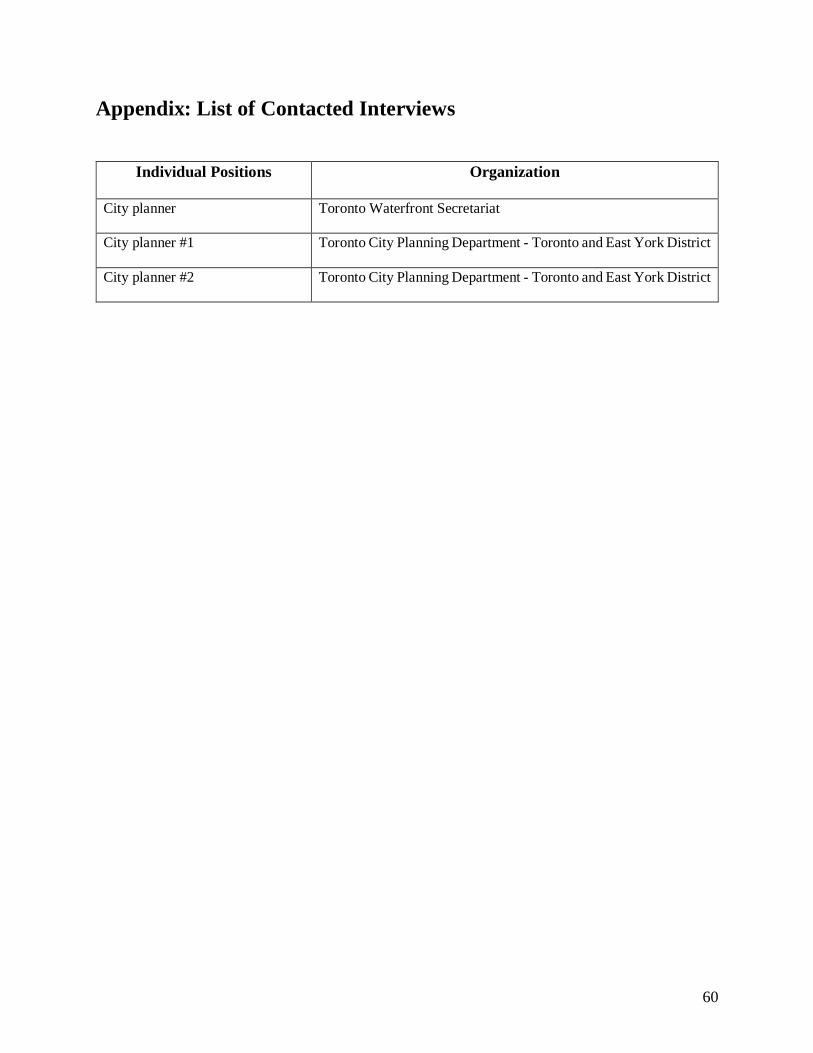
60
Appendix: List of Contacted Interviews
Individual Positions Organization
City planner Toronto Waterfront Secretariat
City planner #1 Toronto City Planning Department - Toronto and East York District
City planner #2 Toronto City Planning Department - Toronto and East York District