Embed Size (px)
Citation preview

CHANNAKA-KORATA (RUDHA) BARRAGE
CONTENTS
S.NO DESCRIPTION PAGE NO'S
SALIENT FEATURES
1 INTRODUCTION 1 – 9
2 PHYSICAL FEATURES 10 – 11
3 INTERSTATE ASPECTS 12 – 16
4 SURVEYS AND INVESTIGATIONS 17 – 25
5 PROJECT HYDROLOGY 26 – 42
6 HYDROGEOLOGY 43 – 45
7 DESIGN FEATURES 46 – 59
8 RESERVOIR 60 – 63
9 IRRIGATION PLANNING 64 – 83
10 COMMAND AREA 84 – 106
11 FLOOD CONTROL 107
12 DRAINAGE 108
13 POWER 109
14 NAVIGATION 110
15 CONSTRUCTION PROGRAMME AND PLANNING 111 – 112
16 FOREIGN EXCHANGE ELEMENT 113
17 114
18 ESTIMATE 115 – 118
19 FINANCIAL RESOURCES 119
20 BENEFIT – COST RATIO 120 – 121
ENVIRONMENT, ECOLOGY AND FOREST ASPECTS OF THE
PROJECT

SECTION -1
SALIENT FEATURES

1 Name of The Project : channaka-korata (Rudha)
barrage
2 Type of Project (Irrigation Or
Multipurpose)
: Multipurpose
3 Location : Near Channaka village inKelapur Tahsil of Yavatmaldistrict in Maharashtra state& Korata village in JainadMandal of Adilabad district ofTelangana State
3.1 River Basin Godavari
a) Name : Penganga
b) Located in : Near Kelapur Tahsil ofYavatmal district inMaharashtra state & JainadMandal of Adilabad district ofTelangana State
i) State(s) : Telangana & Maharashtra
ii) Countries (if international river) : N.A
3.2 River/ Tributary : Wardha in Godavari riverbasin
3.3 State(s)/District(s)/Taluka(s) or Tehsils
in which the following are located:
a) Reservoir : Near Kelapur Tahsil ofYavatmal district inMaharashtra state & JainadMandal of Adilabad district ofTelangana State
b) Head work : Near Kelapur Tahsil ofYavatmal district inMaharashtra state & JainadMandal of Adilabad district ofTelangana State
c) Command Area : 3 Mandals of Adilabad districtin Telangana State
d) Power house : Jainad Mandal of Adilabaddistrict of Telangana State forTelanga Portion
1

3.4 Name of village near the Head works : Channaka village in KelapurTahsil of Yavatmal district inMaharashtra state & Koratavillage in Tamsi Mandal ofAdilabad district of TelanganaState
3.5 Location of Head works
a) Longitude : 78o 31’ 7.30” E
b) Latitude : 19o 49’ 8.19” N
c) Lies in Earthquake Zone No. : III
3.6 Project area reference to
a) Degree Sheets : 56 I/5 & 56i/9 toposheet;
b) Index Plan : Enclosed
3.7 Access to the Project
a) Airport : Nagpur at 180km away
b) Rail Head : Adilabad at 18 km away
c) Road Head : Near the site
d) River port : Kakinada
e) Sea Port : Mumbai , 800km
4 International/Interstate aspects of the
project
Government of Maharashtrainitially planned to construct4 barrages on Penganga riverat different locations on thedown stream of LowerPenganga Dam to utilise3.127 TMC out of the 9 TMCof water allocated to it byGWDT. Government ofMaharashtra requestedGovernment of Telangana toparticipate in these barrageschemes and take benefitsout of them duly using theallocated share of Telanganabelow Lower Penganga damsite.
a) Catchment area of the basin : 19355.23 km²
b) State wise details of catchment area : Free catchment – 1338km²
Telangana – 191.45 km²
Maharashtra – 1146.52 km²
2

c) Submergence due to project
i) In the state : 30.94 ha
ii) In other states : 0.63 ha (Maharashtra)
iii) In other countries : Does not arise
d) Water allocation for the state (if any) : 1.2 TMC
e) Water allocation for other states : 0.3 TMC
f) Committed utilization : Not Applicable
Upstream Projects 58.51 Mcum
vii) Projects completed : Not Applicable
viii) Projects under construction : Not Applicable
ix) Future Projects :
NIL
x) Any other :
Downstream Projects :
xi) Projects completed :
xii) Projects under construction :
xiii) Future Projects :
xiv) Any other : -
g) Proposed utilization by the project 42.475Mcum(1.50TMC)- - 33.98Mcum(1.2 TMC) for Telangana & 8.495Mcum(0.30 TMC) for Maharshtra.The proposed command areaof the barrage is 6680.16 ha(CCA) (5465.870 ha (CCA) forTelangana Portion & 1214.575ha (CCA) for MaharashtraPortion)
i) Irrigation :
− Kharif : 417.24 Ha.m
− Rabi : 508.01 Ha.m
− Two seasonal : 3171.21 Ha.m
Total 4096.46 Ham
ii) Water Supply : 115.83 Ha m
iii) Hydel (evaporation losses) : -
iv) Thermal power : -
v) Industrial :
3

vi) Gross annual utilization {sum of (i) to
(v)}
: 4212.29 Ham
h) Minimum agreed/proposed flow in theriver for maintaining ecology
: 10 cusecs
5 Estimated life of the project (years) : 100 Years
6 Irrigation (ha.)
a) Gross command area (GCA) : 5967.55 Ha for Telanganaportion 1798.38 Ha forMaharashtra portion
b) Culturable command area (CCA) : 5465.8 Ha for Telanganaportion1214.57Ha for Maharashtraportion
c) Area under Irrigation (break up) :
i) Kharif : 2672 Ha
ii) Rabi : 1002 Ha (15% of CCA)
iii) Hot weather :
iv) Two seasonal : 4008 Ha
v) Perennial :
vi) Gross irrigated area (GIA)** : 7682 Ha
vii) Intensity of irrigation
( GIA_x 100'% ) CCA
: 115%
viii) District(s) Benefited : Adilabad
7 Flood control : NA
8 Navigation : NA
9 Domestic : 1.218Mcum
10 Project Performance Period of simulation No. of
failures
a) Irrigation : 25 years
b) Power : – --
c) Flood Control : – --
d) Water Supply : – --
e) Navigation : – --
• Deficit of more than 10% isconsidered as failure
4

11 Hydrology
11.1 Catchment : 19355.23 km²
11.1.1 Catchment area at head works site
a) Gross (Sq Km) : 19355.23 km²
b) Intercepted (Sq Km) : 222.526 Sq Km²
c) Unintercepted (Sq Km) 1338.1852 km²
11.1.
2
Catchment area classification
according to mode of precipitation
a) Rain fed (sq Km) : 1338.1852 km²
b) Snow fed (sq Km) : NIL
11.2 PRECIPITATION
11.2.1 Catchment (DRAINAGE BASIN) : 1338.1852 km² (Telangana)
Rainfall (weighted mm) Snowfall (mm)AnnualAnnual Monsoon (June-
Oct.)
a) Average 983 892-b) Maximum 1596 2012
c) Minimum 358 1541
11.2.2 Command Area :
Cropping Season
Annual Kharif Rabi Hot
(June – October) November –February
(March)
a) Average (mm) 1540.468
180.46 507.970
b) ETo(mm) 600.39 311.11 0
11.3 Annual yield calculated at the proposed site (M.cum) :
Gross Net
a) Maximum : 930.28 930.28
b) Minimum : 104 104
c) Average : 462 462
d) Dependable : 303.16 303.16
11.4 Climate Data (Command)
5
11.4.1 :
Sl.
No.
Name of station Period of Record
From To
1 Adilabad 1967 2008
11.4.2 Data (Mean Monthly)
Maximum Minimum
a) Air temp.( C) : 48.5 4.6
b) Humidity (per cent) : 56 17
c) Wind (day) : 20.39
d) Water temperature(°C) : - -
11.5 Seismic coefficients : 0.060
(Horiz.)
0.02 0.03(Vert.
)
11.6 Utilisation within the state
(MCum)
N.A
11.6.1 Water availability (State's share in
case of interstate river)
: N.A
11.6.2 Committed Utilization N.A
11.6.3 Proposed utilization by the project :
a) Irrigation :
i. Kharif : -
ii. Rabi : -
iii. Hot Weather : -
iv. Perennials : -
Total : -
b) Water Supply : -
11.7 Floods near the head work site : Not Available
11.7.1 Historical-period of record : Not Available
11.7.2 Observed-period of record : Not Available
11.7.3 Estimated Flood
a) 50 year return period : 13908.89 cumec
b) 100 year return period : 16366.48 cumecs
c) 500 year return period : 22293.33 cumecs
d) Standard project flood (Cumecs)
e) Maximum probable flood 16366.48 cumecs in
6

(Cumecs) 100years(PMF)
11.7.4 Design flood (Cumecs)
a) Dam ---
b) Barrage : 16366.48 cumecs
c) Construction Diversion : Lift
d) Flood Control Works (Freeboard) : N.A
11.7.5 River flows (minimum observed) Not available
a) Water level (El-m) : 202.640m
b) Discharge (cumecs) : -
c) Months of nil flow, if any : Nil
12. RESERVOIR
12.1 Water levels (EI-m)
a) Maximum Water Level (MWL) : +218.100
b) Full Reservoir Level (FRL) : +213.000
c) Minimum Draw Down Level
(MDDL)
: +203.00
d) Outlet levels
i. Irrigation : -
ii. Power : -
iii. Others (Please specify)
Scour Sluice
: -
e) Dead Storage Level : -
12.2 Free Board (m) : -
12.3 Wa Wave Height (m) : -
12.4 Live storage (MCum) : 23.309
12.5 Capacity (MCum)
a) Maximum Water Level (MWL) :
b) Full Reservoir Level (FRL) : 23.502
c) Minimum Draw Down Level
(MDDL)
: 0.193
d) Dead Storage level : 0.193
12.6Flood absorption capacity(M.Cum) Flood absorption capacity (M cum) : -
12.7 Sedimentation (M. cum) and levels :
7

after 50years and 100 years -
a) Above (MDDL) : -
b) Below (MDDL) : -
c) Encroachment of live storage % : -
12.8 Average monthly evaporation
losses from the reservoir (M cum)
: 5.318 MCum
13 Submergence : 0.63 Ha (Maharastra) 11.09Ha(Telangana)
13.1 Land and property submerged : -
a) Villages affected (No.)
i. Fully : NIL
ii. Partially : NIL
b) Land affected (ha.) :
i. Gross : NIL
ii. Culturable :
iii. Irrigated :
iv. Forest : NIL
v. Others (specify) : NIL
c) Buildings/houses (No.) : NIL
i. Private : NIL
ii. Community's : NIL
iii. Govt. : NIL
d) Wells (No.) : NIL
e) Road / rail (km) : NIL
f) Transmission lines (km.) : NIL
g) Any other : NIL
13.2 Submergence ratio (with reference
to culturable command areas)
: 0.463%
13.3 Number of families/persons
affected
: -
: Families Persons
a) Scheduled Castes : Nil
b) Scheduled Tribes : -
c) Other Backwards : -
8

d) Castes General : -
13.4 Anticipated back water levels atimportant places along theperiphery of the reservoir (500 YrsFlood)
: - Nil -
14 Head Works : -
14.1 Dam
14.1.1 Embankment Dam(Approach
bund)
: -
a) Type of dam (Homogenous /Zoned /Rock- fill /Concrete faced)
: -Homogeneous
b) Length of the dam at top (m) : -
i. Right Flank : 837.50
ii. Left Flank : -
c. Top width (m) : 6.00
d. Maximum Height above G.L. (m) : 6.39
i. Right Flank : -
ii. Left Flank : -
e) Dyke(s) : -
i. Number : -
ii. Total length(m) : -
iii. Maximum height (m) : -
f) Type of cut off and maximum
depth
: -
(Upstream blanket/open trench/diaphragm/grout curtain/combination of
alternatives)
14.1.2 Masonry and Concrete Dam (Non-over flow section) : -
a) Type of Dam (Concrete) : -
b) EL of top (m) : -
c) EL of deepest foundation (m) : -
d) Length at top (m) : -
e) Length at the river bed (m) : -
f) Width at top (m) : -
g) Width at deepest bed level (m) : -
h) Maximum height above deepest
foundation level (m)
: -
9

14.1.3 Spillway (overflow section)
a) Type of spillway : Broad crested weir
(Ogee /chute/side Channel/tunnel/ syphon/any other type (specify)
b) Full reservoir level (EL-m) : +213.000
c) Maximum water level (EL-m) : +218.100
d) Length (m) : 287.500
e) Maximum height above the deepest foundation (m) : 6.0
f) Crest level (El-m) : +203.000
g) Number of gates : 20
h) Type of gate : Vertical Gates
i) Size of gate (m) : 12 x10 M
j) Maximum discharging capacity
(cumec)
:
i. FRL :
ii. MWL : 16366.48 cumecs
k) Flood lift (m) :
l) Tail water level (EL-m)
i. Maximum : 217.100
ii. Minimum : -
m) Type of energy dissipation
arrangement
: Stilling Basin
Note: - Similar details shall be furnished for subsidiary and auxiliary spillway, if any.
14.1.4 River sluice(s), Irrigation/Power
outlet(s)
: -
a) Purpose : -
b) Number : -
c) Size (m) : -
d) Sill level (El-m) : -
e) Discharging capacity at (cumec)
Full reservoir level : - 7
ii. Minimum draw down level : -
f) Number of gates : -
g) Type of gate : -
h) Size of gate : -
10

Canal System : -
15.1 Main Canal (Name) : main canal
15.1.1 Purpose of canal (Irrigation/Power/Navigation/Diversion/WaterSupply/Multipurpose)
: Irrigation
15.1.2 Type
a) Flow/lift : Lift followed by gravity
b) Lined-unlined : Lined
c) Discharging capacity of the channel upto which lining is proposed: Entire discharge
:
d) Type of lining : Concrete
15.1.3 Design data :
a) Length (Km) : 3.36 KM
b) Full supply level at head/tail (El-m) : +281.8
c) Full supply depth at head/tail
(El-m)
: 1.80m
d) Bed width at head/tail (El-m) 4.75m
e) Side slope at head/tail (El-m) : 1.5 to 1
f) Bed slope (range) : 1 in 4000 to 1 in 3000
g) Maximum discharging capacity athead/tail (El-m)( m3/sec)
: 4.5 cumecs
h) Total number of canal structures : 830 structures ( Telangana Portion upto Sub Distributories)
i) Total assumed -head losses across
the structure(m)
: 1.80
j) Gross Command Area (ha) : 7763 ha (Both states)
k) Culturable Command area (ha) : 6680 ha (Both states)
15.2 Efficiencies (percent)
i. Conveyance : 70
ii. Field application : 65
16 Cropping Pattern
16.1 Name of crop (Season-wise)
(1) Kharif Percentage area CCA Existing Proposed
Soybean 18% 30 %
11

Jowar 5%
Red gram 9%
Tomato 5 %
Brinjal 5 %
(2) Rabi
Bengal gram - 10 %
cabbage - 5 %
(3) Two seasonal
Cotton 68% 60 %
Note: - If there are different cropping patterns iv different reaches of the canal,information for each reach shall be given separately.
17 Power requirement : 8.44 MW
18. Construction facilities N.A
19. Costs
19.1 Cost of the project (Rs. Lakhs) : 39916
Annual Cost (As per BC ratio Calculations)
: 5267.36
20 Annual Benefits : 8425.51
21 B.C Ratio : 1.60
12

DPR of Channaka-Korata (Rudha) Barrage May, 2016
Revision: R0
CHAPTER 1
INTRODUCTION
1.1 . Aim of the Project
The main aim of the project is to irrigate the left out ayacut of Lower
Penganga project in Adilabad district by lifting water from the river Penganga from a
point down stream of LPP Dam by constructing barrage at Channaka-Korata
(Rudha).
The Lower Penganga project (LPP)
The Lower Penganga project is a joint project between the states of
Maharashtra and Telangana on Penganga river. An understanding was reached
between the states of Maharashtra and Andhra Pradesh (now Telangana) on 6th
October 1975 to take up Lower Penganga Project as an inter-state joint project.
Maharashtra Government prepared the Detailed Project Report for the joint project
and submitted the same to Central Water Commission for clearance. The clearance
from CWC is still awaited as of April 2016.
The net annual 75% dependable flows at Lower Penganga dam are
assessed as 42.67TMC to be shared in the ratio of 88:12 between Maharashtra and
Telangana, which makes the share of Maharashtra as 37.55 TMC and that of
Telangana as 5.12 TMC. The Telangana share of water is proposed to be utilised for
irrigating 19232 ha of land in the backward tribal areas of Adilabad district by gravity
canals. The uplands in Adilabad district are not served by this gravity canal.
Thus the available alternatives to irrigate this left over ayacut is to plan lift
irrigation schemes to allocated water to Telangana from downstream of LPP from
Penganga river.
Godavari Water Dispute Tribunal (GWDT) allocation up to LPP and below LPP
Godavari Water Dispute Tribunal (GWDT) made the following allocation of
water to the Penganga basin states at 75 % dependability.
Draft Detailed Project Report 1

DPR of Channaka-Korata (Rudha) Barrage May, 2016
Revision: R0
Table 1.1: GWDT allocation up to LPP and below LPP
State Allocation (annually at 75 % dependability)
Maharashtra
A. The state of Maharashtra can use all the waters upto :
1. Lower Penganga project site near Chikal Wardha
subject to the condition that the Lower Penganga
Project is taken up as a joint project.
2. Waghadi Project Dam site on the Waghadi River near
village Yelbara.
3. Saikheda Dam on Khuni river near village Lingti.
B. In addition to the use of all the waters up to the point as
specified above, the state of Maharashtra can use the
waters of the rest of Penganga sub-basin 9 TMC (255
Mcum) for its existing, under construction and proposed
schemes / projects each of which individually will not
exceed an annual use of I.5 TMC.
AP
(Now
Telangana)
The State of AP (Now Telangana) can use all the
remaining waters of the Penganga Sub-basin.
1.1.1. Description of works
The channaka-Korata (Rudha) irrigation project envisages construction of
barrage across Penganga River on the downstream of Lower Penganga Dam near
village channaka / Korata.
The major components of the channaka-Korata (Rudha) project are
Barrage, Reservoir, Pump House, Pressure mains, Balancing Reservoir if any and
Canal network.
1.2. Location Of Project Area
The channaka-Korata (Rudha) barrage is located on Penganga river near
Channaka village in Kelapur Tahsil of Yavatmal district in Maharashtra state and
Korata village in Tamsi Mandal of Adilabad district of Telangana State having
following coordinates.
Longitude : 78o 31’ 7.30” E
Draft Detailed Project Report 2

DPR of Channaka-Korata (Rudha) Barrage May, 2016
Revision: R0
Latitude : 19o 49’ 8.19” N
Index map showing the location of the barrage and project area is enclosed (Drawing
No: AA/IRR/1774/ DPR/BAR/01).
1.3. Access
Road
The proposed barrage is approachable by road from Adilabad.
Adilabad – Borjiam (NH7) - 8.50 km
Borjiam – Gimma - 4.00 km
Gimma – Korata - 5.00 km
Air
The nearest airport is Nagpur (180 km)
Rail
The nearest rail head is Adilabad in Adilabad district of Telangana.
14. . General Climatic Conditions of the State and the Project Area in Particular
Three distinct seasons prevail over the Penganga sub-basin: the rainy
season from mid June to mid October, winter from mid October to February and
summer from March to mid June.
The precipitation of the catchment area is mainly due to south-west
monsoon and is from June to October. There are occasional post monsoon showers
in December. There are frequent dry spells of a fortnight or more even during
monsoon period. In early October, heavy showers are experienced some times. The
average rainfall in the river valley is 1016 mm out of which 762 mm occurs in
monsoon. The rainfall increases from west to east in the river valley.
The climate of the area is dry with large temperature variations. The
maximum and minimum temperature in the valley so far recorded is 44.40C and
15.60C respectively.
Climate of Adilabad district (Project area)
The climate of the district is characterised by a hot summer and is generally
dry except during the southwest monsoon season. The year may be divided into four
Draft Detailed Project Report 3

DPR of Channaka-Korata (Rudha) Barrage May, 2016
Revision: R0
seasons. The cold season from December to February; summer from March to May;
south-west monsoon season from June to September and post monsoon season
from October and November.
1.5. General description of topography, physiography and Geology of the Area
The river Penganga originates near village Madha in Buldhana district at an
altitude of 685.70m. The river flows mainly in south-eastern direction up to the upper
Penganga dam site. From here it flows in southern direction for a short distance and
again flows in south-eastern direction up to the Sahastrakunda fall from where it
flows in a northern direction for some distance. From the point of confluence of its
tributary Pus river, it flows in eastern direction up to Lower Penganga Dam site. From
LPP Dam site, the river traverses in easterly direction till its confluence with Wardha
River. The total length of river Penganga is 668.8km.
The Penganga catchment is feather shaped with length about twice the average
width. Upper reaches of the basin lie on the plateau and is covered by forest in lower
reaches.
The types of rocks that are found in the Penganga sub-basin are the
Deccan trap, Gondwanas and Puranas. The ground water occurs in the soil cover,
weathered mantle and in the highly jointed fractured zones of the hard rock. In the
alluvium, the ground water is found in the basal portion containing gravel and coarse
sand. The depth of ground water varies from 4.5m to 16.0m.
Topography, Physiography and Geology of Adilabad district.
The Sahayadri parvat or Satnala range traverses the district from the north-
west to the south-east for about 281km. In this range, the Mahbubghat is the highest
peak. In the eastern portion of the district, some hills and hillocks of minor importance
are found.
In the geological history of the Peninsular India, the district of Adilabad has
special significance in some of the areas. The Indian stratigraphy occurs in this
district in addition to various types of geological formations. Important deposits of
coal, limestone, iron ore and clays are also found besides several other minerals in
the district.
1.6. Population
Data on Mandal-wise, village-wise population in the command area of the lift
scheme (Barrage) are collected from the Mandal Revenue Officers concerned.
Draft Detailed Project Report 4

DPR of Channaka-Korata (Rudha) Barrage May, 2016
Revision: R0
Table 1.2: Population in the command area under proposed barrage on
Penganga in Adalibad District of Telangana State
S.No. Mandal
NamePopulation
Channakha – Korata (Rudha) Barrage
1
Tamsi
Gunjala 876
2 Gollaghat 286
3 Tamsi (K) 908
4 Nipani 1788
5 Dabbakuchi 406
6 Bheempoor 1767
7 Wadgon 715
8 Khapperla 3148
9 Pippalkhoti 2876
10 Ghotkuri 1207
11 Adilabad Jamdapur 1359
12
Jainad
Rampur Taraf 704
13 Guda 1279
14 Hathighat 21
TOTAL 17340
1.7. Natural Resources
The present project is on the Penganga River. Penganga is an inter-state
river and is a tributary of river Wardha in Godavari river basin. Its catchment area lies
mostly in Maharashtra (93.5%) and part in Telangana (6.5%).
Telangana has drawn up sub-basin wise master plan for the use of Godavari water
resources as per the GWDT tribunal award. The present planned utilizations are as
per the agreement between Maharashtra and Telangana in accordance with the
GWDT award.
1.7.1. The planned utilizations of Telangana
Following table shows the planned utilizations of different projects in
Telangana on Penganga River Sub-basin (Unit: TMC)
Draft Detailed Project Report 5

DPR of Channaka-Korata (Rudha) Barrage May, 2016
Revision: R0
Table 1.3 Utilization of Penganga River Sub -basins
Name of the project Existing Ongoing Future
Major Lower Penganga - - 5.120
MediumSatnala 2.048 - -
Mathadivagu - 0.905 -
Minor 2.020 0.237 0.233
Sub-
Total4.068 1.142 5.352
Total 10.562
1.7.2. Present Level of Utilization of Land and Water Resources
At present the utilizations from the existing projects in Penganga sub-basin
are as above irrigating an ayacut of 11457ha.
1.7.3. System Efficiency
Specific data in this regard from the existing projects in Adilabad district is
not available. The following efficiencies are considered for calculating the Crop Water
requirement.
1. Conveyance efficiency 70%
2. Field Efficiency 65%
1.8. Land Use and Socio Economic Aspects Including Tribal, Backward and
Drought Areas etc.
Adilabad district is economically backward. The percentage of tribal
population in the district is 16.74% of the total population and that of schedule castes
is 18.54%. The rural population in the district is 73.47% consisting of mainly illiterate
working class. The literacy rate of the district is 44.7%. The main occupation and
source of livelihood of the people of Adilabad is agriculture. Even though the lands
are fertile, the farmers depend on ill distributed and erratic rainfall with no dependable
assured irrigation at all. Thus full benefit of the natural resources are not realized by
the people so far.
The total Geographical area of the district is 1610500 Ha, out of which forest area is
43%, barren and uncultivated land is 3 %, land put to non agricultural uses is 4%,
Current fallows is 7 %, Permanent pastures and other grazing lands is 1%, Other
Draft Detailed Project Report 6

DPR of Channaka-Korata (Rudha) Barrage May, 2016
Revision: R0
fallow land is 4% , net area sown is 37% and land under miscellaneous tree crops &
groves not included in net area sown is 1%.
1.9. History (Earlier Proposals)
Government of Maharashtra initially planned to construct 4 barrages on
Penganga river at different locations on the downstream of Lower Penganga Dam to
utilize 3.127 TMC out of the 9 TMC of water allocated to it by GWDT. Government of
Maharashtra requested Government of Telangana to participate in these barrage
schemes and take benefits out of them duly using the allocated share of Telangana
below Lower Penganga dam site. The cost sharing of these barrages is proposed to
be in the ratio of utilization of waters between the states of Maharashtra and
Telangana. Subsequently meetings were held between the officers of the two states.
As decided in the 3rd round of the Chief Engineers Level meeting, a Joint meeting
has decided that Telangana Govt. will participate in 3 barrages out of the 4 barrages
proposed by Maharashtra (1. Rajapet, 2.t Rudha, 3. Pimpard) below the Lower
Penganga Project.
Table 1.3: The water availability and sharing from the 3 Barrages will be as follows:
Sl.No.
Bar-rageLoca-tion
Stor-age ca-pacityin TMC
Percentage of Sharing Sharing of water in TMC Ayacut in Ac
Telan-gana
Maharash-tra
Telan-gana
Maharash-tra
Telan-gana
Maharashtra
1 Rajapet 0.7 50 50 0.35 0.35 2500 2500
2 Rudha 1.5 80 20 1.2 0.3 13500 3000
3Pim-pard 1.5 30 70 0.45 1.05 4500 10000
During the meeting held in the Chambers of Engineer-in-Chief (AW), I& CAD, Hyderabad
on 10-10-2012, it was agreed that 2.00 TMC can be earmarked from 5.12 TMC
unaccounted water below LPP for the use in AP (now Telangana State) in Penganga
Basin (G7) under proposed barrages as there is no effect in water availability for the
Project down below. ( Letter enclosed as Appendix-1.1)
Governments vide Memo No. 25577/PW. IS/ 2013, dt. 15-07-2013 accorded permission
to take up Barrage -1 at Rajapet and Barrage-3 at Pimpard by the state of Maharashtra
and Barrage-2 at Rudha by the state of Telangana, ( Letter enclosed as Appendix-1.2)
Draft Detailed Project Report 7

DPR of Channaka-Korata (Rudha) Barrage May, 2016
Revision: R0
1.10. Choice of Project
On 30/03/2015, a Joint Inspection for finalization of location for Rudha Barrage was
made by Superintending Engineer Yavatmal Irrigation Circle, Yavatmal &
Superintending Engineer, Irrigation Circle (I & CADD), Nirmal. Joint inspection note
is enclosed as Appendix-1.3.
Three alternatives were studied for the barrage near Rudha village at the following
locations.
• Just upstream of the confluence of stream with Penganga
• Just downstream of the confluence of stream with Penganga
• Beyond Rudha village on the downstream.
Drawing showing these alternative alignments is enclosed (Drawing
No:AA/IRR/1774/ DPR/BAR/02).
Considering the techno-economic factors as well as the local factors like
submergence and LA issues, alternative 1 is favored. The alternative 1 was
approved by CE/CDO during Joint Inspection held on 22-04-2015 (letter enclosed as
Appendix – 1.4).
1.11. Stages of Development
Barrage on Penganga river at Channaka-Korata (Rudha)
As already explained above, Telangana Govt. is planning to construct the
proposed barrage at channaka-korata (Rudha) for irrigating the left out ayacut of
LPP situated in the uplands of Adilabad district.
1.12. Fitment of the Scheme in Overall Development of the River Basin
The proposed utilizations under the project will be within the frame work of
GWDT award. The utilizations by Telangana are within the allocated waters to it and
fit into the master plan for the overall development of sub-basin wise water
resources in Godavari basin.
1.13. Intimation to the other development authorities regarding this scheme.
The development authorities concerned are aware of the scheme.
1.14. Public announcement and Public hearing
Draft Detailed Project Report 8

DPR of Channaka-Korata (Rudha) Barrage May, 2016
Revision: R0
As the development authorities concerned are aware of the scheme, public
and the farmers are happy about the construction of the barrage which was
expressed several times during the interaction of the people with public
representatives.
1.15. Interlinking of the scheme with neighboring schemes.
The other schemes on Penganga River adjacent to the present scheme are
Lower Penganga project on the upstream of the present barrage.
The other significant schemes of Telangana in Penganga basin are Satnala
project and Mathadivagu project, both are in Adilabad district. The present scheme
excludes the command of these projects. However, some of the existing minor
schemes will be integrated into the present scheme.
1.16. Interstate / International aspects
This project is a joint project of Maharashtra and Telangana, as per the
agreement reached between these States on interstate river Penganga and as per
the GWDT award.
No international aspects are involved.
1.17. Cost and Benefit of the Scheme
The B:C ratio for the joint project is 1.61 as per the as per the Draft Detailed
Project Report.
1.18. Public cooperation and participation
The storage under this barrage will be limited to within the banks. The
proposed barrage involves only 49 Acres of Private land in the submergence area
in Telangana. It is proposed to construct protection wall along the Channaka
village in Maharashtra under MWL condition. Public resolution was passed by the
people of Channaka village to support the project. As such public cooperation and
participation is assured.
1.19. Provision for domestic and industrial power supply
Provision of 1.218 M cum (0.043 TMC) of water is made for the drinking
water supply for the en-route villages. No provision is made for industrial power
supply.
Draft Detailed Project Report 9

DPR of Channaka-Korata (Rudha) Barrage May, 2016
Revision: R0
CHAPTER 2
PHYSICAL FEATURES
2.1 Geographical Disposition
The channaka-Korata (Rudha) barrage is located on Penganga river near
Channaka village in Kelapur Tahsil of Yavatmal district in Maharashtra state and
Korata village in Tamsi Mandal of Adilabad district of Telangana State having
following coordinates.
Longitude : 78o 31’ 7.30” E
Latitude : 19o 49’ 8.19” N
The free catchment area upto the project site is 133804.2 Ha. The
Telangana portion of the works lie in the Adilabad distrct area.
2.2 Topography of the Basin, Reservoir and Command Area.
Basin
The Penganga catchment is feather shaped with length about twice the
average width. Upper reaches of the basin lie on the plateau and is covered by
forest in lower reaches. The terrain of the basin is a rolling terrain with natural
slope of the ground and rock outcrops.
Command area
Adilabad district is situated between East longitudes 77o 47 ` to 80o 0'' and
North latitudes 18o 40` to 19o 56`. Telangana portion of the command lies entirely
in Adilabad district. The command area is rolling and undulating. The Sahayadri
parvat or Satnala range traverses the district from the north-west to the south-east
for about 281km. In this range, the Mahbubghat is the highest peak. In the eastern
portion of the district some hills and hillocks of minor importance are found.
2.3 Geology of the Basin, Reservoir and Command Area
Basin
The types of rocks that are found in the Penganga sub-basin are the
Deccan trap, Gondwanas & Puranas. The ground water occurs in the soil cover,
Draft Detailed Project Report 10

DPR of Channaka-Korata (Rudha) Barrage May, 2016
Revision: R0
weathered mantle and in the highly jointed fractured zones of the hard rock. In the
alluvium, the ground water is found in the basal portion containing gravel and
coarse sand. The depth of ground water varies from 4.5m to 16.0m.
Barrage site
The barrage site is located in sedimentary belt belonging to Penganga
Group. Satnala shales are lithological type of the area which is sporadically
exposed .At the proposed barrage site, the river bed is 175m wide and is 11m
deep. The main river bed is occupied by pebbles boulders of basalt and limestone
and Purple shale occurs as thin rock fragments. Maximum size of sub rounded
boulder observed is 0.30 cum. They are loosely packed in coarse sand. These
pebbles, boulders and rock fragments make up 75% of total bed loads of the river.
Command Area
In the geological history of the peninsular India, the district of Adilabad has
special significance. The Indian stratigraphy occurs in this district in addition to
various types of geological formations. Important deposits of coal, limestone,
Manganese, iron ore and clays are also found besides several other minerals in
the district.
Draft Detailed Project Report 11
DPR of Channaka-Korata (Rudha) Barrage May, 2016
Revision: R0
CHAPTER 3
INTER STATE / INTERNATIONAL ASPECTS
3.0 Introduction
The Channaka-Korata Barrage project is the joint project of Maharashtra
and Telangana, as per the agreement reached between these States on interstate
river Penganga and as per the GWDT award.
No international aspects are involved.
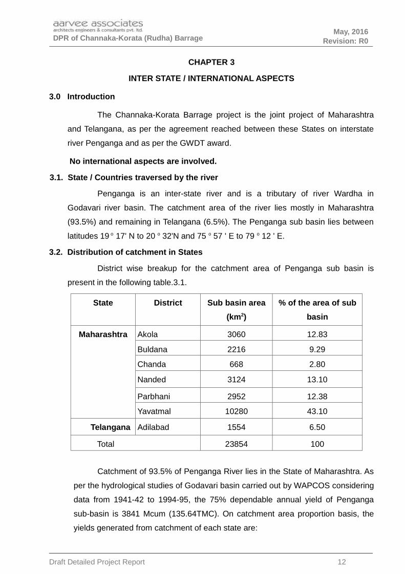
3.1. State / Countries traversed by the river
Penganga is an inter-state river and is a tributary of river Wardha in
Godavari river basin. The catchment area of the river lies mostly in Maharashtra
(93.5%) and remaining in Telangana (6.5%). The Penganga sub basin lies between
latitudes 19 o 17' N to 20 o 32'N and 75 o 57 ' E to 79 o 12 ' E.
3.2. Distribution of catchment in States
District wise breakup for the catchment area of Penganga sub basin is
present in the following table.3.1.
State District Sub basin area
(km2)
% of the area of sub
basin
Maharashtra Akola 3060 12.83
Buldana 2216 9.29
Chanda 668 2.80
Nanded 3124 13.10
Parbhani 2952 12.38
Yavatmal 10280 43.10
Telangana Adilabad 1554 6.50
Total 23854 100
Catchment of 93.5% of Penganga River lies in the State of Maharashtra. As
per the hydrological studies of Godavari basin carried out by WAPCOS considering
data from 1941-42 to 1994-95, the 75% dependable annual yield of Penganga
sub-basin is 3841 Mcum (135.64TMC). On catchment area proportion basis, the
yields generated from catchment of each state are:
Draft Detailed Project Report 12

DPR of Channaka-Korata (Rudha) Barrage May, 2016
Revision: R0
Maharashtra: 126.8 TMC
Telangana: 8.84 TMC
3.3. Interstate agreement
The barrage at channaka-korata (Rudha) is the joint project between the
states of Maharashtra and Telangana on Penganga River independent of the joint
Lower Penganga Project. An understanding was reached between the states of
Maharashtra and Telangana to take up the barrages at Rajapet,. Channaka- Korata
(Rudha) and Pimprod as an inter-state joint projects.
Government of Maharashtra initially planned to construct 4 barrages on
Penganga River at different locations on the down stream of Lower Penganga Dam
to utilise 3.127 TMC out of the 9 TMC of water allocated to it by GWDT. Government
of Maharashtra requested Government of Telangana to participate in these barrage
schemes and take benefits out of them duly using the allocated share of Telangana
below Lower Penganga dam site. The cost sharing of these barrages is proposed to
be in the ratio of utilization of waters between the states of Maharashtra and
Telangana.
Subsequently, following meetings were held between the officials of the two states.
3rd round of the Chief Engineers Level interstate meeting, 24-01-2012 at
Dr.MCR HRD Institute, Hyderabad (letter enclosed as Appendix – 1.6).
A Joint meeting of Superintending Engineers of Andhra pradesh (now
Telangana) and Maharashtra States on 14.03.2012 at Nirmal (letter enclosed
as Appendix – 1.5).
In the 2nd meeting, it has been decided that Telangana Government will
participate in 3 barrages out of the 4 barrages proposed by Maharashtra at Rajapet,
Channaka-Korata (Rudha) and Pimprod below the Lower Penganga Project. During
the meeting held in the Chambers of Engineer-in-Chief (AW), I& CAD, Hyderabad on
10-10-2012 (letter enclosed as Appendix 1.1), it was agreed that 2.00 TMC can be
earmarked from 5.12 TMC unaccounted water below LPP for the use in Andhra
Pradesh (now Telangana State) in Penganga Basin (G7) under proposed barrages
as there is no effect in water availability for the Project down below.
Draft Detailed Project Report 13

DPR of Channaka-Korata (Rudha) Barrage May, 2016
Revision: R0
Table 2.2 : The water availability and sharing of ayacut and water for the 3 Barrages
Sl.
No
BarrageLoca-tion
Stor-age ca-pacityin TMC
Percentage of Sharing
of cost
Sharing of water in
TMCAyacut in Ac
Telan-
gana
Maharash-
tra
Telan-
gana
Ma-
hara-shtraTelangana Mahara-shtra
1 Rajapet 0.7 50 50 0.35 0.35 2500 2500
2 Rudha 1.5 80 20 1.2 0.3 13500 3000
3 Pimprod 1.5 30 70 0.45 1.05 4500 10000
Governments vide Memo No. 25577/PW. IS/ 2013, dt. 15-07-2013 accorded
permission to take up Barrage -1 at Rajapet and Barrage-3 at Pimprod by the state
of Maharashtra and Barrage-2 at channaka-korata (Rudha) by the state of
Telangana .
Government Memo No. 25577/PW. IS/ 2013, dt. 15-07-2013 (letter enclosed as
Appendix 1.2).
3.3a. State / Countries traversed by the river
Penganga is an inter-state river and is a tributary of river Wardha in
Godavari river basin. Its catchment area lies mostly in Maharashtra (93.5%) and
remaining in Telangana (6.5%). The Penganga sub basin lies between latitudes 19
o 17’ N to 20 o 32'N and 75 o 57 ' E to 79 o 12 ' E.
3.3. b Interstate adjudication
Godavari Water Dispute Tribunal (GWDT) made the following allocation of
water to the basin states at 75 % dependability.
State Allocation (annually at 75 % dependability)
Maharashtra
A. The state of Maharashtra can use all the waters upto :
Lower Penganga project site near ChikalWardha subject to
the condition that the Lower Penganga Project is taken up
as a joint project.
Waghadi Project Dam site on the Waghadi river near village
Yelbara.
Saikheda Dam on Khuni river near village Lingti.
B. In addition to the use of all the waters up to the point as
Draft Detailed Project Report 14

DPR of Channaka-Korata (Rudha) Barrage May, 2016
Revision: R0
specified above, the state of Maharashtra can use from the
waters of the rest of Penganga sub-basin 9 TMC.(255 M
cum) for its existing, under construction and proposed
schemes / projects each of which individually will not exceed
an annual use of I.5 TMC.
TelanganaThe State of Telangana (now Telangana) can use all the
remaining waters of the Penganga Sub-basin.
3.3.c Interstate aspect submergence.
No submergence of Private land or property is involved in Maharashtra as
the storage is restricted to with in the banks.
3.3.d Any other aspects of the project involving Inter-state problems.
A draft agreement in respect of the joint Rudha barrage Project between
the States of Maharashtra and Telangana is prepared and is likely to be signed
very soon. This agreement deals with all the aspects likely to be emerged during
construction and Operation of the project.
3.3.e Existing and sanctioned projects.
Particulars of the existing and sanctioned projects pertaining to Telangana in Penganga
basin are given in the following table.
Name of theproject
Existing Ongoing Future
Major Lower Penganga 5.120
Medium Satnala 2.048
Mathadivagu 0.905
Minor 2.020 0.237 0.233
Sub-Total 4.068 1.142 5.352
Total 10.562
In addition to the above, lift schemes for lifting water from the proposed 3barrages (including the Rudha barrage) on Penganga river below LowerPenganga Project for the purpose of drinking water supply to Adilabad town andirrigation of leftover ayacut in Adilabad district, are under proposal.
3.4 Existing riparian use, quantum of water presently utilised, commitments for
ongoing projects, plans for future development, balance share of the
state/country and proposed utilisation by this project.
As given above under Para 3.3.e
Draft Detailed Project Report 15

DPR of Channaka-Korata (Rudha) Barrage May, 2016
Revision: R0
3.5 Whether operation and regulation of the project conform to the 'stipulation
made in the Tribunal award/agreement and also the mechanism for such
operation.
Yes. Operation and regulation of this project will be as per the stipulation
made in the GWDT award and as per the agreement between the states of
Telangana and Maharashtra.
3.6 In case of addition/alterations for existing project involving submergence in
other states and additional utilization of water, concurrence of the concerned
states is to be included.
Not applicable
3.7 Details regarding consumptive use of water in case of Hydro electric or
Thermal Power Projects
Not applicable
Draft Detailed Project Report 16

DPR of Channaka-Korata (Rudha) Barrage May, 2016
Revision: R0
CHAPTER 4
SURVEYS AND INVESTIGATIONS
4.0 General
The accuracy of the design of any scheme depends on the accuracy of field
data. As such the survey has a greater importance in this kind of projects. Every
effort was made to collect reliable data.
The objective of the proposed topographical surveys is to assess the
topography of the project area, type of terrain, profile of alignment, ground features
etc to enable planning, engineering and construction works.
Based on the information furnished in the tender document, initially a
preliminary survey was conducted to study the general topographical conditions of the
project stretch. In this survey, the neighboring villages under the stretch, location of
different tanks, canals, power lines, pipe lines etc are studied; local enquiries were
made to collect available information. Topo sheets and village maps of the project
were collected.
Following are the various surveys undertaken.
4.1. Topographical Surveys
Relevant Topo maps of Survey of India were collected and Topographical
features of the area studied which gave a preliminary idea of the river and command
area. All the relevant topo sheets were joined together to get an overall picture of the
project. The contours of the area were studied vis-a-vis the river levels and general
command area levels. All the Survey requirements and scales of maps etc are
according to the Central water Commission (CWC), Government of India. The project
components were marked on topo sheets. Possible alternatives were explored on the
map. Following series covers the Topo grid of the project area.
56 I/5 56 I/9 56 I/13
56 I/6 56 I/10 56 I/14
Draft Detailed Project Report 17

DPR of Channaka-Korata (Rudha) Barrage May, 2016
Revision: R0
4.1.1 Reconnaissance Survey
Walk through surveys were conducted repeatedly to get the first hand
information about the area. A reconnaissance survey is made at the river, proposed
reservoir, possible Barrage axis, pump House and Command Area. All salient features
of the area are noted during the reconnaissance survey. As such, the alignment
marked on the toposheet was verified on the ground and found feasible ways to
proceed with other surveys.
4.1.2 Reference Bench Mark
Height control has been established with respect to the GTS bench mark
bearing value +225.300 m is located in Post Office at Gimma Village, Jainad Mandal.
4.1.3 Primary Control Points
Following the basic principle of surveying i.e., “to work from whole to part” a
network of permanent primary control points have been established in the project
area using auto levels and Dual frequency Global Positioning System (DGPS).
Traversing was conducted between the DGPS points using Total Station.
4.1.4 Secondary Control Points
To facilitate the detailed survey of remote areas, which are not directly
accessible from primary control GPS points, temporary secondary level control points
have been established. Several such points were established during detailed survey
depending upon the complexity of features and accessibility. Different arrangements
were made for these temporary points like erection of a stone pillar wherever
possible, marking on the rock where rock is exposed or driving a nail into the firm
ground.
All the permanent and temporary reference points established above were
also interconnected elevation wise. A double check leveling procedure has been
followed to transfer the level of bench mark.
4.1.5 Detailed Topographical Survey
Survey was based on TM (WGS84) co-ordinate system. One pair of control
points have been established in the Barrage site using DGPS and 16 pairs of control
Draft Detailed Project Report 18

DPR of Channaka-Korata (Rudha) Barrage May, 2016
Revision: R0
points have been established in the Command area using DGPS. North south
reference base line has been established to true North & East west lines has been
established perpendicular to it. The control points have been established at an
average of 4.0 to 5.0 km using DGPS and Traversing was carried out on control
points using total station.
In the detailed survey, actual field data was collected duly covering the
entire project area so as to prepare the scheme proposal in detail. This survey
involved establishment of bench marks, collection of ground features and their levels.
Following are the various activities covered under this survey.
Alternative studies for finalization of Barrage alignment
Annexure – Alternative site examined, are enclosed
Considering the techno-economic factors as well as the local factors like
submergence and LA issues, alternative 1 is favored. The alternative 1 was
approved by CE/CDO during Joint Inspection held on 22-04-2015 (letter enclosed as
Appendix - 1.4).
Similarly canal alignment is marked in the combined toposheets. Various
factors like optimum cutting and filling, commandability of ayacut, suitable locations
for CM & CD works are taken into account before deciding on canal alignment.
Detailed surveys are taken up for Barrage, canals, and command area. The detailed
surveys comprise of the following activities.
4.1.6 Development of Plan
The overall plan of the project site indicating the streams, topographical
features like cliffs, rock outcrops, mounds, ditches, was generated by taking
coordinates using total station. Proposed alignment of barrage, approach bund,
pump house, WCS, canals and distributories etc. are indicated in the plan.
4.1.7 Barrage Survey
The exact alignment of barrage, approach bund is fixed and detailed
surveys carried out. The broad crested weir is located at the river portion and
approach bund on right flank. The general arrangement drawing (GAD) enclosed.
Draft Detailed Project Report 19
DPR of Channaka-Korata (Rudha) Barrage May, 2016
Revision: R0
4.1.8 Submergence area, Longitudinal and Cross sections of the proposed barrage
In order to generate the submergence area map, LS & CS of proposed
barrage x, y and z coordinates of the following points are picked up using Total
station with reference to the benchmarks.
1. Grid survey for submergence area at interval of 30m or less.
2. LS at every 25m along the Barrage alignment.
3. LS at every 25m along the Submergence area in Penganga River.
4. CS of the river on upstream and downstream.
4.1.9 Command Area Survey
An ayacut of 13500 acres is proposed to be irrigated under Channaka-
Korata barrage in Telangana. This essentially includes collection of details for all
features such as structures (buildings, tanks, towers etc.), monuments, places of
worship, existing road and railway lines, streams, canals / rivers, tanks, utilities,
electric and telephone installations, huts, fencing falling within the extent of survey.
The detailed survey was carried out in a systematic way by covering all the details
in the command area.
The entire command was surveyed with total station and contour plans are enclosed
in AA/IRR/1774/DPR/BAR-2/09 and AA/IRR/1774/DPR/BAR-2/02. Alignment of main
canal and distributaries are marked on this plan.
Main Canal
Longitudinal section of the canal is taken at 25m interval. Cross sections of
the canal alignment are taken @ 50m interval extending 100 m on either side of
the center line of the alignment for preparing the Strip Contour plan. Plan &
Longitudinal are plotted giving the following details.
• Bed width
• Side slopes
• Full supply depth and free board
• Profiles of banks.
• Details of inspection and non-inspection paths
Draft Detailed Project Report 20

DPR of Channaka-Korata (Rudha) Barrage May, 2016
Revision: R0
The Plan & Longitudinal Section plots are presented in Designs & Drawing volume
IV (Part 2).
Canal Structures.
Block leveling of the area of the structure on 5m grid basis is carried out.
Grid plan of the site with contours at 1m interval to cover an area up to 100m on
either side of the center line of the canal.
• L.S and cross sections at 25m interval along the river and road crossings up
to a l ength of 500m upstream and down stream are taken.
• Particulars of the cross drainage and Cross masonry structures are given in
Designs & Drawings Volume IV (Part 1)
• The design details of the CM & CD works(for 10% of the total Structures for
main canal) are given in the Designs & Drawings Volume IV (Part 1)
4.1.10 Standard observation procedure for traversing and staking using Total
station
Aim: To provide planimetric and height control for subsequent survey exercise and
to stake out points whose coordinates are known.
Instruments: Total Station and 50m long Fibre glass Tapes.
Observations:
• The work should start from a known station or a point whose coordinates are known.
• After setting instrument on a known station, telescope should be trained & targeted on
to another known point, to get natural bearing.
• In case, the work starts from a GPS location, Total station should be set on one of the
GPS points of the pair and the other GPS point of the pair should be taken as
reference station for mutual bearing.
• The traverse line should have connection to one DT level at the beginning of the
alignment and be connected to one more DT level at the end of the traverse.
• Offsets to pillars, should be restricted to 200m length only.
• Recording of point number in field observation book should be very clear and with no
over writings.
Draft Detailed Project Report 21

DPR of Channaka-Korata (Rudha) Barrage May, 2016
Revision: R0
• If needed, the figures should be cut neatly and the observations be recorded afresh.
Each page of the field observation book must be completed in all respects in the field
itself.
4.1.11 Computations:
• Computation of observations made during the traverse should be completed only
after ensuring that all the observations are within tolerance limits.
• Traverse set up must be completed by running down the bearings and the
corresponding distances, in the same sequence as that of the observation.
• Computation of coordinates and heights should also be completed in the same
sequence.
• Closing error, if any, should be adjusted within the traverse legs as inversely
proportional to their lengths.
4.1.12 Standard deviation of procedure for levelling
Aim: To provide height control for subsequent survey of cross sections of the
canal, Plane Table Survey and contouring with 1m vertical interval.
Instruments: Auto levels, Aluminum levelling Staves and Iron brands.
Observations:
• Double tertiary levelling should be run along the banks of the canal.
• All level lines should start and close on the same point.
• In case, the level line is run from one BM to another, both the BMs should be
visited, prior to the commencement of work.
• For DT levelling two sets of observations are to be taken at each of the instrument
stations, disturbing the instrument between the observations. The difference
between the two sets must agree within 0.003m and then the mean of the two sets
is to be taken for reducing error.
• To avoid collimation error of the instrument, the instrument should always be kept
at the center of forward and back staves.
• Maximum length of a shot should restricted to 50m only.
• Observation during high winds and shimmering should be avoided.
Draft Detailed Project Report 22

DPR of Channaka-Korata (Rudha) Barrage May, 2016
Revision: R0
• Staves should be kept on the iron brads and not on the ground directly. On the
slopes of canal where it is not possible to put the iron brad, a small patch of firm
ground may be levelled and the staff be put on it.
• To ensure that the same staff is kept on BMs, even number of stations should be
made between the BMs.
• Spot heights should thrown as offsets, to a limiting distance of 50m.
• All the three wires should be read in quick succession and the mean of these
should agree within 0.002m with the value of the central wire reading. Otherwise,
the observation must be repeated.
• Always, the back staff is to be observed first.
• Accuracy should be within 0.025 multiplied by the square root of KX km square
where K is the total distance in km of the level line for ST level line and 0.0125
multiplied by the square root of KX square for DT level lines.
• Bench marks should be made on permanent points with hard surface and should
be painted with their elevation values.
• All the levels should be reduced in the field and accuracy should be ensured
before closure of the work.
• While taking levels for the cross section of the canal all the levels should be taken
in the line connecting the two BMs on either of the canal.
• While taking the levels under water, bed should be probed with staff till it touches
firm surface and then should be held perfectly against the current.
Third extension piece of the staff is not be used at all.
EQUIPMENT USED
DGPS - 1 Set, DGPS 1200 Series
Total stations- 4 Sets
Leica TC 1800
Leica TRS1101
Leica TRS1202
Leica TS-02
Draft Detailed Project Report 23
DPR of Channaka-Korata (Rudha) Barrage May, 2016
Revision: R0
Auto Levels
Sets of Pentax AFL 128 model
Sets of Pentax AL 240 model
Sets of Pentax AP 124 model
4.2 Other Surveys
4.2.1 Archaeological survey in the reservoir area.
There are no centrally protected monument / Archaeological site located in
the proposed submergence area or along the canal alignment .
4.2.2 Mineral Survey
The mineral resources are not affected by the project.
4.2.3 Right of way surveys for the reservoirs
Due to formation of the proposed barrage across the Penganga river,
survey of the existing causeways, existing highways etc, which are likely to be
affected by submergence was undertaken. It has been found that, with the FRL of
+213.00m as proposed no highway or road of importance are affected by the
submergence.
4.2.4 Communication survey
No roads of importance are getting affected with the FRL fixed at +213.00m.
4.2.5 Drainage Survey
The topography of the command is sloping and can offer adequate
drainage. Water logging of the command is not anticipated.
4.3 Geology Geo-technical Features and Seismicity.
These features are covered in detail in Volume III.
4.4 Foundation Investigation
Foundation Investigations are covered in detail in the Volume III.
4.5 Construction Material Investigation
Various construction materials like sand, aggregate, stone, borrow area
soils, cement and steel are proposed to be obtained from the designated quarries.
The samples of these materials will be got tested before doing detailed designs of
the structures. For preliminary designs random samples are tested and values
Draft Detailed Project Report 24

DPR of Channaka-Korata (Rudha) Barrage May, 2016
Revision: R0
taken. The quarry map is enclosed. Detailed investigation report is enclosed in
Volume III.
4.7 Hydrological and Meteorological Investigations
Hydrological and Meteorological Investigations are covered in the next
CHAPTER. Hydrology of the project is presented in Volume II.
Draft Detailed Project Report 25
DPR of Channaka-Korata (Rudha) Barrage May, 2016
Revision: R0
CHAPTER – 5
HYDROLOGY
5.1.5.1.5.1.5.1. Hydro-logic Inputs to the project planning
The project is classified by storage as A-3 (with in the year storage). It is pri-
marily classified as B-1 by use (Irrigation). Provision of drinking water supply is inci-
dental and as such it can not be classified as B-2 (Multipurpose) by use.
Following are the requirement of inputs for the project.
For simulation studies
▪ Water inflows
▪ Lake evaporation
▪ Potential evapo-transpiration and rainfall
▪ Water quality inputs
The time unit for simulation studies can be monthly for such a storage reservoir.
The length of data for use in simulation studies for this project is 25 years.
For studies other than simulation
▪ Design Flood for the safety of the structure:
▪ Design Flood for diversion structure (cofferdam)
▪ Level at the Dam site
▪ Tail Water Rating Curve
5.1.1. Water inflows
The availability of water to Telangana at the barrage at Channaka-
Korata(Channaka-Korata(Rudha)) can be assessed as per the allocation of GWDT
according to which, the state of Maharashtra can use all the waters upto the
following projects:
Draft Detailed Project Report 26

DPR of Channaka-Korata (Rudha) Barrage May, 2016
Revision: R0
• Lower Penganga project site near ChikalWardha.
• Waghadi Project Dam site on the Waghadi river near village Yelbara.
• Saikheda Dam on Khuni river near village Lingti.
GWDT further allotted 9TMC of water annually to Maharashtra from Penganga
below LPP subject to a maximum utilisation by Maharashtra of 1.5 TMC from each
location below LPP.
Accordingly the yield need to be assessed from the free catchment below the above
projects up to the project site and considering a total allocation of 9 TMC below LPP
to Maharashtra. Accordingly the yield is assessed as given below.
5.2.1 Hydrological data
There are no Gauge and Discharge sites near the proposed barrages on
Penganga. No project specific gauge and discharge data was observed for
assessing the yields at the barrages. Central Water Commission maintains a regular
gauge and discharge site on Penganga river on the upstream at Penganga bridge
which is located on the upstream of the barrage at Channaka-Korata (Rudha).
5.2.2 Computation of yield, assessment of available water
There is no observed discharge data at the proposed barrage site to
develop yield series and assessing the water availability. The possible alternative
methods for estimating the yields at Channaka-Korata barrage are:
• Assessing the yield at barrage based on the yields at Lower Penganga Dam on
prorata basis of catchment areas.
• Using Rainfall- Runoff relations for the Penganga sub basin based on the nearest
Discharge observation point Penganga Bridge on Penganga.
5.2.3 Rainfall-runoff relation for Penganga basin
Detailed studies on the rainfall runoff relations for Penganga basin at Penganga
Bridge made by the following agencies are available.
• Yavatmal Irrigation Circle, Govt. of Maharashtra for the yield studies for the DPR of
Lower Penganga project.
Draft Detailed Project Report 27

DPR of Channaka-Korata (Rudha) Barrage May, 2016
Revision: R0
• WAPCOS for the hydrological studies of Godavari basin for me&CAD department,
Govt of Telangana.
5.2.4 Rainfall in the basin
WAPCOS have studied the rainfall data from 19 rain gauge stations in the
Penganga sub basin in the context of hydrological studies of Godavari basin. The
western most parts of Penganga sub basin receive relatively lowest rainfall, which
gradually increases as one move to the eastern parts of the sub-basin.
The annual normal rainfall varies from 800 mm in the west to 1000 mm in
the central part of the sub basin and 1300 mm in the extreme eastern part.
Magnitude of dependable rainfall over the sub basin is highest over the extreme
eastern parts and decreases gradually to the west.
The present study area falls in the extreme eastern part of the sub basin
and experiences relatively higher rain fall.
The range of variation in the magnitude of rainfall is given in the following Table 5.1
Month Level of dependability
Range of rainfallmagnitude
( East to West)
June
50 160-120
75 100-70
90 80-50
July
50 350-200
75 250-140
90 150-140
August
50 300-175
75 200-100
90 40-10
Septem-ber
50 160-100
75 100-60
90 40-10
October
50 50-20
75 10-0
90 0
Water Resources Department, Maharashtra finalized the water availability
studies for Lower Penganga Project based on observed rainfall data at 20 stations
Draft Detailed Project Report 28

DPR of Channaka-Korata (Rudha) Barrage May, 2016
Revision: R0
in the catchment for the period 1967 to 2008 and observed G&D data at CWC
G&D site at P.G. Bridge for the period 1970 to 2008. These studies have been
approved by CWC. The monthly weighted rainfall data for the project and the
corresponding flow data are presented in Annexure 5.1.
5.2.5 Rainfall-Runoff regression equations.
The regression equations developed in the above studies are given below.
For monsoon
Y = 0.6237 * X – 25.202 (Maharashtra Irrigation department) …............(Eq.1)
Y = 0.7162 * X – 381.92; where Y = Runoff; X=Weighted Mean Rainfall.....(Eq2).
For Non-Monsoon
3.37 % of monsoon flows (Maharashtra studies)
4.15 % of monsoon flows (WAPCOS study)
5.2.6 Yield at Channaka-Korata (Rudha) barrage
The water availability studies for Lower Penganga Project carried out by
Maharashtra Irrigation department are based on the latest observed data and are
more relevant to the yield calculations at the proposed barrage below Lower
Penganga Dam.
The varacity of the yield calculations at each barrage is verified by
reassessing the yields using the equation developed for Lower Penganga Dam
(Eq.1). The water availability at the barrage site is reassessed. The weighted mean
rainfall for the Penganga basin up to P.G. Bridge is considered as the weighted
mean rainfall for the free catchment area of Rudha barrage.
The gross yield at Rudha has been assessed as 303.16MCM (10.71TMC)
The calculations are presented in Annexure 5.1.
5.3 75% DEPENDABLE FLOWS AT Channaka-Korata (Rudha) BARRAGE
From the yields thus assessed from free catchment, the net annual 75%
dependable yields available to Telangana at Channaka-Korata (Rudha) barrage are
assessed in the following table 5.2.
Draft Detailed Project Report 29

DPR of Channaka-Korata (Rudha) Barrage May, 2016
Revision: R0
Table 5.2: Net annual 75% dependableyields available to Telanga at Channaka-Korata (Rudha) barrage
Unit : TMC
Barrage Grossflows
Existing utili-sation by
Maharashtra
Net flowsavailable toTelangana
Remarks
Channaka - Korata(Rudha)
10.71 0.322 10.388
The net annual 75% dependable yields available to Telangana for future use after
accounting for the existing utilizations by Telangana at Channaka-Korata (Rudha)
barrage are given in the following table 5.3.
Table 5.3: Net annual flows available for future use by Telangana
Unit :TMC
Barrage at Net flowsavailable toTelangana
Existingutilisations by
Telangana
Net annual flowsavailable forfuture use by
Telangana
Remarks
Channaka -
Korata (Rudha)10.388 1.744 8.644
5.4 Monthly Net yield flow series Channaka-Korata (Rudha) barrage.
The 75% dependable net available monthly flows at Channaka-Korata (Rudha) are
derived as follows.
•••• The gross flows available at Channaka-Korata (Rudha) from free catchment have
been assessed using Rainfall-Runoff relations.
•••• From the above virgin flows the existing utilisations by Maharashtra & Telangana in
Penganga basin upto Channaka-Korata (Rudha) barrage site have been
subtracted.
•••• The resulting flow series after subtracting the existing utilizations(proportion to the
LPP main canal demands) are the net flows available at Channaka-Korata (Rudha)
barrage for planning utilisations from Channaka-Korata(Rudha) barrage.
•••• The 75% dependable net available flow series at Channaka-Korata (Rudha) are
given in Annexure -5.1 & 5.2 respectively.
Draft Detailed Project Report 30

DPR of Channaka-Korata (Rudha) Barrage May, 2016
Revision: R0
5.4.1 Lake evaporation
The meteorological observations at RARS, Jagtial used for estimation of Eto of
Northern Telangana Agriculural zone .The average lake evaporation as per the
working tables is 0.007 TMC.
Table 5.4: Mean meteorological observations at RARS, Jagtial used for estimation
of ETo of Northern Telangana Agriculural zone
MonthMax.Temp
0C
Min.Tem
p 0C
Humidit
y %
RH max
%
Wind
km/day
Sunshin
e Hours
ETo
mm/day
JAN 30.01 14.49 58.57 76.46 51.97 7.55 3.74
FEB 32.53 16.76 54.06 71.99 74.13 8.34 4.92
MAR 36.22 19.67 48.42 64.76 84.12 8.12 6.06
APR 39.31 23.04 42.97 58.35 93.67 8.64 7.21
MAY 41.65 26.41 40.00 50.51 169.55 8.28 8.75
JUN 37.06 25.82 58.51 67.36 245.70 5.93 7.76
JUL 32.09 23.52 71.73 79.17 227.93 4.29 5.68
AUG 30.97 23.00 75.67 82.98 193.13 4.59 5.22
SEP 32.07 22.83 73.13 82.22 121.57 5.87 5.12
OCT 32.30 20.43 66.42 79.97 57.05 7.16 4.66
NOV 30.79 16.70 61.00 76.94 45.50 7.37 3.88
DEC 29.45 13.38 58.35 75.07 42.44 7.48 3.40
Year 33.70 20.50 59.07 72.15 117.23 6.97 5.53
5.4.2 Potential evapo-transpiration and rainfall
Draft Detailed Project Report 31

DPR of Channaka-Korata (Rudha) Barrage May, 2016
Revision: R0
This aspect has been considered while working out crop water requirements
and assessing irrigation demands under Irrigation Planning.
5.4.3 Simulation studies
Working tables are prepared for 25 years (1984 to 2008) using monthly
inflows and demands. The area - capacity tables of the reservoir are used for the
simulation studies.
Area Capacity Table
S.No Elevation (m) Area ( Mm2)Capacity in M
CumCapacity In Tmc
1 197 0.000 0.000 0.0000
2 198 0.002 0.001 0.0000
3 199 0.005 0.004 0.0001
4 200 0.014 0.013 0.0005
5 201 0.033 0.036 0.0013
6 202 0.067 0.084 0.0030
7 203 0.158 0.193 0.0068
8 204 0.363 0.447 0.0158
9 205 0.828 1.027 0.0363
10 206 1.322 2.092 0.0739
11 207 1.776 3.635 0.1284
10 208 2.349 5.691 0.2010
11 209 2.933 8.327 0.2941
12 210 3.424 11.502 0.4062
13 211 3.816 15.121 0.5340
14 212 4.169 19.112 0.6750
15 213 4.614 23.502 0.8299
16 214 5.473 28.540 1.0079
17 215 7.023 34.771 1.2279
18 216 7.677 42.119 1.4874
19 217 8.293 50.102 1.7693
20 218 8.893 58.693 2.0727
21 219 9.617 67.945 2.3995
Draft Detailed Project Report 32

DPR of Channaka-Korata (Rudha) Barrage May, 2016
Revision: R0
Fig: 5.1 Area- Capacity curve for Channaka-Korata Barrage
The FRL is considered as +213.000m with a capacity of 23.474 MCM. The
summary of the working tables is given below table 5.5. The detailed calculations
are presented in Annexure 5.3.
Summary Of Working Tables
FTL+
213.000
mM.D.D.L
:
+203.00
0m
Ca-pacity
:0.830 TMC
Capacity:
0.007 TMC
23.500
MCM 0.191 MCM
S.No Year
Start-ingCa-
pacity
Total In-flows
TotalDe-
mand
Evapo-rationlosses
EndingCapac-
ity
Sur-plus
De-mands
metDeficit
TMC TMC TMC TMC TMC TMC TMC TMC %
(1) (2) (3) (4) (5) (6) (7) (8) (9) (10) (11)
1 1984 0.007 4.302 1.488 0.202 0.154 2.465 1.488 0.000 0.000
2 1985 0.154 8.956 1.488 0.210 0.187 7.226 1.488 0.000 0.000
3 1986 0.187 21.043 1.488 0.153 0.123 19.682 1.272 -0.216 14.513
4 1987 0.123 4.550 1.488 0.119 0.029 3.051 1.473 -0.015 1.002
5 1988 0.029 31.570 1.488 0.221 0.284 29.607 1.488 0.000 0.000
6 1989 0.284 16.972 1.488 0.148 0.083 15.753 1.272 -0.216 14.513
Draft Detailed Project Report 33

DPR of Channaka-Korata (Rudha) Barrage May, 2016
Revision: R0
7 1990 0.083 21.717 1.488 0.214 0.226 19.873 1.488 0.000 0.000
8 1991 0.226 5.894 1.488 0.123 0.035 5.012 0.950 -0.537 36.123
9 1992 0.035 22.370 1.488 0.157 0.123 20.771 1.355 -0.132 8.894
10 1993 0.123 13.758 1.488 0.202 0.221 11.971 1.488 0.000 0.000
11 1994 0.221 18.992 1.488 0.210 0.236 17.279 1.488 0.000 0.000
12 1995 0.236 14.053 1.488 0.214 0.214 12.375 1.488 0.000 0.000
13 1996 0.214 15.061 1.488 0.200 0.221 13.366 1.488 0.000 0.000
14 1997 0.221 9.512 1.488 0.197 0.191 7.858 1.488 0.000 0.000
15 1998 0.191 10.822 1.488 0.153 0.059 9.313 1.488 0.000 0.000
16 1999 0.059 16.921 1.488 0.212 0.219 15.060 1.488 0.000 0.000
17 2000 0.219 10.073 1.488 0.129 0.059 9.153 0.950 -0.537 36.123
18 2001 0.059 16.192 1.488 0.209 0.220 14.335 1.488 0.000 0.000
19 2002 0.220 19.276 1.488 0.148 0.089 17.986 1.272 -0.216 14.513
20 2003 0.089 19.547 1.488 0.195 0.247 17.986 1.488 0.000 0.000
21 2004 0.247 10.018 1.488 0.209 0.247 8.134 1.488 0.000 0.000
22 2005 0.247 17.129 1.488 0.215 0.223 15.399 1.488 0.000 0.000
23 2006 0.223 32.446 1.488 0.226 0.314 30.641 1.488 0.000 0.000
24 2007 0.314 14.864 1.488 0.216 0.221 13.253 1.488 0.000 0.000
25 2008 0.221 16.012 1.488 0.214 0.233 14.299 1.488 0.000 0.000
Average 0.188
The minimum success rates for considering the project as viable as recommended
by Planning Commission based on use of project are:
B-1 (Irrigation) : 75%
B-2 (Hydro Power) : 90%
B-3 (Water Supply) : Nearly 100%
Table 5.6: Performance of Channaka-Korata(Rudha) Lift Irrigation project
Sl.no
Description Remarks
a No. of years of simulation 25
b Number of failure years to meet the demands 6
c No of success years 19
d % dependability 76 %
Draft Detailed Project Report 34
DPR of Channaka-Korata (Rudha) Barrage May, 2016
Revision: R0
5.5. Hydrologic studies for design flood
5.5.1 Design flood for safety of structure
a. Criteria
The design flood can be defined as the maximum peak rate of runoff that
occurs over a catchment due to a rainfall storm of given intensity and of various du-
rations. A structure is to be designed to withstand this flood.
As per the IS code: 6966(Part 1)- 1989, For purposes of design of items
other than freeboard, a design flood of 50 year frequency may normally suffice. In
such cases where risks and hazards are involved, a review of this criteria based on
site conditions may be necessary. For designing the free board, a minimum of 500
year frequency flood or the standard project flood may be desirable.
Floods of larger or smaller magnitude may be used if the hazard involved in
the eventuality of a failure is particularly high or low. The relevant parameters to be
considered in judging the hazard in addition to the size would be:
i) Distance to and location of the human habitations on the downstream after
considering the likely future developments.
ii) Maximum hydraulic capacity of the downstream channel at a level at which
catastrophic damage is not expected.
Table 5.7: Salient features of the Channaka-Korata(Rudha) barrage
Sl.no Description Level (m)
1 Average bed level +201.645
2 Crest level +203.000
3 FRL +213.000
From the above discussion, 100yr frequency flood is to be adopted for the
safety of the structure. The storage behind the dam is not much. It is unlikely, that
Draft Detailed Project Report 35

DPR of Channaka-Korata (Rudha) Barrage May, 2016
Revision: R0
the damage caused on the down stream will be high in case of its failure, as the
flood wave will be attenuated very soon. The design flood discharge for this project
is calculated by the following method.
5.5.2 Frequency aproach
Observed series of annual peak flows are available at CWC gauge and
discharge site at Penganga Bridge on the upstream side of the project site.
Frequency floods for different return periods have been assessed by applying proper
frequency distribution to these peak flood series at P.G.Bridge. The 100yr frequency
flood at the barrage site has been assessed by assuming an empirical formula
equating discharge as a function of catchment area, ie; Q = C*(Root A).
The 100 year return flood for the project is assessed as 16366.48 cumec.
The calculations are presented below.
INPUT OF THE VARIATE VALUES and FILE COMMUNICATION
Table 5.8: Annual Peak discharge at Pengang Bridge
S.No
YearDis-
charge(Cumecs)
S.No
Year
Dis-charge
(Cumecs)
S.No
Year Discharge(Cumec
s)
1196
5 1670 16 1980 4873 31 1995 6591
2196
6 4309 17 1981 4513 32 1996 2082
3196
7 2084 18 1982 1948 33 1997 528
4196
8 1748 19 1983 16000 34 1998 2192
5196
9 3188 20 1984 353 35 1999 4109
6197
0 5734 21 1985 2141 36 2000 4658
7197
1 1048 22 1986 6561 37 2001 4530
8197
2 3632 23 1987 741 38 2002 8702
9197
3 3552 24 1988 5970 39 2003 4118
10197
4 1142 25 1989 5591 40 2004 721
11 197 5278 26 1990 5520 41 2005 7140
Draft Detailed Project Report 36

DPR of Channaka-Korata (Rudha) Barrage May, 2016
Revision: R0
5
12197
6 6137 27 1991 1125 42 2006 13881
13197
7 3642 28 1992 4533 43 2007 2877
14197
8 5410 29 1993 3676
15197
9 4130 30 1994 5334
BASIC STATISTICS OF x and lnx
Description x-stat lnx-stat
mean = 4272.3720 8.0838
var = .9778E+07 .6804
St.dev= 3127.0510 .8248
biasskew= 1.7883 -.7405
biaskurt= 7.4544 3.3253
skew = 1.9202 -.7951
kurt = 8.6045 3.8384
Table 5.9: Ranking of the data & the plotting positions
RankValueof x
Valueof
ln(x)
Plotting position(percent) according
to WEIBULL
1 353 5.866 2.2727
2 528 6.269 4.5455
3 721 6.581 6.8182
4 741 6.608 9.0909
5 1048 6.955 11.3636
6 1125 7.026 13.6364
7 1142 7.041 15.9091
8 1670 7.421 18.1818
9 1748 7.466 20.4545
10 1948 7.575 22.7273
11 2082 7.641 25.0000
12 2084 7.642 27.2727
13 2141 7.669 29.5455
14 2192 7.693 31.8182
15 2877 7.965 34.0909
16 3188 8.067 36.3636
Draft Detailed Project Report 37

DPR of Channaka-Korata (Rudha) Barrage May, 2016
Revision: R0
17 3552 8.175 38.6364
18 3632 8.198 40.9091
19 3642 8.200 43.1818
20 3676 8.210 45.4545
21 4109 8.321 47.7273
22 4118 8.323 50.0000
23 4130 8.326 52.2727
24 4309 8.368 54.5455
25 4513 8.415 56.8182
26 4530 8.418 59.0909
27 4533 8.419 61.3636
28 4658 8.446 63.6364
29 4873 8.491 65.9091
30 5278 8.571 68.1818
31 5334 8.582 70.4545
32 5410 8.596 72.7273
33 5520 8.616 75.0000
34 5591 8.629 77.2727
35 5734 8.654 79.5455
36 5970 8.695 81.8182
37 6137 8.722 84.0909
38 6561 8.789 86.3636
39 6591 8.793 88.6364
40 7140 8.873 90.9091
41 8702 9.071 93.1818
42 13881 9.538 95.4545
43 16000 9.680 97.7273
EVALUATION t-VALUE
**one-tail Student t-value**
degrees of freedom = 42 , level of significance= .9500
t - v a l u e = -.100T
Table 5.10: Pearson type III distribution
ReturnPeriodYears
Probab.Exc(p)
NonProbab.
Exc(1-p)
EstimatedValue
(Cumecs)
2 0.50 0.50 3280.967
5 0.20 0.80 6034.073
10 0.10 0.90 8207.091
20 0.05 0.95 10450.24
25 0.04 0.96 11186.53
50 0.02 0.98 13514.64
100 0.01 0.99 15902.88
500 0.00 1.00 21662.18
Draft Detailed Project Report 38

DPR of Channaka-Korata (Rudha) Barrage May, 2016
Revision: R0
DESIGN FLOOD AT RUDHA
CA upto PGBridge 18441 sqkm
-do- upto Channaka-Korata barrage 19531.57 sqkm
25 yr flood upto PG Bridge 11187 cumecs
Equating Q=C*rootA;
11187=C*18441 and C=11187/root18441 , C = 82.37993
25 yr flood at Channaka-korata bar-rage 11513.04 cumec
100 yr flood upto PG Bridge 15903 cumec
Equating Q=C*rootA;
15903=C*18441 and C=15903/root18441, C = 117.1081
100 yr flood at Channaka-korata bar-rage 16366.48
500 yr flood upto PG Bridge 21662 cumec
Equating Q=C*rootA;
21662=C*18441 and C=21662/root18441, C = 159.5168
500 yr flood at Rudha 22293.33 cumec
The design flood for a return period of 100 & 500 years is approved by CE, Hydrology,
Telangana (Letter Enclosed as Appendix 1.7).
5.3.3 Design floods for flood control component
No storage for flood control is considered necessary in this project as no
flood problems are anticipated in the downstream reaches.
5.3.4 Hydrological design of surface drainage
Flood control aspects are not contemplated in this project. The command
area is not flood prone.
5.3.5 Design flood for planning construction and diversion arrangements
Construction of cofferdam is proposed for facilitating construction of the
barrage. The construction of barrage will be throughout the year. A 25 year return
flood is considered for the diversion arrangements.
The 25 year return flood is assessed as 11513 cumes.
Draft Detailed Project Report 39

DPR of Channaka-Korata (Rudha) Barrage May, 2016
Revision: R0
5.3.6 Determination of flood levels for structures on river banks
The pump house will be located above MWL corresponding to 500 yr return flood.
5.3.7 Determination of outlet levels
The out let level for drawing water (MDDL) is fixed as +203.000.
5.3.7 Tailwater rating curves
The tail water rating curve up to the design flood value has been worked out
by Standard Step Method. The actual x-sections of the river below the dam axis
have been used for this purpose. Average coefficient of rugosity value is considered
as 0.03 as per the profile and bed material of the river section. The tail water level
corresponding to 100 yr return flood has been assessed as +217.100m. The tail
water rating curve for 100 yr flood is given below fig 5.2. Tail water calculations are
enclosed in Annexure 5.4.
Figure: 5.2 Tail water Rating Curve
5.4. Effect of project development on hydrologic regime.
a. Impact on existing projects in the downstream of planned projects.
There will not be any impact with respect to water availability on the projects
in the downstream, as the allocation to this project is made as per the overall
planning for the basin. However the sedimentation concentration will be marginally
reduced in the project in the downstream.
Draft Detailed Project Report 40
0
500
1000
1500
2000
2500
3000
3500
206
208
210
212
214
216
218
Tail-Water Rating Curves
16366.48 12274.86 8183.24 4091.62Chainage from Axis (m)
Wate
r su
rface leve
l (m
)

DPR of Channaka-Korata (Rudha) Barrage May, 2016
Revision: R0
b. Effect on low flows
It is proposed to divert a maximum of 5.00 cumecs or less as per the
requirement from stored water from the reservoir. The flow condition in the river
before this project is dry during non monsoon. After construction of the reservoir and
development of command, it is likely that the volume of low flows on the downstream
reaches will increase due to regeneration etc. As such there will not be any adverse
effect on low flows in the river.
c. Effect on Flood hydrograph
The flood hydrograph will be routed through the reservoir. The storage is by
gates. The crest of the barrage structure will be almost near the river bed. During
floods all the gates will be lifted and the outflows are not regulated. The incoming
flood will pass over the crest. The effect of the project on river regime will be
negligible during peak floods as the whole flood will pass over the spillway as it is
without any moderation.
d. Effect on Total run off
The reservoir area is not considerable as it is located in a valley. The
average annual evaporation losses will be about 0.25MCM only.
e. Effect on river hydraulics (Short and long terms)
The effect of the project on river regime will be negligible during peak floods
as the whole flood will pass over the spillway as it is without any moderation.
f. Sedimentation
The trap efficiency of the reservoir will be negligible. The entire sediment is
likely to flow down the river. The sediment concentration in the lower reaches will not
be altered after the construction of the project. It is likely that slight aggredation may
take place on the upstream and slight degradation may take place on the
downstream.
g. Effect on Water quality
There will not be any effect on the water quality in the upstream. However
on the downstream side there will be slight improvement in the physical water quality
Draft Detailed Project Report 41

DPR of Channaka-Korata (Rudha) Barrage May, 2016
Revision: R0
parameters, since some of the sediment and organic matter will be trapped in the
reservoir.
h. Effect on Water Demand
Demands for the water for this project are proposed based on the availability
of yield and within the allocation of planning by the State Government. So, no
problem is foreseen in respect of water demand either from upstream or
downstream areas in future.
Draft Detailed Project Report 42

DPR of Channaka-Korata (Rudha) Barrage May, 2016
Revision: R0
CHAPTER – 6
HYDRO - GEOLOGY
6.1 Introduction
In finally selecting the suitable alignment for Channaka- Korata barrage,
geological conditions need to be addressed for individual sites, so as to avoid
geologically unsafe site and select more suitable site Geologically and techno
economic considerations which merits further studies. For this purpose,
Geomorphological, Regional geology and site specific geology have been studied
and evaluated.
6.2 Geomorphology
Geomorphology describes the land forms, their evolution, genetic
relationship with Geology and influence of weathering and building agencies in
carving present land forms.
In any project planning, study of the land forms for their maximum utilization
is desirable. The Proiect area is predominantly undulatory, with sediplain terrain
spreading towards south of the proposed sites and high hill ranges extending
towards north and west.
The sediplain is developed over sedimentary rocks and with gentle easterly
or northeasterly gradient of 3º to 15º. The hill ranges are classified, predominantly as
denudational and structural hills with structures like meas and buttes which are
characteristic land forms of Deccan Trap (Basaltic) terrain
The site is drained by Penganga River and its tributaries. Penganga River
flows in easterly direction with uniform gradient and width, suggesting a
homogenous nature of underlying bed rock. However, further upstream and
downstream reaches, it shows sinuous courses, here and there. The fluvial
geomorphologic setup suggests that the river has attained maturity stage, Not much
degradation of the river is noticed in the form of erosion of banks. However,
deposition of bed loads is observed on the banks and on the concave side of the
river curves. With increase in the accumulation of sediments the actual river course
either has narrowed down or it has shifted its course at places.
Draft Detailed Project Report 43

DPR of Channaka-Korata (Rudha) Barrage May, 2016
Revision: R0
Lower order streams have developed dendritic drainage pattern in the
southern side of the area towards Adilabad, but with less density, suggesting uniform
gradient and also less infiltration than run off through underlying imperious strata.
Towards north and west, dendritic, radial and parallel drainage pattern has
developed in the resistant hill ranges.
Overall geomorphologic setup does not indicate any indirect evidence of
adverse geological features in the area.
6.3 Regional Geology
Regional Geology gives a broad account of the overall stratigraphy,
structural setup surrounding project site and helps in inferring and proper
interpretation of geological setup and adverse structural features, if any, that may
influence in selecting the site. Regional geology of the area is studied from published
geological maps, reports and satellite imagery data of Geological Survey of India.
The broad geological set up of the area encompassing the site reveals that
sedimentary rocks like lime stones, sandstones and shales occupy the central area,
on either side of the Penganga river, which are flanked by igneous rocks like granite
towards south and volcanic rocks like basalt towards north and west (Table 6.1).
Table 6.1: The general stratigraphic sequence of the area as established by GSI
Rock type / Lithology Formation Group/SuperGroup
Era
Alluvium, conglomerate Recent
Basalt with inter trappean beds Deccan Trap Upper Carbniferous toEoacene
Infratrappean Upper Carboniferous
Sandstones and Shales KamthiTalchir
Gondwana SuperGroup
Upper Carboniferous topermian
Sandstone/limestone/shale Penganga Group Upper Proterozoic
Pebbly sandstone/ Limestone Pakhal SuperGroup
-do-
Dolerite dyke/ Quartz vein Lower to middleproterozoic
Draft Detailed Project Report 44

DPR of Channaka-Korata (Rudha) Barrage May, 2016
Revision: R0
Pink and Gray Granite PeninsularGneissic complex
Archaean
Granites are exposed in and around Adilabad town, Basalts are exposed in Yavatmal
district and western part on either side of state boundary. Gondwanas occur in North
eastern part around kayar in Maharashtra.
Penganga group of rocks occur on either side of Penganga River. They are
further sub devided into Pranahita sandstone, Chanda limestone and Satnala shale .
The thickness of limestone is estimated to be 400m, whereas that of shales as
2000m. Lime stones are exposed in the western part and shales in the eastern part.
They show regional trend varying from WNW-ESE to NW-SE. They are horizontally
bedded or show dips varying from 3º to 15º towards north east.
A few faults are reported in the area, A fault trending N75º W- S 75ºE in the
granitic terrain ,located just north of Adilabad and a few NW -SE trending faults in
Deccan Trap terrain, located towards west of the area close to state boundary.
6.4 Site Geology
In and around the site, Satnala shales belonging to Penganga Group are
exposed sporadically and at the site in Penganga River they are reddish brown to
pinkish in color. They are thin to medium thick bedded and are inter bedded with thin
laminate of calcareous bands. They are horizontally bedded or show dips of 3º
towards northeast.
Bedding joints are prominent discontinuities in this lithological unit. Apart
from these a few joints trending along N 70º W-S 70º E, N W – S W and E - W are
also observed at places in the area. Spacing of bedding joints vary from 10 to 50 cm.
The spacing of other joints is not uniform and they are at random. The joints are tight
as exposed.
At the barrage site, Satnala shales are exposed and there are no lithological
variations from site to site. No adverse geological feature is observed at the
proposed Barrage site. The barrage site fall in Seismic Zone II as per IS 1893 -2002.
Geology Map is enclosed as Drawing No. AA/IRR/1774/DPR/BAR/9.
Draft Detailed Project Report 45

DPR of Channaka-Korata (Rudha) Barrage May, 2016
Revision: R0
CHAPTER – 7
DESIGN FEATURES AND CRITERIA
7.1 Structure and layout
7.1.1 (a) Headworks - Site and Vicinity
The Rudha barrage is proposed on river Penganga which is a tributary to
the river Wardha, near village Channaka in Kelapur Tahsil of Yavatmal district in
Maharashtra and Korata village in Jainad Mandal of Adilabad district of Telangana.
The river valley spreads over an area of 19531.57 Sq km up to barrage site. The
average slope of the river in the vicinity of the barrage site is 1 in 637.
7.1.1 (b) Reasons for choice of the layout of the Project
All lands in the basin are fertile and suitable for Khariff and Rabi crops. All
crops are rain fed with a few storage ponds. The occupation of the Inhabitants of
the command area is agriculture. Due to erratic nature of rainfall, there is no
assured irrigation. To overcome the above, channaka-Korata barrage is proposed.
The project comprises of head works, Pump House, Canal network to supply
assured water for crops, and drinking water.
7.1.1 (c) Type of Structure
The head works of the scheme comprise of broad crested weir and bank
connections (abutments, returns, guide walls, guide walls & approach bund). The
crest level of the barrage is proposed at +203.00m, while the average bed level of
river is +201.645 and FRL of the barrage is restricted upto + 213.00m to avoid
submergence. The barrage is constructed to store 23.502Mcm (0.829TMC) of
water. The height of the crest above deepest foundation level will be about 6.00m.
7.1.1 (d) Layout of the dam
The layout plan showing the barrage, approach & guide bunds and roads
connecting barrage to existing roads and bank connections have been decided as
per the topographical features and soil/geological features and presented in the
General Arrangement Drawing (GAD), which is enclosed.
Draft Detailed Project Report 46

DPR of Channaka-Korata (Rudha) Barrage May, 2016
Revision: R0
7.1.2 Geology, seismicity and foundation
Covered in detailed in vol-III
(a) Geology of the entire project area.
To know the depth and nature of overburden, rock type and their physical
conditions, total 9 numbers of exploratory bore holes were drilled. Out of this, 5
bore holes are along the centre line of barrage, 2 bore holes are in U/S and 2 bore
holes are in D/S of barrage axis.
The barrage site is located in sedimentary belt belonging to Penganga
Group. Satnala shales are lithological type of the area which is sporadically
exposed .At the proposed barrage site, the river bed is 175m wide and is 11m
deep. The main river bed is occupied by pebbles boulders of basalt and limestone
and Purple shale occurs as thin rock fragments. Maximum size of sub rounded
boulder observed is 0.30 cum. They are loosely packed in coarse sand. These
pebbles, boulders and rock fragments make up 75% of total bed loads of the river.
A brief account of geology reach wise, along the alignment is given below:
Left bank is an undulatory to flat terrain with G.L varying from Rl.216.0 – 220.0 m
and it is covered with dark silty clayey soils.
Reach from ch -25.91 – 0.00m forms left bank slope (near 1;1) with G.L varying
from 216m slope. This slope is covered with silty soils and rock fragments but
exposes bed rock between ch -5.0- 0.00 m. The bed rock is purple shale which
shows dips of 3 – 5º degrees due north east.
River bed between Ch0.00and Ch. 122.189m is occupied by running water of
about 1.5 to 2m deep.
The river bed portion between Ch.122.189- 151 m is covered with sand,
pebbles, smooth angular fragments of different shapes and sizes.
Reach from 151 to 175m forms right bank slope with G.L’s varying from R.L 203
TO 213 m and forms 1:1 slope and covered with silty soils mixed with pebbels rock
fragments.
From ch 175 - 287.5m forms right bank with G.L’s varying from R.L 213 to 217 m
and is occupied by brown silty sandy /clay soils, forming a flat terrain
The shales as exposed in the left edge of the river are near horizontally bedded or
show 2-3º dips towards north east or north. The strike of bedding makes an angle
Draft Detailed Project Report 47

DPR of Channaka-Korata (Rudha) Barrage May, 2016
Revision: R0
of 60º with the barrage axis. At exposed surface they are thin to medium bedded
with bedding thickness varying from 0.10 to 0.50 m. Thin laminae of calcareous
bands occur with in these shales. The thickness of these laminae is about 2 to 3
mm. It shows weathering in the form of discolouration of the exposed surface and
deposition of calcareous material along steepely dipping joint planes. The shale is
splintary in nature and air slaking type, Normally shales show fissilityand degree of
fissility depending on compositional variation. Siliceous and calcareous shales are
less fissile when compared to pure (argilaceous shales). Shales occurring at the
site are calcareous in nature and hence less fissile .It is traversed by the following
sets of joints.
TABLE -7.1 JOINT PATTERN
Jointset no.
Strike ofjoint
Dip and dipdirection
Spacing and nature remarks
1 NW-SE 2-5º due NE or
Horizontal
0.05-o.50m, tight,
planar, smooth or
undulatory
Bedding joints,
skew to dam
alignment
2 E-W Steeply dipping or
90º
Random, tight at some
places filled with thin
calcrete/calcareous
material
Parallel to river
course
3 NW-SE 30-90º due NE Random, tight or 1 to
2mm opening filled with
calcareous material.
Planar, rough
Skew to axis
Of the above three sets of joints, bedding joints are prominent and they are tight or
shows openness of 1 to 2mm.
7.1.3 Alternative studies carried out for selection of site
As discussed wide para 4.1.5
7.1.4 Choice of final layout of all major components of the project and reason
details.
Draft Detailed Project Report 48

DPR of Channaka-Korata (Rudha) Barrage May, 2016
Revision: R0
7.1.5 Design Flood and Sediment Studies
The design flood has been discussed in detail in CHAPTER 5. The
maximum design flood to be adopted will be 16366.48 cumecs (100yr return flood).
The yield has been worked out and given in CHAPTER 5. The net annual 75%
dependable yield at head works out to 303.16 Mcum (10.71 TMC) after considering
the planned upstream utilizations. The MDDL has been fixed as + 203.00 m.
7.1.7 River Diversion Arrangements
Coffer dams are proposed on u/s and d/s of the proposed site during construction
activity.
7.1.8 Construction Materials
The samples from borrow areas for approach bund have been tested for c
and φ values and engineering properties and permeability are evolved. The same
have been used while designing the approach bund.
The source of material and their leads are enclosed with the data sheets and the
same have been used for preparation of data and estimate of the barrage.
7.1.9 Model Studies
Model studies were conducted by TSERL(Telangana State Research Laboratory)
(Report enclosed).
7.2 Barrage
7.2.1 Salient Features & Controlling Levels
• Hydrology:
1. 100 years return flood : 16366.480 cumecs
2. Planned storage : 1.50 TMC
• Barrage:
1 Design Flood : 16366.480 cumecs
2 Type : Barrage with vertical lift gates
3 Lowest river bed level : +201.645 m
4 Crest level of barrage : +203.000m
Draft Detailed Project Report 49

DPR of Channaka-Korata (Rudha) Barrage May, 2016
Revision: R0
5 Full Reservoir Level (FRL) : +213.000m
6 Maximum Water Level (MWL) : +218.10m
7 Tail Water Level : +217.100m
8 Length of barrage : 287.50 m
9 Length of each bay : 12.0 m
10 Energy dissipation length : 40.0 m
• Piers:
1. Thickness : 2.50 m
2. Length : 14.850 m including cut waters
3. No’s. : 19
• Gates:
1. Type : Vertical Lift Gates
2. Size : 12.0 x 10.0 m
3. No’s. : 20
4. Hoist Bridge level : +231.60 m
• Road Bridge:
1. Carriageway width : 4.250 m
2. Road Bridge top level : + 220.10 m
3. Type : RCC T-Beam
4. C/C span : 14.5m
7.2.2 Hydraulic Design
Fixation of Crest level
The lowest river bed level at barrage location is El. +201.645m and the crest
level of barrage is fixed at El. +203.00m. The difference b/w crest level and river
bed level is 1.355m.
Draft Detailed Project Report 50
DPR of Channaka-Korata (Rudha) Barrage May, 2016
Revision: R0
7.2.3 Fixation of Barrage Bays
Maximum 100 years food of 16366.480 cumecs is considered for design of
barrage bays. Barrage of 287.50m long in between abutments with crest level at
El. +203.00m has been proposed to pass the design flood with an afflux of 1.0 m
above TWL (+217.10m) and MWL is El. +218.10m. The proposed barrage is
consists of 20 bays of 12.0m width each with pier thickness of 2.5m and is capable
of passing the estimated design flood even when two bays inoperative during the
high floods. FRL of barrage is fixed at El. +213.00m to fulfill the peak requirements.
Vertical Lift Gates in the barrage is provided from top of crest El. +203.00m to FRL
+213.00m and they are spanning between the piers.
7.2.4 Overflow section Profile
As per the hydraulic requirements and techno economical considerations,
Broad crested type of profile is proposed. Hydraulic design of barrage is done as
per IS: 6966-1989. U/s glacis of 2:1 from crest level of barrage to u/s apron floor
level +201.645m and below this it is vertical up to hard rock level. D/s glacis of 3:1
from crest level to d/s apron floor level of +197.60m. Crest width of 5.5m is
provided as per the minimum clearances requirements for stop log and gate
grooves.
Hard rock is available at El. +197.00m, hence the foundation of barrage is
proposed at El. +197.00m. The excavated portion is backfilled with M15 grade
concrete and top 1.5m thickness is glacis concrete with M20 grade excluding
wearing coat of thickness 150 mm with M25 grade.
7.2.5 Energy Dissipation Arrangements
The energy dissipation arrangement for different flood discharges has been
worked out based on IS: 4997-1962. The maximum length of basin worked out as
40m and basin floor level is +200.00m. The basin floor is proposed at El. +197.600
due to availability of hard rock at El. +197.0m, with apron thickness of 0.6m.
7.2.6 Design Assumptions
The following design parameters are adopted.
Unit weight of concrete : 2.40 t/m3
Draft Detailed Project Report 51

DPR of Channaka-Korata (Rudha) Barrage May, 2016
Revision: R0
Unit weight of water : 1.00 t/m3
Saturated weight of earth : 2.10 t/m3
Angle of internal friction (φ) : 30 deg.
Seismic Zone : II
7.2.7 Stability Analysis & Structural Design
7.2.7.1 Overflow Section
Stability analysis of Overflow section is carried out for different loading
conditions and load combinations as per IS: 6512-1984. Seismic calculations were
performed as per IS: 1893-1984. The maximum and minimum stresses were
checked at foundation level. There is no tensile stresses were developed at base
and the maximum & minimum stresses are within permissible limits. To take care
of shrinkage and temperature stresses nominal reinforcement of 16mm dia. @
250mm c/c is proposed in both ways on top.
The maximum and minimum stresses for various load combinations are shown in
table below.
S.
No.
Load
Combination
Stresses ( T/ Sq.m)
Max. Min.
1 A 28.208 9.478
2 B 14.631 10.643
3 C 18.969 0.632
4 D 31.000 7.241
5 E 13.730 12.105
7.2.7.2 Intermediate Pier
Pier thickness is 2.5m and length is 14.85m. It is resting on overflow section
of barrage. Hoist platform with rope drum hoist and gantry crane is proposed at El.
+231.600m. Walkway platform is proposed on u/s of barrage at El. +220.1m for
maintenance of stop logs. Single lane Road Bridge is proposed on d/s of barrage
at El. +220.1m for vehicle movement.
Draft Detailed Project Report 52

DPR of Channaka-Korata (Rudha) Barrage May, 2016
Revision: R0
Stability analysis of Intermediate Pier is carried out for different loading
conditions as per IS: 13551-1992. Seismic calculations were performed as per IS:
1893- 1984. Piers are proposed with M20 grade concrete. The Longitudinal and
Transverse stability of pier is checked at crest level +203.00m. There is no tensile
stresses were developed at crest level and the maximum & minimum stresses are
within permissible limits. Hence, the Minimum Vertical reinforcement of 20mm dia.
@ 150mm c/c and Horizontal reinforcement of 16mm dia. @ 150mm c/c is
proposed.
The maximum and minimum stresses for various load combinations are shown in
table below.
S.No. Analysis Load Case Stress (T/Sq.m)
Max. Min.
1 Longitudinal a. Without Seismic 96.255 25.004
b. With Seismic 80.463 40.796
2 Transverse With Seismic 97.960 33.793
7.2.7.3 Energy Dissipation Arrangement
Basin Floor is resting on hard rock, hence 600 mm thick apron slab with
nominal reinforcement is provided on top. Concrete grade for basin slab is M20.
Minimum reinforcement of 20mm dia. @ 300 c/c provided on top as per IS:4997-
1987. To relive the uplift pressure, formed drain holes of 75mm dia. @ 3.0m c/c is
provided in basin floor. To take care off uplift due to any choking condition of
drains, 25mm dia. anchor rods @ 1.5m c/c 3.0m long is provided.
7.2.7.4 Left and Right side Abutments
Abutments are designed as RCC counterfort retaining walls for saturated
earth pressure. Stability of retaining wall is carried out at the foundation level of El.
+197.00m. Top of abutment is + 220.100m on either side of Hoist Platform. In hoist
platform portion, the abutment top is +231.600m. Hard rock available at foundation
level is Shale, hence max. Stress on foundation is limited to 50.0 T/Sq.m.
Draft Detailed Project Report 53

DPR of Channaka-Korata (Rudha) Barrage May, 2016
Revision: R0
The maximum and minimum stresses for various load combinations are shown in
table below.
S.No. Structure Stresses (T/Sq.m)
Max. Min.
1 Abutment 48.785 42.228
7.2.7.5 U/S and D/S Guide Walls
U/S Guide walls
The top of Guide wall is provided at El. +220.10m i.e. 2.0m above MWL
+218.100m. Foundation level is same as like abutment i.e. El. + 197.00. It is
designed as a RCC counterfort retaining wall for saturated earth pressure.
The maximum and minimum stresses for various load combinations are shown in
table below.
S.No. Structure Stresses (T/Sq.m)
Max. Min.
1 Guide wall 49.90 40.90
D/S Guide walls
The top of Guide wall is proposed at El. +219.10m i.e. 2.0m above TWL
+217.100m. Foundation level is same as like abutment i.e. El. + 197.00. It is
designed as a RCC counterfort retaining wall for saturated earth pressure.
The maximum and minimum stresses for various load combinations are shown in
table below.
S.No. Structure Stresses (T/Sq.m)
Max. Min.
Draft Detailed Project Report 54
DPR of Channaka-Korata (Rudha) Barrage May, 2016
Revision: R0
1 Guide wall 49.80 33.10
7.2.7.6 Guide Bunds
Guide bunds are provided on u/s and d/s of barrage as per IS: 10751:1994.
U/s Guide bunds are provided for a length of 290.0m and d/s guide bunds are
provided for length of 72.50m.
7.2.7.7 Approach Bund
The maximum height of approach bund is 6.4 m. Earth dam is designed as
Homogenous section with hearting zone with 1:1 slope with 2% extra moisture and
a casing zone with slope 2:1 on D/S face and 2:1 on U/S face. The top width of
the earth dam is kept as 6.00 m. Parapet on upstream side and guard stones on
D/S on top of bund have been provided.
The Cut-off trench is taken 1.0m into the rock or continuous impervious
strata. Grout -curtain in rock will be done in consultation with GSI, after the
foundations for cut- off trenches are exposed. Key trenches are provided up to
reach where the Ground levels are higher than FRL level.
In reaches where earth dam rests directly on rock, the foundation treatment
consists of a key 1.0 m depth with bottom width of 4.0 m and the surface shall be
treated for fractures and joints and transition zone provided wherever necessary.
The earth Dam is keyed with abutments of the Dam by means of core wall
extending from abutment into the earth dam. The core wall is taken upto hard rock.
Drainage arrangements shall be as per IS 9429 – 1999. The horizontal filters of
1000 mm shall be extended up to D/S rock toe.
Profile walls shall be provided at 30 m intervals for earth dam in line with
revetment. The revetment shall be as per IS 8237 – 1985 reaffirmed – 1997 and
rock toes are as per IS 9429- 1999.
Turfing shall be provided on D/S slope of earth bunds and chute drains at 45.0 m
c/c shall be provided as shown in drawings and these are as per IS 8237 – 1985.
Tentative proposals for curtain grouting, consolidation grouting and drainage
grouting have been provided. The curtain grouting depth is taken as 2/3 H + 8.0.
The consolidation grouting is taken as H/4. Depth of grouting may be modified if
necessary in consultation with geologist after opening the foundation.
Draft Detailed Project Report 55

DPR of Channaka-Korata (Rudha) Barrage May, 2016
Revision: R0
Temperature Control
For control of concrete cracking and development of high thermal stress,
temperature control of concrete is necessary. This may be achieved by pre -
cooling of aggregates to obtain desirable placement temperature of concrete. The
concrete as deposited should have a temperature of not more than 15 to 21o c.
Water Stops at Transverse Contraction Joints
PVC (Polyvinyl Chloride) water stops are provided for transverse joints. The
specifications to be followed are as per codes IS 12200 – 2001, IS 15058 – 2001
and IS 290 – 1901.
The design calculations for barrage, bank connections, earth dam as well as
drawing are enclosed in Volume IV.
7.3 Opening through Dams
a) Galleries, adits, shafts, stair wells etc,.
Not applicable
b) Outlet(s)/sluice(s)
7.3.1 Pump House and Pressure mains
The crop water demand of Channaka-Korata(Rudha) Barrge was worked
out. The peak demand of 4.47 cumecs was observed during September III
decadal. The 4.5 cumecs of water for irrigation is proposed to be lifted from the
barrage and delivered at elevated place and will be carried through gravity canals.
The Pump House is located at U/S of Barrage near Hattighat village, to lift
4.50Cumecs of water from Barrage with LWL in the Jackwell as +204.670 to
Delivery Cistern with El. +317.750. An approach channel 120 m long connects the
fore bay of the pump House to the river bed level +204.00m. The static head is
113.08 m and total head including all losses workout to 123.00m. Vertical Turbine
pumps (4 Nos) are proposed to lift the water through MS pressure mains of dia
1.60 m with a thickness of 18/16 mm having a length of 3.373km. The thickness of
the MS pressure mains are finalized based on surge analysis and minimum
thickness as per the IS Codes. The power required for lifting the water will be 7.68
MW.
The Motor floor level is kept at +220.00m with free board of nearly 2.0m
from MWL. Ground levels at this location are greater than +220.0m locally. Hence,
Draft Detailed Project Report 56
DPR of Channaka-Korata (Rudha) Barrage May, 2016
Revision: R0
level platform is created up to +220.0m and the drainage is diverted into the fore
bay.
The Pump House, 23.025m x 9.80m, houses 4 Units of Vertical Turbine
pumps/ motors. Capacity of each Pump is 1.92 MW. It is a semi underground type
of pump House with sump floor level +202.370m (17.630m below motor floor level
+220.0m).
Design
The main loads on the Substructure of the Pump House are Water pressure
and uplift. It is an RCC structure in M- 25 Concrete. The foundation raft 750mm
thick rests on hard natural rock strata. The RCC walls of the substructure along
with internal strut beams and raft form a rigid box structure.
The Superstructure of the main Pump House is of RCC columns with brick
walls and metallic sheet cladding. The roof consists of trusses and metallic
sheeting. Superstructure houses 25 Tones Capacity EOT crane. The Switch gear
and control equipment is housed in two storey RCC annexe building 30.055m x
6.510m.
The Substructure is Designed for the following load conditions
1. Construction / Fore bay empty
No water in the fore bay and External walls are subjected to water pressure.
2. Fore bay full and gates closed
Water pressures on the external walls and full uplift on raft.
Fore bay full and one gate closed and other open
Critical condition for the design of central wall (wall -4) is water on one side and no
water on the other side.
Materials
Concrete is M-25 grade with MSA 40mm.
Reinforcement is HYSD Bars conforming to IS: 1786 of Grade Fe 415.
Permissible stresses:
The design is based on working stress method as per IS: 456 & IS: 3370 with
stress in steel 150 N/mm2.
Designs & drawings are enclosed in VOLUME IV.
Draft Detailed Project Report 57

DPR of Channaka-Korata (Rudha) Barrage May, 2016
Revision: R0
7.4 CANALS
7.4.1 Description of canal system
As the command area is having undulating topography, the most of the
canals including Main, distributory & sub distributory were proposed on the ridge of
the area. This layout reduces cost of canals and the cross drainage works. Ayacut
registers were prepared upto 40 ha chacks.
The main canal at head reach is designed for 4.50 cumecs and balance
canals are designed as per the water requirement of the area. The detailed
particulars along with the designs are enclosed in Volume IV. The design of CM &
CD works for canal system are followed as per IS Codes, Manuals etc and same
are enclosed.
7.4.2 Network of canal system:
Canal network is planned to supply water to all holdings under commendable area.
It is also proposed to feed water to the existing ponds and provision is made
towards drinking water supply.
7.4.3 Soil profile
Soils available in commendable area are BC soils which are suitable for growing
the recommended crops with high productivity.
7.4.4 Evaluation of design Parameter
The canal is running almost in cutting except in some reaches. Wherever the
canal is in embankment suitable soils are proposed for embankment.
7.4.5 Lining
Lining is provided upto 40ha chalk.
7.4.6 Cutoff statement showing the detail of the discharge required from tail to the
head considering the irrigation requirement and transmission losses in the
off taking channel.
MAIN CANAL
REACH WISE HYDRAULIC PARTICULARS
S.No Description Units
Reach - I Reach – II Reach -III Reach -IV Reach -V
0 - 75 m 75 - 515 m515 - 1685
m1685 - 2850
m2850 - 3360 m
1 Reach Ayacut Ha 5494.2 1363.8 1304.9 2858.6 2479.2
2 a) Discharge Re- Cumec 4.500 2.669 2.214 1.779 0.826
Draft Detailed Project Report 58
DPR of Channaka-Korata (Rudha) Barrage May, 2016
Revision: R0
quired s
b) Discharge de-signed
Cumecs
4.530 2.735 2.251 1.785 0.868
3 Bed width m 3.20 2.60 2.40 2.15 1.40
4 Full supply depth m 1.20 1.00 0.90 0.80 0.65
5Canal side slopes (in/out) -
1.5 : 1 /2 : 1 1.5 : 1/2 : 1 1.5 : 1/2 : 1 1.5 : 1/2 : 1 1.5 : 1/2 : 1
6 Bed fall - 1 in 4000 1 in 4000 1 in 3500 1 in 3000 1 in 3000
7 Value of Rugosity - 0.018 0.018 0.018 0.018 0.018
8Free board(upto TBL) m
0.60 0.50 0.50 0.50 0.30
9 Velocity m/s 0.755 0.667 0.667 0.666 0.562
10Critical Velocity Ratio
1.588 1.551 1.643 1.751 1.656
11Top width of banks I/NI m
6 m / 2.5 m 4 m / 2 m 4 m / 2 m 4 m / 2 m 4 m / 1.5 m
12Thickness of lin-ing mm
60 60 60 60 60
13 Lining Free Board m 0.45 0.35 0.35 0.35 0.15
14 Canal Bed Level m 315.500 315.481 313.821 312.512 310.424
7.4.7 Design Discharge:
Water requirement is arrived with modified Penman method for each crop and total
required discharge is arrived at considering all losses and also provision towards
drinking water. For maximum required discharge, the canal section is designed.
7.4.8 Fixing the level of outlets:
Sill levels of outlets are fixed such that the off take channel can draw required
discharge even at 3/4 F.S.L condition.
7.5 Canal structures
Cross masonry and cross drainage structures are proposed wherever required and
the list of the structures along with details are enclosed in Volume IV (Part I).
7.6 Instrumentation
Not Applicable.
Draft Detailed Project Report 59

DPR of Channaka-Korata (Rudha) Barrage May, 2016
Revision: R0
CHAPTER 8
RESERVOIR
8.1 Fixation of Storage and Reservoir Levels-Approach- Criteria
The storage and Reservoir levels are fixed based on water availability
studies and crop water requirement studies. The levels are finalised after preparing
working tables for 25 years.
8.1.1 Dead storage Level (El-m): +203.00m
8.1.2 Low Water Level (Minimum draw down) (El-m): +203.00m
8.1.3 Full Reservoir Level (El-m) : +213.00m
8.1.4 Maximum Water Levet (EI-m): +218.10m
8.1.5 Maximum Back Water Level at Full Reservoir Level and Maximum Water Level
and its effect.
The FRL is +203.00m
The MWL is +218.10m
The maximum back water level extends upto about 23.93 km on the upstream side
of the reservoir.
8.1.6 Any saddles present along the rim of the reservoir, how they are being
tackled. Etc.
No significant saddles are present
8.2 Sedimentation data and studies
Sedimentation studies are not carried out since this is a barrage and storage
capacity against crest is 0.194Mcum(0.007TMC) only.
8.3 Life of Reservoir in years with basis
Life of reservoir is taken as 100 years with full capacity as planned.
Draft Detailed Project Report 60

DPR of Channaka-Korata (Rudha) Barrage May, 2016
Revision: R0
8.4 Capacities (Mcum)
8.4.1 Capacities (Mcum.)
Capacity at MDDL : 0.194 Mcum
Capacity at FRL : 23.502 Mcum
8.4.2 Storage (Mcum)
(a) Storage capacity is provided to meet the following requirement.
Irrigation requirement
Drinking water requirement (10%)
Evaporation losses
No separate allotment is made for power generation.
(i) Additional reservoir data
Bed level +201.645 m
Crest level. +203.00m
(ii) Hydrology
Details are given in hydrology Volume.
(iii) Diversion requirement
Requirements are as per crop water requirement and drinking water require-
ment. Details are given in hydrology Volume and irrigation planning chapter.
(iv) Return flow details
Return flows are not considered in the study.
(v) Minimum flow demands in the system.
(vi) Power details
The proposed project is basically an irrigation project.
(b) Annual Carry over capacity provided. If any, with basis. . Nil
Draft Detailed Project Report 61

DPR of Channaka-Korata (Rudha) Barrage May, 2016
Revision: R0
(c) Gross annual utilisation and dependability (Mcum) for each use.
Gross annual utilisation 42.19 Mcum
For Irrigation 40.96 Mcum
For Drinking water purpose 1.23 Mcum
8.4.3 Water tight ness of the reservoir
No seepage is anticipated through the bed or through the foundation of the
barrage as per the prevailing geological condition.
8.4.4 Annual Losses (Mcum) and basis
(a) Evaporation:
Average annual evaporation is 5.318 Mcum
(b) Seepage in the reservoir
No seepage losses are anticipated.
8.5 Effect on sub soiI water table in the adjoining areas particularly downstream of
the barrage.
Effect on sub soiI water table in the adjoining areas will be nominal as the reservoir
area is small.
8.6 Reservoir rim stability
As per the details given the geology chapter.
8.7 Area of submergence (ha) at: 31.552
8.7.1 Maximum Water Level
8.7.2 Full Reservoir Level: 11.09ha ( Storage is within the banks only)
8.7.3 Submergence ratio(s) Submerged (cultivated) ArealCCA
= 11.09/6680*100 = 0.166 %
8.8 Land Acquisition, property submerged and rehabilitation
Draft Detailed Project Report 62
DPR of Channaka-Korata (Rudha) Barrage May, 2016
Revision: R0
8.8.1 Land Acquisition (ha)
(a) Quantum of land: 35.552 ha
(i) Up to Full Reservoir Level +213.00 = 11.09 ha
8.9 Recreation facilities
Not provided at DPR stage
8.10 Pisciculture
Pisciculture is considered in the reservoir area.
8.11 Need and recommendation for soil conservation measure in the catchments
There is no need for soil conservation measure in the catchments.
8.12 Any other relevant information: Nil
Draft Detailed Project Report 63

DPR of Channaka-Korata (Rudha) Barrage May, 2016
Revision: R0
CHAPTER 9
IRRIGATION PLANNING
9.0 Introduction
The major source of irrigation in the district is through ground water
(86.55%) followed by tanks and canals. During the year 2010-11, an area of
1,22,994 ha was gross irrigated of which 44,130 ha was irrigated more than once.
The canals, tanks, tube wells, dugwells, lift irrigation schemes, other sources
irrigated 12121, 1554, 33993, 15367, 934, and 975 ha respectively.
Two major irrigation projects (Capacity > 10000 Ha) namely Kaddam
Narayanreddy Project and S.R.S Saraswati Canal (Sri Ramsagar Project-Left canal)
with registered ayacut of 68500 and 35735 ha and Utilized ayacut of 50000 and
32735 ha respectively are major source of irrigation. The medium irrigation projects
(Capacity > 2000-10000 Ha) like Vattivagu (Stage I and II), Satnala, Chalamala
(NTR stage), Suddavagu, Ralivagu, Peddavgu, Gollavagu and Yerravagu with
71562 Ha registered ayacut and 48600 utilized ayacut are other sources of surface
irrigation in the district. There are 675 minor irrigation tanks (>40-2000 ha irrigation
capacity) and 1378 tanks below <40 ha capacity with 140746 ha and 42197 ha
utilized ayacut.
9.1. Existing cropping pattern
9.1.1. Existing area under rainfed cultivation
9.1.1(a) :Rain fall during monsoon (Max, min and average)
The maximum, minimum and average rainfall received in three mandals command area
during monsoon iperiod is 1038, 904 and 978 mm respectively (Table 9.1).
Table 9.1 : Rainfall received during monsoon and non monsoon periods in three mandals of command
area
Maximum, mm Minimum, mm Average, mm
Rainfall during monsoon (june –Sep)
1038 904 978
Rainfall during non- monsoon (Oct -May)
213 181 189
Draft Detailed Project Report 64

DPR of Channaka-Korata (Rudha) Barrage May, 2016
Revision: R0
9.1.1(b) Rain fall during non- monsoon (Max, min and average)
The maximum, minimum and average rainfall received in three mandals command
area during non- monsoon period is 213, 181 and 189 mm respectively
9.1.1(c): Area under rainfed cultivation:
The principal crops grown in the proposed command area are cotton followed by
soybean, Redgram and Jowar purly under rainfed condition in an area of 8626 acres. On
the other hand, the area for other crops is small.
9.1.2 Area under each crop
Agriculture is one of the most important sectors of the Adilabad district economy.
The main / first agricultural season is normally referred to the growing cycle of temporary
crops that are planted and harvested from June to Oct / Nov of the year known as Kharif
and the Rabi - second agricultural season starts from Oct / Nov and continues up to
March / April.
Cotton is the main commercial crop of the district and nearly 48.73 % of the net
area sown is covered. Other principal crops are Soyabean, Jowar, Redgram, rice and
maize in decreasing order. The commercial crops like cotton are grown mostly under rain-
fed and chilies, turmeric and groundnut are grown under irrigation. The total area under
food grains is 211025 ha, out of which 146457 ha is under Khariff crop and 64568 ha is
under Rabi crops.
In order to assess the existing cropping pattern and crop production system in the
proposed barrage command area, the field level visits were made and interviewed the
beneficiaries. The discussions were held with farmers, district agricultural and irrigation
officers and also reviewed the information available in the form of publications. In three
mandals of the proposed ayacut area of channaka-korata (Rudha) barrage, the crop area
of the revenue villages was collected and the present cropping system was assessed.
The principal crops grown in the proposed command area are cotton followed by
soybean, Redgram and Jowar (Table 9.2 ) under rainfed condition. On the other hand, the
area for other crops is small. There are no orchard crops, lakes and water bodies and
lakes for aquatic farming under the proposed command. The cropping during rabi, hot
weather seasons is negligible.
Draft Detailed Project Report 65

DPR of Channaka-Korata (Rudha) Barrage May, 2016
Revision: R0
Table 9.2: Area (ha) sown under different crops during 2014-2015 under pro-posed Channaka-Korata(Rudha) barrage of Adilabad district, Telan-gana State
Barrage MandalNo of
villages
Cropped area, Ha
Cot-ton
Soyabean
Jowar
RedGram
BlackGram
GreenGram
Paddy
Total
chan-naka-Korata
(Rudha)
Adilabad
14 5850 1561 437 772 2 4 0 8626Jainad
Tamsi
9.3 Soil Surveys
The basic purpose of Soil Survey is to obtain a clear understanding of the soils for
their optimal utilisation consistent with the quality and potential. It enables organising and
providing information on characteristics of the different soil classes and evaluate their
utilisation potential from interpretative groups. Interpretative groupings thus serve
evaluation of their potential and prediction of their behaviour under different management
systems. It also indicates the degree of limitation for the sustained use of a soil under a
specified system. The data obtained from soils survey is translated for several varied
uses. Most commonly used interpretative are: Land capability classification and land
irrigability classification.
Properties of soil may change after the introduction of irrigation system in the
region due to the development of salinity, alkalinity, water logging etc. The soil survey
therefore, be conducted during the planning stage of a project with particular emphasis to
the suitability of soils for irrigation, reclamation, drainage and also in command areas
where water is to be used for irrigation after impounding in a reservoir or running a canal.
Soil Surveys of the catchment and command areas helps in formulating measures
for mitigating reservoir siltation, prevention of soil erosion and suggesting remedial
measures for drainage and water logging problems. Further, soil surveys provides
examination of the physical, chemical and engineering properties of the soil. From
agricultural point of view the studies help in determining the availability of plant foods in
the soils and the need for correcting the deficiencies.
Soil types (Traditional nomenclature):
The proposed command area of the Project, falls under North Telangana Agro
climatic zone. In Adilabad district, red loamy soils are predominant which are followed by
Draft Detailed Project Report 66

DPR of Channaka-Korata (Rudha) Barrage May, 2016
Revision: R0
black cotton soils. The soils of channaka-korata (Rudha) barrage command are rock
lands followed by deep black soils and shallow black soils.
Table 9.3 : Area (ha) of different soil types in command area of the proposed
barrage on Penganga in Adilabad Distict of Telangana state
TypeChannaka-
Korata(Rudha)
Rock lands 5336
Shallow black soils 862
Deep black soils 1895
58
Total 8150
9.3.1 Soil Capability Classification
Soil irrigability classes are useful to make grouping of soils according to their
suitability for sustained use under irrigation.
The following factors have been taken into account in the classification of soils
pertaining to the command area.
(1) Consideration of erosion.
(2) Consideration of slope of the land.
(3) Development of soil such as Zonal (well developed) intra zonal (More or
less developed) and a zonal (not well developed).
(4) Soil series.
(5) Type of soil.
(6) Suitability of land use, whether suitable for agricultural purposes or not.
(7) Suitability of soil for irrigation.
9.3.2 Land Capability Classification
Land capability classification is the grouping of soil map units to show the
capability of the soils to produce field crops or to be put to other uses on sustained
basis, based on the limitations of climate, problem of drainage, erosion and soil
factors affecting the plant growth.
Draft Detailed Project Report 67

DPR of Channaka-Korata (Rudha) Barrage May, 2016
Revision: R0
Soils suitable for agriculture are grouped under classes I to IV and soils not
suitable for agricultural are grouped under classes V to VIII which are useful for
pasture / forestry/ wildlife/ recreation.
In the three mandals where an area of 6680 ha is proposed to be irrigated
under surface method are fertile soils and falls under class ii and III and iv lands
and are suitable for cultivation.
9.4 Agroclimatic conditions
The proposed command area of barrage fall in Northern Telangana Agro cli-
matic Zone of newly formed state of Telangana. The zonal Reginal Research station
is located at Jagtial in Karimnagar district where a fully fledged Meteorological sta-
tion is in operation since 1982 and complete data set is available from 1989 to 2014.
On the other hand, at Adilabad an Agricultural Research station is located
but complete meteorological data is not available. Considering the data availability,
the rainfall which is available in complete form at Adilabad Research station and
Temperature, Relative humidity, Wind Velocity and sunshine hours of RARS, Jagtial
of the same agroclimatic zone was utilized for estimation of crop water requirements.
On considering terrain and climatic variations, the command area with re-
spect to irrigation planning has been grouped into one zone. It may be worthwhile to
mention here that variation in climatological parameters such as sunshine hours, rel-
ative humidity, maximum and minimum temperature over the area is much less.
Based on temperature and rainfall pattern, the proposed ayacut can be clas-
sified as subtropical and semiarid area.
Rain fall
The proposed command area mandals receive annual high rainfall > 1000
mm, of which nearly 80% was received during South West monsoon (June-Sep) and
about 10% was received during North east monsoon and rest during winter and hot
weather period (Table 9.4).
Table 9.4: Season wise normal rainfall(mm) in four mandals of proposed bar-rages on Penganga in Adalibad District of Telangana State
Draft Detailed Project Report 68

DPR of Channaka-Korata (Rudha) Barrage May, 2016
Revision: R0
Mandal
Rainfall in mm
Southwest
Northeast
WinterHot
weatherperiod
Total
Tamsi 904 135 13 27 1079
Adilabad 993 134 17 62 1206
Jainad 1038 109 23 49 1219
Average 978 126 17 46 1167
Adilabad Dist. average
984 117 17 40 1158
The average monthly rainfall of Adilabad is given in Fig. 9.1. The monthly year wise
and average ten day decadal rainfall is presented in Annex 9.1 & 9.2 respectively.
Fig. 9.1: Average monthly rainfall (mm) at ARS, Adilabad
Temperature
The mean daily max temperature ranges from 29.50C to 41.7 0C, while mean
daily minimum temperature ranges from 13.4 to 26.4 0C. The temperatures were
lowest in Dec and highest in May. In Dec the minimum temp was 13.40C resulting in
restriction of sowing of Rabi crops like groundnut (Fig. 9.2). However, during this pe-
riod Bengal Gram can be grown successfully. The average daily max & min temper-
atures are presented in Annex 9.3.1 & 9.3.2 respectively.
Draft Detailed Project Report 69

DPR of Channaka-Korata (Rudha) Barrage May, 2016
Revision: R0
Fig. 9.2: Mean daily Max & Min Temperature in oC at RARS, Jagtial
Relative Humidity (RH)
The mean daily maximum relative Humidity (RH1) was highest during July
to Oct (79-83%) and it was lowest in May (Fig 9.3). The average daily RH1, RH2 &
mean Relative Humidity are presented in Annex 9.4.1,9.4.2 & 9.4.3 respectively.
Fig. 9.3: Mean daily Relative Humidity (RH1,RH2 & Mean) in % at RARS, JagtialSunshine Hours
The maximum sunshine hours of 8.64 hours/day were observed during April
and minimum of 4.29 hrs/day were observed in July. The sunshine hrs ranged be-
tween 4.29 to 7.37 during kharif and 7.37 to 8.64 during Rabi/summer season
(Fig.9.4).
Draft Detailed Project Report 70
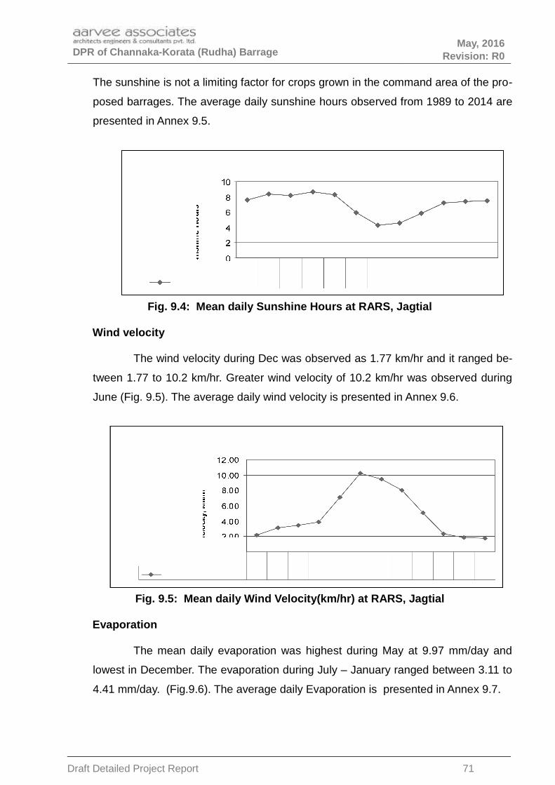
DPR of Channaka-Korata (Rudha) Barrage May, 2016
Revision: R0
The sunshine is not a limiting factor for crops grown in the command area of the pro-
posed barrages. The average daily sunshine hours observed from 1989 to 2014 are
presented in Annex 9.5.
Fig. 9.4: Mean daily Sunshine Hours at RARS, Jagtial
Wind velocity
The wind velocity during Dec was observed as 1.77 km/hr and it ranged be-
tween 1.77 to 10.2 km/hr. Greater wind velocity of 10.2 km/hr was observed during
June (Fig. 9.5). The average daily wind velocity is presented in Annex 9.6.
Fig. 9.5: Mean daily Wind Velocity(km/hr) at RARS, Jagtial
Evaporation
The mean daily evaporation was highest during May at 9.97 mm/day and
lowest in December. The evaporation during July – January ranged between 3.11 to
4.41 mm/day. (Fig.9.6). The average daily Evaporation is presented in Annex 9.7.
Draft Detailed Project Report 71

DPR of Channaka-Korata (Rudha) Barrage May, 2016
Revision: R0
Fig. 9.6: Mean daily Evaporation (mm/day) at RARS, Jagtial
9.5 Proposed cropping system
The following crops have been identified for the command area, which suits
the agro-climate, socio economic conditions and other factors (Table 9.6).
Under the existing irrigation scheme Satnala in Adilabad district which is
near to the proposed barrages, cotton crop is being cultivated for two seasons with
irrigation during mostly from post monsoon season from September onwards and
continue to irrigate up to end of March. Further, Soybean crop is also grown during
kharif under rainfed condition followed by Bengal gram under irrigation during Rabi.
The following crops are proposed to be grown under irrigated conditions in
the command of the barrage on Penganga during kharif and Rabi with extent of area
and crop calendar are given as under (Table 9.5 & 9.6).
1. LS Cotton (Two Seasonal)
2. Soybean – Bengal gram
3. Vegetables
a) Tomato – Cabbage
b) Brinjal - Cabbage
Draft Detailed Project Report 72

DPR of Channaka-Korata (Rudha) Barrage May, 2016
Revision: R0
Potential Crops
Cotton
Cotton is the most important crop of the existing cropping pattern, which
may continue to occupy almost the same area with little year-to-year variations. The
optimum time for sowing cotton is from 10th June onwards following onset of rains.
The crop stand of early-planted cotton is better than normal planted cotton. In cotton
crop coverage increased very much in recent years and But cotton being shorter in
duration, its early planting makes possible the timely planting of next season crop
such as sesame.
Soybean
Soyabean crop is major crop grown in Adilabad district. It has been the ex-
perience that there is limitation of soil moisture at grain falling stage of the crop, par-
ticularly during the first week of September. It is, therefore, advisable to grow this
crop with supplementary irrigation.
Bengal gram:
Vegetables: Tomato, Brinjal and Cabbage
Table 9.5: Proposed cropping pattern under the three barrages on River Penganga
S.no Season Crop Name
% of CCA
channaka- Korata (Rudha)
A) Kharif Soyabean 30
Tomato 5
Brinjal 5
B) Rabi Bengal Gram 10
Cabbage 5
C) Twosea-sonal LS Cotton 60
Draft Detailed Project Report 73

DPR of Channaka-Korata (Rudha) Barrage May, 2016
Revision: R0
Table 9.6 :Crop calendar for proposed irrigation barrage on River Penganga in Adil-abad district of Telangana state
CroppingSystem
CropDuration(Days)
Sowingtime
Harvestingtime
Remarks
LS Cotton LS
Cotton 185 11-Jun 12-Dec -
Soya Bean-Bengal Gram
SoyaBean
105 (Mainfield) 15-Jun 27-Sept -
BengalGram 100 12-Oct 09-Jan -
Tomato-Cab-bage
Tomato
105 (Mainfield) 10-Jul 22-Oct 25 days nursery
Cab-bage
75 (Mainfield) 04-Nov 17-Jan 25 days nursery
Brinjal Brinjal125 (Main
field) 11-Jun 13-Oct 25 days nursery
Figure: 9.7 Crop Calender
9.6 Crop water requirements
Crop water requirement is defined as the depth of water needed to meet the
water loss through evapotranspiration of crop growing in large fields under non-re-
stricting soils, water and nutrient availability and achieving full production potential
under the given growing environment.
The amount of water required to compensate the evapotranspiration loss
from the cropped field is defined as crop water requirement. Although the values for
Draft Detailed Project Report 74

DPR of Channaka-Korata (Rudha) Barrage May, 2016
Revision: R0
Crop evapotranspiration under standard conditions (ETc) and crop water
requirement are identical, crop water requirement refers to the amount of water that
needs to be supplied, while crop evapotranspiration refers to the amount of water
that is lost through evapotranspiration.
The success of this project depends on matching the water availability at
river source with the quantum of water required for various crops in the command
area for sustainable agricultural production. Keeping in view the above object, crop
water requirements have been computed using Modified Penman’s method.
The following are the main factors which play an important role in determining crop
water requirements.
Climate or the ambient environment enveloping the plant determines the
evaporative demand. For instance, in sunny and hot climate, crops need more water
per day than in cloudy and cool climate,
Crops like banana and sugarcane having large leaf area need more water
than crops having smaller leaf area like beans and wheat,
The crops which are fully grown need more water than crops that have just
been planted and On the whole, surface climatology including temperature, sunshine
duration, wind velocity relative humidity and rainfall has substantial effect.
Computing Crop Water Requirements
There are several methods for computing crop water requirements using
climatological and physiological approaches. The most practical and comprehensive
method for computing crop water requirements based on climatological approach is
“Modified Penman’s method”, which has been used to compute crop water
requirements.
Modified Penman Method
Based on the studies of the climate and measured grass evopotranspiration
data from various research stations in the world, Dooren bas and Pruitt (1977)
proposed a modified Penman’s method for estimating reference crop
evopotranspiration (ETo) and gave tables for computations.
The procedure for computing crop water requirements is summarized below:
Draft Detailed Project Report 75

DPR of Channaka-Korata (Rudha) Barrage May, 2016
Revision: R0
• Collection of climatological data.
• Computation of reference evapotranspiration (ETo) based on two components viz:
radiation term and aero dynamic term.
•••• Selection of crop coefficient Kc
•••• Determination of effective rain fall.
•••• Computation of crop water requirements and irrigation requirements for the pro-
posed cropping pattern.
Crop water requirement is basically influenced by surface climatological
data including temperature, sunshine duration, wind velocity, relative humidity and
rainfall. The climatic data available from 1989 to 2014 at RARS, Jagtial were used
for computing the ETo(Table.9.7 and Annexure 9.8 to 9.10).
Table 9.7: Mean meteorological observations at RARS, Jagtial used for estimationof ETo of Northern Telangana Agriculural zone
Month
Max.Temp 0C
Min.Temp0C
Humidity%
RH max%
Windkm/day
Sun-shineHours
ET0mm/day
JAN 30.01 14.49 58.57 76.46 51.97 7.55 3.74
FEB 32.53 16.76 54.06 71.99 74.13 8.34 4.92
MAR 36.22 19.67 48.42 64.76 84.12 8.12 6.06
APR 39.31 23.04 42.97 58.35 93.67 8.64 7.21
MAY 41.65 26.41 40.00 50.51 169.55 8.28 8.75
JUN 37.06 25.82 58.51 67.36 245.70 5.93 7.76
JUL 32.09 23.52 71.73 79.17 227.93 4.29 5.68
AUG 30.97 23.00 75.67 82.98 193.13 4.59 5.22
SEP 32.07 22.83 73.13 82.22 121.57 5.87 5.12
OCT 32.30 20.43 66.42 79.97 57.05 7.16 4.66
NOV 30.79 16.70 61.00 76.94 45.50 7.37 3.88
DEC 29.45 13.38 58.35 75.07 42.44 7.48 3.40
Year 33.70 20.50 59.07 72.15 117.23 6.97 5.53
Computation of reference Crop evapotranspiration (ETc)
The crop water requirement (ETc) was calculated using the relation
ETc =ETo x Kc
Where,
Draft Detailed Project Report 76

DPR of Channaka-Korata (Rudha) Barrage May, 2016
Revision: R0
ETc = Crop evapotanspiration in mm/day. Actually ETc is defined as crop water re-
quirement or consumptive use of crop which is defined as the depth of water needed
to meet the water loss through evapotranspiration (ET crop) of a disease-free crop,
growing in large fields under non-restricting soil conditions including soil water fertil-
ity and achieving full production potential under the given growing environment.
ETo= Reference crop evapotanspiration in mm/day. ETo represents the rate of
evapotranspiration from an extended surface of 8 to 15 cm, green grass cover, act-
ively growing, completely shading the ground and not short of water.
Kc = Crop co-efficient which varies with the crop genotype and growth stages. More
explicitly it is the function of crop canopy coverage. The Kc of crop at younger age is
lower than that at full maturity stage.
Kc values
The crop coefficient is the ratio of ETc/ETo. Where ETc is the crop evapo-
transpiration of a crop and ETo is the reference evapotranspiration of grass crop. Kc
is defined as the canopy coverage factor, which is influenced by type of crop, growth
stage of the crop, Climate, and surface moisture condition of the field. To determine
the crop factor Kc the following parameters are to be considered Crop genotype i.e.
type of crop as cereal, vegetables, pulses, fiber crop etc. Total growing period of
each crop.
Crop growth stages
The total growing period of a crop is divided into four growth stages.
The initial growth stage: this is the period from sowing or transplanting when the
crop covers about 10 % of the ground.
The crop development stage: this period starts at the end of the initial growth
stage and lasts until the full ground cover has been reached (ground cover about 70-
80 %).
The mid-season stage: this period starts at the end of the crop development stage
and lasts until maturity; it includes flowering and grain setting.
The late season stage: this period starts at the end of the mid season stage andlasts until the last day of the harvest; it includes ripening.
Draft Detailed Project Report 77

DPR of Channaka-Korata (Rudha) Barrage May, 2016
Revision: R0
In the present study the crop coefficient values for the crops under consideration as
recommended by FAO have been used and Kc values are furnished in Table 9.8.
Table 9.8 : Growth periods (days) and crop coefficients (kc) of suggested cropsunder three barrages on Penganga in Adilabad district of Telangana state
Crop
Crop Development Stages
InitialDevelop-
ment
Midsea-son Late season
LS Cotton Length(Days) 30 50 60 45
(185 days) Kc 0.45 ----->> 1.15 0.68
Soya BeanLength(Days) 20 25 40 20
(105 days) Kc 0.35 ----->> 1.08 0.75
Bengal GramLength(Days) 15 25 30 20
(90 days) Kc 0.40 ------>> 1.00 0.70
Tomato *Length(Days) 20 30 35 20
Main field(105 days) Kc 0.45 ------>> 1.15 0.90
Cabbage *Length(Days) 15 20 30 10
Main field(75 days) Kc 0.45 ------>> 1.05 0.95
Brinjal *Length(Days) 25 35 40 25
Main field(125 days) Kc 0.45 ------>> 1.10 0.90
* Nursery of 25day old seedlings for transplanting in main field.
Effective rainfall
The growing crop does not utilize entire water received through rainfall in
the field; a part of it may be lost by surface runoff, deep percolation or evaporation.
Only a portion of heavy and high intensive rains can enter and be stored in the root
zone. A part of stored water is utilized by crop to meet its evapotranspiration. In the
present study, this is so called “effective rainfall” was computed using Table 10 of
Technical series 2 “A Guide for Estimating Irrigation Water Requirements” published
by Govt. of India, Ministry Of Irrigation. The ten day effective rainfall was computed
in proportion to that of rain received in ten days which was calculated from the daily
rainfall observed at ARS, Adilabad(Annexure 9.2).
Draft Detailed Project Report 78

DPR of Channaka-Korata (Rudha) Barrage May, 2016
Revision: R0
Computation of crop water requirements and irrigation requirements
Crop water requirement (CWR) in practice is governed not only by the agro-
climatic conditions (temperature, humidity, wind velocity and bright sunshine hours)
and crop physiology i.e. crop coefficients (Kc values) but also by effective rooting
depth and soil moisture condition i.e. water depletion level airiving the growth period.
For design purposes, CWR is based on the assumption that no restrictive conditions
arising out of soil on water stress would apply. The ETc was accordingly computed
using kc factor values for particular crops and the ETo values as computed by “Modi-
fied Penman’s” method are summarized. The ETc for the proposed crops was calcu-
lated and presented in Annexures 9.11 to 9.16.
The net irrigation requirement has been computed by deducting effective
rainfall from ETc. the effective rain fall has been calculated from the monthly average
rainfall and monthly Etc values using Table-10 of Technical series -2 and adjusted
proportional to the mean 10 day rainfall. The 10 daily gross irrigation requirements
were computed adopting the following system efficiencies.
System efficiency takes into consideration the field efficiency, conveyance
efficiency and operational efficiency. The field loss comprises seepage losses in field
channels percolation losses beyond root zones and wastage of applied irrigation.
Conveyance efficiency accounts for the losses in conveyance system from canal
head to irrigation turnout and the operational losses result on account of slackness
of management in responding to the changes in crop water requirements (as a result
of rain fall in the command), etc.,
The following values of efficiency factors have been adopted.
Field Efficiency : 65 %
Conveyance Efficiency : 70 %
Overall Efficiency : 45.50 %
9.7 Water Planning
The total available water and ayacut for Telangana & Maharashtra for three
barrages below Lower Penganga project were agreed to share as given below in
Joint meeting of SE’s of Andhra Pradesh and Maharashtra on LPP held on
Draft Detailed Project Report 79

DPR of Channaka-Korata (Rudha) Barrage May, 2016
Revision: R0
14.03.2012 at Nirmal and 4th round of CE’s level Inter state meeting on LPP on
04.09.2013 at Aurangabad .This water is to be fully utilised for irrigation and drinking
water purposes of enroute villages.
As per the National Water Policy and guidelines of CWC, irrigation and mul-
tipurpose projects should invariably include a drinking water component, whenever
there is no alternative source of drinking water. Drinking water needs of human be-
ings and animals should be the first charge on any available water. In this regard
guidelines are available in the following.
Guidelines on Provision for Drinking Water Supply Systems in Multipurpose
and Irrigation Projects – issued by Central Water Commission.
Manual on Water supply and Treatment – brought out by Ministry of Urban Develop-
ment.
9.7.1. Drinking Water Requirement
The drinking water requirement is for the villages enroute in the canal align-
ment in the project area. The quantity of water required for drinking purpose is as-
sessed based on the population projected over the next 50 years after completion of
the project.
Data on the population statistics of Adilabad district is collected for the cen-
sus of 2011 from the Handbook of statistics, Adilabad district, published by the Chief
Planning Officer, Adilabad.
Population projections are made for the year 2066 (50 years from 2016 the
year when the project is expected to be commissioned). The average decade growth
rate of population of Adilabad district as per the census records from 1901 to 2011 is
18.03%.
The per capita demand per day in case of rural areas is between 40 to 70
liters as per the CPHEEO guide lines. However, the per capita demand for this
project is considered as 70 liters per day per person and filtration and other losses
25 and 5% respectively towards industrial requirement.
Draft Detailed Project Report 80

DPR of Channaka-Korata (Rudha) Barrage May, 2016
Revision: R0
The drinking water requirements for the villages under the command area of
Channaka-Korata (Rudha) barrage are 1.16 Mcm(0.04 TMC).
The detailed calculations is presented in Annexure 9.17 .
This requirement will be added to the peak requirement for irrigation includ-
ing provision for rush irrigation for designing the canal capacity at the head.
9.7.2 Irrigation purpose
The total quantity of water required for irrigation and drinking purpose is
1.49 TMC excluding seepage losses. The requirement on 10 daily basis is given
below.
Month/10daily
Total Wa-ter re-
quirement(Mcum)
Total De-mand
(Cumecs)
Water Re-quirement(Mcum) for13500 Ac)
Total De-mand
(Cumecs)for 13500
Ac
June
I 0.00 0.00 0.00 0.00
II 0.00 0.00 0.00 0.00
III 0.00 0.00 0.00 0.00
July
I 0.00 0.00 0.00 0.00
II 0.00 0.00 0.00 0.00
III 0.00 0.00 0.00 0.00
Aug
I 0.00 0.00 0.00 0.00
II 3.60 4.17 2.96 3.43
III 0.96 1.01 0.80 0.84
Sept
I 0.64 0.74 0.54 0.62
II 3.60 4.16 2.96 3.42
III 4.71 5.45 3.86 4.47
Oct
I 3.29 3.80 2.70 3.13
II 3.54 4.10 2.91 3.37
III 4.34 4.57 3.57 3.75
Nov
I 3.62 4.19 2.97 3.44
II 3.73 4.32 3.07 3.55
III 3.61 4.18 2.97 3.43
Dec
I 3.00 3.47 2.47 2.85
II 1.24 1.43 1.02 1.19
III 0.87 0.91 0.72 0.76
Jan
I 0.79 0.91 0.66 0.76
II 0.60 0.69 0.50 0.58
III 0.00 0.00 0.00 0.00
Feb I 0.00 0.00 0.00 0.00
II 0.00 0.00 0.00 0.00
Draft Detailed Project Report 81
DPR of Channaka-Korata (Rudha) Barrage May, 2016
Revision: R0
III 0.00 0.00 0.00 0.00
March
I 0.00 0.00 0.00 0.00
II 0.00 0.00 0.00 0.00
III 0.00 0.00 0.00 0.00
April
I 0.00 0.00 0.00 0.00
II
III
42.12 34.68
9.7.3 Availability of Water (Surface)
The net annual 75% dependable yields available to Telangana for future use after
accounting for the existing utilizations by Telangana at Channaka-Korata (Rudha)
barrage is 244.768 Mcum(8.644 TMC).
The proposed utilisation by Telangana under this project is 1.20 TMC annually.
9.7.4 Canal capacity
The demand at the canal head is arrived at considering all the requirements for
peak irrigation & drinking water. The main canal for telangana is designed for a
discharge of 4.5 Cumecs. The canal sections are designed as per the procedure
given in the relevant BIS codes.
9.8 Command Area Drainage
9.8.1 Review of existing drainage system
(a) The maximum intensity of rainfall over the command (SPS value)is given
below.
1 day 410mm
2 day 560mm
3 day 592mm
(Source: Generalised PMP Atlas for Godavari published by CWC)
(b) Assessment of water logging, soil salinity and alkalinity
From the local inquiry and field inspection, it is gathered that these problems do
not exist in the command.
(c ) Identification of areas needing drainage
No water logging problem is anticipated.
9.8.2 Type of drainage needed with proposals
Draft Detailed Project Report 82

DPR of Channaka-Korata (Rudha) Barrage May, 2016
Revision: R0
Does not arise.
9.9 Water course / Field channels
Provision for water courses / field channels has been made at the rate of
Rs.15000/- per acre as per the Telangana Government norms.
9.10 Water Management
9.10.1 Review and evaluation of existing system of operation and distribution
At present Water User Associations manage the water distribution at field level.
The system is functioning satisfactorily.
9.10.2 Proposal for Participatory Irrigation Management
Participatory Irrigation Management is already in vogue through WUAs.
9.10.3 Scope of introduction of modern technology like sprinklers; drip irrigation
etc. (generally for lift schemes)
Not contemplated in this report as irrigation in the present project is planned
through g ravity canal.
9.10.4 Existing practice of Dept. of Agriculture for popularising micro irrigation
Micro irrigation system is popularised through seminars, publicity and workshops.
However at present the area irrigated in Adilabad by lift irrigation is virtually nil.
9.10.5 Facilities for Training the Operation and Maintenance-personnel at- different
levels of management & farmers
Departmental infrastructure is available for this purpose. Govt. of Telangana
invested large amounts under Neeru-Meeru program towards water conservation
and water management program.
9.10.6 Existing extension activity & proposals for its improvement be described.
Does not arise.
9.11 Agricultural support services
Existing :- Does not arise.
Proposed :- Does not arise.
Draft Detailed Project Report 83

DPR of Channaka-Korata (Rudha) Barrage May, 2016
Revision: R0
CHAPTER 10
COMMAND AREA
10.1 Command Area
10.1.1 Command Area Details
(a) Location
The Channaka-Korata barrage is planned on Penganga river to irrigate area in 14
villages of three mandals Tamsi, Adilabad and Jainad mandals of Adilabad district.
b) Classification of land
Present land use and Land cover
Adilabad district is economically backward. The percentage of tribal popula-
tion in the district is 16.74% of the total population and that of schedule castes is
18.54%. The rural population in the district is 73.47% consisting of mainly illiterate
working class and the literacy rate of the district is 44.7%. The main occupation and
source of livelihood of the people of Adilabad is agriculture. Even though the lands
are fertile, farmers depend on ill distributed and erratic rainfall with no dependable
assured irrigation at all. Thus, full benefit of the natural resources is not realized by
the people so far.
The total Geographical area of the district is 1610500 ha, out of which forest
area is 43%, barren and uncultivated land is 3 %, land put to non agricultural uses is
4%, Current fallows is 7 %, Permanent pastures and other grazing lands is 1%,
Other fallow land is 4%, net area sown is 37% and land under miscellaneous tree
crops & groves not included in net area sown is 1%.
The geographical area of Adilabad district is 16105 sqkm and it consists of
52 mandals (an administrative unit with 15-20 villages). The agriculture and forests
are the two important units of land utilization and the forests occupy about 689517
ha (42.8 % of total geographical area of the district) (Table 10.1). The gross cropped
area during the year 2010-11 in the district is 664998 ha. The net area sown is
582886 ha, which is 41.3 % of total geographical area of the district.
Draft Detailed Project Report 84

DPR of Channaka-Korata (Rudha) Barrage May, 2016
Revision: R0
Table 10.1 : Area (ha) under different land use & land cover in Adilabad Distict ofTelangana state
Category Area in ha
Total Geographical area 1610500
Forest 689517
Barren & uncultivated land 43920
Water logged 789
Social forestry 2346
Land under still water 9985
Other Land 47564
Land put to non agricultural uses 60684
Cultivable waste 14737
Permanent Pastures and other glazing lands 14234
Land under miscellaneous tree crops andgroves
not included in net area sown
8504
Other fallows 72109
Current fallows 123909
Net area sown 582886
Total cropped area 664998
Area sown more than once 82112
Draft Detailed Project Report 85

DPR of Channaka-Korata (Rudha) Barrage May, 2016
Revision: R0
The land use of the three mandals which benefit from the proposed barrage indicate
that of the 1,01,597 ha of geographical area net cropped area is 59920 and total
cropped area is 62466 ha with a cropping intensity of 104 per cent (Table 10.2. ).
Table 10.2. : Land use of mandals of proposed command area of Channaka-Korata(Rudha) barrage of Adilabad district, Telangana State (ha)
Category Mandals
Tamsi Adilabad Jainad Total
Geographical area 27728 45105 28764 101597
Forest area 2167 23264 708 26139
Bareen & uncultivated land 1428 184 841 2453
Social forests 45.00 81 91 217
Land under still water 24 20 146 190
Other Roads 2895 1510 1786 6191
Land put to non agriculturaluses
2964 1611 2023 6598
Cultivable waste 283 1635 77 1995
Permanent Pastures andother glazing lands
488 0 845 1333
Other fallows 139 604 296 1039
Current fallows 0 1411 349 1760
Net area sown 20259 16396 23265 59920
127234
Total cropped area 20549 16491 25426 62466
Draft Detailed Project Report 86

DPR of Channaka-Korata (Rudha) Barrage May, 2016
Revision: R0
c) Gross command area, culturable command area
The land of the proposed command is culturable and there exists barren lands
also. The land uses of the three mandals which benefit from the proposed barrage
are given Table10.3.
Table 10.3: Gross Command Area, Culturable command area (Ac)
Sl.no Name of Mandal GCA CCA
1 Tamsi 14155 12937
2 Adilabad 292 282
3 Jainad 2161 2029
d) Size of land holding
In Adilabad district, there are 215788 marginal farmers (land <2.47 acres)
and the total area are 246334 acres. Small farmers (land between 2.47-4.93 acres)
are about 118305, semi-medium farmers (4.94-9.87 acres) are 88445, medium
(9.88-24.7 acres) and large farmers (>24.71 acres) are 29012 and 2661
respectively. More than 85 per cent of holdings are small and marginal.
Most of the land is held by small and marginal farmers. In four mandals
under the command, 36.97 and 30.91 percent of farmers are small (1-2 ha) and
marginal (0-1 ha) holding 30.65 and 11.05 percent area respectively. On the other
hand, 25.95 per cent farmers (2-4 ha) are holding 36.7 percent area. The large
farmers (>4 ha) with 6.17 percent in number are holding an area of 21.6 per cent.
Table 10. 4 : Land holding of barrage command area mandals
Sl.No
Size ofHolding
(ha)Number
Total% oftotal
Area (Ha)Total
% oftotal
Adilabad Jainad Tamsi AdilabadJaina
dTamsi
1 0.0 to1.0
3658 4682 3665 12005 32.88 2215 3096 2125 7436 11.70
2 1.0-2.0 3180 4929 4871 12980 35.55 4570 7262 7101 18933 29.79
3 2.0 to4.0
2730 3273 3291 9294 25.45 6804 8299 8075 23178 36.47
4 4 &above
724 916 596 2236 6.12 4463 5786 3751 14000 22.03
Total 10292 13800 12423 36515 100 18052 24443 21052 63547 100
Draft Detailed Project Report 87

DPR of Channaka-Korata (Rudha) Barrage May, 2016
Revision: R0
10.1.2 Climate of Command Area.
(a) Average annual Rainfall 1157mm
(b) Seasonal distribution
Monsoon 984mm
Non-monsoon 173mm
(c ) Coefficient of variation
The coefficient of variation of rainfall over the sub-basin is generally of the order:
June 60%.
July 40-50%
August 50%
September 70 to 80%
October >100%
(d)Temperature
Maximum 41.1 o c
Minimum 9.4 o c
Average 25.3 o c
Evapo transpiration (ETO) – annual 1577mm
10.1.3 Irrigation
a) Present sources of irrigation in the command
Rainfall is the source of raising crops. However, there are few minor
irrigation tanks in the three mandals of which 14 villages are supposed to receive
water through the proposed barrage. Further, bore wells are the major source of
irrigation in the area.
b) Method(s) of irrigation followed
Surface Irrigation methods are commonly followed in the command area. In
wide row crops furrow method, close growing crops border strip method of
irrigation is followed. In the recent past few sprinkler and drip method of irrigation is
followed in high value crops like vegetables.
Draft Detailed Project Report 88

DPR of Channaka-Korata (Rudha) Barrage May, 2016
Revision: R0
C) Status of land development for Irrigated Ares
i) Condition of channels (lined/unlined): Unlined
ii) Longitudinal slopes in the field: Natural ground
iii) Status of field channels/drains: Unlined
Open channels are unlined and the water percolates deep into soil and the
seepage water which drains through natural drains are available at lower reaches
for irrigation.
(d) Assumed field aplication efficiency
Based on the performance of the existing projects the field application efficiency of
65 % was considered.
(e) Record of water logging, Salinity and Flooding
No records are available. However, from the local inquiry and field
inspection, it is gathered that these problems do not exist in the command. From
the local enquiry and field inspection, the problem of water logging / flooding does
not exist. Further, the problem of salinity and ill drained condition may not crop up
in the command area.
10.1.4 Socio-Economic Aspect
(a) Population major occupation(s) and income etc.
The major occupation of the population is farming and agricultural labor.
About 74 % of the population lives in rural areas. The per capita income is very
low. However, the average daily earning of coal worker is Rs.750/-
b). Population major occupation, income etc
The major occupation of the people live in villages is farming and agriculture
labour. The per capita income is very low.
Draft Detailed Project Report 89

DPR of Channaka-Korata (Rudha) Barrage May, 2016
Revision: R0
Table 10.5: Cultivators, Agricultural labourers and literacy in mandals of
proposed command area of Channaka- Korata barrage of Adilabad district,
Telangana State (ha), 2001 census
S.No Mandal Cultivators Agriculturelabourers
Literacy rate, % ofpopulation
% of total population
% of total population
SC ST All
1 Tamsi 8448 23 8306 23 46.79 43.91 48.93
2 Adilabad 9301 5 11643 7 60.74 47.26 67.48
3 Jainad 10823 24 11082 25 42.81 44.16 50.56
Beneficiaries
There are 3998 households in the proposed command area villages (Table 10. 6).
There are 3438 and 4187 SC and ST population in the command.
Table 10.6: Households, SC, ST, Male and female population of villages under
proposed Pen ganga barrages, census 2011.
BarrageNo of house holds
Population
SC ST Male Female Total
Channaka-Korata
3998 3438 4187 7990 8058
(c) Classification of farmers (marginal-small-medium-big)
Majority of the farmers are marginal and small (Table 10.4)
(d) Land tenure
Small and marginal farmers account for 33 and 36 per cent of land holdings (Table
10.4).
(e) Annual Income-average (Rs)
Category Farm Subsidiarysources
Total
Land less Nil 20000 (labour) 20000
Draft Detailed Project Report 90

DPR of Channaka-Korata (Rudha) Barrage May, 2016
Revision: R0
Marginal farmers ( up to 2 acres)
25000 10000 (labour) 35000
Medium farmers (5 acres) 70000 70000
Big farmers (10 acres) 150000 150000
(f) Availability of agriculture labour and wages
About 74% of the people in Adilabad district live in rural areas. They are mostly
agriculture workers. The average daily wage of agricultural worker is Rs. 200.
10.1.5 Infrastructure facilities
(a) Railways and roads (villages, district etc.)
Railways
There are 16 no of railway stations in Adilabad district with a track length of 219km in
the district.
3. Highways
Length of roads in the district is given below.
National Highway 110km
4. R&B
State Highways 340km
Major district roads 844km
Other district roads 764km
iii) Zilla parishad 7355km
(all roads including district and village roads)
(b) Marketing facilities
There are a number of agriculture market committees in the district.
(c) Agro-industries
Draft Detailed Project Report 91

DPR of Channaka-Korata (Rudha) Barrage May, 2016
Revision: R0
There are no agro industries in the three mandals. However, in Adilabad mandal
there are tractor and other agriculture machinery shops are located. Further, seed,
fertilizer and pesticides shops are also located in Adilabad and other mandal head
quarters.
(d) Banks; credit societies etc.
There are a total of 22 banks functioning in Adilabad district. The average
population per Bank branch is 5829000. The details of the banks is given below
Nationalised banks 9
Rural banks 4
Cooperative banks 1
Other banks 8
10.2 Topography and Soils
10.2.1 Topography and Relief
The terrain is generally undulating with a large forest cover. There are some
hill ranges notable among them being Sahayadri. Gentle slope with undulating
terrain topography exists in the command area.
Land slopes
Slope refers to indication of the land surface. It is defined by gradient, shape
and length, which form integral part of soil as a natural body. The length and
gradient of slope influence soil formation, proneness to erosion and effect on land
use and development The land is generally undulating with gentle slopes from west
to east.
10.2.3 SOILS
Soil types (Traditional nomenclature):
The soils in the district are predominantly clay loams (Black cotton soils), sandy
loams, sandy clay loams and red soils.
The soils of Rudha barrage are rock lands followed by deep black soils and
shallow black soils (Table 10.7).
Draft Detailed Project Report 92

DPR of Channaka-Korata (Rudha) Barrage May, 2016
Revision: R0
Table 10.7 : Area (ha) of different soil types in command area of proposed barrage
Type Rudha
Rock lands 5336
Shallow black soils 862
Deep black soils 1895
Other 58
Total 8150
a) Origin
Black soils
b) Texture
Gravel : In Adilabad soil, only surface was gravelly with 25.7 % gravel while in
Jainad soil the gravel content is <17% in different soil layers. The Surface is
having only 5.9% gravel.
Sand: Sand content in Adilabad soils ranged from 20.2 % to 35.2 % in different soil
layers. The sand content decreased with depth in Adilabad soils, while reverse
trend was observed in Jainad soils.
Silt : It ranged from 10-15 % in adilabad soils and 5-15 % it different soil layers of
Jainad.
Clay : Clay content ranged ranged from 49.8 % to 69.8 % in different soil layers of
Adilabad and 49.9% to 59.9% in Jainad soils. Clay content increased with depth in
Adilabad (49.8 % to 69.8 % upto 110+ cm). however, it decreased with increase in
soil depth in Jainad soils.
Textural class: Adilabad and Jainad soils are clay soils
Table 10.8 : Particle size distribution of soils of Adilabad district
Location of Depth Gravel Mechanical composition (%) Textural
Draft Detailed Project Report 93

DPR of Channaka-Korata (Rudha) Barrage May, 2016
Revision: R0
the profile (cm) (%) classSand Silt Clay
Adilabad 0-10 25.7 35.2 15 49.8 GC
10-48 6.1 30.2 10 59.8 C
48-79 16.9 20.2 15 64.8 C
79-110 11.0 20.2 15 64.8 C
110+ 8.6 20.2 10 69.8 C
Jainad 0-10 5.9 25.2 15 59.8 C
10-46 14.8 35.2 10 54.8 C
46-95 16.8 40.2 5 54.8 C
95-130 7.2 40.2 10 49.8 C
C – Clay; CL – clay loam; SCL – Sandy clay loam; SC – Sandy clay; SL – Sandy loam;
LS – Loam sand, G – gravity.
Source: SPCRP, Annual report for 1997-98
c) Depth
d) Infilteration and drainability
Infiltration rate at 150’ varied from 0.02 (Adilabad soil) to 0.09 cm/min (Jainad soil).
The cumulative inflation at 150’ was 6.7 cm in Adilabad soils and 17.2 cm in jainad
soils.
At Adilabad, the soils are deep and are moderately drained. Water table is at 80-
100’. Big cracks of width 2 to 5 cm up to 1 m depth and fine cracks beyond 1 m
depth were observed.
At Jainad, soils are deep and poorly drained occurring on plain. In this area,
ground water level is improved because of Satmala Project. Water table is at 30’.
Table 10.9 : Infiltration rate and cumulative infiltration of soils of Adilabad district
Location of Time in minutes
Draft Detailed Project Report 94

DPR of Channaka-Korata (Rudha) Barrage May, 2016
Revision: R0
the profile 5 10 30 60 90 120 150
Jainad 0.43 0.23 0.11 0.10 0.10 0.10 0.09
Adilabad 0.30 0.19 0.05 0.04 0.03 0.02 0.02
Cumulative infiltration (cm)
Jainad 2.15 3.30 6.50 8.50 11.60 14.50 17.20
Adilabad 1.50 2.48 3.48 4.68 5.58 6.18 6.78
Source: SPCRP, Annual report for 1997-98
Bulk density, saturated hydraulic conductivity (Ks)
Bulk density
Bulk density was 1.202 to 2.39 mg m-3 in surface layers of Adilabad and Jainad
respectively. It increased with depth in Adilabad and decreased in soils layers of
Jainad.
Particle density
It varied from 2.39 to 2.53 mg m-3 in different soil layers of Adilabad and jainad
soils.
Saturated hydraulic conductivity (Ks)
There was large variation in Ks in different profiles and horizons. The Ks values
ranged from as low as 0.07cm h-1 in the bottom layer of Adilabad profile. It was
high in plough layers of Adilabad and Jainad.
Table10.10 : Density, saturated hydraulic conductivity and water retention of soils
of Adilabad district
Draft Detailed Project Report 95

DPR of Channaka-Korata (Rudha) Barrage May, 2016
Revision: R0
Location ofthe profile
Depth(cm)
Bulkdensity
(Mgm-3)
Particledensity(Mg m-3)
Ks(cmhr-1)
Watercontent atsaturation
(% w/w)
Moisture retained at(% w/w) Available
water
(% w/w)
Depth ofavailable
water (cm m-
1 depth)0.1bar
0.33bar
15 bar
Adilabad 0-10 1.202 2.51 3.30 3.30 26.38 22.65 11.58 11.07 16.34
High10-48 1.505 2.53 1.90 1.9 32.89 30.04 18.26 1.78
48-79 1.625 2.53 3.60 3.6 36.25 34.47 20.47 14.00
79-110 1.525 2.52 0.08 0.08 36.18 34.56 21.40 13.16
110+ 1.361 2.55 0.07 0.07 36.17 33.65 22.87 10.78
Jainad 0-10 1.320 2.39 3.62 3.62 39.54 36.65 22.94 13.71 20.01 veryhigh
10-46 1.403 2.42 0.30 0.30 36.04 34.56 20.74 13.82
46-95 1.590 2.40 0.30 0.30 35.28 33.51 19.96 13.75
95-130 1.663 2.43 - - 25.03 21.03 14.83 6.2
* cm/50 cm depth
Source: SPCRP, Annual report for 1997-98
e) Salinity
Physico-chemical properties
Horizon wise soil pH, EC and CEC data is given in Table 10.11 . Data on
exchangeable cation and exchangeable sodium percentage is given in Table10.11.
Soil reaction (pH)
Soil pH was > 8 (slightly alkaline) in both Adilabad and Jainad soils. The pH with
depth in profiles of Adilabad and Jainad increased. The soils were moderately
alkaline in reaction.
Electrical conductivity
The electrical conductivity values ranged from 0.12 to 0.40 dS/ m in soil (+110cm
depth) of Adilabad profile. While these values varied from 0. 38 to 0.69 dS/m in
different soil layers of Jainad profile. No particular trend with depth was observed in
profiles of Adilabad and Jainad soils.
Cation exchange capacity
Draft Detailed Project Report 96

DPR of Channaka-Korata (Rudha) Barrage May, 2016
Revision: R0
CEC values ranged from 36.62 42.2 (c mol) (p+) kg-1 soil). It increased with-
depth in adilabad, profile. CEC values of different layers in Jainad soil profile was
around 41 to 43 (c mol) (p+) kg-1 soil).
Table 10.11 : Physico-chemical properties of soils of Adilabad district
Location ofprofile
Depth (cm) pH (1:2.5) EC (d S/m)CEC (c mol)(p+) kg-1 soil)
Adilabad 0-10 8.68 0.21 36.62
10-48 8.78 0.12 40.96
48-79 8.85 0.24 41.93
79-110 8.97 0.40 42.20
110+ 9.16 0.22 42.37
Jainad 0-18 8.74 0.69 42.17
18-46 8.82 0.40 43.45
46-95 8.84 0.38 41.72
95-130 8.88 0.41 42.14
Source: SPCRP, Annual report for 1997-98
f) Base exchange
Exchangeable cations
In Adilabad and Jainad soil profiles calcium was the dominating cation on the
exchange followed by magnesium, sodium and potassium
Exchangeable sodium percentage (ESP)
The soils were non sodic and the ESP ranged between 0.43 and 5.42.
Draft Detailed Project Report 97

DPR of Channaka-Korata (Rudha) Barrage May, 2016
Revision: R0
Table10.12: Exchangeable cations and exchangeable sodium percentage in soils of
Adilabad district
Location ofprofile
Depth (cm)
Exchangeable cation (cmol (p+) /kg)
ESP
Ca Mg Na K
Adilabad 0-10 25.29 9.83 0.29 0.79 0.79
10-48 29.22 10.69 0.18 0.49 0.43
48-79 29.49 11.21 0.40 0.47 0.95
79-110 28.98 11.50 0.59 0.47 2.10
110+ 27.56 11.69 2.30 0.52 5.42
Jainad 0-18 31.27 9.02 0.37 1.16 0.80
18-46 33.50 8.78 0.37 0.44 0.85
46-95 30.89 9.86 0.33 0.27 0.79
95-130 30.53 10.52 0.40 0.34 0.94
Source: SPCRP, Annual report for 1997-98
g) Fertility status
Data on organic carbon, N, P & K are given in Table 10. and micronutrients are given inTable 10. .
Organic carbon
The organic in the soil top layers was 1.09 to 1.19 % and it decreased with
increase in soil depth both at Adilabad and Jainad. In general soils were with
medium (0.5-0.75 %) organic carbon content.
Available nitrogen
Available nitrogen content was 156.8 and 210.1 kg / ha in the surface layers of
Adilabad and Jainad respectively. Available nitrogen content decreased with depth.
Available phosphorus
The available phosphorus content of the top soil layer of Adilabad was 26.1 kgP2O5/ ha and it decreased with increase in soil depth.On the other hand, atJainad, the available phosphorus content was lower than Adilabad profile and itwas 19.8 kg /ha.
Available potassium
Draft Detailed Project Report 98

DPR of Channaka-Korata (Rudha) Barrage May, 2016
Revision: R0
Available potassium content of the soil profile was higher at Jainad that that at
Adilabad. It was high in surface soils and it decreased with depth.Available
potassium contents steeply decreased in the surface horizon to lower horizons in
Jainad profile.
Table 10.13 : Organic carbon and available nutrient content of soils of Adilabad
district
Location of profile Depth (cm)Organiccarbon
(%)
Available nutrients (kg/ha)
N P2O5 K2O
Adilabad 0-10 1.09 156.8 26.1 443.5
10-48 0.81 150.5 19.8 398.6
48-79 0.34 151.2 21.6 357.0
79-110 0.88 188.1 12.6 346.2
110+ 0.51 87.8 10.8 340.8
Jainad 0-18 1.19 210.1 19.8 551.7
18-46 0.95 169.3 9.0 454.4
46-95 0.88 169.3 10.8 292.1
95-130 0.62 150.5 10.8 259.6
Source: SPCRP, Annual report for 1997-98
Available Micronutrients
The data on available micronutrient contents of the soils are presented in Table
10.14. The available zinc, iron, copper and manganese contents ranged from 0.22
to 2.76; 2.16 to 9.04; 0.33 to 1.60; 11.18 to 49.58 ppm respectively.
Table 10.14 : Available micronutrients content of soils of Adilabad district
Location of profile Depth (cm)Available micronutrients content (ppm)
Zn Fe Cu Mn
Adilabad 0-10 0.94 3.64 1.19 9.48
10-48 0.32 4.78 1.04 6.26
Draft Detailed Project Report 99

DPR of Channaka-Korata (Rudha) Barrage May, 2016
Revision: R0
Location of profile Depth (cm)Available micronutrients content (ppm)
Zn Fe Cu Mn
48-79 1.64 6.32 1.36 19.58
79-110 0.24 2.16 1.01 11.18
110+ 2.76 4.34 1.27 14.68
Jainad 0-18 1.27 9.04 1.60 35.6
18-46 0.29 4.64 0.98 49.58
46-95 0.34 3.96 0.61 26.82
95-130 0.22 3.56 0.33 12.3
Source: SPCRP, Annual report for 1997-98
It can be concluded that the pH in general is normal to very weakly alkaline. The
total soluble salts in the soils are within the normal limit. The organic carbon
content of soil is low to medium. The available P2O5 content in the soil is generally
low. The K2O content of the soil is generally medium to high.
10.3 Drainage – Density of natural drainage (km per sq km of command area.)
The most important river that drains the district is the river Godavari. The
Penganga, Wardha and Pranahita are the other important rivers. Kadam river and
Peddavagu river also drain the district. Besides these major rivers, small rivers like
the Satnala, the Swarna vagu and the Sudha vagu also drain the district. Thus, the
natural drainage network of the district is very dense.
The command area is having close network of village nalas draining in to
Penganga . The soils of the command area are well drained with rolling terrain and
topography having 1 - 5% slopes. Hence, the problem of drainage does not exist
even after commissioning of lift irrigation project with irrigated dry crops in the
proposed command area.
10.4 Agriculture
Draft Detailed Project Report 100

DPR of Channaka-Korata (Rudha) Barrage May, 2016
Revision: R0
10.4.1. Cropping pattern followed
Crops are grown in two cropping seasons namely, Khariff (June to
September) and Rabi (October to March). Cotton is the main commercial crop of
the district occupying nearly 48.73 % of the net area sown. Other principal crops
are soyabean, jowar, redgram, rice and maize in decreasing order. The commercial
crops like cotton are grown mostly under rain-fed and chilies, turmeric and
groundnut are grown under irrigation. The total area under food grains is 211025
ha, out of which 146457 ha are under khariff crop and 64568 ha is under rabi
crops.
Table 10.15: Cropping pattern followed with average yield of 3 years irrigated and
rain fed crops separately for each crop.
Rain Fed Irrigation
Kharif Crop Area Yield area Yield
, % (t/ha) % (t/ha)
(i) Paddy 5 2.5 95 3.0
(ii)Maize 100 3.7 -
(iii)Cotton 80 0.55 20
(iv)Red gram 100 0.53
(v)Green gram 100 0.49
10.4.2 Agriculture practices adopted-use of
(a) Improved implements and seeds
Farmers in the command area are habituated to use high yielding varieties
of crops and improved bullock drawn and tractor drawn agriculture implements.
Each village is having tractors for different primary and secondary tillage purposes.
These tractors are also use for transportation purposes.
(b) Fertilizers, insecticides, pesticides, etc.
Farmers are using adequate quantities of fertilizers and pesticides in crop
production. Number of fertilizer and pesticide shops are available at village/
mandal levels.
(c ) Extension services.
Draft Detailed Project Report 101

DPR of Channaka-Korata (Rudha) Barrage May, 2016
Revision: R0
Department of Agriculture, Horticulture, Animal husbandry, Sericulture,
Marketing are actively involved in transfer of Technology at farmers level. However
due to paucity of man power at mandal and village level the services are not up to
the expectations of the farming community.
At present one agriculture officer is supposed to offer advice on crop
production. However, in practice they are not positioned due to vacancies. Hence,
there is a need to strengthen agricultural extension in the command area to get full
benefit of irrigation.
However due to paucity of man power at mandal and village level the services are
not up to the expectations of the farming community.
10.4.3: Farmer’s attitude towards improved agricultural practices and willingness
for payment of water cess to meet O&M expenses.
Farmers in the command area are highly responsive to the viable new
agricultural technology and ready to adopt them on a large scale. They are eager
to change the cropping pattern with the introduction of irrigation water. Water users
associations have been formed at village level and are actively involved in
management of community irrigation systems such as tanks. They are ready to pay
the water tax to meet operation and maintenance expenditure.
10.4.4 Preparedness by State Irrigation/Agriculture Departments / WUAs/
Cooperatives to adopt improved farming system.
Once the water is made available Generally the farmers are prepared to
adopt improved agriculture practices and all the departments will take necessary
steps in implementing the required steps in improving the yield of crops and
thereby the income of the farmers.
10.5.1. Physical problems (including hazards)
Land suitability assessment for irrigated dry crops:
Land suitability assessment for agriculture is meant to evaluate the ability of
a piece of land to provide the optimal ecological requirements of selected crops.In
other words, assessing the capability of land in enabling optimum crop
development and maximum productivity. The land and soil parameters like land
Characteristics, Temp, R. Humidity, Eff depth (cm), Texture class, drainage class, pH,
Draft Detailed Project Report 102

DPR of Channaka-Korata (Rudha) Barrage May, 2016
Revision: R0
OC (%), N (%), are highly suitable for growing crops like cotton , soybean, Bengal
gram, vegetables like Tomato, Brinjal and Cabbage. Further, there is no salinity,
available water in the soil is more, the soil does not have stones hence are suitable for
growing the recommended crops with high productivity. It can be concluded that the
soils under the proposed irrigation scheme are suitable for irrigation development.
10.5.2 Financial problems
(a) Socio-economic conditions
The farmers in the command are poor with small and marginal land
holdings. They need financial support for seeds and manures.
(b) Availability of improved implements/machines and other inputs.
Farmers in the command area are habituated to use improved bullock
drawn and tractor drawn agriculture implements .
(c) Credit facilities - Existing Cooperative structures/Number of primary
agricultural societies in the area
Public sector banks and co-operative banks are existing in the area.
(d) Infrastructure facilities
Seed supply centers, Agriculture marketing yards are established in the
area.
(e) Department of Agriculture and Soil Conservation's Plan for agricultural
development with details of financial sharing.
10.6 Proposed Cropping pattern with justification based on land Irrigibility
classification, agro-climatic conditions, developed irrigated cropping pattern
in the adjoining projects/areas etc.
Discussed in Chapter 9.
10.7 Land Development Works (proposals)
10.7.1 Area involved
(a) Land leveling/shaping
(b) Field channels
(c) Field drainage
(d)Implementation of warabandi
Draft Detailed Project Report 103

DPR of Channaka-Korata (Rudha) Barrage May, 2016
Revision: R0
(e) Reclamation of water logged areas.
(f) Farm roads
No specific land development plans are proposed other than the canal system.
10.7.2 Measures proposed
No specific land development plans are proposed other than the canal system.
10.7.3 Agency responsible for survey planning and execution of land'
development works. Availability of experienced agencies/contractors and their
willingness to employ local population especially displaced persons.
No specific land development plans are proposed other than the canal system.
10.7.4 Cost estimates and cost per ha for land development.
No specific land development plans are proposed other than the canal system.
10.7.5 Financing arrangement for execution of works
Project will be completed with state funds only
10.7.6 Schedule for completion of land development
No specific land development plans are proposed other than the canal system.
10.7.7 Status of existing extension services, credit agencies, TCD 'farms etc.
and location of inputs like seeds, fertilizers, insecticides, pesticides etc.
depots and proposals for their strengthening if required with justification.
The existing extension services, credit agencies, TCD farms etc. and location of inputs
like seeds fertilizers, insecticides, pesticides etc., need augmentation.
10.7.8. Conducting adaptive trails and demonstration on farmer’s field.
The local research station of ANGRAU, Department of Agriculture and Horticulture and
KVK’s are jointly conducting adoptive trials and large scale demonstrations on various
agro technologies developed in the farmers’ field for their verification and improvement.
However, there is a need to verify and test the technologies developed by the University
through on farm demonstration in the newly developed ayacut for better adoption by the
farming community.
10.7.9. Action Research Programme.
Draft Detailed Project Report 104
DPR of Channaka-Korata (Rudha) Barrage May, 2016
Revision: R0
Irrigation water management being highly site specific and needs cooperation of all
farmers in a distributory, the action research on a distributory basis is to be conducted on
a pilot scale by PJTSAU in the farmers’ field.
10.7.10 Participatory Irrigation Management
Being implemented through WUAs. The same will be extended to new command and
participatory approach in integrated water management will be the main focus.
10.7.11 Training of
Senior level officers
Trainings to senior level officers will be imparted by national/ international institutes like
WTC and IARI, New Delhi on recent advances in integrated water resource management.
Middle level officers and Farmers
The middle level officers and farmers’ training is to be conducted at National and state
level institutes on integrated water resource management.
10.8 Ayacut roads
The existing road network is adequate. No provision is made for new roads except
inspection path along the bank of the main gravity canal.
10.9 Benfits
10.9.1. Crop-wise increase in yields per ha and total expected output from the
command
Draft Detailed Project Report 105

DPR of Channaka-Korata (Rudha) Barrage May, 2016
Revision: R0
Draft Detailed Project Report 106
GROSS VALUE OF PRODUCE - WITHOUT PROJECT
Sl.No Crop
1 a) COTTON4543 68 11221 1000 11221 41000 4601 23600 2648.21 1952.49
2 a) SOYA BEAN1202 18 2969 400 1188 26000 309 9100 270.17 38.60
3 a) JOWAR334 5 825 550 454 15700 71 8200 67.65 3.59
4 a) RED GRAM601 9 1484 250 371 44250 164 10250 152.16 12.06
Total 6680 16500 5145 3138 2007
GROSS VALUE OF PRODUCE - WITH PROJECT
Sl.NoTwo Seasonal
KHARIF
1 SOYA BEAN2004 30 4950 1000 4950 26000 1287 10600 525 762
2 TOMATO 334 5 825 14000 11550 15000 1733 19600 162 1571
3 BRINJAL 334 5 825 14000 11550 12000 1386 19600 162 1224
RABI
4 BENGAL GRAM668 10 1650 1000 1650 34250 565 8100 134 431
5 CABBAGE334 5 825 6000 4950 8000 396 15100 125 271
Two Seasonal
1 LS COTTON4008 60 9900 2500 24749 41000 10147 39400 3901 6247
7682 18975 15514 5007 10507
AreaHa
Area in
Acres
Produce Kg
per Acre
Total Produc
e in ton's
Price per
Ton in Rs
Value of
Produce in
Lakhs
Cost of
cultivation per Acre
Total cost Rs. In Lakhs
Net returns Of
Produce ( Rs Lakhs)
AreaHa
Area in
Acres
Produce Kg
per Acre
Total Produc
e in ton's
Price per
Ton in Rs
Value of
Produce in
Lakhs
Cost of
cultivation per Acre
Total cost Rs. In Lakhs
Net returns Of
Produce ( Rs Lakhs)
DPR of Channaka-Korata (Rudha) Barrage May, 2016
Revision: R0
CHAPTER 11
FLOOD CONTROL
Not applicable.
Draft Detailed Project Report 107

DPR of Channaka-Korata (Rudha) Barrage May, 2016
Revision: R0
CHAPTER 12
DRAINAGE
12.0 DRAINAGE
No drainage congestion / water logging / Salinity are anticipated.
12.1 Basin Characteristics
(a) Geological history/geology
(b) Physiography
(c) Existing Drainage lines
(d) Farm drainage
(e) Rainfall, its distribution over space and time (give 1, 2 and 3 days rainfall of 5
years frequency)
12.2 Investigation—Brief
(a) Water-table investigation and Artesian conditions, if any
Not warranted
(b) Soil surveys-texture and permeability
Not warranted
12.3 Cultivation practices
(a) Existing cultivation practices
Conventional practices only.
(b) Proposed cultivation practices
Modern practices can be gradually introduced.
12.4 Existing Drainage
Natural drainage system
12.5 Drainage deficiencies
No deficiency
12.6 Drainage requirements including alternative layout of drains, their capacities
Not required and hence not proposed
Draft Detailed Project Report 108

DPR of Channaka-Korata (Rudha) Barrage May, 2016
Revision: R0
CHAPTER 13
POWER
Not applicable.
Draft Detailed Project Report 109

DPR of Channaka-Korata (Rudha) Barrage May, 2016
Revision: R0
CHAPTER 14
NAVIGATION
Not applicable.
Draft Detailed Project Report 110

DPR of Channaka-Korata (Rudha) Barrage May, 2016
Revision: R0
CHAPTER 15
CONSTRUCTION PROGRAMME AND MAN POWER AND PLANT PLANNING
15.1 Construction Programme
It is proposed to complete the work in 30 months duration and work Program in the form
of bar chart is enclosed as Annexure-15.1.
15.2 Key materials Planning
15.2.1 Special Materials
(a) Cement
(b) Steel
(i) Structural
(ii) Plates
(iii) Bars & rounds
(iv) Special Steels, if any
(c) Explosives
(i) Gelatin
(ii) Detonators
(iii) Fuse coil
(iv) Explosives-Ammonia Nitrate
(d) Oils and Lubricants
(i) H.S.D. Oil
(ii) Petrol
(iii)Lubricants
Work is likely to be carried out through contractors. Hence, no planning of material is
required at this stage.
Draft Detailed Project Report 111

DPR of Channaka-Korata (Rudha) Barrage May, 2016
Revision: R0
15.2.2 Materials - Data
Material Source Mode of transportation
Distance from nearest Rly.stn to work site
Mode of handling
Cement Manufacturers
Rail / Road 20 Km Trucks
Steel SAIL Rail / Road 20 Km Trucks
Explosives Rail / Road 20 Km Trucks
Oils and Lubricants
Oil Companies
Rail / Road 20 Km Trucks
15.3 Construction power requirement & proposed supply arrangement
Power requirement for the construction is insignificant and will be drawn from the local
power grid.
15.4 Plant/Equipment Planning
Work is likely to be taken up through Non - EPC procedure. Agency will take care of this
aspect.
15.5 Man Power Planning
Required professional and Technical staff will be provided by the agency. The work
is likely to be attached to a division of I &CAD department, under the control of a circle.
The quality control circle of I & CAD department will monitor the quality aspects.
Draft Detailed Project Report 112

DPR of Channaka-Korata (Rudha) Barrage May, 2016
Revision: R0
CHAPTER 16
FOREIGN EXCHANE ELEMENT
No foreign exchange is involved.
Draft Detailed Project Report 113

DPR of Channaka-Korata (Rudha) Barrage May, 2016
Revision: R0
CHAPTER 17
ENVIRONMENT, ECOLOGY AND FOREST ASPECTS OF THE PROJECT
EIA aspects are covered separately in the EIA study report.
Draft Detailed Project Report 114

DPR of Channaka-Korata (Rudha) Barrage May, 2016
Revision: R0
CHAPTER 18
ESTIMATE
18.1 The estimates are prepared as per the CWC publication “Guidelines for preparation
of estimate for river valley projects''. The Telangana Schedule of Rates for the year 2012-
13 are followed.
18.2 Classification of Units
The project works are grouped into the following units:
Unit-I Head-Works including main dam and auxiliary dam, dykes spillway, outlet works,
energy dissipation devices, barrages, weirs regulators including intake structures and
diversion works.
Unit-II - Main canals, branches., and distribution system inclusive of all pucca works.
18.3 Accounts Heads
18.3.1 Minor Heads:
(i) Direct Charges
(I) Works
(II) Establishment
(III) Tools and Plant
(IV) Suspense.
(V) Receipts and recoveries on capital account
(ii) Indirect Charges:
a) capitalized value of abatement of land revenue, and
b) Audit and account charges.
18.3.2 Detailed Sub-Heads under l-Works
A- Preliminary
B- Land
i) Acquisition & Compensation
ii) Rehabilitation and resettlement
C- Works
D- Regulators and measuring devices (for canals only)
E- Falls (for canals only) .
Draft Detailed Project Report 115

DPR of Channaka-Korata (Rudha) Barrage May, 2016
Revision: R0
F- Cross drainage works (for canals only).
G- Bridges (for canals only)
H- EscTelanganaes (for canals only)
1- Navigation works
J- Power Plant Civil Works
K- Buildings
L- i) Earthwork;
ii) Lining and
iii) Service Road
M- Plantation
N- Tanks and reservoirs
0- Miscellaneous
P- Maintenance
Q- Special T&P
R- Communications.
S- Power Plant and Electrical Mechanical system
T- Water Supply Works
U- Distributaries minors and sub-minors.
V- Water courses
W- Drainage (to be clubbed with Environment and ecology)
X- Environment and ecology
Y- Losses on stock
18.4 Abstract of cost
18.4.1 Detailed Abstract of Cost
The cost of various units are compiled in a tabular form according to the various accounts
heads as below.
18.4.2 General Abstract of Cost
On the basis of the detailed abstract of cost as in Para 18.4.1 a general abstract of cost
for the whole project is compiled by minor and detailed heads in the following table.
Draft Detailed Project Report 116
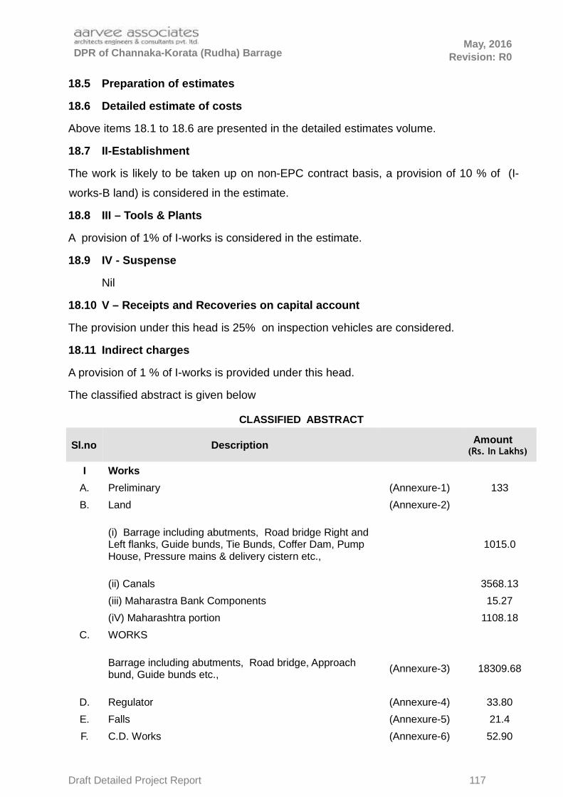
DPR of Channaka-Korata (Rudha) Barrage May, 2016
Revision: R0
18.5 Preparation of estimates
18.6 Detailed estimate of costs
Above items 18.1 to 18.6 are presented in the detailed estimates volume.
18.7 II-Establishment
The work is likely to be taken up on non-EPC contract basis, a provision of 10 % of (I-
works-B land) is considered in the estimate.
18.8 III – Tools & Plants
A provision of 1% of I-works is considered in the estimate.
18.9 IV - Suspense
Nil
18.10 V – Receipts and Recoveries on capital account
The provision under this head is 25% on inspection vehicles are considered.
18.11 Indirect charges
A provision of 1 % of I-works is provided under this head.
The classified abstract is given below
CLASSIFIED ABSTRACT
Sl.no Description Amount (Rs. In Lakhs)
I Works
A. Preliminary (Annexure-1) 133
B. Land (Annexure-2)
(i) Barrage including abutments, Road bridge Right andLeft flanks, Guide bunds, Tie Bunds, Coffer Dam, Pump House, Pressure mains & delivery cistern etc.,
1015.0
(ii) Canals 3568.13
(iii) Maharastra Bank Components 15.27
(iV) Maharashtra portion 1108.18
C. WORKS
Barrage including abutments, Road bridge, Approach bund, Guide bunds etc.,
(Annexure-3) 18309.68
D. Regulator (Annexure-4) 33.80
E. Falls (Annexure-5) 21.4
F. C.D. Works (Annexure-6) 52.90
Draft Detailed Project Report 117

DPR of Channaka-Korata (Rudha) Barrage May, 2016
Revision: R0
G. Bridges (Annexure-7) 9.50
H. Escapes NIL
I. Off takes & DPs (Annexure-8) 49.9
J Pump House And Pressure Mains etc (Annexure-9) 5645.21
K. Buildings
L. Earth Work & Lining of Canals (Annexure-10) 231
M. Plantation (Annexure-11) 4.00
N. Tanks and Reservoirs. NIL
Q. Special T & P 10.00
R. Communications. 100.00
S Electro Mechanical works (Annexure-12) 2025.60
U Distributories and Minors (Annexure-13) 1833.30
V Field channels (Annexure-14) 247.50
X. Environment & Ecology NIL
34413.45
O. Miscellaneous 4 % of I – works 1,376.54
P. Maintenance 1% of I - work except A+B+O+M+Q+X+Y 285.60
Y.Loss of Stock 0.25% fo I - work except A+B+O+M+P+Q+X
71.40
Total of I-Works 36146.99
IIEstablishment Charges @ 10 % on works less 'B' Land
3,044.04
III T&P @ 1% on I-works. 361.47
V Receipts and Recoveries.
a) 15 % of the cost of Temporary buildings 0.00
b) 25 % of the cost of the inspection vehicles 2.50
Total Cost of Direct charges 3408.01
VI In direct Charges
a)Abutment of Land Revenue @ 5% of the cost of the Cul-turable land.
NIL
b) Audit and accounts charges at 1% of I-works 361.47
Total Cost of Indirect charges 361.47
Total Cost of Direct and Indirect charges 3769.48
Total Cost in lakhs 39916.47
or say 39916.47
Draft Detailed Project Report 118

DPR of Channaka-Korata (Rudha) Barrage May, 2016
Revision: R0
CHAPTER 19
FINANCIAL RESOURCES
19.0 FINANCIAL RESOURCES
19.1 Total resources of the state and their utilisation for developmental activities--
sector wise resources for the last five years – will be provided in Detailed
Project Report Stage
19.2 Present position of the scheme regarding its inclusion in the plan
concurrence of the State Planning Finance Department - The G.O.R.T No.828
has been enclosed
19.3 Provision for the sector/for the scheme in the plan. Irrigation -The above
mentioned Go issues with the concurrence of Finance (W & P) Department vide
heir U.O No.7275/236/W&P/A1/2015, dated.18.11.2015.
19.4 Central/foreign aid contemplated, if any. -Not Provided at DPR Stage
19.5 Information on similar / related pending projects in the state, their status,
stage/percentage of completion, percentage of expenditure incurred and
average annual expenditure by the state on these projects put together year-
wise during the Last 5 years. - Not Provided at DPR Stage
19.6 Commitment on the work in progress in the plan and allocation available for
starting new scheme. - Not Provided at DPR Stage
19.7 Effect of inclusion of the scheme in the plan on the schedule of other works
in progress budget staff etc. - Not Provided at DPR Stage
19.8 Requirement of funds for the scheme and its yearly phasing as in project
report - Not Provided at DPR Stage
19.9 Adequate/strengthening of organisational set up for execution for all projects
together as contemplated - Not Provided at DPR Stage
19.10 Advance action proposal for starting the preliminaries of the project, if any.
Not Provided at DPR Stage
Draft Detailed Project Report 119

May, 2016
DPR of Channaka-Korata (Rudha) Barrage Revision: R0
CHAPTER 20
BENEFIT - COST RATIO, FINANCIAL RETURN & INTERNAL RATE OF RETURN
B.C. RATIO
The B.C. Ratio for the joint project is 1.60
. Project Cost 399.16
Crores
BENEFIT COST RATIO (BCR) Prop. Command Area :6680 ha
S.No.
Description
WithoutProject
With Project
Amount in Lakhs
A. GROSS RECEIPT
1 Gross value of farm produce 5144.92 15513.72
2 Dung receipts (as 30% of the fodder expenditure) 0.00 0.00
3 Total (A) : Gross Receipt (1+2) 5144.92 15513.72
B EXPENSES :
1 Expenditure on seeds,manure & labour etc 3138.19 5006.80
2 Expenditure on manure etc
3 Expenditure on hired labour (human and bullock)
Without Project With Project
4Fodder expenses 15% of Item A.1 10% of Item A.1
5Depreciation on implements 2.7% of Item A.1 2.7% ofItem A.1
138.91 418.87
6Share and Cash rent 5% of Item A.1 3% of Item A.1
257.25 465.41
7Land Revenue 2% of Item A.1 2% of Item A.1
102.90 310.27
8 Total (B) : Expenses (1 to 7) 3637.24 6201.36
C NET VALUE OF PRODUCE
1 Total Gross receipts (Total A.3) 5144.92 15513.72
2 Minus total expenses (Total B.8) 3637.24 6201.36
3 Net Value of Produce (C) : (1-2) 1507.68 9312.36
D ANNUAL AGRICULTURAL BENEFITS
1 Net value with project benefits by irrigation (C.3) 9312.36
2 Minus Net value without project by irrigation (C.3) 1507.68
3 Net Annual Benefits (D) : (1-2) 7804.68
E Other net annual benefits due to aqua-culture in-cluding pisiciculture, drinking & industrial watersupply, hydro - power generation, animal hus-bandry, catchment area treatment chargeable toproject, canal bank plantation, reservoir periph-ery afforestation
Draft Detailed Project Report 120

May, 2016
DPR of Channaka-Korata (Rudha) Barrage Revision: R0
Drinking water supply (0.043 TMC or 12.18 lakh cums ) as per CWC guidelines and Rs. 10 per KL 121.78
Fisheries
Reservoir area (average of area at FRL & MDDL) 238.60 Ha
Rates as per fisheries Department10000 per
Ha
Benefits 23.86
Animal Husbandry
No. of Cows 12000
Yield per cow per month 3960
Benefits 475.20
F Total Net Annual Benefits (D.3 + E) in Lakhs 8425.51
G ANNUAL COSTS :
Total cost of the project including Hydro power gener-ation
39916.47
39916.47
1Interest on capital @ 10% estimated cost of the project
3991.65
2 Depreciation Cost
Civil works @ 1% of the cost of the project for 100 years life of the project.
181.28
Rising main @ 3.33% on Rs.4766.98lakhs 158.74
Pumping Machinery @ 8.33% on Rs.2025.6 lakhs 168.73
3Annual operation and maintenance charges @ Rs.180 per ha of CCA 6680Ha.
12.02
4Maintenance of the head works @ 1% of its cost (Barrage)
181.28
5 Power charges @ Rs. 2.36/kW for 8.44 MW 573.65
6 Total(G) : Annual Costs (1 to 5) 5267.36
BENEFIT COST RATIO = Annual Benefits / Annual Costs = 1.60
Draft Detailed Project Report 121