Embed Size (px)
Citation preview

The hydrographic basin of the lake
extends over an area of about 2.4 million
km2, half of which is desert. This is shared
by the four riparian countries, as well as
by Algeria, the Sudan and the Central
African Republic [1.7].
The conventional basin was established in
1964, by convention of the four riparian
countries, as the area to be jointly
managed by the Lake Chad Basin
Commission. It covers an area of 427 300
km2 which stretches from latitudes 10° to
16°N and from longitudes 9° to 18°E. Its
hydrographic basin is composed of the
Chari–Logone–El-Beïd and
28[
[
T H E L A K E A N D I T S E C O S Y S T E M S
Komadugu–Yobé river systems [1.6]. The
term “basin” used in this book generally
refers to this area.
When the Central African Republic joined
the Commission in 1994, the conventional
basin was extended and it now covers an
area of about 967 000 km2. In 2000, the
Sudan also joined the Commission.
MAP SHOWING THE HYDROGRAPHIC AND CONVENTIONAL BASINS OF LAKE CHAD
DA
TA
EL
AB
OR
AT
ED
FR
OM
LIV
ES
TO
CK
AT
LA
S O
F T
HE
LA
KE
CH
AD
BA
SIN
[1.6
]
T H E B A S I N
HYDROGRAPHIC BASIN CONVENTIONAL BASIN EXTENDED CONVENTIONAL BASIN
chap01_thelake_37 7-02-2008 12:18 Pagina 28
]29
TH
E
FU
TU
RE
I
S
AN
A
NC
IE
NT
L
AK
E
[
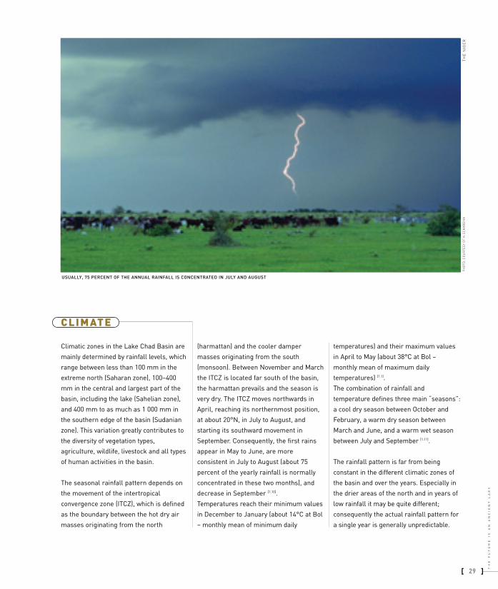
USUALLY, 75 PERCENT OF THE ANNUAL RAINFALL IS CONCENTRATED IN JULY AND AUGUST
TH
E N
IGE
R
Climatic zones in the Lake Chad Basin are
mainly determined by rainfall levels, which
range between less than 100 mm in the
extreme north (Saharan zone), 100–400
mm in the central and largest part of the
basin, including the lake (Sahelian zone),
and 400 mm to as much as 1 000 mm in
the southern edge of the basin (Sudanian
zone). This variation greatly contributes to
the diversity of vegetation types,
agriculture, wildlife, livestock and all types
of human activities in the basin.
The seasonal rainfall pattern depends on
the movement of the intertropical
convergence zone (ITCZ), which is defined
as the boundary between the hot dry air
masses originating from the north
(harmattan) and the cooler damper
masses originating from the south
(monsoon). Between November and March
the ITCZ is located far south of the basin,
the harmattan prevails and the season is
very dry. The ITCZ moves northwards in
April, reaching its northernmost position,
at about 20°N, in July to August, and
starting its southward movement in
September. Consequently, the first rains
appear in May to June, are more
consistent in July to August (about 75
percent of the yearly rainfall is normally
concentrated in these two months), and
decrease in September [1.10].
Temperatures reach their minimum values
in December to January (about 14°C at Bol
– monthly mean of minimum daily
temperatures) and their maximum values
in April to May (about 38°C at Bol –
monthly mean of maximum daily
temperatures) [1.1].
The combination of rainfall and
temperature defines three main “seasons”:
a cool dry season between October and
February, a warm dry season between
March and June, and a warm wet season
between July and September [1.11].
The rainfall pattern is far from being
constant in the different climatic zones of
the basin and over the years. Especially in
the drier areas of the north and in years of
low rainfall it may be quite different;
consequently the actual rainfall pattern for
a single year is generally unpredictable.
CLIM ATE
PH
OT
O:
CO
UR
TE
SY
OF
N.S
CH
AR
EIK
A
chap01_thelake_37 7-02-2008 12:18 Pagina 29

30[
[
T H E L A K E A N D I T S E C O S Y S T E M S
The Lake Chad Basin is a sedimentary
basin formed in the Mesozoic era.
Fluctuations are not new to Lake Chad.
Fossils and the landscape of the area show
evidence of wide fluctuations in the
palaeoclimate, with periods alternating
from very arid to very humid. During arid
phases the lake dried out completely and
dunes were formed.
During humid phases the lake extended
over increasingly larger areas, to a
maximum of about 400 000 km2 (also
known as Megachad). At least three such
major cycles have been identified in the
period from 55 000 to 6 500 years before
present (BP) [1.12]. The current climatic arid
phase started about 4 500 years BP. It is
characterized by the presence of the
Sahara Desert in the northern part of the
basin and by a lake surface area not
exceeding about 25 000 km2.
The presence of prehistoric humans in the
basin is well documented and is closely
linked with these climate fluctuations, as
these humans almost disappear during the
most arid periods. Fossil evidence shows
that populations relied on fish and other
lake and river fauna for food.
Even in recent ages, geological data and
historical records show how the alternation
of humid and arid periods caused
correspondingly wide fluctuations in the
lake level. In the second millennium BC, the
arid climate caused the population to
concentrate in a few scattered oases and
led to the development of nomadism.
HISTORY
A MAP PRODUCED IN 1653 BY P. DU VAL D’ABBEVILLE FOR THE KING OF FRANCE LOUIS XIV. LAKE CHAD IS SHOWN WITH THE NAME “LAC DE BORNO” [1.13]
chap01_thelake_37 7-02-2008 12:18 Pagina 30

way back, they would carry slaves captured
in the southern part of the Kanem-Bornu
kingdom. More recently, this trade
continued with wheat and natron, etc.
A people called Zaghawa ruled Kanem
until 1075, when the dynasty of Sefuwa
became dominant. From 1210 to 1248,
King Dunama Dibolami brought the
Kingdom of Kanem to its peak. The
kingdoms of Bornu and Kawar were
unified under Kanem and trade was very
active. Between 1382 and 1387, Kanem
was annexed to the territories of Bulala,
and the Bornu Empire dominated the
region. Until the mid-nineteenth century,
Kanem–Bornu remained a powerful state
but, after European occupation, the
population and its wealth decreased
rapidly [1.14].
In the first half of the sixteenth century the
lake almost disappeared but, by the end of
the following century, the lake surface was
about 25 000 km2 in area. Another
significant arid period was recorded in the
first half of the nineteenth century [1.14].
More precise data are available concerning
the recent history of the lake, since the
beginning of the twentieth century: the
highest level was reached in the 1960s (a
surface area of 25 000 km2 in 1962/63),
while the lowest levels were reached
during the droughts of the 1970s and
1980s (less than 2 000 km2 of open water
surface area in 1990). In the last few years
there has been evidence of a trend
inversion [1.11], although the lake must still
be considered as being in the Lesser Chad
condition hydrologically.
As for the populations, during the first
millennium BC the Sao and Daima
civilizations were already present in the
south of the Lake Chad Basin and Nok
people were found in the southwest.
Agriculture, fishery and pastoralism were
the main activities.
According to legends, there was a
flourishing civilization to the south of the
Lake Chad Basin from 700 to 1050 AD.
Textiles and pottery have been found, as
well as defensive walls, built probably
against the Kanembu. Trade flourished
after the fourth century as a result of the
introduction of camels, which enabled
connections between the Mediterranean
Sea and the Lake Chad Basin. The caravans
used to carry products from the north, as
well as weapons and precious fabric. On the
]31
TH
E
FU
TU
RE
I
S
AN
A
NC
IE
NT
L
AK
E
[
WIDE FLUCTUATIONS IN LAKE LEVELS HAVE BEEN DOCUMENTED THROUGHOUT THE AGES. THE CURRENT ARID PHASE STARTED ABOUT 4 500 YEARS BP
EA
ST
OF
N'G
UIG
MI,
TH
E N
IGE
R
chap01_thelake_37 7-02-2008 12:18 Pagina 31

32[
[
T H E L A K E A N D I T S E C O S Y S T E M S
A TOTAL OF 11 MILLION PEOPLE LIVE IN THE LAKE CHAD BASIN. IN CHAD, ALONE, MORE THAN 130 LANGUAGES ARE SPOKEN
NE
AR
BO
L,
CH
AD
chap01_thelake_37 7-02-2008 12:18 Pagina 32
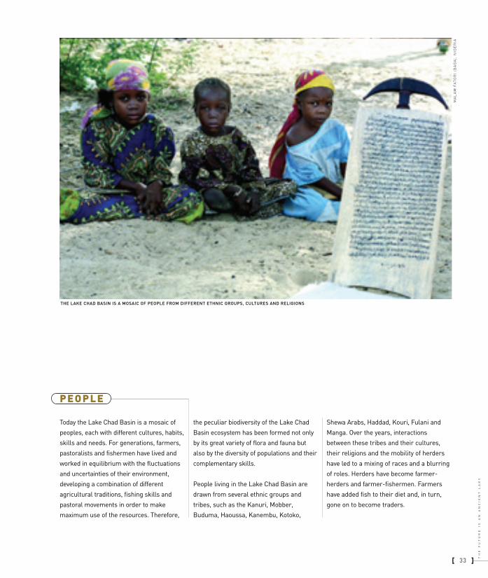
Today the Lake Chad Basin is a mosaic of
peoples, each with different cultures, habits,
skills and needs. For generations, farmers,
pastoralists and fishermen have lived and
worked in equilibrium with the fluctuations
and uncertainties of their environment,
developing a combination of different
agricultural traditions, fishing skills and
pastoral movements in order to make
maximum use of the resources. Therefore,
the peculiar biodiversity of the Lake Chad
Basin ecosystem has been formed not only
by its great variety of flora and fauna but
also by the diversity of populations and their
complementary skills.
People living in the Lake Chad Basin are
drawn from several ethnic groups and
tribes, such as the Kanuri, Mobber,
Buduma, Haoussa, Kanembu, Kotoko,
Shewa Arabs, Haddad, Kouri, Fulani and
Manga. Over the years, interactions
between these tribes and their cultures,
their religions and the mobility of herders
have led to a mixing of races and a blurring
of roles. Herders have become farmer-
herders and farmer-fishermen. Farmers
have added fish to their diet and, in turn,
gone on to become traders.
]33
TH
E
FU
TU
RE
I
S
AN
A
NC
IE
NT
L
AK
E
[
THE LAKE CHAD BASIN IS A MOSAIC OF PEOPLE FROM DIFFERENT ETHNIC GROUPS, CULTURES AND RELIGIONS
MA
LA
M F
AT
OR
I (B
AG
A),
NIG
ER
IA
P E O P L E
chap01_thelake_37 7-02-2008 12:18 Pagina 33
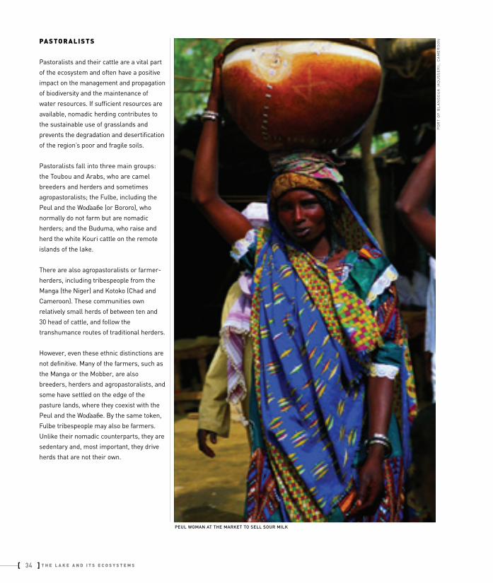
PEUL WOMAN AT THE MARKET TO SELL SOUR MILK
PO
RT
OF
BL
AN
GO
UA
(K
OU
SS
ER
I),
CA
ME
RO
ONPASTORALIST S
Pastoralists and their cattle are a vital part
of the ecosystem and often have a positive
impact on the management and propagation
of biodiversity and the maintenance of
water resources. If sufficient resources are
available, nomadic herding contributes to
the sustainable use of grasslands and
prevents the degradation and desertification
of the region’s poor and fragile soils.
Pastoralists fall into three main groups:
the Toubou and Arabs, who are camel
breeders and herders and sometimes
agropastoralists; the Fulbe, including the
Peul and the Wodaabe (or Bororo), who
normally do not farm but are nomadic
herders; and the Buduma, who raise and
herd the white Kouri cattle on the remote
islands of the lake.
There are also agropastoralists or farmer-
herders, including tribespeople from the
Manga (the Niger) and Kotoko (Chad and
Cameroon). These communities own
relatively small herds of between ten and
30 head of cattle, and follow the
transhumance routes of traditional herders.
However, even these ethnic distinctions are
not definitive. Many of the farmers, such as
the Manga or the Mobber, are also
breeders, herders and agropastoralists, and
some have settled on the edge of the
pasture lands, where they coexist with the
Peul and the Wodaabe. By the same token,
Fulbe tribespeople may also be farmers.
Unlike their nomadic counterparts, they are
sedentary and, most important, they drive
herds that are not their own.
34[
[
T H E L A K E A N D I T S E C O S Y S T E M S
chap01_thelake_37 7-02-2008 12:18 Pagina 34

ARAB PASTORALIST AT THE WELL NEAR LOWA
WODAABE YOUTH AT THE WELL NEAR KABELEWA
KA
BE
LE
WA
VIL
LA
GE
(N
'GU
IGM
I),
TH
E N
IGE
R
]35
TH
E
FU
TU
RE
I
S
AN
A
NC
IE
NT
L
AK
E
[
TA
L D
ES
ER
T (
N'G
UIG
MI)
, T
HE
NIG
ER
chap01_thelake_37 7-02-2008 12:18 Pagina 35

36[
[
T H E L A K E A N D I T S E C O S Y S T E M S
KANEMBU WOMAN
DU
MB
A V
ILL
AG
E (
BA
GA
), N
IGE
RIAFARMERS
Almost all of the communities in the Lake
Chad Basin grow crops to some extent.
Among these tribes are the Haoussa,
Mobber (Kanuri), Kanembu, Buduma,
Shewa Arabs, Dadjo, Kouri and Sara.
Most farmers have limited land and labour.
Soils are generally of marginal quality and
rainfall is unpredictable. In addition, markets
are scattered and difficult to reach and the
population is scattered and mainly rural. As
a consequence, farmers adopt subsistence
strategies. Rather than looking for high
yields, they select their seed according to
its capacity to resist drought and disease, to
produce on poor soils and to leave sufficient
amounts of residues that can be used as
animal feed or left on the ground to increase
soil fertility. Market prices for agricultural
products are generally low, so farmers have
no interest in producing a surplus for sale
at market, which would require additional
input in terms of labour and fertilizers.
As a result, although there is great
potential for increasing food production in
the Lake Chad Basin, most of the
production is still for household
consumption, and only a small portion of
the cereals produced in the area reaches
the marketplace. Taste also plays an
important role and most farmers select and
grow cereals that best suit their processing
and cooking habits.
The livelihood of farmers depends to a
great extent on the crops that they are able
to grow. At rainfall levels of 250–500 mm
per annum, millet and sorghum are
predominant. At rainfall levels of 500–750
mm, cereals, groundnuts and vegetables
may be grown. Where levels reach 1 000
mm, cultivated crops include rice, wheat,
maize, sorghum, groundnuts, cotton and
forage crops.
chap01_thelake_37 7-02-2008 12:18 Pagina 36

]37
TH
E
FU
TU
RE
I
S
AN
A
NC
IE
NT
L
AK
E
[
ABOVE AND BELOW: SOME FARMERS PRODUCE MOSTLY RAINFED CROPS, WHILE OTHERS ARE ABLE TO GROW TWO OR EVEN THREE CROPS USING RECESSIONAL LAND
DA
NO
UW
AN
E V
ILL
AG
E (
N'G
UIG
MI)
, T
HE
NIG
ER
MA
LA
M K
OU
RN
AD
I V
ILL
AG
E (
DIF
FA
), T
HE
NIG
ER
chap01_thelake_37 7-02-2008 12:18 Pagina 37

38[
[
T H E L A K E A N D I T S E C O S Y S T E M S
FISH IS AN IMPORTANT SOURCE OF PROTEIN FOR THE INHABITANTS OF THE LAKE CHAD BASIN
DO
RO
LE
LE
WA
VIL
LA
GE
(N
'GU
IGM
I),
TH
E N
IGE
RF I S H E R M E N
Around the islands of Lake Chad, people
from communities such as the Buduma,
Kanembu, Haoussa, Kotoko, Masa, Kanuri,
Kim and Kabalay all make their living by
fishing. There are estimated to be at least
20 000 professional fishermen in the lake
basin, with the highest numbers
concentrated in Chad and Cameroon,
although over 300 000 people fish as a part-
time activity. As well as in the lake itself,
fishing is also practised along the Chari and
Logone rivers and within the floodplain
areas of the lake and rivers.
Many people fish the waters of the lake, the
rivers and the wadis or pools for domestic
consumption – fish is an important source
of protein in the region. Fish is also an
important trading commodity, and many
people are involved at different stages of
the fish marketing operations. So far,
fishing has been practised according to
seasonal fluctuations of the water basins,
and there appears to be room for
developing this important economic asset.
chap01_thelake_37 7-02-2008 12:18 Pagina 38

OVER 300 000 PEOPLE FISH IN THE LAKE CHAD BASIN AS A PART-TIME ACTIVITY
DO
RO
LE
LE
WA
VIL
LA
GE
(N
'GU
IGM
I),
TH
E N
IGE
R
]39
TH
E
FU
TU
RE
I
S
AN
A
NC
IE
NT
L
AK
E
[
FISH TRADER AT THE MARKET IN BALATUNGUR PORT
BA
LA
TU
NG
UR
VIL
LA
GE
(B
OS
SO
), T
HE
NIG
ER
chap01_thelake_37 7-02-2008 12:18 Pagina 39
People and societies of theLake Chad Basin
by Pierluigi Agnelli *
Names of the people
The names given to different ethnic groups
often reflect historical situations or how the
groups are viewed by their neighbours. For
example, the inhabitants of the islands, who
used to hide themselves in the thick island
vegetation to protect themselves from other
groups, call themselves “Yedna” but are
more commonly known as “Buduma”, which
in Kanembu language means “people living
in water grasses”. Mobber people – farmers
who have settled in the Komadugu-Yobé
area – are called “Doho”, meaning “they
have arrived and we have also arrived”, by
the Tumagri Kanembu of the Niger. Kotoko
people make a distinction between Saway
Arabs (la gadi, meaning “Arabs coming from
the east”) and Suwa Arabs (saway gogi,
meaning “curdled milk Arabs” or “small Arabs”).
The Kanuri are distinguished as “big Bornu”
and “small Bornu”; the first term refers to those
who live in Bornu, and the second to those who
live temporarily in the Kotoko fishing zones.
Kanembu and Kanuri societies
These societies have only recently accepted
state organization, and some aspects of the
former Kanem–Bornu Empire social structure
are still apparent.
In the Kanem (Chad) each member of the
village obeys a village chief (Marama in
Kanembu and Buluma in Arabic). His title is
hereditary, but he is sometimes elected by the
heads of families. A group of villages is ruled by
the Maï, or Chef du canton (formerly called
“sultan”), who is the representative of central
administration. He is generally chief of an
ethnic group, although a “canton” is not always
ethnically homogeneous. Finally, at the top of
the pyramid, there is the Alifa of Mao, supreme
chief of the Kanembu people. He collects part
of the village taxes and is the depositary of land
titles for his territory.
In the Bornu (Nigeria) the village chief is also
called Buluma, and a group of ethnically
homogeneous villages is called a Lawanat and is
ruled by a Lawan (race chief). A group of
Lawanats is ruled by an Adji or Adja assisted by
a counsellor. The Adji is nominated by the Shehu
of Maiduguri who is the highest authority in the
entire territory of the ancient Kingdom of Bornu.
The authority of the Shehu is also recognized by
other people. When the Katchella (chief) of the
Mobber of Bosso pays a visit to the Shehu, he
does not wear the traditional boubou but a
goatskin on his shoulders as a sign of respect.
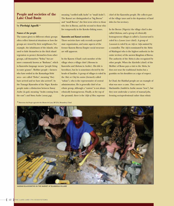
In Chad, the Haddad people are an example of
what was once a caste. They used to be
blacksmiths (haddid in Arabic means “iron”), but
they now undertake a variety of manual jobs,
forming socioprofessional rather than ethnic
HADDAD BLACKSMITHS IN THE MARKET AT BLANGOUA VILLAGE
BL
AN
GO
UA
VIL
LA
GE
(K
OU
SS
ER
I),
CA
ME
RO
ON
* Directeur du Projet agricole des Monts de Lam, BP 254, Moundou, Chad
40[
[
T H E L A K E A N D I T S E C O S Y S T E M S
chap01_thelake_37 7-02-2008 12:18 Pagina 40

groups. They generally marry within their own
group. Haddad people are shoemakers,
hunters, farmers, natron extractors, butchers,
griots, musicians, masons, and radio- and watch-
repairers. In addition, Haddad women carry
out artisanal work such as pottery making, dihé
extraction and midwifery. All these jobs are
often considered degrading activities, but this
neglected group of people is now slowly gaining
social recognition thanks to education and their
highly prized work. Most of the Haddad people
live in the areas of N’Gouri and Massakori.
Kotoko society
Kotoko people live in two large territories, Mandegé
in the north and Lagwané, which lies south of a line
from Kousseri (Cameroon) to Ndufu (Nigeria).
The Kotoko developed an urbanized society
because the villages in their territory were
generally larger than those of their neighbours
from different ethnic groups. The various Kotoko
principalities are relatively independent. The
main political power rests with the Mé, or prince.
From the capital city, the Mé rules over several
groups of villages, each governed by a Mra, who
is selected directly by the Mé. Each village is ruled
by a Buluma, who is nominated by the Mra. In
the Mandegé region, the Buluma also takes the
role of land chief (Msitani, or Chef de terre). The
Buluma are elected by free men, grouped by
age, and therefore their role is very important.
In the larger agglomerations (over 1 000
people), such as Makari and Goulfey, the class
division is quite marked. At the top of the caste
system are the Fanawn people, who are
members of the prince’s family and hold the
political and economic power. They own large
homes and horses, and wear expensive clothes.
Then there are the Mirwada, or “land people”,
who produce goods for the city, and are
responsible for the traditional religious
ceremonies. At the lowest level are the Furukay,
or “children from the west”, who are
descendants of slaves captured in the west (i.e.
in the Mousgoun or Mouloui), and have the
humblest jobs. This hierarchy, although not so
well defined as in the past, still influences social
relationships among people.
THE HISTORICAL HOUSE OF THE KOTOKO SULTAN IN GAOUI
GA
OU
I V
ILL
AG
E (
N'D
JA
ME
NA
), C
HA
D
]41
TH
E
FU
TU
RE
I
S
AN
A
NC
IE
NT
L
AK
E
[
chap01_thelake_37 7-02-2008 12:18 Pagina 41

The four countries sharing Lake Chad,
Cameroon, Chad, the Niger and Nigeria, are
among the largest nations in Africa.
Between them, they cover a total area of
little less than 4 million km2, i.e. 13 percent
of the total surface of the continent [1.6].
Their total population of about 145 million
people is not evenly distributed: about 77
percent live in highly populated Nigeria, 10
percent in Cameroon and the rest in the two
northern and more arid countries, Chad
and the Niger. The population in the Lake
Chad Basin area is estimated at about 11
million people [1.6], [1.15].FOOD SECURITY AND POVERTY ALLEVIATION ARE IMPORTANT OBJECTIVES OF SUSTAINABLE DEVELOPMENT POLICIESIN LAKE CHAD BASIN COUNTRIES
NE
AR
BO
L,
CH
ADT H E C O U N T R I E S
42[
[
T H E L A K E A N D I T S E C O S Y S T E M S
TABLE 1 POPULATION DATA OF THE COUNTRIES SHARING LAKE CHAD
Cameroon
Chad
Nigeria
The Niger
World
* 1999 population data extrapolated from 1992 data [1.6] by applying growth rates [1.15] in the four countries Sources: UNDP, 2001 [1.15]
and CIRAD/CTA, 1996, for population data in the Conventional Basin [1.6]
74.8
41.0
62.6
15.3
79.2
38
73
43
41
–
34
54
90
34
–
COUNTRY
Total population
in 1999
(MILLIONS)
Population
in the conventional
basin in 1999
(MILLIONS)*
Annual population
growth rate for
1999–2015
(%)
Adult
literacy rate
(%)
Population
not using improved
water sources
(%)
Population
without access
to essential drugs
(%)
2.1
3.0
2.5
3.6
1.2
2.9
3.8
3.7
0.25
–
14.6
7.6
110.8
10.5
5 862.7
TABLE 2 HUMAN DEVELOPMENT DATA OF THE COUNTRIES SHARING LAKE CHAD
Source: UNDP, 2001 [1.15]
40
64
34
63
–
COUNTRY
Human Development
Index (HDI)
HDI rank
(out of 162 countries)
Gross domestic
product per capita
(PPP* US$)
Population below
national poverty line
(%)
1 573
850
853
753
6 980
125
155
136
161
–
0.506
0.359
0.455
0.274
0.716
Cameroon
Chad
Nigeria
The Niger
World
* PPP = purchasing power parity
chap01_thelake_37 7-02-2008 12:18 Pagina 42

]43
TH
E
FU
TU
RE
I
S
AN
A
NC
IE
NT
L
AK
E
[
chap01_thelake_37 7-02-2008 12:18 Pagina 43

Papyrus canoes on Lake Chad
9 March 2002In open waters, Lake Chad
Returning to Bol by boat, we encounter on the
way a number of fishermen. These days, their
boats are all made of plywood, called madré; a
factory-made material that comes from Nigeria.
The famous papyrus canoes, kadey in the Buduma
language, once the only mode of transport on
the lake, belong to the past or probably to the
poorest fishermen living on the most remote of
the islands. From a distance, we make out the
shape of just such a vessel on the shores of the
island of Goergilom, half hidden by the reeds.
It belongs to a very elderly looking fisherman,
who, as we later find out, lives by himself in a
hut a few metres from the lake shore.
The bearded old man moves very slowly and is
helped by a young boy who looks about ten
years old. Together, they prepare a fish for the
market, splitting it down the middle and placing
it over a rudimentary grill. Smoke rises slowly
from the makeshift fire. It is all very simple, but
it appears to be effective as well.
The “mythical” papyrus canoe turns out to be
extremely small and very old. It is pulled up
on the shore; we want to try it out, but it
hardly floats any more. It is a far cry from the
huge vessels that once took to the open
waters, their great prows curved to look like
an elephant’s tusk. André Gide wrote about
just such a boat in his Voyage au Congo and
Retour au Tchad in 1925. “They don’t use wood
to build their boats. Using thick mats made
out of papyrus, they make long rafts with a
curved prow, a bit like a gondola,” wrote the
French author. “These extraordinary vessels
are propelled by long poles, which are often
imported from far away.” Gide’s travelling
companion Allégret took a superb photograph
of the vessel.
These papyrus boats are the same as the ones
still found, even today, on Lake Titicaca in Peru
and on Lakes Tana and Zwai in Ethiopia. They
also bear a striking resemblance to vessels
depicted in the paintings and bas-reliefs of the
Not
es fr
om a
jour
ney
TRADITIONAL PAPYRUS CANOES ARE BEING REPLACED WITH BOATS MADE FROM IMPORTED PLYWOOD
GO
ER
GIL
OM
IS
LA
ND
(B
OL
), C
HA
D
ancient Egyptians, more than 4 000 years ago.
This was the method of transport used by the
pharaohs. In fact it was believed that a crocodile
would never attack a boat made out of papyrus,
since this was the material used to make the boat
in which the goddess Isis travelled, on her search
to find the dead body of her beloved Osiris.
In spite of their apparent fragility, boats made
from papyrus (Cyperus papyrus) were
surprisingly strong and could be used on the
high seas. This was amply demonstrated in 1970
by one of the greatest and most intriguing
modern-day sailors, the Norwegian Thor
Heyerdahl, who created the Kon-Tiki (built
from balsawood) and later the Ra II, which was
entirely made from papyrus.
Heyerdahl recruited Buduma fishermen from
Lake Chad to build Ra II, and in the space of
just a few months they had made a magnificent
vessel, 12 m long. Heyerdahl used this vessel to
cross the Atlantic Ocean, in an effort to prove
his theory that ancient African sailors could
have reached the coast of the Americas long
before Christopher Columbus.
44[
[
T H E L A K E A N D I T S E C O S Y S T E M S
chap01_thelake_37 7-02-2008 12:18 Pagina 44

GO
ER
GIL
OM
IS
LA
ND
(B
OL
), C
HA
D
ABOVE AND BELOW: DESPITE THEIR FRAGILE APPEARANCE, PAPYRUS BOATS ARE SURPRISINGLY STRONG. THE BOAT USED BY THOR HEYERDAHL TO CROSS THE ATLANTIC OCEANWAS BUILT BY BUDUMA FISHERMEN
GO
ER
GIL
OM
IS
LA
ND
(B
OL
), C
HA
D
]45
TH
E
FU
TU
RE
I
S
AN
A
NC
IE
NT
L
AK
E
[
chap01_thelake_37 7-02-2008 12:18 Pagina 45