Embed Size (px)
Citation preview

____________________________________________________________________________________________________Ministry of Lands Draft Reference Paper on National Land Information Management Systems (NLIMS) Page 1 of 82
1 Chapter 1 Introduction
1.1 The Mandate of the Ministry The Ministry of Lands has the following functions as spelt out in the Presidential Circular No. 1/2008 of May 2008 on Organization of the Government of the Republic of Kenya: • Land Policy • Physical Planning • Land Transactions • Survey and Mapping • Land Adjudication • Settlement Matters • Land Registration • Valuation • Administration of State and Trust Land • Land Information System*
* For the first time an integrated National Land Information (Management) System (NLIMS) has been identified as an added core mandate of the Ministry and this is the focus of this Report Paper. 1.2 The Ministry’s Structure and Core Functions The core function of the Ministry is to manage and administer the land resource. The Ministry’s functions are critical to the realization of the National Development Goals and Objectives outlined in the Economic Recovery Strategy for Wealth and Employment Creation (ERSWEC), Vision 2030 and the Millennium Development Goals (MDGs); especially poverty reduction, infrastructure and economic growth. The structure of the Ministry of Lands is organized under the following departments: • Administration and Planning (Management and Support Services) • Survey • Physical Planning • Lands • Land Adjudication and Settlement The functions of the Ministry are detailed in the following paragraphs:
1.2.1 Administration and Planning The Department is responsible for: • Overall Policy Direction & Co-ordination • Planning and Management of Resources; Human and Financial • Legal Advisory Services • Coordination of Parastatals under the Ministry mandate • Liaison with International Organizations, Development Partners and other Stakeholders • Information Communication Technology (ICT) Services
____________________________________________________________________________________________________Ministry of Lands Draft Reference Paper on National Land Information Management Systems (NLIMS) Page 2 of 82
• Land Reform Transformation Unit (LRTU) • Public Relations • Cross cutting issues; Management Information Systems, Gender Mainstreaming and HIV
/AIDS control.
1.2.2 Survey The Department offers the following services: • Surveying and Mapping • Photogrammetric and Remote Sensing Services • Map Printing and General Publishing • Maintenance of Land Registration Maps • Inspection and re-establishment surveys of National and International Boundaries
• Provision of Hydrographical Survey Services • Supervision and Maintenance of Quality Control and Assurance on Surveying and
Mapping data • Pre-service and in-service Training Courses at the Kenya Institute of Surveying and
Mapping (KISM). This is an Institute of the Department of Survey that offers: Pre-service courses in Land Surveying, Cartography, Photogrammetry and Remote
Sensing and Map Reproduction at Diploma and Higher Diploma levels.
In-service training for the Ministry and other tailor-made short term courses such as Geographical Information System (GIS), Global Position System (GPS), and Remote Sensing for Mapping and Information Technology (IT).
Under the Ministry’s Rationalization Programme, KISM has been proposed for Semi-Autonomous Government Agency (SAGA) status.
1.2.3 Physical Planning The Department is responsible for:
• Formulation of national, regional and local physical development policies and guidelines
• Preparation of regional and local physical development plans
• Initiate and undertake research in matters concerning physical planning
• Advise Commissioner of Lands and on matters concerning alienation of land under Government Lands Act and Trust lands Act
• Advise the Commissioner of Lands, and Local Authorities on most appropriate use of land including land management (change of user, extension of lease, subdivision and amalgamation)
• Require local authorities to ensure proper execution of physical development controls and preservation orders
1.2.4 Lands The services offered in this Department include:
• Land Policy Formulation and Implementation • Management and custody of the land resource records

____________________________________________________________________________________________________Ministry of Lands Draft Reference Paper on National Land Information Management Systems (NLIMS) Page 3 of 82
• Administration of Government and Trust Lands • Registration of titles and various transactions • Land valuation for various purposes • Resolution of land and boundary disputes • Generation of revenue and collection of A.I.A
1.2.5 Land Adjudication and Settlement The Department is in charge of:
• Ascertaining land rights and interests under Caps 283 and 284 • Settlement of poor landless Kenyans under the Settlement Fund Trustees • Management of the Agricultural Settlement Fund • Administration of group ranches under Cap 287 of the Laws of Kenya.
1.3 Task Force on Automation of the Ministry’s Land Records
1.3.1 The Appointment of the Task Force The Ministry has been in operations for over 100 years and the amount of data generated has since accumulated to unmanageable levels using manual systems. In addition, the demand for land information has increased tremendously over the years. The manual system has therefore hampered service delivery in the Ministry. This has been noted by no lesser office than the Cabinet which, through the Standing Cabinet Committee on e-Government, vide letter Ref: OP/CAB 1/16A dated 11th May 2007 – see Appendix3b, directed the Ministry to establish a Task Force to spearhead the Automation Programme of the entire Ministry’s Land Records. In this regard, the Ministry appointed a Ministerial Task Force on Automation of all Ministry’s Land Records (MTF_AMLR) vide letter Ref: CON/LS/A/1/1 Vol.IV/57 of 25th May 2007 to address issues of computerisation of all the Ministry’s Land Records - see Appendix2a. The Task Force comprises of members from all the technical departments, namely; Survey, Physical Planning, Lands and Land Adjudication & Settlement as well as the ICT unit in the Ministry. The composition of the members of the Task Force is as indicated previously at page (iii) above.
1.3.2 The Mandate of the Task Force (a) Objectives The Task Force will be required to develop improved systems and process that would enhance service delivery and improve efficiency in line with the reform initiative being undertaken by the Government. (b) Terms of Reference The Task Force was mandated to address the following Terms of Reference (TOR) :- (see Appendix2a)

____________________________________________________________________________________________________Ministry of Lands Draft Reference Paper on National Land Information Management Systems (NLIMS) Page 4 of 82
1. Examine the current processes and practices and recommend efficient solutions.
Emphasize on cutting down on turn round time and resources without compromising the reliability.
2. Identify and take stock of all the relevant land records and data sets for capture and
computerization. 3. Carry out an update of the records 4. Determine linkages across the Department 5. Digitize all the land records and data sets identified at “2” above 6. Design and establish a computer based operation system to support and be responsive to
all the essential services. 7. Ensure that there is sufficient networking to provide for sharing of the data from within
the Ministry both for Headquarters and the field stations. 8. Any other assignment found necessary as we implement the programme.
1.3.3 How the Task Force Operated The Task Force embarked on the assignment by having its first meeting on 5th June 2007 by defining the scope of work. It subsequently held numerous other, daily and then weekly, technical meetings. Later on, between July-November 2007, the Ministry of Lands was placed under Rapid Results Initiative (RRI), a result Based Management (RBM) tool, by the Public Service Reform and Development Secretariat (PSR & DS), OP and the entire Task Force Team members was reconstituted into an RRI Team on Automation of the Land Records. The team identified and implemented five quick win goals in the Ministry (see Chapter 5 below). After the RRI period, the Task Force Team was, in April 2008 reconstituted as the Technical Working Group on Land Information Management System (LIMS) under the Land Reform Transformation Unit (LRTU) – see Appendix 3.
1.3.3.1 Interpretation of the TORs ToR No. 1: Examine the current processes and practices and recommend efficient solutions. Emphasize on cutting down on turn round time and resources without compromising the reliability.
The Task Force addresses the ToR No. 1 in three parts; one, to consider the situational analysis of the current procedures and practises; two to identify current Challenges and Weaknesses of these procedures; three, to provide solution of re-engineering of the processes. Parts one and two are considered in Chapter 2“Current Processes and Practices” with detailed diagrammatic explanations. The recommended solutions are presented, with others, in Chapter 7 on “Recommendations on Way Forward and Conclusions.”
ToR No. 2: Identify and take stock of all the relevant land records and data sets for capture and computerization; and ToR No. 3: Carry out an update of the record.
____________________________________________________________________________________________________Ministry of Lands Draft Reference Paper on National Land Information Management Systems (NLIMS) Page 5 of 82
The Task Force that ToR Nos. 2 & 3 to be related and hence it addressed the two ToRs together in Chapter 3 titled “Identification of the Key Land Records for Computerization”
ToR No. 4: Determine linkages across the Departments.
The ToR No. 4 is presented in Chapter 4“Linkages across the Departments”. Here the Task Force considered the internal and external customer linkages in service delivery by the Ministry. We therefore considered and addressed an additional ToR “Identify Key Customer Service Points and Services Offered by the Ministry”
ToR No. 5: Digitize all the land records and data sets identified at “2” above
The ToR No. 5 Having identified and taken stock of all the key land records to be considered for computerization, the Task Force embarked on implementation of some computerization. This chapter presents the 5 RRI Goals, achievements and lessons learned.
ToR No. 6: Design and establish a computer based operation system to support and be responsive to all the essential services. ToR No. 7: Ensure that there is sufficient networking to provide for sharing of the data from within the Ministry both for Headquarters and the field stations.
The Task Force found these two ToRs related as the ToRs are addressing the solution to all the situational analysis of Ministry presented in detail in the previous chapters 1-5. The Task Force designed some data bases for data capture. It presents recommendation of desired characteristics of a good database design for the Ministry of Lands that a procured technical expertise needs to adhere to.
ToR No. 8: Any other assignment found necessary as we implement the programme.
In July - November 2007 the entire Task Force Team was reconstituted into an RRI Team on Automation of the Land Records. The team identified and successfully implemented five (5) quick win RRI goals in the Ministry (see Chapter 5 below). After the completion of the RRI period and having registered good results, the Task Force was then transformed into a Working Group on Land Information System (LIMS) under the Land reform Transformation Unit (LRTU) - see Appendix2b.
The Task Force has summarized and presented its recommendations on the way forward and conclusion in chapter 7 of this Report. We feel that these recommendations should form a basis of current and future computerization projects in the Ministry.
1.3.3.2 Periodical Status Reports The Task Force made periodical reports on the status of computerization of Ministry’s land records to the Permanent Secretary (PS), Lands as was asked for by the Standing Cabinet Committee on e-Government – see Appendix 3b.
____________________________________________________________________________________________________Ministry of Lands Draft Reference Paper on National Land Information Management Systems (NLIMS) Page 6 of 82
1.3.3.3 NLIMS Project Proposal In September 2007, the Task Force made and presented a PROJECT PROPOSAL titled “Development and Implementation of an Automated National Land Information Management System (NLIMS)” to both the Director of e_Government, Office of the President (OP) and the Chief Executive Officer (CEO) of the Information Communication Technology (ICT Board) for consideration for funding by the World Bank under the Kenya Communication Transparency Project (KCTP) – see Appendix 7.
1.3.3.4 The Task Force as an RRI Team on Automation The team identified and successfully implemented the following five (5) quick win RRI goals in the Ministry (see Chapter 5 for results) as follows) : - • RRI No. 1 – Reconstruction of GLA Volumes/Land Records. • RRI No. 2 – Creation of a Property Valuation Database System. • RRI No. 3 – Document Management System (DMS) for All Approved Physical
Development Plans in the Country. • RRI No. 4 – Document Management System (DMS) for All Authenticated Cadastral
Survey Plans in the Country. • RRI No. 5 – File Tracking System for All Settlement Plot Files at the Ministry
Headquarters. This was the first time for ALL the 5 RRIs initiatives to be carried out at the Ministry of Lands!! For the summary of the results, – see Appendix 9.
1.3.3.5 The Task Force under the Land Reform Transformation Unit (LRTU) The Task Force was later incorporated into the Land Reform Transformation Unit (LRTU) as the Ministerial Technical Working Group on Land Information Management System (LIMS) vide letter Ref. No. CON/L/A/29/VOL.X/ of 4th April, 2008 - see Appendix2b - to coordinate and ensure that the computerization initiatives in all the departments of the Ministry are expanded and up scaled in an integrated manner. The Task Force, together with Sida Consultant Team (of Macleran & Mwathane) has developed a LIMS Implementation Programme under LRTU for Next 2 Years – see Summary Report in Appendix 13.
1.3.3.6 Kenya National Dialogue and Reconciliation: Agenda Item 4: Long-Term Issues and Solutions Matrix of Implementation Agenda
The issue on the computerization and automation of the Ministry’s Land Records, being addressed and presented here in this Report Paper by the Ministerial Task Force, is also being considered as a Land Reform issue, under the Kenya National Dialogue and Reconciliation – Agenda Item 4 – which calls for the “Establishment of a transparent, decentralized, affordable and efficient GIS-based Land Information Management System and a GIS-based Land Registry at the Ministry of Lands including all local authorities” – see Appendix 4.
____________________________________________________________________________________________________Ministry of Lands Draft Reference Paper on National Land Information Management Systems (NLIMS) Page 7 of 82
2 Chapter 2 The Current Processes and Practices
This Chapter examines the Current Processes and Practices in each of the four
technical departments of the Ministry. It also presents strengths and weaknesses in
these processes. However, re-engineering of these processes is presented later in
Chapter 7 on recommendations on the way forward.
2.1 Department of Lands Introduction
The department was founded in 1903 to operate the Crown Lands Ordinance
1902 as subsequently amended. Currently it consists of three Divisions
namely; Land Administration, Valuation and Land Registration.
2.1.1 Land Administration Division It is responsible for the administration of all Government Land and the Trust
Land on behalf of the County Councils.
2.1.3.1 Current Processes and Practices
i). Alienation of Government and Trust Land for institutional purposes and regularization of allocations by local authorities.
ii). Title preparation for Government and Trust Land under the Registration of
Titles Act Cap. 281 and the Registered Land Act Cap. 300.
iii). Issuance of land rent clearance certificate and consents
iv). Processing of development applications (change of user, extension of user and extension of lease)
v). Processing of Sub-division Schemes;
a. Private land within urban areas. Applications received through the local authorities or recommendations
for approval forwarded to the Commissioner of Lands by Local authorities
b. Processing of subdivision of Agricultural Land
vi). Processing applications for setting apart of Trust Land
vii). Approval of building plans

____________________________________________________________________________________________________Ministry of Lands Draft Reference Paper on National Land Information Management Systems (NLIMS) Page 8 of 82
viii). Establishment and oversee operation of the Land Control Boards
ix). Preservation of land for public use as well as preservation of fragile
ecosystems.
x). Plans Records Office – Checking of status, noting allocations, plotting of maps/plans, preparing forms for setting apart, etc.
xi). Preparation of Titles/Documents for institutions
xii). Processing of Court cases and Parliamentary Questions

____________________________________________________________________________________________________Ministry of Lands Draft Reference Paper on National Land Information Management Systems (NLIMS) Page 9 of 82
Diagram 2.1(1): Current Processes and Practices in Land Administration a) Alienation of Trustland for Regularization or Institutional Purposes
An application is forwarded to the respective County Council. The Application is
considered in a full council meeting and minutes taken before being forwarded to
the Minister for Local Government.
The application together with recommendations from the Minister for Local
Government is received by the Commissioner of Lands.
Data used • Applications
Documents • Topocadastral
maps Data created • Comments by CoL • Comments by
SPRO • Comments by DoS • Comments by DPP • Meeting Minutes • Valuation Report • Letter of Allotment • Payment Receipts • Survey plan • Title Document
An Application for Documentation
Commissioner of Lands/Land Officer
Records
SPRO for comments status
Application referred to Directors of Survey and Physical Planning for comments
Back to Land Officer
Departmental Committee to consider application
Minute for Authority to Document through SLO, ACL, SACL, DCL
Preparation of Title
Survey
Payment
Issuance of Letter of Allotment
Meeting with Minister and Permanent Secretary for approval
Valuation
Commissioner of Lands
____________________________________________________________________________________________________Ministry of Lands Draft Reference Paper on National Land Information Management Systems (NLIMS) Page 10 of 82
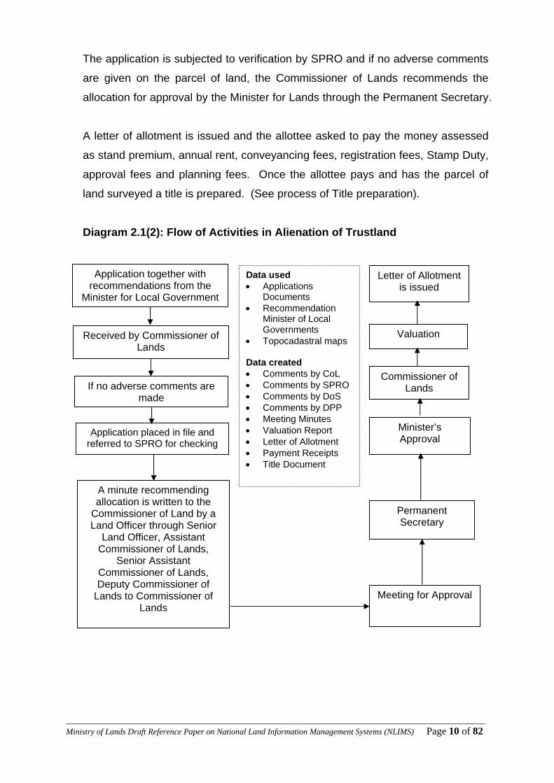
The application is subjected to verification by SPRO and if no adverse comments
are given on the parcel of land, the Commissioner of Lands recommends the
allocation for approval by the Minister for Lands through the Permanent Secretary.
A letter of allotment is issued and the allottee asked to pay the money assessed
as stand premium, annual rent, conveyancing fees, registration fees, Stamp Duty,
approval fees and planning fees. Once the allottee pays and has the parcel of
land surveyed a title is prepared. (See process of Title preparation).
Diagram 2.1(2): Flow of Activities in Alienation of Trustland
Data used • Applications
Documents • Recommendation
Minister of Local Governments
• Topocadastral maps Data created • Comments by CoL • Comments by SPRO • Comments by DoS • Comments by DPP • Meeting Minutes • Valuation Report • Letter of Allotment • Payment Receipts • Title Document
Application together with recommendations from the
Minister for Local Government
Received by Commissioner of Lands
Application placed in file and referred to SPRO for checking
If no adverse comments are made
A minute recommending allocation is written to the
Commissioner of Land by a Land Officer through Senior
Land Officer, Assistant Commissioner of Lands,
Senior Assistant Commissioner of Lands, Deputy Commissioner of
Lands to Commissioner of Lands
Meeting for Approval
Minister’s Approval
Commissioner of Lands
Valuation
Letter of Allotment is issued
Permanent Secretary
____________________________________________________________________________________________________Ministry of Lands Draft Reference Paper on National Land Information Management Systems (NLIMS) Page 11 of 82
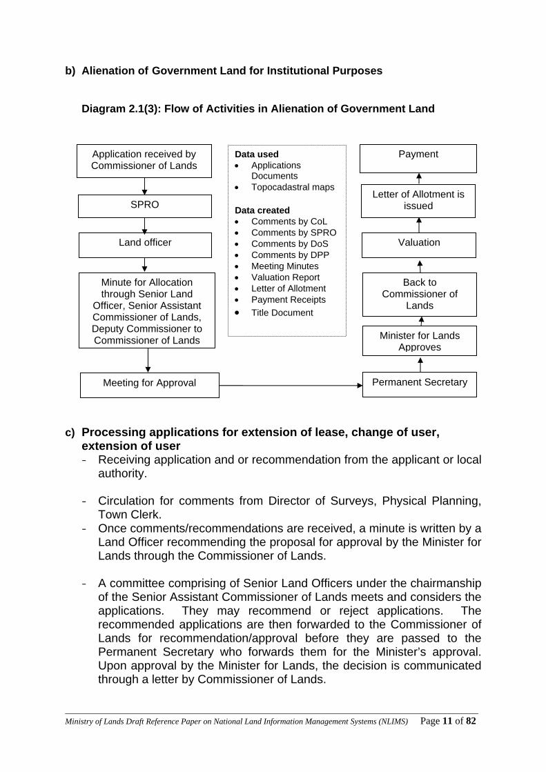
b) Alienation of Government Land for Institutional Purposes
Diagram 2.1(3): Flow of Activities in Alienation of Government Land
c) Processing applications for extension of lease, change of user,
extension of user - Receiving application and or recommendation from the applicant or local
authority. - Circulation for comments from Director of Surveys, Physical Planning,
Town Clerk. - Once comments/recommendations are received, a minute is written by a
Land Officer recommending the proposal for approval by the Minister for Lands through the Commissioner of Lands.
- A committee comprising of Senior Land Officers under the chairmanship
of the Senior Assistant Commissioner of Lands meets and considers the applications. They may recommend or reject applications. The recommended applications are then forwarded to the Commissioner of Lands for recommendation/approval before they are passed to the Permanent Secretary who forwards them for the Minister’s approval. Upon approval by the Minister for Lands, the decision is communicated through a letter by Commissioner of Lands.
Data used • Applications
Documents • Topocadastral maps Data created • Comments by CoL • Comments by SPRO • Comments by DoS • Comments by DPP • Meeting Minutes • Valuation Report • Letter of Allotment • Payment Receipts • Title Document
Application received by Commissioner of Lands
SPRO
Land officer
Minute for Allocation through Senior Land
Officer, Senior Assistant Commissioner of Lands, Deputy Commissioner to Commissioner of Lands
Meeting for Approval Permanent Secretary
Minister for Lands Approves
Valuation
Back to Commissioner of
Lands
Letter of Allotment is issued
Payment

____________________________________________________________________________________________________Ministry of Lands Draft Reference Paper on National Land Information Management Systems (NLIMS) Page 12 of 82
- Valuation for enhanced rent is done and the applicant asked to comply with certain conditions.
Preparation of Title of endorsement is done upon payment of some fees (see attached schedule for title preparation process).
d) Building Plans Approval
An application is received from the concerned Institution together with a plan showing the portion of land being applied for. The application is received and passed to Senior Plan Records Officer) SPRO for verification of the status. The application is minuted to Commissioner of Lands for approval. Upon approval the Institution is issued with a letter of allotment with conditions specifying the user of the plot and the fees payable. A file is opened and the allottee pays.
Diagram 2.1(4): Flow of Activities in Building Plans Approval
Building Plans received from Local Authority e.g.
Nairobi City Council
Building Plans filed
Passed to SPRO for calculation of site
coverage
Land Officer writes to owner to pay approval
fees
Payment
Approval of Building plans
Forwarding building plan to the owner and a
copy of the Local Authority
Data used • Building Plan • Topocadastral maps Data created • CoL letter to owner for
approval fee • Approval • Payment recepts
____________________________________________________________________________________________________Ministry of Lands Draft Reference Paper on National Land Information Management Systems (NLIMS) Page 13 of 82
2.1.2 Valuation Division The division is responsible for valuation of land and landed properties for various purposes. Common types of valuations carried out in the division are:- (i) Valuation for Stamp Duty
(ii) Valuation for subdivision (rent apportionment)
(iii) Valuation for Lease extension, change of user and extension of user
(iv) Valuation for Rating
(v) Valuation for alienation
(vi) Valuation for Government Purchase, Sale and Leasing
(vii) Valuation for purchase of freehold interest
(viii) Valuation for compulsory acquisition
(ix) Valuation for estate duty/public trustee administration
2.1.3.1 Current Processes and Practices The Processes have a common procedure which is as follows a) Instructions Instructions are received in a valuation requisition form which is filled in the correspondence file. Instructions for stamp duty are received from the Collector of Stamp Duty while instructions for rent apportionment, lease extension, change of user and alienation are received from a Land Officer. Valuation for Rating and Government Purchase/Sale/Leasing are received from other Ministries and Departments. b) Allocation by Chief Valuer The correspondence file is received at the Chief Valuation Officer’s (C.V.O’s) office. The Chief Valuer assigns the file to the action officer. c) Registry From the C.V.O. the file is forwarded to the Registry. Here a register is maintained where all the files allocated to valuers and the corresponding dates are indicated. d) Valuation The Registry staff forwards the file to the action officer. The valuer gets the necessary Plans/Maps, searches and arranges for field inspection. The valuer collects market data and then prepares the valuation report and the same discussed with the supervisor who countersigns the valuation. The valuer then indicates on the requisition form the value or rent returned and signs the form.

____________________________________________________________________________________________________Ministry of Lands Draft Reference Paper on National Land Information Management Systems (NLIMS) Page 14 of 82
e) Data Entry at Registry The file is forwarded back to the Registry for recording and filing. The following is done at the Registry at this stage:- i. Record in the Movement Register ii. Opening or updating of Cards: This Card indicates the following:-
(File Number, L.R. No., Area, Date of Valuation, Transferee, Transferor, Valuation Reference (V.O.S. No.), Value/Rent)
iii. Filing the Valuation Report
This is done in Box files which are classified into different zones (adopted from local authorities) depending on the locality of the property. The valuation report is given a reference number which is also indicated in the Card and in the requisition form for ease of reference.
f) Dispatch
File is dispatched to the instructing officer (collector of stamp duty or Land Officer) for further action.
Diagram 2.1(5): Flow of Activities in Valuation procedure
CVO assigns to action officer
File with requisition form received at CVO office
Registry- card opening & recording
Discussion and countersigning by the Supervisor
Report Writing & Valuation File received by
valuer
Preparation for fieldwork – maps, searches & transport.
Registry - recording
Field inspection
File returned to instructing officer
Data used • Request for valuation • Topocadastral maps Data created • Valuation report • Approval • Registry Card

____________________________________________________________________________________________________Ministry of Lands Draft Reference Paper on National Land Information Management Systems (NLIMS) Page 15 of 82
2.1.3 Land Registration Division
The division is responsible for all registration of titles in Kenya.
2.1.4.1 Current Processes and Practices
a) Stamping of Documents
i. Documents are presented for assessment of stamp duty at the banking hall.
ii. The Assessor of stamp duty confirms whether duty is payable and then issues a Kenya Revenue Authority (KRA) stamp duty assessment form to be completed and duly returned to the Assessor for purposes of assessment of duty.
iii. After counterchecking the information on the document and on the
assessment form the Assessor proceeds to assess stamp duty payable and appends his/her signature to the form thereby advising the applicant to proceed to pay the assessed duty at the Bank.
iv. After payment, the presentor brings back the document and the form which
has been duly stamped by the bank that payment was actually done.
v. The returns from KRA are brought to the stamping section after 2 days and it is only then that Stamping can be franked or embossed on the document.
vi. After the documents are stamped they are forwarded to the Accountant to
countercheck payments and then forwarded to the Auditors for audit purposes.
vii. The documents are then ready for dispatch.
CHALLENGES
1. The embossing machine is archaic and ancient dating back to 1958 which is physically handled and constantly breaks down. The process of repair by the Government printer is bureaucratic and takes too long.
2. Payments are done outside the building and the communication for confirmation of payment takes 2 days.
____________________________________________________________________________________________________Ministry of Lands Draft Reference Paper on National Land Information Management Systems (NLIMS) Page 16 of 82
b) Registration
The Central Registry registers titles and documents under the Registration of Titles Act (Cap 281), the Government Lands Act (Cap 280) and the Registration of Documents Act (Cap 285) and the Nairobi District Registry handles documents registered under the Registration of Lands Act (Cap 300). The process of Registration starts with collection of Stamp duty and other prescribed fees. Once the document is booked, it becomes an accountable instrument. After booking a document, deed files are matched, investigations done and then entered in the “A” Book. The Registrar of Titles signs the document and eventually it is copied and dispatched. A document follows the procedure described here below for its registration.
i. Booking Counter
The counter is the main window where documents are first presented and this is also the enquiries counter where members of the public are served. Documents are received and booked in this counter. The Applicant completes the Application for Registration forms in quadruplicate and makes the requisite fees by way of affixing revenue stamps on the original form. The documents, together with the forms are stamped with a date stamp indicating the date, the month, the year and the exact time when received. This becomes the legal date of registration. A Day Book number is given and indicated on both the documents and the forms and it is useful for a later follow-up in case there is a query on the document. One copy of the form is then given back to the presentor. The documents once booked are kept in the strong room up to the following day when they are worked on to give time for any other opposing document e.g. an encumbrance that may precede or follow a document. Applications for official search are also presented at the booking counter.
ii. Strong -Room The next day, the documents are taken to the auditor who checks them to ensure that payments in terms of stamp duty and the land rent have been paid, after which they are returned to the strong-room. The strong-room officer assigned the duty of matching documents then retrieves all the relevant deed files relating to the booked documents and matches them together. He also completes his morning list indicating the Deed files which have been retrieved from the strong-room and against what day book numbers. The morning list is important in helping trace deed files.
____________________________________________________________________________________________________Ministry of Lands Draft Reference Paper on National Land Information Management Systems (NLIMS) Page 17 of 82
The auditing and matching of documents in the strong-room takes about four hours. Documents are then forwarded to the Registry Superintendent (R/S)
iii. Registry Once the R/S receives the documents in the Registry, he marks them to the investigation officers and completes the movement register to show who is allocated what documents. This is called the “A” Book. This takes about one hour. Refer to Sec 26 of R.T.A.
iv. Investigation The investigation Officers check and examine whether the documents are properly drawn and whether there are any encumbrances that can prevent their registration. They also ensure that all the necessary files/documents from the strongroom are attached or matched with the documents to be registered. Once they examine the suitability of the documents, they make recommendations with reasons whether they should be registered or rejected. If they recommend for rejection, a given document will be forwarded to the Registrar of Titles to countercheck and verify the information and countersign for its rejection. The rejected document will follow these procedures backwards to the dispatching counter. If an Investigation Officer finds the document in order and it is recommended by the Registrar of Titles for registration, it is brought back to the Registry Superintendent who in turn marks it to the entry officers. This process takes about one day except in cases of sub-division. Where there is sub-division, the investigating officers refer the Deed plans to the Department of Surveys for confirmation and also to the Valuation Section for rent apportionment as the case may be. They also draft certificates of Titles of the new sub-plots for typing. They also complete the “A” Book and indicate when the document is passed to the next stage.
v. Making of Entries At this stage, the Registration Officer enters the transaction(s) on the documents and also on both the land office copy of the Title and on the Original Title unless the document is an encumbrance which is then entered on the Registry Copy of the Title only and they indicate the time and date of registration. These officers also draft memorandums and valuation forms in case of transfers, complete the portion books where there are sub-divisions. They also complete the “A” Book indicating when they have finalized with a document. The Registration officers then pass the documents to the R/S who in turn marks them to the Registrar of Titles.

____________________________________________________________________________________________________Ministry of Lands Draft Reference Paper on National Land Information Management Systems (NLIMS) Page 18 of 82
At this stage the Registrar of Titles will countercheck the entries made by the entry officers and the legality of the documents and if found in order the documents are signed. The Registrar will pass the signed documents to the R/S who in turn completes the “A” Book. The document is deemed registered when the Registrar of Titles signs the same. This takes about one day.
vi. Photocopying, Sealing and Dispatch Once registered, the documents are passed to The R/S who then makes arrangements to have the original document photocopied and all the documents sealed by the dispatching officer. Copies of the original documents are put in the relevant deed files and the other documents are sent to the booking counter where the presentor collects the documents. CHALLENGES.
1. Documents are booked manually which is tedious, tiresome and time consuming.
2. Documents are physically inspected by the internal auditors in their offices which is time consuming.
3. The documents are manually matched with the Deed files which are also retrieved manually.
4. The Deed files are not always available due to misfiling. 5. The documents are manually entered into the control book and manually
allocated to the investigation officers. 6. The entries and registration are done manually and this is time consuming. 7. The documents have to be photocopied after registration and more often than
not, the machines cannot cope. 8. The G.L.A. volumes and Kalamazoo binders are torn and are in tatters, making
registration impossible, necessitating reconstruction which is time consuming and prone to forgeries, and/or incorrect entries.
9. The manual records are prone to forgeries because we do not have a back-up.
____________________________________________________________________________________________________Ministry of Lands Draft Reference Paper on National Land Information Management Systems (NLIMS) Page 19 of 82
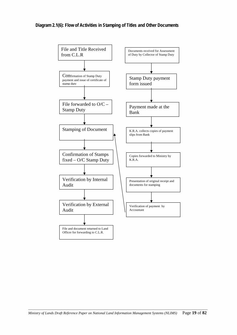
Diagram 2.1(6): Flow of Activities in Stamping of Titles and Other Documents 11
File and Title Received from C.L.R
Confirmation of Stamp Duty payment and issue of certificate of stamp duty
File forwarded to O/C – Stamp Duty
Stamping of Document
Confirmation of Stamps fixed – O/C Stamp Duty
Verification by Internal Audit
File and document returned to Land Officer for forwarding to C.L.R.
Verification by External Audit
Documents received for Assessment of Duty by Collector of Stamp Duty
Stamp Duty payment form issued
Payment made at the Bank
K.R.A. collects copies of payment slips from Bank
Copies forwarded to Ministry by K.R.A.
Presentation of original receipt and documents for stamping
Verification of payment by Accountant

____________________________________________________________________________________________________Ministry of Lands Draft Reference Paper on National Land Information Management Systems (NLIMS) Page 20 of 82
Diagram 2.1(6): Flow of Activities in the Central Registry
Data used • Transfer • Topocadastral maps Data created
Transfer Received for Booking. Day Book Number - issued
Strong Room to Retrieve
Deed File
Audited
To Registry Superintendent for assigning task
To Investigation Officer A-Book recorded
To Entry Officer
New Deed Plan sent to Director of Surveys for verification
To Valuation for Stamp Duty
To Registrar for Signature
Photocopying & Sealing
To Dispatch
To counter for Collection by Owner/Applicant
____________________________________________________________________________________________________Ministry of Lands Draft Reference Paper on National Land Information Management Systems (NLIMS) Page 21 of 82
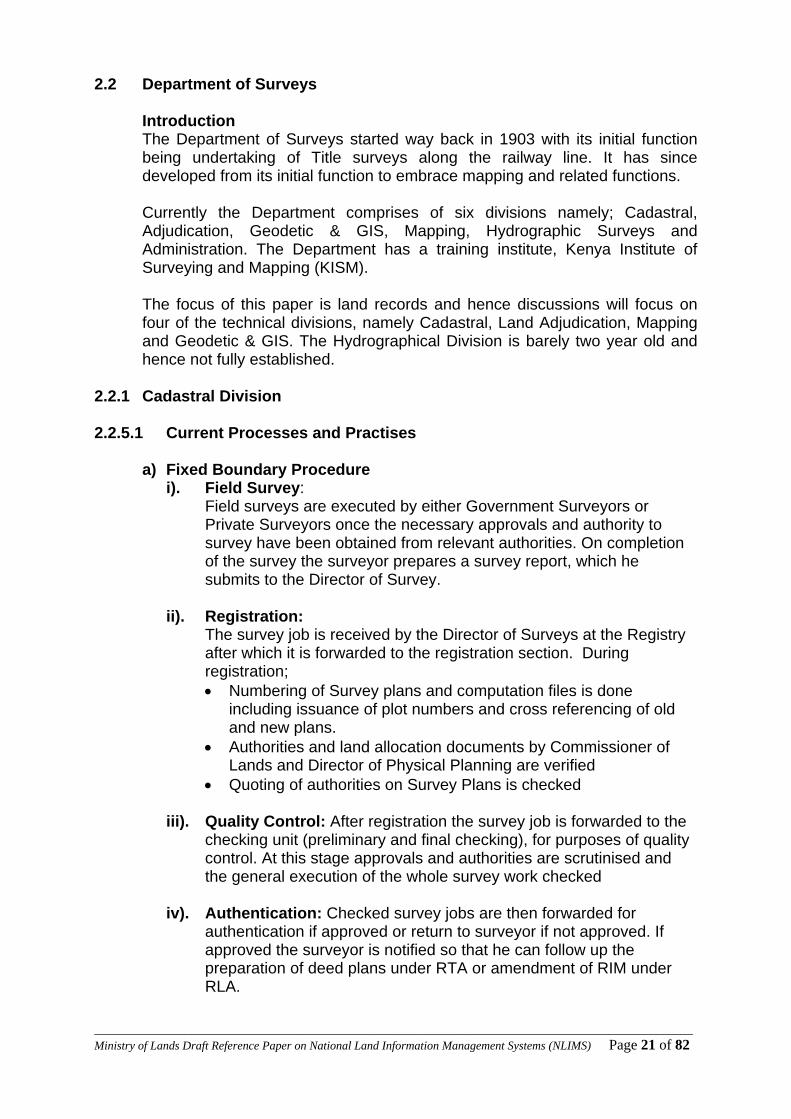
2.2 Department of Surveys Introduction
The Department of Surveys started way back in 1903 with its initial function being undertaking of Title surveys along the railway line. It has since developed from its initial function to embrace mapping and related functions. Currently the Department comprises of six divisions namely; Cadastral, Adjudication, Geodetic & GIS, Mapping, Hydrographic Surveys and Administration. The Department has a training institute, Kenya Institute of Surveying and Mapping (KISM). The focus of this paper is land records and hence discussions will focus on four of the technical divisions, namely Cadastral, Land Adjudication, Mapping and Geodetic & GIS. The Hydrographical Division is barely two year old and hence not fully established.
2.2.1 Cadastral Division 2.2.5.1 Current Processes and Practises
a) Fixed Boundary Procedure
i). Field Survey: Field surveys are executed by either Government Surveyors or Private Surveyors once the necessary approvals and authority to survey have been obtained from relevant authorities. On completion of the survey the surveyor prepares a survey report, which he submits to the Director of Survey.
ii). Registration:
The survey job is received by the Director of Surveys at the Registry after which it is forwarded to the registration section. During registration; • Numbering of Survey plans and computation files is done
including issuance of plot numbers and cross referencing of old and new plans.
• Authorities and land allocation documents by Commissioner of Lands and Director of Physical Planning are verified
• Quoting of authorities on Survey Plans is checked
iii). Quality Control: After registration the survey job is forwarded to the checking unit (preliminary and final checking), for purposes of quality control. At this stage approvals and authorities are scrutinised and the general execution of the whole survey work checked
iv). Authentication: Checked survey jobs are then forwarded for
authentication if approved or return to surveyor if not approved. If approved the surveyor is notified so that he can follow up the preparation of deed plans under RTA or amendment of RIM under RLA.
____________________________________________________________________________________________________Ministry of Lands Draft Reference Paper on National Land Information Management Systems (NLIMS) Page 22 of 82
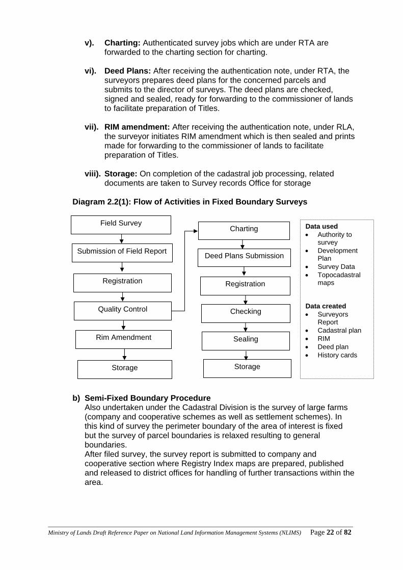
v). Charting: Authenticated survey jobs which are under RTA are forwarded to the charting section for charting.
vi). Deed Plans: After receiving the authentication note, under RTA, the
surveyors prepares deed plans for the concerned parcels and submits to the director of surveys. The deed plans are checked, signed and sealed, ready for forwarding to the commissioner of lands to facilitate preparation of Titles.
vii). RIM amendment: After receiving the authentication note, under RLA,
the surveyor initiates RIM amendment which is then sealed and prints made for forwarding to the commissioner of lands to facilitate preparation of Titles.
viii). Storage: On completion of the cadastral job processing, related
documents are taken to Survey records Office for storage Diagram 2.2(1): Flow of Activities in Fixed Boundary Surveys
b) Semi-Fixed Boundary Procedure Also undertaken under the Cadastral Division is the survey of large farms (company and cooperative schemes as well as settlement schemes). In this kind of survey the perimeter boundary of the area of interest is fixed but the survey of parcel boundaries is relaxed resulting to general boundaries. After filed survey, the survey report is submitted to company and cooperative section where Registry Index maps are prepared, published and released to district offices for handling of further transactions within the area.
Field Survey
Submission of Field Report
Registration
Quality Control
Storage
Rim Amendment
Charting
Deed Plans Submission
Registration
Storage
Sealing
Checking
Data used • Authority to
survey • Development
Plan • Survey Data • Topocadastral
maps Data created • Surveyors
Report • Cadastral plan • RIM • Deed plan • History cards
____________________________________________________________________________________________________Ministry of Lands Draft Reference Paper on National Land Information Management Systems (NLIMS) Page 23 of 82
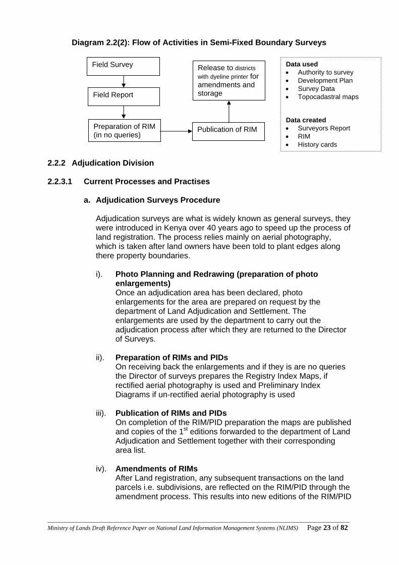
Diagram 2.2(2): Flow of Activities in Semi-Fixed Boundary Surveys 2.2.2 Adjudication Division 2.2.3.1 Current Processes and Practises
a. Adjudication Surveys Procedure
Adjudication surveys are what is widely known as general surveys, they were introduced in Kenya over 40 years ago to speed up the process of land registration. The process relies mainly on aerial photography, which is taken after land owners have been told to plant edges along there property boundaries.
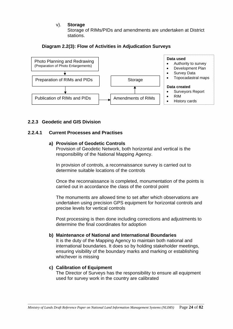
i). Photo Planning and Redrawing (preparation of photo
enlargements) Once an adjudication area has been declared, photo enlargements for the area are prepared on request by the department of Land Adjudication and Settlement. The enlargements are used by the department to carry out the adjudication process after which they are returned to the Director of Surveys.
ii). Preparation of RIMs and PIDs
On receiving back the enlargements and if they is are no queries the Director of surveys prepares the Registry Index Maps, if rectified aerial photography is used and Preliminary Index Diagrams if un-rectified aerial photography is used
iii). Publication of RIMs and PIDs
On completion of the RIM/PID preparation the maps are published and copies of the 1st editions forwarded to the department of Land Adjudication and Settlement together with their corresponding area list.
iv). Amendments of RIMs
After Land registration, any subsequent transactions on the land parcels i.e. subdivisions, are reflected on the RIM/PID through the amendment process. This results into new editions of the RIM/PID
Field Survey
Field Report
Preparation of RIM (in no queries)
Publication of RIM
Release to districts with dyeline printer for amendments and storage
Data used • Authority to survey • Development Plan • Survey Data • Topocadastral maps Data created • Surveyors Report • RIM • History cards
____________________________________________________________________________________________________Ministry of Lands Draft Reference Paper on National Land Information Management Systems (NLIMS) Page 24 of 82
v). Storage Storage of RIMs/PIDs and amendments are undertaken at District stations.
Diagram 2.2(3): Flow of Activities in Adjudication Surveys
2.2.3 Geodetic and GIS Division 2.2.4.1 Current Processes and Practises
a) Provision of Geodetic Controls Provision of Geodetic Network, both horizontal and vertical is the responsibility of the National Mapping Agency.
In provision of controls, a reconnaissance survey is carried out to determine suitable locations of the controls Once the reconnaissance is completed, monumentation of the points is carried out in accordance the class of the control point The monuments are allowed time to set after which observations are undertaken using precision GPS equipment for horizontal controls and precise levels for vertical controls Post processing is then done including corrections and adjustments to determine the final coordinates for adoption
b) Maintenance of National and International Boundaries It is the duty of the Mapping Agency to maintain both national and international boundaries. It does so by holding stakeholder meetings, ensuring visibility of the boundary marks and marking or establishing whichever is missing
c) Calibration of Equipment The Director of Surveys has the responsibility to ensure all equipment used for survey work in the country are calibrated
Data used • Authority to survey • Development Plan • Survey Data • Topocadastral maps Data created • Surveyors Report • RIM • History cards
Photo Planning and Redrawing (Preparation of Photo Enlargements)
Preparation of RIMs and PIDs
Publication of RIMs and PIDs Amendments of RIMs
Storage

____________________________________________________________________________________________________Ministry of Lands Draft Reference Paper on National Land Information Management Systems (NLIMS) Page 25 of 82
d) Photogrammetric Procedure
i. Photo Planning Before aerial photography is undertaken, a most important stage is that of planning. This includes; identification of the area of interest, the number of runs and their direction, the best season to fly and remarking
ii. Pre-marking This is the process of making ground marks on the area to be covered by aerial photography. The marks are later used to undertake aerial triangulation.
iii. Aerial Photography The actual exercise of taking photographs
iv. Triangulation A technical process of correcting distortions on the photographs
v. Data capture Extracting data from the aerial photographs
vi. Output/Storage Presentation of the acquired data and storage of the same
Diagram 2.2(4): Flow of Activities in Photogrammetry
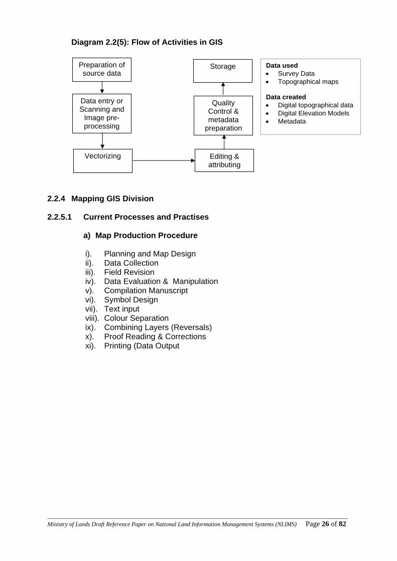
e) GIS Procedure The GIS unit has the responsibility of conversion of analogy data to digital format and required GIS standards. The process includes;
i). Preparation of the source data ii). Data entry or Scanning and Image pre-processing iii). Vectorizing iv). Editing & attributing v). Quality Control and metadata preparation vi). Storage
Photo-Planning
Pre-marking
Aerial Photography Triangulation
Data capture
Output/Storage Data used • Authority to survey • Survey Data (controls) • Topographical maps Data created • Aerial Photographs • Ortho-photographs • Machine plots
____________________________________________________________________________________________________Ministry of Lands Draft Reference Paper on National Land Information Management Systems (NLIMS) Page 26 of 82
Diagram 2.2(5): Flow of Activities in GIS
2.2.4 Mapping GIS Division 2.2.5.1 Current Processes and Practises
a) Map Production Procedure
i). Planning and Map Design ii). Data Collection iii). Field Revision iv). Data Evaluation & Manipulation v). Compilation Manuscript vi). Symbol Design vii). Text input viii). Colour Separation ix). Combining Layers (Reversals) x). Proof Reading & Corrections xi). Printing (Data Output
Preparation of source data
Data entry or Scanning and
Image pre-processing
Vectorizing Editing & attributing
Quality Control & metadata
preparation
Storage
Data used • Survey Data • Topographical maps Data created • Digital topographical data • Digital Elevation Models • Metadata
____________________________________________________________________________________________________Ministry of Lands Draft Reference Paper on National Land Information Management Systems (NLIMS) Page 27 of 82
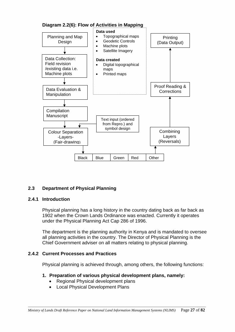
Diagram 2.2(6): Flow of Activities in Mapping 2.3 Department of Physical Planning 2.4.1 Introduction
Physical planning has a long history in the country dating back as far back as 1902 when the Crown Lands Ordinance was enacted. Currently it operates under the Physical Planning Act Cap 286 of 1996. The department is the planning authority in Kenya and is mandated to oversee all planning activities in the country. The Director of Physical Planning is the Chief Government adviser on all matters relating to physical planning.
2.4.2 Current Processes and Practices
Physical planning is achieved through, among others, the following functions:
1. Preparation of various physical development plans, namely: • Regional Physical development plans • Local Physical Development Plans
Compilation Manuscript
Planning and Map Design
Data Collection: Field revision /existing data i.e. Machine plots
Data Evaluation & Manipulation
Colour Separation -Layers-
(Fair-drawing)
Text input (ordered from Repro.) and
symbol design Combining
Layers (Reversals)
Proof Reading & Corrections
Black Blue Green Red Other
Printing (Data Output)
Data used • Topographical maps • Geodetic Controls • Machine plots • Satellite Imagery Data created • Digital topographical
maps • Printed maps

____________________________________________________________________________________________________Ministry of Lands Draft Reference Paper on National Land Information Management Systems (NLIMS) Page 28 of 82
2. Recommending on development applications, namely: • Change of use e.g from residential to commercial • Extension of use e.g from single to multi-family dwelling houses • Extension of lease • Subdivision and amalgamation
3. Dispute resolution through the various Physical Planning Liaison
Committees:–
• Municipal/District Physical Planning Liaison Committee • Nairobi Physical Planning Liaison Committee and • The National Physical Planning Liaison Committee.
In all these Committees with the exception of Nairobi, the Director or the District Physical Planning Officer is the Secretary.
2.3.2.1 Procedure for plan preparation
i). Intention to prepare the development plan ii). Data collection from Imagery/topographical information, background
information. The critical sources are Survey of Kenya, Regional Centre for Mapping for Resource and Development ,ground picking/surveys
iii). Data collection from line Ministries and Departments,(economic data, social data etc)
iv). Base map preparation v). Stakeholder meetings for consensus building vi). Draft Plan vii). Notice of completion of the Plan and circulation (calling for comments,
objections within a period of sixty days).In Kenya Gazette and two local dailies
viii). Amendments ix). Vetting for approval x). Submission to Minister for Approval xi). Notice of Approval (in Kenya Gazette) xii). Assigning Plan approval number xiii). Circulation to Commissioner of Lands xiv). Recording in Plan records register xv). Storage
____________________________________________________________________________________________________Ministry of Lands Draft Reference Paper on National Land Information Management Systems (NLIMS) Page 29 of 82
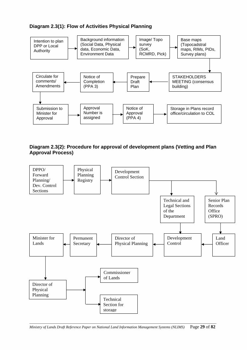
Diagram 2.3(1): Flow of Activities Physical Planning
Diagram 2.3(2): Procedure for approval of development plans (Vetting and Plan Approval Process)
Intention to plan DPP or Local Authority
Background information (Social Data, Physical data, Economic Data, Environment Data
Image/ Topo survey (SoK, RCMRD, Pick)
Base maps (Topocadstral maps, RIMs, PIDs, Survey plans)
STAKEHOLDERS MEETING (consensus building)
Prepare Draft Plan
Notice of Completion (PPA 3)
Circulate for comments/ Amendments
Submission to Minister for Approval
Approval Number is assigned
Notice of Approval (PPA 4)
Storage in Plans record office/circulation to COL
Physical Planning Registry
Development Control Section
DPPO/ Forward Planning/ Dev. Control Sections
Permanent Secretary
Development Control
Land Officer
Director of Physical Planning
Minister for Lands
Director of Physical Planning
Commissioner of Lands
Technical Section for storage
Senior Plan Records Office (SPRO)
Technical and Legal Sections of the Department
____________________________________________________________________________________________________Ministry of Lands Draft Reference Paper on National Land Information Management Systems (NLIMS) Page 30 of 82
2.4 Department of Land Adjudication and Settlement Introduction
Land Adjudication commenced in 1959 with the enactment of the Land Consolidation Act Cap.283 and Land Adjudication Act Cap. 284 of 1968. Settlement programmes which operate under Agricultural Act Cap 318 started in 1961
The Department is charged with the responsibility of ascertaining land rights and interests, land consolidation and Adjudication, settlement of the poor landless Kenyans and management of group ranches Currently the department comprises of two divisions namely Land Adjudication Division and Settlement Division.
2.4.1 Settlement Processes
a) Acquisition of suitable agricultural land Land for settlement is acquired from either private proprietors or the Government
Privately-Owned Land i. Carrying out a search of the Title (Land Registration Division) ii. Valuation of the property (Valuation Division) iii. Ministerial Tender Committee negotiates and deals with purchase
issues after the officer administering the fund (P.S) is consulted (Administration and Planning)
iv. Purchase of property (Settlement Fund Trustees)
Government Land i. Reservation of Government land for settlement purposes
(Commissioner of Lands) ii. Transfer of land to Settlement Fund Trustees (Lands, Administration
and Land Registry)
b) Planning, Demarcation and Survey i. Physical planning of settlement plots, public utility plots, access roads,
etc (Settlement, Physical Planning and Survey Departments) ii. Demarcation and survey of plots (Settlement and Survey Departments) iii. Final survey for title-mapping – (Department of Surveys) iv. Production of Registry Index Maps (RIMS) and Final Area Lists
(Department of Surveys and Land Registry)
c) Identification and verification of beneficiaries i. Actual ground verification exercise (Settlement Division) ii. District Settler Selection Committee interviews the applicants and
comes up with the proposed list of beneficiaries iii. District Settlement Officer forwards list to Director of Land Adjudication
and Settlement iv. Director forwards to Minister for approval through the PS
____________________________________________________________________________________________________Ministry of Lands Draft Reference Paper on National Land Information Management Systems (NLIMS) Page 31 of 82
v. Minister approves allocation
d) Allocation Procedures i. Issuance of Letters of offer (given 90 days to accept offer) ii. Issuance of allotment documents after beneficiaries pay 10% deposit
land charge iii. Issuance of land development loans
e) Transfers (Sales, Gifts, Succession, etc)
i. Witnessing of transfer documents by settlement officer ii. Valuation of property for purposes of Stamp Duty by government valuer iii. Conveyancing by Registrar of Titles in the Department iv. Actual transfer
f) Land and Development Loans Repayment
i. Issuance of loan Demand Notices ii. Processing of full balance forms (Appendix B) by the District Settlement
Officer iii. Full balance processing by Accounts Section, Settlement Fund
Trustees (SFT) iv. Land and development loans clearance by Chief Accountant, SFT
g) Issuance of Final Legal Documents
i. Preparation of Transfer and Discharge of Charge– (Settlement) ii. Signing and sealing the Transfer and Discharge of Charge to facilitate
issuance of Title Deed – (PS)
h) Registration Issuance of Title Deed – (Land Registration Division)
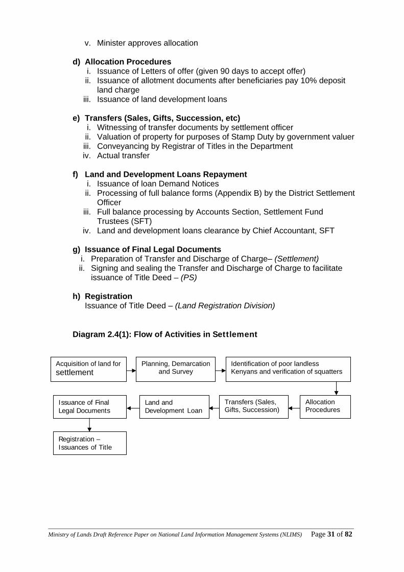
Diagram 2.4(1): Flow of Activities in Settlement
Acquisition of land forsettlement
Planning, Demarcation and Survey
Identification of poor landless Kenyans and verification of squatters
Allocation Procedures
Transfers (Sales, Gifts, Succession)
Land and Development Loan
Issuance of Final Legal Documents
Registration – Issuances of Title

____________________________________________________________________________________________________Ministry of Lands Draft Reference Paper on National Land Information Management Systems (NLIMS) Page 32 of 82
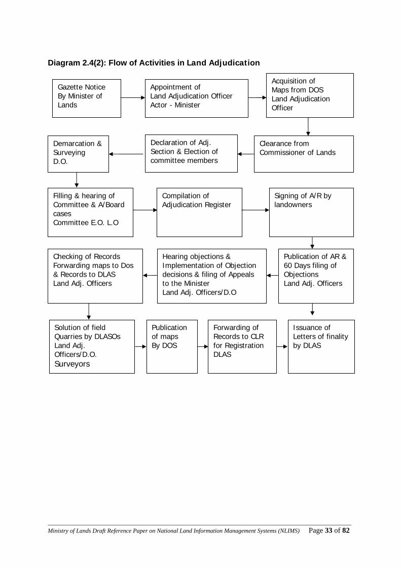
2.1.2 Land Adjudication Processes i. Gazette Notice By Minister of Lands
ii. Appointment of Land Adjudication Officer Actor – Minister
iii. Acquisition of Maps from DOS Land Adjudication Officer
iv. Demarcation & Surveying D.O.
v. Declaration of Adj. Section & Election of committee members
vi. Clearance from Commissioner of Lands
vii. Filling & hearing of Committee & A/Board cases Committee E.O. L.O
viii. Compilation of Adjudication Register
ix. Signing of A/R by landowners
x. Checking of Records Forwarding maps to Dos & Records to DLAS Land
Adj. Officers
xi. Hearing objections & Implementation of Objection decisions & filing of
Appeals to the Minister Land Adj. Officers/D.O
xii. Publication of AR & 60 Days filing of Objections Land Adj. Officers
xiii. Solution of field Quarries by DLASOs Land Adj. Officers/D.O. Surveyors
xiv. Publication of maps By DOS
xv. Forwarding of Records to CLR for Registration DLAS
xvi. Issuance of Letters of finality by DLAS
____________________________________________________________________________________________________Ministry of Lands Draft Reference Paper on National Land Information Management Systems (NLIMS) Page 33 of 82
Diagram 2.4(2): Flow of Activities in Land Adjudication
Gazette Notice By Minister of Lands
Appointment of Land Adjudication Officer Actor - Minister
Acquisition of Maps from DOS Land Adjudication Officer
Demarcation & Surveying D.O.
Declaration of Adj. Section & Election of committee members
Clearance from Commissioner of Lands
Checking of Records Forwarding maps to Dos & Records to DLAS Land Adj. Officers
Hearing objections & Implementation of Objection decisions & filing of Appeals to the Minister Land Adj. Officers/D.O
Publication of AR & 60 Days filing of Objections Land Adj. Officers
Filling & hearing of Committee & A/Board cases Committee E.O. L.O
Compilation of Adjudication Register
Signing of A/R by landowners
Solution of field Quarries by DLASOs Land Adj. Officers/D.O. Surveyors
Publication of maps By DOS
Issuance of Letters of finality by DLAS
Forwarding of Records to CLR for Registration DLAS

____________________________________________________________________________________________________Ministry of Lands Draft Reference Paper on National Land Information Management Systems (NLIMS) Page 34 of 82
2.5 Strengths of the Ministry in Service Delivery
The following have been identified as the common strengths in the four Technical
Departments in the Ministry:
There are Land Administration Procedures in practice
Well laid down structures and frameworks
Well trained and skilled manpower available
Established Taskforce on automation of all the Ministry Land records
A wealth of land data
On-going public sector reforms
Political Goodwill
Vision 2030,Country Vision
Training opportunities in GIS based LIMS
There is Donor support.
Infrastructure (LAN) already exists in Ardhi House
Existence of e-Government that supports computerization in the Government
Existence of a Draft National Land Policy
Increased demand for land services
Availability of modern technology in Information management
2.6 Challenges and Weaknesses in Service Delivery
The following have been identified as the common challenges facing the four
Technical Departments in the Ministry:
Records are manual, voluminous and hence vulnerable to wear and tear,
loss/missing, fraudulent/illegal alterations, illegible
The titles are too big for handling and storage especially those issued under
the Registration of Titles Act; e.g. New Grants, Certificates of Titles etc.
Lengthy, slow and cumbersome processes
Inefficient monitoring and evaluation system
Duplication of land records
Non sharable analogue data
Lack of up to date land Information
____________________________________________________________________________________________________Ministry of Lands Draft Reference Paper on National Land Information Management Systems (NLIMS) Page 35 of 82
Poor storage and tedious retrieval of land data
Backlog of the un-digitized maps is overwhelming
Use of un-rectified photo enlargements as worsened the already weak general
boundary system
Lack of real Time Data Service GPS Control Points.
No capacity to provide Magnetic declination data on time
No capacity to provide Geoidal modulation data
No common coordinate system in use
The existing computer based information systems are stand-alone, insecure,
low scale operations.
Inadequate funding.
WAN not yet developed to allow data sharing
Inadequate human capacity
Insufficient hardware and software for digital data processing
Limited skills and awareness on modern Information Management Technology
Failure to keep pace with the fast changing technology.
Use of archaic/obsolete equipment (stamp duty machine, deed plan sealing
machine, stereo plotters, printing machine, full balance machine (SFT)
The practice is hampered by continued cases of missing files and at times
proprietors are requested to swear an affidavit and indemnify the government
for missing Titles before another file is opened.
Lack of back-up for both manual and digital records
Poor attitude towards change
Vulnerability of the manual records in case of a disaster like fire
Forgeries

____________________________________________________________________________________________________Ministry of Lands Draft Reference Paper on National Land Information Management Systems (NLIMS) Page 36 of 82
3 Chapter 3 Identification of the Key Land Records for Computerization
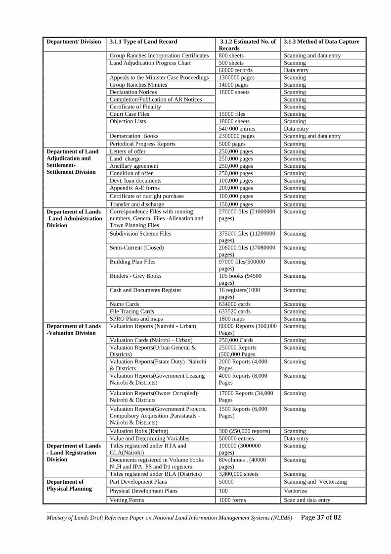
This Chapter identifies the type of land records that need to be computerised and the method of data capture. Records which need to be updated and reconstructed before computerization are also identified. 3.1 Land Records for Capture and Computerisation In the previous chapter, we have seen the various work procedures within the Ministry of Lands in respect to departments. These procedures use and create data, and to computerise them requires digitization. In order to digitize the data their volume must be known so as to lay down the digitization plan. Below is a table indicating the type of data per department/division, their estimated volume and well as the most appropriate method of data capture: Table 3.1(1): Types and Volumes of Key Land Records for Computerization Department/ Division 3.1.1 Type of Land Record 3.1.2 Estimated No. of
Records 3.1.3 Method of Data Capture
70000 plans Survey Plans 3000000 parcels
Scanning and Vectorizing
Survey Computation files/ sheets 70000 files (3500000 pages)
Scanning
RIMs/ parcels 1000 map (500000 parcels)
Scanning and Vectorizing
25000 sheets Scanning Area List sheets /records 750000 records Data entry
Department of Surveys, Cadastral Division
Survey Reports & other files sheets 6000000 sheets Scanning Map of Scale 1 in 250000 49 maps Scanning and Vectorizing Map of Scale 1 in 100000 91 maps Scanning and Vectorizing Map of Scale 1 in 50000 506 maps Scanning and Vectorizing
Department of Surveys, Mapping Division
Other maps 50 maps Scanning and Vectorizing RIMs & PIDs/ parcels 25000 maps
(3000000 parcels) Scanning and Vectorizing
Photo Enlargements, 50000 photos Scanning Mutation Forms sheets 3000000 sheets Scanning
200000 sheets Scanning Area List 3000000 records data entry
Department of Surveys, Adjudication Division(Nairobi And Districts)
Surveyor Reports sheets 350000 sheets Scanning Aerial Photographs 100000 photos Scanning Photo Positives 100000 positives Scanning Geodetic Trig Charts 1200 charts Scanning
Department of Survey, Geodetic & GIS Division
Geodetic Trig control cards 6000 cards Data entry Adjudication records 4000000 records Scanning and
Data entry Land Adjudication Maps (R.I.Ms) 18000 maps Scanning District Diagrams 80 diagrams Scanning Group Ranches Members Registers 400000 registers Scanning and data entry
Appeal Case Files 1300000 pages Scanning National Land Adjudication Progress Map 1 map Scanning and Vectorizing Committee Cases Proceedings Arbitration Board Cases Proceedings
Department of Land Adjudication and Settlement- Land Adjudication Division
Objection to A/R Cases Proceedings
22000000 pages
Scanning
____________________________________________________________________________________________________Ministry of Lands Draft Reference Paper on National Land Information Management Systems (NLIMS) Page 37 of 82
Department/ Division 3.1.1 Type of Land Record 3.1.2 Estimated No. of Records
3.1.3 Method of Data Capture
Group Ranches Incorporation Certificates 800 sheets Scanning and data entry 500 sheets Scanning Land Adjudication Progress Chart 60000 records Data entry
Appeals to the Minister Case Proceedings 1300000 pages Scanning Group Ranches Minutes 14000 pages Scanning Declaration Notices Scanning Completion/Publication of AR Notices Scanning Certificate of Finality
16000 sheets
Scanning Court Case Files 15000 files Scanning
18000 sheets Scanning Objection Lists 540 000 entries Data entry Demarcation Books 2300000 pages Scanning and data entry Periodical Progress Reports 5000 pages Scanning Letters of offer 250,000 pages Scanning Land charge 250,000 pages Scanning Ancillary agreement 250,000 pages Scanning Condition of offer 250,000 pages Scanning Devt. loan documents 100,000 pages Scanning Appendix A-E forms 200,000 pages Scanning Certificate of outright purchase 100,000 pages Scanning
Department of Land Adjudication and Settlement- Settlement Division
Transfer and discharge 150,000 pages Scanning Correspondence Files with running numbers, General Files -Alienation and Town Planning Files
270000 files (21000000 pages)
Scanning
Subdivision Scheme Files 375000 files (11200000 pages)
Scanning
Semi-Current (Closed) 206000 files (37080000 pages)
Scanning
Building Plan Files 97000 files(500000 pages)
Scanning
Binders - Grey Books 105 books (94500 pages)
Scanning
Cash and Documents Register 16 registers(1000 pages)
Scanning
Name Cards 634000 cards Scanning File Tracing Cards 633520 cards Scanning
Department of Lands -Land Administration Division
SPRO Plans and maps 1800 maps Scanning Valuation Reports (Nairobi - Urban) 80000 Reports (160,000
Pages) Scanning
Valuation Cards (Nairobi – Urban) 250,000 Cards Scanning Valuation Reports(Urban General & Districts)
250000 Reports (500,000 Pages
Scanning
Valuation Reports(Estate Duty)- Nairobi & Districts
2000 Reports (4,000 Pages
Scanning
Valuation Reports(Government Leasing Nairobi & Districts)
4000 Reports (8,000 Pages
Scanning
Valuation Reports(Owner Occupied)-Nairobi & Districts
17000 Reports (34,000 Pages
Scanning
Valuation Reports(Government Projects, Compulsory Acquisition ,Parastatals - Nairobi & Districts)
1500 Reports (6,000 Pages)
Scanning
Valuation Rolls (Rating) 300 (250,000 reports) Scanning
Department of Lands -Valuation Division
Value and Determining Variables 500000 entries Data entry Titles registered under RTA and GLA(Nairobi)
190000 (3000000 pages)
Scanning
Documents registered in Volume books N ,H and IPA, PS and D1 registers
80volumes , (40000 pages)
Scanning
Department of Lands - Land Registration Division
Titles registered under RLA (Districts) 3,800,000 sheets Scanning Part Development Plans 50000 Scanning and Vectorizing Physical Development Plans 100 Vectorize
Department of Physical Planning
Vetting Forms 1000 forms Scan and data entry

____________________________________________________________________________________________________Ministry of Lands Draft Reference Paper on National Land Information Management Systems (NLIMS) Page 38 of 82
Department/ Division 3.1.1 Type of Land Record 3.1.2 Estimated No. of Records
3.1.3 Method of Data Capture
Correspondence files 2500000 pages scanning Reports(planning briefs, regional planning, policy papers)
5000 pages Scanning
Registers 10000 pages Scanning and data entry
Minutes 1000 pages Scanning
3.2 Updating of Land Records in the Ministry Within the Ministry of Lands, there are two types of records; those that require updating and those that do not require updating. In the process of computerization the most sensitive records are those that undergo updating, since the changes must be reflected in real time. This section presents land records that require frequent updating in each department. 3.2.1 Department of Surveys
i). Registration Index Maps (RIMs): Updating is always done whenever there is a new survey (under the Registered Land Act) such as new grant or subdivision of property within the extent of the RIM. Data source is the survey plan under fixed boundaries and mutation form under general boundaries.
ii). Preliminary Index Diagrams (PIDs): Updating is always done whenever there is a new survey (under the Registered Land Act) such as new grant or subdivision of property within the extent of the PID. Data source is uncertified aerial photograph from Department of Surveys and the demarcation survey data from Department of Land Adjudication and settlement; and mutation form under general boundaries.
iii). Topo-cadastral maps (Chartings): Updating is done whenever there is a new survey. Data source is the survey plan.
iv). Parcel cards: Whenever a new survey is registered, the history details of the parcel are entered in a card. Data source is the survey plan under fixed boundaries and mutation form under general boundaries
v). Topographical Maps: For maintenance of up to date maps, it is a requirement that
the Department of Surveys captures all new developments throughout the country on these maps at various scales. Data sources include field survey, photogrammetry and remote sensing.
vi). Correspondence Files on Survey Records: These are used for filing internal and external communication. The correspondences are cumulative and need to be filed on time as they are received.
vii). Land Adjudication Progress Chart. Data source is the Adjudication Division,
Department of Land Adjudication and Settlement.
____________________________________________________________________________________________________Ministry of Lands Draft Reference Paper on National Land Information Management Systems (NLIMS) Page 39 of 82
3.2.2 Department of Physical Planning i). Physical Development Plans: They are updated when there is a change of user or
extension of user. An update is also done at the expiry of the plan period to capture the changing environment. Data sources include Part Development Plans, Survey records (RIMs, PIDs, topographical maps and imageries) and field surveys.
ii). Correspondence Files On Physical Planning Records: These are used for filing
internal and external communication. The correspondences are cumulative and need to be filed on time as they are received.
3.2.3 Department of Lands
i). Land Rent Cards: These cards need to be updated whenever there is enhancement in land rent, rent payment and Change of ownership attributes upon transfer or by request. Also new cards for subplots are opened when a subdivision is done.
ii). File Movement Cards: Whenever a file moves out of the Records office, the date, the
office number, receiving officer and the collecting officer are noted in the file movement card.
iii). Correspondence Files On Lands Records: These are used for filing internal and
external communication. The correspondences are cumulative and need to be filed on time as they are received.
iv). Topo-Cadastral Maps at SPRO: Noting and charting land status v). SPRO Land Records Cards: The noting of Land reference number, Correspondence
File numbers, tenure, term of leasehold if leasehold, cadastral Folio Registration number (F/R No.), plot size, plot status. Data source is the correspondence file.
vi). Valuation Cards: Land reference number, Correspondence File numbers, tenure,
term of leasehold if leasehold, plot size, User, value/ land rent, purpose of valuation, date of valuation, transferee, transferor, valuation reference number. Data source is the valuation reports.
vii). Deed Files: Registration of Transfers, charges, discharges, mortgages, assents,
caveats and court orders. Data source are these legal documents presented by the presentors and copies of other previously registered documents, title deed inclusive, in the deed file.
viii). Green Cards: Registration of Transfers charges and discharges. The data source is
as indicated in the ‘vii’ above ix). GLA Volumes: Registration of Indentures, Conveyance, Mortgage, reconveyance of
mortgage, transmissions, court orders, caveats and removal of caveats. The data source is as indicated in the ‘vii’ above
x). IPA Register (Power of Attorney): Registration of grant and revocation of power of
attorney. Data sources are these legal document presented by the presentor.

____________________________________________________________________________________________________Ministry of Lands Draft Reference Paper on National Land Information Management Systems (NLIMS) Page 40 of 82
xi). Perpetual Succession File: Registration of Change of trustees. Data source is an application by the previous trustees
3.2.4 Department of Land Adjudication and Settlement
i). Adjudication Records: these are updated whenever there is a decision on an objection case or appeal to the Minister. Data source is the case ruling.
ii). Settlement Plot Files; these are updated on documentation of the plot owner when
there is a succession or transfer on computation and payment of full balance and on discharge
iii). Appeal Case Files: Updated upon completion of an appeal case. Data source is the
case ruling. iv). Group Ranch Registers; these are updated upon change of membership. Data source
is the resolutions from the members Annual General Meetings v). Correspondence Files On Adjudication Land & Settlement Records: These are
used for filing internal and external communication. The correspondences are cumulative and need to be filed on time as they are received.
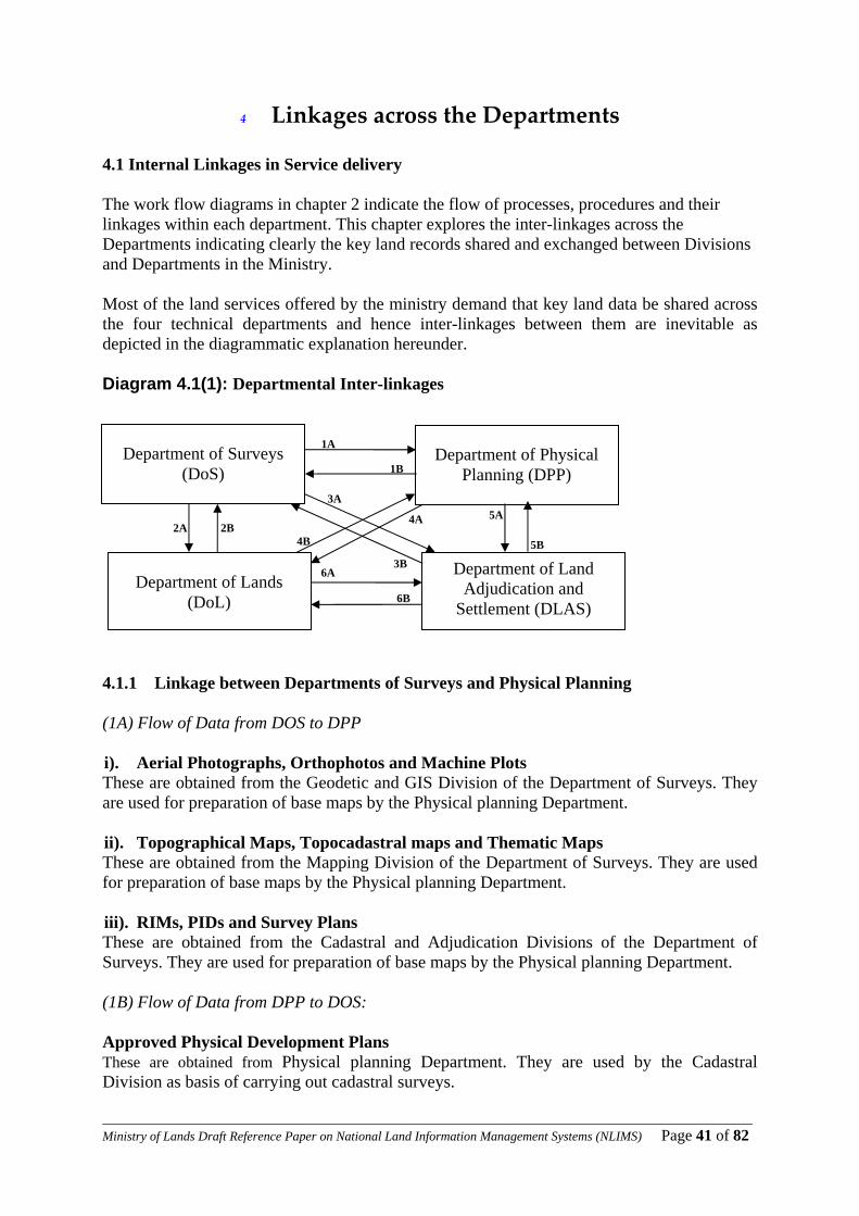
____________________________________________________________________________________________________Ministry of Lands Draft Reference Paper on National Land Information Management Systems (NLIMS) Page 41 of 82
4 Linkages across the Departments 4.1 Internal Linkages in Service delivery The work flow diagrams in chapter 2 indicate the flow of processes, procedures and their linkages within each department. This chapter explores the inter-linkages across the Departments indicating clearly the key land records shared and exchanged between Divisions and Departments in the Ministry. Most of the land services offered by the ministry demand that key land data be shared across the four technical departments and hence inter-linkages between them are inevitable as depicted in the diagrammatic explanation hereunder. Diagram 4.1(1): Departmental Inter-linkages 4.1.1 Linkage between Departments of Surveys and Physical Planning (1A) Flow of Data from DOS to DPP i). Aerial Photographs, Orthophotos and Machine Plots These are obtained from the Geodetic and GIS Division of the Department of Surveys. They are used for preparation of base maps by the Physical planning Department. ii). Topographical Maps, Topocadastral maps and Thematic Maps These are obtained from the Mapping Division of the Department of Surveys. They are used for preparation of base maps by the Physical planning Department. iii). RIMs, PIDs and Survey Plans These are obtained from the Cadastral and Adjudication Divisions of the Department of Surveys. They are used for preparation of base maps by the Physical planning Department. (1B) Flow of Data from DPP to DOS: Approved Physical Development Plans These are obtained from Physical planning Department. They are used by the Cadastral Division as basis of carrying out cadastral surveys.
4A
Department of Surveys
(DoS)
Department of Lands
(DoL)
Department of Land Adjudication and
Settlement (DLAS)
Department of Physical
Planning (DPP)
1A
1B
2A 2B
3A
3B
5A
4B 5B
6A
6B

____________________________________________________________________________________________________Ministry of Lands Draft Reference Paper on National Land Information Management Systems (NLIMS) Page 42 of 82
4.1.2 Departments of Surveys and Lands (2A) Flow of Data from DOS to DOL: i). Survey Plans These are obtained from the Cadastral division of the Department of Surveys. They are used to guide cartographers based in SPRO in Land administration division to note the location of parcels of land within a surveyed area. They are also for confirming plot areas in rent apportionment in the Valuation Division. ii). Topocadastral Maps These are obtained from the Cadastral division of the Department of Surveys. They are used together with survey Plans for locating properties on the ground by valuers, land officers and catographers. iii). Deed Plans These are obtained from the Cadastral division of the Department of Surveys. They are final documents after cadastral survey is completed on land held under Registration of Titles Act (RTA) and Government Land Act (GLA). They are used in both the Land administration and Land registration divisions to prepare titles under these Acts. iv). RIMs There are two types of RIMs: RIMs prepared under RLA Cap 300 section 22 (fixed boundary surveys) are obtained from the Cadastral division of the Department of Surveys. RIMs prepared under RLA Cap 300 (general boundary surveys) are obtained from both the Cadastral division and the adjudication division of the Department of Surveys. These RIMs are the final documents after survey is completed for land which is to be registered under the registered land Act (cap 300) land Registration Division. They are used for locating parcels of land on the ground by valuers in Valuation Division. They are also used by Land officers in Land administration Division in preparation of Title Deeds and Certificate of Lease. Finally they are used by the Land Registrars in issuance of Leases and Title Deeds. v). PIDs PIDs prepared under RLA Cap 300 (general boundary surveys) are obtained from the adjudication division of the Department of Surveys. They are also final documents prepared under Cap 300 vi). Area List These accompany both the RIMs and PIDs. They contain the sizes of plots which are used in registration of title deeds and certificate of leases. (2B) LANDS – SOK i). Letters of Allotment Copies of letters of allotment are obtained from the Land Administration Division of the Department of Lands. They are used to ascertain authenticity of allotted lands when carrying out Cadastral/Title surveys.
____________________________________________________________________________________________________Ministry of Lands Draft Reference Paper on National Land Information Management Systems (NLIMS) Page 43 of 82
ii). Letters of Consent Copies of letters of consent are obtained from the Land Administration Division of the Department of Lands. They are used to request for subdivision surveys iii).Letters of Indent
Indent Letters are obtained from the Land Administration Division of the Department of Lands. They are used to request for Deed Plan or RIM 4.1.3 Departments of Surveys and Land Adjudication & Settlement (3A) SOK – DLAS i). Photo-enlargements, These are obtained from the Adjudication Division of the Department of Surveys. They are used for demarcation in adjudication sections ii) RIMs and PIDS These are obtained from the Cadastral and Adjudication Divisions of the Department of Surveys. They are used for registration of settlement schemes and Adjudication sections iii) Area List These accompany both the RIMs and PIDs. They contain the final sizes of plots which are used in registration of title deeds and certificate of leases. (3B) DLAS – SOK i). Demarcation Data (Contained on Photo-enlargements) These are obtained from the Adjudication Divisions of the Department of Land adjudication and settlement. These contain parcel boundaries as picked on the ground and numbers as assigned by the demarcation officer. They are used by Adjudication Division of Department of Surveys to prepare final registration maps, RIMs or PIDs. ii). Preliminary Area List These accompany Photo-enlargements. They contain map and parcel numbers as assigned by the demarcation officer. 4.1.4 Departments of Physical Planning and Lands (4A) PPD – LANDS Approved Physical Development Plans These are obtained from the Department of Physical Planning. They are used for alienation and record keeping by the Land Administration Division of the Department of Lands. They are also used for preparation of valuation rolls by the Valuation Division of the Department of Lands. (4B) LANDS – PPD Letters of Request to prepare Physical Development Plans These are obtained from the Department of Lands. They are used for requesting for planning of special areas such as Public utilities and Institutions by the Land Administration Division of the Department of Lands.
____________________________________________________________________________________________________Ministry of Lands Draft Reference Paper on National Land Information Management Systems (NLIMS) Page 44 of 82
4.1.5 Departments of Physical Planning and Land Adjudication & Settlement (5A) PPD – DLAS Approved Physical Development Plans These are obtained from the Department of Physical Planning. They are used for Demarcation and Survey in settlement schemes by the Settlement Division of the Department of Land Adjudication and Settlement. (5B) DLAS – PPD Letters of Request to prepare Physical Development Plans These are obtained from the Department of Land Adjudication and Settlement. They are used for requesting for planning of Settlement Schemes by the Settlement Division of Department of Land Adjudication and Settlement. 4.1.6 Departments of Lands and Land Adjudication & Settlement (6A) LANDS – DLAS i). Valuation Report These are obtained from the Valuation Division of the Department of Lands. They are used as a guide for purchase of land for settlement purposes by the Settlement Division of Department of Land Adjudication and Settlement. ii). Clearance These are obtained from the Land Administration Division of the Department of Lands. They are used to confirm the status of land within a Trustland area to determine whether any land has been set apart by the Adjudication Division of Department of Land Adjudication and Settlement. iii). Transfer Document These are obtained from the Land Registration Division of the Department of Lands. They are used to transfer Government Land to Settlement Fund Trustees in the Settlement Division of the Department of Land Adjudication and Settlement for settlement purposes. (6B) DLAS – LANDS i). Original Adjudication Records These are obtained from the Land Adjudication Division of the Department of Land Adjudication and settlement. They are used by the Land Registration Division in preparation of Titles to land. ii). Discharge of Charge and Transfer These are obtained from the Settlement Division of the Department of Land Adjudication and settlement. They are used by the Land Registration Division for issuance of Titles to land.

____________________________________________________________________________________________________Ministry of Lands Draft Reference Paper on National Land Information Management Systems (NLIMS) Page 45 of 82
Table 4.1(1): Summary of the Flow of Key Land Records across the Departments
Data Work Flow No. Link From To
Linkage Key Data Type Remarks
1 1A DOS DPP Aerial Photographs, Orthophotos, Machine Plots, Topographical Maps, Topocadastral maps and Thematic Maps, RIMs, PIDs and Survey Plans
2 1B DPP DOS Approved Physical Development Plans
3 2A DOS COL Survey Plans, Topo-Cadastral Maps Deed Plans, RIMs, PIDs & Area Lists.
4 2B COL DOS Letters of Allotment, Consent & Indent. 5 3A DOS DLAS Enlarged Aerial Photos, RIMs & PIDs &
Area Lists.
6 3B DLAS DOS Demarcation Data (Contained on Photo-enlargements)
7 4A DPP COL Approved Physical Development Plans 8 4B COL DPP Letters of Request to prepare Physical
Development Plans
9 5A DPP DLAS Approved Physical Development Plans 10 5B DLAS DPP Letters of Request to prepare Physical
Development Plans
11 6A COL DLAS Valuation Report, Clearance, Transfer Document
12 6B DLAS COL Original Adjudication Records, Discharge of Charge and Transfer
Table 4.1(2): Summary of the Flow of Key Land Records in the Department of Lands
Data Work Flow No. From To
Linkage Key Data Type Remarks
1a Land Admin Valuation Request for Valuation
1b Valuation Land Admin Valuation Reports
2a Land Admin Land Registration New grants Extension of Lease Application for registration of new Deed Plan/RIM
2b Land Registration Land Admin Titles, MRT 3a Valuation Land Registration Property Valuation Reports 3b Land Registration Valuation Searches & Valuation Requests 4.2 External Customer Linkages in Service Delivery 4.2.1 Categories of External Key Customers
• National Government Institutions • Private Practice • Professional Bodies • Regional & International Bodies • Academia • Members of General Public
____________________________________________________________________________________________________Ministry of Lands Draft Reference Paper on National Land Information Management Systems (NLIMS) Page 46 of 82
4.2.2 Organizations that frequently interact with the Ministry • Nairobi City council • Other local authorities • Cooperative societies • Land buying companies • Group Ranch Members • Kenya Revenue Authority • State Law Office (AG Chambers) • Land Control Board • Land Dispute Tribunals • Ministry of Roads • The Police Department • Provincial administration • KACC • Ministry of Finance • NEMA • KWS • Kenya Railways • Government Printer • KPLC • RCMRD • Physical planning Liaison Committees • Kenya Forest Service
4.2.3 Key Customer Service Points and Services Offered in the Departments Table 4.1(3): Key Customer Service Points and Services Offered in the Departments
Department Service Point Service Offered Remarks
Collection of application forms
Application forms are downloadable from www.ardhi.go.ke Sensitization needed
Enquiries Can be provided via internet/SMS once databases are created
Booking of documents for registration
DMS to be used once documents booked to enable enquiries via internet/SMS once databases are created
Official Searches Can be provided over the counter once databases are created. Will be provided via internet/SMS once necessary legal framework is in place
Registry counter (Ground floor, wing B Ardhi House and district Land Registries)
Collection of registered documents and searches
Once booked give timeframe because it will be tracked in the DMS system
Assessment of stamp duty payable
Assessment real time
Land rent demand notices issues
Can be provided via internet/SMS once databases are created. Updating should be online.
Lands
Banking hall (stamp duty and land rent counters)
Issuance of Land clearance certificates
Can be provided over the counter once databases are created. Will be provided via internet/SMS once necessary legal

____________________________________________________________________________________________________Ministry of Lands Draft Reference Paper on National Land Information Management Systems (NLIMS) Page 47 of 82
Department Service Point Service Offered Remarks framework is in place
Purchase of revenue stamp
Purchase is real time
Cashiers in banking hall
Payments due to COL (fees for registration, consent, stand premium, etc)
Payment is real time
Registrars Offices Booking of Perpetual succession Trusts and provisional Certificates of Title
Once booked give timeframe because it will be tracked in the DMS system
File Records Retrieval of files for clients
Once the data base is created and up to date there won’t be any need of clients going to records office
Cash and document Applications for consent and Clearance Certificate. Receive all mails addressed t the COL.
DMS should be put in place
Central Registry(RS) Distribution of documents for registration
DMS should be put in place
Plan records office Enquiry on file number Once the data base is created and up to date there won’t be any need of clients going to records office
Application for valuation for stamp duty.
Application forms should be made available on www.ardhi.go.ke
Endorsement of valuation on documents.
Immediate
Collector of stamp duty office
Letters of demand for additional stamp duty
Immediate
Registry Mails receiving All mails to DPP. Need to have a MIS and file tracking system
Accounts Receive payment on services rendered (AIA)
Immediate. Need to create a computer based accounting system
Physical Planning
Plan Records Office Sale of plans Immediate Registry Mails receiving All mails sorted. Need to have a MIS
and file tracking system Accounts Receive payment on
services rendered (AIA) Immediate. Need to create a computer based accounting system
Enquiries on parcel history
Can be provided over the counter once databases are created. Will be provided via internet/SMS once necessary legal framework is in place
Sale of Survey Plans Finalise scanning & Vectorization Issuance of RIMs(under fixed boundary surveys)
Finalise Vectorization
Sale of Topocadastral Maps
Vectorize & Update
Issuance of Deed Plans Commence Scanning
Survey
SRO Cadastral Division
Issuance of Area Lists Create Database

____________________________________________________________________________________________________Ministry of Lands Draft Reference Paper on National Land Information Management Systems (NLIMS) Page 48 of 82
Department Service Point Service Offered Remarks Receiving and registration of Survey Jobs (Computation sheets, field notes, survey plans & approval documents)
Finalise creation of Database and develop a File Tracking System.
Issuance of RIMs (under general boundary surveys)
Vectorize
Issuance of PIDs (under general boundary surveys)
Carry out GPS field surveys and vectorize
Issuance of Area Lists Create Database Issuance of Enlarged Aerial Photos.
Create Database and Commence Scanning
Adjudication Survey Records Office, Adjudication survey Division
Issuance of Mutation forms
These are serialised
Sale of Aerial Photographs
Create Database and Commence Scanning Requires clearance from DOD
Sale of Orthophotos, Create digital Database and Commence Scanning
Photogrammetric Unit, Geodetic & GIS Division
Sale of Machine Plots Create digital Database and Commence Scanning
Sale of Survey control data
Finalise creation of Database
Sale of Trigonometrical charts
Finalise creation of Database and commence scanning
Geodetic Unit, Geodetic & GIS Division
Calibration of Survey Equipments
Commence creation of Database Need to modernise Calibration Equipment
Enquiries on maps Create Database Sale of Topographical Maps
Requires clearance from DOD Maps sales office, Mapping Division
Sale of Thematic Maps Doesn’t require clearance from DOD. Real time
Registry Mails receving Retrieval of files Management of file tracking system
All mails to DLAS. Need to have a MIS
Cash office Receiving and custody of SFT land and loan payments
Immediate. Need to create a computer based accounting system
Records Office
Custody of accountability list, RIMs, PIDs and duplicate adjudication records
Create digital Database and scan records
Adjudication and Settlement
Customer Care desk
Receive and direct clients
To minimise congestion
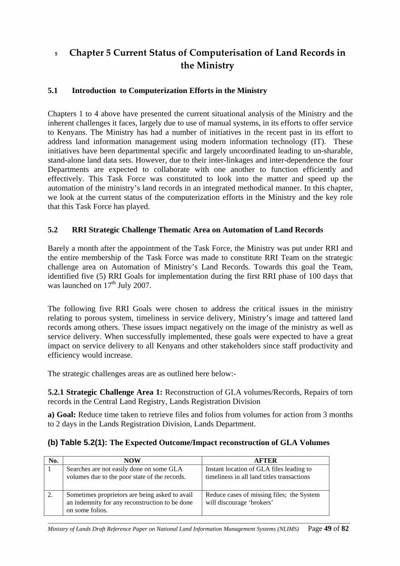
____________________________________________________________________________________________________Ministry of Lands Draft Reference Paper on National Land Information Management Systems (NLIMS) Page 49 of 82
5 Chapter 5 Current Status of Computerisation of Land Records in the Ministry
5.1 Introduction to Computerization Efforts in the Ministry
Chapters 1 to 4 above have presented the current situational analysis of the Ministry and the inherent challenges it faces, largely due to use of manual systems, in its efforts to offer service to Kenyans. The Ministry has had a number of initiatives in the recent past in its effort to address land information management using modern information technology (IT). These initiatives have been departmental specific and largely uncoordinated leading to un-sharable, stand-alone land data sets. However, due to their inter-linkages and inter-dependence the four Departments are expected to collaborate with one another to function efficiently and effectively. This Task Force was constituted to look into the matter and speed up the automation of the ministry’s land records in an integrated methodical manner. In this chapter, we look at the current status of the computerization efforts in the Ministry and the key role that this Task Force has played.
5.2 RRI Strategic Challenge Thematic Area on Automation of Land Records Barely a month after the appointment of the Task Force, the Ministry was put under RRI and the entire membership of the Task Force was made to constitute RRI Team on the strategic challenge area on Automation of Ministry’s Land Records. Towards this goal the Team, identified five (5) RRI Goals for implementation during the first RRI phase of 100 days that was launched on 17th July 2007.
The following five RRI Goals were chosen to address the critical issues in the ministry relating to porous system, timeliness in service delivery, Ministry’s image and tattered land records among others. These issues impact negatively on the image of the ministry as well as service delivery. When successfully implemented, these goals were expected to have a great impact on service delivery to all Kenyans and other stakeholders since staff productivity and efficiency would increase. The strategic challenges areas are as outlined here below:- 5.2.1 Strategic Challenge Area 1: Reconstruction of GLA volumes/Records, Repairs of torn records in the Central Land Registry, Lands Registration Division
a) Goal: Reduce time taken to retrieve files and folios from volumes for action from 3 months to 2 days in the Lands Registration Division, Lands Department. (b) Table 5.2(1): The Expected Outcome/Impact reconstruction of GLA Volumes No. NOW AFTER 1 Searches are not easily done on some GLA
volumes due to the poor state of the records. Instant location of GLA files leading to timeliness in all land titles transactions
2. Sometimes proprietors are being asked to avail an indemnity for any reconstruction to be done on some folios.
Reduce cases of missing files; the System will discourage ‘brokers’

____________________________________________________________________________________________________Ministry of Lands Draft Reference Paper on National Land Information Management Systems (NLIMS) Page 50 of 82
5.2.2 Strategic Challenge Area 2: Creating a Land /Property Value Database and Document Management System at the Valuation Division, Department of Lands
a) Goal: Reduce time taken to finalise valuation reports after field inspection from an average of 2 days to an average of 1 day.
(b) Table 5.2(2): The Expected Outcome/Impact of Property Valuation Database. No. NOW: Manual-Based Valuation Property Database AFTER: Computer-Based Valuation
Property Database 1. After field inspection a valuer needs to do a market
analysis to determine market values. Searching for data to complete valuation is a manual procedure. The files sometimes are out of the registry as such delay does occur when looking for the data
Valuation data available immediately from the Valuation Land/Property Database .
2. A property may have been valued before. It is important to see the previous report. This involves manually looking for the file where the report was filed.
Valuation Report available on the networked computer terminals.
3. Writing a valuation report is a tedious process. It involves describing the property in detail in terms of construction and accommodation.
A Computer Based Valuation System where the attribute values are fed in the system can generate well organized reports.
5.2.3 Strategic Challenge Area 3: Creating a Document Management System of all approved physical development plans for Department of Physical Planning. a) Goal: Reduce time taken for vetting and verification of plans submitted for approval by the District Physical Planners from 3 days to 2 hours.
b) Table 5.2(3):The Expected Outcome/Impact of DMS for Physical Development Plans. No. NOW: Manual-Based Database for
All Approved Development Plans in the Country.
AFTER: Computer-Based Database & DMS for All Approved Development Plans in the
Country. 1. Vetting and verification takes at least
3 days Reduce time taken for vetting and verification to 2 hours
2. Information is scattered and difficult to retrieve
Easy storage and retrieval
3. Documents prone to loss, wear & tear Secure storage and back up
5.2.4 Strategic Challenge Area 4: Creating a Document Management System of all authenticated survey plans at the Cadastral Division at the Department of Surveys. a) Goal: Reduce time taken by officers, licensed surveyors and members of the public to access and retrieve any authenticated survey plans from an average of 2 days to 1 hour.

____________________________________________________________________________________________________Ministry of Lands Draft Reference Paper on National Land Information Management Systems (NLIMS) Page 51 of 82
b) Table 5.2(4): The Expected Outcome/Impact of DMS for Authenticated Survey Plans. NO NOW: Manual-Based Database for All
Authenticated Survey Plans in the Country since 1903.
AFTER: Computer-Based Database & DMS for All Authenticated Survey Plans
in the Country since 1903.
1 Four steps are involved for a client to obtain a copy of a survey plan
A one-stop shop for clients to obtain a copy of a survey plan.
2 It takes 2 days and sometimes longer period to obtain a survey plan if it is available
It will take 1 hour to obtain a survey plan
3 Survey plans are prone to destruction in case of calamity
There will be a backup of all survey plans
4 There is a lot of movements/misplacement of survey plans
No movement/misplacement of survey plans
5 A survey plan can be used by only one officer at a time
A survey plan can be used by many officers at a time
Strategic Challenge Area 5: Creating a File Tracking System for all settlement plot files at Department of Land Adjudication and Settlement. Goal: Reduce time taken to retrieve settlement plot files for action from an average of 2 days to 1 hour b) Table 5.2(5): The Expected Outcome/Impact of File Tracking System for all Settlement Plot File No. NOW AFTER 1. Retrieval of files is cumbersome Efficient location of settlement files
2 Lengthy settlement transactions Timeliness in all settlement transactions 3 Delays in service delivery Improved service delivery and customer
satisfaction 4 Poor image Improved image
5 Cases of missing files Reduced cases of missing files
5.3 Results in 100 Days 5.3.1 Tattered Land Records Reconstructed a) Results At least 50 Title Registers of GLA Volumes/Records were identified for reconstruction. However, reconstructing of 12 GLA Volumes, Nos. N59 to N70, that had the most torn and tattered land records that were most active and were being used on a daily basis was considered. Each GLA Volume has an average of about 400 folios. So, 12 GLA Volumes have a total of 4,800 folios that were earmarked to be reconstructed during this RRI Period. A total of 2,686 (56%) out of the planned 4,800 folios for the 12 GLA Volumes were completed during the RRI Period and as shown below, we managed to complete reconstruction of four (4) GLA Volumes N59, N60, N61 & N62!
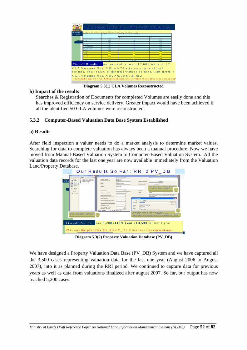
____________________________________________________________________________________________________Ministry of Lands Draft Reference Paper on National Land Information Management Systems (NLIMS) Page 52 of 82
M i ni stryo fL an ds
R a pi d R esu l ts In it i at i ve (RR I) : A utoma tio n o f M in i stry’s L an d R ec ords 80 8 / 0 2 / 2 0 0 6 1 4 : 4 4
P ro jec t ed Ov er al l S um m ar y of t he M il es t one Re s ul ts as a t 21s t N ovem be r 200 7O ff i c e r GL A Vo l um e s Fo l i o s D o ne a s a t Tue s 1 6 t h O c t
No s. %To m Og e n g a N6 3 2 4 4 6 1 %K e z ia N6 4 1 7 8 4 5 %
Sa l o m e K ir e ra N6 5 1 0 1 2 5 %
O n e s mu s N6 6 1 5 5 3 9 %
N a n c y M g a n g a N6 7 2 1 7 5 4 %Pe t e r K im a n i N6 8 1 7 6 4 4 %N g e ti c h N6 9 2 0 0 5 0 %C h a rl e s N 5 9* 2 7 1 6 8 %Te l v in N 6 0* 4 2 8 1 0 7 %Pa t r ic k N 6 2* 2 9 7 7 4 %St u d e n t N 6 1* 2 6 8 6 7 %
St u d e n t N7 0 1 5 1 3 8 %
T o ta l 1 2 2 , 6 8 6 5 6 %
Ov e r a l l % Re s ul t s o ut o f the e x pe c t e d 2 0 ,0 0 0 f o li o s = 1 3 . 0 %
O ur Re sul t s S o F ar : R R I 1 G L A V ol um e s
O v er al l R esu lt s : R eco n s tr u ct ed a t ot al o f 2 ,6 8 6 fo li o s of 1 2 G L A V ol u m es N o s . N 59 t o N 7 0 w it h w o rs t ta tt er ed l an d r ec or d s . T h is i s 5 6 % of th e to ta l w or k t o b e do n e. C om pl et ed 4 G L A V ol u m es N o s . N 59 , N 60 , N 6 1 & N6 2T h is w a s th e firs t tim e fo r t h e R ec o n s tru c tio n o f G LA Vo lu m e s in iti a tiv e to b e c a rr ied o u t!
Diagram 5.3(1) GLA Volumes Reconstructed
b) Impact of the results Searches & Registration of Documents for completed Volumes are easily done and this has improved efficiency on service delivery. Greater impact would have been achieved if all the identified 50 GLA volumes were reconstructed.
5.3.2 Computer-Based Valuation Data Base System Established a) Results After field inspection a valuer needs to do a market analysis to determine market values. Searching for data to complete valuation has always been a manual procedure. Now we have moved from Manual-Based Valuation System to Computer-Based Valuation System. All the valuation data records for the last one year are now available immediately from the Valuation Land/Property Database.
M in is tr yof L an d s
R a p id R e s u l ts In i t ia tiv e (R R I ) : A u to m a tion o f M in i s tr y ’s L a n d R e c or d s 1 20 8 /0 2 / 2 0 0 6 1 2 : 5 3
O u r R e s u lts S o F a r : R R I 2 P V _ D B
T o S ear ch f or D eta ils of a P art icu la r Pr o per ty:K ey in th e P r op er ty I den tif ie r e .g . N B I/ B L K 91 /9 . T h en th e r eq ui red a ttr ib ut e v a lu e s f or th is pr o per ty ap pe a rs a s i n Di agr am N o . 2 a b ove
On ce PV _ DB has b een o pen ed , t he nSe lec t V alu a ti on I nf o Fo rm O pti on .
Ke y in t he req u ire d P ro per ty D et a ils in th e s pac es p ro vi ded as s ho w n.
1
3
2
O v e r a l l R e s u lt s: D o n e 5 ,2 0 0 ( 1 4 8 % ) o u t o f 3 ,5 0 0 fo r la s t 1 y e a r
T h i s w a s th e fir s t ti m e fo r th i s P V _ D B in i ti a ti v e t o b e c a r ri e d o u t!
Diagram 5.3(2) Property Valuation Database (PV_DB)
We have designed a Property Valuation Data Base (PV_DB) System and we have captured all the 3,500 cases representing valuation data for the last one year (August 2006 to August 2007), into it as planned during the RRI period. We continued to capture data for previous years as well as data from valuations finalized after august 2007. So far, our output has now reached 5,200 cases.

____________________________________________________________________________________________________Ministry of Lands Draft Reference Paper on National Land Information Management Systems (NLIMS) Page 53 of 82
b) Impact of the results
i. asy to access data (for the period covered) from the database ii. Easy to determine if property has been valued before within the period covered
iii. Experience has been gained and will be used in planning and implementing other automation programmes.
5.3.3 Physical Development Plans Scanned a) Results There are about 5,000 approved Physical Development Plans (Development, Part Development, Zonal, Structural, Action and Advisory Plans) in the country at the Department of Physical Planning HQs. Out of these plans; about 430 are Development Plans (DPs), inclusive of Zonal, Structural, Action, & Advisory Plans). The rest are Part Development Plans.
Minis tryo f La nds
R ap id Results In it ia tiv e (R RI) : Au tom ation of Minis try’s L and Records 1608/02/2006 13:28
Our Resu lts So Far : RRI 3 DM S_PDP
O v erall R esul ts: 5,6 21 (112 .4% ) ou t o f 5 ,00 0 Plan s Scann ed so far.[Tot al repa ired 1,1 70 P la ns] With O ne Sta tio n co ns is t in g of 1 Sca nner & 1 P C s a nd 2 S tudents (NB . Thi s old sca n ner h a d almo s t b een w r it ten of f b ut the RR I Team re su rrect ed i t) Th is wa s th e f ir st t ime fo r th is D M S_ P DP ini ti at i ve to b e c ar ried o ut !
D iag ram Sho w ing a S can n ed Ph ysical D evelo p men t Plan
Diagram 5.3(3) Scanned Physical Development Plan
We have so far scanned 5,621 and repaired 1,170 approved plans out of 5,000 Plans that we had planned to do during the RRI period. This we achieved using only 1 Scanner, 1PC & 2 Students on attachment. b) Impact of the results
i. ii. There is now a backup of all approved physical development plans
iii. A useful inventory of approved physical development plans is being developed iv. Experience has been gained and will be used in planning and implementing other
automation programmes v. No possible loss or misplacement of the scanned approved physical development plans
5.3.4 Cadastral Survey Plans Scanned a) Results There are about 65,000 Authenticated Survey Plans containing about 300,000 parcels in the country at the Cadastral Division of the Survey Department HQs. Out of these 4,000 plans had been scanned prior to the RRI period. We targeted to scan 15,000 Survey Plans with

____________________________________________________________________________________________________Ministry of Lands Draft Reference Paper on National Land Information Management Systems (NLIMS) Page 54 of 82
available equipment but could have easily scanned all the 61,000 Plans if additional equipment were provided;-these could not be availed during RRI period as anticipated.
Ministry of Lands
Rapid Results Initiative (RRI) : Automation of Ministry’s Land Records 2009/01/2008 12:30
Results So Far: RRI 4 DMS_CSPResults So Far: RRI 4 DMS_CSP
Overall Results:Overall Results: Data capture Data capture -- Scanning of Survey Plans 13,540 Scanning of Survey Plans 13,540 Survey Plans scanned so far out of planned 15,000 Plans (90%)Survey Plans scanned so far out of planned 15,000 Plans (90%)
Diagram Showing image of a Diagram Showing image of a scanned Cadastral Surveyscanned Cadastral Survey Plan that has finally been converted to pdfpdf format format and stored into DMS_CSP
Mi nistryof Lands
Ra pid Result s In it iat iv e (R RI) : Auto mat io n of M in istry’s La nd Reco rds 2113/02/ 2006 11:28
Results So Far: PI_DB
Ov erall Re su lts: Data C aptu re – Su rvey Pla ns Data Entr y into th e Sur vey Plan Datab ase ( SP_ DB )Th is i s the f irs t t ime fo r th e Sur vey Plan s Data B ase SP _D B in itiat ive to b e carr ied out !
Di agram Sh owing h ow Su rv ey P lan Da t ab as e Da t a is C aptured i nto i ntoS P _DB . This info i s u sed fo r fu ture re ference & li nkage t o DMS _C SP.
Diagram 5.3(4) Scanned Survey Plan Diagram 5.3(5) Data capture Survey Plan info entry
Data capture Parcel Information Entry Diagram 5.3(6) Diagram showing how Parcel Information Data
b) Impact of the results
i. There is now a backup of all scanned survey plans ii. A useful inventory of survey plans and parcels is being developed
iii. A scanned survey plan is now being used by many officers at a time iv. Experience has been gained and will be used in planning and implementing other
automation programmes v. It now takes less than 30 minutes to obtain a scanned survey plan
vi. No possible loss or misplacement of the scanned survey plans vii. Inventory of Missing Survey Plans developed for every series
It took the Department two (2) years to scan 4,000 Survey Plans before the RRI period. However, it has taken 100 days only for the RRI Team to scan 13,540 (90%) Survey Plans using same resources of One Station consisting of 1 Scanner & 2 PC. This has drastically reduced time taken to obtain a scanned survey plan to within a few minutes. In addition to the scanning, a database for survey plans and another one for parcel information have been developed to enhance data retrieval.
Overall Results :Data Capture – Parcel Data Entry into the Parcel Info Database (PI_DB) 23,339 (7.8% 0 Parcels entered out of 300,000. This is the first time for the Parcel Info Database to be carried out
Diagram showing how Parcel Information Data is Captured into PI_DB. This is used for future reference & linkage to DMS_CSP

____________________________________________________________________________________________________Ministry of Lands Draft Reference Paper on National Land Information Management Systems (NLIMS) Page 55 of 82
Diagram 5.3(7): General Flow of Activities in Cadastral Information Systems Section
Cadastral Survey Plans & Parcel Information
5.3.5 File Tracking System Developed a) Results BBaasseedd oonn tthhee ttoottaall nnuummbbeerr ooff aallllooccaattiioonn ttoo tthhee sseettttlleerrss,, tthheerree sshhoouulldd bbee aabboouutt 222200,,000000 FFiilleess ooppeenneedd.. HHoowweevveerr,, tthhee aaccttuuaall ffiilleess ooppeenneedd aarree aabboouutt 111100,,000000 aanndd oouutt ooff tthheessee 111100,,000000 ffiilleess,, aabboouutt 2200,,000000 ooff tthheemm hhaavvee iinnaaddeeqquuaattee iinnffoorrmmaattiioonn.. TThhee DDiirreeccttoorr ooff LLaanndd AAddjjuuddiiccaattiioonn aanndd SSeettttlleemmeenntt hhaass aallrreeaaddyy sseenntt lleetttteerrss ttoo rreessppeeccttiivvee DDiissttrriicctt OOffffiicceerrss ffoorr tthhee llaatttteerr ttoo pprroovviiddee aannyy iinnffoorrmmaattiioonn oonn tthhee uunnooppeenneedd ffiilleess.. A File Tracking System for Settlement Plot Files (FTS_SPF) has been developed into which some 89,778 (90%) out of the 110,000 settlement plot files have been imported from the Billing System currently being undertaken in the Department. All the attributes for the 140 staff and 4388 General files at the Ministry Headquarters have been captured into the file tracking systems. The System will display the current location of the file and history of the
Request for Survey Plans (SP) from Survey Records Office
Extract SP information into SP
Databases
Scan the SP in JPEG format/List down available and missing SPs
Convert the scanned JPEG images to PDF and encrypt
them
Hyperlink the PDF Survey Plans with the SP_DB
Use SPs to vectorise parcel
boundaries into a GIS
Extract Parcel Information (PI) into PI Database
Link GIS polygons (graphics) with PI_DB and SP_DB
Ensure harmonized linkage between Graphics, Databases and Image-archives in order to facilitate easy updating, querying and efficient service to members of the public
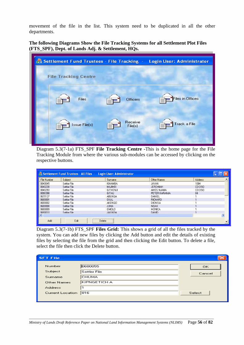
____________________________________________________________________________________________________Ministry of Lands Draft Reference Paper on National Land Information Management Systems (NLIMS) Page 56 of 82
movement of the file in the list. This system need to be duplicated in all the other departments. The following Diagrams Show the File Tracking Systems for all Settlement Plot Files (FTS_SPF), Dept. of Lands Adj. & Settlement, HQs.
Diagram 5.3(7-1a) FTS_SPF File Tracking Centre -This is the home page for the File Tracking Module from where the various sub-modules can be accessed by clicking on the respective buttons.
Diagram 5.3(7-1b) FTS_SPF Files Grid: This shows a grid of all the files tracked by the system. You can add new files by clicking the Add button and edit the details of existing files by selecting the file from the grid and then clicking the Edit button. To delete a file, select the file then click the Delete button.
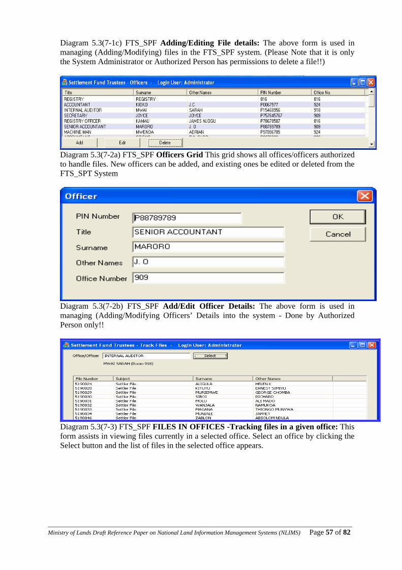
____________________________________________________________________________________________________Ministry of Lands Draft Reference Paper on National Land Information Management Systems (NLIMS) Page 57 of 82
Diagram 5.3(7-1c) FTS_SPF Adding/Editing File details: The above form is used in managing (Adding/Modifying) files in the FTS_SPF system. (Please Note that it is only the System Administrator or Authorized Person has permissions to delete a file!!)
Diagram 5.3(7-2a) FTS_SPF Officers Grid This grid shows all offices/officers authorized to handle files. New officers can be added, and existing ones be edited or deleted from the FTS_SPT System
Diagram 5.3(7-2b) FTS_SPF Add/Edit Officer Details: The above form is used in managing (Adding/Modifying Officers’ Details into the system - Done by Authorized Person only!!
Diagram 5.3(7-3) FTS_SPF FILES IN OFFICES -Tracking files in a given office: This form assists in viewing files currently in a selected office. Select an office by clicking the Select button and the list of files in the selected office appears.
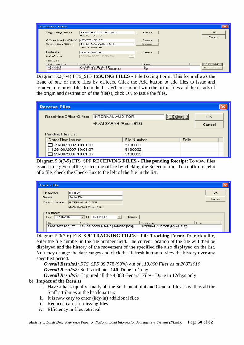
____________________________________________________________________________________________________Ministry of Lands Draft Reference Paper on National Land Information Management Systems (NLIMS) Page 58 of 82
Diagram 5.3(7-4) FTS_SPF ISSUING FILES - File Issuing Form: This form allows the issue of one or more files by officers. Click the Add button to add files to issue and remove to remove files from the list. When satisfied with the list of files and the details of the origin and destination of the file(s), click OK to issue the files.
Diagram 5.3(7-5) FTS_SPF RECEIVING FILES - Files pending Receipt: To view files issued to a given office, select the office by clicking the Select button. To confirm receipt of a file, check the Check-Box to the left of the file in the list.
Diagram 5.3(7-6) FTS_SPF TRACKING FILES - File Tracking Form: To track a file, enter the file number in the file number field. The current location of the file will then be displayed and the history of the movement of the specified file also displayed on the list. You may change the date ranges and click the Refresh button to view the history over any specified period.
Overall Results1: FTS_SPF 89,778 (90%) out of 110,000 Files as at 20071010 Overall Results2: Staff attributes 140–Done in 1 day Overall Results3: Captured all the 4,388 General Files– Done in 12days only
b) Impact of the Results i. Have a back up of virtually all the Settlement plot and General files as well as all the
Staff attributes at the headquarters ii. It is now easy to enter (key-in) additional files
iii. Reduced cases of missing files iv. Efficiency in files retrieval
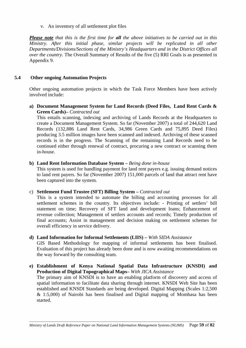
____________________________________________________________________________________________________Ministry of Lands Draft Reference Paper on National Land Information Management Systems (NLIMS) Page 59 of 82
v. An inventory of all settlement plot files Please note that this is the first time for all the above initiatives to be carried out in this Ministry. After this initial phase, similar projects will be replicated in all other Departments/Divisions/Sections of the Ministry’s Headquarters and in the District Offices all over the country. The Overall Summary of Results of the five (5) RRI Goals is as presented in Appendix 9.
5.4 Other ongoing Automation Projects Other ongoing automation projects in which the Task Force Members have been actively involved include: a) Document Management System for Land Records (Deed Files, Land Rent Cards &
Green Cards)– Contracted out This entails scanning, indexing and archiving of Lands Records at the Headquarters to create a Document Management System. So far (November 2007) a total of 244,620 Land Records (132,886 Land Rent Cards, 34,986 Green Cards and 75,895 Deed Files) producing 3.5 million images have been scanned and indexed. Archiving of these scanned records is in the progress. The Scanning of the remaining Land Records need to be continued either through renewal of contract, procuring a new contract or scanning them in-house.
b) Land Rent Information Database System – Being done in-house
This system is used for handling payment for land rent payers e.g. issuing demand notices to land rent payers. So far (November 2007) 151,000 parcels of land that attract rent have been captured into the system.
c) Settlement Fund Trustee (SFT) Billing System – Contracted out
This is a system intended to automate the billing and accounting processes for all settlement schemes in the country. Its objectives include: - Printing of settlers’ bill statement on time; Recovery of SFT land and development loans; Enhancement of revenue collection; Management of settlers accounts and records; Timely production of final accounts; Assist in management and decision making on settlement schemes for overall efficiency in service delivery.
d) Land Information for Informal Settlements (LIIS) – With SIDA Assistance
GIS Based Methodology for mapping of informal settlements has been finalised. Evaluation of this project has already been done and is now awaiting recommendations on the way forward by the consulting team.
e) Establishment of Kenya National Spatial Data Infrastructure (KNSDI) and
Production of Digital Topographical Maps– With JICA Assistance The primary aim of KNSDI is to have an enabling platform of discovery and access of spatial information to facilitate data sharing through internet. KNSDI Web Site has been established and KNSDI Standards are being developed. Digital Mapping (Scales 1:2,500 & 1:5,000) of Nairobi has been finalised and Digital mapping of Mombasa has been started.
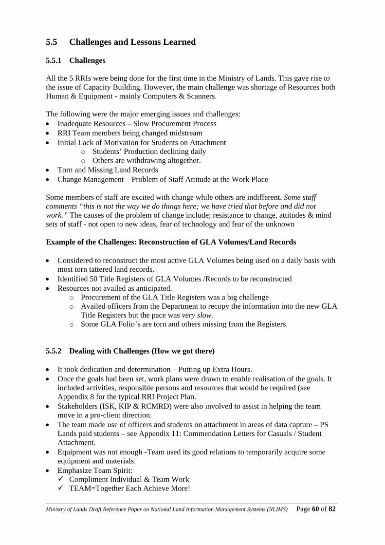
____________________________________________________________________________________________________Ministry of Lands Draft Reference Paper on National Land Information Management Systems (NLIMS) Page 60 of 82
5.5 Challenges and Lessons Learned 5.5.1 Challenges All the 5 RRIs were being done for the first time in the Ministry of Lands. This gave rise to the issue of Capacity Building. However, the main challenge was shortage of Resources both Human & Equipment - mainly Computers & Scanners.
The following were the major emerging issues and challenges: • Inadequate Resources – Slow Procurement Process • RRI Team members being changed midstream • Initial Lack of Motivation for Students on Attachment
o Students’ Production declining daily o Others are withdrawing altogether.
• Torn and Missing Land Records • Change Management – Problem of Staff Attitude at the Work Place Some members of staff are excited with change while others are indifferent. Some staff comments “this is not the way we do things here; we have tried that before and did not work.” The causes of the problem of change include; resistance to change, attitudes & mind sets of staff - not open to new ideas, fear of technology and fear of the unknown
Example of the Challenges: Reconstruction of GLA Volumes/Land Records • Considered to reconstruct the most active GLA Volumes being used on a daily basis with
most torn tattered land records. • Identified 50 Title Registers of GLA Volumes /Records to be reconstructed • Resources not availed as anticipated.
o Procurement of the GLA Title Registers was a big challenge o Availed officers from the Department to recopy the information into the new GLA
Title Registers but the pace was very slow. o Some GLA Folio’s are torn and others missing from the Registers.
5.5.2 Dealing with Challenges (How we got there) • It took dedication and determination – Putting up Extra Hours. • Once the goals had been set, work plans were drawn to enable realisation of the goals. It
included activities, responsible persons and resources that would be required (see Appendix 8 for the typical RRI Project Plan.
• Stakeholders (ISK, KIP & RCMRD) were also involved to assist in helping the team move in a pro-client direction.
• The team made use of officers and students on attachment in areas of data capture – PS Lands paid students – see Appendix 11: Commendation Letters for Casuals / Student Attachment.
• Equipment was not enough -Team used its good relations to temporarily acquire some equipment and materials.
• Emphasize Team Spirit: Compliment Individual & Team Work TEAM=Together Each Achieve More!
____________________________________________________________________________________________________Ministry of Lands Draft Reference Paper on National Land Information Management Systems (NLIMS) Page 61 of 82
Example: Dealing with the GLA Challenge
• Daily and WEEKLY EVALUATION Reports –see Appendix 12 (a-b) for Typical
Individual Evaluation Report Forms • The printing of the GLA Title Registers was given priority as some officers of the
Government Printers worked overtime to ensure the Registers were delivered in time upon our insistence.
• Our team member actually followed the procurement process all the way to the Government Printer.
• Later employed skilled Casuals/Students on attachment to speed up the process. • Procured 12 Title Registers from the Government Printers out of 50 required. • Collection of information of missing folio’s from Deed Files into the New Registers. 5.5.3 Lessons Learned • RRI as a RBM tool can be used to achieve quick results where other attempts take too
long or fail. • The 100 days to accomplish immense tasks efficiently improved the way work is done in
the Ministry by eliminating lethargy. • Some actions required ‘personal touch” • It is important to have the planned equipment and personnel in order to achieve the
desired results • Out of the RRI we have now obtained statistical data on how much a person can capture
per day for all the 5 RRIs - (see Appendix 10: Quantifying Methodology/ Lessons Learned.
• It is important to put a Change Management Programme at the Work Place.

____________________________________________________________________________________________________Ministry of Lands Draft Reference Paper on National Land Information Management Systems (NLIMS) Page 62 of 82
6 Chapter 6 Design of a GIS-based National Land Information Management System (NLIMS)
6.1 Introduction to Proposed GIS-Based NLIMS Except for the stand alone computerization projects already discussed in the previous Chapter 5 above, the Ministry has continued to use mainly manual Land Information Management System. The Ministry has however accumulated massive land information records dating back to over 100 years ago which have now increased to unmanageable proportions largely due to continued use of the outdated manual systems, thereby making service delivery both inefficient and ineffective. Due to the large data volumes and the technological demand for faster services, the manual system can no longer be relied upon – a more efficient system is necessary. Such a system is a Computer Based Information System (CBIS) on the Ministry’s Land Records which operates on GIS Technology. 6.2 GIS Concepts
a) What is GIS? Geographical Information System (GIS) is defined as an information system that is used to input, store, retrieve, manipulate, analyze and output geographically referenced data or geospatial data, in order to support decision making for planning and management of land use, natural resources, environment, transportation, urban facilities, and other administrative records. b) The key components of GIS The key components of GIS are computer systems, geospatial data and users, as shown in the figure below
Diagram 6.2(1): The Key Components of GIS
A computer system consists of hardware, software and procedures designed to support capture, processing, analysis, modeling, display and sharing of geospatial data. The sources of geospatial data are digitized maps, aerial photographs, satellite images, statistical tables and other related documents.
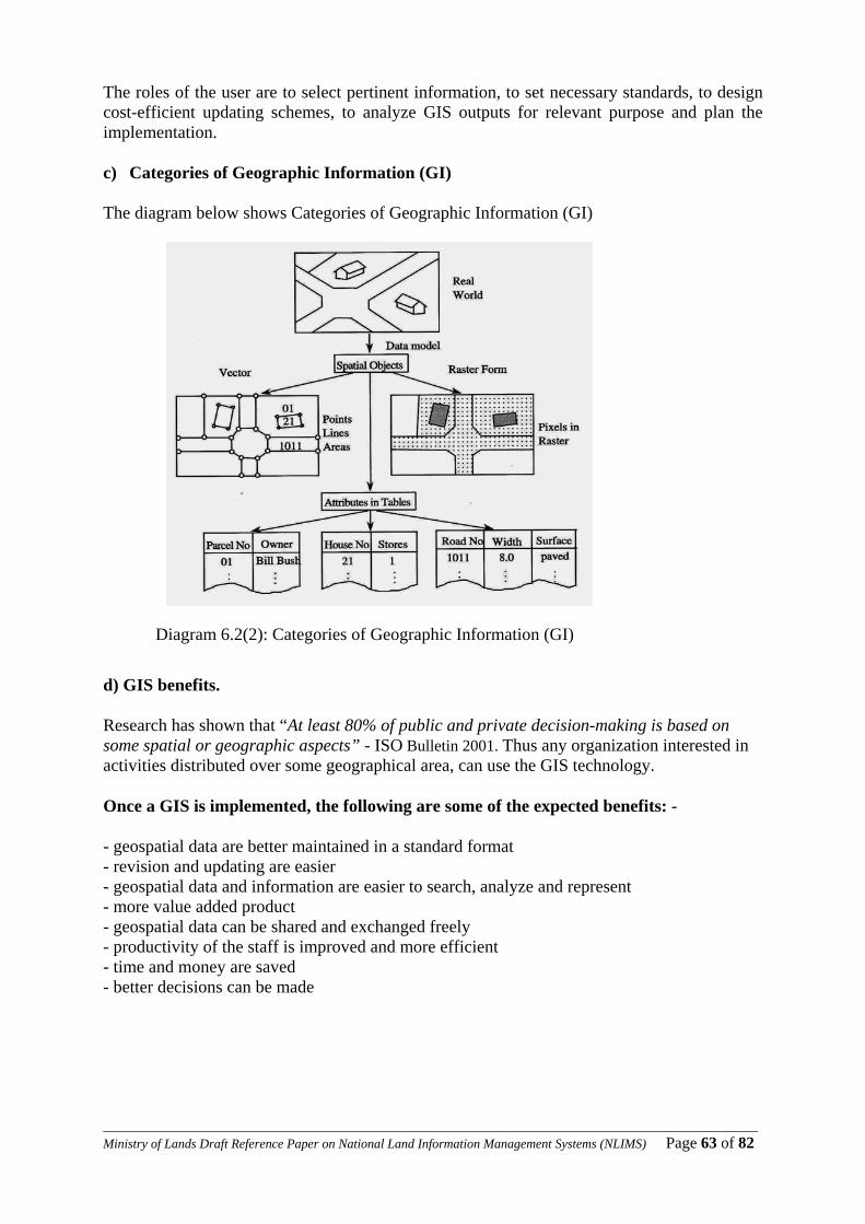
____________________________________________________________________________________________________Ministry of Lands Draft Reference Paper on National Land Information Management Systems (NLIMS) Page 63 of 82
The roles of the user are to select pertinent information, to set necessary standards, to design cost-efficient updating schemes, to analyze GIS outputs for relevant purpose and plan the implementation.
c) Categories of Geographic Information (GI) The diagram below shows Categories of Geographic Information (GI)
Diagram 6.2(2): Categories of Geographic Information (GI)
d) GIS benefits.
Research has shown that “At least 80% of public and private decision-making is based on some spatial or geographic aspects” - ISO Bulletin 2001. Thus any organization interested in activities distributed over some geographical area, can use the GIS technology. Once a GIS is implemented, the following are some of the expected benefits: -
- geospatial data are better maintained in a standard format - revision and updating are easier - geospatial data and information are easier to search, analyze and represent - more value added product - geospatial data can be shared and exchanged freely - productivity of the staff is improved and more efficient - time and money are saved - better decisions can be made
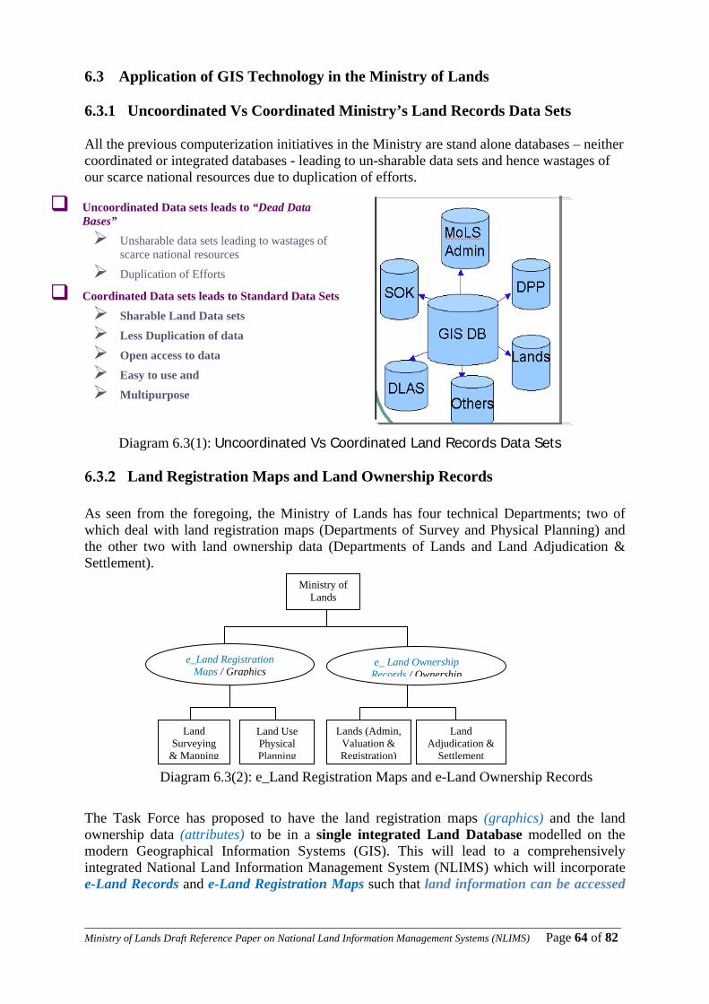
____________________________________________________________________________________________________Ministry of Lands Draft Reference Paper on National Land Information Management Systems (NLIMS) Page 64 of 82
6.3 Application of GIS Technology in the Ministry of Lands 6.3.1 Uncoordinated Vs Coordinated Ministry’s Land Records Data Sets All the previous computerization initiatives in the Ministry are stand alone databases – neither coordinated or integrated databases - leading to un-sharable data sets and hence wastages of our scarce national resources due to duplication of efforts.
Diagram 6.3(1): Uncoordinated Vs Coordinated Land Records Data Sets
6.3.2 Land Registration Maps and Land Ownership Records As seen from the foregoing, the Ministry of Lands has four technical Departments; two of which deal with land registration maps (Departments of Survey and Physical Planning) and the other two with land ownership data (Departments of Lands and Land Adjudication & Settlement).
Diagram 6.3(2): e_Land Registration Maps and e-Land Ownership Records
The Task Force has proposed to have the land registration maps (graphics) and the land ownership data (attributes) to be in a single integrated Land Database modelled on the modern Geographical Information Systems (GIS). This will lead to a comprehensively integrated National Land Information Management System (NLIMS) which will incorporate e-Land Records and e-Land Registration Maps such that land information can be accessed
Ministry of Lands
e_Land Registration Maps / Graphics
e_ Land Ownership Records / Ownership
Lands (Admin, Valuation & Registration)
Land Use Physical Planning
Land Surveying
& Mapping
Land Adjudication &
Settlement
Uncoordinated Data sets leads to “Dead Data Bases”
Unsharable data sets leading to wastages of scarce national resources
Duplication of Efforts
Coordinated Data sets leads to Standard Data Sets
Sharable Land Data sets
Less Duplication of data
Open access to data
Easy to use and
Multipurpose
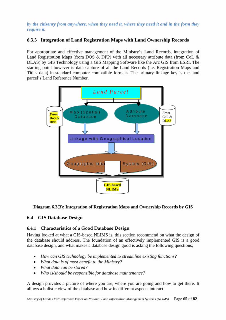
____________________________________________________________________________________________________Ministry of Lands Draft Reference Paper on National Land Information Management Systems (NLIMS) Page 65 of 82
by the citizenry from anywhere, when they need it, where they need it and in the form they require it.
6.3.3 Integration of Land Registration Maps with Land Ownership Records For appropriate and effective management of the Ministry’s Land Records, integration of Land Registration Maps (from DOS & DPP) with all necessary attribute data (from CoL & DLAS) by GIS Technology using a GIS Mapping Software like the Arc GIS from ESRI. The starting point however is data capture of all the Land Records (i.e. Registration Maps and Titles data) in standard computer compatible formats. The primary linkage key is the land parcel’s Land Reference Number.
Diagram 6.3(3): Integration of Registration Maps and Ownership Records by GIS 6.4 GIS Database Design
6.4.1 Characteristics of a Good Database Design Having looked at what a GIS-based NLIMS is, this section recommend on what the design of the database should address. The foundation of an effectively implemented GIS is a good database design, and what makes a database design good is asking the following questions;
• How can GIS technology be implemented to streamline existing functions? • What data is of most benefit to the Ministry? • What data can be stored? • Who is/should be responsible for database maintenance?
A design provides a picture of where you are, where you are going and how to get there. It allows a holistic view of the database and how its different aspects interact.
M a p (S p a t ia l)D a ta b a s e
M a p (S p a t ia l)D a ta b a s e
A ttr ib u te D a ta b a s eA ttr ib u te D a ta b a s e
L in k a g e w ith G e o g ra p h ic a l L o c a t io nL in k a g e w ith G e o g ra p h ic a l L o c a t io n
G e o g ra p h ic In fo rm a t io n S y s te m (G IS )G e o g ra p h ic In fo rm a t io n S y s te m (G e o g ra p h ic In fo rm a tio n S y s te m ( G ISG IS ))
P a r c e l
M a p (S p a t ia l)D a ta b a s e
M a p (S p a t ia l)D a ta b a s e
A ttr ib u te D a ta b a s eA ttr ib u te D a ta b a s e
L in k a g e w ith G e o g ra p h ic a l L o c a t io nL in k a g e w ith G e o g ra p h ic a l L o c a t io n
G e o g ra p h ic In fo rm a t io n S y s te m (G IS )G e o g ra p h ic In fo rm a t io n S y s te m (G e o g ra p h ic In fo rm a t io n S y s te m ( G ISG IS ))
P a r c e lL a n d P a r c e l
From CoL & DLAS
From DoS & DPP
GIS-based NLIMS

____________________________________________________________________________________________________Ministry of Lands Draft Reference Paper on National Land Information Management Systems (NLIMS) Page 66 of 82
6.4.2 Steps in Designing a Geodatabase The database in focus is a Geodatabase. A geodatabse extent a database thus achieving the maintenance of graphic features and attributes in a true relational database management system such as SQL-Server database. The design of a geo-database is achieved through the following four steps; Step 1: Identifying Data required in GIS, Step 2: Modelling of Users View, Step 3: Selecting/Matching Geographic Data with Geodatabase Model Step 4: Organising Geodatabase Structure.
Step 1: Identification of Ministry’s Land Records Data Required in GIS In chapter 3 we have seen a list of all data that should be captured. Below is an extraction, from the same list, of data required for GIS, which is hereby grouped into five categories based on type: - • Land Records - Records related to land planning, surveying, registration and
administration • Topographical- These category consists of features on the surface of the earth • Altimetry- These is data concerned with the shape of the earth • Geodetic - Data concerned with coordination of features on the surface of the earth • Imagery - Imagery includes aerial photographs satellite imagery, scanned parcel maps
and all other scanned documents that relate to the parcel
LOGICAL DATA GROUP Data LayersParcels International Boundary Land Adjudication Progress Map National Boundary
Land Parcel Records
Development Plans Land UseBuildings StructuresTransport VegetationCenterline RecreationParkings FencesRoads AirfieldsRailway UtilitiesHydrography Bridges/Overpasses Swamps/marshes Digital Orthophotos
Topographic
Water Bodies Satellite Imagery DTM Spot heights Altimetry Contours River Valley Trigonometrical Stations Boundary Pillars Geodetic BenchmarksScanned Parcel Maps Digital Orthophoto Imagery Scanned Parcel Reports Satellite Imagery
Table 6.2(1): The Ministry’s Land Records Data Required in GIS
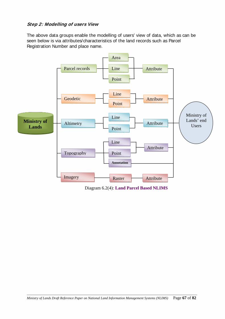
____________________________________________________________________________________________________Ministry of Lands Draft Reference Paper on National Land Information Management Systems (NLIMS) Page 67 of 82
Step 2: Modelling of users View The above data groups enable the modelling of users’ view of data, which as can be seen below is via attributes/characteristics of the land records such as Parcel Registration Number and place name.
Diagram 6.2(4): Land Parcel Based NLIMS
Ministry of Lands
Parcel records
Topography
Altimetry
Geodetic
Imagery
Area
Line
Point
Line
Point
Line
Point
Line
Point
Raster
Annotation
Attribute
Attribute
Attribute
Attribute
Attribute
Ministry of Lands’ end
Users
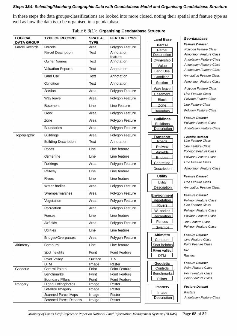
____________________________________________________________________________________________________Ministry of Lands Draft Reference Paper on National Land Information Management Systems (NLIMS) Page 68 of 82
Table 6.3(1): Organising Geodatabase Structure
LOGICAL DATA GROUP
TYPE OF RECORD SPATIAL TYPE
FEATURE TYPE
Parcels Area Polygon Feature Parcel Description Text Annotation
feature Owner Names Text Annotation
Valuation Reports Text Annotation
Land Use Text Annotation
Condition Text Annotation
Section Area Polygon Feature
Way leave Area Polygon Feature
Easement Line Line Feature
Block Area Polygon Feature
Zone Area Polygon Feature
Parcel Records
Boundaries Area Polygon Feature
Buildings Area Polygon Feature
Building Description Text Annotation
Roads Line Line feature
Centerline Line Line feature
Parkings Area Polygon Feature
Railway Line Line feature
Rivers Line Line feature
Water bodies Area Polygon Feature
Swamps/marshes Area Polygon Feature
Vegetation Area Polygon Feature
Recreation Area Polygon Feature
Fences Line Line feature
Airfields Area Polygon Feature
Utilities Line Line feature
Topographic
Bridges/Overpasses Area Polygon Feature
Contours Line Line feature
Spot heights Point Point Feature
River Valley Surface TIN
Altimetry
DTM Image Raster Control Points Point Point Feature Benchmarks Point Point Feature
Geodetic
Boundary Pillars Point Point Feature Digital Orthophotos Image Raster Satellite Imagery Image Raster
Scanned Parcel Maps Image Raster
Imagery
Scanned Parcel Reports Image Raster
Feature Dataset
Geo-database
Feature Dataset
Polygon Feature Class Annotation Feature Class
Land Base
Buildings Description
Buildings
ParcelParcel
Description Ownership
ValueLand Use Condition Section
Way leave Easement
BlockZone
Boundary
Altimetry Contours
River valley DTM
Spot heights
Geodetic Controls
PillarsBenchmarks
Transport Roads
Railway Airfields Bridges
Centreline Description
UtilityDescription
Utility
Environment Vegetation
RiversW. bodies Recreation
Fences Swamps
ImageDescription
Imagery
Annotation Feature Class Annotation Feature Class Annotation Feature Class
Annotation Feature Class
Annotation Feature Class
Polygon Feature Class
Polygon Feature Class
Polygon Feature Class
Line Feature Class
Polygon Feature Class
Line Feature Class
Annotation Feature Class
Line Feature Class
Line Feature Class
Line Feature Class
Line Feature Class
Feature Dataset
Feature Dataset
Feature Dataset
Feature Dataset
Feature Dataset
Feature Dataset
Annotation Feature Class
Annotation Feature Class
Annotation Feature Class Rasters
Point Feature Class
Point Feature Class
Point Feature Class
Rasters TIN
Point Feature Class Line Feature Class
Line Feature Class
Line Feature Class
Polygon Feature Class
Polygon Feature Class
Polygon Feature Class
Polygon Feature Class
Polygon Feature Class
Polygon Feature Class
Steps 3&4: Selecting/Matching Geographic Data with Geodatabase Model and Organising Geodatabase Structure In these steps the data groups/classifications are looked into more closed, noting their spatial and feature type as well as how the data is to be organised in a geodatabase
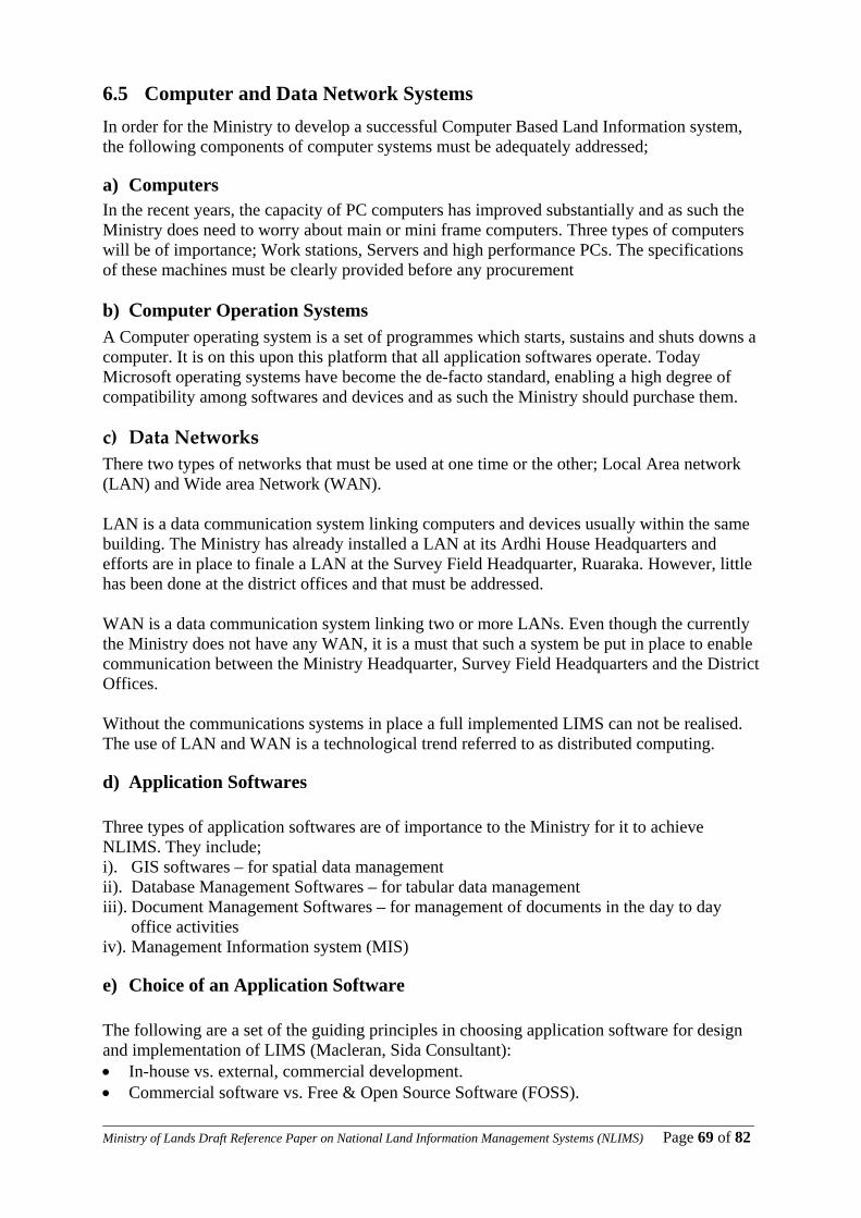
____________________________________________________________________________________________________Ministry of Lands Draft Reference Paper on National Land Information Management Systems (NLIMS) Page 69 of 82
6.5 Computer and Data Network Systems In order for the Ministry to develop a successful Computer Based Land Information system, the following components of computer systems must be adequately addressed;
a) Computers In the recent years, the capacity of PC computers has improved substantially and as such the Ministry does need to worry about main or mini frame computers. Three types of computers will be of importance; Work stations, Servers and high performance PCs. The specifications of these machines must be clearly provided before any procurement
b) Computer Operation Systems A Computer operating system is a set of programmes which starts, sustains and shuts downs a computer. It is on this upon this platform that all application softwares operate. Today Microsoft operating systems have become the de-facto standard, enabling a high degree of compatibility among softwares and devices and as such the Ministry should purchase them.
c) Data Networks There two types of networks that must be used at one time or the other; Local Area network (LAN) and Wide area Network (WAN). LAN is a data communication system linking computers and devices usually within the same building. The Ministry has already installed a LAN at its Ardhi House Headquarters and efforts are in place to finale a LAN at the Survey Field Headquarter, Ruaraka. However, little has been done at the district offices and that must be addressed. WAN is a data communication system linking two or more LANs. Even though the currently the Ministry does not have any WAN, it is a must that such a system be put in place to enable communication between the Ministry Headquarter, Survey Field Headquarters and the District Offices. Without the communications systems in place a full implemented LIMS can not be realised. The use of LAN and WAN is a technological trend referred to as distributed computing.
d) Application Softwares Three types of application softwares are of importance to the Ministry for it to achieve NLIMS. They include; i). GIS softwares – for spatial data management ii). Database Management Softwares – for tabular data management iii). Document Management Softwares – for management of documents in the day to day
office activities iv). Management Information system (MIS)
e) Choice of an Application Software The following are a set of the guiding principles in choosing application software for design and implementation of LIMS (Macleran, Sida Consultant): • In-house vs. external, commercial development. • Commercial software vs. Free & Open Source Software (FOSS).
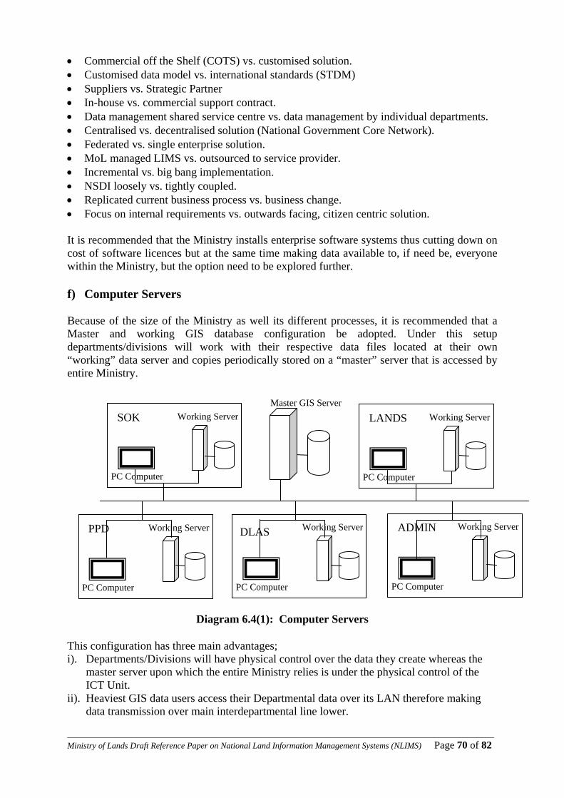
____________________________________________________________________________________________________Ministry of Lands Draft Reference Paper on National Land Information Management Systems (NLIMS) Page 70 of 82
• Commercial off the Shelf (COTS) vs. customised solution. • Customised data model vs. international standards (STDM) • Suppliers vs. Strategic Partner • In-house vs. commercial support contract. • Data management shared service centre vs. data management by individual departments. • Centralised vs. decentralised solution (National Government Core Network). • Federated vs. single enterprise solution. • MoL managed LIMS vs. outsourced to service provider. • Incremental vs. big bang implementation. • NSDI loosely vs. tightly coupled. • Replicated current business process vs. business change. • Focus on internal requirements vs. outwards facing, citizen centric solution. It is recommended that the Ministry installs enterprise software systems thus cutting down on cost of software licences but at the same time making data available to, if need be, everyone within the Ministry, but the option need to be explored further. f) Computer Servers Because of the size of the Ministry as well its different processes, it is recommended that a Master and working GIS database configuration be adopted. Under this setup departments/divisions will work with their respective data files located at their own “working” data server and copies periodically stored on a “master” server that is accessed by entire Ministry.
Diagram 6.4(1): Computer Servers
This configuration has three main advantages; i). Departments/Divisions will have physical control over the data they create whereas the
master server upon which the entire Ministry relies is under the physical control of the ICT Unit.
ii). Heaviest GIS data users access their Departmental data over its LAN therefore making data transmission over main interdepartmental line lower.
SOK Working Server
PC Computer
LANDS Working Server
PC Computer
Working Server
PC Computer
ADMIN Working Server
PC Computer
PPD Working Server
PC Computer
Master GIS Server
DLAS
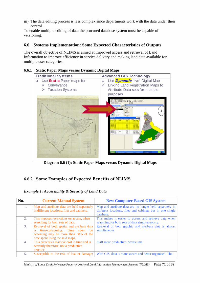
____________________________________________________________________________________________________Ministry of Lands Draft Reference Paper on National Land Information Management Systems (NLIMS) Page 71 of 82
iii). The data editing process is less complex since departments work with the data under their control.
To enable multiple editing of data the procured database system must be capable of versioning.
6.6 Systems Implementation: Some Expected Characteristics of Outputs
The overall objective of NLIMS is aimed at improved access and retrieval of Land Information to improve efficiency in service delivery and making land data available for multiple user categories.
6.6.1 Static Paper Maps versus Dynamic Digital Maps Traditional Systems Advanced GIS Technology
Use Static Paper maps for Conveyance Taxation Systems
Use DDyynnaammiicc ‘live’ Digital Map Linking Land Registration Maps to
Attribute Data sets for multiple purposes.
Diagram 6.6 (1): Static Paper Maps versus Dynamic Digital Maps
6.6.2 Some Examples of Expected Benefits of NLIMS Example 1: Accessibility & Security of Land Data
No. Current Manual System New Computer-Based GIS System 1. Map and attribute data are held separately
in different locations, files and cabinets. Map and attribute data are no longer held separately in different locations, files and cabinets but in one single database.
2. This imposes restrictions on access, when searching for both sets of data.
This makes it easier to access and retrieve data when searching for both sets of data simultaneously.
3. Retrieval of both spatial and attribute data is time-consuming. Time spent on accessing may be more than 50% of the time spent using the said maps.
Retrieval of both graphic and attribute data is almost simultaneous.
4. This presents a massive cost in time and is certainly therefore, not a productive practice
Staff more productive. Saves time
5. Susceptible to the risk of loss or damage; With GIS, data is more secure and better organized. The
4
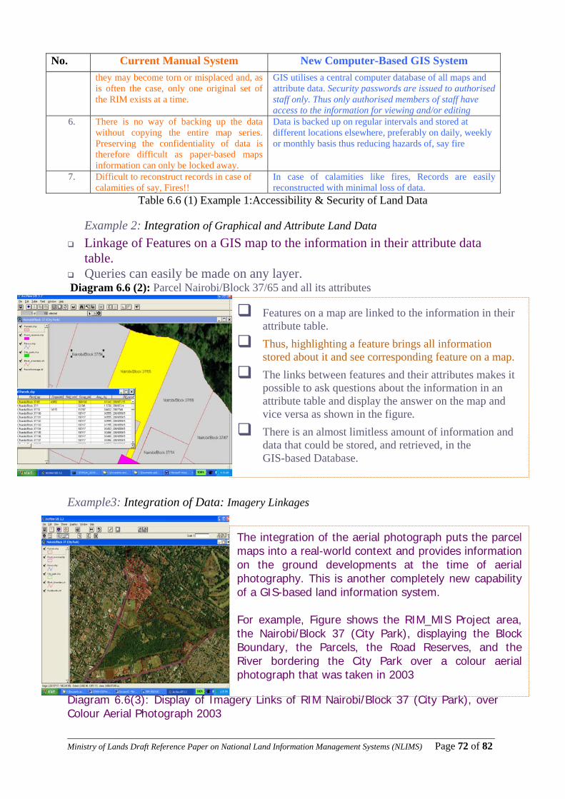
____________________________________________________________________________________________________Ministry of Lands Draft Reference Paper on National Land Information Management Systems (NLIMS) Page 72 of 82
No. Current Manual System New Computer-Based GIS System they may become torn or misplaced and, as is often the case, only one original set of the RIM exists at a time.
GIS utilises a central computer database of all maps and attribute data. Security passwords are issued to authorised staff only. Thus only authorised members of staff have access to the information for viewing and/or editing
6. There is no way of backing up the data without copying the entire map series. Preserving the confidentiality of data is therefore difficult as paper-based maps information can only be locked away.
Data is backed up on regular intervals and stored at different locations elsewhere, preferably on daily, weekly or monthly basis thus reducing hazards of, say fire
7. Difficult to reconstruct records in case of calamities of say, Fires!!
In case of calamities like fires, Records are easily reconstructed with minimal loss of data.
Table 6.6 (1) Example 1:Accessibility & Security of Land Data
Example 2: Integration of Graphical and Attribute Land Data Linkage of Features on a GIS map to the information in their attribute data
table. Queries can easily be made on any layer.
Diagram 6.6 (2): Parcel Nairobi/Block 37/65 and all its attributes
Example3: Integration of Data: Imagery Linkages
Diagram 6.6(3): Display of Imagery Links of RIM Nairobi/Block 37 (City Park), over Colour Aerial Photograph 2003
Features on a map are linked to the information in their attribute table.
Thus, highlighting a feature brings all information stored about it and see corresponding feature on a map.
The links between features and their attributes makes it possible to ask questions about the information in an attribute table and display the answer on the map and vice versa as shown in the figure.
There is an almost limitless amount of information and data that could be stored, and retrieved, in the GIS-based Database.
The integration of the aerial photograph puts the parcel maps into a real-world context and provides information on the ground developments at the time of aerial photography. This is another completely new capability of a GIS-based land information system. For example, Figure shows the RIM_MIS Project area, the Nairobi/Block 37 (City Park), displaying the Block Boundary, the Parcels, the Road Reserves, and the River bordering the City Park over a colour aerial photograph that was taken in 2003
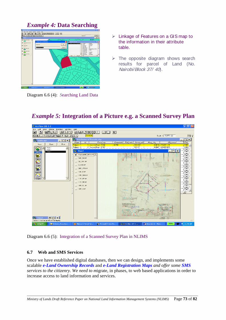
____________________________________________________________________________________________________Ministry of Lands Draft Reference Paper on National Land Information Management Systems (NLIMS) Page 73 of 82
Example 4: Data Searching Diagram 6.6 (4): Searching Land Data
Example 5: Integration of a Picture e.g. a Scanned Survey Plan
Diagram 6.6 (5): Integration of a Scanned Survey Plan in NLIMS
6.7 Web and SMS Services
Once we have established digital databases, then we can design, and implements some scalable e-Land Ownership Records and e-Land Registration Maps and offer some SMS services to the citizenry. We need to migrate, in phases, to web based applications in order to increase access to land information and services.
Linkage of Features on a GIS map to the information in their attribute table.
The opposite diagram shows search
results for parcel of Land (No. Nairobi/Block 37/ 40).

____________________________________________________________________________________________________Ministry of Lands Draft Reference Paper on National Land Information Management Systems (NLIMS) Page 74 of 82
7 Chapter 7 Recommendations on the Way Forward and Conclusions
This chapter gives recommendation on how the challenges identified previously in chapters 1-6 above can be overcome in order to achieve an efficient NLIMS. It is presented in two parts; the common and specific recommendations per Department.
7.1 Common Key Findings & Recommendations across the Departments 7.1.1 Recommendations I: Processes and Procedures The Task Force found out that the Ministry was burdened by an “inherited” culture, systems, structure, procedures and practices much of which were badly “outdated” and irrelevant. However, the Task Force found that the Ministyry’s existing structure was not necessarily the major problem that hindered service delivery. The problem was that the various Departments within the Ministry were acting like independent silos instead of working together in a coordinated effort to achieve commonly held Ministerial goals and objectives. The service will greatly be enhanced by reducing overal number of steps especially in Land Adminidstration and Land Registration Divisions in the Department of Lands and at the Cadsstral Division of the Department of Surveys where there is alot of duplications and redundancy. Some of the steps, such as the 39 steps in preparation of titles can be reduced to say 10 steps, can eliminated without compromising on quality. This may require re-organisation of the affected offices including knocking down some walls and modernising service counters similar to those at KRA offices. The ultimate solution, however, is by the establishment of an integrated, transparent, decentralized, affordable and efficient GIS-based Land Information Management System at both the Ministry Headquarters and District offices across the country. The GIS-based NLIMS can be implemented in phases. Identify and implement LIMS in an urban area like part of City of Nairobi and peri-urban/rural area like Kiambu, Thika, Machakos or Kajiado. 7.1.2 Recommendations II: Safeguard the Paper Records a) Make a comprehensive inventory volumes and types of all land records; their physical
condition and their storage facilities b) Verify authenticity of the land records data. c) Improve the records storage facilities: space, shelving and environment. d) Manage solution for incorrect and missing records e) Create a records conversion strategy. f) Reconstruct records where appropriate prior to scanning and digitising. g) Improve the records storage facilities: space, shelving and environment. h) Improve security for access to the land records especially the titling records at Department
of Lands and the Land Registration Maps at the Department of Surveys. 7.1.3 Recommendations III : Scale – up the RRIs for Quick Wins a) RRI Goal 1 Finalise reconstruction and create database for GLA Volumes. b) RRI Goal 2 Share Valuation Database through LAN c) RRI Goal 3 Digitize /vectorize all the 430 Development Plans.

____________________________________________________________________________________________________Ministry of Lands Draft Reference Paper on National Land Information Management Systems (NLIMS) Page 75 of 82
d) RRI Goal 4 Finalise scanning of all survey plans and scale up by digitizing of parcel boundaries and scanning of survey reports.
e) RRI Goal 5 Now that the Settlement Plot Files (FTS_SPF) is implemented, and then it will be replicated in all the other sister Departments in the Ministry.
In all cases above we need to enhance security/backups for the databases. See RRI Scale up Implementation Programme and Budget – Appendix 5 7.1.4 Recommendations IV : Working in Shifts The Ministry can introduce working in shifts on some special projects such as the RRI ones. In all the five RRIs, support will be required in providing more resources in terms of equipment, consultancy and compensations to officers who may from time to time have to go the extra-mile beyond normal working hours. Once adequate resources are availed, employ casuals to Work in Shifts 0800-1400 & 1400-2000 Daily; Work on Saturdays 0900-1600 (M,E &R for the week) and Pay Motivation Allowances to Casuals/Students/Staff Overtimes 7.1.5 Recommendations V: Human Resource Capacity Building Technology is Dynamic: Although, the Ministry has skilled manpower, it needs to have the staff being up to date in modern technology, particularly the ICT. Since technology is dynamic it is recommended that the Ministry not only concentrates on investing in modern equipment but also on continuous training of staff on the application of new technology in all technical fields. In this respect there should be a proper training programme: - a) The executive (the PS, the Minister, Heads of departments and the top management) b) The technical staff at various levels c) The clerical officers (support staff’, the operators d) The Sensitization, Seminars and Workshops e) Organizations that interact with the ministry including the professionals and other
stakeholders f) Technical tours Change Management- to bring together those against and those who embrace the change Team Work: To make better use of the available resources in terms of personnel, equipments and software’s, there is need to embrace team work policy. This is where the management team can participate fully in terms of drafting a work plan and deciding on data is to be given preference. 7.1.6 Recommendations VI: Working Environment The process of modernisation will need conducive IT working environment. The state of offices and the infrastructure in place most offices both at the headquarters and field stations is not conducive to IT development. For instance, the buildings in Ruaraka were put up in early 1950s and have become dilapidated. Generally, there is also increased pressure for office space and other facilities. In this respect, it is recommended that the Ministry invests in modern offices and furniture as a long term programme, meanwhile the existing offices can be renovated.
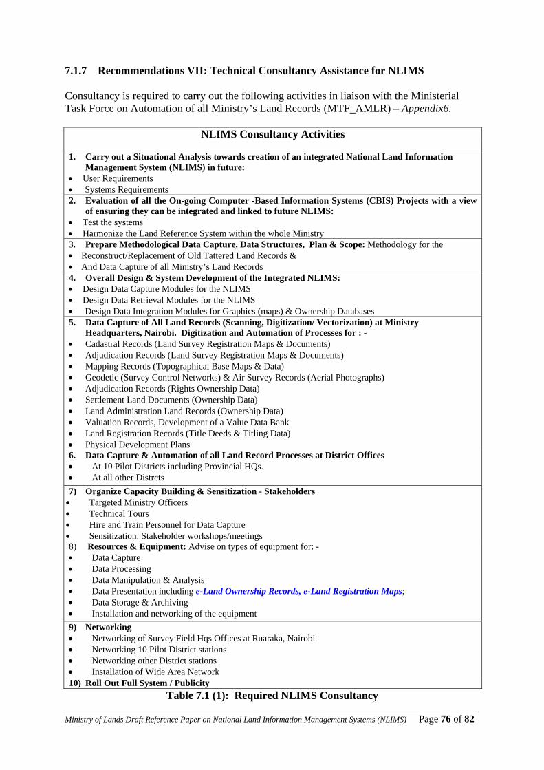
____________________________________________________________________________________________________Ministry of Lands Draft Reference Paper on National Land Information Management Systems (NLIMS) Page 76 of 82
7.1.7 Recommendations VII: Technical Consultancy Assistance for NLIMS Consultancy is required to carry out the following activities in liaison with the Ministerial Task Force on Automation of all Ministry’s Land Records (MTF_AMLR) – Appendix6.
NLIMS Consultancy Activities
1. Carry out a Situational Analysis towards creation of an integrated National Land Information Management System (NLIMS) in future:
• User Requirements • Systems Requirements 2. Evaluation of all the On-going Computer -Based Information Systems (CBIS) Projects with a view
of ensuring they can be integrated and linked to future NLIMS: • Test the systems • Harmonize the Land Reference System within the whole Ministry 3. Prepare Methodological Data Capture, Data Structures, Plan & Scope: Methodology for the • Reconstruct/Replacement of Old Tattered Land Records & • And Data Capture of all Ministry’s Land Records 4. Overall Design & System Development of the Integrated NLIMS: • Design Data Capture Modules for the NLIMS • Design Data Retrieval Modules for the NLIMS • Design Data Integration Modules for Graphics (maps) & Ownership Databases 5. Data Capture of All Land Records (Scanning, Digitization/ Vectorization) at Ministry
Headquarters, Nairobi. Digitization and Automation of Processes for : - • Cadastral Records (Land Survey Registration Maps & Documents) • Adjudication Records (Land Survey Registration Maps & Documents) • Mapping Records (Topographical Base Maps & Data) • Geodetic (Survey Control Networks) & Air Survey Records (Aerial Photographs) • Adjudication Records (Rights Ownership Data) • Settlement Land Documents (Ownership Data) • Land Administration Land Records (Ownership Data) • Valuation Records, Development of a Value Data Bank • Land Registration Records (Title Deeds & Titling Data) • Physical Development Plans 6. Data Capture & Automation of all Land Record Processes at District Offices • At 10 Pilot Districts including Provincial HQs. • At all other Distrcts 7) Organize Capacity Building & Sensitization - Stakeholders • Targeted Ministry Officers • Technical Tours • Hire and Train Personnel for Data Capture • Sensitization: Stakeholder workshops/meetings 8) Resources & Equipment: Advise on types of equipment for: - • Data Capture • Data Processing • Data Manipulation & Analysis • Data Presentation including e-Land Ownership Records, e-Land Registration Maps; • Data Storage & Archiving • Installation and networking of the equipment 9) Networking • Networking of Survey Field Hqs Offices at Ruaraka, Nairobi • Networking 10 Pilot District stations • Networking other District stations • Installation of Wide Area Network 10) Roll Out Full System / Publicity
Table 7.1 (1): Required NLIMS Consultancy
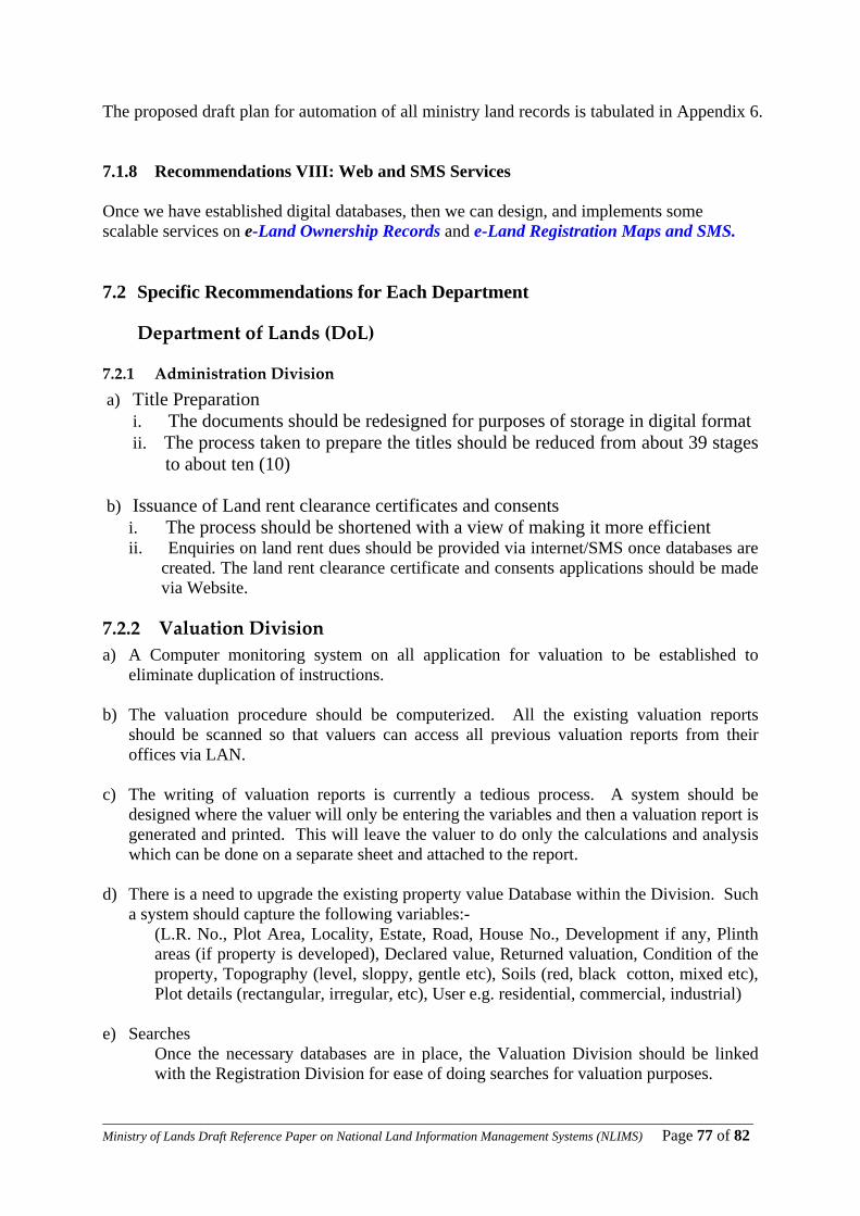
____________________________________________________________________________________________________Ministry of Lands Draft Reference Paper on National Land Information Management Systems (NLIMS) Page 77 of 82
The proposed draft plan for automation of all ministry land records is tabulated in Appendix 6. 7.1.8 Recommendations VIII: Web and SMS Services Once we have established digital databases, then we can design, and implements some scalable services on e-Land Ownership Records and e-Land Registration Maps and SMS. 7.2 Specific Recommendations for Each Department
Department of Lands (DoL)
7.2.1 Administration Division a) Title Preparation
i. The documents should be redesigned for purposes of storage in digital format ii. The process taken to prepare the titles should be reduced from about 39 stages
to about ten (10) b) Issuance of Land rent clearance certificates and consents
i. The process should be shortened with a view of making it more efficient ii. Enquiries on land rent dues should be provided via internet/SMS once databases are
created. The land rent clearance certificate and consents applications should be made via Website.
7.2.2 Valuation Division a) A Computer monitoring system on all application for valuation to be established to
eliminate duplication of instructions.
b) The valuation procedure should be computerized. All the existing valuation reports should be scanned so that valuers can access all previous valuation reports from their offices via LAN.
c) The writing of valuation reports is currently a tedious process. A system should be
designed where the valuer will only be entering the variables and then a valuation report is generated and printed. This will leave the valuer to do only the calculations and analysis which can be done on a separate sheet and attached to the report.
d) There is a need to upgrade the existing property value Database within the Division. Such
a system should capture the following variables:- (L.R. No., Plot Area, Locality, Estate, Road, House No., Development if any, Plinth areas (if property is developed), Declared value, Returned valuation, Condition of the property, Topography (level, sloppy, gentle etc), Soils (red, black cotton, mixed etc), Plot details (rectangular, irregular, etc), User e.g. residential, commercial, industrial)
e) Searches
Once the necessary databases are in place, the Valuation Division should be linked with the Registration Division for ease of doing searches for valuation purposes.

____________________________________________________________________________________________________Ministry of Lands Draft Reference Paper on National Land Information Management Systems (NLIMS) Page 78 of 82
f) Maps Once the necessary databases are in place, the Valuation Division should be linked with the Department of Surveys for easy access to survey data for valuation purposes
The maps should be user friendly and in GIS format enabling query of location of properties of interest.
7.2.3 Land Registration Division
a) The A-Book should be automated so that all officers make immediate notes upon dealing with a document at all stages. A customised DMS system should be developed. Meanwhile, in the short term a file tracking system should be established in the Registry .the above systems should be web site interactive.
b) Recommendations concerning Searches.
i. A File Tracking System should be put in place. This should reduce instances of missing files and speed up the time for processing of official searches.
ii. Search forms should be availed online – on the Website
iii. Reduce the process of copying by enabling the Registrar to have a scanned
copy of the File; and upon verifying may print and certify the search. iv. Recopying of the tattered and torn G.L.A Titles (Volumes)
v. G.L.A. searches to be modified from volumes by conversion to another
system of Registration either R.L.A. or R.T.A.
- This can be done gradually and on the initiative of the Registrars - The documents presented for transactions under G.L.A. for
example conveyances and indentures can be converted upon presentation to R.T.A. System.
vi. Provide for a programme that enables the Registrar to view the Land
variables online (land area, value, rent) vii. Sensitize customers to download applications forms online
viii. In the long term application should be made online
Department of Surveys (DOS)
7.2.4 Cadastral Division It is recommended that a Computer based Cadastral Information System be fully established as an integral part of the wider NLIMS. The system should be an integration of; i. Document Management System ii. Geographical Information System (GIS) and a iii. Database Management System
____________________________________________________________________________________________________Ministry of Lands Draft Reference Paper on National Land Information Management Systems (NLIMS) Page 79 of 82
7.2.5 Adjudication Division It is recommended that;
a) A Computer based Adjudication Survey Information System be fully established as an
integral part of the wider NLIMS. The system should be an integration of;
i. Document Management System ii. Geographic Information System and a
iii. Database Management System b) Only rectified aerial photo enlargements should be used in the adjudication process and
the existing P.I.Ds georeferenced
c) Land owners encouraged to apply for fixing of their property boundaries so as to minimise the expensive boundary disputes.
7.2.6 Geodetic & Geographical Information Systems (G&GIS) Division a) Real time data service GPS control points should be established b) Capacity should be built on provision of Magnetic declination data c) Capacity should be built on provision of Geoidal modulation data d) A common coordinate system should be agreed on and all digital data converted to the new system. e) All analogue data should be digitized to create a National Digital Topographical Database
(NDTDB).
7.2.7 Mapping Division a) It is recommended that all activities in the division be done by use of a Geographic
Information System which is an integral part of the wider NLIMS. b) A culture of acquiring new aerial photography and satellite imagery should be developed
so as to ensure that all maps are up to date. c) All analogue topographical details should be digitized
7.2.8 Records Management at the Department
The Department’s land records need to be managed professionally. E.g. all survey records are recommended to be accessed from one office. The office can have specialized units for various types of records. This is the office which will be charged with the responsibility of converting analogue data to raster data. It will also catalogue the scanned data and sent to a central data base.
When the current Survey Act was enacted, it assumed data handling methods that have now been overtaken by advances in technology. It is recommended that the current Survey Act be amended to accommodate modern technology and protection of copyright interest.
____________________________________________________________________________________________________Ministry of Lands Draft Reference Paper on National Land Information Management Systems (NLIMS) Page 80 of 82
Department of Land Adjudication and Settlement (DLAS)
7.2.9 Adjudication Division a) A Document Management System should be put in place to manage adjudication
processes b) Scan all original RIMs and PIDs c) All analogue data to be digitized d) Once the necessary databases are in place, the Department should be linked with the
Department of Surveys for easy access to survey data for adjudication and settlement purposes
7.2.10 Settlement Division
a) Up-scale the SFT billing system to be website interactive b) A Document Management System should be put in place to manage settlement
processes c) Scan all original RIMs and PIDs d) All analogue data to be digitized e) Once the necessary databases are in place, the Department should be linked with the
Department of Surveys for easy access to survey data for adjudication and settlement purposes
7.2.11 Department of Physical Planning (DPP)
a) It is recommended that planning processes be automated. This calls for acquisition of the requisite hardware and software, design of appropriate interlinked and integrative system and capacity building.
b) Once the necessary databases are in place, the Department should be linked with the
Department of Surveys for easy access to survey data for planning purposes
____________________________________________________________________________________________________Ministry of Lands Draft Reference Paper on National Land Information Management Systems (NLIMS) Page 81 of 82
7.3 CONCLUSIONS: Sustainability Project Proposal We have made a project proposal entitled” Development and Implementation of an Automated National Land Information Management System (NLIMS)” – See Appendix7a - to be rolled out in Phases of 100 days under RBM/RRI for users to reap benefits as soon as practicable. NLIMS aims at improved access, retrieval and processing of Land Information to improve efficiency in service delivery and making land data available for multiple user categories e.g.
conveyance, valuation, taxation and planning. NLIMS will ultimately lead us towards the establishment of an intelligent, integrated approach to management of Land Records i.e. single Database of Title, Land Survey, Planning and Adjudication Land Records for the entire country that is accessible online. E_LandRecords
.
Vision Our envisaged NLIMS Vision is to ensure that high quality Land Information is easily accessible by the Kenyan citizenry from anywhere, when they need it, where they need it and in a form they require it.
Mission Our envisaged NLIMS Mission is to Ensure the Land Registration maps and the Land Ownership Data to be in a single integrated Land Database modelled on the modern Geographical Information Systems (GIS) leading to an integrated National Land Information Management System (NLIMS) which will incorporate e-Land Ownership Records and e-Land Registration Maps to provide our clients and customers with high quality and needs-oriented land information products and services on a timely basis. The vision and mission will ultimately lead to a New Paradigm Shift in the way the Ministry of Lands conducts its business; a typical example is as depicted in Appendix 7b - New Ministry’s Paradigm Shift
____________________________________________________________________________________________________Ministry of Lands Draft Reference Paper on National Land Information Management Systems (NLIMS) Page 82 of 82
8 Chapter 8 Appendices 8.1 Appendix 1: The Task Force Members – Short CVs 8.2 Appendix 8.2(a-b): Letters of Appointments:
(a): Ministerial Task Force on Automation of all Ministry’s Land Records (b): Ministerial Technical Working Group: Land Reform Transformation Unit Land Information Management Systems (LRTU_LIMS)
8.3 Appendix 3(a-b): Letters by the Cabinet Office on Computerization
(a): Letters by the Cabinet Office on Digitization of Land Registries & Maps (b): Letters by the Standing Cabinet Committee on e_Government
8.4 Appendix 4: Kenya National Dialogue and Reconciliation 8.5 Appendix 5: RRIs Scale up Implementation Programme 8.6 Appendix 6: Technical Consultancy Assistance on NLIMS 8.7 Appendix 7(a-b): NLIMS Project Proposal & New Ministry’s Paradigm Shift 8.8 Appendix 8: Typical RRI Project Work Plan 8.9 Appendix 9: Overall Summary of Results for the five (5) RRI Goals 8.10 Appendix 9: Quantifying Methodology/ Lessons Learned in Achieving RRI Goals 8.11 Appendix 10: Atypical Commendation Letter for Casuals / Student Attachment 8.12 Appendix 11 (a-b): Typical Individual Evaluation Report Forms 8.13 Appendix 12: LIMS Programme (under LRTU) for Next 2 Years Version 1.0 20th May 2008


![[XLS]fmism.univ-guelma.dzfmism.univ-guelma.dz/sites/default/files/le fond... · Web view1 1 1 1 1 1 1 1 1 1 1 1 1 1 1 1 1 1 1 1 1 1 1 1 1 1 1 1 1 1 1 1 1 1 1 1 1 1 1 1 1 1 1 1 1 1](https://img.pdfslide.net/doc/110x75/5b9d17e509d3f2194e8d827e/xlsfmismuniv-fond-web-view1-1-1-1-1-1-1-1-1-1-1-1-1-1-1-1-1-1-1-1-1-1.jpg)


![1 $SU VW (G +LWDFKL +HDOWKFDUH %XVLQHVV 8QLW 1 X ñ 1 … · 2020. 5. 26. · 1 1 1 1 1 x 1 1 , x _ y ] 1 1 1 1 1 1 ¢ 1 1 1 1 1 1 1 1 1 1 1 1 1 1 1 1 1 1 1 1 1 1 1 1 1 1 1 1 1 1](https://img.pdfslide.net/doc/110x75/5fbfc0fcc822f24c4706936b/1-su-vw-g-lwdfkl-hdowkfduh-xvlqhvv-8qlw-1-x-1-2020-5-26-1-1-1-1-1-x.jpg)


![$1RYHO2SWLRQ &KDSWHU $ORN6KDUPD +HPDQJL6DQH … · 1 1 1 1 1 1 1 ¢1 1 1 1 1 ¢ 1 1 1 1 1 1 1w1¼1wv]1 1 1 1 1 1 1 1 1 1 1 1 1 ï1 ð1 1 1 1 1 3](https://img.pdfslide.net/doc/110x75/5f3ff1245bf7aa711f5af641/1ryho2swlrq-kdswhu-orn6kdupd-hpdqjl6dqh-1-1-1-1-1-1-1-1-1-1-1-1-1-1.jpg)