Embed Size (px)
Citation preview
Chapter 12Chapter 12
MeteorologyMeteorology

Lesson 4Lesson 4
The Causes of WeatherThe Causes of Weather
Think About It…Think About It…
Where does the weather in our Where does the weather in our country come from?country come from?
Focus Question…Focus Question…
Which air masses Which air masses determine the weather determine the weather
in our country?in our country?
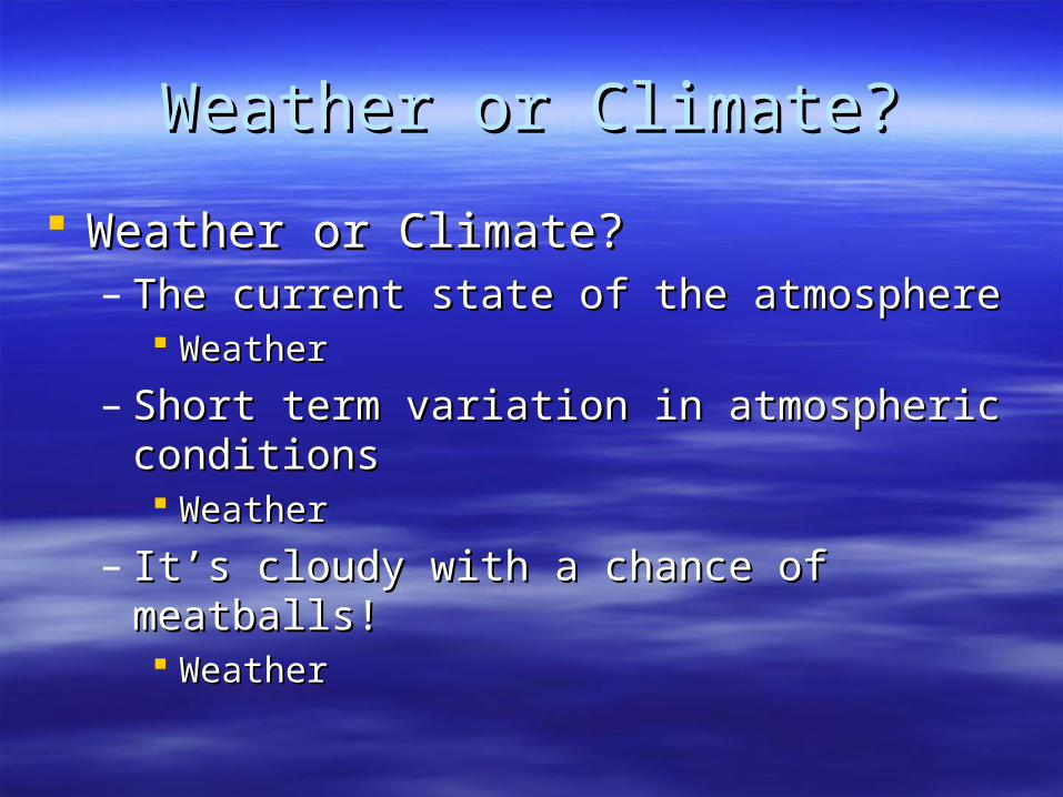
Weather or Climate?Weather or Climate?
Weather or Climate?Weather or Climate?– The current state of the atmosphereThe current state of the atmosphere
WeatherWeather
– Short term variation in atmospheric conditionsShort term variation in atmospheric conditions WeatherWeather
– It’s cloudy with a chance of meatballs!It’s cloudy with a chance of meatballs! WeatherWeather
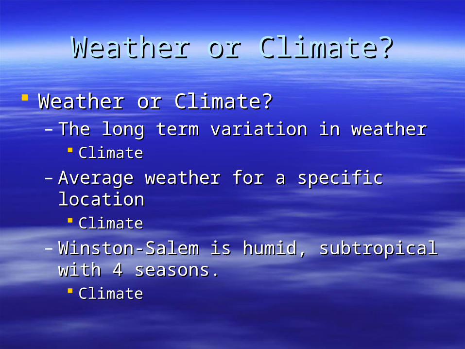
Weather or Climate?Weather or Climate?
Weather or Climate?Weather or Climate?– The long term variation in weatherThe long term variation in weather
ClimateClimate
– Average weather for a specific locationAverage weather for a specific location ClimateClimate
– Winston-Salem is humid, subtropical with 4 Winston-Salem is humid, subtropical with 4 seasons.seasons. ClimateClimate
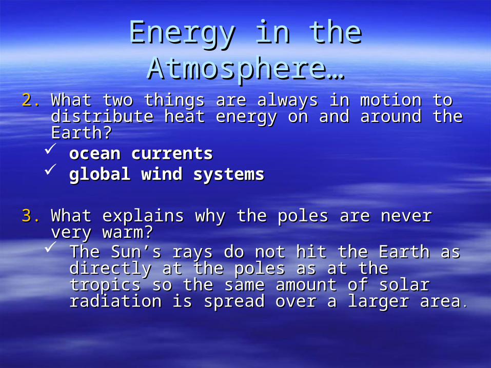
Energy in the Atmosphere…Energy in the Atmosphere…
2.2. What two things are always in motion to What two things are always in motion to distribute heat energy on and around the Earth?distribute heat energy on and around the Earth?
ocean currentsocean currents global wind systemsglobal wind systems
3.3. What explains why the poles are never very What explains why the poles are never very warm?warm?
The Sun’s rays do not hit the Earth as directly The Sun’s rays do not hit the Earth as directly at the poles as at the tropics so the same at the poles as at the tropics so the same amount of solar radiation is spread over a amount of solar radiation is spread over a larger arealarger area..
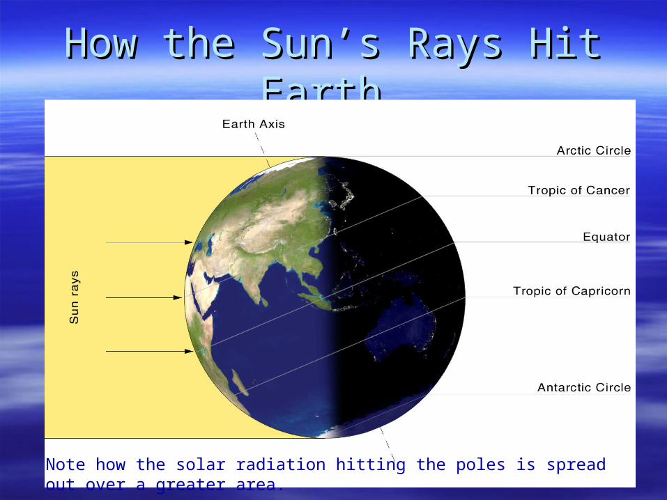
How the Sun’s Rays Hit Earth…How the Sun’s Rays Hit Earth…
http://blog.richmond.edu/geog250/files/2010/04/earth-lighting-summer-solstice_en.pngNote how the solar radiation hitting the poles is spread out over a greater area.
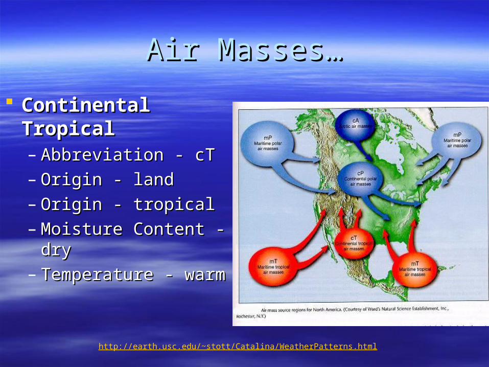
Air Masses…Air Masses…
Continental Continental TropicalTropical– Abbreviation - cTAbbreviation - cT– Origin - landOrigin - land– Origin - tropicalOrigin - tropical– Moisture Content - Moisture Content -
drydry– Temperature - warmTemperature - warm
http://earth.usc.edu/~stott/Catalina/WeatherPatterns.html
Air Masses…Air Masses…
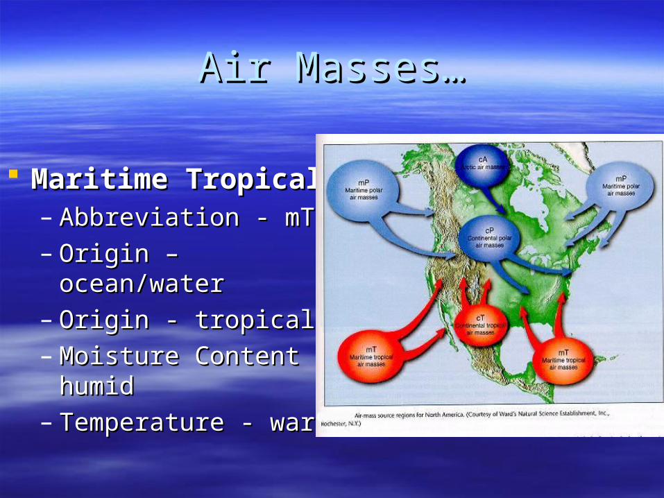
Maritime TropicalMaritime Tropical– Abbreviation - mTAbbreviation - mT– Origin – ocean/waterOrigin – ocean/water– Origin - tropicalOrigin - tropical– Moisture Content - Moisture Content -
humidhumid– Temperature - warmTemperature - warm
Air Masses…Air Masses…
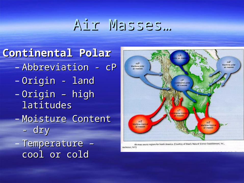
Continental PolarContinental Polar– Abbreviation - cPAbbreviation - cP– Origin - landOrigin - land– Origin – high latitudesOrigin – high latitudes– Moisture Content - dryMoisture Content - dry– Temperature – cool or Temperature – cool or
coldcold

Air Masses…Air Masses…
Maritime PolarMaritime Polar– Abbreviation - mPAbbreviation - mP– Origin – ocean/waterOrigin – ocean/water– Origin – high latitudesOrigin – high latitudes– Moisture Content - Moisture Content -
humidhumid– Temperature – cool or Temperature – cool or
coldcold
Air Masses…Air Masses…
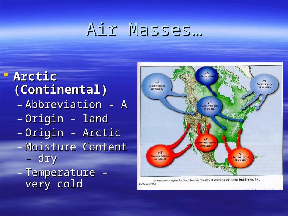
Arctic (Continental)Arctic (Continental)– Abbreviation - AAbbreviation - A– Origin – landOrigin – land– Origin - ArcticOrigin - Arctic– Moisture Content – Moisture Content –
drydry– Temperature – very Temperature – very
coldcold
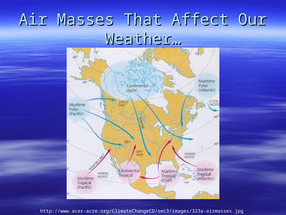
Air Masses That Affect Our Air Masses That Affect Our Weather…Weather…
http://www.acer-acre.org/ClimateChangeCD/sec3/images/323a-airmasses.jpg
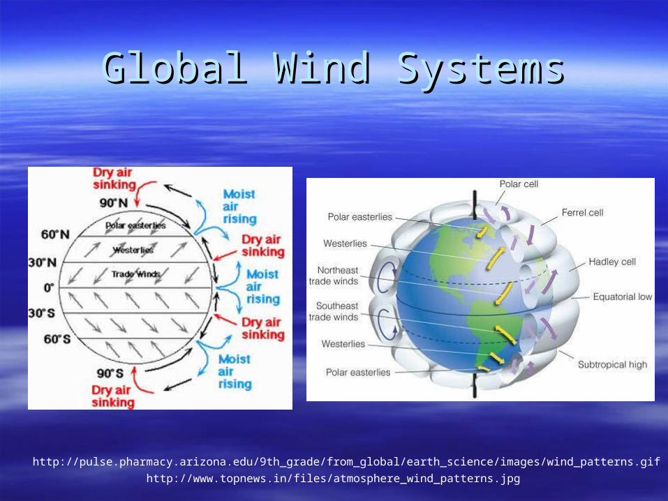
Global Wind SystemsGlobal Wind Systems
http://pulse.pharmacy.arizona.edu/9th_grade/from_global/earth_science/images/wind_patterns.gif
http://www.topnews.in/files/atmosphere_wind_patterns.jpg
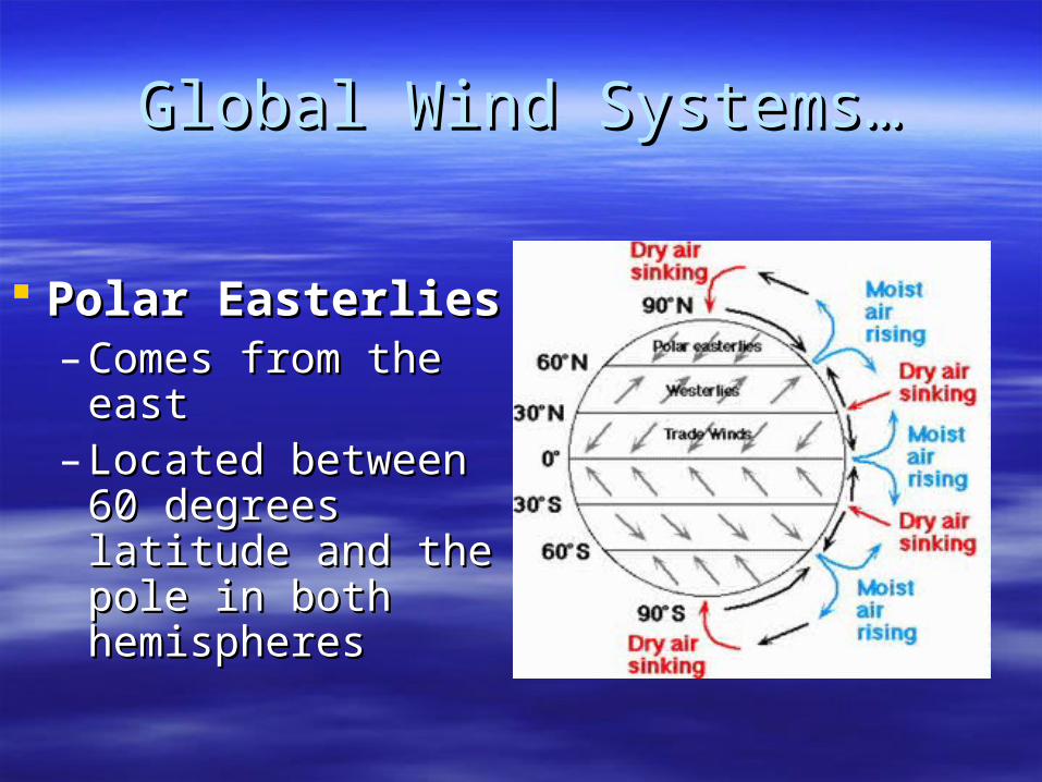
Global Wind Systems…Global Wind Systems…
Polar EasterliesPolar Easterlies– Comes from the Comes from the
easteast– Located between Located between
60 degrees latitude 60 degrees latitude and the pole in both and the pole in both hemisphereshemispheres
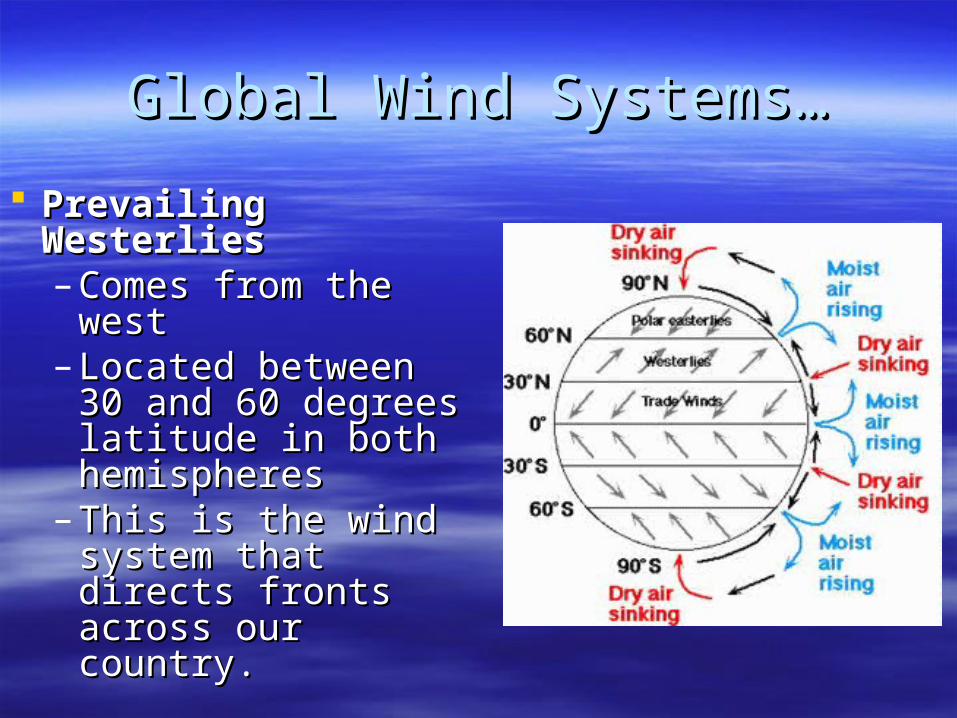
Global Wind Systems…Global Wind Systems…
Prevailing WesterliesPrevailing Westerlies– Comes from the Comes from the
westwest– Located between 30 Located between 30
and 60 degrees and 60 degrees latitude in both latitude in both hemisphereshemispheres
– This is the wind This is the wind system that directs system that directs fronts across our fronts across our country.country.
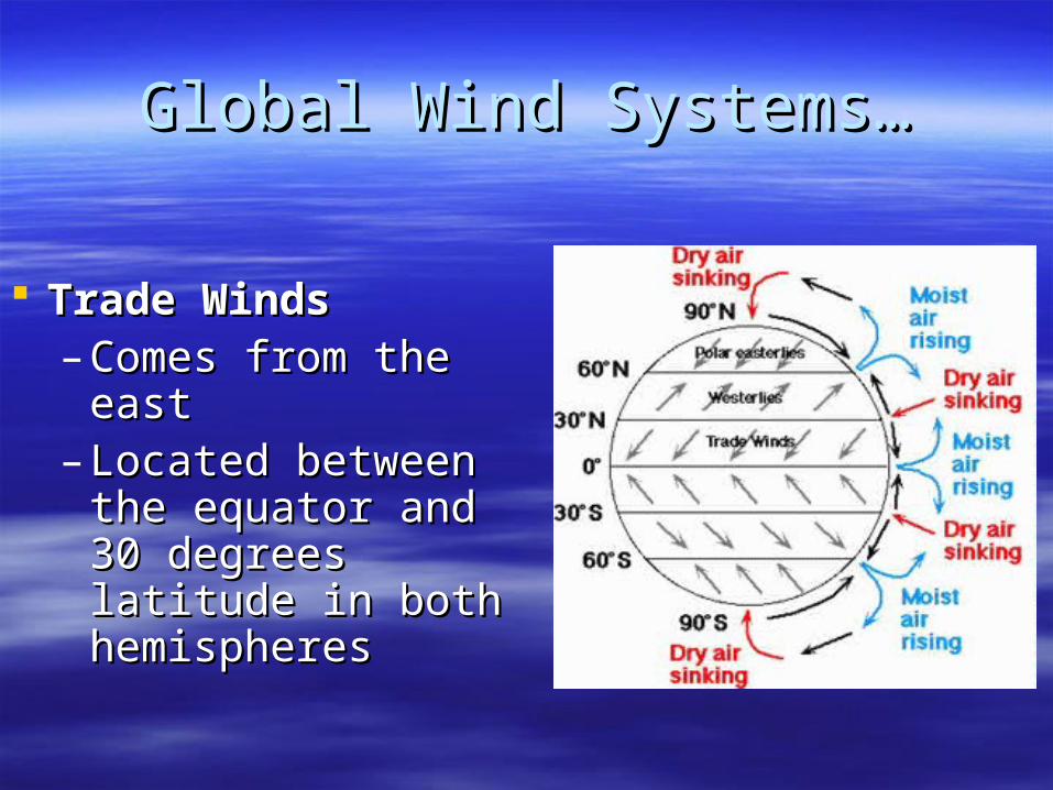
Global Wind Systems…Global Wind Systems…
Trade WindsTrade Winds– Comes from the Comes from the
easteast– Located between Located between
the equator and 30 the equator and 30 degrees latitude in degrees latitude in both hemispheresboth hemispheres
The Intertropical Convergence ZoneThe Intertropical Convergence Zone
3.3. What is the What is the intertropical convergence intertropical convergence zone (ITCZ)zone (ITCZ)??
The area near the equator where the trade The area near the equator where the trade winds converge from 2 different directions. winds converge from 2 different directions.
Air is forced up and creates an area of low Air is forced up and creates an area of low pressure. (Remember – warm air rising!)pressure. (Remember – warm air rising!)
The ITCZ provides the moisture for many of The ITCZ provides the moisture for many of the world’s tropical rain forests.the world’s tropical rain forests.
Picture on next slide…Picture on next slide…
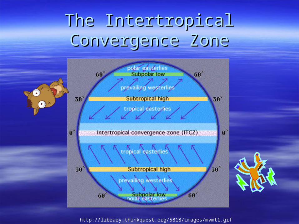
The Intertropical Convergence ZoneThe Intertropical Convergence Zone
http://library.thinkquest.org/5818/images/mvmt1.gif
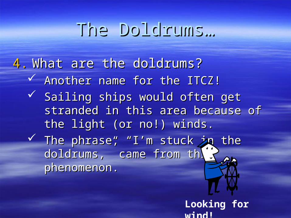
The Doldrums…The Doldrums…
4.4. What are the doldrums?What are the doldrums? Another name for the ITCZ!Another name for the ITCZ! Sailing ships would often get stranded in this Sailing ships would often get stranded in this
area because of the light (or no!) winds.area because of the light (or no!) winds. The phrase, “I’m stuck in the doldrums,” came The phrase, “I’m stuck in the doldrums,” came
from this phenomenon. from this phenomenon.
Looking for wind!
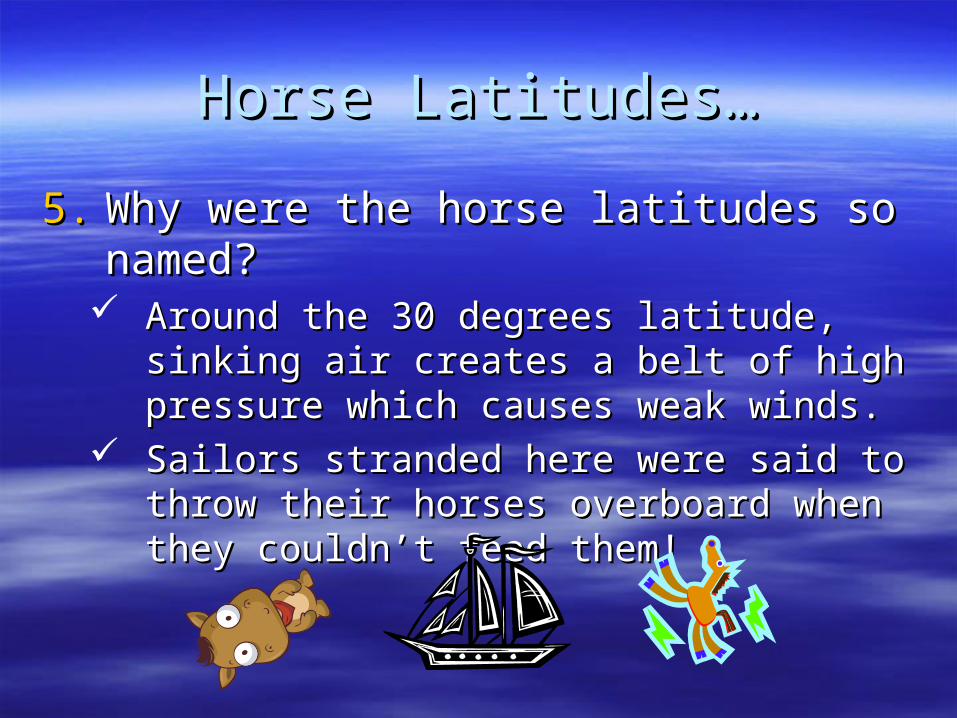
Horse Latitudes…Horse Latitudes…
5.5. Why were the horse latitudes so named?Why were the horse latitudes so named? Around the 30 degrees latitude, sinking air Around the 30 degrees latitude, sinking air
creates a belt of high pressure which causes creates a belt of high pressure which causes weak winds.weak winds.
Sailors stranded here were said to throw their Sailors stranded here were said to throw their horses overboard when they couldn’t feed horses overboard when they couldn’t feed them!them!
Weather Systems in the USAWeather Systems in the USA
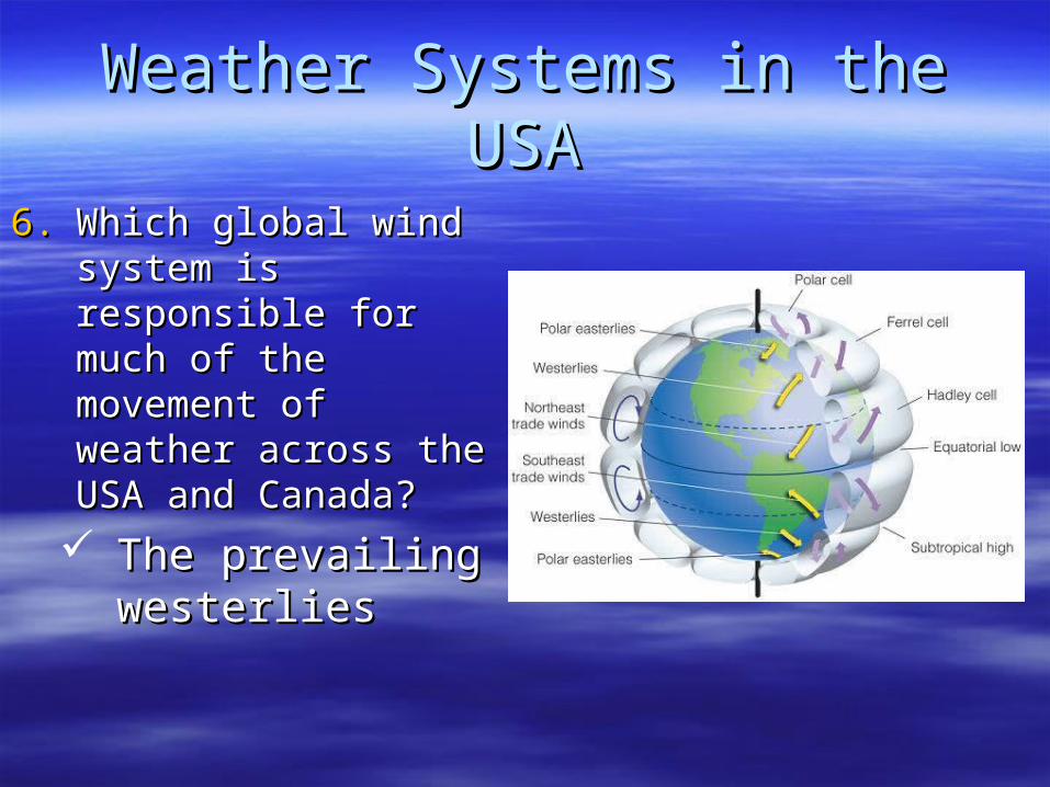
6.6. Which global wind Which global wind system is responsible system is responsible for much of the for much of the movement of weather movement of weather across the USA and across the USA and Canada?Canada?
The prevailing The prevailing westerlieswesterlies
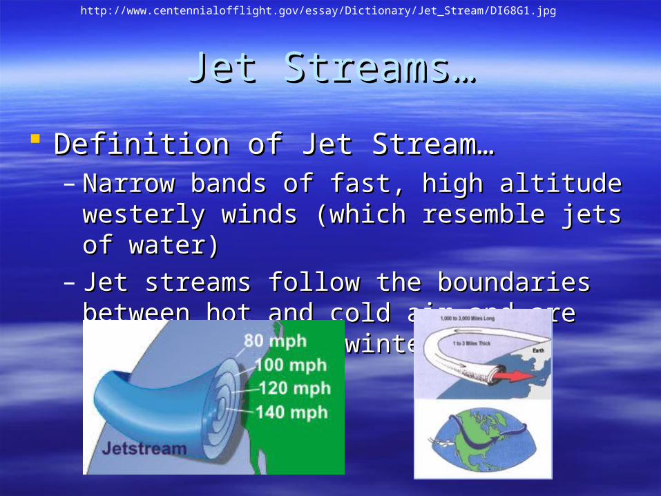
Jet Streams…Jet Streams…
Definition of Jet Stream… Definition of Jet Stream… – Narrow bands of fast, high altitude westerly Narrow bands of fast, high altitude westerly
winds (which resemble jets of water)winds (which resemble jets of water)– Jet streams follow the boundaries between hot Jet streams follow the boundaries between hot
and cold air and are strongest in the winter.and cold air and are strongest in the winter.
http://www.centennialofflight.gov/essay/Dictionary/Jet_Stream/DI68G1.jpg
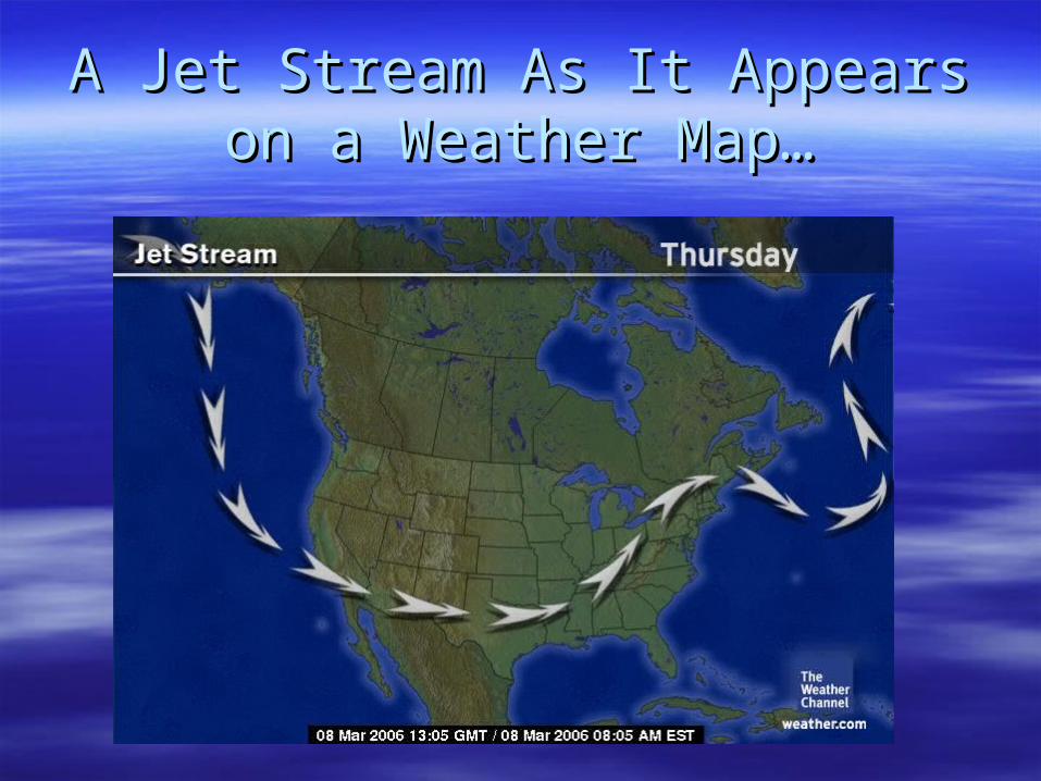
A Jet Stream As It Appears on a A Jet Stream As It Appears on a Weather Map…Weather Map…
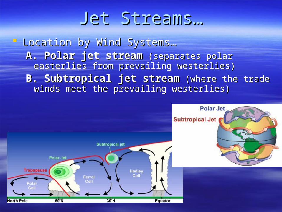
Jet Streams…Jet Streams… Location by Wind Systems…Location by Wind Systems…
A. Polar jet streamA. Polar jet stream (separates polar easterlies from (separates polar easterlies from prevailing westerlies)prevailing westerlies)
B. Subtropical jet streamB. Subtropical jet stream (where the trade winds (where the trade winds meet the prevailing westerlies)meet the prevailing westerlies)
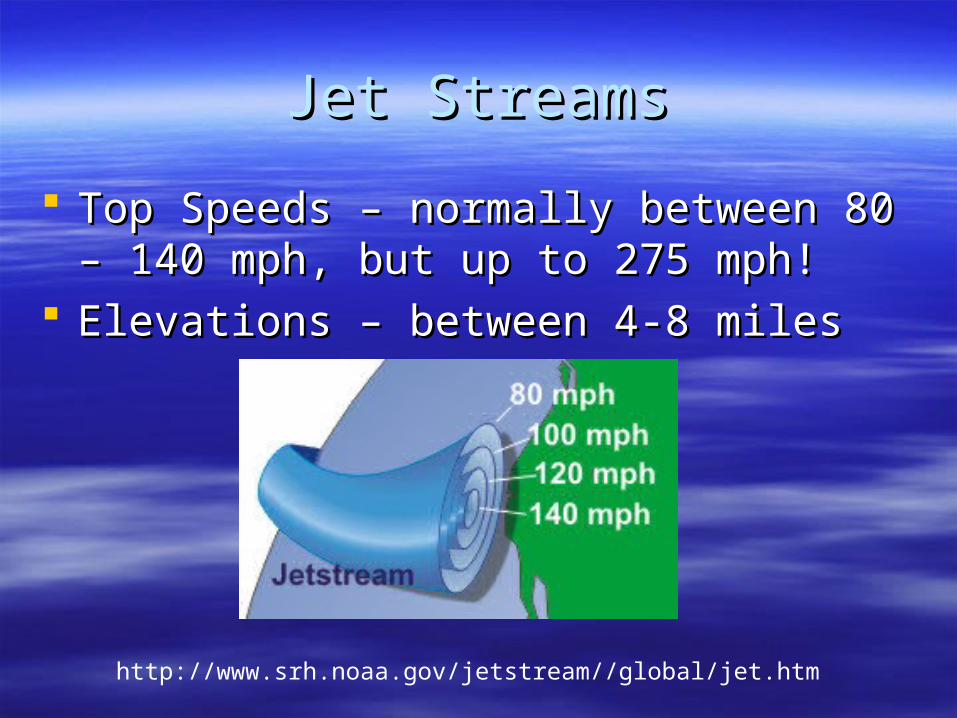
Jet StreamsJet Streams
Top Speeds – normally between 80 – 140 Top Speeds – normally between 80 – 140 mph, but up to 275 mph!mph, but up to 275 mph!
Elevations – between 4-8 milesElevations – between 4-8 miles
http://www.srh.noaa.gov/jetstream//global/jet.htm
Jet StreamsJet Streams
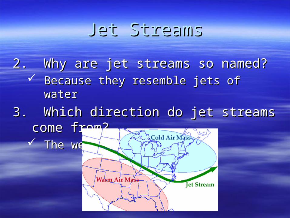
2. Why are jet streams so named?2. Why are jet streams so named? Because they resemble jets of waterBecause they resemble jets of water
3. Which direction do jet streams come from?3. Which direction do jet streams come from? The westThe west
Lesson 5Lesson 5
The Causes of WeatherThe Causes of Weather
Think About It…Think About It…
What is a “front” the front of?!What is a “front” the front of?!
Focus Question…Focus Question…
What causes the four What causes the four types of fronts and types of fronts and what weather does what weather does
each bring?each bring?
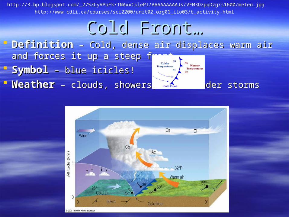
Cold Front…Cold Front… DefinitionDefinition – Cold, dense air displaces warm air and forces it up a – Cold, dense air displaces warm air and forces it up a
steep frontsteep front
SymbolSymbol – blue icicles! – blue icicles!
WeatherWeather – clouds, showers, and thunder storms – clouds, showers, and thunder storms
http://3.bp.blogspot.com/_275ZCyVPoFk/TNAxxCklePI/AAAAAAAAAJs/VFM3DzpqDzg/s1600/meteo.jpg
http://www.cdli.ca/courses/sci2200/unit02_org01_ilo03/b_activity.html
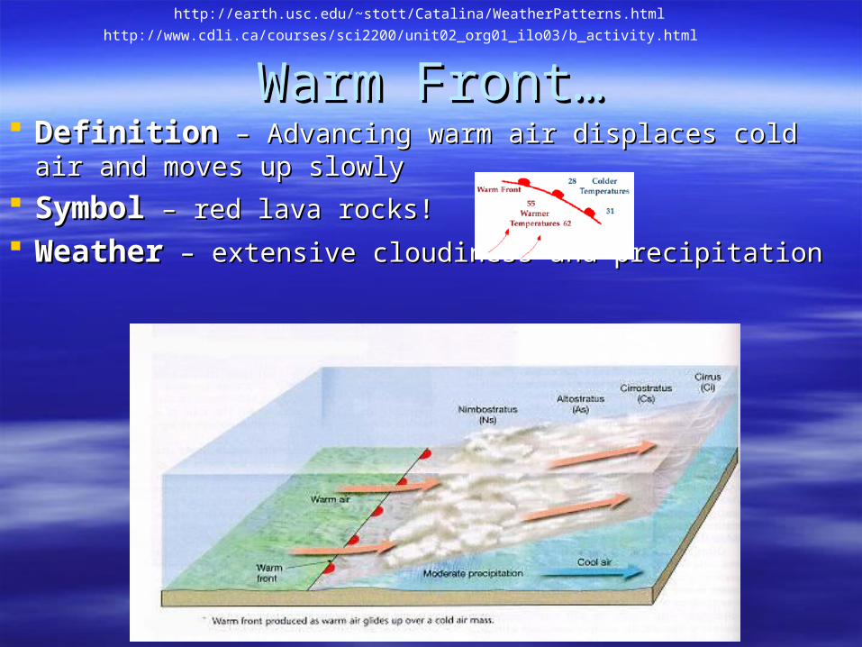
Warm Front…Warm Front… DefinitionDefinition – Advancing warm air displaces cold air and moves – Advancing warm air displaces cold air and moves
up slowlyup slowly
SymbolSymbol – red lava rocks! – red lava rocks!
WeatherWeather – extensive cloudiness and precipitation – extensive cloudiness and precipitation
http://www.cdli.ca/courses/sci2200/unit02_org01_ilo03/b_activity.html
http://earth.usc.edu/~stott/Catalina/WeatherPatterns.html
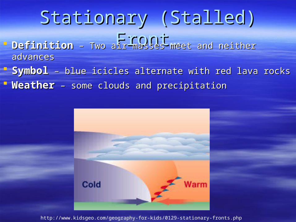
Stationary (Stalled) Front…Stationary (Stalled) Front… DefinitionDefinition – Two air masses meet and neither advances – Two air masses meet and neither advances
SymbolSymbol – blue icicles alternate with red lava rocks – blue icicles alternate with red lava rocks
WeatherWeather – some clouds and precipitation – some clouds and precipitation
http://www.kidsgeo.com/geography-for-kids/0129-stationary-fronts.php
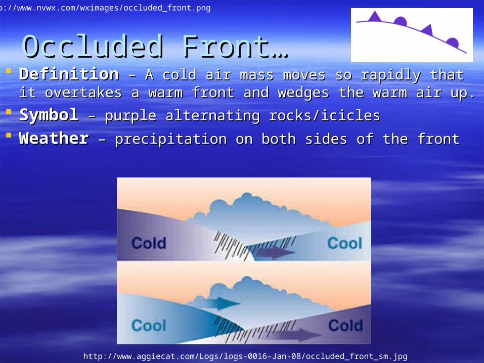
Occluded Front…Occluded Front… DefinitionDefinition – A cold air mass moves so rapidly that it overtakes a – A cold air mass moves so rapidly that it overtakes a
warm front and wedges the warm air up.warm front and wedges the warm air up.
SymbolSymbol – purple alternating rocks/icicles – purple alternating rocks/icicles
WeatherWeather – precipitation on both sides of the front – precipitation on both sides of the front
http://www.nvwx.com/wximages/occluded_front.png
http://www.aggiecat.com/Logs/logs-0016-Jan-08/occluded_front_sm.jpg
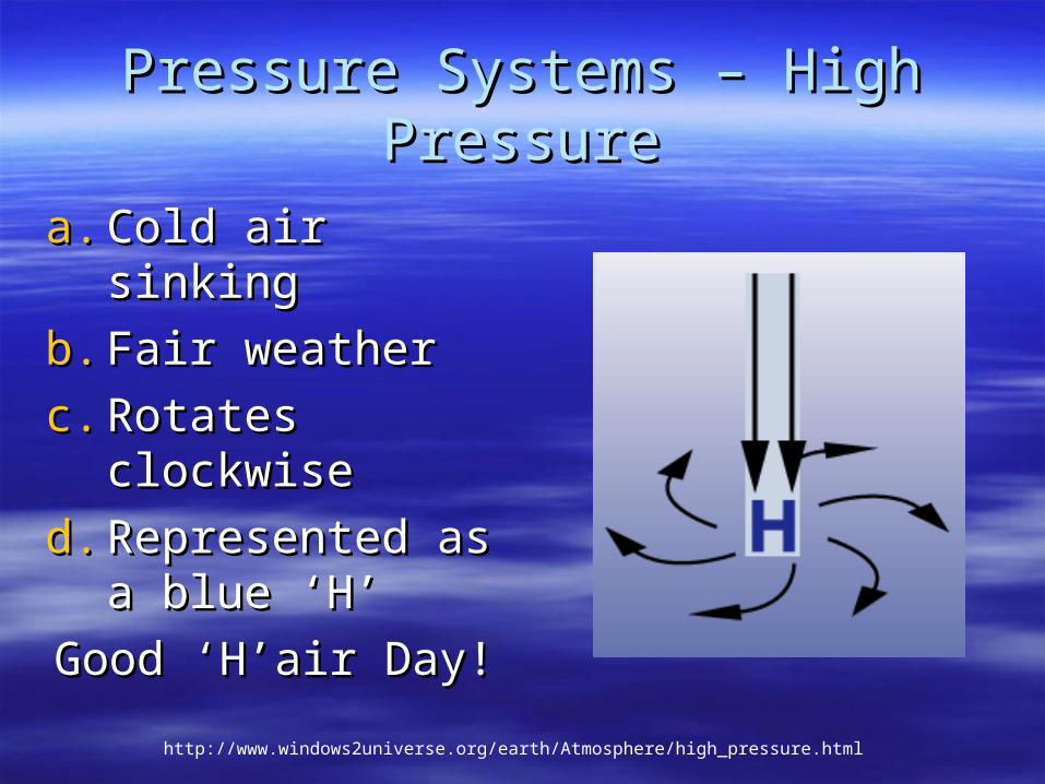
Pressure Systems – High PressurePressure Systems – High Pressure
a.a. Cold air sinking Cold air sinking
b.b. Fair weatherFair weather
c.c. Rotates Rotates clockwiseclockwise
d.d. Represented as Represented as a blue ‘H’a blue ‘H’
Good ‘H’air Day!Good ‘H’air Day!
http://www.windows2universe.org/earth/Atmosphere/high_pressure.html
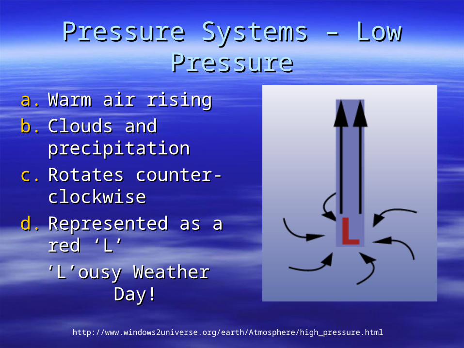
Pressure Systems – Low PressurePressure Systems – Low Pressure
a.a. Warm air rising Warm air rising
b.b. Clouds and Clouds and precipitationprecipitation
c.c. Rotates counter-Rotates counter-clockwiseclockwise
d.d. Represented as a Represented as a red ‘L’red ‘L’
‘ ‘L’ousy Weather Day!L’ousy Weather Day!
http://www.windows2universe.org/earth/Atmosphere/high_pressure.html
Lesson 6Lesson 6
Gathering Weather DataGathering Weather Data
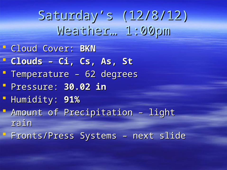
Saturday’s (12/8/12) Weather… Saturday’s (12/8/12) Weather… 1:00pm1:00pm
Cloud Cover: Cloud Cover: BKNBKN Clouds – Ci, Cs, As, StClouds – Ci, Cs, As, St Temperature – 62 degreesTemperature – 62 degrees Pressure: Pressure: 30.02 in30.02 in Humidity: Humidity: 91%91% Amount of Precipitation – light rain Amount of Precipitation – light rain Fronts/Press Systems – next slide Fronts/Press Systems – next slide
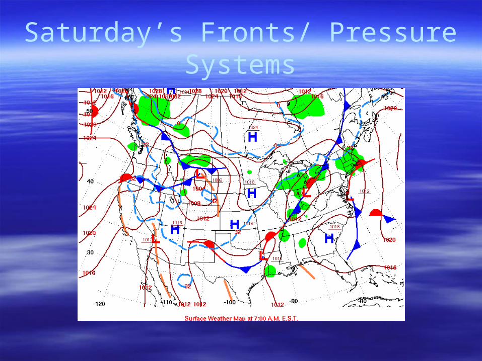
Saturday’s Fronts/ Pressure Systems
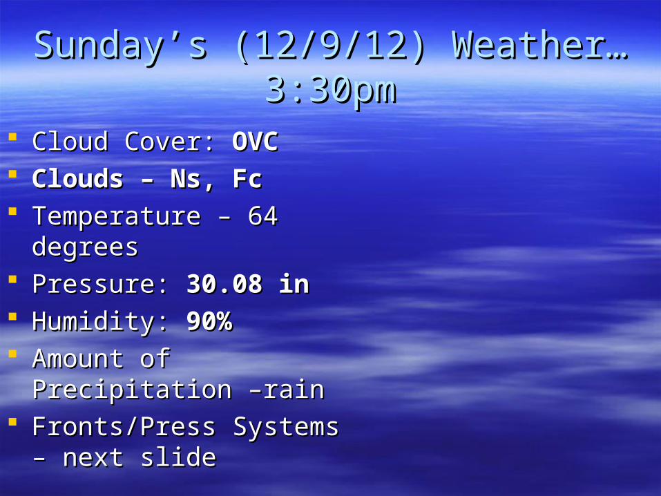
Sunday’s (12/9/12) Weather… Sunday’s (12/9/12) Weather… 3:30pm3:30pm
Cloud Cover: Cloud Cover: OVCOVC Clouds – Ns, FcClouds – Ns, Fc Temperature – 64 degreesTemperature – 64 degrees Pressure: Pressure: 30.08 in30.08 in Humidity: Humidity: 90%90% Amount of Precipitation –Amount of Precipitation –
rain rain Fronts/Press Systems – Fronts/Press Systems –
next slide next slide
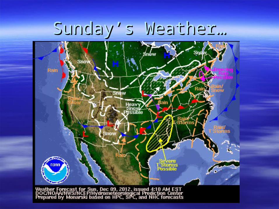
Sunday’s Weather…Sunday’s Weather…
Weather Broadcast…Weather Broadcast…
Fox 8 Local Forecast – Fox 8 Local Forecast – http://myfox8.com/weather/http://myfox8.com/weather/
Weather Channel National Forecast – Weather Channel National Forecast – http://www.weather.com/forecasthttp://www.weather.com/forecast
Think About It…Think About It…
We get our weather from We get our weather from radio/TV/computers. Where do radio/TV/computers. Where do
weather-persons get their weather-persons get their weather?weather?
Focus Question…Focus Question…
How do meteorologists How do meteorologists gather data about the gather data about the
weather?weather?
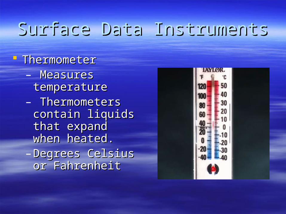
Surface Data InstrumentsSurface Data Instruments
ThermometerThermometer– Measures Measures
temperaturetemperature– Thermometers Thermometers
contain liquids contain liquids that expand when that expand when heated.heated.
– Degrees Celsius Degrees Celsius or Fahrenheit or Fahrenheit
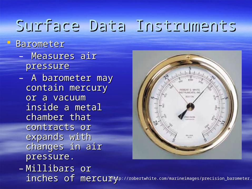
Surface Data InstrumentsSurface Data Instruments BarometerBarometer
– Measures air Measures air pressurepressure
– A barometer may A barometer may contain mercury or a contain mercury or a vacuum inside a vacuum inside a metal chamber that metal chamber that contracts or expands contracts or expands with changes in air with changes in air pressure.pressure.
– Millibars or inches of Millibars or inches of mercurymercury
http://robertwhite.com/marineimages/precision_barometer.jpg
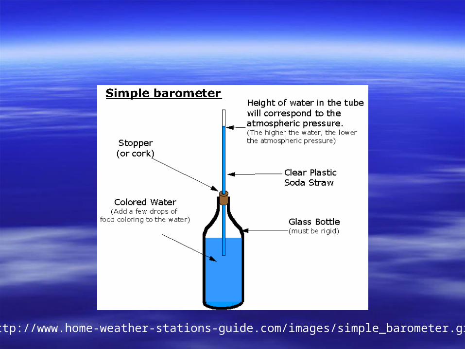
http://www.home-weather-stations-guide.com/images/simple_barometer.gif

Surface Data InstrumentsSurface Data Instruments
AnemometerAnemometer– Measures wind Measures wind
speedspeed– Has cupped Has cupped
arms that rotate arms that rotate as the wind as the wind blows.blows.
–… … mph or km/hmph or km/hhttp://www.smg.gov.mo/www/dm/equip/ws.jpg
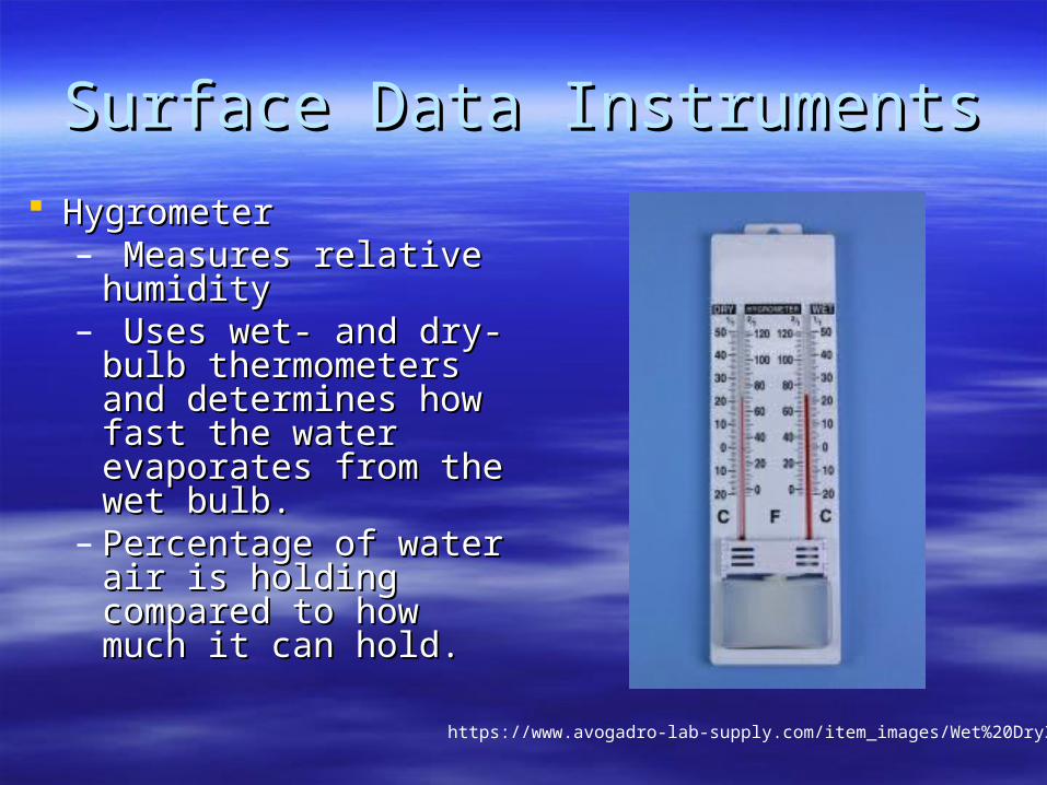
Surface Data InstrumentsSurface Data Instruments
HygrometerHygrometer– Measures relative Measures relative
humidityhumidity– Uses wet- and dry-Uses wet- and dry-
bulb thermometers bulb thermometers and determines how and determines how fast the water fast the water evaporates from the evaporates from the wet bulb.wet bulb.
– Percentage of water Percentage of water air is holding air is holding compared to how compared to how much it can hold.much it can hold.
https://www.avogadro-lab-supply.com/item_images/Wet%20Dry3.jpg
Surface Data InstrumentsSurface Data Instruments
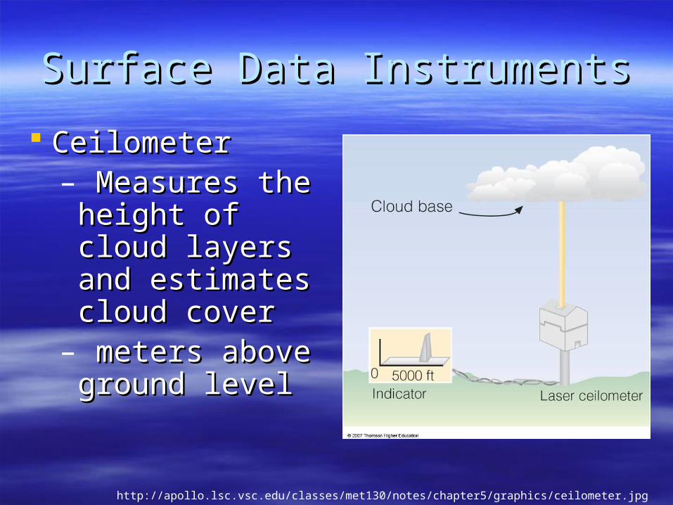
CeilometerCeilometer– Measures the Measures the
height of cloud height of cloud layers and layers and estimates cloud estimates cloud covercover
– meters above meters above ground levelground level
http://apollo.lsc.vsc.edu/classes/met130/notes/chapter5/graphics/ceilometer.jpg
Upper Level DataUpper Level Data
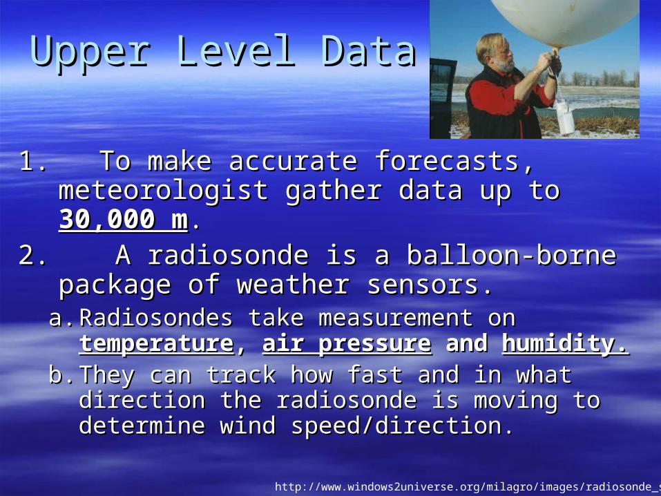
1. To make accurate forecasts, meteorologist 1. To make accurate forecasts, meteorologist gather data up to gather data up to 30,000 m30,000 m..
2. A radiosonde is a balloon-borne package 2. A radiosonde is a balloon-borne package of weather sensors.of weather sensors.
a.a. Radiosondes take measurement on Radiosondes take measurement on temperaturetemperature, , air pressureair pressure and and humidity.humidity.
b.b. They can track how fast and in what direction They can track how fast and in what direction the radiosonde is moving to determine wind the radiosonde is moving to determine wind speed/direction.speed/direction.
http://www.windows2universe.org/milagro/images/radiosonde_sm.jpg
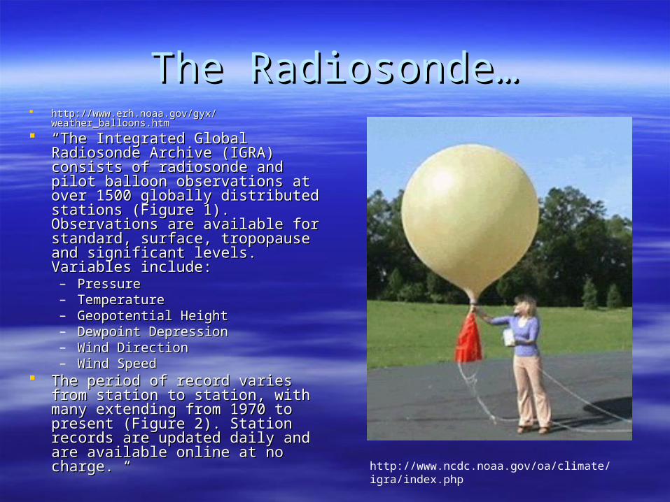
The Radiosonde…The Radiosonde… http://www.erh.noaa.gov/gyx/weather_balloons.htmhttp://www.erh.noaa.gov/gyx/weather_balloons.htm
““The Integrated Global Radiosonde The Integrated Global Radiosonde Archive (IGRA) consists of Archive (IGRA) consists of radiosonde and pilot balloon radiosonde and pilot balloon observations at over 1500 globally observations at over 1500 globally distributed stations (Figure 1). distributed stations (Figure 1). Observations are available for Observations are available for standard, surface, tropopause and standard, surface, tropopause and significant levels. Variables include: significant levels. Variables include: – Pressure Pressure – Temperature Temperature – Geopotential Height Geopotential Height – Dewpoint Depression Dewpoint Depression – Wind Direction Wind Direction – Wind Speed Wind Speed
The period of record varies from The period of record varies from station to station, with many station to station, with many extending from 1970 to present extending from 1970 to present (Figure 2). Station records are (Figure 2). Station records are updated daily and are available updated daily and are available online at no charge. “online at no charge. “
http://www.ncdc.noaa.gov/oa/climate/igra/index.php
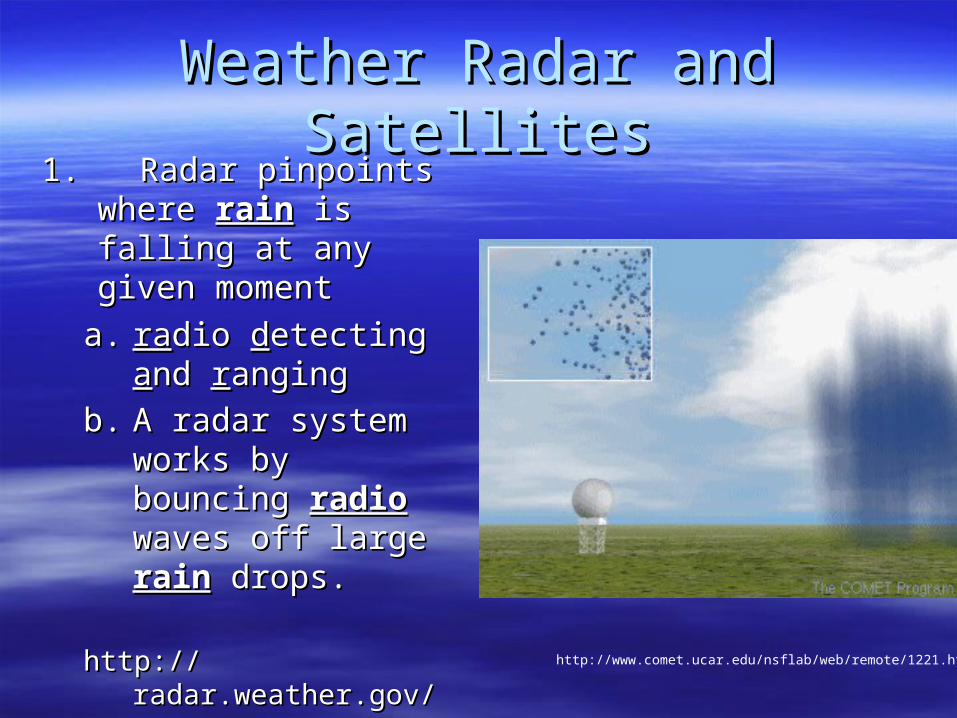
Weather Radar and SatellitesWeather Radar and Satellites1. Radar pinpoints 1. Radar pinpoints
where where rainrain is falling is falling at any given momentat any given moment
a.a. raradio dio ddetecting etecting aand nd rranginganging
b.b. A radar system A radar system works by bouncing works by bouncing radioradio waves off waves off large large rainrain drops. drops.
http://radar.weather.gov/http://radar.weather.gov/http://www.comet.ucar.edu/nsflab/web/remote/1221.htm
The Doppler Effect…The Doppler Effect…
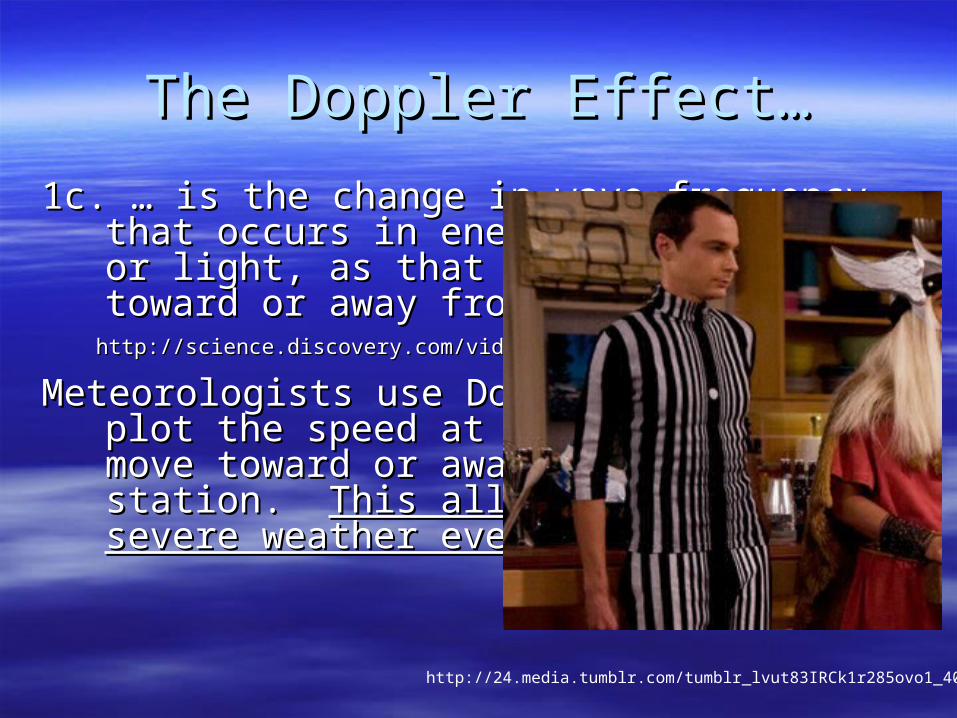
1c. … is the change in wave frequency that occurs in 1c. … is the change in wave frequency that occurs in energy, such as sound or light, as that energy energy, such as sound or light, as that energy moves toward or away from an observer.moves toward or away from an observer.
http://science.discovery.com/videos/time-doppler-effect.htmlhttp://science.discovery.com/videos/time-doppler-effect.html
Meteorologists use Doppler Radar to plot the speed Meteorologists use Doppler Radar to plot the speed at which raindrops move toward or away from a at which raindrops move toward or away from a radar station. radar station. This allows them to detect severe This allows them to detect severe weather events!weather events!
http://24.media.tumblr.com/tumblr_lvut83IRCk1r285ovo1_400.jpg
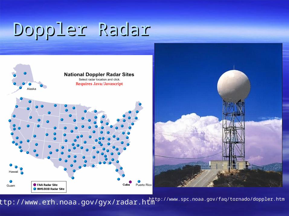
Doppler RadarDoppler Radar
http://www.spc.noaa.gov/faq/tornado/doppler.htmhttp://www.erh.noaa.gov/gyx/radar.htm
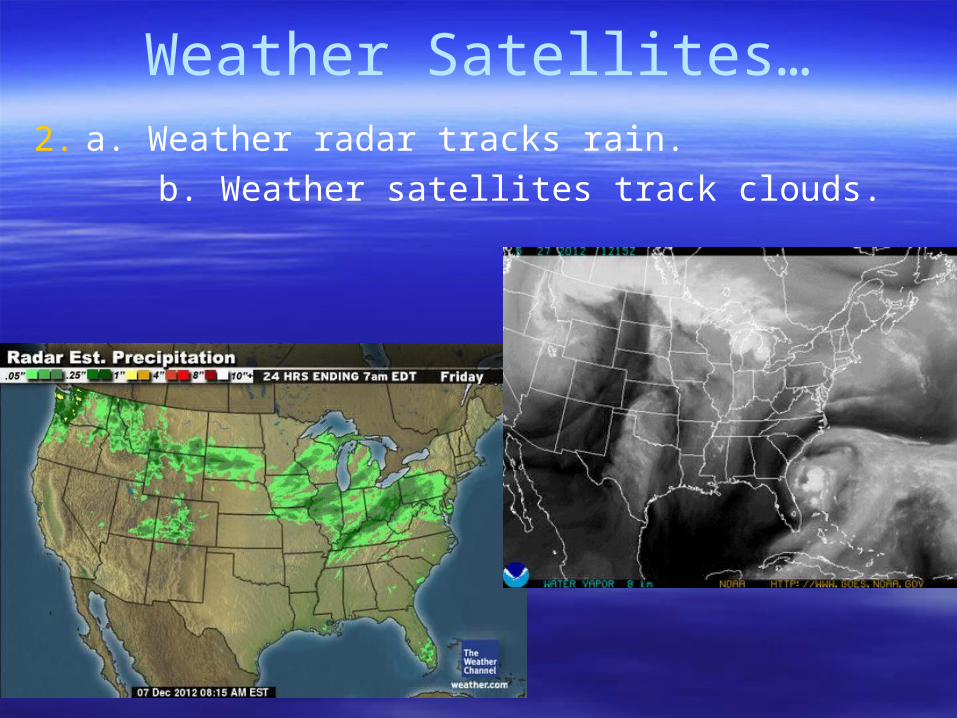
Weather Satellites…
2. a. Weather radar tracks rain.
b. Weather satellites track clouds.
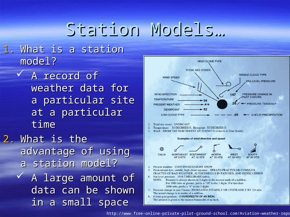
Station Models…Station Models…1.1. What is a station What is a station
model?model? A record of weather A record of weather
data for a particular data for a particular site at a particular site at a particular timetime
2.2. What is the advantage What is the advantage of using a station of using a station model? model?
A large amount of A large amount of data can be shown data can be shown in a small spacein a small space
http://www.free-online-private-pilot-ground-school.com/Aviation-weather-reporting.html
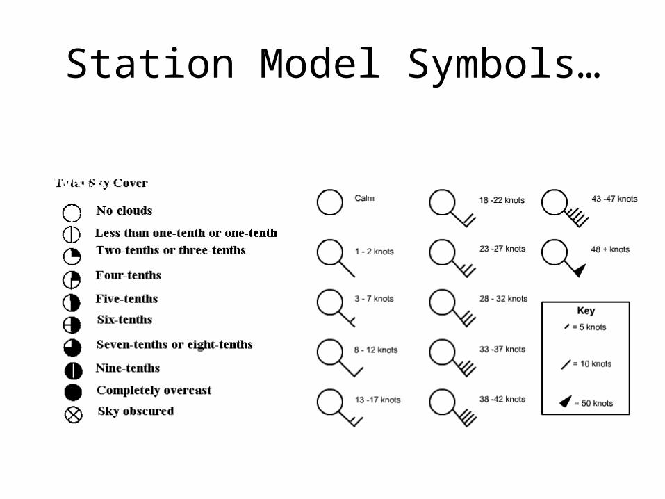
Station Model Symbols…
http://0.tqn.com/d/weather/1/0/R/-/-/-/cloudcover.gif
Cloud/Sky Cover Wind Speed
http://www.scalloway.org.uk/images/knots.gif
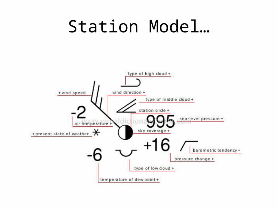
Station Model…
http://visual.merriam-webster.com/images/earth/meteorology/station-model.jpg

Station Models…Station Models…1.1. high clouds… scattered cirrushigh clouds… scattered cirrus2.2. middle clouds… thin altostratus in bandsmiddle clouds… thin altostratus in bands3.3. low clouds… fractocumulus of bad weatherlow clouds… fractocumulus of bad weather4.4. precipitation… rainprecipitation… rain5.5. temperature… 20 degrees Celsiustemperature… 20 degrees Celsius6.6. dew point… 19 degrees Celsiusdew point… 19 degrees Celsius7.7. barometric pressure… 918.8barometric pressure… 918.88.8. wind speed… 3-7 knotswind speed… 3-7 knots9.9. wind direction…southeast (SE)wind direction…southeast (SE)
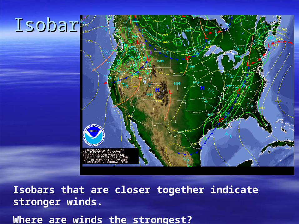
IsobarsIsobars
Isobars that are closer together indicate stronger winds.
Where are winds the strongest?
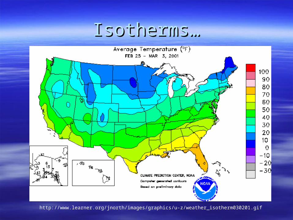
Isotherms…Isotherms…
http://www.learner.org/jnorth/images/graphics/u-z/weather_isotherm030201.gif
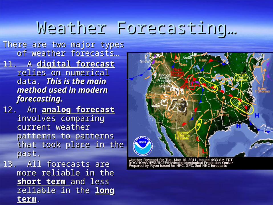
Weather Forecasting…Weather Forecasting…There are two major types of There are two major types of
weather forecasts…weather forecasts…11. A 11. A digital forecastdigital forecast relies relies
on numerical data. on numerical data. This is This is the main method used in the main method used in modern forecasting.modern forecasting.
12. An 12. An analog forecastanalog forecast involves comparing current involves comparing current weather patterns to weather patterns to patterns that took place in patterns that took place in the past.the past.
13. All forecasts are more 13. All forecasts are more reliable in the reliable in the short term short term and less reliable in the and less reliable in the long termlong term. .
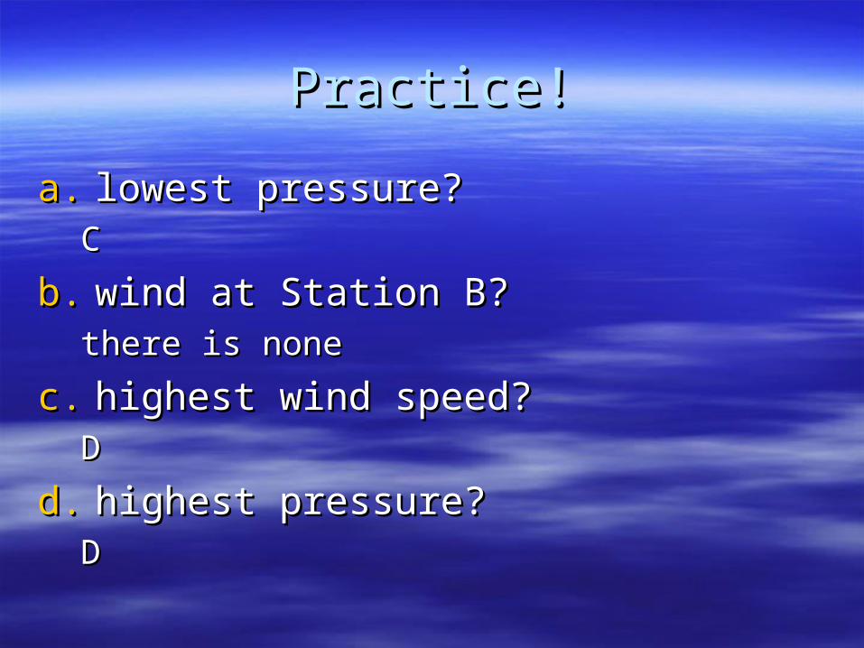
Practice!Practice!
a.a. lowest pressure? lowest pressure? CC
b.b. wind at Station B? wind at Station B? there is nonethere is none
c.c. highest wind speed? highest wind speed? DD
d.d. highest pressure?highest pressure?DD
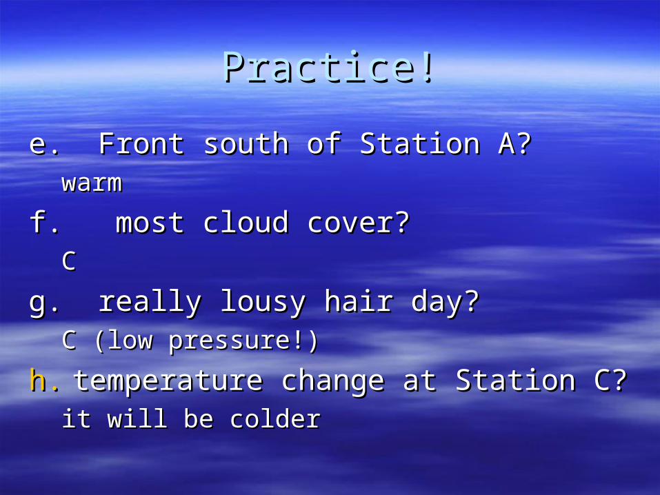
Practice!Practice!
e. Front south of Station A? e. Front south of Station A? warmwarm
f. most cloud cover? f. most cloud cover? CC
g. really lousy hair day? g. really lousy hair day? C (low pressure!)C (low pressure!)
h.h. temperature change at Station C?temperature change at Station C?it will be colderit will be colder