Embed Size (px)
Citation preview
Amendmentno i ~October1994
CHAPTER 12
THE SYNOPTIC CODE - DETAILED DESCRIPTION
12.1 GENERAL. Detailedcodinginstructionsfor eachelementof eachgroupof the Synopticcodearegiven below. The instructionsoften include referenceto entrieson the SurfaceWeatherRecordForm63—2322.In mostcases,theobserverwill find thatthepreparationoftheSynopticmessageissimplifiedif theappropriateentriesfor linesandcolumnsI to42aonForm63—2322arecompletedbeforepreparingthecoded flmessage.Observersmayfind thatForm63—9028,TablesforSynopticCode,will assisttheminencodingthesynopticreport.
12.1.1 Completeinstructionsfor recordingthe observeddataon Form63—2322 aregiven in Chapter13.
12.2 SECTION0
12.2.1 GroupMIMIMJMJ This groupis insertedby the commmunicationscomputerin themessageheaderfor identificationof synopticbulletinsandis encodedAAXX for synopticreportsfrom landstations.It is thefirst groupof thesecondline of the messageheader.(M1M1M~M~ is encodedBBXX forsy-noptic reportsfrom ship stations.)
12.2.2 GroupYYGGIW Thisgroupis insertedby thecommunicationscomputerasthesecondgroupof thesecondline of the messageheaderof asynopticbulletin originatingfrom alandstation.
12.2.2.1
12.2.2.2
YY — Dayof themonth (UTC).
GG— Hourof the observation(UTC).
12.2.2.3i~ — Wind indicator,showingthe units of wind speedandwhetherthe wind speedis measuredorestimated.Thecommunicationscomputerwill insertthe figure 4 for i~, atCanadianlandstations.Observerson shipswill havetheo ptionof specifyinga3 or4, dependingon whetherornot theshipsareequippedwithanemometers.The following table for i~ is given for decodingpurposes.
Codefigure Wind indicator
Wind speedestimatedWind speedobtainedfrom anemometer
Wind speedestimatedWind speedobtainedfrom anemometer
Z Wind speedin metresper second
Z Wind speedinknots
12.2.3 Group lliii
12.2.3.1 II — Block number.All Canadianlandstationsuse71.
0
34
12.2.3.2 iii — Stationnumber,asfound in METSTAT.
12—2
Amend. No. 10 Nov. 1, 1989
12.3 SECTION 1
12.3.1 Group iRixhVV
12.3.1.1iR — Thissymbolisanindicatortoshowwhetherornottheprecipitationgroup6RRRtRisincludedinthemessageand,if included,in whatSectionof themessageit appears.Thefollowingcodetableshallbeused.
WMO Code 1819
CodeFigure Precipitationdataare reported Group 6RRRtRis:iR
0 in Sections1 and3 includedin both Sections
in Section 1 included
2 in Section3 included
3 in noneof thetwo sections omitted(precipitationland3 amount=0)
4 in noneof thetwo sections omitted(precipitationI and3 amountnot available)
12.3.1.1.1 Codefigure0 is not usedfor iR in Canada.Whenthegroup6RRRtRis includedin themainsynop-tic report,it is includedin Section I, andiR is encoded1. Whenprecipitationoccursatastationwhichtrans-mitsi ntermediatesynopticreports,andit occursbetweenamainsynoptichourandthesubsequentintermedi-atesynoptichour,the6RRRtRgroupwill beincludedin theintermediatesynopticreport,andiR will been-coded2.
12.3.1.2 i,~ — This symbol indicateswhetherthesynopticmessagehasoriginatedfrom amannedor anauto-maticstationandsecondly,whetheror notthepresentandpastweathergroup,7wwW1W2 is included.Thefollowing codetableshall be used.
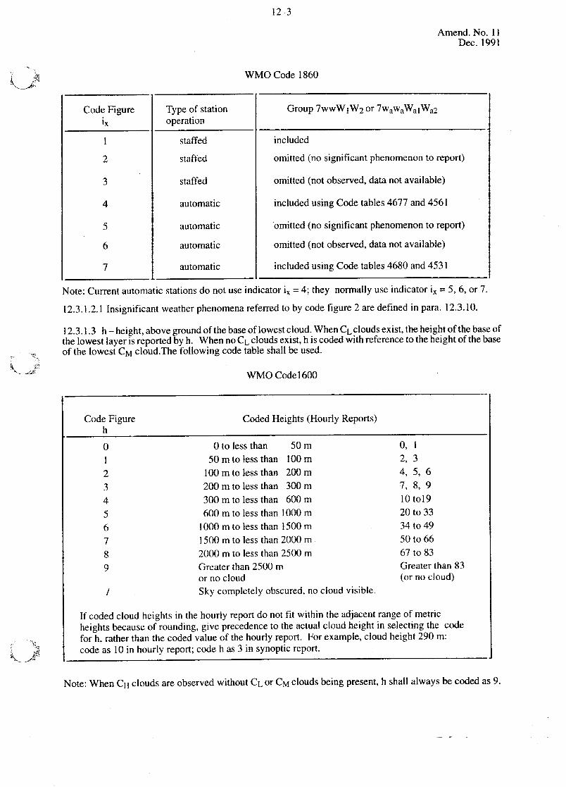
12—3
Amend.No. 11Dec. 1991
WMO Code 1860
CodeFigure Type of station Group7wwW;W2or7wawaWalWa2
operation
staffed included
2 staffed omitted(no significantphenomenonto report)
3 staffed omitted(notobserved,datanot available)
4 automatic includedusingCodetables4677 and4561
5 automatic omitted(no significantphenomenonto report)
6 automatic omitted(not observed,datanot available)
7 automatic includedusingCodetables4680and4531
Note: Currentautomaticstationsdo not useindicator i,~ = 4; they normallyuseindicator i,~ = 5, 6, or 7.
12.3.1.2.1 Insignificantweatherphenomenareferredto by codefigure 2 aredefinedin para. 12.3.10.
12.3.1.3 h— height,abovegroundofthebaseoflowestcloud.WhenCL cloudsexist,theheightofthebaseofthe lowestlayeris reportedby h. Whenno CL cloudsexist,h is codedwith referenceto theheightof thebaseof thelowestCM cloud.Thefollowing codetableshall beused.
WMO Codel600
Note: WhenCH cloudsareobservedwithout CL orCM cloudsbeingpresent,h shallalwaysbe codedas 9.
CodeFigure CodedHeights(Hourly Reports)h
0 Otolessthan SOm 0, 1I S0mtolessthanlOOm 2, 32 l00mtolessthan 200m 4, 5, 63 200mtolessthan300m 7, 8, 94 300m to lessthan 600 m 10 tol95 600mtolessthan lOOOm 20 to 336 l000mtolessthan1500m 34to497 1500 m to lessthan2000 m 50 to 668 2000m to less than2500 m 67 to 839 Greaterthan2500 m Greaterthan83
or no cloud (or no cloud)/ Sky completelyobscured,no cloudvisible.
If codedcloud heightsin the hourly report do not fit within the adjacentrangeof metricheightsbecauseof rounding,giveprecedenceto theactualcloud heightin selectingthe codefor h, ratherthanthecodedvalueof the hourly report. Forexample,cloud height290 m:codeas 10 in hourly report;codeh as3 in synoptic report.
12—4
12.3.1.3.1 If thesky is partiallyobscuredby fogorotherobscuringphenomena,hreferstothebaseof thelowestcloud observed,if any.
12.3.1.3.2 If the sky is completelyobscured,h is recordedas X; however,if the sky is completelyob-scuredandcloudsarevisiblebelowtheobscuration,hisreportedasobserved.Forexample,if thesky iscom-pletelyobscuredby snowin which theverticalvisibility is 300m and1/10of StratusFractusis observedat150m thecodingfor h would be 2.
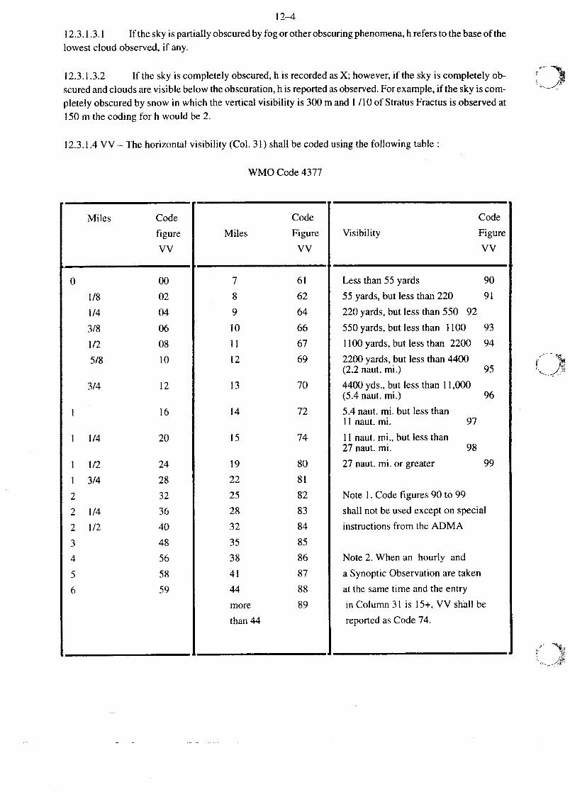
12.3.1.4VV — The horizontalvisibility (Col. 31) shall be codedusingthefollowing table:
WMO Code4377
Miles Code
Miles
Code
Figure
VV
Code
Visibility Figure
vV
7 61 Lessthan55 yards 90
1/8 02 8 62 55 yards,but lessthan220 91
1/4 04 9 64 220yards,but lessthan 550 92
3/8 06 10 66 550yards,but lessthan 1100 93
1/2 08 11 67 1100 yards,but lessthan 2200 94
5/8 10 12 69 2200 yards,but lessthan4400(2.2 naut.mi.) 95
3/4 12 13 70 4400yds.,but lessthan 11,000(5.4 naut. mi.) 96
16 14 72 5.4naut. mi. but lessthanII naut.mi. 97
1 1/4 20 15 74 11 naut.mi., but lessthan27 naut.ml. 98
1 1/2 24 19 80 27 naut.mi. or greater 991 3/4 28 22 81
2 32 25 82 Note I. Codefigures90 to 99
2 1/4 36 28 83 shall not be usedexcepton special
2 1/2 40 32 84 instructionsfrom the ADMA
3 48 35 854 56 38 86 Note 2. Whenan hourly and
5 58 41 87 aSynopticObservationaretaken
6 59 44 88 atthe sametime andtheentry
more 89 in Column31 is 15+, VV shall be
than44 reportedas Code74.
r
12—5
Amendmentn0 13October1994
12.3.1.4.1If thevisibility recordedin Column31 fallsbetweentwo codefigures,usethe lower codefigure.Thus,20 milesshallbe codedas80; 30 milesas 83 etc.
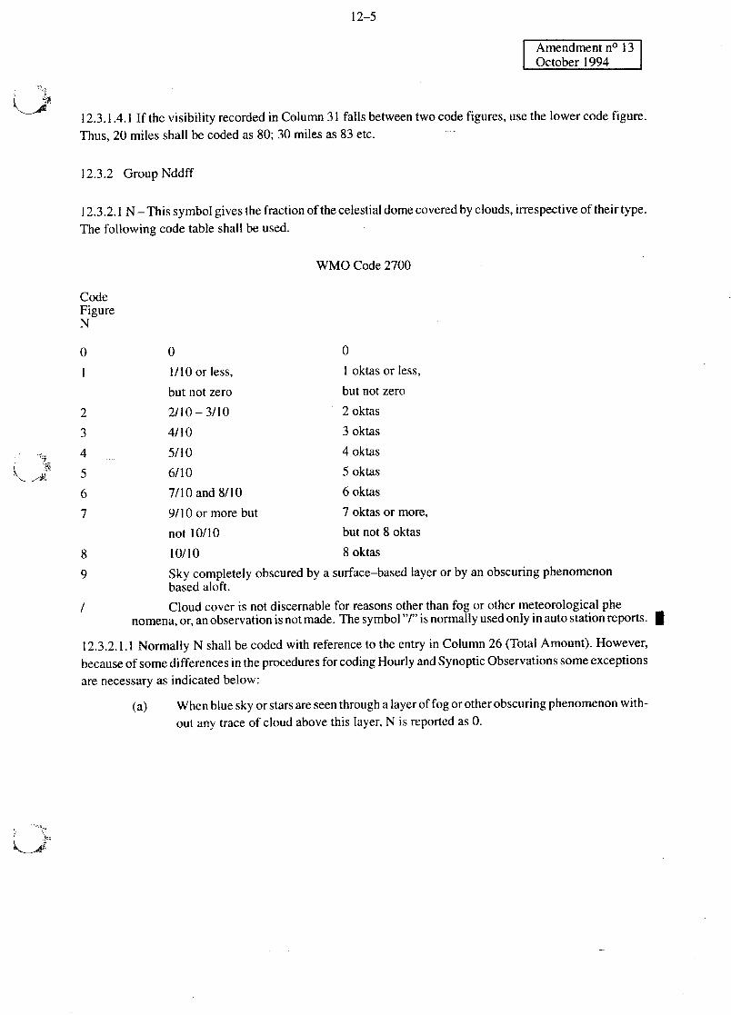
12.3.2 GroupNddff
12.3.2.1N— Thissymbolgivesthefractionofthecelestialdomecoveredbyclouds,irrespectiveof theirtype.The following codetable shallbeused.
WMO Code2700
CodeFigureN
0
1/10 or less,
0
1 oktasor less,
but not zero
2/10— 3/10
4/10
5/10
6/10
7/10 and8/10
9/10or morebut
not 10/10
10/10
but not zero
2 oktas
3 oktas
4 oktas
5 oktas
6 oktas
7 oktasor more,
but not 8 oktas
8 oktas
Sky completelyobscuredby asurface—basedlayeror by an obscuringphenomenonbasedaloft.
Cloudcover is not discernablefor reasonsotherthanfog or othermeteorologicalphenomena,or,anobservationis not made.Thesymbol“r’ is normallyusedonly in autostationreports. U
12.3.2.1.1Normally N shall becodedwith referenceto theentry in Column26 (TotalAmount).However,becauseof somedifferencesin theproceduresforcodingHourly andSynopticObservationssomeexceptionsarenecessaryas indicatedbelow:
(a) Whenbluesky orstarsareseenthroughalayerof fogorotherobscuringphenomenonwith-out any traceof cloudabovethis layer,N is reportedas 0.
0
2
3
4
5
6
7
8
9
/
12—6
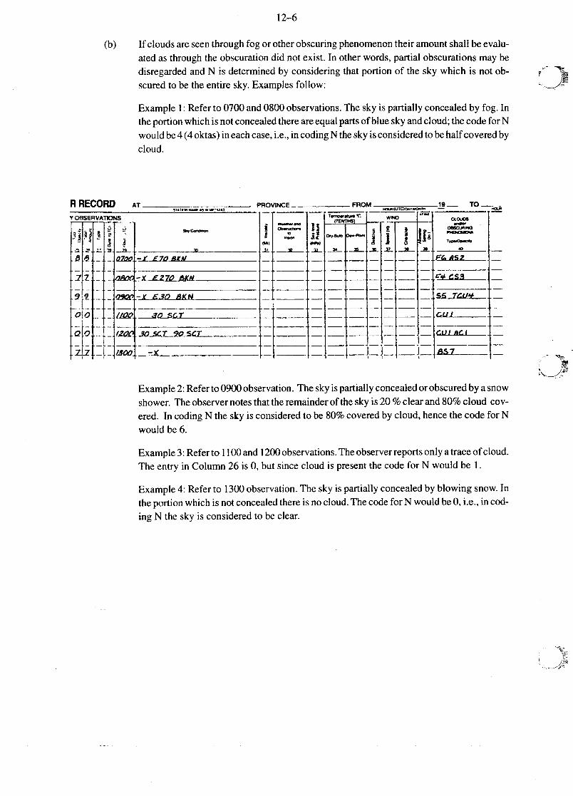
(b) If cloudsareseenthroughfogor otherobscuringphenomenontheir amountshallbeevalu-atedas throughthe obscurationdid not exist. In otherwords,partial obscurationsmaybedisregardedandN is determinedby consideringthat portionof the sky which is not ob-scuredto bethe entiresky. Examplesfollow:
Example1: Referto 0700and0800observations.Thesky is partiallyconcealedby fog. Intheportionwhichisnotconcealedthereareequalpartsof bluesky andcloud;thecodefor Nwouldbe4(4oktas)ineachcase,i.e., in codingN thesky isconsideredtobehalfcoveredbycloud.
R RECORD AT PROViNCE _____________ FROM 19 TO
Y O6SERVATIONS
~CO~o
-~ I~
rr
rM~
IL
II(I,p).a ~ ~ .k. 2L ...~ 3’
ENOWNA
O~L~PG
S ~Zt2O—1 A 70 AkPd
-~ £270 AKN
-y £30 AKN
I7OtO~UOO
VIO - - ~&1[21i --~
.~0StT
~OSA~T 9OSCT
-~
Example2: Referto0900observation.Theskyispartiallyconcealedorobscuredby asnowshower.Theobservernotesthatthe remainderof thesky is20 % clearand80% cloud cov-ered. In codingN the sky is consideredto be 80% coveredby cloud,hencethecodefor Nwouldbe 6.
Example3: Referto 1100and1200observations.Theobserverreportsonly atraceofcloud.The entryin Column26 is 0, but sincecloudis presentthe codefor N wouldbe 1.
Example4: Referto 1300observation.Thesky is partially concealedby blowing snow.Intheportionwhichisnot concealedthereis no cloud.Thecodefor N would be0, i.e., in cod-ing N thesky is consideredto be clear.
12—7
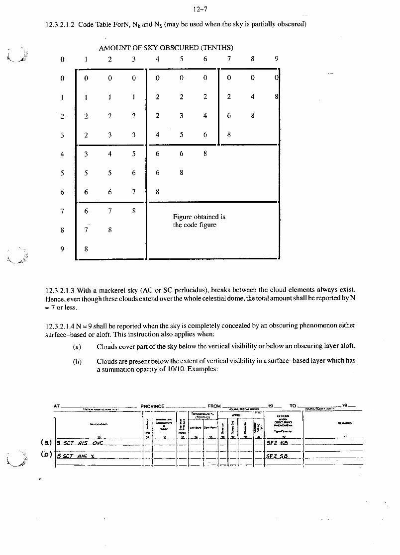
12.3.2.1.2 CodeTable ForN, Nh andN5 (may beusedwhenthe sky is partially obscured)
AMOUNT OF SKY OBSCURED(TENTHS)
0 1 2 3 4 5 6 7 8 9
0 0 0
1 1 1
2 2 2
2 3 3
0 0 0
2 2 2
2 3 4
4 5 6
0 0 0
2 4 8
6 8
8
3 4 5
5 5 6
6 6 7
6 6 8
6 8
8
6 7 8
7 8
8
Figureobtainedisthecodefigure
12.3.2.1.3With a mackerelsky (AC or SC perlucidus),breaksbetweenthe cloud elementsalwaysexist.Hence,eventhoughthesecloudsextendoverthewholecelestialdome,thetotalamountshallbereportedbyN= 7 or less.
12.3.2.1.4N 9 shall bereportedwhenthesky is completelyconcealedby anobscuringphenomenoneither
surface—basedor aloft. This instructionalsoapplieswhen:
(a) Cloudscoverpartof the sky belowthe verticalvisibility or belowanobscuringlayeraloft.
(b) Cloudsarepresentbelowtheextentof verticalvisibility in asurface—basedlayerwhichhasasummationopacityof 10/10.Examples:
AT PROVINCE FROM _____________19. TO _____________19.......
S~,Co.o,o~ ~~
*..ainn
~“~“~“0
•.
~.1A & ~ ~ ~
AA
O
OBS~’.G
0~
.-~rnS ~C
SCT A/S X
0
2
3
4
5
6
7
8
9
(a)
(b)
12—8
12.3.2.1.5 Persistentcondensationtrailsandcloudmasseswhichhaveobviouslydevelopedfrom condensa-tion trails shallbereportedas cloudandconsideredwhencodingthecloud amount,N. Rapidlydissipatingcondensationtrails shallnot be consideredin codingN.
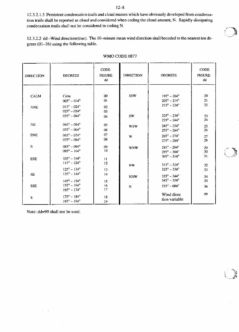
12.3.2.2dd —Wind direction(true).The 10—minutemeanwind direction shallbecodedto thenearesttende-grees(01—36) usingthe following table.
WMOCODE0877
DIRECTION DEGREES
CODE
FtGUREdd
DIRECTION DEGREES
CODE
FIGUREdd
CALM CaIrn 00 55W 195o~204o 20
00500140 01 205o~2I4o 21
NNE 015~—024~ 02 215o~224o 22025o~034o 03
035o~044o 04 SW 225a~234o
235a~244o
23
24NE 045o~O54o
055o~064o
05
06
245o~254o
255o~264o
25
26
ENE O65o~074o
O75Q~084o
07
08
W 265~—274~
275o~284o
27
28
E O85o~0940
09501040
09
10
WNW 285o~294o
2950~3040
29
30
ESE 105o~I14o 11305o~3I4o 31
115~—124~ 12 NW 3I5o~324o 32
SE
SSE
I250~I340
1350~I44o
145o~1540
I550~I640I650~ 1740
13
14
15
1617
NNW
N
325o~3340
3350344034503540
35500040
33
3435
36
1750~I840
1850~ 1940
18
19
Winddirection variable
99
Note: dd=99shallnot be used.
12—9
Amendment n0 13October1994
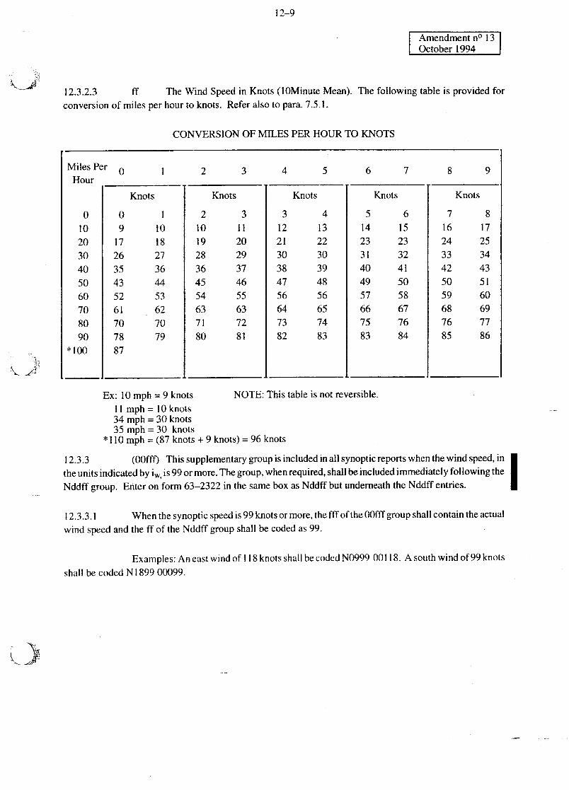
ff The Wind Speed in Knots (lOMinute Mean). The following table is providedforconversion of milesperhourto knots. Referalsoto para.7.5.1.
CONVERSIONOFMILES PERHOUR TO KNOTS
Miles Per 0Hour
0102030405060708090
*100
Knots
09
172635435261707887
101827
364453
627079
2 3 4 5
Knots
2 3
10 1119 2028 2936 3745 4654 5563 6371 7280 81
Knots
3 412 1321 2230 3038 3947 48
56 5664 6573 7482 83
NOTE: This table is not reversible.Ex: l0mph=9knots
11 mph=l0knots34 mph = 30 knots35 mph = 30 knots
* 110 mph = (87 knots + 9 knots) = 96 knots
12.3.3 (OOfft) Thissupplementarygroupisincludedin all synopticreportswhenthewind speed,intheunitsindicatedby is.,,,, is 99or more.Thegroup,whenrequired,shallbeincludedimmediatelyfollowing theNddff group. Enteron form 63—2322 in thesamebox asNddff but underneaththeNddff entries. I
12.3.3.1 Whenthesynopticspeedis 99knotsormore,thefff of theO0fffgroupshallcontaintheactualwind speedandthe ff of theNddff groupshall becodedas 99.
Examples:An eastwind of 118knotsshallbecodedN099900118. A southwind of 99 knotsshall be codedN189900099.
12.3.2.3
6 7
Knots
5 614 1523 2331 3240 4149 5057 58
66 6775 7683 84
8 9
Knots
7 816 1724 2533 3442 4350 5159 6068 6976 7785 86
12—10
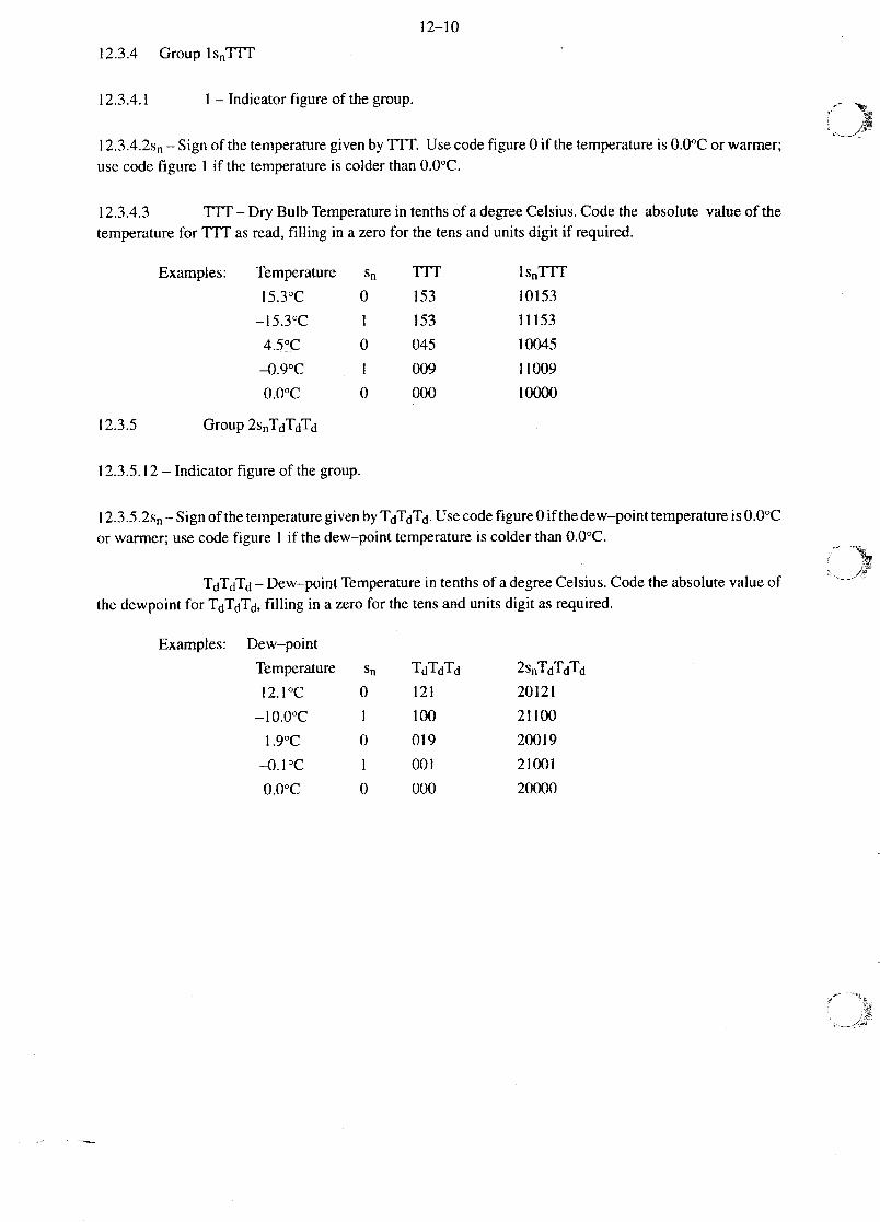
12.3.4 Group ls~TIT
12.3.4.1 1 — Indicatorfigure of thegroup.
I 2.3A~2s~— Signof thetemperaturegivenby TIT. Usecodefigure 0 if the temperatureis 0.00Cor warmer;usecodefigure 1 if thetemperatureis colderthan0.00C.
12.3.4.3 TTT— Dry Bulb Temperaturein tenthsof adegreeCelsius.Codethe absolutevalueof thetemperaturefor ITF as read,filling in azerofor the tensandunits digit if required.
Examples: Temperature s~ TIT ls~Tff
l5.30C 0 153 10153
—15.30C 1 153 11153
4.50C 0 045 10045
—0.90C 1 009 11009
0.00C 0 000 10000
12.3.5 Group 2snTdTdTd
12.3.5.12 — Indicatorfigure of the group.
12.3.5.2s~— Signof thetemperaturegivenby TdTdTd.Usecodefigure0 if thedew—pointtemperatureis0.00Cor warmer;usecodefigure 1 if thedew—pointtemperatureis colderthan0.00C.
TdTdTd— Dew—pointTemperaturein tenthsof adegreeCelsius.Codetheabsolutevalueofthe dewpoint for TdTdTd, filling in azerofor the tensandunits digit as required.
Examples: Dew—point
Temperature 5~ TdTdTd 2snTdTdTd
12.10C 0 121 20121
—l0.00C 1 100 21100
l.90C 0 019 20019
—0.10C 1 001 21001
0.00C 0 000 20000
x
12—Il
Amend. No. 9Sept. 1987
12.3.6 Group 3POPOPOPO
This groupshall be includedin main synoptic reportsonly.
12.3.6.13—Indicatorfigure of the group.
12.3.6.2 P0P0POPO— Stationpressure.Obtainthestationpressurefrom Line 20 of Section1 andcodedirectly if the stationpressureis lessthan 1000.0hPa,omitting thedecimalpoint.
Example:Stationpressure 3P0POPOPQ
987.2= 39872
964.3 = 39643
999.0= 39990 etc.
12.3.6.2.1 If the station pressure is 1000.0 hPaor more,codeP0P0P0P0 by omitting the thousands digitandrecordthe hundreds,tens,units, andtenthsdigits directly,omitting the decimal point.
Example:Stationpressure= 3 P0P0P0P0
1000.0 = 30000
1012.4 = 30124
1004.2=30042 etc.
12.3.7 Group 4PPPP
12.3.7.14— Indicatorfigureof the group.
12.3.7.2 PPPP— SeaLevel Pressurein Tenthsof a Hectopascal.To obtain thecodefigure for PPPP,referto the valuerecordedon Line 22, anduseall four digitswhensealevel pressureis lessthan 1000hPa.Whensealevel pressureis 1000hPaor more,omit thethousandsdigit andrecordthe hundreds,tens,units,andtenthsdigits directly. The decimalis alwaysomitted.
Examples:Sealevel pressure Codefor PPPP
996.2 9962
1015.4 0154
12.3.8 Group Sappp
12.3.8.I 5 — Indicator figure of the group.
12—12
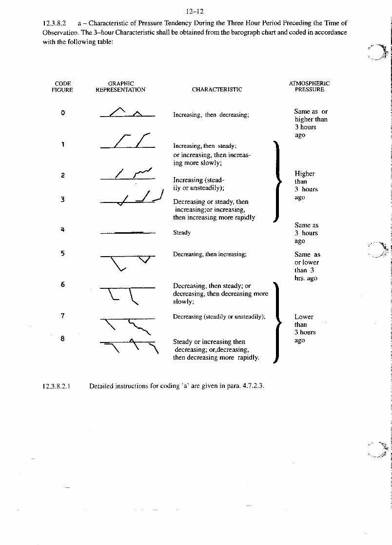
12.3.8.2 a— Characteristicof PressureTendencyDuring the ThreeHour PeriodPrecedingthe Time ofObservation.The3—hourCharacteristicshallbeobtainedfrom thebarographchartandcodedin accordancewith the following table:
GRAPHICREPRESENTATION
—il--LI-
I -i/-i
CHARACTERISTIC
Increasing,then decreasing;
Increasing,then steady;or increasing,thenincreas-ing moreslowly;
Increasing(stead-ily orunsteadily);
Decreasingor steady,thenincreasing;orincreasing,thenincreasingmorerapidly
Steady
Decreasing,thenincreasing;
Decreasing,thensteady;ordecreasing,thendecreasingmoreslowly;
.9
Decreasing(steadilyor unsteadily);
- Steadyor increasingthendecreasing;or,decreasing,thendecreasingmore rapidly.
4
ATMOSPHERICPRESSURE
Sameas orhigher than3 hoursago
Higher~than3 hoursago
Sameas3 hoursago
Sameasor lowerthan 3hrs. ago
~Lowerthan3 hoursago
1I
CODEFIGURE
0
1
2
3
I
4
5
6
7
8
12.3.8.2.1 Detailed instructions for coding ‘a’ aregiven in para.4.7.2.3.
12—13
Amendmentn0 13October1994
12.3.8.3 ppp— Amountof PressureTendencyDuringtheThreeHoursPrecedingtheTimeofObserva-tion,Expressedin Tenthsof aHectopascal.Obtainthe3 hourtendencyamount,(seepara.4.7.1.1)andcodedirectly forpppinsertingazeroin theplaceof thetensdigit if theamountis lessthan10 hPaandtwo zerosintheplacesof the tensandunits digits if the amountis lessthanI hPa.Always omit the decimalpoint.
Examples: Net 3—hourpressure
change
11.2 hPa
9.3 hPa
0.8hPa
Code for ppp
112
093
008
12.3.9 Group6RRRtR
Thisgroupshallbe includedin mainandintermediatesynopticreportsif precipitationhasoccurredsincethepreviousmain synopticobservation.(Seepara.12.3.1.1on theuseof the symbol iR.)
12.3.9.16 — Indicatorfigure of the group.
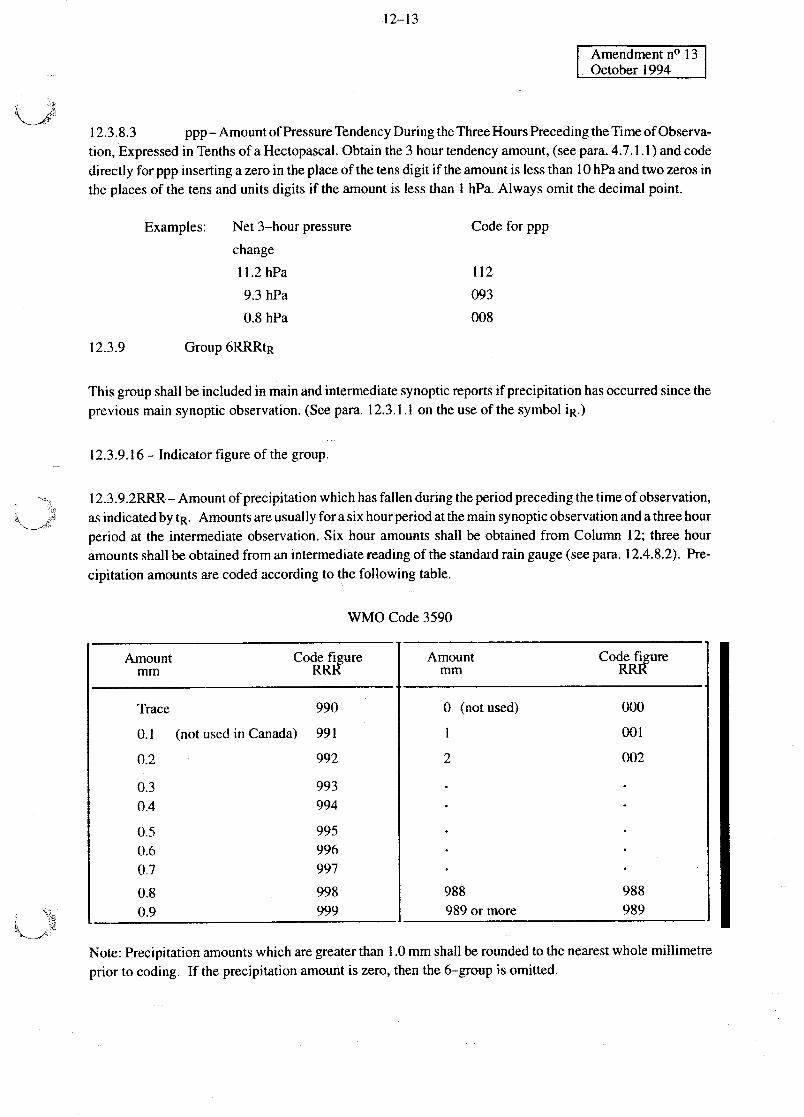
12.3.9 .2RRR — Amountof precipitation which has fallen duringtheperiodprecedingthetimeof observation,asindicatedby tR. Amountsareusuallyfor asix hourperiodatthemainsynopticobservationandathreehourperiod at the intermediateobservation.Six hour amountsshall be obtainedfrom Column 12; threehouramountsshallbeobtainedfroman intermediatereadingof thestandardrain gauge(seepara.12.4.8.2).Pre-cipitation amountsarecodedaccordingto thefollowing table.
WMO Code3590
Amount Codefiguremm RRR
Amountmm
CodefigureRRR
Trace 990 0 (not used) 000
0.1 (not used in Canada) 991 1 001
0.2 992 2 002
0.3 9930.4 994
0.5 9950.6 9960.7 997
0.8 998 988 9880.9 999 989 or more 989
Note: Precipitationamountswhich aregreaterthan1.0mm shallberoundedto thenearestwholemillimetreprior to coding. If the precipitation amount is zero, then the 6—group is omitted.
12—14
Amend.No. 10Nov. 1, 1989
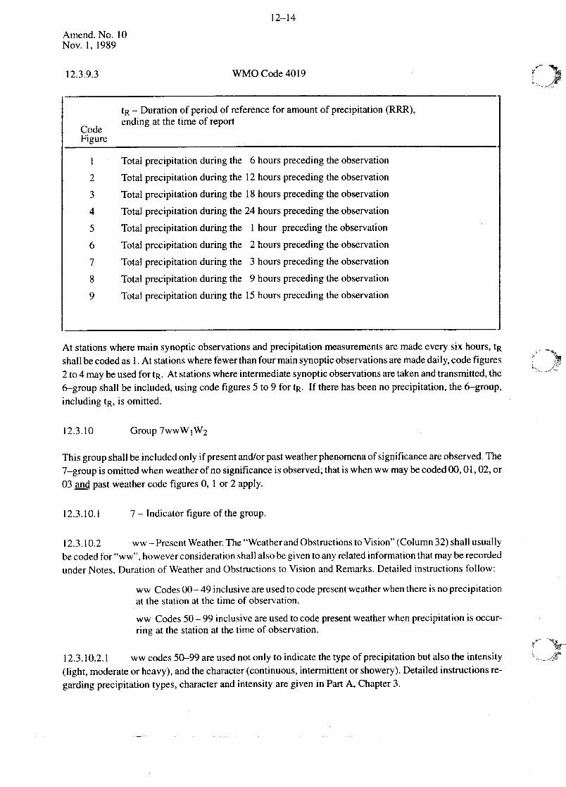
12.3.9.3 WMO Code4019
At stationswheremainsynopticobservationsandprecipitationmeasurementsare madeevery six hours,tR
shallbecodedas 1. At stationswherefewerthanfourmainsynopticobservationsaremadedaily,codefigures2 to 4 maybeusedfor tR. At stationswhereintermediatesynopticobservationsaretakenandtransmitted,the6-groupshallbe included,usingcodefigures5 to 9 for tR. If therehasbeenno precipitation,the 6—group,includingtR, is omitted.
12.3.10 Group 7wwWjW2
Thisgroupshallbeincludedonlyif presentand/orpastweatherphenomenaof significanceareobserved.The7—groupis omittedwhenweatherof no significanceisobserved;thatis whenww maybecoded00,01,02,or03 andpastweathercodefigures 0, 1 or 2 apply.
12.3.10.1 7 — Indicatorfigure of the group.
12.3.10.2 ww— PresentWeather.The “WeatherandObstructionsto Vision” (Column32)shallusuallybecodedfor “ww”, howeverconsiderationshallalsobegiventoanyrelatedinformationthatmayberecordedunderNotes,Durationof WeatherandObstructionsto Vision andRemarks.Detailedinstructionsfollow:
ww Codes00—49inclusiveareusedtocodepresentweatherwhenthereisno precipitationatthe stationat the time of observation.
ww Codes50—99 inclusiveareusedtocodepresentweatherwhenprecipitationis occur-ring at the stationatthetime of observation.
12.3.10.2.1 ww codes50—99areusednot only to indicatethetypeof precipitationbut alsothe intensity(light, moderateorheavy),andthecharacter(continuous,intermittentor showery).Detailedinstructionsre-gardingprecipitationtypes,characterandintensityaregiven in PartA, Chapter3.
tR — Duration of periodof referencefor amountof precipitation(RRR),
Code ending at the timeof report
FigureTotal precipitationduringthe 6 hoursprecedingtheobservation
2 Total precipitationduring the 12 hoursprecedingtheobservation
3 Total precipitationduringthe 18 hoursprecedingtheobservation
4 Total precipitationduring the24 hoursprecedingtheobservation
5 Total precipitationduringthe 1 hour preceding the observation
6 Total precipitationduringthe 2 hoursprecedingthe observation
7 Total precipitation during the 3 hoursprecedingthe observation
8 Total precipitationduringthe 9 hoursprecedingthe observation
9 Total precipitationduringthe 15 hoursprecedingthe observation
12—15
Amend.No. 10Nov. 1, 1989
12.3.10.2.2 Properusageof thepresentweather(ww) codesrequiresacompleteknowledgeof:
(a) “Definitions and Descriptionsof Meteors”asgivenin the InternationalCloudAtlas,and,
(b) “AtmosphericPhenomena”instructionsanddefinitionsas given in Chapter3 of this man-ual.
12.3.10.2.3 Thefirst figure of theww codecorrespondsto thetenprincipalcategoriesof weather.Firstly,thedecademostsuitabletothegeneralstateof theweatherischosen;then,fromthatdecade,thecodefigure ischosenwhich bestdescribesthe weatheratthe time of observationor (wherespecificallymentionedin thecode)during theperiodof onehourimmediatelyprecedingit. In makingthechoiceof thedecadeor in deter-mining thecompletecodefigure ww, onedoesnot takeinto accountmeteorologicalphenomenawhichhavebeenexperiencedmorethanonehourbeforetheofficial timeof observingtheweather(with theoneexceptionof thunder,whichmay havebeenheardup to 75 minutesbeforetheofficial timeoftheweatherobservation.Seeww codes29 and91—94.)
12.3.10.2.4 If morethanonespecificationof the ww codesis applicable,the highestcodefigure is cho-sen,exceptthat code17 shallbe givenpreferenceover codes20—49.
Note: If atornadois ator within sightof astationatthetimeof observationorwithin thepasthour,theplain languagewordTORNADOshall berecordedandtransmittedas the lastgroupof Section3. A tor-nadomayalsobereportedin the7—groupsimultaneouslyif ww= 19is thehighestpresentweathercodeappli-cableatthetime. This codingshallapplyto both mainandintermediatesynopticreports,if applicable.
12.3.10.2.5 The following graphicguide, in which priority is indicatedby the relativepositionof theblock,maybeusedto assistin theselectionforcodingPresentWeather.An abbreviateddescriptionof eachofthe codefiguresfollows the chart.
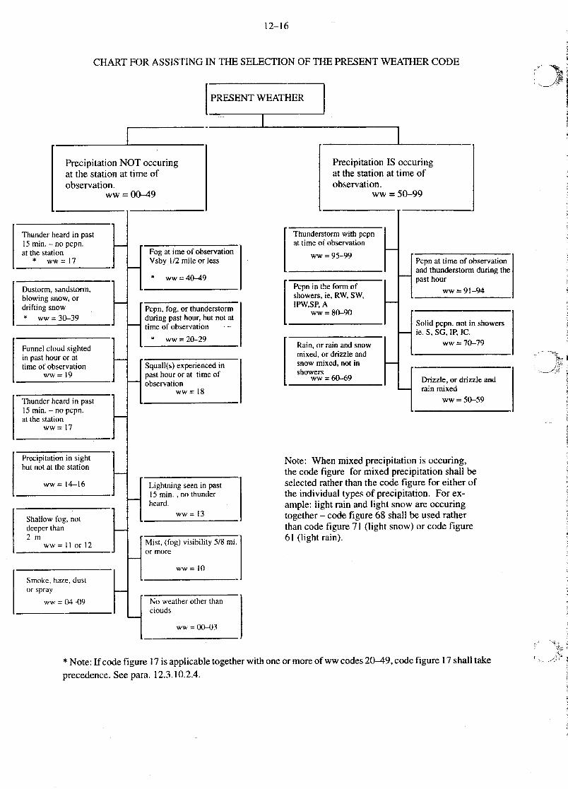
12—16
CHART FOR ASSISTING IN THE SELECTIONOF THE PRESENTWEATHERCODE
PRESENTWEATHER
[ III
Note: Whenmixed precipitationis occuring,the codefigure for mixed precipitationshall beselectedratherthanthe codefigure for eitherofthe individual typesof precipitation. Forex-ample: light rain andlight snowareoccuringtogether— codefigure 68 shall be usedratherthancodefigure 71 (light snow)or codefigure61 (light rain).
* Note:If codefigure 17 is applicabletogetherwithoneor moreof ww codes20—49,codefigure 17 shalltake
PrecipitationNOT occuringatthe stationat timeofobservation.
ww = 00-49
Thunder heardin past15 min.—nopcpn.atthestation
* ww=17
PrecipitationIS occuringatthe stationattimeofobservation.
ww =50-99
I Fog atimeof observation
Vsby 1/2 mile or less
* ww~=4O—49
Dustorm,sandstorm,blowing snow,ordrifting snow* ww=30—39
Thunderstormwith pcpnat timeof observation
ww=95-99
I II
Pepo, fog, or thunderstormduringpasthour,but not attime of observation
“ ww=20—29Funnelcloudsightedin pasthouror attime of observation
ww = 19
Pcpnin theform ofshowers,ie,RW, SW,IPW,SP,A
ww=80-90
Pcpnat time of observationandthunderstormduringthepasthour
ww =91-94
I Squall(s)experiencedinpasthour or at timeofobservation
ww = 18Thunderheardin past15 mm. — no pcpn.at thestation
ww = 17
Rain,or rainandsnowmixed,or drizzleandsnow mixed, not inshowers
ww = 60-69
Solid pcpn. not in showersie. S. 5G. IF’, IC.
ww = 70-79
IPrecipitationin sight
but not atthe station
ww = 14-16
Drizzle,or drizzleandrain mixed
ww=50-59
I
I
II
Lightning seenin past15mm. ,no thunderheard.
ww = 13Shallow fog, notdeeperthan2m
ww= II or 12 I Mist, (fog) visibility 5/8 mi.
or more
ww = 10
Smoke, haze, dustor spray
ww = 04-4)9No weatherother than
clouds
ww = 00-03
precedence.Seepara.12.3.10.2.4.
12—17
Amendmentn0 14June1996
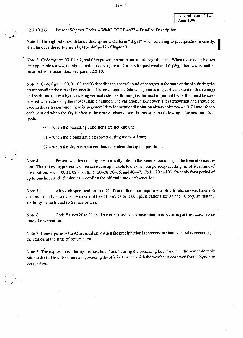
12.3.10.2.6 PresentWeatherCodes— WMO CODE4677 — DetailedDescription
Note I: Throughoutthesedetaileddescriptions,the term“slight” when referringto precipitationintensity, •shall beconsideredto meanlight as definedin Chapter3.
Note 2: Codefigures00,01, 02,and03 representphenomenaof little significance.Whenthesecodefigures
areapplicablefor ww, combinedwith acodefigureof 2or lessfor pastweather(W1W2),thenwwis neither
recordednortransmitted.Seepara. 12.3.10.
Note3: Codefigures00,01,02and03 describethegeneraltrendofchangesin thestateof the skyduring the
hourprecedingthetimeof observation.Thedevelopment(shownby increasingverticalextentor thickening)ordissolution(shownby decreasingverticalextentor thinning)is themostimportantfactorthatmustbecon-sideredwhenchoosingthe mostsuitablenumber.The variation in sky coveris lessimportantandshouldbeusedasthecriterionwhenthereis no generaldevelopmentor dissolutionobservable;ww= 00,01 and02 can
eachbe usedwhenthe sky is clearatthetime of observation.In thiscasethefollowing interpretationshallapply:
00 — whenthe precedingconditionsare not known;
01 — whenthe cloudshavedissolvedduring thepasthour;
02 — whenthe sky hasbeencontinuouslyclearduringthe pasthour.
Note 4: Presentweathercodefiguresnormallyreferto theweatheroccurringatthe timeof observa-tion. Thefollowingpresentweathercodesareapplicableto theonehourperiodprecedingtheofficial timeof
observation:ww= 00,01,02,03,18, 19,20-28,30—35,and40—47. Codes29 and90-94applyforaperiodofup to onehourand 15 minutesprecedingthe official timeof observation.
Note 5: Althoughspecificationsfor 04, 05 and06 do not requirevisibility limits, smoke,hazeanddustareusuallyassociatedwith visibilities of 6 milesor less. Specificationsfor 07 and 10 requirethatthevisibility berestrictedto 6 milesor less.
Note6: Codefigures20 to 29 shallneverbeusedwhenprecipitationis occurringatthestationatthetime of observation.
Note 7: Codefigures80 to 90areusedonlywhentheprecipitationisshoweryin characterandis occurringatthe stationatthe time of observation.
Note 8: The expressions“during thepast hour” and“during the precedinghour” usedin the ww codetablerefertothefull hour(60minutes)precedingtheofficial timeatwhichtheweatheris observedfortheSynopticobservation.

12—18
F~e~F7olT1
Codefigure 00 shallbeusedwhenthe clouddevelopmentduring theprecedinghouris unknownor hasnotbeenobserved.
Codefigure 01 shall be usedwhenthecloudshaveshownatendencyto dissolveor to decreasein verticaldevelopmentduringthe precedinghour,e.g.,codefigure 01 is applicableto thedecreaseof fine weatherCu-muluslate in the day.
Code figure 02 shallbeusedwhentherehas beenno appreciablechangein the stateof the sky during thepreceding hour.
Codefigure03 shallbeusedwhenthecloudshaveshownatendencytoform ordevelopduringtheprecedinghour; e.g.,thisfigure is applicablewhencumuluscloudsareforming andalsowhenfair weatherCumulusisdevelopinginto CumulusCongestus.
Codefigure 04 shall beusedwhentheprevailingvisibility is restrictedby smoke,e.g.,forestfire, industrialsmokeor volcanicash.
Codefigure 05 shallbe usedwhenthe obstructionto vision consistsof lithometeors,generallyknownas“haze”.
Codefigure06 shallbeusedwhentheprevailingvisibility isrestrictedbydustsuspendedin theair, not raisedby wind.
Codefigure07 shallbeusedwhenblowing dustorblowing sandisobservedatornearthestationatthetimeofobservation and the prevailing visibility is observed to be not more than 6 miles,but no well—developeddustwhirl(s) or sandwhirl(s) andno duststormor sandstormseen,or in the caseof ships,blowing sprayat thestation.
Codefigure 08 shallbeusedwhenwell developeddustwhirls or sandwhirls areseenator nearthe stationduring the preceding hour or at the time of observation, but no duststorm or sandstorm.
Codefigure 09 shallbeusedwhenaduststormor sandstorm is within sightatthetimeof observationorhasoccurredatthe stationduringtheprecedinghourandtheestimatedorobservedvisibility in theduststorm orsandstorm is/was less than 5/8 mile.
12—19
Amend.No. 10Nov. 1,1989
Codefigure 10 shallbeusedwhenfog or icefog is observedandtheprevailingvisibility is6 milesor lessbutnot lessthan5/8 mile (morecorrectly referredto as mist).
Codefigure 11 shallbeusedwhenpatchesof shallowfog or ice fogareobservedatthestationatthe timeofobservation.The depthof the fog shall not restrict visibility at eye level; however,the fog mustbe denseenoughso thatthe apparentvisibility in thefog is lessthan5/8 mile.
Codefigure 12 shallbeusedwhenmoreor lesscontinuousshallowfog or icefog is observedatthe stationatthetimeof observation.Thedepthof thefog shall notrestrictvisibility ateye level;however,thefog mustbedenseenoughsothat the apparentvisibility in thefog is lessthan 5/8 mile. Codefigure 12 shall beusedinpreferenceto codefigure Il when shallow fog is observedto covermorethanhalf of the groundnormallyvisible.
Codefigure 13 shallbeusedwhenlightningis seenatthetimeof observationorwithin 15 minutesprecedingthe timeof observation,but no thunderis heard.
Codefigure 14shallbeusedto reportVIRGA, i.e.,precipitationwithin sight, butnot reachingthegroundorthe surfaceof the sea.
Codefigure 15 shallbeusedwhenprecipitationis within sightandisreachingthegroundor thesurfaceof thesea,at an estimateddistanceof morethan3 miles from the station.
Codefigure 16 shallbeusedwhenprecipitationiswithin sightandis reachingthegroundor thesurfaceof thesea,at an estimateddistanceof 3 milesor lessfrom thestation, but not at the station.
Codefigure 17 shallbeusedwhenthunderis heardatthetimeof observation,orwithin 15 minutesprecedingthetime of observation,andno precipitationis occurringat the stationat the timeof observation.
Note:Wheneverww can becoded17, this codefigure shallbe givenpreferenceovercodefigures20—49.
Codefigure 18 shallbeusedwhensquallsoccuratthetimeofobservation,orhaveoccurredwithin thepreced-ing hour.
Codefigure 19 shall be usedwhenafunnel cloud, waterspout,or tomadois within sight of thestationatthetimeof observationor was observedduring the precedinghour. In thecaseof a tornado,the plain languagewordTORNADO shallbe recordedandtransmittedasthe lastgroupof Section 3, whetheror not ww is en-codedas 19.
12—20
Amend.No 10Nov. 1, 1989
Codefigure 20 shallbe usedwhendrizzleor snowgrainshaveoccurredat the stationduring theprecedinghour,but arenot occurringatthe time of observation.If freezingdrizzlehasoccurredduring theprecedinghour,usecodefigure 24.
Codefigure 21 shallbeusedwhenrain (notrain showers)hasoccurredat thestation duringthe precedinghour,but is not occurringatthe timeof observation.If freezingrain hasoccurredduring theprecedinghour,usec odefigure 24.
Codefigure 22 shallbe usedwhensnow(notsnowshowers)or icecrystalshaveoccurredatthestationduringthe precedinghour,but arenot occurringatthe time of observation.
Codefigure 23 shallbeusedwhenmixed rain andsnow,or icepellets,non—showery,haveoccurredatthestationduring theprecedinghourbut arenot occurringat thetime of observation.
Codefigure 24shall beusedwhenfreezingrain (non—showery)or freezingdrizzlehasoccurredatthestationduring the precedinghour,but is not occurringat thetime of observation.
Codefigure 25 shallbeusedwhenarain showerhasoccurredatthestationduringtheprecedinghour,but isnot occuringat thetime of observation.
Codefigure 26 shallbeusedwhena snowshower,or ashowerof rain andsnowhasoccurredatthe stationduringtheprecedinghour,but is not occurringat the timeof observation.
Codefigure 27 shallbeusedwhenashowerof hail, or of hail andrain, hasoccurredatthestationduringtheprecedinghour,but is not occurringatthetime of observation.Forpurposesof reportingcodefigure27,hailmaybeconsideredto meanany one,or anycombinationof hail, snowpellets,or ice pellets(typc b).
Codefigure 28 shallbeusedwhenfogor icefog, with visibility lessthan5/8 mile hasoccurredatthestationduring theprecedinghour,but is not occurringatthetime of observation.
Codefigure 29 shallbeusedwhenathunderstormwith or withoutprecipitation,hasoccurredatthe stationduring theprecedinghour,but neitherthundernorprecipitationis occurringatthetime of observation.Thisrequiresthatthe last thunderbe heard15 minutesor morebeforethetime of observation.Forpurposesofreportingthiscodefigure, the “precedinghour” is from 1 hourand 15 minutesagoto 15 minutesago.