Embed Size (px)
Citation preview
1
CHAPTER 13 Denudation, weathering and mass wasting
Introduction
The collective processes of denudation appear as just two facilitating links in the sedimentary loop of the rock cycle, between the formation of continental crust and the post-depositional fate of derived sediments. In practice they form the principal element in any review of landsurface development and the core of the science of geomorphology. They are studied here and in later chapters at two levels – in their own right, as components of geomorphology, and as those connective links in the larger scheme of Earth Systems processes. This approach permits the linkage of geomorphic processes with the time scales and global patterns of morphotectonic activity, the tectonic machinery providing initial uplift and a global tectonic framework for the location of orogens, cratons and basins where geomorphic landsystems develop. Tectonic forcing also provides a major source of general environmental and geomorphic change.
General processes of denudation, weathering and mass wasting are introduced here as the prelude to later chapters where they are shown to operate in more specific ways in particular geomorphic environments. An outline history of the significance of denudation rates and earlier attempts to define denudation chronologies precedes an introduction to opposing forces in the geomorphic environment – the static force of gravity and the dynamic force of moving bodies of water, ice and air versus the strength of earth materials. These are defined by Mohr–Coulomb failure criteria, which are used widely in applied geomorphology and geotechnical investigations to summarize the source of principal strength components and mobilized eroding forces. Weathering is reviewed in its own right with classic physical and chemical processes. It is also treated here as a means to an end – a source of in situ reduction of rock strength facilitating subsequent mass wasting or erosion – and as a natural extension of geological fractionation processes.
Mohr–Coulomb criteria are revisited to demonstrate sliding resistance before a review of principal styles of slope instability and failure, with distinctions between rock and debris slopes. The chapter includes a review of debris flow hazard, which appears to be on the increase in temperate climates through changes in land use and climate.
Chapter Summary
Denudation
• Denudation processes are powered by the direct impact of sunlight, as in insolation weathering, and indirectly in the form of thermally-driven ice, water and air gravity flows.
• Tectonic uplift elevates landsurfaces into the denudational environment, thereby endowing these agents with potential energy.
• It is evident from the modern surface outcrop of rocks known to be have been emplaced below Earth’s surface, as well as from superficial rock debris and soft sediment bodies, that landsurfaces are eroded and lowered over time unless disturbed by renewed uplift
2
• Denudation rates are derived largely from the degree of exhumation of such rocks and the measurement of sediment transfers to construct average surface lowering rates, although they do not reflect the degree of dissection and creation of relative relief.
• Rates of uplift and denudation inevitably vary during the life cycle of an orogen but the accordance of many mountain summits also demonstrates that steady-state conditions may prevail for long periods when denudation matches uplift.
• Model denudation cycles were constructed formerly to provide a framework for seemingly repeated uplift and denudation. Sea-floor spreading and volcano-tectonic activity have shown that supercontinental cycles offer more appropriate explanations of pulsed uplift and denudation.
Force and resistance
• As the belief in denudation cycles waned, the validity of morphogenetic studies equating landform assemblages with the controlling effects of specific climates grew.
• Even these are now thought by many to be too inflexible, failing to consider the wholesale and repeated disturbance of Quaternary climatic patterns and the impact of neotectonics.
• A morphotectonic treatment is preferred here, and tensile, compressive and shear stresses are identified. The first two are particularly important in tectonic processes but their effects are also evident in planar structures – folds, faults, joints, etc., which create defects in rock mass.
• Emphasis is also placed on a materials science or geotechnical approach to the behaviour of earth materials and the role of water, ice and air in geomorphic processes.
• It is important to recognise the forces to which earth materials may be subjected and the properties of rock and soil strength which are mobilized to resist them.
• Whilst tensile and compressive stresses also result from expansion, heaving and crushing processes at Earth’s surface, shear stress is predominant in geomorphic processes.
• Shear stress is a destabilizing component of the forces operating on slopes, acting to pull a rock or soil mass downslope, and develops when water, ice or air together with entrained debris moves over the landsurface.
• Important aspects of geomorphic processes are summarized in the Mohr–Coulomb equation, which defines shear stress and opposing shear strength at the point of incipient failure in earth materials.
Weathering
• Weathering processes and landforms are important in their own right but weathering is regarded here mainly as a preliminary to mass wasting and denudation. Its role is to reduce the strength of earth materials and make them more liable to fail.
3
• Weathering reduces the tensile and shear strength of rock by attacking the cohesive properties or bonds between constituent minerals or particles.
• In so doing, weathering also triggers the final stages of fractionation by converting hard, mechanically stable but chemically unstable rock to mechanically unstable but chemically stable residues.
• Rock texture and structure dictate the pattern of circulating fluids, thereby determining rock susceptibility to physical weathering and influencing the extent of chemical weathering processes.
• Physical weathering mostly involves the cyclical application and relaxation of stress through thermal changes, wetting–drying and freezing– thawing, which produce disaggregated rock fragments, known generally as regolith.
• The lithology of rock determines the specific susceptibility of its minerals and bonds to particular types of chemical weathering. These may be summarized as hydrothermal and redox reactions in the presence of specific moisture, temperature and aerobic conditions.
• The chief products of chemical weathering are stable quartz, clay minerals and dissolved minerals; in situ residue is known generally as saprolite.
Mass wasting
• Denudation generally commences with mass wasting, which is the downslope movement of weathered rock debris under gravity without the need for moving streams of water, ice or air.
• Slope stability depends on the ratio of stabilizing to destabilizing forces which can be summarized by the Mohr–Coulomb equation. This defines the balance of forces at the point of failure and equates with the engineering concept of a Factor of Safety, which = 1 at the same point of failure.
• The Mohr–Coulomb criteria can be manipulated to define the sliding resistance of rock blocks on a slope, and the failure of rock slopes is shown to occur primarily by planar slides, wedge slides and toppling.
• Failure in debris slopes can be summarized by a version of the above criteria, after recognizing the low to zero cohesion of unconsolidated, granular materials and their vulnerability to water-induced changes in material properties.
• Mass wasting processes are classified by materials, rates and processes, and a widely used model of slope development is cited.
CASE STUDY : Geomorphological development of Northwest England Aims and Objectives The Case Study for Chapter 12 sets out the palaeo-environments in which representative rocks of northwestern England were formed, together with an outline of the principal rock formations themselves and their tectonic deformation. We focus here on the subsequent denudation of the region, influenced strongly by the lithology and structure of the rocks. This starts with the exploitation of tectonic structures which further distinguishes the western Yorkshire Dales from the Lake
4
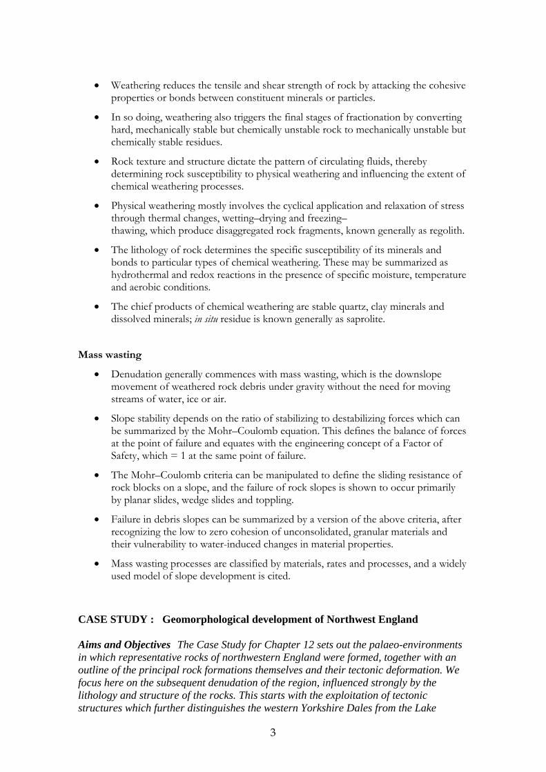
District and concludes with the impacts of Quaternary glaciation. This Case Study can therefore be read in association with those supporting Chapters 11-12 and with sections of Chapter 1, describing Wharfedale, and Chapter 10 describing the geological development of Wales. It can also be compared with the website Case Study supporting Chapter 10 and a description of karst processes is found in Chapter 13. Geological controls on denudation The south-east Lake District and western Yorkshire Dales terranes are two crustal fragments with their own individual lithological and structural identities and geological history (Plate 1 and Figure 1). They were formed c. 100 Ma apart in substantially different environments and latitudes, on the margins of the older Iapetus Ocean between c. 60o
– 30o S and younger Rheic Ocean astride the equator respectively. Although there is almost as much lithological diversity within each terrane as between them, each consists primarily of a coherent package of rocks clearly attributable to environmentally and tectonically-related origins. Indeed, global tectonics are the key to understanding not only the character of each terrane but also what brought them together across time and space and why their landsystems differ markedly today.
Plate 1 and Figure 1 Southern Lake District and western Yorkshire Dales of north-west England. Borrowdale Volcanic Group (map dark blue) and Windermere Supergroup (light blue) form mountainous areas. They were domed by thermal diapirism, including emplacement of the now-exposed Shap granite pluton (S) during the Caledonian orogeny. Part of the radial pattern of glacial rock basins holding Wastwater (WW), Coniston Water (CW) and Windermere (WM) punctuate the mountains, showing in black on the image (white on map). Upper Palaeozoic strata (brown) form the Variscan orogen and terrane’s Askrigg fault block (AB) of the western Yorkshire Dales and Bowland Forest fault block (BF). Carboniferous limestone benches in Wensleydale (WD), Upper Wharfedale (UW) and the monadnock peaks (▲) of Whernside (W), Ingleborough (I) and Pen-y-ghent (P) are visible. Drumlin swarms (dimpled micro-relief) mark the path of Late Quaternary glaciers sweeping out of the Lake District and through the Dales. Barrier and estuarine coasts fringe Morecombe Bay lowlands (MB) on Mesozoic strata (green). Landsat Thematic Mapper Image 90 km E→W and 80 km N→S, in bands 4, 5 & 7. Moorland and montane vegetation (green) contrasts with plantation, pastoral and arable farmland (brown) and estuarine sediments (cyan) on the false-colour image. Credit: British Geological Survey
5
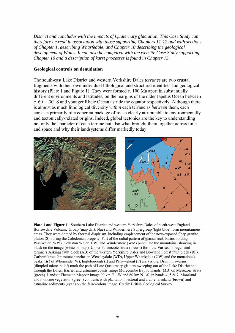
Rocks forming the Lake District terrane represent active subduction in a temperate climate setting, with crustal compression and shortening driving tectonic structures. Early subduction proceeded with the accumulation of trench turbidites before a short, sharp volcanic phase in the maturing fore-arc basin. The sequence closed as post-eruptive subsidence drew deeper waters and terrestrially-derived sediments into the basin. In contrast, the Yorkshire Dales terrane developed as an entirely sedimentary sequence, in a tropical/equatorial marine and marine-margin environment under active crustal extension. The juxtaposition of both terranes next to each was brought about through random tectonic plate reorganization since their individual formation. The website Case Study for Chapter 12 showed how the overall “grain” of modern landscapes is controlled by their respective tectonic history and associated lineaments or major regional structures. Although both terranes contain upland and mountain elements, their respective structures and lithologies combine to create quite different landforms. The Lake District’s highest and most rugged mountains are located on rocks of the Borrowdale Group, where resistant volcanic rocks provide greater stiffness and strength compared with metamorphosed marine sediments to the north and south. England’s highest summits are located here, including Scafell Pike (977m OD), the Langdale Pikes (850-900m OD), Helvellyn (Plate 2), Fairfield and High Street (800-930m OD). This contrasts with the Furness Fells (generally 500-700m OD) and Shap Fells (c. 500m OD) on less resistant slates and grits to the south, with the exception of summits around Coniston Old Man at c. 801 OD
Plate 2 The peaks of the Helvellyn range (maximum 925 m OD) carved by glaciers on rocks of the Borrowdale Volcanic Group form some of the highest and most rugged relief in the Lake District. Photo: Ken Addison
6
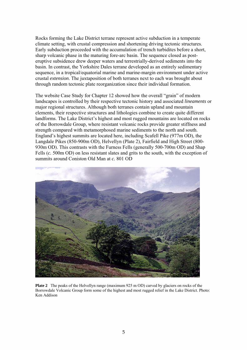
The highest cluster of Yorkshire Dales peaks ~ Whernside (736m OD), Ingleborough (723m OD) and Pen-y-ghent (694m OD) ~ lie on the southwestern leading edge of the tilted fault block, above the footwall. From here, more rounded uplands dip gently north and east down the eroded hanging wall surface of the block. Low regional dip means that erosion exposes each successively older strata as a series of concentric terraces around the summits, like a layer cake ~ a sort of gâteaux-stratigraphy! The greater part of upland slopes and summits are formed on Wensleydale Group shales, grits and thin limestones and ~ where it survives erosion ~ resistant Millstone Grit caps the highest summits (Plate 3).
Plate 13.3 The Carboniferous rocks which form Ingleborough (724 m OD) in the western Yorkshire Dales. Karst pavement is developed on Great Scar Limestone in the foreground, above which Namurian shales, sandstones and thin limestones form the bulk of the mountain, capped by resistant Millstone Grit. Photo: Graham Noble. As the oldest group, Carboniferous Limestone is exposed mostly in valley floors and lower valley sides and, in places, is cut through to expose Caledonian basement. Limestone scars (low cliffs) flank the valley sides and, where they widen out, form extensive karst pavements (Plate 4). The major Dales (valleys) of Wensleydale and Upper Wharfedale are eroded along structures parallel to the Craven fault system whilst their tributaries, entering at right angles, and upper Ribblesdale are steered by structures parallel to the Dent fault system. Larger features are seen clearly on the Landsat image and smaller geological structures and geomorphological features are visible with the aid of a hand lens.
7
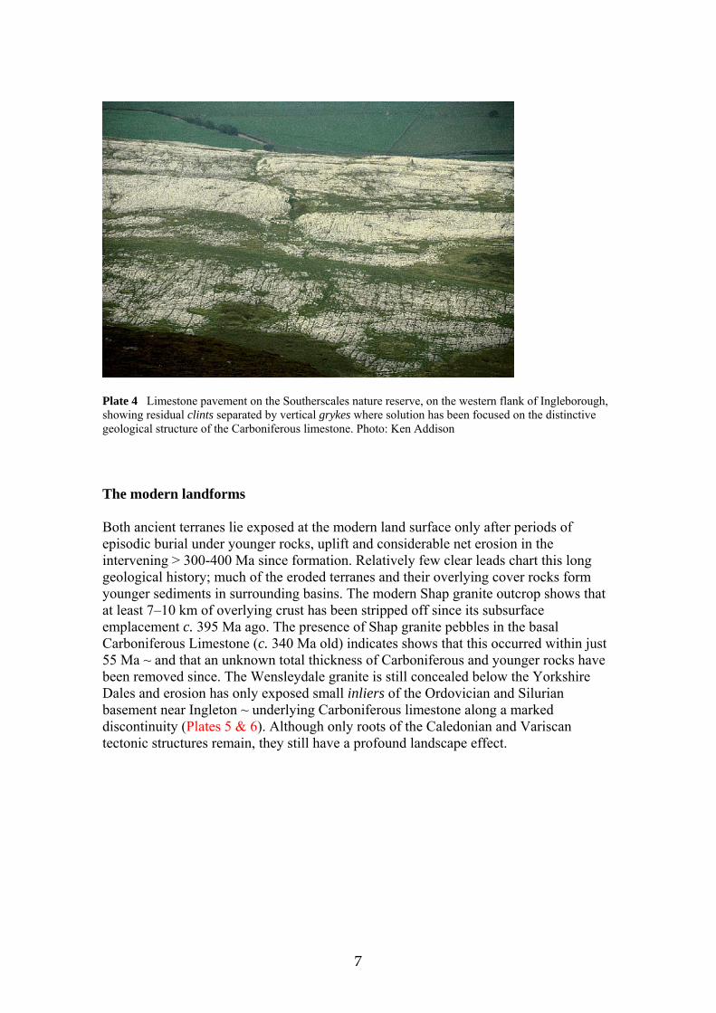
Plate 4 Limestone pavement on the Southerscales nature reserve, on the western flank of Ingleborough, showing residual clints separated by vertical grykes where solution has been focused on the distinctive geological structure of the Carboniferous limestone. Photo: Ken Addison The modern landforms Both ancient terranes lie exposed at the modern land surface only after periods of episodic burial under younger rocks, uplift and considerable net erosion in the intervening > 300-400 Ma since formation. Relatively few clear leads chart this long geological history; much of the eroded terranes and their overlying cover rocks form younger sediments in surrounding basins. The modern Shap granite outcrop shows that at least 7–10 km of overlying crust has been stripped off since its subsurface emplacement c. 395 Ma ago. The presence of Shap granite pebbles in the basal Carboniferous Limestone (c. 340 Ma old) indicates shows that this occurred within just 55 Ma ~ and that an unknown total thickness of Carboniferous and younger rocks have been removed since. The Wensleydale granite is still concealed below the Yorkshire Dales and erosion has only exposed small inliers of the Ordovician and Silurian basement near Ingleton ~ underlying Carboniferous limestone along a marked discontinuity (Plates 5 & 6). Although only roots of the Caledonian and Variscan tectonic structures remain, they still have a profound landscape effect.
8
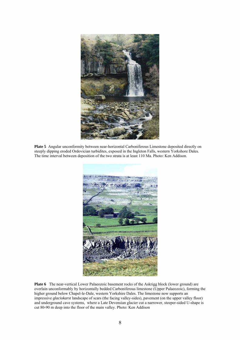
Plate 5 Angular unconformity between near-horizontal Carboniferous Limestone deposited directly on steeply dipping eroded Ordovician turbidites, exposed in the Ingleton Falls, western Yorkshore Dales. The time interval between deposition of the two strata is at least 110 Ma. Photo: Ken Addison.
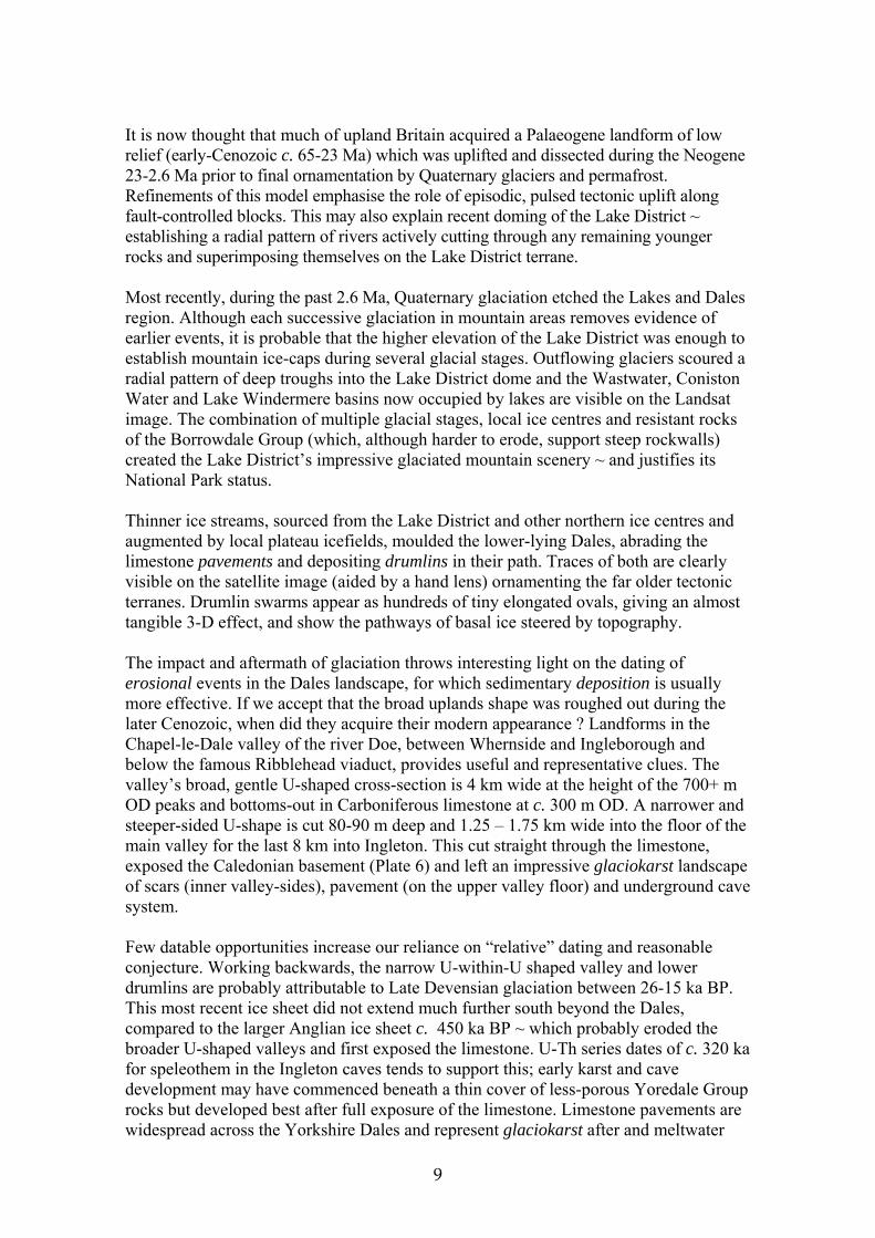
Plate 6 The near-vertical Lower Palaeozoic basement rocks of the Askrigg block (lower ground) are overlain unconformably by horizontally bedded Carboniferous limestone (Upper Palaeozoic), forming the higher ground below Chapel-le-Dale, western Yorkshire Dales. The limestone now supports an impressive glaciokarst landscape of scars (the facing valley-sides), pavement (on the upper valley floor) and underground cave systems, where a Late Devensian glacier cut a narrower, steeper-sided U-shape is cut 80-90 m deep into the floor of the main valley. Photo: Ken Addison
9
It is now thought that much of upland Britain acquired a Palaeogene landform of low relief (early-Cenozoic c. 65-23 Ma) which was uplifted and dissected during the Neogene 23-2.6 Ma prior to final ornamentation by Quaternary glaciers and permafrost. Refinements of this model emphasise the role of episodic, pulsed tectonic uplift along fault-controlled blocks. This may also explain recent doming of the Lake District ~ establishing a radial pattern of rivers actively cutting through any remaining younger rocks and superimposing themselves on the Lake District terrane. Most recently, during the past 2.6 Ma, Quaternary glaciation etched the Lakes and Dales region. Although each successive glaciation in mountain areas removes evidence of earlier events, it is probable that the higher elevation of the Lake District was enough to establish mountain ice-caps during several glacial stages. Outflowing glaciers scoured a radial pattern of deep troughs into the Lake District dome and the Wastwater, Coniston Water and Lake Windermere basins now occupied by lakes are visible on the Landsat image. The combination of multiple glacial stages, local ice centres and resistant rocks of the Borrowdale Group (which, although harder to erode, support steep rockwalls) created the Lake District’s impressive glaciated mountain scenery ~ and justifies its National Park status. Thinner ice streams, sourced from the Lake District and other northern ice centres and augmented by local plateau icefields, moulded the lower-lying Dales, abrading the limestone pavements and depositing drumlins in their path. Traces of both are clearly visible on the satellite image (aided by a hand lens) ornamenting the far older tectonic terranes. Drumlin swarms appear as hundreds of tiny elongated ovals, giving an almost tangible 3-D effect, and show the pathways of basal ice steered by topography. The impact and aftermath of glaciation throws interesting light on the dating of erosional events in the Dales landscape, for which sedimentary deposition is usually more effective. If we accept that the broad uplands shape was roughed out during the later Cenozoic, when did they acquire their modern appearance ? Landforms in the Chapel-le-Dale valley of the river Doe, between Whernside and Ingleborough and below the famous Ribblehead viaduct, provides useful and representative clues. The valley’s broad, gentle U-shaped cross-section is 4 km wide at the height of the 700+ m OD peaks and bottoms-out in Carboniferous limestone at c. 300 m OD. A narrower and steeper-sided U-shape is cut 80-90 m deep and 1.25 – 1.75 km wide into the floor of the main valley for the last 8 km into Ingleton. This cut straight through the limestone, exposed the Caledonian basement (Plate 6) and left an impressive glaciokarst landscape of scars (inner valley-sides), pavement (on the upper valley floor) and underground cave system. Few datable opportunities increase our reliance on “relative” dating and reasonable conjecture. Working backwards, the narrow U-within-U shaped valley and lower drumlins are probably attributable to Late Devensian glaciation between 26-15 ka BP. This most recent ice sheet did not extend much further south beyond the Dales, compared to the larger Anglian ice sheet c. 450 ka BP ~ which probably eroded the broader U-shaped valleys and first exposed the limestone. U-Th series dates of c. 320 ka for speleothem in the Ingleton caves tends to support this; early karst and cave development may have commenced beneath a thin cover of less-porous Yoredale Group rocks but developed best after full exposure of the limestone. Limestone pavements are widespread across the Yorkshire Dales and represent glaciokarst after and meltwater
10
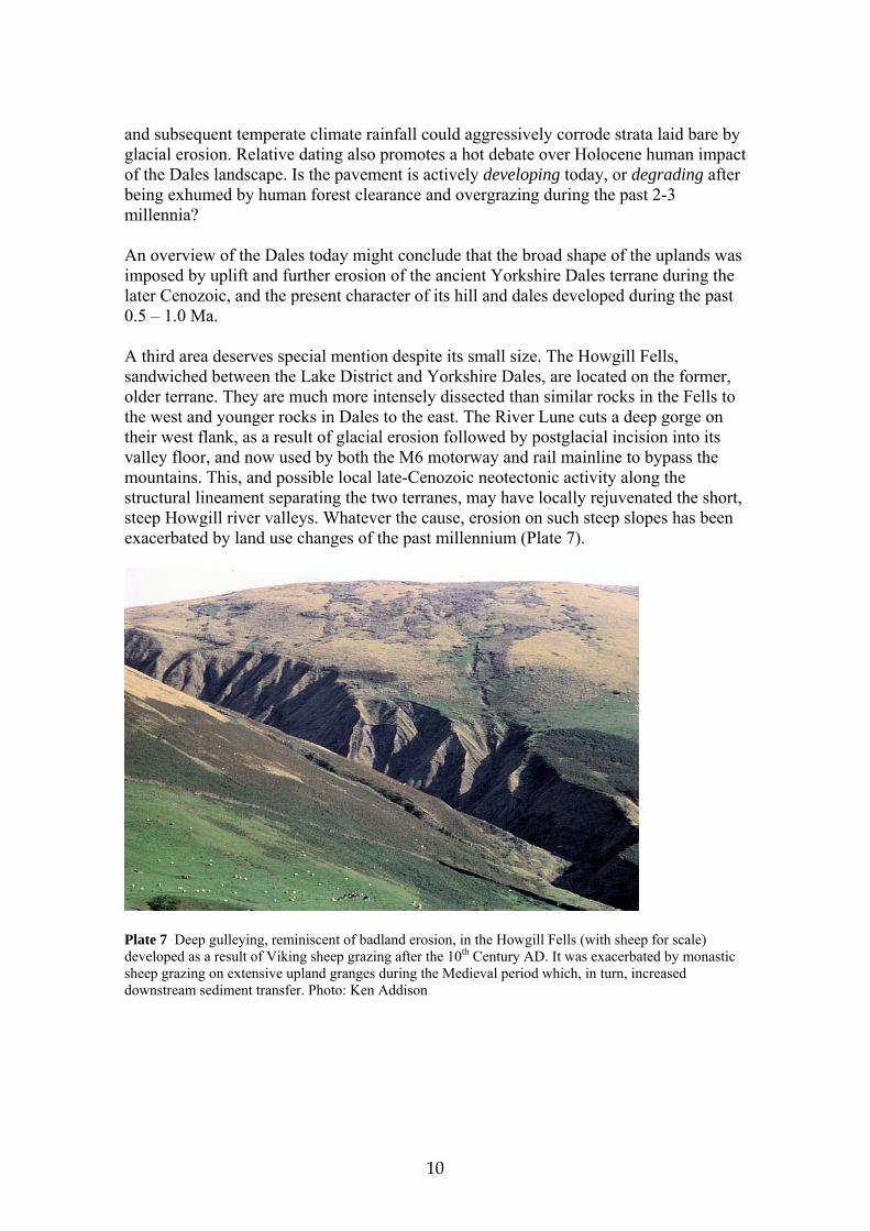
and subsequent temperate climate rainfall could aggressively corrode strata laid bare by glacial erosion. Relative dating also promotes a hot debate over Holocene human impact of the Dales landscape. Is the pavement is actively developing today, or degrading after being exhumed by human forest clearance and overgrazing during the past 2-3 millennia? An overview of the Dales today might conclude that the broad shape of the uplands was imposed by uplift and further erosion of the ancient Yorkshire Dales terrane during the later Cenozoic, and the present character of its hill and dales developed during the past 0.5 – 1.0 Ma. A third area deserves special mention despite its small size. The Howgill Fells, sandwiched between the Lake District and Yorkshire Dales, are located on the former, older terrane. They are much more intensely dissected than similar rocks in the Fells to the west and younger rocks in Dales to the east. The River Lune cuts a deep gorge on their west flank, as a result of glacial erosion followed by postglacial incision into its valley floor, and now used by both the M6 motorway and rail mainline to bypass the mountains. This, and possible local late-Cenozoic neotectonic activity along the structural lineament separating the two terranes, may have locally rejuvenated the short, steep Howgill river valleys. Whatever the cause, erosion on such steep slopes has been exacerbated by land use changes of the past millennium (Plate 7).
Plate 7 Deep gulleying, reminiscent of badland erosion, in the Howgill Fells (with sheep for scale) developed as a result of Viking sheep grazing after the 10th Century AD. It was exacerbated by monastic sheep grazing on extensive upland granges during the Medieval period which, in turn, increased downstream sediment transfer. Photo: Ken Addison
11
Learning Objectives
• understand the key stages of the Rock Cycle involved in the denudation of the continents and the respective rôle of climate, lithology, structure and tectonics in driving or influencing its principal processes
• appreciate that geomorphic processes transform Earth materials from one state
or condition to another, dependent on the properties of the materials involved and the nature and quantity of energy available
• recognise that landforms represent transient states of the landsurface which are
diagnostic of the processes which formed and altered them Essay titles
1. In the light of modern knowledge, why have theories of denudation cycles and the identification of morphogenetic regions lost favour?
2. How far is it sufficient to regard weathering as merely a means to an end?
3. Write an explanatory account of the life cycle of an orogen.
Discussion topics
1. Why do the oldest rocks in Britain generally form the highest ground?
2. Compile an illustrated inventory of the range of weathering processes visible on buildings in your neighbourhood.
3. What is meant by the specific susceptibility of minerals or rocks? Further Reading Duff, P. M. D., ed. (1993) Holmes’s ‘Principles of Physical Geology’, fourth edition,
London: Chapman & Hall. This volume of nearly 800 pages is a major reference text for any student of the physical environment. Although it ranges over the entire geological environment, a large portion deals generally and then specifically with the processes which denude and sculpture Earth’s surface. Well written and concise, the text is supported by copious illustrations.
Fookes, P.G., Lee, E.M and Milligan, G. (2005) Geomorphology for Engineers, Dunbeath, Scotland: Whittles Publishing. An enormous, comprehensively illustrated textbook at the forefront of the applied field, which bridges the academic and engineering fields of geomorphology in a manner entirely readable and suitable for both students and practioners.
Huggett, R.J (2003) Fundamentals of Geomorphology, London: Routledge. A good, straightforward and clearly written geomorphology textbook, with a sound geological and tectonic introduction and clear illustrations.
12
Selby, M. J. (1993) Hillslope Materials and Processes, Oxford and New York: Oxford University Press. This remains an outstanding text which commences with a review of rock and soil properties and strength. It proceeds via weathering to geomorphic processes, focusing on slopes, slope failure and mass wasting before concluding with hill slope models and denudation rates. The book is exceptionally well illustrated, with case studies, line drawings and photographs.
References Dearman, W. R. (1974) ‘Weathering classification in the characterisation of rock for engineering purposes in British practice’, Bull. Int. Assoc. Eng. Geol. 13, 123–7 Dalrymple, J. B., Blong, R. J. and Conacher, A. J. (1968) ‘A hypothetical nine-unit land surface model’, Zeitschrift für Geomorphologie 12, 60–76 Gregory, K. J. and Walling, D. E. (1973) Drainage Basin Form and Process: a geomorphological approach, London: Arnold Hoek, E. and Bray, J. (1977) Rock Slope Engineering, second edition, London: Institute of Mining and Metallurgy Peltier, L. (1950) ‘The geographic cycle in periglacial regions as it is related to climatic geomorphology’, Ann. Assoc. Amer. Geogrs, 40, 214–36 Selby, M. J. (1993) Hillslope Materials and Processes, second edition, Oxford and New York: Oxford University Press Tricart, J. and Cailleux, A. (1972) Introduction to Climatic Geomorphology, London: Longman Web resources The following websites provide access to a range of different aspects and interpretations of the geology of the Lake District and Yorkshire Dales: http://groups.msn.com/YorkshireGeology/homepage http://www.yorksgeolsoc.org.uk/ http://www.english-nature.org.uk/special/geological/sites/area_ID41.asp http://www.rocksafoot.com/lake_district.htm http://www.lake-district.gov.uk/index/understanding/specialqualities.htm http://www.lake-district.gov.uk/index/understanding/geology.htm

13
http://earthsci.org/index.html A comprehensive Earth Science Australia geological, geomorphological ~ and weather and climate ~ website under the aegis of the Australian Geological Society, with a global outreach. A very good source of illustrated course materials, text, illustrations and contemporary issues, with an extensive range of global hyperlinks into many other related websites and image archives. http://www.nerc.ac.uk The UK Government’s Natural Environment Research Council website, providing information on its core mission, research and international projects and direct access to its subsidiary environmental agencies (including atmospheric, polar, ecological, hydrological and marine sciences). It also provides information and resources for schools resources, students and researchers and maintains a contemporary news and research results service. http://edsserver.ucsd.edu/visualizingearth The Visualizing Earth project reviews the technical opportunities provided by remote sensing, GIS (Geographic Information Systems) and visualization for the study of Earth and Geographic sciences and provides a gateway to visualization through its many illustrations, access to further websites, reports, resources and valuable image databases. http://geolsoc.org.uk/index/html The UK’s oldest and leading professional geological organization, providing information and direct access to relevant Educational and Career services, Publications (some available online), |Library and Information services, events and regional groupings of professional geologists and the geology of Britain. The website also includes direct links to the Society’s websites and other similar organizations, such as the Geologists’ Association. http://www.nasa.gov and http://nai.nasa.gov Both websites relate to the work of the US National Aeronautical & Space Administration with access to plenty of terrestrial, as well as astronomic and other planetary, materials. They are hyperlinked into NASA’s various US specialist laboratories, through which current news, data, information, video clips and access to published materials and images. Specifically geological material needs to be searched for but usually the results are rewarding.