Embed Size (px)
Citation preview

Title 14 & 14.1 1
TITLE 14
ZONING
Table of Contents
CHAPTER 14-01 - CITY PLANNING AND ZONING COMMISSION........... 5 14-01-01. Creation.................................... 5 14-01-02. Members..................................... 5 14-01-03. Term of Members............................. 5 14-01-04. Approval of Appointments.................... 6 14-01-05. Powers and Compensation..................... 6 14-01-06. Appeal Process of Commission................ 6
CHAPTER 14-02 - GENERAL PROVISIONS AND DEFINITIONS............. 8 14-02-01. Intent...................................... 8 14-02-02. Application................................. 9 14-02-03. Definitions................................. 9
CHAPTER 14-03 - DISTRICTS: USES............................... 31 14-03-01. Division of City Into Districts............ 31 14-03-02. Boundaries of Districts and Zoning Map..... 32 14-03-03. Interpretation of District Boundaries...... 32 14-03-04. General Provisions......................... 34 14-03-05. Supplementary Provisions................... 35 14-03-06. Incidental Uses............................ 38 14-03-07. Use Groups................................. 52 14-03-08. Special Uses............................... 67 14-03-09. Nonconforming Uses........................ 103 14-03-10. Off-Street Parking and Loading............ 107 14-03-11. Landscaping and Screening................. 123 14-03-12. Screening of Mechanical Equipment and Solid
Waste Collection Areas.................... 140
CHAPTER 14-03.1 - SIGNS...................................... 140 14-03.1-01. Purpose.................................... 140 14-03.1-02. Definitions and Measurements............... 141 14-03.1-03. Scope of Sign Provisions................... 150 14-03.1-04. Permitting Procedures...................... 160 14-03.1-05. General Standards.......................... 164 14-03.1-06. Agricultural Zoning District Standards..... 168 14-03.1-07. Residential Zoning District Standards...... 168 14-03.1-08. Commercial Zoning District Standards....... 173 14-03.1-09. Downtown Zoning District Standards......... 182 14-03.1-10. Non-Conforming Signs....................... 187
CHAPTER 14-04 - DISTRICT REGULATIONS......................... 188 14-04-01. RR Residential District................... 188 14-04-01.1. RR5 Residential District.................. 194 14-04-02. RRMH Rural Mobile Home Residential
District.................................. 199

Title 14 & 14.1 2
14-04-03. R5 Residential District................... 199 14-04-04. RMH Mobile Home Residential District...... 202 14-04-05. RMH Residential District.................. 202 14-04-06. R10 Residential District.................. 208 14-04-07. RM Residential District................... 212 14-04-08. RT Residential District................... 218 14-04-09. HM Medical Facility District.............. 222 14-04-10. CA Commercial District.................... 226 14-04-11. CB Commercial District.................... 230 14-04-12. CG Commercial District.................... 230 14-04-13. CR Commercial District.................... 234 14-04-14. MA Industrial District.................... 234 14-04-15. MB Industrial District.................... 238 14-04-16. P Public Use District..................... 240 14-04-17. A Agricultural District................... 244 14-04-18. Planned Unit Developments................. 250 14-04-19. FP Floodplain District.................... 254 14-04-20. AN Airport Noise Overlay District......... 276 14-04-21. Downtown Districts........................ 280 14-04-21.1 DC Downtown Core District................. 285 14-04-21.2 DF Downtown Fringe District............... 291 14-04-21.3 Use Categories............................ 297 14-04-21.4 Use Standards............................. 304
CHAPTER 14-05 - ENFORCEMENT.................................. 315 14-05-01. Administration and Enforcement............ 315 14-05-01.1. Building Permits and Approval of Plans.... 315 14-05-02. Certificate of Occupancy.................. 315 14-05-03. Duties of Zoning Administrator, Board of
Adjustment, Health Officer, Courts, City
Planning and Zoning Commission and Board of
City Commissioners as to Matter of Appeal. 315 14-05-03.1. Notice and Order.......................... 316 14-05-04. Remedies.................................. 316 14-05-05. Fees...................................... 316 14-05-05.1. Accumulation of Certain Items Prohibited.. 317 14-05-06. Violation................................. 318 14-05-06.1. Abatement................................. 318 14-05-07. Requirement for Building Permit........... 318
CHAPTER 14-06 - BOARD OF ADJUSTMENT.......................... 320 14-06-01. Members................................... 320 14-06-02. Powers and Duties......................... 320 14-06-03. Appeal Procedure.......................... 323
CHAPTER 14-07 - AMENDMENTS................................... 324 14-07-01. Purposes.................................. 325 14-07-02. Procedure................................. 325
CHAPTER 14-08 - MASTER PLAN.................................. 328 14-08-01. Master Plan Established................... 328

Title 14 & 14.1 3
14-08-02. Purposes of Plan.......................... 328 14-08-03. Territorial Application................... 329 14-08-04. Streets, Sewers, Mains to Conform to Plan. 329 14-08-05. Buildings to Conform to Plan.............. 329
CHAPTER 14-09 - REGULATIONS GOVERNING THE SUBDIVISION OF LAND 329 14-09-01. Planning Commission....................... 329 14-09-02. Purpose of Subdivision Regulations; Approval
of Plats.................................. 330 14-09-03. Definitions............................... 330 14-09-04. Procedure................................. 333 14-09-05. Design Standards.......................... 348 14-09-06. Improvements.............................. 361 14-09-07. Specifications for Plats.................. 365 14-09-08. Variances................................. 371 14-09-09. Fees...................................... 372 14-09-10. Penalties................................. 373 14-09-11. Vacation of Plats......................... 373 14-09-12. Change or Correction of Street Names...... 373
TITLE 14.1 - STORMWATER MANAGEMENT – BECOMES EFFECTIVE 01/01/18
................................................. 375
CHAPTER 14.1-01 GENERAL PROVISIONS........................ 375 14.1-01-01. Purpose and Need.......................... 375 14.1-01-02. Transfer of Authority..................... 376 14.1-01-02. Definitions............................... 376 14.1-01-03. Scope..................................... 383
CHAPTER 14.1-02 STORMWATER MANAGEMENT PROGRAM............. 383 14.1-02-01. Municipal Separate Storm Sewer System..... 383 14.1-02-02. Conformance with Local, State and Federal
Regulations............................... 384 14.1-02-03. Stormwater Design Standards Manual......... 384 14.1-02-04. Waiver..................................... 384 14.1-02-05. Illicit Discharges Prohibited.............. 384
CHAPTER 14.1-03 CONSTRUCTION STORMWATER MANAGEMENT PERMITS 384 14.1-03-02. Small Site Construction Stormwater Management
Permits................................... 387 14.1-03-03. Large Site Construction Stormwater Management
Permits................................... 387
CHAPTER 14.1-04 POST-CONSTRUCTION STORMWATER MANAGEMENT
PERMITS.................................. 388 14.1-04-02. Review and Approval Procedures............. 389 14.1-04-03. Mandatory Stormwater Management Scoping Sheet
.......................................... 389 14.1-04-04. Conditional Approval....................... 389 14.1-04-05. Material Submitted After Conditional Approval
.......................................... 390 14.1-04-06. Completion and Final Approval.............. 393

Title 14 & 14.1 4
CHAPTER 14.1-05 ENFORCEMENT............................... 393 14.1-05-01. Remedies and Enforcement Powers............ 393 14.1-05-02. Administrative Search Warrant.............. 396 14.1-05-03. Notice and Order........................... 396 14.1-05-04. Appeal..................................... 397 14.1-05-05. Hearing.................................... 397
CHAPTER 14.1-06 PENALTIES................................. 397 14.1-06-01. Penalty.................................... 397 14.1-06-02. Abatement.................................. 397 14.1-06-03. Falsifying Information..................... 398

Title 14 & 14.1 5
CHAPTER 14-01 - CITY PLANNING AND ZONING COMMISSION
14-01-01. Creation. There was created a body known as
the planning commission of the City of Bismarck which has also
served as the city zoning commission of the City of Bismarck,
which planning and zoning commission has been and is actively
serving the community. It is intended that this commission will
continue as the Bismarck Planning and Zoning Commission, with
duties and functions hereinafter recited, pursuant to the powers
authorized by the North Dakota Century Code.
Reference: NDCC Sec. 40-47-06; 40-48-03
14-01-02. Members. The planning and zoning commission
shall consist of eleven members. Two of the members shall be
the president of the board of city commissioners and the city
engineer who shall act as ex officio members of the said
commission. Five of the members shall be appointed by the
president of the board of city commissioners with the approval
of the city commission.
Three of the members of the commission shall be persons
residing outside the corporate limits of the City of Bismarck
and within four miles thereof, and shall be appointed by the
board of county commissioners of Burleigh County. One member of
the commission shall be a county commissioner and shall be
appointed by the board of county commissioners of Burleigh
County. All members shall have equal voting status on all
issues.
In addition to the eleven members enumerated above, for all
issues before the planning and zoning commission relating to a
geographic area outside the City of Bismarck corporate limits, a
township supervisor of any organized township wherein such issue
is located shall be invited to participate as a voting member.
Each township shall designate one township supervisor for this
limited planning and zoning commission membership. A township
supervisor's participation on the planning and zoning commission
shall be limited to those issues occurring outside the City's
corporate limits and in his or her respective township.
Reference: NDCC Sec. 40-47-06; 40-48-03; Home Rule Charter for the City of Bismarck
(Ord. 5293, 01-27-04)
14-01-03. Term of Members. The ex officio members of the
commission shall serve during and for their respective terms for
which they have been elected or appointed. The president of the
board of city commissioners shall appoint five members of the
commission who shall be residents of the City of Bismarck, and
such appointments shall be for a term of five years. The

Title 14 & 14.1 6
Burleigh County Board of Commissioners shall appoint three
members to the planning commission for a period of five years
each. The county commissioner appointed by the Burleigh County
Board of Commissioners shall serve during and for his or her
elected or appointed term. The township supervisor authorized
by Section 14-01-02 shall serve during and for his or her
elected or appointed term.
Reference: NDCC Sec. 40-47-06; 40-48-04
(Ord.5293, 01-27-04)
14-01-04. Approval of Appointments. The president of the
board of city commissioners shall submit to the city commission
at the next meeting after making such appointments, the names of
persons who shall be residents of the City of Bismarck. The
city commission shall by majority vote, confirm or reject such
appointments. If such appointments are rejected, the president
shall make other appointments for such appointees as may be
rejected, which said appointments shall be approved or rejected
in like manner. If a vacancy occurs on the commission, an
appointment to fill such unexpired term shall be made in the
manner in which original appointments were made.
14-01-05. Powers and Compensation. The city planning and
zoning commission shall have all of the powers and perform all
of the duties as may now or hereafter be provided by law or as
directed by the Board of City Commissioners as provided by the
Home Rule Charter for the City of Bismarck, Article 3, Section
11, and shall receive no compensation except they may be allowed
actual expenses for traveling as provided by law. These powers
shall include but not be limited to recommendations relative to
the zoning ordinance text and zoning district recommendations.
The commission shall have extended territorial authority to all
unincorporated territory located within four miles of the
corporate limits of the City of Bismarck as authorized by the
North Dakota Century Code, and shall enforce such regulations in
the extraterritorial area to the same extent as if such property
were situated within the city's corporate limits.
The powers heretofore exercised by the planning and zoning
commission of the City of Bismarck, prior to the adoption of
this revised ordinance, and its duties and powers as heretofore
exercised are hereby in all things continued.
Reference: NDCC Sec. 40-47-01.1, Home Rule Charter for the City of Bismarck, Article 3, Section 11.
(Ord. 5278, 09-23-03)
14-01-06. Appeal Process of Commission. Any final decision
of the city planning and zoning commission may be appealed to
the city commission by either the aggrieved applicant or the
applicant’s representative or by any officer, department, board,

Title 14 & 14.1 7
or bureau of the city. Notice of appeal in writing shall be
delivered to the office of the city administrator or to the
community development department within 10 calendar days of the
city planning and zoning commission's decision. A hearing shall
be set before the city commission within 30 days of the receipt
of the notice of appeal unless otherwise agreed by the
applicant.
1. For an appeal from the denial of a zoning
change ordinance or a zoning ordinance text amendment
or for any item requiring a public hearing at the city
commission, the hearing on appeal will only consider
the question of whether or not to reverse the decision
of the planning and zoning commission, introduce the
ordinance, if necessary, and call for a public hearing
on the zoning change ordinance, text amendment
ordinance or other item requiring a public hearing.
At the hearing, only the aggrieved applicant or their
representative, a person entitled to receive mailed
written notice of the application or an officer,
department, board or bureau of the city may argue for
or against the appeal. No new evidence may be
presented and the review is limited to the record as
received from the planning and zoning commission and
the arguments at the hearing.
2. After the hearing, the city commission shall
decide the appeal on its merits and shall issue its
written decision containing its findings and an
appropriate order. The written decision shall be
issued within 10 calendar days of the close of the
hearing. If the city commission decides to reverse
the decision of the planning and zoning commission and
call for a public hearing and second reading on the
zoning change ordinance, the zoning ordinance text
amendment, or any other item requiring a public
hearing, a hearing will be set for a date that allows
the public hearing to be appropriately noticed
pursuant to the North Dakota Century Code and this
code of ordinances. The written decision shall be
issued within 10 days of the close of the hearing.
3. The public hearing resulting from an appeal
shall be conducted in accordance with Section 14-07-
02(6-8).
4. For all appeals from the denial of a request
prior to a public hearing at the planning and zoning
commission, the hearing on appeal will only consider

Title 14 & 14.1 8
whether or not to require a public hearing or further
action at the planning and zoning commission and shall
be conducted pursuant to paragraphs 1 and 2 of this
section. The action of the city commission regarding
the appeal is limited to denying the appeal and
upholding the planning and zoning commission or
reversing the planning and zoning commission and
sending the matter back to the planning and zoning
commission for further action.
5. For all other appeals from a final decision
of the planning and zoning commission for which the
decision of the city commission will be final, the
board of city commissioners shall fix a time for the
hearing of the appeal and shall give due notice of the
hearing to the parties pursuant to paragraph 1 of this
section. The appeal shall be decided and a written
decision shall be issued within 10 calendar days of
the close of the hearing unless otherwise stipulated
by the commission. Any party to the appeal may appear
in person or by representative or by attorney at the
hearing before the board of city commissioners. New
evidence and arguments may be presented and the review
is not limited to the record as received from the
planning and zoning commission. The board of city
commissioners may reverse or affirm the decision of
the planning and zoning commission, in whole or in
part, or may modify the decision or determination
appealed.
A final decision of the city commission on an appeal from a
decision of the planning and zoning commission may be appealed
to the district court in the manner provided in NDCC Section 28-
34-01.
Reference: NDCC Sec. 40-47-01.1, Home Rule Charter for the City of Bismarck, Article 3, Section 11.
(Ord. 4486, 04-27-93; Ord. 4501, 04-27-93; Ord. 5446, 07-26-05; Ord. 6042, 04-22-14; Ord. 6131, 06-23-15)
CHAPTER 14-02 - GENERAL PROVISIONS AND DEFINITIONS
14-02-01. Intent. It is the intent of the board of city
commissioners to promote the health, safety and general welfare
by guiding the development of the city by means of a
comprehensive land use plan which is in part carried out by the
provisions of this ordinance. It is the intent of this
ordinance to provide regulations, standards and guides for the
city's development which will:
a) Lessen congestion in the streets;

Title 14 & 14.1 9
b) Secure safety from fire, panic and other dangers;
c) Promote the health and general welfare;
d) Prevent the overcrowding of land;
e) Provide adequate light and air;
f) Avoid undue concentration of population;
g) Facilitate adequate provision for transportation,
water, sewerage, schools, parks and other requirements.
Reference: NDCC Sec. 40-47-03
14-02-02. Application. The zoning ordinances and
subdivision regulations of the City of Bismarck shall apply to
all unincorporated territory within four miles of the corporate
limits as authorized by the North Dakota century Code.
All actions taken and matters resulting therefrom by the
city planning and zoning commission of the City of Bismarck,
pursuant to ordinance number 3322, are hereby validated.
Ordinances enacted in reliance on Senate Bill 2395 of
the 45th Legislative Assembly of the State of North Dakota,
which became effective July 1, 1976, are hereby validated. This
title is enacted under the authority contained in the Home Rule
Charter for the City of Bismarck, Article 3, Section 11.
Reference: NDCC 40-47-01.1.
(Ord. 4486, 04-27-93; Ord. 5278, 09-23-03)
14-02-03. Definitions. The following definitions represent
the meanings of terms as they are used in these regulations:
All words used in the present tense include the future
tense. All words in the plural number include the singular
number, and all words in the singular number include the
plural number, unless the natural construction of the
wording indicates otherwise. The word "building" includes
the word "structure". The word "shall" is mandatory and not
directory. The word "used" shall be deemed also to include
"designed, intended or arranged to be used". Unless
otherwise specified, all distances shall be measured
horizontally. The word "city" means the City of Bismarck,
North Dakota; the term "board of city commissioners" means
the board of city commissioners of said city; the term
"board of adjustment" means the board of adjustment of said
city; the term "city planning commission" means the city
Title 14 & 14.1 10
planning and zoning commission of said city; the term "board
of county commissioners" means the Burleigh County Board of
Commissioners; all officials referred to herein refer to the
current appointed officials of said city or their authorized
representatives.
Accessory Building: See "Building-Accessory".
Accessory Dwelling Unit: A separate and complete
dwelling unit established in conjunction with, but clearly
subordinate to, the principal single-family dwelling unit,
whether within the same structure as the principal unit or
within a detached accessory structure on the same lot or
parcel. An accessory dwelling unit contains one bedroom,
kitchen and bathroom facilities, and a separate exterior
entrance.
Accessory Use: A use or structure that is clearly
incidental to and customarily found in connection with a
principal structure or use; is subordinate in area, extent
and purpose to the principal building or uses; contributes
to the comfort, convenience or necessity of occupants of the
principal use; and is located on the same lot and in the
same zoning district as the principal use.
Adult Bookstore: An enclosed building having a
substantial or significant portion of its stock in trade,
books, magazines, or other periodicals which are
distinguished or characterized by the emphasis on matter
depicting or describing specified sexual activities or
specified anatomical areas, for observation by patrons
therein in return for payment of a consideration,
irrespective of the numbers of patrons who may be able to
view the presentation at one time.
Adult Care Facility. A free-standing facility
providing care for more than twelve (12) frail, physically,
cognitively and/or functionally impaired adults in a
protective setting for less than twenty-four (24) hours per
day. An adult care facility may also be located within a
hospital, care center or nursing home as an accessory use.
Educational and training programs for cognitively and/or
functionally impaired adults in a protective setting for
less than twenty-four (24) hours per day is not defined as
an adult care facility.
Adult Cinema: An enclosed building used on a regular
basis for presenting pictorial materials or other visual
images by way of direct or indirect projection, which

Title 14 & 14.1 11
materials are distinguished or characterized by an emphasis
on the depiction of specified sexual activities or specified
anatomical areas, for observation by patrons therein in
return for payment of a consideration, irrespective of the
number of patrons who may be able to view the presentation
at one time.
Adult Entertainment Center: An adult bookstore or
adult cinema, or any establishment allowing any performance,
entertainment or appearance, live or otherwise, of any
specified anatomical areas or specified sexual activities on
the premises, excluding licensed liquor premises.
(For the purposes of this ordinance, the following
definitions shall apply to the foregoing terms:
"Specified anatomical areas":
(1) Less than completely and opaquely covered:
(a) Human genitals, pubic region;
(b) Buttocks;
(c) Female breast below a point immediately
above the top of the areola; and
(2) Human male genitals in a discernibly turgid
state, even if completely and opaquely covered.
"Specified sexual activities":
(1) Human genitals in a state of sexual
stimulation or arousal;
(2) Acts of human masturbation, sexual
intercourse or sodomy;
(3) Fondling of human genitals, pubic region,
buttock or female breast.)
Alley: A strip of land, dedicated to public use,
primarily to provide vehicular service access to the side or
rear of properties otherwise abutting on a street.
Animal Feeding Operation: A place where: 1) livestock
have been, are, or will be confined, concentrated and fed
for forty-five (45) or more days in any twelve (12) month
period; 2) pasture, crops, or other vegetation are not

Title 14 & 14.1 12
normally managed or sustained for grazing during the normal
growing season; and 3) animal waste or manure accumulates.
All such operations containing more than three hundred (300)
animal units, including an animal wintering operation, shall
be defined as an animal feeding operation. Adjoining animal
feeding operations under the common ownership are considered
to be one animal feeding operation if they use common areas
or systems for manure handling. An animal feeding operation
in place and operating on the date this ordinance amendment
is effective shall be considered an existing animal feeding
operation and shall not be allowed to expand by any number
of animal units.
The following table outlines the maximum number of
livestock allowed before the operation is considered an
animal feeding operation, based on animal unit equivalents
(AUE) for various types of livestock:
Livestock Type AUE Maximum Number Allowed
(300 AUE)
Horse 2.00 150
Dairy Cow 1.33 225
Mature Beef 1.00 300
Beef Feeder-Finishing 1.00 300
Beef Feeder-Backgrounding 0.75 400
Mature Bison 1.00 300
Bison Feeder 1.00 300
Elk 1.00 300
Swine, >55 lbs. 0.40 750
Swine, Nursery 0.10 3,000
Sheep 0.10 3,000
Goose or Duck 0.20 1,500
Turkey 0.0182 16,500
Chicken 0.01 30,000
Animal Wintering Operation: The confinement of cattle
or sheep used or kept for breeding purposes in a feedlot or
sheltered area at any time between October 15 and May 15 of
each production cycle under circumstances in which these
animals do not obtain a majority of their feed and nutrients
from grazing. The term includes the weaned offspring of
cattle and sheep, but it does not include: 1) breeding
operations of more than three hundred (300) animal units or
2) weaned offspring which are kept longer than one hundred-
twenty (120) days and that are not retained for breeding
purposes.

Title 14 & 14.1 13
Auditor's Plat: See "Plat-Auditor's".
Basement: That portion of a building below the first
story joists, the floor of which is more than one-half clear
ceiling height below the adjacent finished grade level.
Bio Swale. Landscape elements designed to concentrate
or remove silt and pollution from surface water runoff.
Block: A unit of land bounded by streets or by a
combination of streets and public land, railroad rights-of-
way, waterways or any other barrier to the continuity of
development.
Bluff: A topographic feature such as a hill,
cliff or embankment having the following
characteristics:
(1) Part or all of the feature is located
adjacent to the Missouri River;
(2) The slope rises at least 25 feet above the
ordinary high water mark of the Missouri River;
(3) The grade of the slope from the toe of the bluff
to a point 25 feet or more above the ordinary high water
mark of the Missouri River averages 30 percent or greater;
and
(4) The slope drains towards the Missouri River.
An area with an average slope of less than 18 percent
over a horizontal distance of 50 feet or more shall not be
considered part of a bluff.
Bluff, Toe Of The: The lower point of a 50-foot
horizontal segment with an average slope exceeding 18
percent.
Bluff, Top Of The: The higher point of a 50-foot
horizontal segment with an average slope exceeding 18
percent.
Brewery: A facility that manufactures over 10,000
barrels (31 gallons/barrel = 310,000 gallons) of fermented
malt beverages per year for wholesale with no direct sales
to the general public.

Title 14 & 14.1 14
Brewer Taproom: A facility that manufacturers no more
than 25,000 barrels of fermented malt beverage per year for
wholesale, sale directly to consumer or for consumption on
the premises. A brewer taproom may be co-located within a
restaurant or a separate stand-alone facility.
Buffer Zone: A strip of land, identified in the zoning
ordinance, established to protect one type of land use from
another with which it is incompatible.
Building: Any structure used or intended for
supporting or sheltering any use or occupancy.
Building-Accessory: A subordinate building or
structure, the use of which is customarily incidental to
that of a principal building on the same lot, including,
without limitation, garages, storage sheds, playhouses,
kennels, statuary, trellises, barbecue stoves or similar
structures, storm or civil defense shelter, radio towers,
satellite receiving or transmitting stations or antennas,
and other structures, towers, antenna, ornaments or devices.
Building-Integrated Solar Energy System: Any active
solar energy system that is an integral part of a principal
or accessory building, rather than a separate mechanical
device, replacing or substituting for an architectural or
structural component of the building. Building-integrated
systems include but are not limited to photovoltaic or hot
water solar energy systems that are contained within
roofing materials, windows, skylights, and awnings.
Building Official: The person designated by the
Director of Community Development to administer and enforce
the City's building regulations and other duties as
specified in this chapter.
Building-Principal: A building occupied by the
principal use of the lot on which it is situated.
Building Line: A line established in general, parallel
to the front street line over which no part of a building
shall project, except as otherwise provided by this
ordinance.
Carnival: Any entertainment activity utilizing rides,
side shows, games of skill, or any combination thereof,
designed for participation by the public.

Title 14 & 14.1 15
Central Sewer System: A system designed and
constructed to allow for the disposal of sewerage from more
than one user. Each system must be approved by the North
Dakota State Health Department and the city engineer.
Central sewer systems are intended for use on urban lots.
Child Care Center: Also known as a day care center, a
child care center is a free-standing facility offering care,
maintenance, and supervision for hire or compensation, for
less than twenty-four (24) hours per day, for more than
twelve (12) children under the age of twelve (12) years, and
licensed by the North Dakota Department of Human Services as
an early childhood program. The following shall not be
considered a child care center: 1) child care provided in
any educational facility, whether public or private, in
grade one or above; 2) child care, preschool, kindergarten,
and pre-kindergarten services provided to children under six
(6) years of age in any educational facility through a
program approved by the North Dakota Superintendent of
Public Instruction; 3) child care provided in facilities
operated in connection with a religious facility, business,
or organization where children are cared for during periods
of time not exceeding four (4) continuous hours while the
child’s parent, guardian or custodian is attending religious
services or is engaged in other activities on the premises;
4) schools or classes for religious instruction conducted by
religious orders, Sunday schools, weekly catechism or other
classes for religious instruction; 5) sporting events,
practices for sporting events, or sporting or physical
activities conducted under the supervision of an adult; and
6) child care provided in a medical facility by medical
personnel to children who are ill.
Circus: Any traveling entertainment event to be held
in an open area or temporary structure involving acrobats,
wild animals, events of skill, or any combination thereof,
and designed for participation of the public as spectators.
Commercial School: Any educational facility owned and
operated by a nonpublic sponsor and designed to provide
occupational training in a job-related skill or craft.
Commercial Parking Lot: Any parking facility in which
charges are made for vehicular parking privileges.
Comprehensive plan: A statement in documented text
setting forth explicit goals, objectives, policies and
standards of the jurisdiction to guide public and private
development.

Title 14 & 14.1 16
Density: The number of families residing on, or
dwelling units developed on, an acre of land.
Domestic Distillery: A facility that manufactures less
than 25,000 gallons of spirits per year produced on-site and
available for wholesale, for sale directly to consumers on-
site, or sale to other domestic distilleries on-site. A
domestic distillery may be co-located within a restaurant or
a separate stand-alone facility.
Downtown Design Review Committee: The person or
persons designated by the City of Bismarck to administer and
apply the Downtown Design Guidelines for all new
construction projects, building addition projects, exterior
building renovation projects and historic restoration
projects within the DC – Downtown Core and DF – Downtown
Fringe zoning districts. The Renaissance Zone Authority and
its Technical Advisors have been designated as the Downtown
Design Review Committee.
Drive-in Restaurant: Any establishment dispensing
food or drink where the customers are served in their cars,
pick up such food or drink by driving by a pass-out window,
or where they step out of the automobile briefly to pick up
food or drink.
Dwelling: A building or portion thereof arranged or
designed to provide living facilities for one or more
families. The term "dwelling" shall not be deemed to
include transient housing facilities.
Dwelling-Group: In general, a building in which
several unrelated individuals or families permanently
reside, but in which individual cooking facilities are not
provided for the individual persons or families.
Specifically, "group dwelling" shall include rooming houses,
fraternity house, sorority house, dormitory, halfway house
and private club in which one or more members have a
permanent residence. "Group dwelling" shall not be deemed
to include uses such as a hotel, motel, mobile home park,
sanitarium, hospital or nursing home.
Dwelling-Multifamily: A building containing three or
more dwelling units or a group of two or more buildings on a
single parcel with each containing at least two dwelling
units.

Title 14 & 14.1 17
Dwelling-Multifamily High Rise: A building containing
over three dwelling units with a height of over sixty feet.
Dwelling-Single-Family: A building containing only one
dwelling unit designed to be located on a permanent
perimeter foundation and, if site built, constructed in
accordance with the provisions of the applicable City codes
governing construction; or, if manufactured off site,
constructed in accordance with either the City codes
governing construction or the HUD Manufactured Home
Construction and Safety Standards Act of 1974 (24 CFR 3280).
All single-family dwellings shall be considered and taxed as
real property, as provided by law. Each single-family
dwelling shall have a minimum width of twenty (20) feet, a
minimum depth of twenty (20) feet, and a minimum ceiling
height of seven (7) feet, six (6) inches. A manufactured
home that meets all of the requirements herein is classified
as a single family dwelling.
Dwelling-Two-Family: A building containing only two
dwelling units.
Dwelling Unit: A building or portion thereof providing
complete, independent living facilities for one or more
persons including permanent provisions for living, sleeping,
eating, cooking and sanitation.
Easement: A grant by the property owner of the use of
land by the public, or by one or more persons or
corporations for a specific purpose or purposes.
Extraterritorial Jurisdiction: The territorial zoning
and subdivision authority of the City which extends to all
unincorporated land located within four (4) miles of the
corporate limits of the City as authorized by the North
Dakota Century Code.
Fair: See "Carnival".
Family: One or more persons related by blood,
adoption, marriage, or foster care for children, living and
cooking together as a single housekeeping unit; or, a number
of persons, but not exceeding four, living together as a
single housekeeping unit, though not related by blood,
adoption, marriage, or foster care for children. In
accordance with the provisions of NDCC 25-16-13, a group
home serving six or fewer developmentally disabled persons
is classified as a family in all single-family residential
districts (RR, RR5, and R5), and a group home serving eight

Title 14 & 14.1 18
or fewer developmentally disabled persons is classified as a
family in all other residential zoning districts.
Family Child Care: A detached single family dwelling,
which also serves as the primary residence of the
operator/provider, offering care, maintenance and
supervision for hire or compensation, for less than twenty-
four (24) hours per day, for no more than twelve (12)
children under the age of twelve (12) years, including any
children of the operator/provider on the premises that are
under the age of twelve (12) years, and generally licensed
by the North Dakota Department of Human Services as an early
childhood program. Family child care is considered an
accessory use to the principal use of the property as single
family detached residential dwelling.
Family Foster Home For Adults: An occupied private
residence in which foster care for adults is regularly
provided by the owner or lessee thereof, to four or fewer
adults who are not related by blood or marriage to the owner
or lessee, for hire or compensation that is licensed by the
State of North Dakota.
Family Foster Home For Children. An occupied private
residence in which foster care for children is regularly
provided by the owner or lessee thereof to no more than four
children, unless all children in foster care are related to
each other by blood or marriage, in which case such
limitation does not apply.
Filling Station: A building or lot having pumps and
storage tanks where fuels, oils and/or accessories for motor
vehicles are dispensed, sold or offered for sale at retail
only; repair service is incidental; and no storage or
parking space is offered for rent.
Floodplain: The channel and the relatively flat area
adjoining the channel of a natural stream or river which has
been or may be covered by floodwater.
Floodway: The channel of a natural stream or river and
portions of the floodplain adjoining the channel, which are
reasonably required to carry and discharge the floodwater or
flood flow of any natural stream or river.
Foster Care For Adults: The provision of food,
shelter, security and safety, guidance, and comfort on a
twenty-four hour per day basis, in the home of a caregiver,

Title 14 & 14.1 19
to a person age eighteen or older, who is unable, neglects,
or refuses to provide for the person's own care.
Foster Care For Children. The provision of substitute
parental child care for those children who are in need of
care for which the child's parent, guardian, or custodian is
unable, neglects, or refuses to provide, and includes the
provision of food, shelter, security, and safety guidance
and comfort on a twenty-four hour basis, to one or more
children under twenty-one years of age to safeguard the
child's growth and development and to minimize and
counteract hazards to the child's emotional health inherent
in the separation from the child's family. Foster care may
be provided in a family foster home, group home, or
residential child care facility.
Funeral Home: A facility used for pre-burial
preparations of human cadavers including but not limited to
a mortuary, crematorium, chapel, viewing area, vehicular
storage, parking, but not including burial facilities.
Functional Classification: The process by which
streets and highways are grouped into classes, or systems,
according to the character of service they are intended to
provide.
Garage-Private: An accessory building or part of a
principal building used primarily for the storage of motor
vehicles customarily accessory to the principal use.
Garage-Public: A building or premises which is
operated for commercial purposes and used for the storage,
care or repair of motor vehicles, but a "public garage"
shall not be used for the storage of dismantled or wrecked
motor vehicles, parts thereof, or junk.
Group-Use: See "Use Group".
Group dwelling: See "Dwelling-Group".
Height of Building: The vertical distance measured
from the highest of the following three levels:
(a) The street curb level;
(b) The established or mean street grade in case
the curb has not been constructed; or

Title 14 & 14.1 20
(c) The average finished ground level adjoining
the building if it sets back from the street line to
the level of the highest point at the roof beams of
flat roofs, or roofs including not more than one inch
to the foot, and to the mean height level of the top of
the main plate and highest ridge for other roofs.
Hotel: A building in which lodging, with or without
meals, is provided and offered to the public for
compensation, and which is open to transient guests. Hotels
include motels and automobile courts, but do not include
group dwellings as defined herein.
Improvements: Street grading and surfacing, with or
without curbs and gutters, sidewalks, crosswalks,
watermains, sanitary and storm sewers, culverts, bridges and
street trees.
Interstate: Roadway which provides rapid movement of
large traffic volumes between major population centers and
other arterials. Interstates are multi-lane divided
highways with grade separations at all crossroads, full
access control and no parking. The locations of roadways
classified as interstates shall be as designated on the most
recent edition of the North Dakota Department of
Transportation functional classification map.
Junkyard: The use of any part of any premises whether
inside or outside of a building for the storage of, keeping
or abandonment of junk, including scrap metals, rags, paper
or other scrap material, used lumber, salvage house wrecking
and used structural steel material, and equipment or for
dismantling. Demolition or storage of unlicensed or
abandoned automobiles or other vehicles, or machinery or
parts thereof, is included in this definition.
Lot: The word "lot" when used alone shall mean, unless
the context of the article clearly indicates otherwise, a
"zoning lot" as defined herein.
Lot-Auditor's: Land designated as a separate and
distinct lot, parcel or tract on a legally recorded plat of
irregular description.
Lot-Corner: A zoning lot at the junction of and
abutting on two or more intersecting streets or a curved
street when the interior angle of the intersection does not
exceed one hundred thirty-five degrees.

Title 14 & 14.1 21
Lot-Interior: A zoning lot other than a corner lot.
Lot-Rural: All lots not meeting criteria for urban
lots as defined herein.
Lot areas may be readjusted in size when, on building
sites, the soil classification can be shown to be other than
that shown by the soil survey manual. Proof of such
differing classification shall be furnished by a qualified
soils engineer who has taken soil samples on the site in
question. All changes in soil classification must be
approved by the Director of Inspections. In no case shall a
lot area of less than forty thousand square feet be allowed.
Lot-Urban: All lots serviced by a central sewer system
and a water system which equals municipal water system fire
flow capacities.
Lot-Zoning: A tract of land occupied or to be occupied
by a principal building and its accessory buildings,
together with such open spaces and yards as are required
under the provisions of this article, having not less than
the minimum area required by this ordinance for a zoning lot
in the district in which such land is situated and having
its principal frontage on a dedicated public right-of-way or
a permanent, exclusive, nonobstructed access easement to a
dedicated public right-of-way, not less than twenty feet
wide. A "zoning lot" need not necessarily coincide with a
"record lot" and may consist of: 1) a single record lot; 2)
a portion of a record lot; or 3) a combination of complete
record lots, or complete record lots and portions of record
lots, or portions of record lots.
Lot Depth: The mean horizontal distance between the
front and rear lot lines, measured in the general direction
of the side lot lines.
Lot Line-Rear: The lot line generally opposite or
parallel to the front street line. If a rear lot line is
less than ten feet long, or the lot comes to a point at the
rear, said rear lot line is assumed to be a line at least
ten feet long, lying wholly within the lot, parallel to the
front street line, or if the front street line is curbed,
parallel to the chord of the arc of said front street line.
Lot Width: The mean width of a lot measured at right
angles to its depth.

Title 14 & 14.1 22
Low and Moderate Income Multi-family housing: Multi-
family housing for persons who are income qualified that is
usually supported by state and federal funding programs.
Manufactured Home: A factory built structure which is
to be used as a place for human habitation, which is not
constructed or equipped with a permanent hitch or other
device allowing it to be moved other than to a permanent
site, which does not have permanently attached to its body
or frame any wheels or axles, and which bears a label
certifying that it was built in compliance with the HUD
Manufactured Home Construction and Safety Standards Act of
1974 (24 CFR 3280).
Manufactured Home Park: A plat of ground under single
ownership or management which has been planned and improved
for the placement of at least twenty mobile or manufactured
homes which are used for dwelling purposes.
Master Plan: Any plan meeting the requirements of
Section 40-48 of the North Dakota Century Code.
Microbrew Pub: A facility that manufactures up to
10,000 barrels (31 gallons/barrel = 310,000 gallons) of
fermented malt beverages per year for wholesale or sale
directly to the consumer or for consumption on the premises.
A microbrew pub may be co-located within a restaurant or a
separate stand-alone facility.
Mobile Home: A transportable, factory built home,
designed to be used as a year-round residential dwelling and
built prior to enactment of the HUD Manufactured Home
Construction and Safety Standards Act of 1974 (24 CFR 3280).
Mortuary: See "Funeral home".
Motor Vehicle Parts Salvage Yard: The use of a
premises for the storage of motor vehicles for dismantling
and sale of used parts thereof.
Nonconforming Use: The use of a building or other
structure or of a tract of land which does not conform to
the use or regulations of this title for the district in
which it is located, either at the effective date of this
title, or as a result of subsequent amendments which may be
incorporated into this title.
Nonconforming Structure: A structure which does not
conform to the regulations of this title for the district in

Title 14 & 14.1 23
which it is located, either at the effective date of this
title or as a result of subsequent amendments which may be
incorporated into this title.
Off-Street Parking Space: An off-street area for the
parking of one motor vehicle and complying with all
requirements of Section 14-03-10 of this ordinance.
Ordinary High Water Mark: The elevation of the
Missouri River at a flow rate of 33,000 cubic feet per
second. In areas where there are multiple channels, the
ordinary high water mark is the landward extent of the
floodway, as delineated on the Federal Emergency Management
Agency’s Flood Boundary and Floodway Maps for the City of
Bismarck and Burleigh County.
Overlay Zone: A district that contains a set of
zoning requirements that is imposed in addition to those of
the underlying district. Development within the overlay
zone must conform to the requirements of both zones, or if
in conflict, the more restrictive of the two.
Parcel: a tract of land created by any means other
than a subdivision platted pursuant to Chapter 40-50 NDCC.
Parcel of Record. A parcel that existed as a separate
and unique legal description prior to the effective date of
this title. For property not under the City’s jurisdiction
on the effective date of this title, a parcel that existed
as a separate and unique legal description prior to coming
under the City’s jurisdiction.
Parking lot, on-site: An on-site parking lot shall
mean any land legally used for the parking of motor
vehicles that is located on the same lot or parcel as the
use it is intended to serve.
Parking lot, off-site: An off-site parking lot shall
mean any land legally used for the parking of motor
vehicles that is located on a different lot or parcel as
the use it is intended to serve.
Planned unit development (PUD): A form of development
usually characterized by a unified site design for a number
of housing units, clustered buildings and providing common
space, density increases, and a mix of building types and
land acres.
Title 14 & 14.1 24
Plat: Any subdivision platted pursuant to Chapter 40-
50 NDCC.
Plat of Irregular Description: A plat made for
taxation purposes at the request of the County Auditor in
accordance with Section 57-02-39 NDCC. Such a County
Auditor’s plat is not platting pursuant to Chapter 40-50
NDCC, but rather is made for the convenience of tax
officials in describing property on the tax rolls. A plat
of irregular description may also be referred to as an
Auditor’s Plat.
Portable Storage Containers: Containers that are used
for storage purposes and are also known as shipping
containers, cargo containers, cargo-trailer containers,
metal freight containers, metal containers designed for
freight and cargo. This definition also includes semi
trailers, buses, vans, and other types of non-permanent
containers used for storage purposes hereafter referred to
as "container(s)." This definition does not include the
following: dumpsters actively used for solid waste or
recycling collections, contractors' construction trailers
or containers being used at active job sites, or trailers
normally associated with private use such as stock car
trailers, boat trailers, utility trailers, campers or other
similar equipment.
Principal building: See "Building-Principal".
Racetrack: A course in which vehicular races, either
competitive or non-competitive, are run. Such courses
shall include racetracks, drag strips, go-cart tracks and
other similar facilities.
Rain Garden: A planted depression or hole that allows
rainwater runoff from impervious urban areas the
opportunity to be absorbed prior to entering municipal
stormwater facilities.
Record Lot: Land designated as a separate and
distinct lot on a legally recorded subdivision platted
pursuant to Chapter 40-50 NDCC.
Recreation Facility - Personal: A place designed and
equipped for the conduct of sports and leisure-time
activities provided as an accessory use on the same parcel
as the principal permitted use and designed to be used by
the occupants of the principal use and their guests.

Title 14 & 14.1 25
Recreational Vehicle: A unit primarily designed as
temporary living quarters for recreational, camping or
travel use, which either has its own motive power, is
mounted on, stored in or drawn by another vehicle.
Recreational Vehicle Park: A plat of ground of at
least ninety thousand square feet under single ownership or
management which has been planned and improved for the
parking of recreational vehicles and tents regardless of
whether or not a charge is made for such accommodation.
Religious Institution. A building that primarily
provides a meeting area for religious activities and
related social events. Examples include churches, chapels,
temples, synagogues, mosques or any other building or
portion of a building used for this purpose.
Row House: A building which has dwelling units
erected in a row as a single building on adjoining lots,
each being separated from the adjoining unit or units by an
approved two-hour or equivalent fire-rated wall extending
from the footing to and through the roof and where each
dwelling unit is located upon a separate parcel. Each unit
in a row house has private front and rear entrances and its
own front and rear yards. Row houses are constructed side-
by-side and the line(s) dividing the parcel(s) is a
straight line from the front property line to the back
property line along the common wall.
Rural Lot: See "Lot-Rural."
Salvage Yards: See "Motor vehicle parts salvage
yards."
Senior Citizen Housing: Multi-family housing designed
specifically for occupancy by senior citizens in separate
dwelling units within a single building or multiple
buildings, including assisted living facilities. Facilities
providing a higher degree of care (such as nursing homes and
Alzheimer's facilities) are not considered senior citizen
housing.
Setback Line: See "Building line."
Short Impact Zone: The land located between the
ordinary high water mark of the Missouri River and a line
parallel to it at a setback of 50 feet.

Title 14 & 14.1 26
Sight Triangle: An area of unobstructed vision at the
intersections of streets, alleys and driveways. The
purpose of the sight triangle is to ensure visibility for
operators of motor vehicles, bicycles and pedestrians on
intersecting streets, driveways and alleys.
For any use on a corner lot, the sight triangle is the
triangle formed by measuring from the point of intersection
of the two (2) property lines a distance of twenty-five
(25) feet in both directions along the street right-of-way
lines and connecting the points to form a sight triangle on
the area of the lot adjacent to the street intersection.
For a commercial, industrial, institutional or multi-
family use on a lot at the intersection of a street and an
alley, the sight triangle is the triangle formed by
measuring from the point of intersection of the two (2)
property lines a distance of fifteen (15) feet along the
street right-of-way line and a distance of fifteen (15)
feet along the alley right-of-way line and connecting the
points to form a sight triangle on the area of the lot
adjacent to the intersection of the street and alley.
For a commercial, industrial, institutional or multi-
family use with a driveway, the sight triangle is the
triangle formed by measuring from the point of intersection
of the property line adjacent to a street and the edge of
the driveway a distance of fifteen (15) feet in along the
street right-of-way line and a distance of fifteen (15)
feet along the edge of the driveway and connecting the
points to form a sight triangle on the area of the lot
adjacent to the intersection of the street and the
driveway.
For commercial, industrial, institutional or multi-
family uses, the City engineer may require a greater sight
triangle than indicated above on a case-by-case basis when
it is warranted based on the posted speed and traffic
volumes on the adjacent roadway, topography, sight
distances or any other engineering concern.
Site plan: A plan, to scale, showing uses, structures
and associated amenities proposed for a parcel of land.
Small Animal Veterinary Clinic: A facility in which
the veterinary practice conducted is essentially an out-
patient type of practice with an occasional confinement
limited to domestic household pets.

Title 14 & 14.1 27
Small Wind Energy System (SWES): A wind turbine of
less than 25 kilowatts maximum output capacity and all
appurtenant structures and equipment.
Solar Collector: A solar photovoltaic cell, panel, or
array, or solar hot water collection device, which relies
upon solar radiation as an energy source for the generation
of electricity or transfer of stored heat.
Solar Energy System: Any active mechanical or passive
thermal device or feature of a structure designed to
collect, distribute, and/or store the sun’s radiant energy.
A system may consist of a solar collector, battery, and/or
any appurtenant features. Passive solar collecting
architectural features, such as windows and skylights, are
not included in this definition.
Special Use: A use permitted in a particular zoning
district only upon showing that such in a specified
location will comply with all the conditions and standards
for the location or operation of such use as specified in
a zoning ordinance and authorized by the city planning and
zoning commission or the Zoning Administrator (where
allowed).
Steep Slope: Land where agricultural activity or
development is either not recommended or described as
poorly suited due to slope steepness and/or the site’s soil
characteristics, as mapped and described in the Burleigh
County Soil Survey or other technical report. Where
specific information is not available, steep slopes are
defined as lands having an average slope over 12 percent,
as measured over horizontal distances of 50 feet or more,
that are not bluffs.
Street: A public thoroughfare which affords principal
means of access to abutting property.
Street-Collector: Roadway which provides traffic
movements between local roads and arterial roads and also
provides direct access to abutting property. Collectors
are often only two-lane roads but should be planned and
designed to minimize on-street parking and direct driveway
access.
Street-Local Commercial: Roadway whose primary
function is to provide access to abutting commercial,
industrial, or multi-family residential property. Local
Commercial roads are typically two-lane roads with parking
Title 14 & 14.1 28
and direct access to adjacent lands within all districts
other than R5-Residential and R10-Residential.
Street-Local Residential: Roadway whose primary
function is to provide access to abutting residential
property. Local Residential roads are typically two-lane
roads with parking and direct access to adjacent lands
within the R5-Residential and R10-Residential zoning
districts.
Street-Parkway: A multi-modal roadway designed
according to complete street principles to operate at
moderate speeds. Parkways typically include one drive lane
and one bike lane in each direction, and raised and
landscaped median, and landscaped boulevards and sidewalks
on both sides of the street.
Street-Minor Arterial: Roadway which provides through
traffic movements between areas and links collectors with
other arterials. Minor arterials usually have two to four
lanes and may be divided or undivided roads, preferably
with little or no parking, and limited access. The
locations of roadways classified as minor arterials shall
be as designated on the most recent edition of the North
Dakota Department of Transportation functional
classification map.
Street-Principal Arterial: Roadway which provides for
rapid movements of relatively large traffic volumes between
large land areas, major traffic generators and other
arterials. Principal arterials should have controlled
access and are usually multi-lane roads with no parking.
The locations of roadways classified as principal arterials
shall be as designated on the most recent edition of the
North Dakota Department of Transportation functional
classification map.
Structural Alteration: Any change in the supporting
members of a building, such as bearing walls or partitions,
columns, beams or girders, or any structural change in the
roof, or dimension of the rooms therein.
Structure: Anything constructed or erected, which
requires location on the ground or is attached to something
having a location on the ground; including but not limited
to buildings, advertising signs, billboards and poster
panels; but not including customary fences or boundary or
retaining walls.

Title 14 & 14.1 29
Subdivision: The division of a tract or parcel of
land into record lots for the purpose, whether immediate or
future, of sale or of building development, including any
plat or plan which includes the creation of any part of one
or more streets, public easements, or other rights-of-way,
whether public or private, for access to or from such lots,
and/or including the creation of new or enlarged parks,
playgrounds, plazas or open spaces. However, the division
of land for agricultural purposes into parcels of ten or
more acres, not involving any new street or easement of
access, shall be exempted from these regulations.
Townhouse: A building which has dwelling units
erected together as a single building on adjoining lots,
each being separated from the adjoining unit or units by an
approved two-hour or equivalent fire-rated wall extending
from the footing to and through the roof and where each
dwelling unit is located upon a separate parcel. Each unit
in a townhouse has a private front entrance. Townhouses
are constructed side-by-side and back-to-back and the lines
dividing the parcels are straight lines from the front
property line to the back property line along the common
walls.
Urban Lot: See "Lot-Urban."
Urban Service Area Boundary (USAB): An official
line, established by the city commission, within the
city’s zoning and subdivision jurisdiction that
distinguishes between future urban and rural
densities. Municipal infrastructure expansions could
be expected within 10 to 15 years on land within the
USAB. Proposed development within the USAB is subject
to standards consistent with potential urban expansion
and higher-density land uses. Changes to the USAB
correspond with growth and expansion of the city and
the city’s capital improvements plan.
Use: The term referring to:
a. Any purpose for which buildings, other
structures or land may be arranged, designed,
intended, maintained or occupied; and
b. Any occupation, business, activity or
operation carried on (or intended to be carried on) in
a building or other structure or on land; or
Title 14 & 14.1 30
c. A name of a building, other structure or
tract of land which indicates the purpose for which it
is arranged, designed, intended, maintained or
occupied.
Use Group: Two or more uses similar in physical
characteristics, traffic generation, locational, utility or
municipal service requirements, or generally compatible
with other uses in the use group. Members of the several
use groups herein established are specifically listed in
this article.
Uses Permitted: Any use permitted by the regulations
of this article. The term "permitted" or its equivalent
shall not be deemed to include any nonconforming use.
Variance: A device which grants a property owner
relief from certain provisions of a zoning ordinance when,
because of the particular physical surroundings, shape or
topographical condition of the property, compliance would
result in a particular hardship upon the owner, as
distinguished from a mere inconvenience or a desire to
increase the financial return.
Vegetative Clearing, Intense: The complete removal of
trees, shrubs or natural vegetation in a contiguous patch,
strip, row or block.
Veterinary clinic: See "Small animal veterinary
clinic".
Yard: An open space of uniform width or depth on the
same zoning lot with a building or group of buildings,
which open space lies between the buildings or group of
buildings and the nearest lot line and is unoccupied and
unobstructed, from the ground upward except as may be
specifically provided in this article. In measuring a
yard, the line of a building shall be deemed to mean a line
parallel to the nearest lot line drawn through the point of
a building or group of buildings nearest to such lot line,
exclusive of such features specified as not to be
considered in measuring yard dimensions or as being
permitted to extend into a yard, and said measurements
shall be taken at right angles from the line of the
building to the nearest lot line. When a private roadway
easement or access easement is located along a lot line,
the yard width or depth shall be measured from the interior
edge of said easement rather than the actual lot line.
Title 14 & 14.1 31
Yard-Front: A yard extending across the full width of
the lot and lying between the front line of the lot and the
nearest line of the principal building. When a private
roadway easement or access easement is located along a
front lot line, the front yard width shall be measured from
the interior edge of said easement rather than the actual
lot line.
Yard-Rear: A yard extending across the full width of
the lot and lying between the rear line of the lot and the
nearest line of the principal building. When a private
roadway easement or access easement is located along a rear
lot line, the rear yard width shall be measured from the
interior edge of said easement rather than the actual lot
line.
Yard-Side: A yard between the side line of the lot
and the nearest line of the principal building and
extending from the front yard to the rear yard, or, in the
absence of either side yards, is a front or rear lot line,
respectively, no case being closer than four feet. The
first two feet of the overhang shall not be subtracted from
the allowable side yard spacing provided that the overhang
is not closer than four feet to the property line. When a
private roadway easement or access easement is located
along a side lot line, the side yard width shall be
measured from the interior edge of said easement rather
than the actual lot line.
Zoning Administrator: The person or persons
designated by the Director of Community Development to
administer and enforce the City's zoning and subdivision
regulations.
(Ord. 4165, 07-21-87; 0rd. 4424, 03-31-92; Ord. 4486, 04-27-93; Ord. 4529, 07-06-93; Ord. 4564, 11-23-93; Ord.
4631, 08-30-94; Ord. 4735, 11-14-95; Ord. 4756, 05-14-96; Ord. 4828, 03-25-97; Ord. 4880, 12-30-97; Ord. 4912,
07-14-98; Ord. 4936, 09-08-98; Ord. 5122, 07-10-01; Ord. 5139, 11-13-01; Ord. 5163, 04-09-02; Ord. 5228, 01-
28-03; Ord. 5278, 09-23-03; Ord. 5287, 12-16-03; Ord. 5365, 10-26-04; Ord. 5468, 10-25-05; Ord. 5527, 06-27-
06; Ord. 5528, 06-27-06; Ord. 5540, 08-22-06; Ord. 5584, 03-27-07; Ord. 5599, 04-24-07; Ord. 5678, 07-22-08;
Ord. 5689, 08-26-08; Ord.5719, 05-12-09; Ord. 5728, 05-26-09, Ord. 5764, 01-12-10; Ord. 5811, 03-22-11; Ord.
5859, 01-24-12; Ord. 5887, 05-22-12; Ord. 5958, 03-26-13; Ord. 6020, 11-26-13; Ord. 6028, 01-28-14; Ord. 6040,
04-22-14; Ord. 6050, 05-27-14; Ord. 6118, 05-12-15; Ord. 6172, 10-27-15; Ord. 6190, 03-08-16; Ord. 6203, 05-
24-16; Ord. 6218, 07-26-16; Ord. 6310, 02-27-18; Ord. 6311, 02-27-18; Ord. 6424, 06-12-20; Ord. 6423, 07-25-
20; Ord. 6456, 03-29-21)
CHAPTER 14-03 - DISTRICTS: USES
14-03-01. Division of City Into Districts. For the purpose
of these regulations, the city is hereby divided into twenty
classes of districts, which are established as follows:

Title 14 & 14.1 32
RR Residential (rural single-family)
RR5 Residential (rural single-family – 5 acres)
R5 Residential (single-family)
RMH Residential (manufactured home park)
R10 Residential (two-family)
RM Residential (multifamily)
RT Residential (office – multifamily)
HM Health-Medical
CA Commercial (neighborhood)
CG Commercial (heavy commercial)
MA Industrial (light industrial)
MB Industrial (heavy industrial)
P Public
A Agricultural
PUD Planned Unit Development
FP Floodplain
AN Airport Noise
DC Downtown Core
DF Downtown Fringe
Reference: NDCC Sec. 40-47-02
(Ord. 4424, 03-31-92; Ord. 4936, 09-08-98; Ord. 5422, 10-24-05; Ord. 6234, 10-25-16)
14-03-02. Boundaries of Districts and Zoning Map. The
location and boundaries of districts established in the city are
shown on the official zoning map of the city. This map is
entitled "Zoning Map of the City of Bismarck, North Dakota" and
is on file in the office of the city auditor. This map is
hereby made a part of this article. This map shall reflect the
ordinances adopted prior to this date and all ordinances adopted
after this date relating to the boundaries of zoning districts.
The city auditor is authorized and directed to make the
necessary changes upon the official zoning map of the city in
accordance with such ordinances as they are from time to time
enacted.
14-03-03. Interpretation of District Boundaries. Where
uncertainties exist as to the boundaries of the various
districts as shown on the zoning map accompanying and made a
part of this title, the following rules shall apply:
1. District boundary lines are intended to follow
street, alley or lot lines, or lines parallel to or
perpendicular thereto, and such lines shall be construed to
be such boundaries.
2. Where district boundaries are so indicated that
they approximately follow lot lines and are not more than

Title 14 & 14.1 33
ten feet distance therefrom, such lot lines shall be such
boundaries.
3. Where land within the city limits is not
subdivided into lots and blocks or where district boundary
lines are not approximately street, alley or lot lines, the
district boundary lines on the zoning map shall be
determined by the scale shown on such map, and where
uncertainty exists, the district boundary line shall be
determined by the planning commission by written decision.
If land within the city limits has been or is subsequently
subdivided into lots and blocks by a duly recorded
subdivision map and the lot and block arrangement does not
conform to that anticipated when the district boundaries
were established, or property is resubdivided by a duly
recorded subdivision map into a different arrangement of
lots and blocks than shown on said zoning map, the planning
commission after notice to the owners of property affected
thereby and public hearing, may interpret the zoning map and
make minor readjustments in the district boundaries in such
a way as to carry out the intent and purpose of these
regulations and conform to the street and lot layout of the
ground. Such interpretations or adjustments shall be by
written decision, and thereafter the copies of the zoning
map shall be changed to conform thereto.
4. Any street, alley or railroad right-of-way,
watercourse, channel or body of water, included on the
zoning map shall, unless otherwise indicated, be included
within the zoning district of adjoining property on either
side thereof. Where such street, alley, right-of-way,
watercourse, channel or body of water, serves as a boundary
between two or more different zoning districts, a line
midway in such street, alley, right-of-way, watercourse,
channel or body of water, and extending in the general
direction of the long dimension thereof shall be considered
the boundary between zones. If a dedicated street or alley
shown on the zoning map is vacated by ordinance, the
property formerly in said street or alley shall be included
within the zone of the adjoining property on either side of
said vacated street or alley. In the event said street or
alley was a zone boundary between two or more different
zones, the new zone boundary shall be the former center line
of said vacated street or alley.
5. Any land or territory in the city which is not
indicated on the zoning map as being in any district shall
be classified as A-Agricultural.

Title 14 & 14.1 34
14-03-04. General Provisions. In interpreting and applying
the provisions contained herein, the requirements contained
herein are declared to be the minimum requirements necessary to
carry out the purpose of this ordinance. The provisions of this
title shall not be deemed to interfere with, abrogate, annul or
otherwise affect in any manner whatsoever any easements,
covenants or other agreements between parties so long as those
agreements are not contrary to any laws or ordinances of the
United States, the State of North Dakota, and the City of
Bismarck. Provided, however, that where this article imposes a
greater restriction upon the use of buildings or premises, or
upon the height of buildings, or requires larger open spaces
than are imposed or required by other articles, rules,
regulations or permits, or by easements, covenants or
agreements, the provisions of this article shall prevail.
Except as hereinafter provided, the following general
regulations shall apply:
1. Permitted uses. No building or structure shall be
erected, and no existing building or structure shall be
moved, altered, added to or enlarged; nor shall any land,
building or structure be used, designed or arranged for use
for any purpose or in any manner not included among the uses
hereinafter listed as permitted in the district in which
such building, structure or land be located.
2. Zoning lot. Every building hereafter erected
shall be located on a zoning lot as herein defined; and,
except as herein provided, there shall be no more than one
principal building on such lot.
3. Height. No building or structure shall be
erected, reconstructed or structurally altered to exceed in
height the limit hereinafter designated for the district in
which such building or structure is located.
4. Area and yards.
a. No building or structure shall be erected;
nor shall any existing building or structure be
altered, enlarged or rebuilt; nor shall any open space
surrounding any building be encroached upon or reduced
in any manner except in conformity with the yard, lot,
area and building location regulations hereinafter
designated for the district in which such building or
open space is located.
b. No yard or other open space provided about
any building, for the purpose of complying with the

Title 14 & 14.1 35
provisions of these regulations, shall be considered as
a yard or open space for any other building; and no
yard or other open space on one lot shall be considered
as a yard or open space for a building on any other
lot.
c. All yards required by these regulations shall
be open and unobstructed to the sky, except as
hereinafter provided.
d. All yards required by these regulations shall
be provided through the application of front, side and
rear yards and setbacks, with widths being measured at
the closest point between a building or structure and a
property line.
5. Nonconforming uses. The Building Official is
authorized to issue a certificate of occupancy for a
building only if said building fully complies with the
zoning ordinance in effect at the date of issuance of the
building permit and with the building code and with other
applicable ordinances of the City of Bismarck.
6. Property abutting the Missouri River. Zoning
designations for property abutting the Missouri River that
is not within the corporate limits shall be limited to A-
Agricultural, RR – Residential, RR5 – Residential, or PUD –
Planned Unit Development.
(Ord. 5287, 12-16-03; Ord. 5371, 11-23-04; Ord. 5728, 05-26-09; Ord. 6361, 01-22-19)
14-03-05. Supplementary Provisions. The regulations
specified in this title shall be subject to the following
provisions and interpretations:
1. Structures excluded from height limits. A
building height limit set forth in this title shall not
apply to belfries, chimneys, cupolas, domes, flagpoles,
flues, monuments, radio towers, spires, tanks, water towers
or similar structures, nor to bulkheads, elevators, water
tanks or similar roof structures and mechanical
appurtenances. No such structure shall have a total area
greater than one third of the roof area of the building; nor
shall such structure be used for any use other than a use
incidental to the main use of the building. Nothing in this
paragraph nor in this article shall be interpreted to permit
the erection of any structure in violation of any applicable
provisions of the Bismarck municipal airport zoning
regulation ordinances.

Title 14 & 14.1 36
2. Projection into yards. Steps, terraces and
uncovered porches may extend into any minimum front or rear
yard not more than six feet, provided the floor thereof is
no higher than that of the first floor entrance to the
buildings; and such features may extend into any minimum
side yard not more than four feet, provided, however, that
such feature shall not be less than four feet from any lot
line. Uncovered decks and patios no more than 18" above
grade at any point, exclusive of guardrails, may extend into
any minimum side or rear yard up to the lot line, and may
extend into any minimum front yard no more than 15 feet
provided the deck or patio is at least 10 feet from the
front lot line. Fire escapes and outside open stairways may
project not more than two feet into any minimum required
yard. Chimneys may extend into any minimum yard not more
than two feet. Civil defense shelters may extend into any
required side yard to within two feet of the lot line; they
may extend into a required front or rear yard not more than
twelve feet. The roof of the shelter that extends into any
required yard shall not extend over eight inches above
outside grade or above existing basement height, whichever
is the lesser. Accessibility ramps for one and two-family
dwellings shall be exempt from the provisions of this
section, provided they are constructed with the minimum
encroachment necessary to accommodate access and are removed
when no longer needed.
3. Fences, Walls and Vegetation. The building line
and yard requirements of these regulations shall not apply
to retaining walls or other walls or fences not over six
feet in height; except that, on any lot in any district, no
fence, wall, terrace, structure, shrubbery, planting, off-
street parking spaces, or other obstruction to vision having
a height greater than three feet above the curb level shall
be located within the sight triangle, as defined in section
14-02-03. Deciduous trees may be planted within the sight
triangle provided they are not an obstruction to vision
between three feet and ten feet above the curb level. On a
corner lot in a commercial or industrial district, no
portion of a building or other obstruction to vision between
two and ten feet above the curb level, except a post or
column, shall be located within the sight triangle, except
for buildings located in zoning districts with no minimum
front yard setback.
It shall be unlawful for any person to erect or
maintain any barbed wire fence in or along a residential
area in the City of Bismarck. Further, any barbed wire
fence erected in other areas of the city shall, along any

Title 14 & 14.1 37
public street or sidewalk, maintain the lowest strand of
barbed wire at least six (6) feet above sidewalk grade, over
the top of a non-barbed fence over private property and at
least six (6) inches inside the property line.
4. Location of residential accessory buildings.
a. In any residential zoning district except RR
and RR5 (see the RR or RR5 district for accessory
building regulations specific to that district), all
accessory buildings except garages shall be located in
the rear yard and shall not be less than three feet
from the rear or side lot line when located at least
ten feet behind the rear wall of the principal
building. If the ten-foot distance behind the rear wall
of the principal building cannot be maintained, the
same setbacks shall be maintained as is required for
the principal building. Any uncovered deck, patio or
porch shall not be considered as part of the principal
building for purposes of this subsection.
b. A garage located in a rear yard and
approached from an alley must be set back from the
alley line at least twenty feet. When the approach to
the garage is parallel to the alley and the car
maneuvers on private property, the distance from the
alley and side lot lines to the garage may be not less
than three feet.
c. Accessory buildings, including garages,
located on a corner lot in a residential district shall
be located not less than twenty feet from the lot line
of the side street and in no case shall be set back
less than the setback distance required for the
principal building. The minimum setback from the
adjacent lot line of the lot also facing the side
street shall be the same as required for the principal
building.
d. In a residential district any garage on an
inside lot may be located with the same setback from
the street as required for the principal building
providing that such setback is at least twenty feet and
that such garage does not violate the side yard
requirements for a principal building for the district
in which it is located. If such detached garage is
located at least ten feet behind the rear wall of the
principal building, such garage may be located not less
than three feet from the side lot line.

Title 14 & 14.1 38
e. All setback measurements for accessory
buildings shall be made from the eaves rather than the
wall or foundation.
f. No accessory building shall be allowed on any
utility easement.
5. Through lots. Any building constructed on any
interior lot having a frontage on two streets shall be
located so as to comply with the regulations governing front
yards on both streets.
6. Mixed uses. Any building containing two or more
dwelling units and space designed or used for commercial
purposes shall comply with all requirements for multifamily
dwellings in the district in which it is located. Provided
also that no such building designed or used for mixed
residential and other uses shall be permitted in any
district in which a multifamily dwelling is not permitted.
7. Rural road building setbacks. On platted lots
having frontage on a road built to rural standards, the
setback shall be the same as for platted lots having
frontage on a road built to urban standards, unless
otherwise specified in the setback regulations of underlying
zoning district.
8. All structures in all zones except RR, RR5 and A
shall be built on urban lots when municipal water and sewer
service is available within one hundred fifty (150) feet or
they may be built on urban lots when a central sewer system
and a central water system offering water availability
equivalent to urban system fire flow requirements are
provided. All other structures and all structures in RR,
RR5 and A zones must be built on rural lots.
(Ord. 4322, 4-24-90; Ord. 4426 & 4427, 03-31-92; Ord. 4875, 10-14-97; Ord. 4955, 12-08-98; Ord. 5122, 07-10-
01; Ord. 5147, 12-18-01; Ord. 5215, 11-12-02; Ord. 5286, 11-13-03; Ord. 5372, 11-23-04; Ord. 5501, 04-25-06;
Ord. 5668, 05-27-08; Ord. 5887, 05-22-12; Ord. 6028, 01-28-14; Ord. 6109, 03-24-15; Ord. 6423, 07-25-20)
14-03-06. Incidental Uses. Permitted uses and approved
special uses shall be deemed to include accessory uses and
accessory structures that are customarily incidental to the
principal use, subject to the following standards:
1. Accessory Uses and Buildings.

Title 14 & 14.1 39
a. General Requirements. Accessory uses and
buildings shall comply with the following standards and
all other applicable regulations of this chapter:
1. The accessory use or building shall be
incidental and customarily associated with the
principal use or structure.
2. Except for accessory buildings for one
and two-family residential uses constructed in
accordance with the provisions of Section 14-03-
06(1)(b), the accessory use or building shall be
subordinate in area, extent, and purpose to the
principal use or building served.
3. The accessory use or building shall
contribute to the comfort, convenience and
necessity of the occupants of the principal use or
building served.
4. The accessory use or building shall be
located on the same zoning lot as the principal
use or building.
5. The accessory use or building shall not
be injurious to the use and enjoyment of
surrounding properties.
6. No accessory building shall be located
within any recorded public easement or over any
known public utility.
b. One and two-family residential accessory uses
and buildings.
1. Accessory uses and buildings commonly
associated with residential uses include
recreational activities, raising of pets, hobbies
and parking of occupants' vehicles.
2. Customary domestic pets are allowed in
accordance with the provisions of Title 3 of the
Bismarck Code of Ordinances, but not including
horses, poultry or agricultural livestock except
as allowed in Sections 14-04-01, 14-04-01.1 or 14-
04-17 of this ordinance. No more than three (3)
dogs or cats, four months of age or older are
allowed.
Title 14 & 14.1 40
3. Private swimming pools are allowed in
accordance with the provisions of Chapter 4-06 of
the City Code of Ordinances.
4. All allowable accessory buildings for a
one or two-family residence in an urban
residential zoning district (R5, R10, RM, RMH &
RT) shall be limited to a maximum area of twelve
hundred (1,200) square feet, a maximum wall height
of twelve (12) feet and a maximum building height
of twenty-five (25) feet.
Accessory buildings for the above computations
shall include the following buildings: barns,
stables, coops, storage buildings, and detached
garages. Attached garages are not included in the
above computations, provided the area occupied by
an attached garage does not exceed one and one-
half times the area of the footprint of the
dwelling portion of the principal structure to
which it is attached.
5. All allowable accessory buildings for a
single-family rural residence in a rural
residential zoning district (RR & RR5) shall be
limited to a maximum area of fourteen hundred
(1,400) square feet for lots of 40,000 square
feet or less; to a maximum area of eighteen
hundred (1,800) square feet for lots between
40,000 square feet and 64,999 square feet; to a
maximum area of twenty-four hundred (2,400)
square feet for lots over 65,000 square feet,
except as provided for herein. The maximum wall
height shall be limited to sixteen and one-half
(16.5)feet and the maximum building height shall
be limited to twenty-five (25) feet.
The allowable accessory buildings for a single-
family rural residence on a lot in a rural
residential zoning district (RR & RR5) with
40,000 to 64,999 square feet in area may be
increased to a maximum of twenty-four hundred
(2,400) square feet provided a special use permit
is approved by the Planning Commission in
accordance with the provisions of Section 14-03-
08.
The allowable accessory buildings for a single-
family rural residence on a lot in a rural

Title 14 & 14.1 41
residential zoning district (RR & RR5) with more
than 65,000 square feet in area may be increased
to a maximum of thirty-two hundred (3,200) square
feet provided a special use permit is approved by
the Planning Commission in accordance with the
provisions of Section 14-03-08.
Accessory buildings for the above computations
shall include the following buildings: barns,
stables, coops, storage buildings, garden sheds,
and detached garages. Attached garages are not
included in the above computations, provided the
area occupied by an attached garage does not
exceed one and one-half times the area of the
footprint of the dwelling portion of the
principal structure to which it is attached.
6. All allowable accessory buildings for a
single-family rural residence in the agricultural
zoning district (A) shall be limited to a maximum
area of one (1) percent of the total lot area up
to a maximum of five thousand (5,000) square
feet. The maximum wall height shall be limited
to sixteen and one-half (16.5) feet and the
maximum building height shall be limited to
twenty-five (25) feet.
The allowable accessory buildings for a single-
family rural residence on a lot in the
agricultural zoning district (A) with at least
forty (40) acres in area, or the aliquot part of
a corrective section intended to comprise a
quarter-quarter section, provided such aliquot
part is not less than thirty-five (35) acres in
size, may be increased to a maximum of seventy-
five hundred (7,500) square feet provided a
special use permit is approved by the Planning
Commission in accordance with the provisions of
Section 14-03-08.
The allowable accessory buildings for a single-
family rural residence on a lot in the A –
Agricultural zoning district with at least eighty
(80) acres in area, or two aliquot parts of a
corrective section intended to comprise two
quarter-quarter sections, provide such aliquot
parts are not less than seventy (70) acres in
area when combined together, may be increased to
a maximum of 15,000 square feet as a special use

Title 14 & 14.1 42
in accordance with the provisions of Sections 14-
03-08 and 14-04-17.
Accessory buildings for the above computations
shall include the following buildings: barns,
stables, storage buildings, garden sheds, and
detached garages. Attached garages are not
included in the above computations, provided the
area occupied by an attached garage does not
exceed one and one-half times the area of the
footprint of the dwelling portion of the
principal structure to which it is attached.
7. Construction of an accessory building
for a single-family rural residence on a lot in a
rural residential or agricultural zoning district
(RR, RR5 & A) is allowed prior to the construction
of the principal dwelling provided the following
conditions are met:
a. A petition waiving any objection to
the proposed outbuilding is signed by 60% of
all owners of land within one-quarter mile of
the property on which the building will be
located.
b. Any residential accessory building
constructed pursuant to this section shall be
limited to one structure of no more than one
thousand two hundred (1,200) square feet for
lots less than 10 acres in size, one thousand
eight hundred (1,800) square feet for lots
between 10 and 34 acres in size, and two
thousand four hundred (2,400) for lots over
34 acres in size.
8. All allowable accessory buildings shall
comply with the applicable provisions of Section
14-03-05.
c. Multi-family accessory uses and structures.
1. Accessory uses and buildings commonly
associated with multi-family residential uses
include recreational activities, management
offices, and parking of occupants' vehicles.
2. Customary domestic pets are allowed in
accordance with the provisions of Title 3 of the

Title 14 & 14.1 43
Bismarck Code of Ordinances, but not including
horses, poultry or agricultural livestock except
as allowed in Sections 14-04-01, 14-04-02 or 14-
04-17 of this ordinance. No more than three (3)
dogs or cats, four months of age or older are
allowed per dwelling unit.
3. Swimming pools for the use of residents
and their guests are allowed in accordance with
the provisions of Chapter 4-06 of the City Code of
Ordinances.
4. Accessory buildings shall be located on
the side or rear of the principal building and are
not permitted within any required front yard.
5. The design and construction of any
accessory building shall be similar to or
compatible with the design and construction of the
principal building.
6. All allowable accessory buildings shall
comply with the applicable provisions of Section
14-03-05.
d. Non-residential accessory buildings or uses
in residential zoning districts:
1. Accessory uses and buildings commonly
associated with non-residential uses in
residential zoning districts, such as schools and
religious facilities, include offices, athletic
and recreation facilities, and maintenance
facilities.
2. A parish house or similar residential
facility is allowed as an accessory use to a
religious facility, along with any accessory uses
and buildings commonly associated with a
residential use.
3. Signage shall be subject to the
provisions of Chapter 14-03.1 of the City Code of
Ordinances.
4. All non-residential accessory buildings
in residential zoning districts shall be subject
to the applicable provisions of Section 14-03-05.

Title 14 & 14.1 44
5. The design and construction of any
accessory building shall be similar to or
compatible with the design and construction of the
principal building.
e. Non-residential accessory uses and buildings
in all other zoning districts.
1. Health and Medical Uses. Accessory uses
and buildings commonly associated with health and
medical uses (health care facilities, not
including free-standing medical clinics) include
out-patient clinics, offices, laboratories,
teaching facilities, meeting areas, cafeterias,
housing for staff or trainees and maintenance
facilities.
2. Office Uses. Accessory uses and
buildings commonly associated with office uses,
including medical clinics and financial
institutions, include cafeterias, health
facilities, maintenance facilities and other
amenities primarily for the use of the employees
in the building.
3. Institutional Uses. Accessory uses and
buildings commonly associated with non-residential
uses in residential zoning districts, such as
schools and religious facilities, include offices,
athletic and recreation facilities, and
maintenance facilities.
4. Commercial Uses. Accessory uses and
buildings commonly associated with commercial uses
include offices, storage of goods for sale on the
premises and maintenance facilities.
5. Industrial Uses. Accessory uses and
buildings commonly associated with industrial uses
include offices, cafeterias, health facilities,
maintenance facilities and other amenities
primarily for the use of the employees in the
building.
6. Gate houses, guard shelters, and
structures for parking attendants may be located
in a front or side yard at least five (5) feet
from the property line and outside of any required
sight triangle.

Title 14 & 14.1 45
7. All other accessory buildings and
structures, including mechanical equipment and
electrical transformers, shall comply with the
applicable setbacks (front, side and rear) and lot
coverage requirements for principal buildings
within the underlying zoning district. The
provisions of Section 14-03-05 of the City Code of
Ordinances do not apply to non-residential
accessory buildings in non-residential zoning
districts.
8. The design and construction of any
accessory building shall be similar to or
compatible with the design and construction of the
principal building.
9. Except for agricultural buildings
located in the agricultural zoning district, no
accessory building shall exceed the height or
floor area of the principal building.
10. Manufacturing and repair facilities
incidental to the principal use subject to the
following limitations:
a. Floor space so used shall not exceed
twenty-five percent of the total floor space
devoted to the principal use.
b. No motive power other than
electricity shall be used.
c. No motor used on any machine for
manufacturing and repair shall exceed one
horsepower.
d. All operations shall be conducted so
that no dust, odor, smoke, noise, vibration,
heat or glare created by such operation is
perceptible from any boundary line of the lot
on which the principal use is located.
2. Home occupation:
a. There is permitted in a dwelling any
occupation customarily incidental to the principal use
as a dwelling subject to the following limitations:

Title 14 & 14.1 46
1. A permit for the home occupation shall
be obtained from the Zoning Administrator prior to
the initiation of the use. Said permit shall be
valid for two years. An administrative fee may be
charged. Any appeal from a decision relative to
said permit shall be referred to the Board of
Adjustment.
2. No more than one person other than a
member of the immediate family occupying a
dwelling is employed, except domestic help.
3. No stock in trade is stored outside,
displayed or sold upon the premises.
4. No alteration of the principal building
changes the character thereof as a dwelling.
5. No sign is used.
6. No more than twenty-five percent of the
area of one story of the building is devoted to
the home occupation.
7. The address of the home occupation is
not used in any advertising of the business or
service.
8. No objectionable noise, odor, vibration
or electrical interference is noticeable at the
property line.
9. No traffic significantly in excess of
present neighborhood levels is created.
b. The following are hereby declared to be home
occupations as intended by this section:
1. Dressmaker, seamstress.
2. Artist. A person who is skilled in the
profession of the fine arts of creative work or
its principles; making or doing of things that
display form, beauty and unusual perception and
shall be limited to a person engaging in or
teaching painting, sculpture, music, literature,
dramatic art and ballet dancing. Group or student
assemblies for the purpose of teaching or learning

Title 14 & 14.1 47
shall be limited to no more than four students at
any one time.
3. Emergency treatment only of patients by
physician or dentist.
4. Office uses provided said use does not
generate traffic significantly in excess of
present levels in the neighborhood.
5. Minister.
c. Rummage sales, yard sales or garage sales
will be permitted provided that no one location hold
more than two such sales in any calendar year.
Rummage, yard or garage sales may be of up to four
consecutive days in duration but the two sales
permitted under this section may not exceed a total of
six days.
3. Portable Storage Containers.
a. General Requirements. Container usage in all
zoning districts as allowed in this section is subject
to the following requirements.
1. Containers shall not occupy any required
building setback area, landscaped area or buffer
yard.
2. Containers shall not be placed within a
sight triangle as defined in Section 14-02-03.
3. Containers shall be included in lot
coverage computations.
4. Containers shall be subject to the
provisions of Chapter 8-08 of the City of Bismarck
Code of Ordinances concerning rodent control.
5. Containers shall be subject to the
provisions of the Fire Code concerning fire
department access and hydrant blockage.
b. Portable storage containers in industrial
zoning districts.

Title 14 & 14.1 48
1. Portage storage containers are allowed
in the MA and MB Industrial Zoning Districts.
2. A container that is not temporary in
nature may only be used in a manner that would
result in the container being subject to taxation
as real property and subject to all applicable
provisions of the Building Code and Zoning
Ordinance.
c. Portable storage containers in commercial
zoning districts.
1. Portable storage containers are allowed
in the CA and CG Commercial Zoning Districts for
the purpose of storage of seasonal merchandise
during the following time periods: November 1
through January 15, and April 1 through June 15.
d. Portable storage containers – other
requirements in non-industrial zoning districts.
Container usage in any non-industrial zoning district
is allowed only as follows:
1. Residential moving. Containers may be
used for a period not to exceed 30 days for the
purpose of loading or unloading furniture and
other household goods associated with a
residential relocation.
2. Loading & unloading. Semi trailers in
the process of transferring goods may occupy a
site for up to 48 hours for loading and unloading
purposes.
3. Parking lot truckload sales, fund
raising activities or similar promotional or
charitable events which utilize containers are
permitted for a period not to exceed 30 days
within any 90-day period.
4. Accessory Solar Energy Systems:
a. Intent: Encourage investment in solar energy
generation on all parcels in the city, both
residential and non-residential, while providing that
all such systems are safe and harmonious with the
surrounding area.

Title 14 & 14.1 49
b. Solar Access: an applicant may obtain solar
easements from the adjoining property owners to
preserve direct access to sunlight, as authorized by
Section 47-05-01.2 of the North Dakota Century Code.
A permit granted by the City of Bismarck to install a
solar energy system does not guarantee solar access.
c. Accessory Use: Solar energy systems are
permitted in all zoning districts as an accessory use,
subject to all requirements of this Section 14-03-06
and building code requirements of Title 4 of the Code
of Ordinances.
1. An accessory solar energy system must be
located on the same lot or parcel of land as the
primary use it is intended to serve.
2. An accessory solar energy system is
intended to produce energy primarily for on-site
consumption but excess electrical power may be
transferred to a power supply grid pursuant to
utility company interconnection agreements.
d. Permits Required: The following permits shall
be required prior to installation of an accessory
solar energy system:
1. A building-integrated accessory solar
energy system requires no additional permits
beyond the building permit required for the
structure.
2. A building permit must be obtained prior
to installation of any building-mounted or
freestanding accessory solar energy system. A
building permit will be granted by the Building
Official to any applicant who has demonstrated
that all requirements of this section and other
applicable sections of the Code of Ordinances
have been met.
e. Building-mounted Solar Energy Systems: Any
system that is mounted to the roof or attached to the
wall of a principal or accessory structure shall meet
the following requirements:
1. The building-mounted system shall not
render the structure to which it is attached non-

Title 14 & 14.1 50
compliant with the height or setback requirements
of the underlying zoning district.
2. No roof-mounted system may extend beyond
the edge of a roof, and no wall-mounted system
may extend beyond the façade of a wall.
3. A system mounted to a residential roof
shall have a pitch oriented in the same direction
as and no more than twenty percent (20%) steeper
than the pitch of the roof on which the system is
mounted, and no part of the system shall be
higher than two (2) feet above the surface of the
roof. Measurements are made from any position of
an adjustable system.
4. A system mounted to a non-residential
roof shall be no higher than twelve (12) feet
above the surface of the roof, measured from any
position of an adjustable system.
5. A system mounted to a wall of a
structure shall not project more than five (5)
feet from the structure.
f. Freestanding Solar Energy Systems: Any
accessory solar energy system that is ground-mounted
or pole-mounted and not attached to a structure shall
meet the following requirements:
1. Freestanding accessory systems shall be
counted toward lot coverage requirements of the
underlying zoning district.
2. No freestanding accessory solar energy
system on a residential property may exceed eight
hundred (800) square feet in area per dwelling
unit, except that such systems on lots or parcels
zoned A - Agricultural, RR - Rural Residential,
or RR5 – Rural Residential are permitted to be up
to an additional two hundred (200) square feet in
area per acre of land in the lot or parcel.
3. No freestanding accessory solar energy
system on a non-residential property may exceed
one-half (1/2) the area of the building footprint
of the principal use on the lot or parcel, except
that any system collocated with and above a

Title 14 & 14.1 51
required off-street parking lot shall not be
counted toward total allowable area.
4. A freestanding accessory solar energy
system must meet all setback restrictions that
apply to accessory buildings in the zoning
district in which it is located, as outlined in
Subsection 4 of Section 14-03-05. Setbacks must
be met for all positions of an adjustable system.
5. No freestanding accessory solar energy
system may exceed twelve (12) feet in height,
measured from any position of an adjustable
system to the ground adjacent to the base of the
system.
6. No freestanding accessory solar energy
system may extend into or over a legally-recorded
easement.
7. All abandoned or unused freestanding
accessory solar energy systems in a state of
disrepair shall be removed by the property owner
within twelve (12) months of the cessation of
operations. Removal of any foundation is not
required.
g. Interconnection: The property owner of any
solar energy system that will be connected to the
electrical power grid shall receive authorization to
enter into an interconnection agreement with the
applicable utility company prior to applying for
permits from the City.
h. Appearance: The following provisions apply
when any part of an accessory solar energy system may
be visible from any public right-of-way of any
adjacent street frontage, except for alleys.
1. All electrical and plumbing lines
serving a freestanding accessory solar energy
system shall be buried.
2. All exterior electrical and plumbing
lines, batteries, and other appurtenant features
serving a building-mounted accessory solar energy
system shall be either screened or painted/coated
to match the color of adjacent roofing or siding
Title 14 & 14.1 52
materials. This provision does not apply to a
solar collector.
3. The non-collecting side of a solar
collector and other appurtenant features of any
freestanding accessory solar energy system shall
be screened from view of said public right-of-way
with vegetation and/or fencing.
i. Information Requirements: Prior to the
issuance of a permit, the Zoning Administrator shall
be provided with any requested information necessary
to prove compliance with this subsection, including
but not limited to:
1. For freestanding accessory solar energy
systems, a scaled and dimensioned site plan of
the lot or parcel, including existing structures
on the lot, location and orientation of proposed
system, property lines, required setbacks,
easements, rights-of-way, and a utility diagram
applicable to the proposed system.
2. Specifications and/or drawings of the
system and any component parts provided by the
manufacturer, including heights and lengths at
various positions for adjustable systems.
3. Acknowledgement from the applicable
utility company that an interconnection agreement
has been requested, if applicable.
(Ord. 4235, 1-17-89; Ord. 4327, 4-24-90 & 5-01-90; Ord. 4341, 9-11&18-90; Ord. 4529, 07-06-93; Ord. 4634,
09-27-94: Ord. 4772, 06-25-96; Ord. 4880, 12-30-97; Ord. 5237, 02-25-03; Ord. 5372, 11-23-04; Ord. 5447, 07-
26-05; Ord. 5468, 10-25-05; Ord. 5528, 06-27-06; Ord. 5728, 05-26-09; Ord. 5902, 06-26-12; Ord. 6028, 01-28-
14; Ord. 6109, 03-24-15; Ord. 6203, 05-24-16; Ord. 6234, 10-25-16; Ord. 6235, 10-25-16; Ord. 6278, 08-22-17;
Ord. 6283, 09-26-17; Ord. 6423, 07-25-20)
14-03-07. Use Groups. In order to carry out the purposes
of this title, certain uses having similar characteristics are
classified together as "use groups". In any district in which a
use group is permitted, it is the intent of this title to permit
any particular member of that use group to be located within
that district. In any district in which a use group is not
listed as a permitted use, it is the intent of this title to
prohibit each and every member of that use group from locating
within that district. These use groups shall apply to all
zoning districts except the Downtown Core and Downtown Fringe
district.

Title 14 & 14.1 53
1. Group dwelling. A group dwelling is a building
used for residential purposes, and in which:
a. The occupants are unrelated.
b. Separate cooking facilities are not provided
for individuals or groups of individuals.
c. Persons residing in the building are
domiciled more or less permanently, in contrast to
transient residents characteristic of hotels.
d. The following uses are declared to be typical
group dwelling uses:
1) Boardinghouse.
2) Convent, monastery.
3) Fraternity, sorority house.
4) Rooming house or dormitory.
5) Halfway house.
6) Nursing, convalescent or orphan's home.
2. Retail group A. A use in retail group A is one in
which the principal activity is the sale at retail of
merchandise and which:
a. Merchandise is not of such a nature as to be
customarily taken away by the customer in a truck.
b. Includes no incidental manufacturing or
processing carried on in such a manner as to provide
offensive noise, dust, odor, glare, heat or vibration
perceptible or measurable from outside the building in
which the use is located.
c. All household merchandise shall be kept and
displayed within an enclosed building.
d. The following uses are declared to be typical
uses in retail group A:
1) Antique store.
2) Appliance, radio, television store.
Title 14 & 14.1 54
3) Auto accessory store.
4) Book, magazine, newspaper store.
5) Butcher shop.
6) Camera store, art supply store.
7) Candy store.
8) Clothing, clothing accessories store.
9) Delicatessen.
10) Department store.
11) Drugstore.
12) Flower shop.
13) Furniture, office equipment store.
14) Gift shop.
15) Grocery store.
16) Hardware store.
17) Hobby, toy store.
18) Jewelry store.
19) Music store.
20) Notion, variety store.
21) Office supply, stationery store.
22) Package liquor store.
23) Photographic studio.
24) Shoe store.
25) Sporting goods store.
26) Bakery, in which nothing is baked except
for retail sale on the premises.

Title 14 & 14.1 55
27) Pet shops, limited to cats, dogs, fish
and other small mammals provided all pets are
confined within a building and same do not create
an odor, noise or nuisance affecting the adjacent
occupants.
3. Retail group B. A use in retail group B is one in
which the principal activity is the sale at retail of
merchandise, and in which one or more of the following
factors is present:
a. Merchandise is of such a nature as to be
customarily taken away by the customer in a truck.
b. Merchandise is of such a nature as to require
fifty percent or more of the space within the building
for storage of the merchandise.
c. Merchandise is of such a nature as to be
stored or customarily displayed outside a building.
d. The following uses are declared to be typical
uses in retail group B:
1) Auto, truck sales.
2) Farm implement store.
3) Feed, grain, farm supply store.
4) Trailer sales.
5) Commercial greenhouse.
6) Lumberyard provided all building
materials are stored within a building or fenced
area.
4. Service group A. A use in service group A is one
in which the principal activity is the serving of food for
consumption on the premises, personal service, household or
clothing service, or the repair of small equipment and
which:
a. Operations are carried on in such a manner as
to produce no offensive noise, dust, odor, glare, heat
or vibration perceptible or measurable from outside the
building in which the use is located.

Title 14 & 14.1 56
b. All household merchandise for repair,
disposal or parts shall be kept within an enclosed
building.
c. The following uses are declared to be typical
uses in service group A:
1) Barbershop.
2) Beauty shop.
3) Dressmaker, tailor.
4) Laundry pickup agency.
5) Laundry, self-service.
6) Radio and appliance repair.
7) Food service establishment, exclusive of
drive-in restaurant.
8) Shoe repair.
9) Watch, jewelry, camera repair.
10) Dry cleaning plants, providing service
for wearing apparel only and complying with all
provisions of the fire prevention code for a class
four system.
11) Mortuary or funeral home.
12) Commercial child care facility for child
care not in excess of four (4) hours in any
twenty-four (24) hour period. Facilities shall
provide at least thirty-five (35) square feet of
play area per child and one (1) parking space per
employee as well as one (1) space per ten (10)
children.
5. Service group B. The use in service group B is
one in which the principal activity is technical or
vocational instruction by a private organization for profit,
repair and service to motor vehicles (not including a
filling station as defined herein) and other service uses
not necessary in or appropriate to neighborhood commercial

Title 14 & 14.1 57
districts, and for which one or more of the following
factors is present:
a. Repair or service operations are such as to
produce some offensive noise, dust, odor, glare, heat
or vibration perceptible or measurable from outside the
building in which the use is located.
b. The use is one which, if placed on a lot
adjacent to a lot in a residential district, would
create an unusual safety hazard for the lot or other
lots in said residential district, or would otherwise
unduly depreciate the value of any lot in said
residential district.
c. The following uses are declared to be typical
uses in service group B:
1) Reserved.
2) Motor vehicle repair garage.
3) Commercial school, including business,
secretarial, dancing, music, physical culture,
technical trade school, adult education or
vocational education.
4) Commercial parking lot or structure.
5) Tire and battery repair.
6) Furniture repair and upholstery.
7) Radio, television or communication
broadcast and receiving facilities.
6. Office-bank group. A use in the office-bank group
is one in which the principal activity is the conduct of
commercial, governmental, financial, professional or
management activities. The following uses are declared to be
typical uses in the office-bank group:
a. Bank.
b. General office.
c. Medical office, including doctor, dentist
and chiropractor office, where patients are
not kept overnight.
Title 14 & 14.1 58
7. Commercial recreation group. A use in the
commercial recreation group is one in which the principal
activity is the furnishing of recreation, and for which one
or more of the following factors is present:
a. Alcoholic beverages are offered for sale for
consumption on the premises.
b. The activity is not operated by a
governmental agency.
c. The following uses are declared to be typical
uses in the commercial recreation group:
1) Bowling alley.
2) Dance hall.
3) Pool or billiard parlor.
4) Roller and ice skating facilities.
5) Athletic facility.
6) Tavern, saloon, bar.
7) Theater within an enclosed structure,
auditorium.
8) Coin-operated amusements and game
devices provided they are accessible to minors and
do not require a license under Chapter 5-03 of the
Code of Ordinances of the City of Bismarck.
9) Private or fraternal clubs.
10) Miniature golf course.
8. Wholesale group. A use in the wholesale group is
one in which the principal activity is the sale of
merchandise to individuals and corporations for resale to
the public, and for which:
a. The merchandise offered for sale is stored
wholly within a completely enclosed building.
b. No unusual fire or safety hazard is caused by
the storage of the merchandise.

Title 14 & 14.1 59
c. No live animals are sold.
d. No junk, wrecked automobiles, secondhand
equipment or other salvaged materials or dead animals
are stored or sold on the premises.
e. The following uses are declared to be typical
uses in the wholesale group:
1) Newspaper, magazine distributor.
2) Wholesale food and grocery sales.
3) Wholesale material sales.
9. Health-medical group. A use in the health-medical
group is one in which the principal activity is related to
the care or medical treatment of human beings and the
training of medical staff. The following uses are declared
to be typical uses in the health-medical group:
a. Hospital for human beings.
b. Medical clinic.
c. Medical schools.
d. Adult care facility.
10. Education group. A use in the education group is
one in which the principal activity is the education of
children or adults by a public or private nonprofit agency.
The following uses are declared to be typical uses in the
education group:
a. College or junior college.
b. Elementary school.
c. High school or junior high school.
d. Kindergarten.
e. Private or parochial school offering a
curriculum substantially equivalent to that offered by
public schools.
f. Student or faculty dormitory on college
campus.

Title 14 & 14.1 60
g. Stadium, gymnasium or field house as an
accessory use.
11. Public recreation group. A use in the public
recreation group is one in which the principal activity is
public recreation and which is carried on by a governmental
agency. The following uses are declared to be typical uses
in the public recreation group:
a. Community center.
b. Golf course.
c. Museum.
d. Park.
e. Playground or athletic field.
f. Swimming pool.
g. Ice arena.
h. Zoo.
12. Farming group. A use in the farming group is
one that is customarily carried on in non-urban areas. It
is the intent of this article to permit as an integral part
of any particular use in the general farming group all
customary accessory buildings for breeding and rearing
poultry and livestock and for the storage of feed and farm
crops. The following uses are declared to be typical uses
in the farming group, provided the operation is not defined
as an animal feeding operation:
a. Field crop farming.
b. Dairy farming.
c. Fur farming.
d. Greenhouse, commercial.
e. Livestock raising.
f. Farrowing operation.
g. Poultry hatchery.

Title 14 & 14.1 61
h. Poultry farming.
i. Riding stable.
j. Roadside stand for sale of products grown on
premises.
k. Apiary.
l. Tree, shrub or plant nursery.
13. Industrial group A. A use in industrial group A
is one involving manufacturing or the storage and sale of
heavy building materials or equipment and which conforms to
the following requirements:
a. There is no unusual fire, explosion or safety
hazard.
b. There is no production of noise at any
boundary of this district in which such use is located
in excess of the average intensity of street and
traffic noise at that point.
c. There is no emission of smoke in excess of
any density described as No. One as measured by a
standard Ringelmann Chart as prepared by the United
States Bureau of Mines; provided, however, that smoke
of a density not in excess of No. Two on a Ringelmann
Chart will be permitted for a period not in excess of
four minutes in any thirty minute period.
d. There is no emission of dust, dirt, or toxic
or offensive odors or gas.
e. There is no production of heat or glare
perceptible from any lot line of the premises on which
the use is located.
f. There is no activity which produces
electrical, electronic or radio frequency interference
beyond the boundaries of the property on which the
activity is located.
g. The following uses are declared to be typical
uses in the industrial group A:

Title 14 & 14.1 62
1) Manufacture, compounding, processing,
packaging, treatment or assembly of the following
materials and products:
a) Bakery goods, candy, cosmetics,
dairy products, drugs, perfumes,
pharmaceuticals, and food products except
fish and meat products, sauerkraut vinegar,
yeast and the rendering or refining of fats
and oils.
b) Products from the previously
prepared materials: Bone, cellophane,
canvas, cloth, cork, feathers, felt, fiber,
metals, stones, fur, glass, hair, horn,
leather, paper, plastics, shell, textiles,
wood and yarns.
c) Pottery and other ceramic products
using only previously pulverized clay, and
kilns fired only by electricity or gas.
d) Electric and neon signs, outdoor
advertising signs, commercial advertising
structures, and light sheet metal products,
including heating and ventilating ducts and
equipment, cornices, eaves, and similar
products.
e) Musical instruments, toys, novelties
and rubber and metal stamps.
f) Welding and machine shop.
g) Laundry, cleaning and dyeing works,
and carpet and rug cleaning.
h) Ice manufacturing.
i) Assembly of electric appliances,
electronic instruments and devices, including
the manufacture of small parts only, such as
coils, condensers, transformers, crystal
holders and similar products.
j) Soft drink bottling plant.
2) Storage building and warehouses
including refrigerated storage.

Title 14 & 14.1 63
3) Experimental and testing laboratories.
4) The following uses when conducted wholly
within a completely enclosed building, or within
an area enclosed on all sides with a solid wall,
compact hedge or security fence, not less than six
feet in height:
a) Building materials sales yard,
including the sale of rock, sand and gravel.
b) Contractors' equipment storage yard.
c) Pipe storage yard, including sales.
d) Feed or fuel storage yard including
sales.
e) Public utility service yard.
f) Sale, rental or storage of oil and
gas well drilling equipment.
5) Concrete products, material storage and
mixing.
6) Petroleum bulk plants, if in compliance
with Title 11 of the Code of Ordinances of the
City of Bismarck.
7) Manufacturing and storage of alcoholic
beverages, including brewery.
14. Industrial group B. A use in industrial group B
is one involving manufacturing or the storage, sale of
products and material, and in which the operations create a
greater degree of hazard or more annoyance than the
operations of uses in industrial group A, but which conforms
to the following requirements:
a. The design and the operation of the building,
and design and use of the premises fully comply with
all special requirements established by this paragraph
and this article.
b. There is no emission of smoke in excess of a
density described as No. Two as measured by a standard
Ringelmann Chart as prepared by the United States
Bureau of Mines; provided, however, that smoke of a

Title 14 & 14.1 64
density not in excess of No. Three on a Ringelmann
Chart will be permitted for a period not in excess of
four minutes in any thirty minute period.
c. There is no emission of toxic gases or fumes.
d. There is no production of heat or glare
perceptible from any lot line of the premises on which
the use is located.
e. The following uses are declared to be typical
uses in the industrial group B:
1) Any use listed in industrial group A,
provided that all other requirements of industrial
group B uses are complied with.
2) Manufacture, compounding, processing,
refining or treatment of the following materials
and products:
a) Acetylene.
b) Alcohol.
c) Asphalt and bituminous products.
d) Brick, tile or terra-cotta.
e) Oilcloth or linoleum.
f) Paint, shellac, turpentine, lacquer
or varnish.
g) Paper or pulp.
h) Petroleum products.
i) Plastics.
3) Any of the following uses provided that
they shall not be located closer than five hundred
(500) feet from any zone in which they are
prohibited:
a) Cement, lime, gypsum, or plaster of
paris manufacture.

Title 14 & 14.1 65
b) Drop forge industry, manufacturing
forgings with power hammer.
c) Fertilizer manufacturing.
d) Garbage, offal, bone or dead animal
reduction.
e) Gas manufacture or utility
regulating stations.
f) Electric generating plant.
g) Smelting of tin, copper, zinc or
iron ores.
h) Soap manufacture.
i) Stockyards, feeding pens or
livestock sale facilities.
j) Slaughter and packing of animals
and meat products.
k) Tannery, curing or storing of raw
hides.
15. Uses permitted in any district. The following
uses are allowed in any district:
a. Utility service group. A use in the utility
service group is one necessary for the safe or
efficient operation of a gas, water, communication or
electric utility or sewerage system for the benefit of
the public, and is one in which the following factors
are present:
1) The structure or use is necessary for
the safe or efficient operation of the utility.
2) The utility which the structure or use
serves is one available to the general public.
3) The design and location of the facility
and structures are in compliance with all
applicable requirements of this section.

Title 14 & 14.1 66
4) The use is located on a lot no smaller
in area than the minimum lot area required for the
zoning district in which it is located.
5) Any building associated with the use
complies with all setback regulations for a
principal building for the district in which it is
located. Structures and equipment other than
buildings, such as those found in an electric
transformer station, must be setback no less than
15 feet from the front property line in any zoning
district, no less than 15 feet from the side or
rear lot line in or abutting any agricultural or
residential district, and no less than 10 feet
from the side or rear lot line in any non-
residential zoning district.
6) Wherever the lot on which the use is
located adjoins a lot in any residential zoning
district, a landscaped buffer yard no less than
fifteen (15) feet in width is required along the
entire length of any side or rear lot line
adjacent to the residential zoning district. Said
buffer yard shall be planted with two (2) shade
trees, two (2) ornamental trees, and two (2) large
upright coniferous trees per 100 linear feet in
conjunction with site development. Alternative
material types and numbers may be allowed in
situations where there are concerns with site
security. Minimum material size at the time of
planting shall be in accordance with the
provisions of Section 14-03-11(10) (Landscaping
and Screening/Buffer Yards) of this chapter.
7) Proper security fencing shall be erected
around the perimeter of the site where there is
any safety hazard whatsoever for children or for
site security purposes. Said fencing shall be at
least six (6) feet high and may be placed within
the required setback along a front, side, or rear
yard provided said fence is not located within a
required sight triangle and provided that the
location of any gated entrance is set back at
least twenty (20) feet from any property line.
8) For the proper operation of the utility,
it is necessary that the proposed use be located
on, or within a short distance of, the site on
which it is proposed to be located.

Title 14 & 14.1 67
9) The following uses are declared to be
typical uses in the utility service group:
a) Electric transformer station, but
not a steam generating plant.
b) Electric transmission line.
c) Sewage pumping station.
d) Water pumping station.
e) Storm water pumping station.
f) Water reservoir.
g) Telephone switching or exchange
station.
h) Gas regulator stations, excluding
stations emitting noise of more than fifty
(50) decibels at any property line adjacent
to any residentially zoned area.
i) Radio or cellular communication
tower.
b. Fire station. Fire stations are permitted as
a principal use in any district as a necessity for the
protection and safety of the public, subject to
district requirements in which it is located. The
design of the structure shall be compatible with
surrounding structures in the district.
c. Railroad line or spur trackage.
(Ord. 4325, 4-24-90 & 5-01-90; Ord. 4326, 4-26-90 & 5-01-90; Ord. 4428, 3-31-92; Ord. 4486, 04-27-93; Ord.
5139, 11-13-01; Ord. 5205, 10-08-02; Ord. 5422, 05-24-05; Ord. 5501, 04-25-06; Ord. 5719, 05-12-09; Ord. 5944,
01-22-13; Ord. 5958, 03-26-13; Ord. 6190, 03-08-16; Ord. 6456, 03-29-21)
14-03-08. Special Uses. In order to carry out the purposes
of this title, the board of city commissioners finds it
necessary to require that certain uses, because of unusual size,
safety hazards, infrequent occurrence, effect on surrounding
area, or other reasons, be reviewed by the city planning and
zoning commission and by the Zoning Administrator (where
allowed) prior to the granting of a building permit or
certificate of occupancy and that the city planning and zoning
commission and the Zoning Administrator (where allowed) are

Title 14 & 14.1 68
hereby given limited discretionary powers relating to the
granting of such permit or certificate.
1. General provisions.
a. The uses listed in this section are
designated as special uses, and no building permit or
certificate of occupancy shall be issued by the
Building Official until the application for such permit
or certificate has been reviewed and authorized by the
city planning and zoning commission except that certain
uses may be authorized by the Zoning Administrator.
b. The city planning and zoning commission shall
not authorize the issuance of a building permit or
certificate of occupancy until the applicant has
appeared at a public hearing on such application,
notice of the time and place of which hearing has been
given in a newspaper of general circulation in the
City of Bismarck once each week for two (2)
consecutive weeks prior to the date of such hearing.
Not less than ten (10) days prior to the date of the
scheduled public hearing, the City shall attempt to
notify all known adjacent property owners within three
hundred (300) feet of the proposed special use.
“Notify” shall mean the mailing of a written notice to
the address on record with the City Assessor or
Burleigh County Auditor. The failure of adjacent
property owners to actually receive the notice shall
not invalidate the proceedings.
c. Before approving the issuance of a building
permit or certificate of occupancy for a special use,
the city planning and zoning commission or the Zoning
Administrator (where allowed) shall find:
1) The proposed use is in harmony with the
purpose and intent of this title and with the
master plan of the City of Bismarck.
2) The proposed use will not adversely
affect the health and safety of the public and the
workers and residents in the area, and will not be
detrimental to the use or development of adjacent
properties or of the general neighborhood.
3) The proposed use will comply with all
special regulations established by this section, and

Title 14 & 14.1 69
all special conditions necessary for the safety and
welfare of the public.
d. The city planning and zoning commission or
the Zoning Administrator (where allowed) is authorized
to impose any conditions on the granting of a building
permit or certificate of occupancy for a special use as
deemed necessary for the protection of the neighborhood
and the general welfare of the public.
e. The city planning and zoning commission or
the Zoning Administrator (where allowed) shall not
authorize the location of a special use in any district
from which it is prohibited.
f. The city planning and zoning commission or
the Zoning Administrator shall not be authorized to
permit the issuance of a building permit or certificate
of occupancy for any special use if it is found that
such special use would fail to comply with any of the
requirements of this title or this section.
g. The city planning and zoning commission or
the Zoning Administrator (where allowed) shall require
the applicant for authorization of a special use to
furnish any engineering drawings or specifications,
site plans, operating plans or any other data necessary
to appraise the need for or effect of such special use.
h. A special use granted under this article must
be put into use within twenty-four (24) months of the
granting of the special use or it shall lapse and the
landowner must re-apply.
i. Special use permit applications that require
approval by the city planning and zoning commission
shall be submitted to the Director of Community
Development by the specified application deadline and
on the proper form. The following items shall
accompany the special use permit application:
i. The applicable fee.
ii. Three (3) copies of a preliminary site
plan at a scale of one (1) inch equals twenty (20)
feet or less containing all items required by the
Zoning Ordinance for each particular special use,
unless waived by the Director of Community
Development.

Title 14 & 14.1 70
iii. A photographic reduction of the
preliminary site plan described above designed to
fit an 8-1/2 x 11 inch sheet.
2. Temporary uses (administrative approval). The
Zoning Administrator is authorized to grant permits for
certain temporary uses without a public hearing or approval
of the city planning and zoning commission. All temporary
structures used for the following uses shall be removed
within fifteen (15) days after termination of the use. The
following are temporary uses to which such regulations
apply:
a. For a religious meeting in a tent or other
temporary structure in a CG, MA, MB or A district for a
period not to exceed thirty (30) days.
b. For the open lot sale of Christmas trees in a
CA, CG, MA, MB or A district for a period not to exceed
forty-five (45) days.
c. For seasonal sales of nursery and bedding
stock for a period of not more than ninety (90) days in
a CA, CG, MA, MB or A district.
d. For sale of fireworks for a period of not more
than thirty (30) days in a MA, MB or A district.
e. For sale of locally grown farm or garden
produce in a CA, CG, MA, MB or A district of not more
than ninety (90) days.
f. For temporary retail sales in a CA, CG, or MA
district for a period not to exceed sixty (60) days.
g. For a show, circus, menagerie or carnival in
a CA, CG, MA, MB, A or P Zone for a period of no more
than ten days provided that proof of a bond or
liability insurance as required by City Ordinance
5-03-08 is provided prior to the first day of the event
and that no less than thirty days prior to the first
day of the event the applicant shall submit an
application for the event to the Zoning Administrator.
Such application shall be accompanied by a fee, as
established by the City, for each day of the event
which shall be in addition to any other license or
inspection fees, and a site plan of the event showing
at least the following details:

Title 14 & 14.1 71
1) General layout with dimensions and legal
description.
2) Location and type of sanitary facilities.
There shall be at least one toilet facility for
each sex for every ten concessions.
3) Circulation plan showing access points,
pedestrian areas and parking areas.
4) At least nine hundred square feet of area
shall be required for each concession.
5) No public right-of-way shall be utilized
for any portion of the event without special
permission of the Board of City Commissioners.
6) No noise in excess of sixty decibels may
be emitted after 11:00 p.m.
7) No event may begin earlier than 9:00 a.m.
nor continue later than 1:00 a.m.
8) Each event which conducts, operates,
manages, or sponsors any ferris wheel, merry-go-
round, or other amusement ride shall post a
$500,000 bond or liability insurance as required
by City Ordinance 5-03-08.
9) Shows, circuses, menageries, or
carnivals held at the Civic Center or the Missouri
Valley Complex do not require a special use
permit. Events held at those locations must still
comply with all applicable City ordinances and
adopted codes.
10) The Zoning Administrator will provide a
copy of each application for a temporary special
use permit for a show, circus, menagerie, or
carnival to the Police Department, Fire
Department, the Building Official, the Traffic
Engineer, and to the Environmental Health
Administrator for events held within the City, and
to the Sheriff, the County Engineer, the Building
Official, and the Rural Fire Department for events
held outside the City.

Title 14 & 14.1 72
h. For the placement of a temporary structure
for a school or religious institution for a period of
not more than twelve (12) months, provided the
structure meets the setback requirements for the
underlying zoning district, does not reduce the amount
of required off-street parking, and meets all
applicable building code requirements. The temporary
use permit may be renewed for up to two (2) additional
twelve (12) month periods, for a total of not more than
thirty-six (36) consecutive months, except as provided
by the provisions of the North Dakota Century Code.
3. Permanent uses (administrative approval). The
Zoning Administrator may issue special use permits for the
following uses without a public hearing or approval of the
city planning and zoning commission:
a. Small animal veterinary clinic. Defined as a
facility in which the practice conducted is essentially
an outpatient type of practice with an occasional
confinement limited to domestic household pets. A
small animal veterinary clinic may be permitted in a
CG, MA, MB or A district as a special use provided.
1. The clinic shall be maintained within a
completely enclosed sound resistant building.
The building must contain adequate heating and
the ventilation system must have filters
incorporated so as to absorb all objectionable
inside odor.
2. The building must be constructed so as
to contain sound and odors in such a way as to
produce no objectionable noise or odors outside
the building.
3. The structure shall be sufficient to
meet the requirements set forth by the Animal and
Plant Health Service, U.S. Department of
Agriculture.
4. All animal treatment shall be conducted
within the confines of the clinic building.
5. Off-street parking space shall be
provided as required in section 14-03-10.
4. Permanent uses (planning and zoning commission
approval). The city planning and zoning commission is

Title 14 & 14.1 73
authorized to grant special use permits for the following
uses:
a. Airports. An airport or heliport may be
permitted in any A, MA, MB or P district as a special
use, provided:
1. The area shall be sufficient to meet the
Federal Aviation Administration's requirements for
the class of airport proposed.
2. There are no existing flight
obstructions such as towers, chimneys or other
tall structures, or natural obstructions outside
the proposed airport which would fall within the
approach zone to any of the proposed runways or
landing strips of the airport.
3. There is sufficient distance between the
end of each usable landing strip and the airport
boundary to satisfy the requirements of the
Federal Aviation Administration or any other
appropriate authority. In cases where air rights
or easements have been acquired from the owners of
abutting properties in which approach zones fall,
satisfactory evidence thereof shall be submitted
with the application.
4. Any buildings, hangars or other
structures shall be at least one hundred feet from
any street or lot line.
5. Adequate space for off-street parking of
at least fifty (50) vehicles has been provided.
If, in the opinion of the City Planning and Zoning
Commission, off-street parking space for more than
fifty (50) vehicles will be required, the
commissioners shall increase this requirement.
6. The application for authorization of an
airport shall be accompanied by a plan, drawn to
scale, showing the proposed location of the
airport; boundary lines; dimensions; names of
owners of abutting properties; proposed layout of
runways, landing strips or areas, taxi strips,
aprons, roads, parking areas, hangars, buildings,
and other structures and facilities; the location
and height of all buildings, structures, trees and
overhead wires falling within the airport approach

Title 14 & 14.1 74
zone and less than five hundred (500) feet distant
from the boundary lines of the airport; other
pertinent data such as topography and grading
plan, drainage, water and sewage, etc.
7. In its approval of the proposed airport,
the city planning commission shall make at least
the following two findings:
a) The airport is not in conflict with
any existing element of a master plan.
b) The benefits of and need for the
airport are greater than any depreciating
effects and damages to neighboring property.
b. Cemetery. A cemetery, mausoleum or
columbarium (except for columbarium allowed as an
accessory use to a religious institution in accordance
with this section) may be permitted in any A or P
district as a special use, provided:
1. No graves shall be located less than ten
(10) feet distant from any property line.
2. No public mausoleum, columbarium or
cemetery chapel shall be erected within one
hundred (100) feet of any boundary of the lot or
parcel on which it is located.
3. The owners of any cemetery parcel which
lies across any proposed major or secondary
thoroughfare shown on a master plan of the City of
Bismarck shall reserve and dedicate a right-of-way
for such thoroughfare having a minimum width of
one hundred (100) feet, or such greater minimum
width as the city engineer of the City of Bismarck
shall determine necessary in the fee simple to the
City of Bismarck for highway purposes and those
portions of said cemetery lying on either side of
such dedicated thoroughfare shall be considered as
separate cemeteries for the purpose of determining
grave setbacks, landscaped strips, and building
setbacks.
4. Crematoriums may be allowed as an
accessory use to a cemetery, provided that no
crematorium shall be located within fifty (50)
feet of any boundary of the lot or parcel on which

Title 14 & 14.1 75
it is located. The addition of a crematorium to
an existing cemetery requires a special use
permit.
c. Golf driving range. A golf driving range not
an accessory use to a golf course may be permitted in
an A, CG, or MA district as a special use, provided:
1. The area within one hundred (100) feet
of the range is not developed in residences.
2. Any floodlights used to illuminate the
premises are so directed and shielded as not to be
an annoyance to any developed property.
3. The driving range shall be arranged so
as to keep golf balls from leaving the property,
particularly near public rights-of-way.
4. Parking shall be provided to equal 90%
of the facility's rated capacity.
d. Recreational vehicle parks. A recreational
vehicle park may be permitted in any A or MA district
as a special use provided all recreational vehicle
parks hereinafter erected or altered shall conform to
the following:
1. The minimum total area of the premises
shall contain at least ninety thousand (90,000)
square feet.
2. The site shall be well-drained and not
exposed to objectionable noise or odors.
3. Each recreational vehicle space shall
contain at least fifteen hundred (1,500) square
feet and be at least thirty (30) feet wide. Each
space shall be clearly defined on the ground by
stakes or markers.
4. Recreational vehicle spaces shall be so
arranged that no recreational vehicle will be
parked less than fifteen (15) feet from an
adjacent recreational vehicle. Recreational
vehicle spaces adjacent to a major street or
highway shall provide a setback of at least thirty
(30) feet.

Title 14 & 14.1 76
5. Access to recreational vehicle parks
shall be directly from a major street or highway
and such access shall be of a design that will
minimize traffic congestion. The minimum street or
roadway within such park shall be twenty (20) feet
in width. Dead-end streets shall not exceed one
hundred seventy-five (175) feet in length and the
turning circle shall be at least eighty (80) feet
in diameter.
6. All entrance and exit lanes within such
park shall be lighted to provide an intensity of
at least five (5) footcandles.
7. A recreational area shall be provided in
each recreational vehicle park at a ratio of at
least two hundred (200) square feet per space,
with a minimum of five thousand (5,000) square
feet per park.
8. All provisions for water, laundry,
sanitary facilities, swimming facilities, fire
protection, and electrical services shall be
installed and maintained in accordance with all
applicable city ordinances.
9. No recreational vehicle shall occupy any
space for more than ninety (90) days continuously.
e. Filling stations. A filling station may be
permitted in a CA, CG, or MA district as a special use
provided:
1. The minimum total area of the premises
shall be at least twenty-one thousand (21,000)
square feet with minimum lot dimensions of one
hundred forty (140) feet in width and length.
2. Pump dispensers shall have a setback of
at least fourteen (14) feet from the property
line.
3. The filling station building shall have
a fifty (50) foot setback from property lines
adjacent to public streets.

Title 14 & 14.1 77
4. A filling station may front on only one
arterial or collector street and may also be
adjacent to a local street.
5. Ingress and egress points shall be
maintained at not less than sixty (60) feet from
an intersecting street corner of arterial or
collector streets, and not less than forty (40)
feet from intersecting street corner on local
streets.
6. All repair areas, grease and wash racks
shall be maintained within the principal building.
7. Rubbish bins and storage racks shall be
maintained within a screened area only.
8. Adequate off-street parking must be
provided for all operator equipment and at least
one space for each two employees and at least five
(5) spaces for each service stall or bay on the
premises.
9. No storing or parking of wrecked or
partially disassembled automobiles or trucks for
periods of greater than ninety-six (96) hours
shall be allowed.
10. Above-ground storage of petroleum
products may be allowed only in MA-Industrial
District subject to prior written approval of the
Fire Department and adherence to the requirements
of subsection p of this section.
EXCEPTION: LPG storage in any zoning district must
meet all the requirements of Chapter 82 of the Uniform
Fire Code.
f. Religious Institutions. A religious
institution may be permitted in any RR, RR5, R5, R10,
RM, or RT district as a special use, provided:
1. The lot area, lot width, front yard, side
yard, rear yard and height limits of a religious
institution shall conform to the lot, yard and
height requirements specified for a principal
building in the district regulations where the
building permit is requested.

Title 14 & 14.1 78
2. The ground area occupied by the
principal and accessory buildings shall not exceed
thirty-five (35) percent of the total area of the
lot.
3. Space for off-street parking shall be
provided as per section 14-03-10 hereof or as the
city planning and zoning commission may require.
4. No application for a building permit or
certificate of occupancy in any zone shall be
approved unless there is included with the plan
for such building a plot plan showing the open
space designated as being reserved for off-street
parking purposes to be provided in connection with
such building and no certificate of occupancy
shall be issued unless the required facilities
have been provided in accordance with those shown
on the approved plan.
5. A columbarium is allowed as an accessory
use to a religious institution in any district in
which a religious institution is permitted,
provided it is included within the principal
structure.
g. Drive-in/drive-through retail or service
establishments. An establishment dispensing goods at
retail or providing services through a drive-in/drive-
through facility, including, but not limited to drive-
in/drive-through restaurants, banks or other drive-
in/drive-through facilities, exclusive of theatres, in
a CG, MA or HM district; drive-in/drive-through
facilities for banks and drive-in/drive-through windows
for pharmacies as an ancillary use to a medical
office/clinic only in a CA district; and drive-
in/drive-through facilities for banks only in the RT
district, only when located adjacent to an arterial
roadway, may be permitted as a special use provided:
1. The lot area, lot width, front yard,
side yards, rear yard, floor area and height limit
of the structure and its appurtenances shall
conform to the requirements of the district in
which it is located.
2. Access to and egress from a drive-
in/drive-through establishment shall be arranged
for the free flow of vehicles at all times, so as

Title 14 & 14.1 79
to prevent the blocking or endangering of
vehicular or pedestrian traffic through the
stopping or standing or backing of vehicles on
sidewalks or streets.
3. Adequate off-street parking shall be
provided in conformance with section 14-03-10 of
this ordinance. In addition, vehicle stacking
spaces shall be provided on the premises in
accordance with section 14-03-10 of this
ordinance, in addition to all common ingress and
egress areas provided.
4. Ingress and egress points shall be
maintained at not less than sixty (60) feet from
an intersecting street corner of arterial or
collector streets, and not less than forty (40)
feet from an intersecting street corner on local
street.
5. All access and egress driveways shall
cross a sidewalk only in such a manner that its
width at the inner edge of the sidewalk is no
greater than its width at the curb, excluding any
curved or tapered section known as the curb
return. Any portion of a parking or loading area
abutting a sidewalk at a point other than a
permitted driveway shall be provided with wheel
stops, bumper guards, or other devices to prevent
encroachment of parked, standing or moving
vehicles upon any sidewalk area not contained
within a permitted driveway. All curb cuts,
widths and other specifications shall comply with
the standards established by the city engineer.
6. On a corner lot no fence, wall, terrace,
structure, shrubbery or automobile shall be parked
or other obstruction to vision having a height
greater than three (3) feet above the curb shall
occupy the space in a triangle formed by measuring
ten (10) feet back along the side and front
property lines.
h. Motor Vehicle Parts Salvage Yard. In
addition to other provisions of Title 14 of the revised
ordinances of the City of Bismarck, a motor vehicle
parts salvage yard may be operated in the MA or MB
industrial districts as a special use, provided:

Title 14 & 14.1 80
1. That the special use permit granted
under the provisions of this article shall be
revoked by the Zoning Administrator if the holder
violates any provisions of this ordinance or any
special provision imposed by the city planning
and zoning commission.
2. That all storage and salvage operations
be conducted within an enclosed building or
within an area enclosed on all sides with an
opaque wall or fence not less than eight (8) feet
in height or as approved by the city planning and
zoning commission.
3. That the wall or fence be set back at
least fifteen (15) feet from those property lines
which border public rights-of-way.
4. That there shall be no burning of
wrecked motor vehicles and that there shall be no
stacking of motor vehicles.
5. There shall be no parts handled other
than for motor vehicles.
6. That a completely and permanently
landscaped setback strip of at least fifteen (15)
feet be installed around those portions of the
salvage yard perimeter which border public
rights-of-way. All area between the property
line and the required wall or fence shall be
landscaped. The primary landscaping materials
used in the setback strip shall be trees,
shrubbery, ground cover, hedges, lawn, and other
live planting materials. The land owners shall
be responsible for providing, protecting and
maintaining all landscaping materials in healthy
growing condition.
7. That the total area of the
premises shall be a minimum of two (2) acres and
a maximum of five (5) acres in size.
i. Junkyards. A junkyard may be permitted in a
MA or MB industrial district as a special use,
provided:

Title 14 & 14.1 81
1. That the total area of the premises
shall be a minimum of two (2) acres and a maximum
of five (5) acres in size.
2. That no burning of salvaged material or
junk be permitted on the premises.
3. That the buildings comply with the
setback requirements of the city zoning
regulations.
4. That the entire junkyard be enclosed
with an opaque wall or fence at least eight (8)
feet in height or as approved by the city planning
and zoning commission.
5. That the wall or fence be set back at
least fifteen (15) feet from those property lines
which border public rights-of-way.
6. That all junk be stored within the
fenced area.
7. That the operation not be located
immediately adjacent to any arterial street or
highway.
8. That the operation be conducted and the
area be maintained in such a manner as to prevent
unsightliness to the adjacent area.
9. That a completely and permanently
landscaped setback strip of at least fifteen (15)
feet be installed around those portions of the
junkyard perimeter which border public rights-of-
way. All area between the property line and the
required wall or fence shall be landscaped. The
primary landscaping materials used in the setback
strip shall be trees, shrubbery, ground cover,
hedges, lawn and other live planting materials.
The land owners shall be responsible for
providing, protecting and maintaining all
landscaping materials in healthy growing
condition.
j. Mortuary or funeral homes. A funeral home
or mortuary may be permitted in an RT residential
district as a special use, provided:

Title 14 & 14.1 82
1. An application for a special use to
locate a funeral home or mortuary in an RT
residential district shall be accompanied by a
plat plan filed with the city planning and zoning
commission showing compliance with the following
minimum provisions:
a) Minimum lot size shall be twenty
thousand (20,000) square feet.
b) The lot width, front yard, height
limits, and lot coverage shall conform to the
district requirements.
c) Off-street parking - One space for
each four (4) seats for patron use or one
space for each sixty (60) square feet of
building area, whichever is greater.
d) Funeral home or mortuary shall have
a horizontal separation of at least fifty
(50) feet from any adjacent residential
building site.
e) Adjacent streets shall not be
considered as automobile parking space for
any use of the funeral home and ingress and
egress from premises shall be so designed to
prevent traffic congestion.
f) All property owners within a three
hundred (300) foot radius of the proposed
site shall be notified of the time and date
of the public hearing for the proposed
special use.
k. Animal hospital or kennel. An animal
hospital or kennel may be permitted in any A, MA, or MB
district as a special use, provided:
1. The structure shall be sufficient to
meet the requirements set forth by the Animal and
Plant Health Service, Department of Agriculture.
2. The structure's setback lines be
approved by the city planning and zoning
commission on a case-by-case basis, but in no case
shall they be less than twenty-five (25) feet.
Title 14 & 14.1 83
3. The hospital or kennel must be
maintained within a completely enclosed sound
resistant building. The building must contain
adequate heating and the ventilation system must
have filters incorporated so as to absorb all
objectionable inside odors.
4. If any exercise yard, run or corral is
maintained without an enclosed structure provided
they must be shielded from view, the sound muffled
by a fixed and immovable barrier, and no residence
or residentially zoned area may be located closer
than one thousand (1,000) feet to any such
facility.
5. The building must be constructed so as
to contain sound and odor in such a way as to
produce no objectionable noise or odor outside the
building.
6. Off-street parking space be provided at
a rate of three (3) spaces per doctor and one and
one-half (1-1/2) additional spaces for every
employee.
l. Adult entertainment centers. Notwithstanding
anything in this zoning ordinance to the contrary, an
adult entertainment center shall be permitted only in
an MA or MB district and in no other district,
providing the center meets the following conditions:
1. The center is located no closer than two
thousand (2,000) feet from any preexisting
religious institution, school, or residentially
zoned property and/or property used for
residential purposes.
2. The center excludes from its premises
those persons less than eighteen years of age.
3. The center displays no signs visible
from the exterior of the center except signs
identifying the center as an adult bookstore or
adult cinema or both.
4. No materials depicting specified sexual
activities or specified anatomical areas shall be
visible from the exterior of the center.

Title 14 & 14.1 84
5. The manager and the owners of the center
are registered with the chief of police and have
provided him with such information as he
reasonably may require with respect to their
identities, including fingerprints, and prior
criminal records, if any.
6. The business premises of the center
which are generally open to its patrons are open
equally at the same time without charge to members
of the city police force who may wish to enter
thereon, provided the entry is in the course of
the discharge of the policemen's duties.
7. The business premises of the center
which are generally open to its patrons shall be
closed to its patrons from 1:00 a.m. to 8:00 a.m.
daily, except Sundays 12:01 a.m. to 8:00 a.m. the
following day.
8. The center shall be licensed by the
city.
m. Auto laundry-car wash. An auto laundry or
car wash may be permitted in a CG, MA or MB district as
a special use, provided:
1. The lot area, lot width, front yard,
side yards, rear yards, floor area and height
limit of the structure and its appurtenances shall
conform to the requirements of the district in
which it is located except that the minimum front
yard setback shall be twenty-five (25) feet.
2. Access to and egress from an auto
laundry facility shall be arranged for the free
flow of vehicles at all times, so as to prevent
the blocking or endangering of vehicular or
pedestrian traffic through the stopping or
standing or backing of vehicles on sidewalks or
streets. In addition, vehicle stacking spaces
shall be provided on the premises in accordance
with section 14-03-10 of this ordinance, in
addition to all common ingress and egress areas
provided.
3. Ingress and egress points shall be
maintained at not less than sixty (60) feet from
an intersecting street corner of arterial or

Title 14 & 14.1 85
collector streets, and not less than forty (40)
feet from an intersecting street corner on local
streets.
4. An auto laundry-car wash may front on
only one arterial or collector street and may also
be adjacent to a local street.
5. All access and egress driveways shall
cross a sidewalk only in such a manner that its
width at the inner edge of the sidewalk is no
greater than its width at the curb, excluding any
curved or tapered section known as the curb
return. All curb cuts, widths, and other
specifications shall comply with the standards
established by the city engineer.
6. No fence, wall, terrace, structure,
shrubbery or other obstruction to vision having a
height greater than three (3) feet above the curb
shall occupy the front ten (10) feet of any lot
except a sign pole as permitted in Chapter 14-03.1
of the City Code of Ordinances.
7. No automobile shall be parked in the
first fifteen feet of a required setback area.
n. Racetracks. A racetrack not within an
enclosed structure may be allowed as a special use in
any A, MA or MB district provided:
1. Adequate direct road access to the site
is provided, with such access designed to minimize
traffic congestion; and
2. Sufficient off-street parking areas are
provided in conformance with Section 14-03-10; and
3. The site is located at least one (1) mile
from any residentially zoned area; and
4. The sound produced by the use shall not
exceed 55 decibels, measured at a
distance of one (1) mile or more from the
perimeter of the racetrack.
o. Flammable, combustible or hazardous material
bulk storage plants. Bulk storage plants for the
purpose of storage and distribution of flammable,

Title 14 & 14.1 86
combustible or hazardous materials in a liquid, gaseous
or solid state may be allowed in an MA, MB or A
district as a special use, provided such installations:
1. Meet all requirements of the city's fire
code;
2. Shall not be adjacent to waterways or
drainage ways;
3. Copies of appropriate certificates of
siting from the Environmental Protection Agency
shall be furnished by the applicant;
4. Shall be located at least four hundred
(400) feet from any residential area;
5. Shall be located within eight hundred
(800) feet of a dependable water supply for fire
suppression purposes.
p. Solid Waste Disposal Facility. Solid waste
disposal facilities as regulated by this section shall
include all facilities for the incineration or disposal
of solid waste or solid waste residue which are
required to be permitted under statute or rule by the
North Dakota Department of Health and Consolidated
Laboratories. A solid waste disposal facility may be
allowed in any A Agricultural, or MA and MB Industrial
zones as a special use provided:
1. It is located at least one-half (1/2)
mile from any residences or residentially zoned
area and the approval required by Section 4 hereof
is obtained.
2. It is continuously licensed and approved
by the North Dakota Department of Health and
Consolidated Laboratories as to location and
operation.
3. There is no substantive evidence that
the facility will endanger the public health or
the environment.
4. The special use permit will be valid for
a period of time set by the Board of City
Commissioners. For the permit to be approved
sixty percent (60%) of all property owners within

Title 14 & 14.1 87
one-half (1/2) mile of the proposed location must
approve of the proposed facility.
5. Medical waste incinerators:
a. No medical waste incinerator may be
constructed in the corporate limits of the
City of Bismarck or its extraterritorial
jurisdiction.
(Source: Section 5 was enacted as the result of an initiated ordinance adopted in an election held June 9, 1992)
q. Child Care Center. Child Care centers may be
permitted as a special use in all zoning districts
except RMH or MB districts, provided:
1) Each building shall provide not less
than thirty-five (35) square feet of interior
recreation area per child. Work areas, office
areas, and other areas not designed for use of the
children may not be counted in this computation.
2) Each lot shall provide an outdoor
recreation area of not less than seventy-five (75)
square feet per child. The recreation area shall
be fenced, have a minimum width of twenty (20)
feet, a minimum depth of twenty (20) feet, be
located on the same lot or parcel of land as the
facility it is intended to serve, and must be
located behind the building setback lines.
3) Adequate off street parking shall be
provided at the following ratio: One space for
each employee and one space for each ten (10)
children.
4) Child Care centers shall conform to all
applicable requirements of the International
Building Code and The International Fire Code as
adopted by the City of Bismarck (Title 4 of the
City Code of Ordinances – Building Regulations),
and all requirements of the North Dakota
Department of Human Services.
5) Child care centers shall comply with all
applicable requirements relating to health and
sanitation that have been adopted by the City of
Bismarck (Title 8 of the City Code of Ordinances –
Health and Sanitation), and all requirements of
the North Dakota Department of Health.

Title 14 & 14.1 88
r. Moving of buildings and structures. The
following moved-in buildings and structures that have
been previously located for use may be permitted in any
zoning district as a special use,
1. Principal buildings and structures; and
2. Accessory buildings and structures that
are twelve hundred (1,200) square feet or larger
in size.
The above described principal buildings and
structures may be permitted, provided:
a. The moved-in building or structure
is a permitted use and complies with all
requirements of the zoning district in which
it is to be located.
b. All provisions of Chapters 4-02
(Uniform Building Code) and 4-06 (Moving of
Buildings) of the Code of Ordinances of the
City of Bismarck; and if applicable, the
Manufactured Home Construction and Safety
Standards Act of 1974 (24 CFR 3280) have been
complied with.
c. The moved-in building or structure
shall be compatible with the surrounding
neighborhood.
s. Retail Liquor Sales. Retail liquor sales for
Burleigh County Class AA, B, D and E liquor license
holders may be permitted within the city's four-mile
extraterritorial jurisdiction in any CA, CG, or MA
district as a special use provided:
1. The site is not within three hundred
(300) feet from the nearest lot line point of any
religious institution, public or parochial school,
public library, hospital, or college or university
building used for academic purposes.
2. The site is a minimum of three hundred
(300) feet from similarly licensed premises, to be
measured upon a straight line drawn directly
between the nearest primary public accesses onto
the licensed liquor premises. The line may not

Title 14 & 14.1 89
pass through obstructions but shall follow the
public right-of-way around them as nearly as
possible.
3. The site will not impede the orderly
development of the city.
4. The site must not have an adverse impact
on the character of the neighborhood. The
following criteria may be used to evaluate
proposed sites: the effect on traffic movements
in the area, the number and nature of sites
already existing in the area, the general nature,
character, age and condition of the adjacent
development, the proximity to residential areas,
regardless of zoning, or any other criteria the
city may deem pertinent.
5. The site will be licensed by the county
and comply with the requirements of the license.
6. The site must comply with applicable
building code, health and sanitation, and zoning
regulations.
t. Asphalt and Concrete Production Facilities.
Asphalt production facilities, either permanent or
temporary, may be permitted in any A or MA district,
and temporary concrete production facilities may be
permitted in any A district as a special use provided:
1. The site is located at least 1/2 mile
from any residential principal structure or any
residentially zoned property.
2. A site plan is submitted showing the
overall dimensions of the site, the location of
specific activities, fences, parking areas and
access roads.
3. A written narrative is submitted
describing the operation of the facility,
including fugitive dust management, run-off
control, and spill containment.
4. A permit to operate is issued by the
North Dakota Department of Health prior to
operation of the facility, if required.

Title 14 & 14.1 90
5. The County Engineer and/or City
Engineer, depending on location of the site, has
approved the proposed access (ingress/egress) for
the operation.
6. For temporary asphalt or concrete
production facilities, the following additional
provisions apply:
a) The temporary asphalt or concrete
production facility is for a specific
construction project and not for general sale
of product to the public.
b) At the time of initial
consideration, the applicant provides a
detailed written explanation of the length of
time needed for the use.
c) The use is for a specified period of
time, tied to the duration of the
construction project, which shall be clearly
stated in the approval of the temporary use
permit.
u. Microbrew Pub and Domestic Distillery. A
microbrew pub and/or domestic distillery may be
permitted in any CA, DC or DF district as a special
use provided:
1. The site may not be located within three
hundred (300) feet of the nearest lot line of any
religious institution, public or parochial school,
public library, hospital, or college or university
building used for academic purposes, unless the
entity(s) affected by the above limitation consent
to the granting of the special use permit.
2. A facility at the proposed site will not
have an adverse impact on the character of the
neighborhood. The following criteria may be used
to evaluate proposed sites: the effect on traffic
movements in the area; the general nature,
character, age and condition of the adjacent
development; the proximity to residential areas,
regardless of zoning; or any other criteria the
City may deem pertinent.

Title 14 & 14.1 91
3. All brewing, and/or distilling and
storage activities are located within a completely
enclosed building.
4. The facility complies with all
applicable building code, health and sanitation,
and zoning regulations.
5. The facility complies with all
applicable licensing and operational requirements
of the State.
6. Beverages brewed or distilled onsite
cannot be sold or otherwise provided for
consumption on the premises unless the owner holds
the appropriate liquor license from the City.
7. Beverages brewed or distilled onsite
cannot be sold or otherwise provided to non-
wholesale customers for consumption off the
premises unless the owner holds appropriate liquor
license from the City.
8. Adequate parking is provided onsite in
accordance with the provisions of Section 14-03-
10.
v. Small Wind Energy Systems. This section is
intended to provide reasonable standards for the use
of a Small Wind Energy System (SWES) which would allow
electrical power consumers to supplement or replace
their use of utility-provided electrical power without
creating negative impacts to adjacent properties or
the public.
1. For the purposes of this section, a
SWES is defined as a wind turbine of less than 25
kilowatts maximum output capacity and all
appurtenant structures and equipment. A SWES is
incidental and accessory to a permitted principal
use located on the same lot or parcel of land. A
SWES is intended to produce electricity primarily
for on-site consumption but excess electrical
power may be transferred to a utility company
power supply grid pursuant to utility company
interconnection agreements.
2. A SWES may be permitted in any zoning
district subject to approval of a special use

Title 14 & 14.1 92
permit by the Bismarck Planning and Zoning
Commission. A special use permit may be revoked
at any time if the SWES is found to be in
violation of any of the rules of this or other
sections of the Bismarck Code of Ordinances or in
violation of any of the conditions imposed by the
Bismarck Planning and Zoning Commission in
granting the special use permit.
3. The minimum building setback distance
shall be 150% of the height of the structure.
a. The setback distance is the
horizontal distance from the center of the
supporting structure to the nearest property
line or to the nearest overhead utility
easement or underground petroleum product
pipeline easement.
b. The height of the structure is the
vertical distance from the ground surface to
the highest point of a rotor blade when in
an upright position.
4. The bottom of the rotor blade sweep
shall be no closer than 35-feet above the ground
surface. Blades may not extend over parking
areas, driveways, or sidewalks.
5. The location of any SWES shall not
result in the net displacement of required
parking as specified in Chapter 14-03-10 of the
Bismarck Code of Ordinances.
6. Sound produced by a SWES shall not
exceed the following limits at the property line:
Zoning District Day Night
Residential: RR, RR5, R5,
RMH, R10, RM, RT, HM, DF 55 45
Commercial: CA, CG, DC 60 50
Industrial: MA, MB, P, A 65 60
a. Sound pressure level limits are
measured in dB(A) as specified in the latest
edition of the American National Standards
Institute specifications.

Title 14 & 14.1 93
b. Sound is measured at the property
line of any receiving property.
c. Day is defined as the time period
from 7:00 a.m. to 10:00 p.m. Night is
defined as the time period from 10:00 p.m.
to 7:00 a.m.
7. Additional rules regarding SWES’s.
a. Sound Measurements. Following
approval and installation of a SWES, the
Zoning Administrator may require the
owner/operator of the SWES to engage a
certified technician to perform sound
measurements at the closest property line to
determine and report ambient and operating
decibel levels.
b. Braking Controls. A SWES shall be
equipped with both automatic and manual
braking controls to prevent uncontrolled
rotation and to limit the rotation speed to
the design limits of the SWES.
c. Insurance. The owner/operator of a
SWES must provide proof of liability
insurance at the time of application.
d. Shadow Flicker. Shadow flicker
shall not negatively impact any adjacent
properties.
e. Electronic Interference. The SWES
shall not cause electronic or
electromagnetic interference with signal
receptions or transmissions beyond the
boundaries of the property upon which the
SWES is located.
f. Monopole Requirement. Within the
corporate boundary of the City of Bismarck,
wind turbines are required to be mounted on
monopole structures without guy wires.
Within the extraterritorial zoning
jurisdiction of the City of Bismarck,
monopole structures are not required for
wind turbines and guy wires may be used.

Title 14 & 14.1 94
g. Roof-mounted SWES. A roof-mounted
SWES is not allowed on residential
structures.
h. Color. To minimize off-site
visibility to the greatest extent possible,
the color of a structure shall be a neutral
white or light gray and the surface finish
shall be non-reflective.
i. Lighting. The use of flood lights,
laser lights, strobe lights, searchlights,
beacons and similar lighting is prohibited
unless required by the FAA.
j. Signs. No signs are allowed on
SWES structures except for safety or warning
signs which are limited to three square feet
in area.
k. Climbing Apparatus. No climbing
apparatus shall be located within 12-feet of
the ground on any structure. All structures
shall be designed to prevent climbing by
unauthorized persons.
l. Removal of Defunct Systems.
Facilities shall be well maintained in an
operational condition that poses no
potential safety hazard.
1. If a SWES remains
nonfunctional for a continuous period
of one-year, the system shall
constitute a public nuisance and shall
be removed.
2. The owner shall remove a
defunct system at the owner’s expense.
3. Removal includes the entire
structure and related appurtenances
including any foundation and
transmission systems.
m. Building Permit Required.
Following approval of a special use permit
and prior to installing a SWES, the

Title 14 & 14.1 95
applicant shall obtain a building permit
from the Building Inspections Division.
n. Compliance with Airport Zoning. A
SWES must comply with Airport zoning rules
under Chapter 10-09.
8. An application for a special use permit
for the placement of a SWES shall include the
following:
a. Scaled and dimensioned site plan
drawing showing features of the property and
adjacent land within 300-feet of the subject
parcel, including but not limited to:
1. Location and height of the
SWES;
2. Property boundaries;
3. Distances from a SWES to
closest points on adjacent property
boundaries;
4. Location and dimensions of
structures;
5. Zoning districts of all
adjacent properties;
6. Owners of all adjacent
properties;
7. Locations, dimensions and
descriptions of utility easements;
8. Location of overhead utility
lines;
9. Location of underground
petroleum pipelines; and
10. Distances from the SWES to
the closest points on utility
easements.

Title 14 & 14.1 96
b. Written information from the
manufacturer on the proposed SWES stating
the following:
1. Compliance with noise
standards established by paragraph v(6)
of this section;
2. Compliance with electronic
interference standards established by
paragraph v(8) of this section;
3. Evidence that the proposed
SWES model has an operational history of
at least one year; and
4. Shadow flicker properties.
c. Unless certified by the
manufacturer as not causing shadow flicker
in the proposed installation, a shadow
flicker model and map showing:
1. Shadow flicker map coverage
area of 1,000-feet from a SWES; and
2. Shadow flicker model
representing locations affected,
intensity, and duration.
d. Copy of letter of compliance of
the proposed SWES with airport zoning from
the Bismarck Municipal Airport.
e. Copies of letters of compliance of
the proposed SWES from the following:
1. Federal Aviation
Administration;
2. United States Fish and
Wildlife Service; and
3. The local electrical utility
company serving the subject property.
9. An application for a building permit
for the placement of a SWES must include:

Title 14 & 14.1 97
a. A copy of the special use permit,
with the site plan, as approved by the city
planning and zoning commission;
b. Dimensioned engineering drawings
of the structure including the tower, base,
and footings;
c. Line drawing of the electrical
components in sufficient detail to allow for
a determination that the manner of
installation will meet compliance with the
electrical code; and
d. Documentation certifying that the
SWES will meet structural loading
requirements for a 90 m.p.h. sustained wind.
Wind load certification shall be prepared by
a professional structural engineer
registered in the State of North Dakota.
w. Roadway Maintenance Facilities. Roadway
maintenance facilities necessary for the provision of
services by a governmental entity may be permitted in
any A - Agricultural district as a special use
provided:
1. The parcel meets the dimensional
requirements for the A – Agricultural zoning
district.
2. The parcel is located along an improved
section line roadway or other roadway classified
as an arterial.
3. The parcel is located at least 1/2 mile
(2640 feet) from any residentially zoned
property.
4. All proposed buildings will meet the
setback requirements for the A – Agricultural
zoning district.
5. All exterior equipment and material
storage areas will be set back no less than one
hundred fifty (150) feet from a front property
line and no less than seventy-five (75) feet from
a side or rear property line.
Title 14 & 14.1 98
6. A landscaped buffer yard is provided
around the perimeter of the site to screen the
operation from adjacent land uses. Said buffer
yard shall be no less than fifty (50) feet in
width and shall be densely planted in conjunction
with site development in accordance with the
requirements of Section 14-03-11 of the City Code
of Ordinances (Landscaping and Screening).
7. A site plan is submitted showing the
overall dimensions of the site, the location of
specific activities, fences, landscaped buffer
yards, parking areas, adjacent roadways and
proposed access (ingress/egress).
8. A written narrative is submitted
describing the operation of the facility,
including fugitive dust management, run-off
control and spill containment.
x. Off-site Parking Lots. Off-site parking
lots for any use may be permitted in any R5-
Residential, R10-Residential, RM-Residential and RT-
Residential district as a special use provided:
1. The lot or parcel meets the dimensional
requirements for the underlying zoning district.
2. The lot or parcel is located along a
public roadway and obtains access from a roadway
classified as either a local roadway or a
collector.
3. The lot or parcel is located no further
than four hundred (400) feet from the use it is
intended to serve.
4. A landscaped buffer yard is provided
along any common lot line with an existing
residential use and the buffer yard is installed
in accordance with the provisions of Section 14-
03-11(10) of the City Code of Ordinances
(Landscaping and Screening/Buffer Yards).
5. A site plan is submitted showing the
overall dimensions of the site, the location and
dimensions of parking spaces and access aisles,
perimeter landscaping, landscaped buffer yards,

Title 14 & 14.1 99
adjacent roadways and proposed access
(ingress/egress.
y. Accessory Dwelling Units:
1. Intent: Provide for a broader range of
housing options, efficiently utilize existing
infrastructure and housing stock, and preserve
the character of existing single-family
neighborhoods.
2. Applicability: An accessory dwelling
unit to a single-family dwelling is permitted as
a special use within any R5 – Residential, R10 –
Residential, RM – Residential, RR – Rural
Residential, RR5 – Rural Residential, and A –
Agricultural zoning district subject to all
requirements of the City of Bismarck Code of
Ordinances, unless otherwise stated within this
section.
3. Requirements for All Accessory Dwelling
Units. Prior to receiving a special use permit an
applicant shall demonstrate that the following
requirements will be met:
a. No more than one accessory
dwelling unit may be permitted on each lot
or parcel.
b. An accessory dwelling unit must be
contained completely within the principal
structure on the lot or parcel, or contained
within an accessory structure that meets all
requirements of this Code, including size
and setback requirements of the underlying
zoning district. However, the height of any
accessory dwelling unit may be up to twenty
(20) feet or the height of the principal
structure on the lot, whichever is less.
c. The principal or accessory
dwelling unit must be occupied by the owner
of the subject parcel as a legal residence
for more than six (6) months of any given
year. The home may not be owned by a
corporation, but the owner-occupant may be a
benefited person in a private trust or life
estate. The owner-occupancy requirement

Title 14 & 14.1 100
applies to the applicant as well as all
subsequent owners of the property.
d. At least one off-street parking
space shall be provided for an accessory
dwelling, in addition to any parking
required for the principal dwelling unit on
the lot. However, in such cases where
existing conditions render additional
parking infeasible, the applicant may submit
a parking plan to demonstrate how on-street
facilities or other methods are sufficient
to meet anticipated parking demand, such as
the dwelling unit being reserved for a class
or individual who does not need to store a
personal vehicle on-site.
e. Size requirements.
1. No accessory dwelling unit
may include more than one (1) bedroom.
2. Units within Principal
Structure: The floor area of an
accessory dwelling unit may not exceed
forty percent (40%) of the gross floor
area of the principal structure,
excluding any attached garage, and may
not be greater than 800 square feet or
less than 300 square feet.
3. Units within Accessory
Structure: The floor area of an
accessory dwelling unit may not be
greater than 800 square feet or less
than 300 square feet on any lot or
parcel five (5) acres in area or less.
The floor area of an accessory dwelling
unit may be up to 1,200 square feet on
any lot or parcel that is greater than
five (5) acres in area.
f. An accessory dwelling unit on any
lot or parcel that does not conform to the
minimum lot size requirement of the
underlying zoning district may only be
permitted inside the principal building.

Title 14 & 14.1 101
g. No part of any rooftop deck or
balcony on an accessory dwelling unit may be
located within twenty five (25) feet of a
side or rear property line.
h. An accessory dwelling unit must be
connected to public utilities if available
on the lot or parcel. If the lot is serviced
by an on-site sewage treatment facility, the
applicant must show that sufficient sewage
treatment capacity will be available to meet
anticipated needs.
i. An accessory dwelling unit must
comply with all residential building code
requirements outlined in Title 4 of the
Bismarck Code of Ordinances.
j. An accessory dwelling unit may be
occupied by no more than one family, as
defined by Title 14 of the Bismarck Code of
Ordinances.
4. Methods of Creation. A new accessory
dwelling unit may be created in any of the
following ways:
a. Conversion of a portion of an
existing principal or accessory structure
into a separate accessory dwelling unit.
b. Expansion of an existing structure
that is in compliance with all setback, lot
coverage, and height requirements of the
underlying zoning district.
c. Construction of a new structure
containing a single family dwelling unit
with an internal accessory dwelling unit.
d. Construction of a new detached
accessory structure containing a dwelling
unit on a lot with an existing principal
structure.
e. Reuse of a non-conforming second
dwelling unit within a residence that has
ceased to be continuously utilized as a
dwelling unit and thus does not qualify as a

Title 14 & 14.1 102
non-conforming use under Section of 14-03-09
of the Bismarck Code of Ordinances.
5. Special Use Permit Submittal
Requirements. The following documents shall be
submitted with any application for a special use
permit to allow an accessory dwelling unit:
a. A building plan that demonstrates
compliance with all requirements of the
residential building code.
b. For all new construction of an
accessory structure, a site plan is
required. The site plan must show, to scale,
the location and dimensions of the building,
all required setbacks, and any easements on
the property.
c. For all accessory dwelling units
that would not comply with required parking,
a parking plan as detailed in Subsection 3.d
of this Section is required.
d. For all accessory dwelling units
that would be served by an on-site sewage
treatment facility, sufficient evidence to
assure compliance with Subsection 4.f of
this Section to the satisfaction of the
Building Official is required.
6. Termination of Special Use Permit. A
special use permit for an accessory dwelling
shall automatically expire if the permitted
accessory dwelling unit is substantially altered
and no longer in conformance with these
provisions, the owner of the property no longer
occupies one of the units, the required parking
is no longer maintained and available for use by
the occupant, or the permit is not put to use
within twenty-four (24) months of approval.
(Ord. 4136, 4-28-87; Ord. 4286, 08-22-89; Ord. 4312, 2-20-90; Ord. 4331, 6-05-90; Ord. 4425, 03-31-92; Ord.
4486, 04-27-93; Ord. 4563, 12-07-93; Ord. 4564, 11-23-93; Ord. 4598, 04-28-94; Ord. 4598, 04-28-94; Ord. 4620,
07-19-94; Ord. 4702, 06-13-95; Ord. 4713, 08-22-95; Ord. 4738, 11-14-95; Ord. 4739, 11-14-95; Ord. 4745,
02-13-96; Ord. 4802, 11-12-96; Ord. 4808, 11-12-96; Ord. 4912, 07-14-98; Ord. 4913, 06-09-98; Ord. 4936, 09-
08-98; Ord. 4946, 10-27-98; Ord. 5027, 02-08-00; Ord. 5214, 11-12-02; Ord. 5218, 11-26-02; 5224, 12-17-02;
Ord. 5228, 01-28-03; Ord. 5278, 09-23-03; Ord. 5317, 06-22-04; Ord. 5343, 06-22-04; Ord. 5348, 07-27-04; Ord.
5351, 08-24-04; Ord. 5438, 06-28-05; Ord. 5467, 10-25-05; Ord. 5527, 06-27-06; Ord. 5719, 05-12-09; Ord. 5728,
05-26-09; Ord. 5764, 01-12-10; Ord. 5820, 4-26-11; Ord. 5852, 11-22-11; Ord. 5958, 03-26-13; Ord. 6028, 01-28-

Title 14 & 14.1 103
14; Ord. 6040, 04-22-14; Ord. 6050; 05-27-14, corrected 06-10-14; Ord. 6121, 05-26-15; Ord. 6122, 05-26-15;
Ord. 6175, 11-24-15; Ord. 6179, 12-22-15; Ord. 6190, 03-08-16; Ord. 6218, 07-26-16; Ord. 6234, 10-25-16; Ord.
6279, 08-22-17; Ord. 6288, 10-24-17; Ord. 6299, 12-26-17; Ord. 6310, 02-27-18; Ord. 6424, 06-12-20; Ord. 6423,
07-25-20; Ord. 6456, 03-29-21)
14-03-09. Nonconforming Uses. Any lawful use of the land
or buildings existing at the date of passage of this title, and
located in a district in which it would not be permitted as a
new use under the regulations of this title, is hereby declared
to be a nonconforming use, and not in violation of this title.
Provided, however, a nonconforming use shall be subject to, and
the owner shall comply with the following regulations:
1. Certificate of occupancy. After the adoption of
this title, the owner of a nonconforming use shall be
notified, by the Building Official, of the provisions of
this title. Within thirty days after receipt of said
notice, the owner shall apply for and be issued a
certificate of occupancy for the nonconforming use. The
application for such certificate shall designate the
location, nature and extent of the nonconforming use and
such other details as may be necessary for the issuance of
the certificate of occupancy. If the owner of a
nonconforming use fails to apply for a certificate of
occupancy within thirty days after receipt of the foregoing
notice, the use ceases to be nonconforming and is hereby
declared to be in violation of this title. The Building
Official and city attorney shall take appropriate action to
enjoin such violation. If the Building Official shall find,
upon reviewing the application for a certificate of
occupancy that the existing use is illegal or in violation
of other ordinances or laws, or if he finds that the
building for which the certificate is requested has been
constructed or altered for the existing use or any other use
without full compliance with the building code or zoning
ordinance in effect at the time of construction or
alteration, he shall not issue the certificate of occupancy,
but shall declare such use to be in violation of this
article.
2. Nonconforming Use-Extension. The nonconforming
use of a building may be extended throughout any part of a
building clearly designed for such use but not so used at
the date of the adoption of this title. No nonconforming
use may be extended to occupy any land outside the building
nor any additional building not used for such nonconforming
use at the date of adoption of this title. The
nonconforming use of land shall not be extended to any
Title 14 & 14.1 104
additional land not so used at the date of the adoption of
this title.
3. Nonconforming Use-Additions, repair, alteration.
No building used for a nonconforming use shall be enlarged,
extended, reconstructed, or structurally altered, unless the
use is changed to one which complies with the provisions of
this title. Provided, however, permits may be issued for the
reconstruction of an existing building to be continued as a
nonconforming use if the following conditions are complied
with:
a. New use would decrease the number of living
units or population density in case such is violated.
b. New use would decrease the automobile parking
congestion in the area.
c. New use would not increase the cubical
contents of the structure if such would violate
provisions of this ordinance.
d. Such reconstruction would be one in
accordance with the city building, plumbing, electrical
codes and fire prevention code.
e. The issuance of such permit would not violate
the provisions of paragraph 4 of this section.
In addition, repairs and maintenance work may be
carried out each year in an amount not to exceed twenty-five
percent (25%) of the assessed value of the building for that
year. Such repairs and maintenance work shall not increase
the cubical content of the building, nor the floor area
devoted to the nonconforming use. Nor shall it increase the
number of dwelling units provided in a building. Nothing
in this article shall be deemed to prevent the strengthening
or repair of a building which may be necessary to restore
the building to a safe condition or to improve the sanitary
conditions of the building, provided that such strengthening
and repair may not be used to restore a building to the
provisions of paragraph 4 of this section.
Alterations may be made to a nonconforming principal
residential structure or any principal building in which
there is a nonconforming residential use when the alteration
will improve the livability thereof, provided it will not
increase the number of dwelling units or the outside
dimensions of the building.

Title 14 & 14.1 105
Notwithstanding the foregoing provisions of this
paragraph, any principal nonconforming use or structure
that is located in an R5 – Residential or R10 – Residential
zoning district, occupied by a single-family or two-family
residence, and not subject to the provisions of the FP
Floodplain overlay district, may be expanded if all of the
following conditions are met:
a. Nonconforming setbacks are not further
reduced;
b. Nonconforming building separations are not
further reduced;
c. Nonconforming height is not further increased;
d. No additional nonconforming conditions are
created.
4. Nonconforming Use-Destruction. If any
nonconforming structure or any building in which there is a
nonconforming use is damaged by fire, flood, explosion,
wind, war or other catastrophe, in an amount equal to or
greater than fifty percent (50%) of its assessed valuation,
it shall not be again used or reconstructed to be used for
any use except one complying with the provisions of this
article for the district in which it is located.
Notwithstanding the foregoing provisions of this paragraph,
any principal nonconforming use or structure devoted in
whole or in part to a residential use that is damaged or
destroyed by any means, to the extent of more than fifty
percent (50%) of its structural value prior to the damage,
that structure may be restored, repaired or rebuilt in its
entirety if all of the following conditions are met:
a. The building or structure will not occupy any
portion of the lot that was not occupied by the
destroyed structure;
b. The building or structure will not have a
greater floor area than the destroyed structure;
c. The building or structure will not exceed the
height or number of stories contained in the destroyed
structure;

Title 14 & 14.1 106
d. The number of off-street parking spaces
located on the property will not be reduced from the
number available before the damage; and
e. The building permit for the repair or
restoration must be obtained within six (6) months of
date of the damage and restoration must begin within one
(1) year of the date of the damage.
5. Nonconforming Use-Moving Building. Any building in
which there is a nonconforming use shall not be moved unless
it is moved to a district in which the use for which the
building was designed is permitted by this title. If any
building in which there is a nonconforming use is moved any
distance whatsoever, the building shall thereafter be used
only in compliance with the provisions of this article for
the district in which it is located.
6. Nonconforming Use-Change. A nonconforming use
may be continued in accordance with the provisions of this
section, but it shall not be changed to any other use except
the one which would be permitted as a new use in the
district in which the building is located.
7. Nonconforming Use-Discontinuance.
a. If for any reason a nonconforming use of land
ceases for a continuous period of more than thirty (30)
days, the land shall thereafter not be used except in
compliance with the provisions of this article for the
district in which the land is located.
b. If for any reason a nonconforming use of a
building ceases for a continuous period of more than
six (6) months, the building shall thereafter not be
used except in compliance with the provisions of this
title for the district in which the building is
located.
8. Nonconforming Use-Continuance. Any legal
nonconforming use, except those listed in paragraph 9 of
this section, may be continued. The certificate of
occupancy issued by the Building Official for a
nonconforming use shall state that the use may be continued
indefinitely or, for those uses listed in paragraph 9 of
this section, that the use must be discontinued.
All periods of time shown below in paragraph 9 shall
begin thirty-one (31) days after receipt by the owner of

Title 14 & 14.1 107
notice of the provisions of this title. Upon application to
the board of adjustment the board may, in certain cases,
extend the date of the certificate of occupancy for one
period of time not to exceed the limit indicated in
paragraph 9 of this section.
9. Nonconforming Use-Period of Continuance. Certain
nonconforming uses, indicated in the following table shall
be discontinued at the expiration of the periods of time
shown, or at the expiration of one extension period, as
provided in paragraph 8 of this section:
Nonconforming Use Period of Continuance Limit of
Extension
Loam stripping 30 days 10 days
Garbage, trash dump 30 days 10 days
Livestock feeding 90 days 90 days
Junk, auto wrecking yard 180 days 30 days
Sand, gravel extraction 1 year 60 days
Other open uses of land 1 year 90 days
(Ord. 5728, 05-26-09; Ord. 5901, 06-26-12; Ord. 6300, 12-26-17)
14-03-10. Off-Street Parking and Loading.
1. Purpose. The provisions of this section are
intended to provide accessible, attractive, secure and
well-maintained off-street parking and loading areas with
the appropriate number of spaces in proportion to the needs
of proposed and future uses and to prevent overflow parking
into adjacent properties. The provisions of this section
are also intended to help protect the public health, safety
and general welfare by:
a. Helping to avoid and mitigate traffic
congestion;
b. Encouraging multi-modal transportation
options and enhanced pedestrian safety; and
c. Providing flexible methods for responding to
the transportation and access demands of various land
uses.
2. Applicability. The off-street parking and
loading requirements contained herein shall apply to any of
the following:

Title 14 & 14.1 108
a. New Development. The parking, stacking and
loading requirements of this section shall apply to
any new building constructed and to any new use
established.
b. Expansion and Alterations. The parking,
stacking and loading requirements of this section
shall apply when an existing structure or use is
expanded or enlarged. Additional parking and loading
spaces will be required only to serve the enlarged or
expanded area. The parking, stacking and loading
space provided for the existing use prior to the
expansion or alteration may not be reduced below what
is required.
c. Change of Use. The parking, stacking and
loading requirements of this section shall apply to
any change of use that would result in a requirement
for more parking, stacking or loading spaces than the
existing use. Additional parking, stacking and
loading spaces will only be required in proportion to
the extent of the change, not for the entire building
or use.
In the case of a change of use where the current use
does not meet the minimum parking requirements and the
proposed change of use would require less parking,
stacking or loading spaces than the current use,
regardless of the number of spaces actually provided
on the site, the Zoning Administrator may allow such
change of use provided the parking, stacking and
loading spaces for the new use is no less conforming
than the current use.
3. Reductions and Exemptions.
a. Mixed Use Parking Reductions. Parking
requirements may be reduced by an additional ten (10)
percent for mixed use developments including a
combination of residential, or a hotel or motel in
combination with office and/or commercial uses.
b. Bicycle Parking Reductions. The following
reductions may be used to provide relief from off-
street parking requirements:
i. The number of vehicle parking spaces may
be reduced by one (1) for five (5) bicycle

Title 14 & 14.1 109
parking spaces provided on the parcel, up to ten
(10) percent of the total required vehicle
parking spaces.
ii. A fixed bicycle rack shall be installed
with the following design guidelines:
a. Support the bicycle at two points
above its center of gravity.
b. Accommodate high security U-shaped
bike locks.
c. Accommodate locks securing the
frame and one or both wheels, preferably
without removing the front wheel from the
bicycle.
d. Provide adequate distance between
spaces so that bicycles do not interfere
with each other.
e. Do not contain protruding elements
or sharp edges.
f. Do not bend wheels or damage other
bicycle parts.
g. Do not require the user to lift
the bicycle off the ground in order to place
it into the rack.
iii. The bicycle rack is provided with an
aisle one side of the bicycle parking space to
allow for adequate access and maneuvering.
iv. The bicycle rack is connected to an
Americans with Disabilities Act (ADA) accessible
side-walk or corridor.
v. The bicycle rack is placed on a
dustless all-weather hard surface material.
vi. The bicycle rack is located so as to
not interfere with pedestrian or motor vehicle
traffic.

Title 14 & 14.1 110
vii. Bicycle parking may be provided within
a building, but the location must be easily
accessible.
c. Parking Exemption. Properties located within
the DC – Downtown Core, DF – Downtown Fringe, and HM –
Health Medical zoning districts are not subject to the
off-street parking and loading requirements of this
section.
4. Required Parking. Except as provided elsewhere
in this section, no application for a building permit or
certificate of occupancy in any zone shall be approved
unless required parking is provided in connection with such
building improvements or use in accordance with this
section; and no certificate of occupancy shall be issued
unless the required facilities have been provided.
When the installation of required parking cannot be
completed in conjunction with site development due to
seasonal constraints, the Zoning Administrator may issue a
temporary certificate of occupancy with the understanding
that the installation of the required parking be completed
by a date agreed upon by the Zoning Administrator and
property owner(s).
5. Design Standards for Required Off-Street Parking
and Loading Spaces. All applications for a building
permit or certificate of occupancy shall include a site
plan, drawn to scale, that depicts the location and
arrangement of required parking and loading spaces,
driveways, and walkways as provided for in this section.
a. Parking Spaces. Each required off-street
parking space shall be of an area at least nine (9)
feet wide and eighteen (18) feet in length, in
addition to the ingress and egress driveways required.
b. Compact Parking Spaces. A compact parking
space shall be of an area at least eight (8) feet wide
and sixteen (16) feet in length in addition to the
ingress and egress driveways required. Compact parking
spaces may count for up to 10 percent of required
parking spaces and must be marked or signed as compact
parking.

Title 14 & 14.1 111
c. For each parking space, not under a roof,
there shall be provided additional area for access
lanes, aisles and drives necessary for safe and
adequate parking maneuvering. Access lanes, aisles
and drives must be designed according to acceptable
professional industry design standards.
d. Accessible Parking Spaces and Aisles. The
size, number and location of stalls reserved for ADA
parking shall be provided and identified as required
by applicable ADA regulations. These spaces are
included in the calculation for the total required
parking.
e. Electric Vehicle Charging Stations. Charging
station stalls must meet local, state and federal
requirements. These spaces are included in the
calculation for the total required parking.
f. Surfacing. All applications for required
off-street parking and loading spaces and all
driveways on private property leading to such parking
areas shall be surfaced with a dustless all-weather
hard surface material. Acceptable surfacing materials
include asphalt, concrete, brick, cement pavers or
similar materials installed and maintained according
to industry standards. Crushed rock, crushed asphalt,
crushed concrete, or gravel shall not be considered an
acceptable surfacing material.
g. Turnarounds. All off-street parking areas
shall be designed so that vehicles do not have to back
into the public right-of-way to exit parking areas.
h. Encroachment. No parking space may block
access to another parking space. No open area in an
off-street parking area shall be encroached upon by
buildings, storage or any other use.
i. Pedestrian Facilities. Off-street parking
areas for fifty (50) or more vehicles shall have
walkways separated from the parking area and surfaced
with a dustless all-weather hard surface material to
provide safe access from parking areas, bicycle
storage areas, public rights-of-way and existing
pedestrian facilities to building entrances.

Title 14 & 14.1 112
j. Striping. All off-street parking areas
containing four (4) or more spaces or containing
angled parking shall have the parking spaces and
aisles clearly marked on the pavement.
k. All required parking, stacking and loading
spaces, and access areas shall be used exclusively for
the temporary parking and maneuvering of vehicles and
shall not be used for the sale, lease, display,
repair, or storage of vehicles, trailers, boats,
campers, mobile homes, merchandise, or equipment, or
for any other use not authorized by the provisions of
this Title.
l. Loading Facilities. For each off-street
loading space required by this section there shall be
provided space clear and free of all obstructions, at
least ten (10) feet in width, fifty feet (50) feet in
length and fourteen (14) feet in height. Off-street
parking and off-street loading space shall be provided
with methods of ingress and egress such that it will
be unnecessary for trucks or tractor trailer
combinations to back into them from a public street
or out of them into a public street; however, off-
street loading spaces may utilize adjacent local
streets as needed for ingress and egress when
specifically approved in writing by the City Engineer
or designee, based upon a submitted drawing using
truck turning radius templates that demonstrates how
the loading spaces will be utilized.
m. Maintenance. All off-street parking and
loading facilities for the use of the public required
pursuant to the provisions of this section shall be
paved, drained, lighted and periodically maintained by
the owner in accordance with specifications of the
City Engineer.
n. Reductions. Required off-street parking
spaces may not be reduced except upon the approval of
the Zoning Administrator and then only after proof
that, by reason of a decrease of floor space, seating
capacity, number of employees, or change in other
factors controlling the regulation of the number of

Title 14 & 14.1 113
parking spaces, the proposed reduction is reasonable
and consistent with the intent of this section.
6. Calculation of Required Parking.
a. When the determination of the number of
parking, stacking, bicycle parking or loading spaces
results in a requirement of a fractional space, any
fraction up to and including one-fourth shall be
disregarded and fractions over one-fourth shall
require one additional parking, stacking, bicycle
parking or loading space.
b. When there are multiple structures on a lot
or multiple uses within a structure, parking shall be
calculated separately for each different use area
within a building or site, including all accessory
uses, unless a plan for shared parking or joint-use
parking is approved by the Zoning Administrator.
c. One parking space for each twenty-five (25)
uninterrupted linear feet of available street frontage
of a local roadway usable for on-street parking
directly adjacent to a parcel may be deducted from the
total off-street parking spaces required for a site.
The width of drive accesses, designated non-parking
areas, sight triangles, and similar circumstances may
not be considered as available for the purpose of on-
street parking space. Parking on roadways classified
as an arterial roadway or a collector roadway will not
be considered.
d. Parking spaces required on a per-employee
basis shall be based on the maximum number of
employees on the largest shift.
e. When parking is required based on seating as
a unit of measurement, all calculations shall be based
on the number of fixed seats. If fixed seats are not
provided, then parking shall be determined at a rate
of one space per five (5) occupants.
f. The number of parking spaces shall be
provided on the basis of the following minimum
requirements:
USE REQUIRED NUMBER OF OFF-STREET PARKING

Title 14 & 14.1 114
SPACES
Residential Uses
Single-family Two (2) spaces for each dwelling unit.
Two-family Two (2) spaces for each dwelling unit.
Accessory
dwelling unit
One (1) space for accessory dwelling
unit.
Low and moderate
income multi-
family housing
0.65 spaces for each dwelling unit.
Multi-family One (1) space for each efficiency unit or
each one-bedroom unit; and
Two (2) spaces for each two-bedroom unit
or larger.
Rooming &
boarding houses
One (1) space for each sleeping room
rented, plus two (2) additional spaces
for the owner or operator of the house.
Senior housing 0.65 spaces for each living unit.
Dormitories One (1) space for each sleeping room.
Adult or
disabled care
centers,
convalescent
homes and
nursing homes
One (1) space for each four (4) patient
beds, plus one additional space for each
employee on the largest shift.
Institutional Uses
Elementary and
middle schools
One (1) space for each employee, plus
additional space for any places of public
assembly in accordance with the
requirements set forth in this section
for such uses.
Schools
including
colleges, and
high schools
One (1) space for each employee, plus
additional space for any places of public
assembly in accordance with the
requirements set forth in this section
for such uses and one space for every
three (3) students.
Libraries and
museums
One (1) space for each three hundred
sixty (360) square feet of gross floor
area.
Places of public
assembly
including
exhibition
halls,
convention
halls,
One (1) space for each five (5) seats
provided. If fixed seats are not
provided, then parking shall be
determined at a rate of one space per
five (5) occupants.

Title 14 & 14.1 115
auditoriums,
sports arenas,
athletic fields
and theaters
Religious
institutions
One space for each five (5) seats
provided in an assembly area. If fixed
seats are not provided, then parking
shall be determined at a rate of one
space per five (5) occupants.
Commercial Uses
Child care
centers
One (1) space for each employee and one
(1) space for each ten (10) children.
Motor fueling
stations/
convenience
stores
Four (4) spaces plus two (2) spaces for
each service stall or bay. Facilities
designed for sale of other items shall be
required to provide additional parking in
accordance with other applicable
provisions of this Section.
Motor vehicle
repair garages
Two (2) spaces for each repair stall,
plus additional spaces as needed to store
vehicles waiting to be repaired or picked
up after repair.
Hospitals One (1) space for each two (2) patient
beds plus one (1) additional space for
each two (2) employees.
Hotels and
motels
One (1) space for each guest room. If, in
addition to the guest rooms, patrons are
provided with assembly halls, bars,
restaurants, nightclubs, retail shops,
service establishments or other
businesses, additional off-street parking
spaces will be required for such other
uses in accordance with the regulations
of this Section for those uses.
Funeral homes
and mortuaries
One (1) space for each four (4)seats or
one (1) space for each seventy-five (75)
gross square feet of building area,
whichever is greater.
Office buildings One (1) space for each three hundred
sixty(360) square feet of gross floor
area.
Medical,
chiropractic and
dental clinics
One (1) space for each three hundred
(300)square feet of gross floor area.
Veterinary
clinics
One (1) space for each three hundred
(300) square feet of gross floor area.
Sports and
fitness clubs
One (1) space for each three hundred
sixty(360) square feet of gross floor

Title 14 & 14.1 116
area.
Retail sales and
service
One (1) space for each three hundred
(300) square feet of gross floor area.
Multi-tenant
shopping center
One (1) space for each three hundred
(300) square feet of gross leasable area,
provided the area of all dining and
drinking establishments within the
shopping center do not exceed twenty-five
(25) percent of the total leasable area.
Furniture and
appliance sales
One (1) space for each seven hundred
twenty (720) square feet of gross floor
area.
Bar, tavern or
lounge
One (1) space for each sixty (60) square
feet of gross floor area, plus one (1)
space for each employee on the largest
shift. Outdoor patio areas shall not be
included when calculating floor area.
Full service
restaurant
One (1) space for each seventy-five (75)
square feet of gross floor dining area,
plus one (1) space for each employee.
Outdoor patio areas shall not be included
when calculating gross floor area. If
the restaurant includes designated bar
areas, off-street parking shall be
provided for that area at a ratio of one
(1) space for each sixty (60) square feet
of gross floor area.
Fast food
restaurant with
or without
drive-through
facilities,
including coffee
shops, ice cream
or yogurt shops
One (1) space for each sixty (60) square
feet of gross floor dining area. Outdoor
patio areas shall not be included when
calculating gross floor area. If a
drive-though is included, stacking space
in accordance with the applicable
provisions of this Section must also be
provided.
Take out
restaurant with
no patron
seating
One (1) space for each two hundred forty
(240) square feet of gross floor area.
Amusement uses One (1) space for each three hundred
sixty (360) square feet of gross floor
area.
Industrial Uses
Service
businesses
located within
the MA -
Industrial or MB
One (1) space for each four hundred (400)
square feet of each unit storage area.
Sufficient space to park all company-
owned or leased vehicles including

Title 14 & 14.1 117
– Industrial
zoning districts
with fifty (50)
percent or more
of the gross
floor area
devoted to
storage,
warehouse and/or
industry use,
including those
facilities
commonly
referred to as
shop condos
passenger automobiles, trucks, tractors,
trailers and similar company-owned motor
vehicles must be provided in addition to
the required off-street parking. These
provisions shall apply on a per unit
basis for multi-tenant or multi-owner
buildings such as shop condos.
Self-service
storage
facilities
A dedicated parking lane with a minimum
width of nine (9) feet shall be provided
adjacent to each storage unit opening in
the building. Driveways adjacent to each
parking lane shall be a minimum of twenty
(20) feet in width. In facilities
provided with a dedicated rental or
leasing office, one (1) space for each
three hundred (300) gross square feet of
office area must be provided.
Manufacturing
and industrial
plants, public
utility
buildings,
fabricating
plants and all
other similar
structures
One (1) space for each manufacturing
employee on the largest shift, plus one
(1) space for each three hundred (300)
gross feet of office area. Sufficient
space to park all company-owned or leased
vehicles including passenger automobiles,
trucks, tractors, trailers and similar
company-owned motor vehicles must be
provided in addition to the required off-
street parking.
Warehousing and
distribution
One (1) space for each employee on the
largest shift or one (1) space for each
two thousand four hundred (2,400) square
feet of gross floor area, whichever is
greater, plus one (1) space for each
three hundred (300) gross square feet of
office area. Sufficient space to park all
company-owned or leased vehicles
including passenger automobiles, trucks,
tractors, trailers and similar company-
owned motor vehicles must be provided in
addition to the required off- street
parking.
Title 14 & 14.1 118
g. Interpretation. For uses not specifically
listed in this Section, parking requirements shall be
determined by the Zoning Administrator on the same
basis as required for the most similar listed uses.
In such cases, the Zoning Administrator may also
consult parking reference materials including, but not
limited to, manuals prepared by the American Planning
Association and the Institute of Transportation
Engineers.
7. Location of Required Parking Facilities. The off-
street parking facilities required by this section shall be
on the same parcel of land as the structure they are
intended to serve. When practical difficulties prevent the
establishment of such facilities upon the same parcel, off-
site parking shall be furnished within four hundred (400)
feet of the premises to which they are appurtenant. In
addition, adequate and safe pedestrian access shall be
provided to and from the off-site parking facility.
8. Off-street vehicle stacking. Except as provided
elsewhere in this section, no application for a building
permit or certificate of occupancy for a commercial or
industrial use shall be approved unless there is included
with the plan for such building improvement or use, a site
plan showing the required space designated as being reserved
for off-street vehicle stacking purposes to be provided in
connection with such building improvements or use in
accordance with this section; and no certificate of
occupancy shall be issued unless the required facilities
have been provided. Each required vehicle stacking space
shall be of an area at least ten (10) feet wide and twenty
(20) feet in length. Vehicle stacking lanes shall be
located completely upon the parcel of land that includes the
structure they are intended to serve and shall be so
designed as to not impede on- or off-site traffic movements.
All vehicle stacking spaces shall be surfaced with a
dustless all-weather hard surface material. Acceptable
surfacing materials include asphalt, concrete, brick, cement
pavers or similar materials installed and maintained
according to industry standards. Crushed rock, crushed
asphalt, crushed concrete or gravel shall not be considered
an acceptable surfacing material. The number of off-street
vehicle stacking spaces shall be provided on the basis of
the following minimum requirements:
Type of Use Minimum Number of Measured From

Title 14 & 14.1 119
Stacking Spaces
Financial
institution- ATM
3 spaces per lane Kiosk
Financial institution
– teller
4 spaces for
first lane, 3
spaces for each
additional lane
Window or pneumatic
tube kiosk
Drive-through
restaurant
12 spaces Pick-up window
Drive-through coffee
shop
10 spaces Pick-up window
Car wash, automatic 6 spaces per bay Entrance
Car wash, self-
service
3 spaces per bay Entrance
Drive-through car
service (oil change
and similar)
3 spaces per bay Entrance
Drive-through
pharmacy
3 spaces Window
Drive-through
cleaners
3 spaces Window
Drive-through photo
lab
3 spaces Window
Self-service fueling
station
2 spaces per
fueling island
Each end of the
fueling island
Gated parking lots
and entrances
2 spaces Gate
a. Interpretation. For uses not specifically
listed above, stacking requirements shall be
determined by the Planning and Zoning Commission, in
conjunction with approval of a special use permit, on
the same basis as required for the most similar listed
uses.
9. Special Use Permit for a Drive–in/Drive-through
Retail or Service Establishment. Drive–in/drive-through for
retail or service establishments are subject to the
requirements of Section 14-03-08(4)(g). A drive-through
facility with vehicle stacking spaces based on one type of
use may not be converted to another type of use without the
submittal and approval of a new site plan. A new special
use permit shall be required for any change to a use with
greater vehicle stacking space requirements.
10. Administrative Approval of Parking and Stacking
Alternatives. The Zoning Administrator, where appropriate,
may approve a reduction of required parking, provided a

Title 14 & 14.1 120
parking study prepared by the applicant or their consultant
is submitted for review. Such study shall include
estimates of parking demand based on recommendations of the
Institute of Traffic Engineers, the American Planning
Association, Urban Land Institute, or other acceptable
estimates as approved by the zoning administrator. The
study should also include other reliable data collected
from uses or combinations of uses that are the same as or
comparable with the proposed use. Comparability will be
determined by development type, density, size and scale,
and location. Additional considerations will be given to
adaptive re-uses surrounding land uses, anticipated users,
seasonal uses, low and moderate housing, availability of
transportation choices, walkability index score and
existing or proposed pedestrian infrastructure. The study
shall document the source of data used to develop the
recommendations. Any subsequent change in use or dimensions
of a site approved utilizing this Section of the ordinance
will require a review to determine if adequate parking
exists for any new use.
a. Shared Parking. The Zoning Administrator,
where appropriate, may approve shared or simultaneous
use of parking provided a parking study prepared by
the applicant or their consultant is submitted for
review. Such study shall include estimates of parking
demand based on recommendations of the Institute of
Traffic Engineers, the American Planning Association,
Urban Land Institute, or other acceptable estimates as
approved by the Zoning Administrator. Such study must
provide the following:
i. It can be demonstrated that the
location and design requirements of this section
are met.
ii. Adequate and safe pedestrian access is
provided from and to parking areas.
iii. In the event that an off-site parking
area is not under the same ownership as the
principal use served, a written shared parking
agreement, for heirs and assigns of the
properties will be required. An attested copy of
the agreement between the owners of record must
be submitted to the Zoning Administrator for
review and approval. The agreement must be
recorded with the Burleigh County Recorder prior

Title 14 & 14.1 121
to the issuance of a building permit for any use
served by the off-site parking area.
iv. Any subsequent change in use or
dimensions by either party will require proof
that the minimum parking requirements of the
approved shared parking agreement are met.
b. Parking Determination. The Zoning
Administrator may apply to the Board of Adjustment for
an interpretation of the provisions of this article
for required parking, stacking and loading
requirements and the Board of Adjustment shall render
a decision in writing in the manner provided for in
this section for such action.
11. Off-street loading. Except as provided elsewhere
in this section, no application for a building permit or
certificate of occupancy for a commercial or industrial use
shall be approved unless there is included with the plan
for such building improvement or use, a site plan showing
the required loading space or structural design for
off-street loading purposes to be provided in connection
with such building, improvement or use, in accordance with
this section; and no certificate of occupancy shall be
issued unless the required facilities have been provided in
accordance with those shown on the approved plan.
a. the number of off-street stacking spaces
shall be provided on the basis of the following
minimum requirements:
i. Each department store, freight terminal
or railroad yard, medical facility, industrial
plant, manufacturing establishment, retail
establishment, storage warehouse or wholesale
establishment which has an aggregate gross floor
area of twenty-five thousand (25,000) square feet
or more, arranged, intended or designed for such
use, shall provide off-street truck loading or
unloading berths in accordance with the following
table:
Square feet of Aggregate Gross
Floor Area Devoted to Such Use
Required Number of
Berths
25,000 but less than 40,000 1
40,000 but less than 100,000 2
100,000 but less than 160,000 2
160,000 but less than 240,000 4
240,000 up to and including 5
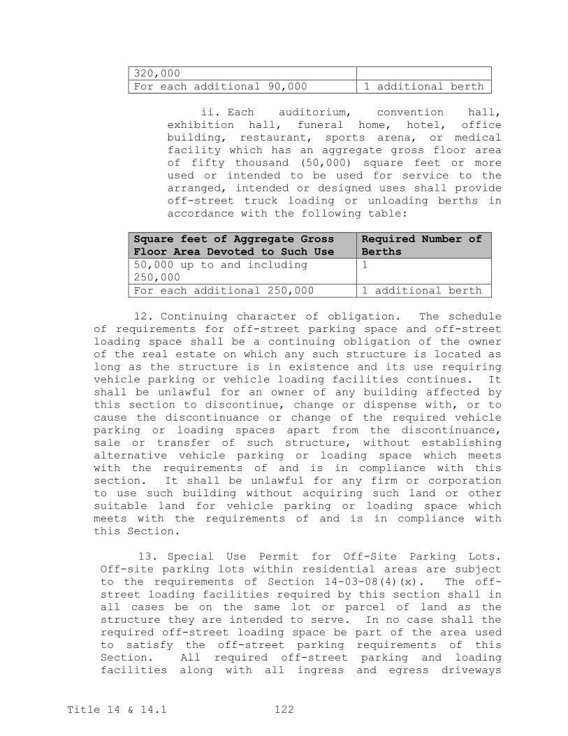
Title 14 & 14.1 122
320,000
For each additional 90,000 1 additional berth
ii. Each auditorium, convention hall,
exhibition hall, funeral home, hotel, office
building, restaurant, sports arena, or medical
facility which has an aggregate gross floor area
of fifty thousand (50,000) square feet or more
used or intended to be used for service to the
arranged, intended or designed uses shall provide
off-street truck loading or unloading berths in
accordance with the following table:
Square feet of Aggregate Gross
Floor Area Devoted to Such Use
Required Number of
Berths
50,000 up to and including
250,000
1
For each additional 250,000 1 additional berth
12. Continuing character of obligation. The schedule
of requirements for off-street parking space and off-street
loading space shall be a continuing obligation of the owner
of the real estate on which any such structure is located as
long as the structure is in existence and its use requiring
vehicle parking or vehicle loading facilities continues. It
shall be unlawful for an owner of any building affected by
this section to discontinue, change or dispense with, or to
cause the discontinuance or change of the required vehicle
parking or loading spaces apart from the discontinuance,
sale or transfer of such structure, without establishing
alternative vehicle parking or loading space which meets
with the requirements of and is in compliance with this
section. It shall be unlawful for any firm or corporation
to use such building without acquiring such land or other
suitable land for vehicle parking or loading space which
meets with the requirements of and is in compliance with
this Section.
13. Special Use Permit for Off-Site Parking Lots.
Off-site parking lots within residential areas are subject
to the requirements of Section 14-03-08(4)(x). The off-
street loading facilities required by this section shall in
all cases be on the same lot or parcel of land as the
structure they are intended to serve. In no case shall the
required off-street loading space be part of the area used
to satisfy the off-street parking requirements of this
Section. All required off-street parking and loading
facilities along with all ingress and egress driveways

Title 14 & 14.1 123
thereto shall be zoned appropriately for the principal use
which they are intended to serve.
14. Nonconforming uses. In the case of nonconforming
uses where major repairs, substantial alterations or
extensions are made, no such major repairs, substantial
alterations or extensions shall be permitted unless and
until the off-street parking and off-street loading facility
space requirements of this section, so far as they apply to
the use to which such building is devoted, shall be fully
provided for. Provided, however, this item shall not apply
to the rebuilding of nonconforming uses that are being
rebuilt according to section 14-03-09 of the zoning
ordinance.
(Ord. 4117, 12-30-86; Ord. 4213, 8-02-88; Ord. 4323, 4-24-90; Ord. 4236, 1-17-89; Ord. 4325 and 4326, 4-24-90
& 5-01-90; Ord. 4333, 6-05-90; Ord. 4332, 6-05-90; Ord. 4336, 7-31-90; Ord. 4770, 06-25-96; Ord. 4821,
02-25-97; Ord. 4863, 08-12-97; Ord. 4936, 09-08-98; Ord. 5206, 10-08-02; Ord. 5207, 10-08-02; Ord. 5247, 04-
22-03; Ord. 5295, 02-24-04; Ord. 5501, 04-25-06; Ord. 5527, 06-27-06; Ord. 5693, 09-23-08; Ord. 5728, 05-26-
09; Ord. 5852, 11-22-11; Ord. 6028, 01-28-14; Ord. 6040, 04-22-14; Ord. 6043, 04-22-14; Ord. 6050, 05-27-14;
Ord. 6120, 05-26-15; Ord. 6157, 8-25-15; Ord. 6171, 10-27-15; Ord. 6195, 03-22-16; Ord. 6271, 07-25-17; Ord.
6424, 06-12-20)
14-03-11. Landscaping and Screening.
1. Purpose. The purpose of these regulations are to
maintain the City’s quality and character by enhancing
its visual appearance through the use of landscaping;
enhance environmental conditions by providing shade,
air purification, reduction of storm water run-off,
and filtering of noise and light; promote neighborhood
character, traffic calming, wildlife habitat,
pedestrian amenity and aesthetic value, screen off-
street parking areas and exterior storage areas from
view of persons on public streets and adjoining
properties and mitigate off-site headlight projection;
provide buffer areas between land uses of differing
intensity; and encourage the planting of trees and
other plant materials throughout the community that
are native or generally suitable for this area.
2. Applicability. The landscaping requirements contained herein shall apply to any of the following:
a. The construction of any principal commercial,
industrial, institutional, or multi-family
building(s) with three (3) or more units or an
accessory building for any of the above uses;

Title 14 & 14.1 124
b. The installation of any parking area or the
expansion of any existing parking area by five
(5) or more off-street parking spaces;
c. A change in the use of the property that requires rezoning to a more intensive zoning
classification or a special use permit; and
d. The reconstruction of a portion of an existing off-street parking lot equal to or greater than
twenty percent (20%) at one time or forty percent
(40%) over a five (5) year period, regardless of
whether or not required parking spaces are added,
and provided the required plant materials do not
reduce the number of off-street parking spaces
below what is required. Reconstruction includes
any land disturbance activity or exposure of any
subgrade or soil material. Regular maintenance,
minor repairs, patch work or a partial mill and
overlay would not constitute reconstruction. Only
those portions of the off-street parking areas
being reconstructed would be subject to these
requirements. Consideration may be given by the
Director of Community Development and the City
Forester on a case-by-case basis to modify the
requirements for the reconstructed off-street
parking areas.
3. General Requirements. All exposed ground areas,
including areas not devoted to off-street parking,
drives, sidewalks or other such improvements shall be
landscaped with grass, vegetative ground cover,
shrubs, trees or other ornamental landscape materials
in conjunction with site development. All landscaped
areas shall be kept neat, clean and uncluttered. No
required landscaped area shall be used for parking of
vehicles or for the storage or display of materials,
supplies or merchandise. Boulevard areas shall be
subject to the requirements of Sections 10-03-14 and
10-05-04.
The Director of Community Development and the City
Forester may allow the placement of existing and/or
required landscaping to be altered as deemed
appropriate.
4. Landscaping Plan Required. A landscape plan shall be required for all development subject to the provisions
of this subsection. All landscape plans submitted for

Title 14 & 14.1 125
approval shall contain, at a minimum, the following
information:
a. North point and scale;
b. The boundary lines of the property with
dimensions and area;
c. The location of all driveways, parking areas,
sidewalks, structures, utilities, or other
features, existing or proposed, affecting the
landscaping of the site;
d. The location, common name, scientific name to the species level, size and quantity of all existing
trees, shrubs or other vegetation intended for
use in meeting the requirements of this
subsection;
e. The location, common name, scientific name to the species level, size and quantity of all proposed
landscape materials;
f. The location and height of any proposed earthen berms, masonry fences or other features used to
meet the landscaping or buffer yard requirements;
g. The location of any existing and/or proposed
easements; and
h. The square footage of each interior parking lot landscaping area and the overall square footage
of all interior parking lot landscaping areas
shown.
i. An opinion of cost prepared by the landscape
architect, landscape designer, landscape
contractor or civil engineer submitting the
landscape plan in the amount sufficient to
guarantee the installation of all the required
landscaping elements and materials, including
trees, shrubs, perennials, ornamental grasses,
ground cover, rock mulch, wood mulch, top soil,
edging material, or any other materials necessary
to install the required landscape materials, as
well as all labor costs to implement the
landscape plan.

Title 14 & 14.1 126
j. A landscaping phasing plan must be provided if the required landscaping will be installed with
phased development.
5. Landscape Design Considerations. Landscape design
should serve to provide visually interesting open
space, reduce the potential negative impact of
development on adjacent land uses, and complement the
scale of the development and its surroundings. The
following items are to be considered in developing a
landscape plan for submittal to the City:
a. Landscape materials and structural items placed within the sight triangle of a corner lot, as
defined in Section 14-02-03, shall not have a
height of more than three (3) feet above the curb
level during all stages of plant growth.
Deciduous trees may be planted within the sight
triangle provided they are not an obstruction to
vision between three (3) feet and ten (10) feet
above the curb level;
b. Landscape materials and structural items at
driveway entrances shall be placed so that
visibility for vehicles entering or exiting a
parking lot is not obstructed;
c. Trees or shrubs shall not be planted under
utility lines when their ultimate height may
interfere with the lowest lines;
d. Landscaped areas shall be of adequate size to
promote proper plant growth and to protect
plantings from pedestrian traffic, vehicle
traffic, and other types of concentrated
activity;
e. Landscaped areas and plantings shall be located in a manner to allow adequate room for proper
maintenance;
f. A variety of tree and shrub species shall be
utilized to provide year around visual interest.
Except for continuous hedges and street trees,
not more than fifty percent (50%) of the required
number of trees or shrubs may be comprised of any
one (1) species. In addition, not more than
fifty percent (50%) of the shrubs and perennials
within any planting bed larger than five hundred

Title 14 & 14.1 127
(500) square feet in area may be comprised of any
one (1) genus;
g. Final slopes greater than a 3:1 ratio, including slopes on earthen berms, will not be permitted
without special approval or treatment, such as
special seed mixtures or reforestation, terracing
or retaining walls; and
h. Within the DC – Downtown Core and DF – Downtown Fringe zoning districts, streetscape elements
from the City’s Streetscape Guidelines should be
incorporated into the perimeter parking lot
landscaping.
i. The use of rain gardens, bioswales, storm water infiltration areas are encouraged.
6. Landscape Materials Standards.
a. Plant Quality. Plants installed to satisfy the
requirements of this subsection must meet or
exceed the plant quality standards of the most
recent edition of American Standards for Nursery
Stock, published by the American Association of
Nurserymen, be nursery grown and adapted to the
local area.
b. Artificial Plants. No artificial plants or
vegetation may be used to meet any standard of
this section.
c. Sizes.
Type of Material Minimum Size at Time of
Planting
Shade Trees Caliper of 1½ inches
measured 6 inches above the
root collar for trees with a
mature height of 30 feet or
greater
Ornamental Trees Caliper of 1 inch measured 6
inches above the root collar
for trees with a mature
height of less than 30 feet
Upright
Coniferous Trees
Minimum height of 4 feet
above grade
Shrubs Minimum container size of 2
gallons and minimum mature

Title 14 & 14.1 128
d. Existing Plant Material. Existing, healthy plant material may be utilized to satisfy landscaping
requirements, provided it meets the minimum sizes
specified above.
e. Ground Cover. Vegetative ground cover shall be of a size and spacing to provide a minimum of fifty
percent (50%) coverage during the first full
growing season and complete coverage upon
maturity. Only pervious weed barriers shall be
allowed. Mulch may not be used in lieu of
vegetative ground cover, except in those
situations where mulch is necessary to promote
healthy tree and shrub growth.
Where mulch is used, an adequate vertical barrier
must be included around the perimeter of the
mulch area to prevent mulch from washing into the
public right-of-way or on to adjacent properties.
f. Soil in Landscaped Areas. Soil in landscaped
areas shall consist of loose, friable, loamy
topsoil that is free of excess acid and alkali.
It shall be free from objectionable amounts of
sod, hard lumps, gravel, subsoil or other
undesirable material, to a depth of eighteen (18)
inches.
7. Street Trees.
a. Purpose. The street tree requirements are
intended to promote air quality, shade,
neighborhood character, traffic calming, reduced
storm water runoff, wildlife habitat, pedestrian
amenity and aesthetic value.
b. Applicability. Street trees shall be installed in conjunction with the construction of any
principal commercial, industrial, institutional
or multi-family building with more than three (3)
units along a section of public roadway with curb
and gutter installed or scheduled to be installed
in conjunction with the project.
height of 3 feet above grade
Perennials Minimum container size of 1
gallon

Title 14 & 14.1 129
c. Location. Street trees shall be installed within the public right-of-way or within ten (10) feet
of the public right-of-way.
d. Spacing and Planting Requirements. Unless the
City Forester determines that it is necessary to
address specific site conditions, three (3)
deciduous trees are required for every one
hundred (100) linear feet of street frontage.
Street trees need not be placed at exact
intervals, but they must be placed evenly along
the street frontage. The City Forester shall have
the authority to determine the final location of
street trees in accordance with Section 13-02-01
of the City Code. Mulch shall be installed to a
minimum coverage thickness of two (2) inches
within a radius of three (3) feet of the trunk
base, and in accordance with the City Forester’s
planting standards and specifications. Tree
grates may be used in lieu of mulching at the
discretion of the City Forester.
e. Permit Required. A planting permit must be
obtained from the Forestry Division of the Public
Works Department prior to planting any trees
within the public right-of-way.
8. Perimeter Parking Lot Landscaping.
a. Purpose. The perimeter parking lot landscaping
requirements are intended to screen views of
parking lots and access lanes from public rights-
of-way, mitigate off-site headlight projection,
and provide pervious surfaces to reduce storm
water run-off.
b. Applicability. Perimeter parking lot landscaping shall be required with the installation or
reconstruction (as defined in subsection 2(d))of
any off-street parking area or access lane
adjacent to the public right-of-way and/or
visible from and within three hundred (300) feet
of a public right-of-way.
c. Standards. All parking lots and access lanes
shall provide perimeter landscaping between said
off-street parking areas and access lanes and
adjacent public rights-of-way. Said perimeter
landscaping shall be constructed with standard

Title 14 & 14.1 130
poured-in-place concrete curbing on the parking
lot side in order to minimize damage to plant
material. Said perimeter curbing may be modified
to allow for storm water management applications
designed to function as rain gardens, bioswales
or storm water infiltration areas at the
discretion of the Director of Community
Development and the City Forester.
d. Trees and Shrubs. Trees and shrubs shall be
installed in accordance with the following table.
The intent of the minimum requirements column is
to provide a total number of trees and shrubs
required based on street frontage, not to dictate
the spacing of the trees and shrubs within that
frontage. For fractions of the specified linear
feet, the number of trees and shrubs required
shall be the corresponding fraction.
Parking
Lot Size
(Number
of
Spaces)
Minimum
Landscaping
Width
Minimum Requirements
Less
than 100
4 feet; or
Masonry wall,
decorative fencing or
continuous evergreen or
deciduous hedge with a
minimum height of 3
feet.
6 feet 1 shade or ornamental
tree and 5 shrubs for
every 25 linear feet of
street frontage.
100 to
399
10 feet; or
4 shade or ornamental
trees and 40 shrubs for
every 100 linear feet
of street frontage; or
Masonry wall,
decorative fencing
combined with a variety
of landscape materials,
or continuous evergreen
or deciduous hedge with
a minimum height of 3
feet

Title 14 & 14.1 131
20 feet; or Earthen berm with a
minimum height of 3
feet plus 2 shade or
ornamental trees for
every 100 linear feet
of street frontage; or
2 shade or ornamental
trees and 15 shrubs for
every 100 linear feet
of street frontage.
30 feet 4 shade or ornamental
trees and 10 shrubs for
every 100 linear feet
of street frontage.
400 or
more
20 feet Earthen berm with a
minimum height of 3
feet plus 4 shade or
ornamental trees for
every 100 linear feet
of street frontage; or
4 shade or ornamental
trees and 15 shrubs for
every 100 linear feet
of street frontage; or
Masonry wall,
decorative iron fencing
combined with a variety
of landscape materials,
or continuous evergreen
or deciduous hedge with
a minimum height of 4
feet.
30 feet 4 shade or ornamental
trees and 10 shrubs for
every 100 linear feet
of street frontage.
40 feet or
greater
4 shade or ornamental
trees for every 100
linear feet of street
frontage.
e. Applicability to Industrial Districts. Within the
MA – Industrial and MB – Industrial zoning
districts, the Director of Community Development
and the City Forester may waive or modify
perimeter parking lot landscaping requirements
based on site conditions if the parking lot has
twenty-five (25) or fewer parking spaces and the

Title 14 & 14.1 132
property is not located along a collector or
arterial roadway.
f. Grade Differential. Consideration will be given
for parking areas and access lanes that are
significantly above or below the finish grade of
the adjacent public right-of-way. Modifications to
the required plant quantities will be considered
on a case-by-case basis by the Director of
Community Development and the City Forester with
the submittal of section and/or elevation drawings
showing how the design will meet the intent of the
ordinance.
g. Separation. For off-street parking areas with
varying widths adjacent to a public right-of-way,
the average separation distance between the
parking area and the right-of-way will be the
basis for the required plant materials.
h. Substitutions. The Director of Community
Development and the City Forester may allow
perennials to be substituted for a portion of the
required shrubs on a two-to-one basis (two
perennials to one shrub), and for one shade tree
to be substituted for three shrubs, based on
specific site conditions and the overall landscape
design for the site.
9. Interior Parking Lot Landscaping.
a. Purpose. The interior parking lot landscaping
requirements are intended to break up large
expanses of pavement, provide relief from the
heat island effect associated with paved areas,
promote air quality, shade, aesthetic value, and
provide pervious surfaces to reduce storm water
run-off.
b. Applicability. Interior parking lot landscaping
applies to any new or reconstructed parking lot
(as defined by subsection 2(d)).
c. Standards. All parking lots containing fifty (50) or more off-street parking spaces shall provide
interior landscape areas within the parking lot.
Said landscape areas shall be provided at the
rate of ten (10) square feet per parking space,
shall be no less than ten (10) feet by ten (10)

Title 14 & 14.1 133
feet (100 square feet), and shall be constructed
with poured-in-place concrete curbing to minimize
damage to plant material. Said curbing may be
modified to allow for storm water management
applications designed to function as rain
gardens, bioswales or storm water infiltration
areas at the discretion of the Director of
Community Development and the City Forester. For
parking lots with one hundred (100) to four
hundred (400) parking spaces, at least fifty
percent (50%) of the landscape areas shall be no
less than six hundred (600) square feet in area
with a minimum width dimension of ten (10) feet.
For parking lots with more than four hundred
(400) parking spaces, at least fifty percent
(50%) of the landscape areas shall be no less
than twelve hundred (1200) square feet in area
with a minimum width dimension of ten (10) feet.
d. Placement of Landscape Areas. Live plant material should be evenly dispersed throughout the parking
area.
e. Trees and Shrubs. At least one (1) shade tree and three (3) shrubs shall be provided for every
twenty (20) parking spaces or fraction thereof
within the off-street parking area. One (1) shade
tree may be substituted for three (3) shrubs, but
shrubs may not be substituted for shade trees.
The Director of Community Development and the
City Forester may allow perennials to be
substituted for a portion of the required shrubs
on a two-to-one basis (two perennials to one
shrub), based on specific site conditions and the
overall landscape design for the site.
f. For sites located within industrial zoning
districts, the required plant material for
interior landscape islands located in areas
designated for truck maneuverability may be
relocated throughout the site at the discretion
of the Director of Community Development and the
City Forester.
10. Buffer Yards.
a. Purpose. The buffer yard requirements are
intended to provide separation between land uses
of differing intensity. Buffer yards utilize a

Title 14 & 14.1 134
combination of distance and plantings to form a
dense landscaping screen to mitigate the
undesirable impacts associated with incompatible
land uses on adjacent properties. Earthen berms
and/or opaque wood or similar screening fence as
defined in this section may also be used where
appropriate at the discretion of the Director of
Community Development and the City Forester.
b. Applicability. Buffer yards shall be required
between a single- or two-family residential use
and zoning and any other non-agricultural land
use, and between a multiple family residential
use (three (3) or more units) and any commercial,
industrial or institutional use in all zoning
districts except when both properties are located
within the Downtown Core (DC) and/or Downtown
Fringe (DF) zoning districts. Buffer yards shall
also be required for parking lots and access
lanes associated with these uses, whether they
are located on the same parcel or on a separate
parcel.
c. Location of Buffer Yards. Buffer yards shall be located along the entire length of any lot line
where two (2) land uses of differing intensity
abut, excluding areas adjacent to access points
and sight triangles. Such buffer yards may be
located within required yards, but not within any
portion of the public right-of-way or over any
established trail or access easement.
d. Responsibility for Buffer Yard Installation.
Installation of all required buffer yards shall
be the responsibility of the proposed higher
intensity use and shall be located on the lot of
the higher intensity use unless a perpetual
landscape easement is obtained from the property
owner with the lower intensity use, in which case
the buffer yard may be located on the lot with
the lower intensity use. In situations where the
higher intensity use was in place prior to the
adoption of this section (October 8, 2002), or
any subsequent amendments, a buffer yard shall
not be required with the subsequent development
of the adjacent lower intensity land use.
Landscape easements for buffer yards may be
required in conjunction with the platting process
in situations where such buffer yards will be

Title 14 & 14.1 135
required based on existing or proposed zoning
and/or land uses.
e. Standards. Buffer yards shall be installed in
accordance with the following table:
Area Where
Buffer Yard
Required
Minimum Width
of Buffer Yard
Landscape
Materials
Required per 100
Linear Feet
Side or rear
yard of any
expanding
higher
intensity land
use adjacent
to single and
two-family
residential
uses or zoning
10 feet w/6-
foot screening
fence
4 shade trees
and 2 ornamental
trees
Side or rear
yard of any
new multi-
family land
use adjacent
to single and
two-family
residential
uses or zoning
or
Side or rear
yard of any
new commercial
or
institutional
use adjacent
to a multi-
family
residential
use or zoning
15 feet
or
3 shade trees, 4
ornamental
trees, 2 large
upright
coniferous
trees, 10 small
upright
coniferous trees
and 14 shrubs
(25% of shrubs
must be
evergreens)
15 feet w/6-
foot screening
fence
2 shade trees
and 2 ornamental
trees and 2
large upright
coniferous trees
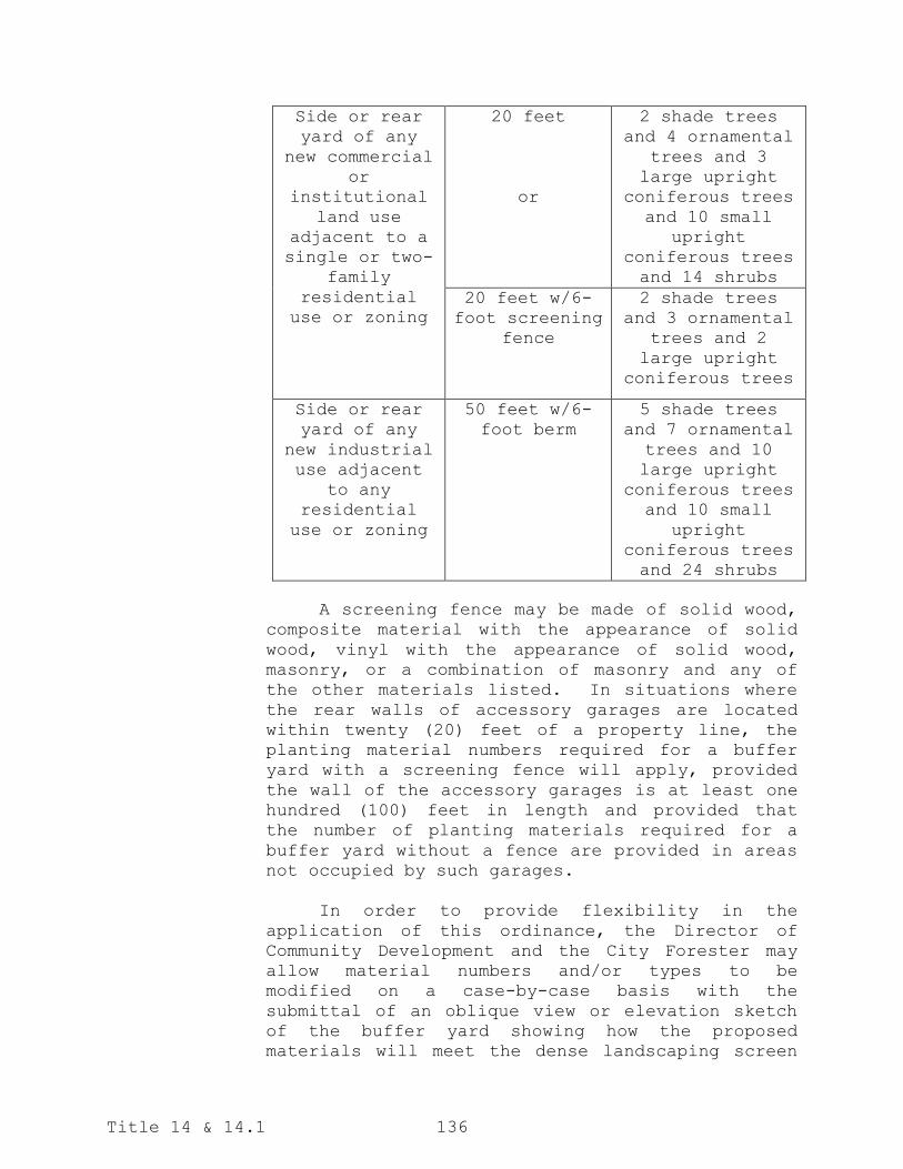
Title 14 & 14.1 136
Side or rear
yard of any
new commercial
or
institutional
land use
adjacent to a
single or two-
family
residential
use or zoning
20 feet
or
2 shade trees
and 4 ornamental
trees and 3
large upright
coniferous trees
and 10 small
upright
coniferous trees
and 14 shrubs
20 feet w/6-
foot screening
fence
2 shade trees
and 3 ornamental
trees and 2
large upright
coniferous trees
Side or rear
yard of any
new industrial
use adjacent
to any
residential
use or zoning
50 feet w/6-
foot berm
5 shade trees
and 7 ornamental
trees and 10
large upright
coniferous trees
and 10 small
upright
coniferous trees
and 24 shrubs
A screening fence may be made of solid wood,
composite material with the appearance of solid
wood, vinyl with the appearance of solid wood,
masonry, or a combination of masonry and any of
the other materials listed. In situations where
the rear walls of accessory garages are located
within twenty (20) feet of a property line, the
planting material numbers required for a buffer
yard with a screening fence will apply, provided
the wall of the accessory garages is at least one
hundred (100) feet in length and provided that
the number of planting materials required for a
buffer yard without a fence are provided in areas
not occupied by such garages.
In order to provide flexibility in the
application of this ordinance, the Director of
Community Development and the City Forester may
allow material numbers and/or types to be
modified on a case-by-case basis with the
submittal of an oblique view or elevation sketch
of the buffer yard showing how the proposed
materials will meet the dense landscaping screen

Title 14 & 14.1 137
intent of this ordinance within five (5) years of
initial installation and at full maturity.
f. Sizes. In order to provide an effective
landscaping screen in conjunction with site
development, minimum sizes at the time of
planting and minimum heights at maturity have
been established. The classification of various
types of materials shall be based on the City of
Bismarck's Forestry standards and specifications.
Type of
Materials
Minimum Size
at Time of
Planting
Minimum Height
at Maturity
Shade Trees Caliper of 1.5
inches
measured 6
inches above
the root
collar
20 feet
Ornamental
Trees
Caliper of 1
inch measured
6 inches above
the root
collar
15 feet
Small Upright
Coniferous
Trees
Minimum height
of 2 feet
above grade or
minimum
container size
of 5 gallons
6 feet
Large Upright
Coniferous
Trees
Minimum height
of 4 feet
above grade
20 feet
Shrubs Minimum height
of 2 feet
above grade or
a minimum
container size
of 2 gallons
3 feet
g. Applicability to Non-Conforming Uses. Proposed
modifications to a required buffer yard adjacent
to any non-conforming use, based on zoning, may
be considered on a case-by-case basis by the
Director of Community Development and the City
Forester.

Title 14 & 14.1 138
h. Applicability to Buffer Yards in Areas Within the
Extraterritorial Area. Consideration will be
given by the Director of Community Development
and the City Forester on a case-by-case basis to
allow a modified buffer yard in developing areas
within the extraterritorial area. Consideration
will be given for reduced plant quantities,
sizes, locations and plant species.
i. Grade Differential. Consideration will be given
for required buffer yards that are significantly
above or below the finish grade of the adjacent
property. Modifications to the required plant
quantities may be considered on a case-by-case
basis by the Director of Community Development
and the City Forester with the submittal of
section and/or elevation drawings showing how the
design will meet the intent of the ordinance.
11. Installation, Maintenance, Replacement, Inspection and Enforcement.
a. Installation of Street Trees. The City Forester shall determine the time for installation of
street trees.
b. Installation of Other Required Landscaping. All other landscaping and buffer yards required by
this subsection shall be healthy and in-place as
soon as grading or construction has been
completed to eliminate or reduce wind and/or
water erosion. When landscaping cannot be
completed in conjunction with site development
due to seasonal constraints, the plant material
shall be installed at the beginning of the next
growing season, unless otherwise approved by the
Director of Community Development and the City
Forester.
c. Maintenance and Replacement. The owner, or
successors in interest, or agent, if any, shall
be responsible for regular maintenance of all
landscaping in good condition in a way that
presents a healthy, neat and orderly appearance.
All landscaping must be maintained free from
disease, pests, weeds and litter. This
maintenance must include weeding, watering,
fertilizing, pruning, mowing, edging, mulching
and other maintenance, as needed and in

Title 14 & 14.1 139
accordance with acceptable horticultural
practices. Dead plants must be promptly removed
and replaced within the next growing season.
Trees located along fire department access
routes, as identified on an approved site plan,
must be pruned as needed to maintain a vertical
clearance height of no less than fourteen (14)
feet.
d. Inspection and Enforcement. All landscaping shall be subject to periodic inspection by the City
Forester. Landscaping that is not installed,
maintained or replaced as needed to comply with
the approved landscape plan shall be considered a
violation of this Section and shall be subject to
the enforcement provisions Chapter 13-02-14.
e. Surety Requirement.
1. For landscaping required under Section 14-
03-11, the landscaping shown in the approved
landscaping plan must be installed prior to
issuance of a certificate of occupancy. If
the required landscaping cannot be installed
in conjunction with site development because
of extenuating circumstances, such as
seasonal concerns, the Director of Community
Development and City Forester may allow the
installation of the required landscaping to
be delayed on a case-by-case basis. Unless
waived by the Director of Community
Development and City Forester for good cause
shown, said delay would only be allowed in
conjunction with the issuance of a temporary
certificate of occupancy and a receipt of a
cash deposit with the City of Bismarck in an
amount equal to the estimate submitted with
the landscape plan, updated if required by
the City Forester, plus ten percent (10%)
sufficient to guarantee the installation of
the landscaping according to the landscape
plan.
If the required landscaping is not installed by the date
set by the Director of Community Development and the
City Forester, the City may utilize the cash deposit and
order the installation of the landscaping according to
the approved landscape plan, based on an estimate
prepared by the landscape architect, landscape designer,

Title 14 & 14.1 140
landscape contractor or civil engineer submitting the
landscape plan and agreed to by the City.
(Ord. 5437, 06-28-05; Ord. 5450, 08-23-05; Ord. 5562, 11-28-06; Ord. 5640, 10-09-07; Ord. 5812, 03-22-11; Ord.
6051, 05-27-14; Ord. 6311, 02-27-18)
14-03-12. Screening of Mechanical Equipment and Solid
Waste Collection Areas.
1. Mechanical Equipment. All rooftop and ground mounted
mechanical equipment shall be designed and located so
to be as unobtrusive as possible. If this is not
possible, ground equipment shall be screened from view
of adjacent properties and public rights-of-way by
landscape plantings, fencing or other screening
treatment compatible with the principal building.
2. Solid Waste Collection Areas. All solid waste
collection areas for commercial, industrial,
institutional or multi-family buildings with more than
four units shall be screened from view of adjacent
properties and public rights-of-way on at least three
sides with a six-foot solid masonry wall, opaque wood
fence or other compatible building material.
(Ord. 5207, 10-08-02)
CHAPTER 14-03.1 – SIGNS
14-03.1-01 Purpose. The purpose of this chapter is to:
1. Provide fair standards and procedures to ensure
that individuals, businesses, and organizations have a
reasonable ability to communicate messages to the general
public.
2. Protect public safety by preventing or mitigating
traffic hazards through obstruction of view, distraction of
roadway users, and all other negative effects on public
travel.
3. Promote wayfinding to facilitate the efficient
identification of destinations, which requires making a
distinction between on-premise signs and off-premise signs.
4. Reduce visual clutter along public rights-of-way
to improve the legibility of existing signs, including
traffic control devices, and enhance the overall aesthetics
of the community.

Title 14 & 14.1 141
5. Protect property values of residential and
commercial property owners who may be negatively impacted
by signs within view of the property.
6. Encourage creative expression and artistic
contributions to the community, which requires a
distinction between signs of a commercial and non-
commercial nature.
7. Preserve the health, safety, and general welfare
of the public.
(Ord. 6423, 07-25-20)
14-03.1-02 Definitions and Measurements.
1. Definitions of Terms. In addition to the overall
definitions for zoning contained in Section 14-02-03
(Definitions) of the City Code of Ordinances, the following
definitions represent the meanings of terms as they are
used in this chapter:
Air-blown Sign: A sign that is designed to be moved
or filled with air or gas, such as balloons and products
marketed as “air puppet” or “tube man.” This includes such
devices that do not contain a message but are intended to
attract attention.
Awning: Any structure or shelter attached to and
projecting outward from the face of a building, typical
extending over a sidewalk or other thoroughfare.
Changeable Copy Sign: A sign or portion thereof with
characters, letters or illustrations that can be changed or
rearranged manually without altering the face of the sign.
Reader boards and marquee signs are considered changeable
copy signs.
Commercial Zoning District: The CA – Commercial, CG –
Commercial, HM – Health Medical, or RT – Residential zoning
districts. Street frontages in a P – Public zoning district
that are not adjacent to or across from a residential
zoning district, the A – Agricultural zoning district, or
another P – Public zoning district are considered to be
within a commercial zoning district for the purpose of this
section.
Community-Wide Event: Any special event or other
local, cultural, educational, or sporting activities of

Title 14 & 14.1 142
specific benefit to the City. Any content with the primary
purpose of endorsing or promoting commercial interests;
campaign messages that endorse or oppose a candidate for
election to public office; or business logos and
sponsorships by commercial entities shall not be considered
advertisement of a community event.
Digital Off-Premise Advertising Sign: An off-premise
advertising sign with a digital display of information that
is capable of displaying multiple static images
sequentially and is controlled by electronic
communications. A sign with one digital face and one
static face shall be considered a digital off-premise
advertising sign.
Downtown Zoning District: The DC – Downtown Core and
DF – Downtown Fringe zoning districts.
Electronic Component: A small-scale electronic
component of a permanent sign that meets all conditions of
Section 14-03.1-05(10).
Electronic Message Center Sign (EMC): An on-premise
advertising sign with a digital display of information that
is capable of displaying characters, letters or
illustrations and can be electronically changed by remote
or automatic means. Small scale electronic components to
signs that comply with all requirements of this ordinance
are not included within this definition.
Feather Flag Sign: A freestanding sign typically
constructed of a single plastic or metal shaft driven in
the ground or fixed to a weighted base and with an attached
pennant that is vertically elongated and attached to the
shaft.
Frame Hold Time: The duration or interval of time
during which each individual digital advertisement or
message is displayed on any sign which is capable of
sequentially displaying more than one advertisement or
message on its display surface.
Freestanding Sign: A permanent sign that is not
attached to any building or structure, with the exception
of a structure, such as a pole or foundation, with the sole
purpose of supporting signs. Freestanding signs are further
divided into pole signs or monument signs.

Title 14 & 14.1 143
Industrial Zoning District: The MA – Industrial or MB
– Industrial zoning districts.
Monument Sign: A freestanding sign supported by a
solid base, extending to the ground, of at least fifty (50)
percent of the sign width with the highest point of the
sign face located eight (8) feet or less from the ground.
Signs that are affixed to boulders or other inorganic
natural features may be considered monument signs.
Off-Premise Advertising Sign: A ground sign, as
defined in the most recent adoption of the International
Building Code (IBC), that may advertise goods or services
that are not associated with the use of the premises. Off-
premise advertising signs may also advertise on-premise
goods or services. An off-premise advertising sign may be
static, digital, illuminated, non-illuminated or any
combination thereof where permitted.
On-Premise Advertising Sign: A sign advertising the
business, person, service or major product of the building
or land upon which it is located, or identifying the
premises or goods manufactured, produced, or services
rendered thereon. On-premise does not necessarily imply
that the sign and its referent share a single lot or
parcel, but a set of contiguous lots or parcels that
function as a whole use may be considered a premise for the
purposes of this definition.
Permanent Sign: Any sign that is intended to be and
is constructed to remain unchanged in character and
position and affixed to features such as the ground or
building for one (1) year or more. A temporary sign left in
place for one (1) year or more does not become a permanent
sign.
Pole Sign: A freestanding sign resting on or
supported by one or more poles or other vertical
structures. Any permanent freestanding sign that does not
meet the definition of monument sign shall be considered a
pole sign. Signs commonly referred to as pylon signs are
considered poles signs.
Portable Sign: A sign that is constructed to be
movable, either by skids, wheels, truck or other conveyance
and which does not have a permanent foundation or is
otherwise permanently fastened to the ground and is not
actively used as a vehicle for movement of goods. When on a

Title 14 & 14.1 144
trailer, the removal of the wheels or undercarriage does
not place the sign in another category, neither does the
anchoring of the sign by means of concrete blocks,
sandbags, or other types of temporary anchors. However,
sidewalk signs are not considered portable signs.
Projecting Sign: A sign that is wholly or partly
dependent upon a building or structure for support and
which projects outward from the surface of the building in
a direction not parallel to the surface.
Residential Zoning District: The R5 – Residential,
R10 – Residential, RM – Residential, RMH – Residential, RR
– Residential, or RR5 – Residential zoning districts. Lots
or parcels within a P – Public zoning district that is
adjacent to or across from a residential zoning district,
the A – Agricultural zoning district, or another P – Public
zoning district, are considered to be within a residential
zoning district for the purpose of this section.
Sidewalk Sign: A sign that is portable, typically
designed with an A-frame structure, and is placed on the
sidewalk or boulevard area of a public right-of-way,
associated with an abutting commercial establishment.
Sign: Any visual display visible from a public right-
of-way designed to identify, announce, direct, or inform.
Sign Face: The entire surface area of the sign that
is used to identify, advertise or communicate information
for visual representation and is visible from any one
direction, exclusive of any supporting structure for the
sign. Multiple parts of a sign attached to a wall are
considered a single sign face if the parts are intended to
be viewed as a coherent whole. Multiple sign faces may be
considered parts of one sign, provided the sign faces are
no greater than eighteen (18) inches from each other in
distance and are either parallel to or at an interior angle
of less than thirty (30) degrees with each other.
Site Sign: An on-premise sign of temporary nature
installed on a parcel of land with certain activity
specified in this ordinance underway and constructed of
temporary materials such as plywood, durable plastic,
composite, or metal, with or without a frame. Yard signs as
herein defined shall not be considered site signs.

Title 14 & 14.1 145
Temporary Banner: A display sign banner, or other
advertising device constructed of, cloth, canvas, fabric or
other light temporary material, with or without a
structural frame intended for a limited period of display,
including but not limited to decorative displays for
holidays, public demonstrations, business sales,
promotions, and relocations. Portable signs as herein
defined shall not be considered temporary banners.
Wall Sign: A sign fastened to the wall of a building
or structure in such a manner that the wall becomes the
supporting structure for, or forms a background surface of,
the sign.
Yard Sign: A small sign of a temporary nature
inserted into the ground by wire or post, including but not
limited to real estate signs, garage sales, political
signs, and construction signs, constructed of a light
temporary material, such as corrugated plastic, aluminum,
or composite, with or without a frame. Portable signs and
site signs as herein defined shall not be considered yard
signs.
Wall Sign Projecting Sign
Pole Sign Monument Sign

Title 14 & 14.1 146
Yard Sign Temporary Banner
Figure 1: Illustrations of Selected Sign Types
2. Method of Measurement. All dimensional
measurements in this chapter shall be calculated based on
the following methods:
a. Determining Allowable Area. Wherever a
total allowable sign area is applied in this chapter,
the following methods shall be used to determine area
measurements:
i. The total allowable sign area for all
signs on a parcel is based on the length of
linear street frontage of the parcel on a
public right-of-way, other than alleyways,
towards which the sign or signs are oriented in
all parcels outside of Downtown Zoning
Districts. In Downtown Zoning Districts, total
allowable sign area for all signs on a parcel
is based on the length of street frontage that
is occupied by a building at any point along a
perpendicular line extending from the street
frontage, other than alleyways, towards which
the sign or signs are oriented.
ii. The primary street frontage shall be
considered the side from which the principal
structure on the parcel has its primary
entrance, which is the means by which the
majority of the ground-floor space of the
building is accessed or the most commonly used
entrance for the building. In such cases where
said entrance is on a corner, the Zoning
Administrator shall assign one street frontage
as primary.

Title 14 & 14.1 147
Height
iii. Secondary street frontages shall be
considered all sides of a property that are not
considered the primary street frontage.
iv. The total allowable sign area of any
street frontage, whether primary or secondary,
may be applied to any sign that is visible from
that frontage, including the combined total
from multiple street frontages. The total
allowable sign area of any street frontage may
not be applied to any sign that is not visible
from that frontage.
v. Only permitted signs are included in
total allowable sign area calculations. Permit-
exempt signs shall not be included.
b. Area of Sign Face. The area in square feet
of a sign face, not including any supporting
structures, is measured as follows:
i. Signs within a cabinet or base with a
regular polygon or circular shape shall be
measured as the total area of the shape,
including any frame.
Figure 2: Example of regular shape area measurement (Length
Height)
ii. Signs with irregularly-shaped sign
faces or multiple parts, such as independent
letters or logos, shall be measured as the area
of the smallest single polygon with all
interior angles less than 180 degrees that
encompasses the entire sign face.
Length

Title 14 & 14.1 148
Figure 3: Example of irregular shape area measurement (Area within
dashed line)
iii. Signs on a non-planar shape, such as
spheres, cylinders, cones, or other
multidimensional shapes, shall be measured as
the area of the sum of the four vertical sides
of the smallest cube that completely
encompasses the sign.
Figure 4: Example of measurement of non-planar shape
iv. Signs with two faces are measured as
the area of only the larger of the two faces,
as long as the faces are no greater than
eighteen (18) inches from each other in
distance and are either parallel to or at an
interior angle of less than thirty (30) degrees
with each other. Signs with multiple faces that
do not meet this condition shall be considered
separate signs for each face.
Face A
Face B
Face A
Face B
Face C
+ Face D
Total Area

Title 14 & 14.1 149
Figure 5: Example of one sign with two faces
c. Height of Sign. The vertical distance in
feet between the top of the curb of the roadway
nearest to the pole, monument, or building wall
supporting the sign and the highest point of the area
of the sign face.
d. Setback of Sign. The horizontal distance
between any part of a sign or supporting structure and
the front property line of the parcel the sign is
located within.
e. Clearance of Sign. The vertical distance
between any part of a sign, including supporting
structure, and the highest finished grade directly
beneath the sign.
Figure 6: Example of height, setback, and clearance measurements
≤ 30°
≤ 18”
Setback
Heigh
t
Clearance
Curb
Property
Line

Title 14 & 14.1 150
f. Spacing of Signs. The shortest distance
between two signs, as measured horizontal to the
ground plane from the any point on both signs.
g. Illumination of Signs. The illumination of
signs is measured in foot-candles by an illuminance
meter. Two measurements must be taken, one for ambient
light and another for operational light, with as short
a duration between tests as practicable. Required
illumination levels are determined by subtracting
ambient light from operational light.
i. Location of Tests. Measurements shall
be taken from a distance no closer than the
nearest curb of a public right-of-way or the
nearest property line to the subject sign at a
height of three (3) feet above the ground.
ii. Time of Tests. Measurements may be
taken at any time. However, conducting tests at
least 30 minutes past sunset is recommended.
iii. Testing Method. Ambient light is
recorded with the subject sign turned off, or
alternatively the sign may be blocked by a dark
and opaque object. Operational light is recorded
with the sign turned on and displaying a full
white image, or alternatively measured as the
highest level recorded during normal sign
operation. The light meter shall be pointed
directly at the sign for both tests.
(Ord. 6423, 07-25-20; Ord. 6497, 02-15-22)
14-03.1-03 Scope of Sign Provisions.
1. Applicability and Jurisdiction. This chapter
shall apply to the construction, installation, function,
maintenance, and/or alteration of all signs, whether
permanent or temporary, in the entirety of the City of
Bismarck and its extraterritorial zoning jurisdiction.
2. Permit Exempt Signs. The following signs are
exempt from requirements to obtain permits in Section 14-
03.1-04, but are still subject to the general standards of
Section 14-03.1-05 and any specific standards as noted
herein:

Title 14 & 14.1 151
a. Address Number. A physical street address
marking, as required by Section 10-01-07 (Numbering
Buildings and Lots) of the City Code of Ordinances,
except where the address information is also included
within the name of the business or organization owning
or occupying the premises.
b. Air-Blown Sign. A temporary sign, as
defined in this chapter, subject to the following
provisions:
i. Air-blown signs may be displayed on a
property or lease space for a continuous display
period of no greater than seven (7) days. Up to
two (2) display periods are permissible per
calendar year per business or organization. The
display periods cannot be consecutive and must be
separated by at least thirty (30) days.
ii. Air-blown signs are prohibited in the
downtown zoning districts.
c. Architectural Feature. A sign, symbol,
logo, or lettering that is integral to a building’s
structure and design that is constructed with
permanent materials that are used generally throughout
the building and are not specific to the sign.
d. Beacon Transmission. The use of location-
based wireless transmission to or collection of
information from personal electronic devices within
proximity of the transmitter, through means such as
Bluetooth or similar technologies, provided that
transmitters are on private property and use is in
compliance with all applicable state and federal law.
e. Bulletin Board. An informational display,
such has a menu board, an event listing, promotional
flyer, or other display intended to be read from a
close distance and providing specific information
typically sought by the viewer. Bulletin Boards may be
illuminated only externally with light directed toward
the bulletin board.
f. Carried Sign. A sign carried or worn by a
person or persons, provided that all traffic safety
laws are met.

Title 14 & 14.1 152
g. Construction Fence Sign. A sign affixed to
a fence erected temporarily around a construction
site, subject to the following provisions:
i. Construction fence signs must be
installed flush to the fence and may not extend
beyond the area of the fence, but are otherwise
not limited size.
ii. Construction fence signs must be
removed no later than thirty (30) days after a
certificate of occupancy has been granted on the
building on site or ceasing of the activity for
which the fence is used.
h. Electronic Message Center Sign
Demonstration. The temporary display of an electronic
message center for demonstration purposes over a
period of twenty-four (24) hours or less, provided the
sign is used as an on-premise advertising sign without
any off-premise advertising content.
i. Feather Flag Sign. A sign, as defined
in this chapter, subject to the following
provisions:
a. Feather flag signs may be displayed on
a property or lease space for a continuous
display period of no greater than sixty (60)
days. Up to two (2) display periods are
permissible per calendar year per business
or organization. The display periods cannot
be consecutive and must be separated by at
least thirty (30) days.
b. Feather flag signs are prohibited in
the downtown zoning districts.
j. Flag or Pennant. A flag, emblem or insignia
of any nation, political subdivision, corporation, or
any other entity.
k. Grave Marker. A name or other marker of the
deceased located in a cemetery.
l. Identification Plaque. A small, permanent
wall sign or plaque that identifies a household name,
business and/or organization occupying a building,
subject to the following provisions:

Title 14 & 14.1 153
i. No more than one (1) identification
plaque is permitted on any parcel.
ii. Identification plaques may not exceed
one and a half (1 ½) square feet in area in
residential zoning districts.
iii. Identification plaques may not exceed
three (3) square feet in area in commercial
zoning districts, industrial zoning districts,
downtown zoning districts, or agricultural zoning
districts. An identification plaque may be
freestanding in agricultural zoning districts.
iv. Identification plaques may not be
illuminated, either internally or externally.
m. Inwardly-Oriented Sign. A sign that meets
any of the following conditions:
i. Located indoors;
ii. Located inside a stadium, concert
venue, or athletic fields and oriented toward
patrons of that venue;
iii. Located within a parking area or site,
such as signs used to provide directions or
practical information, and oriented toward the
interior of the site;
iv. Any sign not intended to be visible
from the public right-of-way or any adjoining
property.
n. Public Art. Any installation of a mural or
visual artwork visible from a public right-of-way that
not does not contain any brand name, product name,
letters of the alphabet spelling or abbreviating the
name of any product, company, profession, business,
logo, trademark, or other commercial message. The
following provisions must be met only in the DC –
Downtown Core and DF – Downtown Fringe zoning
districts:
i. All Downtown Design Review procedures
shall be followed for any installation of public
art.

Title 14 & 14.1 154
ii. The public art is not installed on any
side of a building directly adjacent to a public
right-of-way, excluding alleys.
iii. The public art is not installed on a
vacant building or within a vacant lot or parcel,
unless the property owner has filed a building
permit with the intention of occupation or is
otherwise actively in the process of improving
the building or parcel for the purpose of
occupation.
iv. The public art is not installed on any
original façade of a building listed as a
contributing structure of the downtown historic
district, unless the art may be attached to a
removable panel without damage to the underlying
historic façade and the artwork meets all other
downtown design review requirements pertaining to
historic structures.
o. Public Utilitarian Sign. Signs of a non-
commercial nature and in the public interest displayed
by order of a political subdivision or public utility
in performance of its official duties for the purpose
of traffic control, wayfinding, public safety,
providing legal notice, or identifying public
facilities or historical landmarks.
p. Sidewalk Sign. A portable sign, as defined
in this chapter. Sidewalk signs are subject to the
following restrictions:
i. The maximum width of a sidewalk sign
shall be two (2) feet, six (6) inches and the
maximum height shall be four (4) feet.
ii. Sidewalk signs may only be placed
within a public right-of-way in downtown
districts, subject to standards of Section 14-
03.1-09(11). Sidewalk signs must be placed on
private property in all other districts, unless
granted an encroachment agreement.
q. Site Sign. A temporary site sign used for
on-premise commercial advertising, as defined in this
chapter. Site signs are subject to the following

Title 14 & 14.1 155
restrictions, depending on activity currently underway
on the parcel or in the vicinity thereof:
i. For Sale or Rent. Site signs may be
placed on parcels containing property that is
currently for sale or rent in commercial,
industrial, downtown, or agricultural zoning
districts, as well as any RM – Residential zoning
district. On said parcels, one (1) site sign may
be placed per street frontage on a parcel, with
one (1) additional site sign allowed on street
frontages of greater than two hundred (200) feet
in length. Said site sign(s) shall be no greater
than sixty-four (64) square feet in area and ten
(10) feet in height, and shall be removed no
later than thirty (30) days after sale, lease, or
occupancy of the property.
ii. Under Development or Construction. Site
signs may be placed on parcels in areas that are
currently under development or building
construction in any zoning district. On said
parcels, no more than three (3) site signs may be
placed at each entrance into a development or
site. All of said site sign(s) shall be no
greater than one-hundred and forty-four (144)
square feet in area cumulatively and ten (10)
feet in height, and may be displayed until thirty
(30) days after all lots in a subdivision have
been sold by the developer or thirty (30) days
after a certificate of occupancy has been granted
on an individual commercial property that is not
associated with a subdivision under development.
iii. Site signs are prohibited on properties
that do not meet either of the provisions of this
section.
iv. Site signs are permitted in addition to
any other signs, temporary or permanent, allowed
on a parcel under this chapter, and all
measurements of spacing or number shall be made
independently of other sign types.
v. Site signs may not be illuminated,
either internally or externally.

Title 14 & 14.1 156
r. Small-Scale Freestanding Sign. A small
permanent on-premise sign, typically used for
ancillary messages such as providing directions,
subject to the following provisions:
i. The sign is no larger than six (6)
square feet with a height of three (3) feet or
less.
ii. No more than two (2) small-scale
freestanding signs may be installed on each
street frontage of each parcel, in addition to
any permitted freestanding signs.
s. Temporary Banner. A temporary sign, as
defined in this chapter, subject to the following
provisions:
i. Temporary banners may be displayed on a
property or lease space for a continuous display
period of no greater than three hundred (300)
days per calendar year per business or
organization.
ii. Temporary banners may not be used to
advertise off-premise commercial content.
iii. Temporary banners must be attached to,
and flush with, a building wall, retaining wall,
fence, or other permanent structure.
iv. Temporary banners may not exceed
thirty-two (32) square feet in area in downtown
zoning districts and residential zoning
districts.
v. Temporary banners may not be displayed
on residential properties of four (4) units or
less.
vi. Temporary banners may not be
illuminated, with the exception of temporary
banners affixed to a permitted permanent sign
structure to allow for transitions between
occupants of a building.
t. Temporary Lighting Display. Temporary use
of low-wattage lighting for holidays or other events,
including standard effects such as flashing or fading,
Title 14 & 14.1 157
provided any associated glare does not create a public
nuisance or traffic safety hazard.
u. Vending Machine Sign. A sign integral to a
legally-operating vending machine.
v. Window Sign. A sign affixed to the inside
or outside of an exterior window or located in the
interior of a building, within twelve (12) inches of a
window, and oriented outside the window, subject to
the following requirements:
i. Window signs may not be used to
advertise off-premise commercial content.
ii. In downtown zoning districts, paper,
cardboard, or solid surface signs are not
permitted on second floor windows or above.
iii. In the downtown zoning districts, all
window signs on a building may not occupy more
than twenty-five (25) percent of the total
transparent window surface of each window or door
opening, unless the interior space is unoccupied
or window signs are used for an appropriate
screening function and are approved by the
Downtown Design Review Committee.
Notwithstanding, any window sign or part thereof
that does not completely impede visibility, but
provides transparency between individual letters
or designs, shall be counted as fifty (50)
percent of a window sign for the purposes of
measuring maximum window coverage.
w. Yard Sign. A temporary sign, as defined in
this chapter. Yard signs are subject to the following
provisions:
i. A yard sign may not be used to
advertise off-premise commercial content.
Advertisement of on-premise commercial activity,
including but not limited to real estate, sales,
construction activity, is permitted for the
entire duration of said activity and must be
removed within thirty (30) days after completion
of said activity. Non-commercial yard signs are
permitted and not limited in number or duration.

Title 14 & 14.1 158
ii. Yard signs are not permitted for home
occupations permitted under Section 14-03-06(2)
of the City Code of Ordinances.
iii. Each yard sign may not exceed eight (8)
square feet in area, exclusive of any post or
supporting structure. Notwithstanding, one (1)
non-commercial yard sign may exceed this area
limitation for a time period no greater than
twenty-four (24) hours. Said non-commercial sign
may not be used more than one (1) time per
calendar year on any parcel unless the content of
the sign is changed.
iv. Yard signs may be freestanding or
attached to a fence, deck, or garage door, but
may not be affixed to a building wall or any
vegetative matter.
v. Yard signs may not be illuminated,
either internally or externally.
3. Permit Exempt Activity. The following activities
are exempt from requirements to obtain a permit in Section
14-03.1-04 only if the activity does not render a sign non-
compliant, or further non-compliance in the case of non-
conforming signs, with any ordinance requirements:
a. Routine Maintenance. Maintenance necessary
to keep a sign in a functional and attractive
condition, including painting, cleaning, replacing
parts, and small repairs. Temporary removal may be
considered maintenance if the same sign is placed back
in the same location and orientation. Any enlargement,
structural alteration, upgrading technological
elements, or relocation is not considered routine
maintenance.
b. Change of Message. Changing the message
content on the face of any off-premise advertising
sign, changeable copy sign, or electronic message
center. Replacing or altering the face of any other
permitted permanent sign is not exempt from
requirements to obtain a permit for the replacement or
alteration.
c. Removal of Sign. The removal of any
permanent or temporary sign, including the dismantling

Title 14 & 14.1 159
and complete removal of all supporting structures used
exclusively for the sign.
4. Prohibited Signs. Certain signs that detract
from the purpose of this chapter are prohibited. Provisions
related to the prohibition of signs in specific zoning
districts are within sections 14-03.1-06 through 14-03.1-
09. The following signs are prohibited in all zoning
districts:
a. Sign Resembling Public Facility. A private
sign that resembles or conflicts with a public sign or
traffic control device.
b. Roof Sign. A sign that is mounted on the
roof of a building which is wholly dependent upon a
building for support and which projects above the
parapet of a building for a flat roof, the eave line
of a building with gable roof, or the deck line of a
building with a mansard roof. A false roof, canopy,
and other non-structural fascia shall not be
considered a roof for the purposes of this section.
c. Searchlights. High-intensity lighting
devices oriented outward, such as strobe lights,
searchlights, laser lights, or beacons, unless said
lights are part of a temporary lighting display as
exempted in Subsection 14-03.1-02(2).
d. Use of Mechanical Motion. A sign that
rotates, revolves, pivots, swings, or uses any
mechanical motion, with the exception of rotating
barber poles.
e. Use of Vegetation. A sign painted on or
affixed to a tree or other organic matter.
f. Use of Live Animal. A sign that uses a live
animal.
g. Use of Pyrotechnics. A sign that uses open
flames, sparks, explosions, or any form of
illumination by means other than electricity. This
prohibition does not apply to fireworks displays that
comply with all local and state requirements.
h. Use of Sound. A sign that emits any sound
through audio speakers or any other device. This
includes the use of sound to advertise or draw

Title 14 & 14.1 160
attention to a business or activity occurring on
premise that is clearly audible from a public right-
of-way or adjoining property, whether or not the sign
includes a visual component.
i. Vehicle Sign. The use of a parked car,
truck, bus, boat, or other vehicle or part thereof as
a sign, unless the vehicle containing a sign meets all
of the following conditions:
i. The vehicle is consistently used in the
normal conduct of a business or organization or
is utilized as an example of products that are
sold on premises.
ii. The vehicle is maintained in operable
condition and is properly registered with the
State of North Dakota Department of
Transportation.
iii. The vehicle is lawfully parked.
5. Permitted Signs. Any sign that is not identified
as a permit exempt sign or a prohibited sign by this
section shall be considered a permitted sign, and shall
require a permit and be subject to all provisions of this
chapter, including but not limited to all pole signs,
monument signs, wall signs, projecting signs, sidewalk
signs, changeable copy signs, and portable signs.
6. New Sign Types. It is recognized that, due to
changing technology and the desires of businesses in the
community, sign types may be proposed that do not clearly
meet any definitions of this chapter. Such signs are not
necessarily prohibited by this ordinance. The Zoning
Administrator is hereby authorized to interpret a proposed
new sign type to be substantially similar, in terms of
size, shape, duration, and overall visual impact, to a sign
type defined in this chapter, including prohibited sign
types.
(Ord. 6423, 07-25-20)
14-03.1-04 Permitting Procedures.
1. Permit Required. No sign or any structure with
the sole purpose of supporting a sign may be constructed,
installed, displayed, relocated, converted to electronic or
reconstructed until the applicable sign permit is issued by

Title 14 & 14.1 161
the Zoning Administrator, pursuant to Section 04-01-08 of
the City Code of Ordinance, unless identified as a permit
exempt sign or permit exempt activity in this chapter.
2. Sign Installation License. A person may not
engage in the business of erecting or placing signs or be
entitled to a permit to erect or place any sign under the
provisions of this chapter unless licensed to do so by the
Zoning Administrator on written application as prescribed.
a. Insurance Required. A license may not take
effect until the licensee files with the Zoning
Administrator a copy of the licensee's liability
insurance policy in the minimum amount of two hundred
and fifty thousand dollars ($250,000) for each person
and five hundred thousand dollars ($500,000) for each
occurrence, which names the City of Bismarck as an
additional insured, and insures against any damage or
claim resulting from or related to the erection or
maintenance of any sign within the City’s jurisdiction
by the licensee.
b. License Duration. Licenses are valid for
the calendar year within which the license is issued.
All licenses expire on December 31 of each year.
3. Permit Submittal Requirements. The following
items shall be submitted by an applicant to the Zoning
Administrator prior to the issuance of any sign permit:
a. Application. A written application
prescribed by the City must be submitted for all
signs. The City may prescribe separate applications
for different sign types with specific information
relevant to each type contained therein. Multiple
signs on a single site to be installed within thirty
(30) days of each other may be included on a single
application, provided sufficient information is
provided for all signs included in the application.
b. Sign Display. An elevation or photographic
visualization of the proposed sign and surrounding
context, with exact dimensions of the area, height,
depth, and placement of the sign, must be submitted
for all signs, with the exception of portable signs.
If any other signs exist within the parcel, they must
be shown and dimensioned or described in terms of
area.

Title 14 & 14.1 162
c. Site Exhibit. A site exhibit showing the
dimensions of the sign, the exact location of the sign
and any appurtenant features must be submitted for all
pole signs, monuments signs, and off-premise
advertising signs. The exhibit must include locations
of all property lines, easements, sign setbacks, and
structures in proximity to the proposed sign. This
requirement may be waived by the Zoning Administrator
if the sign is shown on an approved site plan for the
overall development of the site.
d. Street Visualizations. Street
visualizations must be submitted for all new
electronic message center signs and off-premise
advertising signs, unless waived by the City Engineer.
Renderings of the proposed sign superimposed on a
photograph of the proposed location, with accurate
scale and placement, must be submitted. A separate
rendering is required from 100 feet, 300 feet, and 500
feet from each direction of all streets from which the
sign would be visible.
e. Operational Narrative. An operational
narrative is required for all electronic message
centers and digital off-premise advertising signs. The
narrative must outline brightness levels, times of day
the sign will be operational, entrance or exit effects
that will be utilized, and any other features of the
sign that are relevant to administration of this
chapter. The operational narrative shall be agreed to
and signed by the owner of the sign.
4. Portable Sign Reporting. A licensed sign
installer may place an unlimited number of portable signs
without approval of a permit for each sign placement,
subject to the following reporting requirements.
a. Keeping Report Required. Any sign installer
with portable signs in use that have not been issued
individual permits must keep a report on a form
prescribed by the City containing the following
information:
i. Name and address of the sign installer.
ii. A record of each sign placed for any
duration of time, indicating the address, street
toward which the sign is oriented, the date the
sign was placed, the date the sign was removed,

Title 14 & 14.1 163
if applicable, and a photograph of the sign in
location during each display period.
iii. Evidence of property owner approval for
each sign in use at any time.
b. Submittal of Report. Any licensed sign
installer shall furnish a report upon request of the
Zoning Administrator of all portable signs placed by
the installer within the previous one year of the
request date, or since the effective date of this
ordinance, whichever is most recent.
c. Individual Option. In lieu of keeping
reports, portable signs may also be permitted
individually according to the procedures of this
section. A license and insurance is not required for
individually-permitted portable signs.
d. License Revocation. The Zoning
Administrator may revoke the license of any sign
installer for up to one year upon failure to provide
an accurate report in a timely manner, or failure to
meet any other requirements of this ordinance.
5. Permit fees. All sign permits may be subject to
a fee, as established in Section 4-02-05 (Building Permit
Fees) of the City Code of Ordinances.
6. Issuance of Permit. After a reasonable period of
time for review, the Zoning Administrator shall issue a
sign permit to any sign that conforms to the provisions of
this chapter, as demonstrated in the application submittal
as well as any documented communications between the
applicant and City staff, which shall be considered part of
the application submittal. Non-compliant signs will be
issued a denial.
7. Inspection. The Building Inspections Division
may inspect any proposed or existing sign at any time to
ensure compliance with all requirements of this chapter.
8. Revocation of Permit. The Zoning Administrator
may revoke any issued sign permit upon determination that
the application contained false or misleading information
or an actual sign is substantially different than described
in the application and submitted documents.

Title 14 & 14.1 164
9. Appeals. Any denial or revocation of a sign
permit by the Zoning Administrator, or any enforcement
action taken against an existing sign for non-compliance,
is subject to an appeal to the Board of City Commissioners
following the procedures of Section 14-06-03 (Appeal
Procedures) of the City Code of Ordinances.
(Ord. 6423, 07-25-20; Ord. 6497, 02-15-22)
14-03.1-05 General Standards.
1. Application. The provisions of this section
apply to all signs, whether permitted or permit-exempt, in
all zoning districts.
2. Building Code. All permanent signs must conform
to the structural design standards of the International
Building Code most recently adopted through Section 04-02-
02 (Adoption of the City of Bismarck Building Code) of the
City Code of Ordinances.
3. Maintenance of Signs. All signs, whether
permanent or temporary, shall be kept in a state of good
repair and operation at all times. The Zoning Administrator
may issue a notice and order to any owner of property
containing a sign out of compliance with the provisions of
this chapter to maintain or remove said sign. A sign shall
be considered in disrepair if it exhibits one or more of
the following conditions:
a. A business or organization that has vacated
the property on which the sign is located, or any
freestanding supporting structure without a sign face.
A sign or supporting structure shall be considered
abandoned and in violation of this section six (6)
months after the occurrence of either event.
b. Structural supports are deemed to be
unstable due to deterioration or previous damage.
c. Panels, sections, or lettering of the sign
face are missing or significantly damaged or faded.
d. Bulbs are burned out or electronic elements
of a sign are malfunctioning such that the intended
display of the sign is compromised.
e. Paint, coating, or other cosmetic materials
of the sign are peeling or no longer present in their
original form.

Title 14 & 14.1 165
f. The face of a sign is obstructed from public
view by growth of vegetation on private property or
any other visual obstruction.
g. The condition of a sign has changed in any
way that creates a public safety hazard.
4. Illumination of Signs. The illumination of all
signs, including electronic message centers and digital
off-premise advertising signs, is subject to the following
requirements:
a. Externally-illuminated signs shall direct
illumination toward the sign or downward so as to
minimize the amount of glare or light trespass across
property lines.
b. Internally-illuminated signs shall not
exceed a brightness level that creates a safety hazard
for drivers on adjacent roadways or a nuisance for any
nearby residential uses, as determined by the Zoning
administrator.
c. High-intensity lighting devices oriented
outward, such as laser lights, strobe lights,
searchlights, and beacons, are not permitted.
d. Lighting for any signs, with the exception
of electronic message centers or digital off-premise
advertising signs, may not alternate between fully
illuminated and fully non-illuminated in a flashing
manner. However, lighting of internally illuminated
signs may gradually transition between colors in a
fading, but not flashing manner, as determined by the
Zoning Administrator.
e. Illumination of temporary and portable signs
is not permitted, as further stated in Sections 14-
03.1-03(2) and 14-03.1-08(5) of this chapter.
5. Restrictions on Placement. In all zoning
districts, the placement or installation of all signs is
further restricted in the following areas:
a. Public Right-of-Way. No sign, or any part
thereof, may be located within or above a public
right-of-way, either temporarily or permanently,
unless an encroachment agreement is approved in

Title 14 & 14.1 166
accordance with Title 02-01-04 of the City Code of
Ordinances or as permitted in Section 14-03.1-09(11)
(Sidewalk Signs). The City Engineer is authorized to
approve encroachment agreements for signs extending
above a public right-of-way.
b. Sight Triangles. Any sign in a sight
triangle, as defined in Section 14-02-03 (Definitions)
of the City Code of Ordinances, is subject to the
following additional standards:
i. No freestanding sign may visually
obstruct the vertical space between three (3)
feet and ten (10) feet above grade, with the
exception of a pole or base with a diameter or
longest horizontal cross-section of eight (8)
inches or less. No sign face or other supporting
structures may be located within said vertical
space.
ii. No wall signs or projecting signs shall
be permitted, except where exempted in the
downtown zoning districts.
c. Property Lines. No part of any sign, or
necessary supports of a sign, may project across or
over any property line.
d. Easements. With the exception of portable
signs, yard signs, site signs, and other signs of a
temporary nature, no sign may be placed within or
above any utility, access, stormwater and drainage, or
any other easement encumbering use of the land, unless
this provision is waived in writing by the City
Engineer and/or all owners with rights to the
easement.
e. Means of Egress. No sign may be placed or
installed in such a way that obstructs any means of
egress from windows or doors required by building or
fire code.
6. Restrictions on Content. All provisions of this
chapter apply irrespective to the content or message of any
sign, and no greater preference is conferred to commercial
over non-commercial signs, except that the following
content, without reference to the viewpoint of the speaker,
shall not be displayed on any sign:

Title 14 & 14.1 167
a. Text or images that may be reasonably
confused with traffic control or public safety
devices, including any sign that contains the words
“stop,” “caution,” “danger,” or similar words hereby
reserved for public safety.
b. Text or images that are obscene from the
point of view of a typical person applying current
standards of the community to the whole content of the
sign; describe sexual or excretory functions, as
defined by state law; and, taken as a whole, lack
serious literary, artistic, political, or scientific
value.
c. Text or images that are unlawful by local,
state or federal law, including but not limited to
slander, defamation, incitement to imminent lawless
action, and true threats.
7. Protection of Public Safety. A sign shall not
resemble or interfere, to any degree, with the
effectiveness of a traffic control device, sign or signal;
shall not be placed beside or behind a traffic control
device in a location or at a height that makes a motorist’s
view of a traffic control device indistinguishable from the
sign; shall not obstruct or interfere with a motorist’s
view of approaching, merging or intersecting traffic within
the operational area of an intersection; and shall not have
distracting flashing or moving lights so designed or
lighted as to create a traffic hazard.
8. Standards of Structure Not Applicable.
Freestanding signs shall not be considered a structure and
subject to dimensional requirements, such as setbacks and
heights, applied to structures within Chapter 14-04
(District Regulations) of this Title. All dimensional
standards for freestanding signs within this chapter shall
take precedence.
9. Off-Premise Content on Signs of Public Interest.
Notwithstanding all other provisions of this chapter,
permanent on-premise signs or temporary banners used by
public or non-profit entities or used for community-wide
events may include ancillary off-premise content, such as
naming rights or sponsorships.

Title 14 & 14.1 168
10. Small-Scale Electronic Components. Any permanent
permitted sign may include small-scale electronic
components, which shall not be considered an electronic
message center sign, subject to the following conditions:
a. Each electronic component is no greater than
five (5) square feet in size.
b. No more than three (3) electronic components
are included on any sign.
c. Each frame of all electronic components is
held for a minimum of three (3) hours before
changing content.
d. Each electronic component uses only one (1)
color.
(Ord. 6423, 07-25-20; Ord. 6497, 02-15-22)
14-03.1-06 Agricultural Zoning District Standards.
1. Purpose. The standards for signs in this section
are intended to preserve the agricultural nature of this
district and discourage any uses with direct commercial
sales or services requiring signage.
2. Application. No signs are permitted in the A –
Agricultural zoning district, with the exception of:
a. Portable signs, subject to all requirements
of Section 14-03.1-08(5) applicable to commercial
zoning districts.
b. Any signs exempt under Section 14-03.1-03 of
this ordinance.
(Ord. 6423, 07-25-20)
14-03.1-07 Residential Zoning District Standards.
1. Purpose. The standards for signs in this section
are intended to preserve the residential character of
neighborhoods while allowing uses within this district the
reasonable ability to identify themselves and promote
activities occurring on premises.
2. Application. In addition to general standards of
this chapter, the provisions of this section apply only to

Title 14 & 14.1 169
permitted signs within residential zoning districts, as
defined in this chapter. Certain street frontages in the P
– Public zoning district are considered to be within a
residential zoning district.
3. Prohibited Signs. In addition to signs
prohibited in Section 14-03.1-30 (Scope of Sign
Provisions), the following signs are prohibited in
residential zoning districts:
a. Off-premise advertising signs
b. Portable signs.
4. Identification of Residential Areas. Signs used
for the purposed of identifying residential subdivisions,
multifamily complexes, or manufactured home parks are
permitted, subject to the following standards:
a. Number. No more than two (2) signs shall be
permitted for each entrance to a residential
subdivision, or for each multifamily complex or
manufactured home park. For the purposes of this
section, residential subdivisions shall include all
phases of staged developments that share a common name
or identity.
b. Monument Sign Permitted. Only monument
signs may be used to identify residential areas.
c. Entrances. The sign may only be located at
an entrance to a residential subdivision, multifamily
residential complex or manufactured home park.
d. Sign Dimensions. The total area of the sign
face shall not exceed sixty (60) square feet, and the
sign may not exceed eight (8) feet in height.
e. Sign Materials. The base, supports, and
face of the sign shall be constructed of durable,
weather-resistant materials.
f. Landscaping. All monument signs shall be
provided with landscaping around the base of the sign.
g. Dimensional Lettering. The sign must be
dimensional in nature, utilizing letters, numerals,

Title 14 & 14.1 170
and/or imagery that are either raised or engraved
relative to the plane of sign face.
h. Maintenance Responsibility. Ongoing
responsibility for maintenance and upkeep of the sign
shall be assigned to a private entity with sufficient
rights and capacity to complete said duties. The
Zoning Administrator reserves the right to request any
documents of an association and to make a
determination regarding its ability to comply.
5. Signs for Non-Residential Uses. On-premise
advertising signs are permitted in residential zoning
districts on properties with non-residential uses, other
than home occupations, such as schools and religious
institutions, subject to the following standards:
a. Area of Signs. The total allowable sign
area in residential zoning districts shall by as
follows:
i. Primary Street Frontage. The total
allowable sign area on a primary street frontage
is one-half (½) square foot of sign area for
every one (1) linear foot of street frontage.
ii. Secondary Street Frontage. The total
allowable sign area on a secondary street
frontage is one-quarter (¼) square foot of sign
area for every one (1) linear foot of street
frontage.
iii. Small Lot Exception. A wall sign of up
to 20 square feet may be permitted on any street
frontage, notwithstanding requirements of this
section.
b. Freestanding Signs. Freestanding signs
shall be subject to the following provisions:
i. Number. One (1) freestanding sign may
be permitted per street frontage, up to a maximum
of two (2) signs on any parcel.
ii. Height of Sign. The overall height of
a freestanding sign shall not exceed twenty (20)
feet.
iii. Setback of Sign. All parts of a pole
sign shall be setback from the front property
line a distance at least the height of the sign.

Title 14 & 14.1 171
A monument sign shall not be subject to any
setback additional to what may be required in
Section 14-03.1-05.
iv. Landscaping. All monument signs shall
be provided with landscaping around the base of
the sign.
v. Clearance. Pole signs that are greater
than three (3) feet in height shall have a
clearance of at least eight (8) feet, except
where required to be greater within a sight
triangle.
c. Wall Signs. Wall signs shall be subject to
the following provisions:
i. Number. One (1) wall sign may be
permitted per street frontage, up to a maximum of
four (4) signs on any parcel, subject to the
following standards:
ii. Principal Building. Signs may only be
affixed to the principal building on the
property, and may not be affixed to any
accessory buildings.
iii. Placement of Sign. The face of a wall
sign shall be parallel to the plane of the wall
it is mounted on and shall not project above or
beyond the wall it is mounted on.
iv. Dimensional Lettering. Wall signs must
be dimensional in nature, utilizing letters,
numerals, and/or imagery that are either raised
or engraved from the plane of the sign face.
d. Electronic Message Center Signs. The
following provisions apply to electronic message
center signs within residential zoning districts or
within one-hundred and fifty (150) feet of a
residential zoning district, as measured from any part
of the sign to the nearest property line within any
residential zoning district:
i. Special Use Permit. A special use
permit shall be required, subject to all
procedures of Section 14-03-08 (Special Uses) of
the City Code of Ordinances.
ii. Sign Type. Electronic message center
signs may only be incorporated into on-premise
Title 14 & 14.1 172
pole signs, monument signs, or wall signs.
Electronic message center signs shall not be
located on projecting signs, portable signs, or
any other temporary signs, with the exception of
demonstrations allowed by Section 14-03.1-03(3).
No off-premise advertising may occur on
electronic message center signs.
iii. Number of Signs. Only one (1)
electronic message center sign shall be allowed
per parcel.
iv. Area of Signs. the electronic
message center portion of a sign shall not
exceed thirty-two (32) square feet in area.
v. Proportion of Sign. Electronic message
centers may only be included on pole signs that
also contain static content. The electronic
portion of the sign may not exceed fifty (50)
percent of the entire sign area, and must be
entirely below the static portion of the sign.
Electronic Message Center signs used as wall
signs are exempt from this requirement.
e. Operational Requirements. Electronic
message center signs shall be subject to the following
operational requirements:
i. Brightness. The sign shall not exceed
a maximum illumination level of 0.3 foot-candles
above ambient light levels.
ii. Frame Hold Time. The sign shall have a
frame hold time of no less than three (3) seconds
between 7:00 a.m. and 9:00 p.m. The sign shall
hold on a constant frame or be turned off between
9:00 p.m. and 7:00 a.m.
iii. Effects. The sign shall be limited to
instantaneous or continuous fading transitions
from one static frame to another static frame
without the use of any frame entrance, exit or
hold effects or the use of any animation or
background animation.
iv. Video. The use of streaming video or
full-motion video on any electronic message
center sign is prohibited.

Title 14 & 14.1 173
f. Sign Features. Electronic message center
signs shall be equipped with the following features:
i. A default mechanism that shall freeze
the sign in one position as a static message if a
malfunction occurs; and
ii. A mechanism able to automatically
adjust the illuminative brightness of the display
according to ambient light conditions by means of
a light detector/photocell.
6. Portable Signs. In addition to general standards
of Section 14-03.1-05, the following provisions apply to
all portable signs in residential zoning districts:
a. A special use permit is obtained from the
City of Bismarck Planning and Zoning Commission,
subject to all requirements of Section 14-03-08, to
verify that the placement and design of proposed
portable sign(s) does not have a negative impact on
the surrounding neighborhood. The term of any special
use permit may not exceed two (2) years.
b. All requirements pertaining to portable
signs in commercial zoning districts in Section 14-
03.1-08(5) are met.
(Ord. 6423, 07-25-20)
14-03.1-08 Commercial Zoning District Standards.
1. Purpose. The standards for signs in this section
are intended to afford the greatest degree of flexibility
for signs in areas with commercial or industrial activity
while still adhering to the other purpose of this chapter.
2. Application. In addition to general standards of
this chapter, the provisions of this section apply only to
permitted signs within commercial zoning districts or
industrial zoning districts, as defined in this chapter.
3. On-Premise Advertising Signs. In addition to
general standards of Section 14-03.1-05, the following
provisions apply to all on-premise advertising signs,
excluding portable signs.
a. Freestanding Signs. Freestanding signs,
including pole signs and monument signs, are permitted
according to the following provisions:
i. Number. Freestanding signs shall be
limited to one (1) freestanding sign per street

Title 14 & 14.1 174
frontage per parcel. Notwithstanding, parcels
with a street frontage of greater than three
hundred and fifty (350) feet are entitled to one
(1) additional freestanding sign for each
additional three hundred and fifty feet (350) for
frontage. Multiple businesses operating on-
premises may be advertised on any single sign.
ii. Area. There is no maximum allowable
sign area within commercial zoning districts.
iii. Setback. Freestanding signs are not
subject to any setback additional to what may be
required in Section 14-03.1-05.
iv. Height. The following height
requirements shall apply, based on the zoning
district within which the sign is located:
a. In the CA – Commercial, HM –
Health and Medical, and RT – Residential
zoning districts, freestanding signs shall
not exceed thirty (30) feet in height.
b. In the CG – Commercial, MA –
Industrial, and MB – Industrial zoning
districts, freestanding signs shall not
exceed fifty (50) feet in height.
v. Interstate-Oriented Freestanding Sign.
Notwithstanding the requirements of this section,
a freestanding sign may be installed at a height
of no greater than eight (80) feet, subject to
the following additional standards:
a. A special use permit is obtained
from the City of Bismarck Planning and
Zoning Commission, subject to all
requirements of Section 14-03-08.
b. The sign is oriented toward and
within six hundred and sixty (660) feet of
an Interstate.
c. All permitting requirements of
Section 14-03.1-04 of this chapter that are
applicable to off-premise advertising signs
are submitted, including street
visualizations and verification of public
safety.

Title 14 & 14.1 175
d. The sign does not contain an
electronic message center displayed above
fifty (50) feet in height.
iv. Clearance. Pole signs that are greater
than three (3) feet in height shall have a
clearance of at least eight (8) feet, except
where required to be greater within a sight
triangle.
b. Wall Signs. Wall signs are permitted in
commercial zoning districts and industrial zoning
districts according to the following provisions:
i. Number. There is no limit to the
number of wall signs on a parcel in commercial
zoning districts or industrial zoning districts.
ii. Area. There is no maximum allowable
wall sign area in commercial zoning districts or
industrial zoning districts.
iii. Setback. There are no setbacks
required for wall signs in commercial zoning
districts or industrial zoning districts.
iv. Height. There are no height limits for
wall signs in commercial zoning districts or
industrial zoning districts.
v. Principal Building. Wall signs may
only be affixed to a principal building on the
property, and may not be affixed to any accessory
buildings.
vi. Placement of Sign. The face of a wall
sign shall be parallel to the plane of the wall
it is mounted on and shall not project above or
beyond the wall it is mounted on.
c. Projecting Signs. Projecting signs are
permitted in commercial zoning districts and
industrial zoning districts according to the following
provisions. For the purposes of this section,
projecting signs include signs that are attached to or
displayed on an awning:
i. Number. There is no limit to the
number of projecting signs on a parcel in
commercial zoning districts or industrial zoning
districts.

Title 14 & 14.1 176
ii. Area. There is no maximum allowable
projecting sign area in commercial zoning
districts or industrial zoning districts.
iii. Setback. There are no setbacks
required for projecting signs in commercial
zoning districts or industrial zoning districts.
Projecting signs may extend into a required
setback and are not considered part of a
structure for the purpose of determining
setbacks.
iv. Height. There are no height limits for
projecting signs in commercial zoning districts
or industrial zoning districts.
v. Extension. A sign may not project from
the face of any building or structure a distance
of more than six (6) feet.
vi. Clearance. Projecting signs shall have
a clearance of at least eight (8) feet, except
where required to be greater within a sight
triangle. A projecting sign may not extend above
a driving, loading or parking lane or area.
d. Electronic Message Center Signs. The
following provisions apply to electronic message
center signs within commercial zoning districts or
industrial zoning districts, with the exception of
electronic message center signs located within one
hundred and fifty (150) feet of any residential zoning
district, as measured from any part of the sign to the
nearest property line within any residential zoning
district, which are subject to residential
requirements for electronic message center signs in
Section 14-03.1-07(5)d.
i. Sign Type. Electronic message center
signs may only be incorporated into on-premise
pole signs, monument signs, or wall signs.
Electronic message center signs shall not be
located on projecting signs, portable signs, or
any other temporary signs, with the exception of
demonstrations allowed by Section 14-03.1-03(3).
No off-premise advertising may occur on
electronic message center signs. Digital off-
premise advertising signs are defined
independently and subject to requirements of
Section 14-03.1-08(4).

Title 14 & 14.1 177
ii. Number of Signs. No more than one (1)
electronic message center sign shall be allowed
per street frontage per parcel.
iii. Area of Sign. The electronic message
center sign portion of any sign shall not exceed
the area specified in the table below, which is
based on the zoning district in which the sign is
located and the functional classification of the
roadway toward which the sign is oriented.
Zoning District
Functional Class
of Road
MA or
MB
Indust
rial
CG
Commer
cial
CA
Commer
cial
HM
Health
Medica
l
RT
Reside
ntial
Interstate 100 SF 100 SF 72 SF N/A 48 SF
Principal Arterial 100 SF 100 SF 72 SF 32 SF 32 SF
Minor Arterial 72 SF 72 SF 48 SF 32 SF 32 SF
Collector 48 SF 48 SF 32 SF 32 SF 32 SF
Local 32 SF 32 SF 32 SF 32 SF 32 SF
iv. Proportion of Sign. Electronic message
center signs may only be included on freestanding
signs that also contain static content.
Electronic message center signs used as wall
signs are exempt from this requirement.
v. Operational Requirements. Electronic
message center signs shall be subject to the
following operational requirements:
a. Brightness. The sign shall not
exceed a maximum illumination level of 0.3
foot-candles above ambient light levels.
b. Frame Hold Time. The sign shall
have a frame hold time of no less than one
(1) second. The use of animation and
background animation is allowed and is not
subject to the one (1) second frame hold
time requirement.
c. Effects. Special effects may be
used to transition from one frame to
another, provided said entrance effects

Title 14 & 14.1 178
result in all of the text within the frame
appearing at once or in the order that the
text is normally read, including, but not
limited to, scrolling from right to left or
scrolling from bottom to top entrance
effects. Entrance effects where all of the
text within the frame does not appear at
once or in the order that the text is
normally read are prohibited, including, but
not limited to, scrolling from left to
right, scrolling from top to bottom, and
entrance effects referred to as slot
machine, slots, splice, mesh, radar,
kaleidoscope and spin. There are no
limitations on the types of exit effects
used. Except for such transitions, each
frame shall remain static with no additional
frame or hold effects applied to text within
the frame, including, but not limited to,
the fading or flashing on any part of the
message and hold effects referred to as
flash, spin, twinkle, wavy and rumble. The
use of bijou lights as a frame effect is
allowed.
d. Video. The use of full-motion
video is prohibited.
vi. Sign Features. Electronic message
center signs shall be equipped with the following
features:
a. A default mechanism that shall
freeze the sign in one position as a static
message if a malfunction occurs; and
b. A mechanism able to automatically
adjust the illuminative brightness of the
display according to ambient light
conditions by means of a light
detector/photocell.
4. Off-Premise Advertising Signs. In addition to
general standards of Section 14-03.1-05, the following
provisions shall apply specifically to all off-premise
advertising signs:

Title 14 & 14.1 179
a. Zoning Districts Permitted. Off-premise
advertising signs are only permitted in any CG -
Commercial, MA - Industrial, or MB - Industrial zoning
district. Off-premise advertising signs are prohibited
in the CA – Commercial, RT – Residential, and HM –
Health Medical zoning districts.
b. State Approval Required. The sign meets
provisions outlined in Chapter 24-17 of the North
Dakota Century Code (NDCC) and a permit has been
issued by the North Dakota Department of
Transportation, where required.
c. Front Yard Setback. Off-premise advertising
signs shall not be subject to front yard setback
requirements for each zoning district, but the
entirety of the sign shall be set back at least
fifteen (15) feet from any property line fronting a
street, except that off-premise advertising signs
oriented toward Interstate 94 (not business loop) are
exempted from this front yard setback requirement.
d. Roadway Functional Class. Off-premise
advertising signs may only be located adjacent to a
minor or principal arterial roadway. If the right-of-
way of an arterial roadway includes a local or
frontage roadway, the sign may be adjacent to said
local or frontage roadway.
e. Sign Area. Each sign face may not exceed
three hundred (300) square feet in area, sixteen (16)
feet in height or thirty (30) feet in width, with the
exception of off-premise advertising signs oriented
toward Interstate 94 (not business loop) or Bismarck
Expressway east of the intersection with Airport Road,
which may not exceed six hundred and seventy-two (672)
square feet in area, sixteen (16) feet in height or
fifty (50) feet in width. In addition, no off-premise
advertising sign face may be less than two hundred
(200) square feet in area.
f. Extensions to Signs. A non-digital off-
premise advertising sign may have up to an additional
twenty percent (20%) of the sign face area on the
perimeter of the sign face for extension elements.
All sign extension space shall be of the same material
as the sign face.

Title 14 & 14.1 180
g. Number of Faces. The sign shall have no
more than two (2) faces.
h. Height of Signs. The sign shall not exceed
fifty (50) feet in height, and the sign face shall
have a clearance of at least ten (10) feet.
i. Spacing. Any and all parts of the sign,
whether static or digital, shall be located at least
three hundred (300) feet from any part of an existing
or approved off-premise advertising sign, whether
static or digital; at least two hundred (200) feet
from the center point of any intersection of an
arterial and an arterial and/or collector roadway; and
at least five hundred (500) feet from the nearest
right-of-way of an interstate interchange. In
addition, all parts of a digital off-premise
advertising sign shall be located at least twelve
hundred (1,200) feet from any part of an existing or
approved digital off-premise advertising sign.
Distance is measured as the linear distance along the
centerline of the roadway toward which the sign is
oriented. The distance shall be measured between any
two signs on the same or opposite sides of this
roadway.
j. Residential Setback. The sign shall be
located at least three hundred (300) feet from any
residential zoning district, as measured from any part
of the sign to the nearest property line within any
residential zoning district.
k. No Obstruction of View. The sign shall not
obstruct any other existing sign, either off-premise
or on-premise.
l. Digital Signs. Digital off-premise
advertising signs shall meet the following additional
standards:
i. The sign shall have a frame hold time
of no less than seven (7) seconds and must
transition instantaneously from one static image
to another static image without any special
effects. The use of streaming video, full-motion
video, animation or frame effects is prohibited.

Title 14 & 14.1 181
ii. The sign shall have a default mechanism
that shall freeze the sign in one position as a
static message if a malfunction occurs; and
ii. The sign shall have a mechanism able to
automatically adjust the illuminative brightness
of the display according to ambient light
conditions by means of a light
detector/photocell.
iv. The sign shall not exceed a maximum
illumination level of 0.3 foot-candles above
ambient light levels.
m. Conversion of Type. A separate sign permit
shall be required for the conversion of any existing
non-digital off-premise advertising sign to a digital
off-premise advertising sign. An existing non-
conforming sign must meet all requirements outlined in
this chapter prior to approval of a sign permit.
5. Portable Signs. In addition to general standards
of Section 14-03.1-05, the following provisions apply to
all portable signs in commercial zoning districts or
industrial zoning districts:
a. On-Premise. Portable signs may only be used
as on-premise signs, unless a portable sign is used to
inform or promote a community-wide event as defined in
this chapter.
b. Spacing. Portable signs shall be placed
with a minimum spacing of one hundred (100) feet
between portable signs on a parcel.
c. Dimensions. Portable sign faces shall not
exceed sixty (60) square feet in area, and the sign,
including all supporting structures, shall not exceed
eight (8) feet in height. Lettering may not extend
beyond the face of the sign.
d. Duration. Portable signs may only be
displayed at any location for two hundred forty (240)
days within any calendar year. Each location must be
vacated of all portable signs for the remaining one
hundred twenty-five (125) days of each calendar year.
For the purposes of this section, a location shall be
defined as a street frontage of a parcel or portion

Title 14 & 14.1 182
thereof within which a sign may be legally placed and
meet all spacing requirements.
e. Electricity. Portable signs may not be
wired to received electricity, produce electricity, or
contain any batteries.
f. Parking. Portable signs shall not obstruct
a parking space required to meet the provisions of
Section 14-03-10 (Off-Street Parking and Loading) of
the City Code of Ordinances.
g. Identification. The name and telephone
number of the owner of any portable sign must be
clearly displayed while in use.
(Ord. 6423, 07-25-20; Ord. 6497, 02-15-22)
14-03.1-09 Downtown Zoning District Standards.
1. Purpose. The standards for signs in this section
are intended to encourage signs that are scaled and
oriented predominantly toward pedestrians, complementary to
the existing context of the downtown streetscape, and
aligned with the goals and objectives of the Downtown
Design Guidelines.
2. Application. In addition to general standards of
this chapter, the provisions of this section apply only to
permitted signs within downtown zoning districts, as
defined in this chapter.
3. Prohibited Signs. In addition to signs
prohibited in Section 14-03.1-30(4), the following signs
are prohibited in downtown zoning districts:
a. Off-premise advertising signs.
b. Electronic message center signs.
c. Portable signs, excluding sidewalk signs.
d. Feather flag signs.
e. Air-blown signs.
4. Area of Sign. The total allowable sign area for
on-premise advertising signs shall be as follows:
a. Downtown Core. In the DC - Downtown Core
zoning district, the following measurements apply:

Title 14 & 14.1 183
i. Primary Street Frontage. The total
allowable sign area on a primary street building
frontage is two and a half (2 ½) square feet of
sign area for every one (1) linear foot of street
frontage.
ii. Secondary Street Frontage. The total
allowable sign area on a secondary street
building frontage is (1) square foot of sign area
for every one (1) linear foot of street frontage.
b. Downtown Fringe. In the DF - Downtown
Fringe zoning district, the following measurements
apply:
i. Primary Street Frontage. The total
allowable sign area on a primary street building
frontage is one (1) square foot of sign area for
every one (1) linear foot of street frontage.
ii. Secondary Street Frontage. The total
allowable sign area on a secondary street
building frontage is one-half (½) square foot of
sign area for every one (1) linear foot of street
frontage.
5. Dimensional Lettering. All signs in downtown
zoning districts, except as herein exempted, including wall
signs, projecting signs, pole signs, and monument signs are
required to be dimensional, utilizing raised letters,
numerals, and/or imagery.
a. Relief of Lettering. Lettering greater than
six (6) inches in height must protrude at least one
(1) inch from the base surface of the sign. Lettering
greater than three (3) inches in height must likewise
protrude at least one-half (½) inch, and lettering
three (3) inches or less in height or supplemental
lettering or imagery with narrow text or lines may be
installed flush to the surface of the sign face.
b. Exemptions. The following types of
permitted signs are exempt from dimensional lettering
requirements:
i. Signs that are internally illuminated.
ii. Signs painted on the wall of a
building.

Title 14 & 14.1 184
iii. Sidewalk signs.
iv. Signs on an awning of light material
that is not suitable for supporting dimensional
lettering.
v. All permit exempt signs.
6. Wall Signs. Wall signs are permitted in downtown
zoning districts according to the following provisions:
a. The face of a wall sign shall be parallel to
the plane of the wall it is mounted on and shall not
project above or beyond the wall it is mounted on.
b. All signs placed against exterior walls of
buildings and structures may not protrude more than
twelve (12) inches from a wall's surface.
c. Signs painted directly on exterior walls or
surfaces of a building are allowed, provided such
signs are not located on the front façade of the
building and the building is not an historic
structure, as defined in this Title.
7. Awning Signs. Signs placed on or attached to an
awning are permitted in downtown zoning districts according
to the following provisions:
a. No awning may extend into the sidewalk
further than two (2) feet from the back of the street
curb.
b. Any awning shall generally be located within
a window and/or door recess.
c. The shape, color, and material of any awning
shall complement the overall architectural design of
the building and conform to the Downtown Design
Guidelines.
d. A sign may be attached beneath an awning,
provided sufficient structural support for the weight
of the sign existing and the sign does not extend more
than one (1) foot below the lowest point of the
awning.
e. All signs attached to or hanging below
canopies must maintain a clearance at least eight (8)
feet must be provided below all parts of the sign.

Title 14 & 14.1 185
f. Signs on sloped canopies shall be encouraged
to be placed on the vertical band or the valance of
the awning and shall be discouraged on the sloped
portion.
8. Projecting Signs. Projecting signs are permitted
in downtown zoning districts according to the following
provisions:
a. A sign may not project from the face of any
building or structure a distance of more than four (4)
feet.
b. Projecting signs shall have a clearance of
at least eight (8) feet, and no part of any projecting
sign may be above the sill of any second floor window
of the building or the parapet of the roof of the
building.
c. A projecting sign may not be permitted in an
alley, unless the primary public access to the
business or firm is obtained from the alley.
9. Monument Signs. Monument signs are permitted in
downtown zoning districts according to the following
provisions:
a. A monument sign or any part thereof may not
exceed eight (8) feet in height, recognizing that a
lower maximum height is required in sight triangles
b. Monument signs shall be constructed of
brick, stone, or a similar durable material
complementary to the building material.
c. No more than one (1) monument sign may be
installed per street frontage on any lot or parcel.
Parcels with multiple street frontages are permitted
an additional monument sign for each additional
frontage.
10. Pole signs. Pole signs are permitted in downtown
zoning districts according to the following provisions:
a. A pole sign may not be more than twenty (20)
feet in height.

Title 14 & 14.1 186
b. Pole signs of greater than three (3) feet in
height shall have a clearance of at least eight (8)
feet, except where a greater clearance is required in
sight triangles.
c. No more than one (1) pole sign may be
installed on any parcel.
d. The visible supports of any pole sign shall
be enclosed or covered with a decorative sheathing.
11. Sidewalk Signs. Sidewalk signs are permitted in
downtown districts within the public right-of-way according
to the following provisions:
a. One (1) sidewalk sign is allowed per
business or organization occupying an adjoining
property.
b. All sidewalk signs must be portable and may
not be affixed to the ground or any streetscape
elements, such as signs or trees.
c. The maximum width of a sidewalk sign shall
be two (2) feet, six (6) inches and the maximum height
shall be four (4) feet.
d. A sidewalk sign shall be placed only where a
minimum width of four (4) continuous feet for
pedestrian movements and all requirements of the
Americans with Disabilities Act can be maintained.
e. Sidewalk signs may be placed on the sidewalk
only during hours of operation and must be removed
during non-business hours.
f. Sidewalk signs shall not be illuminated.
g. Sidewalk signs may not be placed in a
location that creates a safety hazard by limiting
visibility for pedestrians or motorists or obstructing
any building ingress or egress.

Title 14 & 14.1 187
h. Streamers, flags, or banners shall not be
attached to any sidewalk sign or use the sign as an
anchor.
12. Downtown Design Review. All signs in the
downtown districts shall be subject to the City's downtown
design review procedures in accordance with the provisions
of Sections 14-04-21.1(4) (DC - Downtown Core Zoning
District) and 14-04-21.2(4) (DF – Downtown Fringe Zoning
District) of the City Code of Ordinances.
a. The Downtown Design Review Committee may
delegate design review of any application for a sign
permit or permit-exempt sign to the Building Official.
b. The Downtown Design Review Committee may
waive any provision of this section, or impose
additional requirements, as a condition of any design
approval, for reasons including aligning with
surrounding context, preserving historic integrity,
allowing unique and creative expression, or any other
objective of the Downtown Design Guidelines. Any such
waiver shall be recorded in the minutes of the meeting
and enforced by the Building Inspections Division.
c. An applicant may appeal a decision of the
Downtown Design Review Committee in a similar manner
to any appeal of an advisory board.
(Ord. 6423, 07-25-20)
14-03.1-10 Non-Conforming Signs.
1. Application. Any existing permanent sign that
does not currently conform to a provision or provisions of
this ordinance, and did conform to all applicable
regulations at the time of said sign’s installation or most
recent alteration, relocation, or reconstruction shall be
considered a non-conforming sign. Portable or temporary
signs may not be considered non-conforming.
2. Continuation. A non-conforming sign may continue
to exist in its vested form, place, and operation and shall
not be considered in violation of this ordinance, unless
rendered in violation on the basis of this section.

Title 14 & 14.1 188
3. Maintenance and Change of Message. Activities
that are permit-exempt under Section 14-03.1-03 or any
change of message content may be performed on a non-
conforming sign only if the activity does not increase the
extent to which the sign does not comply with ordinance
requirements.
4. Technological Upgrades. Any electronic elements
of a non-conforming electronic message center or digital
off-premise advertising sign may be replaced or upgraded,
provided the overall dimensions, orientation, and location
of the screen is not altered and the operation of the sign
is in compliance with all provisions of this ordinance.
5. Relocation. A non-conforming sign may not be
relocated or reoriented, unless the sign in its new
location or orientation complies with all provisions of
this ordinance. Temporary removal and replacement of a sign
for repair purposes shall not be considered relocation.
6. Alteration. A non-conforming sign may not be
enlarged or altered, except as allowed by this section.
Electronic components or illumination may not be added to a
non-conforming sign where none previously existed.
7. Reconstruction. A damaged non-conforming sign
may be rebuilt or reconstructed to resemble its previous
condition only if the following conditions are met:
a. The cost of reconstruction does not exceed
fifty (50) percent of the replacement cost of the sign
at the time of damage.
b. The reconstructed sign is not enlarged or
altered such that the sign is non-compliant with the
provisions of the ordinance to a greater extent than
the sign was prior to damage.
(Ord. 6423, 07-25-20)
CHAPTER 14-04 - DISTRICT REGULATIONS
14-04-01. RR Residential District. In any RR residential
district, the following regulations shall apply:
1. General description. The RR residential district
is established as a district in which the principal use of
the land shall be for low density, large lot single-family

Title 14 & 14.1 189
dwellings, limited agriculture, and limited equine
husbandry. For the RR residential district, in promoting
the general purposes of this title, the specific intent of
this section is:
a. To encourage the construction or placement of
and use of land for single-family dwellings on large
rural lots and for limited agricultural uses.
b. To prohibit general commercial and industrial
uses of the land and to prohibit any use which would
substantially interfere with the development or the
continuation of single-family dwellings and limited
agricultural uses.
c. To encourage the discontinuance of existing
uses that would not be permitted as new uses under the
provisions of this title.
d. To discourage any use which would generate
traffic on the streets of the district other than
normal traffic to serve the single-family residences of
the area.
e. To provide additional development standards
for rural residential properties abutting the Missouri
River platted after December 16, 2003.
2. Uses permitted. The following uses are permitted.
a. Single-family dwellings.
b. Education group.
c. Public recreational group.
d. Private riding stables in areas outside of
the corporate limits, provided that animals shall be
used for private use only; that no animal, animal
stable, barn or shelter shall be located within one
hundred (100) feet of any neighboring residence or
structure; that two (2) horses shall be permitted on
any premises which contains at least two (2) acres and
additional horses shall be allowed at the rate of one
horse for every additional three (3) acres of property
owned. For the purposes of this ordinance the
definition of a horse will be only those horses that
are one calendar year of age or older and a miniature
horse shall be defined as a horse less than 50 inches

Title 14 & 14.1 190
high measured at the withers. For the purpose of
calculating the number of horses allowed under this
section, a miniature horse shall be deemed to be the
equivalent of .66 of a horse.
e. Chicken Hens and Coops in areas outside of
the corporate limits, provided that the animals are
kept for private use only; that no male chickens
(roosters) are kept; all hens are kept in a fenced
area; all coops and structures meet applicable
setbacks and size limitations for allowable accessory
structures and are not located less than one hundred
and fifty (150) feet of any neighboring residence or
structure; and that no more than ten (10) chickens
shall be permitted.
f. Animal husbandry activity or project in areas
outside of the corporate limits, conducted primarily
for educational purposes or school credits, provided
such activities are not conducted for commercial
purposes and the premises are maintained in a sanitary
manner.
g. Family foster home for adults.
h. Family child care.
The following special uses are permitted as per Section
14-03-08 hereof:
a. Child care centers.
b. Religious institution.
c. Accessory dwelling unit.
3. Lot area. Each principal building erected,
together with its accessory buildings, shall be located on a
lot containing a minimum area of 65,000 square feet with a
minimum lot width of 150 feet and a minimum lot depth of 200
feet. Provided, however, that on a record lot corresponding
to a plat recorded prior to September 23, 2003, a
single-family dwelling and accessory buildings may be
erected, provided said lot contains no less than forty
thousand (40,000) square feet.
4. Front yard. Each platted lot shall have a front
yard not less than forty (40) feet in depth as measured from
the front property line.

Title 14 & 14.1 191
5. Side yard. Each lot shall have two (2) side
yards, one on each side of the principal and accessory
buildings. Each side yard shall be no less than fifteen
(15) feet in width. No building on a corner lot shall have
a side yard on the side street less than forty (40) feet in
width.
6. Rear yard. Each lot or premises shall have a rear
yard depth of not less than fifty (50) feet.
7. Height limits. No single-family dwelling shall
exceed forty (40) feet in height nor shall any other
principal structure exceed fifty (50) feet in height nor
shall any accessory structure exceed twenty-five (25) feet
in height. For each foot or fraction thereof, that a
building exceeds thirty-five (35) feet in height there shall
be added four (4) feet to the minimum depth of each rear
yard required by this section.
8. Automobile parking. Adequate automobile parking
shall be provided for each dwelling as set forth by Section
14-03-10 hereof.
9. Minimum road standards. Right-of-way and roadway
widths shall conform to the standards as set forth by Part K
of Subsection 1 of Section 14-09-05 hereof.
Sufficient temporary construction easements shall be
given to allow for proper road construction. All streets to
be used for on-street parking shall be forty (40) feet in
roadway width if constructed with curb and gutter section or
thirty-six (36) feet in roadway width if constructed without
curb and gutter section.
10. Accessory Buildings. All allowable accessory
buildings for a single-family residence shall be limited to
a maximum of fourteen hundred (1,400) square feet for lots
of 40,000 square feet or less; to a maximum of eighteen
hundred (1,800) square feet for lots between 40,000 square
feet and 64,999 square feet; and to a maximum of twenty-four
hundred (2,400) square feet for lots over 65,000 square
feet, except as provided herein. The maximum wall height
shall be limited to sixteen and one-half (16.5) feet and the
maximum building height shall be limited to twenty-five (25)
feet.
The allowable accessory buildings for a single-family
rural residence on a lot with 40,000 to 64,999 square feet

Title 14 & 14.1 192
in area may be increased to a maximum of twenty-four hundred
(2,400) square feet provided a special use permit is
approved by the Planning Commission in accordance with the
provisions of Section 14-03-08.
The allowable accessory buildings for a single-family
rural residence on a lot with more than 65,000 square feet
in area may be increased to a maximum of thirty-two hundred
(3,200) square feet provided a special use permit is
approved by the Planning Commission in accordance with the
provisions of Section 14-03-08.
Accessory buildings for the above computations shall
include the following buildings: barns, stables, coops,
storage buildings, garden sheds, and detached garages.
Attached garages are not included in the above computations,
provided the area occupied by an attached garage does not
exceed one and one-half times the area of the footprint of
the dwelling portion of the principal structure to which it
is attached.
11. Additional Development Standards for Land
Abutting the Missouri River. In order to preserve and
enhance the environmental and recreational qualities of the
Missouri River, conserve the scenic and historic values of
the Missouri River shoreland, protect shoreland development
from river bank erosion, and provide for the wise use of the
river and related land resources, the following additional
development standards are hereby established for land
abutting the Missouri River platted after November 25, 2003:
a. Structure Setbacks. All structures shall be
setback a minimum of 100 feet from the ordinary high
water mark of the Missouri River.
b. Design Criteria. Structures should be placed
and designed in a manner as to reduce visibility as
viewed from the river and adjacent shoreland by
vegetation, topography or the color of the structure,
assuming summer, leaf-on conditions.
c. Impervious Surface Coverage. The percentage
of lot covered by impervious surfaces (structures,
paved surfaces, etc.) shall not exceed 25 percent of
the lot area.
d. On-Site Sewage Treatment Facility Setbacks.
All sewage treatment facilities, including drainfields,

Title 14 & 14.1 193
shall be setback a minimum of 100 feet from the
ordinary high water mark of the Missouri River.
e. Stairways, Lifts and Landings. Stairways and
lifts are the preferred alternative to major
topographic alterations for achieving access up and
down bluffs and steep slopes to shore areas. Stairways
and lifts must meet the following design requirements:
1) stairways and lifts shall not exceed four feet in
width; 2) landings for stairways and lifts shall not
exceed 32 square feet in area; 3) canopies or roofs are
not allowed on stairways, lifts or landings; 4)
stairways, lifts and landings may be constructed on
posts/pilings or placed in the ground, provided they
are designed and built in a manner than controls soil
erosion, meets building code requirements, and does not
affect the integrity of bank stabilization projects.
f. Boat Docks. The placement of boat docks
shall be allowed in accordance with the requirements of
the North Dakota Century Code and any other applicable
regulations.
g. Shore Impact Zone. Structures and accessory
facilities, except stairways and landings, shall not be
placed within a shore impact zone.
h. Steep Slopes. For structures and/or
facilities to be placed on steep slopes, the Building
Official may attach conditions on the building permit
to prevent erosion and preserve existing vegetation.
i. Vegetation Alterations. Intensive vegetative
clearing within the shore impact zone and on steep
slopes is prohibited. Limited clearing of vegetation
is permitted in order to provide a view of the river
from the principal dwelling site and to accommodate the
placement of permitted stairways, lifts or landings.
Removal of vegetation that is dead, diseased or that
poses a safety hazard is allowed.
j. Topographic Alterations Above the Ordinary
High Water Mark. Grading, filling and excavation
necessary for the construction of structures, sewage
treatment systems or driveways under validly issued
permits shall be allowed. Notwithstanding any other
applicable regulations, any other topographic
alterations must meet the following standards: 1)
alterations shall not adversely affect adjacent or

Title 14 & 14.1 194
nearby properties; and 2) alterations must be designed
and conducted in a manner that minimizes soil erosion,
including the installation of erosion control measures
as needed.
k. Topographic Alterations Below the Ordinary
High Water Mark. All topographic alterations below the
ordinary high water mark must be approved by the United
States Army Corps of Engineers.
(Ord. 4564, 11-23-93; Ord. 4577, 02-01-94; Ord. 4631, 08-30-94; Ord. 4756, 05-14-96; Ord. 4772, 06-25-96; Ord.
4828, 03-25-97; Ord. 4875, 10-14-97; Ord. 5280, 09-23-03; Ord. 5286, 11-13-03; Ord. 5287, 12-16-03; Ord. 5369,
11-23-04; Ord. 5566, 12-12-06; Ord. 5902, 06-26-12; Ord. 5958, 03-26-13; Ord. 6040, 04-22-14; Ord. 6109, 03-
24-15; Ord. 6218, 07-26-16; Ord. 6278, 08-22-17; Ord. 6283, 09-26-17; Ord. 6361, 01-22-19)
14-04-01.1. RR5 Residential District. In any RR5
residential district, the following regulations shall apply:
1. General description. The RR5 residential
district is established as a district in which the
principal use of the land shall be for low density, large
lot single-family dwellings, limited agriculture, and
limited equine husbandry. For the RR5 residential
district, in promoting the general purposes of this title,
the specific intent of this section is:
a. To encourage the construction or placement
of and use of land for single-family dwellings on
large rural lots that are no less than five acres in
size and for limited agricultural uses.
b. To prohibit general commercial and
industrial uses of the land and to prohibit any use
which would substantially interfere with the
development or the continuation of single-family
dwellings and limited agricultural uses.
c. To encourage the discontinuance of existing
uses that would not be permitted as new uses under the
provisions of this title.
d. To discourage any use which would generate
traffic on the streets of the district other than
normal traffic to serve the single-family residences
of the area.
e. To provide a zoning classification for
existing single-family dwellings on large rural lots
that are no less than five acres in size.

Title 14 & 14.1 195
2. Uses permitted. The following uses are
permitted.
a. Single-family dwellings.
b. Education group.
c. Public recreational group.
d. Private riding stables in areas outside of
the corporate limits, provided that animals shall be
used for private use only; that no animal, animal
stable, barn or shelter shall be located within one
hundred (100) feet of any neighboring residence or
structure; that three (3) horses shall be permitted on
any premises which contains at least five (5) acres
and additional horses shall be allowed at the rate of
one (1) horse for every additional three (3) acres of
property owned. For the purposes of this ordinance
the definition of a horse will be only those horses
that are one calendar year of age or older and a
miniature horse shall be defined as a horse less than
50 inches high measured at the withers. For the
purpose of calculating the number of horses allowed
under this section, a miniature horse shall be deemed
to be the equivalent of .66 of a horse.
e. Chicken Hens and Coops in areas outside of
the corporate limits, provided that the animals are
kept for private use only; that no male chickens
(roosters) are kept; all hens are kept in a fenced
area; all coops and structures meet applicable
setbacks and size limitations for allowable accessory
structures and are not located less than one hundred
and fifty (150) feet of any neighboring residence or
structure; and that no more than ten (10) chickens
shall be permitted.
f. Animal husbandry activity or project in
areas outside of the corporate limits, conducted
primarily for educational purposes or school credits,
provided such activities are not conducted for
commercial purposes and the premises are maintained in
a sanitary manner.
g. Family foster home for adults.
h. Family child care.

Title 14 & 14.1 196
The following special uses are permitted as per Section 14-
03-08 hereof:
a. Child care centers.
b. Religious institution.
c. Accessory dwelling unit.
3. Lot area. Each principal building erected,
together with its accessory buildings, shall be located on
a lot containing a minimum area of 5.0 acres with a minimum
lot width of 300 feet and a minimum lot depth of 400 feet.
4. Front yard. Each platted lot shall have a front
yard of not less than forty (40) feet in depth as measured
from the front property line.
5. Side yard. Each lot shall have two (2) side
yards, one on each side of the principal and accessory
buildings. Each side yard shall be no less than fifteen
(15) feet in width. No building on a corner lot shall have
a side yard on the side street less than forty (40) feet in
width.
6. Rear yard. Each lot or premises shall have a
rear yard depth of not less than fifty (50) feet.
7. Density. Density shall be one dwelling unit per
five acres.
8. Height limits. No single-family dwelling shall
exceed forty (40) feet in height nor shall any other
principal structure exceed fifty (50) feet in height nor
shall any accessory structure exceed twenty-five (25) feet
in height. For each foot or fraction thereof, that a
building exceeds thirty-five (35) feet in height there
shall be added four (4) feet to the minimum depth of each
rear yard required by this section.
9. Automobile parking. Adequate automobile parking
shall be provided for each dwelling as set forth by Section
14-03-10 hereof.
10. Minimum road standards. Right-of-way and roadway
widths shall conform to the standards as set forth by Part
K of Subsection 1 of Section 14-09-05 hereof.

Title 14 & 14.1 197
11. Accessory Buildings. All allowable accessory
buildings for a single-family rural residence shall be
limited to a maximum of thirty-two hundred (3,200) square
feet. The maximum wall height shall be limited to sixteen
and one-half (16.5) feet and the maximum building height
shall be limited to twenty-five (25) feet.
Accessory buildings for the above computations shall
include the following buildings: barns, stables, coops,
storage buildings, garden sheds, and detached garages.
Attached garages are not included in the above
computations, provided the area occupied by an attached
garage does not exceed one and one-half times the area of
the footprint of the dwelling portion of the principal
structure to which it is attached.
12. Additional Development Standards for Land
Abutting the Missouri River. In order to preserve and
enhance the environmental and recreational qualities of the
Missouri River, conserve the scenic and historic values of
the Missouri River shoreland, protect shoreland development
from river bank erosion, and provide for the wise use of
the river and related land resources, the following
additional development standards are hereby established for
land abutting the Missouri River platted after November 25,
2003:
a. Structure Setbacks. All structures shall be
setback a minimum of 100 feet from the ordinary high
water mark of the Missouri River.
b. Design Criteria. Structures should be placed
and designed in a manner as to reduce visibility as
viewed from the river and adjacent shoreland by
vegetation, topography or the color of the structure,
assuming summer, leaf-on conditions.
c. Impervious Surface Coverage. The percentage
of lot covered by impervious surfaces (structures,
paved surfaces, etc.) shall not exceed 25 percent of
the lot area.
d. On-Site Sewage Treatment Facility Setbacks.
All sewage treatment facilities, including
drainfields, shall be setback a minimum of 100 feet
from the ordinary high water mark of the Missouri
River.

Title 14 & 14.1 198
e. Stairways, Lifts and Landings. Stairways and
lifts are the preferred alternative to major
topographic alterations for achieving access up and
down bluffs and steep slopes to shore areas.
Stairways and lifts must meet the following design
requirements: 1) stairways and lifts shall not exceed
four feet in width; 2) landings for stairways and
lifts shall not exceed 32 square feet in area; 3)
canopies or roofs are not allowed on stairways, lifts
or landings; 4) stairways, lifts and landings may be
constructed on posts/pilings or placed in the ground,
provided they are designed and built in a manner than
controls soil erosion, meets building code
requirements, and does not affect the integrity of
bank stabilization projects.
f. Boat Docks. The placement of boat docks
shall be allowed in accordance with the requirements
of the North Dakota Century Code and any other
applicable regulations.
g. Shore Impact Zone. Structures and accessory
facilities, except stairways and landings, shall not
be placed within a shore impact zone.
h. Steep Slopes. For structures and/or
facilities to be placed on steep slopes, the Building
Official may attach conditions on the building permit
to prevent erosion and preserve existing vegetation.
i. Vegetation Alterations. Intensive vegetative
clearing within the shore impact zone and on steep
slopes is prohibited. Limited clearing of vegetation
is permitted in order to provide a view of the river
from the principal dwelling site and to accommodate
the placement of permitted stairways, lifts or
landings. Removal of vegetation that is dead,
diseased or that poses a safety hazard is allowed.
j. Topographic Alterations Above the Ordinary
High Water Mark. Grading, filling and excavation
necessary for the construction of structures, sewage
treatment systems or driveways under validly issued
permits shall be allowed. Notwithstanding any other
applicable regulations, any other topographic
alterations must meet the following standards: 1)
alterations shall not adversely affect adjacent or
nearby properties; and 2) alterations must be designed
and conducted in a manner that minimizes soil erosion,

Title 14 & 14.1 199
including the installation of erosion control measures
as needed.
k. Topographic Alterations Below the Ordinary
High Water Mark. All topographic alterations below the
ordinary high water mark must be approved by the
United States Army Corps of Engineers.
(Ord. 5296, 02-24-04; Ord. 5371, 11-23-04; Ord. 5902, 06-26-12; Ord. 6040, 04-22-14; Ord. 6109, 03-24-15; Ord.
6218, 07-26-16; Ord. 6278, 08-22-17; Ord. 6283, 09-26-17; Ord. 6361, 01-22-19)
14-04-02. RRMH Rural Mobile Home Residential District.
Repealed 05-14-96, Ord. No. 4756.
14-04-03. R5 Residential District. In any R5 residential
district, the following regulations shall apply:
1. General description. The R5 residential district
is established as a district in which the principal use of
land is for single-family dwellings. For the R5 residential
district, in promoting the general purposes of this title,
the specific intent of this section is:
a. To encourage the construction or placement
of, and the continued use of the land for single-family
dwellings on urban lots.
b. To prohibit commercial and industrial use of
the land, and to prohibit any other use which would
substantially interfere with development or
continuation of single-family dwellings in the
district.
c. To encourage the discontinuance of existing
uses that would not be permitted as new uses under the
provisions of this title.
d. To discourage any use which would generate
traffic on minor streets other than normal traffic to
serve residents on those streets.
e. To discourage any use which because of its
character or size would create requirements and costs
for public services, such as police and fire
protection, water supply and sewerage, substantially
in excess of such requirements and costs if the
district were developed solely for single-family
dwellings.

Title 14 & 14.1 200
2. Uses permitted. The following uses are
permitted:
a. Single-family dwelling.
b. Education group.
c. Public recreation group.
d. Family foster home for adults.
e. Family child care.
The following special uses are permitted as per
Section 14-03-08 hereof:
a. Child care center.
b. Religious institution.
c. Accessory dwelling unit.
3. Density. The maximum allowable density is five
(5) families per gross acre.
4. Lot area. Each permitted structure hereafter
erected, together with its accessory buildings, shall be
located on a lot having an area of not less than seven
thousand (7,000) square feet. Provided, however, that on a
record lot corresponding to a plat recorded prior to 1953,
a single-family dwelling and accessory buildings may be
erected, provided said lot contains no less than five
thousand (5,000) square feet.
5. Lot width. Each lot shall have a front property
line width of not less than forty (40) feet, and in
addition, shall have a width of not less than sixty (60)
feet, measured along a line approximately parallel to and
forty (40) feet back from the front property line.
Provided, however, that on a record lot corresponding to a
plat or deed recorded prior to 1953, the minimum lot width
measured along the front building line may be reduced to
not less than fifty (50) feet.
6. Lot coverage. The ground area occupied by the
principal and accessory buildings shall not exceed thirty
(30) per cent of the total area of the lot. In computing
lot coverage, off-street parking areas complying with
Section 14-03-10 hereof shall be added to the actual area
Title 14 & 14.1 201
of the buildings, if such space is not furnished within a
building.
7. Front yard. Each lot or parcel shall have a
front yard for principal or accessory structures not less
than twenty-five (25) feet in depth, provided, however,
that on a record lot corresponding to a plat recorded prior
to 1979, the following setback standards apply:
a. Reference Lots. A sample of reference lots in
the vicinity of the proposed activity are used as the
basis for front yard setbacks. Reference lots shall be
selected as follows:
1. Reference lots are the three (3) closest
adjacent lots or parcels on either side of the
proposed activity, for a total of six (6)
reference lots.
2. Reference lots are on the same side of
the same street.
3. Reference lots contain residential
structures, irrespective of the orientation of
the structure. Vacant lots or lots with non-
residential structures are skipped over for the
next closest lot or parcel.
4. Reference lots may be selected across
local streets, but may not be selected across
collector or arterial streets.
5. Reference lots must be in the same
zoning district as the proposed activity.
6. If three (3) lots or parcels that comply
with the rules of this section are not available
on any side, a corresponding number of lots or
parcels are selected on the opposite side of the
proposed activity, so that a total number of six
(6) reference lots are selected.
7. The zoning administrator may adjust the
number of reference lots, if necessary to
determine a sample representative of the context.
b. Contextual Setback. The required front yard
for principal or accessory structures shall be the
median of all existing front yards measured from

Title 14 & 14.1 202
reference lots, plus or minus three (3) feet, but no
less than the shortest front yard setback or more than
the longest front yard setback measured from all
reference lots.
c. Garage Exception. Notwithstanding the
requirements of this section, no front face of a
garage or vehicle storage unit shall be closer than
twenty (20) feet from a right-of-way line to allow an
additional parking spot in front of the garage without
encroaching into the right-of-way.
8. Side yards. Each lot shall have two (2) side
yards, one on each side of the principal building. Each
side yard shall be no less than six (6) feet in width. No
building on a corner lot shall have a side yard on the side
street less than twenty-five (25) feet in width.
9. Rear yard. Each lot shall have a rear yard not
less than twenty (20) feet in depth.
10. Height limits. No single-family dwelling shall
exceed forty (40) feet in height. No principal building
for any other permitted use shall exceed fifty (50) feet in
height. No accessory building shall exceed twenty-five
(25) feet in height.
(Ord. 4486, 04-27-93; Ord. 4564, 11-23-93; Ord. 4610, 05-24-94; Ord. 4703, 06-13-95; Ord. 4756, 05-14-96; Ord.
4991, 06-22-99; Ord. 5958, 03-26-13; Ord. 6040, 04-22-14; Ord. 6218, 07-26-16; Ord. 6287, 10-24-17; Ord. 6361,
01-22-19)
14-04-04. RMH Mobile Home Residential District. Repealed.
(Ord. 4756, 05-24-96)
14-04-05. RMH Residential District.
1. Description. The RMH residential district is
established as a district in which the principal use of land
is for single-family mobile and manufactured home dwellings
located within manufactured home parks. For the RMH
residential district the specific intent of this section is:
a. To encourage the placement of, and the
continued use of land for single-family mobile and
manufactured home dwellings located within manufactured
home parks.
b. To prohibit commercial and industrial uses of
the land.

Title 14 & 14.1 203
c. To encourage suitable and proper development
of manufactured home parks.
2. Permitted Uses. The following use is permitted:
a. Single-family mobile home dwellings or
manufactured homes with or without a permanent
foundation when located within manufactured home
parks.
3. Development Standards.
a. Density. The maximum allowable density for
all manufactured home parks shall be seven (7)
families per net acre.
b. Lot Dimensions.
1. For single-wide manufactured home
dwelling units, minimum lot dimensions shall be
fifty (50) feet and the minimum lot area shall be
five thousand (5,000) square feet.
2. For double-wide manufactured home
dwelling units, minimum lot dimensions shall be
sixty (60) feet and the minimum lot area shall be
six thousand (6,000) square feet.
c. Park Area. The minimum total area of a
manufactured home park shall be at least one hundred
forty thousand (140,000) square feet.
d. Lot Coverage. The ground area occupied by a
manufactured home, all utility structures, roofed deck
or patio, and required off-street parking spaces shall
not exceed forty (40) per cent of the total area of
the lot. In computing the ground coverage, sufficient
off-street parking space to comply with Section
14-03-10 hereof shall be added to actual area of the
principal and accessory buildings. Each lot shall be
limited to one attached utility structure of no more
than one hundred twenty (120) square feet. Each lot
may also have a detached accessory building(s) in
accordance with Section 14-03-06(1) of this Title,
provided the lot coverage requirement is not exceeded.
e. Height Limits. No accessory building shall
exceed fifteen (15) feet in height, nor shall any

Title 14 & 14.1 204
legal attachment to a principal building except the
height of the principal building.
f. Setbacks. Lot development shall observe the
following setbacks:
1. Front Yard. No manufactured home or any
other legal attachments to said dwelling or any
accessory structures shall be located less than
twenty (20) feet from the front lot line,
measured back from the sidewalk or walkway,
provided, however, that on a record lot
corresponding to a plat recorded prior to 1979,
the following setback standards apply:
a. Reference Lots. A sample of
reference lots in the vicinity of the
proposed activity are used as the basis for
front yard setbacks. Reference lots shall be
selected as follows:
1. Reference lots are the three
(3) closest adjacent manufactured homes
on either side of the proposed
activity, for a total of six (6)
reference lots.
2. Reference lots are on the
same side of the same street.
3. Vacant lots or lots with non-
residential structures are skipped over
for the next closest lot or parcel.
4. Reference lots may be
selected across local streets, but may
not be selected across collector or
arterial streets.
5. Reference lots must be in the
same zoning district as the proposed
activity.
6. If three (3) lots or parcels
that comply with the rules of this
section are not available on any side,
a corresponding number of lots or
parcels are selected on the opposite
side of the proposed activity, so that

Title 14 & 14.1 205
a total number of six (6) reference
lots are selected.
7. The zoning administrator may
adjust the number of reference lots, if
necessary to determine a sample
representative of the context.
b. Contextual Setback. The required
front yard for principal or accessory
structures shall be the median of all
existing front yards measured from reference
lots, plus or minus three (3) feet, but no
less than the shortest front yard setback or
more than the longest front yard setback
measured from all reference lots.
c. Garage Exception. Notwithstanding
the requirements of this section, no front
face of a garage or vehicle storage unit
shall be closer than twenty (20) feet from a
right-of-way line to allow an additional
parking spot in front of the garage without
encroaching into the right-of-way.
2. Side Yard and Spacing. No manufactured
home or any other legal attachments to said
dwelling or accessory structure shall be located
less than six (6) feet from the side lot line
measured back from the walkway or sidewalk.
Manufactured homes on corner lots shall follow
front yard setbacks from all streets. Side yard
measurements are to be taken at right angles to
the building at the closest points to a property
line. Detached accessory buildings shall be
located not less than five (5) feet from the side
or rear lot lines. The ends of the manufactured
homes shall be at least twelve (12) feet apart.
3. Landscaped setback area. All
manufactured home parks must provide a completely
and permanently landscaped setback area of at
least thirty (30) feet in width around those
portions of the park perimeter which border
public rights-of-way. The primary landscaping
materials used in the setback areas shall be
trees, shrubbery, ground cover, hedges, lawn and
other live planting materials. The land owners
shall be responsible for providing, protecting

Title 14 & 14.1 206
and maintaining all landscaping materials in
healthy growing condition. Fences shall not be
permitted within landscaped setback areas, nor
shall any structures or accessory uses be
installed within such areas by park residents.
g. Parking. Off-street parking shall be
provided in accordance with Section 14-03-10 hereof.
h. Streets. The minimum street or accessway on
which each manufactured home fronts shall be at least
thirty-six (36) feet from curb to curb in width.
Dead-end streets shall terminate in a cul-de-sac with
a turning diameter of at least forty (40) feet. All
streets shall be hard-surfaced, either concrete or
bituminized.
i. Walkways. Manufactured home parks shall be
provided with walkways at least four (4) feet wide
adjacent to streets or accessways.
j. Lighting. All entrances, exits, lanes and
driveways between rows of manufactured homes shall be
lighted to provide an intensity of at least five (5)
footcandles, measured at ground level.
k. Services. All provisions for water supply,
sewage and fire protection to be provided in any
manufactured home park shall have been approved by the
appropriate city department and shall meet urban
service standards.
l. Recreation Area. There shall be provided
within each manufactured home park an adequate site or
sites for recreation for the exclusive use of the park
occupants. Such recreation site or sites shall have a
minimum area in the aggregate of four thousand (4,000)
square feet plus one hundred (100) square feet for each
manufactured home space in said park. The recreation
sites shall be approved by the planning commission and
provided with adequate equipment.
m. Enlargement or Alteration. Any enlargement
or alteration of a manufactured home park that exceeds
ten (10) per cent of the total number of lots or spaces
shall comply with the provisions of Subsection 3 of
this Section. The remaining portion of a manufactured
home park not being enlarged or altered will not be
required to comply with the provisions of Subsection 3.

Title 14 & 14.1 207
n. Business Uses. No business shall be
conducted in any manufactured home park except
manufactured home sales.
o. Public Right-of-Way. If public right-of-way
bisects a manufactured home park, all lots located
adjacent to such public right-of-way shall conform to
the standards and setbacks as specified in the R5-
Residential District.
4. Community Storage Buildings. Private garages or
storage buildings located within manufactured home parks but
not located on individual lots may be allowed, provided:
a. Height Limits. No community storage building
sidewall shall exceed fourteen (14) feet in height.
The maximum roof pitch of such buildings shall not
exceed 3:12.
b. Activities. No activities other than storage
of vehicles and household goods by residents of the
manufactured home park shall be allowed.
c. Dimensions. No single building dimension
shall exceed one hundred-twenty (120) feet and no
individual building shall exceed a total of three
thousand (3,000) square feet in size. All such
buildings must be separated by a minimum of twelve (12)
feet. No more than four (4) storage buildings may be
grouped together in one location within a manufactured
home park. All such groups of buildings must be
separated by a minimum of five hundred (500) feet.
d. Accessways. Accessways to community storage
buildings shall be hard-surfaced, either concrete or
bituminized.
e. Floors. All floors in community storage
buildings shall be hard surfaced.
f. Site Plan. No community storage building or
buildings shall be constructed until a site plan has
been approved by the Zoning Administrator.
5. Additional Manufactured Home Requirements. All
mobile and manufactured homes shall be installed in
conformance with the requirements of Chapter 4-12 of the
Code of Ordinances.

Title 14 & 14.1 208
(Ord. 4756, 05-14-96; Ord. 4936, 09-08-98; Ord. 5728, 05-26-09; Ord. 6028, 01-28-14; Ord. 6235, 10-25-16; Ord.
6287, 10-24-17)
14-04-06. R10 Residential District. In any R10
residential district, the following regulations shall apply:
1. General description. The R10 residential
district is established as a district in which the
principal use of land is for single-family and two-family
dwellings. For the R10 residential district, in promoting
the general purposes of this article, the specific intent
of this section is:
a. To encourage the construction or placement
of and the continued use of the land for single-family
and two-family dwellings on urban lots.
b. To prohibit commercial and industrial use of
the land and to prohibit any other use which would
substantially interfere with development or
continuation of single-family and two-family dwellings
in the district.
c. To encourage the discontinuation of existing
uses that would not be permitted as new uses under the
provisions of this ordinance.
d. To discourage any use which would generate
traffic on minor streets other than normal traffic to
serve residences of those streets.
e. To discourage any use which because of its
character or size would create requirements and costs
for public services such as police and fire
protection, water supply and sewerage, substantially
in excess of such requirements and costs if the
district were developed solely for single-family and
two-family dwellings.
2. Uses permitted. The following uses are
permitted:
a. Single-family dwelling.
b. Two-family dwelling.
c. Education group.
d. Public recreation group.

Title 14 & 14.1 209
e. Row house. Attached single-family dwelling
in groups of two (2).
1) Density. The maximum allowable density
shall be ten (10) families per gross acre.
2) Lot area.
a) Lot and yard requirement regulations
for row house, townhouse or zero lot line
attached units. Each attached single-family
dwelling hereafter erected shall conform to
the following minimums:
Lot area in square feet--not less than 3,500
feet per unit;
Lot width of front building line-not less
than 30 feet, provided, however, that on a record
lot corresponding to a plat or deed recorded
prior to 1953, the minimum lot width measured
along the front building line may be reduced to
not less than twenty-five (25) feet;
Width of each side yard in feet--not less
than 6 feet, except 25 feet shall be maintained
at corner lots.
Depth of rear yard in feet—not less than 20
feet.
3) Height regulations. The maximum height
of any principal building shall be forty (40)
feet.
4) Safety provisions. Row house,
townhouse or zero lot line attached units shall
have wall separations between each dwelling unit
of at least a two-hour, fire-resistant wall which
shall extend from the footing to and through the
roof at least thirty (30) inches except as may be
allowed by the city building code pertaining to
area separation walls.
5) Off-street parking. Off-street parking
spaces shall be provided for each dwelling unit
in compliance with Section 14-03-10 hereof.

Title 14 & 14.1 210
6) Regulations Imposed on Overall
Structure. The lot coverage requirements and the
minimum front, side and rear yard setbacks shall
be imposed on the overall structure rather than
on each individual unit.
f. Family foster home for adults.
g. Family child care, when located in a
detached single family dwelling.
The following special uses are permitted as per
Section 14-03-08 hereof:
a. Child care center.
b. Religious institution.
c. Accessory dwelling unit.
3. Density. The maximum allowable density is ten
(10) families per gross acre.
4. Lot area. Each permitted structure hereafter
erected, together with its accessory buildings, shall be
located on a lot having an area of not less than seven
thousand (7,000) square feet. Provided, however, that on a
record lot corresponding to a plat recorded prior to 1953,
a single-family or two-family dwelling and accessory
buildings may be erected, provided said lot contains not
less than five thousand (5,000) square feet.
5. Lot width. Each lot shall have a front property
line width of not less than forty (40) feet, and in
addition, shall have a width of not less than sixty (60)
feet, measured along a line approximately parallel to and
forty (40) feet back from the front property line.
Provided, however, that on a record lot corresponding to a
plat or deed recorded prior to 1953, the minimum lot width
measured along the front building line may be reduced to
not less than fifty (50) feet.
6. Lot coverage. The ground area occupied by the
principal and accessory buildings shall not exceed forty
(40) per cent of the total area of the lot. In computing
lot coverage, off-street parking areas complying with
Section 14-03-10 hereof shall be added to the actual area
of the buildings, if such parking space is not furnished
within a building.

Title 14 & 14.1 211
7. Front yard. Each lot or parcel shall have a front
yard for principal or accessory structures of not less than
twenty-five (25) feet in depth, provided, however, that on a
record lot corresponding to a plat recorded prior to 1979,
the following setback standards apply:
a. Reference Lots. A sample of reference lots in
the vicinity of the proposed activity are used as the
basis for front yard setbacks. Reference lots shall be
selected as follows:
1. Reference lots are the three (3) closest
adjacent lots or parcels on either side of the
proposed activity, for a total of six (6)
reference lots.
2. Reference lots are on the same side of
the same street.
3. Reference lots contain residential
structures, irrespective of the orientation of
the structure. Vacant lots or lots with non-
residential structures are skipped over for the
next closest lot or parcel.
4. Reference lots may be selected across
local streets, but may not be selected across
collector or arterial streets.
5. Reference lots must be in the same
zoning district as the proposed activity.
6. If three (3) lots or parcels that comply
with the rules of this section are not available
on any side, a corresponding number of lots or
parcels are selected on the opposite side of the
proposed activity, so that a total number of six
(6) reference lots are selected.
7. The zoning administrator may adjust the
number of reference lots, if necessary to
determine a sample representative of the context.
b. Contextual Setback. The required front yard
for principal or accessory structures shall be the
median of all existing front yards measured from
reference lots, plus or minus three (3) feet, but no
less than the shortest front yard setback or more than

Title 14 & 14.1 212
the longest front yard setback measured from all
reference lots.
c. Garage Exception. Notwithstanding the
requirements of this section, no front face of a
garage or vehicle storage unit shall be closer than
twenty (20) feet from a right-of-way line to allow an
additional parking spot in front of the garage without
encroaching into the right-of-way.
8. Side yards. Each lot shall have two (2) side
yards, one on each side of the principal building. Each
side yard shall be no less than six (6) feet in width. No
building on a corner lot shall have a side yard on the side
street less than twenty-five (25) feet in width.
9. Rear yard. Each lot shall have a rear yard not
less than twenty (20) feet in depth.
10. Height limits. No single-family dwelling and no
two-family dwelling shall exceed forty (40) feet in height.
No principal building for any other permitted use shall
exceed fifty (50) feet in height. No accessory buildings
shall exceed twenty-five (25) feet in height.
(Ord. 4486, 04-27-93; Ord. 4564, 11-23-93; Ord. 4610, 05-24-94; Ord. 4649, 12-06-94; Ord. 4703, 06-13-95; Ord.
4756, 05-14-96; Ord. 4828, 03-25-97; Ord. 4991, 06-22-99; Ord. 5027, 02-08-00; Ord. 5666, 05-27-08; Ord. 5958,
03-26-13; Ord. 6040, 04-22-14; Ord. 6176, 11-24-15; Ord. 6218, 07-26-16; Ord. 6287, 10-24-17; Ord. 6361, 01-
22-19)
14-04-07. RM Residential District. In any RM residential
district, the following regulations shall apply:
1. General description. The RM residential district
is established as a district in which the principal use of
land is for multifamily dwellings and similar high density
residential development. For the RM residential district,
in promoting the general purposes of this title, the
specific intent of this section is:
a. To encourage the construction of and the
continued use of the land for residential purposes on
urban lots.
b. To prohibit commercial and industrial use of
the land and to prohibit any other use which would
substantially interfere with the development or
continuation of residential structures in this
district.
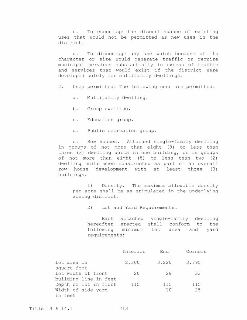
Title 14 & 14.1 213
c. To encourage the discontinuance of existing
uses that would not be permitted as new uses in the
district.
d. To discourage any use which because of its
character or size would generate traffic or require
municipal services substantially in excess of traffic
and services that would exist if the district were
developed solely for multifamily dwellings.
2. Uses permitted. The following uses are permitted.
a. Multifamily dwelling.
b. Group dwelling.
c. Education group.
d. Public recreation group.
e. Row houses. Attached single-family dwelling
in groups of not more than eight (8) or less than
three (3) dwelling units in one building, or in groups
of not more than eight (8) or less than two (2)
dwelling units when constructed as part of an overall
row house development with at least three (3)
buildings.
1) Density. The maximum allowable density
per acre shall be as stipulated in the underlying
zoning district.
2) Lot and Yard Requirements.
Each attached single-family dwelling
hereafter erected shall conform to the
following minimum lot area and yard
requirements:
Interior Street
Interior End Corners
Lot area in 2,300 3,220 3,795
square feet
Lot width of front 20 28 33
building line in feet
Depth of lot in front 115 115 115
Width of side yard 10 25
in feet

Title 14 & 14.1 214
Depth of rear yard 20 20 20
in feet
3) Height regulations. The maximum height
of any principal building shall be forty (40)
feet.
4) Safety provision. Row houses shall
have wall separations between each dwelling unit
of at least a two-hour fire-rated wall which
shall extend from the footing to and through the
roof at least thirty (30) inches except as may be
allowed by the city building code pertaining to
area separation walls.
5) Off-street parking. Off-street parking
spaces shall be provided for each dwelling unit
in compliance with Section 14-03-10 hereof.
6) Regulations Imposed on Overall
Structure. The lot coverage requirements and the
minimum front, side and rear yard setbacks shall
be imposed on the overall structure rather than
on each individual unit.
f. Health medical group. Only within area
bounded by Fourth and Tenth Streets and Avenue A and
Boulevard Avenue.
g. Single-family and two-family dwelling only
within the following described area:
1) Area bounded by Washington Street,
Boulevard Avenue, Sixteenth Street and Broadway
Avenue;
2) Area bounded by Ninth Street, Sweet
Avenue, Airport Road and Indiana Avenue;
3) Area bounded by Third Street, Divide
Avenue, Fourth Street and Boulevard Avenue.
h. Townhouses. Attached single-family dwelling
in groups of not more than ten (10) or less than four
(4).
1) Density. The maximum allowable density
per acre shall be as stipulated in the underlying
zoning district.

Title 14 & 14.1 215
2) Lot and Yard Requirements. Each
attached single-family dwelling hereafter erected
as part of a townhouse shall conform to the
following minimum lot area and yard requirements:
Interior End
Lot area in square feet 1,200 1,400
Lot width of front building
line in feet
20 25
Depth of lot in front 40 40
Depth of front yard in feet 5 5
Width of side yard in feet N/A 5
Depth of rear yard in feet N/A N/A
3) Height regulations. The maximum height
of any principal building shall be forty (40)
feet.
4) Safety provision. Townhouses shall have
wall separations between each dwelling unit of at
least a two-hour fire-rated wall which shall
extend from the footing to and through the roof
at least thirty (30) inches except as may be
allowed by the city building code pertaining to
area separation walls.
5) Off-street parking. Off-street parking
spaces shall be provided for each dwelling unit
in compliance with Section 14-03-10 hereof.
6) Regulations Imposed on Overall
Development. The lot coverage requirements and
the minimum front, side and rear yard setbacks
for the underlying district shall be imposed on
the overall development rather than on each
individual unit or structure. If the townhouse
project is arranged with each structure on a
separate common parcel rather than on a common
parcel for the overall development, the lot
coverage requirements and the minimum front, side
and rear yard setbacks for the underlying
district shall be imposed on each structure
rather than the overall development.
The following special uses are permitted as per Section
14-03-08 hereof:
a. Child care center.

Title 14 & 14.1 216
b. Religious institution.
c. Accessory dwelling unit to a single-family
home.
3. Density. The maximum allowable density per net
acre shall be stipulated in each district. The density
shall vary between three (3) and thirty (30) units per net
acre.
4. Lot area. Each permitted structure hereafter
erected, together with its accessory buildings, shall be
located on a lot having an area of not less than seven
thousand (7,000) square feet. Provided, however, that on a
record lot corresponding to a plat recorded prior to 1953, a
multiple-family dwelling and accessory buildings may be
erected subject to zone density restrictions and provided
said lot contains at least five thousand (5,000) square
feet.
5. Lot width. Each lot shall have a width of not
less than sixty (60) feet, measured along the front building
line. Provided, however, that for a record lot
corresponding to a plat or deed recorded prior to 1953, the
minimum lot width measured along the front building line may
be reduced to not less than fifty (50) feet.
6. Lot coverage. The ground area occupied by the
principal building and all accessory buildings shall not
exceed fifty (50) per cent of the total lot area. In
computing the ground coverage, off-street parking area
complying with Section 14-03-10 hereof shall be added to the
actual area of the buildings, if such spaces are not
furnished within a building.
7. Front yard. Each lot or parcel shall have a front
yard for principal or accessory structures not less than
twenty-five (25) feet in depth, provided, however, that on a
record lot corresponding to a plat recorded prior to 1979,
the following setback standards apply:
a. Reference Lots. A sample of reference lots in
the vicinity of the proposed activity are used as the
basis for front yard setbacks. Reference lots shall be
selected as follows:
1. Reference lots are the three (3) closest
adjacent lots or parcels on either side of the

Title 14 & 14.1 217
proposed activity, for a total of six (6)
reference lots.
2. Reference lots are on the same side of
the same street.
3. Reference lots contain residential
structures, irrespective of the orientation of
the structure. Vacant lots or lots with non-
residential structures are skipped over for the
next closest lot or parcel.
4. Reference lots may be selected across
local streets, but may not be selected across
collector or arterial streets.
5. Reference lots must be in the same
zoning district as the proposed activity.
6. If three (3) lots or parcels that comply
with the rules of this section are not available
on any side, a corresponding number of lots or
parcels are selected on the opposite side of the
proposed activity, so that a total number of six
(6) reference lots are selected.
7. The zoning administrator may adjust the
number of reference lots, if necessary to
determine a sample representative of the context.
b. Contextual Setback. The required front yard
for principal or accessory structures shall be the
median of all existing front yards measured from
reference lots, plus or minus three (3) feet, but no
less than the shortest front yard setback or more than
the longest front yard setback measured from all
reference lots.
c. Garage Exception. Notwithstanding the
requirements of this section, no front face of a
garage or vehicle storage unit shall be closer than
twenty (20) feet from a right-of-way line to allow an
additional parking spot in front of the garage without
encroaching into the right-of-way.
8. Side yards. Each lot shall have two (2) side
yards, one on each side of the principal building. Each
side yard shall be no less than ten (10) feet in width. No
building on a corner lot shall have a side yard on the side

Title 14 & 14.1 218
street less than twenty-five (25) feet in width. Such
sideyard setbacks on corner lots shall apply to all
structures permitted on or after August 12, 1997. Any
structure originally permitted prior to August 12, 1997 that
is damaged to the extent that the foundation is no longer
usable must comply with this section if it is rebuilt. For
buildings in excess of two stories in height permitted on or
after October 1, 2007, the required side yard setback shall
be increased by 10 feet for each additional story in height
over two.
9. Rear yard. Each lot shall have a rear yard not
less than twenty (20) feet in width. Such rear yard
setbacks shall apply to all structures permitted on or after
August 12, 1997. Any structure originally permitted prior
to August 12, 1997 that is damaged to the extent that the
foundation is no longer usable must comply with this section
if it is rebuilt. For buildings in excess of two stories in
height permitted on or after October 1, 2007, the required
rear yard setback shall be increased by 10 feet for each
additional story in height over two.
10. Height limits. No principal building shall exceed
sixty (60) feet in height. No accessory building shall
exceed twenty-five (25) feet in height. For buildings in
excess of two stories in height permitted on or after
October 1, 2007, the required side and rear yard setbacks
shall be increased by 10 feet for each additional story in
height over two.
(Ord. 4486, 04-27-93; Ord. 4564, 11-23-93; Ord. 4703, 06-13-95; Ord. 4864, 08-12-97; Ord. 4947, 10-27-98; Ord.
4970, 04-27-99; Ord. 5027, 02-08-00; Ord. 5527, 06-27-06; Ord. 5563, 11-28-06; Ord. 5641, 10-09-07; Ord.
5678, 07-22-08; Ord. 5958, 03-26-13; Ord. 6040, 04-22-14; Ord. 6044, 04-22-14; Ord. 6076, 08-12-14; Ord. 6218,
07-26-16; Ord. 6287, 10-24-17; Ord. 6361, 01-22-19)
14-04-08. RT Residential District. In any RT residential
district, the following regulations shall apply:
1. General description. The RT residential district
is established as a district in which the use of land is
high density residential uses and limited business
development. For the RT residential district, in promoting
the general purposes of this title, the specific intent of
this section is:
a. To encourage the construction of and
continued use of the land for residential purposes and
limited business uses on urban lots.

Title 14 & 14.1 219
b. To prohibit those commercial and service uses
and industrial uses characterized by a high volume of
direct daily customer contact and heavy volumes of
vehicular traffic.
c. To encourage the discontinuance of uses that
would not be permitted as new uses under the provisions
of this title.
d. To discourage the expansion of commercial
uses and encroachment of such districts into
surrounding residential districts.
e. To discourage any use, which because of its
character or size would create requirements and cost
for public services, such as police and fire
protection, water supply and sewerage substantially in
excess of such requirements if the district were
developed solely for multifamily dwellings and limited
business development.
2. Uses permitted. The following uses are permitted.
a. A single- or two-family living unit when used
in conjunction with a commercial use.
b. Multifamily dwelling.
c. Group dwelling.
d. Education group.
e. Health and medical group.
f. Public recreation group.
g. Office-bank group.
h. Row houses. Attached single-family dwelling
in groups of not more than eight (8) nor less than
three (3) dwelling units in one building, or in groups
of not more than eight (8) or less than two (2)
dwelling units when constructed as part of an overall
row house development with at least three (3)
buildings.
1) Density. The maximum allowable density
is sixteen (16) families per net acre.

Title 14 & 14.1 220
2) Lot area.
a) Lot and yard requirement regulations
for row house use. Each attached single-
family dwelling hereafter erected shall
conform to the following minimums:
Interior Street
Interior End Corners
Lot area in 2,300 3,220 3,795
square feet
Lot width of front 20 28 33
building line in feet
Depth of lot in feet 115 115 115
Depth of front yard 25 25 25
in feet
Width of side yard - 10 25
in feet
Depth of rear yard 20 20 20
in feet
3) Height regulations. The maximum height
of any principal building shall be forty (40)
feet.
4) Safety provision. Row houses shall have
wall separations between each dwelling unit of at
least a two-hour fire-rated wall which shall
extend from the footing to and through the roof at
least thirty (30) inches except as may be allowed
by Chapter 5 of the city building code pertaining
to area separation walls.
5) Access to rear yards. The required rear
yard to each row dwelling shall have an
unobstructed access to a public walkway at least
four (4) feet wide extending to an alley or
street.
6) Off-street parking. Off-street parking
spaces shall be provided for each dwelling unit as
provided under Section 14-03-10 of this ordinance.
i. Beauty shop, barber shop.
j. Ancillary retail sales of material products
directly related to the primary business such
as hair care products being sold at a beauty

Title 14 & 14.1 221
shop or barber shop. Such product display
areas shall not occupy more than 25% (twenty-
five percent) of the gross floor area of the
primary business.
The following special uses are permitted as per Section
14-03-08 hereof:
a. Religious institution.
b. Child care center.
c. Mortuary/funeral homes.
d. Drive-in/drive-through facilities for a bank,
only if located adjacent to an arterial roadway.
3. Density. The maximum allowable density is thirty
(30) families per net acre.
4. Lot area. Each building containing dwelling units
hereafter erected shall be located on a lot having not less
than the following:
a. Each multifamily dwelling hereafter erected
together with its accessory buildings shall comply with
all regulations governing such uses in an RM
residential district as provided under Section 14-04-07
except no lot shall be less than seven thousand (7,000)
square feet in size.
b. A permitted commercial use shall be located
on a lot containing at least seven thousand (7,000)
square feet.
5. Lot width. Each lot shall have a width of not
less than sixty (60) feet measured along the front building
line.
6. Lot coverage. Residential and commercial uses.
a. Residential use. The ground area occupied by
the principal building and all accessory buildings
shall not exceed fifty (50) per cent of the total lot
area. In computing the floor area ratio and ground
coverage, appropriate square footage shall be added to
the actual area of the principal building and all
accessory buildings to provide off-street parking
spaces as required by Section 14-03-10 of this

Title 14 & 14.1 222
ordinance, if such spaces are not furnished within a
building.
b. Commercial use or commercial and residential
uses. The ground area occupied by the principal
building and accessory buildings shall not exceed
seventy-five (75) per cent of the area of the lot. In
computing the ground coverage of a building, off-street
parking area complying with Section 14-03-10 hereof
shall be added to the actual area of the building, if
such spaces are not furnished within the building.
7. Front yard. Each lot shall have a front yard not
less than fifteen (15) feet in depth.
8. Side yards. Each lot shall have two (2) side
yards, one on each side of the principal building. Each
side yard shall be no less than ten (10) feet in width. For
buildings in excess of two (2) stories in height permitted
on or after December 22, 2009, the required side yard
setbacks shall be increased by ten (10) feet for each
additional story in height over two (2).
9. Rear yards. Each lot shall have a rear yard not
less than ten (10) feet in depth. For buildings in excess
of two (2) stories in height permitted on or after December
22, 2009, the required rear yard setback shall be increased
by ten (10) feet for each additional story in height over
two (2).
10. Height limit. No principal building shall exceed
fifty (50) feet in height; no accessory building shall
exceed twenty-five (25) feet in height. For buildings in
excess of two (2) stories in height permitted on or after
December 22, 2009, the required side and rear yard setbacks
shall be increased by ten (10) feet for each additional
story in height over two (2) as required by this section.
(Ord. 4323, 4-24-90; Ord. 4351, 1-02-91; Ord. 4564, 11-23-93; Ord. 4703, 06-13-95; Ord. 5027, 02-08-00; 5451,
08-23-05; Ord. 5527, 06-27-06; Ord. 5763, 12-22-09; Ord. 5958, 03-26-13; Ord. 6040, 04-22-14; Ord. 6076, 08-
12-14; Ord. 6279, 08-22-17; Ord. 6361, 01-22-19)
14-04-09. HM Medical Facility District.
1. General description. The HM medical facility
district is established as a district in which the principal
use of the land is for health and medical uses. For HM
medical facility districts, in promoting the general
purposes of this title, the specific intent of this section
is:

Title 14 & 14.1 223
a. To encourage construction and continuing
operation of the land uses which directly affect the
health of community residents on urban lots.
b. To provide an identifiable area within the
community for cooperation and continuing medical
research and treatment of human beings.
c. To provide for such other uses as are in
harmony with the medical uses existing in the district.
d. To prohibit uses which are or may be
disruptive of the main purpose of the district.
e. To encourage discontinuance of existing uses
that would not be permitted as new uses under the
provision of this title.
2. Uses permitted. The following uses are permitted
in HM medical facility districts:
a. Single-family dwelling.
b. Two-family dwelling.
c. Multiple family housing.
d. Row houses/townhouses (subject to all
requirements for same in RM residential zone.)
e. Group dwelling.
f. Professional offices other than health care
offices provided they occupy no more than fifty (50)
per cent of the gross leasable area of any structure.
g. Education group.
h. Hotel.
i. Motel.
j. Health-medical group.
k. Public recreation group.
l. Restaurant, provided that all food is
consumed within and enclosed building and provided

Title 14 & 14.1 224
further that this use is an accessory use to another
allowable use in this district.
m. Service group A uses as follows: Travel
agency, barbershop, beauty shop, dressmaker, tailor,
dry cleaning pickup agency, laundry pickup agency and
self-service laundry.
n. Retail group A uses as follows: Book,
magazine or newspaper store, candy store, delicatessen,
drugstore, flower shop, ice cream parlor and hobby
shop.
o. Commercial parking lot.
p. Banks.
The following special uses are permitted as per Section
14-03-08 hereof:
a. Child care center.
b. Religious institution.
3. Density. Maximum allowable densities are the
same as allowed for the corresponding type of construction
and occupancy in RM residential zone.
4. Lot area. Each building containing dwelling units
hereafter erected shall be located on a lot having not less
than the following:
a. Each multifamily dwelling, townhouse or row
house hereafter erected together with its accessory
building shall comply with all regulations governing
such uses in RM residential district as provided under
Section 14-04-07 except no lot shall be less than seven
thousand (7,000) square feet in size. Provided,
however, that on a record lot corresponding to a plat
recorded prior to 1953, a single-family or two-family
dwelling and accessory buildings may be erected on a
lot containing not less than five thousand (5,000)
square feet.
b. Any other permitted uses shall be located on
a lot containing at least seven thousand (7,000) square
feet.

Title 14 & 14.1 225
5. Lot width. Each lot shall have a width of not
less than sixty (60) feet measured along the front building
line; provided, however, that on a record lot corresponding
to a plat or deed recorded prior to 1953, the minimum lot
width measured along the front building line may be reduced
to not less than fifty (50) feet.
6. Lot coverage. Residential and commercial use.
a. Residential use. The ground area of the
principal building and all accessory buildings shall
not exceed fifty (50) per cent of the total lot area.
In computing the ground coverage, sufficient area shall
be added to the actual area of the buildings to provide
off-street parking spaces as required by Section
14-03-10 of this ordinance, if such spaces are not
furnished within a building.
b. Commercial use or commercial and residential
uses. The ground area occupied by the principal
building and accessory building shall not exceed
seventy-five (75) per cent of the area of the lot. In
computing the ground coverage of a building, sufficient
area shall be added to the coverage of said building
for off-street parking space as required by Section
14-03-10 if such spaces are not furnished within the
building.
Exception. Upon presentation of a site plan
indicating building locations, sizes, design and other
land uses, the board of adjustment may adjust lot
coverage up to one hundred (100) per cent of the lot.
7. Front yard. There is no minimum front yard
setback, unless the property is immediately adjacent to a
residentially-zoned property, in which case the minimum
front yard setback shall be fifteen (15) feet.
8. Side yards. A lot on which is erected a
residential structure shall have two (2) side yards, one on
each side of the principal building. The sum width of the
two (2) side yards shall not be less than twenty (20) per
cent of the average width of the lot. In no case shall the
side yard be less than six (6) feet. On any lot on which
the principal building is designed and used for
nonresidential use, no side yards shall be required except
where such lot is located adjacent to a residential district
in which case that side adjoining such residential district
shall comply with the side yard requirement of such

Title 14 & 14.1 226
residential district. Commercial buildings of wood and
unprotected metal shall have side yards, complying with the
requirements of the city building code, Chapter 4-02 of the
Code of Ordinances of the City of Bismarck. All side yards
are subject to variance under provisions of subsection
(6)(b) of this district regulation.
9. Rear yards. Each lot shall have a rear yard not
less than ten (10) feet in depth, except as may be allowed
under provisions of subsection 6(b) of this district
regulation. Provided, however, that where the rear of a lot
adjoins an alley, no rear yard shall be required for a
principal non-residential building.
10. Height limit. No nonmedical principal building
shall exceed fifty (50) feet in height; no accessory
building shall exceed twenty-five (25) feet in height.
Buildings housing more than fifty (50) per cent occupants
whose uses fall within health-medical group uses in excess
of fifty (50) feet in height may not be located within one
hundred (100) feet of a single- or two-family dwelling in a
residential zoning district.
(Ord. 4351, 1-02-91; Ord. 4486, 04-27-93; Ord. 4564, 11-23-93; Ord. 4703, 06-13-95; Ord. 5027, 02-08-00; Ord.
5527, 06-27-06; Ord. 5768, 04-27-10; Ord. 5958, 03-26-13; Ord. 6040, 04-22-14)
14-04-10. CA Commercial District. In any CA commercial
district, the following regulations shall apply:
1. General description. The CA commercial district
is established as a district in which the predominant use of
the land is for commercial and service uses to serve
residential districts in the general area. The CA
commercial district should be served by arterial or
collector streets. For the CA commercial district, in
promoting the general purposes of this article, the specific
intent of this section is:
a. To encourage the continued use of the land
for neighborhood commercial and services uses.
b. To prohibit heavy commercial and services
uses and industrial uses of the land, and to prohibit
any other use which would substantially depreciate the
value of residential districts surrounding the CA
commercial district.
c. To encourage the discontinuance of mixed uses
and uses that would not be permitted as new uses under
the provisions of this article.

Title 14 & 14.1 227
d. To discourage the expansion of CA commercial
districts and the encroachment of such districts into
surrounding residential districts.
e. To discourage any use, which because of its
character or size, would create requirements and costs
for public services, such as police and fire
protection, water supply and sewerage substantially in
excess of those necessary if the district were
developed solely for neighborhood commercial and
service uses.
2. Uses permitted. The following uses are permitted:
a. A single- or two-family dwelling when used in
conjunction with a commercial use.
b. Multifamily dwelling.
c. Group dwelling.
d. Row houses/townhouses (subject to RM
residential zone regulations).
e. Retail group A.
f. Service group A.
g. Office-bank group.
h. Health-medical group.
i. Public recreation group.
j. Education group.
k. Religious institution.
The following special uses are permitted as per Section
14-03-08 hereof:
a. Temporary Christmas tree sales.
b. Temporary farm and garden produce sales.
c. Filling station.
d. Seasonal nursery and bedding stock sales.

Title 14 & 14.1 228
e. Child care center.
f. Drive-in bank.
g. Retail liquor sales.
h. Microbrew pub.
i. Domestic distillery.
3. Lot area.
a. Commercial use. Each principal building
hereafter erected, together with accessory buildings,
shall be located on a lot having an area of not less
than seven thousand (7,000) square feet.
b. Multifamily residential use. Each dwelling
unit hereafter erected or altered shall comply with all
regulations governing such uses in an RM residential
district.
4. Lot width. Each residential lot shall have a
width of not less than sixty (60) feet, measured along the
front building line.
5. Lot coverage.
a. Commercial use. The lot coverage of a
commercial building and its accessory buildings shall
not exceed seventy (70) per cent of the lot area. In
computing the lot coverage of a commercial building and
its accessory buildings, sufficient area shall be added
to its ground coverage for each off-street parking
space as required by Section 14-03-10 of this
ordinance.
b. Residential use. The ground area occupied by
the principal building and all accessory buildings
shall not exceed fifty (50) per cent of the total area.
In computing the lot coverage, sufficient area shall be
added to the actual area of the principal building and
all accessory buildings to provide off-street parking
spaces as required by Section 14-03-10 of this
ordinance if such spaces are not furnished within a
building.

Title 14 & 14.1 229
6. Front yard. Each lot shall have a front yard not
less than fifteen (15) feet in depth.
7. Side yard.
a. Residential use. Each lot shall have two
(2) side yards, one on each side of the principal
building. The sum of the widths of the two (2) side
yards shall be not less than twenty (20) per cent of
the average width of the lot. In no case shall the
side yard be less than ten (10) feet. For buildings in
excess of two (2) stories in height permitted on or
after December 22, 2009, the required side yard
setbacks shall be increased by ten (10) feet for each
additional story in height over two (2).
b. Commercial use. On any lot on which the
principal building is designed or used for a commercial
use, the side yards shall be at least ten (10) feet in
width. For buildings in excess of two (2) stories in
height permitted on or after December 22, 2009, the
required side yard setbacks shall be increased by ten
(10) feet for each additional story in height over two
(2) for any side yard located adjacent to an R5, R10 or
RM zoning district.
8. Rear yard.
a. Residential use. Each lot shall have a rear
yard not less than ten (10) feet in depth. For
buildings in excess of two (2) stories in height
permitted on or after December 22, 2009, the required
rear yard setback shall be increased by ten (10) feet
for each additional story in height over two (2).
b. Commercial use. Each lot shall have a rear
yard not less than ten (10) feet in depth unless
adjacent to a public alley. For buildings in excess of
two (2) stories in height permitted on or after
December 22, 2009, the required rear yard setback shall
be increased by ten (10) feet for each additional story
in height over two (2) for any rear yard located
adjacent to an R5, R10 or RM zoning district.
9. Height limits.
a. Commercial buildings. No building shall
exceed forty (40) feet in height. No accessory
building shall exceed twenty-five (25) feet in height.

Title 14 & 14.1 230
For buildings in excess of two (2) stories in height,
permitted on or after December 22, 2009, the required
side and rear yard setbacks shall be increased by ten
(10) feet for each additional story in height over two
(2) for any side or rear yard located adjacent to an
R5, R10 or RM zoning district.
b. Residential buildings. Height limits shall
follow those in effect in RM residential zones. For
buildings in excess of two (2) stories in height,
permitted on or after December 22, 2009, the required
side and rear yard setbacks shall be increased by ten
(10) feet for each additional story in height over two
(2).
10. Off-street parking space. Off-street parking
space requirements of Section 14-03-10 hereof shall be
complied with.
(Ord. 4564, 11-23-93; Ord. 4702, 06-13-95; Ord. 4808, 11-12-96; Ord. 5027, 02-08-00; Ord. 5527, 06-27-06; Ord.
5763, 12-22-09; Ord. 5958, 03-26-13; Ord. 6010, 09-24-13; Ord. 6040, 04-22-14; Ord. 6456, 03-29-21)
14-04-11. CB Commercial District. Section 14-04-11 is
hereby repealed.
(Ord. 4564, 11-23-93; Ord. 4703, 06-13-95; Ord. 4808, 11-12-96; Ord. 5027, 02-08-00; Ord. 5564, 11-28-06)
14-04-12. CG Commercial District. In any CG commercial
district, the following regulations shall apply:
1. General description. The CG commercial district
is a heavy commercial area located outside the central
business district to provide commerce and service to the
City of Bismarck and surrounding regional market. The CG
commercial district is established to promote the general
purpose of this article, the specific intent of this section
is:
a. To encourage the continued expansion of the
commercial facilities within the city without creating
increased vehicular congestion in the existing central
business district.
b. To provide an orderly and comprehensive
expansion of commercial services within the city.
c. To prevent commercial encroachment on
existing residential districts.
d. To encourage the development of a
conveniently arranged district offering a broad range

Title 14 & 14.1 231
of commercial and professional services in a relaxed
atmosphere and in an area where adequate off-street
parking will be provided.
2. Uses permitted. The following uses are permitted:
a. A single- or two -family dwelling when used
in conjunction with a commercial use.
b. Multifamily dwelling.
c. Group dwelling.
d. Multifamily high rise.
e. Hotel-motel.
f. Retail group A.
g. Service group A.
h. Office-bank group.
i. Retail group B.
j. Service group B.
k. Commercial recreation group.
l. Wholesale group.
m. Health-medical group.
n. Education group.
o. Public recreation group.
p. Railroad or bus passenger station.
q. Commercial greenhouse.
r. Commercial parking lot.
s. Religious institution.
t. Microbrew pub.
u. Domestic distillery.

Title 14 & 14.1 232
The following uses are allowed as special uses pursuant
to Section 14-03-08 hereof:
a. Temporary Christmas tree sales.
b. Temporary religious meetings.
c. Temporary farm and garden produce sales.
d. Seasonal nursery and bedding stock sales.
e. Filling station.
f. Drive-in retail or service establishment.
g. Child care center.
h. Small animal veterinary clinic.
i. Golf driving range.
j. Auto laundry - car wash.
k. Retail liquor sales.
3. Lot area. Any permitted principal building or
structure, together with its accessory buildings shall be
located on a lot having an area of not less than seven
thousand (7,000) square feet. Provided, however, that such
building and accessory buildings may be located on a lot
containing not less than five thousand (5,000) square feet
if such lot is on a plat recorded prior to 1953.
4. Lot width. Each lot shall have a width of not
less than sixty (60) feet, measured along the front building
line. Provided, however, that on a record lot corresponding
to a plat or deed recorded prior to 1953, the minimum lot
width measured along the front building line may be reduced
to not less than fifty (50) feet.
5. Lot coverage. The lot coverage of any
nonresidential building and its accessory building shall not
exceed eighty (80) per cent. In computing the lot coverage,
sufficient area shall be added for each off-street parking
space as required in Section 14-03-08 of this article. For
the purposes of this section any structure with living units
below the second floor shall be considered a residential
use. All residential uses shall comply with RM residential
zone regulations.

Title 14 & 14.1 233
6. Front yard. A fifteen (15) foot front yard shall
be required of any building in a CG commercial district
except that all structures located on principal arterials
shall have a fifty (50) foot front yard. Buildings located
on the following principal arterials shall be exempt from
the fifty (50) foot front yard requirement: Main Avenue
west of 26th Street; State Street between Divide Avenue and
Interstate 94; and 7th and 9th Streets between Bismarck
Expressway and Boulevard Avenue.
7. Side yards. No side yard shall be required of any
principal nonresidential building in a CG district. For
non-residential buildings in excess of two (2) stories in
height permitted on or after December 22, 2009, the required
side yard setbacks shall be increased by ten (10) feet for
each additional story in height over two (2) for any side
yard located adjacent to an R5, R10 or RM zoning district.
Residential structures shall comply with requirements in
effect for RM residential zones.
8. Rear yard. Each lot shall have a rear yard not
less than ten (10) feet in depth. Provided, however, that
where the rear of a lot adjoins an alley, no rear yard shall
be required for a principal nonresidential building. For
non-residential buildings in excess of two (2) stories in
height permitted on or after December 22, 2009, the required
rear yard setback shall be increased by ten (10) feet for
each additional story in height over two (2) for any rear
yard located adjacent to an R5, R10 or RM zoning district.
Residential structures shall comply with requirements in
effect for RM residential zones.
9. Height limit. No building shall exceed one
hundred thirty (130) feet in height. For buildings in
excess of two (2) stories in height permitted on or after
December 22, 2009, the required side and rear yard setbacks
shall be increased by ten (10) feet for each additional
story in height over two (2) as required by this section.
10. Dwelling regulations. Each multifamily or group
dwelling hereafter erected shall comply with all regulations
governing such uses in an RM residential district.
11. Dwelling regulations – high-rise. Each
multifamily high-rise dwelling hereafter erected shall
comply with the following regulations:

Title 14 & 14.1 234
a. Height limits. No multifamily high-rise
apartment house shall exceed one hundred thirty (130)
feet in height. For each story in excess of two (2)
there shall be added one foot to the minimum width and
depth of each required yard.
b. Maximum density. The maximum allowable
density is forty-two (42) families per acre.
c. Lot coverage. The ground area occupied by
the principal building and all accessory buildings
shall not exceed seventy-five (75) per cent of the
total lot area. In computing the floor area ratio and
ground coverage, sufficient parking area shall be added
to the actual area of the principal building and all
accessory buildings to provide off-street parking
spaces as required by Section 14-03-10 of this
ordinance, if such spaces are not furnished within a
building.
d. Front yard. Each lot shall have a front yard
not less than fifteen feet in depth.
e. Side yards. Each lot shall have two side
yards, one on each side of the principal building. The
minimum width of each side yard shall be fifteen feet.
No building on a corner lot shall have a side yard on
the side street of less than fifteen feet; provided,
further, that no high-rise dwelling shall be located
within one hundred fifty feet of any residential zoning
district.
f. Rear yard. Each lot shall have a rear yard
of not less than fifteen feet in depth.
12. Off-street parking and loading space. Off-street
parking and loading space requirements of section 14-03-10
hereof shall be complied with.
(Ord. 4208, 5-10-88; Ord. 4486, 04-27-93; Ord. 4564, 11-23-93; Ord. 4703, 06-13-95; Ord. 4734, 11-14-95; Ord.
4735, 11-14-95; Ord. 4808, 11-12-96; Ord. 4811, 12-17-96; Ord. 5027, 02-08-00; Ord. 5527, 06-27-06; 5719, 05-
12-09; Ord. 5763, 12-22-09; Ord. 5958, 03-26-13; Ord. 6040, 04-22-14; Ord. 6190, 03-08-16; Ord. 6423, 07-25-
20; Ord. 6456, 03-29-21)
14-04-13. CR Commercial District. Repealed.
(Ord. 6234, 10-25-16)
14-04-14. MA Industrial District. In any MA industrial
district the following regulations shall apply:

Title 14 & 14.1 235
1. General description. The MA industrial district
is established as a district in which the principal use of
land is for heavy commercial establishments and non-nuisance
industries. For MA industrial districts, in promoting the
general purposes of this article, the specific intent of
this section is:
a. To encourage the construction of and the
continued use of the land for commercial and industrial
buildings.
b. To prohibit use of the land for heavy
nuisance industry or any other use which would
substantially interfere with the development or
continuation of commercial and industrial
establishments in the district.
c. To encourage the discontinuance of existing
uses that would not be permitted as new uses under the
provisions of this article.
d. To discourage the use of the land for
residences for the purpose both of preserving the area
for its appropriate use and for preventing the location
of residences in an area inappropriate for residential
use.
2. Uses permitted. The following uses are permitted:
a. Hotel-motel.
b. Retail group A.
c. Retail group B.
d. Service group A.
e. Service group B.
f. Wholesale group.
g. Truck terminal.
h. Railroad or bus passenger station.
i. Railroad freight station.
j. Industrial group A.

Title 14 & 14.1 236
k. Radio or television transmitting station.
l. Commercial recreation group.
m. Office-bank group.
n. Religious institution.
o. Microbrew pub.
p. Domestic distillery.
q. Brewer Taproom.
The following uses are allowed as special uses pursuant
to Section 14-03-08 hereof:
a. Temporary Christmas tree sales.
b. Temporary religious meetings.
c. Temporary circus/fair/carnival.
d. Temporary farm and garden produce sales.
e. Temporary fireworks sales.
f. Seasonal nursery and bedding stock sales.
g. Solid waste disposal facility.
h. Airport.
i. Recreational vehicle park.
j. Filling station.
k. Drive-in retail or service establishment.
l. Motor vehicle parts salvage yard.
m. Small animal veterinary clinic.
n. Animal hospital or kennel.
o. Golf driving range.
p. Junkyard.

Title 14 & 14.1 237
q. Retail liquor sales.
r. Racetracks.
s. Child care center.
t. Asphalt production facilities, both permanent
and temporary.
3. Lot area. Each principal building hereafter
erected, together with its accessory buildings, shall be
located on a lot having an area of not less than ten
thousand (10,000) square feet.
4. Lot width. Each lot shall have width of not less
than sixty (60) feet measured along the front building line.
5. Lot coverage. The ground area occupied by the
principal building or buildings and accessory buildings
shall not exceed eighty (80) percent of the total area of
the lot. In computing the lot coverage of a principal
building and its accessory buildings, sufficient area shall
be added to its ground coverage for each off-street parking
space as required by Section 14-03-10 of this ordinance.
6. Front yard. A fifteen (15) foot front yard shall
be required of any building in an MA industrial district
except that all structures located on principal arterials
shall have a fifty (50) foot front yard. Buildings located
on the following principal arterials shall be exempt from
the fifty (50) foot front yard requirement: Main Avenue
west of 26th Street; State Street between Divide Avenue and
Interstate 94; and 7th and 9th Streets between Bismarck
Expressway and Boulevard Avenue.
7. Side yards. No side yards shall be required
except where a lot adjoins a lot in a residential district.
The side yards shall be as required for the residential
district.
8. Rear yard. A rear yard of at least ten (10) feet
is required except when located adjacent to a public alley.
9. Height limits. No principal building shall exceed
seventy-five (75) feet in height. All accessory buildings
shall not exceed fifty (50) feet in height.

Title 14 & 14.1 238
10. Off-street parking and loading space. Off-street
parking and loading requirements of Section 14-03-10 hereof
shall be complied with.
(Ord. 4242, 2-28-89; Ord. 4461, 08-18-92; Ord. 4486, 04-27-93; Ord. 4735, 11-14-95; Ord. 4808, 11-12-96; Ord.
4811, 12-17-96; Ord. 4912, 07-14-98; Ord. 5958, 03-26-13; Ord. 6040, 04-22-14; Ord. 6179, 12-22-15; Ord. 6190,
03-08-16; Ord. 6423, 07-25-20; Ord. 6456, 03-29-21)
14-04-15. MB Industrial District. In any MB industrial
district the following regulations shall apply:
1. General description. The MB industrial district
is established as a district in which the principal use of
land is for heavy commercial and industrial establishments,
which may create some nuisance, and which are not properly
associated with nor compatible with residential,
institutional and neighborhood commercial and service
establishments. For the MB industrial district, in
promoting the general purposes of this article, the specific
intent of this section is:
a. To encourage the construction of and the
continued use of the land for heavy commercial and
industrial purposes.
b. To prohibit residential and neighborhood
commercial use of the land and to prohibit any other
use which would substantially interfere with the
development, continuation or expansion of commercial
and industrial uses in the district.
2. Use permitted. The following uses are permitted.
a. Retail group B.
b. Service group B.
c. Wholesale group.
d. Truck terminal.
e. Railroad freight classification yards and
stations.
f. Farming group.
g. Industrial group A.
h. Industrial group B.

Title 14 & 14.1 239
i. Oil or gas well.
j. Radio or television transmitting station.
k. Sand or gravel extraction and processing.
l. Sewage treatment plant.
The following uses are allowed as special uses pursuant
to Section 14-03-08 hereof:
a. Temporary Christmas tree sales.
b. Temporary circus/fair/carnival.
c. Temporary religious meeting.
d. Seasonal nursery and bedding stock sales.
e. Temporary fireworks sales.
f. Temporary farm and garden produce sales.
g. Airport.
h. Solid waste disposal facility.
i. Motor vehicle parts salvage yard.
j. Small animal veterinary clinic.
k. Animal hospital or kennel.
l. Junkyard.
m. Adult entertainment center.
n. Auto laundry - car wash.
o. Vehicular racetrack.
p. Hazardous material bulk storage plant.
3. Lot area. Each principal building hereafter
erected, together with its accessory buildings, shall be
located on a lot having not less than ten thousand (10,000)
square feet. Provided, however, that in a MB industrial
district, and in no other residential, commercial or
industrial district, it is permissible to erect more than

Title 14 & 14.1 240
one principal building on a zoning lot, provided that all
other requirements of this section and this article are
complied with.
4. Lot width. Each lot shall have a width of not
less than seventy-five (75) feet measured along the front
building line.
5. Lot coverage. The lot coverage of the principal
building and all accessory buildings shall not exceed eighty
(80) percent of lot. In computing the lot coverage of a
principal building and its accessory buildings, sufficient
area shall be added to its ground coverage for each off-
street parking space as required by Section 14-03-10 of this
ordinance.
6. Front yard. Each lot shall have a front yard not
less than fifty (50) feet in depth.
7. Side yards. Each lot shall have two (2) side
yards, one on each side of any principal building. The sum
of the widths of the two (2) side yards shall be not less
than twenty (20) per cent of the average width of the lot.
On any lot having an average width of seventy-five (75) feet
or less, each side yard shall be not less than ten (10) per
cent of the width of the lot, and in no case shall a side
yard be less than five (5) feet in width. On a lot having
an average width greater than seventy-five (75) feet,
neither side yard shall be less than seven and one-half
(7.5) feet in width and no side yard need be greater than
fifty (50) feet in width. On a lot containing two (2)
principal buildings located side by side, there are no
minimum requirements for side yards between the two (2)
buildings.
8. Rear yard. Each lot shall have a rear yard not
less than twenty-five (25) feet in depth.
9. Height limits. No principal building shall exceed
seventy-five (75) feet in height. No accessory building
shall exceed fifty (50) feet in height.
10. Off-street parking and loading space. Off-street
parking and loading requirements of Section 14-03-10 hereof
shall be complied with.
(Ord. No. 4242, 02-28-89; Ord. 4486, 04-27-93; Ord. 6190, 03-08-16; Ord. 6423, 07-25-20)
14-04-16. "P" Public Use District. In any P public use
district the following regulations shall apply.

Title 14 & 14.1 241
1. General description. The P public use district is
established as a district in which the predominant use of
land is for public uses. For the P public use district, in
promoting the general purposes of this article, the specific
intent of this section is:
a. To encourage the continued use of the land
for public recreation, education and other government
services.
b. To prohibit residential, commercial and
industrial uses of the land, and to prohibit any use of
the land which would diminish its value in serving the
needs of the public.
2. Uses permitted. The following uses are permitted.
a. Education group.
b. Public recreation group.
c. Water treatment plant.
d. Buildings and necessary on-site facilities
required for conduct of government.
e. Commercial recreation group occupying public
owned lands.
f. Sewerage treatment plant.
g. Municipal landfill.
h. Parking lots.
i. Gift shop occupying public owned lands.
j. Food service establishment exclusive of
drive-in restaurant, occupying public owned lands.
The following special uses are permitted as per Section
14-03-08 hereof:
a. Airport.
b. Cemetery.

Title 14 & 14.1 242
3. Lot coverage. The lot coverage of the principal
building and all accessory buildings shall not exceed thirty
(30) per cent of the lot.
4. Front yard. Each lot shall have a front yard of
not less than twenty-five (25) feet in depth.
5. Side yards. Each lot shall have two (2) yards,
one on each side of the principal building. The sum of the
widths of the two (2) side yards shall be not less than
twenty (20) per cent of the average width of the lot. On
any lot having an average width of sixty (60) feet or less,
each side yard shall be not less than ten (10) per cent of
the width of the lot, and in no case shall a side yard be
less than five (5) feet in width. On any lot having an
average width greater than sixty (60) feet neither side yard
shall be less than six (6) feet in width; provided, however,
that for a building thirty-five (35) feet or less in height,
neither side yard is required to exceed fifteen (15) feet in
width.
6. Rear yard. Each lot shall have a rear yard not
less than twenty (20) feet in depth.
7. Height limits. No principal building shall exceed
seventy-five (75) feet in height, unless said principal
building is within three hundred (300) feet of a residential
zoning district, in which case no principal building shall
exceed fifty (50) feet in height. For each one foot or
fraction thereof that a building exceeds thirty-five (35)
feet in height there shall be added four (4) feet to the
minimum width of each side yard, two (2) feet to the minimum
depth of front yard, and two (2) feet to the minimum depth
of rear yard required by this section. Any accessory
building that exceeds twenty-five (25) feet in height shall
be considered a principal building for the purpose of
figuring yards and distance from lot boundary lines.
8. Additional Development Standards for Land Abutting
the Missouri River. In order to preserve and enhance the
environmental and recreational qualities of the Missouri
River, conserve the scenic and historic values of the
Missouri River shoreland, protect shoreland development from
river bank erosion, and provide for the wise use of the
river and related land resources, the following additional
development standards are hereby established for land
abutting the Missouri River which is outside of the
corporate limits of the City of Bismarck and within the
Extraterritorial Area (ETA):

Title 14 & 14.1 243
a. Structure Setbacks. All structures shall be
setback a minimum of 100 feet from the ordinary high
water mark of the Missouri River.
b. Design Criteria. Structures should be placed
and designed in a manner as to reduce visibility as
viewed from the river and adjacent shoreland by
vegetation, topography or the color of the structure,
assuming summer, leaf-on conditions.
c. Impervious Surface Coverage. The percentage
of lot covered by impervious surfaces (structures,
paved surfaces, etc.) shall not exceed 25 percent of
the lot area.
d. On-Site Sewage Treatment Facility Setbacks.
All sewage treatment facilities, including drainfields,
shall be setback a minimum of 100 feet from the
ordinary high water mark of the Missouri River.
e. Stairways, Lifts and Landings. Stairways and
lifts are the preferred alternative to major
topographic alterations for achieving access up and
down bluffs and steep slopes to shore areas. Stairways
and lifts must meet the following design requirements:
1) stairways and lifts shall not exceed four feet in
width; 2) landings for stairways and lifts shall not
exceed 32 square feet in area; 3) canopies or roofs are
not allowed on stairways, lifts or landings; 4)
stairways, lifts and landings may be constructed on
posts/pilings or placed in the ground, provided they
are designed and built in a manner that controls soil
erosion, meets building code requirements, and does not
affect the integrity of bank stabilization projects.
f. Boat Docks. The placement of boat docks
shall be allowed in accordance with the requirements of
the North Dakota Century Code and any other applicable
regulations.
g. Shore Impact Zone. Structures and accessory
facilities, except stairways and landings, shall not be
placed within a shore impact zone.
h. Steep Slopes. For structures and/or
facilities to be placed on steep slopes, the Building
Official may attach conditions on the building permit
to prevent erosion and preserve existing vegetation.
Title 14 & 14.1 244
i. Vegetation Alterations. Intensive vegetative
clearing within the shore impact zone and on steep
slopes is prohibited. Limited clearing of vegetation
is permitted in order to provide a view of the river
from the principal dwelling site and to accommodate the
placement of permitted stairways, lifts or landings.
Removal of vegetation that is dead, diseased or that
poses a safety hazard is allowed.
j. Topographic Alterations Above the Ordinary
High Water Mark. Grading, filling and excavation
necessary for the construction of structures, sewage
treatment systems or driveways under validly issued
permits shall be allowed. Notwithstanding any other
applicable regulations, any other topographic
alterations must meet the following standards: 1)
alterations shall not adversely affect adjacent or
nearby properties; and 2) alterations must be designed
and conducted in a manner that minimizes soil erosion,
including the installation of erosion control measures
as needed.
k. Topographic Alterations Below the Ordinary
High Water Mark. All topographic alterations below the
ordinary high water mark must be approved by the United
States Army Corps of Engineers.
(Ord. 4384, 07-30-91; Ord. 5486, 02-28-06; Ord. 6130, 06-23-15)
14-04-17. "A" Agricultural District. In an A
agricultural district, the following regulations shall apply:
1. General description. The agricultural district is
established as a district in which the predominant use of
land is for general agricultural uses. For an A
agricultural district, in promoting the general purposes of
this ordinance, the specific intent of this section is:
a. To encourage the continued use of land for
agricultural uses.
b. To prohibit scattered commercial and
industrial use of land, and to prohibit any other use
which would interfere with an integrated and efficient
development of the land for more intensive urban uses
as the city expands.
c. To discourage any use, which because of its
character or size, would create unusual requirements

Title 14 & 14.1 245
and costs for public services, such as police and fire
protection, water supply and sewerage before such
services could be expanded efficiently in the normal
development of the city.
d. To provide additional development standards
for non-farm rural properties abutting the Missouri
River developed after November 25, 2003.
2. Uses permitted. The following uses are permitted.
a. Public recreation group.
b. Farming group.
c. Golf course.
d. Livestock sales pavilion.
e. Loam stripping.
f. Oil or gas well.
g. Radio or television transmitting station.
h. Sand or gravel extraction and processing.
i. Sewage treatment plant.
j. One single-family dwelling shall be allowed
for each parcel of land not less than forty (40) acres
in size or the aliquot part of a corrective section
intended to comprise a quarter-quarter-section,
provided such aliquot part is not less than thirty-five
(35) acres in size. For purposes of this section, a
parcel refers to a contiguous tract of land which is
taxed as a single tax parcel, located within a single
section of land, and not bisected by a public roadway.
k. Family child care.
The following special uses are allowed as per Section
14-03-08 hereof:
a. Temporary circus/fair/carnival.
b. Temporary Christmas tree sales.
c. Temporary religious meetings.

Title 14 & 14.1 246
d. Seasonal nursery and bedding stock sales.
e. Temporary fireworks sales.
f. Temporary farm and garden produce sales.
g. Solid waste disposal facility.
h. Recreational vehicle park.
i. Small animal veterinary clinic.
j. Animal hospital or kennel.
k. Airport.
l. Cemetery.
m. Junkyard.
n. Child care center.
o. Religious institution.
p. Golf driving range.
q. Vehicular racetrack.
r. Hazardous material bulk storage plant.
s. Concrete and asphalt production facilities,
both permanent and temporary.
t. Accessory dwelling unit.
3. Lot width. Each lot shall have a width of not
less than six hundred sixty (660) feet, measured along the
front property line.
4. Front yard. Each lot shall have a front yard as
follows, as measured from the property line:
Arterial Road
(feet)
Collector Road
(feet)
Local Road
(feet)
175 125 40

Title 14 & 14.1 247
All section line roads shall be classified as arterial
highways unless specifically designated as a collector
highway or local road.
5. Side yards. Each lot shall have two (2) side
yards, one on each side of the principal building. The sum
of the width of the two (2) side yards shall be not less
than twenty (20) per cent of the average width of the lot,
but in no case less than fifteen (15) feet per yard.
Provided further, that no building housing livestock or
poultry shall be less than fifty (50) feet distant from any
residential building on an adjacent lot, nor shall such a
building be less than fifty (50) feet from the boundary of
any lot in a residential or commercial district. No
building on a corner lot shall have a side yard on the side
street less than the front yard requirements specified in
this section.
6. Rear yard. Each lot shall have a rear yard not
less than twenty (20) feet in depth. If such rear yard
abuts an arterial or collector road right-of-way, building
locations shall also conform to the front yard requirements
specified in this section.
7. Height limits. No principal building for any
permitted use shall exceed fifty (50) feet in height. For
each one foot or fraction thereof that a building exceeds
thirty-five (35) feet in height, there shall be added four
(4) feet to the minimum width of each side yard, two (2)
feet to the minimum depth of front yard, and two (2) feet to
the minimum depth of rear yard required by this section.
Any accessory building that exceeds twenty-five (25) feet in
height shall be considered a principal building for the
purpose of figuring yards and distances from lot boundary
lines.
8. Parking requirements. All requirements for off-
street parking and loading as shown in Section 14-03-10 of
this ordinance shall apply only to nonagricultural uses
which involve building(s).
9. Definition of "farm." For the purpose of the
administration of this ordinance - A "farm" shall mean a
single tract, or contiguous tract, of agricultural land
containing a minimum of ten (10) acres and which normally
provides a farmer, who is actually farming the land or
engaged in the raising of livestock or other similar
operations normally associated with farming and ranching,
with not less than fifty (50) per cent of his annual net

Title 14 & 14.1 248
income; and the term "farmer" means an individual who
normally devotes the major portion of his/her time to the
activities of producing products of the soil, poultry,
livestock, or dairy farming in such products' unmanufactured
state and who normally receives not less than fifty (50) per
cent of his/her annual net income from any one or more of
the foregoing activities; and the term also includes an
individual who is retired because of illness or age and who
at the time of retirement owned and occupied, as a farmer,
the premises.
10. Additional Development Standards for Land
Abutting the Missouri River. In order to preserve and
enhance the environmental and recreational qualities of the
Missouri River, conserve the scenic and historic values of
the Missouri River shoreland, protect shoreland development
from river bank erosion, and provide for the wise use of the
river and related land resources, the following additional
development standards are hereby established for land
abutting the Missouri River:
a. Structure Setbacks. All structures shall be
setback a minimum of 100 feet from the ordinary high
water mark of the Missouri River.
b. Design Criteria. Structures should be placed
and designed in a manner as to reduce visibility as
viewed from the river and adjacent shoreland by
vegetation, topography or the color of the structure,
assuming summer, leaf-on conditions.
c. On-Site Sewage Treatment Facility Setbacks.
All sewage treatment facilities, including
drainfields, shall be setback a minimum of 100 feet
from the ordinary high water mark of the Missouri
River.
d. Stairways, Lifts and Landings. Stairways and
lifts are the preferred alternative to major
topographic alterations for achieving access up and
down bluffs and steep slopes to shore areas.
Stairways and lifts must meet the following design
requirements: 1) stairways and lifts shall not exceed
four feet in width; 2) landings for stairways and
lifts shall not exceed 32 square feet in area; 3)
canopies or roofs are not allowed on stairways, lifts
or landings; 4) stairways, lifts and landings may be
constructed on posts/pilings or placed in the ground,
provided they are designed and built in a manner than

Title 14 & 14.1 249
controls soil erosion, meets building code
requirements, and does not affect the integrity of
bank stabilization projects.
e. Boat Docks. The placement of boat docks
shall be allowed in accordance with the requirements
of the North Dakota Century Code and any other
applicable regulations.
f. Shore Impact Zone. Structures and accessory
facilities, except stairways and landings, shall not
be placed within a shore impact zone.
g. Steep Slopes. For structures and/or
facilities to be placed on steep slopes, the Building
Official may attach conditions on the building permit
to prevent erosion and preserve existing vegetation.
h. Vegetation Alterations. Intensive vegetative
clearing within the shore impact zone and on steep
slopes is prohibited. Limited clearing of vegetation
is permitted in order to provide a view of the river
from the principal dwelling site and to accommodate
the placement of permitted stairways, lifts or
landings. Removal of vegetation that is dead,
diseased or that poses a safety hazard is allowed.
i. Topographic Alterations Above the Ordinary
High Water Mark. Grading, filling and excavation
necessary for the construction of structures, sewage
treatment systems or driveways under validly issued
permits shall be allowed. Notwithstanding any other
applicable regulations, any other topographic
alterations must meet the following standards: 1)
alterations shall not adversely affect adjacent or
nearby properties; and 2) alterations must be designed
and conducted in a manner that minimizes soil erosion,
including the installation of erosion control measures
as needed.
j. Topographic Alterations Below the Ordinary
High Water Mark. All topographic alterations below the
ordinary high water mark must be approved by the
United States Army Corps of Engineers.
11. Accessory Buildings. All allowable accessory
buildings for a non-farm single-family rural residence shall
be limited to a maximum of one (1) percent of the total area
of the lot up to a maximum of five thousand (5,000) square

Title 14 & 14.1 250
feet. The maximum wall height shall be limited to sixteen and
one-half (16.5) feet and the maximum building height shall be
limited to twenty-five (25) feet.
The allowable accessory buildings for a single-family rural
residence a lot in the agricultural zoning district (A)
with at least forty (40) acres in area, or the aliquot part
of a corrective section intended to comprise a quarter-
quarter section, provided such aliquot part is not less
than thirty-five (35) acres in size, may be increased to a
maximum of seventy-five hundred (7,500) square feet
provided a special use permit is approved by the Planning
Commission in accordance with the provisions of Section 14-
03-08.
The allowable accessory buildings to a non-farm single-
family residence may be increased to a maximum of fifteen
thousand (15,000) square feet in area, provided:
a. The property on which the accessory
building(s) is to be located is no less than 80 acres
in area, or two aliquot parts of a corrective section
intended to comprise two quarter-quarter sections,
provided such aliquot parts when combined are not less
than seventy (70) acres in area.
b. The property on which the accessory
building(s) is to be located is at least two (2) miles
from the current corporate limits of Bismarck.
c. A special use permit is approved by the
Planning Commission in accordance with the provisions
of Section 14-03-08.
Accessory buildings for the above computations shall
include the following buildings: barns, stables, coops,
storage buildings, garden sheds, and detached garages.
Attached garages are not included in the above
computations, provided the area occupied by an attached
garage does not exceed one and one-half times the area of
the footprint of the dwelling portion of the principal
structure to which it is attached.
(Ord. 4486, 04-27-93; Ord. 4564, 11-23-93; Ord. 4803, 11-12-96; Ord. 5026, 02-08-00; Ord. 5027, 02-08-00; Ord.
5286, 11-13-03; Ord. 5287, 12-16-03; Ord. 5368, 11-23-04; Ord. 5478, 12-13-05; Ord. 5665, 05-27-08; Ord. 5902,
06-26-12; Ord. 5958, 03-26-13; Ord. 6040, 04-22-14; Ord. 6109, 03-24-15; Ord. 6179, 12-22-15; Ord. 6218, 07-
26-16; Ord. 6283, 09-26-17)
14-04-18. Planned Unit Developments. It is the intent of
this section to encourage flexibility in development of land in

Title 14 & 14.1 251
order to promote its most appropriate use; to improve the
design, character and quality of new development; to facilitate
the adequate and economical provision of streets and utilities;
and to preserve the natural and scenic features of open space.
1. Site plan, written statement and architectural
drawings. The application must be accompanied by a site
plan, a written statement and architectural drawings:
a. Site plan. A complete site plan of the
proposed planned unit prepared at a scale of not less
than one (1) inch equals one hundred (100) feet shall
be submitted in sufficient detail to evaluate the land
planning, building design, and other features of the
planned unit. The site plan must contain, insofar as
applicable, the following minimum information.
1) The existing topographic character of
the land;
2) Existing and proposed land uses;
3) The location of all existing and
proposed buildings, structures and improvements;
4) The maximum height of all buildings;
5) The density and type of dwelling;
6) The internal traffic and circulation
systems, off-street parking areas, and major
points of access to public right-of-way;
7) Areas which are to be conveyed,
dedicated or reserved as common park areas,
including public parks and recreational areas;
8) Proposed interior buffer areas between
uses;
9) Acreage of PUD;
10) Utility service plan showing existing
utilities in place and all existing and proposed
easements;
11) Landscape plan; and

Title 14 & 14.1 252
12) Surrounding land uses, zoning and
ownership.
b. Written statement. The written statement to
be submitted with the planned unit application must
contain the following information:
1) A statement of the present ownership and
a legal description of all the land included in
the planned unit;
2) An explanation of the objectives to be
achieved by the planned unit, including building
descriptions, sketches or elevations as may be
required to described the objectives; and
3) A copy of all proposed condominium
agreements for common areas.
c. Architectural drawings - the following
architectural drawings shall be submitted in sufficient
detail to allow evaluation of building height, form,
massing, texture, materials of construction, and type,
size, and location of door and window openings:
1) Elevations of the front and one side of
a typical structure.
2) A perspective of a typical structure,
unless waived by the planning department.
2. Review and approval.
a. All planned units shall be considered by the
planning commission in the same manner as a zoning
change. The planning commission may grant the proposed
planned unit in whole or in part, with or without
modifications and conditions, or deny it.
b. All approved site plans for planned units,
including modifications or conditions shall be endorsed
by the planning commission and filed with the Director
of Community Development. The zoning district map
shall indicate that a planned unit has been approved
for the area included in the site plan.
3. Standards. The planning commission must be
satisfied that the site plan for the planned unit has met
each of the following criteria:

Title 14 & 14.1 253
a. Proposal conforms to the comprehensive plan.
b. Buffer areas between noncompatible land uses
may be required by the planning commission.
c. Preservation of natural features including
trees and drainage areas should be accomplished.
d. The internal street circulation system must
be designed for the type of traffic generated. Private
internal streets may be permitted if they conform to
this ordinance and are constructed in a manner
agreeable to the city engineer.
e. The character and nature of the proposal
contains a planned and coordinated land use or mix of
land uses which are compatible and harmonious with
adjacent land areas.
4. Changes.
a. Minor changes in the location, setting, or
character of buildings and structures may be authorized
by the Director of Community Development.
b. All other changes in the planned unit shall
be initiated in the following manner:
1) Application for Planned Development
Amendment.
a) The application shall be completed
and filed by all owners of the property
proposed to be changed, or his/their
designated agent.
b) The application shall be submitted
by the specified application deadline and on
the proper form and shall not be accepted by
the Director of Community Development unless
and, until all of the application
requirements of this section have been
fulfilled.
2) Consideration by Planning Commission.
The planning commission secretary, upon the
satisfactory fulfillment of the amendment
application and requirements contained herein,

Title 14 & 14.1 254
shall schedule the requested amendment for a
regular or special meeting of the planning
commission, but in no event later than sixty (60)
calendar days following the filing and acceptance
of the application. The planning commission may
approve and call for a public hearing on the
request, deny the request or table the request for
additional study.
3) Public Hearing by Planning Commission.
Following preliminary approval of an amendment
application, the Director of Community Development
shall set a time and place for a public hearing
thereon. Notice of the time and place of holding
such public hearing shall be published in a
newspaper of general circulation in the City of
Bismarck once each week for two (2) consecutive
weeks prior to the hearing. Not less than ten
(10) days prior to the date of the scheduled
public hearing, the City shall attempt to notify
all known adjacent property owners within three
hundred (300) feet of the planned unit development
amendment. “Notify” shall mean the mailing of a
written notice to the address on record with the
City Assessor or Burleigh County Auditor. The
failure of adjacent property owners to actually
receive the notice shall not invalidate the
proceedings. The Planning Commission may approve,
approve subject to certain stated conditions being
met, deny or table the application for further
consideration and study, or, because of the nature
of the proposed change, make a recommendation and
send to the Board of City Commissioners for final
action.
(Ord. 4364, 05-07-91; Ord. 4876, 11-25-97; Ord. 4946, 10-27-98; Ord. 5218, 11-26-02; Ord. 5343, 06-22-04; Ord.
5351, 08-24-04; Ord. 5728, 05-26-09)
14-04-19. FP Floodplain District. In any FP floodplain
district, the following regulations shall apply:
1. Statement of purpose. It is the purpose of this
section to promote the public health, safety, and general
welfare, and to minimize public and private losses due to
flood conditions in specific areas by provisions designed:
a. To protect human life and health;
b. To minimize expenditure of public money for
costly flood control projects;
Title 14 & 14.1 255
c. To minimize the need for rescue and relief
efforts associated with flooding, generally undertaken
at the expense of the general public;
d. To minimize prolonged business
interruptions;
e. To minimize damage to public facilities and
utilities located in special flood hazard areas such as
water and gas mains, electric, telephone, and sewer
lines, streets, and bridges;
f. To help maintain a stable tax base by
providing for the use and development of special flood
hazard areas so as to minimize future flood blight
areas;
g. To ensure that potential buyers are notified
that property is located in a special flood hazard
area;
h. To ensure that those who occupy the special
flood hazard areas assume responsibility for their
actions; and
i. To provide an increased level of protection
in anticipation of future increases in the base flood
elevation (BFE).
2. Methods of reducing flood losses. In order to
accomplish its purposes, this section includes methods and
provisions for:
a. Restricting or prohibiting uses which are
dangerous to health, safety, and property due to water
or erosion hazards, or which result in damaging
increases in erosion, flood water elevations or flow
velocities;
b. Requiring that uses vulnerable to flooding,
including attendant utilities and facilities which
serve such uses, be protected against flood damage at
the time of initial construction;
c. Controlling the alteration of natural
floodplains, stream channels, and natural protective
barriers, which help accommodate or convey flood
waters;

Title 14 & 14.1 256
d. Controlling filling, grading, dredging, and
other development which may increase flood damage; and
e. Preventing or regulating the construction of
flood barriers or obstructions which will unnaturally
divert flood waters or which may increase flood hazards
in other areas.
3. Definitions. Unless specifically defined below,
words or phrases used in this section shall be interpreted
so as to give them the meaning they have in common usage and
to give this section its most reasonable application.
”Accessory Structure” for floodplain management
purposes means structures that are on the same parcel of
property as a principal structure, the use of which is
incidental to the use of the principal structure. Accessory
structures are a single-story structure that may only be
used for parking or storage, represent a minimal investment
by owners, and have low damage potential. Structures that
include the following uses are not considered accessory
structures for floodplain management purposes: habitable
spaces, bathrooms, toilet rooms, laundry facilities, and
entertainment and recreational spaces including but not
limited to workshops and game rooms.
“Agricultural Structure” for floodplain management
purposes means structures that are used exclusively for
agricultural purposes or uses in connection with the
production, harvesting, storage, raising, or drying of
agricultural commodities and livestock.
"Appeal" means a request for a review of the Floodplain
Administrator's interpretation of any provision of this
section or a request for a variance.
"Attendant utilities and equipment" means utilities,
electrical, plumbing, heating, ventilation, and air
conditioning equipment, as well as facilities and services
associated with new construction.
"Base flood or 100-year flood" means the flood having a
one percent (1%) chance of being equaled or exceeded in any
given year.
"Base flood elevation (BFE)" means the height of the
base flood or 100-year flood, usually in feet above mean sea
level, as designated on a FEMA published digital flood

Title 14 & 14.1 257
insurance rate map (DFIRM) or as determined by the storm
water management plan prepared for the area in which the
property is located.
"Basement" means any area of a building having its
floor subgrade (below ground level) on all sides.
"Best available data (BAD)" means water elevation
information from any source used to estimate or determine
the base flood elevation (i.e., high water mark).
"Conveyance or hydraulic conveyance" means a geometric
characteristic of a river or watercourse at a given location
that determines the flow-carrying capacity at that location.
"Development" means any man-made change to improved or
unimproved real estate, including but not limited to
buildings or other structures, mining, dredging, filling,
grading, paving, excavation or drilling operations located
within the special flood hazard area.
"Fill" means materials such as soil, gravel, or crushed
stone that is placed in an area and increases the ground
elevation, whether or not that was the intention.
"Flood or flooding" means a general and temporary
condition of partial or complete inundation of normally dry
land areas from the overflow of inland or tidal waters,
and/or the unusual and rapid accumulation or runoff of
surface waters from any source.
"Flood insurance rate map (FIRM) or digital flood
insurance rate map (DFIRM)" means the official map issued by
the Federal Emergency Management Agency (FEMA) where special
flood hazard areas are designated as Zone A, AE, AO, AH, A1-
A30 or A-99.
"Flood insurance study (FIS)" means the official report
provided by the Federal Emergency Management Agency (FEMA)
that includes flood profiles, the flood insurance rate map
(FIRM), and the water surface elevation of the base flood.
"Floodplain or flood-prone area" means any land area
susceptible to partial or complete inundation by water from
any source.
"Floodplain Administrator" means the person designated
by the Director of Community Development to administer and
enforce the City's floodplain regulations.

Title 14 & 14.1 258
"Floodproofing (dry)" means protection provided a
structure, together with attendant utilities and sanitary
facilities, which is watertight to two (2) feet above the
base flood elevation with walls that are substantially
impermeable to the passage of water.
“Floodproofing (wet)” means the use of flood damage
resistant materials and construction techniques to minimize
flood damage to structures by intentionally allowing
floodwater to enter and exit automatically (without human
intervention) to minimize unequal pressure of water on walls
(hydrostatic load or pressure). Wet floodproofing also
requires structures to be anchored to resist flooding, have
mechanical and utility equipment elevated or protected, and
have flood openings installed in walls.
"Floodway or regulatory floodway" means the channel of
a river or other watercourse and the adjacent land areas
that must be reserved in order to discharge the base flood
without cumulatively increasing the water surface elevation
more than one (1) foot.
"Letter of map amendment (LOMA)" means an official
amendment to the currently effective flood insurance rate
map (FIRM) which establishes that a property is not located
in a special flood hazard area. A letter of map amendment
(LOMA) is issued by FEMA.
"Letter of map revision (LOMR)" means an official
amendment to the currently effective flood insurance rate
map (FIRM) which is issued by FEMA and changes flood zones,
delineations and elevations. A letter of map revision based
on fill (LOMR(f)) is a LOMR issued by FEMA based on the
placement of fill.
"Lowest floor" means the lowest floor of a structure
including the basement and/or crawl space.
"Manufactured home" means a structure transportable in
one or more sections, which is built on a permanent chassis
and is designed for use with or without a permanent
foundation when connected to the required utilities. The
term "manufactured home" does not include a recreational
vehicle, but does include a mobile home.
"Manufactured home park or subdivision" means a parcel
(or contiguous parcels) of land divided into two or more
manufactured home lots for rent or sale.

Title 14 & 14.1 259
"New construction" means structures for which the
"start of construction" commenced on or after the effective
date of this section.
“Non-conversion agreement” means an agreement signed by
applicants and property owners, affirming that the owners
agree not to convert or modify in any manner that is
inconsistent with approved permit (and variance conditions,
when applicable).
"Non-residential" means any building or structure or
portion thereof that is not classified as residential.
“Pre-FIRM Building” means a building for which
construction or substantial improvement occurred on or
before December 31, 1974 or before the effective date of an
initial Flood Insurance Rate Map (FIRM).
“Principal structure” for floodplain management
purposes means a structure that is not an accessory
structure. All principal structures must be constructed in
accordance with the requirements applicable to residential
construction or nonresidential construction as determined by
the use of the structure.
“Post-FIRM Building” means a building for which
construction or substantial improvement occurred after
December 31, 1974 or on or after the effective date of an
initial Flood Insurance Rate Map (FIRM), whichever is later.
"Reasonably safe from flooding" means base flood waters
will not inundate the land or damage structures to be
removed from the special flood hazard area, and that any
subsurface waters related to the base flood will not damage
existing or proposed buildings.
"Recreational vehicle" means a vehicle which is built
on a single chassis; four hundred (400) square feet or less
when measured at the largest horizontal projection;
designated to be self-propelled or permanently towable by a
light duty truck; and designed primarily not for use as a
permanent dwelling but as temporary living quarters for
recreational camping, travel, or seasonal uses.
Recreational vehicles include, but are not limited to,
travel trailers, trailers on wheels, park-model trailers and
other similar vehicles.
"Residential" means:

Title 14 & 14.1 260
a. Buildings and structures and portions thereof
where people live or that are used for sleeping
purposes on a transient or non-transient basis;
b. Residential structures, including but not
limited to one and two-family dwellings, multifamily
dwellings, group dwellings, bed and breakfast
facilities, hotels and motels; and
c. Institutional facilities where people are
cared for or live on a 24-hour basis in a supervised
environment, including but not limited to board and
care facilities, assisted living facilities, nursing
homes, group homes, congregate care facilities,
hospitals, medical centers, jails and detention
centers.
"Special flood hazard area (SFHA)" means an area of
land that would be inundated by a flood having a one percent
(1%) chance of being equaled or exceeded in any given year
(100-year flood).
"Start of construction" includes substantial
improvement and means the date the building permit was
issued, provided the actual start of construction, repair,
reconstruction, placement, or other improvement was within
one hundred eighty (180) days of the permit date. The actual
start means the first placement of permanent construction of
a structure on a site, such as the pouring of slab or
footings, the installation of piles, the construction of
columns, or any work beyond the stage of excavation or the
placement of a manufactured home on a foundation. Permanent
construction does not include land preparation, such as
clearing, grading and filling; nor does it include the
installation of streets and/or walkways; nor does it include
excavation for a basement, footings, piers, or foundations
or the erection of temporary forms.
"Storage tank" means any closed vessel used to store
gases or liquids.
"Storm water management plan" means a document prepared
in accordance with the provisions of Title 14.1 of the City
Code of Ordinances to evaluate surface water runoff and
flood risks within a development, plat or watershed; to
document special flood hazard areas; and to determine the
systems required to convey or control flood flows within and
through the area.

Title 14 & 14.1 261
"Structure" means a walled and roofed building,
including manufactured homes and gas or liquid above-ground
storage tanks.
"Substantial damage" means damage of any origin
sustained by a structure whereby the cost of restoring the
building to its pre-damaged condition would equal or exceed
fifty percent (50%) of the market value as assessed of the
structure before the damage occurred.
"Substantial improvement" means any repair,
reconstruction, or improvement of a structure, the cost of
which equals or exceeds fifty percent (50%) of the market
value as assessed of the structure either: before the
improvement or repair is started; or if the structure has
been damaged and is being restored, before the damage
occurred. For the purposes of this definition, "substantial
improvement" is considered to occur when the first
alteration of any wall, ceiling, floor or other structural
part of the building commences, whether or not that
alteration affects the external dimensions of the structure.
The term does not, however, include either: any project for
improvement of a structure to comply with existing state or
local health, sanitary, or safety code specifications which
are solely necessary to assure safe living conditions; or
any alteration of a structure listed on the National
Register of Historic Places or a State Inventory of Historic
Places.
"Variance" means a grant of relief from the
requirements of this section which permits construction in a
manner that would otherwise be prohibited by this section.
4. General provisions.
a. Jurisdiction. This section shall apply to
all special flood hazard areas within the jurisdiction
of the City of Bismarck, including all lands within the
corporate limits of the City of Bismarck and the
extraterritorial jurisdiction as provided for in
Section 40-47-01.1 of the North Dakota Century Code,
including areas specifically included in the
jurisdiction of the City of Bismarck through agreement
as approved by the Board of City Commissioners.
b. Basis for establishing the special flood
hazard areas. The special flood hazard areas
identified by the Federal Emergency Management Agency

Title 14 & 14.1 262
(FEMA) in a scientific and engineering report titled
"The Flood Insurance Study for Burleigh County, North
Dakota and Incorporated Areas", dated August 4, 2014,
with an accompanying flood insurance rate map (FIRM),
and as subsequently updated by any Letter of Map
Amendment (LOMA), Letter of Map Revision (LOMR) and/or
Letter of Map Revision Based on Fill (LOMR(f)) issued
by the Federal Emergency Management Agency (FEMA), is
hereby adopted by reference and declared to be a part
of this section. The Flood Insurance Study (FIS) is on
file in the office of the Floodplain Administrator.
Special flood hazard areas may also be designated in a
storm water management plan prepared for a development,
plat or watershed.
c. Compliance. No structure or land shall
hereafter be constructed, located, extended, converted,
or altered without full compliance with the terms of
this section and other applicable regulations, unless a
valid building permit was in place prior to July 27,
2010, except as provided for in subsection 6(b)(5)
(additions to existing structures).
d. Greater restrictions. This section is not
intended to repeal, remedy, or impair any existing
easements, covenants, or deed restrictions. However,
where this section and another section of the City Code
of Ordinances, an easement, covenant or deed
restriction conflict or overlap, whichever imposes the
more stringent restrictions shall prevail.
e. Interpretation. In the interpretation and
application of this section, all provisions shall be:
1. Considered as minimum requirements;
2. Liberally construed in favor of the City
of Bismarck; and
3. Deemed neither to limit nor repeal any
other powers granted to the City under the North
Dakota Century Code or the Home Rule Charter for
the City of Bismarck.
f. Warning and disclaimer of liability. The
degree of flood protection required by this section is
considered reasonable for regulatory purposes and is
based on scientific and engineering considerations.
Larger floods can and will occur on rare occasions.

Title 14 & 14.1 263
Flood heights may be increased by man-made or natural
causes. This section does not imply that land outside
the special flood hazard areas or uses permitted within
such areas will be free from flooding or flood damages.
This section shall not create liability on the part of
the City of Bismarck, any officer or employee thereof,
or the Federal Emergency Management Agency (FEMA) for
any flood damages that result from reliance on this
section or any administrative decision lawfully made
thereunder.
g. Letter of Map Revision (LOMR). Development
on any parcel for which a Letter of Map Revision (LOMR)
has been issued shall comply with all of the
requirements and recommendations as contained therein.
Development on any parcel for which a LOMR has been
issued shall be constructed in accordance with the
provisions of FEMA Technical Bulletin 10-01.
h. Non-conforming Status. Any structure
constructed with the lowest floor elevated as required
by the regulations in effect at the time of
construction shall be considered a non-conforming
structure for the purposes of this section, provided
the lowest floor of said structure is elevated on fill
and/or a permanent foundation to at least one (1) foot
above the base flood elevation.
5. Administration.
a. Establishment of a development permit. A
development permit shall be obtained before
construction or development begins within any special
flood hazard area established in subsection 4(b) (basis
for establishing the special flood hazard areas).
Application for a development permit shall be made on
forms furnished by the Floodplain Administrator and may
include, but not be limited to: plans in duplicate
drawn to scale showing the nature, location,
dimensions, and elevations of the area in question;
existing or proposed structures, fill, storage of
materials, drainage facilities; and the location of the
foregoing. Specifically, the following information is
required:
1. Elevation in relation to mean sea level
(NAVD88), of the lowest floor (including basements
and/or crawl spaces) of all structures;

Title 14 & 14.1 264
2. Elevation in relation to mean sea level
(NAVD88) to which any structure has been
floodproofed;
3. Certification by a registered
professional engineer or architect that the
floodproofing methods for any non-residential
structure meet the floodproofing criteria in
subsection 6(b)(2) (nonresidential construction);
and
4. Description of the extent to which any
watercourse will be altered or relocated as a
result of proposed development.
b. Establishment of a non-structural development
permit. A non-structural development permit shall be
obtained before any land disturbing activity begins
within any special flood hazard area established in
subsection 4(b)(basis for establishing the special
flood hazard areas). Application for a non-structural
development permit shall be made on forms furnished by
the Floodplain Administrator and may include, but not
be limited to: plans in duplicate drawn to scale
showing the nature, location, dimensions, and
elevations of the area in question; proposed elevations
upon completion of the land disturbing activity; the
type of fill being used, if fill is proposed; and a
description of the extent to which any watercourse will
be altered or relocated as a result of proposed land
disturbing activity.
c. Administration by the Floodplain
Administrator. The Floodplain Administrator, as
defined herein, shall administer and implement this
section by granting or denying development permit and
non-structural development permit applications in
accordance with its provisions.
d. Duties and Responsibilities of the Floodplain
Administrator. Duties and responsibilities of the
Floodplain Administrator shall include, but not be
limited to:
1. Permit application review.
a. Review all development permit
applications and non-structural development
permit applications to determine that the

Title 14 & 14.1 265
permit requirements of this section have been
satisfied.
b. Review all development permit
applications and non-structural development
permit applications to determine that all
necessary permits have been obtained from
those federal, state or local governmental
agencies from which prior approval is
required.
c. Review all development permit
applications and non-structural development
permit applications to determine if the
proposed development or land disturbing
activity is located in the floodway. If
located in the floodway, assure that the
encroachment provisions of this section are
met.
2. Use of other base flood data. When base
flood elevation data has not been provided in
accordance with subsection 4(b) (basis for
establishing the special flood hazard areas), the
Floodplain Administrator shall obtain, review and
reasonably utilize any base flood elevation data
available (known as best available data (BAD)) from
a federal, state or other source, as criteria for
requiring that new construction, substantial
improvements, or other development in the
floodplain are administered in accordance with
subsection 6(b) (specific standards).
3. Information to be obtained and
maintained.
a. Obtain and record the actual
elevation (in relation to mean sea level in
NAVD88) of the lowest floor (including
basement and/or crawl space) of all new or
substantially improved structures, and whether
or not the structure contains a basement
and/or crawl space.
b. For all new or substantially improved
floodproofed structures:
i. Obtain and record the actual
elevation (in relation to mean sea level

Title 14 & 14.1 266
in NAVD88) to which the structure has
been floodproofed; and
ii. Maintain the floodproofing
certifications required in subsection
5(a)(3).
c. Maintain for public inspection all
records pertaining to the provisions of this
section.
4. Alteration of watercourses. The
Floodplain Administrator shall:
a. Notify nearby communities, water
resource districts, and the North Dakota State
Engineer, as necessary, prior to any
alteration or relocation of a watercourse, and
submit evidence of such notification to the
Federal Emergency Management Agency (FEMA).
b. Require that maintenance is provided
within the altered or relocated portion of
said watercourse so that the flood-carrying
capacity is not diminished; and
c. Notify the appropriate water resource
district prior to removal or placement of fill
within two hundred (200) feet of the ordinary
high water mark of a body of water during
normal flow or stage.
5. Interpretation of flood insurance rate
map (FIRM) or digital flood insurance rate map
(DFIRM) boundaries. Make interpretations where
needed, as to the exact location of the boundaries
of the special flood hazard areas (for example,
where there appears to be a conflict between a
mapped boundary and actual field conditions). The
person contesting the location of the boundary
shall be given a reasonable opportunity to appeal
the interpretation as provided in subsection 7
(variance procedure). The Floodplain
Administrator may require information be submitted
by a registered land surveyor.
6. Provisions for flood hazard reduction.

Title 14 & 14.1 267
a. General standards. In all special flood
hazard areas, the following standards are required:
1. Anchoring.
a. All new construction and substantial
improvements, including additions, shall be
anchored to prevent flotation, collapse or
lateral movement of the structure.
b. All manufactured homes must be
elevated and anchored to resist flotation,
collapse or lateral movement. Methods of
anchoring may include, but are not limited
to, use of over-the-top or frame ties to
ground anchors. This requirement is in
addition to applicable state and local
anchoring requirements for resisting wind
forces.
2. Construction materials and methods.
a. All new construction and substantial
improvements shall be constructed with
materials and utility equipment resistant to
flood damage;
b. All new construction and substantial
improvements shall be constructed using
methods and practices that minimize flood
damage; and
c. All new construction and substantial
improvements shall be constructed with
electrical, heating, ventilation, plumbing
and air conditioning equipment, and other
service facilities that are designed and/or
located so as to prevent water from entering
or accumulating within the components during
conditions of flooding. Such facilities
shall be located in areas that have been
elevated on fill and/or a permanent
foundation to at least two (2) feet above the
base flood elevation for residential
structures and manufactured homes.
3. Utilities.

Title 14 & 14.1 268
a. All new and replacement water supply
systems shall be designed to minimize or
eliminate infiltration of flood waters into
the system;
b. All new and replacement sanitary
sewage systems shall be designed to minimize
or eliminate infiltration of flood waters
into the system and discharge from the system
into flood waters; and
c. All new and replacement on-site
waste disposal systems shall be located to
avoid impairment to them or contamination
from them during flooding.
4. Subdivision proposals.
a. All subdivision proposals shall be
consistent with the need to minimize flood
damage;
b. All subdivision proposals shall have
utilities and facilities such as sewer, gas,
electrical, and water systems located and
constructed to minimize flood damage;
c. All subdivision proposals shall have
adequate drainage provided to reduce exposure
to flood damage; and
d. Base flood elevation data shall be
provided for all subdivision proposals and
other proposed developments. Elevation data
must be provided in NAVD88 for areas with a
flood insurance rate map (FIRM) or other base
flood elevation data in that datum.
b. Specific standards. In all special flood
hazard areas where base flood elevation data have been
provided as set forth in subsection 4(b) (basis for
establishing the special flood hazard areas) or
subsection 5(d)(2) (use of other base flood data), the
following provisions are required:
1. Residential construction. New
construction and substantial improvement of any
residential structure shall have the lowest floor,
including basement and/or crawl space, elevated on

Title 14 & 14.1 269
fill and/or a permanent foundation to at least two
(2) feet above the base flood elevation.
2. Nonresidential construction. Construction
and substantial improvement of any nonresidential
structure shall either have the lowest floor,
including basement and/or crawl space, elevated on
fill and/or a permanent foundation to at least two
(2) feet above the base flood elevation or,
together with attendant utility and sanitary
facilities, shall:
a. Be floodproofed to at least two (2)
feet above the base flood elevation, so that
below this elevation the structure is
watertight with walls substantially
impermeable to the passage of water;
b. Have structural components capable
of resisting hydrostatic and hydrodynamic
loads and effects of buoyancy; and
c. Be certified by a registered
professional engineer or architect that the
standards of this subsection are satisfied.
Such certifications shall be provided to the
Floodplain Administrator as set forth in
subsection 5(d)(3) (information to be
obtained and maintained).
3. Manufactured homes.
a. Manufactured homes shall be anchored
in accordance with subsection 6(a)(1)
(anchoring).
b. All manufactured homes or those to
be substantially improved shall be on a
permanent foundation, have the lowest floor
of the manufactured home elevated on fill
and/or a permanent foundation to at least two
(2) feet above the base flood elevation, and
be securely anchored to an adequately
anchored foundation system.
4. Attached garages, decks and landings
providing primary access, and accessory
buildings.

Title 14 & 14.1 270
a. Garages attached to any residential
structure, non-residential structure or
manufactured home shall be subject to the
same construction requirements as the
residential structure, non-residential
structure or manufactured home to which it is
attached.
b. Decks and landings providing access
to the primary entrance of a residential
structure, non-residential structure or
manufactured home shall be subject to the
same construction requirements as the
residential structure, non-residential
structure or manufactured home to which it
provides access.
5. Accessory structures.
a. Accessory structures defined within
this section that are not greater than 600
square feet in area may be constructed with
the lowest floor below the base flood
elevation in accordance with the following
wet floodproofing requirements:
i. Must be anchored to resist
floatation, collapse and lateral
movement.
ii. Must have structural and non-
structural components constructed of
flood damage resistant material to an
elevation of at least two feet above the
base flood elevation. Flood damage
materials must meet or exceed the
requirements of the most recent version
of FEMA Technical Bulletin 2;
iii. Must be provided with flood
openings designed to equalize the
hydrostatic pressure of flood forces on
exterior walls by allowing the automatic
entry and exit of floodwaters. Flood
opening designs must meet or exceed the
requirements of the most recent version
of FEMA Technical Bulletin 1;
Title 14 & 14.1 271
iv. Must have mechanical, electrical
and utility equipment elevated at least
two-feet above the base flood elevation
or specifically designed to prevent water
from entering or accumulating within the
components during flooding in accordance
with the most recent version of FEMA
Technical Bulletin P-348; and,
v. Prior to the issuance of a
building permit for the structure, the
property owner must submit a signed non-
conversion agreement to the City of
Bismarck. The non-conversion agreement
must be recorded with the Burleigh County
Recorder.
b. Accessory structures defined
within this section that are greater than 600
square feet in area may be constructed with
the lowest floor one foot above the base flood
elevation in accordance with the following
requirements.
i. Must have mechanical, electrical
and utility equipment elevated at least
two-feet above the base flood elevation
or specifically designed to prevent water
from entering or accumulating within the
components during flooding in accordance
with the most recent version of FEMA
Technical Bulletin P-348; and,
ii. Prior to the issuance of a
building permit for the structure, the
property owner must submit a signed non-
conversion agreement to the City of
Bismarck. The non-conversion agreement
must be recorded with the Burleigh County
Recorder.
c. Accessory structures that are not
enclosed and do not have more than one ridged
wall may be constructed at grade in accordance
with the following requirements.
i. Must have structural and non-
structural components constructed of
flood damage resistant material to an

Title 14 & 14.1 272
elevation of at least two feet above the
base flood elevation. Flood damage
materials must meet or exceed the
requirements of the most recent version
of FEMA Technical Bulletin 2;
ii. Must have mechanical, electrical
and utility equipment elevated at least
two-feet above the base flood elevation
or specifically designed to prevent water
from entering or accumulating within the
components during flooding in accordance
with the most recent version of FEMA
Technical Bulletin P-348; and,
iii. Prior to the issuance of a
building permit for the structure, the
property owner must submit a signed non-
conversion agreement to the City of
Bismarck. The non-conversion agreement
must be recorded with the Burleigh County
Recorder.
6. Additions to existing structures.
a. Any addition to any existing
residential structure, non-residential
structure, manufactured home, garage, deck,
landing or accessory structure that is
considered a post-FIRM building and is not
deemed a substantial improvement may be
constructed with the lowest floor at the same
elevation as the existing structure, provided
the lowest floor of the existing structure is
elevated on fill and/or a permanent
foundation to at least one (1) foot above the
base flood elevation. Any addition to any
existing residential structure, non-
residential structure, manufactured home,
garage, deck, landing or accessory structure
that is considered a pre-FIRM building and is
not deemed a substantial improvement may be
constructed with the lowest floor at the same
elevation as the existing structure.
c. Floodways. Floodways are designated areas
located within the special flood hazard areas
established in subsection 4(b) (basis for establishing
the special flood hazard areas). Since the floodway

Title 14 & 14.1 273
is an extremely hazardous area due to the velocity of
flood waters which carry debris, potential
projectiles, and erosion potential, the following
provisions apply:
1. Prohibit encroachments, including fill,
new construction, substantial improvements, and
other development unless certification by a
registered professional engineer is provided
demonstrating that encroachments shall not result
in any increase in flood levels during the
occurrence of the base flood discharge.
2. If the preceding subsection is satisfied,
all new construction and substantial improvements
shall comply with all applicable flood hazard
reduction provisions of subsection 6 (provisions
for flood hazard reduction).
8. Variance procedure.
a. Board of Adjustment. The Board of
Adjustment, as established in Chapter 14-06 of the City
Code of Ordinances (Board of Adjustment), shall hear
and decide appeals and requests for variances from the
requirements of this section.
b. Appeals. An appeal may be filed by any
person, firm, or corporation aggrieved, or by any
governmental officer, department or board affected by
any decision or determination made by the Floodplain
Administrator in the enforcement or administration of
this section, in accordance with the provisions of
Sections 14-06-02 (Powers and Duties) and 14-06-03
(Appeal Procedures).
c. Variances. An application for a variance may
be made by any person, firm, or corporation with a
legal interest in the property for which the variance
is being sought, in accordance with the provisions of
Sections 14-06-02 (Powers and Duties) and 14-06-03
(Appeal Procedures).
d. In considering appeals and variance
applications, and in addition to the requirements
outlined in Section 14-06-02 (Powers and Duties), the
Board of Adjustment shall consider all technical
evaluations, all relevant factors, and the standards
specified in this section, including:

Title 14 & 14.1 274
1. The danger to life and property due to
flooding or erosion damage;
2. The danger that materials may be swept
onto other lands to the injury of others;
3. The susceptibility of the proposed
facility and its contents to flood damage and the
effect of such damage on the individual owner;
4. The importance of the services provided
by the proposed facility to the community;
5. The necessity to the facility of a
waterfront location, where applicable;
6. The availability of alternative
locations for the proposed use, which are not
subject to flooding or erosion damage;
7. The compatibility of the proposed use
with the existing and anticipated development;
8. The relationship of the proposed use to
the comprehensive plan and floodplain management
program for that area;
9. The safety of access to the property in
times of flood for ordinary and emergency
vehicles;
10. The expected heights, velocity,
duration, rate of rise, and sediment transport of
the floodwaters and the effects of wave action, if
applicable, expected at the site; and
11. The costs of providing governmental
services during and after flood conditions,
including maintenance and repair of utilities and
facilities such as sewer, gas, electrical, and
water systems, and streets and bridges.
e. Upon consideration of the factors in
subsection (7)(d) and the purposes of this section, the
Board of Adjustment may attach such conditions to the
granting of a variance as it deems necessary to further
the purpose of this section.

Title 14 & 14.1 275
f. Conditions for variances.
1. Variances may be issued for the
reconstruction, rehabilitation, or restoration of
structures listed on the National Register of
Historic Places or the State Inventory of Historic
Places, without regard to the procedures set forth
in the remainder of this subsection.
2. Variances shall not be issued within the
identified floodplain if any increase in flood
levels during the base flood discharge would
result.
3. Variances shall only be issued upon a
determination that the variance is the minimum
necessary, considering the flood hazard, to afford
relief.
4. Variances shall only be issued upon:
a. A showing of good and sufficient
cause;
b. A determination that failure to
grant the variance would result in
exceptional hardship to the applicant; and
c. A determination that the granting of
the variance will not result in increased
flood heights, additional threats to public
safety, cause fraud on or victimization of
the public or conflict with existing local
laws or ordinances.
g. Any applicant to whom a variance is granted
shall be given written notice that the structure will
be permitted to be built with the lowest floor
elevation lower than two (2) feet above the base flood
elevation and that the cost of flood insurance will be
commensurate with the increased risk resulting from the
reduced lowest floor elevation.
h. The Floodplain Administrator shall maintain
the records of all appeal actions and report any
variances granted to the Federal Emergency Management
Agency (FEMA) upon request.

Title 14 & 14.1 276
9. Penalties for Violations. Penalties for violation
of this section shall be in accordance with the provisions
of Chapter 14-05 (Enforcement) of the City Code of
Ordinances.
(Ord. 4137, 5-26-87; Ord. 4737, 11-14-95; Ord. 4948, 10-13-98; Ord. 5037, 03-14-00; Ord. 5259, 05-27-2003;
Ord. 5423, 05-24-05; Ord. 5728, 05-26-09; Ord. 5779, 07-27-10 and 08-10-10; Ord. 5811, 03-22-11; Ord. 6028,
01-28-14; Ord. 6068; 06-24-14; Ord. 6173, 10-27-15; Ord. 6477, 08-02-21)
14-04-20. AN Airport Noise Overlay District. In any AN
Airport Noise overlay district, the following regulations shall
apply:
1. General description. The AN Airport Noise overlay
district for the area around the Bismarck Municipal Airport
is hereby established based on the analysis and
recommendations of the F.A.R. Part 150 Noise Compatibility
Plan prepared for the Bismarck Municipal Airport. The AN
zone is an overlay zone, the requirements and standards of
which shall supplement the requirements and standards of the
underlying zone. For the AN Airport Noise district, in
promoting the general purposes of this ordinance, the
specific interest of this section is:
a. To establish specific standards within noise-
impacted areas to help mitigate the problems caused by
airport noise.
b. To encourage the establishment of, and
continuing operation of land uses within the overlay
district which are compatible with the recommendations
of the F.A.R. Part 150 Noise Compatibility Plan for the
airport.
c. To permit the establishment of, and
continuing operation of land uses within the overlay
district which are non-compatible with the
recommendations of the F.A.R. Part 150 Noise
Compatibility Plan for the airport, provided such uses
are located on lots of record which exist as of the
date of enactment of this ordinance.
d. To prohibit the development of new noise-
sensitive land uses within the overlay district, except
as provided under the provisions of this ordinance.
2. AN district boundaries. The boundaries of the AN
airport noise district are shown on the official zoning map
of the city and generally correspond to the area impacted by
noise exceeding 65 Ldn based on a combination of noise

Title 14 & 14.1 277
contours for the 1989 Official Noise Exposure Map, the 1990
Noise Compatibility Plan, and the 1995 Noise Compatibility
Plan as presented in the F.A.R. Part 150 Noise Compatibility
Study prepared for the Bismarck Municipal Airport and dated
February 12, 1991.
3. Definitions.
a. Day-Night Sound Level(Ldn): A cumulative
noise metric which describes the noise occurring during
a 24-hour period as averaged over one year. The Ldn
metric assesses a 10 dB penalty to all noise events
occurring between 10:00 p.m. and 7:00 a.m., reflecting
the greater annoyance associated with nighttime noise.
b. Ldn Contour: A line linking together a
series of points of equal cumulative noise exposure
based on the Ldn metric. Aircraft noise contours are
developed based on aircraft flight patterns, number of
daily aircraft operations by type of aircraft and time
of day, noise characteristics of each aircraft, and
typical runway usage patterns.
c. Lot of Record: A record lot as defined in
Section 14-02-03 of the Zoning Ordinance.
d. Navigable Airspace: The airspace above the
minimum altitudes of flight prescribed by regulations
issued under the Federal Aviation Act of 1958, Section
101(24) 49 United States Code 1301, including the
airspace needed to ensure safety in the take-off and
landing of aircraft.
e. Noise Compatibility Plan: A plan developed
in conformance with Part 150 of the Federal Aviation
Regulations proposing noise abatement and land use
management measures to reduce the adverse impact of
aircraft noise on surrounding residents and noise-
sensitive land uses.
f. Non-compatible Land Use: A land use shown in
the Table of Land Use Compatibility Standards as not
permitted within the AN Airport Noise Overlay Zone.
g. Official Noise Exposure Map: A map showing
either existing or forecast aircraft noise exposure
prepared in conformance with Part 150 of the Federal
Aviation Regulations.

Title 14 & 14.1 278
4. Uses permitted. Land uses permitted in the AN
district shall be as specified in the Table of Land Use
Compatibility Standards.
5. Use prohibited. Land uses prohibited in the AN
district shall be as specified in the Table of Land Use
Compatibility Standards.
5. Land Use Compatibility Standards:
TABLE OF LAND USE COMPATIBILITY STANDARDS
SLUCM
NO.
Land Use Name
Overlay
Zoning
District
AN
(65+Ldn)
10 RESIDENTIAL
11 Household units
11.11 Single Unit - detached N¹ 11.12 Single Unit - semi-detached N¹ 11.13 Single Unit - attached row N¹ 11.21 Two units - side by side N¹ 11.22 Two units - over-under N¹ 11.31 Apartments - walk-up N¹ 11.32 Apartments - elevator N¹ 12 Group quarters N¹ 13 Residential hotels N¹ 14.1 Mobile home parks N
14.2 Mobile homes in existing parks N¹ 15 Transient lodgings, hotels, motels Y² 16 Other residential N¹
20
MANUFACTURING
21 Food & kindred products Y
22 Textile mill products Y
23 Apparel & other finished products made from
fabrics, leather & similar materials
Y
24 Lumber & wood products (except furniture) Y
25 Furniture & fixtures Y
26 Paper & allied products Y
27 Printing, publishing & allied industries Y
28 Chemicals & allied products Y
29 Petroleum refining and related industries Y
30
MANUFACTURING (Continued)

Title 14 & 14.1 279
31 Rubber & miscellaneous plastic products Y
32 Stone, clay & glass products Y
33 Primary metal industries Y
34 Fabricated metal products Y
35 Professional, scientific & controlling
instruments; photographic & optical goods;
watches & clocks
Y
39 Miscellaneous manufacturing Y
40
TRANSPORTATION, COMMUNICATIONS & UTILITIES
41 Rail transportation Y
42 Motor Vehicle transportation Y
43 Aircraft transportation Y
44 Marine craft transportation Y
45 Highway & street right-of-way Y
46 Automobile parking Y
47 Communication Y
48 Utilities Y
49 Other transportation, communication &
utilities
Y
50
TRADE
51 Wholesale trade Y
52 Retail trade - building materials, hardware &
farm equipment
Y
53 Retail trade - general merchandise Y
54 Retail trade - food Y
55
Retail trade - automotive, marine craft &
aircraft
Y
56 Retail trade - apparel & accessories Y
57 Retail trade - furniture & home furnishings Y
58 Retail trade - eating & drinking Y
59 Other retail trade Y
60
SERVICES
61 Finance, insurance & real estate services Y
62 Personal services Y
62.4 Cemeteries Y
63 Business services Y
64 Repair services Y
65 Professional services Y
65.1 Hospitals, nursing homes N¹ 65.19 Other medical facilities Y
66 Contract construction services Y
67 Governmental services Y
68 Educational services N¹ 69 Miscellaneous services Y

Title 14 & 14.1 280
70 CULTURAL, ENTERTAINMENT AND RECREATIONAL
71 Cultural activities (including churches) Y² 71.2 Nature exhibits Y
72 Public Assembly Y² 72.11 Outdoor music shells, amphitheaters N
72.2 Outdoor sports arenas, spectator sports Y
72.3 Auditoriums, concert halls Y² 73 Amusements Y
74 Recreational activities (including golf
courses, riding stables, water recreation)
Y
75 Resorts & group camps Y
76 Parks Y
79 Other cultural, entertainment & recreation Y
KEY TO TABLE OF LAND USE COMPATIBILITY
STANDARDS
SLUCM Standard Land Use Coding Manual, U.S. Urban
Renewal Administration and Bureau of Public Roads,
1965
Y (Yes) Land use and related structures are permitted.
N (No) Land use and related structures are not compatible
and shall be prohibited.
1 These uses may be permitted on existing lots of
record. Although not required, builders and
developers should be encouraged to incorporate
measures to achieve a noise level reduction of 25
dBA (outdoor to indoor).
2 Although not required, builders and developers
should be encouraged to incorporate measures to
achieve a noise level reduction of 25 dBA (outdoor
to indoor) in the construction of those portions
of these buildings where the public is received,
office areas, and other noise-sensitive areas.
(Ord. 4424, 03-31-92)
14-04-21. Downtown Districts.
1. Districts Established. The following downtown
zoning districts are hereby established: DC Downtown Core
District and DF Downtown Fringe District.
2. Use Table. The table contained herein lists the
uses allowed within the downtown zoning districts.

Title 14 & 14.1 281
a. Use Categories. All of the categories listed
in the use table are explained in detail in Section
14-04-21.3. The second column of the use table
contains an abbreviated explanation of the respective
use category. If there is a conflict between the
abbreviated explanation and the full explanation in
Section 14-04-21.3, the provisions of Section 14-04-
21.3 shall prevail.
b. Use Standards. An “X” in the third column of
the use table indicates that the use is subject to
use-specific standards. These standards are listed
alphabetically in Section 14-04-21.4.
c. Uses Permitted By Right. A “P” indicates
that a use category is allowed by right in the
respective zoning district. These permitted uses are
subject to all other applicable provisions of this
chapter.
d. Special Uses. An “SUP” indicates that the
use is allowed only if reviewed and approved as a
Special Use, in accordance with the Special Use
provisions in Section 14-03-08, and is subject to all
other applicable regulations in this chapter.
e. Uses Not Allowed. An “---” indicates that
the use is not allowed in the respective zoning
district.
Use Table.
Use Category Definition Use
Standards
District
DC DF
Residential Uses
Group Living Residential occupancy
of a structure by a
group of people who do
not meet the definition
of household.
P P
Household Living Residential occupancy
of a dwelling unit by a
household (related or
up to four unrelated).
Single-family,
detached
--- P
Duplex/single-family --- P

Title 14 & 14.1 282
attached (2)
Single-family,
attached (3-8)
--- P
Multi-family
structure
P P
Multi-family – senior
citizens
X P P
New Residences on 2nd
floor & above
P P
Commercial Uses
Demolition of
Buildings and
Structures
Removal or demolition
of buildings and
structures
X SUP SUP
Domestic Distillery A facility that
manufactures less than
25,000 gallons of
spirits per year.
X SUP SUP
Drive-in Drive-
through Facilities
Drive-in Drive-through
facilities in
conjunction with a
permitted principal
use.
X SUP SUP
Entertainment Event,
Major
Activities and
structures that draw
large numbers of people
to specific events or
shows. This category
does not include
outdoor recreation and
entertainment uses,
such as golf driving
ranges and racetracks.
P ---
Microbrew Pub Small-scale brewery
that manufactures up to
10,000 barrels of
fermented malt
beverages per year.
X SUP SUP
Office Activities conducted in
an office setting and
generally focusing on
business, government,
professional, medical
or financial services.
P P
Parking, Accessory Parking that is
accessory to a specific
use, but not located on
the same parcel as the
use – use standards for
X SUP SUP

Title 14 & 14.1 283
accessory parking that
is adjacent to a
residential use.
Parking, Commercial Parking that is not
accessory to a specific
use – fees may or may
not be charged.
X SUP SUP
Retail Sales and
Services
Sales-Oriented
Personal Service-
Oriented
Entertainment-
Oriented
Repair-Oriented
Establishments involved
in the sale, lease or
rental of any new or
used products to the
general public – they
may also provide
personal services or
entertainment or
provide product repair
or services for
consumer and business
goods – use standards
for convenience
store/gas stations,
mortuaries/funeral
homes and vehicle sales
lots. This category
does not include self-
service storage uses,
adult entertainment
centers, animal
hospitals or kennels,
off-premise advertising
signs or
microbreweries.
Convenience store/gas
stations are not
allowed within the
Downtown Core.
X P P
Use Category Definition Use
Standards
District
DC DF
Commercial Uses
Vehicle Repair
Service to passenger
vehicles, light trucks
and other consumer
motor vehicles –
generally, the customer
does not wait at the
site while the service
or repair is being
performed.
X SUP P

Title 14 & 14.1 284
Vehicle Service,
Limited
Direct services to
motor vehicles where
the driver generally
waits in the car or
nearby while the
service is performed.
X SUP P
Institutional Uses
Colleges Colleges and
institutions of higher
learning.
P P
Community Services Public, non-profit or
charitable uses,
generally providing a
local service to the
community.
X P P
Child care Care, protection and
supervision for
children and adults on
a regular basis away
from their primary
residence for less than
24 hours/day.
Family child care X --- P
Child care center X --- SUP
Health Care
Facilities
Medical or surgical
care to patients, with
overnight care.
P P
Parks and Open Areas Natural areas
consisting mostly of
vegetative landscaping
or outdoor recreation,
community gardens, etc.
P P
Religious
Institutions
Meeting area for
religious activities
X P P
Safety Services Public safety and
emergency response
services.
P P
Schools Schools at the primary,
elementary, middle,
junior high or high
school level.
X --- P
Other Uses
Detention Facilities Government-operated
facilities for the
detention or
incarceration of
people.
X P ---
Moving of Moving in of a building X --- SUP

Title 14 & 14.1 285
buildings/structures or structure that has
been previously
occupied in another
location.
Passenger Terminals
Passenger terminals for
regional bus and rail
service.
X P P
Telecommunications
Facilities
Devices and supporting
elements necessary to
provide
telecommunication
services.
SUP
SUP
Utilities and
Essential Services
Infrastructure services
that need to be located
in or near the area
where the service is
provided.
P P
(Ord. 5422, 05-24-05; Ord. 5719, 05-12-09; Ord. 5958, 03-26-13; Ord. 6020, 11-26-13; Ord. 6034, 02-25-14; Ord.
6118, 05-12-15; Ord. 6456, 03-29-21)
14-04-21.1 DC Downtown Core District.
1. Purpose. The purpose of the Downtown Core
District is to preserve and enhance the mixed-use,
pedestrian-oriented nature of the City’s downtown area. The
district allows a wide range of mutually supportive uses in
order to enhance downtown Bismarck’s role as a commercial,
cultural, governmental, health/ medical, entertainment and
residential center. The district standards also facilitate
the creation of a strong and distinctive sense of place
through the inclusion of open space and public plazas. The
use of design standards will maintain the historical
integrity, enhance the quality of design, and preserve the
human-scale development of downtown.
2. Uses. Uses are allowed in the Downtown Core
District in accordance with the Use Table of Section 14-04-
21.
3. Dimensional Standards. Development within the
Downtown Core District is subject to the following
dimensional standards:
a. Lot Area. The minimum lot area is 7,000
square feet. For lots platted prior to 1953, the
minimum lot area is 5,000 square feet.
b. Lot Width. The minimum lot width is 25
feet.

Title 14 & 14.1 286
c. Lot Depth. There is no lot depth
requirement.
d. Front Yard Setback. There is no minimum
front yard setback. New buildings shall be built to
the front property line. If the development site is
between two existing buildings which are both setback
from the front property line, the new building shall
be built to match the setback of the adjacent building
with the least setback distance from the property
line. In no case shall a setback greater than 15 feet
be allowed. Consideration will be given to privately-
owned spaces that are designed to provide space for
public seating, public events, public displays, public
gatherings and public performances. The area shall be
landscaped and/or incorporate streetscape elements on
a case-by-case basis.
e. Side Yard Setback. There is no minimum side
yard setback, unless the side property line abuts
residentially-zoned property, in which case the
minimum side yard setback shall be 6 feet.
f. Rear Yard Setback. There is no minimum rear
yard setback, unless the rear property line abuts
residentially-zoned property, in which case the
minimum rear yard setback shall be 10 feet.
g. Height. The maximum height is 130 feet,
unless a special use permit to exceed this height is
granted in accordance with the provisions of Section
14-08-03. The minimum height is two stories or 20
feet.
h. Lot Coverage. The maximum lot coverage is
100%.
4. Design Standards. All development within the
Downtown Core District is subject to the following design
standards:
a. Intent. The intent of the design standards
is to create and maintain a high visual quality and
appearance for the Downtown Core District. The
regulations are also intended to ensure that new
buildings, building additions, façade alterations,
building rehabilitations, and signage are compatible
with or improve the character of the Downtown Core

Title 14 & 14.1 287
District and fit into their surroundings. It is also
the intent of these regulations to stimulate and
protect public and private investment through the
establishment of high standards with respect to
spatial enclosure, architectural design, building
materials, and appearance, and to support the
preservation of historically significant buildings.
b. Review and Approval. All new buildings,
building additions, facade alterations (both
structural and non-structural), demolition of existing
buildings, signage, streetscape installation or
modification, fences, lighting and improvements within
the public right-of-way within the Downtown Core
District shall be subject to the City’s downtown
design review procedures and guidelines established in
the Downtown Design Guidelines document and must be
approved prior to issuance of any permits. The City’s
Renaissance Zone Authority is authorized to act as the
Downtown Design Review Committee and shall review
project applications for conformance with the Downtown
Design Guidelines. After review, the Renaissance Zone
Authority may approve an application, deny the
application or ask for project modification before
approval. The City’s Downtown Design Review Committee
may delegate design review related tasks to Community
Development staff. The building official is
authorized by the Downtown Design Review Committee to
review sign project applications for design compliance
and grant permits to sign applications that meet
design standards in the ordinance. Any sign
application that is denied because it does not meet
design standards in the ordinance may be appealed to
the Renaissance Zone Authority acting as the Downtown
Design Review Committee upon the request of the
applicant. A decision by the Renaissance Zone
Authority, acting as the Downtown Design Review
Committee regarding the application of the design
guidelines, may be appealed to the Board of City
Commissioners pursuant to the process outlined in
Section 14-06-03(3) of the City Code of Ordinances
(Appeal to the Board of City Commissioners).
c. Restoration or Rehabilitation of
Historically Significant Buildings. Any building
listed on the National Register of Historic Places,
identified as being individually eligible for listing
on the National Register or identified as contributing
to the downtown Bismarck historic district in the

Title 14 & 14.1 288
Historic Architectural Inventory and Evaluation (2000)
or any subsequent inventory and evaluation, is
considered to be a historically significant building.
For any building not identified above that is more
than 50 years old, a determination shall be made on a
case-by-case basis as to whether or not the building
is historically significant. Projects involving the
restoration or rehabilitation of existing historically
significant buildings should reflect the original
architectural character of the building and its
characteristics. The removal of historic materials or
alteration of features and spaces that characterize
the building shall be avoided. The introduction of
any new design elements should be consistent with the
traditional features of the building. The
rehabilitation of existing historically significant
buildings is encouraged to be in accordance with the
Secretary of the Interior’s Standards for
Rehabilitation. All projects involving the
restoration or rehabilitation of historically
significant buildings are subject to review by the
Downtown Design Review Committee.
d. New Construction. Projects involving new
construction shall consider the context of the site
and be compatible with the general character of the
downtown area. While new buildings are required to
fit into their surroundings, the City will not require
uniformity of design or dictate specific architectural
styles. The overall context of the downtown area
includes a variety of architectural styles and these
regulations are intended to allow both flexibility and
creativity in achieving compatible design solutions.
All new construction projects are subject to the
design criteria established in the Downtown Design
Guidelines document. All new construction projects
are subject to review by the Downtown Design Review
Committee to ensure the design meets the intent of the
Downtown Design Guidelines.
e. Renovation or Rehabilitation of Existing
Structures. Projects involving the renovation of
existing structures that are not historically
significant shall consider the context of the site and
be compatible with the general character of the
downtown area. Renovations of existing structures are
subject to the design criteria established in the
Downtown Design Guidelines document. All renovation
projects are subject to review by the Downtown Design

Title 14 & 14.1 289
Review Committee to ensure the design meets the intent
of the Downtown Design Guidelines.
f. Building Additions. Projects involving an
addition to an existing building that is not
historically significant shall consider the context of
the site and be compatible with the general character
of the downtown area. Building additions to existing
structures are subject to the design criteria
established in the Downtown Design Guidelines
document. All building addition projects are subject
to review by the Downtown Design Review Committee to
ensure the design meets the intent of the Downtown
Design Guidelines.
g. Building Materials. Building materials shall
be high-quality materials and compatible with those
used for adjacent buildings. The following building
materials are specifically prohibited from use as the
primary exterior finish: unfinished, precast concrete
block, vinyl or steel siding, rough sawn wood, or
other materials typically found on residential
dwellings.
All subsequent renovations, additions and related
structures undertaken after the construction of an
original building shall be finished with materials
comparable to those used in the original construction
and shall be designed in a manner conforming to the
original architectural design and general appearance.
For existing historically significant buildings,
the sheathing or installation of another material over
the facade or any wall visible from the street shall
be prohibited unless deemed necessary to preserve the
structural integrity of the building.
h. Building Design Aspects. Design aspects
including mass, form, scale, colors, height,
alignment, width and horizontal rhythm shall be in
accordance with the Downtown Design Guidelines and be
approved by the Downtown Design Review Committee. All
other building design aspects not listed herein shall
be accordance with the Downtown Design Guidelines.
i. Entrances. Main entrances to buildings shall
face and be clearly visible from the street, and be
recessed to maintain a coherent pattern along the
sidewalk and to define the entry point. Recessed

Title 14 & 14.1 290
entrances shall allow operation of the door(s) without
the doors extending beyond the property line into the
public right-of-way.
j. Windows. Ground floor windows shall be
transparent. The original size, shape and proportion
of all windows on existing historically significant
buildings shall be preserved. For new non-residential
buildings, a minimum of seventy percent (70%) of first
floor facades fronting the street shall be windows,
doors and other transparent elements. In order to
preserve the character of existing historically
significant buildings, it is not the intent of this
provision to require windows to be installed where
none existed in the original design. However, if the
exterior of an existing historically significant
building is being remodeled, renovated or
rehabilitated, the size, shape and proportion of the
original window openings shall generally be restored
or maintained. Replacement windows shall generally
conform with the style of the original windows used in
the building.
k. Rooftop Equipment. Rooftop equipment shall
be screened from ground level views with parapet walls
or enclosures similar in form, material and detail to
the primary structure.
l. Demolition and Vacant Lots. Any demolition
shall be in accordance with the provisions of Section
4-05-03 of the City Code of Ordinances. Any lots left
vacant after demolition shall be treated to control
fugitive dust. If the lot is to remain vacant for more
than sixty (60) days, said lot shall be landscaped,
mulched and seeded or sodded to establish a perennial
vegetative grass cover. The lot shall be maintained
and kept free of debris and litter. If common walls
are exposed due to demolition of adjoining buildings,
the walls shall be treated to ensure that the walls do
not become a visual detriment. The treatment may be
temporary or permanent depending on the potential for
redevelopment of adjoining parcels. Permanent
alternative treatments include architectural treatment
that is similar to the front façade of the building or
stucco. The wall treatment shall be in place within
ninety (90) days of the date of demolition, unless a
longer period is authorized at the time of approval of
the demolition plans, and shall be the financial

Title 14 & 14.1 291
responsibility of the owner of the property upon which
the demolished building was located.
m. Work in Public Right-of-Way. Any work within
the public right-of-way that relates to an identified
streetscape element, as identified in the Streetscape
Guidelines for Downtown Bismarck (May 1995) or
subsequent updates, shall be in accordance with the
design elements identified by those guidelines and
shall comply with the standards established by the
City Engineer.
5. Off-street Parking and Loading. Off-street
parking and loading shall be provided in accordance with
the provisions of Section 14-03-10. Off-street parking
shall not be required for properties within the Downtown
Parking District.
6. Landscaping and Screening. Development within the
Downtown Core District, including the development of
parking areas, shall be subject to the requirements of
Section 14-03-11 of the City Code of Ordinances
(Landscaping and Screening. If decorative fencing or any
other streetscape elements are used, they shall be
consistent with or complementary to the designated downtown
streetscape elements as described in the Downtown
Streetscape Standards document.
7. Signage. All signage in the Downtown Core
District shall be installed and maintained in accordance
with the provisions of Chapter 14-03.1 of the City Code of
Ordinances (Signs). Canopies used for signage shall be
consistent with the architectural style of the building.
(Ord. 5422, 05-24-05; Ord. 5813, 03-22-11; Ord. 5852, 11-22-11; Ord. 6118, 05-12-15; Ord. 6332, 06-12-18; Ord.
6423, 07-25-20)
14-04-21.2 DF Downtown Fringe District.
1. Purpose. The purpose of the Downtown Fringe
District is to strengthen and complement the City’s
downtown area by allowing uses not normally allowed in the
Downtown Core District. The Downtown Fringe District also
serves to provide a transitional area between the Downtown
Core District and adjacent commercial and residential
zoning districts. The uses allowed in this district usually
require larger parcels and a greater emphasis on automobile
access and parking.

Title 14 & 14.1 292
2. Uses. Uses are allowed in the Downtown Fringe
District in accordance with the Use Table of Section 14-04-
21.
3. Dimensional Standards. Development within the
Downtown Fringe District is subject to the following
dimensional standards:
a. Lot Area. The minimum lot area is 7,000
square feet. For lots platted prior to 1953, the
minimum lot area is 5,000 square feet.
b. Lot Width. The minimum lot width is 60 feet.
For lots platted prior to 1953, the minimum lot width
is 50 feet.
c. Lot Depth. There is no lot depth
requirement.
d. Front Yard Setback. There is no minimum
front yard setback, unless the property is immediately
adjacent to a residentially-zoned property, in which
case the minimum front yard setback shall be 15 feet.
In no case shall a setback greater than 25 feet be
allowed, and this area must be landscaped and/or
incorporate streetscape elements. Except for
driveways associated with single and two-family
dwellings, off-street parking and loading areas shall
not occupy any portion of the front yard setback area.
e. Side Yard Setback. There is no minimum side
yard setback, unless the property is immediately
adjacent to a residentially-zoned property, in which
case the minimum side yard setback shall be 6 feet.
f. Rear Yard Setback. There is no minimum rear
yard setback, unless the property is immediately
adjacent to a residentially-zoned property, in which
case the minimum rear yard setback shall be 10 feet.
g. Height. The maximum height is 75 feet,
unless the property is immediately adjacent to a
residentially-zoned property, in which case the
maximum height is 50 feet.
h. Lot Coverage. The maximum lot coverage is
100%, unless the property is immediately adjacent to a
residentially zoned parcel, in which case the maximum
lot coverage shall be 70%.

Title 14 & 14.1 293
4. Design Standards. All development within the
Downtown Fringe District is subject to the following design
standards:
a. Intent. The intent of the design standards
is to create and maintain a high visual quality and
appearance for the Downtown Fringe District. The
regulations are also intended to ensure that new
buildings, building additions, façade alterations,
building rehabilitations, and signage are compatible
with the character of the Downtown Fringe District and
fit into their surroundings. It is also the intent of
these regulations to stimulate and protect public and
private investment through the establishment of high
standards with respect to architectural design,
building materials, and appearance, and to support the
preservation of historically significant buildings.
b. Review and Approval. All new buildings,
building additions, facade alterations (both
structural and non-structural) demolition of existing
buildings, signage, streetscape installation or
modification, fences, lighting and improvement within
the public right-of-way within the Downtown Fringe
District shall be subject to the City’s downtown
design review procedures guidelines established in the
Downtown Design Guidelines document and must be
approved prior to issuance of any permits. The City’s
Renaissance Zone Authority is authorized to act as the
Downtown Design Review Committee and shall review
project applications for conformance with the Downtown
Design Guidelines. After review, the Renaissance Zone
Authority may approve an application, deny the
application or ask for project modification before
approval. The City’s Downtown Design Review Committee
may delegate design review related tasks to Community
Development staff. The building official is
authorized by the Downtown Design Review Committee to
review sign project applications for design compliance
and grant permits to sign applications that meet
design standards in the ordinance. Any sign
application that is denied because it does not meet
design standards in the ordinance may be appealed to
the Renaissance Zone Authority acting as the Downtown
Design Review Committee upon the request of the
applicant. A decision by the Renaissance Zone
Authority acting as the Downtown Design Review
Committee regarding the application of the design

Title 14 & 14.1 294
guidelines may be appealed to the Board of City
Commissioners pursuant to the process outlined in
Section 14-06-03 of the City Code of Ordinances
(Appeal to the Board of City Commissioners).
c. Restoration or Rehabilitation of
Historically Significant Buildings. Any building
listed on the National Register of Historic Places,
identified as being individually eligible for listing
on the National Register or identified as contributing
to the downtown Bismarck historic district in the
Historic Architectural Inventory and Evaluation (2000)
or any subsequent inventory and evaluation, is
considered to be a historically significant building.
For any building not identified above that is more
than 50 years old, a determination shall be made on a
case-by-case basis as to whether or not the building
is historically significant. Projects involving the
restoration or rehabilitation of existing historically
significant buildings should reflect the original
architectural character of the building and retain its
defining characteristics. The removal of historic
materials or alteration of features and spaces that
characterize the building shall be avoided. The
introduction of any new design elements should be
consistent with the traditional features of the
building. The rehabilitation of existing historically
significant buildings is encouraged to be in
accordance with the Secretary of the Interior’s
Standards for Rehabilitation. All projects involving
the restoration or rehabilitation of historically
significant buildings are subject to review by the
Downtown Design Review Committee.
d. New Construction. Projects involving new
construction shall consider the context of the site
and be compatible with the general character of the
downtown area. While new buildings are required to
fit into their surroundings, the City will not require
uniformity of design or dictate specific architectural
styles. The overall context of the downtown area
includes a variety of architectural styles and these
regulations are intended to allow both flexibility and
creativity in achieving compatible design solutions.
All new construction projects are subject to the
design criteria established in the Downtown Design
Guidelines document. All new construction projects
are subject to review by the Downtown Design Review

Title 14 & 14.1 295
Committee to ensure the design meets the intent of the
Downtown Design Guidelines.
e. Renovation or Rehabilitation of Existing
Structures. Projects involving the renovation of
existing structures that are not historically
significant shall consider the context of the site and
be compatible with the general character of the
downtown area. Renovations of existing structures are
subject to the design criteria established in the
Downtown Design Guidelines document. All renovation
projects are subject to review by the Downtown Design
Review Committee to ensure the design meets the intent
of the Downtown Design Guidelines.
f. Building Additions. Projects involving an
addition to an existing building that is not
historically significant shall consider the context of
the site and be compatible with the general character
of the downtown area. Building additions to existing
structures are subject to the design criteria
established in the Downtown Design Guidelines
document. All renovation projects are subject to
review by the Downtown Design Review Committee to
ensure the design meets the intent of the Downtown
Design Guidelines.
g. Building Materials. Building materials shall
be high-quality materials and compatible with those
used for adjacent buildings. The following building
materials are specifically prohibited from use as the
primary exterior finish: unfinished precast concrete
block, vinyl or steel siding, rough sawn wood, or
other materials typically found on residential
dwellings.
All subsequent renovations, additions and related
structures undertaken after the construction of an
original building shall be finished with materials
comparable to those used in the original construction
and shall be designed in a manner conforming to the
original architectural design and general appearance.
For existing historically significant buildings,
the sheathing or installation of another material over
the façade or any wall visible from the street shall
be prohibited unless deemed necessary to preserve the
structural integrity of the building.

Title 14 & 14.1 296
h. Building Design Aspects. Design aspects
including mass, form, scale, colors, height,
alignment, width and horizontal rhythm shall be in
accordance with the Downtown Design Guidelines and be
approved by the Downtown Design Review Committee. All
other building design aspects not listed herein shall
be in accordance with the Downtown Design Guidelines.
i. Entrances. Main entrances to buildings shall
face and be clearly visible from the street, and be
recessed to maintain a coherent pattern along the
sidewalk and to define the entry point. Recessed
entrances shall allow operation of the door(s) without
the doors extending beyond the property line into the
public right-of-way.
j. Rooftop Equipment. Rooftop equipment shall
be screened from ground level views with parapet walls
or enclosures similar in form, material and detail to
the primary structure.
k. Demolition and Vacant Lots. Any demolition
shall be in accordance with the provisions of Section
4-05-03 of the City Code of Ordinances. Any lots left
vacant after demolition shall be treated to ensure to
control fugitive dust. If the lot is to remain vacant
for more than sixty (60) days, said lot shall be
landscaped, mulched and seeded or sodded to establish
a perennial vegetative grass cover. The lot shall be
maintained and kept free of debris and litter. If
common walls are exposed due to demolition of
adjoining buildings, the walls shall be treated to
ensure that the walls do not become a visual
detriment. The treatment may be temporary or
permanent depending on the potential for redevelopment
of adjoining parcels. Permanent alternative
treatments include architectural treatment that is
similar to the front façade of the building or stucco.
The wall treatment shall be in place within ninety
(90) days of the date of demolition, unless a longer
period is authorized at the time of approval of the
demolition plans, and shall be the financial
responsibility of the owner of the property upon which
the demolished building was located.
l. Work in Public Right-of-Way. Any work within
the public right-of-way that relates to an identified
streetscape element, as identified in the Streetscape
Guidelines for Downtown Bismarck (May 1995) or

Title 14 & 14.1 297
subsequent updates, shall be in accordance with the
design elements identified by those guidelines and
shall comply with the standards established by the
City Engineer.
m. Landscaping and Screening. New construction
and major remodeling, renovation or rehabilitation
projects shall be subject to the requirements of
Section 14-03-11 of the City Code of Ordinances
(Landscaping and Screening), including the
installation of street trees if required.
5. Off-street Parking and Loading. Off-street
parking and loading shall be provided in accordance with
the provisions of Section 14-03-10. Off-street parking
shall not be required for properties within the Downtown
Parking District.
6. Landscaping and Screening. Development within the
Downtown Fringe District, including the development of
parking areas, shall be subject to the requirements of
Section 14-03-11 of the City Code of Ordinances
(Landscaping and Screening). If decorative fencing or any
other streetscape elements are used, they shall be
consistent with or complementary to the designated downtown
streetscape elements as described in the Downtown
Streetscape Standards document.
7. Signage. All signage in the Downtown Fringe
District shall be installed and maintained in accordance
with the provisions of Chapter 14-03.1 of the City Code of
Ordinances (Signs). Canopies used for signage shall be
consistent with the architectural style of the building.
(Ord. 5422, 05-24-05; Ord. 5813, 03-22-11; Ord. 6118, 05-12-15; Ord. 6332, 06-12-18; Ord. 6423, 07-25-20)
14-04-21.3 Use Categories.
1. Residential Use Categories.
a. Group Living. Group living is characterized
by the residential occupancy of a structure by a group
of people who do not meet the definition of a
household on a monthly or longer basis. Uses where
tenancy may be for a shorter period of time are
considered to be transient lodging, rather than
residential (see sales and service). The size of the
group may be larger than the average size of a
household and cooking facilities are shared by all
members of the group. The residents may receive care,

Title 14 & 14.1 298
training, or treatment, as long as the care giver also
resides at the site. Examples include rooming houses,
dormitories, fraternities and sororities, monasteries
and convents, nursing and convalescent homes, group
homes, residential programs for drug and alcohol
treatment, and alternative or post incarceration
facilities.
b. Household Living. Household living is
characterized by the residential occupancy of a
dwelling unit by a household/family on a monthly or
longer basis. Uses where tenancy may be for a shorter
period of time are considered to be transient lodging,
rather than residential (see sales and service).
Examples include single-family dwelling - detached,
two-family dwelling/duplex/twinhome, single-family
dwelling - attached (3 to 8 units); multi-family
structures, retirement/senior citizen apartments,
manufactured housing, and other structures with self-
contained dwelling units.
2. Commercial Use Categories.
a. Domestic Distillery. Domestic Distilleries are
facilities that manufacture less than 25,000 gallons
of spirits per year produced on-site and available for
wholesale, for sale directly to consumers on-site, or
sale to other domestic distilleries on-site. A
domestic distillery may be co-located within a
restaurant or a separate stand-alone facility.
b. Drive-through Facilities. Drive-through facilities
are any portion of a building from which business is
transacted, or capable of being transacted, directly
with customers located in a motor vehicle. Such a
facility is usually accessory to a principal use and
may also be referred to as a drive-in or drive-up.
Examples include drive-through windows at financial
institutions and restaurants.
c. Entertainment Event, Major. Major entertainment
events are characterized by activities and structures
that draw large numbers of people to specific events
or shows. Activities are generally of a spectator
nature. Examples include stadiums, sports arenas,
auditoriums, exhibition halls, convention centers and
fairgrounds. This category does not include outdoor
recreation and entertainment uses, such as golf
driving ranges and racetracks.

Title 14 & 14.1 299
d. Microbrew Pub. A facility that manufactures up to
10,000 barrels (31 gallons/barrel = 310,000 gallons)
of fermented malt beverages per year for wholesale,
sale directly to consumer or for consumption on the
premises. A brewpub may be co-located within a
restaurant or a separate stand-alone facility.
e. Office. Office uses are characterized by activities conducted in an office setting and generally focusing
on business, government, professional, medical or
financial services. Examples include professional
services such as lawyers, accountants, engineers or
architects; financial businesses such as lenders,
brokerage houses, bank headquarters or real estate
agents; data processing; sales offices; government
offices and public utility offices; TV and radio
studios; medical and dental clinics; medical and
dental labs; and blood-collection facilities.
f. Parking, Accessory. Accessory parking facilities
provide parking that is accessory to a specific use,
but not located on the same parcel as the use.
Examples include short and long-term parking
facilities, both surface and in structures. A facility
that provides both accessory parking for a specific
use and fee parking for people not connected to the
use is classified as a commercial parking facility.
g. Parking, Commercial. Commercial parking facilities
provide parking that is not accessory to a specific
use. A fee may or may not be charged. A facility that
provides both accessory parking for a specific use and
fee parking for people not connected to the use is
also classified as a commercial parking facility.
Examples include short and long-term parking
facilities, both surface and in structures.
h. Retail Sales and Services. Retail sales and services are firms that are involved in the sale, lease or rent
of new or used products to the general public. They
may also provide personal services or entertainment,
or provide product repair or services for consumer and
business goods. Examples of retail sales and services
are broken down into four categories: sales-oriented,
personal-service-oriented, entertainment-oriented, and
repair oriented.

Title 14 & 14.1 300
Examples of sales-oriented uses include stores
selling, leasing or renting consumer, home and
business goods including art, art supplies, bicycles,
clothing, dry goods, electronic equipment, fabric,
furniture, garden supplies, gifts, groceries,
hardware, home improvements, household products,
jewelry, pets, pet food, pharmaceuticals, plants,
printed material, stationery and videos; food sales;
and sales or leasing of consumer vehicles including
passenger vehicles, motorcycles, light trucks and
other recreational vehicles.
Examples of personal services-oriented uses
include branch banks; laundromats; photographic
studios; photocopy and blueprint services; hair,
tanning and personal care services; business, martial
arts and other trade schools; dance or music classes;
taxidermists; mortuaries; veterinarians (out-patient
only); and animal grooming.
Examples of entertainment-oriented uses include
restaurants, cafes, delicatessens, brewpubs, bars and
taverns; indoor entertainment activities such as
bowling alleys, ice rinks, game arcades, and pool
halls; dance halls; indoor firing ranges; theaters;
health clubs and gyms; membership clubs and lodges;
and hotels, motels and other temporary lodging with an
average stay of less than 30 days, including bed and
breakfast facilities.
Examples of repair-oriented uses include repair
of televisions, bicycles, clocks, watches, shoes,
guns, appliances and office equipment; photo or
laundry drop-off; tailor; locksmith; and upholsterer.
This category does not include self-service
storage uses, adult entertainment centers, animal
hospitals or kennels, off-premise advertising signs or
microbreweries.
h. Vehicle Repair. Vehicle repair uses service
passenger vehicles, light trucks and other consumer
motor vehicles such as motorcycles, boats and
recreational vehicles. Generally, the customer does
not wait on site while the service or repair is being
performed. Examples include vehicle repair,
transmission or muffler shop, auto body shop, auto
upholstery shop, auto detailing, and tire sales and
mounting.

Title 14 & 14.1 301
i. Vehicle Service, Limited. Limited vehicle
service uses provide direct service to motor vehicles
where the driver generally waits in the car or nearby
while the service is performed. Examples include full-
service and self-service gas stations; free-standing
carwash facilities; and quick lubrication services.
This category does not include convenience store/gas
stations.
3. Institutional Uses.
a. Colleges. This category includes colleges
and other institutions of higher learning that offer
courses of general or specialized study leading to a
degree. Colleges tend to be in campus-like settings or
on multiple blocks. Examples include universities,
liberal arts colleges, community colleges, seminaries,
and nursing and medical schools not accessory to
health care facilities.
b. Community Services. Community services are
uses of a public, nonprofit or charitable nature
generally providing a local service to people of the
community. Generally, they provide the service on-site
or have employees at the site on a regular basis. The
service is ongoing, not just for special events. The
use may also provide special counseling, education or
training of a public, nonprofit or charitable nature.
Examples include libraries, museums, senior centers,
community centers, publicly-owned swimming pools,
youth club facilities, hospices, social service
facilities, temporary shelters, and vocational
training for persons with physical or mental
disabilities.
c. Child Care. Child care uses provide care,
protection and supervision for children on a regular
basis away from their primary residence for less than
24 hours per day. Examples include preschools, child
care centers, nursery schools and latch key programs.
Child care facilities providing care for no more than
twelve (12) children within a single-family residence
are classified as family child care; and facilities
providing care for more than twelve (12) children are
classified as child care centers. The following shall
not be considered a child care center: 1) child care
provided in any educational facility, whether public
or private, in grade one or above; 2) child care,

Title 14 & 14.1 302
preschool, kindergarten, and pre-kindergarten services
provided to children under six (6) years of age in any
educational facility through a program approved by the
North Dakota Superintendent of Public Instruction; 3)
child care provided in facilities operated in
connection with a religious facility, business, or
organization where children are cared for during
periods of time not exceeding four (4) continuous
hours while the child’s parent, guardian or custodian
is attending religious services or is engaged in other
activities on the premises; 4) schools or classes for
religious instruction conducted by religious orders,
Sunday schools, weekly catechism or other classes for
religious instruction; 5) sporting events, practices
for sporting events, or sporting or physical
activities conducted under the supervision of an
adult; and 6) child care provided in a medical
facility by medical personnel to children who are
ill.
d. Health Care Facilities. Health care
facilities include uses providing medical or surgical
care to patients and offering overnight care. Examples
include medical centers and hospitals.
e. Parks and Open Areas. Parks and open areas
are uses of land focusing on natural areas, large
areas consisting mostly of vegetative landscaping or
outdoor recreation, community gardens or public
squares. Lands occupied by these uses tend to have few
structures. Examples include parks, golf courses,
cemeteries, public squares, plazas, recreational
trails, botanical gardens and nature preserves.
f. Religious Institutions. Religious
institutions primarily provide meeting areas for
religious activities and related social events.
Examples include churches, chapels, temples,
synagogues, mosques and any other building or portion
of a building used for this purpose.
g. Safety Services. Safety services are uses
that provide public safety and emergency response
services. They often need to be located in or near the
area where the service is provided. Employees are
generally present on-site. Examples include fire
stations, police stations and emergency medical and
ambulance stations.

Title 14 & 14.1 303
h. Schools. This category includes public and
private schools at the primary, elementary, middle,
junior high or high school level that provide state-
mandated basic education. Examples include public and
private daytime schools, boarding schools and military
academies.
4. Other Uses.
a. Detention Facilities. Detention facilities
include facilities for the judicially required
detention or incarceration of people. Inmates and
detainees are under 24 hour supervision by sworn
officers, except when on approved leave. Examples
include prisons, jails, probation centers and juvenile
detention homes.
b. Moving of Buildings/Structures. This
category includes the moving of a building or
structure previously occupied in another location.
c. Passenger Terminals. This category includes
passenger terminals for regional bus service and
regional rail service.
d. Telecommunication Facilities. Tele-
communication facilities include all devices,
equipment, machinery, structures or supporting
elements necessary to produce non-ionizing
electromagnetic radiation within the range of
frequencies from 100 KHz to 300 GHz and operating as a
discrete unit to produce a signal or message.
Facilities may be self-supporting, guyed, or mounted
on poles, light posts, power poles, buildings or other
structures. This category shall also include
interconnection translators, connections from over-
the-air to cable, fiber optic, or other landline
transmission system. Examples include broadcast
towers, attached telecommunication facilities,
telecommunication support towers, point-to-point
microwave towers, and amateur radio facilities that
are owned and operated by a federally-licensed amateur
radio station operator.
e. Utilities, Basic. Basic utilities are
infrastructure services that need to be located in or
near the area where the service is provided. Basic
utility services generally do not regularly have
employees on-site. Services may be public or privately

Title 14 & 14.1 304
provided. Examples include water and sewage pumping
stations; electrical substations; water towers and
reservoirs; storm water retention and detention
facilities; telephone exchanges; recycling collection
centers; and park-and-ride facilities for mass
transit.
(Ord. 5422, 05-24-05; Ord. 5719, 05-12-09; Ord. 5958, 03-26-13; Ord. 6020, 11-26-13; Ord. 6040, 04-22-14; Ord.
6456, 03-29-21)
14-04-21.4 Use Standards.
1. Child Care.
a. Child care shall be allowed only as an
accessory use to a permitted detached single-family
residential use which serves as the primary residence
of the operator/provider.
b. Child care centers shall provide not less
than thirty-five (35) square feet of interior
recreation area per child. Work areas, office areas,
and other areas not designed for use of the children
may not be counted in this computation.
c. Child care centers shall provide an outdoor
recreation area of not less than seventy-five (75)
square feet per child. The recreation area shall be
fenced, have a minimum width of twenty (20) feet, a
minimum depth of twenty (20) feet, be located on the
same lot or parcel of land as the facility it is
intended to serve, and must be located behind the
building setback lines.
d. For child care centers, adequate off street
parking shall be provided at the following ratio: One
space for each employee and one space for each ten
(10) children.
e. Child care centers shall conform to all
applicable requirements of the International Building
Code and the International Fire Code as adopted by the
City of Bismarck (Title 4 of the City Code of
Ordinances – Building Regulations), and all
requirements of the North Dakota Department of Human
Services.
f. Child care centers shall comply with all
applicable requirements relating to health and
sanitation that have been adopted by the City of

Title 14 & 14.1 305
Bismarck (Title 8 of the City Code of Ordinances –
Health and Sanitation), and all requirements of the
North Dakota Department of Health.
2. Demolition of Existing Buildings and Structures.
a. A special use permit is required prior to
the demolition of any building or structure classified
as historically significant or as a contributing
structure in the Historical Architectural Inventory
and Evaluation of Downtown Bismarck, North Dakota
within the DC – Downtown Core or DF – Downtown Fringe
zoning districts, unless the building has been
significantly damaged beyond repair or condemned by
the Building Official. A special use permit is also
required prior to the demolition of any building or
structure for the creation of an off-street parking
facility or structure within the DC – Downtown Core or
DF – Downtown Fringe zoning districts. When
requesting a special use permit to demolish a building
or structure within the DC – Downtown Core or DF –
Downtown Fringe zoning districts, the owner/applicant
must provide the following information:
i. The historical significance or
contributing status of the building.
ii. Current assessed value of the building.
iii. Current use of the building.
iv. Current building condition assessment.
v. Intended re-use of the property.
vi. Site plan for re-use of the property.
b. Any new off-street surface parking lot must
comply with the Landscaping and Screening Ordinance
and the Downtown Streetscape Standards.
3. Drive-through Facilities.
a. Access to and egress from a drive-through
facility shall be arranged for the free flow of
vehicles at all times, so as to prevent the blocking
or endangering of vehicular or pedestrian traffic
through the stopping or standing or backing of
vehicles on sidewalks or streets.

Title 14 & 14.1 306
b. Adequate off-street parking shall be
provided in conformance with Section 14-03-10 of this
ordinance. In addition, vehicle stacking spaces shall
be provided on the premises in conformance with
Section 14-03-10 of this ordinance, in addition to all
common ingress and egress areas provided.
c. Ingress and egress points shall be
maintained at not less than sixty (60) feet from an
intersecting street corner on arterial or collector
streets, and not less than forty (40) feet from an
intersecting street corner on local streets.
d. All access and egress driveways shall cross
a sidewalk only in such a manner that its width at the
inner edge of the sidewalk is no greater than its
width at the curb, excluding any curved or tapered
section known as the curb return. All curb cuts,
widths and other specifications shall comply with the
standards established by the City Engineer.
e. Any portion of a parking or loading area
abutting a sidewalk at a point other than a permitted
driveway shall be provided with wheel stops, bumper
guards, or other devices to prevent encroachment of
parked, standing or moving vehicles upon any sidewalk
area not contained within a permitted driveway.
f. On a corner lot no fence, wall, terrace,
structure, shrubbery or automobile shall be parked or
other obstruction to vision having a height greater
than three (3) feet above the curb shall occupy the
space in a triangle formed by measuring ten (10) feet
back along the side and front property lines.
g. For a drive-through lane adjacent to a
public right-of-way, landscaping must be provided in
accordance with the provisions of Section 14-03-11 of
this ordinance.
4. Detention Facilities.
a. Detention facilities shall be located no
less than 500 feet from any residentially-zoned
property.
5. Household Living – Senior Citizen Housing.

Title 14 & 14.1 307
a. The submitted site plan shall include
details on the following: building(s) height and
design; unit and room size; open space and
recreational areas; and off-street parking layout.
b. All proposals must stipulate to a density
not to exceed forty-five (45) units per acre.
c. All proposals must observe a twenty (20)
foot buffer between the proposal and each adjacent
land use.
d. All proposals must include off-street
parking spaces in conformance with Section 14-03-10 of
this ordinance.
6. Microbrew Pub and Domestic Distillery.
a. The site may not be located within three
hundred (300) feet of the nearest lot line of any
religious institution, public or parochial school,
public library, hospital, or college or university
building used for academic purposes, unless the
entity(s) affected by the above limitation consent to
the granting of the special use permit.
b. A facility at the proposed site will not
have an adverse impact on the character of the
neighborhood. The following criteria may be used to
evaluate proposed sites: the effect on traffic
movements in the area; the general nature, character,
age and condition of the adjacent development; the
proximity to residential areas, regardless of zoning;
or any other criteria the City may deem pertinent.
c. All brewing, distilling and storage
activities are located within a completely enclosed
building.
d. The facility complies with all applicable
building code, health and sanitation, and zoning
regulations.
e. The facility complies with all applicable
licensing and operational requirements of the State.
f. Beverages brewed or distilled onsite cannot
be sold or otherwise provided for consumption on the

Title 14 & 14.1 308
premises unless the owner holds the appropriate liquor
license from the City.
g. Beverages brewed or distilled onsite cannot
be sold or otherwise provided to non-wholesale
customers for consumption off the premises unless the
owner holds the appropriate liquor license from the
City.
h. Adequate parking is provided onsite in
accordance with the provisions of Section 14-03-10.
7. Moving of Buildings and Structures.
a. No principal building or accessory building
1,200 square feet or larger in size, which has been
previously occupied in another location, shall be
moved on to a property unless a special use permit is
approved in accordance with the provisions of Section
14-03-08.
b. The moved-in building or structure is a
permitted use and complies with all requirements of
the zoning district in which it is to be located.
c. All provisions of Chapters 4-02 (City
Building Code) and 4-06 (Moving of Buildings) of the
Code of Ordinances of the City of Bismarck; and if
applicable, the Manufactured Home Construction and
Safety Standards Act of 1974 (24 CFR 3280) have been
complied with.
d. The moved-in building or structure shall be
compatible with the surrounding neighborhood.
8. Parking, Accessory.
a. For surface parking lots, landscaping must
be provided in accordance with the provisions of
Section 14-03-11 of this ordinance.
b. For surface parking lots adjacent to a
residential use, a buffer yard must also be provided
in accordance with the provisions of Section 14-03-11
of this ordinance.
c. For parking structures in the downtown area,
the design standards for buildings shall apply.

Title 14 & 14.1 309
9. Parking, Commercial.
a. For surface parking lots, landscaping must
be provided in accordance with the provisions of
Section 14-03-11 of this ordinance.
b. For surface parking lots adjacent to a
residential use, a buffer yard must also be provided
in accordance with the provisions of Section 14-03-11
of this ordinance.
c. The ground floor of multi-level commercial
parking structures shall have retail sales and service
uses located between the parking structure and any
public sidewalk, except where frontage is needed to
provide vehicular and pedestrian access to the
facility, along the retail corridors identified as
signature streets in the 2013 Downtown Bismarck
Subarea Plan (Fifth Street between Kirkwood Mall and
Avenue A and Main Avenue between Washington Street and
Seventh Street) and along other streets that are
predominantly retail sales and service uses along the
street frontage, in order to promote and maintain
walkability.
d. For parking structures in the downtown area,
the design standards for buildings shall apply.
10. Religious Institutions.
a. The ground area occupied by the principal
and accessory buildings shall not exceed thirty-five
(35) percent of the total area of the lot.
b. Space for off-street parking shall be
provided as per section 14-03-10 hereof or as the City
Planning and Zoning Commission may require.
c. No application for a building permit or
certificate of occupancy in any zone shall be approved
unless there is included with the plan for such
building a plot plan showing the open space designated
as being reserved for off-street parking purposes to
be provided in connection with such building and no
certificate of occupancy shall be issued unless the
required facilities have been provided in accordance
with those shown on the approved plan.

Title 14 & 14.1 310
d. A columbarium is allowed as an accessory use
to a religious institution provided it is included
within the principal structure.
e. At least thirty-five (35) percent of the
parcel shall be maintained as landscaped open space.
11. Retail Sales and Service – Convenience Store/Gas
Station.
a. The minimum total area of the premises shall
be at least twenty-one thousand (21,000) square feet
with minimum lot dimensions of one hundred forty (140)
feet in width and length.
b. Pump dispensers shall have a setback of at
least fourteen (14) feet from the property line.
c. The building shall have a setback of at
least twenty-five (25) feet setback from any property
line adjacent to a public street.
d. Access to and egress from a convenience
store/gas station shall be arranged for the free flow
of vehicles at all times, so as to prevent the
blocking or endangering of vehicular or pedestrian
traffic through the stopping or standing or backing of
vehicles on sidewalks or streets.
e. Adequate off-street parking shall be
provided in conformance with Section 14-03-10 of this
ordinance. In addition, for car wash facilities,
vehicle stacking spaces shall be provided on the
premises in accordance with Section 14-03-10 of this
ordinance, in addition to all common ingress and
egress areas provided.
f. Ingress and egress points shall be
maintained at not less than sixty (60) feet from an
intersecting street corner on arterial or collector
streets, and not less than forty (40) feet from an
intersecting street corner on local streets.
g. All access and egress driveways shall cross
a sidewalk only in such a manner that its width at the
inner edge of the sidewalk is no greater than its
width at the curb, excluding any curved or tapered
section known as the curb return. All curb cuts,

Title 14 & 14.1 311
widths, and other specifications shall comply with the
standards established by the City Engineer.
h. Any portion of a parking or loading area
abutting a sidewalk at a point other than a permitted
driveway shall be provided with wheel stops, bumper
guards, or other devices to prevent encroachment of
parked, standing or moving vehicles upon any sidewalk
area not contained within a permitted driveway.
i. On a corner lot no fence, wall, terrace,
structure, shrubbery or automobile shall be parked or
other obstruction to vision having a height greater
than three (3) feet above the curb shall occupy the
space in a triangle formed by measuring ten (10) feet
back along the side and front property lines.
12. Retail Sales and Service – Mortuary/Funeral Home.
a. Minimum lot size shall be twenty thousand
(20,000) square feet.
b. Off-street parking - One space for each four
(4) seats for patron use or one space for each sixty
(60) square feet of building area, whichever is
greater.
c. Funeral home or mortuary shall have a
horizontal separation of at least fifty (50) feet from
any adjacent residential building site.
d. Adjacent streets shall not be considered as
automobile parking space for any use of the funeral
home and ingress and egress from premises shall be so
designed to prevent traffic congestion.
13. Retail Sales and Service – Outdoor Sales Display
Area.
a. The sales display area shall be maintained
in an orderly fashion, with display items consisting
solely of products sold or distributed on the site.
b. The sales display area shall not occupy any
required parking or landscaping areas.
c. Items for sale shall not be displayed within
the public right-of-way, except as specifically
approved by the City Commission.

Title 14 & 14.1 312
14. Retail Sales and Service – Vehicle Sales Lots.
a. Vehicle sales lots shall be subject to the
perimeter landscaping requirements of Section 14-03-
11.
b. Vehicles for sale shall not be displayed
within the public right-of-way.
c. On a corner lot no fence, wall, terrace,
structure, shrubbery or automobile shall be parked or
other obstruction to vision having a height greater
than three (3) feet above the curb shall occupy the
space in a triangle formed by measuring ten (10) feet
back along the side and front property lines.
15. Schools.
a. At least thirty-five (35) percent of the
site area shall be maintained as landscaped open
space.
16. Telecommunication Facilities.
a. Wherever possible, all telecommunications
facilities shall be placed on existing poles, tanks,
towers, roofs, signs, or other existing manmade or
natural features to make the equipment inconspicuous.
Every reasonable effort shall be taken to design the
equipment so as to minimize its visual impact.
Whenever possible, natural terrain and hillsides shall
be used to elevate equipment. Towers, antennae, poles,
dishes and other equipment shall be the least size and
height necessary to perform their intended functions
and to maximize opportunities for co-locations,
thereby minimizing new wireless telecommunications
sites.
b. Towers shall be located, to the extent
possible, to minimize any adverse impacts on
residential property.
c. All antennas and towers shall be located and
designed in a manner to minimize off-site visibility
to the greatest extent possible and shall be painted a
non-contrasting gray or similar color minimizing its
visibility, unless otherwise required by the Federal

Title 14 & 14.1 313
Communications Commission (FCC) or Federal Aviation
Administration (FAA).
d. The height of any building mounted antennae
or satellite dish, including its support structure,
shall not exceed 20 feet above the highest point of
the roof, and in no case shall the overall height of
the building and tower together exceed the height
limitations for the underlying zoning district.
e. Free-standing antennas and towers shall not
exceed the height limitation for the underlying zoning
district.
f. No signs, other than public safety warning
or equipment information, shall be affixed to any
portion of the structure or accessory equipment
enclosure.
g. No artificial illumination, except when
required by law or by a governmental agency to protect
the public’s health and safety, shall be utilized.
h. Accessory equipment or buildings shall be
screened in accordance with the provisions of Section
14-03-12.
i. Support buildings or enclosures to house
switching and other equipment shall be constructed of
materials compatible with the surrounding buildings.
17. Vehicle Repair.
a. The building shall have a front yard setback
of at least twenty-five (25) feet from any property
line adjacent to a public right-of-way.
b. All vehicles awaiting repair or pickup shall
be stored on site within an enclosed building or in a
defined parking space.
c. All repair shall be performed within an
enclosed building.
d. All vehicles parked or stored on site shall
display a current license plate with a current license
tab. Outside storage of automotive parts or storage
of junk vehicles shall be prohibited.

Title 14 & 14.1 314
e. Venting of odors, gas and fumes shall be
directed away from residential uses.
18. Vehicle Service, Limited.
a. The building shall have a front yard setback
of at least twenty-five (25) feet from any property
line adjacent to a public right-of-way.
b. Access to and egress from a limited vehicle
service facility shall be arranged for the free flow
of vehicles at all times, so as to prevent the
blocking or endangering of vehicular or pedestrian
traffic through the stopping or standing or backing of
vehicles on sidewalks or streets.
c. Adequate off-street parking shall be
provided in conformance with Section 14-03-10 of this
ordinance. In addition, for car wash facilities,
vehicle stacking spaces shall be provided on the
premises in accordance with Section 14-03-10 of this
ordinance, in addition to all common ingress and
egress areas provided.
d. Ingress and egress points shall be
maintained at not less than sixty (60) feet from an
intersecting street corner on arterial or collector
streets, and not less than forty (40) feet from an
intersecting street corner on local streets.
e. All access and egress driveways shall cross
a sidewalk only in such a manner that its width at the
inner edge of the sidewalk is no greater than its
width at the curb, excluding any curved or tapered
section known as the curb return. All curb cuts,
widths, and other specifications shall comply with the
standards established by the City Engineer.
f. Any portion of a parking or loading area
abutting a sidewalk at a point other than a permitted
driveway shall be provided with wheel stops, bumper
guards, or other devices to prevent encroachment of
parked, standing or moving vehicles upon any sidewalk
area not contained within a permitted driveway.
g. On a corner lot no fence, wall, terrace,
structure, shrubbery or automobile shall be parked or
other obstruction to vision having a height greater
than three (3) feet above the curb shall occupy the

Title 14 & 14.1 315
space in a triangle formed by measuring ten (10) feet
back along the side and front property lines.
(Ord. 5422, 05-24-05; Ord. 5719, 05-12-09; Ord. 5852, 11-22-11; Ord. 5958, 03-26-13, Ord. 6034, 02 25 14; Ord.
6040, 04-22-14; Ord. 6170, 10-27-15; Ord. 6456, 03-29-21)
CHAPTER 14-05 – ENFORCEMENT
14-05-01. Administration and Enforcement. This title
shall be administered and enforced by the Zoning Administrator.
14-05-01.1. Building Permits and Approval of Plans. The
Building Official shall in no case grant any permit for the
construction, moving, or alteration of any building if the
building as proposed to be constructed, moved or altered would
be in violation of any of the provisions of this article. All
applications for building permits shall be accompanied by plans
in duplicate, drawn to scale, showing the actual shape and
dimensions of the plot to be built upon, the exact sizes and
locations on the plot of the buildings and accessory buildings
then existing, and the lines within which the proposed building
or structure shall be erected or altered, the existing and
intended use of such building or part of a building, the number
of families or housekeeping units the building is designed to
accommodate, and such other information with regard to the plot
and neighboring plots as may be necessary to determine and
provide for the enforcement of this chapter. One copy of such
plans shall be returned to the owner when such plans shall have
been approved by the Building Official.
(Ord. 4486, 04-27-93; Ord. 5728, 05-26-09; Ord. 6028, 01-28-14)
14-05-02. Certificate of Occupancy. It shall be unlawful
to use or permit the use of any building or premises or part
thereof, hereafter created, erected, changed, converted, moved,
altered or enlarged wholly, or partly in its use or structure,
until a certificate of occupancy shall have been issued
therefore by the Building Official. Such certificate shall show
that such building or premises or part thereof and the proposed
use thereof are in conformity with the provisions of this
article.
(Ord. 4486, 04-27-93; Ord. 5728, 05-26-09)
14-05-03. Duties of Zoning Administrator, Board of
Adjustment, Health Officer, Courts, City Planning and Zoning
Commission and Board of City Commissioners as to Matter of
Appeal. It is the intent of this article that questions arising
in connection with the enforcement of the article shall be
presented first to the Zoning Administrator and that such
questions shall be presented to the board of adjustment only on
appeal from the Zoning Administrator and that from the decision

Title 14 & 14.1 316
of the board of adjustment, appeal may be made to the board of
city commissioners as provided by ordinance. Questions involving
the enforcement of Section 14-05-05.1 shall be presented first
to the Health Officer and that such questions shall be presented
to the Board of Adjustment only on appeal from the Health
Officer and that from the decision of the Board of Adjustment,
appeal may be made to the board of city commissioners as
provided by ordinance. Questions involving special uses shall
be presented to the City Planning and Zoning Commission and
appeal may be made to the Board of City Commissioners as
provided by ordinance. Temporary special uses may be granted by
the Zoning Administrator and appealed to the Board of City
Commissioners.
(Ord. 4486, 04-27-93; Ord. 5728, 05-26-09; Ord. 6028, 01-28-14)
14-05-03.1. Notice and Order. Whenever a violation of this
title is found, the Zoning Administrator or his or her agent
shall give written notifications to the owner of the property or
to the occupant or renter of the property that a violation has
occurred and order the violation abated and the property,
building or use brought into compliance with this title.
Whenever a violation of Section 14-05-05.1 of this title is
found, the Health Officer or his or her agent shall give written
notifications to the owner of the property or to the occupant or
renter of the property that a violation has occurred and order
the violation abated and the property, building or use brought
into compliance with this title. A reasonable amount of time
must be allowed for compliance.
(Ord. 4862, 08-12-97; Ord. 5728, 05-26-09; Ord. 6028, 01-28-14)
14-05-04. Remedies. In case any building or structure is
erected, constructed, reconstructed, repaired, moved, converted
or maintained, or any building, structure, or land is used in
violation of this article, the building inspector or any other
appropriate authority or any adjacent, nearby or neighboring
property owner who would be affected by such violation, in
addition to other remedies, may institute injunction, mandamus,
or other appropriate action in proceeding to prevent the
occupancy of such building, structure or land.
14-05-05. Fees. The fees to be charged and collected for
consideration of any application for a variance, appeal to the
Board of Adjustment, special use permit, zoning map amendment,
annexation or certificate of occupancy for uses not requiring a
building permit shall be as established by the Board of City
Commissioners and shall be collected at the time of filing of an
application.
(Ord. 4385, 07-30-91; Ord. 4486, 04-27-93; Ord. 4635, 09-27-94; Ord. 5028, 02-22-00; Ord. 5063, 07-25-00; Ord.
5214, 11-12-02)
Title 14 & 14.1 317
14-05-05.1. Accumulation of Certain Items Prohibited.
1. No person shall cause, permit, keep, accumulate or
allow the accumulation of any commercial equipment, junk,
refuse, surplus, scrap, salvage or other similar items
outside of a closed building in any residentially-zoned
district. The items for which accumulations are prohibited
under this section may include one or more of the following
but are not limited to hazardous wastes, scrap metals,
used or scrap lumber, household appliances, machinery, farm
machinery, commercial equipment, new or used building
materials, construction or demolition waste or salvage,
abandoned or unlicensed vehicle(s), automotive or machinery
parts, tires, used oil or solvents, garbage or rubbish of
any kind, waste paper, used furniture or other household
goods, barrels, rags, boxes, cardboard, or other similar
items. The fact that an item or items has value or is
operational shall not excuse conduct prohibited by this
section. For the purposes of this section, residential
districts shall include RR, RR5, R5, RMH, R10, RM, RT, PUD,
and HM. Prior to signing a complaint under this section,
the Health Officer or his or her agent must serve the
property owner or tenant with a notice and order pursuant to
Section 14-05-03.1.
2. No person shall cause, permit, keep, accumulate or
allow the accumulation of any junk, refuse, surplus, scrap,
salvage or similar items outside of a closed building or
opaque fencing in any commercially, industrially or
agriculturally-zoned district absent a special use permit.
The items for which accumulations are prohibited under this
section may include one or more of the following but are not
limited to hazardous wastes, scrap metals, used or scrap
lumber, household or commercial appliances, used building
materials or salvage, construction demolition waste or
salvage, abandoned or unlicensed vehicle(s), automotive or
machinery parts, used tires, used oil or solvents, garbage
or rubbish of any kind, waste paper, used furniture or other
household goods, barrels, rags, boxes, cardboard, or other
similar items. The fact that an item or items may have
value does not excuse the conduct prohibited by this
section. The prohibitions contained in this section shall
apply to properties zoned CA, CG, MA, MB, A, PUD, DC, or DF.
Prior to signing a complaint under this section, the Health
Officer or his or her agent must serve the property owner or
tenant with a notice and order pursuant to Section
14-05-03.1.
(Ord. 4861, 08-12-97; Ord. 4936, 09-08-98; Ord. 5728, 05-26-09; Ord. 6028, 01-28-14; Ord. 6234, 10-25-16)

Title 14 & 14.1 318
14-05-06. Violations. The erection, construction,
reconstruction, alteration, repair, conversion or maintenance of
any building or structure, or the use of any building, structure
or land, in violation of this title, or of any regulation,
order, requirement, decision or determination made under
authority conferred by this title shall constitute the
maintenance of a public nuisance and any appropriate action or
proceeding may be instituted by the City of Bismarck, through
any administrative official, department, board or bureau charged
with the enforcement of this title.
1. To prevent such unlawful erection, construction,
reconstruction, alteration, repair, conversion, maintenance
or use;
2. To restrain, correct or abate such violation;
3. To prevent the occupancy of the building,
structure or land; or
4. To prevent any illegal act, conduct, business or
use in or about such premises.
A violation of any provision of this title or a violation of
or refusal or failure to comply with any regulation, order,
requirement, decision or determination made under authority
conferred by this title shall be an infraction and punishable as
provided in Title 1 entitled "General Provisions" of the Code of
Ordinances of the City of Bismarck. Each day the violation
continues constitutes a separate violation.
(Ord. 4963, 02-23-99)
14-05-06.1 Abatement. The imposition of a penalty provided
by the provisions of this title shall not preclude the city from
instituting proceedings to restrain, correct or abate a
continuing violation of this title. If within ten days of a
final order that order has not been obeyed, the Zoning
Administrator or Health Officer or their agent is hereby
authorized to restrain, correct or abate the violation and have
the costs incurred assessed against the property. An order of
the Zoning Administrator or Health Officer issued pursuant to
Section 14-05-03.1 becomes final when upheld by the Board of
City Commissioners or when the time specified for appeal to the
board of city commissioners has expired.
(Ord. 4963, 02-23-99; Ord. 5728, 05-26-09; Ord. 6028, 01-28-14)
14-05-07. Requirement for Building Permit. No permit for
the erection of any new principal building or any new accessory

Title 14 & 14.1 319
building prior to the construction of the principal building
shall be issued unless such building is to be located on a lot
in a subdivision platted pursuant to Chapter 40-50 NDCC or on a
tract of land not less than forty (40) acres in size or the
aliquot part of a corrective section intended to comprise a
quarter-quarter-section, provided such aliquot part is not less
than thirty-five (35) acres in size.
A building permit may be issued for an addition to an
existing single-family principal building on a parcel of record,
provided: 1) the value of said addition does not exceed twenty-
five (25) percent of the assessed value of the building to which
it is being added; 2) the parcel of record meets the minimum lot
area requirement for a zoning lot in the district in which the
parcel is located; 3) the parcel of record has its principal
frontage on a dedicated public right-of-way or on a permanent,
exclusive, non-obstructed access easement to a dedicated public
right-of-way not less than twenty feet wide; and 4) the parcel
of record is an auditor’s lot or an aliquot description rather
than a metes and bounds description.
A building permit may be issued to reconstruct an existing
single-family principal building damaged by fire, flood,
explosion, wind, war or other catastrophe on a parcel of record,
provided: 1) the value of the reconstruction does not exceed
fifty (50) percent of the assessed value of the building being
reconstructed; 2) the reconstruction is within the original
footprint of the building being reconstructed; 3) the parcel of
record meets the minimum lot area requirement for a zoning lot
in the district in which the parcel is located; 4) the parcel of
record has its principal frontage on a dedicated public right-
of-way or on a permanent, exclusive, non-obstructed access
easement to a dedicated public right-of-way not less than twenty
(20) feet wide; and 5) the parcel of record is an auditor’s lot
or aliquot description rather than a metes and bounds
description.
A building permit may be issued to construct a replacement
single-family principal building on a parcel of record,
provided: 1) the parcel of record meets the minimum lot area
requirement for a zoning lot in the district in which the parcel
is located; 2) the parcel of record has its principal frontage
on a dedicated public right-of-way or on a permanent, exclusive,
non-obstructed access easement to a dedicated public right-of-
way not less than twenty (20) feet wide; 3) the parcel of record
is an auditor's lot or aliquot description rather than a metes
and bounds description; 4) the replacement single-family
principal building meets all of the setback and other
development requirements for the district in which the parcel is

Title 14 & 14.1 320
located; and 5) the existing single-family principal building is
removed from the property or no longer used as a residential
structure upon completion of the new single-family principal
building.
A building permit may be issued for a new accessory building
on a parcel of record with an existing single-family principal
building, provided: 1) the parcel of record meets the minimum
lot area requirement for a zoning lot in the district in which
the parcel is located; 2) the parcel of record has its principal
frontage on a dedicated public right-of-way or on a permanent,
exclusive, non-obstructed access easement to a dedicated public
right-of-way not less than twenty feet wide; and 3) the parcel
of record is an auditor’s lot or aliquot description rather than
a metes and bounds description.
(Ord. 4423, 03-31-92; Ord. 5026, 02-08-00; Ord. 5278, 09-23-03; Ord. 5689, 08-26-08; Ord. 5726, 05-26-09)
CHAPTER 14-06 - BOARD OF ADJUSTMENT
14-06-01. Members. The board of adjustment heretofore
created by ordinance shall continue in full force and effect.
The board of adjustment shall consist of six (6) members, each
to be appointed by the board of city commissioners for a term of
three (3) years. The board of adjustment shall have all of the
powers and duties imposed upon it by the statutes of the State
of North Dakota and the ordinances of the City of Bismarck.
(Ord. 5667, 05-27-08)
14-06-02. Powers and Duties. The board of adjustment is an
administrative board whose powers and duties are limited
generally by the laws of the State of North Dakota, particularly
by the powers and duties set forth in this section. The board
of adjustment shall not have the power to amend this article on
zoning, nor to permit nor prohibit any actions which accomplish
an amendment of this article on zoning, nor to permit any action
nor fail to prohibit any action which would violate this
article. However, it is declared the intent of this section
that any actions taken by the board of adjustment in full
compliance with the provisions of this section shall be deemed
to be administrative actions, and shall not be interpreted as
unauthorized amendments of the article. The board of adjustment
shall have the following powers and duties:
1. Interpretation. On appeal from an order,
requirement, determination or provision made by the Zoning
Administrator or other administrative official, or by
request from any official, agency or head of the city, the
board of adjustment shall decide any question involving the
interpretation of any provision of this article. The board

Title 14 & 14.1 321
of adjustment may, in conformity with this article, reverse,
affirm, or modify wholly or in part, or render a decision
upon any such appeal or request.
2. Variances. On appeal from an order, requirement,
decision or determination made by an administrative
official, the board of adjustment may vary or adjust the
strict application of any of the requirements of this
article in the case of an exceptionally irregular, narrow,
shallow or steep lot or other exceptional physical or
topographical condition, by reason of which the strict
application of the provisions of the article would result in
unnecessary hardship that would deprive the owner of a
reasonable use of the land or building involved, but in no
other case.
No adjustment in the strict application of any
provisions of this article shall be granted by the board of
adjustment unless it finds:
a. That there are special circumstances or
conditions, fully described in the findings of the
board, applying to the land or buildings for which the
variance is sought, which circumstances or conditions
are peculiar to such land or building, and do not apply
generally to land or buildings in the neighborhood, and
have not resulted from any act of the applicant taken
subsequent to the adoption of this article, whether in
violation of the provisions of the article, or not.
b. That, for reasons fully set forth in the
findings of the board, the circumstances or conditions
so found are such that the strict application of the
provisions of this article would deprive the applicant
of the reasonable use of said land or building, and the
granting of the variances is necessary for the
reasonable use of the land or building, and that the
variance as granted by the board is the minimum
variance that will accomplish the relief sought by the
applicant.
c. That the grant of the variance will be
in harmony with the general purposes and intent of this
article, and will not be injurious to the neighborhood
or otherwise detrimental to the public welfare.
d. A variance granted under this chapter
must be put into use within 24 months of the granting

Title 14 & 14.1 322
of the variance or it shall lapse and the landowner
must re-apply.
3. Conditional Variance. In granting any variance,
the board of adjustment shall prescribe any conditions
applying thereto that it may deem necessary or desirable to
carry out the general purposes of the article or preserve
the neighborhood or general welfare from injury.
4. Renewal of Certificate of Occupancy for
Nonconforming Use. The board of adjustment shall have the
power to renew a certificate of occupancy for nonconforming
use in accordance with the provisions of Section 14-03-09 of
this article. In granting such renewal, the board of
adjustment shall determine that the temporary continuation
will not be injurious to the neighborhood, nor to the public
welfare, and that there are unusual circumstances or
conditions which would create an unnecessary hardship on the
applicant for extension, if such extension were refused.
The board of adjustment may refuse to grant an extension of
the certificate of occupancy for a nonconforming use if
application for such extension is received by the board of
adjustment less than fifteen (15) days prior to the
expiration of the original certificate of occupancy.
5. Renewal of Automatically Revoked Building
Permit: Upon appeal by any person holding a building
permit automatically revoked by the provisions of
Section 14-03-04 of this article, the board of
adjustment shall hear and determine whether or not
such revoked building permit will be renewed. The
board of adjustment shall authorize such renewal only
where it specifically finds:
a. Construction of the building has, in
fact, been started;
b. Substantial expenditures have been made
for such construction; and
c. The plans for building and actual
construction of the building are in full
compliance with the zoning ordinance in effect at
the date of issuance of the building permit, and
in full compliance with the building code and any
other ordinance of the City of Bismarck.
6. Off-street Parking. The board of adjustment
shall, upon application, hear and decide any question

Title 14 & 14.1 323
relating to the decrease of required off-street
parking or off-street loading spaces as set forth in
Section 14-03-10 of this article.
7. Airport Zoning. The board of adjustment
shall have all powers and duties granted to it by the
Bismarck Municipal Airport zoning regulation
ordinance.
8. Recommendations to City Planning and Zoning
Commission. The board of adjustment is authorized to
recommend to the city planning and zoning commission
for study or action any changes or amendments to the
text or district zoning maps that said board finds
desirable. The city planning and zoning commission
shall consider such recommendation and may prepare
appropriate amendments for the consideration of the
board of city commissioners to carry out said
recommendation.
9. Miscellaneous Powers and Duties. The board
of adjustment shall have such other powers and duties
as may be authorized by this article, or any amendment
thereto.
10. Rules. The board of adjustment is
authorized to establish such rules of procedure, not
in conflict with any provisions of the laws of North
Dakota, this article, or any other ordinance of the
City of Bismarck, as it may deem necessary to carry
out the provisions of this article.
(Ord. 4486, 04-27-93; Ord. 5728, 05-26-09)
14-06-03. Appeal Procedure.
1. Appeal - How taken: An appeal to the board of
adjustment may be taken by any aggrieved applicant,
including any person, firm, or corporation aggrieved, or by
any governmental officer, department, board, or bureau
affected by any decision of the Zoning Administrator based
in whole or in part upon the provisions of this article.
Such appeal shall be taken within such time as shall be
prescribed by the board of adjustment by general rule, by
filing with the Zoning Administrator and with the board of
adjustment at the community development department, a notice
of appeal and specifying the grounds thereof. The Zoning
Administrator shall forthwith transmit to the board all the
papers constituting the record upon which the action
appealed from was taken. An appeal stays all proceedings in

Title 14 & 14.1 324
furtherance of the action appealed from unless the Zoning
Administrator certifies to the board of adjustment, after
the notice of appeal shall have been filed with him that by
reason of facts stated in the certificate a stay would, in
his opinion, cause imminent peril to life or property, in
which case proceedings shall not be stayed otherwise than by
a restraining order which may be granted by the board of
adjustment or by a court of record on application, and
notice to the Zoning Administrator and on due cause shown.
2. Appeal - Procedure. The board of adjustment shall
fix a reasonable time for the hearing of an appeal or for
action on any matter upon which it is required to pass under
this article and give due notice thereof to interested
parties, and make all decisions within a reasonable time.
Upon any hearing, any party to the appeal may appear in
person or by representative or attorney. The concurring
vote of four members of the board shall be necessary to
reverse an order, requirement, decision or determination of
the Zoning Administrator or other official, or to decide in
favor of the applicant any matter upon which it is required
to pass under this article. The board shall adopt rules of
procedure and shall keep records of applications and action
thereon, which shall be a public record.
3. Appeal to the Board of City Commissioners. A
decision of the board of adjustment may be appealed to the
board of city commissioners by either the aggrieved
applicant or by any officer, department, board, or bureau of
the city by filing, within fifteen (15) calendar days after
notice of the decision, with the office of the city
administrator or the community development department, a
notice of appeal pursuant to the provisions of section
40-47-11, NDCC. The board of city commissioners shall fix a
time, within thirty days, for the hearing of the appeal and
shall give due notice of the hearing to the parties. The
appeal shall be decided within a reasonable time. Any party
to the appeal may appear in person or by representative or
by attorney at the hearing of the board of city
commissioners on the appeal. The board of city
commissioners may reverse or affirm the decision of the
board of adjustment, in whole or in part, or may modify the
order, decision or determination appealed.
(Ord. 4486, 04-27-93; Ord. 5728, 05-26-09; Ord. 6028, 01-28-14; Ord. 6042, 04-22-14)
CHAPTER 14-07 - AMENDMENTS

Title 14 & 14.1 325
14-07-01. Purposes. Wherever the public necessity,
convenience, general welfare, or good zoning practice requires,
the board of city commissioners may amend, supplement, or change
the regulations in the zoning ordinance, or the zoning
boundaries or classification of property on the zoning map, as
set forth herein.
14-07-02. Procedure.
1. Initiation of Amendments. Amendments to the
zoning ordinance shall be initiated only in the following
manner:
a. Amendments to the text of the ordinance
and/or changes in the zoning boundaries or
classification of properties shown on the zoning map
may be initiated by the board of city commissioners or
the planning commission.
b. Amendments to the zoning boundaries or
classification of property shown on the zoning map may
be initiated by property owners of the land proposed to
be rezoned, by the filing with the planning commission
secretary of a zoning change application, which
application shall be provided by the planning
commission secretary, and accompanied by the applicable
fee and all other materials and data required in said
application.
2. Application for Amendment.
a. The zoning change application shall be
completed and filed by all owners of the property
proposed to be changed, or his/their designated
representative.
b. The zoning change application shall be
submitted to the Director of Community Development by
the specified application deadline and on the proper
form and shall not be accepted by the Director of
Community Development unless and until all of the
application requirements of this section have been
fulfilled.
3. Preliminary Consideration by Planning Commission.
The planning commission secretary, upon the satisfactory
fulfillment of the zoning change application and
requirements contained herein, shall schedule the requested
amendment for a regular or special meeting of the planning

Title 14 & 14.1 326
commission, but in no event later than sixty (60) calendar
days following the filing and acceptance of the application.
The planning commission may approve and call for a public
hearing on the request, deny the request or table the
request for additional study.
4. Public Hearing by Planning and Zoning Commission.
Following preliminary approval of a zoning change
application, the Director of Community Development shall set
a time and place for a public hearing thereon. Notice of
the time and place of holding such public hearing shall be
published in a newspaper of general circulation in the City
of Bismarck once each week for two (2) consecutive weeks
prior to the hearing. Not less than ten (10) days prior to
the date of the scheduled public hearing, the City shall
attempt to notify all known adjacent property owners within
three hundred (300) feet of the proposed zoning change.
“Notify” shall mean the mailing of a written notice to the
address on record with the City Assessor or Burleigh County
Auditor. The failure of adjacent property owners to
actually receive the notice shall not invalidate the
proceedings. The Planning and Zoning Commission may
approve, approve subject to certain stated conditions being
met, deny or table the application for further consideration
and study.
5. Planning and Zoning Commission Recommendations.
Following approval by the Planning and Zoning Commission
after the public hearing, the Director of Community
Development shall forward the proposed amendment to the
Board of City Commissioners together with the Planning and
Zoning Commission's recommendation and a report fully
setting forth the reasons for such recommendation. If the
Planning and Zoning Commission denies the request, the
proposed amendment shall not be forwarded to the Board of
City Commissioners unless appealed pursuant to Section 14-
01-06.
6. Board of City Commissioners' Actions. Upon
receipt of the Planning Commission's recommendation and
report, the Board of City Commissioners shall consider the
proposed amendment and, if they agree, schedule a public
hearing on same within ninety (90) days following the time
said recommendation and report were first received by the
Secretary to the Board of City Commissioners. Notice of
the time and place of holding such public hearing shall
first be published in a newspaper of general circulation in
the City of Bismarck once each week for two (2) consecutive
weeks prior to the hearing. At the public hearing, each

Title 14 & 14.1 327
party and other interested persons may present evidence or
argument consisting of testimony and exhibits introduced
through either sworn or unsworn testimony, as required by
the city commission, in any order deemed sufficient by the
city commission so long as all interested parties or
persons are given a reasonable opportunity to be heard.
All of the records of the proceeding before the planning
and zoning commission are deemed to be part of the record
of this public hearing. The record before the planning and
zoning commission transmitted to the city commission shall
become part of the record of the public hearing. Following
the public hearing on the proposed amendment, the Board of
City Commissioners may approve, approve subject to certain
stated conditions being met, deny or table the application
for further consideration and study by either staff or the
planning and zoning commission.
7. Protest. If a protest petition against a change,
supplement, modification, amendment or repeal of the zoning
ordinance is filed and is signed by owners of twenty (20)
per cent or more of the property immediately adjacent and
within one hundred fifty (150) feet of the request,
excluding street right-of-way widths, the amendment shall
not become effective except by the favorable vote of three-
fourths (3/4) of all members of the board of city
commissioners. Otherwise said amendment shall not be
approved or adopted without proceeding anew as in the case
of a new amendment.
8. No amendments to the zoning ordinance shall be
approved for a change in zoning classification different
from the one applied for and contained in the public notice
of hearing except that a downzoning may be approved. No
amendments to the zoning ordinance shall be approved for a
change in zoning classification for any land not included in
the application and the public notice of the hearing without
referring said change to the planning commission for its
review and recommendations, and proceeding pursuant to
subsections (2), (3) and (4) above, provided, however, that
an amendment may be approved for only a portion of the area
proposed for rezoning if the portion rezoned is accurately
and sufficiently delimited in the approval action.
9. Withdrawal of Applications. Any application filed
pursuant to subsection (b) of subsection (2) above may be
withdrawn upon written request by the applicant any time
prior to the submission of any public hearing notice for
advertisement; provided, that the request for withdrawal
shall be only with the consent of either the planning

Title 14 & 14.1 328
commission or the board of city commissioners, whichever
body has advertised the hearing, or their respective
secretaries.
(Ord. 4222, 1-03-89; Ord. 4298, 10-31-89; Ord. 4647, 12-06-94; Ord. 4946, 10-27-98; Ord. 5214, 11-12-02, Ord.
5218, 11-26-02; Ord. 5343, 06-22-04; Ord. 5728, 05-26-09; Ord. 6042, 04-22-14)
CHAPTER 14-08 - MASTER PLAN
14-08-01. Master Plan Established. All street, road, land
use, water, sanitary sewer and drainage plans as might from time
to time be adopted by the City of Bismarck pursuant to statute
and filed with the register of deeds shall be in full force and
effect from and after their final passage and adoption. The
various master plans shall hereinafter be referred to as the
"master plan" or "the plan."
14-08-02. Purposes of Plan. The street and highway plan is
adopted to protect and promote public health, safety, comfort,
convenience and general welfare and for the accomplishment
thereof is adopted for the following purposes:
1. To assist in providing a definite plan of
development for the City of Bismarck and adjacent territory,
and to guide, control and regulate the future growth of said
area in accordance with said plan.
2. To provide a guide for the intelligent outlay of
the capital expenditures of said city for street, highway,
drainage and utility improvements.
3. To provide an authentic source of information as
to the development of the city for prospective residents and
investors therein.
4. To provide a pattern for such future subdivisions
of land as may take place in said city and adjacent
territory.
5. To obviate the menace to the public safety
resulting from inadequate provision of city improvements in
connection with and as a result of the development of the
city.
6. To prevent deterioration of property values and
impairment of conditions making for desirable agricultural,
residential, commercial or industrial development, as the
case may be, which would result from a lack of plans
designed to assure the orderly, harmonious and beneficial
development of the city and territory adjacent thereto.

Title 14 & 14.1 329
14-08-03. Territorial Application. The territorial
application or jurisdiction of the master plan shall be the
entire area within the corporate and extraterritorial limits of
the city and adjacent territory beyond the corporate and
extraterritorial limits which the commission has determined
bears a relation to the planning of the city and is designated
on said master plan.
14-08-04. Streets, Sewers, Mains to Conform to Plan. The
City of Bismarck shall not accept, lay out, open, improve,
grade, pave, or curb any street, or lay or authorize to be laid
sewers or connections thereto, or water mains or connections
thereto, in any street or right-of-way within the territory of
subdivision jurisdiction described in Section 14-08-03, unless
such street (a) shall have been accepted or open as, or shall
otherwise have received the legal status of a public street
prior to the adoption of this street and highway plan; or
unless such street (b) corresponds with a street shown on the
street or highway plan, or an amendment thereto. Utilities may
be placed on private property or in private rights-of-way with
the city engineer's approval.
14-08-05. Buildings to Conform to Plan. No building shall
be erected on any lot within the territory designated in Section
14-08-03, nor shall a building permit be issued for such
building unless the street giving access to the lot upon which
such building is proposed to be placed (a) shall have been
accepted, opened or shall otherwise have received legal status
of a public or private street prior to that time; or (b) unless
such a street corresponds with a street shown on the master plan
or an amendment thereto. Any building erected in violation of
this section shall be deemed an unlawful structure and the
building inspector or other appropriate official may cause it to
be vacated and have it removed.
CHAPTER 14-09 - REGULATIONS GOVERNING THE SUBDIVISION OF LAND
14-09-01. Planning Commission.
1. The planning commission of the City of Bismarck is
hereby authorized and instructed to review and approve or
disapprove the formal subdivision of land within its
jurisdiction.
2. The territorial jurisdiction of the city planning
commission over the subdivision or platting of land shall
include all land located within the corporate limits, and

Title 14 & 14.1 330
all land lying within the extraterritorial jurisdiction as
defined in Section 14-02-03 hereof.
(Ord. 5278, 09-23-03)
14-09-02. Purpose of Subdivision Regulations; Approval of
Plats. As each new subdivision of land in the City becomes a
permanent unit in the basic structure of the expanding
community, to which the community will be forced to adhere, the
design and arrangement of such subdivisions must correlate to
the unified scheme of community interests. In order to provide
for the proper arrangement of streets in relation to other
existing and planned streets, and to the master plan of the City
of Bismarck; to provide for adequate and convenient open spaces,
for recreation, for light and air; in order to avoid congestion
of population; in order to provide for traffic, for utilities,
for access of fire-fighting apparatus; in order to promote,
preserve and enhance area natural resources; in order to provide
for and improve the public health, safety and general welfare of
the City of Bismarck, the following rules and regulations for
the platting and subdivision of land within the City of Bismarck
and adjacent territory have been adopted by the Planning
Commission of the City of Bismarck, in accordance with the laws
of the State of North Dakota and the ordinances of the City of
Bismarck.
Every piece of land proposed within the City or within the
City's extraterritorial area shall be prepared, presented for
approval and recorded as described in this Chapter. This
chapter applies to the platting of land into a single parcel,
the subdivision of a lot or parcel of land into two or more
lots, or other division of land for the purpose of sale or
development, whether immediate or future, including the
resubdivision or replatting of lots. No plat of a subdivision
of land within the City of Bismarck or within the adjacent
territory designated on any filed master plan as subject to
subdivision regulations of the City of Bismarck, shall be filed
or recorded until it shall have been approved by the Planning
Commission of the City of Bismarck and such approval entered in
writing on the plat by the chairman and secretary of the City
Planning Commission. Such subdivision plats must be prepared in
accordance with provisions of Chapter 40-50 of the North Dakota
Century Code. The filing of a plat of irregular description in
accordance with Chapter 57-02-39 of the North Dakota Century
Code does not meet the requirements of this Chapter.
(Ord. 4822, 02-25-97; Ord. 5146, 12-18-01)
14-09-03. Definitions. The following definitions represent
the meanings of terms as they are used in these regulations:

Title 14 & 14.1 331
Collector: Roadway which provides traffic movements
between local roads and arterial roads and also provides
direct access to abutting property. Collectors are often
only two-lane roads but should be planned and designed to
minimize on-street parking and direct driveway access. The
locations of roadways classified as collectors shall be as
designated on the most recent edition of the North Dakota
Department of Transportation functional classification map.
Functional Classification: The process by which
streets and highways are grouped into classes, or systems,
according to the character of service they are intended to
provide.
Ghost platting: A method of master planning for future
urban densities in rural residential large-lot subdivisions
located within the Urban Service Area Boundary (USAB).
Platting for future urban densities is achieved by
establishing lines for future splits of large lots into
smaller lots and dedication of right-of-way and easements
for future streets, utilities, storm water facilities etc.
As the city grows and rural residential large-lot
subdivisions are incorporated into the city, costs of
public facility improvements can be shared among more users
by planning ahead for conversion of rural residential
subdivisions into urban density neighborhoods.
Interstate: Roadway which provides rapid movement of
large traffic volumes between major population centers and
other arterials. Interstates are multi-lane divided
highways with grade separations at all crossroads, full
access control and no parking. The locations of roadways
classified as interstates shall be as designated on the
most recent edition of the North Dakota Department of
Transportation functional classification map.
Local: Roadway whose primary function is to provide
access to abutting property. Local roads are usually two-
lane roads with parking and direct access to adjacent
lands.
Lot: As used in Section 14-09-01 and following of
this ordinance shall mean a "record lot" as defined in
Section 14-02-02 hereof unless otherwise stated.
Lot Combination: A combination of two (2) or more
previously platted lots or parcels into a single parcel.

Title 14 & 14.1 332
Lot Line Adjustment: An administrative adjustment of
an existing previously platted lot line between two (2)
adjoining lots or parcels by relocation of a common
boundary.
Lot Modification: A lot line adjustment, lot split or
lot combination as defined herein.
Lot Split: The division of a previously platted lot
or parcel into not more than three (3) lots or parcels.
Minor Arterial: Roadway which provides through
traffic movements between areas and links collectors with
other arterials. Minor arterials usually have two to four
lanes and may be divided or undivided roads, preferably
with little or no parking, and limited access. The
locations of roadways classified as minor arterials shall
be as designated on the most recent edition of the North
Dakota Department of Transportation functional
classification map.
Neighborhood Park: A park that typically serves the
immediate residential areas within walking distance. Both
passive and active park uses may be provided. Neighborhood
parks do not typically have amenities that citizens would
be drawn to drive to, but may include such features as part
of a Park Development Agreement.
Park Concept Development Plan: A conceptual plan of
development of park and open space facilities for a
particular property. Such plans may be developed for a
subdivision plat or as part of a larger property that may
be developed in phases and form the basis for subsequent
subdivision plats.
Park Development Agreement: A written agreement
between the Bismarck Parks and Recreation District and an
owner and/or developer of land within the planning and
zoning jurisdiction of the City of Bismarck. Such
agreements shall be in accordance with the latest adopted
City policy and shall include provisions for the transfer
of property to the Park District for the purpose of
development of park and open space facilities and the
obligations of all parties pursuant to the provisions of
the agreement.
Plat of Irregular Description: A plat made for
taxation purposes at the request of the County Auditor in
accordance with Section 57-02-39 NDCC. Such a County

Title 14 & 14.1 333
Auditor's plat is not platting pursuant to Chapter 40-50
NDCC, but rather is made for the convenience of tax
officials in describing property on the tax rolls.
Principal Arterial: Roadway which provides for rapid
movements of relatively large traffic volumes between large
land areas, major traffic generators and other arterials.
Principal arterials should have controlled access and are
usually multi-lane roads with no parking. The locations of
roadways classified as principal arterials shall be as
designated on the most recent edition of the North Dakota
Department of Transportation functional classification map.
Subdivision: The division of a tract or parcel of
land into record lots for the purpose, whether immediate or
future, of sale or of building development, including any
plat or plan which includes the creation of any part of one
or more streets, public easements, or other rights-of-way,
whether public or private, for access to or from such lots,
and/or including the creation of new or enlarged parks,
playgrounds, plazas or open spaces. However, the division
of land for agricultural purposes into parcels of ten (10)
or more acres not involving any new street or easement of
access, shall be exempted from these regulations.
Subdivision Plat, Major: Any subdivision, platted
pursuant to Chapter 40-50 NDCC, that does not meet the
definition of a minor subdivision.
Subdivision Plat, Minor: A subdivision, platted
pursuant to Chapter 40-50 NDCC, that is part of a
previously platted subdivision and does not include the
dedication of new public rights-of-way.
(Ord. 4631, 08-30-94; Ord. 4735, 11-14-95; Ord. 5146, 12-18-01; Ord. 5279, 09-23-03; Ord. 5452, 08-23-05; Ord.
5539, 08-22-06; Ord. 5728, 05-26-09; Ord. 5819, 04-26-11; Ord. 6295, 12-12-17; Ord. 6492, 01-06-22)
14-09-04. Procedure.
1. Pre-submittal Considerations for Major
Subdivision Preliminary Plats and Minor Subdivision Final
Plats.
a. Prior to preparing either a preliminary major
subdivision plat or a minor subdivision plat for
submittal, the applicant or applicant’s
consulting engineer shall complete a pre-
submittal scoping sheet for a post-construction
stormwater management permit and submit it to the
City Engineer in accordance with the provisions

Title 14 & 14.1 334
of Chapter 14.1-04 of the Code of Ordinances
(Stormwater Management/Post-Construction
Stormwater Management Permit).
b. Prior to preparing a subdivision plat for
submittal, the applicant shall schedule a pre-
application meeting with City staff to discuss
the proposed plat, consistency of the plat with
City policies and plans, the overall concept plan
for the area, the extension of municipal
utilities needed to service the plat (both route
and funding expectations), compliance with the
fringe area road master plan, any undevelopable
land within or adjacent to the proposed plat, and
any storm water management issues.
c. Prior to preparing a preliminary major
subdivision plat for submittal, if the proposed
plat is to include urban residential zoning, the
applicant shall schedule a pre-application
meeting with Bismarck Parks and Recreation
District staff to discuss the proposed plat,
consistency of the plat with Parks and Recreation
District policies and plans, and the development
of park and open spaces within the plat.
d. It is the duty of the Planning and Zoning
Commission to discourage the subdividing of lands
that are far in advance of the needs of the
community; that by their location cannot be
efficiently served by public utilities, fire
protection, police protection or other municipal
services; that are located in areas subject to
flooding; that are located in areas that would
adversely impact water quality and
environmentally sensitive lands; that are
topographically unsuitable for development; or
that for any other reason are being unwisely or
prematurely subdivided. It shall also be the
duty of the planning commission to encourage the
replatting of lands deemed to be unsatisfactorily
subdivided or which represent an obstacle to the
orderly and efficient growth of the city. It
shall also be the duty of the planning commission
to encourage the coordinated platting of adjacent
parcels of land.
2. Major Subdivision Plat – Preliminary Plat
(Tentative Approval):

Title 14 & 14.1 335
a. An application for tentative approval of a major
subdivision plat (preliminary plat) shall be
submitted to the Director of Community
Development by the specified application deadline
and on the proper application form. All current
owners of property within the plat shall sign or
ratify the application form.
The application shall be accompanied by:
i. The applicable fee;
ii. The number of paper prints as indicate
in the current application form, prepared in
compliance with the provisions of Section 14-09-
07(1) of the regulations;
iii. An 8½ x 11 inch reduction of the plat;
iv. A pdf of the full-size plat;
u. A dwg file of the plat in accordance
with the City’s GIS submittal requirements; and
vi. A concept development plan showing the
proposed location of roadways and a generalized
lot layout for all adjacent land within ½ mile of
the proposed plat that is owned by the applicant.
vii. A statement of intent to provide
neighborhood park and open space, as shown on the
plat, unless waived in writing by the Director of
Parks and Recreation or unless the proposed plat
does not include any urban residential zoning.
viii. A copy of the completed scoping
sheet for a post-construction stormwater
management permit submitted to the City Engineer
in accordance with the provisions of Chapter
14.1-04 of the Code of Ordinances (Stormwater
Management/ Post-Construction Stormwater
Management Permit) and approved by the City
Engineer.
b. For a proposed subdivision plat that will be
served by municipal utilities, a preliminary utility
servicing plan is also required. This preliminary
utility servicing plan shall include:

Title 14 & 14.1 336
i. An accurate location map;
ii. The proposed layout of lots and
streets;
iii. Topographic contours with a minimum
contour interval of two (2) feet;
iv. The location of any existing municipal
utilities within or adjacent to the plat; and
v. The proposed location and size of water
and sanitary sewer mains within the subdivision,
how these mains are proposed to connect to the
existing utility systems, the incorporation of
any city master-planned utilities, and any
easements on adjacent property required to
accommodate connections.
c. For proposed subdivision plats outside of
the corporate limits, but within the Urban Service
Area Boundary, the following profiles for
roads/streets are also required:
i. Three profiles of existing ground
elevation; one at centerline and one on each side
of the right-of-way, fifty feet beyond the right-
of-way lines, and
ii. Two centerline profiles of proposed
design elevations; one for a rural road section
and another for a future urban street section
design.
d. For proposed subdivision plats within two-
miles of the corporate limits, the source of water
(either city or rural) shall be identified. If the
subdivision is to be served by South Central Regional
Water District, a rural water agreement will be
required as part of the platting process. Said rural
water agreement shall include a statement indicating
that all rural water service line installed by or on
behalf of South Central Regional Water District will
be installed to City specifications. The City
Engineer, in consultation with the Director of Public
Works – Utility Operations, will review the request
and make a determination as to whether or not South
Central Regional Water District service will be
Title 14 & 14.1 337
allowed and the appropriate term for the rural water
agreement.
e. All areas proposed for development shall be
platted to the edge of the property with all
undevelopable land included within the plat (subject
to discussion and agreement between the landowner and
the City).
i. Land determined by the owner and City
to be undevelopable and/or needed for stormwater
purposes shall be:
a. Included in adjoining platted
lot(s) as either a stormwater and drainage
easement or a slope protection easement that
is privately owned and maintained. The
amount of property taxes and special
assessments for these areas will be
determined by the City based on the level of
benefit and the value of the land; or
b. Platted as a separate lot(s) that
is owned and maintained by the City, as a
regional stormwater conveyance or detention
facility; or
c. Platted as a separate lot(s) that is
owned and maintained by the Bismarck Parks
and Recreation District, (subject to their
agreement) either with or without a city-
maintained stormwater easement; or
d. Other options as agreed to by the
landowner and the City.
f. After receipt of a complete application for
tentative approval of a major subdivision preliminary
plat, the plat shall be scheduled for review. Upon
completion of the review by staff and compliance with
all requirements, the Director of Community
Development shall schedule the plat for consideration
by the Planning and Zoning Commission. The Planning
and Zoning Commission shall approve, approve
conditionally, table or disapprove such major
subdivision preliminary plat. If approved with
modification or waiver of certain requirements by the
Planning and Zoning Commission, the reasons therefore

Title 14 & 14.1 338
shall be specified. If approved conditionally, the
conditions and reasons therefore shall be specified.
In any conditional approval, the Planning and Zoning
Commission may require the property owner to submit a
revised major subdivision preliminary plat. If
disapproved, the reasons for that action shall be
stated, and if possible, the Planning and Zoning
Commission shall make recommendations on the basis of
which the proposed subdivision may be approved.
g. The action of the Planning and Zoning
Commission shall be entered on the official records of
the Planning and Zoning Commission, including any
conditions imposed and the reasons for any disapproval
of a major subdivision preliminary plat.
h. Tentative approval of a major subdivision
preliminary plat by the Planning and Zoning Commission
is not an acceptance of the major subdivision plat for
record, but is rather an expression of approval of a
general plat for the final approval and recording upon
fulfillment of all requirements of these regulations.
i. Tentative approval shall be effective for a
maximum period of twelve (12) months, unless upon
application by the property owner, the Director of
Community Development grants an extension. If the
major subdivision final plat has not been submitted
for final approval within this time limit, a major
subdivision preliminary plat must again be submitted
to the Planning and Zoning Commission for tentative
approval.
3. Major Subdivision Plat – Final Plat (Final
Approval):
a. An application for approval of a major
subdivision final plat shall be submitted to the
Director of Community Development by the specified
application deadline and on the proper form. All
current owners of property within the plat shall sign
or ratify the application form.
The application shall be accompanied by:
i. The applicable fee;
ii. The number of paper prints as indicated
in the current application form, prepared in

Title 14 & 14.1 339
compliance with the provisions of Section 14-09-
07(2) of these regulations.
iii. Either a copy of a current title
insurance policy running to the benefit of the
City of Bismarck or a current attorney’s opinion
of ownership;
iv. An 8½ x 11 inch reduction of the plat;
v. A pdf of the full-size plat;
vi. A dwg file of the plat in accordance
with the City’s GIS submittal requirements;
vii. A copy of the conditional post-
construction stormwater management permit issued
by the City Engineer; and
viii. A Park Development Agreement or
Park Concept Development Plan in accordance with
the latest adopted City policy, unless waived in
writing by the Director of Parks and Recreation
or unless the proposed plat does not include any
urban residential zoning.
b. For a proposed subdivision plat that will be
served by municipal utilities, a revised utility
servicing plan may be required. This revised utility
servicing plan shall include:
i. An accurate location map;
ii. The proposed layout of lots and
streets;
iii. Topographic contours with a minimum
contour interval of two (2) feet;
iv. The location of any existing municipal
utilities within or adjacent to the plat; and
v. The proposed location and size of water
and sanitary sewer mains within the subdivision,
how these mains are proposed to connect to the
existing utility systems, the incorporation of
any city master-planned utilities, and any
easements on adjacent property required to
accommodate connections.

Title 14 & 14.1 340
c. For proposed subdivision plats outside of
the corporate limits, but within the Urban Service
Area Boundary, the following are also required:
i. Grading plans for both rural section
roadways to be constructed to serve the rural
lots and future urban roadway sections to be
constructed to serve the ghost platted urban
lots; and
ii. Master plans for the future extension
of municipal water and sewer facilities to ghost
platted urban lots.
d. After receipt of the complete application
for major subdivision final plat approval, the plat
shall be scheduled for review. Upon completion of the
review by staff and compliance with all requirements,
the Director of Community Development shall give
notice of a public hearing before the Planning and
Zoning Commission on such proposed subdivision by
advertising the time and place of such hearing in a
newspaper of general circulation in the City of
Bismarck once each week for two (2) consecutive weeks
prior to the date of such hearing. Not less than ten
(10) days prior to date of the scheduled public
hearing, the City shall attempt to notify all known
adjacent property owners within three hundred (300)
feet of the proposed major subdivision plat. “Notify”
shall mean the mailing of a written notice to the
address on record with the City Assessor or Burleigh
County Auditor. The failure of adjacent property
owners to actually receive the notice shall not
invalidate the proceedings. The Director of Community
Development shall send a notice of the time and place
of such public hearing to the property owner(s) via
registered mail not less than ten (10) days prior to
the date of the scheduled public hearing.
e. After a public hearing, the Planning and
Zoning Commission may act upon the request for final
approval of a major subdivision final plat. If the
Planning and Zoning Commission recommends approval of
the subdivision, such approval will be entered upon
the plat prepared for recording purposes and will be
signed by the secretary (Director of community
Development) and the Chair of the Planning and Zoning

Title 14 & 14.1 341
Commission. If the Planning and Zoning Commission
disapproves the subdivision, such action, together
with the reasons therefor will be entered in the
official records of the Planning and Zoning Commission
and the property owner shall be so notified.
f. Upon final approval of a major subdivision
final plat involving the creation of new street(s);
the widening, decreasing or vacation of existing
street(s) or alley(s); the creation or modification of
easements; or the creation, enlargement or decrease of
other lands devoted to public use, the Planning and
Zoning Commission shall at the same time and without
further public hearing, approve such change in
streets, alleys, easements or public lands as an
amendment to the master plan. The Planning and Zoning
Commission will transmit notice of such action to the
Board of City Commissioners together with appropriate
recommendations concerning the acceptance of dedicated
streets and alleys, or the vacation thereof, and of
the acceptance of easements and other dedicated lands.
In the case of streets, alleys and public lands lying
outside the City of Bismarck, notice of the action of
the Planning and Zoning Commission and appropriate
recommendations will be transmitted to the Board of
County Commissioners of Burleigh County or other body
having jurisdiction in order to procure approval of
roadway dedications.
g. Final approval of a major subdivision final
plat by the Planning and Zoning Commission shall in no
way constitute legal acceptance of any dedicated
streets, alleys or other public lands.
h. A major subdivision final plat that is
recommended for approval by the Planning and Zoning
Commission will be forwarded to the Board of City
Commissioners. Following final approval of the major
subdivision final plat and the Park Development
Agreement or Park Concept Development Plan (if
required) by the Board of City Commissioners, a plat
in recordable form and all required ratifications
shall be furnished to the Director of Community
Development within one hundred eighty (180) days
following approval. If the plat in recordable form
and all required ratifications are not furnished to
the Director of Community Development within one
hundred eighty (180) days following approval, the

Title 14 & 14.1 342
approval of the plat shall be considered null and void
and the applicant will have to reapply for approval.
Upon review and obtaining required signatures, and
upon submittal of a final dwg file, the Director of
Community Development shall file and record the original
signed plat with the Burleigh County Recorder. A signed
Park Development Agreement (if required) shall be recorded
in conjunction with the plat. The recording of Park
Concept Development Plans is not required. A rural water
agreement (if required) shall also be recorded in
conjunction with the plat.
4. Minor Subdivision – Final Plat.
a. The purpose of this subsection is to provide
for an expedited review and approval process for the
resubdivision of property that is completely contained
within a previously platted subdivision and does not
include the dedication of new public rights-of-way.
b. An application for approval of a minor
subdivision final plat shall be submitted to the
Director of Community Development by the specified
application deadline and on the proper form. All
current owners of property within the plat shall sign
or ratify the application form.
The application shall be accompanied by:
i. The applicable fee;
ii. The number of paper prints as indicated in
the current application form, prepared in compliance
with the provisions of Section 14-09-07(2) of these
regulations;
iii. Either a copy of a current title insurance
policy running to the benefit of the City or a
current attorney’s opinion of ownership;
iv. An 8½ x 11 inch reduction of the plat;
v. A pdf of the full-size plat;
vi. A dwg file of the plat in accordance with
the City’s GIS submittal requirements; and

Title 14 & 14.1 343
vii. A copy of the completed scoping sheet for a
post-construction stormwater management permit
submitted to the City Engineer in accordance with the
provisions of Chapter 14.1-04 of the Code of
Ordinances (Stormwater Management/ Post-Construction
Stormwater Management Permit) and approved by the
City Engineer.
c. After receipt of a complete application for
minor subdivision final plat approval, the plat shall
be scheduled for review. Upon completion of the
review by staff and compliance with all requirements,
including the issuance of a conditional post-
construction stormwater management permit by the City
Engineer, the Director of Community Development shall
give notice of a public hearing before the Planning
and Zoning Commission on such proposed subdivision by
advertising the time and place of such hearing in a
newspaper of general circulation in the City of
Bismarck once each week for two (2) consecutive weeks
prior to the date of such hearing. Not less than ten
(10) days prior to date of the scheduled public
hearing, the City shall attempt to notify all known
adjacent property owners within three hundred (300)
feet of the proposed minor subdivision final plat.
“Notify” shall mean the mailing of a written notice to
the address on record with the City Assessor or
Burleigh County Auditor. The failure of adjacent
property owners to actually receive the notice shall
not invalidate the proceedings. The Director of
Community Development shall send a notice of the time
and place of such public hearing to the property
owner(s) via registered mail not less than ten (10)
days prior to the date of the scheduled public
hearing.
d. After a public hearing, the Planning and
Zoning Commission may act upon the request for minor
subdivision final plat approval. If the Planning
Commission recommends approval of the minor
subdivision final plat, such approval will be entered
upon the plat prepared for recording purposes and will
be signed by the secretary of the Planning Commission
(Director of Community Development) and the Chair of
the Planning and Zoning Commission. If the Planning
and Zoning Commission denies the subdivision, such
action, together with the reasons therefor, will be
entered in the official records of the Planning and

Title 14 & 14.1 344
Zoning Commission and the property owner shall be so
notified.
e. A minor subdivision final plat that is
recommended for approval by the Planning and Zoning
Commission will be forwarded to the Board of City
Commissioners. Following final approval by the Board
of City Commissioners, a plat in recordable form and
all required ratifications shall be furnished to the
Director of Community Development within one hundred
eighty (180) days following approval. Upon review and
obtaining required signatures, and upon submittal of a
final dwg file, the Director of Community Development
shall file and record the original signed plat with
the Burleigh County Recorder. If the plat in
recordable form and all required ratifications are not
furnished to the Director of Community Development
within one hundred eighty (180) days following
approval, the approval of the plat shall be considered
null and void and the applicant will have to reapply
for approval.
5. Rural Residential Lot Splits.
a. The purpose of this subsection is to provide
for approval of lot splits within the rural
residential zoning districts (RR and RR5) that meet
specific criteria and for the waiver of standard
platting requirements specified elsewhere in this
Chapter. This process is intended to facilitate the
further division of previously platted rural
residential lots into two or three parcels for
development.
b. Any person having a legal interest in the
property may file an application for a rural
residential lot split.
c. An application for approval of a rural
residential lot split shall be submitted to the
Director of Community Development on the proper form.
The application shall be accompanied by:
i. The applicable fee;
ii. A sketch of the proposed modification
with all existing buildings or structures on the
property and setbacks from existing and proposed
parcel boundaries;

Title 14 & 14.1 345
iii. The legal description(s) of the
existing lot(s) and/or parcel(s); and
iv. The legal description(s)of the
resulting lots(s) and/or parcel(s).
d. After receipt of all items required for the
application for approval of a rural residential lot
split, the Director of Community Development shall
give notice of a public hearing on the proposed rural
residential lot split by advertising the time and
place of such hearing in a newspaper of general
circulation in the City of Bismarck once each week for
two (2) consecutive weeks prior to the date of such
hearing. Not less than ten (10) days prior to the
date of such hearing, all known adjacent property
owners within 1,320 feet of the proposed lot split
shall be notified of the public hearing by letter.
“Notify” shall mean the mailing of a written notice to
the address on record with the City Assessor or
Burleigh County Auditor. The failure of adjacent
property owners to actually receive the notice shall
not invalidate the proceedings. The Director of
Community Development shall send a notice of the time
and place of such public hearing to the property
owner(s) before the date fixed for the hearing.
e. After a public hearing, the Planning and
Zoning Commission may act upon the request for a rural
residential lot split. The action of the Planning and
Zoning Commission, together with the reasons therefor,
will be entered in the official records of the
Planning and Zoning Commission and the applicant shall
be so notified. If the Planning and Zoning Commission
approves the lot split, the applicant shall record a
document that legally creates the two new parcels with
the Burleigh County Recorder. Failure to record such
a document within sixty (60) days shall nullify the
approval of the lot split.
6. Lot Modifications - Lot Line Adjustments, Lot
Combinations, and Lot Splits.
a. The purpose of this subsection is to provide
for approval of lot modifications that meet specific
criteria and for the waiver of standard platting
requirements specified elsewhere in this Chapter.
This process is intended to facilitate the further

Title 14 & 14.1 346
division of previously platted lots, the combination
of previously platted lots or for the adjustment of an
existing lot line or parcel line by relocation of a
common boundary.
b. Lot line adjustments must meet the following
criteria to be approved administratively:
i. Does not involve lots or parcels within
more than one zoning classification;
ii. Is not one lot line adjustment in a
series of lot line adjustments proposed for
contiguous lots as a way to circumvent the minor
subdivision plat process;
iii. Both of the resulting parcels conform
to the minimum lot area, width and depth for the
zoning district in which the property is located,
or will when combined with an adjacent parcel as
part of the same lot modification action; and
iv. The resulting parcels can be legally
described with no more than two (2) directional
descriptors (e.g. the north 100 feet of the west
200 feet of Lot 1, Block 1, ABC Addition). For
lot line adjustments between irregularly-shaped
parcels or to transfer an irregularly-shaped
portion of a lot to an adjacent land owner, the
Director of Community Development may waive this
requirement, provided the resulting parcels can
be legally described with an accurate metes and
bounds or other legal description.
c. Lot combinations must meet the following
criteria to be approved administratively:
i. Does not involve the vacation of
existing easements; and
ii. Does not involve lots or parcels within
more than one zoning classification.
d. Lot splits must meet the following criteria
to be approved administratively:
i. The property is not in a rural
residential zoning district (RR or RR5);

Title 14 & 14.1 347
ii. The lot split does not involve the
creation of any new utility easements;
iii. The lot split does not require the
dedication of a public rights-of-way or a private
access easement for the purpose of gaining access
to any part of the property;
iv. All resulting parcels conform to the
minimum lot area, width and depth for the zoning
district in which the property is located;
v. The resulting parcels can be legally
described with no more than two (2) directional
descriptors (e.g. the north 100 feet of the west
200 feet of Lot 1, Block 1, ABC Addition). For
an irregularly-shaped lot, the Director of
Community Development may waive this requirement,
provided the resulting parcels can be legally
described with an accurate metes and bounds or
other legal description; and provided that any
line dividing the parcel along a common wall is a
straight line from the front property line to the
back property line among the common wall; and
vi. The property has not previously been
divided through the lot split provisions of this
ordinance.
e. Any person having a legal interest in the
property may file an application for a lot
modification. For an adjustment of an existing lot
line, an affidavit or separate signature sheet with
signatures from all affected property owners
indicating their consent must also be submitted.
f. An application for approval of a lot
modification shall be submitted to the Director of
Community Development on the proper form. The
application shall be accompanied by:
i. The applicable fee;
ii. A sketch of the proposed modification
with all existing buildings or structures on the
property, setbacks from existing or proposed
parcel boundaries, and the location and
dimensions of any previously recorded easements;

Title 14 & 14.1 348
iii. The legal description(s) of the
existing lot(s) and/or parcel(s); and
iv. The legal description(s)of the
resulting lots(s) and/or parcel(s).
g. For lot combinations and lot line
adjustments in all zoning districts and for lot splits
in all zoning districts except RR – Residential and
RR5 – Residential, the application will be reviewed by
the Director of Community Development, in consultation
with other impacted departments, and shall be
tentatively approved if all requirements are met. No
hearing or review by either the Planning and Zoning
Commission or City Commission is necessary.
h. Upon tentative approval of a lot line
adjustment or a lot split, a Certificate of Survey
showing the location of any found and set pins and
signed by a registered land surveyor licensed in the
State of North Dakota will be required prior to a lot
modification being administratively finalized and the
resulting parcels created. The County Auditor may
also require an Auditor’s Plat or Plat of Irregular
Description of the parcel(s) prior to the acceptance
of a deed transferring ownership of any resulting
parcel.
Ord. 4393, 08-27-91; Ord. 4483, 02-02-93; Ord. 4733, 11-14-95; Ord. 4804, 11-12-96; Ord. 4822, 02-25-97; Ord.
4946, 10-27-98; Ord. 5097, 02-13-01; Ord. 5138, 11-13-01 Ord. 5146, 12-18-01; 5218, 11-26-02l Ord. 5279, 09-
23-03; Ord. 5297, 02-24-04; Ord. 5343, 06-22-04; Ord. 5351, 08-24-04; Ord. 5370, 11-23-04; Ord. 5452, 08-23-
05; Ord. 5453, 08-23-05; Ord. 5567, 12-12-06; Ord. 5728, 05-26-09; Ord. 6015, 10-22-13; Ord. 6197, 04-26-16;
Ord. 6295, 12-12-17; Ord. 6492, 01-06-22)
14-09-05. Design Standards.
1. Streets and alleys:
a. The arrangement, character, extent, width, grade,
and location of all streets shall conform to the
master plan and shall be considered in relation
to existing and planned streets, to topographical
conditions, and to the proposed uses of lands to
be served thereby.
b. Where it is now shown on the master plan, the
arrangement of streets in a subdivision shall either:
1. Provide for the continuation or
appropriate projection of existing arterial and
collector streets in surrounding areas; or

Title 14 & 14.1 349
2. Conform to a plan for the neighborhood
approved or adopted by the planning commission to
meet a particular situation where topographical or
other conditions make continuance of or
conformance to existing streets impractical.
c. Local streets shall be so laid out that their
use by through traffic is discouraged.
d. Where a subdivision abuts or contains an
existing or proposed arterial street, the planning
commission shall limit access to the arterial street
and may require reverse frontage of lots with a screen
planting contained in a non-access reservation along
the rear property lines, deep lots with rear services
alleys, or other treatment that it deems advisable to
limit such access and to give adequate protection to
residential properties and to afford separation of
through and local traffic.
e. Private streets are discouraged but may be
permitted provided that the plat of any subdivision
with private streets shall clearly establish or
indicate private easements on such streets for the
benefit of those who may become owners of lots in such
subdivision, and further shall provide use of such
private street easements to and for the use of any
governmental subdivision, its officers and employees
for utilities and any other governmental use or uses it
deems necessary or advisable, provided the City shall
not be responsible in any way to furnish any City
services if such private street easements are not
properly maintained or are obstructed by the owners of
property in the subdivision. Private streets shall
meet, at a minimum, the requirements of the most recent
version of the International Fire Code (IFC) that has
been adopted by the City and shall not become a
maintenance liability for the City or County, depending
on the location. Detailed written justification for
the use of private streets in proposed subdivision
plats shall be provided as part of the plat application
process. Each private street shall be evaluated by the
City or County, depending on the location, during the
subdivision review and approval process.
f. Nonaccess lines shall be placed along all
arterial streets and at the intersections of all

Title 14 & 14.1 350
streets, with the dimensions of same to be approved by
the planning commission.
g. Street jogs should be avoided.
h. A tangent at least one hundred (100) feet
long shall be introduced between reverse curves on
arterial and collector streets.
i. When connecting street lines deflect from
each other by more than ten (10) degrees they shall be
connected by a curve of adequate radius to insure clear
visibility for vehicles.
j. Intersecting streets shall be laid out at as
nearly right angles as possible, and no such angle of
intersection shall be less than sixty (60) degrees.
k. In all areas within the corporate limits of
the City of Bismarck right-of-way and roadway widths
shall be as follows:
Functional
Classification
Right-of-Way
(in feet)
Roadway Width
(in feet)
Principal Arterial 150 632
Minor Arterial 120 512
Parkway 120 363
Collector (No
Parking)
80 36
Collector (Parking
one side)
80 44
Collector (Parking
both sides)
80 48
Local Commercial 80 48
Local Residential
Option A
66 38
Local Residential
Option B
60 32
Local Residential
Option C (Parking
one side)
54 26
1 Measured as the distance between curb faces for
streets with standard curbs or six (6) inches from the
back of the curb for streets with mountable curbs.
Title 14 & 14.1 351
2 Typical width. Actual width to be determined by
traffic study.
3 Including both drive lanes and bike lanes, but
not including median.
Principal arterials, minor arterials, and
parkways shall be designed to prohibit all on-street
parking. Collector roadways may be designed to
prohibit all on-street parking or allow parking on
either or both sides of the street, subject to the
minimum roadway widths of this section and all
restrictions of Section 12-13-02 of the City Code of
Ordinances. Local residential streets with a pavement
width of thirty-two (32) feet or greater and local
commercial roadways shall be designed to allow on-
street parking on both sides of the street, and all
local residential streets with a pavement width of
less than thirty-two (32) feet shall be designed to
prohibit parking on one side of the street, subject to
all restrictions of Section 12-13-02 of the City Code
of Ordinances.
All principal arterial, minor arterial,
collector, and local commercial streets shall be
constructed with standard curbs. Local residential
streets within the R5 – Residential or R10 –
Residential zoning districts may be constructed with
either standard or mountable curbs, provided the type
of curb is determined prior to approval of the
subdivision dedicating said right-of-way and
incorporated into the Post-Construction Stormwater
Management Permit for said subdivision.
All new residential, commercial, industrial, or
public properties shall include the installation of
sidewalks to City specifications unless specifically
waived by the City Commission during the subdivision
process.
If demonstrated by the developer that special
circumstances exist, or for the purpose of
transitioning between existing and new roadways of
varying geometry, the City Engineer may recommend
adjusted required right-of-way roadway widths, and curb
types during the subdivision review process.
l. In all areas outside the corporate limits but
within the extraterritorial area of the City of

Title 14 & 14.1 352
Bismarck, unless otherwise shown on the master plan,
right-of-way and roadway widths shall be as follows:
Functional
Classification
Minimum
Right-of-Way
(in feet)
Typical
Roadway Width
(in feet)
Principal Arterial 150 40
Minor Arterial 150 36
Collector 80 30
Local 80 26
If demonstrated by the developer that special
circumstances exist, the County Engineer may recommend
adjusted minimum required right-of-way and roadway
widths during the subdivision review and approval
process.
m. Half-streets shall be prohibited except where
essential to the reasonable development of the
subdivision in conformity with the other standards of
these regulations, and where the planning commission
finds it will be practicable to require the dedication
of the other half-street when the adjoining property is
subdivided. Wherever there exists a half-street
adjacent to a tract to be subdivided, the other half of
the street shall be platted within such tract.
n. Cul-de-sacs. The use of cul-de-sac streets
shall be limited in order to promote a well-connected
street network that provides for safe, direct and
convenient access by vehicles, bicycles, and
pedestrians. Cul-de-sac streets may be permitted in
instances where there is no reasonable opportunity to
provide for future connections to adjoining streets,
including natural barriers such as topography or water
features, man-made barriers such as railroad tracks, or
to discourage through traffic between incompatible land
uses. Detailed written justification for the use of
cul-de-sac streets in proposed subdivision plats shall
be provided as part of the plat application process.
In such cases where cul-de-sacs are accepted by the
City, the following standards shall apply:
1. Length. The maximum overall length of a
cul-de-sac shall be seven hundred-fifty (750)
feet. The minimum throat length of a cul-de-sac
shall be two hundred-thirty (230) feet. Such
lengths shall be measured from the centerline

Title 14 & 14.1 353
intersection with the through street to the center
point of the turnaround.
2. Turnaround Dimension. One of the
following sets of dimensional standards shall
apply:
a. Circular cul-de-sac turnarounds shall
have a dedicated right-of-way diameter of at
least one hundred twenty-two (122) feet and a
paved diameter of at least ninety-six (96)
feet for plats within the corporate limits and
a paved diameter of at least eighty (80) feet
for plats within the extraterritorial area.
Such paved diameter shall be measured from
face to face of the curb within the corporate
limits and from roadway edge to roadway edge
within the extraterritorial area.
b. Irregular cul-de-sac turnarounds shall
provide a minimum inside radius of twenty-
eight (28) feet to the face of the curb and a
minimum outside turning radius of forty-eight
(48) feet to the face of the curb. Additional
area beyond the minimum outside radius will
need to be provided if parking is allowed.
3. Lot Width. In the R5 and R10-Residential
zoning districts, each lot located on a cul-de-sac
street shall have a minimum width of forty (40) feet,
measured at the front property line and in addition,
shall have a minimum width of sixty (60) feet,
measured at the front setback line.
4. Multi-use Paths. Access easements may be
required to provide current and/or future access
connections from the turnaround terminus area to other
streets, schools, neighborhood activity centers, or
open space areas. Such access easements shall be
included in a maintenance agreement with either a
neighborhood association or governmental entities,
subject to review and approval by the City and
recorded as part of the subdivision plat approval
process.
5. Islands/Medians. Islands or medians within a
cul-de-sac are subject to the following standards:
a. Maintenance. Landscaped islands or
medians may be permitted provided a

Title 14 & 14.1 354
neighborhood association assumes
responsibility for curb and vegetation
maintenance. Maintenance agreements shall be
reviewed and approved by the City, depending
on the location of the plat, and recorded as
part of the subdivision plat approval
process.
b. Parking. Islands or medians may
provide off-street parking areas. All such
parking shall be subject to review and
approval by the City or County, depending on
the location of the plat.
c. Snow storage. Islands or medians,
including any adjacent parking area shall be
available for snow storage purposes by the
City or County, depending on the location of
the plat.
d. The design of such proposed islands
or medians shall be subject to review and
approval by the City or County, depending on
the location of the plat during the
subdivision plat approval process.
Landscaping within islands or medians within
the corporate limits shall be subject to the
City’s landscape permit approval process.
6. Street Surface Width. The minimum width
of street surface on a cul-de-sac within the
corporate limits shall be forty (40) feet, or if
separated by an island or median, each lane shall
be at least twenty (20) feet in width. If
constructed with mountable curbs, the minimum
street surface width may be reduced to thirty-
seven (37) feet and the minimum width of each
lane may be reduced to eighteen and one-half
(18.5) feet. If fire hydrants are located along
a cul-de-sac, all such lane widths shall be at
least twenty-six (26) feet.
o. No street names will be used that will
duplicate or be confused with the names of existing
streets. Streets that are now or will eventually be
continuations of existing streets shall be called by
the names of the existing streets. The City shall
review and make recommendations for street names.
Numbered street names may only be used for arterial and

Title 14 & 14.1 355
collector roadways within the northeast and southeast
quadrants, unless the name is a logical extension of an
existing street.
p. All streets shall have a grade of not less
than three-tenths (0.3) per cent. No arterial street
shall have a grade in excess of five (5) per cent, and
no other street shall have a grade in excess of ten
(10) per cent except that roadways with grades not
meeting these standards may be allowed where topography
makes it impossible to meet normal standards.
q. Alleys shall be avoided in residential
districts but may be required in commercial and
industrial districts.
r. The width of all alleys shall be no less than
twenty (20) feet.
s. Dead-end alleys should be avoided, but if
unavoidable, shall be provided with adequate turnaround
facilities at the closed end.
t. On rural road sections within the corporate
limits of the City of Bismarck the following standards
shall apply:
1. Adequate culverts shall be installed to
handle all drainage, with a minimum size of
eighteen (18) inches in diameter or equivalent.
The owner shall present to the City Engineer two
(2) copies of a report proposing the size, type,
and location of all drainage structures. All
drainage structures shall conform to current North
Dakota Department of Transportation standard
specifications. For drainage structures with
drainage areas of over forty (40) acres, the
report shall include acceptable engineering
calculations for the required hydraulic capacity.
Written approval shall be obtained from the City
Engineer prior to the installation of drainage
structures.
2. Gravel surfacing, where permitted, shall
be in accordance with the standards and
specifications of the City Engineer.

Title 14 & 14.1 356
Rural subdivision roadways must be paved in
accordance with the standards and specifications
of the City Engineer.
All approaches shall be graveled or paved in
accordance with the standards and specifications
of the City Engineer.
3. All drainage under streets, private
drives, and approaches must have culverts
installed where required by the City Engineer.
4. All streets must be constructed to an
adequate height to ensure proper snow clearance
and removal. Any deviation from the minimum road
section must have written approval of the City
Engineer. Protective covenants shall be filed by
the owner to preserve the backslopes extending
onto the lots.
5. The City Engineer will inspect the
completed roads in each subdivision before
assuming responsibility and maintenance of the
roads and streets to ensure that the above
standards, and those of the zoning regulations,
have been complied with.
6. No more than two (2) approaches onto an
arterial or section line road in any one thousand
three hundred twenty (1,320) feet of distance will
be allowed without prior approval of the City
Engineer. No approach may be constructed without
first having obtained an approach permit from the
City Engineer.
u. On rural road sections outside the corporate
limits but within the extraterritorial area of the
City of Bismarck the following standards shall apply:
1. Adequate culverts shall be installed to
handle all drainage, with a minimum size of
eighteen (18) inches in diameter or equivalent.
The owner shall present to the County Engineer
two (2) copies of a report proposing the size,
type, and location of all drainage structures.
All drainage structures shall conform to current
North Dakota Department of Transportation
standard specifications. For drainage structures
with drainage areas of over forty (40) acres, the

Title 14 & 14.1 357
report shall include acceptable engineering
calculations for the required hydraulic capacity.
Written approval shall be obtained from the
County Engineer prior to the installation of
drainage structures.
2. Gravel surfacing, where permitted, shall
be in accordance with the standards and
specifications of the County Engineer. Gravel
surfacing shall be spread the full width of the
roadway. The depth of the gravel surfacing shall
not be less than six (6) inches when compacted in
place. Aggregates for gravel surfacing shall
conform to North Dakota Department of
Transportation specifications for Class 13
Aggregate.
All costs for sampling and testing shall be
the responsibility of the developer.
3. Rural subdivision roadways must be paved
in accordance with the standards and
specifications of the County Engineer. Minimum
depth of hot bituminous pavement shall be six (6)
inches in the MA or MB zoning district and four
(4) inches in all other zoning districts
compacted in place with proper base and subgrade.
All approaches shall be graveled with Class
13 or Class 3 aggregate to an un-compacted depth
of two (2) inches. Gravel shall extend from the
edge of the roadway to the property line.
4. All drainage under streets, private
drives, and approaches must have culverts
installed where required by the County Engineer.
5. All streets must be constructed to an
adequate height to ensure proper snow clearance
and removal. Any deviation from the minimum road
section must have written approval of the County
Engineer. Protective covenants shall be filed by
the owner to preserve the backslopes extending
onto the lots.
6. The County Engineer will inspect the
completed roads in each subdivision before
assuming responsibility and maintenance of the

Title 14 & 14.1 358
roads and streets to ensure that the above
standards have been complied with.
7. No more than two (2) approaches onto an
arterial or section line road in any one thousand
three hundred twenty (1,320) feet of distance
will be allowed without prior approval of the
Board of County Commissioners and the County
Engineer. No approach may be constructed without
first having obtained an approach permit from the
County Engineer.
2. Easements:
a. Easements across lots or on rear or side lot
lines shall be at least ten (10) feet wide where
necessary for overhead or underground utilities.
b. Where a subdivision is traversed by a
watercourse, coulee, drainageway, channel, or stream,
there shall be provided a storm water easement or
drainage right-of-way conforming substantially with the
lines of such watercourse, and such further width for
construction that will be adequate for such purpose.
Parallel streets or parkways may be required in
connection with such drainage easement.
c. There shall be a sidewalk construction and
maintenance easement established on the front one and
one-half feet of each lot except where this area is
covered by a building.
3. Blocks:
a. Block length should usually not exceed one
thousand three hundred twenty (1,320) feet nor be less
than three hundred (300) feet, measured from street
center line to street center line.
b. Pedestrian walkways not less than twelve (12)
feet wide may be required in blocks longer than nine
hundred (900) feet where such crosswalks are deemed by
the planning commission to be essential to provide
circulation, or access to schools, playgrounds,
shopping centers, transportation, or other community
facilities. Crosswalks may be six (6) feet wide if
they are no more than one hundred fifty (150) feet in
length.

Title 14 & 14.1 359
c. Blocks intended for business and industrial
use should be designed for such purposes.

Title 14 & 14.1 360
4. Lots:
Minimum
Width at Minimum
Building Minimum Area
Line Depth (square
(feet) (feet) feet)
Lots served by a public
water supply system and a
central sanitary sewer 60 100 7,000
system approved by the
North Dakota
Department of Health
Lots not served by a
central sanitary sewer
system approved by the 150 200 65,000
North Dakota
Department of Health,
a. Lot dimensions and areas shall be no less
than shown in the above table, shall be no less than
the minimum requirements of the underlying zoning
district, and shall be sized to accommodate on-site
wastewater, storm water and water supply facilities as
soil conditions require.
b. Rural residential lots platted within the
city's Urban Service Area Boundary (USAB) shall show
future re-subdivision into urban sublots (ghost lots)
which meet the minimum lot width, depth, and area
requirements of the R5 – Residential zoning district.
These sublots shall be lettered and dimensioned within
the boundaries of the plat and the area of each sublot
shall be shown in a table format to avoid confusion
with the area shown for the numbered rural lots. A
plat note shall also be included which indicates that
the sublots must be held in common ownership until
annexation and servicing by municipal utilities occurs.
Within the Urban Service Area Boundary, proposed
structures shall be subject to the R5 sideyard and
rearyard building setbacks from interior ghost lot
lines, in addition to any setbacks from the primary lot
lines required in the underlying zoning district.
c. Within the Urban Service Area Boundary and as
part of the ghost platting process, dedications are
required for any additional right-of-way, utility

Title 14 & 14.1 361
easements or stormwater easements needed for further
subdivision and the future development of ghost lots.
Installation of roadways and utilities within the
dedications are not required until annexation occurs.
d. All lots shall abut on a street or other
public or private right-of-way.
e. Double frontage or reverse frontage lots
shall not be permitted except where lots back on
arterial streets or highways, or where topographic or
other conditions render subdividing in another fashion
unreasonable. Such double frontage lots shall have an
additional depth of at least twenty (20) feet over and
above normal lot size in order to allow screen planting
and landscaping along the back lot line.
f. Corner lots shall be of extra width
sufficient to maintain building lines on both streets.
g. Side lot lines shall be approximately at
right angles or radial to street lines.
h. A screen planting easement is required
between residential and commercial or industrial lots
in accordance with Section 14-03-11.
(Ord. 4166, 7-21-87; Ord. 4631, 08-30-94; Ord. 4875, 10-14-97; Ord. 5279, 09-23-03; Ord. 5539, 08-22-06; Ord.
5688, 08-26-08; Ord. 6153, 08-11-15; Ord. 6172, 10-27-15; Ord. 6396, 09-10-19)
14-09-06. Improvements.
1. Improvements Required within the Corporate Limits.
Before issuing a building permit for any structure within
the corporate limits, the City will require that the
following improvements are either:
a. Constructed and in place;
b. Assured of completion by the deposit with the
City of Bismarck of a certified check in an amount
sufficient to construct such improvements, the amount
to be determined by the City Engineer; or,
c. Assured of completion by the posting of a
bond with the City of Bismarck, in an amount sufficient
to construct such improvements, the amount to be
determined by the City Engineer, and the form and
surety of the bond to be approved by the City Attorney.
The improvements required shall be:

Title 14 & 14.1 362
1. Street grading.
2. Sanitary sewers, except where, in the
opinion of the City Engineer, the provision of
sanitary sewers is impractical, in which case
individual lots will comply with the size
requirements of these regulations and will be
provided with approved septic tanks and disposal
fields prior to or at the time of construction of
any buildings on such lots.
3. Watermains, except where, in the opinion
of the City Engineer, connection to a public water
supply is impractical, in which case individual
lots will comply with the size requirements of
these regulations.
4. Monuments, as required by the North
Dakota Century Code and Section 14-09-07 of this
Chapter.
5. Fences shall be provided along the
boundary of any subdivision at all points at which
the subdivision abuts or adjoins interstate
highway right-of-way or any open drainage facility
where required by the City Engineer. Said fence
shall meet the requirements of the North Dakota
Department of Transportation where applicable, and
the City Engineer.
2. Procedure for Improvements within the Corporate
Limits.
a. No improvements shall be made unless and
until all necessary plans, profiles and specifications
therefor have been submitted to and approved by the
City Engineer.
b. At the time such plans, profiles and
specifications are submitted for review, the City
Engineer shall prepare an estimate of cost for office
review and field inspection of all improvements. The
subdivider shall thereupon deposit with the Director of
Finance an amount of money equal to said estimated
cost. All work done by the City Engineer in connection
with checking, computing and correcting such plans for
improvements and in connection with field inspection of
the construction thereof, shall be charged to such
deposit. If during the progress of the work, it shall
Title 14 & 14.1 363
appear that the cost thereof will exceed the amount so
deposited, the City Engineer shall notify the
subdivider of this fact and shall do no further work in
connection with such review or field inspection until
the subdivider has deposited the additional amount of
money necessary to cover the cost of the work.
c. Upon completion of the work of reviewing
plans and inspecting the construction of improvements,
the City Engineer shall forward to the Director of
Finance a statement of the amount of the engineering
and inspection costs to be charged against the deposit
made by the subdivider. The Director of Finance shall
thereupon refund to the subdivider any unexpended
balance of such deposits. If such engineering and
inspection charges shall for any reason exceed the
amount of the deposits, the Director of Finance shall
collect the balance due and shall issue a statement
that such charges have been paid.
d. At the time of filing an application for a
building permit the applicant will submit either (a) a
certificate signed by the City Engineer that all
required improvements are in place or (b) a certificate
signed by the City Engineer that plans, specifications,
and profiles for such improvements have been filed with
and approved by him, and a certificate signed by the
Director of Finance that a certified check or
satisfactory performance bond has been posted for
completion of improvements, including the City’s review
and inspection costs. Where part of the improvements
has been completed, appropriate certification will be
filed.
e. Other improvements which may be required by
the City after a building permit is issued, but prior to the
issuance of a certificate of occupancy, include:
1. Street paving;
2. Curb and gutter;
3. Driveways; and
4. Storm sewers, culverts and bridges.
f. Other improvements which may be required by the City
after a certificate of occupancy is issued include:

Title 14 & 14.1 364
1. Sidewalks; and
2. Street lights.
3. Improvements Required within the Extraterritorial
Area.
a. A building permit for any structure within a
platted subdivision within the extraterritorial area
may not be issued until all improvements described in
this section are constructed and accepted by the County
Engineer.
b. The improvements required are:
1. The grading of all roadways within the
subdivision;
2. The paving of all roadways within the
subdivision, unless this requirement was
specifically waived by both the Board of City
Commissioners and the Board of County
Commissioners in conjunction with the approval of
the subdivision;
3. The construction and paving of section
line roads needed to provide access to the
subdivision or the paving of previously constructed
section line roads that provide access to the
subdivision is required by Burleigh County unless
the requirement is specifically waived by the Board
of County Commissioners;
4. The installation of the storm water
management facilities required to manage storm
water in accordance with the approved storm water
management plan and submittal of a statement from
the consulting engineer that certifies that the
facilities were built in accordance with the
approved storm water management plan; and
5. The construction of any other required
facilities, such as turning lanes or bridges.
c. Improvements that are required within a
right-of-way under the jurisdiction of the North
Dakota Department of Transportation must be accepted
by the NDDOT District Engineer.

Title 14 & 14.1 365
d. The completion of required off-site
improvements, such as the construction of turning
lanes or the paving of section line roadways, may be
delayed with the submittal of an assurance of
completion.
3. Procedure for Improvements within the Extraterritorial
Area.
a. No improvements shall be made unless and
until all necessary plans, profiles and specifications
therefor shall have been submitted to the County
Planner and approved by the County Engineer in
accordance with the Burleigh County Highway Department
Subdivision Road Design and Construction Policy.
b. Before any improvements are installed, the
developer shall submit a County Development Permit
Application to the County Planner. Once the
Development Permit Application has been reviewed and
approved by the County Engineer, the developer may
proceed with the construction of the road subgrades
within the subdivision.
c. Upon satisfactory completion of all required
roadways, the County Engineer will notify the City in
writing.
(Ord. 4914, 06-09-98; Ord. 5477, 12-13-05; Ord. 6153, 08-11-15; Ord. 6295, 12-12-17)
14-09-07. Specifications for Plats.
1. The preliminary plat shall contain the following:
a. Proposed name of subdivisions.
b. Location of subdivision by section, township
and range, to the quarter section, or other legal
description.
c. Names and addresses of property owner(s) and
registered land surveyor who prepared the plat.
d. Scale of plat, which shall be one (1) inch
equals one hundred (100) feet or less and shown
graphically.
e. Date.

Title 14 & 14.1 366
f. North point indication.
g. Boundary line of proposed subdivision
indicated by a solid heavy line.
h. Total acreage within subdivision.
i. A location map inset showing the boundary of
the proposed subdivision and covering the area within a
one-mile radius of the subdivision.
j. Existing and proposed access points along
public right-of-way within or adjacent to the
subdivision. In addition, all such adjacent access
points within one-quarter (1/4) mile of the subdivision
shall be shown or noted if the subdivision is located
within the extraterritorial jurisdiction.
k. Name, location, width of all existing or
previously platted streets, including the type and
width of surfacing within or adjacent to the
subdivision.
l. Name, dimensions and location of any railroad
right-of-way within or adjacent to the subdivision.
m. Name, dimensions and location of any utility
easements within or adjacent to the subdivision.
n. Name, dimensions and location of any parks,
public land or multi-use trails or crosswalks within
or adjacent to the subdivision.
o. Name, dimensions and location of any
permanent buildings or structures within or adjacent to
the subdivision.
p. Location of any corporate boundaries within
or adjacent to the subdivision.
q. Location and identification of any section
lines within or adjacent to the subdivision.
r. Existing water mains, storm sewers, sanitary
sewers, culverts, bridges, poles, pipelines and other
utility structures within or adjacent to the tract,
indicating pipe sizes, grades, and exact locations.

Title 14 & 14.1 367
s. Existing zoning of proposed subdivision and
adjacent tracts of subdivided and un-subdivided land.
t. Boundary lines of tracts of subdivided and
un-subdivided land within or adjacent to the proposed
subdivision. Owners' names are not needed for adjacent
tracts within the corporate limits but must be shown
for any adjacent tracts within the extraterritorial
jurisdiction.
u. Topographic contours with a minimum contour
interval of two (2) feet, with indication of datum used
(NGVD29 or NAVD88 with NAVD88 required for areas with
current floodplain information in that datum).
v. 100-year floodplain and floodway elevations
if any portion of the subdivision is within the
floodplain, with indication of datum used (NAVD88
required for areas with current floodplain information
in that datum).
w. Layout, numbers and dimensions of lots and
blocks.
x. Layout of proposed streets, alleys,
crosswalks and easements, showing all widths and
proposed street names.
y. Location and dimensions of proposed utility
easements, including easements for storm water
management facilities and proposed locations of
culverts and retention/detention areas, if available.
z. Location and dimension of all non-access
lines.
aa. Identification of parcels of land intended to
be dedicated or reserved for public use, or set aside
for use of property owners within the subdivision.
bb. Fencing note for fencing along Interstate 94
or drainage facilities in accordance with Section
14-09-06.
cc. The airport noise contours as established by
the latest available data.
2. The final plat shall be submitted on high quality
mylar in sheets thirty (30) inches by thirty-six (36)
Title 14 & 14.1 368
inches, provided that when more than one sheet is required,
there shall also be filed an index sheet on high quality
mylar and of the same dimensions, showing the entire
subdivision on one sheet and giving block and lot numbers.
The final plat shall contain the following:
a. Name of subdivision.
b. Location of subdivision by section, township
and range, to the quarter section, or other legal
description.
c. Names and addresses of owners and registered
land surveyor.
d. Scale of plat, which shall be one (1) inch
equals one hundred (100) feet or less and shown
graphically.
e. Date.
f. North point indication.
g. Basis of bearings, as derived from State
Plane Coordinates.
h. Indication of both vertical datum and
horizontal datum used for the plat.
i. Boundary line of subdivision based on an
accurate traverse, with angular and lineal dimensions
indicated.
j. Legal description of property being platted,
including any section line right-of-way not previously
deeded for plats within the extraterritorial
jurisdiction.
k. Accurate locations of all monuments. For
plats located within the corporate limits or plats that
will be annexed prior to development, one such monument
shall be placed at each corner and at each change of
direction in the boundary line of the subdivisions; one
such monument shall be placed at each block corner, one
such monument shall be placed at each lot corner and at
each point of deflection in the interior lot lines, and
one such monument shall be placed at the point of
curvature and point of tangency of each curve in a
street line on both sides of the street. The monuments

Title 14 & 14.1 369
for the boundary line of the subdivision must be placed
prior to recording the final plat, the monuments for
block corners and the points of curvature and tangency
of each curve in a street line on both sides of the
street must be placed upon completion of roadway and
municipal utility improvements, and monuments for lot
corners and each point of deflection in the interior
lot lines must be placed prior to obtaining a building
permit for that lot.
For plats located in the extraterritorial
jurisdiction, one such monument shall be placed at each
corner and at each change of direction in the boundary
line of the subdivision; one such monument shall be
placed at each block corner, one such monument shall be
placed at each lot corner and at each point of
deflection in the interior lot lines, and one such
monument shall be placed at the point of curvature and
point of tangency of each curve in a street line on
both sides of the street. All monuments must be placed
prior to recording the final plat.
l. True angles and distances to the nearest
official monuments (which shall be accurately described
on the plat and not less than two (2) for subdivisions
within the extraterritorial jurisdiction and not less
than one (1) for subdivisions within the corporate
limits). For the purpose of this requirement, an
official monument is defined as a section corner or
quarter corner.
m. Ties to a minimum of two (2) accepted State
Plane Coordinates based on NAD 83 horizontal datum
(adjusted 86), units of measurement international feet,
ND south zone 3302.
n. Elevations referenced to a durable benchmark
described on the plat with its location and elevation
to the nearest hundredth of a foot, with indication of
datum uses (NAVD88 required for areas with current
floodplain information in that datum).
o. Exact location, width and name of all rights-
of-way within and adjoining the subdivision, and the
exact location of all alleys and or multi-use trails
within the subdivision.
p. Accurate outlines and legal description of
any areas (not including streets, alleys or public

Title 14 & 14.1 370
utility easements) to be dedicated or reserved for
public use, with the purposes indicated; and of any
areas to be reserved by deed covenant for common use of
all property owners within the subdivision.
q. All easements for rights-of-way provided for
public services and public utilities.
r. All lot and block numbers and lot lines, with
accurate dimensions in feet and hundredths.
s. Square footage or acreage of land within the
subdivision, each individual lot, each sublot created
by ghost platting, and the total area in streets. If
the subdivision crosses a quarter-section line, the
acreage within each quarter section must also be noted.
t. Radii, deltas, and lengths of all curves
based on arc definitions.
u. Location and dimension of all non-access
lines and any access points within a continuous non-
access line.
v. 100-year floodplain and floodway elevations
and topographic contours with a minimum contour
interval of two (2) feet for the portion of the plat
lying within a designated floodplain, with an
indication of datum used (NAVD88 required for areas
with current floodplain information in that datum).
w. For any waterways or bodies of water within
or adjacent to the plat, the present shoreline
locations (relative to the meander line).
x. Water elevations must be shown and dated
(meander line).
y. For subdivisions adjacent to the Missouri
River, the 33,000 cfs flowline contour must be shown,
which is the ordinary high water mark defined herein
for the purposes of measuring setback distances for
land abutting the Missouri River.
z. Certification by registered land surveyor to
the effect that the plat represents a survey made by
him/her, or under the surveyor's direct supervision,
and that the monuments shown thereon are accurate, all
Title 14 & 14.1 371
required monuments have been set, and that all
dimensions and elevations are correct.
aa. Notarized certification by the owners of the
land of the adoption of the plat and the dedication of
sewers, water distribution lines, streets, public areas
and other improvements. If there are multiple owners,
the specific lot(s) owned by each owner must be
specified.
bb. Proper form for the approval of the Planning
Commission.
cc. Proper form for acceptance of plat, and
amendment of Master Street Plan by the Board of City
Commissioners.
dd. Proper form for the approval of the City
Engineer.
ee. Fencing note for fencing shall be shown in
accordance with Section 14-09-06.
ff. All restrictive airport noise, clear zone and
approach zone elevations as established by the latest
available data, where applicable.
gg. All easements for stormwater management
facilities shall be shown and dedicated in accordance
with Title 14.1.
hh. Border line of one-half (1/2) inch shall be
provided on the top, bottom and right sides of the
plat, with two (2) inches provided on the left side.
(Ord. 4460, 08-18-92; Ord. 4733, 11-14-95; Ord. 4778, 08-13-96; Ord. 4822, 02-25-97; Ord. 4851, 06-24-97; Ord.
5279, 09-23-03; Ord. 5567, 12-12-06)
14-09-08. Variances.
1. Hardship.
a. Where it can be shown in the case of a
particular proposed subdivision, that strict compliance
with the requirements of these regulations would result
in extraordinary hardship to the subdivider because of
unusual topography, soils, or other such conditions
which would result in retarding the achievement of the
objective of these regulations, then the board of
adjustment may vary, modify or waive requirements so

Title 14 & 14.1 372
substantial justice may be done and the public interest
secured; provided that such variance, modification or
waiver will not have the effect of nullifying the
intent and purpose of these regulations, or of the
master plan.
b. In no case shall any variance, modification
or waiver be more than a minimum easing of the
requirements; in no case shall it have the effect of
reducing the traffic capacity of any arterial or
collector street; in no case shall it be in conflict
with the existing zoning regulations.
c. In granting variances, modifications or
waivers, the board of adjustment may require such
conditions as will, in its judgment secure
substantially the objectives of the standards and
regulations so affected.
2. Large-scale development:
a. These regulations may be modified by the
planning commission in the case of a plan for a planned
unit development which provides such covenants,
financial guarantees, and other legal assurance that
the plan will be followed and will be achieved.
14-09-09. Fees.
1. In order to cover the costs of examining plans,
advertising and holding public hearings, and other expenses
incidental to the approval of a subdivision, the subdivider
shall pay a fee at the time of application for a lot
modification, a minor subdivision plat or tentative approval
of a preliminary major subdivision plat. If, because of the
failure of the subdivider to submit a final major
subdivision plat within twelve (12) months after receiving
tentative approval of a preliminary major subdivision plat,
it is necessary to resubmit a preliminary major subdivision
plat for tentative approval, the subdivider shall be
required to pay the fee currently in effect at the time of
resubmission.
2. The fees to be charged and collected for
consideration of any application for a major subdivision
plat, subdivision plat vacation, lot modification or minor
subdivision plat shall be established by the Board of City
Commissioners and shall be collected at the time of filing
of an application.

Title 14 & 14.1 373
3. All fees established by this section are in
addition to any sums paid to cover the costs of review of
improvement plans and field inspection of construction
required under the provisions of Section 14-09-06,
subsection 2(b) of these regulations.
(Ord. 4386, 07-30-91; Ord. 4635, 09-27-94; Ord. 5028, 02-22-00; Ord. 5146, 12-18-01; Ord. 5214, 11-12-02)
14-09-10. Penalties.
1. After the adoption of these subdivision
regulations as provided by law, it shall be unlawful to sell
or offer for sale a lot in a subdivision in the area under
the jurisdiction of the planning commission, unless that
subdivision has received final approval and been recorded in
compliance with these regulations.
2. Whoever, being the owner or agent of the owner of
any land located within the territory of a subdivision
subject to the approval of the planning commission of the
City of Bismarck, transfers or sells, or agrees to sell any
land by reference to or exhibition of or by other use of a
subdivision plat, before such plat has been approved by said
planning commission in accordance with the requirements of
these regulations and recorded or filed for record as so
approved in the office of the appropriate county register of
deeds, shall, in addition to the punishment provided in
Title 1 of the Code of Ordinances of the City of Bismarck),
forfeit and pay a penalty of one hundred dollars ($100.00)
for each lot or parcel so transferred or sold, or agreed to
be sold. The description of such lot or parcel by metes and
bounds shall not exempt the transaction from such penalties
or the remedies herein provided. Such fine and forfeiture
shall not act to stop the City of Bismarck from enjoining
such transfer or sale or agreement by action from injunction
in a court of equity jurisdiction.
(Ord. 4635, 09-27-94)
14-09-11. Vacation of Plats. Any property owner wishing to
vacate a previously approved and recorded plat or any part
thereof must follow the same procedures as those required for
plat approval and outlined in Section 14-09-04.
14-09-12. Change or Correction of Street Names. The Board
of City Commissioners may, by resolution, change the name of any
street within the city of Bismarck if it finds that such name is
confusing, in error, or otherwise inconsistent with the other
street names within the city. All property owners on the street
being considered for a change of name shall be notified at least

Title 14 & 14.1 374
10 days before the Board of City Commissioners considers the
resolution changing the name of the street. Upon passage of a
resolution changing the name of the street, a copy of the
resolution along with a map detailing the change shall be filed
with the register of deeds.
(Ord. 4573, 01-04-94)

Title 14.1 375
TITLE 14.1 - STORMWATER MANAGEMENT Title 14.1 Becomes effective January 1, 2018
CHAPTER 14.1-01 - GENERAL PROVISIONS
14.1-01-01. Purpose and Need. This Title sets forth
uniform requirements for stormwater management systems within
the City and its extraterritorial jurisdiction. It is the
intent of the Board of City Commissioners that the requirements
and standards contained in this Title comply with all applicable
state and federal laws. In the event of any conflict between
the provisions of this Title and the provisions of any erosion
control, shoreland protection, floodplain ordinance, or other
regulations adopted by the City, County, State or Federal
authorities, the more restrictive standard prevails.
The objectives of this Title are:
1. To promote, preserve, and enhance the natural
resources within the City of Bismarck and its
extraterritorial jurisdiction;
2. To protect and promote the health, safety, and
welfare of the people and property through effective
stormwater management practices;
3. To protect the City and surrounding area's
natural resources from adverse impacts caused by
development or other activities;
4. To regulate land development, land disturbing, or
other activities that may have an adverse and potentially
irreversible impact on water quality and environmentally
sensitive lands;
5. To minimize conflicts and encourage compatibility
between land disturbing and development activities and
environmentally sensitive issues (i.e. land, water,
habitat, etc.);
6. To require detailed review standards and
procedures for land development activities proposed
throughout the City, and its extraterritorial jurisdiction,
thereby achieving a balance between growth and development,
and the protection of water quality;
7. To provide for the protection of surrounding or
adjacent properties from water and wind erosion through the
use of best management practices that meet the intended
use;
8. To provide for adequate stormwater system
analysis and appropriate stormwater system design as

Title 14.1 376
necessary to protect public and private property, water
quality, and existing natural resources; and
9. To comply with the requirements of the Municipal
Separate Storm Sewer System (MS4) under the North Dakota
Pollutant Discharge Elimination System (NDPDES).
(Ord. 4817, 02-25-97; Ord. 5853, 11-22-11; Ord. 6270, 08-22-17)
14.1-01-02. Transfer of Authority. The City may, through
the use of a joint powers agreement, transfer the authority for
the administration and/or enforcement of this Title in the
City's extraterritorial area to another entity.
(Ord. 5853, 11-22-11)
14.1-01-03. Definitions. For the purpose of this Title,
the following terms, phrases, and words, and their derivatives,
shall have the meaning as stated in this section. When
inconsistent with the context, words used in the present tense
include the future tense. Words in the plural number include
the singular number, and words in the singular number include
the plural number. The word “shall” is always mandatory and the
word “may” is always permissive.
Agricultural Land Use: The use of land for planting,
growing, cultivating and harvesting crops for human or
livestock consumption and pasturing or yarding of
livestock.
Applicant: Any person, firm, corporation, sole
proprietorship, partnership, federal or state agency, or
political subdivision wishing to engage in a land
disturbance and/or land development activity or obtain a
building permit, special use permit, zoning change or
subdivision approval that requires a mandatory stormwater
management permit.
Basis of Design Report: A refinement report required
to document conformance with an approved stormwater
management plan. A basis of design report is a required
submittal for a post-construction stormwater management
permit.
Best Management Practices or “BMPs”: A schedule of
activities, prohibitions of practices, maintenance
procedures, and other management practices to prevent or
reduce increases in run-off rates and/or the pollution of
downstream waters.
Board of City Commissioners: The Board of City
Commissioners of the City of Bismarck.

Title 14.1 377
Catchment: The area of a development project that
collects stormwater to a discrete point of discharge or
point of analysis.
Certification Report: The required analysis
documenting that the facilities identified in an approved
stormwater management plan have been constructed and
function as intended. A certification report is a required
submittal for a post-construction stormwater management
permit.
City: The City of Bismarck.
City Engineer: The City Engineer of the City of
Bismarck or a duly authorized representative of the City
Engineer.
Common Plan of Development or Sale: A contiguous area
where multiple separate and distinct construction
activities are planned to occur at different times on
different schedules under one plan, such as a phased
housing development.
Conditional Approval: Tentative approval of a post-
construction storm water management plan issued by the City
Engineer prior to submittal of construction plans and
specifications.
Construction Activity: As defined by the current
North Dakota stormwater discharge General Construction
Permit NDR10-0000, including, but not limited to, a
disturbance to the land that results in a change in
topography, existing soil cover (both vegetative and non-
vegetative), or the existing soil topography that may
result in accelerated stormwater run-off, leading to soil
erosion and movement of sediment into surface waters or
drainage systems. Examples of construction activity may
include clearing, grading, filling and excavating.
Construction activity includes the disturbance of less than
one acre of total land area that is part of a larger common
plan of development or sale if the larger common plan will
ultimately disturb one (1) acre or more. Construction
activity does not include routine maintenance that is
performed to maintain the original line and grade,
hydraulic capacity, or original purpose of the facility.
Construction Plans: Engineered drawings detailing the
size and character of post-construction stormwater
management facilities and site development. Constructions
plans are a required submittal for a post-construction
stormwater management permit.

Title 14.1 378
Construction Stormwater Management: The
implementation of appropriate temporary BMPs to minimize
soil sediment or pollutants carried in run-off from
construction activities. Also included is the management
of run-on and run-off of stormwater from the construction
activities.
Construction Stormwater Management Permit: A permit
requiring the implementation of construction BMPs during
development and land disturbing activities so as to protect
the Public Storm Sewer System and ensure that development
activities are in conformance with the requirements of the
MS4 General Permit and this Title.
County: The County of Burleigh.
County Engineer: The County Engineer of Burleigh
County or a duly authorized representative of the County
Engineer.
Development: Any of the following activities:
a. Structural development, including
construction or demolition of a new building or other
structure;
b. Non-structural development including the
creation or paving of roads, parking lots, storage
areas or similar activities;
c. Expansion or alteration of an existing
structure that results in an increase in the ground
surface dimensions of the building or structure;
d. Redevelopment of a previously developed
site;
e. Land disturbing activities; or
f. Creation or expansion of impervious
surfaces.
Erosion: Any process that wears away at the surface
of the land by the action of water, wind, ice, or gravity.
Erosion can be accelerated by the activities of man and
nature.
Extraterritorial Jurisdiction: The territorial zoning
and subdivision authority of the City which extends to all
unincorporated land located within four (4) miles of the
corporate limits of the City, or as amended by agreement,
as authorized by Section 40-47-01.1 of the North Dakota
Century Code.

Title 14.1 379
FEMA: The Federal Emergency Management Agency.
Fill: Any act by which earth, sand, gravel, rock or
any other similar material is deposited, placed, replaced,
pushed, dumped, pulled, transported or moved to a new
location, and shall include the resulting conditions.
Final Stabilization: The permanent cover of soils
exposed or disturbed during development activities.
Illicit Connection: A physical connection to the
City’s MS4 that primarily conveys non-stormwater discharges
other than uncontaminated groundwater into the MS4; or a
physical connection not authorized or permitted by the City
of Bismarck, where a local authority requires authorization
or a permit for physical connections.
Illicit Discharge: Any discharge to, or seepage into,
the City’s MS4 that is not composed entirely of stormwater
or uncontaminated groundwater except discharges pursuant to
an NPDES permit. Examples include, but are not limited to,
construction material discharges, discharging of sanitary
sewers and run-off of spilled chemicals, fuels or
lubricants. Exceptions to illicit discharges are included
in the City’s current MS4 General Permit.
Impervious Surface: Any land cover that prevents rain
or melting snow from soaking into the ground, such as roofs
(including overhangs), streets, sidewalks, patios,
driveways and parking lots. For the purposes of mandatory
stormwater permits, all road, driveway or parking surfaces,
including gravel surfaces, shall be considered impervious.
Land Disturbing Activity: Any land alteration or
disturbance that may result in erosion, sedimentation, or
change in run-off including, but not limited to, removal of
ground cover, grading, excavating or filling of land, but
not including agricultural land uses such as planting,
growing, cultivating and harvesting of crops, growing and
tending of gardens, and harvesting trees.
Municipal Separate Storm Sewer System or “MS4”: A
conveyance or system of conveyances (including roads with
drainage systems, municipal streets, catch basins, curbs,
gutters, ditched, man-made channels or storm drains:
a. Owned or operated by a state, city, town,
borough, county, parish, district, association or
other public body (created by or pursuant to state
law) having jurisdiction over the disposal of sewage,
industrial wastes, stormwater or other wastes,

Title 14.1 380
including special districts under state law such as a
sewer district, flood control district or drainage
district, or similar entity, or an Indian tribe or an
authorized Indian tribal organization, or a designated
and approved management agency under section 208 of
the Clean Water Act, that discharges to waters of the
United States;
b. Designed or used for collecting or conveying
stormwater;
c. Which is not a combined sewer; and
d. Which is not part of a publicly owned
treatment works (POTW) as defined by 40 CFR 122.2.
National Pollution Discharge Elimination System
(NPDES) Permit: Any permit or requirement enforced by the
North Dakota State Department of Health pursuant to the
Clean Water Act as amended for the purposes of regulating
stormwater discharge.
NDDoH: The North Dakota Department of Health,
Division of Water Quality.
Notice of Termination (NOT): Notification to the City
and/or the NDDoH that all construction activities for a
project have been completed and exposed soils have achieved
final stabilization.
Notice of Transfer: Notification to the City and/or
the NDDoH indicating that the responsibilities of the
mandatory stormwater management permit have been
transferred along with the transfer of a parcel of land.
Owner: Any person firm, corporation, sole
proprietorship, or partnership owning a lot, parcel of
land, or premises connected to and discharging stormwater
into the City's stormwater system.
Permittee: Any person who applies for and receives a
stormwater or other permit under this Title.
Pervious Surface: Any land cover that generally
permits absorption of stormwater or snowmelt into the
ground.
Point of Analysis: The location where run-off from
development will be evaluated for compliance with the
requirements of this Title. In general, this will be the
location where post development flow rates must meet the
existing conditions rates and water quality BMPs have been

Title 14.1 381
provided. The point of analysis may be located downstream
of the point of discharge(s). The point of analysis will
be determined by the City Engineer. In practicality, there
may be more than one point of analysis on a site or for a
project.
Point of Discharge: A location where stormwater
discharges from development into the public storm sewer
system or other receiving waters. In practicality, there
may be more than one point of discharge on a site or for a
project.
Post Construction Facilities: Permanent structural
and non-structural best management practices to mitigate
adverse impacts to stormwater quality and water quantity,
identified in the approved storm water management plan,
which are part of any natural or constructed stormwater
system that require periodic or minimal maintenance to
retain their operations capabilities. This includes, but
is not limited to, storm sewers, infiltration areas,
detention areas, channels, streets, etc.
Post Construction Stormwater Management: The
implementation of appropriate permanent BMPs to address the
stormwater quantity, quality and conveyance for development
projects.
Post Construction Stormwater Management Permit: A
permit requiring the implementation of permanent BMPs so as
to protect the Public Storm Sewer System and ensure that
development activities are in conformance with the
requirements of the MS4 General Permit and this Title.
Private Storm Sewer System: A system of conveyances
designed or used for collecting or conveying stormwater on
privately-owned land or easements which eventually
discharges into the public storm sewer system. The private
storm sewer system consists of both open and enclosed
drainage systems (including roads with drainage systems,
parking lots, catch basins, curbs, gutters, ditches, man-
made channels or storm drains) that are owned and operated
by private entities.
Run-off: The rainfall, snowmelt, dewatering or
irrigation water flowing over the ground surface and into a
public or private stormwater system.
Sediment: Solid material or organic material that, in
suspension, is being transported or has been moved by air,
water, gravity, or ice, and deposited at another location.
Site: The entire area included in the legal
description of the parcel or other land division on which

Title 14.1 382
the land development or land disturbing activity is
proposed in the permit application.
State: The State of North Dakota.
Stormwater: Stormwater run-off, snowmelt run-off,
surface run-off and drainage.
Stormwater Design Standards Manual: The current
edition of the “Stormwater Design Standards Manual,
Bismarck, North Dakota” available from the office of the
City Engineer, which contains the principal standards and
design criteria for developing an effective and acceptable
stormwater management plan.
Stormwater Management: The application of Best
Management Practices (DMPs) to mitigate adverse impacts to
stormwater quality and quantity, prevent sediments and
other pollutants from entering surface or ground water;
source controls, and treatment of run-off to reduce
pollution.
Stormwater Management Plan (SWMP): A written document
detailing stormwater run-off characteristics for a defined
area and the management of that run-off to mitigate adverse
impact to stormwater quality and quantity. A stormwater
management plan is a required submittal for a post-
construction stormwater management permit.
Stormwater Permit: A permit allowing development and
land disturbing activities so as to protect the Public
Storm Sewer System such that development activities are in
conformance with the MS4 General Permit requirements and
this Title.
Stormwater Program Coordinator: The person designated
by the City of Bismarck to administer the NDPDES (MS4)
permit and oversee the compliance and regulation of
stormwater permits issued by the City or a duly authorized
representative of the Stormwater Program Coordinator.
Structure: Anything manufactured, constructed, or
erected which is normally attached to or positioned on
land, including portable structures, earthen structures,
roads, parking lots, and paved storage areas.
Watershed: An area of land where all surface water
from rain, melting snow or ice converges to a single point
at a lower elevation where the waters join another body of
water, such as a river or lake.
Watershed Stormwater Master Plan: A stormwater
management plan that characterizes and addresses run-off

Title 14.1 383
from a defined drainage area and makes recommendations for
the implementation of regional facilities or BMPs to
address peak flow and water quality compliance and/or
regional drainage and conveyance systems. Watershed
stormwater management plans that are adopted by the Board
of City Commissioners are planning documents that provide
drainage area specific refinements to stormwater management
and performance requirements and design standards.
Wetlands: Areas that are inundated or saturated by
surface or ground water at a frequency and duration
sufficient to support, and that under normal circumstances
do support, a prevalence of vegetation typically adapted
for life in saturated soil conditions. Wetlands generally
include swamps, marshes, bogs and similar areas.
(Ord. 4817, 02-25-97; Ord. 5278, 09-23-03; Ord. 5853, 11-22-11; Ord. 6270, 08-22-17)
14.1-01-04. Scope. Every applicant for a building
permit, subdivision approval, or a permit to allow land
disturbing activities for an approved development must comply
with the provisions of this Title and the Stormwater Design
Standards Manual. No building permit, subdivision approval, or
permit to allow land disturbing activities shall be issued until
the mandatory stormwater permits have been issued in accordance
with the provisions of this Title. In addition, no land
disturbing activities shall occur until the Construction
Stormwater Management Permit is issued and the necessary
construction BMPs have been installed at the project site.
Exemptions to the requirements of this Title include:
1. Installation of a fence, sign, telephone, and
electric poles and other kinds of posts or poles; or
2. Emergency work to protect life, limb, or
property.
(Ord. 4817, 02-25-97; Ord. 5853, 11-22-11; Ord. 6270, 08-22-17)
CHAPTER 14.1-02 - STORMWATER MANAGEMENT PROGRAM
14.1-02-01. Municipal Separate Storm Sewer System. The
City of Bismarck is a designated Municipal Separate Storm Sewer
System (MS4) under the Environmental Protection Agency’s
Stormwater Phase II Final Rule published on December 8, 1999 and
is regulated under the North Dakota Pollutant Discharge
Elimination System (NDPDES) by the North Dakota Department of
Health. In order to demonstrate compliance with the requirements
of the MS4 General Permit, all development activities within the
City’s zoning jurisdiction must comply with the provisions
contained herein related to construction stormwater management
permits and post-construction stormwater management permits.
(Ord. 4817, 02-25-97; Ord. 5853, 11-22-11; Ord. 6270, 08-22-17)

Title 14.1 384
14.1-02-02. Conformance with Local, State and Federal
Regulations. In addition to the requirements contained herein,
it is the responsibility of the applicant to obtain all required
approvals from local, state and federal agencies for the
proposed project. Agencies that may require consultation or
permits include the Burleigh County Highway Department, the
Burleigh County Water Resource District, the North Dakota
Department of Transportation, the North Dakota State Water
Commission, the North Dakota Department of Health, the North
Dakota State Historic Preservation Officer, the United States
Army Corps of Engineers, the Federal Emergency Management Agency
or the United States Environmental Protection Agency.
(Ord. 4817, 02-25-97; Ord. 5853, 11-22-11; Ord. 6270, 08-22-17)
14.1-02-03. Stormwater Design Standards Manual. The
Stormwater Design Standards Manual, as adopted and amended by
the City of Bismarck, contains the principal standards and
design criteria for complying with the City’s stormwater
management program. The Manual details criteria for hydrologic
evaluations, the design of stormwater management system facility
components, water quality protection standards, and requirements
for easements and rights-of-way. The Manual also contains a
discussion of operation and maintenance requirements, standard
forms to be used, and standard construction details adopted by
the City.
(Ord. 4817, 02-25-97; Ord. 5853, 11-22-11; Ord. 6270, 08-22-17)
14.1-02-04. Waiver. The City Engineer may waive any
requirement of this Title upon making a finding that compliance
with the requirement will involve an unnecessary non-economic
hardship, and the waiver of such requirement will not adversely
affect the standards and requirements contained herein. The
City Engineer may require as a condition of the waiver, such
dedication or construction, or agreement to dedicate or
construct, as may be necessary to adequately meet the said
standards and requirements. The City Engineer may not waive any
requirement within the City’s extraterritorial area without
written concurrence of the County Engineer.
(Ord. 6270, 08-22-17)
14.1-02-05. Illicit Discharges Prohibited. Illicit
discharges, including dumping, into the public storm sewer
system within the City of Bismarck or its extraterritorial area
is prohibited.
(Ord. 4817, 02-25-97; Ord. 5853, 11-22-11; Ord. 6270, 08-22-17)
CHAPTER 14.1-03 – CONSTRUCTION STORMWATER MANAGEMENT PERMITS
14.1-03-01. Construction Stormwater Management Permits
(CSMP) Required. A construction stormwater permit is required
in order to facilitate implementation of appropriate best
management practices (BMPs) and protect water quality during
development construction activities in areas within the
corporate limits and areas within the extraterritorial area that

Title 14.1 385
contribute to the City’s MS4. Submittal and review requirements
for a CSMP are dependent upon the size and scope of the project.
1. Small Site Construction Stormwater Management
Permit. A small site construction stormwater management
permit is required for construction activities applied for
after January 1, 2018 that meet one or more of the
following criteria:
a. Land disturbance greater than or equal to
3,000 square feet and less than 10,000 square feet,
occurring on land with slopes of less than 12 percent;
or
b. Construction of a one- or two-family
residential home if that construction activity is part
of a larger common plan of development or sale that
would disturb one acre or more.
2. Large Site Construction Stormwater Management
Permit. A large site construction stormwater management
permit is required for construction activities applied for
after January 1, 2018, except for the construction of a
one- or two-family residential home, that meet one or more
of the following criteria:
a. Land disturbance greater than or equal to
10,000 square feet;
b. Construction activity disturbing any amount
of land if that construction activity is part of a
larger common plan of development or sale that would
disturb one acre or more;
c. Land disturbance greater than or equal to
3,000 square feet and disturbance of any size
occurring on land with slopes of 12 percent or more;
d. Land disturbance activities that involves
the excavation or filling in excess of 400 cubic yards
of material regardless of surface area;
e. Land disturbing activity that disturbs more
than 200 feet of road ditch, grassed waterway or other
land area where surface drainage flows in a defined
open channel. This includes the replacement, repair
or removal of any underground pipe, utility or other
facility within the cross-section of the channel,
regardless of the surface area;

Title 14.1 386
f. Land disturbing activity as a result of any
new public or private road(s) or access drive(s)
longer than 150 feet, regardless of the surface area;
g. When discharges from a construction site
violate illicit discharge requirements of this Title,
regardless of surface area; or
h. Any other activity, including the
construction of a one- or two-family residential home,
that the City Engineer determines to have a high risk
of soil erosion or water pollution, or that may
significantly impact an open waterway, stream or
wetland area.
3. City Contracted Projects. Projects contracted by
the City of Bismarck shall meet the submittal and approval
requirements of a Large Site Construction Stormwater
Management Permit.
4. North Dakota Department of Health Construction
General Permit. All projects that result in land
disturbance activity that meets the minimum threshold
outlined in the North Dakota Department of Health
Construction General Permit are required to obtain a
Construction Stormwater Management Permit from the City and
coverage from the North Dakota Department of Health under
the Construction General Permit.
5. Exclusions. The following activities are
excluded from obtaining a mandatory Construction Stormwater
Management Permit:
a. Plowing or tilling for agricultural
purposes;
b. Emergency activity that is immediately
necessary for the protection of life, property or
natural resources;
c. Construction of a one or two-family dwelling
within the City’s extraterritorial area, with the
understanding that erosion control measures are
implemented on-site during construction by the
builder;
d. Construction of any project in the City’s
extraterritorial area, other than a one or two-family
dwelling, that does not contribute to the City’s MS4,
with the understanding that erosion control measures
are implemented on-site during construction by the
builder; or

Title 14.1 387
e. Other construction activities that are
determined by the City Engineer to not have potential
for adverse impact on stormwater quality.
(Ord. 4817, 02-25-97; Ord. 5853, 11-22-11; Ord. 6270, 08-22-17)
14.1-03-02. Small Site Construction Stormwater Management
Permits..
1. Application Required. An application for a small
site construction stormwater management permit shall be
submitted prior to or concurrently with an application for
a building permit for one- or two-family dwellings or other
projects that meet the thresholds outlined in Section 14.1-
03-01. Site development activities shall not commence until
said application has been approved and best management
practices (BMPs) are in place.
2. Submittal Requirements. The submittal
requirements for a small site construction stormwater
management permit are outlined in the City’s Stormwater
Design Standards Manual.
3. Review and Approval Procedures. The review and
approval procedures are outlined in the City’s Stormwater
Design Standards Manual. A building permit will not be
issued and no site development activities may commence
until the small site construction stormwater management
permit has been approved and BMPs are properly installed.
4. Transfer of Permit. Small site construction
stormwater management permits cannot be transferred to a
subsequent owner.
5. Termination of Permit. During construction,
stormwater management best management practices (BMPs) must
be installed and remain in place until final stabilization,
as outlined in the City’s Stormwater Design Standards
Manual, has been achieved on the site. When final
stabilization has been achieved, the applicant shall submit
a Notice of Termination (NOT) request to the City Engineer.
Upon review and approval by the City Engineer, the
applicant will be notified that the authorization has been
terminated.
(Ord. 5853, 11-22-11; Ord. 6270, 08-22-17)
14.1-03-03. Large Site Construction Stormwater Management
Permits.
1. Application Required. An application for a large
site construction stormwater management permit shall be
submitted concurrently with the submittal of construction
drawings or, if review of construction drawings is not
Title 14.1 388
required, a minimum of 30 days prior to commencement of
construction for projects that meet the thresholds outlined
in Section 14.1-03-01. Site development activities shall
not commence until the large site construction stormwater
management has been approved and best management practices
(BMPs) are in place.
2. Submittal Requirements. The submittal
requirements for a large site construction storm water
permit are outlined in the City’s Stormwater Design
Standards Manual. The submittal package shall be prepared
and sealed by a registered professional engineer.
3. Review and Approval Procedures. The review and
approval procedures are outlined in the City’s Stormwater
Design Standards Manual. A building permit will not be
issued and no site development activities may commence
until the large site construction stormwater management
permit has been approved.
4. Transfer of Permit. Upon a change of ownership
of a property subject to a large site construction
stormwater management permit, the original permittee must
submit a request for permit transfer/modification to the
City Engineer. A permit transfer/modification request is
not required for the legal transfer, sale or closing on a
property between permittees covered by a separate
construction stormwater management permit (such as the
transfer of a lot from the developer to a builder).
5. Termination of Permit. During construction,
stormwater management best management practices (BMPs) must
installed and remain in place until final stabilization, as
outlined in the Storm Water Design Standards Manual, has
been achieved on the site. When final stabilization has
been achieved, the applicant shall submit a Notice of
Termination (NOT)request to the City Engineer.
(Ord. 4817, 02-25-97; Ord. 5853, 11-22-11; Ord. 6270, 08-22-17)
CHAPTER 14.1-04 POST-CONSTRUCTION STORMWATER MANAGEMENT
PERMITS.
14.1-04-01. Post-Construction Stormwater Management
Permits. A post construction stormwater management permit
addresses the long-term or permanent function of drainage
facilities for development projects. A post-construction
stormwater management permit is required for development
projects applied for after January 1, 2018 in areas within
either the corporate limits or the extraterritorial area that
meet one or more of the following criteria:

Title 14.1 389
1. Development projects resulting in a cumulative
addition of 20,000 square feet or more of impervious
surface;
2. Any development project that results in
construction activity disturbing any amount of land if that
construction activity is part of a larger common plan of
development or sale that would disturb one acre or more;
3. Land disturbing activity that involves excavating
and/or filling in excess of 400 cubic yards of material,
regardless of surface area;
4. Any development activity that requires approval
of a subdivision under Title 14 of the City Code of
Ordinances or any development project that requires
approval of a site plan; or
5. Any other activity that the City Engineer
determines to have a high risk for water quality or
quantity impacts to the public storm sewer system or
adjoining property.
(Ord. 4817, 02-25-97; Ord. 5853, 11-22-11; Ord. 6270, 08-22-17)
14.1-04-02. Review and Approval Procedures. Post-
Construction Stormwater Management Permit submittal, review and
approval procedures are outlined in the City’s Stormwater Design
Standards Manual.
(Ord.5853, 11-22-11; Ord. 6270, 08 22 17)
14.1-04-03. Mandatory Stormwater Management Scoping Sheet.
Prior to the submittal of an application for a post-construction
stormwater management permit, the applicant shall complete a
pre-submittal scoping sheet and submit it to the City Engineer.
The City Engineer will review the basic project information
submitted by the applicant and will add information to the
scoping sheet regarding the required point of analysis and level
of effort required for the stormwater management application.
For projects within the extraterritorial area, the City Engineer
shall obtain concurrence from the County Engineer prior to
approving the scoping sheet. A copy of the approved scoping
sheet is a required component of the post-construction
stormwater management permit application.
(Ord. 4817, 02-25-97; Ord. 5853, 11-22-11; Ord. 6270, 08-22-17)
14.1-04-04. Conditional Approval. Conditional approval of
a post-construction stormwater management permit is required
prior to submittal of an application for approval of the
associated final plat, minor subdivision final plat or site
plan. In order to provide adequate time for review and
approval, applications for conditional approval of a post-
construction stormwater management permit should be submitted no
less than thirty (30) days prior to the submittal of an

Title 14.1 390
application for approval of a final plat, a minor subdivision
final plat or a site plan. For projects that do not require
approval of a site plan or a final plat, the application for
conditional approval shall be submitted no less than sixty (60)
days prior to construction.
1. Submittal Requirements. The submittal
requirements for conditional approval of a post-
construction stormwater management permit are outlined in
the City’s Stormwater Design Standards Manual. The
submittal package shall be prepared and sealed by a
registered professional engineer.
2. Review and Conditional Approval Procedures. The
review and conditional approval procedures for a post-
construction stormwater management permit are outlined in
the Stormwater Design Standards Manual. For projects
within the City's extraterritorial area, the City Engineer
will provide copies of the stormwater management plan to
the County Engineer for review and comment. For projects
within the extraterritorial area, the City Engineer shall
obtain written concurrence from the County Engineer prior
to granting conditional approval of the post-construction
stormwater management permit. Upon conditional approval of
the post-construction stormwater management permit, the
City Engineer will provide the applicant with the original
signed copy of the conditional permit by mail or in person
and a copy via e-mail. A copy of the conditional permit
shall be submitted with the application for approval of a
final plat, minor subdivision final plat or site plan.
3. Expiration of Conditional Approval. If a project
receiving conditional approval is not initiated within one
(1) year of the date of conditional approval, the
conditional approval shall expire.
(Ord. 6270, 08-22-17)
14.1-04-05. Material Submitted After Conditional Approval.
After obtaining conditional approval of a post-construction
stormwater management permit, construction plans and
specification, geotechnical reports and operation and
maintenance plans may be submitted.
1. Construction Plans and Specifications.
a. Construction Plans and Specifications for
Public Facilities within the Corporate Limits. The
construction plans and specifications prepared for the
construction of public stormwater management
facilities within the corporate limits or on land that
will be annexed prior to development must:
Title 14.1 391
1. Include a basis of design report
demonstrating consistency with the approved storm
water management plan and conditionally approved
post-construction stormwater management permit.
2. Be in conformance with the requirements
of the City of Bismarck Construction
Specifications for Municipal Public Works
Improvements, current special provisions, and any
other necessary permits issued by other
governmental agencies.
3. Be sealed and signed by a Professional
Engineer registered in the State of North Dakota.
4. Be submitted to the City Engineer for
approval.
5. Be submitted concurrently with the
application for approval of a large site
construction management permit.
No construction may commence until the
construction plans and specifications have been
approved by the City Engineer and all other applicable
permits and approvals are received from outside
agencies.
b. Construction Plans and Specifications for
Private Facilities within the Corporate Limits. The
construction plans and specifications prepared for the
construction of private stormwater management
facilities within the corporate limits or on land that
will be annexed prior to development must:
1. Include a basis of design report
demonstrating consistency with the approved storm
water management plan and conditionally approved
post-construction stormwater management permit.
2. Be sealed and signed by a Professional
Engineer registered in the State of North Dakota.
3. Be submitted to the City Engineer for
approval.
4. Be submitted concurrently with the
application for approval of a large site
construction management permit.

Title 14.1 392
No construction may commence until all applicable
permits and approvals are received from the City and
outside agencies.
c. Construction Plans and Specifications for
Public Facilities within the Extraterritorial Area.
The construction plans and specifications prepared for
the construction of public stormwater management
facilities within the extraterritorial areas must:
1. Include a basis of design report
demonstrating consistency with the approved storm
water management plan and conditionally approved
post-construction stormwater management permit.
2. Be in conformance with the requirements
of the Burleigh County Highway Department and any
other necessary permits issued by other
governmental agencies.
3. Be sealed and signed by a Professional
Engineer registered in the State of North Dakota.
4. Be submitted to the County Engineer for
approval.
5. Be submitted concurrently with the
application for approval of a large site
construction management permit.
No construction may commence until the
construction plans and specifications have been
approved by the County Engineer and all other
applicable permits and approvals are received from
outside agencies.
2. Operations and Maintenance Manual. An operations
and maintenance manual shall be submitted in conjunction
with construction plans and specifications for public
projects within the corporate limits and for private
projects within both the corporate limits and the
extraterritorial area. An operations and maintenance
manual shall be submitted for each post-construction
stormwater management control, in accordance with the
provisions of the Stormwater Design Standards Manual.
3. Access and Drainage Easements. The City Engineer
may require that an easement be recorded to allow for
continued access to constructed stormwater management
facilities within or adjacent to the corporate limits, to
provided cross parcel drainage easements and for other
elements that are deemed necessary. All required access
Title 14.1 393
and drainage easements shall be prepared by a professional
land survey, reviewed by the City Engineer and recorded at
the Burleigh County Recorder’s Office, with a copy of the
recorded document provided to the City Engineer.
(Ord. 6270, 08-22-17)
14.1-04-06. Completion and Final Approval.
1. Completion and Certification. Upon completion of
the project, a Certification Report shall be submitted to
the City Engineer. The Certification Report shall certify
that installed BMPs are consistent with the conditionally
approved Post Construction Stormwater Management Plan
(PCSMP), or report that BMPs are not consistent with the
conditionally approved PCSMP. The Certification Report
requirements are outlined in the Stormwater Design
Standards Manual.
2. Record Drawings Required. For public projects,
record drawings of the project shall also be submitted to
the City Engineer.
3. Final Inspection. Upon submittal of the
Certification Report and required record drawings, the City
Engineer will perform a final inspection of the site. Upon
satisfactory completion of the final inspection, final
approval of the Post Construction Stormwater Management
Plan will be issued.
(Ord. 6270, 08-22-17)
CHAPTER 14.1-05 ENFORCEMENT.
14.1-05-01. Remedies and Enforcement Powers. The
City shall have the following remedies and enforcement
powers:
1. Withhold Permits. The City may deny or withhold
all permits, certificates or other forms of authorization
as to any applicant for a construction stormwater
management permit. Instead of withholding or denying an
authorization, the City may grant such authorization
subject to the condition that the violation be corrected.
This enforcement provision applies regardless of whether
the current owner or applicant is responsible for the
violation in question. The City may deny or withhold all
permits, certificates or other forms of authorization on
any land or structure or improvements owned by a person who
owns, develops or otherwise causes an uncorrected violation
of a provision of this Title or of a condition or
qualification of a permit, certificate, approved stormwater
management plan or other authorization previously granted
by a decision-making body. This provision applies
regardless of whether the property for which the

Title 14.1 394
construction stormwater management permit or other approval
is sought is the property in violation.
2. Revocation of Construction Stormwater Management
Permits. A construction stormwater management permit may
be revoked when the City Engineer determines that:
a. There is departure from the plans,
specifications, or conditions as required under terms
of a construction stormwater management permit or
post-construction stormwater management permit;
b. The plans, specifications, or conditions
were obtained by false representation or the
construction stormwater management permit was issued
by mistake; or
c. Any of the provisions of this Title are
being violated as to the project under the
construction stormwater management permit.
3. Revocation of a Post-Construction Stormwater
Management Permit or Other Approval. When a violation of
this Title involves a failure to comply with an approved
post-construction stormwater management permit or
conditions to which the approval of such permit was made
subject, the City Engineer may, upon giving proper notice,
revoke the permit approval or other approval, allow work to
continue on condition of strict compliance with all
applicable rules and regulations, or impose such other
conditions as the City Engineer deems appropriate and
necessary.
4. Suspension of Post-Construction Stormwater
Management Permit or Construction Stormwater Management
Permit. The City Engineer shall have authority to suspend
a post-construction stormwater management permit or a
construction stormwater management permit upon finding that
an actual or threatened discharge exists or when such
conditions present an imminent or substantial danger to the
health or welfare of persons downstream, environment,
natural resources, stormwater quantity, water quality,
and/or environmentally sensitive lands. Upon issuance of
suspension notice and order, all work in the area covered
by the permit, shall cease immediately. If any person
fails to comply with the suspension order, the City shall
commence whatever steps are necessary to obtain compliance.
The City Engineer may lift the suspension order upon proof
of compliance with all post-construction stormwater
management permit or a construction stormwater management
permit conditions.

Title 14.1 395
Whenever the City Engineer orders the suspension of a
post-construction stormwater management permit or a
construction stormwater management permit and declares the
situation to be an emergency, the City Engineer shall serve
a notice and order on the permittee personally, or by
registered or certified mail. The permittee has the right
to an informal hearing before the City Engineer by making
an appointment with the City Engineer. The informal
hearing must be held within five (5) days of service of the
notice and order. Following the hearing, the City Engineer
may affirm, modify or rescind the stop work order.
5. Stop Work Order. The City Engineer shall have
authority to issue a stop work order, ordering suspension
of all work and activity at the site, upon finding that an
actual or threatened discharge exists or when such
conditions present an imminent or substantial danger to the
health or welfare of persons downstream, the environment,
natural resources, stormwater quantity, water quality,
and/or environmentally sensitive lands. Upon issuance of a
stop work order, all work in the area covered by the
construction stormwater management permit, if a permit has
been issued, shall cease immediately. If any person
notified of such stop work order fails to comply, the City
shall commence whatever steps are necessary to obtain
compliance. The City Engineer may lift the stop work order
upon proof of compliance with all post-construction
stormwater management permit or a construction stormwater
management permit requirements and conditions.
Whenever the City Engineer issues a stop work order
and declares the situation to be an emergency, the City
Engineer shall serve a notice and order on the person
performing the work personally, or by registered or
certified mail. The person performing the work, owner or
permittee has the right to an informal hearing before the
City Engineer by making an appointment with the City
Engineer. The informal hearing must be held within five
(5) days of service of the notice and order. Following the
hearing, the City Engineer may affirm, modify or rescind
the stop work order.
6. Injunctive Relief. The City may seek an
injunction or other equitable relief in court to stop any
violation of this Title or of a construction stormwater
management permit, a post-construction stormwater
management permit, certificate or other form of
authorization granted hereunder.
7. Abatement. The City may seek a court order in
the nature of mandamus, abatement, injunction or other
action or proceeding to abate or remove a violation or to

Title 14.1 396
otherwise restore the premises in question to the condition
in which they existed prior to the violation.
8. Restitution. The City may seek an order
requiring restitution as a condition to be met by a person
before the person's construction stormwater management
permit is restored, before the person is allowed to
lawfully discharge into the City’s MS4, or before other
action may be taken by the person as determined by an
appropriate order.
9. Costs of Damage. Any person violating any of the
provisions of this Title or who initiates an activity that
causes a deposit, obstruction, or damage or other
impairment to the City's MS4 is liable to the City for any
expense, loss, or damage caused by the violation or the
discharge. The City may bill the person violating this
Title the costs of any cleaning, repair or replacement work
caused by the violation of stormwater discharge, and if
unpaid within ninety (90) days may result in assessment of
such costs against the violator's property.
10. City Attorney's Fees and Costs. In addition to
the fees and penalties provided herein, the City may
recover reasonable attorney's fees, court costs, court
reporter's fees, and other expenses of litigation by
appropriate action against the person found to have
violated this Title or the orders, rules, regulations and
permits issued hereunder.
11. Other Remedies. The City shall have such other
remedies as are and as may be from time to time provided by
North Dakota law and municipal codes for the violation of
this Chapter or related provisions.
12. Remedies Cumulative. The remedies and
enforcement powers established in this Chapter are
cumulative.
(Ord. 6270, 08-22-17)
14.1-05-02. Administrative Search Warrant. Whenever the
City Engineer is denied access to a property to inspect for
compliance with this Title, he/she may secure an administrative
search warrant from the municipal judge in accordance with
Chapter 29-29.1, N.D.C.C.
(Ord. 6270, 08-22-17)
14.1-05-03. Notice and Order. Except for emergency orders
under Section 14.1-05-01(4) and (5), whenever the City Engineer
finds that any person has violated or is violating this Title, a
construction stormwater management permit and/or its conditions,
an approved post-construction stormwater management permit, or
any prohibition, limitation or requirement contained herein, the

Title 14.1 397
City Engineer shall serve upon such person a written notice and
order stating the nature of the violation. Within thirty (30)
days of the date of the notice, unless a different time frame is
set by the City Engineer due to the nature of the violation, the
correction thereof must be completed to the satisfaction of the
City Engineer.
(Ord. 6270, 08-22-17)
14.1-05-04. Appeal. All decisions of the City Engineer
dealing with violations of a construction stormwater management
permit or this Title or the issuance or non-issuance of the
permits required by this Title are subject to appeal to the
Board of City Commissioners upon written notice of appeal filed
within fifteen (15) days of issuance of the decision. If no
appeal is filed within the time period specified, the decision
of the City Engineer is final. An appeal stays the City
Engineer's decision unless the City Engineer declares the order
to be an emergency and certifies to the Board that a stay would
cause imminent danger to life and property in which case the
decision may be stayed only by a restraining order from the
Board of City Commissioners or a court of record.
(Ord. 6270, 08-22-17)
14.1-05-05. Hearing. Upon receiving the notice of appeal
the Board of City Commissioners shall set a date for a hearing
within thirty (30) days of receipt of the notice of appeal.
Notice of the time and place for the hearing must be served upon
the appellee by certified mail or in person not less than five
(5) days prior to the hearing.
(Ord. 6270, 08-22-17)
CHAPTER 14.1-06 PENALTIES.
14.1-06-01. Penalty. Any person who fails to comply with
a final or un-stayed decision of City Engineer or a decision of
the Board of City Commissioners after a hearing or who has
failed to comply with any provision of this Title and the
orders, rules, regulations and permits issued hereunder, is
guilty of an ordinance violation and subject to the provisions
of Chapter 1-02 of the City Code (Penalties). Each day the
violation continues constitutes a separate offense.
(Ord. 6270, 08-22-17)
14.1-06-02. Abatement. The imposition of a penalty
provided by the provisions of this Title shall not preclude the
City from instituting proceedings to restrain, correct or abate
a continuing violation of this Title. If any person violates
any of the provisions of this Title or initiates an activity
which causes a deposit, obstruction, or damage or other
impairment to the City's MS4 and within ten days of a final
order issued under this Chapter, fails to obey that order, the
City Engineer is hereby authorized to restrain, correct or abate
the violation and have the costs incurred assessed against the
property.

Title 14.1 398
(Ord. 6270, 08-22-17)
14.1-06-03. Falsifying Information. Any person who
knowingly makes any false statements, representations, or
certification in any applicable record, report, plan, or other
document filed or required to be maintained pursuant to this
Title, or construction stormwater management permit, or who
knowingly falsifies, tampers with, or knowingly renders
inaccurate any monitoring devices or method required under this
Chapter, shall be guilty of an offense.
(Ord. 6270, 08-22-17)