Embed Size (px)
Citation preview
CHAPTER 14
THE NEXT GENERATION OF SATELLITE SYSTEMS (OPERATIONAL AND R&D)
14.1 The Global Observing System In the past forty years, a remote sensing capability on polar and geostationary platforms has been established that has proven useful in monitoring and predicting severe weather such as tornadic outbreaks, tropical cyclones, and flash floods in the short term as well as climate trends indicated by sea surface temperatures, biomass burning, and cloud cover in the longer term. This has become possible first with the visible and infrared window imagery of the 1970s and has been augmented with the temperature and moisture sounding capability of the 1980s. Satellite imagery, especially the time continuous observations from geostationary instruments, dramatically enhanced our ability to understand atmospheric cloud motions and to predict severe thunderstorms. These data were almost immediately incorporated into operational procedures. Sounder data are filling important data voids at synoptic scales. Applications include temperature and moisture analyses for weather prediction, analysis of atmospheric stability, estimation of tropical cyclone intensity and position, and global analyses of clouds. Polar orbiting microwave measurements help to alleviate the influence of clouds for all weather soundings. Geostationary depiction of temporal and spatial changes in atmospheric moisture and stability are improving severe storm warnings. Atmospheric flow fields (wind field composites from cloud and water vapour drift) are helping to improve hurricane trajectory forecasting. Applications of these data also extend to the climate programmes; archives from the last twenty years offer important information about the effects of aerosols and greenhouse gases and possible trends in global temperature. In the next decade more improvements will be realized. The anticipated accuracies, resolutions, and cycle times for some of the meteorological parameters derived from satellite systems planned for this decade are summarized in the following table; these include temperature and humidity profiles (from infrared and microwave radiometers) and upper winds (from tracking the movement of cloud and water vapour features). Infrared radiometers provide the highest quality profiles but only in clear sky conditions. Microwave radiometers provide data under cloudy conditions but have lower vertical resolution. Observations from both are currently widely available over the oceans, but over land varying surface emissivity is currently limiting soundings to the upper atmosphere. Upper wind observations are provided on a global basis but only where suitable tracers are available and usually only at one level in the vertical. Improvements in resolution and capability are expected over the next 5-10 years; better utilization of sounding data over land is also near at hand.
As the space based remote sensing system of the future develops and evolves, four critical areas (all dealing with resolution) will need to be addressed in order to achieve the desired growth in knowledge and advanced applications. They are: (1) spatial resolution – what picture element size is required to identify the feature of interest and to capture its spatial variability; (2) spectral coverage and resolution – what part of the continuous electromagnetic spectrum at each spatial element should be measured,

14-2
and with what spectral resolution, to analyze an atmospheric or surface parameter; (3) temporal resolution – how often does the feature of interest need to be observed; and (4) radiometric accuracy – what signal to noise is required and how accurate does an observation need to be. Each of these resolution areas should be addressed in the context of the evolving space based observing system wherein the satellite(s) exist, or will exist. Higher temporal resolution is becoming possible with detector array technology; higher spatial resolution may come with active cooling of infrared detectors so that smaller signals can be measured with adequate signal to noise. Higher spectral resolution is being demonstrated through the use of interferometers and grating spectrometers. Advanced microwave radiometers measuring moisture as well as temperature profiles are being introduced in polar orbit; a geostationary complement is being investigated. Ocean colour observations with multispectral narrow band visible measurements are being studied. Active sensors are being planned to supplement passive sensors with measurements of ocean height and atmospheric motions. The challenge of the future is to further the progress realized in the past decades so that environmental remote sensing of the oceans, atmosphere, and earth increases our understanding the processes affecting our lives and future generations.
Element and Instrument Horiz Res1 Vert Res2 Cycle 3 Delay4 Accuracy (km) (km) (hr) (hr) (rms) Humidity Sfc – 300hPa NOAA & METOP (ATOVS)6 50 3 6 2 15% METOP (IASI) & NPOESS (CrIS) 15 1 12 2 10% Humidity below 50hPa METOP(GRAS) & NPOESS (GPSOS) 500 ~1 12 2 10% Temperature Sfc - 10hPa NOAA & METOP (ATOVS) 6 50 3 6 2 1.5oK METOP (IASI) & NPOESS (CrIS) 15 1 12 2 1oK Temperature 500hPa – 10hPa METOP(GRAS) & NPOESS (GPSOS) 500 ~1 12 2 1oK Wind Sfc – 200hPa MSG (SEVIRI) & GOES (Imager) 50/100 One level5 1 2 2-5m/sec
Notes: 1. The horizontal interval between consecutive measurements (sampling distance). 2. The vertical interval between consecutive measurements.
3. Cycle is time interval between measurements and assumes 2 satellites in polar orbit. 4. Delay is the time delay between the observation and receipt of data by the end user.
5. Satellite winds are single level data with vertical sampling typically ~1km 6. For ATOVS, 1-4 profiles are provided per second per satellite (per 100km2)
14.2 Meeting Remote Sensing Requirements in the next Two Decades Monitoring of the Earth’s environment has become an international endeavor. No one country has the observational systems necessary to provide the data it needs for its environmental monitoring and prediction operations. In the past decade and more so in the next decade, satellite remote sensing contributions to the Global Observing System are being made by an increasing number of international partners. The collaboration and coordination among the international satellite community continues to increase.
14-3
The demands for environmental data are enormous, ranging across all components of the Earth system - atmosphere, oceans, and land. The data requirements cover a broad range of spatial and time scales - 100s of meters and minutes to global, seasonal and inter-annual to decadal and centennial time frames. A number of research satellites are starting to provide advanced observations of the earth and its atmosphere; these instruments will provide data on atmospheric, ocean, and land surface conditions with accuracy and spatial resolutions never before achieved. It is not uncommon for today’s research satellites to achieve lifetimes of several years, and many non-operational space agencies are becoming increasingly aware of the importance of utilization of their satellite’s data streams. It is not unrealistic to foresee a time when there will be more and more of these special data made available for operational uses (blurring the distinction between research and operational platforms). Data from satellites are making contributions not only in the weather forecasting arena, but also in the fields of climate and ocean research. Satellite remote sensing is beginning to establish the level of continuity and calibration in their worldwide observations so that it will be possible to understand the physical, chemical, and biological processes responsible for changes in the Earth system on all relevant spatial and time scales. Coastal and ocean satellite remote-sensing services are expanding. A new generation of improved resolution, coastal and ocean remote-sensing capable satellites is rapidly emerging. For the first time ever, one can envision an operational coastal and ocean remote-sensing system that will assist marine fisheries management, coastal planning, and environmental quality stewardship. In the past, the satellite systems evolved mainly from a series of technology demonstrations. In the current planning, improvements in satellite remote sensing are being driven by user requirements for improved measurements and products. While these will rely on new technology demonstrations, the push is coming from user requirements more than opportunities to realize new technological capabilities. Finally, it is important to note that satellites are but one component of an Integrated Global Observing System. In situ observations from a variety of instruments on balloons, planes, ships, buoys, and land surfaces are the other part of an IGOS. The challenge is to identify the best mix of satellite and in-situ observations that will meet environmental monitoring and prediction requirements. This is a daunting task that must build upon the current systems and anticipate the future systems. 14.3 Current and Future Polar platforms Polar orbiters allow a global coverage to be obtained from each satellite twice a day. To provide a reasonable temporal sampling for many applications at least two satellites are required, thereby providing 6-hourly coverage. A backup capability exists by reactivating 'retired' platforms and this has been demonstrated recently. Since 1979, coverage with two polar orbiting satellites has been achieved most of the time. The orbital altitude of 850 km makes it technically feasible to make high spatial resolution measurements of the atmosphere/surface. Current operational polar orbiters include the NOAA series from the US and the METEOR, RESURS, and OKEAN series from Russia and the FY-1 series from China. They provide image data that can be received locally. The NOAA satellites also enable
14-4
generation of atmospheric sounding products that are disseminated to NWP centres on the GTS. In the future, the NOAA AM satellite will be replaced by the METOP satellites provided by EUMETSAT and the NOAA PM satellite will transition to the NPOESS series. Instruments that have been or will soon be a part of the polar orbiting series of satellites include: 14.3.1 Visible and Infrared Radiometers The Advanced Very High Resolution Radiometer (AVHRR), flown in October 1978 on TIROS N, measures radiation in five visible and IR windows at 1 km resolution. This will transition to a more capable visible and infrared imager called the Visible Infrared Imaging Radiometer Suite (VIIRS), when the NOAA satellites become the NPOESS series, starting with a demonstration program in 2006, called the NPOESS Preparatory Project (NPP). VIIRS will be better calibrated than the AVHRR, have higher spatial resolution (400 meters vs. 1 km at nadir), and have additional spectral capability including channels that can be utilized to determine ocean color. Parameters that may be derived from the VIIRS for use in operational as well as climate monitoring include sea surface temperature, aerosols, snow cover, cloud cover, surface albedo, vegetation index, sea ice, and ocean color. China is evolving to FY-3 in 2006, their second series of polar orbiting meteorological satellites, that will include Visible and Infrared Radiometer (VIRR) with ten visible and infrared channels and the Moderate Resolution Visible and Infrared Imager (MODI) with 20 channels located mainly at VIS and NIR region that are complementary to the VIRR. The Along Track Scanning Radiometer (ATSR), flown on ERS-1 and –2 in the 1990’s, has been providing multi-view multi-spectral measurements enabling accurate determinations of sea surface temperature. This enhancement to the operational AVHRR has been embraced by the ocean community. The Advanced ATSR (AATSR), launched on ENVISAT in 2001, expanded upon these capabilities. 14.3.2 Atmospheric Temperature and Humidity Sounding
An important development was the remote sounding of vertical temperature and humidity profiles in the atmosphere on a worldwide basis with the TIROS Operational Vertical Sounder (TOVS). TOVS has evolved to an advanced version in 1998 and consists of the High resolution Infrared Radiation Sounder (HIRS) and the Advanced Microwave Sounding Unit (AMSU). These IR and microwave sounders can produce soundings in clear and cloudy (non-precipitating) skies every fifty kilometers. NOAA will be transitioning to more capable sounders in the NPOESS series, starting with a demonstration program in 2006, called the NPOESS Preparatory Project (NPP). HIRS will be replaced by the Cross Track Infrared Sounder (CRIS), a Michelson interferometer that is designed to enable retrievals of atmospheric temperature profiles at 1 degree accuracy for 1 km layers in the troposphere, and moisture profiles accurate to 15 percent for 2 km layers. This is accomplished by the CRIS working together with the Advanced Technology Microwave Sounder (ATMS), being designed to be the next generation cross track microwave sounder. Comparable sounding capability will be realized on the METOP series by the Infrared Atmospheric Sounding Interferometer

14-5
(IASI) in conjunction with the advanced microwave temperature sounding units (AMSU-A) and microwave humidity sounders (MHS / HSB). CRIS/ATMS will fly on afternoon (1330 ascending) and IASI/AMSU/MHS will fly in the morning (0930 descending) orbit. Russia is expanding their Meteor-3M with the launch of N1 in 2005 and N2 in 2008. N1 carries the sounding microwave radiometer MTVZA (20 channels in the range of 18-183 GHz). This will be complemented with a infrared sounding interferometer on N2. China is adding to their FY-3 series the Infrared Atmospheric Sounder (IRAS) with 26 channels where the first 20 channels are almost the same as HIRS/3 and remaining six channels will enable IRAS to measure aerosols, stratosphere temperature, carbon dioxide content and cirrus. IRAS will be complemented by Microwave Atmospheric Sounder (MWAS) with 8-channels for temperature sounding in cloudy areas. India has also realized microwave observations for meteorology and oceanographic studies with OCENSAT-1 launched in May 1999 with Multichannel Scanning Microwave radiometer (MSMR) along with Ocean Colour Monitor (OCM). 14.3.3 Microwave All-Weather Radiometers A complementary series of DMSP satellites in polar orbit fly a scanning microwave radiometer called the Special Sensor Microwave Imager (SSM/I), flown since June 1987. These provide night-day, all-weather imaging of the land and ocean surface because of the ability of microwave radiation to penetrate clouds. NOAA has used the DMSP SSM/I data extensively. A conical scanning version of the microwave sounder will be flown on NPOESS. The Conical Microwave Imager Sounder (CMIS) will combine the microwave imaging capabilities of Japan’s Advanced Microwave Scanning Radiometer (AMSR) on EOS PM-1, and the atmospheric sounding capabilities of the Special Sensor Microwave Imager / Sounder (SSMI/S) on the current DMSP satellites. Polarization for selected imaging channels (vertical, horizontal, and +/- 45 degrees) will be utilized to derive ocean surface wind vectors similar to what has previously been achieved with active scatterometers. Although demonstrated on airborne platforms, space based validation of the passive microwave technique for wind vector derivation was accomplished with the Windsat Coriolis mission in late 2002. CMIS data can be utilized to derive a variety of parameters for operations and research including all weather sea surface temperature, surface wetness, precipitation, cloud liquid water, cloud base height, snow water equivalent, surface winds, atmospheric vertical moisture profile, and atmospheric vertical temperature profile. China is adding to their FY-3 series the conically scanning Microwave Radiation Imager (MWRI) with 12 channels at 6 frequency points. This sensor measures thermal microwave radiation from land and ocean surfaces, as well as being sensitive to various forms of water and moisture in the atmosphere, clouds and surfaces. These channels can penetrate clouds and provide forecasters with an all weather measurement capability. At higher frequency channels, the scattering signatures from the cloud and precipitation are also good indicators for detecting rainfall. 14.3.4 Monitoring Ozone Another important sounding approach used the ultraviolet portion of the electromagnetic spectrum to sound atmospheric ozone. The Solar Backscatter Ultraviolet (SBUV), which provides information on ozone amounts for atmospheric 7 to 10 km layers, was incorporated into the operational series of NOAA polar satellites

14-6
(POES) beginning with NOAA-9 in 1984. The Total Ozone Mapping Spectrometer (TOMS) flew on Nimbus-7 and provided critical image data that first identified the Antarctic ozone hole, but it has not been made operational. The Nimbus-7 TOMS lasted into the 1990s and was replaced subsequently by TOMS sensors flying on a Russian Meteor spacecraft, the Japanese ADEOS, and a NASA Earth Probe. The TOMS equivalent capability will be continued with the flight of the Dutch provided Ozone Mapping Instrument (OMI) on NASA’s Chemistry mission in 2002 and subsequently the Ozone Mapping and Profiler Suite (OMPS) on NPOESS, being developed for flight on afternoon (1330 ascending) NPOESS platforms. It consists of a nadir scanning ozone mapper similar in functionality to TOMS and a limb scanning radiometer that will be able to provide ozone profiles with vertical resolution of 3 km. Depending upon its ultimate design, the OMPS may be able to provide some of the same capability as limb scanning sensors on NASA’s UARS and EOS Chem. However in the near term, there is concern about a possible gap in TOMS type data coverage. China is also including on FY-3 a Total Ozone Mapper and Ozone Profiler (TOM/OP), consisting of two instruments to measure ozone in the earth’s atmosphere. TOM is a 6-channel spectrometer with 50km resolution at the nadir and OP is a 12-channel spectrograph with 200 km resolution at nadir.
14.3.5 Scatterometers The first active radar scatterometer to determine wind speed and direction over the ocean surface was flown on Seasat in 1978. Great progress in this area was possible in the 90’s with the SCAT data on ERS-1 and –2; the SCAT on ERS-2 is still providing quasi-operational data. A NASA scatterometer termed NSCATT flew on Japan’s ADEOS from August 1996 to June 1997; scientists were able to show a significant positive impact in predicting marine forecasting, operational global numerical weather prediction, and climate forecasting. A follow-on mission, Quickscat, launched in 1999, carries the NSCATT successor instrument, Seawinds. Another Seawinds sensor was on ADEOS-2 in 2002. No additional U.S. scatterometer missions are planned before NPOESS, which plans to use a passive microwave approach to determining the ocean vector wind field. This passive microwave technique was tested as part of the Windsat Coriolis mission in 2002. Europe’s METOP series of satellites, scheduled to begin flying in 2005 include an Advanced Scatterometer (ASCAT) sensor, but ASCAT alone may not be able to provide the required geographic coverage and frequency of observation needed for operations and research. The Japanese have offered to fly an ADEOS-3 with a U.S. provided scatterometer, but a decision is still pending. 14.3.6 Radiation Budget The Earth’s radiation budget and atmospheric radiation from the top of the atmosphere to the surface will be measured by the Clouds and Earth Radiant Energy System (CERES) on its afternoon (1330 local time ascending orbit) NPOESS platforms. The predecessor Earth Radiation Budget (ERB) sensors flew on Nimbus in 1978, as well as on a free flyer and on NOAA-9 and -10 in the mid 1980s. The first CERES is currently flying on the Tropical Rainfall Measuring Mission (TRMM) which was launched in November 1997. Two CERES scanners (one each working in the biaxial and cross track mode) will be in orbit with EOS Terra in December 1999 and EOS Aqua in July 2001.

14-7
14.3.7 Altimetry Altimeters flew on the European ERS-1 and –2 satellites in the 1990’s and provided a major quasi-operational contribution. NOAA is planning to manifest a dual frequency microwave radar altimeter for its morning (0530 descending) NPOESS platforms. The type of altimeter, planned for JASON-1 in 2000, measures the ocean topography which provides information on the ocean current velocity, the sea level response to global warming/cooling and hydrological balance, the marine geophysical processes (such as crustal deformation), and the global sea state 14.3.8 Positioning Sensors Geometric determinations of location depend on inferences about the atmospheric temperature and moisture concentrations; they provide valuable complementary information to tropospheric infrared and microwave sounders about the tropopause and stratosphere. Ray bending and changes in the phase and amplitude of the transmitted signals allowing inference of the upper atmosphere temperature profile to the order of 1 deg K or better between altitudes of 8 to 30 km in layers (with footprints ranging between 1 km x 30 km to 1 km x 200 km extent) with near global coverage. The coverage would be expected to be evenly spread over the globe, excepting polar regions. The system measures upper atmospheric virtual temperature profiles so data from the lower atmosphere would require alternate data to separate vapour pressure and temperature traces. The Global Positioning System (GPS) offers the opportunity for sensors to measure the refraction of radiowave signals from the GPS constellation. This uses occultation between the constellation of GPS satellite transmitters and receivers on LEO satellites, such as Russia’s Global Navigation Satellite System (GLONASS). These sensors will be used operationally for spacecraft navigation, characterizing the ionosphere, and experimentally to determine tropospheric temperature and humidity. A similar system, GPSMET, flew in 1995. A GPS occultation system was recently provided for launch on the Oersted / Sunsat mission and variations were also included on CHAMP, SAC-C and GRACE, all functioning since 2002. The European Polar-orbiting Satellite (METOP), due to be launched in 2004, will fly a GPS Radio occultation Atmospheric Sounder (GRAS). GRAS will provide ‘all weather’ temperature profiles with high vertical resolution in the upper troposphere and stratosphere, and humidity profiles in the lower troposphere. A promising research GPS system is COSMIC (Constellation Observing System for Meteorology, Ionosphere and Climate). The National Space Program Office (NSPO) in China, the University Corporation for Atmospheric Research (UCAR), the Jet Propulsion Laboratory (JPL), the Naval Research Laboratory (NRL), the University of Texas at Austin, the University of Arizona, Florida State University and other partners in the university community are developing COSMIC, a project for weather and climate research, climate monitoring, space weather, and geodetic science. COSMIC plans to launch eight LEO satellites in 2002, each COSMIC satellite will retrieve about 500 daily profiles of key ionospheric and atmospheric properties from the tracked GPS radio-signals as they are occulted behind the Earth limb. The constellation will provide

14-8
frequent global snapshots of the atmosphere and ionosphere with about 4000 daily soundings. (source sites: http://www.cosmic.ucar.edu/cosmic/index.htm) 14.4 Current and Future Geostationary Platforms The geosynchronous orbit is over 40 times higher than a polar orbit, which makes measurements technically more difficult from geostationary platforms. The advantage of the geostationary orbit is that it allows frequent measurements over the same region necessary for now-casting applications and synoptic meteorology. A disadvantage is that a fixed full disk view of the Earth is viewed from one satellite. Thus, five equally spaced satellites around the equator are needed to provide global coverage; polar regions are reviewed poorly at large zenith angles. Currently, there is global coverage from geostationary orbit (>5 operational satellites for image data and products (e.g., cloud motion winds) and 2 satellites are providing a sounding capability as well. Reactivating ‘retired’ platforms provides backup and there have been several examples of this. Some of the satellites provide a real-time reception capability to allow immediate access to the imagery for real-time applications. Products are disseminated on the GTS by the satellite operators for near real-time applications. Instruments that have been or will soon be a part of the geostationary series of operational satellites include: 14.4.1 Visible and Infrared Radiometers The Visible and Infrared Spin Scan Radiometer (VISSR), flown since 1974, has been the mainstay of geostationary imaging on GOES, Meteosat, and GMS. VISSR enabled 5 to 7 km images of the full earth disk every 30 minutes in 2 or 3 visible and infrared windows and one water vapor sensitive band. The USA changed to a staring Imager with 5 channels of visible and infrared measurements at 5 km resolution with full disk coverage in 30 minutes in 1993. More changes are underway. Europe is moving to SEVIRI with 12 channels of visible and infrared measurements at 3 km resolution full disk every 15 minutes. USA will evolve to an Advanced Baseline Imager (ABI) that makes full disk images in 8 to 12 spectral bands in 5 minutes at 2 km infrared and 0.5 km visible resolution. ABI offers improved performance over current GOES in all dimensions (routine full Earth disk imaging while enabling mesoscale sub one minute interval imaging, better navigation, more noise free signals, and additional spectral bands for improved moisture feature detection). Japan will embark on the MTSAT with 5 channels of visible and infrared measurements at 5 km resolution full disk every 30 minutes. India has been supporting their INSAT series of satellites (with VIS, IR channels) since 1984 for operational short, medium range and synoptic forecasts. INSAT-2E with water vapour channel imaging has been useful for monitoring and forecasting monsoon and cyclone development; INSAT-2E also has a CCD camera providing 1km spatial resolution with around 600km swath. INSAT-3A and Metsat, to be launched by 2001/2002, will have similar capabilities to image in 3 bands. INSAT-3D (~2006) will include a split window thermal channel enabling continuous SST monitoring.

14-9
China plans to continue evolving their five FY-2 geosynchronous satellites, launching FY-2C in 2004 that will improve on the two experimental satellites FY-2 A and 2B. The number of spectral channels of Visible and Infrared Spin Scan Radiometer (VISSR) will be increased from 3 to 5. 14.4.2 Infrared Sounding With the three axis stable platform on GOES-8, NOAA was able to introduce geostationary infrared sounders. Measuring the infrared radiation in 18 spectral bands, these sounders provide temperature and moisture sounding over North America and nearby oceans every hour every 30 km (in clear skies). A variety of products and applications are described in the literature (Menzel et al., 1998). NOAA plans to evolve to the Hyperspectral Environmental Sounder (HES) in 2012, using an interferometer, focal plane detector arrays, and on board data processing to cover 3.7 to 15.4 microns with 2000 plus channels measuring radiation from 10 km resolution; contiguous coverage of 6000 by 5000 km will be accomplished in less than 60 minutes. NASA will be demonstrating the technology necessary for HES, with the Geostationary Imaging Fourier Transform Spectrometer (GIFTS) in 2008. GIFTS will improve observation of all three basic atmospheric state variables (temperature, moisture, and wind velocity) with much higher spatial, vertical, and temporal resolutions. Water vapor, cloud, and trace gas features will be used as tracers of atmospheric transport. GIFTS observations will improve measurement of the atmospheric water cycle processes and the transport of greenhouse and pollutant gases. GIFTS and HES represent a significant advance in geostationary sounding capabilities and brings temporal and horizontal and vertical sounding resolutions into balance for the first time ever. India will be adding a sounding capability to INSAT-3D in 2006; the planned 19 channel sounder will be able to estimate the temperature and humidity profiles of the atmosphere in order to study the mesoscale phenomena in tropical latitudes. 14.4.3 Radiation Budget Europe has been flying the Geostationary Earth Radiation Budget (GERB) on Meteosat Second Generation since 2002. This enables hourly measurements of the Earth’s radiation budget and atmospheric radiation from the top of the atmosphere to the surface. 14.5 Thoughts on the Future Global Observing Satellite System At present, soundings of temperature and humidity are primarily the domain of the polar-orbiting meteorological satellite constellation. The reason for this is historical. Sounding instruments were first developed for the polar-orbiting satellites since they flew closer to the Earth and provided a more complete global coverage. However, the present user requirement is for hourly soundings that cannot be satisfied with the present constellation of polar-orbiting satellites. Additionally, there is already proven technology for soundings from geostationary orbit. Finally, there are firm plans to continue at least some of the geostationary satellites with a sounding capability. Thus, soundings of temperature and humidity should be provided from both constellations of satellites.
14-10
There are several user requirements for wind vector over the ocean surface. The technology has been proven for well over a decade. There are plans to fly operational scatterometers on operational polar-orbiting satellites. Thus, the operational polar-orbiting satellites should have the capability to provide surface wind vectors over the ocean. To assure continuity, as well as to provide sufficient overlap between geostationary satellites, there is a need for at least six geostationary satellites. The concept of requiring a satellite to have the capability to make several different types of concurrent observations, e.g. soundings, imagery and scatterometry from the same polar-orbiting satellite, should be reviewed. It is possible that a series of smaller single purpose satellites would be more cost effective. Although not yet implemented on operational satellites, the concept has been successfully demonstrated on experimental and single satellite missions. Experimental observation satellites pose unique challenges for open and timely access to experimental data in standard formats, preparation of the community for new data usage, and data continuity. It is expected that a set of guidelines will be developed and agreed upon by the satellite operators. Assuming that such assurances can be obtained, then a new constellation of satellites could be added to the space-based GOS. Certainly, user requirements exist in abundance for parameters not provided by the meteorological satellites including, but not limited to aerosol, cloud ice, cloud water, ozone and other trace gas profiles, land cover, land surface topography, ocean wave period and direction, ocean topography, ocean colour, significant wave height, snow water equivalent, soil moisture, and vegetation type. There is now a convergence of needs since the R&D satellite operators have also shown a keen interest for operational evaluations of their new data. The existence of experimental satellite missions capable of measuring these as yet unsatisfied requirements provides ample proof of the availability of technology and plans – although not necessarily for a continuous series of satellites.
Thus, the space-based GOS could add a constellation of experimental satellites covering several different mission areas such as oceanographic, atmospheric chemistry, high-resolution land use and hydrological. Such a constellation would probably require a variety of mission oriented polar-orbiting experimental satellites. Coordination of equator crossing times and geostationary positions, frequency allocations for communications, standard data formats, and open data policy remain challenges for the global community when planning the future GOS. Thus it is envisioned that the space based component of the GOS in 2015 will involve • quantitative measurements for input to 4-D continuous global data assimilation
systems, • synergistic multi-satellite / multi-sensor systems, • atmospheric state variables (T,q,V) with the required accuracy and frequency, • multi-level cloud and H2O imagery, • small-satellite GPS occultation density profiles,
14-11
• higher spatial resolution multispectral (hyperspectral) land and ocean surface observations,
• air quality (CO and O3) monitoring. User requirements in several applications areas (including numerical weather prediction) indicate the need for a four polar and six geostationary satellite system. Microwave, altimetry, scatterometry, radio occultation, and lidar systems remain unique to the low earth orbiting satellites. In the evolved GOS, (a) sounding will be accomplished with combined radiometric (infrared and microwave) and geometric (radio-occultation) systems, (b) passive and active remote sensing are combined to offer the best measurement of water vapour at resolutions commensurate with its variability in nature (c) altimetry will be pursued with a two-orbit system fully operational with real time capability wide swath (non-scanning) altimeters to enhance mesoscale capabilities, (d) atmospheric wind profiles will be accomplished with Doppler lidar systems, (e) ocean surface wind vectors now achieved with active techniques will be derived from passive measurements, (f) SST will evolve from a combined LEO and GEO systems of measurements, (g) expanded ocean color capabilities will include increased horizontal resolution for coastal areas, and (h) SAR will belong to a multi-satellite system with a “wave mode” and sea ice/wave monitoring service. Expansion of the space based component of the GOS will be an international collaboration. There will be efforts to facilitate contributions of single instruments to larger platforms or flying in formation; the latter will mitigate the need for launching the full platform upon the loss of one critical instrument. Replacement strategies of the current or near future GOS satellites by the next generation satellites will proceed with a phased implementation approach. The role of small satellites in the GOS will be expanded. Coordination of international contributions to the polar orbiting observing system to achieve optimal spacing for a balance of spectral, spatial, temporal, and radiometric coverage will be a goal. Operational continuation of research capabilities with proven utility to the GOS will be occur as much as possible without interruption of the data flow. There will be a commitment for adequate resources to sustain research developments necessary for improved utilization of these measurements. As much as possible, preparation for utilization of a given new measurement will begin prior to launch with distribution of simulated data sets that test processing systems; this will improve the percentage of the instrument post launch lifetime that is used operationally (the current six month to two years of post launch familiarization will be reduced). International algorithm development will assure best talent participation and enhance uniformity in derived products.
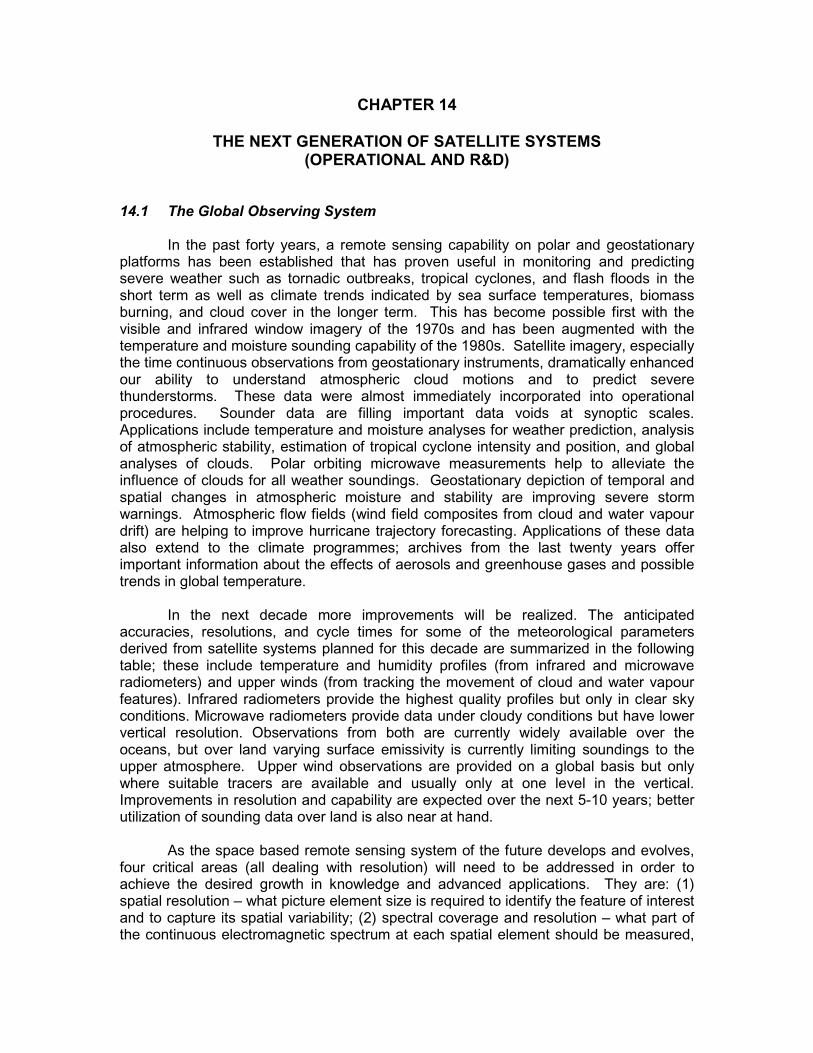
14-12
850 KM
35 800 KmSUBSATELLITE POINT
GOMS (Russian Federation)
76E
MSG
(EUM ETSAT) 63 E
MTSAT (Japan)
140E
FY-2 (China)
105E
GOES-E (USA)
75W
NPOESS (USA)
GOES-W (USA) 135W
GE
OS
TA
T I ONAR Y O
R B I T
Oc e a nog ra p hic Missions
Atm osp he ricChe m istryMissio ns
Hyd ro lo g ic a lMissio ns
Hig h-re so lutio nLa nd useMissio ns
METEOR 3M(Russian Federation)
Pola
r orb
it
R &
D o
rbit
METEOSAT
(EUMETSAT) 0 Longitude
(China)FY-1
M etop (EUM ETSAT)
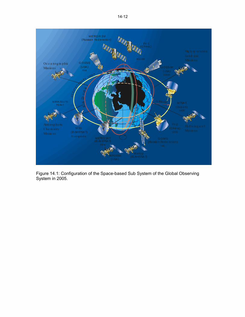
Figure 14.1: Configuration of the Space-based Sub System of the Global Observing System in 2005.