Embed Size (px)
Citation preview

Chapter 1
Introduction
1.1 Introduction
Geophysics, a subject of geology connected with physics and
mathematics, is utilized in the study of earth in exploring the subsurface Geology.
Geophysical investigations involve simple methods of study made on the surface
detail. Geophysical methods of investigations provide quick, inexpensive, easy
and fairly reliable means to get subsurface details.
Gilbert's discovery that the earth behaves as a great and rather irregular
magnet and Newton's theory of gravitation may be said to be the beginning of
Geophysics. Mining and research for metals began at the earliest but the
scientific record began with the publication in 1556 of the famous treatise De re
metallica by Georgius Agricola. The initial step in the application of Geophysics to
the research for minerals probably was taken in 1843 when Von Wrede pointed
out that the magnetic theodolite used by Lamont to measure variations in the
earth's magnetic field might also be employed to discover magnetic ore bodies.
This idea was published in Professor Robert Thalen's book in 1879 entitled, "On
the Examination of Iron Ore Deposits by Magnetic Methods". The Thalen-Tiberg
magnetometer manufactured in Sweden and later the Thomson-Thalen
instrument furnished the means of locating the strike, dip and depth below the
surface of magnetic dikes (Telford, 1988).
1

The aim of geophysical survey is to obtain geological information before
the subsurface excavation. In order to make sure that the inferences drawn from
geophysical investigations are correct, it is necessary to make drillings or
trenches at some selected places and check the inferred data with the
observation data (Meidav 1960, Daily et al 1992, LaBrecque et al 1996a, Lennox
and Carlson 1967). So the geophysical investigations reduce the amount of test
drilling by giving a better selection of test borehole locations. Geophysics devoted
to the exploration of minerals including groundwater is called by different names,
viz. Applied Geophysics, Exploration Geophysics, Geophysical prospecting etc.
1.2 Geophysical Survey
Geophysical exploration, commonly called applied geophysics or
geophysical prospecting, is conducted to locate economically significant
accumulations of oil, natural gas and other minerals including groundwater.
Geophysical investigations are also employed with engineering objectives in
mind, such as predicting the behaviour of earth materials in relation to the
foundations for roads, railways, buildings, tunnels, dams and nuclear power
plants. Surveys are generally identified by the property being measured namely,
electrical, gravity, magnetic, seismic, thermal, or radioactive properties. Deep
electrical sounding provides valuable information about the internal structure of
the earth's crust and mantle. Electrical surveys are based on natural sources of
potential and current. This technique has also become important in the scientific
investigation of environmental problems.
2

1.2.1 Sources of Study
For the present study the information obtained from outcrop, surface
geophysics, and drilling data have been utilized. Natural or man made outcrops
are the essential source of geological information. Two or three dimensional
pictures of subsurface are obtained by surface geophysical techniques. They are
important tools for the exploration of subsurface, since it gives the information of
shape and arrangements of beds, their nature, petrophysical properties, fluid
content etc. This hypothesis drawn by the interpretation of the information is
verified by drilling.
The continued expansion in the demand for metals of all kinds and the
enormous increase in the use of oil and natural gas during the past fifty years
have led to the development of many geophysical techniques of ever increasing
sensitivity for the detection and mapping of unseen deposits and structures. The
development of new electronic devices for field equipment and the widespread
application of the digital computer in the interpretation of geophysical data
advance the geophysical techniques. Several of the devices now used by
geophysicists were developed from methods used for locating guns, submarines
and aircraft during the two world wars.
The variation in electrical conductivity and in natural currents in the earth,
the rate of decay of artificial potential differences introduced into the ground, local
changes in gravity, magnetism and radioactivity provide information to the
geophysicist about the nature of the structures below the surface to locate the
mineral deposits.
3
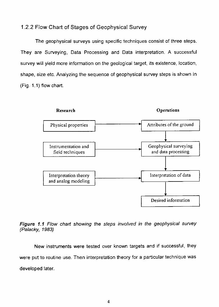
1.2.2 Flow Chart of Stages of Geophysical Survey
The geophysical surveys using specific techniques consist of three steps.
They are Surveying, Data Processing and Data interpretation. A successful
survey will yield more information on the geological target, its existence, location,
shape, size etc. Analyzing the sequence of geophysical survey steps is shown in
(Fig. 1.1) flowchart.
Research
Operations
Physical properties Attributes of the ground
Instrumentation and
Geophysical surveyingfield techniques and data processing
Interpretation theory
Interpretation of dataand analog modeling
Desired information
Figure 1.1 Flow chart showing the steps involved in the geophysical survey(Palacky, 1983)
New instruments were tested over known targets and if successful, they
were put to routine use. Then interpretation theory for a particular technique was
developed later.
4

1.3 Geophysical Methods
Geophysical methods for detection of subsurface anomaly causing bodies
may be classified into surface methods and subsurface methods. Surface
methods include many kinds of geophysical methods used in surface geophysical
prospecting. The surface geophysical methods are used generally for planning
efficient and economical test drilling programmes and to have general preliminary
ideas of the lithological conditions. Though this can never replace drilling, yet this
can provide adequate information so that the number of drillings may be held to a
minimum and the depths of the exploratory boreholes can be estimated.
Experience has shown that most subsurface structures can be identified
and located if detectable differences in physical properties exist. The basic
properties that are exhibited by the common rocks and formations which are
generally used for geophysical prospecting are density, magnetic susceptibility,
elasticity and electrical conductivity.
Based upon four basic properties mentioned above the following methods
are generally used for geophysical exploration. They are:
1. Gravity and Magnetic methods
2. Seismic methods
3. Electrical and Electromagnetic methods
4. Radioactive methods and
5. Subsurface methods which include Well logging methods.
5

1.3.1 Gravity Methods
In gravity methods, the nature of distribution of gravity on the surface is
analyzed. The gravity is influenced positively if the causative body is heavier,
larger and occurs at a shallow depth. The physical property, density of the
material, is the controlling factor of this method. The gravimeter is the suitable
equipment for measurements in this method.
1.3.2 Magnetic Methods
The magnetic methods are based on the fact that the magnetic bodies
present in the earth subsurface contribute to the magnetic field of the earth. The
main controlling physical property in magnetic methods is magnetic susceptibility.
The magnetometer is the instrument used for the magnetic survey.
1.3.3 Seismic Methods
Seismic methods of study are based on the principle that subsurface rock
formations bear different elastic properties. Because of this, the velocities of the
propagation of seismic wave undergo changes with changes occurring in
lithology. Measurement of the seismic wave velocities of rock formations,
therefore, provides a scope to distinguish different subsurface lithological units.
Elastic property differences in rock are the controlling property. The instrument
used in Seismic prospecting is the most complicated and expensive. Geophone,
amplifier, galvanometer and seismic timer all together make the instrument for
seismic measurements in one station.

1.3.4 Electrical and Electromagnetic Methods
Electrical and electromagnetic methods, based on the measurement of the
electrical resistivity or conductivity of the subsurface minerals and formations are
very useful for the exploration of minerals and groundwater. Various methods,
such as Self potential method, Resistivity method, Inductive method, Telluric
method, Magneto-Tell uric method, Induced polarization method, Charged body
method, Radio wave method, and Transient method are used in the electrical and
electromagnetic studies.
Surface self potential studies measure the naturally occurring potential at
the ground due to shallow subsurface conductors having differences in pH
concentration at the top and the bottom. Equipotential line method records the
distortion in regular equipotential lines produced by artificial current sent into the
ground and thereby locates the ore deposits producing the anomaly.
In resistivity method a current is introduced into the ground by two or
more current electrodes and the potential difference is measured between two
points suitably placed with respect to the current electrodes. The potential
difference for unit current sent through the ground is a measure of the electrical
resistance of the ground between the probes. The measured resistance is a
function of the geometrical configuration of the electrodes and the electrical
parameters of the ground.
Inductive method of prospecting makes use of the alternating current as
an artificial source which induces eddy currents on the conductors giving rise to a
7
secondary electromagnetic response which helps in detecting the anomaly.
These methods are very useful in shallow mineral or groundwater exploration.
Telluric method of prospecting uses the electric field due to naturally
flowing earth currents caused by activities in the ionosphere to investigate depths
beyond the range usually penetrated by direct current resistivity method. Telluric
method is used for mapping basement structures below the thick sedimentary
column.
Magneto Telluric method of prospecting makes use of the electromagnetic
fields due to telluric earth currents and measures time variations for the deep
subsurface structures of the order of a few kilometers. Induced polarization
method based on over voltage effect makes measurements of the decay voltage
(in time domain or frequency domain) produced due to polarization of the
electrode interfaces at the subsurface after the current flow has stopped.
Charged body method is used to find the extent of an ore body which has been
located at least in one borehole. Radio wave method makes use of the field due
to electromagnetic waves transmitted from radio broadcasting stations as the
source. The depth of investigation is limited and only the shallow conductors and
water saturated zones may be detected.
1.3.5 Radioactive Method
Radioactive methods of prospecting are based on the measurement of the
spontaneous disintegrated alpha, beta and gamma rays by various radioactive
materials and detect sources of such disintegration by means of GM counter or
Scintillation counter.
8
1.3.6 Subsurface Well Logging Methods
The continuous recording of a geophysical parameter along a bore hole
produces a geophysical well log. The value of the measurement is plotted
continuously against depth in the well. Well logging was first invented by
Schlumberger and Doll in 1927 (Rider, 1986). Various well logging techniques
such as Self potential (SP) log, Resistivity log, Radiation log, Sonic log,
Temperature log, Caliper and micro caliper logs are used for detailing ore
deposits and for mineral, oil and water exploration.
SP log gives a record of the naturally occurring potential with depth and is
utilized for distinguishing "Porous and Permeable" beds against shales.
Resistivity log gives the value of the true resistivity of the formation. Gamma ray
log measures the natural radioactivity of the formations and is used to identify
shales against sand. Neutron log records the response due to neutron capture
gamma rays which depends on the hydrogen content of the formation.
Sonic log records the time required for a sound wave to travel through unit
length of the formation from which the sonic velocity is noted and porosity
calculated. Temperature log records the variation in temperature with depth.
Caliper and micro-caliper logs measure the effective diameter of the bore hole.
1.4 Significance of Electrical Methods
Among these methods the surface electrical methods are the most popular
one because they are successful in dealing with a variety of problems like
groundwater studies, subsurface lithology, ore deposits and many others. So, the
geoelectrical ones are of first rate importance for many reasons. Electrical
measuring instruments with their accuracy, range and wide applicability are
superior to other measuring devices. Furthermore measurements of the electrical
soil properties can be carried out simply and speedily. The soil remains
undamaged in its original state.
Conrad Schlumberger started his pioneering work on electrical prospecting
in 1912, and approximately at the same time Wenner developed the same idea in
the USA (Schlumberger, 1920; Kunetz, 1966). Geoelectrical method is the high
resolution in near surface exploration problems (Akos Gyulai, 1999). The
determination and presentation of electrical properties of geological formations,
particularly of their resistivity represent a very valuable criterion for the
delineation of geostructural and hydrogeological relations of the subsurface.
Many changes in geological structure and hydrogeological characteristics of the
subsurface can be clearly recognized as changes of electrical parameters.
Among geoelectrical and hydrological parameters there exist some well known
functional relationships which can be measured and calculated (Thiele 1952,
Fritsch 1956).
The modern developments and refined techniques of interpretation using
high speed computers have increased the depth of investigation to the order of
8-10 kms with higher precision. Geoelectnc exploration consists of exceedingly
diverse principles and techniques and utilizes both stationary and variable
currents produced either artificially or by natural process.
10

1.5 Development of Resistivity Method
Measurements of the electrical conductivity or resistivity have been
applied for soil salinity surveys for many years (Rhoades and lngvalson 1971;
Austin and Rhoades, 1979; Rhoades et al, 1990). The most common method is
the electrical profiling using four electrode probes in the Wenner configuration.
The probes are applied on the soil surface as well as in borehole logging
(Rhoades and Schilfgaarde, 1976; Halvorson and Rhoades, 1976; Rhoades,
1979).
Vertical electrical sounding was applied for the stratification of soils and
sediments and estimation of their hydraulic conductivity (Mazac et al., 1990) and
texture (Banton et al., 1997). Although the method of vertical electrical sounding
(VES) is very popular in conventional geophysical studies, such as gas, oil, and
coal exploration (Verma and Bandyopadnyay, 1983), it is rarely used in shallow
subsurface and soil studies. Barker (1990) applied VIES to a landfill outlining at a
40 m depth. Smith and Randazzo (1975) demonstrated that for Wenner arrays, a
one to one association between electrode spacing and effective depth of current
penetration can be assumed in shallow, saturated, Florida limestones.
The Geological Society Engineering Group Working Party (1988)
recommends that resistivity testing is an excellent approach with well developed
analysis techniques for identifying depth to rock, stratigraphy and lithology as well
as for groundwater exploration. Surface geophysics can be used in conjunction
with geologic, hydrologic, and borehole geophysical investigations to optimize
well siting (Jansen and Jurcek, 1997), or as a stand alone method of fracture
11
detection (Lewis and Haeni, 1987; Lieblich and others, 1991; Haeni and others,
1993). DC resistivity methods have been successfully used by a number of
investigators to detect bedrock fractures (Habberjam, 1975; Risk, 1975;
McDowell, 1979; Palacky and others, 1981; Soonawala and Dence, 1981; Taylor,
1982; MaIlik and others, 1983; Leonard Mayer, 1984a, 1984b; Ogden and Eddy,
1984; Taylor, 1984; Taylor and Fleming, 1988; Lieblich and others, 1991; Ritzi
and Andolsek, 1992; Lane and Ha€ni, 1995; Powers and others, 1999). DC
resistivity surveys using a square array have been conducted to detect productive
fracture zones in crystalline bedrock for groundwater supply (Darboux Afouda
and Louis, 1989; Sehli, 1990). DC resistivity measurements have been used in
long-term groundwater monitoring programmes (Aaltonen and Olofsson, 2002).
Electrical resistivity mapping was conducted to delineate boundaries and
architecture of the Eumsung Basin Cretaceous (Ji Soo Kim et al, 2001).
Resistivity measurements were carried out utilizing the Wenner array, the single
pole array, the half Wenner array and the half Schlumberger array to evaluate the
resolution of resistivity techniques in detecting and locating anomalies of vein like
bodies in the Al Quweira area, southwest Jordan as part of an economic deposit
and ore exploration project (Batayneh, 2001). The development of direct current
resistivity imaging technique has been discussed by Torleif Dahlin (2001).
Using geoelectrical depth soundings, potential groundwater pollution was
assessed on a former shipyard of the Newport Naval Base, Rhode Island, USA
(Froehlich and Urish, 2002). A series of two dimensional resistivity profiles
collected in the Blue Ridge Province of southwest Virginia and the results from
numerical modelling of synthetic data reveal substantial differences in depth of
12

investigation, resolution, and sensitivity using Wenner, Wenner—Schiumberger,
dipole—dipole, and pole—pole data collection techniques (Seaton and Burbey,
2002). Resistivity sounding curves are used to derive ground anisotropy
parameters using square arrays (Senos Matias, 2002). The saline water intruded
zone in Korean paddy fields near the seashore was diagnosed accurately by joint
exploration with VES and chemical anaysis (Sang Ho Lee et al, 2002). The salt
water intrusion mapping by geoelectrical imaging surveys was made by Abdul
Nassir et al (2000). The 2D electric imaging technique was employed to map the
thick soft Pusan clay deposits in four reclamation sites (Giao and others, 2003).
1.6 Development of Self Potential Method
Self potential methods are used for quantitative interpretation in many
fields of applied Geophysics. Petrowsky (1928) and Yungul (1950) interpreted
self potential data on polarized spheres as the source body. Edge and Laby
(1931) worked out the expression for potential. De Witte (1948) developed a
method which involves field self potential values. Roy and Chowdhury (1959) and
Meiser (1962) made detailed quantitative interpretation methods on self potential.
Rao (1953), Semenov (1974) Schiavone and Quarto (1984) worked on
hydrogeological studies using SP method. Zachos (1963), Sivenas and Beales
(1982) worked on self potential anomalies associated with ore bodies. Paul
(1965) interpreted self potential anomaly caused by infinite inclined sheets. Sato
and Mooney (1960), Heinrichs (1966), Logn and Bolviken (1974), Carry (1985)
reported self potential case histories in the literature concerning mining.
Zohdy et al (1973), Anderson and Johnson (1976), Corwin and Hoover (1979),
Corwin et al (1981), Fitterman and Corwin (1982) worked on self potential
13

measurements in Geothermal exploration. Sill (1983) proposed that the SP
anomalies that occur over massive and disseminated mineral deposits are those
of principal concern in mineral exploration.
Bogoslovsky and Ogilvy (1970a, b, 1973), Bogoslovsky et al (1979),
Gex (1980), Filterrnan (1983a), Hadley (1983), Black and Corwin (1984),
Butler (1984) worked in dam and embankment seepage control on the basis SP
method. Bhattacharya and Roy (1981), Rao and Babu (1984), Murty and Han
chandran (1985) derived numerical estimates of the source parameters from the
analysis of the field self potential anomaly diagram.
Kilty (1984) carried out the origin and interpretation of self potential
anomalies. Pal and Dasguta (1984) and Pal and Mukerjee (1986) studied the
electrical potential in an inhomogeneous an isotropic half space. Corwin and
Morrison (1977), Fitterman (1978), Morrison et al (1979), Varotsos and
Alexopoulos (1984a, b), Patella (1991), Di Bello et al (1994) studied forecasting
earthquakes using the SP method. Corwin (1990) worked on the self potential
method for environmental and engineering applications. Eskola and Hongisto
(1987) and Furness (1992) made physical model for the self potential to study
mineral deposit.
Bogoslovsky and Ogilvy (1977), Bogoslovsky, Ogilvy and Strakhova
(1977), Patella, et al (1995) worked in engineering geophysics for land slide with
the help of SP measurements. Wynm and Sherwood (1984), Cammarano et al
(1995) used SP method in the study of archeological surveying. Zablocki (1976),
Di Maio and Patella (1994), Di Maio et at (1996) studied volcanic eruptions with
14

the help of self potential methods. Patella (1997) presented a new approach to
SP data interpretation for the recognition of a buried causative SP source system.
A review of some applications of the self potential method (SP) in the field of the
subsurface prospecting was made by (Aubert, 1997).
A self potential survey of the summit zone of Karthala volcano (Grande
Comore) was made by Jean Francois Lenat et al (1998). A self potential survey
was carried out in the Kestanbol area, Turkey in order to investigate the fault
zones that might be associated with geothermal activity (Ilyas Caglar and
Mustafa, 1999). The influence of transverse ground anisotropy on the formation
of self potential (SP) anomalies produced by polarized bodies is studied by
Skianis and Hernandez (1999).
Visual interpretation of superposed self potential anomalies in mineral
exploration was made by Ilyas Caglar (2000). Aubert et at (2000) applied self
potential method to investigate the internal structure of the Merapi summit in the
area between the crater Pasabubar and the dome. Self potential anomalies with
unexplained high values in Cerro de Pasco and Hualgayoc areas (Peru) have
been explained by Vagshal and Belyaev (2001) on the basis of electrokinetic
effect obtained when a topographic high occurs above a rock layer through which
water filtrates and which itself lies over a highly resistive layer. Methods of self
potential, electrical profiling, vertical electrical sounding and non-contacting
electromagnetic profiling were applied to urban soils in Astrakhan, Russia and
Kiev, Ukraine (Larisa Pozdnyakova et al 2001). The surveys based on a
combination of self potential (SP), direct current (DC) resistivity, induced
polarisation (IF), and transient electromagnetic (TEM) methods have been
15

carried out at the Ranger mine site in the Northern Territory, Australia to
investigate their use in detecting any seepage from structures used to store ore
processing tailings (Buselli and Kanglin Lu, 2001).
Electrical resistivity method was used to delineate zones favourable for
seepage, whereas self-potential (SP) method was used to delineate the seepage
paths at two of the four Saddle dams of the Som Kamla Amba project, Rajasthan
State, India (Panthulu et al, 2001). Self potential field survey over the oil
reservoirs in Albania was presented by Alfred Frasheri (2002). The experimental
study on variations of self potential and unsaturated water flow with time in sandy
loam and clay loam soils was investigated by Claude Doussan et al (2002). Two
conductive tracers, one deep and one on the surface, were injected and
monitored for direct evaluation of the groundwater flow vector using resistivity
and self potential methods (Sandberg et al 2002).
Nimmer (2002) made an experimental study on direct current and self
potential monitoring of an evolving plume in partially saturated fractured rock in
Columbia River basalt. The study of fluid circulation of the Stromboli Island using
a dense coverage of self potential (SP) and soil CO2 data was made by Anthony
Finizola et al (2002). A self potential survey has been conducted around Waita
volcano, Kyushu, Japan by Yasukawa et al (2003). Resistivity and self potential
changes associated with volcanic activity in Japan was monitored by Zlotnicki
et al (2003).
16

The log shapes are used to find the fades and environments by several
authors. Krueger (1968), Galloway (1968), Fisher (1969), Eons (1969), Pirson
(1970), Goetz et al (1977), Coleman and prior (1982), Galloway and Hobday
(1983) defined the relationship between log shape and grain size in sandstone
bodies and classified sand bodies on the basis of the shape of the Self potential
log. Shields and Gahan (1974), Wolff and Pelissier-combescure (1982)
emphasized the significance of log shape character. Davies & Ethridge (1975),
Tixier and Alger (1967), Serra and Abott (1980), Selley (1976), Sarg and Skjold
(1982), Poupon et al (1970) used the log shapes to identify the depositional
environment.
Of the various surface and subsurface geophysical methods, the
combination of surface resistivity and surface self potential methods are used in
the present study.
1.7 Aim and Objectives
The range of resistivities of rocks is not unique and a considerable
overlapping of several rock types is noticed (Table 1.1). As a result resistivity is
an extremely variable parameter not only from formation to formation but even
within a particular formation (or type of rock). There is no general agreement of
lithology with resistivity. The resistivity of porous sedimentary formations is highly
variable, depending on the degree of saturation and the nature of the pore
electrolytes. Since the resistivity range overlaps for the different rock and soil
types, it becomes necessary to assess the soil stratum encountered with
available borehole data.
17

Table 1.1 Range of resistivity of some common rocks and minerals (Loke andBarker, 1996b)
Material Resistivity (ohm-m)
Igneous and Metamorphic
Granite 5 x 10³— 106
Basalt 103— 106
Slate 6 x 10² _4 x 10
Marble 102_2.5 x 108
Quartzite 102_2 x 108
Sedimentary Rocks
Sandstone 8-4x10
Shale 20-2 x
Limestone 50-4 x 10²
Soils and Waters
Clay 1-100
Alluvium 10-800
Groundwater (fresh) 10-100
Seawater 0.2-1
The range of resistivity of soils depends upon moisture content, salinity,
level of groundwater, degree of compactness, mineralogy and other factors
(Karanth, 1987; Woods R.D, 1994). Generally, rock skeletons without clay matrix
and fluid content are bad conductors. Reduction of porosity by cementing
process in pore spaces of the rocks increases the resistivity values. The clay in
the moisture state encourages ion exchange process, and as a result the
18
conductivity increases manifold. The highly conductive brine in saturation has
tended to mask the real character of the bed rock (Kailasam, 1963A).
The resistivity curves obtained in depth soundings readily indicate whether
two or three layers are involved. It is restricted to identify only a few numbers of
layers. Mathematical studies and laboratory experiments also have established
that the apparent resistivity curves for ideal layers do not show breaks or other
irregularities of the type depending upon the empirical methods of interpretation
(Rao, 1993). The resistivity method sometimes fails to locate the conducting
minerals in the disseminated form (Apparo et al, 1997).
The resistivity values of the rock formation are mainly controlled by the
fluid type and the compactness of the sedimentary formation and it is difficult to
give explanation for the following:
1. To recognize more number of different sedimentary layers in shallow
depth.
2. To estimate the depth of the sedimentary layer boundaries
3. To identify the disseminated form of conducting minerals
4. To distinguish the salt water sand from clay bed (in wet state)
5. To differentiate the hard rock from the clay bed (in dry condition)
6. To make a distinction of the limestone from sandstone
7. To explain masking effect of true resistivity of rock formation due to the
saline water incursion
The self potential (SP) i.e. the naturally occurring current, depends on the
chemical and the physical nature of the rock formations and also it is indicative of
permeable or porous zones. Therefore, the SP method in conjunction with
resistivity method has been used to find out the explanation for the problems
mentioned above.
The following are the main objectives of the present study.
1. To establish the depth of the SP source and the Current penetration
depth in VIES study
2. To identify the mineral formation and also to reconstruct lithological
sequences through the surface level SP and the resistivity study
3. Recognition of the depositional sedimentary environments through
the log shape analysis.
It is also planned to delineate the depthwise bed boundaries, thickness,
and porous and permeable properties of the rock formations and the nature of
fluid type.
1.8 Order of Presentation
The work presented here deals with various aspects pertaining to the
geophysics delineated using geophysical techniques, surface level SP and
resistivity methods, mineral deposits and lithology of subsurface formation and
the depositional environment. The thesis has been divided into seven chapters
and the investigations covered are as follows
Chapter 1 deals with the general aspects of the study comprising the
geophysical survey, geophysical methods, development of resistivity and self
potential methods and the objectives of the studies. This chapter briefly describes

the principles of conventional geophysical methods, such as self potential,
electrical profiling, vertical electrical sounding, electromagnetic induction, and non
contact electromagnetic profiling.
Chapter 2 furnishes an account of each of the electrical methods (SP and
resistivity), outlining the general principles on which they are based and the
instruments and equipments used.
Chapter 3 describes the detection of depth of different rock formations on
the basis of inflection points observed in the SP and resistivity curves. For this
study, laboratory tank model experiment and field experiments were carried out.
Field experiments in two levels, one at shallow level near Tuticorin and another at
deeper level at Neyveli open cast mine area were made.
Chapter 4 explains the identifications of minerals like gypsum and caicrete
beds in the disseminated forms in the black caftan soil of Tuticorin region and the
clay minerals like ball clay and fire clay; sand, sandstone, lignite and marcasite in
the Neyveli mine area are accomplished on the basis of the nature of deflections
observed on the SP curve and the highs and lows of apparent resistivity curve of
the surface level composite logs.
In chapter 5, the curve pattern analysis gives detailed depthwise
lithological sequences of sand, sandstone, limestone, clay and intercalated sand
and clay of the study areas: Govangadu, Spic area, Karapad, and Tuticorin. The
combination of curve elements (peak, trough, etc) of both SP and apparent
resistivity curves at a particular depth leads to the identification of the litho unit of
21

the subsurface. After identifying all the litho units of a particular location,
depthwise lithological column was prepared. This was verified with the level of
depth limits of the core and the rock cuttings collected from the bore hole of the
respective experimental sites.
Chapter 6 explains the recognition of depositional sedimentary
environment of Manapad and Neyveli through the SP log shape (bell, funnel, and
cylinder) analysis. The interpretations of depositional environment and
depositional sequence were made after establishing lithology and electrofacies of
the sedimentary rocks of the Manapad and Neyveli formations.
Chapter 7 concludes the thesis by giving the summary and the significant
findings related to various analyses. Documentation of the work has been carried
out with adequate number of figures and tables followed by detailed references.


![CHAPTER 1shodhganga.inflibnet.ac.in/bitstream/10603/34723/8/08_chapter 1.pdf · Chapter 1 [Genetic engineering of P. fluorescens for enhanced citric acid secretion] Page 4 new bioproducts](https://img.pdfslide.net/doc/110x75/600e12a556ef3758d37220f7/chapter-1pdf-chapter-1-genetic-engineering-of-p-fluorescens-for-enhanced-citric.jpg)