Embed Size (px)
Citation preview
CHAPTER 2
Owens Valley Planning Area 2.1 Project Location and Land Ownership ............................................................... 2-1 2.1.1 Location ............................................................................................. 2-1 2.1.2 Land Ownership ................................................................................ 2-2 2.2 Project History ................................................................................................... 2-2 2.2.1 Environmental Setting and Effects of Diversions on Owens Lake ..... 2-2 2.2.1.1 Geologic History ................................................................... 2-2 2.2.1.2 Historic Lake Levels ............................................................ 2-2 2.2.1.3 Plants and Wildlife ............................................................... 2-3 2.2.1.4 Cultural History .................................................................... 2-3 2.2.2 Legal History ..................................................................................... 2-3 2.2.2.1 Natural Soda Products Co. vs. City of Los Angeles ............ 2-3 2.2.2.2 Senate Bill 270 ..................................................................... 2-4 2.2.3 Regulatory History ............................................................................. 2-5 2.2.3.1 PM10 Nonattainment Designation ......................................... 2-5 2.2.3.2 1990 Clean Air Act Amendments ........................................ 2-5 2.2.3.3 Exceptional Events Rule ...................................................... 2-7 2.3 References ........................................................................................................ 2-8
FIGURES Following Page
Figure 2.1 Vicinity map ............................................................................................ 2-2 Figure 2.2 Relief map ............................................................................................... 2-2 Figure 2.3 2008 Dust Control Measure footprint map .............................................. 2-2
2-1
2
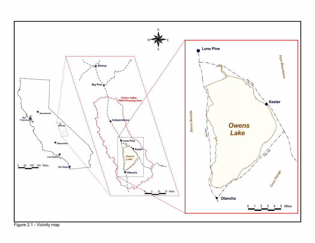
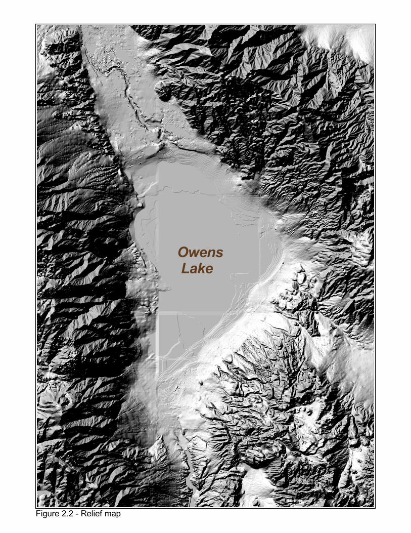
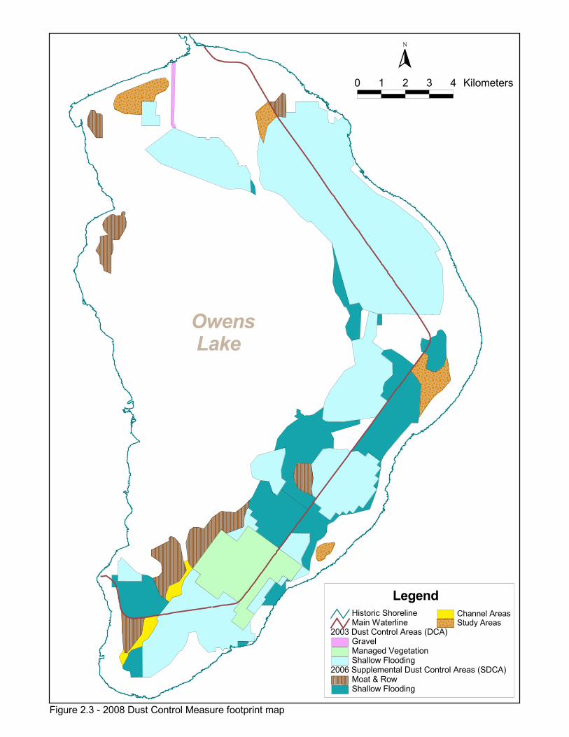
Owens Valley Planning Area 2.1 PROJECT LOCATION AND LAND OWNERSHIP 2.1.1 Location The Owens Valley Planning Area (OVPA) is located in Inyo County in eastern-central California. It is situated at the south end of the deep, long, narrow Owens Valley with the Sierra Nevada to the west (max. elev. 14,495 feet), the Inyo Mountains to the east (max. elev. 14,246 ft.), and the Coso Range to the south (max. elev. 8,160 ft.) (Figure 2.1, Figure 2.2). The predominantly dry, alkaline Owens Lake bed is approximately eight miles south of the community of Lone Pine on U.S. Highway 395, 60 miles north of the city of Ridgecrest, and 35 miles west of Death Valley. The communities of Olancha and Keeler are located on the southwestern and eastern shores of the lake bed, respectively. The bed of Owens Lake is defined as the area below 3,600 feet above mean sea level (all elevations will be given in feet above mean sea level). The lake bed extends about seventeen miles north and south and ten miles east and west and covers an area of approximately 110 square miles (70,000 acres). The majority of the lake bed (over 95%) is state land under the jurisdiction of the California State Lands Commission (CSLC). The remaining portions of the lake bed are owned by the City of Los Angeles and other private owners. During the years from 2000 through 2006 dust control measures were implemented on 29.8 square miles (19,072 acres) of the former lake bed. The map in Figure 2.3 shows the areas where existing dust controls were constructed by the City of Los Angeles Department of Water & Power (City) under the requirements of the 2003 SIP. In accordance with a 2006 Settlement Agreement between the District and the City (GBUAPCD 2006b), the City will implement dust control measures on an additional 13.2 square miles by April 1, 2010 in the Supplemental Dust Control Areas and Channel Areas shown in Figure 2.3. After that date, dust controls may be required in areas shown as Study Areas if they are found to cause or contribute to an exceedance of the federal standard at the shoreline. Figure 2.3 shows the location of the current Managed Vegetation and Shallow Flooding control measures that were implemented by the end of 2006. Under the requirements of the 2003 SIP, Managed Vegetation, Shallow Flooding and Gravel Blanket are considered as Best Available Control Measures (BACM) and may be applied as necessary anywhere on the Owens Lake bed to control windblown dust, subject to completion of appropriate environmental impact analyses and approval by the underlying land owner(s). For the 13.2 square miles of additional Supplemental Dust Controls required by this SIP, Shallow Flooding is planned for at least 9.2 square miles of the area (Figure 2.3). On at most 3.5 square miles the City is allowed, at their sole discretion, to implement an alternative non-BACM measure known as Moat & Row. This measure is being tested by the City in 2007-08. If Moat & Row is implemented by the City and proven to be successful, it may remain in place on the lake bed in the locations shown in Figure 2.3. If the Moat & Row control measure cannot achieve the necessary PM10 control efficiency for the indicated areas (ranges from 50% to 99%), the
Owens Valley Planning Area
2-2
unsuccessful Moat & Row areas must be converted to Shallow Flooding. The remaining 0.5 square miles of dust controls will be applied on the Channel Area. Because of significant existing resource issues and regulatory constraints in this area, the City will implement dust controls that prevent dust emissions and protect or enhance the existing natural resources. 2.1.2 Land Ownership As mentioned above, approximately 68,000 acres, or 95 percent, of the Owens Lake bed is owned by the State of California and managed by the California State Lands Commission (CSLC). Most of this lake bed state-owned land is leased for a variety of purposes. U.S. Borax leases over 16,000 acres of lake bed for the purposes of extracting trona ore (an evaporite sodium carbonate mineral). In addition, there are a few agricultural (grazing) leases near historic shoreline areas. Most of the remaining state-owned lake bed areas are leased from the state by the City of Los Angeles for the purpose of developing and implementing PM10 control measures. Most of the remaining 5 percent of the lake bed, or approximately 2,800 acres, is owned by the City of Los Angeles and is managed by the Los Angeles Department of Water and Power. The City’s lands are in the Owens River delta and on the lake bed west of Keeler. A few small areas below and considerable areas above the historic shoreline are federal lands managed by the U.S. Bureau of Land Management (BLM). A few small isolated private land parcels are also located on the lake bed. All control measures and supporting infrastructure are owned by the City of Los Angeles, on property owned by the City or on leases or easements from other underlying owners. 2.2 PROJECT HISTORY 2.2.1 Environmental Setting and Effects of Diversions on Owens Lake 2.2.1.1 Geologic History Owens Lake is part of a chain of lakes formed between 10,000 and 16,000 years ago. The lakes spanned from Mono Lake (previously a much larger lake known as Lake Russell) in the north to Lake Manley, the southeastern-most lake of the chain, in what is now known as Death Valley. During much of this time, water from the Owens Valley basin flowed out of Owens Lake, through Rose Valley and into China Lake (which occupied the Ridgecrest area). The high stand of Owens Lake that produced the shorelines at an elevation of 3,880 is estimated to have occurred 15,000-16,000 years ago. Since that time, the surface extent of the water of Owens Lake has been diminishing. However, two deep cores on the lake bed failed to identify any previous episodes of complete desiccation (Saint-Amand, et al., 1986, Smith and Bischoff, 1993). Uplift processes in the Coso Range, combined with a post-glacial drying trend, eliminated overland outflow from the basin about 3,000 years ago. As a result, the lake basin became closed, losing water only through surface evaporation and transpiration. This closed hydrologic system, combined with the arid environment, created the highly saline condition of remaining surface waters and soils at the bottom of the Owens Lake basin. Even during historic periods in the 1800s when it was used as a navigable waterway, Owens Lake was an alkali lake. 2.2.1.2 Historic Lake Levels Although historic lake levels were as high as 3,597 feet in 1878 (Lee, 1915), surface water diversions in the Owens Valley over the last 130 years have reduced the lake to less than one-third of its original size and about 5 percent of its original volume (Mihevc et al., 1997). From the 1860s to the early 1900s, withdrawals from the Owens River for agricultural purposes
�
�
�
�
�
�
���������
��������� �
����� �����
� ������
�������
�� ���
�
�
�
�
� �� ��
�������
������������
�������
������
�������
���������
��������������� ���� ������������
�������
������
�������
�
�
�
�������
�����
�
������
���������
��������������
����������
������������
�
� � � � � � ���
� �� ��� ��� ���
� � �� �� ���
�
��
�
�� ���������������������
�����������������������
���������������� ����
���������
�
� � � � � ������ �
���� ��������������������� ������� ����� ������
������������������������� ��� ���� ����!����"�#$�%���$���&���
������������� ��� ���� ���!' �(��������&�)���������%���$���&���
�����*��� ����+��� �,��% �����
�������%������� ������&-�� ���

BLANK PAGE
Owens Valley Planning Area
2-3
substantially reduced surface water inflow to the lake. Extensive irrigation projects compounded by drought caused the lake level to drop as low as 3,565 feet in 1906. However, as the drought ended and lands purchased by the City of Los Angeles were taken out of agricultural production, by 1912 the level had risen to 3,579 feet (Lee, 1915). In 1913, the City completed a fresh water aqueduct system and began diverting waters of the Owens River south to the City of Los Angeles. Demand for exported water increased as Los Angeles grew, and diversions for irrigation continued in the Owens Valley (mainly on City-owned property). These factors resulted in Owens Lake becoming virtually dry by 1930—its level having dropped to its current ordinary high water elevation of about 3,554 feet (Saint-Amand, et al., 1986 and LADWP, 1966). A former or stranded shoreline was left behind at an approximate elevation of 3,600 feet. The former shoreline bounds the lake bed playa in aerial photographs and on most maps. The area enclosed by the stranded historic shoreline is approximately 110 square miles (70,400 acres). Today, the remnant Owens Lake consists of a hypersaline permanent brine pool about 26 square miles (16,500 acres) in size in the lowest portion of the basin, surrounded by dry playa soils and crusts. The ordinary high water mark of this remnant brine pool has been defined by the U.S. Army Corps of Engineers to be that portion of the lake basin below 3,553.55 feet. Evaporite deposits and brines cover much of the playa area; the concentration of dissolved solids (salts) can be as high as 77 percent by weight (GBUAPCD, 2001b). 2.2.1.3 Plants and Wildlife The Owens Valley has been described as having a very rich variety of plants with over 2,000 species represented in the region, though they are limited in distribution at Owens Lake to the relic shoreline and nearby alluvial fans (DeDecker, 1984). Riparian, alkaline meadow and alkali seep plant communities, which circumscribe Owens Lake, provide important habitat for resident and migratory wildlife species. Many of the diverse wildlife resources that are characteristic of the Sierra Nevada, Inyo, and Coso mountain ranges surrounding Owens Lake will occasionally be found on the valley floor, particularly during winter. Heindel and Heindel (1995) report as many as 320 bird species for the Owens Valley floor including permanent residents, summer residents, winter residents, and migrants. Ephemerally flooded areas in the vicinity of Owens Lake provide excellent resting and foraging habitat for migrants and winter residents and winter prime opportunities for bird watching. Several sensitive wildlife species are found at and around Owens Lake. 2.2.1.4 Cultural History The Owens Valley has attracted the interest of archeologists since at least the 1930s. The Riddells (Riddell, 1951, Riddell and Riddell, 1956) conducted the major work in the region in the 1940s and 1950s, recording several sites on the perimeter of Owens Lake including important sites at Cottonwood Creek and Rose Spring. Two California State Historic Landmarks and two California Points of Historic Interest are located in the vicinity of Owens Lake. Ethnographic data indicate that the east shore of Owens Lake was used by Native American groups. Historic resources related to mining and transportation have been identified above the stranded shoreline. 2.2.2 Legal History 2.2.2.1 Natural Soda Products Co. vs. City of Los Angeles By the late 1920s, the majority of the lake bed was dry and remained so until 1937. As the lake
Owens Valley Planning Area
2-4
dried and the lake bed was uncovered, mineral deposits of trona ore were exposed and became available for extraction. In 1937, 1938, and 1939, the City released large quantities of water onto the lake bed, flooding the mineral deposits and causing extensive damage to the chemical processing plants. In 1937, the Natural Soda Products Company, a lessee of mineral rights from the State of California, sued the City of Los Angeles for damages to its chemical plant and business caused by the flooding of Owens Lake. The court decided the case in 1943 and a judgment for damages was awarded. Natural Soda Products Co. vs. City of Los Angeles 1943, 23 Cal.2d 193 [143 P.2d 12] established that “the city, by its long continued diversion of the waters of the Owens River, incurred an obligation to continue that diversion…at least so long as it continued to maintain its aqueduct.” In 1939, the State, as owner of the lake bed, brought an action in People vs. the City of Los Angeles 1939, 34 Cal.2d 695 [214 P.2d 1] to define whether the City’s obligation could be enforced by injunction, and if so, to determine the extent of the injunction. The trial court, citing the principles set forth in Natural Soda Products, later granted an injunction and prohibited the City from: (a) diverting any waters from the Mono Basin watershed into or onto Owens Lake, and (b) diverting any waters of the Owens River and its tributaries into or onto Owens Lake “which are not in excess of an amount equal to the reasonable capacity of [the City’s] aqueduct system and all of its component facilities reasonably operated.” The City of Los Angeles appealed the trial court’s injunction. In 1950, the appeal of People vs. the City of Los Angeles was finally resolved. The appellate court modified and affirmed the lower court’s decision regarding the injunction. The two significant modifications were as follows. First, since waters of the Mono Basin watershed and Owens Valley waters become mixed, the first part of the injunction was technically unenforceable. It was, therefore, amended to prohibit increasing the natural flow of the Owens River, by diverting into it waters of the Mono Basin, if such a diversion would necessitate the release of water into or onto Owens Lake. Second, the City was found to be under no obligation to spread surplus water onto land owned in the Owens Valley in excess of amounts that could reasonably be used on such land or stored underground for future beneficial use. Importantly, it also reaffirmed that portion of the injunction regarding “diverting any waters out of [the City’s] aqueduct system onto Owens Lake, or in any way releasing any waters to be deposited into or onto Owens Lake at any time, unless the flow of water of the Owens Valley watershed is in excess of an amount equal to the reasonable capacity of [the City’s] aqueduct system and all of its component facilities reasonably operated.” Although the Owens Lake dust control measures are not expected to interfere with mining interests, the shallow flooding and managed vegetation control measures involve releasing water onto Owens Lake, which is an action that could have conflicted with the injunction. In September of 2000, the Riverside County Superior Court modified that injunction to allow for the implementation of dust control measures on Owens Lake (People v. City of Los Angeles, et al., (2000) Riverside County Superior Court, Case 34042). 2.2.2.2 Senate Bill 270 In 1982, the City applied for a permit from the District to construct and operate a geothermal electric generating plant in the Coso Known Geothermal Resource Area. The permit was denied based on the assertion that the City was in violation of air pollution rules and regulations elsewhere in the region. Specifically, District Rule 200 considered the water-gathering operations of the City to be a “facility” responsible for the particulate emissions from Owens Lake and concluded that an air quality permit was required for the City’s Aqueduct operations.
Owens Valley Planning Area
2-5
After failure of efforts to petition the action, a negotiated settlement emerged in Senate Bill 270 (SB 270) sponsored by Senator Dills in 1983. SB 270 (Cal. Health and Safety Code §42316) exempted the City of Los Angeles’ water-gathering operations from state air quality permit regulations. It provided that the City must fund control measure development and must implement reasonable measures ordered by the District to attain compliance with the state and federal ambient air quality standards at Owens Lake. By law, the District-mandated control measures may not affect the City’s right to produce, divert store or convey water. Chapter 8 of this document contains the text of SB 270 and includes additional information on Cal. Health and Safety Code §42316 as it applies to the Board order to implement dust control measures. 2.2.3 Regulatory History 2.2.3.1 PM10 Nonattainment Designation In 1987, the United States Environmental Protection Agency (USEPA) revised the National Ambient Air Quality Standards (NAAQS), replacing total suspended particulates (TSP) as the indicator for particulate matter with a new indicator called PM10. PM10 is defined as particulate matter that has an average aerodynamic diameter less than or equal to 10 microns. Ten microns are about one-seventh the diameter of a human hair. The standards for PM10 were set at 150 micrograms per cubic meter (µg/m3) for a 24-hour average and 50 µg/m3 for an annual average. At the same time, USEPA set forth regulations for implementing the revised NAAQS, and announced the policy for development of SIPs and supporting control strategies. Also in 1987, USEPA identified the southern Owens Valley (known as the Owens Valley Planning Area) as one of the areas in the nation that violated the PM10 NAAQS. Subsequent air quality monitoring by the District showed that the dried bed of Owens Lake is the predominant source of PM10 emissions contributing to air quality violations in the Owens Valley Planning Area. Extremely high PM10 concentrations (over 12,000 µg/m3 or more than 80 times the standard) have been verified downwind of Owens Lake. Inter-basin transport of PM10 into the southern Owens Valley is inconsequential. Consequently, the USEPA required the State of California to prepare a SIP for the Owens Valley Planning Area that demonstrates how PM10 emissions will be decreased to comply with the NAAQS. The District is the agency delegated by the state to fulfill this requirement. An initial SIP was prepared by the District in 1988 (GBUAPCD, 1988), approved by the California Air Resources Board (CARB), and forwarded to the USEPA. No action was taken by USEPA to approve or disapprove the 1988 SIP. 2.2.3.2 1990 Clean Air Act Amendments In November 1990, the federal Clean Air Act Amendments (CAAA) were signed into law, setting into motion new statutory requirements for attaining the PM10 NAAQS. All areas in the United States that were previously classified as federal non-attainment areas for PM10, including the southern Owens Valley, were designated as “moderate” PM10 non-attainment areas. In November 1991, the District prepared an addendum to the 1988 SIP that updated the air quality information and the work performed since 1988 (GBUAPCD, 1991). Section 188(b) of the CAAA specified that any area that could not attain the NAAQS by December 1994 would subsequently be reclassified as a “serious” PM10 non-attainment area. In January 1993, USEPA completed its initial reclassification process, and included the southern Owens Valley among five nationwide areas reclassified as “serious,” effective February 8, 1993.
Owens Valley Planning Area
2-6
Section 189(b) of the CAAA further specified that a SIP revision was due within eighteen months of the reclassification (by August 8, 1994). The revision was to assure that implementation of “best available control measures” (BACM), including “best available control technology” (BACT), would be effective within four years of the reclassification date. A Best Available Control Measures SIP was prepared in June 1994 and approved by the CARB (GBUAPCD, 1994). The CAAA required that by February 8, 1997, a PM10 Attainment SIP must be submitted to the USEPA that (a) included preferred and contingency PM10 control strategies, (b) provided air quality modeling that demonstrated attainment of the federal air quality standards from the implementation of these controls, and (c) provided quantitative milestones for “reasonable further progress” reporting to the USEPA. The CAAA further require that the PM10 NAAQS be attained by December 31, 2001. On November 16, 1998, the District adopted a SIP, which was approved by USEPA on August 17, 1999. That 1998 SIP provided for a five-year extension of the deadline for attainment, and for a SIP revision in 2003 that would determine the final control strategy to attain the NAAQS by December 31, 2006 (GBUAPCD, 1998a). On November 13, 2003, the District adopted the 2003 Revised State Implementation Plan for the Owens Valley Planning Area (2003 SIP), which was later approved by the CARB. The 2003 SIP is currently implemented under Board Order #031113-01, which primarily addresses the PM10 control requirements to reduce wind-blown PM10 emissions from the exposed playa at Owens Lake. The 2003 SIP control strategy requires using shallow flooding, managed vegetation, and gravel coverings to accomplish PM10 emission reductions on 29.8 square miles of the Owens Lake bed (GBUAPCD, 2003e). It also contained contingency measure provisions that require the City to control additional lake bed areas beyond the 29.8 square miles, if necessary. The USEPA did not take action on the approval or disapproval of the 2003 SIP, but it is currently enforced by the District. By December 31, 2006, the City had implemented dust control measures on all 29.8 square miles of the lake bed as required in the 2003 SIP. In December 2005, a dispute arose between the District and the City regarding requirements to control dust from additional areas at Owens Lake beyond the 29.8 square miles identified in the 2003 SIP (Schade, 2005 and Schade, 2006). On December 4, 2006 a Settlement Agreement was approved by both parties to resolve this dispute (GBUAPCD, 2006b). Under the provisions of this agreement, the City agreed to implement dust control measures on an additional 13.2 square miles of the lake bed by April 1, 2010 and the District agreed to revise the 2003 SIP before March 1, 2008 to incorporate the provisions of the Settlement Agreement. This 2008 SIP fulfills the District’s commitment. At the time the 2003 SIP was approved by the District and the CARB in November 2003, the USEPA policy direction on PM10 attainment demonstrations was that the control measures that were needed to demonstrate attainment must be implemented by December 31, 2006. After the 2003 SIP was adopted, the USEPA policy direction changed to require three continuous years of air quality data without violations prior to December 31, 2006 to demonstrate attainment. This revised policy direction effectively made the 2003 SIP attainment demonstration deficient, since all the control measures should have been implemented before the end of 2003 to meet the 2006 attainment deadline. Because it takes two to three years to implement the Shallow Flooding and Managed Vegetation control measures, the construction of the 2003 SIP dust control measures were not completed until the end of 2006. Numerous NAAQS violations occurred during the
Owens Valley Planning Area
2-7
3-year attainment demonstration period. As a result, the USEPA made the finding that the Owens Valley failed to attain the standard as required under CAAA §189(d). On March 23, 2007, the USEPA published a finding that the Owens Valley Planning Area did not attain the 24-hour National Ambient Air Quality Standard (NAAQS) for particulate matter of 10 microns or less (PM10) by December 31, 2006 as mandated by the CAAA (USEPA, 2007a). As a result of this finding, the Owens Valley SIP must be revised to include a control strategy that will provide for attainment in the Owens Valley Planning Area as soon as practicable, by achieving at least a 5 percent reduction in PM10 emissions per year. The 2008 SIP must demonstrate that the NAAQS can be attained by March 23, 2012, unless the USEPA grants an extension which could extend the deadline up to March 23, 2017 (CAAA §179(d)(3)). The USEPA may consider the severity of nonattainment and the feasibility of applying available control measures in deciding if an extension should be granted. In accordance with CAAA §189(d), the revised SIP must be submitted to the USEPA by December 31, 2007. This 2008 SIP revises the 2003 SIP and includes an updated analysis of the particulate matter air pollution problem in the Owens Valley and a revised control strategy to bring the area into attainment with the federal air quality standard for particulate matter as soon as practicable. This 2008 SIP also incorporates provisions of the Settlement Agreement between the District and the City to expand dust control measures to additional areas at Owens Lake in order to attain the NAAQS as soon as practicable (GBUAPCD, 2006b). 2.2.3.3. Exceptional Events Rule On March 22, 2007, the USEPA adopted a rule to allow the exclusion of monitored or modeled air quality exceedances and violations that were caused by exceptional or natural events. Exceptional events can be human-caused events that are not expected to recur, and natural events, which are considered to be caused by natural sources such as, wildland fires, volcanic activities, or extreme-wind events. This rule replaced the USEPA’s natural events policy that was approved in 1996. The rule defines the term “exceptional event” to mean an event that:
(i) Affects air quality; (ii) Is not reasonably controllable or preventable; (iii) Is an event caused by human activity that is unlikely to recur at a particular
location or a natural event; and (iv) Is determined by USEPA through the process established in these regulations to
be an exceptional event. USEPA defined a “natural event” as an event in which human activity plays little or no direct causal role. As this pertains to wind blown dust from dry lake beds, the USEPA’s rulemaking cites the U.S. House of Representatives report on approving CAAA §188(f), in which they discussed a circumstance in which recurring emissions from a source should be considered to be caused by human activity. Both the House and Senate committee reports for the 1990 CAAA specifically cited the case of wind-blown dust from Owens and Mono Lakes, and agreed with USEPA’s statement that high concentrations of dust from the lake bed were due to human activity, i.e., the long-term diversion of water from a lake (USEPA, 2007b, U.S. Senate, 1989, U.S. House of Representatives, 1990).
Owens Valley Planning Area
2-8
Although violations caused by wind blown dust from the Owens Lake bed do not qualify as natural events, the exceptional events rule can be applied to dust events that pass two separate and independent tests:
(i) that BACM for wind blown dust was in place and properly maintained to the extent possible at the time of the event, and
(ii) that unusually high winds were the cause of the exceedance. At Owens Lake, BACM would be Shallow Flooding, Managed Vegetation, Gravel Blanket or any other control measure approved by the Air Pollution Control Officer as BACM for Owens Lake. Because these BACM measures are intended to control dust during high wind events, it would be necessary to demonstrate that winds were “unusually high” based on historical records for the Owens Lake area. If it is determined that an exceptional event occurred, then a plan would be developed to determine what measures should be taken to safeguard public health should such an event recur. 2.3 REFERENCES DeDecker, 1984. DeDecker, Mary, Flora of the Northern Mojave Desert, California, California
Native Plant Society Special Publication No. 7, Berkeley, 1984. GBUAPCD, 1988. Great Basin Unified Air Pollution Control District, State Implementation
Plan and Negative Declaration/Initial Study for Owens Valley PM10 Planning Area, GBUAPCD, Bishop, California, December 1988.
GBUAPCD, 1991. Great Basin Unified Air Pollution Control District, Owens Valley PM10
Planning Area State Implementation Plan Addendum, GBUAPCD, Bishop, California, November 1991.
GBUAPCD, 1994. Great Basin Unified Air Pollution Control District, Owens Valley PM10
Planning Area Best Available Controls Measures State Implementation Plan, GBUAPCD, Bishop, California, June 1994.
GBUAPCD, 1998a. Great Basin Unified Air Pollution Control District, Owens Valley PM10
Planning Area Demonstration of Attainment State Implementation Plan, GBUAPCD, Bishop, California, November 16, 1998.
GBUAPCD, 2001b. Great Basin Unified Air Pollution Control District, Hydrogeology Archive
2000, electronic publication by the GBUAPCD, compact disk with data and reports on the hydrology and geology of the Owens Lake area, GBUAPCD, Bishop, California, March 29, 2001.
GBUAPCD, 2003. Great Basin Unified Air Pollution Control District, Owens Valley PM10
Planning Area Demonstration of Attainment State Implementation Plan - 2003 Revision, GBUAPCD, Bishop, California, November 13, 2003.
Owens Valley Planning Area
2-9
GBUAPCD, 2006b. Great Basin Unified Air Pollution Control District, Settlement Agreement between the District and the City to resolve the City’s challenge to the District’s Supplemental Control Requirement determination issued on December 21, 2005 and modified on April 4, 2006, GBUAPCD, Bishop, California, December 4, 2006.
Heindel and Heindel, 1995. Heindel T., and J. Heindel, “Birds” in Putnam, J. and G. Smith, eds.
Deepest Valley: Guide to Owens Valley, Mammoth Lakes, California, Genny Smith Press, 1995.
LADWP, 1966. Los Angeles Department of Water and Power, Record of means and totals,
unpublished data base, 1966. Lee, 1915. Lee, C.H., Report on Hydrology of Owens Lake Basin and the Natural Soda Industry
as Effected by the Los Angeles Aqueduct Diversion, Los Angeles Department of Water and Power internal report, Los Angeles, California, 1915.
Mihevc, et al., 1997. Mihevc, Todd M., Gilbert F. Cochran, and Mary Hall, Simulation of Owens
Lake Water Levels, report prepared for Great Basin Unified Air Pollution Control District, Bishop, California, by Desert Research Institute, Reno, Nevada, June 1997.
Riddell, 1951. Riddell, H.S., The Archaeology of a Paiute Village Site in Owens Valley, Reports
of the University of California Archaeological Survey No. 12, Berkeley, California, 1951.
Riddell and Riddell, 1956. Riddell, H.S., and F.A. Riddell, The Current Status of Archaeological
Investigations in Owens Valley, California, Reports of the University of California Archaeological Survey, No. 33, Paper 38, Berkeley, California, 1956.
Saint-Amand, et al., 1986. Saint-Amand, P., L.A. Mathews, C. Gaines and R. Reinking, Dust
Storms from Owens and Mono Valleys, California, Naval Weapons Center, China Lake, California, NWC TP 6731, 1986.
Schade, 2005. Great Basin Unified Air Pollution Control District, Owens Lake Dust Control: Air
Pollution Control Officer’s 2004-2005 Determination Requiring the City of Los Angeles to Implement, Operate and Maintain Air Pollution Control Measures on Additional Areas of the Owens Lake Bed, Letter from Theodore D. Schade, Air Pollution Control Officer, GBUAPCD, Bishop, California to Ronald Deaton, General Manager, Los Angeles Department of Water and Power, Los Angeles, California, December 21, 2005.
Schade, 2006. Great Basin Unified Air Pollution Control District, Modified Determination and
Response to the City of Los Angeles’ Alternative Analysis of the Air Pollution Control Officer’s 2004-2005 Supplemental Control Requirements Determination (5 volumes); Letter from Theodore D. Schade, Air Pollution Control Officer, GBUAPCD, Bishop, California to Ronald Deaton, General Manager, Los Angeles Department of Water and Power, Los Angeles, California, April 4, 2006.
Smith and Bischoff, 1993. Smith, G.I. and J.L. Bischoff, editors, Core OL92-2 from Owens
Lake, Southeast California, US Geological Survey Open File Report 93-683, 1993.
Owens Valley Planning Area
2-10
USEPA, 2007a. United States Environmental Protection Agency, Proposed Finding of Failure to
Attain; State of California, Owens Valley Nonattainment Area; Particulate Matter of 10 Microns or Less, EPA-R09-OAR-2007-0091, FRL-8291-1, Federal Register, Volume 72, No. 56, March 23, 2007, pp 13723-13726.
USEPA, 2007b. United States Environmental Protection Agency, Treatment of Data Influenced
by Exceptional Events, EPA-HQ-OAR-2005-0159; FRL-8289-5, Federal Register, Volume 72, No. 55, March 22, 2007, pp.13560-13581.
U.S. House of Representatives, 1990. Committee on Energy and Commerce. Clean Air Act
Amendments of 1990. 101st Cong., 2nd session, 1990. House Report 101-490(1), May 17, 1990.
U.S. Senate, 1989. Committee on Environment and Public Works. Clean Air Act Amendments
of 1990. 101st Cong., 1st sess., 1989. Senate Report 101-228, December 20, 1989.