Embed Size (px)
Citation preview

Chapter 2: Plate Tectonics
Fig. 2.26

OBJECTIVES• Outline Wegener’s idea of drifting continents and describe
the evidence he cited to support his hypothesis as well as the primary objection to his claims.
• Explain how paleomagnetism provides support for continental drift by providing evidence for the concepts of apparent polar wander and magnetic polarity reversal.
• Summarize the process of seafloor spreading and the evidence that indicates that new ocean floor is continuously being created at mid-ocean ridges.
OBJECTIVES• Summarize the evidence that old ocean floor is
continuously being destroyed beneath deep ocean trenches by a process called subduction.
• Explain how the theory of plate tectonics provides an explanation for continental drift and describe the three types of plate boundaries.
• Describe how volcanic hotspots are attributed to plumes of hot material rising from deep within Earth’s interior.
• Earth’s rigid outer layer is made up of slabs of rock known as tectonic plates.
• Plate movement is driven by heat flow from Earth’s interior.
• Plate movement causes • continental drift • earthquakes• formation of mountains ranges• some volcanoes
Plate Tectonics: An Overview

• Hypothesis of continental drift proposed by Alfred Wegener in 1912
Continental Drift
• Wegener’s evidence for continental drift• Jigsaw fit of the continents• Continuity of ancient mountain belts• Continuity of major faults or major
crustal fractures• Patterns of ancient climates (as
interpreted in rocks) • Distribution of certain fossil species
Fig. 2.1

Evidence for Continental Drift
Fossils
Glacial deposits
Figs. 2.5, 2.6

• Wegener claimed that 300 million years ago, the continents formed a single landmass called Pangea (“all lands”).
• Continents have drifted slowly to their current positions.
Continental Drift
Fig. 2.2

• Continental drift hypothesis was not generally accepted.• No reasonable mechanism proposed
• Additional evidence for movement of the continents was gathered between the 1920s and 1960s.
• Paleomagnetism• Age of the seafloor• Earthquake locations and depths
• By the 1960s, the hypothesis of continental drift had evolved into the theory of plate tectonics.
Continental Drift to Plate Tectonics
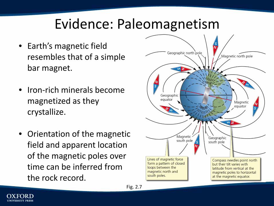
• Earth’s magnetic field resembles that of a simple bar magnet.
• Iron-rich minerals become magnetized as they crystallize.
• Orientation of the magnetic field and apparent location of the magnetic poles over time can be inferred from the rock record.
Evidence: Paleomagnetism
Fig. 2.7
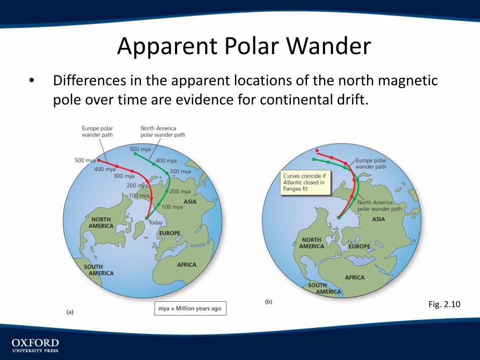
• Differences in the apparent locations of the north magnetic pole over time are evidence for continental drift.
Apparent Polar Wander
Fig. 2.10
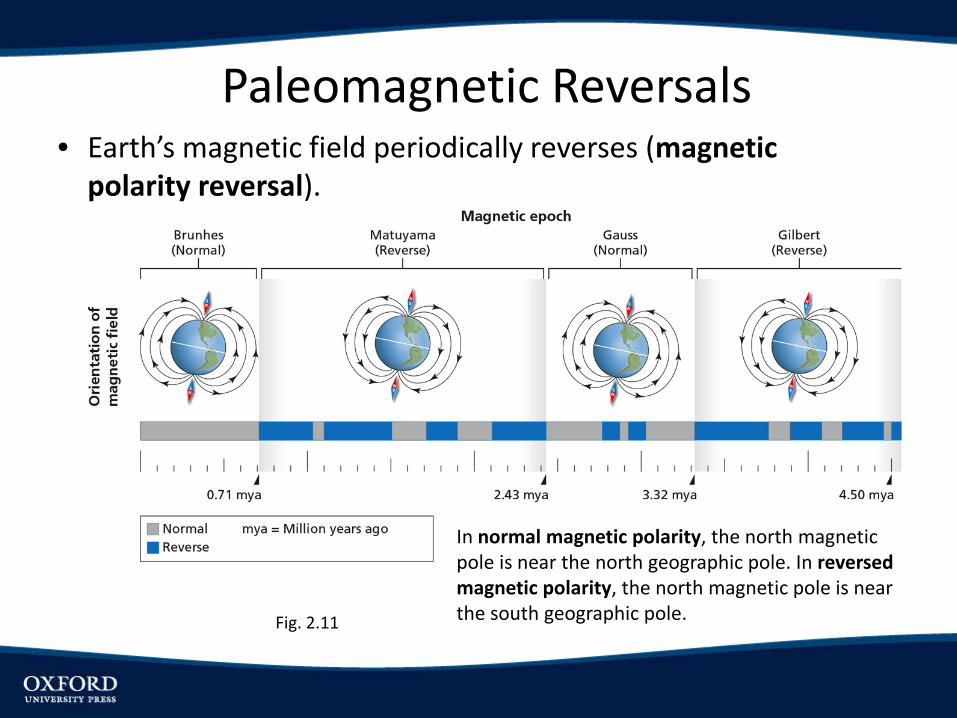
• Earth’s magnetic field periodically reverses (magnetic polarity reversal).
Paleomagnetic Reversals
In normal magnetic polarity, the north magnetic pole is near the north geographic pole. In reversed magnetic polarity, the north magnetic pole is near the south geographic pole.Fig. 2.11
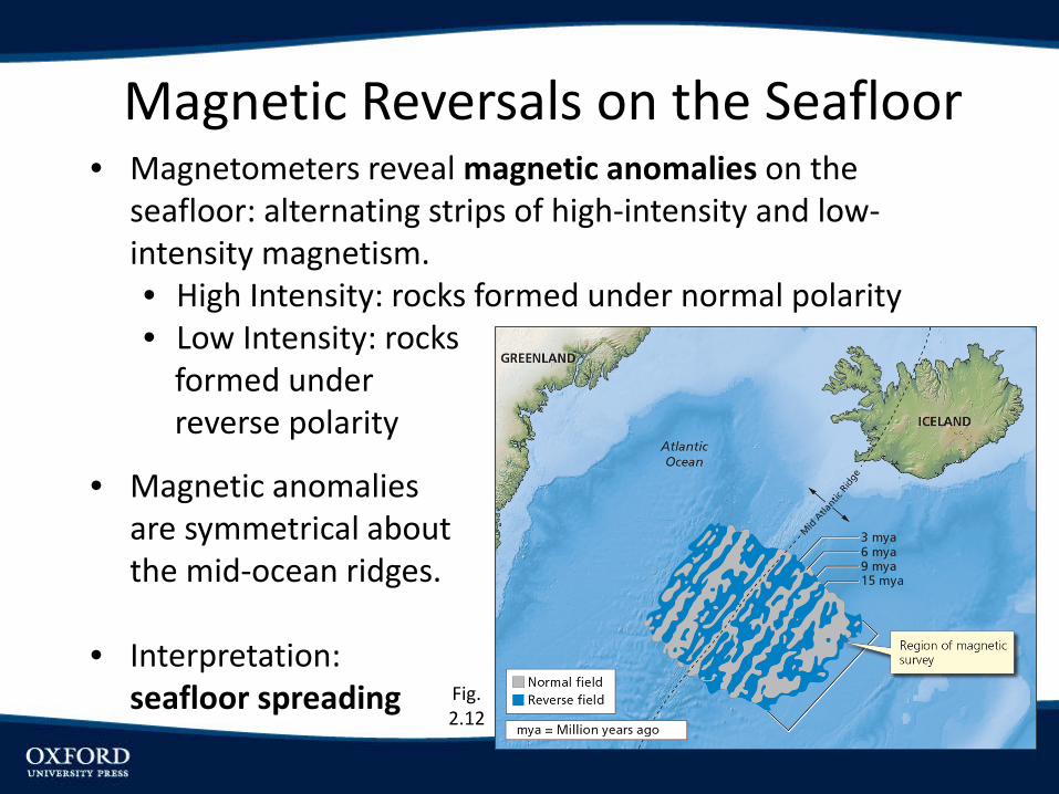
• Magnetometers reveal magnetic anomalies on the seafloor: alternating strips of high-intensity and low-intensity magnetism.• High Intensity: rocks formed under normal polarity• Low Intensity: rocks
formed underreverse polarity
Magnetic Reversals on the Seafloor
• Magnetic anomalies are symmetrical about the mid-ocean ridges.
• Interpretation: seafloor spreading Fig.
2.12

• Partial melting beneath the mid-ocean ridge causes volcanism.
• Earth’s magnetic polarity is recorded as lava crystallizes.
Seafloor Spreading
• Rock moves to either side and new magma is emplaced along the ridge.
• The seafloor moves symmetrically away from mid-ocean ridge, moving the ocean floor and continents.
• Basalts increase in age with distance from the ridge (confirmed by drilling and analysis of seafloor rocks). Fig. 2.13
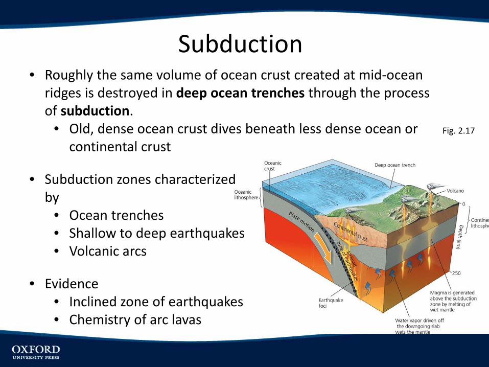
Subduction• Roughly the same volume of ocean crust created at mid-ocean
ridges is destroyed in deep ocean trenches through the process of subduction.
• Old, dense ocean crust dives beneath less dense ocean or continental crust
• Subduction zones characterized by
• Ocean trenches• Shallow to deep earthquakes• Volcanic arcs
• Evidence• Inclined zone of earthquakes• Chemistry of arc lavas
Fig. 2.17

Subduction Zones
Subduction of oceanic lithosphere beneath (a) oceanic lithosphere or (b) continental lithosphere both result in seismic activity and volcanism.
Fig 2.20
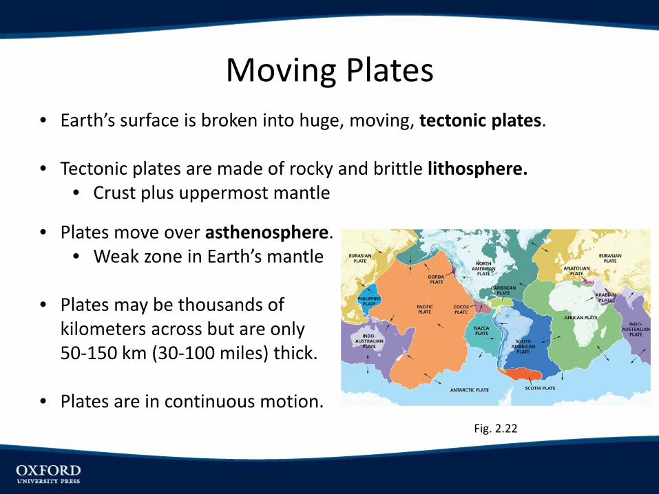
• Earth’s surface is broken into huge, moving, tectonic plates.
• Tectonic plates are made of rocky and brittle lithosphere.• Crust plus uppermost mantle
Moving Plates
• Plates move over asthenosphere. • Weak zone in Earth’s mantle
• Plates may be thousands of kilometers across but are only 50-150 km (30-100 miles) thick.
• Plates are in continuous motion.Fig. 2.22

Major Plates and Relative Motion

• Earthquake zones outline plate boundaries.
• Three types of plate boundaries:
• Divergent (or Constructive): plates move apart• Continents split• Oceans widen
• Convergent (or Destructive): plates move toward each other• Subduction of oceanic lithosphere• Continental collision
• Transform: plates slide past each other along transform faults
Plate Boundaries

Plate Boundaries
Fig. 2.23
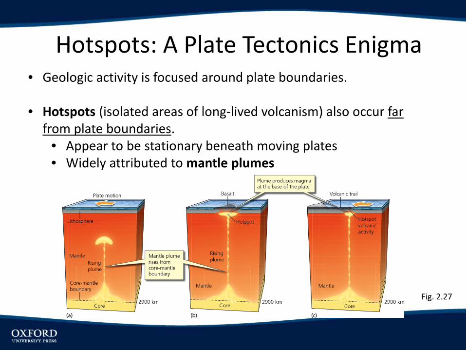
Hotspots: A Plate Tectonics Enigma• Geologic activity is focused around plate boundaries.
• Hotspots (isolated areas of long-lived volcanism) also occur far from plate boundaries.
• Appear to be stationary beneath moving plates• Widely attributed to mantle plumes
Fig. 2.27

Hawaiian Islands: Movement of the Pacific plate over the fixed Hawaiian hotspot has led to the formation of the Hawaiian island chain.
Fig. 2.28

SUMMARY• Theory of plate tectonics is the unifying theory of Earth science.
• Earth’s surface is broken into plates that move slowly relative to each other.
• Divergence of plates at ocean spreading centers and continental rifts
• Convergence of plates at subduction zones and continental collision zones
• Plates sliding past each other at transform boundaries• Explains patterns of earthquakes, volcanism, mountain belts,
and outlines of continents.• Theory evolved from the hypothesis of continental drift proposed
in the early 1900s.• Continental drift was initially rejected, in part because no
viable mechanism was proposed.• Evidence accumulated over the next 50 years.
SUMMARY• The theory of plate tectonics is supported by
• Jigsaw fit of the continents (in features such as mountain belts, major fault lines, and distinctive rock formations)
• Matching climate and fossil patterns on continents separated by major oceans
• Apparent polar wander, reflecting the movement of the continents
• Magnetic stripes on the seafloor• Deep ocean trenches• Patterns of earthquakes
• Shallow along transforms and divergent boundaries• Inclined zones along convergent boundaries (subduction
zones)• Hotspot tracks