Embed Size (px)
Citation preview
Guam and CNMI Military Relocation Final EIS (July 2010)
VOLUME 2: MARINE CORPS – GUAM 2-1 Proposed Action and Alternatives
CHAPTER 2.
PROPOSED ACTION AND ALTERNATIVES
2.1 OVERVIEW
The proposed action evaluated in this Volume 2 of the Guam
and Commonwealth of Northern Mariana Islands (CNMI)
Military Relocation Environmental Impact Statement (EIS) is to
establish a permanent Marine Corps base on Guam to support
the mission and training requirements of Marine Corps units
and personnel that will be relocated from Okinawa. The
rationale for selecting Guam as the focal point of the proposed
relocation is discussed in Chapter 1 of this Volume and Volume
1 of the EIS, and is therefore not repeated in this chapter. For
purposes of the National Environmental Policy Act (NEPA)
analysis in this Volume of the EIS, this chapter focuses only on
the functions, facilities, personnel, operations, and training that
would be constructed, stationed, and implemented on Guam in
order to accomplish the mission requirements of the proposed
relocation. The NEPA analysis for training that would be implemented on Tinian (CNMI) supporting the
relocation is in Volume 3.
This chapter of Volume 2 describes the key components of the proposed action, including the facility
construction and operational requirements for a Marine Corps base on Guam, as well as the development
of a reasonable set of alternatives for implementing the proposed action and the no-action alternative. The
figures and project descriptions provided in this chapter present the footprints of the proposed facilities
and activities of the proposed action.
2.1.1 Summary of Proposed Action: Establish a Marine Corps Base on Guam
The proposed action involves constructing and utilizing all required facilities, infrastructure, and training
assets necessary to establish a Marine Corps base of operations on Guam. The Marine Corps would
relocate approximately 8,600 Marines and their 9,000 dependents from Okinawa to Guam. The proposed
action for the approximately 8,600 Marines includes personnel from the units being relocated and the
associated base support personnel that must also be present at an installation to support the military
mission.
There would be four relocating military elements:
Command Element, III Marine Expeditionary Force (MEF). III MEF is the Marine Corps‘
forward-deployed Marine Air Ground Task Force (MAGTF); it has the ability to deploy
rapidly and conduct operations ranging from humanitarian assistance and disaster relief to
amphibious assault and high intensity combat. The MAGTF command element consists
primarily of Headquarters (HQ) and supporting organizations. Collocation and
communications connectivity is a primary facility siting requirement. Estimated personnel:
3,046.
Ground Combat Element (GCE), 3rd Marine Division Units. The GCE has the mission of
locating, closing with and destroying the enemy with fire, maneuver, and close combat. It
provides infantry, armor, artillery, reconnaissance, anti-tank and other combat arms. It
Chapter 2:
2.1 Overview
2.2 Main Cantonment Area
Functions
2.3 Training Functions
2.4 Airfield Functions
2.5 Waterfront Functions
2.6 Summary of Alternatives
Guam and CNMI Military Relocation Final EIS (July 2010)
VOLUME 2: MARINE CORPS – GUAM 2-2 Proposed Action and Alternatives
consists of Division HQ and subordinate organizations. Ground combat and combat support
organizations require proximity to ranges and training areas as well as traditional base
support facilities. Estimated personnel: 1,100.
Air Combat Element (ACE), 1st Aircraft Wing and subsidiary units. The ACE operates from a
variety of sea- and shore-based facilities to support MAGTF expeditionary operations. The
focus of the ACE is to support the MAGTF during assault landings and subsequent
operations ashore. The ACE includes the Marine Aircraft Wing (MAW) HQ, expeditionary,
and garrison supporting organizations. Unlike aircraft squadrons, aviation command and
general supporting elements can be located close to the airfield and higher commands, and do
not necessarily need to be located at the airfield. Estimated personnel: 1,856.
Logistics Combat Element (LCE), 3rd Marine Logistics Group (MLG). The LCE provides all
support functions beyond the capabilities of the GCE and ACE units. Functions include:
communications, engineering support, motor transport, medical, supply, maintenance, air
delivery, and landing support. The LCE consists of MLG HQ and supporting organizations
that provide a variety of direct logistics support to the rest of the MEF. The MLG HQ
element would be sited in proximity to Command HQ and other HQs. Indirect and industrial
support facilities of the LCE would be located in proximity to support activities and
maximize efficiency, with efficient access to roads, ports and airfields. Estimated personnel:
2,550.
There would also be a large transient component that includes the following units and approximate
personnel numbers:
Infantry battalion (800 people)
Artillery battery (150 people)
Aviation unit (250 people)
Other (800 people)
For the purpose of clearly defining what amounts to a very complex endeavor, this chapter describes the
proposed action and reasonable alternatives in terms of four major functional components of the Marine
Corps relocation to Guam. These components represent core capabilities and support functions within the
context of the overall Marine Corps mission. The mission capabilities of the units to be stationed in Guam
are part of a larger mission capability supporting the overall national defense objectives of the United
States (U.S.) in the Western Pacific Region. The four functional components of the proposed action are:
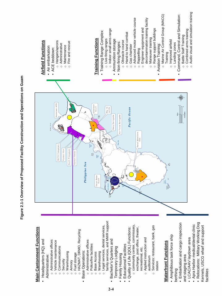
1. Main Cantonment Area functions. Main cantonment military support functions (also known
as base operations and support) include headquarters and administrative support, bachelor
housing, family housing, supply, maintenance, open storage, community support (e.g., retail,
education, recreation, medical, day care, etc.), some site-specific training functions, and open
space (e.g. parade grounds, open training areas, open green space in communities, etc), as
well as the utilities and infrastructure required to support the cantonment area.
2. Training functions. There are three subclasses of training support functions required by
Marine Corps units that would be stationed on Guam:
Firing ranges are required for live and inert munitions practice, which generates the need
for safety buffers called Surface Danger Zones (SDZs), and Special Use Airspace (SUA)
for certain weapons.
Non-fire maneuver ranges are required for vehicle and foot maneuver training, including
urban warfare training. Urban warfare training is conducted in buildings that simulate a
Guam and CNMI Military Relocation Final EIS (July 2010)
VOLUME 2: MARINE CORPS – GUAM 2-3 Proposed Action and Alternatives
city or town. These buildings would be arranged close together so that Marines can
practice entering and maneuvering in tight spaces.
Aviation training areas are either improved (paved runway) or unimproved (unpaved
landing sites) used to practice landing/takeoff and air field support (including
loading/unloading of fuel, munitions, cargo, and personnel). Aviation training includes
use of both international airspace and U.S. controlled airspace within the Mariana Islands
Range Complex (MIRC).
3. Airfield functions. The proposed Marine Corps relocation would include aviation units and
aviation support units that require runway and hangar space and maintenance, supply and
administrative facilities. There is also a need for air embarkation operations that are
comparable to, compatible with, and co-located with, existing Andersen Air Force Base
(AFB) operations. Air embarkation operations refer to loading and unloading cargo and
passengers to and from aircraft, comparable to a civilian airport terminal.
4. Waterfront functions. The ships and assault craft associated with the proposed Marine Corps
relocation are transient (visiting). The transient vessels support Marine Corps operations and
transient forces that presently train on Guam and in the CNMI. These ships would continue to
support Marine Corps requirements in the Western Pacific Region after the proposed
relocation, and would continue to require transient vessel support facilities on Guam. The
planning criteria for harbors, regardless of usage, differ from those for land-based facilities.
Therefore, the proposed waterfront facilities required, although training-related, are being
discussed in this EIS as distinct from other training actions.
Each of these project components is characterized by unique facility and operational requirements that
together comprise one proposed action. Figure 2.1-1 lists, for each of the four components, the types of
facilities that would be constructed and operated under the proposed action. These proposed facilities and
operations are described further in Sections 2.2.1, 2.3.1, 2.4.1, and 2.5.1, respectively, for each of the four
functions.
The process and criteria used to develop and evaluate a set of reasonable alternatives for implementing
the proposed action are described generally in Section 2.1.2 below. Results of the alternatives screening
process for each of the four functional components of the action are described in Sections 2.2.2, 2.3.2,
2.4.2, and 2.5.2, respectively. Alternatives were identified for each of the following:
Main Cantonment Area functions: eight alternatives representing different site-specific
planning alignments for the required Main Cantonment functions (and selected training
functions) were identified and evaluated, with four of these (Alternatives 1, 2, 3, and 8) being
carried forward for detailed analysis in the EIS.
Live-fire Training Range Complex: Firing ranges would be co-located on land to be acquired
east of Andersen AFB South (Andersen South). Two alternatives (Alternative A and B),
representing different site-specific planning alignments of various range facilities required to
conduct live-fire training, were identified and are carried forward for analysis in the EIS.
Access Road for Large Scale Maneuver Training Area: two alternatives representing different
levels of improvement for a single location are carried forward for analysis in the EIS.
Munitions Storage Facilities at the existing Naval Munitions Site (NMS): two alternatives
representing different locations and alignments for a proposed set of 10 new munitions
storage magazines are carried forward for analysis in the EIS.
Mai
n C
anto
nmen
t Fun
ctio
ns•
He
ad
qu
art
ers
(H
Q)
an
d
Ad
min
istr
ative
:o
Adm
inis
trative o
ffic
es
oV
ehic
le m
ain
tenance
oC
om
munic
ations
oS
ecurity
oW
are
housin
g
oA
rmory
oF
uel sto
rage
oH
AZ
MA
T, D
RM
O,
Recyclin
g
•B
ase
Op
era
tio
ns:
oA
dm
inis
trative o
ffic
es
oP
olic
e/f
ire facili
ties
oB
ase A
ccess
oW
are
housin
g
oLegal serv
ices, denta
l serv
ices,
fam
ily s
erv
ices, and M
WR
support
•B
ach
elo
r’s Q
ua
rte
rs a
nd
Te
mp
ora
ry L
od
gin
g
•F
am
ily H
ou
sin
g
•E
du
ca
tio
na
l Fa
cili
tie
s
•Q
ua
lity o
f L
ife
(Q
OL
) F
un
ctio
ns:
ocom
munity c
ente
r, c
om
mis
sary
,
exchange,
post
off
ice, th
eate
r,
recre
ational, e
tc.
oA
pplie
d instr
uction a
nd
auditorium
oS
erv
ices: re
sta
ura
nt,
bank,
gas
sta
tion
Wat
erfr
ont F
unct
ions
•A
mp
hib
iou
s ta
sk fo
rce
sh
ip
be
rth
ing
•E
mb
ark
atio
n a
nd
ca
rgo
in
sp
ectio
n
an
d s
tag
ing
are
a
•L
CA
C/A
AV
la
yd
ow
na
rea
•A
pra
Ha
rbo
r m
ed
ica
l/d
en
tal c
linic
•R
elo
ca
tio
ns: M
ilita
ry W
ork
ing
Do
g
Ke
nn
els
, U
SC
G w
ha
rf a
nd
su
pp
ort
facili
tie
s
Airf
ield
Fun
ctio
ns•
Air
em
ba
rka
tio
n
•A
CE
be
dd
ow
n:
oH
angars
/apro
ns
oA
dm
inis
trative
oM
ain
tenance
oF
ire a
nd r
escue
Trai
ning
Fun
ctio
ns•
Tra
inin
g R
an
ge
Co
mp
lex:
oLiv
e-f
irin
g r
anges
oIn
door
sm
all
arm
s r
ange
•A
mm
un
itio
n s
tora
ge
•N
on
-fir
ing
Ra
ng
es:
oO
bsta
cle
cours
e
oH
and-t
o h
and c
om
bat
oG
as c
ham
ber
oA
dvanced m
oto
r vehic
le c
ours
e
oR
appelli
ng
oE
ngin
eer
equip
ment
and
deconta
min
ation tra
inin
g f
acili
ty
oM
aneuver
train
ing
oR
ange s
upport
build
ings
•A
via
tio
n T
rain
ing
:o
Marine A
ir C
ontr
ol G
roup (
MA
CG
)
Tra
inin
g
oIm
pro
ved a
irfield
oLandin
g z
ones
•C
om
ma
nd
, C
on
tro
l a
nd
Sim
ula
tio
n:
oB
att
le S
taff
Tra
inin
g
oC
om
bin
ed a
rms tra
inin
g
oA
udio
vis
ual and s
imula
tion tra
inin
g
Figu
re 2
.1-1
Ove
rvie
w o
f Pro
pose
d Fa
cilit
y C
onst
ruct
ion
and
Ope
ratio
ns o
n G
uam
2-4
Guam and CNMI Military Relocation Final EIS (July 2010)
VOLUME 2: MARINE CORPS – GUAM 2-5 Proposed Action and Alternatives
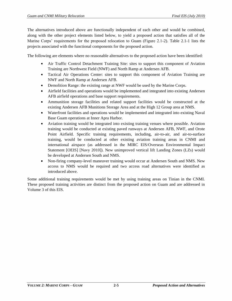
The alternatives introduced above are functionally independent of each other and would be combined,
along with the other project elements listed below, to yield a proposed action that satisfies all of the
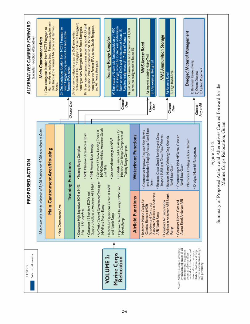
Marine Corps‘ requirements for the proposed relocation to Guam (Figure 2.1-2). Table 2.1-1 lists the
projects associated with the functional components for the proposed action.
The following are elements where no reasonable alternatives to the proposed action have been identified:
Air Traffic Control Detachment Training Site: sites to support this component of Aviation
Training are Northwest Field (NWF) and North Ramp at Andersen AFB.
Tactical Air Operations Center: sites to support this component of Aviation Training are
NWF and North Ramp at Andersen AFB.
Demolition Range: the existing range at NWF would be used by the Marine Corps.
Airfield facilities and operations would be implemented and integrated into existing Andersen
AFB airfield operations and base support requirements.
Ammunition storage facilities and related support facilities would be constructed at the
existing Andersen AFB Munitions Storage Area and at the High 12 Group area at NMS.
Waterfront facilities and operations would be implemented and integrated into existing Naval
Base Guam operations at Inner Apra Harbor.
Aviation training would be integrated into existing training venues where possible. Aviation
training would be conducted at existing paved runways at Andersen AFB, NWF, and Orote
Point Airfield. Specific training requirements, including, air-to-air, and air-to-surface
training, would be conducted at other existing aviation training areas in CNMI and
international airspace (as addressed in the MIRC EIS/Overseas Environmental Impact
Statement [OEIS] [Navy 2010]). New unimproved vertical lift Landing Zones (LZs) would
be developed at Andersen South and NMS.
Non-firing company-level maneuver training would occur at Andersen South and NMS. New
access to NMS would be required and two access road alternatives were identified as
introduced above.
Some additional training requirements would be met by using training areas on Tinian in the CNMI.
These proposed training activities are distinct from the proposed action on Guam and are addressed in
Volume 3 of this EIS.
• Main
Can
tonm
ent A
rea
All d
ecisi
ons a
lso in
clude
reloc
ation
of 8
,600
Mar
ines a
nd 9
,000
depe
nden
ts to
Gua
m
Trai
ning
Fun
ctio
ns
Air
field
Fun
ctio
nsW
ater
fron
t Fu
ncti
ons
Mai
n C
anto
nmen
t Are
a/H
ousi
ng
• Con
stru
ct H
igh E
xplo
sive
ECM
at N
MS
High
12
Gro
up A
rea
• Con
stru
ct 1
2 St
anda
rd E
CM
’s an
d Su
ppor
t Fac
ilitie
s at A
nder
sen A
FB M
SA 1
• Air
Traff
ic C
ontr
ol D
etac
hmen
t Tra
inin
g at
N
WF
and
Nor
th R
amp
• Tac
tical
Air
Ope
ratio
ns C
ente
r at N
WF
and
Nor
th R
amp
• Im
prov
ed A
irfie
ld Tr
ainin
g at
NW
F an
d N
orth
Ram
p
• Tra
inin
g Ra
nge
Com
plex
• NM
S M
aneu
ver A
rea A
cces
s Roa
d
• NM
S Am
mun
ition
Sto
rage
• Con
stru
ct 1
2 N
ew L
andi
ng Z
ones
at
NW
F, O
rote
Airf
ield
, And
erse
n So
uth,
and
NM
S
• Use
dem
oliti
on ra
nge
at N
WF
• Est
ablis
h Re
stric
ted
Are
a Airs
pace
for
Mac
hine
Gun
Ran
ge C
ompo
nent
of
Train
ing
Rang
e C
ompl
ex
• Bed
dow
n M
arin
e C
orps
Air
Com
bat E
lem
ent (
ACE)
Sq
uadr
on a
nd C
onst
ruct
A
ssoc
iated
Fac
ilitie
s at A
nder
sen
AFB
Nor
th R
amp
• Con
stru
ct A
ir Em
bark
atio
n Fa
ciliti
es a
t And
erse
n AFB
Sou
th
Ram
p
• Con
stru
ct N
orth
Gat
e an
d A
cces
s Roa
d, A
nder
sen A
FB
• Con
stru
ct o
r Im
prov
e Re
quire
d Sh
ip B
erth
s an
d Em
bark
atio
n/ S
tagin
g Are
as a
t Nav
al Ba
se
Gua
m
• Rel
ocat
e C
oast
Gua
rd B
erth
ing
and
Cre
w
Supp
ort B
uild
ing
at O
scar
/Pap
a Wha
rves
• Rel
ocat
e M
ilitar
y Wor
king
Dog
Ken
nels,
N
aval
Base
Gua
m
• Con
stru
ct A
pra
Med
ical/D
enta
l Clin
ic at
N
aval
Base
Gua
m
• Mec
hani
cal D
redg
ing
in A
pra
Har
bor*
• Dre
dged
Mat
erial
Man
agem
ent
VOLU
ME
2:M
arin
e C
orps
Rel
ocat
ion
NM
S Ac
cess
Roa
d
NM
S Am
mun
ition
Sto
rage
Mai
n C
anto
nmen
t Are
a
Trai
ning
Ran
ge C
ompl
ex
1) O
ne c
ontig
uous
loca
tion
from
NC
TS F
ineg
ayan
to
Har
mon
Ann
ex, in
clude
s Sou
th F
ineg
ayan
; acq
uire
non
-D
oD la
nds a
t the
For
mer
FA
A p
arce
l and
Har
mon
A
nnex
.2)
One
con
tiguo
us lo
catio
n fro
m N
CTS
Fin
egay
an to
So
uth
Fine
gaya
n; ac
quire
non
-DoD
land
s at t
he
Form
er F
AA
par
cel.
3) F
our n
on-c
ontig
uous
are
as o
n D
oD p
rope
rtie
s: ca
nton
men
t at N
CTS
Fin
egay
an a
nd S
outh
Fin
egay
an;
hous
ing
at N
avy
Barr
igada
and
Air
Forc
e Ba
rriga
da.
8) T
hree
non
-con
tiguo
us a
reas
requ
iring
non
-DoD
land
ac
quisi
tion.
Main
Can
tonm
ent a
t NC
TS F
ineg
ayan
; ho
usin
g at
the
Form
er F
AA
par
cel, S
outh
Fin
egay
an,
and
Air
Forc
e Ba
rriga
da
A) E
ast c
oast
of G
uam
with
land
acq
uisit
ion
of 1
,090
ac
res;
all ra
nges
wou
ld b
e lo
cate
d ea
st o
f And
erse
n So
uth
on n
on-D
oD la
nd to
the
east
of R
oute
15.
Requ
ires r
ealig
nmen
t of 1
.7 m
iles o
f Rou
te 1
5.B)
Eas
t coa
st o
f Gua
m w
ith la
nd a
cqui
sitio
n of
1,8
00
acre
s; no
reali
gnm
ent o
f Rou
te 1
5.
A) I
mpr
ove
exist
ing
Hik
ing T
rail
B) U
se e
xist
ing
Hik
ing T
rail
Dre
dged
Mat
eria
l Man
agem
ent
1) B
enef
icial
Reus
e (P
riorit
y)2)
Oce
an D
ispos
al3)
Upl
and
Plac
emen
t
A) P
arso
n’s R
oad
B) H
igh R
oad
Are
aC
hoos
eO
ne
Cho
ose
One
Cho
ose
One
Cho
ose
One
Cho
ose
Any
or A
ll
ALTE
RNAT
IVES
CAR
RIED
FO
RWAR
D(e
xclu
des n
o-ac
tion
alte
rnat
ive)
PR
OP
OSE
D A
CT
ION
LE
GE
ND
Pre
ferr
ed A
lter
nat
ive
Figu
re 2
.1-2
Sum
mar
y of
Pro
pose
d A
ctio
n an
d A
ltern
ativ
es C
arri
ed F
orw
ard
for
the
Mar
ine
Cor
ps R
eloc
atio
n, G
uam
*Not
e: A
nal
ysis
ass
um
ed d
redg
ing
by m
ech
anic
al m
ean
s as
an
en
viro
nm
enta
l max
imu
m
pote
nti
al a
dver
se a
ffec
t m
eth
od a
nd
is t
he
met
hod
h
isto
rica
lly
use
d at
Apr
a H
arbo
r. H
ydra
uli
c dr
edge
m
ay b
e u
sed
in f
inal
des
ign
an
d pe
rmit
tin
g.
2-6
Guam and CNMI Military Relocation Final EIS (July 2010)
VOLUME 2: MARINE CORPS – GUAM 2-7 Proposed Action and Alternatives
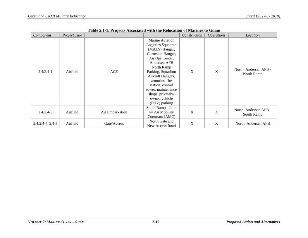
Table 2.1-1. Projects Associated with the Relocation of Marines to Guam Component Project Title Construction Operations Location
2.2/2.2-4 Main
Cantonment
Headquarters and Administrative
facilities, Base Operations,
Temporary Lodging, Family
Housing, Educational facilities,
Quality of Life, Commercial Gate,
Main Gate, and Residential Gate,
Main Cantonment:
Alternative 1 X X
North: Naval Computer and
Telecommunication Station
(NCTS) Finegayan
(Cantonment), Potts
Junction (utilities), Former
Federal Aviation
Administration (FAA)
parcel, South. Finegayan,
and Harmon Annex
(Housing)
2.2/2.2-5 Main
Cantonment
Headquarters and Administrative
facilities, Base Operations,
Temporary Lodging, Family
Housing, Educational facilities,
Quality of Life, Commercial Gate,
Main Gate, and Residential Gate,
Main Cantonment:
Alternative 2 X X
North: NCTS Finegayan
(Cantonment), Potts
Junction (utilities), Former
FAA parcel and South
Finegayan (Housing)
2.2/2.2-6 Main
Cantonment
Headquarters and Administrative
facilities, Base Operations,
Temporary Lodging, Family
Housing, Educational facilities,
Quality of Life, Commercial Gate,
Main Gate, and Residential Gate,
Main Cantonment:
Alternative 3 X X
North: NCTS Finegayan
(Cantonment), Potts
Junction (utilities), South
Finegayan, Central: Navy
Barrigada, AF Barrigada
(Housing)
2.2/2.2-7 Main
Cantonment
Headquarters and Administrative
facilities, Base Operations,
Temporary Lodging, Family
Housing, Educational facilities,
Quality of Life, Commercial Gate,
Main Gate, and Residential Gate,
Main Cantonment:
Alternative 8 X X
North: NCTS Finegayan
(Cantonment), Potts
Junction (utilities), Former
FAA parcel, S. Finegayan,
Central: AF Barrigada
(Housing)
2.3/ 2.3-5 Training Non-Firing/Maneuver Access Roadway,
Alternative A X X South: NMS
2.3/ 2.3-5 Training Non-Firing/Maneuver Access Roadway,
Alternative B X South: NMS
2.3/2.3-11 Training Aviation Training
Improved airfield,
Air Traffic Control
(ATC), Training
Air Operations
Center (TAOC)
X North: NWF, North Ramp,
Andersen AFB
Guam and CNMI Military Relocation Final EIS (July 2010)
VOLUME 2: MARINE CORPS – GUAM 2-8 Proposed Action and Alternatives
Table 2.1-1. Projects Associated with the Relocation of Marines to Guam Component Project Title Construction Operations Location
2.3/2.3-11 Training Aviation Training LZ (4) X North: Andersen AFB -
NWF
2.3/2.3-11 Training Aviation Training LZ (2) (new) X X Central: Andersen South
2.3/2.3-11 Training Aviation Training LZ (1) X Apra Harbor: Orote
2.3/2.3-11 Training Aviation Training LZ (5) (new) X X South: NMS
2.3 Training Aviation Training Airfield Training X North: Andersen AFB
2.3/NA Training Firing Ranges Demolition Range X North: NWF
2.3/2.3-17 Training Firing Ranges
Hand Grenade
Range and grenade
house (HG1);
Breacher and
Shooting House;
(co-located with
Firing Range
Complex
Alternative A)
X X Central: Andersen South
2.3/2.3-17 Training Firing Ranges
Hand Grenade
Range and grenade
house (HG2);
Breacher and
Shooting House;
(co-located with
Firing Range
Complex
Alternative B )
X X Central: Andersen South
2.3/2.3-16 Training
Live-Fire: KD Range, Pistol
Range, Square-Bay Range,
Modified Record of Fire Range,
Range Control, Machine Gun
Range; range roads, Realignment
of Route 15; range towers;
Proposed SUA Airspace
Firing Range
Complex:
Alternative A
X X Central: Rt 15 Plateau
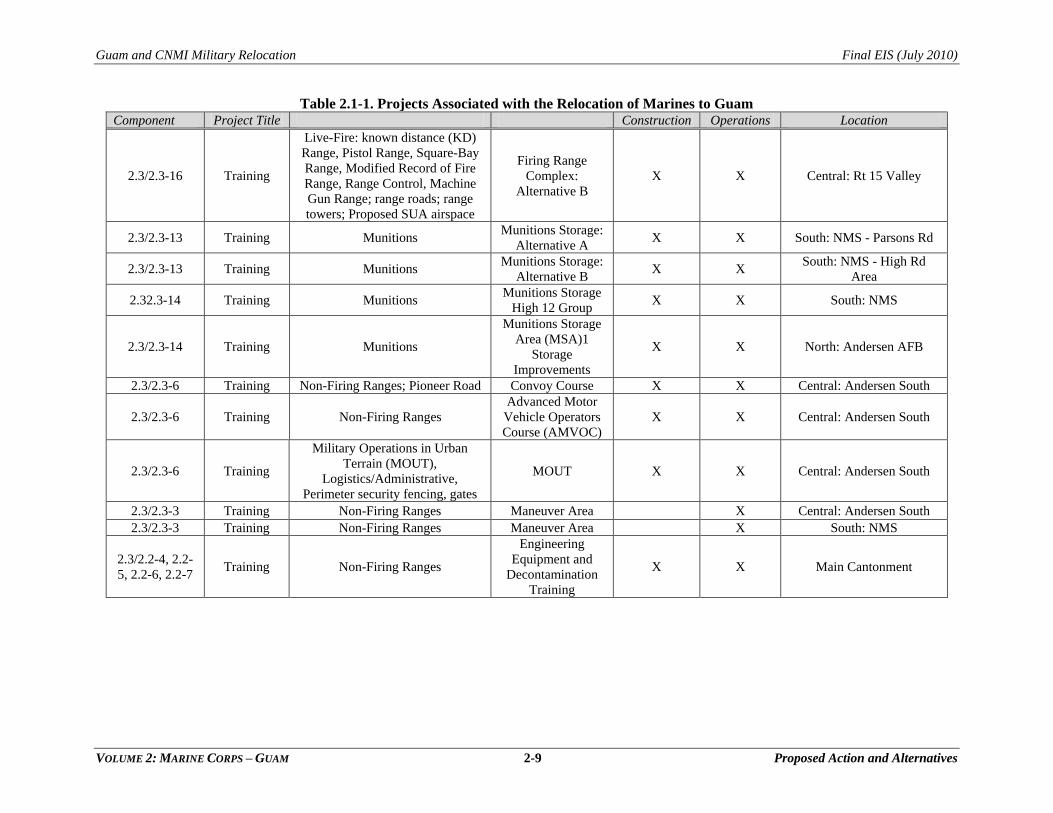
Guam and CNMI Military Relocation Final EIS (July 2010)
VOLUME 2: MARINE CORPS – GUAM 2-9 Proposed Action and Alternatives
Table 2.1-1. Projects Associated with the Relocation of Marines to Guam Component Project Title Construction Operations Location
2.3/2.3-16 Training
Live-Fire: known distance (KD)
Range, Pistol Range, Square-Bay
Range, Modified Record of Fire
Range, Range Control, Machine
Gun Range; range roads; range
towers; Proposed SUA airspace
Firing Range
Complex:
Alternative B
X X Central: Rt 15 Valley
2.3/2.3-13 Training Munitions Munitions Storage:
Alternative A X X South: NMS - Parsons Rd
2.3/2.3-13 Training Munitions Munitions Storage:
Alternative B X X
South: NMS - High Rd
Area
2.32.3-14 Training Munitions Munitions Storage
High 12 Group X X South: NMS
2.3/2.3-14 Training Munitions
Munitions Storage
Area (MSA)1
Storage
Improvements
X X North: Andersen AFB
2.3/2.3-6 Training Non-Firing Ranges; Pioneer Road Convoy Course X X Central: Andersen South
2.3/2.3-6 Training Non-Firing Ranges
Advanced Motor
Vehicle Operators
Course (AMVOC)
X X Central: Andersen South
2.3/2.3-6 Training
Military Operations in Urban
Terrain (MOUT),
Logistics/Administrative,
Perimeter security fencing, gates
MOUT X X Central: Andersen South
2.3/2.3-3 Training Non-Firing Ranges Maneuver Area X Central: Andersen South
2.3/2.3-3 Training Non-Firing Ranges Maneuver Area X South: NMS
2.3/2.2-4, 2.2-
5, 2.2-6, 2.2-7 Training Non-Firing Ranges
Engineering
Equipment and
Decontamination
Training
X X Main Cantonment
Guam and CNMI Military Relocation Final EIS (July 2010)
VOLUME 2: MARINE CORPS – GUAM 2-10 Proposed Action and Alternatives
Table 2.1-1. Projects Associated with the Relocation of Marines to Guam Component Project Title Construction Operations Location
2.4/2.4-1 Airfield ACE
Marine Aviation
Logistics Squadron
(MALS) Hangar,
Corrosion Hangar,
Air Ops Center,
Andersen AFB
North Ramp
Parking, Squadron
Aircraft Hangars,
armories, fire
station, control
tower, maintenance
shops, privately-
owned vehicle
(POV) parking
X X North: Andersen AFB -
North Ramp
2.4/2.4-3 Airfield Air Embarkation
South Ramp - Joint
w/ Air Mobility
Commant (AMC)
X X North: Andersen AFB -
South Ramp
2.4/2.4-4, 2.4-5 Airfield Gate/Access North Gate and
New Access Road X X North: Andersen AFB
Guam and CNMI Military Relocation Final EIS (July 2010)
VOLUME 2: MARINE CORPS – GUAM 2-11 Proposed Action and Alternatives
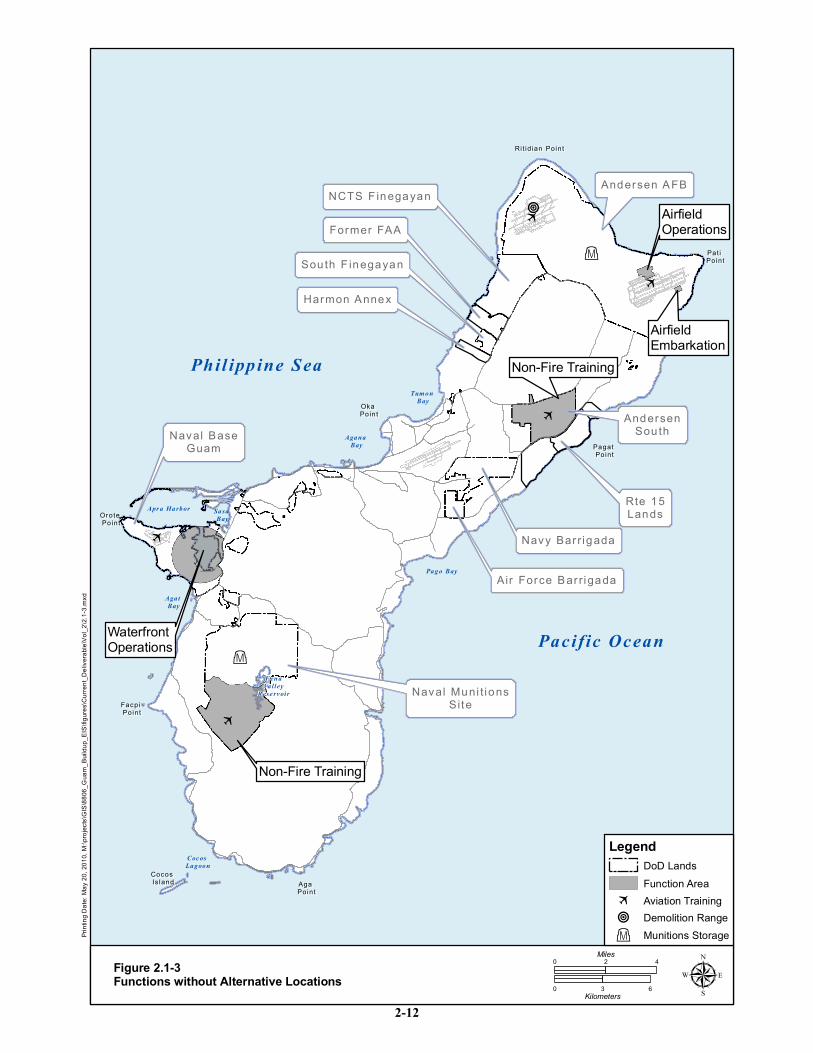
Functions (Airfield, Waterfront) and elements (Munitions Storage) without associated alternatives are
depicted in Figure 2.1-3.
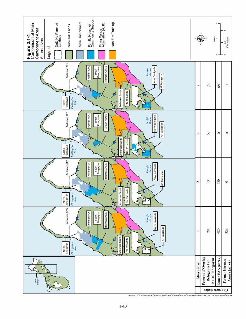
The most substantial differences between the alternatives carried forward for any of the four functional
project components relate to the main cantonment. Alternatives 1, 2, and 8 include a requirement for
obtaining a real estate interest in the former FAA land parcel. Alternative 1 also requires acquisition of a
portion of the Harmon parcel of land. The acquisition of access rights and land parcels would be pursued
with the appropriate land owners upon completion of the Record of Decision (ROD). The alternatives
vary in the quantity of non-Department of Defense (DoD) land to be acquired in the vicinity of NCTS
Finegayan and the quantity of NCTS Finegayan proposed for development. Two of the four alternatives
(3 and 8) would divide the family housing/community support facilities between properties located in the
eastern and western sides of Guam. All four action alternatives meet the purpose and need of the proposed
action. Figure 2.1-4 illustrates the differences between the four Cantonment Area action alternatives.
2.1.2 Alternatives Analysis Methodology
This section summarizes the methodology and criteria used to identify potential project alternatives on
Guam, to screen out alternatives that would not satisfy the purpose and need for the action, and to develop
the range of reasonable action alternatives that are carried forward in the EIS impact analyses. The
alternatives development process that was used to identify a reasonable set of project alternatives for the
proposed action on Guam involved the following four steps:
Step 1. Identify Requirements: Identify and evaluate the facility and operational requirements
associated with the Marine Corps units moving to Guam within the context of the overall
mission of the Marine Corps and DoD in the Western Pacific Region.
Step 2. Identify Site Alternatives: Identify specific land parcels, training ranges, and other assets that
would feasibly accommodate, with or without modification, each of the functional
requirements identified in Step 1. Screening criteria were used to identify both DoD and non-
DoD parcels that would feasibly accommodate either aggregated or disaggregated Marine
Corps functions. No one contiguous area on Guam was identified that could support all the
land use and operational requirements of the proposed action. Further, the amount of
available DoD land was insufficient to satisfy the requirements exclusively. Some project
components, such as airfields and waterfront facilities, could be sited in Step 2 independent
of other proposed land uses or requirements, as they could be accommodated at existing
military facilities designed for those functions. Other project components, such as individual
elements of the main cantonment area, required further analysis to evaluate various site plan
characteristics that might enable feasible project alternatives within identified development
sites.
Step 3. Identify Site-Specific Planning Alternatives: Evaluate specific sites or groupings of available
sites identified in Step 2 to determine if alternative combinations of functional elements (e.g.,
individual main cantonment or training functions) could be feasibly planned to satisfy defined
criteria and the purpose and need for the action.
Step 4. Select Alternatives for Analysis: In situations where multiple alternatives would be feasible
for a particular function apply criteria to identify the alternatives that best satisfy the
requirements identified in Step 1.
Phil ippine Sea
Pacific Ocean
Apr a Harbor Sasa Bay
Agat Bay
Coc os Lagoon
Pago Bay
Agana Bay
Tum on Bay
FenaValley
Rese rv oir
NCTS F inegayanNCTS F inegayan
AndersenAndersenSou thSou th
Navy Bar r igadaNavy Bar r igada
Air Force Bar r igadaAir Force Bar r igada
Rit id ian PointRi t id ian Point
Pat i Pat i PointPoint
Pagat Pagat PointPoint
Oka Oka PointPoint
Or ote Or ote PointPoint
Facpi Facpi PointPoint
Aga Aga PointPoint
Cocos Cocos Is landIs land
Sou th F inegayanSou th F inegayan
Andersen AFBAndersen AFB
Naval Muni t ionsNaval Muni t ionsSiteSite
Naval BaseNaval BaseGuamGuam
Former FAAFormer FAA
Rte 15Rte 15LandsLands
Harmon AnnexHarmon Annex
WaterfrontOperations
AirfieldOperations
7
7
7
7
7
O
O
O
AirfieldEmbarkation
Non-Fire Training
Non-Fire Training
ing D
ate: M
ay 20
, 201
0, M:
\proje
cts\G
IS\88
06_G
uam_
Build
up_E
IS\fig
ures\C
urren
t_Deli
verab
le\Vo
l_2\2.
1-3.m
xd
Figure 2.1-3Functions without Alternative Locations
0 42Miles
0 3 6Kilometers µ
LegendDoD Lands
Munitions StorageO
7 Aviation TrainingO Demolition Range
Function Area
2-12
Printing Date: May 20, 2010, M:\projects\GIS\8806_Guam_Buildup_EIS\figures\Current_Deliverable\Vol_2\2.1-4.mxd
Comp
ariso
n of M
ainCa
ntonm
ent A
reaAlt
ernati
ves
Figur
e 2.1-
4 µ
GUAM
GUAM
Area
Enlar
ged
04
2Miles
02.5
5Kil
omete
rs
!"1 !"15
!"9
NCTS
NC
TS
Fineg
ayan
Fineg
ayan
Ande
rsen A
FBAn
derse
n AFB
Paci
ficOc
ean
Phili
ppin
eSe
a
Form
er FA
AFo
rmer
FAA
South
South
Fineg
ayan
Fineg
ayan
Harm
on An
nex
Harm
on An
nex
Ande
rsen S
outh
Ande
rsen S
outh
Navy
Barrig
ada
Navy
Barrig
ada
AF Ba
rrigad
aAF
Barrig
ada
Rte 1
5 Lan
dsRt
e 15 L
ands
Alter
nativ
e3
8Pe
rcen
t of O
verlay
Re
fuge l
ost a
t NC
TS Fi
nega
yan
5329
Fome
r FAA
(acr
es)
0680
Form
er H
armo
n An
nex (
acre
s)0
0
12
Characteristics
2953
680680
3260
Lege
nd Non-F
ire Tr
aining
Fami
ly Ho
using
/Co
mmun
ity S
uppo
rt
Main
Canto
nmen
t
Non-D
oD La
nds
DoD-
No P
lanne
dLa
ndus
e
Firing
Ran
geAlt
ernati
ve (A
, B)
2-13
Guam and CNMI Military Relocation Final EIS (July 2010)
VOLUME 2: MARINE CORPS – GUAM 2-14 Proposed Action and Alternatives
This four-step process was applied independently for individual projects comprising each of the four
functional components of the action: main cantonment, training, airfield, and waterfront. Sections 2.2
through 2.5 describe in detail, for each functional component of the action, the specific infrastructure
projects and operations that comprise the proposed action, as well as the project alternatives that were
identified. Section 2.6 summarizes the set of all reasonable alternatives for the proposed action, as well as
the no-action alternative.
Alternatives associated with utility infrastructure requirements for the proposed action components (e.g.,
power, wastewater, potable water and solid waste management) are discussed in Volume 6. Utility
planning requires technological alternatives analysis as well as siting alternatives analysis. The utilities
planning would follow the overall master planning evolution.
2.1.2.1 Step 1 - Requirements Analysis
Land use and operational requirements associated with the proposed Marine Corps relocation to Guam
were based on intensive, multi-phased planning efforts conducted by the U.S. Navy and Marine Corps.
Ongoing master planning efforts would continue throughout design and construction phases of the action.
Details of the identified requirements for each functional component of the action are provided in
Sections 2.2.1, 2.3.1, 2.4.1, and 2.5.1, respectively.
2.1.2.2 Step 2 - Site Alternatives
In accordance with federal requirements on land usage, including Title 42 U.S. Code (USC) and
applicable rules and regulations, the master planning effort identified the Marine Corps‘ specific facility
and space requirements on Guam based upon unit mission, functions, and required capabilities. The total
acreage of land required was estimated based on planning assumptions and planning guidance codified in
Unified Facilities Criteria (UFC) codes. The Guam Joint Military Master Plan (Naval Facilities
Engineering Command [NAVFAC] Pacific 2009) lists planning assumptions and criteria for the
development plans (e.g., family housing density is based on 4-6 units per acre (ac) and maximum building
height is four floors). Some of the assumptions were driven by operational requirements and others by
military standards or existing on-island military construction. These assumptions were used for gross
assessment of acreage required and are subject to change as the master planning is refined. The available
DoD land was compared with the total facility requirements and evaluated against the potential loss of
military mission capability. The results indicate that potential loss of mission capability was unacceptable
when only DoD land was considered for development. Non-U.S. controlled property was considered in
the analysis of the alternatives.
Initially, a key assumption was that most of NCTS Finegayan, excluding existing communications
facilities and the Haputo Ecological Reserve, was developable. However, through subsequent informal
agency consultations, agency review of a preliminary Description of Proposed Action and
Alternatives (DOPAA) (April 2008), and subsequent partnering meetings, the DoN recognized the
importance of keeping undeveloped lands within NCTS Finegayan that are a part of Overlay Refuge as
intact as possible. The Overlay Refuge was created to support conservation management efforts for four
threatened or endangered species associated with Guam, including efforts aimed at recovery of the four
species. Because the lands included within the Overlay Refuge may provide habitats essential to the
survival and recovery of the four species, they have been included in the recovery plans for some of the
species. The Overlay Refuge boundaries encumber 87% of NCTS Finegayan and 98% of Andersen AFB
NWF as all operational areas were excluded from the original Overlay Refuge designation. The result of
this consideration was a range of alternatives that differ from the DOPAA (April 2008) action
Guam and CNMI Military Relocation Final EIS (July 2010)
VOLUME 2: MARINE CORPS – GUAM 2-15 Proposed Action and Alternatives
alternatives. Generally these new alternatives require more land acquisition than was initially estimated
when assuming the majority of NCTS Finegayan was fully developable.
The Step 2 site selection process matched land parcels with required land use functions. The candidate
parcels were NCTS and South Finegayan, Andersen South, Barrigada (Navy and Air Force), Naval Base
Guam, NMS, and specific non-DoD lands. The candidate DoD lands were selected because they had
adequate areas of contiguous open space and had large areas of contiguous developable land.
Before acquiring real property by purchase or lease, DoD Components must determine that the
requirement cannot be satisfied by: excess, under-utilized, or otherwise, available property held by other
Military Departments or Federal Agencies (DoD Instruction 4165.71, Real Property Acquisition, January
2005). This instruction is aimed at maximizing the use of existing DoD land prior to acquiring non-DoD
land. During Step 2, it became apparent that not all of the mission critical functions and requirements
associated with the proposed DoD relocation effort would fit on DoD land on Guam. Navy direction was
to then consider non-DoD land only for mission critical functions. Ultimately, it was determined that the
mission critical main cantonment facilities required siting on non-DoD land. In determining which non-
DoD lands could be considered for siting mission-critical functions, the preference was for non-DoD
lands adjacent to DoD lands. This preference was intended to maximize best land use practices and
formation of contiguous DoD property, affording both Guam planners and DoD planners efficiencies in
urban planning for community development.
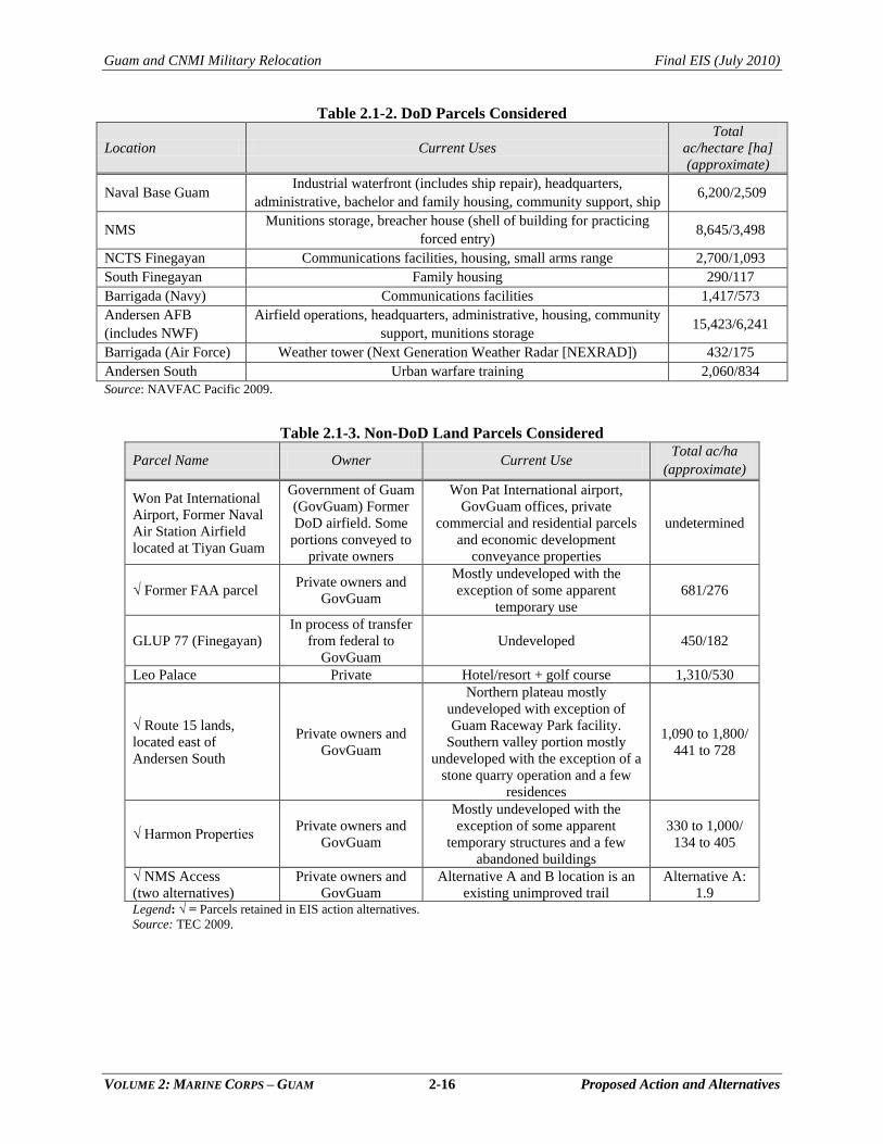
In addition to considering non-DoD lands that are adjacent to DoD lands, there were lands that were
proposed for consideration by special interest groups or private parties, such as the use of Leo Palace for a
family housing area, or lands that were unique in function, such as the Won Pat International Airport for
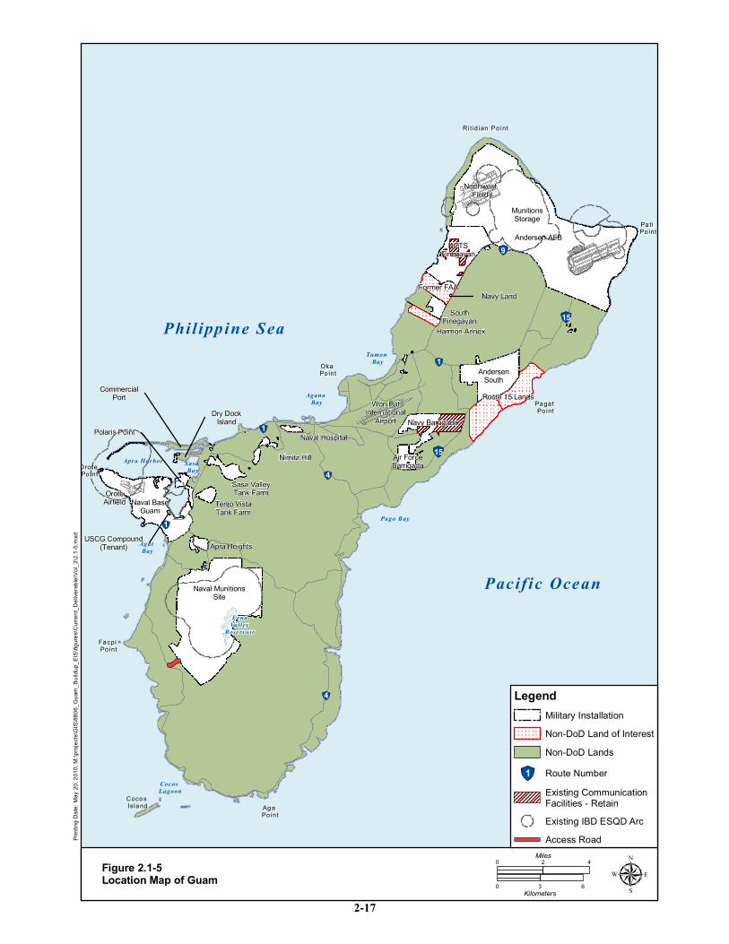
airfield operations. These lands are summarized in Table 2.1-2 and Table 2.1-3 and identified on Figure
2.1-5.
All DoD candidate parcels were considered suitable and feasible for at least one land use function. Of the
non-DoD parcels, Won Pat International Airport, the Guam Land Use Plan (GLUP) of 1977 parcel
(GLUP 77), and Leo Palace were eliminated from further consideration. The Won Pat International
Airport was eliminated from consideration for airfield operations based upon impacts to ongoing civilian
aviation operations and airspace conflicts. Leo Palace was eliminated for consideration as a family
housing site because of the accessibility concerns that would have necessitated the construction of major
roadway improvements and would have resulted in the separation of family housing from operational
facilities. GLUP 77 identified multiple DoD parcels for release. The Guam Excess Land Act of 1994
(Public Law [PL]103–339; 108 Stat. 3116) addresses the release of these parcels. Throughout this EIS the
one parcel near NCTS Finegayan is referred to as the GLUP 77 parcel because it is the name that is
familiar to most area residents. The elimination of the GLUP 77 parcel for any Marine Corps land use
was based on the anticipated duration of the land acquisition process for this parcel (10 years) relative to
other non-DoD parcels (2 to 3 years). With anticipated targeted completion date of 2014, the GLUP 77
parcel land acquisition would not meet the project purpose and need. Even with the use of Adaptive
Program Management, discussed in Volume 7, Chapter 4, and its slowing of construction pace and
adjusting construction sequencing, it was essential to quickly acquire non-DoD parcels to support
development of the main cantonment area and/or training ranges. Further, an approved land use
development plan (Dos Amantes) currently exists for the GLUP 77 parcel. Use of the GLUP 77 parcel for
Marine Corps land uses would preclude implementation of the development plan and negatively impact
community planning efforts on Guam.
Guam and CNMI Military Relocation Final EIS (July 2010)
VOLUME 2: MARINE CORPS – GUAM 2-16 Proposed Action and Alternatives
Table 2.1-2. DoD Parcels Considered
Location Current Uses
Total
ac/hectare [ha]
(approximate)
Naval Base Guam Industrial waterfront (includes ship repair), headquarters,
administrative, bachelor and family housing, community support, ship 6,200/2,509
NMS Munitions storage, breacher house (shell of building for practicing
forced entry) 8,645/3,498
NCTS Finegayan Communications facilities, housing, small arms range 2,700/1,093
South Finegayan Family housing 290/117
Barrigada (Navy) Communications facilities 1,417/573
Andersen AFB
(includes NWF)
Airfield operations, headquarters, administrative, housing, community
support, munitions storage 15,423/6,241
Barrigada (Air Force) Weather tower (Next Generation Weather Radar [NEXRAD]) 432/175
Andersen South Urban warfare training 2,060/834
Source: NAVFAC Pacific 2009.
Table 2.1-3. Non-DoD Land Parcels Considered
Parcel Name Owner Current Use Total ac/ha
(approximate)
Won Pat International
Airport, Former Naval
Air Station Airfield
located at Tiyan Guam
Government of Guam
(GovGuam) Former
DoD airfield. Some
portions conveyed to
private owners
Won Pat International airport,
GovGuam offices, private
commercial and residential parcels
and economic development
conveyance properties
undetermined
√ Former FAA parcel Private owners and
GovGuam
Mostly undeveloped with the
exception of some apparent
temporary use
681/276
GLUP 77 (Finegayan)
In process of transfer
from federal to
GovGuam
Undeveloped 450/182
Leo Palace Private Hotel/resort + golf course 1,310/530
√ Route 15 lands,
located east of
Andersen South
Private owners and
GovGuam
Northern plateau mostly
undeveloped with exception of
Guam Raceway Park facility.
Southern valley portion mostly
undeveloped with the exception of a
stone quarry operation and a few
residences
1,090 to 1,800/
441 to 728
√ Harmon Properties Private owners and
GovGuam
Mostly undeveloped with the
exception of some apparent
temporary structures and a few
abandoned buildings
330 to 1,000/
134 to 405
√ NMS Access
(two alternatives)
Private owners and
GovGuam
Alternative A and B location is an
existing unimproved trail
Alternative A:
1.9 Legend: √ = Parcels retained in EIS action alternatives.
Source: TEC 2009.
!"1
!"1
!"4
!"4
!"1
!"15
!"15
!"9
Ritid ian Po intRit id ian Po int
Pa ti Pa ti Po intPo int
Paga t Paga t Po intPo int
Oka Oka Po intPo int
Oro te Oro te Po intPo int
Facpi Facpi Po intPo int
Aga Aga Po intPo int
Cocos Cocos IslandIsland
Phil ippine Sea
Pacif ic Ocean
Apra Harbor Sasa Bay
Agat Bay
Cocos Lagoon
Pago Bay
Agana Bay
Tumon Bay
FenaValley
Reservoir
ing D
ate: M
ay 20
, 201
0, M:
\proje
cts\G
IS\88
06_G
uam_
Build
up_E
IS\fig
ures\C
urren
t_Deli
verab
le\Vo
l_2\2.
1-5.m
xd
Figure 2.1-5Location Map of Guam
0 42Miles
0 3 6Kilometers µ
Andersen AFB
Naval BaseGuam
Navy Barrigada
AndersenSouth
NCTSFinegayan
NorthwestField
Naval Hospital
Naval MunitionsSite
Air ForceBarrigada
Nimitz Hill
Sasa ValleyTank Farm
Apra Heights
Tenjo VistaTank Farm
SouthFinegayan
MunitionsStorage
Won PatInternational
AirportDry Dock
Island
Former FAA
Harmon Annex
Navy Land
CommercialPort
Polaris Point
OroteAirfield
USCG Compound(Tenant)
Legend
Existing CommunicationFacilities - Retain
Military Installation
!"1 Route Number
Existing IBD ESQD Arc
Non-DoD LandsNon-DoD Land of Interest
Access Road
Route 15 Lands
2-17
Guam and CNMI Military Relocation Final EIS (July 2010)
VOLUME 2: MARINE CORPS – GUAM 2-18 Proposed Action and Alternatives
2.1.2.3 Step 3 - Site-Specific Planning Alternatives
In Step 2, proposed development sites were identified for waterfront, airfield, and some training
functions; there were no reasonable alternative locations for these functions based on consistency and
compatibility with existing land uses. Step 2 identified more than one area on Guam that would be
suitable for main cantonment and selected training functions, so Step 3 planning analysis was applied to
these areas to identify alternative ways to distribute and orient required facilities and functions within the
candidate parcels identified in Step 2. Applying this process to cantonment area functions, for example,
led to the identification of eight different alternatives representing variations in placement and orientation
of the proposed facilities within the candidate parcels. Similarly, this process revealed two reasonable
alternatives for positioning the various component ranges of the live-fire Training Range Complex.
2.1.2.4 Step 4 - Selection of Alternatives Carried Forward for Analysis
Steps 2 and 3 of the alternatives analysis process were designed to yield project alternatives that are
feasible strictly from a planning and project design perspective. In Step 4 of the process, other important
factors were considered in order to eliminate alternatives that did not satisfy other defined (non-planning)
criteria.
Three criteria were identified as necessary to make an alternative reasonable: (1) environmental, (2)
political/public concerns, and (3) mission compatibility. Each alternative was classified as ―meets‖ or
―does not meet‖ for each of the criteria (Joint Guam Program Office [JGPO] Main Cantonment Info Brief
Inputs v3 [draft] 2008 [JGPO 2008a]):
1. Environmental. Alternative does not meet criteria if there are overwhelming negative
environmental impacts, particularly in relationship to essential habitat as determined by
informal consultations with environmental regulatory agencies. In this case, the alternative
would be modified to reduce these impacts as much as possible.
2. Political/public concerns. Alternative does not meet criteria if through ongoing discussions
with Congresswoman Madeline Bordallo and GovGuam officials, it is mutually agreed that
public opposition, which is factually based, would prevent program execution and
harmonious relations between DoD and the community.
3. Mission compatibility. Alternative does not meet criteria if it would be significantly
detrimental to Marine Corps operations, readiness and mission. This evaluation was based on
a Marine Corps evaluation of effects of the alternative on Marine Corps readiness as
evaluated by leadership and operational commanders‘ professional judgment.
This step eliminates the alternatives that do not meet all of these criteria. An alternative does not meet the
service criteria if it would be so challenging to the military commands that military mission, readiness and
operations would be compromised and would not meet the purpose and need for the project.
2.1.3 No-Action Alternative
Under the no-action alternative, Marine Corps units would remain in Japan and would not relocate to
Guam, though they may continue to train on Guam as is the present practice. No additional training
capabilities (beyond what is proposed in the MIRC EIS/OEIS) would be implemented for Guam to
support the proposed action. There would be no land acquisition, dredging, new construction or
infrastructure upgrades associated with Marine Corps forces stationed on Guam. The no-action alternative
would fail to satisfy the purpose and need for the proposed action; however, as required by NEPA, the no-
action alternative is carried forward for analysis in this EIS.
Guam and CNMI Military Relocation Final EIS (July 2010)
VOLUME 2: MARINE CORPS – GUAM 2-19 Proposed Action and Alternatives
2.1.4 Brown Tree Snake Dispersal and Interdiction
The DoD has a long history of success in preventing the dispersal of the brown tree snake (BTS) from
Guam in its transport of personnel and cargo. Since the publication of the DEIS, various agencies within
the Department of Interior (DoI) have expressed concern regarding the adequacy of BTS interdiction
efforts in response to the relocation of Marine Corps forces to Guam. The DoN agrees that it will fund the
increase of current federally funded brown tree snake interdiction measures (in Guam, CNMI, and
Hawaii) where the increase is related to direct, indirect and induced-growth caused by the Marine Corps
relocation to Guam. That funding will continue and become part of the DoN's current BTS interdiction
funding under authority of the Brown Tree Snake Control and Eradication Act. DoI agrees that it is not
Navy's responsibility to fund increased interdiction measures that are identified more than one year after
the end of the fiscal year in which both Marine Corps relocation construction undertaken to implement the
proposed relocation decisions made in the Record of Decision (ROD) for the "Environmental Impact
Statement for Guam and CNMI Military Relocation: Relocating Marines from Okinawa, Visiting Aircraft
Carrier Berthing, and Army Air and Missile Defense Task Force" has ended and the permanent non-
transient Marine Corps military units relocated as a result of decisions made in that ROD have concluded
their relocation to Guam.For the purposes of this project description, interdiction is defined as: ―to hinder,
prohibit, or prevent the BTS from becoming established in new locations by conducting inspection and
suppression processes.‖
This section describes potential pathways of BTS dispersal to Hawaii and islands within CNMI without
suspected populations of BTS and proposed enhancements to exiting programs. The ecological,
economic, and other impacts associated with the accidental introduction of the BTS and other non-native
invasive species on Guam are discussed in Volume 2, Chapter 10 (Terrestrial Biological Resources).
2.1.4.1 Dispersal Threats to Hawaii and Islands within CNMI without Suspected Populations of BTS
Since 1983, there have been eight BTS sightings on Oahu, Hawaii. The last BTS sighting on Oahu
occurred in August 1998, with the BTS found dead within a wheel well of a Continental Airlines flight.
The BTS rapid response team has responded to potential BTS sightings within the CNMI multiple times
in the past five years; however, no BTS have been captured.
Dispersal pathways for cargo associated with the proposed action include:
1. Travel on commercial aircraft
2. Cargo on aircraft
3. Cargo on military and commercial seagoing vessels
4. Military training within CNMI
Typically, travel from Guam to the U.S. mainland via commercial flights transits through Japan or Hawaii
with possible transfer to other flights. Of these outbound flights to the U.S. mainland, only one flight per
day, operated by Continental Airlines, transits from Guam to Honolulu. Guam International Airport
Authority and the carriers are responsible for inspecting for BTS on departing flights. Passengers,
luggage, and cargo are screened prior to embarking.
DoD aircraft departing Andersen AFB are specifically regulated by Defense Transportation Regulation
(DTR) – Part V, Chapter 505 Agricultural Cleaning and Inspection Requirements (2006) and 36 Wing
Instruction 32-7004. DoD cargo handlers are trained by USDA Animal and Plant Health Inspection
Service (APHIS), Wildlife Services (WS) on how to properly pack, stage, and load outbound cargo to
prevent BTS from entering the transportation network. USDA APHIS-WS is not centrally funded for
interdiction efforts. DoD provides funding to USDA APHIS-WS on a cost-reimbursable basis to conduct
Guam and CNMI Military Relocation Final EIS (July 2010)
VOLUME 2: MARINE CORPS – GUAM 2-20 Proposed Action and Alternatives
100% inspection of outbound DoD flights. Aircraft are typically inspected within 3 hours of scheduled
departure. Processes are in place should an aircraft or cargo depart without undergoing an USDA-APHIS-
WS inspection.
The Navy rotary aircraft based at Andersen AFB periodically transit between Guam and CNMI.
Offloading of cargo does not commonly occur with these flights. Where cargo is scheduled for off-
loading, redundant inspections are usually arranged at the destination. USDA-APHIS-WS is utilized to
conduct 100% inspection of outbound flights. Helicopters are typically inspected within 3 hours of
scheduled departure. Processes are in place should an aircraft or cargo depart without undergoing an
USDA APHIS-WS inspection.
DoD cargo and supplies are loaded on DoN vessels from specific warehouses and wharves within Inner
Apra Harbor and at Kilo Wharf. Warehouse managers and cargo handlers are trained by USDA APHIS-
WS on how to properly pack, stage, and load outbound cargo to prevent BTS from entering the
transportation network. Most cargo is palletized and containerized. USDA APHIS-WS completes 100%
inspection on the day cargo is scheduled to be loaded. General freight, such as that staged inside a
warehouse is inspected on a daily basis, regardless of the scheduled departure date. Warehouses are
inspected daily by USDA APHIS-WS staff and dog teams and 100% of the outbound cargo is inspected.
BTS interdiction at the Port of Guam is conducted by USDA APHIS-WS, funded by the Department of
Interior Office of Insular Affairs. Because there are no permanent quarantine facilities at the Port of
Guam, civilian and DoD cargo is co-mingled at Harmon Industrial Complex where USDA APHIS-WS
conducts canine inspections. BTS interdiction efforts at the Port of Hawaii have historically been funded
by DoI and State of Hawaii. Currently, there is no DoI interdiction program on Hawaii. The interdiction
program on Hawaii is limited to a state-run visual inspection program.
BTS control and interdiction for military training occurring in the CNMI is addressed in the Mariana
Islands Range Complex EIS/OEIS. Snake control and interdiction strategies are coordinated with USDA
APHIS-WS and agreed to early in the planning evolution. Containment strategies depend upon the scope
and duration of the training event. Training units transiting from Guam to CNMI undergo 100%
inspection of outbound units and receive a redundant inspection when they arrive in the CNMI. Where
feasible and practical, large-scale training events will be conducted such that personnel and cargo does
not transit through Guam.
2.1.4.2 Current and Proposed Additional Interdiction Efforts
DoD, in cooperation with USDA APHIS-WS, has a multi-pronged approach to BTS interdiction. DoD
currently funds USDA APHIS-WS to implement interdiction strategies.
USDA APHIS-WS concentrates its efforts in cargo packing, handling, and staging areas where
interdiction activities offer maximum benefit. Aircraft, ocean-going vessels, and the cargo and material
associated with air and surface transportation are all subjected to varying levels of containment. Priority
efforts focus upon commodities that originate on Guam or have been staged on island prior to
embarkation, as well as the facilities (e.g. warehouses) that support these activities.
In FY10, DoD provided USDA WS $3,313,000 for DoD-related interdiction efforts on Guam. USDA
APHIS-WS operates 382 BTS traps placed on the perimeter of the Andersen AFB flight line, fuels
facility, Transportation Management Office (TMO), and the 734 AMS facility. A total of 724 brown
treesnakes were removed from the traps in FY09, and an additional 109 snakes were removed during
nighttime fenceline searches. Beginning in the 4th quarter of FY09, toxicants were added as an operation
control tool for Andersen AFB. Toxicant bait lines were set up along secondary lines near existing
Guam and CNMI Military Relocation Final EIS (July 2010)
VOLUME 2: MARINE CORPS – GUAM 2-21 Proposed Action and Alternatives
traplines, near housing and along the golf course. USDA-APHIS-WS is now operating 489 bait tubes that
are baited twice weekly. During the 4th quarter 4,214 baits were taken. On Naval Base Guam USDA-
APHIS-WS maintains over 500 BTS traps placed within discrete areas of the base. In FY09, 421 brown
tree snakes were captured in the traps.
In FY09 USDA-APHIS-WS reported capturing 33 brown treesnakes in what it considers high risk areas
(e.g. flight lines, near cargo staging areas, DoD personnel pack outs on household goods). None of the 33
captured brown treesnakes were actually captured in the transportation system (e.g. in cargo being loaded
or on aircraft), therefore showing the effectiveness of the multi-prong approach to minimize the dispersal
of BTS through the DoD transportation system.
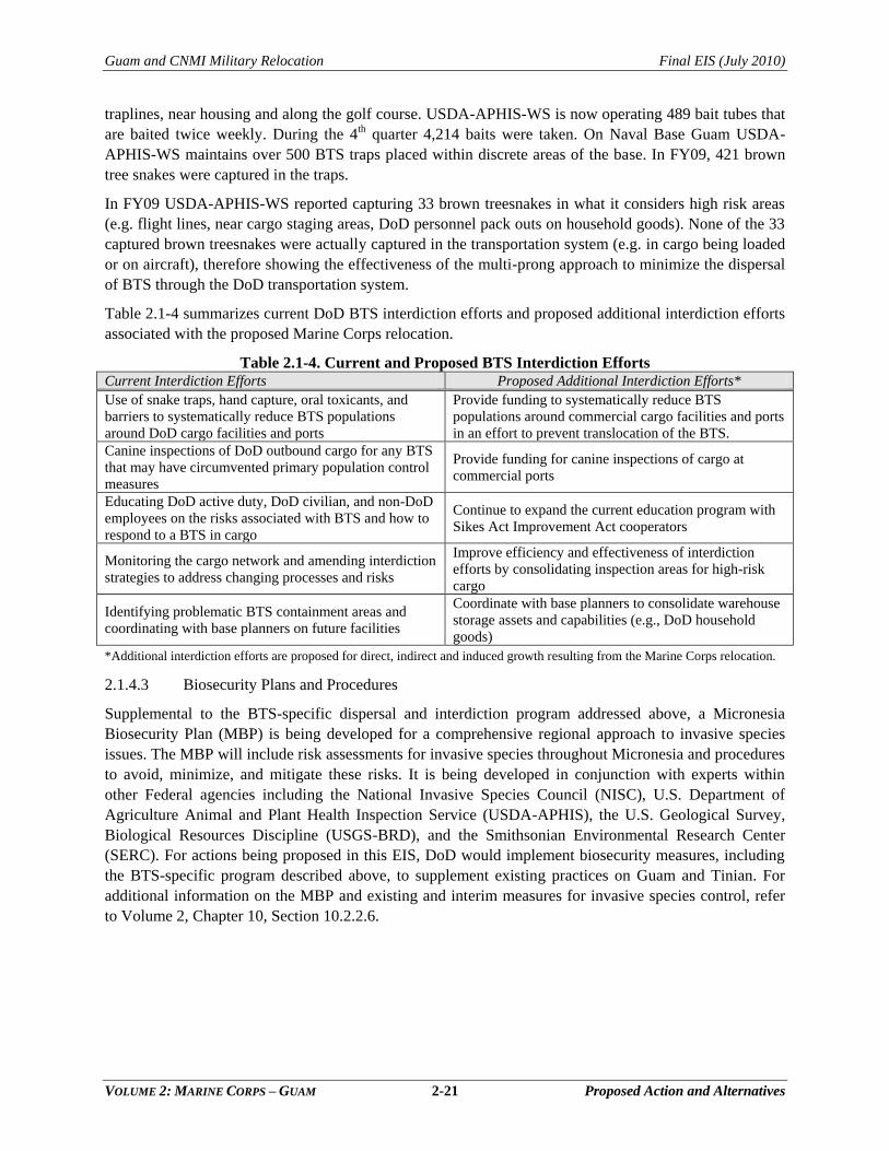
Table 2.1-4 summarizes current DoD BTS interdiction efforts and proposed additional interdiction efforts
associated with the proposed Marine Corps relocation.
Table 2.1-4. Current and Proposed BTS Interdiction Efforts Current Interdiction Efforts Proposed Additional Interdiction Efforts*
Use of snake traps, hand capture, oral toxicants, and
barriers to systematically reduce BTS populations
around DoD cargo facilities and ports
Provide funding to systematically reduce BTS
populations around commercial cargo facilities and ports
in an effort to prevent translocation of the BTS. Canine inspections of DoD outbound cargo for any BTS
that may have circumvented primary population control
measures
Provide funding for canine inspections of cargo at
commercial ports
Educating DoD active duty, DoD civilian, and non-DoD
employees on the risks associated with BTS and how to
respond to a BTS in cargo
Continue to expand the current education program with
Sikes Act Improvement Act cooperators
Monitoring the cargo network and amending interdiction
strategies to address changing processes and risks
Improve efficiency and effectiveness of interdiction
efforts by consolidating inspection areas for high-risk
cargo
Identifying problematic BTS containment areas and
coordinating with base planners on future facilities
Coordinate with base planners to consolidate warehouse
storage assets and capabilities (e.g., DoD household goods)
*Additional interdiction efforts are proposed for direct, indirect and induced growth resulting from the Marine Corps relocation.
2.1.4.3 Biosecurity Plans and Procedures
Supplemental to the BTS-specific dispersal and interdiction program addressed above, a Micronesia
Biosecurity Plan (MBP) is being developed for a comprehensive regional approach to invasive species
issues. The MBP will include risk assessments for invasive species throughout Micronesia and procedures
to avoid, minimize, and mitigate these risks. It is being developed in conjunction with experts within
other Federal agencies including the National Invasive Species Council (NISC), U.S. Department of
Agriculture Animal and Plant Health Inspection Service (USDA-APHIS), the U.S. Geological Survey,
Biological Resources Discipline (USGS-BRD), and the Smithsonian Environmental Research Center
(SERC). For actions being proposed in this EIS, DoD would implement biosecurity measures, including
the BTS-specific program described above, to supplement existing practices on Guam and Tinian. For
additional information on the MBP and existing and interim measures for invasive species control, refer
to Volume 2, Chapter 10, Section 10.2.2.6.
Guam and CNMI Military Relocation Final EIS (July 2010)
VOLUME 2: MARINE CORPS – GUAM 2-22 Proposed Action and Alternatives
2.2 PROPOSED ACTION: MAIN CANTONMENT AREA FUNCTIONS
The proposed action includes construction and operation of
required facilities that would comprise the Main Cantonment
Area for the proposed Marine Corps base on Guam.
2.2.1 Requirements
Facility requirements for the Main Cantonment Area include a
full range of facility types, not unlike a small city: various types
of housing, workplaces, recreation areas, education facilities,
and health and safety-related functions. The workplace facilities
are typical of a military base and include headquarters,
maintenance facilities, warehouses, training areas (field and
classroom), equipment/vehicle storage, and hazardous materials
management and storage areas. Facilities in support of
waterfront and aviation operations are not included under the
description of the Main Cantonment Area because it is not essential that the associated functions be
located in close proximity to or contiguous with each other. Family housing and associated community
support facilities may be included in a cantonment area but they can also be located separate from
cantonment workplace facilities. A contiguous Main Cantonment provides operational efficiency,
minimizes travel and traffic impacts, averts potential future encroachment, reduces operational costs, and
decreases other potential impacts that could result from forces and facilities being decentralized
throughout the island. When contiguous land is not available for Main Cantonment and family
housing/community support facilities, neighborhoods of housing and community support are planned on
non-contiguous parcels. Operationally, mission workplace functions need to be co-located with like
functions to effectively support the military mission.
Cantonment area facility requirements are grouped into the following categories based on commonality of
purpose and function:
HQ and Administrative Support Functions
Administrative offices
Vehicle Maintenance
Electronic/Communications Support and Maintenance
Security
Warehousing
Armory
Fuel Storage
Recycling Center
Base Operations
Administrative offices
Military Police functions: brig/confinement, police offices, rehabilitation facilities, military
dog kennels
Fire station and alert force facilities
Base access: gate house, pass and identification, photographic facilities
Chapter 2:
2.1 Overview
2.2 Main Cantonment Area
Functions
2.3 Training Functions
2.4 Airfield Functions
2.5 Waterfront Functions
2.6 Summary of Alternatives
Guam and CNMI Military Relocation Final EIS (July 2010)
VOLUME 2: MARINE CORPS – GUAM 2-23 Proposed Action and Alternatives
Warehousing
Legal services, dental services, family services, and Morale, Welfare, and Recreation (MWR)
support
Defense Reutilization and Marketing Office
Hazardous Materials (HAZMAT) Management and Storage/Corrosion Control
Bachelor‘s Quarters and Temporary Lodging
Bachelor enlisted quarters, club, dining, indoor fitness, and swimming pool
Bachelor officer quarters, Officer‘s Club
Temporary Lodging facilities
Family Housing
Single-family and attached housing facilities of various sizes and types
Educational Facilities
Child development/daycare facilities
Elementary schools
Middle schools
High School
Quality of Life (QOL) Functions
Main Community Center: commissary, exchange, post office, theater, bowling alley, vehicle
maintenance, hobby shop, medical clinic, religious ministry facilities
Applied instruction and auditorium facilities
Fitness centers, swimming pool, youth centers
Services: restaurant, location exchange, bank, gas station, gate house
These are the facilities that would be constructed as part of the proposed action. Additional training
support facilities, such as tactical trainers, obstacle courses, and indoor pistol range are discussed in
Section 2.3. All of the proposed facilities would incorporate varying degrees of energy, locational, and
water use efficiencies consistent with legal requirements and official Marine Corps policy. Various tools
and design features would be used to achieve Leadership in Energy and Environmental Design (LEED)
Silver certification for various development areas of the base and/or for specific buildings.
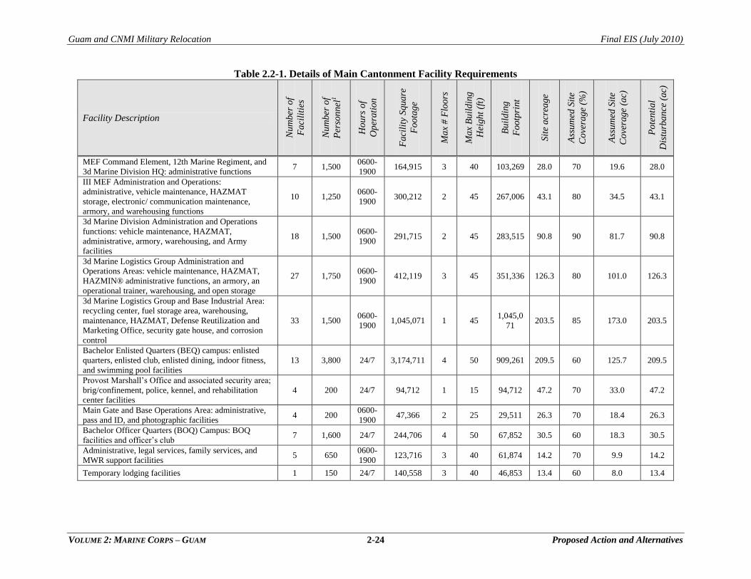
Table 2.2-1 provides specific details about the proposed facilities of each type listed above. The facility
sizing and type was determined by the planned size of the base population, the UFCs, and completion of
the Basic Facility Requirements sheets for each building.
Guam and CNMI Military Relocation Final EIS (July 2010)
VOLUME 2: MARINE CORPS – GUAM 2-24 Proposed Action and Alternatives
Table 2.2-1. Details of Main Cantonment Facility Requirements
Facility Description
Nu
mb
er o
f
Fa
cili
ties
Nu
mb
er o
f
Per
son
nel
1
Ho
urs
of
Op
era
tion
Fa
cili
ty S
qua
re
Foo
tag
e
Ma
x #
Flo
ors
Ma
x B
uil
din
g
Hei
gh
t (f
t)
Bu
ild
ing
Foo
tpri
nt
Sit
e a
crea
ge
Ass
um
ed S
ite
Co
vera
ge
(%)
Ass
um
ed S
ite
Co
vera
ge
(ac)
Po
ten
tia
l
Dis
turb
an
ce (
ac)
MEF Command Element, 12th Marine Regiment, and
3d Marine Division HQ: administrative functions 7 1,500
0600-
1900 164,915 3 40 103,269 28.0 70 19.6 28.0
III MEF Administration and Operations:
administrative, vehicle maintenance, HAZMAT
storage, electronic/ communication maintenance,
armory, and warehousing functions
10 1,250 0600-
1900 300,212 2 45 267,006 43.1 80 34.5 43.1
3d Marine Division Administration and Operations
functions: vehicle maintenance, HAZMAT,
administrative, armory, warehousing, and Army
facilities
18 1,500 0600-
1900 291,715 2 45 283,515 90.8 90 81.7 90.8
3d Marine Logistics Group Administration and
Operations Areas: vehicle maintenance, HAZMAT,
HAZMIN® administrative functions, an armory, an
operational trainer, warehousing, and open storage
27 1,750 0600-
1900 412,119 3 45 351,336 126.3 80 101.0 126.3
3d Marine Logistics Group and Base Industrial Area:
recycling center, fuel storage area, warehousing,
maintenance, HAZMAT, Defense Reutilization and
Marketing Office, security gate house, and corrosion
control
33 1,500 0600-
1900 1,045,071 1 45
1,045,0
71 203.5 85 173.0 203.5
Bachelor Enlisted Quarters (BEQ) campus: enlisted
quarters, enlisted club, enlisted dining, indoor fitness,
and swimming pool facilities
13 3,800 24/7 3,174,711 4 50 909,261 209.5 60 125.7 209.5
Provost Marshall‘s Office and associated security area;
brig/confinement, police, kennel, and rehabilitation
center facilities
4 200 24/7 94,712 1 15 94,712 47.2 70 33.0 47.2
Main Gate and Base Operations Area: administrative,
pass and ID, and photographic facilities 4 200
0600-
1900 47,366 2 25 29,511 26.3 70 18.4 26.3
Bachelor Officer Quarters (BOQ) Campus: BOQ
facilities and officer‘s club 7 1,600 24/7 244,706 4 50 67,852 30.5 60 18.3 30.5
Administrative, legal services, family services, and
MWR support facilities 5 650
0600-
1900 123,716 3 40 61,874 14.2 70 9.9 14.2
Temporary lodging facilities 1 150 24/7 140,558 3 40 46,853 13.4 60 8.0 13.4
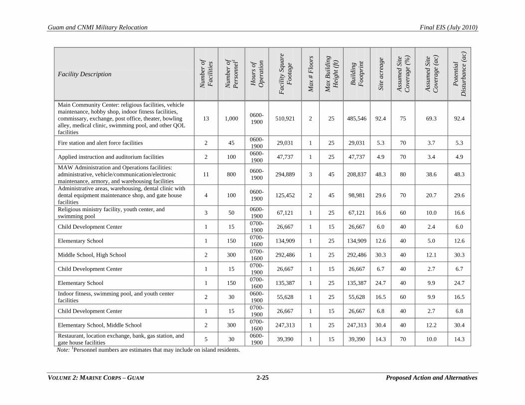
Guam and CNMI Military Relocation Final EIS (July 2010)
VOLUME 2: MARINE CORPS – GUAM 2-25 Proposed Action and Alternatives
Facility Description
Nu
mb
er o
f
Fa
cili
ties
Nu
mb
er o
f
Per
son
nel
1
Ho
urs
of
Op
era
tion
Fa
cili
ty S
qua
re
Foo
tag
e
Ma
x #
Flo
ors
Ma
x B
uil
din
g
Hei
gh
t (f
t)
Bu
ild
ing
Foo
tpri
nt
Sit
e a
crea
ge
Ass
um
ed S
ite
Co
vera
ge
(%)
Ass
um
ed S
ite
Co
vera
ge
(ac)
Po
ten
tia
l
Dis
turb
an
ce (
ac)
Main Community Center: religious facilities, vehicle
maintenance, hobby shop, indoor fitness facilities,
commissary, exchange, post office, theater, bowling
alley, medical clinic, swimming pool, and other QOL
facilities
13 1,000 0600-
1900 510,921 2 25 485,546 92.4 75 69.3 92.4
Fire station and alert force facilities 2 45 0600-
1900 29,031 1 25 29,031 5.3 70 3.7 5.3
Applied instruction and auditorium facilities 2 100 0600-
1900 47,737 1 25 47,737 4.9 70 3.4 4.9
MAW Administration and Operations facilities:
administrative, vehicle/communication/electronic
maintenance, armory, and warehousing facilities
11 800 0600-
1900 294,889 3 45 208,837 48.3 80 38.6 48.3
Administrative areas, warehousing, dental clinic with
dental equipment maintenance shop, and gate house
facilities
4 100 0600-
1900 125,452 2 45 98,981 29.6 70 20.7 29.6
Religious ministry facility, youth center, and
swimming pool 3 50
0600-
1900 67,121 1 25 67,121 16.6 60 10.0 16.6
Child Development Center 1 15 0700-
1900 26,667 1 15 26,667 6.0 40 2.4 6.0
Elementary School 1 150 0700-
1600 134,909 1 25 134,909 12.6 40 5.0 12.6
Middle School, High School 2 300 0700-
1600 292,486 1 25 292,486 30.3 40 12.1 30.3
Child Development Center 1 15 0700-
1900 26,667 1 15 26,667 6.7 40 2.7 6.7
Elementary School 1 150 0700-
1600 135,387 1 25 135,387 24.7 40 9.9 24.7
Indoor fitness, swimming pool, and youth center
facilities 2 30
0600-
1900 55,628 1 25 55,628 16.5 60 9.9 16.5
Child Development Center 1 15 0700-
1900 26,667 1 15 26,667 6.8 40 2.7 6.8
Elementary School, Middle School 2 300 0700-
1600 247,313 1 25 247,313 30.4 40 12.2 30.4
Restaurant, location exchange, bank, gas station, and
gate house facilities 5 30
0600-
1900 39,390 1 15 39,390 14.3 70 10.0 14.3
Note: 1Personnel numbers are estimates that may include on island residents.
Guam and CNMI Military Relocation Final EIS (July 2010)
VOLUME 2: MARINE CORPS – GUAM 2-26 Proposed Action and Alternatives
2.2.2 Alternatives Analysis: Main Cantonment Area
2.2.2.1 Site Alternatives for Main Cantonment Area Functions
As with Andersen AFB and Naval Base Guam, the main cantonment area would ideally be constructed on
contiguous parcels. Family housing would ideally be within the same installation. This facilitates land use
efficiency and organizational integrity. It minimizes traffic exterior to the base; reduces redundancy in
infrastructure; increases the opportunities for walkable and energy efficient development; facilitates
achievement of LEED and sustainability goals and requirements; and provides for cost savings on
construction, maintenance and operation. It is important that the barracks population be able to walk to
amenities and work without relying on personal vehicles in order to reduce traffic flows. The site-specific
planning analysis described in Section 2.2.2.2 carries this ideal land use model further when addressing
the distances between main cantonment, training ranges and family housing.
In Step 2 family housing and main cantonment were considered as separate functional areas because there
were non-contiguous parcels that could potentially accommodate one functional use and not both.
Candidate Land Parcels
The following parcels were considered in the alternative site selection process for the main cantonment
facilities (not including family housing/community services):
NCTS and South Finegayan
Andersen AFB South
Andersen AFB
Navy Barrigada
Air Force Barrigada
Former FAA parcel
Harmon Annex
GLUP 77
Figure 2.2-1 shows the location of each area, and Table 2.2-2 describes specific limitations that apply at
each site. Single parcels that cannot accommodate the entire main cantonment requirement were only
retained as candidate sites if adjacent parcels were also candidate sites.
Feasibility and Suitability Criteria
A qualitative assessment of the feasibility of using specific land areas for siting of Main Cantonment
facilities was based on the following criteria: compatibility with future missions, environmental
considerations (including cultural and historical significance), anticipated public concerns, and proximity
to other military services. Suitability criteria included: land availability, proximity to ranges and the
aviation complex (described in Section 2.4), operational capability, training capability, encroachment, and
antiterrorism/force protection (AT/FP). As defined by the Navy‘s Encroachment Management Program
(OPNAVINST 11010.40), encroachment refers to any non-DoD action planned or executed that ―inhibits,
curtails, or possesses the potential to impede the performance of DoD activities.‖ The basis of analysis is
presented in a brief entitled Guam Alternatives Basing Analysis, Guam Stakeholders Working Group,
dated August 21, 2007 and prepared by NAVFAC Pacific.
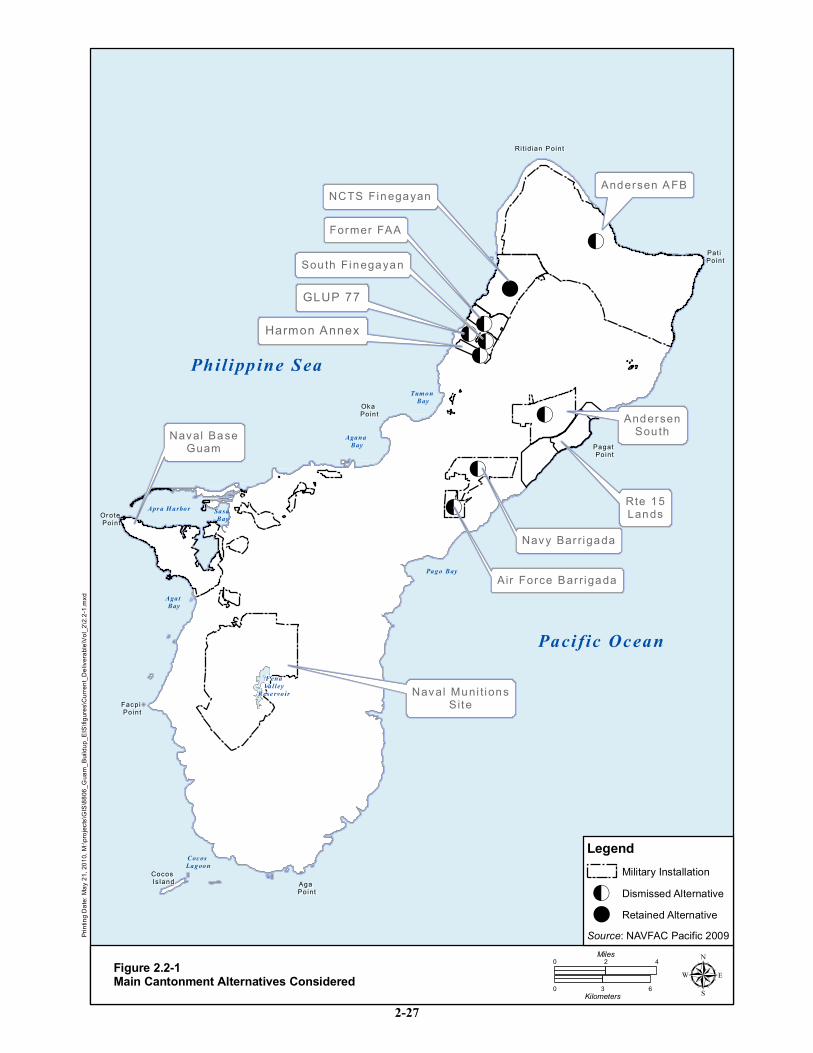
!O
!O
!O
!O!O!O
!
!O
!O
NCTS FinegayanNCTS Finegayan
AndersenAndersenSou thSou th
Navy Bar r igadaNavy Bar r igada
Air Force Bar r igadaAir Force Bar r igada
Rit id ian P ointRi t id ian P oint
Pat i Pat i PointPoint
Pagat Pagat PointPoint
Oka Oka PointPoint
Or ote Or ote PointPoint
Facpi Facpi PointPoint
Aga Aga PointPoint
Cocos Cocos Is landIs land
Sou th FinegayanSou th Finegayan
Andersen AFBAndersen AFB
Naval Muni t ionsNaval Muni t ionsSiteSite
Naval BaseNaval BaseGuamGuam
Former FAAFormer FAA
Rte 15Rte 15LandsLands
Phil ippine Sea
Paci fic Ocean
Apr a H arbor Sasa Bay
Agat Bay
Coc os Lagoon
Pago Bay
Agana Bay
Tum on Bay
FenaValley
Rese rvo ir
GLUP 77GLUP 77
Harmon AnnexHarmon Annex
ing D
ate: M
ay 21
, 201
0, M:
\proje
cts\G
IS\88
06_G
uam_
Build
up_E
IS\fig
ures\C
urren
t_Deli
verab
le\Vo
l_2\2.
2-1.m
xd
Figure 2.2-1Main Cantonment Alternatives Considered
0 42Miles
0 3 6Kilometers µSource: NAVFAC Pacific 2009
LegendMilitary Installation
! Retained Alternative!O Dismissed Alternative
2-27
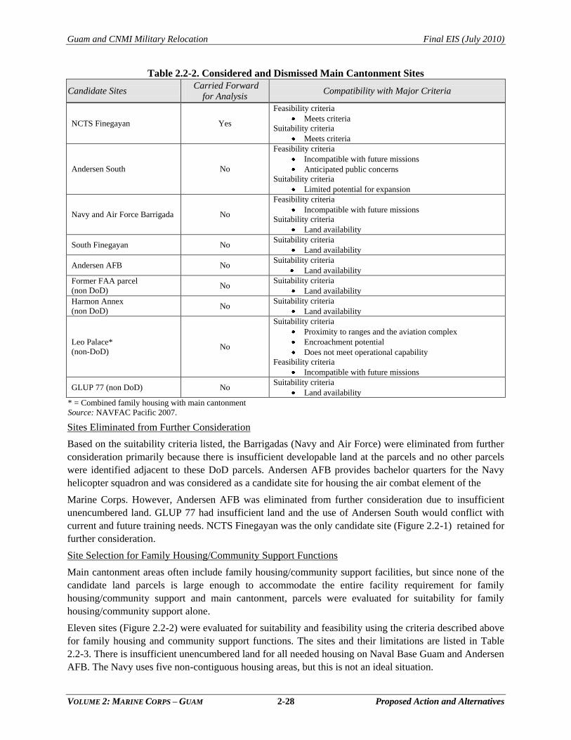
Guam and CNMI Military Relocation Final EIS (July 2010)
VOLUME 2: MARINE CORPS – GUAM 2-28 Proposed Action and Alternatives
Table 2.2-2. Considered and Dismissed Main Cantonment Sites
Candidate Sites Carried Forward
for Analysis Compatibility with Major Criteria
NCTS Finegayan Yes
Feasibility criteria
Meets criteria
Suitability criteria
Meets criteria
Andersen South No
Feasibility criteria
Incompatible with future missions
Anticipated public concerns
Suitability criteria
Limited potential for expansion
Navy and Air Force Barrigada No
Feasibility criteria
Incompatible with future missions
Suitability criteria
Land availability
South Finegayan No Suitability criteria
Land availability
Andersen AFB No Suitability criteria
Land availability
Former FAA parcel
(non DoD) No
Suitability criteria
Land availability
Harmon Annex
(non DoD) No
Suitability criteria
Land availability
Leo Palace*
(non-DoD) No
Suitability criteria
Proximity to ranges and the aviation complex
Encroachment potential
Does not meet operational capability
Feasibility criteria
Incompatible with future missions
GLUP 77 (non DoD) No Suitability criteria
Land availability
* = Combined family housing with main cantonment
Source: NAVFAC Pacific 2007.
Sites Eliminated from Further Consideration
Based on the suitability criteria listed, the Barrigadas (Navy and Air Force) were eliminated from further
consideration primarily because there is insufficient developable land at the parcels and no other parcels
were identified adjacent to these DoD parcels. Andersen AFB provides bachelor quarters for the Navy
helicopter squadron and was considered as a candidate site for housing the air combat element of the
Marine Corps. However, Andersen AFB was eliminated from further consideration due to insufficient
unencumbered land. GLUP 77 had insufficient land and the use of Andersen South would conflict with
current and future training needs. NCTS Finegayan was the only candidate site (Figure 2.2-1) retained for
further consideration.
Site Selection for Family Housing/Community Support Functions
Main cantonment areas often include family housing/community support facilities, but since none of the
candidate land parcels is large enough to accommodate the entire facility requirement for family
housing/community support and main cantonment, parcels were evaluated for suitability for family
housing/community support alone.
Eleven sites (Figure 2.2-2) were evaluated for suitability and feasibility using the criteria described above
for family housing and community support functions. The sites and their limitations are listed in Table
2.2-3. There is insufficient unencumbered land for all needed housing on Naval Base Guam and Andersen
AFB. The Navy uses five non-contiguous housing areas, but this is not an ideal situation.
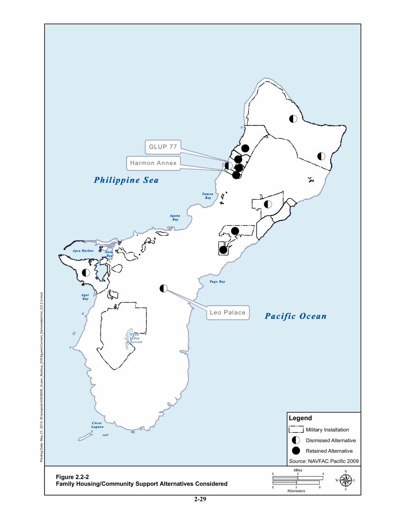
Phil ippine Sea
Pacific Ocean
Apr a Harbor Sasa Bay
Agat Bay
Coc os Lagoon
Pago Bay
Agana Bay
Tum on Bay
FenaValley
Rese rv oir
!O
!O
!
!
!O
!!!O
!!O
!O
!
Phil ippine Sea
Pacific Ocean
Apr a Harbor Sasa Bay
Agat Bay
Coc os Lagoon
Pago Bay
Agana Bay
Tum on Bay
FenaValley
Rese rv oir
GLUP 77GLUP 77
Harmon AnnexHarmon Annex
Leo PalaceLeo Palace
ing D
ate: M
ay 21
, 201
0, M:
\proje
cts\G
IS\88
06_G
uam_
Build
up_E
IS\fig
ures\C
urren
t_Deli
verab
le\Vo
l_2\2.
2-2.m
xd
Figure 2.2-2Family Housing/Community Support Alternatives Considered
0 42Miles
0 3 6Kilometers µSource: NAVFAC Pacific 2009
LegendMilitary Installation
! Retained Alternative!O Dismissed Alternative
2-29
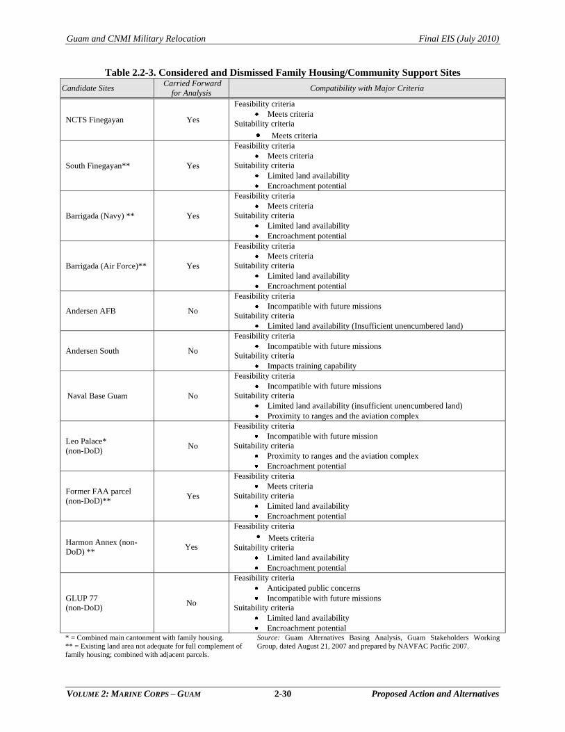
Guam and CNMI Military Relocation Final EIS (July 2010)
VOLUME 2: MARINE CORPS – GUAM 2-30 Proposed Action and Alternatives
Table 2.2-3. Considered and Dismissed Family Housing/Community Support Sites
Candidate Sites Carried Forward
for Analysis Compatibility with Major Criteria
NCTS Finegayan Yes
Feasibility criteria
Meets criteria
Suitability criteria
Meets criteria
South Finegayan** Yes
Feasibility criteria
Meets criteria
Suitability criteria
Limited land availability
Encroachment potential
Barrigada (Navy) ** Yes
Feasibility criteria
Meets criteria
Suitability criteria
Limited land availability
Encroachment potential
Barrigada (Air Force)** Yes
Feasibility criteria
Meets criteria
Suitability criteria
Limited land availability
Encroachment potential
Andersen AFB No
Feasibility criteria
Incompatible with future missions
Suitability criteria
Limited land availability (Insufficient unencumbered land)
Andersen South No
Feasibility criteria
Incompatible with future missions
Suitability criteria
Impacts training capability
Naval Base Guam No
Feasibility criteria
Incompatible with future missions
Suitability criteria
Limited land availability (insufficient unencumbered land)
Proximity to ranges and the aviation complex
Leo Palace*
(non-DoD) No
Feasibility criteria
Incompatible with future mission
Suitability criteria
Proximity to ranges and the aviation complex
Encroachment potential
Former FAA parcel
(non-DoD)** Yes
Feasibility criteria
Meets criteria
Suitability criteria
Limited land availability
Encroachment potential
Harmon Annex (non-
DoD) ** Yes
Feasibility criteria
Meets criteria
Suitability criteria
Limited land availability
Encroachment potential
GLUP 77
(non-DoD) No
Feasibility criteria
Anticipated public concerns
Incompatible with future missions Suitability criteria
Limited land availability
Encroachment potential * = Combined main cantonment with family housing.
** = Existing land area not adequate for full complement of
family housing; combined with adjacent parcels.
Source: Guam Alternatives Basing Analysis, Guam Stakeholders Working
Group, dated August 21, 2007 and prepared by NAVFAC Pacific 2007.
Guam and CNMI Military Relocation Final EIS (July 2010)
VOLUME 2: MARINE CORPS – GUAM 2-31 Proposed Action and Alternatives
There is insufficient space at any or all of these housing areas to accommodate the Marine Corps
population; therefore, these distinct housing areas, including Apra Heights and Nimitz Hill, were
dismissed early in the alternatives analysis. Leo Palace was also examined as a location for military
housig. The building requirements, including space allowances, for military housing are standardized and
the existing Leo Palace units would not meet military standards and maximize the number of units per
acre. Leo Palace was eliminated based on this reason and its incompatibility with future missions.
It is not efficient from a land use or operational perspective to divide up the family housing and
community support into multiple non-contiguous parcels. This step of the alternatives analysis focused on
identifying property that could accommodate all or most of the housing requirement. Maximum efficiency
is achieved with one contiguous parcel so redundancy in retail, recreation and other community support
facilities is reduced. If a parcel can support a portion of the requirement, it is paired with other adjacent or
nearby parcels to meet the total requirement as indicated in Table 2.2-3.
2.2.2.2 Site-Specific Planning Alternatives for Main Cantonment Area Functions
Based on Step 2 of the alternatives development analysis, there are several parcels that would
accommodate some combination of main cantonment and family housing/community support functions.
In Step 3 of the process, project planners identified alternative ways of arranging project facility
requirements within the candidate parcels. Three planning alternatives were initially developed by project
planners and were reviewed by agencies in the Spring 2008 DOPAA. In response to comments received
on the document, and subsequent informal consultations held May through September 2008, a new set of
feasible alternatives was later developed.
The primary impetus for the next stage of selecting or eliminating alternatives was compatibility with
surrounding land uses and the importance of the Guam National Wildlife Refuge Overlay Units (Overlay
Refuge) as essential habitat for endangered species. The Overlay Refuge encumbers most (2,095 of 3,000
ac [848 ha of 1,214]) of NCTS Finegayan, which was proposed as a prime development area in
preliminary planning efforts. Subsequent planning indicated that maintaining the essential habitat intact
would decrease the amount of developable DoD land and increase the acres of non-DoD land acquisition.
Land being considered for development was further reduced by the elimination of Guam Excess Land Act
1994 parcels, also known as GLUP 77 lands, because this area would not meet the operational criteria
based on time.
Eight alternatives resulted from the Step 3 site-specific planning analysis. The alternatives varied in their
use of Overlay Refuge lands, the quantity of non-DoD land required, distances between the various land
uses, and facility planning factors.
2.2.3 Alternatives Carried Forward for Analysis: Main Cantonment Area
A series of workshops was held between June 2007 and November 2008 to evaluate the 8 interim
planning alternatives in Step 4 of the alternatives analysis process (see Section 1.2). Participants included
local and federal representatives; master planners, biologists, legal counsel, and real estate personnel;
operational experts; and service representatives. The Joint Guam Program Office issued a summary of the
results of the session in November that was presented in various formats to DoD leadership for approval.
The screening analysis served to narrow down the alternatives from eight to four through analysis of each
alternative independent of the others. All of these alternatives included the contiguous location of Marine
Corps administrative buildings and operations.
Section 1.2 described the three screening criteria used in Step 4 of the alternatives analysis process to
evaluate the viability of site-specific planning alternatives when other factors were considered:
Guam and CNMI Military Relocation Final EIS (July 2010)
VOLUME 2: MARINE CORPS – GUAM 2-32 Proposed Action and Alternatives
(1) environmental, (2) public concerns, and (3) service. Each of the 8 alternatives was classified as
―meets‖ or ―does not meet‖ each of the criteria. If an alternative was classified as ―does not meet‖ in any
one of the three criteria, it was eliminated from further consideration in this EIS. The criteria and a brief
explanation of ―does not meet‖ for each of the criteria are described in Section 1.2.
This screening process eliminated the alternatives that did not meet the selection criteria. An alternative
does not meet the service criteria if it would be so challenging to the military commands that military
mission, readiness and operations would be compromised and would not meet the purpose and need for
the project. Maps were compiled from natural and cultural resource agencies and specialists to examine
conflicts between siting of facilities and resource locations. This ―constraints mapping‖ provided
information to reduce effects to the resources by eliminating or revising alternatives. Figure 2.2-3 presents
the eight alternatives side by side with a summary of the Step 4 site-specific planning analysis.
Alternatives 4, 5, 6 and 7 were eliminated from further consideration. Alternative 4 did not meet the
environmental criteria because it had an overwhelming impact on areas of essential habitat. Alternative 5
did not meet the public or the service criteria because of impacts to recreational and commercial ocean
uses and the separation of live-fire and non-firing training does not support the Marine Corps
requirements for operational efficiency. Alternative 6 was eliminated because the complexity of land
acquisition would likely require more than 10 years, which would not meet the purpose and need.
Alternative 7, similar to Alternative 5, did not meet the service criteria but in this alternative it was the
separation of the firing range complex from the non-fire training that was the key operational deficiency.
As described in the following subsections, there are four alternatives for development of the Main
Cantonment Area that would be carried forward for analysis in this EIS.
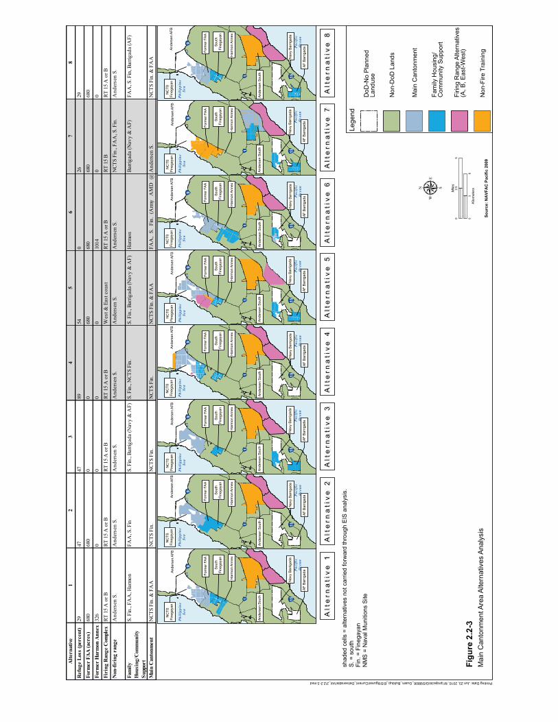
!"1 !"15
!"9
NC
TS
NC
TS
Fine
gaya
nFi
nega
yan
Ande
rsen
AFB
Ande
rsen
AFB
Pacific
Ocean
Philippine
Sea
Form
er F
AA
Form
er F
AA
Sout
hSo
uth
Fine
gaya
nFi
nega
yan
Har
mon
Ann
exH
arm
on A
nnex
Ande
rsen
Sou
thAn
ders
en S
outh
Nav
y Ba
rrig
ada
Nav
y Ba
rrig
ada
AF B
arrig
ada
AF B
arrig
ada
!"1 !"15
!"9
NC
TS
NC
TS
Fine
gaya
nFi
nega
yan
Ande
rsen
AFB
Ande
rsen
AFB
Pacific
Ocean
Philippine
Sea
Form
er F
AA
Form
er F
AA
Sout
hSo
uth
Fine
gaya
nFi
nega
yan
Har
mon
Ann
exH
arm
on A
nnex
Ande
rsen
Sou
thAn
ders
en S
outh
Nav
y Ba
rrig
ada
Nav
y Ba
rrig
ada
AF B
arrig
ada
AF B
arrig
ada
!"1 !"15
!"9
NC
TS
NC
TS
Fine
gaya
nFi
nega
yan
Ande
rsen
AFB
Ande
rsen
AFB
Pacific
Ocean
Philippine
Sea
Form
er F
AA
Form
er F
AA
Sout
hSo
uth
Fine
gaya
nFi
nega
yan
Har
mon
Ann
exH
arm
on A
nnex
Ande
rsen
Sou
thAn
ders
en S
outh
Nav
y Ba
rrig
ada
Nav
y Ba
rrig
ada
AF B
arrig
ada
AF B
arrig
ada
!"1 !"15
!"9
NC
TS
NC
TS
Fine
gaya
nFi
nega
yan
Ande
rsen
AFB
Ande
rsen
AFB
Pacific
Ocean
Philippine
Sea
Form
er F
AA
Form
er F
AA
Sout
hSo
uth
Fine
gaya
nFi
nega
yan
Har
mon
Ann
exH
arm
on A
nnex
Ande
rsen
Sou
thAn
ders
en S
outh
Nav
y Ba
rrig
ada
Nav
y Ba
rrig
ada
AF B
arrig
ada
AF B
arrig
ada
!"1 !"15
!"9
NC
TS
NC
TS
Fine
gaya
nFi
nega
yan
Ande
rsen
AFB
Ande
rsen
AFB
Pacific
Ocean
Philippine
Sea
Form
er F
AA
Form
er F
AA
Sout
hSo
uth
Fine
gaya
nFi
nega
yan
Har
mon
Ann
exH
arm
on A
nnex
Ande
rsen
Sou
thAn
ders
en S
outh
Nav
y Ba
rrig
ada
Nav
y Ba
rrig
ada
AF B
arrig
ada
AF B
arrig
ada
!"1 !"15
!"9
NC
TS
NC
TS
Fine
gaya
nFi
nega
yan
Ande
rsen
AFB
Ande
rsen
AFB
Pacific
Ocean
Philippine
Sea
Form
er F
AA
Form
er F
AA
Sout
hSo
uth
Fine
gaya
nFi
nega
yan
Har
mon
Ann
exH
arm
on A
nnex
Ande
rsen
Sou
thAn
ders
en S
outh
Nav
y Ba
rrig
ada
Nav
y Ba
rrig
ada
AF B
arrig
ada
AF B
arrig
ada
!"1 !"15
!"9
NC
TS
NC
TS
Fine
gaya
nFi
nega
yan
Ande
rsen
AFB
Ande
rsen
AFB
Pacific
Ocean
Philippine
Sea
Form
er F
AA
Form
er F
AA
Sout
hSo
uth
Fine
gaya
nFi
nega
yan
Har
mon
Ann
exH
arm
on A
nnex
Ande
rsen
Sou
thAn
ders
en S
outh
Nav
y Ba
rrig
ada
Nav
y Ba
rrig
ada
AF B
arrig
ada
AF B
arrig
ada
!"1 !"15
!"9
NC
TS
NC
TS
Fine
gaya
nFi
nega
yan
Ande
rsen
AFB
Ande
rsen
AFB
Pacific
Ocean
Philippine
Sea
Form
er F
AA
Form
er F
AA
Sout
hSo
uth
Fine
gaya
nFi
nega
yan
Har
mon
Ann
exH
arm
on A
nnex
Ande
rsen
Sou
thAn
ders
en S
outh
Nav
y Ba
rrig
ada
Nav
y Ba
rrig
ada
AF B
arrig
ada
AF B
arrig
ada
Alt
ern
ati
ve
1A
lte
rna
tiv
e 1
Alt
ern
ati
ve
2A
lte
rna
tiv
e 2
Alt
ern
ati
ve
3A
lte
rna
tiv
e 3
Alt
ern
ati
ve
4A
lte
rna
tiv
e 4
Figu
re 2
.2-3
Sour
ce: N
AVF
AC
Pac
ific
2009
Printing Date: Jun 23, 2010, M:\projects\GIS\8806_Guam_Buildup_EIS\figures\Current_Deliverable\Vol_2\2.2-3.mxd
μ
shad
ed c
ells
= a
ltern
ativ
es n
ot c
arrie
d fo
rwar
d th
roug
h E
IS a
naly
sis.
S. =
sou
thFi
n. =
Fin
egay
anN
MS
= N
aval
Mun
ition
s S
ite
Mai
n C
anto
nmen
t Are
a Al
tern
ativ
es A
naly
sis
Lege
nd
Non
-DoD
Lan
ds
Mai
n C
anto
nmen
t
Fam
ily H
ousi
ng/
Com
mun
ity S
uppo
rt
Non
-Fire
Tra
inin
g
DoD
-No
Plan
ned
Land
use
Firin
g R
ange
Alte
rnat
ives
(A, B
, Eas
t-Wes
t)
Alt
ern
ati
ve
5A
lte
rna
tiv
e 5
Alt
ern
ati
ve
6A
lte
rna
tiv
e 6
Alt
ern
ati
ve
7A
lte
rna
tiv
e 7
Alt
ern
ati
ve
8A
lte
rna
tiv
e 8
Alte
rnat
ive
38
Ref
uge
Loss
(per
cent
)47
29Fo
rmer
FA
A (a
cres
)0
680
Form
er H
arm
on A
nnex
00
Firi
ng R
ange
Com
plex
RT 1
5 A
or B
RT 1
5 A
or B
Non
-firi
ng r
ange
And
erse
n S.
And
erse
n S.
Fam
ily
Hou
sing
/Com
mun
ity
Supp
ort
S. F
in.,
Barri
gada
(Nav
y &
AF)
FAA
, S. F
in, B
arrig
ada
(AF)
Mai
n C
anto
nmen
tN
CTS
Fin.
NCT
S Fi
n. &
FA
AN
CTS
Fin.
& F
AA
NCT
S Fi
n.N
CTS
Fin.
NCT
S Fi
n. &
FA
AFA
A,
S.Fi
n.(A
rmy
AM
D@
And
erse
n S.
S. F
in.,
FAA
, Har
mon
FAA
, S. F
inS.
Fin
., N
CTS
Fin.
S. F
in.,
Barri
gada
(Nav
y &
AF)
Har
mon
Barri
gada
(Nav
y &
AF)
And
erse
n S.
A
nder
sen
S.
And
erse
n S.
And
erse
n S.
And
erse
n S.
NCT
S Fi
n., F
AA
, S. F
in.
1014
0RT
15
A o
r BRT
15
A o
r BRT
15
A o
r BW
est &
Eas
t coa
st
RT 1
5 A
or B
RT 1
5 B
2668
068
00
680
680
680
2947
8954
0
326
00
0
12
45
67
05
2.5
Miles
03
6Kilometers
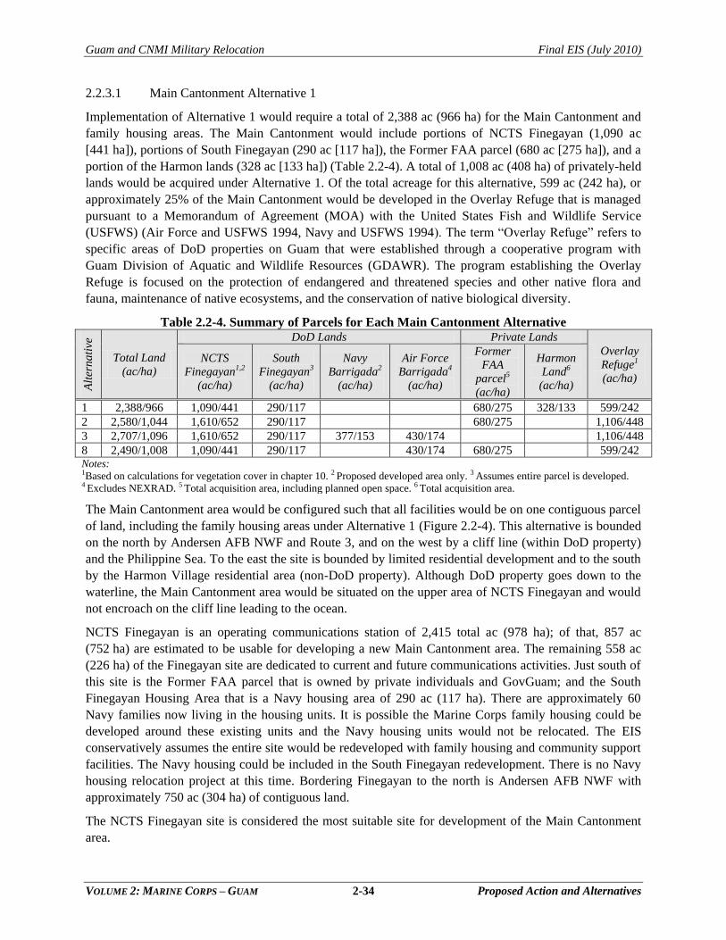
Guam and CNMI Military Relocation Final EIS (July 2010)
VOLUME 2: MARINE CORPS – GUAM 2-34 Proposed Action and Alternatives
2.2.3.1 Main Cantonment Alternative 1
Implementation of Alternative 1 would require a total of 2,388 ac (966 ha) for the Main Cantonment and
family housing areas. The Main Cantonment would include portions of NCTS Finegayan (1,090 ac
[441 ha]), portions of South Finegayan (290 ac [117 ha]), the Former FAA parcel (680 ac [275 ha]), and a
portion of the Harmon lands (328 ac [133 ha]) (Table 2.2-4). A total of 1,008 ac (408 ha) of privately-held
lands would be acquired under Alternative 1. Of the total acreage for this alternative, 599 ac (242 ha), or
approximately 25% of the Main Cantonment would be developed in the Overlay Refuge that is managed
pursuant to a Memorandum of Agreement (MOA) with the United States Fish and Wildlife Service
(USFWS) (Air Force and USFWS 1994, Navy and USFWS 1994). The term ―Overlay Refuge‖ refers to
specific areas of DoD properties on Guam that were established through a cooperative program with
Guam Division of Aquatic and Wildlife Resources (GDAWR). The program establishing the Overlay
Refuge is focused on the protection of endangered and threatened species and other native flora and
fauna, maintenance of native ecosystems, and the conservation of native biological diversity.
Table 2.2-4. Summary of Parcels for Each Main Cantonment Alternative
Alt
ern
ati
ve
Total Land
(ac/ha)
DoD Lands Private Lands
Overlay
Refuge1
(ac/ha)
NCTS
Finegayan1,2
(ac/ha)
South
Finegayan3
(ac/ha)
Navy
Barrigada2
(ac/ha)
Air Force
Barrigada4
(ac/ha)
Former
FAA
parcel5
(ac/ha)
Harmon
Land6
(ac/ha)
1 2,388/966 1,090/441 290/117 680/275 328/133 599/242
2 2,580/1,044 1,610/652 290/117 680/275 1,106/448
3 2,707/1,096 1,610/652 290/117 377/153 430/174 1,106/448
8 2,490/1,008 1,090/441 290/117 430/174 680/275 599/242 Notes:
1Based on calculations for vegetation cover in chapter 10. 2 Proposed developed area only. 3 Assumes entire parcel is developed. 4 Excludes NEXRAD. 5 Total acquisition area, including planned open space. 6 Total acquisition area.
The Main Cantonment area would be configured such that all facilities would be on one contiguous parcel
of land, including the family housing areas under Alternative 1 (Figure 2.2-4). This alternative is bounded
on the north by Andersen AFB NWF and Route 3, and on the west by a cliff line (within DoD property)
and the Philippine Sea. To the east the site is bounded by limited residential development and to the south
by the Harmon Village residential area (non-DoD property). Although DoD property goes down to the
waterline, the Main Cantonment area would be situated on the upper area of NCTS Finegayan and would
not encroach on the cliff line leading to the ocean.
NCTS Finegayan is an operating communications station of 2,415 total ac (978 ha); of that, 857 ac
(752 ha) are estimated to be usable for developing a new Main Cantonment area. The remaining 558 ac
(226 ha) of the Finegayan site are dedicated to current and future communications activities. Just south of
this site is the Former FAA parcel that is owned by private individuals and GovGuam; and the South
Finegayan Housing Area that is a Navy housing area of 290 ac (117 ha). There are approximately 60
Navy families now living in the housing units. It is possible the Marine Corps family housing could be
developed around these existing units and the Navy housing units would not be relocated. The EIS
conservatively assumes the entire site would be redeveloped with family housing and community support
facilities. The Navy housing could be included in the South Finegayan redevelopment. There is no Navy
housing relocation project at this time. Bordering Finegayan to the north is Andersen AFB NWF with
approximately 750 ac (304 ha) of contiguous land.
The NCTS Finegayan site is considered the most suitable site for development of the Main Cantonment
area.
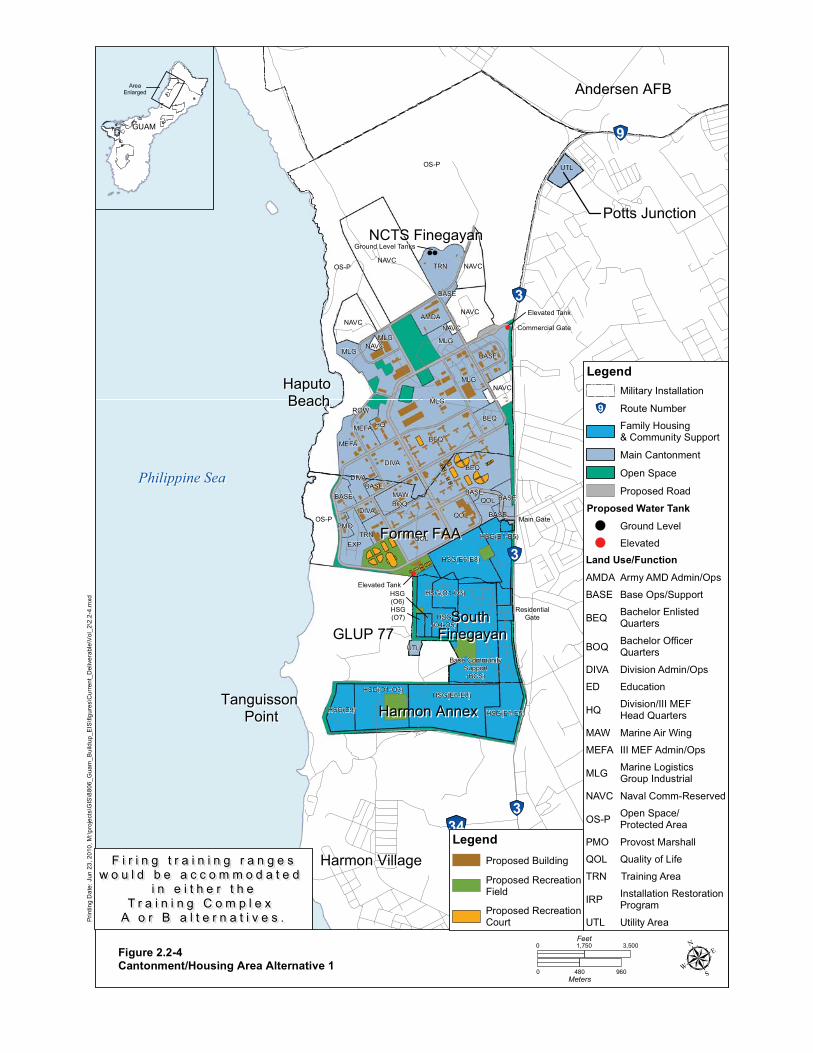
!
!
!
!
!"28
!"9
!"3
!"3
!"3!"34
!"1
Philippine SeaPhilippine Sea
NCTS FinegayanNCTS FinegayanPotts JunctionPotts Junction
Former FAAFormer FAA
GLUP 77GLUP 77South South
FinegayanFinegayan
Tanguisson Tanguisson PointPoint
Haputo Haputo BeachBeach
Andersen AFBAndersen AFB
Harmon VillageHarmon Village
Harmon AnnexHarmon Annex
Commercial GateCommercial Gate
ResidentialResidentialGateGate
Main GateMain Gate
Ground Level Tanks
Elevated Tank
Elevated TankHSG(O6)
OS-P
OS-PNAVC
BEQ
MLG
BEQ
OS-P
QOL
MLG
TRN
MLG
NAVC
DIVA
NAVC
QOL
MAW
DIVA
HQ
NAVC
MEFA
EXP
MLG
AMDA
BEQ
QOL
NAVC
DIVA
BASE
MLG
BOQ
UTL
MEFA
TRN
BASE BASE
PMO
UTL
BASE
BASE
ROW
BASE
NAVC
NAVC
BASE
HSG(E6-E8)
HSG(E6-E8)
HSG(E1-E5)
HSG(O1-O3)
Base CommunitySupport(BCS)
HSG(E1-E5)
HSG(E9)
HSG(O4-O5)
HSG(O1-O3)
HSG(O7)
Prin
ting
Dat
e: J
un 2
3, 2
010,
M:\p
roje
cts\
GIS
\880
6_G
uam
_Bui
ldup
_EIS
\figu
res\
Cur
rent
_Del
iver
able
\Vol
_2\2
.2-4
.mxd
Figure 2.2-4Cantonment/Housing Area Alternative 1
GUAMGUAM
AreaEnlarged
F i r i n g t r a i n i n g r a n g e sF i r i n g t r a i n i n g r a n g e sw o u l d b e a c c o m m o d a t e d w o u l d b e a c c o m m o d a t e d
i n e i t h e r t h ei n e i t h e r t h eT r a i n i n g C o m p l e x T r a i n i n g C o m p l e x
A o r B a l t e r n a t i v e s .A o r B a l t e r n a t i v e s .
μ0 480 960Meters
0 3,5001,750Feet
Legend
Proposed RecreationCourt
Proposed RecreationField
Proposed BuildingTRN Training Area
Legend
Land Use/Function
UTL Utility Area
OS-P Open Space/Protected Area
QOL Quality of Life
PMO Provost Marshall
NAVC Naval Comm-Reserved
AMDA Army AMD Admin/Ops
MAW Marine Air Wing
MLG Marine Logistics Group Industrial
MEFA III MEF Admin/Ops
DIVA Division Admin/Ops
BASE Base Ops/Support
HQ Division/III MEFHead Quarters
BOQ Bachelor OfficerQuarters
BEQ Bachelor Enlisted Quarters
Main Cantonment
Family Housing& Community Support
!"9 Route Number
Military Installation
IRP Installation RestorationProgram
Open Space
ED Education
Proposed Road
Proposed Water Tank
Elevated
Ground Level
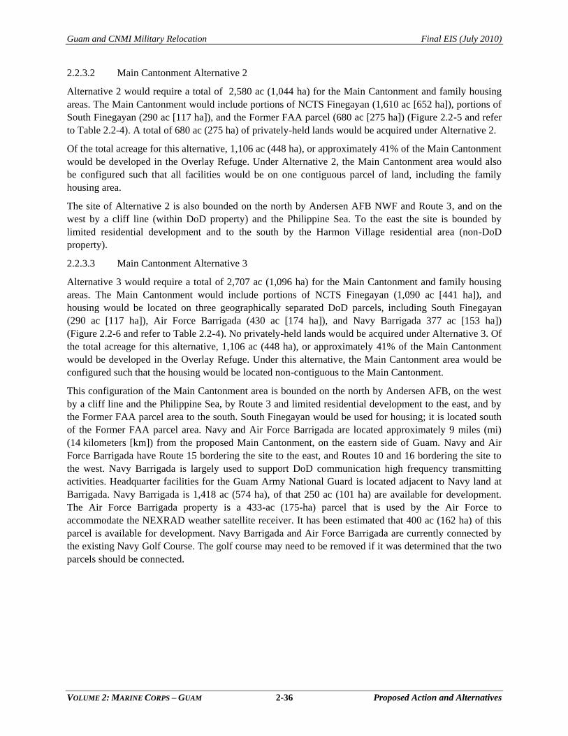
Guam and CNMI Military Relocation Final EIS (July 2010)
VOLUME 2: MARINE CORPS – GUAM 2-36 Proposed Action and Alternatives
2.2.3.2 Main Cantonment Alternative 2
Alternative 2 would require a total of 2,580 ac (1,044 ha) for the Main Cantonment and family housing
areas. The Main Cantonment would include portions of NCTS Finegayan (1,610 ac [652 ha]), portions of
South Finegayan (290 ac [117 ha]), and the Former FAA parcel (680 ac [275 ha]) (Figure 2.2-5 and refer
to Table 2.2-4). A total of 680 ac (275 ha) of privately-held lands would be acquired under Alternative 2.
Of the total acreage for this alternative, 1,106 ac (448 ha), or approximately 41% of the Main Cantonment
would be developed in the Overlay Refuge. Under Alternative 2, the Main Cantonment area would also
be configured such that all facilities would be on one contiguous parcel of land, including the family
housing area.
The site of Alternative 2 is also bounded on the north by Andersen AFB NWF and Route 3, and on the
west by a cliff line (within DoD property) and the Philippine Sea. To the east the site is bounded by
limited residential development and to the south by the Harmon Village residential area (non-DoD
property).
2.2.3.3 Main Cantonment Alternative 3
Alternative 3 would require a total of 2,707 ac (1,096 ha) for the Main Cantonment and family housing
areas. The Main Cantonment would include portions of NCTS Finegayan (1,090 ac [441 ha]), and
housing would be located on three geographically separated DoD parcels, including South Finegayan
(290 ac [117 ha]), Air Force Barrigada (430 ac [174 ha]), and Navy Barrigada 377 ac [153 ha])
(Figure 2.2-6 and refer to Table 2.2-4). No privately-held lands would be acquired under Alternative 3. Of
the total acreage for this alternative, 1,106 ac (448 ha), or approximately 41% of the Main Cantonment
would be developed in the Overlay Refuge. Under this alternative, the Main Cantonment area would be
configured such that the housing would be located non-contiguous to the Main Cantonment.
This configuration of the Main Cantonment area is bounded on the north by Andersen AFB, on the west
by a cliff line and the Philippine Sea, by Route 3 and limited residential development to the east, and by
the Former FAA parcel area to the south. South Finegayan would be used for housing; it is located south
of the Former FAA parcel area. Navy and Air Force Barrigada are located approximately 9 miles (mi)
(14 kilometers [km]) from the proposed Main Cantonment, on the eastern side of Guam. Navy and Air
Force Barrigada have Route 15 bordering the site to the east, and Routes 10 and 16 bordering the site to
the west. Navy Barrigada is largely used to support DoD communication high frequency transmitting
activities. Headquarter facilities for the Guam Army National Guard is located adjacent to Navy land at
Barrigada. Navy Barrigada is 1,418 ac (574 ha), of that 250 ac (101 ha) are available for development.
The Air Force Barrigada property is a 433-ac (175-ha) parcel that is used by the Air Force to
accommodate the NEXRAD weather satellite receiver. It has been estimated that 400 ac (162 ha) of this
parcel is available for development. Navy Barrigada and Air Force Barrigada are currently connected by
the existing Navy Golf Course. The golf course may need to be removed if it was determined that the two
parcels should be connected.
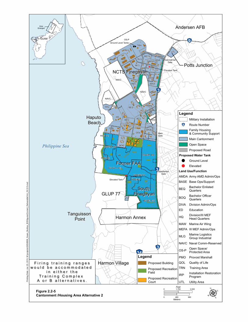
!
!
!
!
!"28
!"9
!"3
!"3
!"3!"34
!"1
Philippine SeaPhilippine Sea
NCTS FinegayanNCTS FinegayanPotts JunctionPotts Junction
Former FAAFormer FAA
GLUP 77GLUP 77South South
FinegayanFinegayan
Tanguisson Tanguisson PointPoint
Haputo Haputo BeachBeach
Andersen AFBAndersen AFB
Harmon VillageHarmon Village
Harmon AnnexHarmon Annex
CommercialCommercialGateGate
ResidentialResidentialGateGate
MainMainGateGate
Elevated Tank
Ground Level Tanks
Elevated Tank
OS-P
ED
NAVC
BEQ
HQ
NAVC
MLG
TRN
HSG(E6-E8)
MLG
HSG(E1-E5)
HSG(O1-O3)
BEQ
HSG(E1-E5)
BEQ
QOL
NAVC
BOQ
MLG
HSG(E9)
BASE
AMDA
BASE
MLG
BEQ
PMOMEFA
TRN
QOL
MAW
MEFA
MEFA
HSG(O4-O5)
MLG
UTL
DIVA
DIVA
MLG
BASE
MEFA
QOL
HSG(O6)
NAVC
UTL
NAVC
BASEDIVA
HSG(O7)
NAVC
Prin
ting
Dat
e: J
un 2
3, 2
010,
M:\p
roje
cts\
GIS
\880
6_G
uam
_Bui
ldup
_EIS
\figu
res\
Cur
rent
_Del
iver
able
\Vol
_2\2
.2-5
.mxd
Figure 2.2-5Cantonment /Housing Area Alternative 2
GUAMGUAM
AreaEnlarged
μ0 480 960Meters
0 3,5001,750Feet
Legend
Proposed RecreationCourt
Proposed RecreationField
Proposed BuildingF i r i n g t r a i n i n g r a n g e sF i r i n g t r a i n i n g r a n g e sw o u l d b e a c c o m m o d a t e d w o u l d b e a c c o m m o d a t e d
i n e i t h e r t h ei n e i t h e r t h eT r a i n i n g C o m p l e x T r a i n i n g C o m p l e x
A o r B a l t e r n a t i v e s .A o r B a l t e r n a t i v e s .
TRN Training Area
Legend
Land Use/Function
UTL Utility Area
OS-P Open Space/Protected Area
QOL Quality of Life
PMO Provost Marshall
NAVC Naval Comm-Reserved
AMDA Army AMD Admin/Ops
MAW Marine Air Wing
MLG Marine Logistics Group Industrial
MEFA III MEF Admin/Ops
DIVA Division Admin/Ops
BASE Base Ops/Support
HQ Division/III MEFHead Quarters
BOQ Bachelor OfficerQuarters
BEQ Bachelor Enlisted Quarters
Main Cantonment
Family Housing& Community Support
!"9 Route Number
Military Installation
IRP Installation RestorationProgram
Open Space
ED Education
Proposed Road
Proposed Water Tank
Elevated
Ground Level
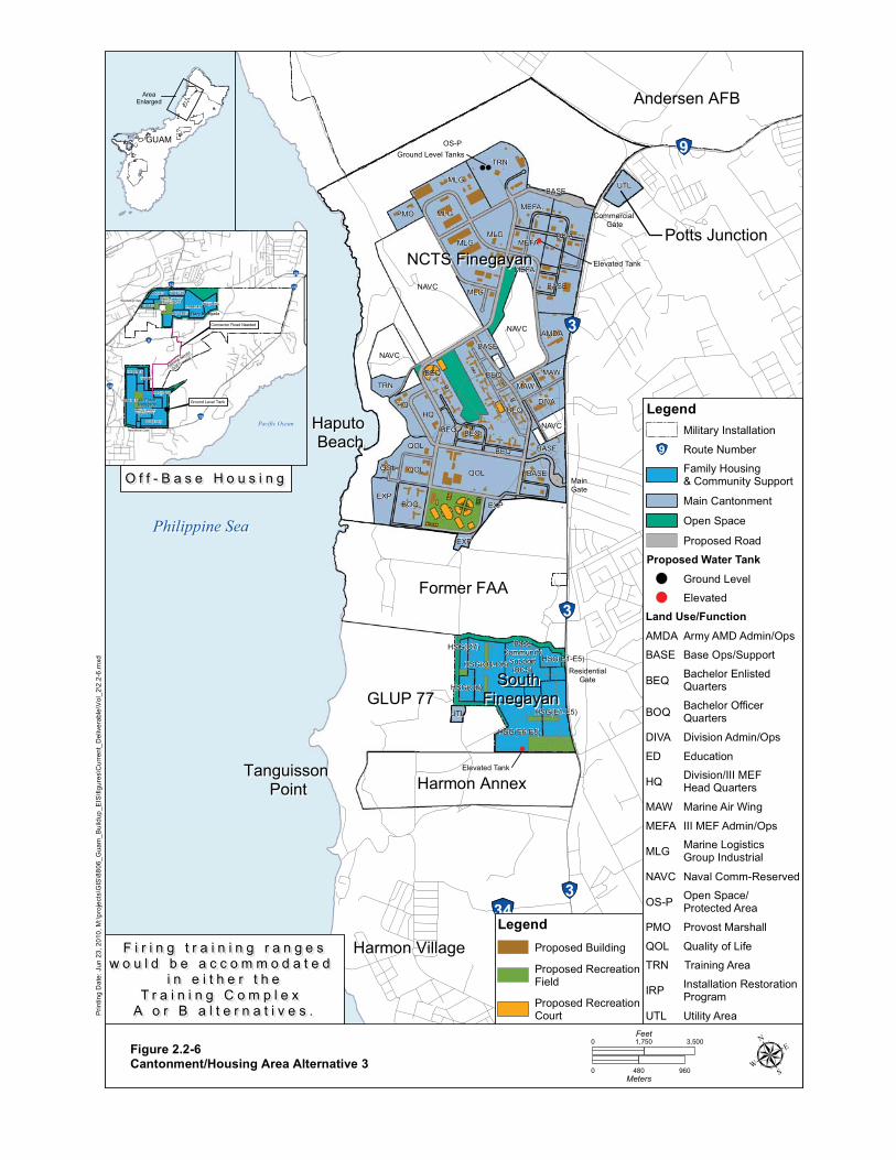
!
!
!
!
!"28
!"9
!"3
!"3
!"3!"34
!"1
Philippine SeaPhilippine Sea
NCTS FinegayanNCTS FinegayanPotts JunctionPotts Junction
Former FAAFormer FAA
GLUP 77GLUP 77South South
FinegayanFinegayan
Tanguisson Tanguisson PointPoint
Haputo Haputo BeachBeach
Andersen AFBAndersen AFB
Harmon VillageHarmon Village
Harmon AnnexHarmon Annex
Commercial Commercial GateGate
ResidentialResidentialGateGate
QOL
MainMainGateGate
EXPEXP
EXP
Ground Level Tanks
Elevated Tank
Elevated Tank
OS-P
NAVC
BEQ
QOL
TRN
NAVC
MLG
MLG
NAVC
MLG
BOQ
HQ
MLG
HQ
BASE
QOL
AMDA
DIVA
QOL
MLG
MEFAPMO
TRN
MAW
BEQ
MEFA
MAW
UTL
BEQ
BASE
DIVA
BASE
BEQ
BEQ
MEFA
BEQ
UTL
BASE
NAVC
BASE
HSG(E6-E8)
HSG(O4-O5)
HSG(E1-E5)
BaseCommunity
Support(BCS)
HSG(O6)
HSG(O7)HSG(E1-E5)
Prin
ting
Dat
e: J
un 2
3, 2
010,
M:\p
roje
cts\
GIS
\880
6_G
uam
_Bui
ldup
_EIS
\figu
res\
Cur
rent
_Del
iver
able
\Vol
_2\2
.2-6
.mxd
Figure 2.2-6Cantonment/Housing Area Alternative 3
GUAMGUAM
AreaEnlarged
!
!"26
!"15!"16
!"8
!"10
!"15
Air ForceAir ForceBarrigadaBarrigada
Navy BarrigadaNavy Barrigada
Admiral Nimitz
Admiral Nimitz
Golf Course
Golf Course
Pacific OceanPacific Ocean
Connector Road NeededConnector Road Needed
Ground Level TankGround Level Tank
HSG(E6-E8)
HSG(E1-E5)
HSG(E9)
HSG(E6-E8)
HSG(E1-E5)
Base CommunitySupport (BCS)
HSG(E1-E5)
HSG(O1-O3)
HSG(O1-O3)
HSG(E9)
Base CommunitySupport (BCS)
HSG(E1-E5)
HSG(E9)
Residential Gate
Residential Gate
O f f - B a s e H o u s i n gO f f - B a s e H o u s i n g
μ0 480 960Meters
0 3,5001,750Feet
Legend
Proposed RecreationCourt
Proposed RecreationField
Proposed BuildingF i r i n g t r a i n i n g r a n g e sF i r i n g t r a i n i n g r a n g e sw o u l d b e a c c o m m o d a t e d w o u l d b e a c c o m m o d a t e d
i n e i t h e r t h ei n e i t h e r t h eT r a i n i n g C o m p l e x T r a i n i n g C o m p l e x
A o r B a l t e r n a t i v e s .A o r B a l t e r n a t i v e s .
TRN Training Area
Legend
Land Use/Function
UTL Utility Area
OS-P Open Space/Protected Area
QOL Quality of Life
PMO Provost Marshall
NAVC Naval Comm-Reserved
AMDA Army AMD Admin/Ops
MAW Marine Air Wing
MLG Marine Logistics Group Industrial
MEFA III MEF Admin/Ops
DIVA Division Admin/Ops
BASE Base Ops/Support
HQ Division/III MEFHead Quarters
BOQ Bachelor OfficerQuarters
BEQ Bachelor Enlisted Quarters
Main Cantonment
Family Housing& Community Support
!"9 Route Number
Military Installation
IRP Installation RestorationProgram
Open Space
ED Education
Proposed Road
Proposed Water Tank
Elevated
Ground Level
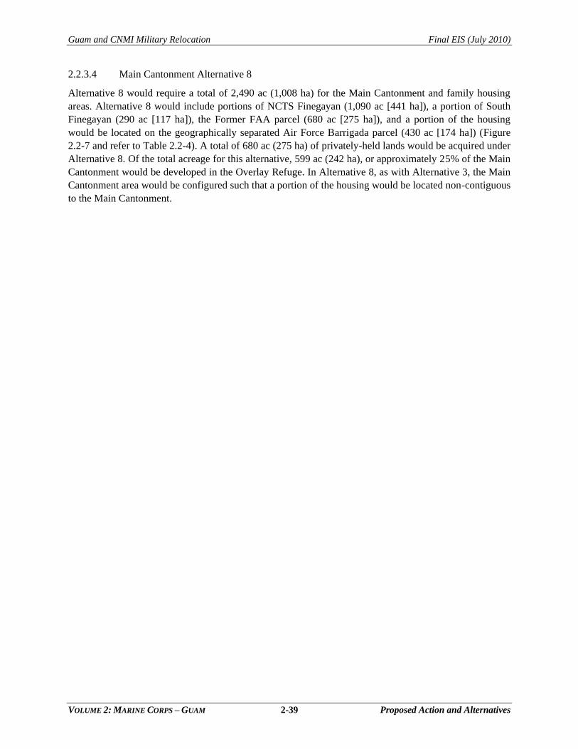
Guam and CNMI Military Relocation Final EIS (July 2010)
VOLUME 2: MARINE CORPS – GUAM 2-39 Proposed Action and Alternatives
2.2.3.4 Main Cantonment Alternative 8
Alternative 8 would require a total of 2,490 ac (1,008 ha) for the Main Cantonment and family housing
areas. Alternative 8 would include portions of NCTS Finegayan (1,090 ac [441 ha]), a portion of South
Finegayan (290 ac [117 ha]), the Former FAA parcel (680 ac [275 ha]), and a portion of the housing
would be located on the geographically separated Air Force Barrigada parcel (430 ac [174 ha]) (Figure
2.2-7 and refer to Table 2.2-4). A total of 680 ac (275 ha) of privately-held lands would be acquired under
Alternative 8. Of the total acreage for this alternative, 599 ac (242 ha), or approximately 25% of the Main
Cantonment would be developed in the Overlay Refuge. In Alternative 8, as with Alternative 3, the Main
Cantonment area would be configured such that a portion of the housing would be located non-contiguous
to the Main Cantonment.
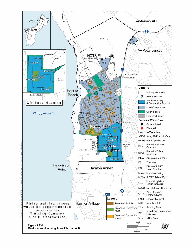
!
!
!
!
!"28
!"9
!"3
!"3
!"3!"34
!"1
Philippine SeaPhilippine Sea
NCTS FinegayanNCTS FinegayanPotts JunctionPotts Junction
Former FAAFormer FAA
GLUP 77GLUP 77South South
FinegayanFinegayan
Tanguisson Tanguisson PointPoint
Haputo Haputo BeachBeach
Andersen AFBAndersen AFB
Harmon VillageHarmon Village
Harmon AnnexHarmon Annex
Main GateMain Gate
ResidentialResidentialGateGate
Commercial GateCommercial Gate
Ground Level Tanks
Elevated Tank
Elevated Tank
HSG(O7)
OS-P
OS-PNAVC
BEQ
MLG
BEQ
OS-P
QOL
MLG
TRN
MLG
NAVC
DIVA
NAVC
QOL
MAW
DIVA
HQ
OS-P
NAVC
MEFA
EXP
MLG
AMDA
BEQ
QOL
NAVC
DIVA
BASE
MLG
BOQ
UTL
MEFA
TRN
BASE BASE
PMO
UTL
BASE
BASE
NAVC
BASE
HSG(E1-E5)
HSG(E6-E8)
HSG(O1-O3)
HSG(O4-O5)
BaseCommunity
Support (BCS)
HSG(E9)
HSG(O6)
Prin
ting
Dat
e: J
un 2
3, 2
010,
M:\p
roje
cts\
GIS
\880
6_G
uam
_Bui
ldup
_EIS
\figu
res\
Cur
rent
_Del
iver
able
\Vol
_2\2
.2-7
.mxd
Figure 2.2-7Cantonment /Housing Area Alternative 8
GUAMGUAM
AreaEnlarged
!
GroundLevel Tank
HSG(E1-E5)
HSG(E6-E8)
HSG(O1-O3)
HSG(E9)
HSG(E1-E5)
Base CommunitySupport (BCS)
Residential Gate
O f f - B a s e H o u s i n gO f f - B a s e H o u s i n g
μ0 480 960Meters
0 3,5001,750Feet
Legend
Proposed RecreationCourt
Proposed RecreationField
Proposed BuildingF i r i n g t r a i n i n g r a n g e sF i r i n g t r a i n i n g r a n g e sw o u l d b e a c c o m m o d a t e d w o u l d b e a c c o m m o d a t e d
i n e i t h e r t h ei n e i t h e r t h eT r a i n i n g C o m p l e x T r a i n i n g C o m p l e x
A o r B a l t e r n a t i v e s .A o r B a l t e r n a t i v e s .
TRN Training Area
Legend
Land Use/Function
UTL Utility Area
OS-P Open Space/Protected Area
QOL Quality of Life
PMO Provost Marshall
NAVC Naval Comm-Reserved
AMDA Army AMD Admin/Ops
MAW Marine Air Wing
MLG Marine Logistics Group Industrial
MEFA III MEF Admin/Ops
DIVA Division Admin/Ops
BASE Base Ops/Support
HQ Division/III MEFHead Quarters
BOQ Bachelor OfficerQuarters
BEQ Bachelor Enlisted Quarters
Main Cantonment
Family Housing& Community Support
!"9 Route Number
Military Installation
IRP Installation RestorationProgram
Open Space
ED Education
Proposed Road
Proposed Water Tank
Elevated
Ground Level
Guam and CNMI Military Relocation Final EIS (July 2010)
VOLUME 2: MARINE CORPS – GUAM 2-41 Proposed Action and Alternatives
2.3 PROPOSED ACTION: TRAINING FUNCTIONS
2.3.1 Requirements
Training requirements associated with relocating Marines from
Okinawa to Guam were derived from the statement of
operational requirements prepared by the Commander, U.S.
Pacific Command as required by the Agreed Implementation
Plan (AIP). This guidance was further developed in an
operational concept for MAGTF operations and training by the
Commander, Marine Forces Pacific. Together, these documents
outline a concept for force movement, command and staff
interaction, operations and training up to the MAGTF level.
Additional information on training is available in Volume 9,
Appendix M.
The essence of this concept is to accomplish frequent, individual and small unit training close to home,
and move farther away as needed for larger, more complex but less frequent training. Marines stationed
on Guam require annual qualification or requalification on individual and crew–served weapons to
maintain their combat readiness. Every Marine on Guam would require this type of training. This high
volume can only be met with ranges located in close proximity to cantonment areas. It would not be
effective or efficient to accomplish this smaller scale, more frequent training on another island.
The overarching goals are:
Individual and Military Occupational Specialty (MOS) training on Guam.
Small unit training up to company level on Guam.
Re-qualification and sustainment training on Guam with individual weapons, machine guns
and other infantry crew-served weapons.
Enhanced battle staff planning and coordination among disparate III MEF command
headquarters.
Optimized use of simulation and training devices.
All infantry weapons and ground supporting arms training on existing DoD land assets in the
Marianas including maneuver to the extent allowed by space and terrain.
MAGTF multi-dimensional fire and maneuver.
Aviation operations throughout the Marianas.
Table 2.3-1 lists the elements of the proposed action associated with Marine Corps training requirements
on Guam (see Volume 1 Figure ES-2a for a graphical depiction of training locations).
The individual training facilities and projects have been organized into the following six training types or
categories, and are discussed further in the corresponding subsections that follow the table:
Ammunition Storage
Command, Control, and Simulation
Non-Firing General Military Skills Training
Firing General Military Skills Training
Aviation Training
Airspace
Chapter 2:
2.1 Overview
2.2 Main Cantonment Area
Functions
2.3 Training Functions
2.4 Airfield Functions
2.4 Waterfront Functions
2.6 Summary of Alternatives
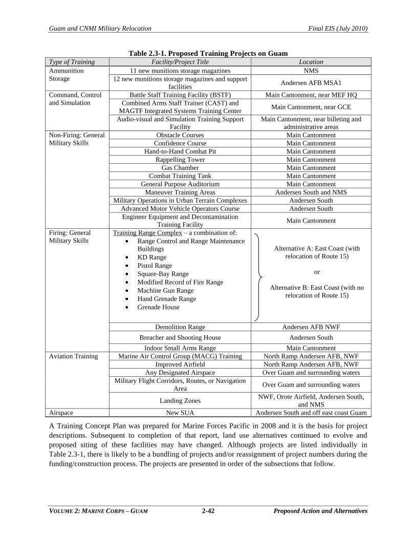
Guam and CNMI Military Relocation Final EIS (July 2010)
VOLUME 2: MARINE CORPS – GUAM 2-42 Proposed Action and Alternatives
Table 2.3-1. Proposed Training Projects on Guam Type of Training Facility/Project Title Location
Ammunition
Storage
11 new munitions storage magazines NMS
12 new munitions storage magazines and support
facilities Andersen AFB MSA1
Command, Control
and Simulation
Battle Staff Training Facility (BSTF) Main Cantonment, near MEF HQ
Combined Arms Staff Trainer (CAST) and
MAGTF Integrated Systems Training Center Main Cantonment, near GCE
Audio-visual and Simulation Training Support
Facility
Main Cantonment, near billeting and
administrative areas
Non-Firing: General
Military Skills
Obstacle Courses Main Cantonment
Confidence Course Main Cantonment
Hand-to-Hand Combat Pit Main Cantonment
Rappelling Tower Main Cantonment
Gas Chamber Main Cantonment
Combat Training Tank Main Cantonment
General Purpose Auditorium Main Cantonment
Maneuver Training Areas Andersen South and NMS
Military Operations in Urban Terrain Complexes Andersen South
Advanced Motor Vehicle Operators Course Andersen South
Engineer Equipment and Decontamination
Training Facility Main Cantonment
Firing: General
Military Skills
Training Range Complex – a combination of:
Range Control and Range Maintenance
Buildings
KD Range
Pistol Range
Square-Bay Range
Modified Record of Fire Range
Machine Gun Range
Hand Grenade Range
Grenade House
Alternative A: East Coast (with
relocation of Route 15)
or
Alternative B: East Coast (with no
relocation of Route 15)
Demolition Range Andersen AFB NWF
Breacher and Shooting House Andersen South
Indoor Small Arms Range Main Cantonment
Aviation Training
Marine Air Control Group (MACG) Training North Ramp Andersen AFB, NWF
Improved Airfield North Ramp Andersen AFB, NWF
Any Designated Airspace Over Guam and surrounding waters
Military Flight Corridors, Routes, or Navigation
Area Over Guam and surrounding waters
Landing Zones NWF, Orote Airfield, Andersen South,
and NMS
Airspace New SUA Andersen South and off east coast Guam
A Training Concept Plan was prepared for Marine Forces Pacific in 2008 and it is the basis for project
descriptions. Subsequent to completion of that report, land use alternatives continued to evolve and
proposed siting of these facilities may have changed. Although projects are listed individually in
Table 2.3-1, there is likely to be a bundling of projects and/or reassignment of project numbers during the
funding/construction process. The projects are presented in order of the subsections that follow.
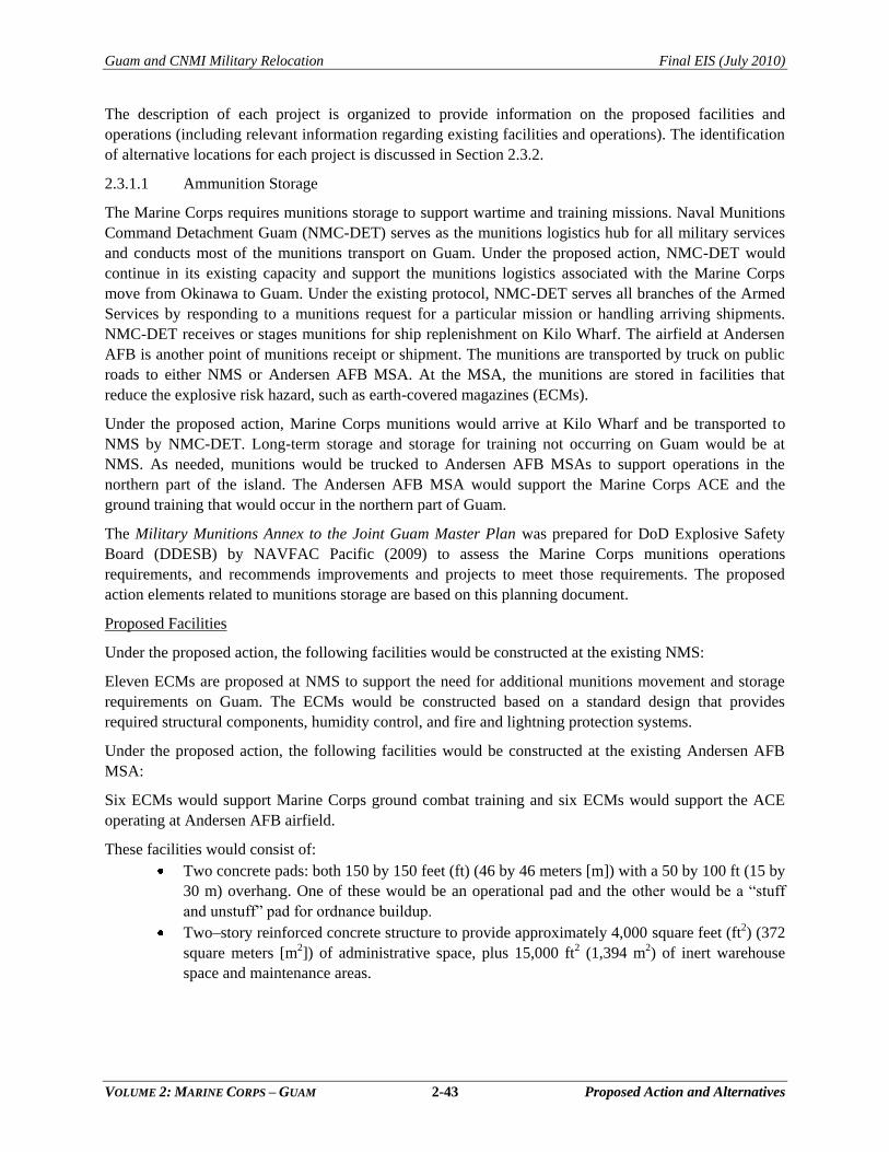
Guam and CNMI Military Relocation Final EIS (July 2010)
VOLUME 2: MARINE CORPS – GUAM 2-43 Proposed Action and Alternatives
The description of each project is organized to provide information on the proposed facilities and
operations (including relevant information regarding existing facilities and operations). The identification
of alternative locations for each project is discussed in Section 2.3.2.
2.3.1.1 Ammunition Storage
The Marine Corps requires munitions storage to support wartime and training missions. Naval Munitions
Command Detachment Guam (NMC-DET) serves as the munitions logistics hub for all military services
and conducts most of the munitions transport on Guam. Under the proposed action, NMC-DET would
continue in its existing capacity and support the munitions logistics associated with the Marine Corps
move from Okinawa to Guam. Under the existing protocol, NMC-DET serves all branches of the Armed
Services by responding to a munitions request for a particular mission or handling arriving shipments.
NMC-DET receives or stages munitions for ship replenishment on Kilo Wharf. The airfield at Andersen
AFB is another point of munitions receipt or shipment. The munitions are transported by truck on public
roads to either NMS or Andersen AFB MSA. At the MSA, the munitions are stored in facilities that
reduce the explosive risk hazard, such as earth-covered magazines (ECMs).
Under the proposed action, Marine Corps munitions would arrive at Kilo Wharf and be transported to
NMS by NMC-DET. Long-term storage and storage for training not occurring on Guam would be at
NMS. As needed, munitions would be trucked to Andersen AFB MSAs to support operations in the
northern part of the island. The Andersen AFB MSA would support the Marine Corps ACE and the
ground training that would occur in the northern part of Guam.
The Military Munitions Annex to the Joint Guam Master Plan was prepared for DoD Explosive Safety
Board (DDESB) by NAVFAC Pacific (2009) to assess the Marine Corps munitions operations
requirements, and recommends improvements and projects to meet those requirements. The proposed
action elements related to munitions storage are based on this planning document.
Proposed Facilities
Under the proposed action, the following facilities would be constructed at the existing NMS:
Eleven ECMs are proposed at NMS to support the need for additional munitions movement and storage
requirements on Guam. The ECMs would be constructed based on a standard design that provides
required structural components, humidity control, and fire and lightning protection systems.
Under the proposed action, the following facilities would be constructed at the existing Andersen AFB
MSA:
Six ECMs would support Marine Corps ground combat training and six ECMs would support the ACE
operating at Andersen AFB airfield.
These facilities would consist of:
Two concrete pads: both 150 by 150 feet (ft) (46 by 46 meters [m]) with a 50 by 100 ft (15 by
30 m) overhang. One of these would be an operational pad and the other would be a ―stuff
and unstuff‖ pad for ordnance buildup.
Two–story reinforced concrete structure to provide approximately 4,000 square feet (ft2) (372
square meters [m2]) of administrative space, plus 15,000 ft2 (1,394 m2) of inert warehouse
space and maintenance areas.
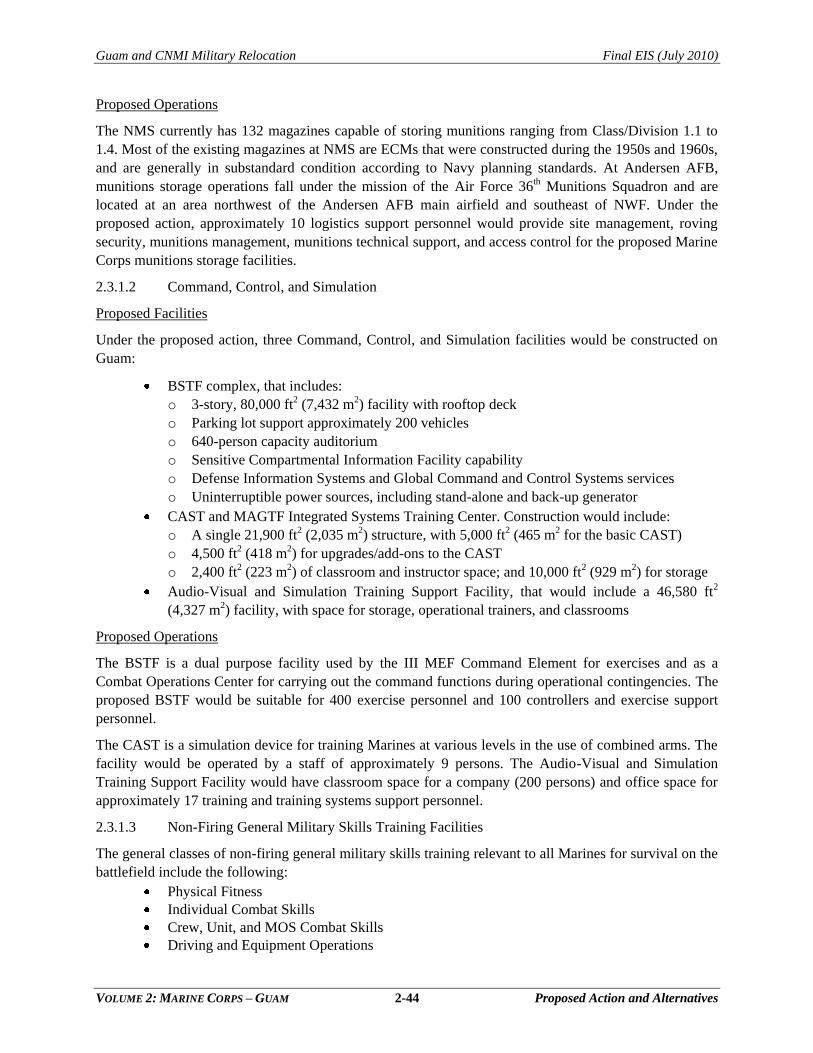
Guam and CNMI Military Relocation Final EIS (July 2010)
VOLUME 2: MARINE CORPS – GUAM 2-44 Proposed Action and Alternatives
Proposed Operations
The NMS currently has 132 magazines capable of storing munitions ranging from Class/Division 1.1 to
1.4. Most of the existing magazines at NMS are ECMs that were constructed during the 1950s and 1960s,
and are generally in substandard condition according to Navy planning standards. At Andersen AFB,
munitions storage operations fall under the mission of the Air Force 36th Munitions Squadron and are
located at an area northwest of the Andersen AFB main airfield and southeast of NWF. Under the
proposed action, approximately 10 logistics support personnel would provide site management, roving
security, munitions management, munitions technical support, and access control for the proposed Marine
Corps munitions storage facilities.
2.3.1.2 Command, Control, and Simulation
Proposed Facilities
Under the proposed action, three Command, Control, and Simulation facilities would be constructed on
Guam:
BSTF complex, that includes:
o 3-story, 80,000 ft2 (7,432 m2) facility with rooftop deck
o Parking lot support approximately 200 vehicles
o 640-person capacity auditorium
o Sensitive Compartmental Information Facility capability
o Defense Information Systems and Global Command and Control Systems services
o Uninterruptible power sources, including stand-alone and back-up generator
CAST and MAGTF Integrated Systems Training Center. Construction would include:
o A single 21,900 ft2 (2,035 m2) structure, with 5,000 ft2 (465 m2 for the basic CAST)
o 4,500 ft2 (418 m
2) for upgrades/add-ons to the CAST
o 2,400 ft2 (223 m2) of classroom and instructor space; and 10,000 ft2 (929 m2) for storage
Audio-Visual and Simulation Training Support Facility, that would include a 46,580 ft2
(4,327 m2) facility, with space for storage, operational trainers, and classrooms
Proposed Operations
The BSTF is a dual purpose facility used by the III MEF Command Element for exercises and as a
Combat Operations Center for carrying out the command functions during operational contingencies. The
proposed BSTF would be suitable for 400 exercise personnel and 100 controllers and exercise support
personnel.
The CAST is a simulation device for training Marines at various levels in the use of combined arms. The
facility would be operated by a staff of approximately 9 persons. The Audio-Visual and Simulation
Training Support Facility would have classroom space for a company (200 persons) and office space for
approximately 17 training and training systems support personnel.
2.3.1.3 Non-Firing General Military Skills Training Facilities
The general classes of non-firing general military skills training relevant to all Marines for survival on the
battlefield include the following:
Physical Fitness
Individual Combat Skills
Crew, Unit, and MOS Combat Skills
Driving and Equipment Operations
Guam and CNMI Military Relocation Final EIS (July 2010)
VOLUME 2: MARINE CORPS – GUAM 2-45 Proposed Action and Alternatives
Proposed Facilities and Operations
Brief project descriptions for each type of proposed facility and training activity are provided below.
Issues related to the proposed siting of these facilities and any project alternatives are described in Section
2.3.2. For more information on all the training elements needed and proposed for Guam, see Volume 9,
Appendix M.
Obstacle and Confidence Courses
Two proposed obstacle courses and one confidence course would be constructed in the same location.
Components of these courses are standard throughout the Marine Corps. Each obstacle course would
include a two-lane outdoor complex of wooden obstacles for Marines to hop, climb, crawl, and pull over.
The confidence course would include additional obstacles and challenges added within the same footprint
as the obstacle courses Figure 2.3-1 depicts a typical Marine Corps training obstacle course. The three
courses would be located together on a 2-ac (.8-ha) site.
The courses would be used daily and accommodate approximately 25 to 60 personnel at a given time.
Hand-to-Hand Combat Pit
A hand-to-hand combat pit is needed for training in hand-to-hand combat techniques. Under the proposed
action, a sand-filled area with padded retaining wall would be constructed to provide a safe area for
training Marines in hand-to-hand combat techniques.
Rappelling Tower
Under the proposed action, a 60-ft (18-m) tower of four floors, approximately 26 ft (8 m) on a side with a
rappelling wall, overhang, and climbing wall would be constructed. Figure 2.3-2 provides a photograph of
a sample Marine Corps rappelling tower.
Gas Chamber
Under the proposed action, a 4,000 ft2 (372 m2) single building would be constructed, consisting of a
600-ft2 (56-m2) gas chamber, 1,500 ft2 (139 m2) of classroom and associated office space, a mechanical
room for ventilation/filtration, and storage of training devices.
During training events in this type of facility, participants are exposed to a non-lethal ―tear gas‖ that is
typically used as a riot control agent. The training is designed to teach individual confidence in the
application of a field protective mask in the presence of gas.
Combat Training Tank
Under the proposed action, one 13,000- ft2 (1,208-m2) swimming pool would be constructed to meet the
training requirement for water survival and amphibious vehicle egress.
General Purpose Auditorium
Under the proposed action, an approximately 72,000-ft2 (6,690-m2) auditorium would be constructed to
provide capacity to simultaneously brief 6,000 military personnel.
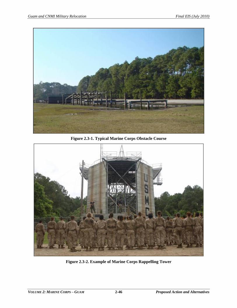
Guam and CNMI Military Relocation Final EIS (July 2010)
VOLUME 2: MARINE CORPS – GUAM 2-46 Proposed Action and Alternatives
Figure 2.3-1. Typical Marine Corps Obstacle Course
Figure 2.3-2. Example of Marine Corps Rappelling Tower
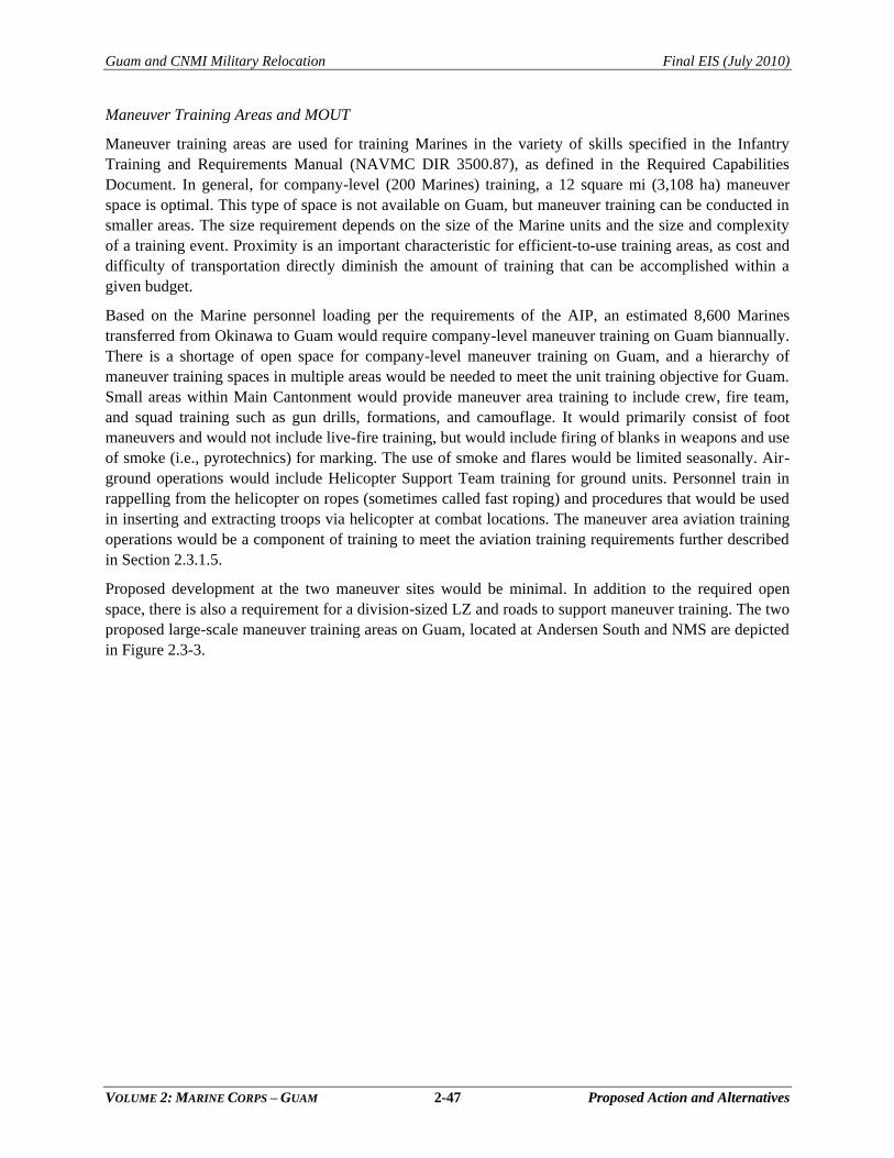
Guam and CNMI Military Relocation Final EIS (July 2010)
VOLUME 2: MARINE CORPS – GUAM 2-47 Proposed Action and Alternatives
Maneuver Training Areas and MOUT
Maneuver training areas are used for training Marines in the variety of skills specified in the Infantry
Training and Requirements Manual (NAVMC DIR 3500.87), as defined in the Required Capabilities
Document. In general, for company-level (200 Marines) training, a 12 square mi (3,108 ha) maneuver
space is optimal. This type of space is not available on Guam, but maneuver training can be conducted in
smaller areas. The size requirement depends on the size of the Marine units and the size and complexity
of a training event. Proximity is an important characteristic for efficient-to-use training areas, as cost and
difficulty of transportation directly diminish the amount of training that can be accomplished within a
given budget.
Based on the Marine personnel loading per the requirements of the AIP, an estimated 8,600 Marines
transferred from Okinawa to Guam would require company-level maneuver training on Guam biannually.
There is a shortage of open space for company-level maneuver training on Guam, and a hierarchy of
maneuver training spaces in multiple areas would be needed to meet the unit training objective for Guam.
Small areas within Main Cantonment would provide maneuver area training to include crew, fire team,
and squad training such as gun drills, formations, and camouflage. It would primarily consist of foot
maneuvers and would not include live-fire training, but would include firing of blanks in weapons and use
of smoke (i.e., pyrotechnics) for marking. The use of smoke and flares would be limited seasonally. Air-
ground operations would include Helicopter Support Team training for ground units. Personnel train in
rappelling from the helicopter on ropes (sometimes called fast roping) and procedures that would be used
in inserting and extracting troops via helicopter at combat locations. The maneuver area aviation training
operations would be a component of training to meet the aviation training requirements further described
in Section 2.3.1.5.
Proposed development at the two maneuver sites would be minimal. In addition to the required open
space, there is also a requirement for a division-sized LZ and roads to support maneuver training. The two
proposed large-scale maneuver training areas on Guam, located at Andersen South and NMS are depicted
in Figure 2.3-3.
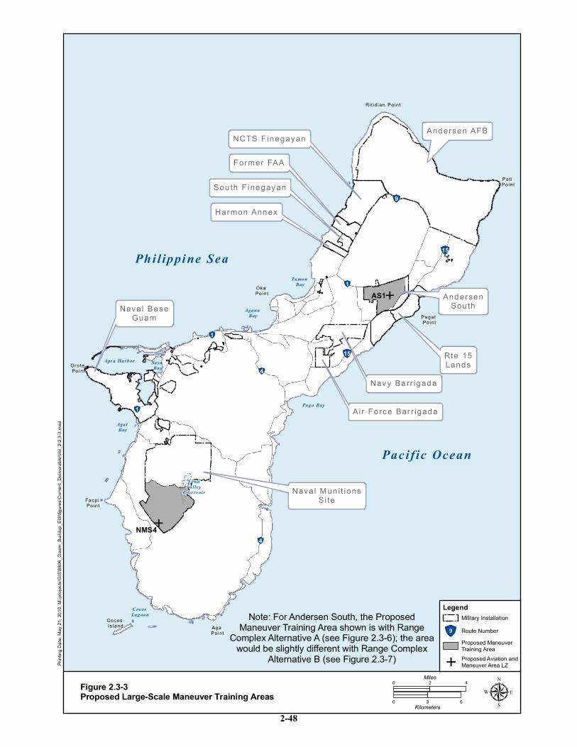
E
E
NCTS F inegayanNCTS F inegayan
AndersenAndersenSou thSou th
Navy Barr igadaNavy Barr igada
Ai r Fo rce Bar r igadaAi r Fo rce Bar r igada
Rit id ian PointRi t id ian Point
Pat i Pat i PointPoint
Pagat Pagat PointPoint
Oka Oka PointPoint
Or ote Or ote PointPoint
Facpi Facpi PointPoint
Aga Aga PointPoint
Cocos Cocos Is landIs land
Sou th F inegayanSou th F inegayan
Andersen AFBAndersen AFB
Naval Mun it ionsNaval Mun it ionsSi teSi te
Naval BaseNaval BaseGuamGuam
Former FAAFormer FAA
Rte 15Rte 15LandsLands
Harmon AnnexHarmon Annex
Phi l ippine Sea
Pacific Ocean
Apr a Harbor Sasa Bay
Agat Bay
Coc os Lagoon
Pago Bay
Agana Bay
Tumon Bay
FenaValley
Rese rv oir
!"1
!"1
!"4
!"4
!"1
!"15
!"15
!"9
AS1
NMS4
ing D
ate: M
ay 21
, 201
0, M:
\proje
cts\G
IS\88
06_G
uam_
Build
up_E
IS\fig
ures\C
urren
t_Deli
verab
le\Vo
l_2\2.
3-3.m
xd
Figure 2.3-3Proposed Large-Scale Maneuver Training Areas
0 42Miles
0 3 6Kilometers µ
Note: For Andersen South, the ProposedManeuver Training Area shown is with Range
Complex Alternative A (see Figure 2.3-6); the areawould be slightly different with Range Complex
Alternative B (see Figure 2.3-7)
LegendMilitary Installation
!"9 Route NumberProposed ManeuverTraining Area
EProposed Aviation andManeuver Area LZ
2-48
Guam and CNMI Military Relocation Final EIS (July 2010)
VOLUME 2: MARINE CORPS – GUAM 2-49 Proposed Action and Alternatives
In these two maneuver training areas, operations would be as follows:
NMS: Company-level patrolling, jungle training, land navigation, and air-ground operations
to occur on 5-7 consecutive days, 12 weeks per year, day and night. Access to the NMS site
would potentially occur via helicopter transport operations. Although improvements to an
existing trail are proposed, no roads would be established within this training site When the
existing Explosive Ordnance Disposal (EOD) demolition range at NMS is operational, an
Explosive Safety Quantity-Distance (ESQD) arc is generated at the proposed site for
maneuver training. LZ NMS4 (Figure 2.3-4) would support maneuver training operations at
NMS. This area would also be used for aviation training and include additional LZs. As
shown in Figure 2.3-4, the maneuver area would require an access road.
Andersen South: Convoy operations, MOUT-related maneuver training, and general
maneuver and air-ground operations to vary from small unit to company-level exercises to
occur 5 days a week, 45 weeks per year, day and night. This area of Andersen South is
currently used by the Air Force for expeditionary airfield training that has similarities to the
proposed maneuver area training. The area would be scheduled to continue to support this Air
Force training, while also accommodating the Marine Corps training requirements. An
approximately 2,000 ac (809 ha) area at Andersen South near the proposed MOUT complex
has been identified for maneuver training to include the convoy course (see Figure 2.3-3). LZ
AS1 (described in Section 2.3.1.5) would support maneuver training operations at Andersen
South (Figure 2.3-5). The convoy training course would use existing roadways and
abandoned rights of way in the northwestern portion of Andersen South within areas
identified for maneuver training use. The site plans depicted in Figure 2.3-6 and Figure 2.3-7
provide the location of the proposed convoy training course.
MOUT training would be conducted in a complex of structures that would simulate urban
rural and embassy environments. The MOUT at Andersen South would be suitable for
units/organizations up to 800 Marines at a time, and would be used on a daily basis by 40 to
750 personnel. The MOUT may operate during daylight hours and at night. Night operations
would comprise an estimated 15% of all operations. The MOUT would be used by III MEF
units and organizations based on Guam, transients, and visiting regional allied forces. Units
using the MOUT may bivouac in the vicinity, or arrive and depart daily. Forklifts or cranes
would be used to reconfigure the modules of the MOUT to add variety and diversity to
training (e.g., simulate a rural village or more complex setting). The MOUT facility requires
surrounding maneuver space to provide room for tactical engagement.
A fire management plan, currently being prepared by NAVFAC Pacific, would address the
fire conditions under which use of pyrotechnics at Andersen South and NMS would be
authorized and Best Management Practices (BMPs) for use of those pyrotechnics. This plan
would also address broad fire management and fire response at the Andersen South and NMS
proposed maneuver areas.
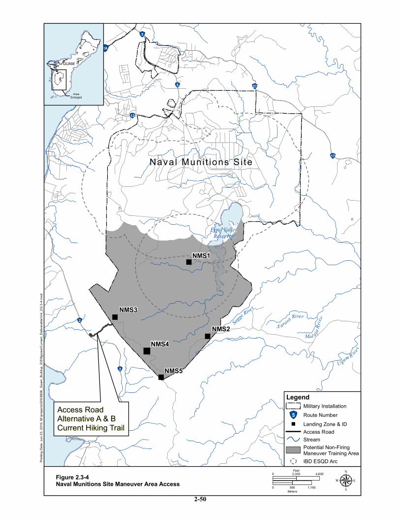
"
"
"
"
"
!"2A
!"5
!"2B
!"5 !"27
!"12
!"2
!"2
!"17
Fena Valley Fena Valley ReservoirReservoir
DD aaddii BBeeaacchh
Nava l Muni t ions S i teNava l Muni t ions S i te
Access RoadAccess RoadAlternative A & BAlternative A & BCurrent Hiking TrailCurrent Hiking Trail
Mal aja Ri
verS arasa River
Sagge R
ive r
Ugum R iver
NMS5
NMS4
NMS3
NMS2
NMS1
ing D
ate: J
un 23
, 201
0, M:
\proje
cts\G
IS\88
06_G
uam_
Build
up_E
IS\fig
ures\C
urren
t_Deli
verab
le\Vo
l_2\2.
3-4.m
xd
GUAMGUAM
AreaEnlarged
Figure 2.3-4Naval Munitions Site Maneuver Area Access µ
0 4,6002,300Feet
0 580 1,160Meters
LegendMilitary Installation
IBD ESQD Arc
Stream
!"5 Route Number" Landing Zone & ID
Potential Non-FiringManeuver Training Area
Access Road
2-50
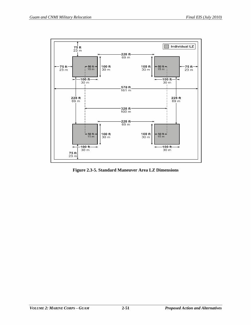
Guam and CNMI Military Relocation Final EIS (July 2010)
VOLUME 2: MARINE CORPS – GUAM 2-51 Proposed Action and Alternatives
Figure 2.3-5. Standard Maneuver Area LZ Dimensions
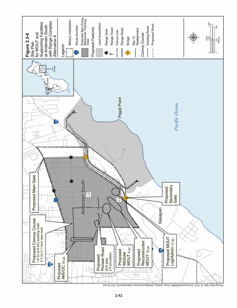
Printing Date: May 19, 2010, M:\projects\GIS\8806_Guam_Buildup_EIS\figures\Current_Deliverable\Vol_2\2.3-6.mxd
kk
k
g
g
" )LZ
" )LZ
!"28!"1
!"26 !"15
!"15
Paga
t Poin
tPa
gat P
oint
Ande
rsen S
outh
Ande
rsen S
outh
Sasa
jyan
Sasa
jyan
Pacif
ic Oc
ean
Pacif
ic Oc
ean
89:X
89:X
Prop
osed
Prop
osed
AMVO
C AM
VOC
15 ac
15 ac
Prop
osed
MOU
TPr
opos
ed M
OUT
Log/A
dmin
Log/A
dmin
>1 ac
>1 ac
Prop
osed
Prop
osed
Modu
larMo
dular
MOUT
MO
UT 5
ac5 ac
Prop
osed
Prop
osed
Reco
nstru
cted
Reco
nstru
cted
MOUT
MO
UT 15
ac15
ac
Prop
osed
Prop
osed
Seco
ndary
Seco
ndary
Gate
Gate
Prop
osed
Main
Gate
Prop
osed
Main
Gate
Prop
osed
Con
voy C
ourse
Pr
opos
ed C
onvo
y Cou
rse
1.8 m
i (2.9
km) e
xistin
g roa
d;1.8
mi (2
.9 km
) exis
ting r
oad;
0.7 m
i (1.1
km) n
ew ro
ad 0.
7 mi (1
.1 km
) new
road
Prop
osed
Prop
osed
Pione
er Ro
adPio
neer
Road
20 ft
wide
20 ft
wide
2 ft s
hould
ers2 f
t sho
ulders
GUAM
GUAM
Area
Enlar
ged
Site P
lanfor
MOU
T and
Supp
orting
Facili
ties
at An
derse
n Sou
thwit
h Ran
ge C
omple
xAlt
ernati
ve A
Figur
e 2.3-
6 µ0
400
800
Meter
s
02,9
001,4
50Fe
et
Lege
nd
!"1Ro
ute N
umbe
r
Conv
oy C
ourse
Milita
ry Ins
tallat
ion
Prop
osed
Featu
res
Rang
e Tow
erg
Prop
osed
Roa
dEx
isting
Roa
d
Poten
tial N
on-F
iring
Mane
uver
Traini
ngAr
ea
Rang
e Gate
k
Rang
e Roa
dFe
nce L
ine
Rte 1
5Re
align
ment
Bridg
e89:X
Land
Acqu
isitio
n
2-52
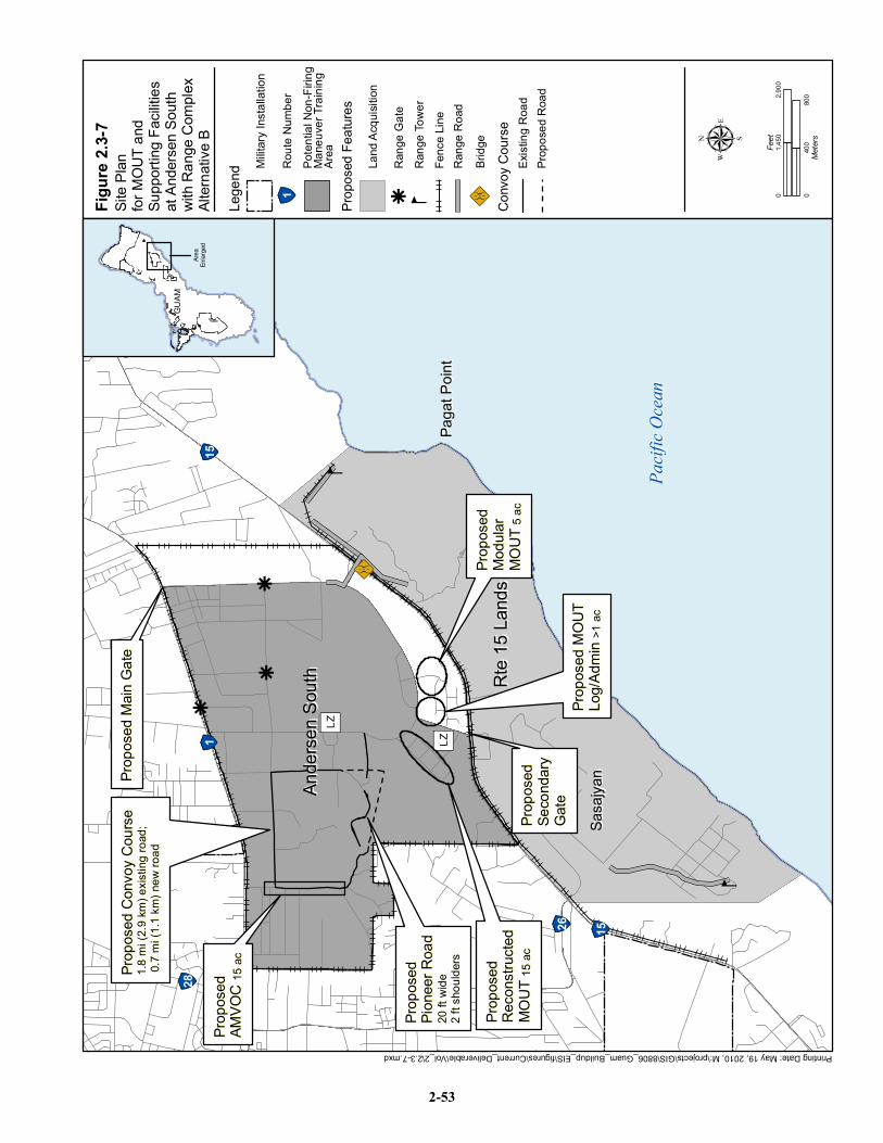
Printing Date: May 19, 2010, M:\projects\GIS\8806_Guam_Buildup_EIS\figures\Current_Deliverable\Vol_2\2.3-7.mxd
kk
k
g
g
!"28!"1
!"26 !"15
!"15
Paga
t Poin
tPa
gat P
oint
Ande
rsen S
outh
Ande
rsen S
outh Rt
e 15 L
ands
Rte 1
5 Lan
ds
Sasa
jyan
Sasa
jyan
Pacif
ic Oc
ean
Pacif
ic Oc
ean
89:X
" )LZ
" )LZ
Prop
osed
MOU
TPr
opos
ed M
OUT
Log/A
dmin
Log/A
dmin
>1 ac
>1 ac
Prop
osed
Prop
osed
Modu
larMo
dular
MOUT
MO
UT 5
ac5 ac
Prop
osed
Prop
osed
Reco
nstru
cted
Reco
nstru
cted
MOUT
MO
UT 15
ac15
acPr
opos
edPr
opos
edSe
cond
arySe
cond
aryGa
teGa
te
Prop
osed
Main
Gate
Prop
osed
Main
Gate
Prop
osed
Prop
osed
AMVO
C AM
VOC
15 ac
15 acPr
opos
ed C
onvo
y Cou
rse
Prop
osed
Con
voy C
ourse
1.8
mi (2
.9 km
) exis
ting r
oad;
1.8 m
i (2.9
km) e
xistin
g roa
d; 0.
7 mi (1
.1 km
) new
road
0.7 m
i (1.1
km) n
ew ro
ad
Prop
osed
Prop
osed
Pione
er Ro
adPio
neer
Road
20 ft
wide
20 ft
wide
2 ft s
hould
ers2 f
t sho
ulders
GUAM
GUAM
Area
Enlar
ged
Site P
lanfor
MOU
T and
Supp
orting
Facili
ties
at An
derse
n Sou
thwit
h Ran
ge C
omple
xAlt
ernati
ve B
Figur
e 2.3-
7 µ0
400
800
Meter
s
02,9
001,4
50Fe
et
Lege
nd
!"1Ro
ute N
umbe
r
Conv
oy C
ourse
Milita
ry Ins
tallat
ion
Prop
osed
Featu
res
Rang
e Tow
erg
Prop
osed
Roa
dEx
isting
Roa
d
Poten
tial N
on-F
iring
Mane
uver
Traini
ngAr
ea
Rang
e Gate
k
Rang
e Roa
dFe
nce L
ine
Bridg
e89:X
Land
Acqu
isitio
n
2-53
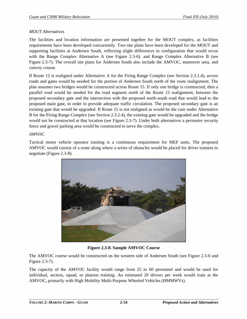
Guam and CNMI Military Relocation Final EIS (July 2010)
VOLUME 2: MARINE CORPS – GUAM 2-54 Proposed Action and Alternatives
MOUT Alternatives
The facilities and location information are presented together for the MOUT complex, as facilities
requirements have been developed concurrently. Two site plans have been developed for the MOUT and
supporting facilities at Andersen South, reflecting slight differences in configuration that would occur
with the Range Complex Alternative A (see Figure 2.3-6). and Range Complex Alternative B (see
Figure 2.3-7). The overall site plans for Andersen South also include the AMVOC, maneuver area, and
convoy course.
If Route 15 is realigned under Alternative A for the Firing Range Complex (see Section 2.3.1.4), access
roads and gates would be needed for the portion of Andersen South north of the route realignment. The
plan assumes two bridges would be constructed across Route 15. If only one bridge is constructed, then a
parallel road would be needed for the road segment north of the Route 15 realignment, between the
proposed secondary gate and the intersection with the proposed north-south road that would lead to the
proposed main gate, in order to provide adequate traffic circulation. The proposed secondary gate is an
existing gate that would be upgraded. If Route 15 is not realigned as would be the case under Alternative
B for the Firing Range Complex (see Section 2.3.2.4), the existing gate would be upgraded and the bridge
would not be constructed at that location (see Figure 2.3-7). Under both alternatives a perimeter security
fence and gravel parking area would be constructed to serve the complex.
AMVOC
Tactical motor vehicle operator training is a continuous requirement for MEF units. The proposed
AMVOC would consist of a route along where a series of obstacles would be placed for driver trainees to
negotiate (Figure 2.3-8).
Figure 2.3-8. Sample AMVOC Course
The AMVOC course would be constructed on the western side of Andersen South (see Figure 2.3-6 and
Figure 2.3-7).
The capacity of the AMVOC facility would range from 25 to 60 personnel and would be used for
individual, section, squad, or platoon training. An estimated 20 drivers per week would train at the
AMVOC, primarily with High Mobility Multi-Purpose Wheeled Vehicles (HMMWVs).
Guam and CNMI Military Relocation Final EIS (July 2010)
VOLUME 2: MARINE CORPS – GUAM 2-55 Proposed Action and Alternatives
Engineer Equipment and Decontamination Training
The engineer equipment training site or ―engineering pit‖ would be similar to a permanent construction
site and would be located at the Main Cantonment. The engineer equipment site would be designed to
support all three engineer units (approximately 750 Marines) to be stationed on Guam. Types of vehicles
that would operate at the ―engineering pit‖ include bulldozers, graders, material handling equipment, and
Armored Combat Engineer vehicles. Decontamination training involves using wash-down equipment to
simulate decontamination of equipment exposed to a chemical or biological agent. The decontamination
site would be used on a weekly basis with equipment and personnel throughput to vary based on the
training scenario. Establishment of the ―engineering pit‖ would include clearing and grubbing the site,
grading, and stormwater drainage.
2.3.1.4 Firing General Military Skills Training
Overview
General military skills training involving the firing of munitions includes the following categories:
Individual Weapons Training
Individual Combat Skills
Live-fire weapons ranges proposed for Guam include four small arms qualification ranges and a machine
gun operational range. Four explosive ranges are also proposed:
A hand grenade range that would be used to fulfill an integral part of Individual Combat
Skills Training
A hand grenade house that would supplement the hand grenade range to provide hand
grenade training in an urban environment
A demolition range that would be used for sustainment training in preparing and priming
various military explosives
A breacher/shooting house that would be used for training in forced entry in an urban
environment using small breacher charges
Volume 9, Appendix D provides a summary of the munitions and munitions constituents to be used at the
proposed ranges.
Criteria from Marine Corps Order 3570.1B define the SDZs for individual weapons systems based on the
weapon and munitions characteristics. SDZs of firing ranges are designed to identify the location of target
areas, a dispersion area, and a buffer zone to contain ricochets and fragments. Access to the SDZ is
restricted during training. For planning purposes in this EIS, SDZs have been developed based on the
placement of ranges. As the planning process progresses, and range designs mature, the SDZs would be
certified in accordance with Marine Corps Order 3550.9, Marine Corps Ground Range Certification and
Recertification Program. Limitations to use of land, water and airspace affected by SDZs are subject to
regulation by the DoD, U.S. Coast Guard (USCG), U.S. Army Corps of Engineers (USACE), and the
FAA, as appropriate.
To address the probability that expended projectiles, or projectile fragments, would fall outside the target
area but within the SDZ, a 1995 Army study about SDZs was used (Army 1995). SDZs are developed for
total confinement of expended munitions. Projectiles, or projectile fragments, landing outside the target
area but within the SDZ would be at highest concentration in the downrange area outside the target area,
just beyond the range backstop. This is based on studies conducted at other small arms ranges (Fort A.P.
Hill 2005, Naval Facilities Engineering Command [NAVFAC] Southeast 2008).
Guam and CNMI Military Relocation Final EIS (July 2010)
VOLUME 2: MARINE CORPS – GUAM 2-56 Proposed Action and Alternatives
Actual distribution in the Army study varied based on a number of factors including range type, weapons
and type of ammunition fired, firing positions, range design, impact media, and a number of other
specifics not currently available. Probability modeling for a particular .50 caliber range (with sand impact
media and a range footprint that extended 800 m from the firing point) found that between 1 in 100,000
(0.001%) to 1 in 10,000,000 (0.00001%) rounds would fall beyond the 2,624 ft (800 m) long range
footprint and within the SDZ in this particular circumstance (Army 1995). It is not possible to calculate
actual numbers of complete rounds or munitions fragments that would fall outside the target area. Since
no scientific studies or simulations are available to conduct a ballistic study of the proposed ranges, a non-
scientific approach was used to estimate the potential for projectiles or projective fragments to fall outside
the target area but within the SDZ. To ensure a conservative analysis in the EIS, the larger of the two
percentages from the Army study was used as the basis and then multiplied by a factor of 10; this resulted
in an assumption that 1 in 10,000 (0.01%) complete rounds or munitions fragments would fall beyond the
target area but within the SDZ. Based on this assumption and projected munitions usage data presented
later in this chapter (see Table 2.3-2), about 1,013 rounds or fragments annually could fall outside the
target area but within the SDZs. Since this is a conservative assumption, it is likely that actual amounts
would be less.
Proposed Facilities
The proposed action would include construction of the following live-firing training facilities:
Training Range Complex that would include five individual small arms ranges of various
types and a range control facility
Hand Grenade Range and Hand Grenade House
Demolition Range
Breacher and Shooting House
The proposed alternatives for the location of the live-fire training range complex are on the east coast of
Guam, east of Andersen South. Range Alternative A includes realignment of Route 15. Range Alternative
B is south of Range Alternative A and would not include realignment of Route 15. Both alternatives
would also include a proposal for SUA from 0 to 3,000 ft (914 m) above ground level (AGL) for the
SDZs of the machine gun range over parts of Andersen South and off the east coast of Guam. Weapons
and explosives live-fire training activities training would be the same at either location and would
include:
Small arms range complex: Multiple ranges would be in the complex. The proposed KD
range would provide for 50 firing points, but the range area would be sized for future
expansion up to 80 firing points. The KD range would be 160-yards (yd) (146-m) wide and
500 yd (457 m) from the farthest firing line to the target line. The proposed pistol range
would provide for 25 firing points and would be expandable to 30 firing points with a 150-ft
(46-m) Nonstandard small arms range for multi-purpose use. The proposed Modified Record
of Fire Range (MRFR) would contain 16 lanes, expandable to 24 lanes in future for training
with 5.56 millimeter (mm) weapons. The proposed Nonstandard Small Arms Range would be
100 m (328 ft) in length with 25 firing points, expandable in future to 50 firing points for
training with 9 mm and 5.56 mm weapons.
Machine Gun Multi-Purpose Range: The range would have eight stationary firing lanes,
expandable to 12, and two moving target lanes. Lanes would be approximately 3,820 ft
(1 km) long. The firing line is 492 ft (150 m) wide and the target line at its farthest extent is
984 ft (300 m) wide. The firing line is raised to include a vehicle firing platform extending
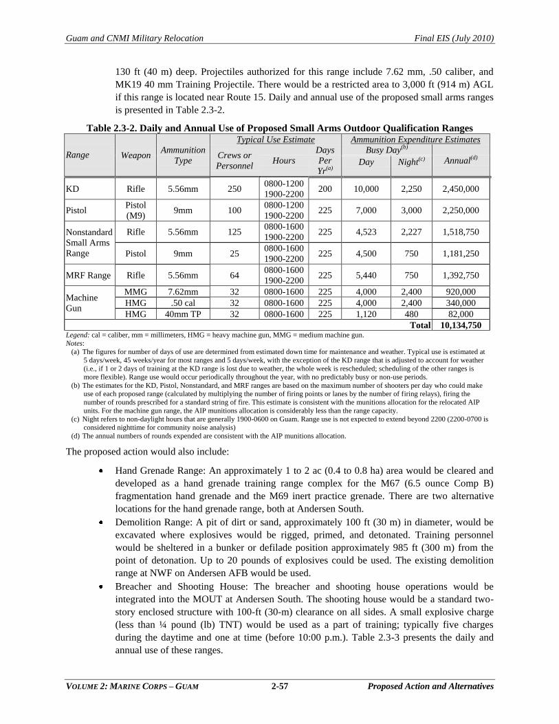
Guam and CNMI Military Relocation Final EIS (July 2010)
VOLUME 2: MARINE CORPS – GUAM 2-57 Proposed Action and Alternatives
130 ft (40 m) deep. Projectiles authorized for this range include 7.62 mm, .50 caliber, and
MK19 40 mm Training Projectile. There would be a restricted area to 3,000 ft (914 m) AGL
if this range is located near Route 15. Daily and annual use of the proposed small arms ranges
is presented in Table 2.3-2.
Table 2.3-2. Daily and Annual Use of Proposed Small Arms Outdoor Qualification Ranges
Range Weapon Ammunition
Type
Typical Use Estimate Ammunition Expenditure Estimates
Crews or
Personnel Hours
Days
Per
Yr(a)
Busy Day(b)
Annual(d) Day Night(c)
KD Rifle 5.56mm 250 0800-1200
1900-2200 200 10,000 2,250 2,450,000
Pistol Pistol
(M9) 9mm 100
0800-1200
1900-2200 225 7,000 3,000 2,250,000
Nonstandard
Small Arms
Range
Rifle 5.56mm 125 0800-1600
1900-2200 225 4,523 2,227 1,518,750
Pistol 9mm 25 0800-1600
1900-2200 225 4,500 750 1,181,250
MRF Range Rifle 5.56mm 64 0800-1600
1900-2200 225 5,440 750 1,392,750
Machine
Gun
MMG 7.62mm 32 0800-1600 225 4,000 2,400 920,000
HMG .50 cal 32 0800-1600 225 4,000 2,400 340,000
HMG 40mm TP 32 0800-1600 225 1,120 480 82,000
Total 10,134,750 Legend: cal = caliber, mm = millimeters, HMG = heavy machine gun, MMG = medium machine gun.
Notes:
(a) The figures for number of days of use are determined from estimated down time for maintenance and weather. Typical use is estimated at
5 days/week, 45 weeks/year for most ranges and 5 days/week, with the exception of the KD range that is adjusted to account for weather
(i.e., if 1 or 2 days of training at the KD range is lost due to weather, the whole week is rescheduled; scheduling of the other ranges is
more flexible). Range use would occur periodically throughout the year, with no predictably busy or non-use periods.
(b) The estimates for the KD, Pistol, Nonstandard, and MRF ranges are based on the maximum number of shooters per day who could make
use of each proposed range (calculated by multiplying the number of firing points or lanes by the number of firing relays), firing the
number of rounds prescribed for a standard string of fire. This estimate is consistent with the munitions allocation for the relocated AIP
units. For the machine gun range, the AIP munitions allocation is considerably less than the range capacity.
(c) Night refers to non-daylight hours that are generally 1900-0600 on Guam. Range use is not expected to extend beyond 2200 (2200-0700 is
considered nighttime for community noise analysis)
(d) The annual numbers of rounds expended are consistent with the AIP munitions allocation.
The proposed action would also include:
Hand Grenade Range: An approximately 1 to 2 ac (0.4 to 0.8 ha) area would be cleared and
developed as a hand grenade training range complex for the M67 (6.5 ounce Comp B)
fragmentation hand grenade and the M69 inert practice grenade. There are two alternative
locations for the hand grenade range, both at Andersen South.
Demolition Range: A pit of dirt or sand, approximately 100 ft (30 m) in diameter, would be
excavated where explosives would be rigged, primed, and detonated. Training personnel
would be sheltered in a bunker or defilade position approximately 985 ft (300 m) from the
point of detonation. Up to 20 pounds of explosives could be used. The existing demolition
range at NWF on Andersen AFB would be used.
Breacher and Shooting House: The breacher and shooting house operations would be
integrated into the MOUT at Andersen South. The shooting house would be a standard two-
story enclosed structure with 100-ft (30-m) clearance on all sides. A small explosive charge
(less than ¼ pound (lb) TNT) would be used as a part of training; typically five charges
during the daytime and one at time (before 10:00 p.m.). Table 2.3-3 presents the daily and
annual use of these ranges.
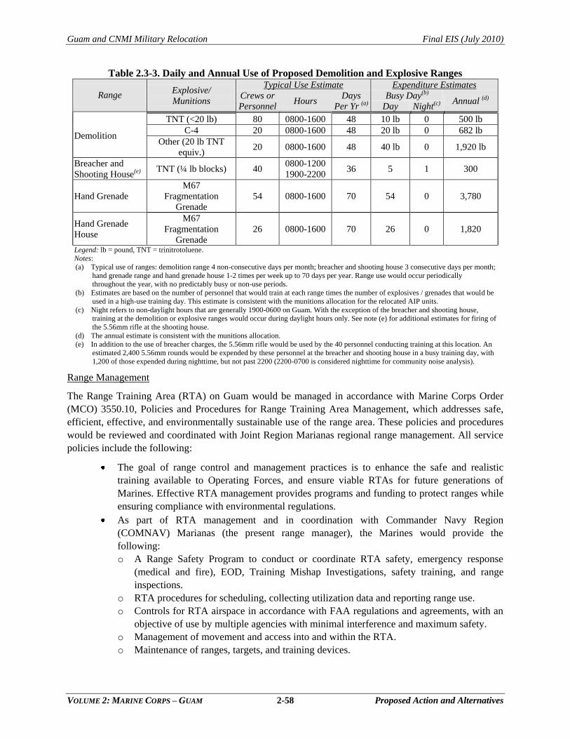
Guam and CNMI Military Relocation Final EIS (July 2010)
VOLUME 2: MARINE CORPS – GUAM 2-58 Proposed Action and Alternatives
Table 2.3-3. Daily and Annual Use of Proposed Demolition and Explosive Ranges
Range Explosive/
Munitions
Typical Use Estimate Expenditure Estimates
Crews or
Personnel Hours
Days
Per Yr (a)
Busy Day(b) Annual (d)
Day Night(c)
Demolition
TNT (<20 lb) 80 0800-1600 48 10 lb 0 500 lb
C-4 20 0800-1600 48 20 lb 0 682 lb
Other (20 lb TNT
equiv.) 20 0800-1600 48 40 lb 0 1,920 lb
Breacher and
Shooting House(e) TNT (¼ lb blocks) 40
0800-1200
1900-2200 36 5 1 300
Hand Grenade
M67
Fragmentation
Grenade
54 0800-1600 70 54 0 3,780
Hand Grenade
House
M67
Fragmentation
Grenade
26 0800-1600 70 26 0 1,820
Legend: lb = pound, TNT = trinitrotoluene.
Notes:
(a) Typical use of ranges: demolition range 4 non-consecutive days per month; breacher and shooting house 3 consecutive days per month;
hand grenade range and hand grenade house 1-2 times per week up to 70 days per year. Range use would occur periodically
throughout the year, with no predictably busy or non-use periods.
(b) Estimates are based on the number of personnel that would train at each range times the number of explosives / grenades that would be
used in a high-use training day. This estimate is consistent with the munitions allocation for the relocated AIP units.
(c) Night refers to non-daylight hours that are generally 1900-0600 on Guam. With the exception of the breacher and shooting house,
training at the demolition or explosive ranges would occur during daylight hours only. See note (e) for additional estimates for firing of
the 5.56mm rifle at the shooting house.
(d) The annual estimate is consistent with the munitions allocation.
(e) In addition to the use of breacher charges, the 5.56mm rifle would be used by the 40 personnel conducting training at this location. An
estimated 2,400 5.56mm rounds would be expended by these personnel at the breacher and shooting house in a busy training day, with
1,200 of those expended during nighttime, but not past 2200 (2200-0700 is considered nighttime for community noise analysis).
Range Management
The Range Training Area (RTA) on Guam would be managed in accordance with Marine Corps Order
(MCO) 3550.10, Policies and Procedures for Range Training Area Management, which addresses safe,
efficient, effective, and environmentally sustainable use of the range area. These policies and procedures
would be reviewed and coordinated with Joint Region Marianas regional range management. All service
policies include the following:
The goal of range control and management practices is to enhance the safe and realistic
training available to Operating Forces, and ensure viable RTAs for future generations of
Marines. Effective RTA management provides programs and funding to protect ranges while
ensuring compliance with environmental regulations.
As part of RTA management and in coordination with Commander Navy Region
(COMNAV) Marianas (the present range manager), the Marines would provide the
following:
o A Range Safety Program to conduct or coordinate RTA safety, emergency response
(medical and fire), EOD, Training Mishap Investigations, safety training, and range
inspections.
o RTA procedures for scheduling, collecting utilization data and reporting range use.
o Controls for RTA airspace in accordance with FAA regulations and agreements, with an
objective of use by multiple agencies with minimal interference and maximum safety.
o Management of movement and access into and within the RTA.
o Maintenance of ranges, targets, and training devices.
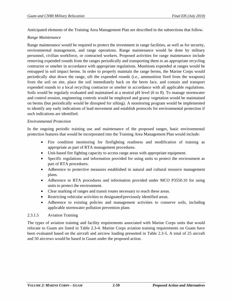
Guam and CNMI Military Relocation Final EIS (July 2010)
VOLUME 2: MARINE CORPS – GUAM 2-59 Proposed Action and Alternatives
Anticipated elements of the Training Area Management Plan are described in the subsections that follow.
Range Maintenance
Range maintenance would be required to protect the investment in range facilities, as well as for security,
environmental management, and range operations. Range maintenance would be done by military
personnel, civilian workforce, or contracted workers. Proposed activities for range maintenance include
removing expended rounds from the ranges periodically and transporting them to an appropriate recycling
contractor or smelter in accordance with appropriate regulations. Munitions expended at ranges would be
entrapped in soil impact berms. In order to properly maintain the range berms, the Marine Corps would
periodically shut down the range, sift the expended rounds (i.e., ammunition fired from the weapons)
from the soil on site, place the soil immediately back on the berm face, and contain and transport
expended rounds to a local recycling contractor or smelter in accordance with all applicable regulations.
Soils would be regularly evaluated and maintained at a neutral pH level (6 to 8). To manage stormwater
and control erosion, engineering controls would be employed and grassy vegetation would be maintained
on berms (but periodically would be disrupted for sifting). A monitoring program would be implemented
to identify any early indications of lead movement and establish protocols for environmental protection if
such indications are identified.
Environmental Protection
In the ongoing periodic training use and maintenance of the proposed ranges, basic environmental
protection features that would be incorporated into the Training Area Management Plan would include:
Fire condition monitoring for firefighting readiness and modification of training as
appropriate as part of RTA management procedures.
Unit-based fire fighting capacity to access range areas with appropriate equipment.
Specific regulations and information provided for using units to protect the environment as
part of RTA procedures.
Adherence to protective measures established in natural and cultural resource management
plans.
Adherence to RTA procedures and information provided under MCO P3550.10 for using
units to protect the environment.
Clear marking of ranges and transit routes necessary to reach these areas.
Restricting vehicular activities to designated/previously identified areas.
Adherence to existing policies and management activities to conserve soils, including
applicable stormwater pollution prevention plans
2.3.1.5 Aviation Training
The types of aviation training and facility requirements associated with Marine Corps units that would
relocate to Guam are listed in Table 2.3-4. Marine Corps aviation training requirements on Guam have
been evaluated based on the aircraft and aircrew loading presented in Table 2.3-5. A total of 25 aircraft
and 50 aircrews would be based in Guam under the proposed action.
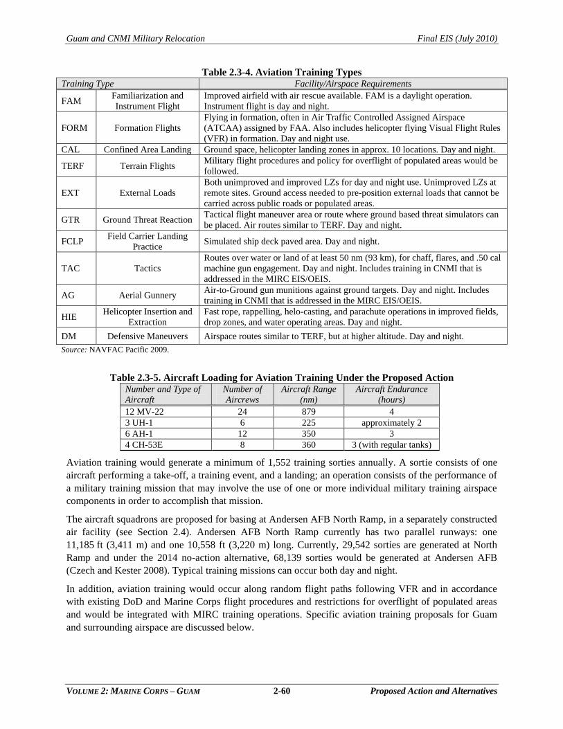
Guam and CNMI Military Relocation Final EIS (July 2010)
VOLUME 2: MARINE CORPS – GUAM 2-60 Proposed Action and Alternatives
Table 2.3-4. Aviation Training Types Training Type Facility/Airspace Requirements
FAM Familiarization and
Instrument Flight
Improved airfield with air rescue available. FAM is a daylight operation.
Instrument flight is day and night.
FORM Formation Flights
Flying in formation, often in Air Traffic Controlled Assigned Airspace
(ATCAA) assigned by FAA. Also includes helicopter flying Visual Flight Rules
(VFR) in formation. Day and night use.
CAL Confined Area Landing Ground space, helicopter landing zones in approx. 10 locations. Day and night.
TERF Terrain Flights Military flight procedures and policy for overflight of populated areas would be
followed.
EXT External Loads
Both unimproved and improved LZs for day and night use. Unimproved LZs at
remote sites. Ground access needed to pre-position external loads that cannot be
carried across public roads or populated areas.
GTR Ground Threat Reaction Tactical flight maneuver area or route where ground based threat simulators can
be placed. Air routes similar to TERF. Day and night.
FCLP Field Carrier Landing
Practice Simulated ship deck paved area. Day and night.
TAC Tactics
Routes over water or land of at least 50 nm (93 km), for chaff, flares, and .50 cal
machine gun engagement. Day and night. Includes training in CNMI that is
addressed in the MIRC EIS/OEIS.
AG Aerial Gunnery Air-to-Ground gun munitions against ground targets. Day and night. Includes
training in CNMI that is addressed in the MIRC EIS/OEIS.
HIE Helicopter Insertion and
Extraction
Fast rope, rappelling, helo-casting, and parachute operations in improved fields,
drop zones, and water operating areas. Day and night.
DM Defensive Maneuvers Airspace routes similar to TERF, but at higher altitude. Day and night.
Source: NAVFAC Pacific 2009.
Table 2.3-5. Aircraft Loading for Aviation Training Under the Proposed Action Number and Type of
Aircraft
Number of
Aircrews
Aircraft Range
(nm)
Aircraft Endurance
(hours)
12 MV-22 24 879 4
3 UH-1 6 225 approximately 2
6 AH-1 12 350 3
4 CH-53E 8 360 3 (with regular tanks)
Aviation training would generate a minimum of 1,552 training sorties annually. A sortie consists of one
aircraft performing a take-off, a training event, and a landing; an operation consists of the performance of
a military training mission that may involve the use of one or more individual military training airspace
components in order to accomplish that mission.
The aircraft squadrons are proposed for basing at Andersen AFB North Ramp, in a separately constructed
air facility (see Section 2.4). Andersen AFB North Ramp currently has two parallel runways: one
11,185 ft (3,411 m) and one 10,558 ft (3,220 m) long. Currently, 29,542 sorties are generated at North
Ramp and under the 2014 no-action alternative, 68,139 sorties would be generated at Andersen AFB
(Czech and Kester 2008). Typical training missions can occur both day and night.
In addition, aviation training would occur along random flight paths following VFR and in accordance
with existing DoD and Marine Corps flight procedures and restrictions for overflight of populated areas
and would be integrated with MIRC training operations. Specific aviation training proposals for Guam
and surrounding airspace are discussed below.
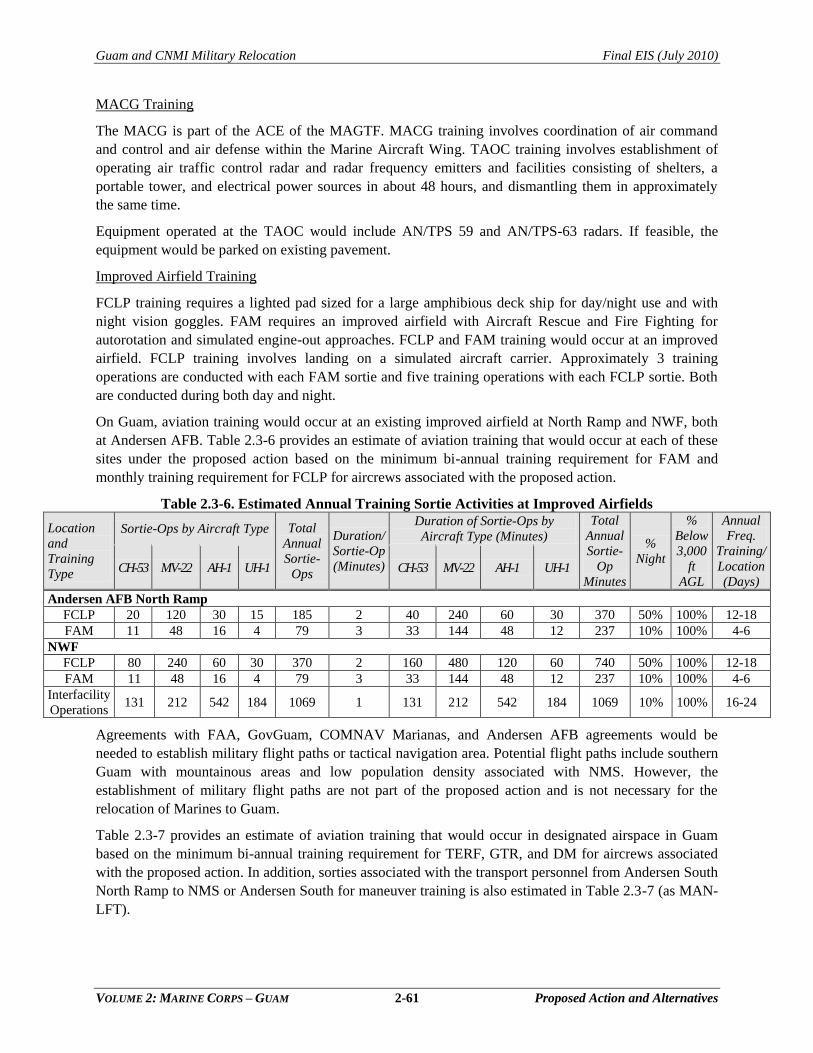
Guam and CNMI Military Relocation Final EIS (July 2010)
VOLUME 2: MARINE CORPS – GUAM 2-61 Proposed Action and Alternatives
MACG Training
The MACG is part of the ACE of the MAGTF. MACG training involves coordination of air command
and control and air defense within the Marine Aircraft Wing. TAOC training involves establishment of
operating air traffic control radar and radar frequency emitters and facilities consisting of shelters, a
portable tower, and electrical power sources in about 48 hours, and dismantling them in approximately
the same time.
Equipment operated at the TAOC would include AN/TPS 59 and AN/TPS-63 radars. If feasible, the
equipment would be parked on existing pavement.
Improved Airfield Training
FCLP training requires a lighted pad sized for a large amphibious deck ship for day/night use and with
night vision goggles. FAM requires an improved airfield with Aircraft Rescue and Fire Fighting for
autorotation and simulated engine-out approaches. FCLP and FAM training would occur at an improved
airfield. FCLP training involves landing on a simulated aircraft carrier. Approximately 3 training
operations are conducted with each FAM sortie and five training operations with each FCLP sortie. Both
are conducted during both day and night.
On Guam, aviation training would occur at an existing improved airfield at North Ramp and NWF, both
at Andersen AFB. Table 2.3-6 provides an estimate of aviation training that would occur at each of these
sites under the proposed action based on the minimum bi-annual training requirement for FAM and
monthly training requirement for FCLP for aircrews associated with the proposed action.
Table 2.3-6. Estimated Annual Training Sortie Activities at Improved Airfields
Location
and
Training
Type
Sortie-Ops by Aircraft Type Total
Annual
Sortie-
Ops
Duration/
Sortie-Op
(Minutes)
Duration of Sortie-Ops by
Aircraft Type (Minutes)
Total
Annual
Sortie-
Op
Minutes
%
Night
%
Below
3,000
ft
AGL
Annual
Freq.
Training/
Location
(Days) CH-53 MV-22 AH-1 UH-1 CH-53 MV-22 AH-1 UH-1
Andersen AFB North Ramp
FCLP 20 120 30 15 185 2 40 240 60 30 370 50% 100% 12-18
FAM 11 48 16 4 79 3 33 144 48 12 237 10% 100% 4-6
NWF
FCLP 80 240 60 30 370 2 160 480 120 60 740 50% 100% 12-18
FAM 11 48 16 4 79 3 33 144 48 12 237 10% 100% 4-6
Interfacility
Operations 131 212 542 184 1069 1 131 212 542 184 1069 10% 100% 16-24
Agreements with FAA, GovGuam, COMNAV Marianas, and Andersen AFB agreements would be
needed to establish military flight paths or tactical navigation area. Potential flight paths include southern
Guam with mountainous areas and low population density associated with NMS. However, the
establishment of military flight paths are not part of the proposed action and is not necessary for the
relocation of Marines to Guam.
Table 2.3-7 provides an estimate of aviation training that would occur in designated airspace in Guam
based on the minimum bi-annual training requirement for TERF, GTR, and DM for aircrews associated
with the proposed action. In addition, sorties associated with the transport personnel from Andersen South
North Ramp to NMS or Andersen South for maneuver training is also estimated in Table 2.3-7 (as MAN-
LFT).
Guam and CNMI Military Relocation Final EIS (July 2010)
VOLUME 2: MARINE CORPS – GUAM 2-62 Proposed Action and Alternatives
Table 2.3-7. Estimated Annual Training Sortie Activity in Military Flight Corridors, Routes, or
Tactical Navigation Area in Guam Based on Minimum Training Requirements
Location
and
Training
Type
Sortie-Ops by Aircraft Type Total
Annual
Sortie-
Ops
Duration/
Sortie-Op
(Minutes)
Duration of Sortie-Ops by
Aircraft Type (Minutes)
Total
Annual
Sortie-
Op
Minutes
%
Night
%
Below
3,000
ft
AGL CH-53 MV-22 AH-1 UH-1 CH-53 MV-22 AH-1 UH-1
TERF 16 48 24 12 100 90 1,440 4,320 2,160 1,080 9,000 10% 90%
GTR 16 48 24 6 94 90 1,440 4,320 2,160 540 8,460 10% 80%
DM 16 48 24 6 94 90 1,440 4,320 2,160 540 8,460 10% 80%
MAN-LFT 912 0 0 0 912 10 9,120 0 0 0 9,120 10% 80%
LZs
Figure 2.3-9 depicts proposed LZ locations at Andersen South, NWF, NMS, and Orote Airfield. Aviation
training at NWF and Orote Airfield LZ locations would not involve any LZ construction or clearance of
approach-departure clearance zones as the existing infrastructure would support the proposed aviation
training at these sites. However, new LZs would be developed to support proposed aviation training at
Andersen South and NMS.
2.3.1.6 Airspace
Overview
The FAA has overall responsibility to manage and control U.S. airspace, including that used by
commercial, civil, and military aircraft. To ensure safe and efficient airspace use, the FAA defines the
types of airspace and the nature of activities that each type can accommodate. Within this system, military
services identify specific needs for airspace (the horizontal and vertical boundaries) and request that the
FAA designate SUA to meet those needs. Although the FAA retains overall management of SUA,
individual military units schedule and coordinate airspace use with other units using Letters of Agreement
with the FAA to formalize and delineate areas of responsibility.
There are two types of SUA airspace requirements associated with the proposed action on Guam. The
first is the need for designation of airspace related to the vertical ricochet hazard associated with the
proposed firing ranges (discussed further below). The second is use of existing SUA and ATCAA to
accommodate proposed Marine Corps aviation training. Such training would involve the use of training
sites at NWF and North Ramp at Andersen AFB, Orote Airfield, Andersen South, and NMS, as well as
training along flight routes, corridors, operating areas, or other designated airspace over Guam and
adjacent waters. No additional SUA over Guam would be needed to support the aviation training
requirements.
It is assumed that a formal joint military airspace proposal will be made to the FAA in the future; at that
time a separate determination would be made as to further environmental documentation requirements.
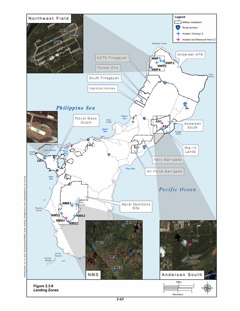
Naval BaseNaval BaseGuamGuam
NWF1
AS2AS1
NWF4NWF2NWF3
OR1
NMS5NMS4NMS3 NMS2
NMS1
ing D
ate: J
un 14
, 201
0, M:
\proje
cts\G
IS\88
06_G
uam_
Build
up_E
IS\fig
ures\C
urren
t_Deli
verab
le\Vo
l_2\2.
3-9.m
xd
Figure 2.3-9Landing Zones
0 42Miles
0 3 6Kilometers µ
E E
E
ENWF3
NWF4
NWF2NWF1
E
E
E
E
E
E
E
E
E
ENMS5
NMS4
NMS3
NMS2
NMS1
E
E
E
EAS2
AS1
A n d e r s e n S o u t hA n d e r s e n S o u t hN M SN M S
N o r t h w e s t F i e l dN o r t h w e s t F i e l d
EOR1
LegendMilitary Installation
E Aviation and Maneuver Area LZE Aviation Training LZ!"9 Route Number
2-63
Guam and CNMI Military Relocation Final EIS (July 2010)
VOLUME 2: MARINE CORPS – GUAM 2-64 Proposed Action and Alternatives
Airspace Requirements: Firing Range Safety
Figure 2.3-10 depicts the proposed SUA associated with the machine gun range component under the
firing range complex Alternatives A and B. SUA would be needed to accommodate the associated vertical
hazard area. Exact coordinates are pending environmental, safety and other analysis, and are based upon
proposed general range layouts and associated coordinates. Proposed R-7202 Guam boundaries for the
Andersen South/Plateau Alternative would start at lat.13°26'48"N., long.144°54'30"E.; to lat.13°29'28"N.,
long.144°51'08"E.; to lat.13°31'15"N., long.144°53'22"E.; to lat.13°28'31"N., long.144°56‘53"E.; to the
point of beginning.
Proposed R-7202 Guam boundaries for the Andersen South/Valley Alternative would start at
lat.13°25'20"N., long.144°52'47"E.;to lat.13°29'03"N., long.144°50'27"E.;to lat 13°31'29"N.,
long.144°52'58"E.;to lat 13°27'36"N., long.144°55'34"E.; to the point of beginning. Altitudes would be
from the surface to 3,000 feet mean sea level (MSL). Times of use would be Monday throughSunday 6:00
a.m. to 11:00 p.m. local, other times by Notice to Airmen (NOTAM). Activation of proposed R-7202
would be for those periods when live-fire includes larger caliber weapons such as 7.62 caliber rifles to
accommodate higher vertical hazard values.
2.3.2 Alternatives Analysis: Training Functions
2.3.2.1 Feasibility and Suitability Criteria
A qualitative assessment of the feasibility of using specific DoD land areas for siting of training facilities
was based on the following criteria:
compatibility with present and future missions,
environmental considerations (including cultural and historical resource, natural resource
constraints, and terrain),
social and political practicality in implementation and operation, and
efficiency of overall base development land use.
Suitability criteria included:
land availability for facilities including associated safety or clearance zones,
efficiently and effectively supports operational requirements,
meets airspace requirements
efficiently and effectively supports training requirements,
minimizes potential for encroachment,
compliance with AT/FP requirements, and
consistent with military vision..
The basis of analysis is presented in a brief entitled Guam Alternatives Basing Analysis, Guam
Stakeholders Working Group, dated August 21, 2007 and prepared by NAVFAC Pacific.
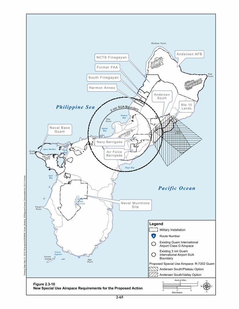
NCTS F inegayanNCTS F inegayan
Rit id ian PointRi t id ian Point
Pat i Pat i PointPoint
Pagat Pagat PointPoint
Oka Oka PointPoint
Or ote Or ote PointPoint
Facpi Facpi PointPoint
Aga Aga PointPoint
Cocos Cocos Is landIs land
Sou th F inegayanSou th F inegayan
Andersen AFBAndersen AFB
Naval Mun it ionsNaval Mun it ionsSi teSi te
Naval BaseNaval BaseGuamGuam
Former FAAFormer FAA
Harmon AnnexHarmon Annex
Phi l ippine Sea
Pacific Ocean
Apr a Harbor Sasa Bay
Agat Bay
Coc os Lagoon
Pago Bay
Agana Bay
Tumon Bay
FenaValley
Rese rv oir
3 nm SUA Boundary
ing D
ate: M
ay 21
, 201
0, M:
\proje
cts\G
IS\88
06_G
uam_
Build
up_E
IS\fig
ures\C
urren
t_Deli
verab
le\Vo
l_2\2.
3-10.m
xd
Figure 2.3-10New Special Use Airspace Requirements for the Proposed Action µ
AndersenAndersenSouthSouth
Navy Barr igadaNavy Barr igada
Air ForceAi r ForceBarrigadaBarrigada
0 3 6Kilometers
0 42Nautical Miles
Rte 15Rte 15LandsLands
Legend
!"9 Route NumberMilitary Installation
Existing 3 nm GuamInternational Airport SUABoundary
Existing Guam InternationalAirport Class D Airspace
Proposed Special Use Airspace: R-7202 GuamAndersen South/Plateau OptionAndersen South/Valley Option
2-65
Guam and CNMI Military Relocation Final EIS (July 2010)
VOLUME 2: MARINE CORPS – GUAM 2-66 Proposed Action and Alternatives
2.3.2.2 Ammunition Storage Alternatives
Only existing munitions storage areas were considered to be candidate sites for the proposed munitions
storage facilities under the proposed action. This narrowed the candidate sites to NMS and the Andersen
AFB MSAs. Within these two areas, the primary factors in selecting alternative munitions storage
configurations were as follows:
Operational: the ECMs should be sited as close together as safety setback distances allow to
minimize logistical and maintenance requirements and total area encumbered by ESQD arcs.
Biological: the amount of habitat disturbed should be minimized (e.g., siting ECMs on
previously cleared or paved areas or areas of lesser habitat value, and avoiding removal of
mature trees) and the ECMs should be sited to avoid sensitive essential habitat for T&E
species.
Safety: ECMs must be sited in accordance with all regulatory guidance to ensure the safe
working environment for munitions and other base personnel (i.e., the direction that the
igloos are oriented in relation to each other, safety setback distances between ECMs, and
explosive safety arcs within and outside of munitions storage area).
The site analysis for future ECM locations was conducted during the preparation of the Military
Munitions Annex to the Guam Joint Military Master Plan (GJMMP), dated June 2009 and prepared by
NAVFAC Pacific for the DoD Explosives Safety Board. As shown on Figure 2.3-11, two locations at
NMS were considered as potential sites for these 10 ECMs: the Parson‘s Road Area and the High Road
Area. In the Parson‘s Road Area, there are two alternatives for layout of the 10 ECMs in a configuration
that would allow for a combined 360,000 lb net explosive weight (NEW) capacity. In the High Road area,
there is one site that could accommodate the 10 ECMs in a configuration that would allow for a combined
capacity of 500,000 lb NEW.
The EIS evaluates the development of munitions storage facilities in currently undeveloped areas. This
does not preclude replacement or upgrade alternatives within implementation, but rather conservatively
estimates potential impacts for the purposes of this EIS.
Within MSA1, there was one alternative identified for the placement of ECMs, work areas,
administrative/inert warehouse building, and storage for munitions, chaff, and flares (Figure 3.2-12). All
proposed munitions facilities would be sited within existing munitions area boundaries and would not
alter the existing ESQD arcs. Land use constraints at each site include natural resources and proximity to
other munitions storage facilities and infrastructure.
2.3.2.3 Command, Control, and Simulation Alternatives
All three proposed Command, Control and Simulation facilities would be located within the Main
Cantonment area to capitalize on functional support relationships with headquarters and administrative
functions; the specific sites are being determined through the Main Cantonment master planning process.
Printing Date: Oct 22, 2008, M:\projects\GIS\8806_Guam_Buildup_EIS\figures\Current_Deliverable\Vol_2\2.3-11.mxd
527
12
Fena
Val
ley
Fena
Val
ley
Rese
rvoi
rRe
serv
oir
Pars
ons
Roa
d A
rea
Pars
ons
Roa
d A
rea
(Alte
rnat
ive
A)(A
ltern
ativ
e A)
10 E
CM
s, e
ach:
2,0
00 ft
10 E
CM
s, e
ach:
2,0
00 ft
22
and
250,
000
Ib N
EWan
d 25
0,00
0 Ib
NEW
Hig
h R
oad
Are
aH
igh
Roa
d A
rea
(Alte
rnat
ive
B)(A
ltern
ativ
e B)
10 E
CM
s, e
ach:
2,0
00 ft
10 E
CM
s, e
ach:
2,0
00 ft
22
and
500,
000
lb N
EWan
d 50
0,00
0 lb
NEW
Hig
h 12
Gro
upH
igh
12 G
roup
(CAT
2 S
ite)
(CAT
2 S
ite)
1 E
CM
500
,000
lb N
EW1
EC
M 5
00,0
00 lb
NEW
NM
S H
Q A
rea
NM
S H
Q A
rea
Nav
al M
uniti
ons
Site
Amm
uniti
on S
tora
geIm
prov
emen
ts
Figu
re 2
.3-1
1
GU
AM
GU
AM
Area
Enla
rged
02,
400
1,20
0Fe
et
033
066
0M
eter
s
Lege
nd
1R
oute
Num
ber
IBD
ES
QD
Arc
Mili
tary
Inst
alla
tion
Mun
ition
s S
tora
ge
US
MC
- P
ropo
sed
EC
M L
ocat
ions
Exi
stin
g M
uniti
ons
Sto
rage
Mag
azin
es
Exi
stin
g B
uild
ing
US
MC
- P
ropo
sed
Alte
rnat
ive
A E
CM
Loca
tions
US
MC
- P
ropo
sed
Alte
rnat
ive
B E
CM
Loca
tions
2-67
Printing Date: Oct 22, 2009, M:\projects\GIS\8806_Guam_Buildup_EIS\figures\Current_Deliverable\Vol_2\2.3-12.mxd
9
Mun
ition
s St
orag
e A
rea
Figu
re 2
.3-1
2
Prop
osed
USM
C O
pera
tiona
l Loc
atio
nPr
opos
ed U
SMC
Ope
ratio
nal L
ocat
ion
(AC
E &
GC
E) P
ad #
: 15B
-6(A
CE
& G
CE)
Pad
#: 1
5B-6
Nee
ded:
300
,000
lb N
EWN
eede
d: 3
00,0
00 lb
NEW
Site
Cer
tifie
d: 2
10,0
00 lb
NE
WSi
te C
ertif
ied:
210
,000
lb N
EW
Prop
osed
USM
C S
tuff/
Uns
tuff
Pad
Loca
tion
Prop
osed
USM
C S
tuff/
Uns
tuff
Pad
Loca
tion
(AC
E &
GC
E) P
ad #
: 11B
-5(A
CE
& G
CE)
Pad
#: 1
1B-5
Nee
ded:
300
,000
lb N
EWN
eede
d: 3
00,0
00 lb
NEW
Site
Cer
tifie
d: 2
80,0
00 lb
NE
WSi
te C
ertif
ied:
280
,000
lb N
EW
Prop
osed
USM
C (E
CM
Loc
atio
n)Pr
opos
ed U
SMC
(EC
M L
ocat
ion)
12 E
CM
s, e
ach:
250
- 26
9,00
0 lb
NEW
12 E
CM
s, e
ach:
250
- 26
9,00
0 lb
NEW
Add
2 B
ays
to E
xist
ing
Line
Bui
ldin
gA
dd 2
Bay
s to
Exi
stin
g Li
ne B
uild
ing
Bldg
No.
901
6 fo
r 20m
m a
mm
uniti
on,
Bldg
No.
901
6 fo
r 20m
m a
mm
uniti
on,
and
chaf
f & fl
ares
and
chaf
f & fl
ares
Tota
l add
ition
: 2,4
00 ft
Tota
l add
ition
: 2,4
00 ft
Prop
osed
USM
C M
uniti
ons
Adm
in B
uild
ing
Prop
osed
USM
C M
uniti
ons
Adm
in B
uild
ing
(AC
E &
GC
E) 1
9,00
0 ft
(AC
E &
GC
E) 1
9,00
0 ft
Firs
t Flo
or: I
nert
Stor
age
Firs
t Flo
or: I
nert
Stor
age
and
Mai
nten
ance
, 15,
000
ftan
d M
aint
enan
ce, 1
5,00
0 ft
Seco
nd F
loor
: Adm
in, 4
,000
ftSe
cond
Flo
or: A
dmin
, 4,0
00 ft
Ande
rsen
AFB
MS
A Im
prov
emen
ts
GU
AM
GU
AMArea
Enla
rged
22
2222
22
01,
700
850
Feet
022
545
0M
eter
s
Lege
nd
1R
oute
Num
ber
IBD
ES
QD
Arc
Mili
tary
Inst
alla
tion
Mun
ition
s S
tora
ge
US
MC
- P
ropo
sed
EC
M L
ocat
ions
Exi
stin
g M
uniti
ons
Sto
rage
Mag
azin
es
Exi
stin
g B
uild
ing
US
MC
- P
ropo
sed
Mun
ition
s A
dmin
US
MC
- P
ropo
sed
Bay
Add
ition
2-68
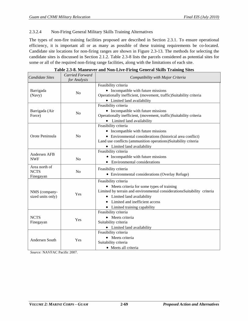
Guam and CNMI Military Relocation Final EIS (July 2010)
VOLUME 2: MARINE CORPS – GUAM 2-69 Proposed Action and Alternatives
2.3.2.4 Non-Firing General Military Skills Training Alternatives
The types of non-fire training facilities proposed are described in Section 2.3.1. To ensure operational
efficiency, it is important all or as many as possible of these training requirements be co-located.
Candidate site locations for non-firing ranges are shown in Figure 2.3-13. The methods for selecting the
candidate sites is discussed in Section 2.1.2. Table 2.3-8 lists the parcels considered as potential sites for
some or all of the required non-firing range facilities, along with the limitations of each site.
Table 2.3-8. Maneuver and Non-Live-Firing General Skills Training Sites
Candidate Sites Carried Forward
for Analysis Compatibility with Major Criteria
Barrigada
(Navy) No
Feasibility criteria
Incompatible with future missions
Operationally inefficient, (movement, traffic)Suitability criteria
Limited land availability
Barrigada (Air
Force) No
Feasibility criteria
Incompatible with future missions
Operationally inefficient, (movement, traffic)Suitability criteria
Limited land availability
Orote Peninsula No
Feasibility criteria
Incompatible with future missions
Environmental considerations (historical area conflict)
Land use conflicts (ammunition operations)Suitability criteria
Limited land availability
Andersen AFB
NWF
No
Feasibility criteria
Incompatible with future missions
Environmental considerations
Area north of
NCTS
Finegayan
No Feasibility criteria
Environmental considerations (Overlay Refuge)
NMS (company-
sized units only) Yes
Feasibility criteria
Meets criteria for some types of training
Limited by terrain and environmental considerationsSuitability criteria
Limited land availability
Limited and inefficient access
Limited training capability
NCTS
Finegayan Yes
Feasibility criteria
Meets criteria
Suitability criteria
Limited land availability
Andersen South Yes
Feasibility criteria
Meets criteria
Suitability criteria
Meets all criteria Source: NAVFAC Pacific 2007.
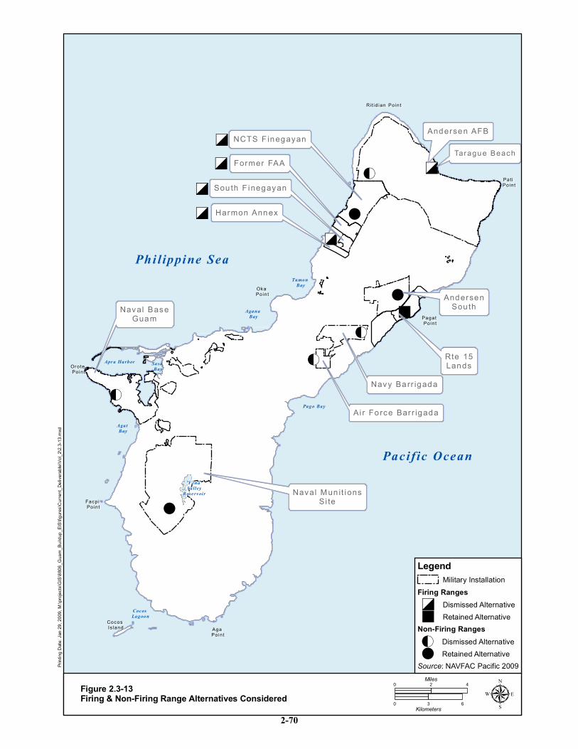
!
!
!
!
!
!
!
O
O
O
O
"
"
"
"
"
"
"
ð
ð
ð
ð
ð
ð
NCTS F inegayanNCTS F inegayan
AndersenAndersenSou thSou th
Navy Barr igadaNavy Barr igada
Ai r Fo rce Bar r igadaAi r Fo rce Bar r igada
Rit id ian PointRi t id ian Point
Pat i Pat i PointPoint
Pagat Pagat PointPoint
Oka Oka PointPoint
Or ote Or ote PointPoint
Facpi Facpi PointPoint
Aga Aga PointPoint
Cocos Cocos Is landIs land
Sou th F inegayanSou th F inegayan
Andersen AFBAndersen AFB
Naval Mun it ionsNaval Mun it ionsSi teSi te
Naval BaseNaval BaseGuamGuam
Former FAAFormer FAA
Rte 15Rte 15LandsLands
Harmon AnnexHarmon Annex
Phi l ippine Sea
Pacific Ocean
Apr a Harbor Sasa Bay
Agat Bay
Coc os Lagoon
Pago Bay
Agana Bay
Tumon Bay
FenaValley
Rese rv oir
Taragu e BeachTaragu e Beach
ing D
ate: J
an 29
, 200
9, M:
\proje
cts\G
IS\88
06_G
uam_
Build
up_E
IS\fig
ures\C
urren
t_Deli
verab
le\Vo
l_2\2.
3-13.m
xd
Figure 2.3-13Firing & Non-Firing Range Alternatives Considered
0 42Miles
0 3 6Kilometers µSource: NAVFAC Pacific 2009
Legend
Firing Ranges
Non-Firing Ranges
Military Installation
! Retained Alternative!O Dismissed Alternative
" Retained Alternative"ð Dismissed Alternative
2-70
Guam and CNMI Military Relocation Final EIS (July 2010)
VOLUME 2: MARINE CORPS – GUAM 2-71 Proposed Action and Alternatives
Andersen South is the largest existing MOUT facility on Guam and the only existing MOUT facility large
enough to support the required company-level training. It is the only location identified for the required
MOUT improvements. Two site plans have been developed for the MOUT and supporting facilities at
Andersen South, reflecting slight differences in configuration that would occur with the Training Range
Complex Alternatives A and B (refer to Section 2.3.1.3). The overall site plans for Andersen South also
include the AMVOC, a convoy course, a MOUT facility, two helicopter landing zones, and general non-
live-fire maneuver areas.
The maneuver requirements were described in Section 2.3.1. Large-scale maneuver requirements would
be met using two separate areas at Andersen South and NMS, since there is no single area on Guam that
provides sufficient space for large-scale maneuvers. The proposed action includes development and use of
both areas, and no reasonable alternatives have been identified on Guam for either area. Development and
use of the maneuver area at NMS would require access , for which two reasonable alternatives have been
identified (see Figure 2.3-4 in Section 2.3.1.3):
a. NMS Access Road Alternative A: Improvements would occur along the existing hiking trail
to create a roadway.
b. NMS Access Road Alternative B: Under this alternative, limited improvements would be
implemented to accommodate foot traffic.
In the Draft EIS, Alternative A was the preferred alternative. However, because of preliminary
engineering studies and public input, the Marine Corps has identified Alternative B as the preferred
alternative in the Final EIS. The purpose of the access road is to transport military supplies and troops to
the southern portion of NMS where proposed company-level maneuvers would occur. Access would be
required on average one week per month. The existing trail begins at Route 2 and ends at the top of the
ridgeline just inside the NMS boundary following the alignment of the Mount Lamlam/Mount Jumullong
Manglo trail. The existing trail is 0.4 mi (0.6 km) in length. DoD would acquire lands in accordance with
federal land acquisition laws and regulations. DoD would control use of the trail. As this is part of the
Mount Lamlam and Mount Jumullong Manglo trail, public access would be allowed when the military is
not conducting training and, as it would be largely unimproved, would be limited to foot traffic.
2.3.2.5 Firing General Military Skills Training Alternatives
Firing ranges are typically the most challenging facilities to site because they use live-fire munitions that
generate three dimensional fan-shaped SDZs that extend well beyond, above, and to the side of the firing-
line-target area. The number of firing points, impact media, and the types of weapons training conducted
impact the size of the range and its SDZ. For public safety reasons, no development can occur within the
SDZs except for fire breaks, range maintenance roads, and perimeter security fencing. Likewise, for
public safety reasons SDZs cannot extend over lands not under the control of DoD.
Due to the difficulty of siting live-fire training ranges, a range location analysis was initially conducted.
Throughout the range location analysis, a priority was to develop a firing range complex to maximize
operational efficiency and minimize impacts to the community. The Marine Corps‘ daily training tempo
supports consolidation of the individual firing ranges into a firing range complex to maximize operational
efficiency. Locating multiple firing ranges in a single firing range complex allows Marine Corps
personnel to quickly and efficiently become trained on required weapons systems with minimal logistical
movement. Further, a firing range complex also allows SDZs to overlap one another, which reduces the
total land, air, and submerged land required for acquisition and/or restrictive access. Also, creation of a
firing range complex facilitates efficient firing range management, including fire suppression and
Guam and CNMI Military Relocation Final EIS (July 2010)
VOLUME 2: MARINE CORPS – GUAM 2-72 Proposed Action and Alternatives
munitions transport, and storage. Consolidation of live-fire ranges into a firing range complex minimizes
impacts to the community as it results in less traffic on public roadways and limits potential noise and
public safety impacts to one location. The greatest operational efficiencies and least impacts to the
community can be achieved by co-locating a firing range complex and non-firing training.
During Step 1 of the range location analysis (See Section 2.1.2 for overview of Steps), the specific live-
fire ranges required to meet the Marine Corps mission were identified. These weapons systems are listed
in Table 2.3-9. As noted by the table the SDZ for the machine gun range requires the greatest amount of
land area, sea area, and airspace. Therefore, the placement of the machine gun range became the driving
factor in determining possible range site selection. More information on ranges and range use is provided
in Volume 9, Appendix M.
Table 2.3-9. Live–Fire Range Mission Requirements
Range Type Firing
Points
Maximum
Distance to
Target (m)
SDZ -Maximum
Linear Distance (m) SDZ Area (ac)
KD Rifle 50 500 3,437 980
KD Pistol 30 25 1,800 --
Non-Standard Small Arms
Range 25 100 3,437
Modified Record of Fire
Range(MRFR) 16 500 3,437 697
Machine Gun (Mk 19, 0.50
calliber and 7.62 mm) 8 1,000 6,500 5,057
Source: Winter undated.
Screening of Federally-Controlled Property for Live-Fire Training Ranges
During Step 2 of the range location analysis, the feasibility and suitability of various federally-controlled
land areas for the placement of one or more of the ranges was considered. Site selection for live-fire
training ranges was initially limited to DoD lands. (No federally controlled non-DoD lands were
considered because of their small size and tendency to be located near residential areas) The federally-
controlled DoD military lands on Guam are noncontiguous and dispersed across the island. Some
federally-controlled DoD military lands were not considered as potential sites for training ranges because
there was insufficient area and/or the land use would not be compatible with live-fire training ranges. The
federally-controlled DOD military land areas that were not considered as firing range sites included:
Navy Barrigada
Apra Heights and New Apra Heights (family housing)
Dry Dock Island
Mt. Santa Rosa
Naval Hospital (hospital)
Nimitz Hill (Joint Region Headquarters and housing)
Polaris Point
Tenjo Vista and Sasa Valley Tank Farm (fuel storage)
Potts Junction
For the remaining federally-controlled DoD military lands the ranges were initially conceptually sited
individually to determine if there was enough land area to accommodate one range in the geographic area
based on existing land uses. As listed in Table 2.3-10, seven federally-controlled DoD military land areas
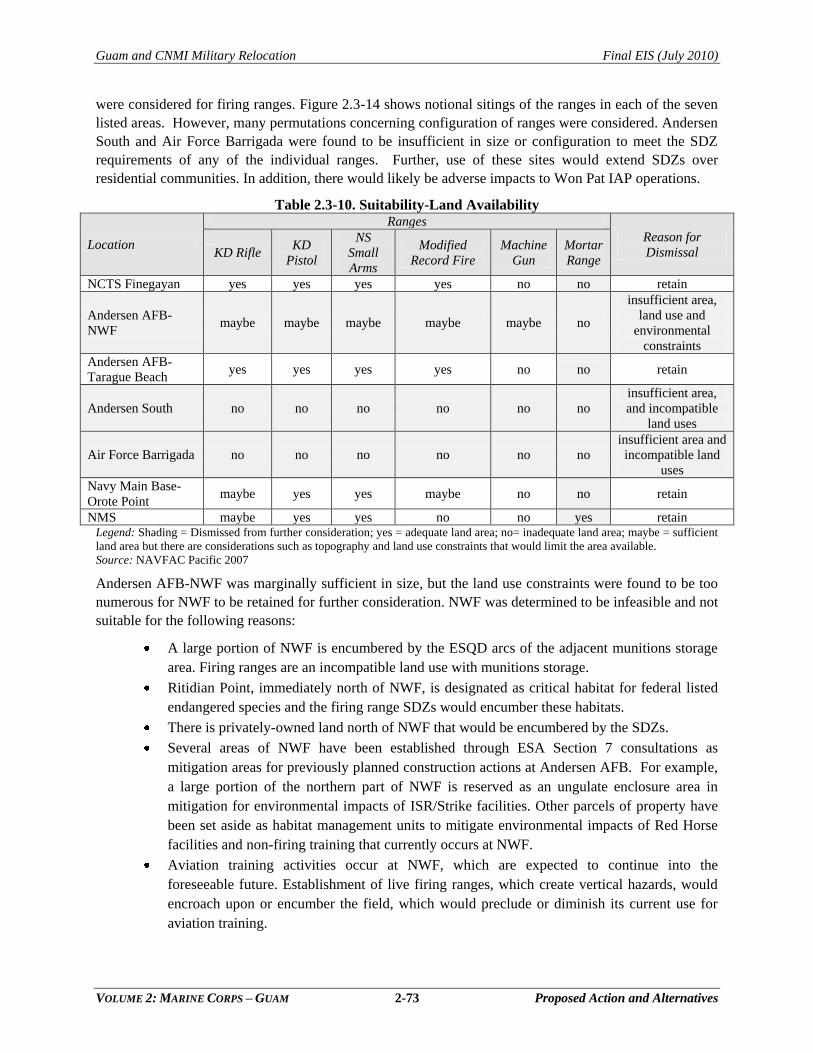
Guam and CNMI Military Relocation Final EIS (July 2010)
VOLUME 2: MARINE CORPS – GUAM 2-73 Proposed Action and Alternatives
were considered for firing ranges. Figure 2.3-14 shows notional sitings of the ranges in each of the seven
listed areas. However, many permutations concerning configuration of ranges were considered. Andersen
South and Air Force Barrigada were found to be insufficient in size or configuration to meet the SDZ
requirements of any of the individual ranges. Further, use of these sites would extend SDZs over
residential communities. In addition, there would likely be adverse impacts to Won Pat IAP operations.
Table 2.3-10. Suitability-Land Availability
Location
Ranges
Reason for
Dismissal KD Rifle KD
Pistol
NS
Small
Arms
Modified
Record Fire
Machine
Gun
Mortar
Range
NCTS Finegayan yes yes yes yes no no retain
Andersen AFB-
NWF maybe maybe maybe maybe maybe no
insufficient area,
land use and
environmental
constraints
Andersen AFB-
Tarague Beach yes yes yes yes no no retain
Andersen South no no no no no no
insufficient area,
and incompatible
land uses
Air Force Barrigada no no no no no no
insufficient area and
incompatible land
uses
Navy Main Base-
Orote Point maybe yes yes maybe no no retain
NMS maybe yes yes no no yes retain Legend: Shading = Dismissed from further consideration; yes = adequate land area; no= inadequate land area; maybe = sufficient
land area but there are considerations such as topography and land use constraints that would limit the area available.
Source: NAVFAC Pacific 2007
Andersen AFB-NWF was marginally sufficient in size, but the land use constraints were found to be too
numerous for NWF to be retained for further consideration. NWF was determined to be infeasible and not
suitable for the following reasons:
A large portion of NWF is encumbered by the ESQD arcs of the adjacent munitions storage
area. Firing ranges are an incompatible land use with munitions storage.
Ritidian Point, immediately north of NWF, is designated as critical habitat for federal listed
endangered species and the firing range SDZs would encumber these habitats.
There is privately-owned land north of NWF that would be encumbered by the SDZs.
Several areas of NWF have been established through ESA Section 7 consultations as
mitigation areas for previously planned construction actions at Andersen AFB. For example,
a large portion of the northern part of NWF is reserved as an ungulate enclosure area in
mitigation for environmental impacts of ISR/Strike facilities. Other parcels of property have
been set aside as habitat management units to mitigate environmental impacts of Red Horse
facilities and non-firing training that currently occurs at NWF.
Aviation training activities occur at NWF, which are expected to continue into the
foreseeable future. Establishment of live firing ranges, which create vertical hazards, would
encroach upon or encumber the field, which would preclude or diminish its current use for
aviation training.
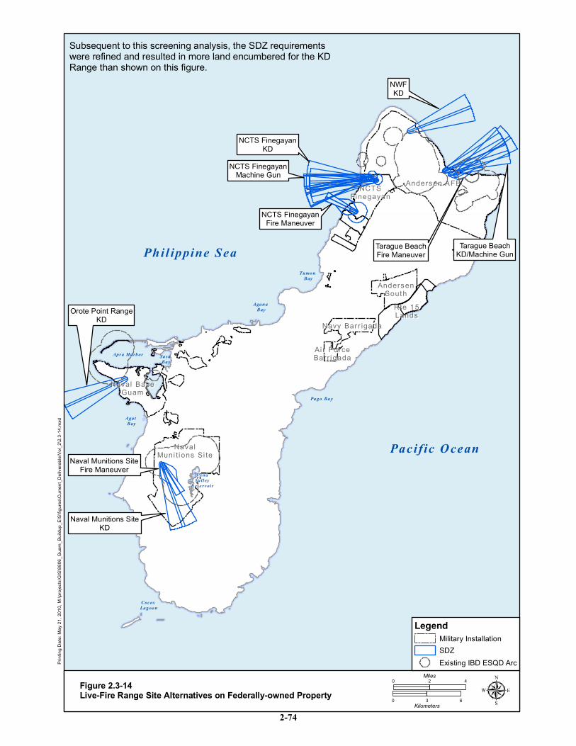
Andersen AFBAndersen AFB
AndersenAndersenSouthSouth
Rte 15Rte 15LandsLands
Navy Barr igadaNavy Barr igada
Ai r ForceAi r ForceBarr igadaBarr igada
NCTSNCTSFinegayanFinegayan
NavalNavalMuni t ions Si teMuni t ions Si te
Naval BaseNaval BaseGuamGuam
Phil ippine Sea
Pacific Ocean
Apr a Harbor Sasa Bay
Agat Bay
Coc os Lagoon
Pago Bay
Agana Bay
Tumon Bay
FenaValley
Rese rv oir
NWFKD
Tarague BeachFire Maneuver
Tarague BeachKD/Machine Gun
NCTS FinegayanKD
NCTS FinegayanMachine Gun
NCTS FinegayanFire Maneuver
Naval Munitions SiteFire Maneuver
Naval Munitions SiteKD
Orote Point RangeKD
ing D
ate: M
ay 21
, 201
0, M:
\proje
cts\G
IS\88
06_G
uam_
Build
up_E
IS\fig
ures\C
urren
t_Deli
verab
le\Vo
l_2\2.
3-14.m
xd
Figure 2.3-14Live-Fire Range Site Alternatives on Federally-owned Property
0 42Miles
0 3 6Kilometers µ
Subsequent to this screening analysis, the SDZ requirementswere refined and resulted in more land encumbered for the KDRange than shown on this figure.
Legend
SDZMilitary Installation
Existing IBD ESQD Arc
2-74
Guam and CNMI Military Relocation Final EIS (July 2010)
VOLUME 2: MARINE CORPS – GUAM 2-75 Proposed Action and Alternatives
The remaining four federally-controlled DoD military lands were further evaluated to determine if they
meet the feasibility and suitability criteria (Section 2.3.2.1). The following text summarizes the key
reasons for their dismissal from further consideration (Table 2.3-11).
Table 2.3-11. Live-Fire Range Alternatives: Key Reason for Dismissal Location Key Reasons for Dismissal
NCTS Finegayan Incompatible with communications operations, west coast waters, and impacts to the Overlay
Refuge
Andersen AFB-
Tarague Rifle
Range
Impacts to natural, cultural and recreational resources, extensive land disturbance, conflict with
Air Force operations, and operational efficiency concerns. and
Navy Main Base-
Orote Point
Incompatible with ammunition operations at Kilo Wharf and ammunition storage on Orote
peninsula, specifically ESQD arcs. Negative impact to nearby recreational uses.
NMS Incompatible with ammunition storage and would require relocation of magazines. Increased
potential for fire hazards. Extensive land disturbance would be required.
NCTS Finegayan. Expansion of the existing rifle and pistol ranges at NCTS Finegayan to create a live-
fire range complex that includes the machine gun range or distribution of such ranges within NCTS
Finegayan would be incompatible with the existing communications facilities. Relocation of the
communications facilities on Guam is not operationally feasible because of siting issues associated with
communications spectrum interference (NAVFAC Pacific 2007). Additionally, as noted earlier, the
majority (approximately 87%) of NCTS Finegayan is encumbered by the Overlay Refuge. Siting of
ranges at NCTS Finegayan would further impact the Overlay Refuge and ongoing natural resources
conservation efforts. Specifically, siting of training ranges at NCTS Finegayan would have required the
removal of considerable acreage of the last remaining stands of primary limestone forest on Guam, the
habitat that is best suited for the recovey of the endangered Micronesian Kingfisher. Further, removal of
this habitat for the siting of training ranges would have adversely impacted the endangered Marianas
Crow and the threatened Marianas Fruit Bat, which is resident in the stands of primary limestone forest on
NCTS Finegayan. Further, as noted at public scoping meetings by comments from the general public and
subsequent discussions with GovGuam officials, configuring a live-fire range complex with SDZs over
the submerged land west of NCTS Finegayan would adversely impact a popular recreational destination
for tourists and the local population and result in increased public safety concerns.
Andersen AFB- Tarague Beach. There is an existing firing range near Tarague Beach on the northern
coast of Andersen AFB. The existing range site and vicinity were evaluated as a candidate site for the
proposedlive fire range complex. The site was dismissed from further consideration because there were a
number of suitability and feasibility criteria that would not be met, as follows:
Operational incompatibility with present and future missions. Expansion of the existing firing
range near Tarague Beach would extend the SDZs such that they would encroach upon or
encumber the active runways at Andersen AFB, which would be incompatible with military
aircraft operations. Further, the Marine Corps training schedule, approximately 45 weeks per
year, would conflict with Red Horse and Commando Warrior training at the existing range.
Additionally, the use of the range by the Air Force is increasing, with only 50 days per year
available for Marine Corps use.
Environmental considerations. Due to the uneven terrain with steep slopes, there would be
extensive earth moving activities to create the suitable land profile for the ranges and provide a
safe access road. This would be cost prohibitive and environmentally destructive, resulting in
increased erosion potential. Cultural and natural resource sites would also be directly impacted
Guam and CNMI Military Relocation Final EIS (July 2010)
VOLUME 2: MARINE CORPS – GUAM 2-76 Proposed Action and Alternatives
by earth moving activities. Further, the SDZs would encumber the Pati Marine Preserve.
Finally, increased vehicular traffic could adversely impact nearby endangered species recovery
efforts on DoD lands and the Guam National Wildlife Refuge.
Land use impacts. There are private lands west of Tarague Beach that would likely be
encumbered by the SDZs.
Operational efficiency. There is insufficient area at the Tarague Beach site to accommodate all
the proposed ranges. As noted above, the use of multiple training sites would adversely affect
the efficiency of Marine Corps operations.
Navy Main Base- Orote Point. Expansion of an existing firing range located on the Naval Station at Orote
Point was examined as a potential location to construct and operate a live fire range complex. This
location was dismissed due to the following suitability and feasibility criteria that would not be met:
Operational incompatibility with existing and future military mission. There is sufficient area
to extend the existing firing range area at Orote Point further into the Navy submerged lands
west of Orote Peninsula and multiple ranges could be accommodated. However, expanding
the firing ranges at this location into a live-fire range complex would be incompatible with
existing and projected ammunition operations at Kilo Wharf and ammunition storage pads on
Orote Point. Existing ESQD arcs generated by Kilo Wharf and associated storage pads
extend over most of Orote Point and would limit use of the ranges to times when ammunition
operations are not being conducted at Kilo Wharf. Further, munitions operations at Kilo
Wharfwould occur approximately 275 days per year.
Land use impacts. There is a high volume of recreational vessel use in off shore waters that
would be within the required SDZs for a new live fire range complex. (JGPO 2008b;
NAVFAC Pacific 2007).
NMS. NMS could accommodate individual pistol and rifle ranges, but not machine gun ranges, into a
live-fire range complex. NMS was eliminated from further consideration because the following suitability
and feasibility criteria that would not be met:
Land use impacts. SDZs associated with the machine gun would be within the ESQD arcs
generated by the munitions storage magazines. This would adversely impact public safety.
Operational efficiency. To access the possible location of a live fire range complex military
personnel would have to transit through ESQD arcs, causing munitions evolutions to halt.
This would adversely impacti the mission of NMS, one of the largest DoD munitions storage
areas in the Pacific.
Environmental considerations. Steep terrain would require extensive earth moving activities
to create the suitable land profile and potentially impact numerous wetlands areas. Further,
firing operations would potentially impact several ESA listed species located within NMS.
Specifically, the construction of training ranges would adversely impact populations of the
threatened Marianas Fruit Bat and the threatened Marianas Swiftlet present in the NMS.
Additionally, firing operations could lead to increased potential fire hazards associated with
grassland/savannah vegetation in NMS, increasing threats to public safety and the ESA listed
species that are present.

Guam and CNMI Military Relocation Final EIS (July 2010)
VOLUME 2: MARINE CORPS – GUAM 2-77 Proposed Action and Alternatives
Live-Fire Training Range Complex with Land Acquisition
Based on the screening of federally-controlled DoD military lands for siting individual live-fire ranges, it
was determined that Marine Corps live-fire training requirements would necessitate acquisition of non-
federally controlled land.
The range location analysis continued with consideration of sites where the live firing ranges could be co-
located in a firing range complex in which the SDZs would largely encumber submerged lands rather than
surface lands. This was done to decrease the land area required and the amount of any lands that would
have to be acquired. (As noted above, location of a range complex on existing DoD lands was not
possible for various suitability and feasibility criteria) Other factors considered in evaluating the
construction of a firing range complex requiring land acquisition included: 1) proximity to existing
federally-controlled land to maximize land use efficiency, 2) minimal interference with existing mission
critical military land uses or GovGuam critical infrastructure that could not be relocated (e.g., Andersen
AFB airfield, Won Pat IAP, communications operations at Navy Barrigada and NCTS Finegayan), and 3)
minimization of impacts on private and public land holders, residential areas, and businesses.
The three areas that met these criteria included non-federally controlled lands on the west coast, east
coast, and a combination of east and west coasts ranges, as shown on Figure 2.3-15. The range locations
shown on the figure are notional. All three alternatives would result in proposed acquisition of public
and/or private lands.
The same suitability and feasibility criteria that were applied to the evaluation of DoD-controlled lands
(see Section 2.3.2.1) were applied to the three live-fire range complex sites and the findings are
summarized in Table 2.3-12. The east-west and the west coast alternatives were eliminated following
detailed discussions with the Guam Stakeholders Working Group (which included local military and
GovGuam representatives). Members of the group included the Air Force, US Coast Guard, Army, Navy,
Marine Corps, and GovGuam.
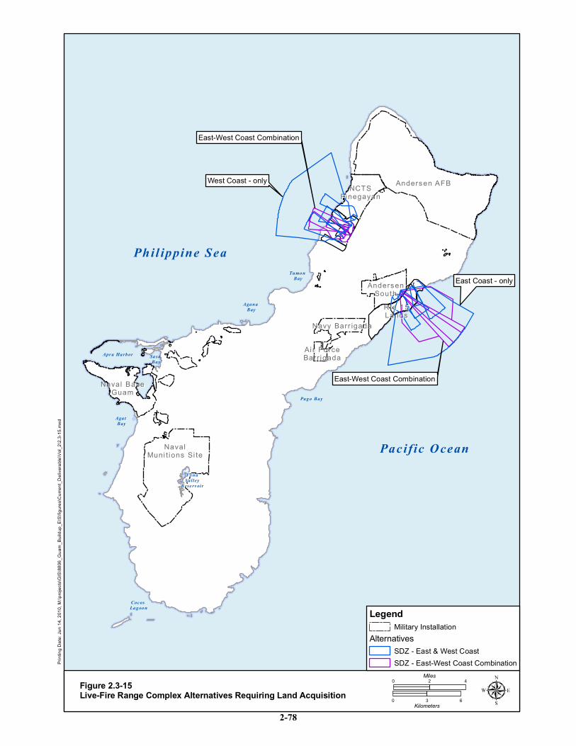
Andersen AFBAndersen AFB
AndersenAndersenSouthSouth
Rte 15Rte 15LandsLands
Navy Barr igadaNavy Barr igada
Ai r ForceAi r ForceBarr igadaBarr igada
NCTSNCTSFinegayanFinegayan
NavalNavalMuni t ions Si teMuni t ions Si te
Naval BaseNaval BaseGuamGuam
Phil ippine Sea
Pacific Ocean
Apr a Harbor Sasa Bay
Agat Bay
Coc os Lagoon
Pago Bay
Agana Bay
Tumon Bay
FenaValley
Rese rv oir
West Coast - only
East Coast - only
East-West Coast Combination
East-West Coast Combination
ing D
ate: J
un 14
, 201
0, M:
\proje
cts\G
IS\88
06_G
uam_
Build
up_E
IS\fig
ures\C
urren
t_Deli
verab
le\Vo
l_2\2.
3-15.m
xd
Figure 2.3-15Live-Fire Range Complex Alternatives Requiring Land Acquisition
0 42Miles
0 3 6Kilometers µ
LegendMilitary Installation
AlternativesSDZ - East & West CoastSDZ - East-West Coast Combination
2-78
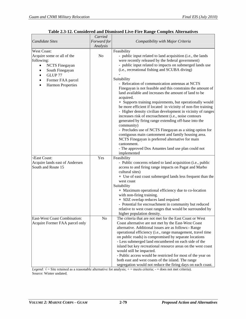
Guam and CNMI Military Relocation Final EIS (July 2010)
VOLUME 2: MARINE CORPS – GUAM 2-79 Proposed Action and Alternatives
Table 2.3-12. Considered and Dismissed Live-Fire Range Complex Alternatives
Candidate Sites
Carried
Forward for
Analysis
Compatibility with Major Criteria
West Coast:
Acquire some or all of the
following:
NCTS Finegayan
South Finegayan
GLUP 77
Former FAA parcel
Harmon Properties
No
Feasibility
- public input related to land acquisition (i.e., the lands
were recently released by the federal government)
- public input related to impacts on submerged lands use
(i.e., recreational fishing and SCUBA diving)
-
Suitability
- Relocation of communication antennas at NCTS
Finegayan is not feasible and this constrains the amount of
land available and increases the amount of land to be
acquired.
+ Supports training requirements, but operationally would
be more efficient if located in vicinity of non-fire training
- Higher density civilian development in vicinity of ranges
increases risk of encroachment (i.e., noise contours
generated by firing range extending off-base into the
community)
- Precludes use of NCTS Finegayan as a siting option for
contiguous main cantonment and family housing area.
NCTS Finegayan is preferred alternative for main
cantonment.
- The approved Dos Amantes land use plan could not
implemented
√East Coast:
Acquire lands east of Andersen
South and Route 15
Yes Feasibility
- Public concerns related to land acquisition (i.e., public
access to and firing range impacts on Pagat and Marbo
cultural sites)
+ Use of east coast submerged lands less frequent than the
west coast
Suitability
+ Maximum operational efficiency due to co-location
with non-firing training.
+ SDZ overlap reduces land required
- Potential for encroachment in community but reduced
relative to west coast ranges that would be surrounded by
higher population density.
East-West Coast Combination:
Acquire Former FAA parcel only
No The criteria that are not met for the East Coast or West
Coast alternative are not met by the East-West Coast
alternative. Additional issues are as follows:- Range
operational efficiency (i.e., range management, travel time
on public roads) is compromised by separate locations
- Less submerged land encumbered on each side of the
island but key recreational resource areas on the west coast
would still be impacted.
- Public access would be restricted for most of the year on
both east and west coasts of the island. The range
segregation would not reduce the firing days on each coast. Legend: √ = Site retained as a reasonable alternative for analysis; + = meets criteria; - = does not met criteria). Source: Winter undated.
Guam and CNMI Military Relocation Final EIS (July 2010)
VOLUME 2: MARINE CORPS – GUAM 2-80 Proposed Action and Alternatives
West Coast
The west coast alternative would involve development of a live-fire range complex on the west coast of
Guam in the vicinity of NCTS Finegayan. As described earlier, the siting of a live-fire range complex at
NCTS Finegayan was dismissed. However, the nearby GLUP 77 parcel, Former FAA parcel, and
Harmon properties, if acquired, would have sufficient lands to support the creation of a live fire range
complex with SDZs extending into submerged lands to the west of these parcels. This area was dismissed
for several reasons. Foremost were issues associated with public access.
Although the Navy owns the submerged lands that would be encumbered by the SDZs, the beaches below
the cliffline are a well know recreational area used by the public and the off shore waters are frequently
used for fishing and SCUBA diving. Because range operations would occur 45 weeks per year, there
would be severe limitation of public recreational access. Further, the SDZs would encumber a much
larger area than the current NCTS ranges. From a range use perspective, the range activities would likely
be interrupted by vessels unaware of the access restrictions. Further, as noted when discussing the
placement of live fire range complex at NCTS Finegayan, comments raised during the scoping from the
general public and subsequent discussions with GovGuam officials specifically recommended against
siting training ranges in this area because of concerns about impacts to public access of the recreation
sites.
Additionally, the lands in question were recently released by the federal government for return to
GovGuam. Re-acquisition for construction of a live-fire range complex would run counter to previous
determinations regarding the need for such lands. There is also an approved land use development plan
(Dos Amantes) for the areas that would be acquired in this scenario. The range development would
preclude implementation of the development plan and negatively impact community planning efforts on
Guam.
Further, there are a limited number of federally-controlled land parcels that are available for development
to support the many Marine Corps functions that will be relocating from Okinawa to Guam. NCTS
Finegayan and Andersen South are among the largest areas and provide the greatest opportunity for
consolidating Marine Corps functions. The optimal use of NCTS Finegayan would be for a consolidated
main cantonment and family housing area. Use of the NCTS Finegayan and vicinity for a live fire range
complex would preclude the use of NCTS Finegayan for a main cantonment and housing area.
Finally, the civilian population density is high in the area outside of the GLUP 77 parcel, Former FAA
parcel, and Harmon properties. This increases the potential for impacts generated on-base to encroach on
communities outside of the base. For example, noise impacts from firing ranges have potential to impact
a larger number of people in the surrounding community than an area of low density.
East Coast
The east coast alternative would involve development of a live-fire range complex on the east coast of
Guam. This area, which consists of private and GovGuam lands located to the east of Andersen South
and Route 15 extending along the coast north to Andersen AFB, was retained for further consideration in
the EIS. During the public scoping process and in subsequent discussions with GovGuam officials, areas
on the east coast of the island of Guam were discussed as a better location of a live fire range complex.
GovGuam officials offered up for DoD‘s consideration the area east of Andersen South and along Route
15. According to GovGuam officials, placement of a live fire range complex on the east coast, or
windward side of the island, would have far lesser impacts on recreation use than those proposed for
NCTS Finegayan or nearby lands. At the time of this discussion, the Pagat cultural area and associated
Guam and CNMI Military Relocation Final EIS (July 2010)
VOLUME 2: MARINE CORPS – GUAM 2-81 Proposed Action and Alternatives
nature trails would be considered more relevant for their recreational use than their cultural significance.
The area east of Andersen South and Route 15 extending along the coast north to Andersen AFB,
although not meeting every suitability and feasibility criteria for the location of live-fire ranges, was the
least constrained of the areas that were advanced for further consideration. Specifically, this area allowed
for the placement of all live-fire ranges, including the machine gun range, into a live-fire range complex.
Additionally, this area would allow the creation of an integrated training range complex that included
non-live fire training at Andersen South and an adjacent live-fire range complex. Although live-fire
ranges located in this area would have SDZs over water, they would be over GovGuam controlled
submerged lands and away from heavily used recreational beaches, dive sites, and fishing areas present
on the west side of the island. The majority of lands in this area are lands under the control of GovGuam,
with the bulk of them undeveloped lands. Some of the GovGuam lands in the northern portion of the area
are currently used for commercial and industrial purposes. Range construction on those lands would be
on brownfields, minimizing environmental impacts and lessening community impacts. Relative to
private lands, only a few parcels under consideration contain residences. The rest are undeveloped.
As with the other two alternatives, land acquisition would be required. Further, public access to the
public lands and submerged land areas within the SDZs would be restricted for up to 45 weeks per year.
Restricted public access to Marbo and Pagat cultural sites and nature trails would be imposed during
range operations, depending on the alternative selected. However, it is envisioned that because ranges
would be collocated and operated simultaneously, they would be operational only a portion of each day
Monday through Friday and a few weekends each year. Thus there would be unrestricted public access to
the Pagat cultural site for some period every day and most weekends. A range management plan would
be developed that would maximize and clearly define public access opportunities to include improved
access at the cultural sites with off-street parking, improved trails, and enhancement of the cultural sites.
Of the three alternatives, the east coast ranges provide the greatest level of Marine Corps operational
efficiency. The live-firing ranges and the non-firing training ranges would be adjacent to and minimize
the traffic and travel time on public roads. Route 15 would divide the two areas, but no impacts to Route
15 traffic were identified. The SDZ‘s can overlap as mentioned under the West Coast Alternative,
minimizing the land area required.
Further, the existing low density development adjacent to the acquisition land boundary reduces the
potential for encroachment on the community. Other possible locations on the East Coast were rejected
because of the lack of available land parcels sufficient to accommodate the ranges or a live-fire range
complex, lack of adjacent federally-controlled properties, and terrain/topography considerations that made
construction of ranges or a live fire range complex infeasible.
East-West Coast
The criteria that are not met under either the East or West Coast range alternatives are also not met by the
East-West Coast alternative. These unmet criteria are described above.
There are characteristics unique to the East-West Coast alternative. Primarily it would involve the
separation of training ranges among multiple sites. Splitting ranges into multiple sites would be less
efficient for range management, including fire management, border control, and equipment storage. There
would be increased travel on public roadways between coasts. Further, as noted above, there are capacity
limitations on some existing range areas that would adversely affect operational/training efficiency.
There would be less submerged land encumbered on each side of the island than described for the other
alternatives, but key recreational resource areas on the west coast would still be impacted. Also there is
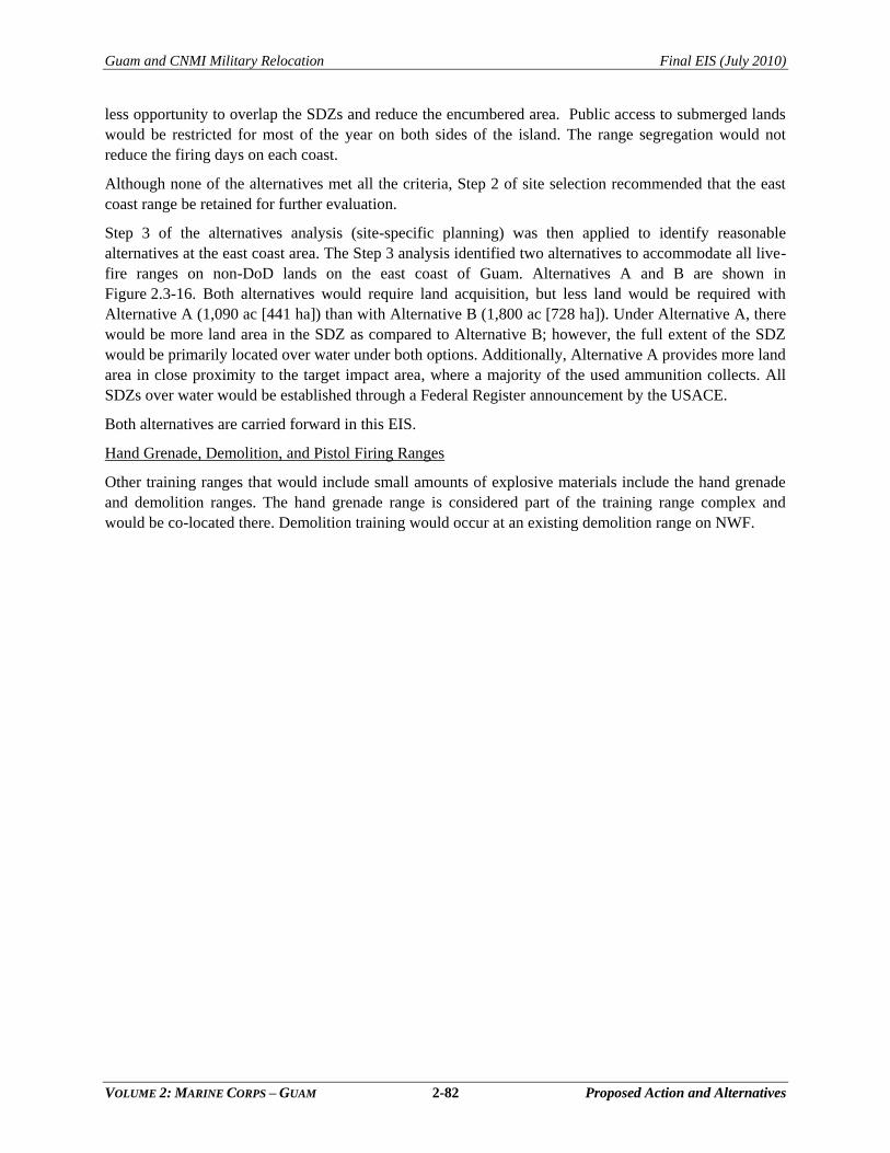
Guam and CNMI Military Relocation Final EIS (July 2010)
VOLUME 2: MARINE CORPS – GUAM 2-82 Proposed Action and Alternatives
less opportunity to overlap the SDZs and reduce the encumbered area. Public access to submerged lands
would be restricted for most of the year on both sides of the island. The range segregation would not
reduce the firing days on each coast.
Although none of the alternatives met all the criteria, Step 2 of site selection recommended that the east
coast range be retained for further evaluation.
Step 3 of the alternatives analysis (site-specific planning) was then applied to identify reasonable
alternatives at the east coast area. The Step 3 analysis identified two alternatives to accommodate all live-
fire ranges on non-DoD lands on the east coast of Guam. Alternatives A and B are shown in
Figure 2.3-16. Both alternatives would require land acquisition, but less land would be required with
Alternative A (1,090 ac [441 ha]) than with Alternative B (1,800 ac [728 ha]). Under Alternative A, there
would be more land area in the SDZ as compared to Alternative B; however, the full extent of the SDZ
would be primarily located over water under both options. Additionally, Alternative A provides more land
area in close proximity to the target impact area, where a majority of the used ammunition collects. All
SDZs over water would be established through a Federal Register announcement by the USACE.
Both alternatives are carried forward in this EIS.
Hand Grenade, Demolition, and Pistol Firing Ranges
Other training ranges that would include small amounts of explosive materials include the hand grenade
and demolition ranges. The hand grenade range is considered part of the training range complex and
would be co-located there. Demolition training would occur at an existing demolition range on NWF.
Figure 2.3-16Training Range Alternatives
")L Z
")L Z
g
g
!"28!"1
!"26
!"15
!"15
Andersen SouthAndersen South
Rte 15 LandsRte 15 Lands
Pacific Ocean
KD RangeKD Range
Machine Gun RangeMachine Gun Range
Nonstandard Small Arms RangeNonstandard Small Arms Range
Modified Record of Fire RangeModified Record of Fire Range
Pistol RangePistol Range
")L Z
")L Z
kk
k
g
g
!"28!"1
!"26
!"15
!"15
!"15
Navy BarrigadaNavy Barrigada
Rte 15 LandsRte 15 Lands
KD RangeKD Range
Modified Record of Fire RangeModified Record of Fire Range
Nonstandard Small Arms RangeNonstandard Small Arms Range
Machine Gun RangeMachine Gun Range Pacific Ocean
Pistol RangePistol Range
A L T E R N A T I V E A : E a s t C o a s tA L T E R N A T I V E A : E a s t C o a s t( R t e 1 5 R e a l i g n m e n t )( R t e 1 5 R e a l i g n m e n t )
A L T E R N A T I V E B : E a s t C o a s tA L T E R N A T I V E B : E a s t C o a s t( N o R t e 1 5 R e a l i g n m e n t )( N o R t e 1 5 R e a l i g n m e n t )
0 830 1,660Meters
0 6,2003,100Feet
µ
ing D
ate: J
un 25
, 201
0, M:
\proje
cts\G
IS\88
06_G
uam_
Build
up_E
IS\fig
ures\C
urren
t_Deli
verab
le\Vo
l_2\2.
3-16.m
xd
Proposed Features
Legend
!"9 Route Number
Range Towerg
Rte 15 RealignmentRange Road
Firing Range
Military Installation
Proposed Land Acquisition
SDZ
Range RoadFence Line
2-83
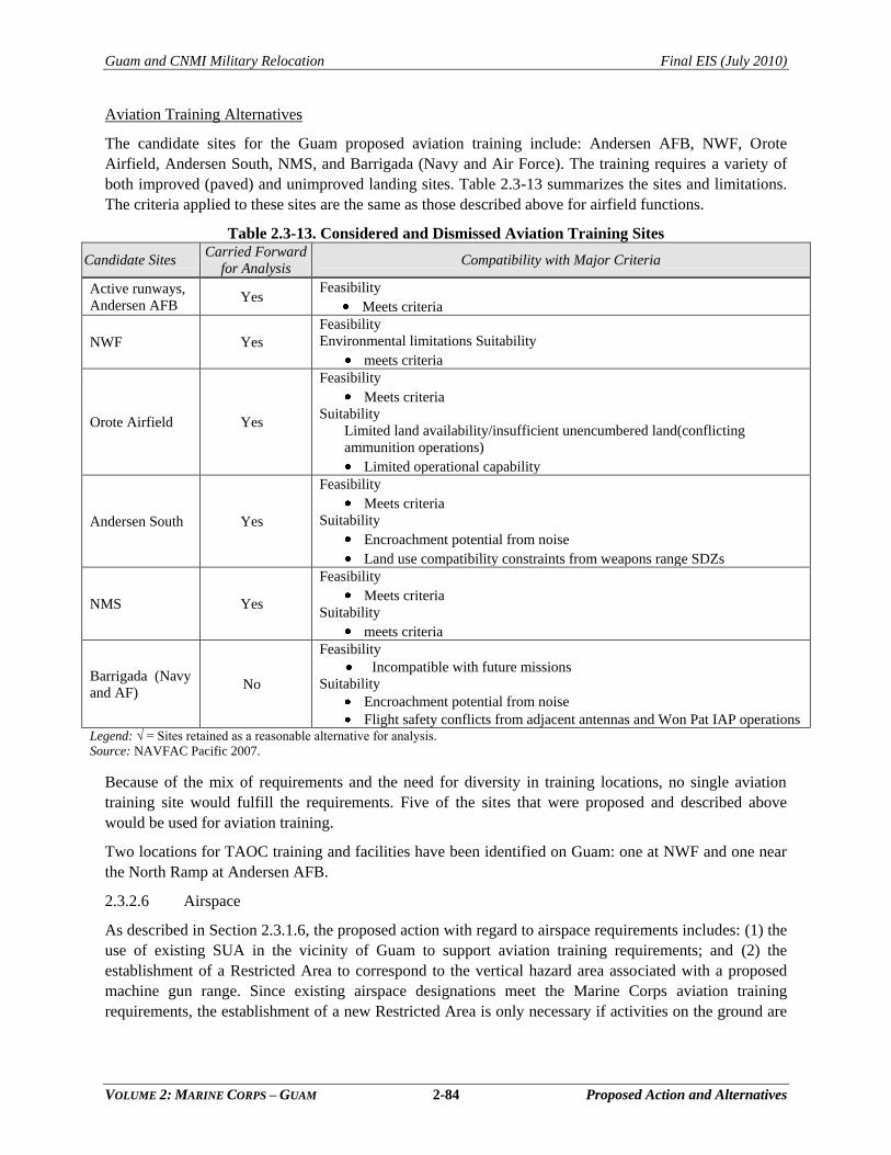
Guam and CNMI Military Relocation Final EIS (July 2010)
VOLUME 2: MARINE CORPS – GUAM 2-84 Proposed Action and Alternatives
Aviation Training Alternatives
The candidate sites for the Guam proposed aviation training include: Andersen AFB, NWF, Orote
Airfield, Andersen South, NMS, and Barrigada (Navy and Air Force). The training requires a variety of
both improved (paved) and unimproved landing sites. Table 2.3-13 summarizes the sites and limitations.
The criteria applied to these sites are the same as those described above for airfield functions.
Table 2.3-13. Considered and Dismissed Aviation Training Sites
Candidate Sites Carried Forward
for Analysis Compatibility with Major Criteria
Active runways,
Andersen AFB Yes
Feasibility
Meets criteria
NWF Yes
Feasibility
Environmental limitations Suitability
meets criteria
Orote Airfield Yes
Feasibility
Meets criteria
Suitability
Limited land availability/insufficient unencumbered land(conflicting
ammunition operations)
Limited operational capability
Andersen South Yes
Feasibility
Meets criteria
Suitability
Encroachment potential from noise
Land use compatibility constraints from weapons range SDZs
NMS Yes
Feasibility
Meets criteria
Suitability
meets criteria
Barrigada (Navy
and AF) No
Feasibility
Incompatible with future missions
Suitability
Encroachment potential from noise
Flight safety conflicts from adjacent antennas and Won Pat IAP operations Legend: √ = Sites retained as a reasonable alternative for analysis.
Source: NAVFAC Pacific 2007.
Because of the mix of requirements and the need for diversity in training locations, no single aviation
training site would fulfill the requirements. Five of the sites that were proposed and described above
would be used for aviation training.
Two locations for TAOC training and facilities have been identified on Guam: one at NWF and one near
the North Ramp at Andersen AFB.
2.3.2.6 Airspace
As described in Section 2.3.1.6, the proposed action with regard to airspace requirements includes: (1) the
use of existing SUA in the vicinity of Guam to support aviation training requirements; and (2) the
establishment of a Restricted Area to correspond to the vertical hazard area associated with a proposed
machine gun range. Since existing airspace designations meet the Marine Corps aviation training
requirements, the establishment of a new Restricted Area is only necessary if activities on the ground are
Guam and CNMI Military Relocation Final EIS (July 2010)
VOLUME 2: MARINE CORPS – GUAM 2-85 Proposed Action and Alternatives
deemed hazardous to non-participating aircraft. The location of a Restricted Area for the machine gun
range would be a function of the location of that range.
2.3.3 Alternatives Carried Forward for Analysis: Training Functions
2.3.3.1 Ammunition Storage Facilities
As summarized in Table 2.3-14, the alternatives analysis identified one action alternative for the high
explosive ECM at the existing NMS, two alternative sites for the standard ECMs at NMS, and one action
alternative for the 12 standard ECMs and associated support facilities at the existing Andersen AFB
MSA 1. All of these alternatives are carried forward for analysis in this EIS. Details of the construction
and operation of each of the proposed facilities were described in Section 2.3.1.1.
Table 2.3-14. Alternatives Carried Forward for Analysis: Ammunition Storage Facilities Facility Alternatives Carried Forward Figure Reference
High Explosive ECM NMS: High 12 Group Area 2.3-11
10 standard ECMs NMS: Parson‘s Road Area Alternative A
2.3-11 NMS: High Road Area Alternative B
12 standard ECMs and
related support facilities Andersen AFB MSA1 2.3-12
2.3.3.2 Command, Control, and Simulation Facilities
To support and sustain functional relationships with headquarters and administrative functions in the
Marine Corps Main Cantonment Area, all three proposed Command, Control, and Simulation facilities
would be sited as a function of the master planning conducted for the Main Cantonment Area, as
discussed in Section 2.2. Accordingly, action alternatives for Command, Control, and Simulation
facilities that are carried forward for analysis in this EIS are incorporated within Alternatives 1, 2, 3, and
8 for the Main Cantonment Area (see Section 2.6.1).
2.3.3.3 Non-Firing General Military Skills Training
Table 2.3-15 summarizes the alternatives carried forward for analysis with regard to non-fire general
military skills training. Under the proposed action, the smaller non-fire range facilities that support
physical fitness and unit-level training would be constructed in conjunction with the Main Cantonment
Area facilities in order to encourage frequency and efficiency of use. No other alternative sites for such
facilities and training activities were identified based on operational requirements.
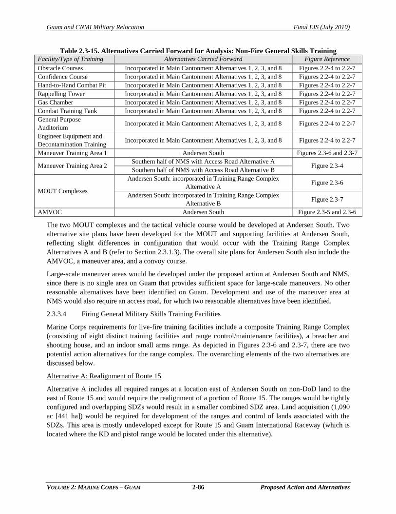
Guam and CNMI Military Relocation Final EIS (July 2010)
VOLUME 2: MARINE CORPS – GUAM 2-86 Proposed Action and Alternatives
Table 2.3-15. Alternatives Carried Forward for Analysis: Non-Fire General Skills Training Facility/Type of Training Alternatives Carried Forward Figure Reference
Obstacle Courses Incorporated in Main Cantonment Alternatives 1, 2, 3, and 8 Figures 2.2-4 to 2.2-7
Confidence Course Incorporated in Main Cantonment Alternatives 1, 2, 3, and 8 Figures 2.2-4 to 2.2-7
Hand-to-Hand Combat Pit Incorporated in Main Cantonment Alternatives 1, 2, 3, and 8 Figures 2.2-4 to 2.2-7
Rappelling Tower Incorporated in Main Cantonment Alternatives 1, 2, 3, and 8 Figures 2.2-4 to 2.2-7
Gas Chamber Incorporated in Main Cantonment Alternatives 1, 2, 3, and 8 Figures 2.2-4 to 2.2-7
Combat Training Tank Incorporated in Main Cantonment Alternatives 1, 2, 3, and 8 Figures 2.2-4 to 2.2-7
General Purpose
Auditorium Incorporated in Main Cantonment Alternatives 1, 2, 3, and 8 Figures 2.2-4 to 2.2-7
Engineer Equipment and
Decontamination Training Incorporated in Main Cantonment Alternatives 1, 2, 3, and 8 Figures 2.2-4 to 2.2-7
Maneuver Training Area 1 Andersen South Figures 2.3-6 and 2.3-7
Maneuver Training Area 2 Southern half of NMS with Access Road Alternative A
Figure 2.3-4 Southern half of NMS with Access Road Alternative B
MOUT Complexes
Andersen South: incorporated in Training Range Complex
Alternative A Figure 2.3-6
Andersen South: incorporated in Training Range Complex
Alternative B Figure 2.3-7
AMVOC Andersen South Figure 2.3-5 and 2.3-6
The two MOUT complexes and the tactical vehicle course would be developed at Andersen South. Two
alternative site plans have been developed for the MOUT and supporting facilities at Andersen South,
reflecting slight differences in configuration that would occur with the Training Range Complex
Alternatives A and B (refer to Section 2.3.1.3). The overall site plans for Andersen South also include the
AMVOC, a maneuver area, and a convoy course.
Large-scale maneuver areas would be developed under the proposed action at Andersen South and NMS,
since there is no single area on Guam that provides sufficient space for large-scale maneuvers. No other
reasonable alternatives have been identified on Guam. Development and use of the maneuver area at
NMS would also require an access road, for which two reasonable alternatives have been identified.
2.3.3.4 Firing General Military Skills Training Facilities
Marine Corps requirements for live-fire training facilities include a composite Training Range Complex
(consisting of eight distinct training facilities and range control/maintenance facilities), a breacher and
shooting house, and an indoor small arms range. As depicted in Figures 2.3-6 and 2.3-7, there are two
potential action alternatives for the range complex. The overarching elements of the two alternatives are
discussed below.
Alternative A: Realignment of Route 15
Alternative A includes all required ranges at a location east of Andersen South on non-DoD land to the
east of Route 15 and would require the realignment of a portion of Route 15. The ranges would be tightly
configured and overlapping SDZs would result in a smaller combined SDZ area. Land acquisition (1,090
ac [441 ha]) would be required for development of the ranges and control of lands associated with the
SDZs. This area is mostly undeveloped except for Route 15 and Guam International Raceway (which is
located where the KD and pistol range would be located under this alternative).
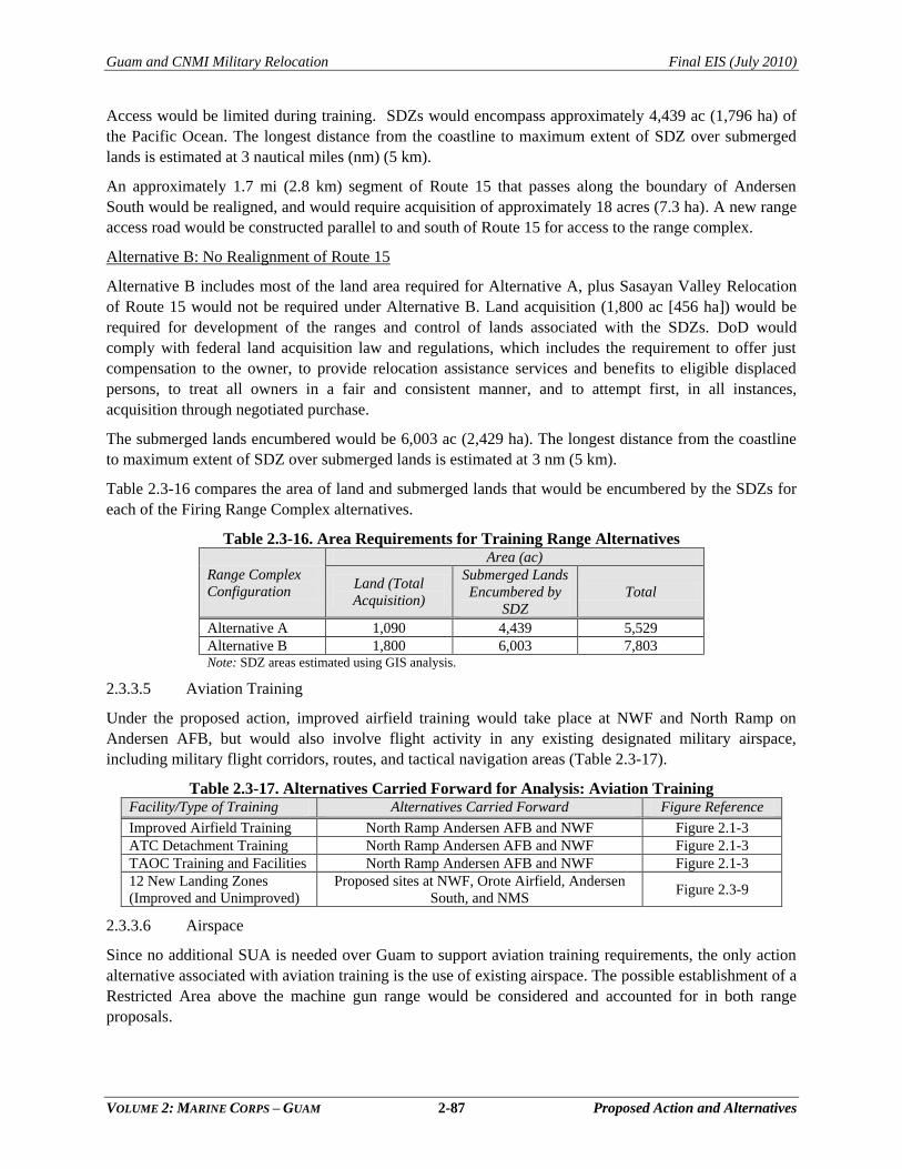
Guam and CNMI Military Relocation Final EIS (July 2010)
VOLUME 2: MARINE CORPS – GUAM 2-87 Proposed Action and Alternatives
Access would be limited during training. SDZs would encompass approximately 4,439 ac (1,796 ha) of
the Pacific Ocean. The longest distance from the coastline to maximum extent of SDZ over submerged
lands is estimated at 3 nautical miles (nm) (5 km).
An approximately 1.7 mi (2.8 km) segment of Route 15 that passes along the boundary of Andersen
South would be realigned, and would require acquisition of approximately 18 acres (7.3 ha). A new range
access road would be constructed parallel to and south of Route 15 for access to the range complex.
Alternative B: No Realignment of Route 15
Alternative B includes most of the land area required for Alternative A, plus Sasayan Valley Relocation
of Route 15 would not be required under Alternative B. Land acquisition (1,800 ac [456 ha]) would be
required for development of the ranges and control of lands associated with the SDZs. DoD would
comply with federal land acquisition law and regulations, which includes the requirement to offer just
compensation to the owner, to provide relocation assistance services and benefits to eligible displaced
persons, to treat all owners in a fair and consistent manner, and to attempt first, in all instances,
acquisition through negotiated purchase.
The submerged lands encumbered would be 6,003 ac (2,429 ha). The longest distance from the coastline
to maximum extent of SDZ over submerged lands is estimated at 3 nm (5 km).
Table 2.3-16 compares the area of land and submerged lands that would be encumbered by the SDZs for
each of the Firing Range Complex alternatives.
Table 2.3-16. Area Requirements for Training Range Alternatives
Range Complex
Configuration
Area (ac)
Land (Total
Acquisition)
Submerged Lands
Encumbered by
SDZ
Total
Alternative A 1,090 4,439 5,529
Alternative B 1,800 6,003 7,803 Note: SDZ areas estimated using GIS analysis.
2.3.3.5 Aviation Training
Under the proposed action, improved airfield training would take place at NWF and North Ramp on
Andersen AFB, but would also involve flight activity in any existing designated military airspace,
including military flight corridors, routes, and tactical navigation areas (Table 2.3-17).
Table 2.3-17. Alternatives Carried Forward for Analysis: Aviation Training Facility/Type of Training Alternatives Carried Forward Figure Reference
Improved Airfield Training North Ramp Andersen AFB and NWF Figure 2.1-3
ATC Detachment Training North Ramp Andersen AFB and NWF Figure 2.1-3
TAOC Training and Facilities North Ramp Andersen AFB and NWF Figure 2.1-3
12 New Landing Zones
(Improved and Unimproved)
Proposed sites at NWF, Orote Airfield, Andersen
South, and NMS Figure 2.3-9
2.3.3.6 Airspace
Since no additional SUA is needed over Guam to support aviation training requirements, the only action
alternative associated with aviation training is the use of existing airspace. The possible establishment of a
Restricted Area above the machine gun range would be considered and accounted for in both range
proposals.
Guam and CNMI Military Relocation Final EIS (July 2010)
VOLUME 2: MARINE CORPS – GUAM 2-88 Proposed Action and Alternatives
2.4 PROPOSED ACTION: AIRFIELD FUNCTIONS
2.4.1 Requirements
Key project components associated with airfield operations
include the beddown of ACE facilities, air embarkation
facilities, and development of a gate and access road to the
airfield. All of these components would be sited at Andersen
AFB airfield. A new access road onto Andersen AFB is
proposed to improve traffic from the Main Cantonment at
NCTS Finegayan to the airfield.
2.4.1.1 ACE Beddown
Proposed Facilities
The ACE beddown would require operational, maintenance, and administrative facilities to support the
presence of permanently assigned or visiting Marine Corps aircraft on Guam. All facilities would be sized
in accordance with Navy criteria for airfield and heliport planning and design. The North Ramp of
Andersen AFB airfield is the proposed site for the operations. Table 2.4-1 describes the facilities required.
This site constitutes an infill development at the already developed North Ramp area of Andersen AFB.
The majority of the ACE Beddown project area is an inactive, previously disturbed area north of the
existing Andersen AFB airfield. This proposed project would be used for vertical lift aircraft operations,
maintenance, and related training and support functions. Airspace and biosecurity requirements must also
be met and are currently being developed (see Section 2.1.4).
Land use constraints in the vicinity of the ACE beddown site include a large sinkhole (Installation
Restoration Program [IRP] Site 66), approximately 700 ft by 900 ft (213 m by 274 m), located just east of
the project site. Intact native forests and Overlay Refuge are located north of the site.
Layouts for the air operations at North Ramp have been proposed (Figure 2.4-1). This plan is subject to
change.
Proposed Operations
The ACE beddown facilities would operate 24 hours per day and 7 days per week. Approximately 2,000
people would occupy this space during the day shift and 400 people would be present at night. Traffic
would include government owned vehicles, personal vehicles, and shuttle buses from the Main
Cantonment area. Air traffic would include helicopter, vertical lift aircraft, fixed wing, and unmanned
aircraft arrivals and departures. Air traffic rates are contingent on surge and operational requirements.
Chapter 2:
2.1 Overview
2.2 Main Cantonment Area
Functions
2.3 Training Functions
2.4 Airfield Functions
2.5 Waterfront Functions
2.6 Summary of Alternatives
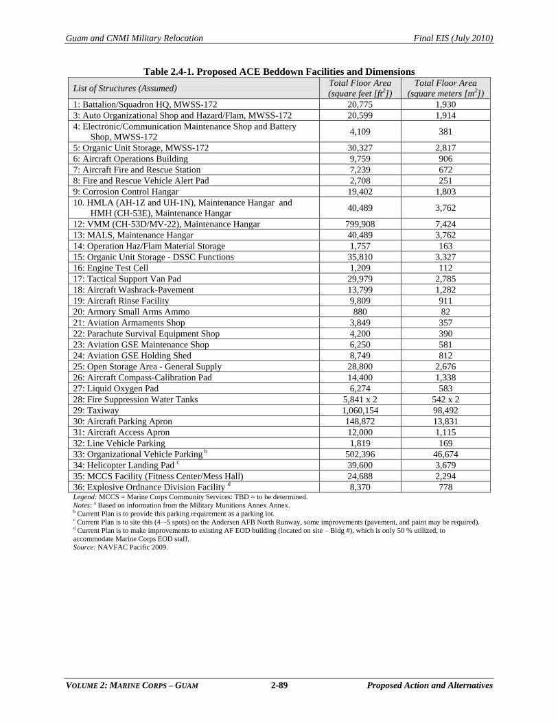
Guam and CNMI Military Relocation Final EIS (July 2010)
VOLUME 2: MARINE CORPS – GUAM 2-89 Proposed Action and Alternatives
Table 2.4-1. Proposed ACE Beddown Facilities and Dimensions
List of Structures (Assumed) Total Floor Area
(square feet [ft2])
Total Floor Area
(square meters [m2])
1: Battalion/Squadron HQ, MWSS-172 20,775 1,930
3: Auto Organizational Shop and Hazard/Flam, MWSS-172 20,599 1,914
4: Electronic/Communication Maintenance Shop and Battery
Shop, MWSS-172 4,109 381
5: Organic Unit Storage, MWSS-172 30,327 2,817
6: Aircraft Operations Building 9,759 906
7: Aircraft Fire and Rescue Station 7,239 672
8: Fire and Rescue Vehicle Alert Pad 2,708 251
9: Corrosion Control Hangar 19,402 1,803
10. HMLA (AH-1Z and UH-1N), Maintenance Hangar and
HMH (CH-53E), Maintenance Hangar 40,489 3,762
12: VMM (CH-53D/MV-22), Maintenance Hangar 799,908 7,424
13: MALS, Maintenance Hangar 40,489 3,762
14: Operation Haz/Flam Material Storage 1,757 163
15: Organic Unit Storage - DSSC Functions 35,810 3,327
16: Engine Test Cell 1,209 112
17: Tactical Support Van Pad 29,979 2,785
18: Aircraft Washrack-Pavement 13,799 1,282
19: Aircraft Rinse Facility 9,809 911
20: Armory Small Arms Ammo 880 82
21: Aviation Armaments Shop 3,849 357
22: Parachute Survival Equipment Shop 4,200 390
23: Aviation GSE Maintenance Shop 6,250 581
24: Aviation GSE Holding Shed 8,749 812
25: Open Storage Area - General Supply 28,800 2,676
26: Aircraft Compass-Calibration Pad 14,400 1,338
27: Liquid Oxygen Pad 6,274 583
28: Fire Suppression Water Tanks 5,841 x 2 542 x 2
29: Taxiway 1,060,154 98,492
30: Aircraft Parking Apron 148,872 13,831
31: Aircraft Access Apron 12,000 1,115
32: Line Vehicle Parking 1,819 169
33: Organizational Vehicle Parking b 502,396 46,674
34: Helicopter Landing Pad c 39,600 3,679
35: MCCS Facility (Fitness Center/Mess Hall) 24,688 2,294
36: Explosive Ordnance Division Facility d 8,370 778 Legend: MCCS = Marine Corps Community Services: TBD = to be determined.
Notes: a Based on information from the Military Munitions Annex Annex. b Current Plan is to provide this parking requirement as a parking lot. c Current Plan is to site this (4–-5 spots) on the Andersen AFB North Runway, some improvements (pavement, and paint may be required). d Current Plan is to make improvements to existing AF EOD building (located on site – Bldg #), which is only 50 % utilized, to
accommodate Marine Corps EOD staff.
Source: NAVFAC Pacific 2009.
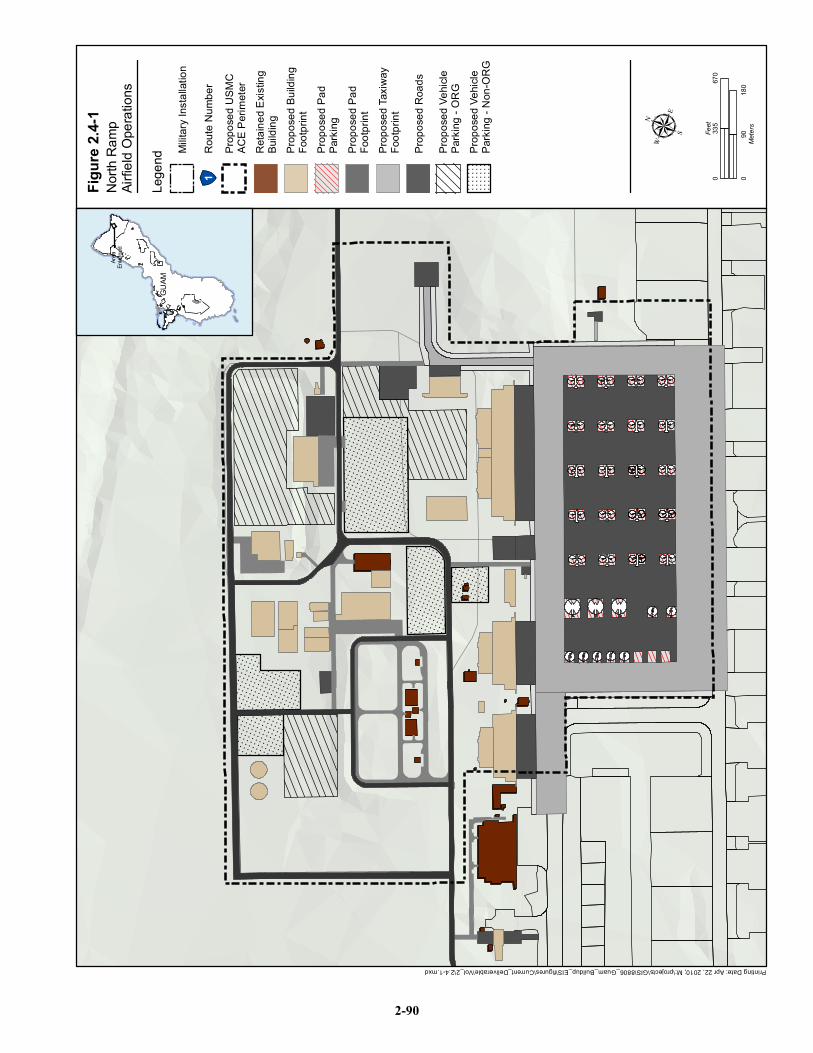
Printing Date: Apr 22, 2010; M:\projects\GIS\8806_Guam_Buildup_EIS\figures\Current_Deliverable\Vol_2\2.4-1.mxd
Figur
e 2.4-
1
µ
North
Ram
pAir
field
Opera
tions
090
180
Meter
s
067
033
5Fe
et
GUAM
GUAM
Area
Enlar
ged
Lege
nd
!"1Ro
ute N
umbe
r
Prop
osed
Roa
ds
Prop
osed
Taxiw
ayFo
otprin
t
Prop
osed
Pad
Footp
rint
Prop
osed
Pad
Parki
ng
Prop
osed
Buil
ding
Footp
rint
Retai
ned E
xistin
gBu
ilding
Prop
osed
USM
CAC
E Peri
meter
Milita
ry Ins
tallat
ion
Prop
osed
Vehic
lePa
rking
- Non
-ORG
Prop
osed
Vehic
lePa
rking
- ORG
2-90
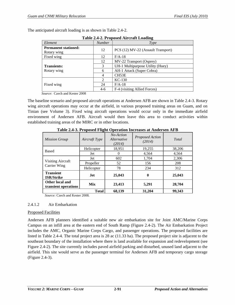
Guam and CNMI Military Relocation Final EIS (July 2010)
VOLUME 2: MARINE CORPS – GUAM 2-91 Proposed Action and Alternatives
The anticipated aircraft loading is as shown in Table 2.4-2.
Table 2.4-2. Proposed Aircraft Loading Element Number Type
Permanent stationed:
Rotary wing 12 PCS (12) MV-22 (Assault Transport)
Fixed wing 12 F/A-18
Transients:
Rotary wing
12 MV-22 Transport (Osprey)
3 UH-1 Multipurpose Utility (Huey)
6 AH-1 Attack (Super Cobra)
4 CH53E
Fixed wing
2 KC-130
24 F/A-18
4-6 F-4 (visiting Allied Forces) Source: Czech and Kester 2008
The baseline scenario and proposed aircraft operations at Andersen AFB are shown in Table 2.4-3. Rotary
wing aircraft operations may occur at the airfield, in various proposed training areas on Guam, and on
Tinian (see Volume 3). Fixed wing aircraft operations would occur only in the immediate airfield
environment of Andersen AFB. Aircraft would then leave this area to conduct activities within
established training areas of the MIRC or in other locations.
Table 2.4-3. Proposed Flight Operation Increases at Andersen AFB
Mission Group Aircraft Type
No-Action
Alternative
(2014)
Proposed Action
(2014) Total
Based Helicopter 18,951 19,255 38,206
Jet 0 4,564 4,564
Visiting Aircraft
Carrier Wing
Jet 602 1,704 2,306
Propeller 52 156 208
Helicopter 78 234 312
Transient
ISR/Strike Jet 25,043 0 25,043
Other local and
transient operations Mix 23,413 5,291 28,704
Total 68,139 31,204 99,343 Source: Czech and Kester 2008.
2.4.1.2 Air Embarkation
Proposed Facilities
Andersen AFB planners identified a suitable new air embarkation site for Joint AMC/Marine Corps
Campus on an infill area at the eastern end of South Ramp (Figure 2.4-2). The Air Embarkation Project
includes the AMC, Organic Marine Corps Cargo, and passenger operations. The proposed facilities are
listed in Table 2.4-4. The total project area is 28 ac (11.33 ha). The proposed project site is adjacent to the
southeast boundary of the installation where there is land available for expansion and redevelopment (see
Figure 2.4-2). The site currently includes paved airfield parking and disturbed, unused land adjacent to the
airfield. This site would serve as the passenger terminal for Andersen AFB and temporary cargo storage
(Figure 2.4-3).
Guam and CNMI Military Relocation Final EIS (July 2010)
VOLUME 2: MARINE CORPS – GUAM 2-92 Proposed Action and Alternatives
Figure 2.4-2. Location of Proposed AMC/Marine Corps Campus at South Ramp
Table 2.4-4. Proposed AMC/Marine Corps Campus Facilities and Dimensions
List of Structures (Assumed): Total Floor
Area (ft2)
Total Floor Area
(m2)
1: Water Tower Size: TBD Size: TBD
2: New passenger terminal & 734 Air Mobility
Squadron HQ 45,600 4,236
3: New Freight Terminal/ Marine Office 55,000 5,110
4: Military Message Handling System 6,250 581
5: Hazardous Waste Storage Facility 3,275 304
6: Material Handling Equipment Washrack 15,163 1409
7: Airfield Pavement: Loading Area 539,660 50,136
8: Airfield Pavement: Facilities 143,986 13,377
9: Undefined Air Mobility Command Building 6,594 613
10: Air Mobility Campus Parking 129,887 12,067
11: New passenger 734 AMS Staff Parking 64,054 5,951
12: Passenger area 1,364 127
13: New Roads/Access Driveways 48,351 4,492 Source: NAVFAC Pacific 2009.
Guam and CNMI Military Relocation Final EIS (July 2010)
VOLUME 2: MARINE CORPS – GUAM 2-93 Proposed Action and Alternatives
Figure 2.4-3. Proposed Joint AMC/Marine Corps Campus
Proposed Operations
Air Embarkation/Disembarkation refers to the loading and unloading of passengers or cargo to aircraft.
The passenger facilities are comparable to those of a small airport: luggage handling, wait area, and
ticket/documentation area. Cargo is staged in the area awaiting loading to aircraft or disbursement to
warehouses or individual commands. There are searches of cargo and baggage. The Air Force has Air
Embarkation facilities at South Ramp of the airfield. A new joint-use Air Embarkation site is proposed
and the Air Force is taking the lead on design. The site would operate 24 hours per day and 7 days per
week. Staffing levels are to be determined and would be contingent upon surge and operational
requirements.
2.4.1.3 North Gate and Access Road
Proposed Facilities
New facilities associated with the proposed north gate include the following:
One-story entry control point (ECP) (204.4 ft2) (18.99 m2) with restrooms,
telecommunications, four parking stalls, and installation fencing.
One-story Pass and Identification Office (783.6 ft2) (72.8 m2) with 12 parking stalls,
restrooms, and telecommunications to be located approximately 4,058.8 ft (1,235 m) from the
ECP.
Vehicle Inspection Facility (VIF), including a one-story Vehicle Queuing Control Facility
(26.21 ft2) (7.99 m2) with two parking stalls and an exit lane.
A high bay, open VIF with two open, concrete-lined, underground pits (7.5 ft by 2.3 ft and
5.9 ft deep) (2.3 m by 0.7 m and 1.8 m deep) for viewing the undercarriage of trucks;
overhead remote video monitoring of the tops of vehicles; and a one-story inspection
administration building (3,440.3 ft2) (319.61 m2) with waiting room, office space, military
working dog holding room, two restrooms, 12 parking stalls, and telecommunications.
A one-story, one-room overwatch station (26.2 ft2) (7.99 m2) with one parking stall.
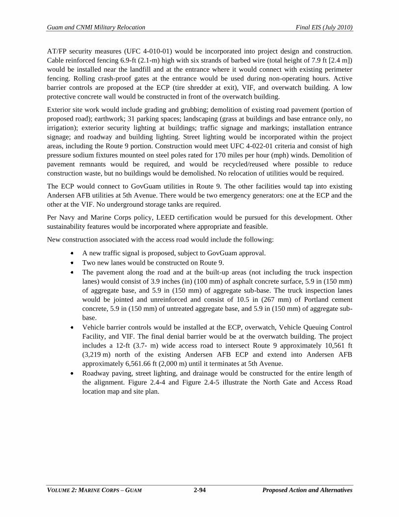
Guam and CNMI Military Relocation Final EIS (July 2010)
VOLUME 2: MARINE CORPS – GUAM 2-94 Proposed Action and Alternatives
AT/FP security measures (UFC 4-010-01) would be incorporated into project design and construction.
Cable reinforced fencing 6.9-ft (2.1-m) high with six strands of barbed wire (total height of 7.9 ft [2.4 m])
would be installed near the landfill and at the entrance where it would connect with existing perimeter
fencing. Rolling crash-proof gates at the entrance would be used during non-operating hours. Active
barrier controls are proposed at the ECP (tire shredder at exit), VIF, and overwatch building. A low
protective concrete wall would be constructed in front of the overwatch building.
Exterior site work would include grading and grubbing; demolition of existing road pavement (portion of
proposed road); earthwork; 31 parking spaces; landscaping (grass at buildings and base entrance only, no
irrigation); exterior security lighting at buildings; traffic signage and markings; installation entrance
signage; and roadway and building lighting. Street lighting would be incorporated within the project
areas, including the Route 9 portion. Construction would meet UFC 4-022-01 criteria and consist of high
pressure sodium fixtures mounted on steel poles rated for 170 miles per hour (mph) winds. Demolition of
pavement remnants would be required, and would be recycled/reused where possible to reduce
construction waste, but no buildings would be demolished. No relocation of utilities would be required.
The ECP would connect to GovGuam utilities in Route 9. The other facilities would tap into existing
Andersen AFB utilities at 5th Avenue. There would be two emergency generators: one at the ECP and the
other at the VIF. No underground storage tanks are required.
Per Navy and Marine Corps policy, LEED certification would be pursued for this development. Other
sustainability features would be incorporated where appropriate and feasible.
New construction associated with the access road would include the following:
A new traffic signal is proposed, subject to GovGuam approval.
Two new lanes would be constructed on Route 9.
The pavement along the road and at the built-up areas (not including the truck inspection
lanes) would consist of 3.9 inches (in) (100 mm) of asphalt concrete surface, 5.9 in (150 mm)
of aggregate base, and 5.9 in (150 mm) of aggregate sub-base. The truck inspection lanes
would be jointed and unreinforced and consist of 10.5 in (267 mm) of Portland cement
concrete, 5.9 in (150 mm) of untreated aggregate base, and 5.9 in (150 mm) of aggregate sub-
base.
Vehicle barrier controls would be installed at the ECP, overwatch, Vehicle Queuing Control
Facility, and VIF. The final denial barrier would be at the overwatch building. The project
includes a 12-ft (3.7- m) wide access road to intersect Route 9 approximately 10,561 ft
(3,219 m) north of the existing Andersen AFB ECP and extend into Andersen AFB
approximately 6,561.66 ft (2,000 m) until it terminates at 5th Avenue.
Roadway paving, street lighting, and drainage would be constructed for the entire length of
the alignment. Figure 2.4-4 and Figure 2.4-5 illustrate the North Gate and Access Road
location map and site plan.
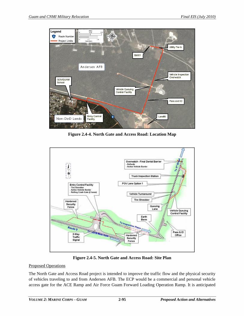
Guam and CNMI Military Relocation Final EIS (July 2010)
VOLUME 2: MARINE CORPS – GUAM 2-95 Proposed Action and Alternatives
Figure 2.4-4. North Gate and Access Road: Location Map
Figure 2.4-5. North Gate and Access Road: Site Plan
Proposed Operations
The North Gate and Access Road project is intended to improve the traffic flow and the physical security
of vehicles traveling to and from Andersen AFB. The ECP would be a commercial and personal vehicle
access gate for the ACE Ramp and Air Force Guam Forward Loading Operation Ramp. It is anticipated
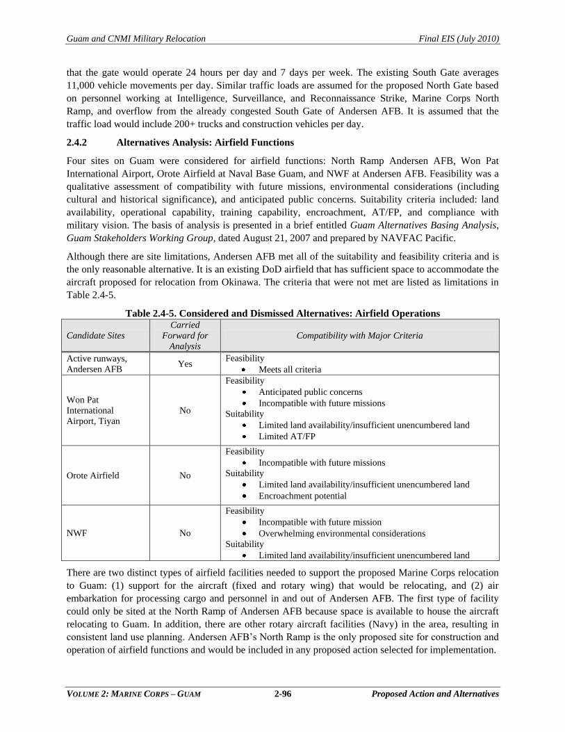
Guam and CNMI Military Relocation Final EIS (July 2010)
VOLUME 2: MARINE CORPS – GUAM 2-96 Proposed Action and Alternatives
that the gate would operate 24 hours per day and 7 days per week. The existing South Gate averages
11,000 vehicle movements per day. Similar traffic loads are assumed for the proposed North Gate based
on personnel working at Intelligence, Surveillance, and Reconnaissance Strike, Marine Corps North
Ramp, and overflow from the already congested South Gate of Andersen AFB. It is assumed that the
traffic load would include 200+ trucks and construction vehicles per day.
2.4.2 Alternatives Analysis: Airfield Functions
Four sites on Guam were considered for airfield functions: North Ramp Andersen AFB, Won Pat
International Airport, Orote Airfield at Naval Base Guam, and NWF at Andersen AFB. Feasibility was a
qualitative assessment of compatibility with future missions, environmental considerations (including
cultural and historical significance), and anticipated public concerns. Suitability criteria included: land
availability, operational capability, training capability, encroachment, AT/FP, and compliance with
military vision. The basis of analysis is presented in a brief entitled Guam Alternatives Basing Analysis,
Guam Stakeholders Working Group, dated August 21, 2007 and prepared by NAVFAC Pacific.
Although there are site limitations, Andersen AFB met all of the suitability and feasibility criteria and is
the only reasonable alternative. It is an existing DoD airfield that has sufficient space to accommodate the
aircraft proposed for relocation from Okinawa. The criteria that were not met are listed as limitations in
Table 2.4-5.
Table 2.4-5. Considered and Dismissed Alternatives: Airfield Operations
Candidate Sites
Carried
Forward for
Analysis
Compatibility with Major Criteria
Active runways,
Andersen AFB Yes
Feasibility
Meets all criteria
Won Pat
International
Airport, Tiyan
No
Feasibility
Anticipated public concerns
Incompatible with future missions
Suitability
Limited land availability/insufficient unencumbered land
Limited AT/FP
Orote Airfield No
Feasibility
Incompatible with future missions
Suitability
Limited land availability/insufficient unencumbered land
Encroachment potential
NWF No
Feasibility
Incompatible with future mission
Overwhelming environmental considerations
Suitability
Limited land availability/insufficient unencumbered land
There are two distinct types of airfield facilities needed to support the proposed Marine Corps relocation
to Guam: (1) support for the aircraft (fixed and rotary wing) that would be relocating, and (2) air
embarkation for processing cargo and personnel in and out of Andersen AFB. The first type of facility
could only be sited at the North Ramp of Andersen AFB because space is available to house the aircraft
relocating to Guam. In addition, there are other rotary aircraft facilities (Navy) in the area, resulting in
consistent land use planning. Andersen AFB‘s North Ramp is the only proposed site for construction and
operation of airfield functions and would be included in any proposed action selected for implementation.
Guam and CNMI Military Relocation Final EIS (July 2010)
VOLUME 2: MARINE CORPS – GUAM 2-97 Proposed Action and Alternatives
Andersen AFB also has a requirement for air embarkation facilities for the Air Force‘s AMC. The Air
Force plans to consolidate its embarkation facilities and relocate to an area at the east end of South Ramp.
Marine Corps embarkation facilities would be co-located with AMC‘s to achieve maximum land use and
operational efficiency. No other reasonable alternatives for air embarkation facilities were identified.
2.4.3 Alternatives Carried Forward for Analysis: Airfield Functions
The Marine Corps requirements for airfield functions would be accommodated at the existing airfield at
Andersen AFB. Other airfields on Guam were eliminated in Step 2 of the alternatives analysis.
Guam and CNMI Military Relocation Final EIS (July 2010)
VOLUME 2: MARINE CORPS – GUAM 2-98 Proposed Action and Alternatives
2.5 PROPOSED ACTION: WATERFRONT FUNCTIONS
2.5.1 Requirements
2.5.1.1 General Overview
Relocation of Marine Corps forces to Guam would result in
frequent embarkation operations to support amphibious
transportation of Guam-based Marines and transiting
amphibious forces for potential contingency, humanitarian, and
exercise operations in the Pacific Theater. The Navy‘s
amphibious task forces and the Marine Expeditionary Unit
(MEU) are transient forces that have traditionally come to
Guam for port visits and training. Frequency of visits is highly
variable based upon operational commitments; however,
transient training events occur approximately twice annually.
Under the proposed action, transient port calls would increase, amphibious task force visits are dependent
on operational requirements but it is anticipated that the task force visits would increase between 2 to 4
annually with the relocation. The composition of the amphibious task force would be dependent on the
specific mission. Typically, there are three ships carrying amphibious vehicles, equipment and personnel
designed to support amphibious operations and an additional four surface combatant ships that escort the
amphibious ships. In addition, naval anti-submarine and strike force surface and subsurface assets may
accompany the task force. Local transport of Marines and supplies between Guam and Tinian not
connected to the visiting MEU would most likely be via airlift (see Volume 3 for more information).
Under the proposed action, MEU training would increase to occur regularly at a minimum of two
additional times per year (for a total of four times per year) for three weeks duration each visit on Guam.
Depending on the mission requirements and training activities planned for the Marianas, the MEU would
travel from Okinawa or California to Guam, and continue on to Tinian; or, alternatively, the MEU would
go directly to Tinian for tactical ship to objective maneuver training. For training on Guam, the aircraft
would beddown at North Ramp Andersen AFB, the amphibious ships would offload personnel and
amphibious craft at Apra Harbor, and troops and equipment would travel administratively to and bivouac
(camp) at proposed training/maneuver areas on Guam. The escort combatant ships may or may not
accompany the amphibious task force.
Existing general purpose Navy wharves in Inner Apra Harbor are currently used by the amphibious task
force during visits by MEUs. In order to accommodate the proposed increase in the number of
amphibious task force visits and use of recent model (class) ships, upgrades to these wharf structures and
utilities, an embarkation area for loading and unloading of ships, and an amphibious vehicle/small boat
laydown area would be required and are proposed.
All training would be a continuation of existing training capabilities within Apra Harbor complex. Hence
amphibious training is not part of the proposed action, but would occur as described in the MIRC
EIS/OEIS.
When in port, the amphibious ships and escort ships listed in Table 2.5-1 would be berthed in Inner Apra
Harbor. In addition, 12 to 15 AAVs, two Rigid Hull Inflatable Boats (RHIB), and eight Combat Rubber
Raiding Craft (CRRC) would be permanently based at the proposed Landing Craft Air
Cushion/Amphibious Assault Vehicle (LCAC/AAV) laydown area as part of the proposed action.
Chapter 2:
2.1 Overview
2.2 Main Cantonment Area
Functions
2.3 Training Functions
2.4 Airfield Functions
2.5 Waterfront Functions
2.6 Summary of Alternatives
Guam and CNMI Military Relocation Final EIS (July 2010)
VOLUME 2: MARINE CORPS – GUAM 2-99 Proposed Action and Alternatives
Table 2.5-1. Amphibious Task Force Ships and Based Amphibious Vehicles and Boats
Proposed Vessel Quantity Permanent/ Visiting Total Wharf Length/
Requirement (ft) Draft (ft)
Ships Carrying Amphibious Vehicles
LHD 1 Visiting 1,044 28
LSD 1 Visiting 710 20
LPD 1 Visiting 669 23
Amphibious Vehicles
LCAC 4 Visiting
(transported on ships) Not applicable
2.8 ft (full stop, no
cushion)
0 ft (navigation)
1-20 inches of
water depression @
18 knots
LCU 4 Visiting
(transported on ships) Not applicable 7 (fully loaded)
AAV- predominantly a land
vehicle Varies
Visiting
(transported on ships) Not applicable 6
AAV 14 Permanent Not applicable 6
Reconnaissance Boats
RHIB/CRRC 2/8 Permanent Not applicable Nominal
Escort Combatants
Guided Missile Cruiser (CG-47) 2 Visiting 1,335 34
Guided Missile Destroyer
(DDG) 2 Visiting 1,210 33
Legend: CRRC = combat rubber raiding craft; LCU = landing craft utility; RHIB = rigid hull inflatable boat.
Although a quantity of ships is specified in Table 2.5-1, the actual number and types of ships would vary
with the amphibious task force mission. The types of ships presented in the table do not differ from those
associated with visiting amphibious task forces that currently berth in Apra Harbor with the existing
approximately two MEUs annually; however, with the relocation of Marine Corps forces to Guam,
amphibious task force mission ships would be berthed in Inner Apra Harbor two additional times annually
(for a total of four annual visits). When the amphibious task force is not in port, the general purpose
wharves would be used by other ships at Port Operations discretion.
The amphibious craft would be deployed from the ―big deck‖ amphibious ships (Amphibious Assault
Ship [LHD], Dock Landing Ship [LSD], and Amphibious Transport Dock [LPD]) either in Inner Apra
Harbor or Outer Apra Harbor, then travel to the proposed amphibious laydown area in Apra Harbor.
These smaller amphibious landing craft would typically include LCAC, and AAVs. The Landing Craft
Utility (LCU) is also currently used in lieu of the LCAC, but is being phased out and, therefore, the
assessment in this EIS is focused on the LCAC. General operational features of these vessels are
described in this section and photos are shown on Figure 2.5-1 and Figure 2.5-2.
LCACs are the largest landing craft. They are pre-loaded from ramps (fore and aft) with land vehicles,
cargo and personnel to deploy within 25 nm (46 km). The LCAC can transport one tank, four AAVs, or
250 personnel. Personnel ride within a prefabricated shell that protects them against spray and noise. The
LCACs are released from the well decks of the amphibious ships. Maximum speed is approximately 50
Figure 2.5-1 Ships
Amphibious Assault Ship (LHD) Joint High Speed Vessels
(JHSV)
Amphibious Transport Dock
(LPD-17)
Dock Landing Ship (LSD-49)
Guided Missile Destroyer (DDG)
Aegis Cruiser (CG-52 through CG-73)
2-100
Figure 2.5-2 Amphibious Ships
Landing Craft, Air Cushion (LCAC) Landing Craft Utility
(LCU)
Assault Amphibious Vehicle (AAV)
Raiding Craft (RIBS)
Combat Rubber Reconnaissance Crafts (CRRC)
2-101
Guam and CNMI Military Relocation Final EIS (July 2010)
VOLUME 2: MARINE CORPS – GUAM 2-102 Proposed Action and Alternatives
knots in smooth seas. They ride above the water on a cushion of air captured under an inflatable skirt
surrounding the craft. Lift fans create the cushion of air between the hull and the water surface or hard
substrate (i.e., coral). LCAC operations depress the surface of the water 12-18 in (309 - 457 mm) and can
create a bow wave. They are designed to cross the high water line and remain on cushion to move inland
before decreasing lift and landing on the ground where cargo is offloaded. When returning to the water,
the lift fans raise the craft 1 to 3 in (25 to 76 mm) and the skirt permits air to escape around the edges.
The LCACs then return to the amphibious ship to be re-loaded.
LCU is a displacement hulled craft with a large open center bay and ramps fore and aft. It can operate in
approximately 8 ft (2.4 m) of water prior to lowering its ramp to the shoreline or pier. An anchor may be
set in rough ocean conditions for added stability. It does not land at beaches protected by offshore shallow
reefs that may damage the hull. It can transport 200 tons of cargo or 200 persons.
AAVs are lightly armored personnel carriers propelled by water jets in the ocean and tracked suspension
in shallow water and on land. The speeds of newer models (Advanced AAV, renamed the Expeditionary
Fighting Vehicle in 2003) are capable of about 25 knots. The tracks engage land at about water depth of
approximately 6 ft (1.8 m). It may be launched directly from the ship or carried by one of the larger
landing craft. Each AAV can carry approximately 23 combat-equipped Marines or five tons of cargo. The
Marines may debark on beach landing or remain on the AAV for inland travel. On land, the AAV is
capable of traveling 25 mph. Each track block is rubber –padded that in turn minimizes damage to paved
roads.
RHIB is a light-weight, high performance and high capacity boat constructed with a solid, shaped hull and
flexible tubes at the gunwale. The inflatable collar allows the vessel to maintain buoyancy if a large
quantity of water is shipped aboard.
CRRCs are used for inserting lightly-armed raiding parties or reconnaissance teams onto beaches, piers,
offshore facilities and larger vessels. The CRRC can be inflated in minutes by foot pump, compressor or
carbon dioxide tank and can be deployed from shore and a variety of vessels. Its chief advantages are
stealth, versatility, lightweight, compact size when stowed, and the safety imparted by its hyper-buoyant
nature, which gives it the ability to operate in relatively high seas for a craft of its size.
When in Apra Harbor, the vehicles and equipment unloaded or being loaded on the ship is subject to
inspection and washdown on arrival and departure to prevent introduction of foreign agricultural and
public health threats. All washdowns are conducted and supervised by trained personnel in accordance
with Armed Forces Technical Guide 31 (Defense Pest Management Information Analysis Center 2004).
USDA personnel participate in inspections. These activities are conducted in a designated paved area with
a washdown area and sufficient space for segregating clean from dirty equipment/vehicles. The BTS is of
particular concern and there is a MOA signed by DoD, USDA, GovGuam, and State of Hawaii that states
these agencies would cooperate with BTS research, control and inspections, and eradication. The
COMNAV Marianas Instruction 5090.10A, Brown Treesnake Control and Interdiction Plan (February 14,
2005) implements this MOA. Special BTS perimeter barriers and sliding chain-link fence gates with
fabric barriers to block all vehicle access points are standard protective measures. All waste onboard the
ship is steam sterilized prior to disposal in regulated landfills in accordance with BMPs and base
operating procedures.
2.5.1.2 Proposed Waterfront Embarkation Projects
There are five waterfront facility projects included in the proposed action, the first two of which are
directly related to amphibious task forces as follows (Figure 2.5-3, projects shaded black):
Guam and CNMI Military Relocation Final EIS (July 2010)
VOLUME 2: MARINE CORPS – GUAM 2-103 Proposed Action and Alternatives
Ship berthing and embarkation/staging area. Includes ships that carry amphibious craft, and
combatant escorts
Amphibious craft (LCAC/AAV) laydown area (i.e., location for storing, maintaining and
deploying amphibious craft)
USCG berthing and crew support building relocation
Military working dog kennel relocation
Apra Medical/Dental Clinic
The USCG and Military Working Dog Kennel (MWDK) relocation projects are required to accommodate
the Marine Corps waterfront project requirements. The fifth project, Apra Medical/Dental Clinic, is also
described in this section. It is not directly related to the amphibious task force waterfront requirements,
but is the only other proposed Marine Corps action requiring construction at Naval Base Guam. Some of
these projects may being construction as early as 2010. The anticipated duration of construction for the
projects is 18-20 months, but that could be accelerated.
Each of these five projects is described in subsequent sections. The sections are organized as follows:
Proposed Facilities and Construction
Proposed Operations
An analysis of alternatives for each project is described in Section 2.5.2.
Waterfront Project: Amphibious Task Force Ship Berthing and Embarkation
Proposed Facilities and Construction
The facilities required to support an amphibious task force include general purpose wharves, a new cargo
staging area/new washdown area, a waterfront operations support facility, and a small
maintenance/equipment storage facility.
The Navy‘s general purpose wharves are on the western side of Inner Apra Harbor. Other wharves are not
general purpose and have specific uses, such as submarine berthing or supply ship berthing. General
purpose berths are used at the discretion of Port Operations based on ship size, requirements (draft of ship
and utility requirements) and wharf availability at the time of arrival; however, ships that are homeported
in Guam are generally assigned a particular wharf that would provide the ship-specific requirements.
Master planning for general purpose wharves requires development of a berthing plan to ensure that there
is enough wharf length to accommodate foreseeable ship arrivals, including the visiting or transient ships
if the majority were in port at one time. In planning, specific ship types are mapped to specific wharves.
In Navy planning the berthing plan is used to justify specific improvement or construction projects. In
reality, once the planning effort is over and wharves are improved to meet the foreseeable range of ships,
Port Operations would assign berths to ships on arrival. The assigned berth may not match the berthing
plan but would meet the wharf and infrastructure requirements of the ship.
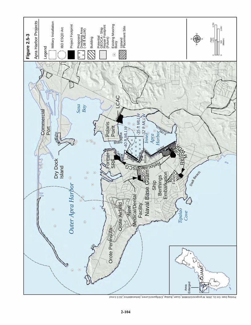
Nav
al B
ase
Gua
mN
aval
Bas
e G
uam
Oro
te P
enin
sula
Oro
te P
enin
sula
Form
er
Form
er
SRF
SRF
Pola
ris
Pola
ris
Poin
tPo
int
Com
mer
cial
Com
mer
cial
Port
Port
LCAC
LCAC
Ship
Ship
Berth
ings
Berth
ings
Emba
rkat
ion
Emba
rkat
ion
New
New
Med
ical
/Den
tal
Med
ical
/Den
tal
Faci
lity
Faci
lity
Alph
aAl
pha
BravoBravo
Lima LimaOscarOscar
Papa
Papa Ta
ngo
Tang
o
SierraSierra
Uniform
Uniform Victor
Victor
X-rayX-ray
Kilo
Kilo
Delta
DeltaE
cho
Ech
o
Out
er A
pra
Har
bor
Out
er A
pra
Har
bor
Inne
rIn
ner
Apra
Ap
ra
Har
bor
Har
bor
Phili
ppin
ePh
ilipp
ine
Sea
Sea
DDaadd
ii BBeeaa
cchh
Tipa
lao
Tipa
lao
Cove
Cove
Oro
te A
irfie
ldO
rote
Airf
ield
Sasa
Sasa
Bay
Bay
-32
ft M
LLW
-35
ft M
LLW
-40
ft M
LLW
Dry
Doc
kD
ry D
ock
Isla
ndIs
land
B316
9B3
169
RRee
llooccaa
ttee
MMWW
DDKK
RReellooccaattee UUSSCCGG
PWC
PWC
Fiel
d 4
Fiel
d 4
Apra
Har
bor P
roje
cts
Figu
re 2
.5-3
Printing Date: Oct 21, 2009, M:\projects\GIS\8806_Guam_Buildup_EIS\figures\Current_Deliverable\Vol_2\2.5-3.mxd
GU
AM
GU
AM
Are
aE
nlar
ged
050
01,
000
Met
ers
03,
750
1,87
5Fe
et
Lege
nd Pro
ject
Foo
tprin
t
IBD
ES
QD
Arc
Mili
tary
Inst
alla
tion
Pot
entia
lG
ED
CA
- Shi
p R
epai
r Foo
tprin
t(F
utur
e)
Bui
ldin
g
Pro
pose
dD
redg
ing
Are
a(-
38 ft
MLL
W)
Exi
stin
g M
oorin
gB
uoy
Upl
and
Pla
cem
ent S
ite
2-104
Guam and CNMI Military Relocation Final EIS (July 2010)
VOLUME 2: MARINE CORPS – GUAM 2-105 Proposed Action and Alternatives
The berthing plan developed for Inner Apra Harbor to address Marine Corps training requirements also
addresses the other anticipated ships visiting Guam. Should a new or unanticipated type of ship visit Apra
Harbor, they too would be able to use the general purpose wharves as long as the minimum draft and
shore side requirements of the specific ship are met. This EIS describes the improvements required
specifically to meet Marine Corps requirements with the understanding that these wharves are available
for use by other ships.
The siting of ships at the general purpose berths was based on Marine Corps requirements for
embarkation operational efficiency while maintaining the operational efficiency of existing waterfront
operations. The Navy Regional Commander made the ultimate determination of where new facilities
would be sited -including where improvements could be made, maximizing use of underutilized wharves
and adjacent areas. Although Inner Apra Harbor has the total wharf length to support the amphibious task
force ship berthing, all of the general purpose wharves of Inner Apra Harbor require repair and utility
upgrades/improvements to meet ship specifications and seismic building codes.
To achieve amphibious task force operational efficiency, the ships that carry amphibious vehicles would
be at contiguous berths and the supporting embarkation facilities would be adjacent to these wharves.
Standard practice is for all ships entering Inner Apra Harbor to be assisted by two tug boats (COMNAV
Marianas 2009).
Victor Wharf is used for transient vessels and USCG owns 200 ft (61 m) of berthing, but the wharf is
generally underutilized. There is adequate area adjacent to Victor Wharf for the port operations building,
and the cargo staging/vehicle wash area can be located a reasonable walking distance (600 ft [183 m])
from the wharf. Victor Wharf met the embarkation requirements for contiguous berthing of the
amphibious task force ship composition. These ships would require the entire length of Victor Wharf
(3,620 ft [1103.4 m]) including the USCG berthing. Relocation of USCG berthing and support facilities is
described as a separate project later in this section. No dredging would be required to accommodate the
amphibious task force ships as the required draft of 28 ft (8.5 m) is accommodated at Victor and Uniform
Wharves, which have a 32 ft (9.7 m) mean lower low water (MLLW) depth. Victor Wharf was
determined to be the operational preference and is underutilized.
This planning process considered the potential berthing of inter-island intermodal passenger/ferry vessels,
including High Speed Vessels (HSVs). An HSV is a high speed catamaran used to ferry cargo and
personnel, which may be used in the future for regional CNMI exercises. Once the amphibious task force
ships were assigned general purpose wharves, Uniform Wharf remained for the berthing of HSVs and
other intermodal ferry or support vessels of limited draft. This would provide operational efficiencies
because the HSV would be berthed in proximity to the embarkation activities at Victor Wharf.
The MWDK is located in the security compound that is adjacent to Victor Wharf and the proposed
embarkation area. The noise generated by the embarkation activities would be disruptive to the dogs;
therefore, the MWDK would be relocated.
Figure 2.5-4 shows the proposed Victor Wharf embarkation facility site plan. The specific facilities and
improvements required are listed in Table 2.5-2. There would likely be phasing or grouping of the project
components under multiple contracts to facilitate continued base operations and continued support for
visiting ships during reconstruction. The reconstruction is estimated to require 26 months. Table 2.5-2
lists the key components of the embarkation waterfront facilities. It is assumed that the construction
would occur from 6:00 a.m. to 5:00 p.m., Monday through Friday and that the construction staging area
would be within the project footprint or nearby on paved or previously developed land.
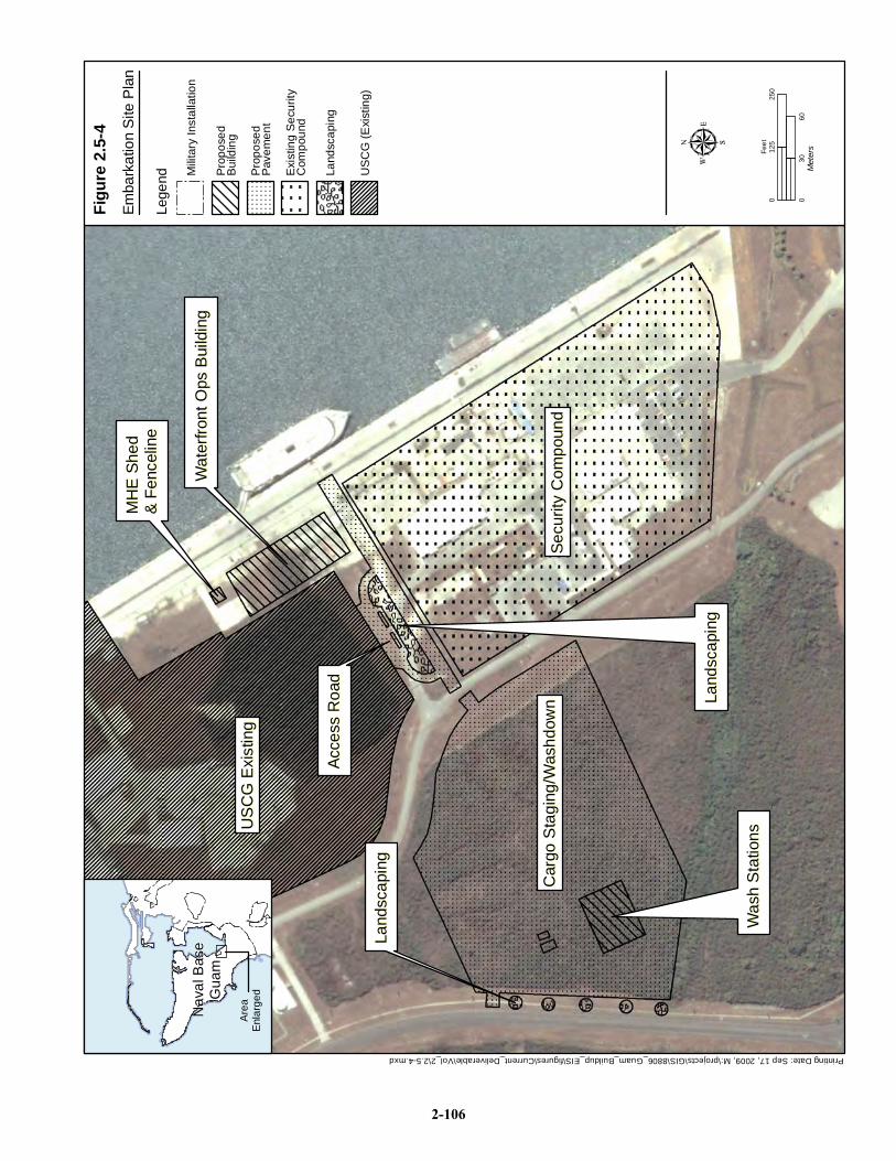
Printing Date: Sep 17, 2009, M:\projects\GIS\8806_Guam_Buildup_EIS\figures\Current_Deliverable\Vol_2\2.5-4.mxd
US
CG
Exi
stin
gU
SC
G E
xist
ing
Secu
rity
Com
poun
dSe
curit
y C
ompo
und
Car
go S
tagi
ng/W
ashd
own
Car
go S
tagi
ng/W
ashd
own
Acce
ss R
oad
Acce
ss R
oad
Wat
erfro
nt O
ps B
uild
ing
Wat
erfro
nt O
ps B
uild
ing
Was
h S
tatio
ns
Was
h S
tatio
ns
Land
scap
ing
Land
scap
ing
Land
scap
ing
Land
scap
ing
MH
E S
hed
MH
E S
hed
& Fe
ncel
ine
& Fe
ncel
ine
Emba
rkat
ion
Site
Pla
n
Figu
re 2
.5-4
Nav
al B
ase
Nav
al B
ase
Gua
mG
uam
Are
aE
nlar
ged
025
012
5Fe
et
030
60M
eter
s
Lege
nd Mili
tary
Inst
alla
tion
Pro
pose
dB
uild
ing
Pro
pose
dP
avem
ent
Exi
stin
g S
ecur
ityC
ompo
und
Land
scap
ing
US
CG
(Exi
stin
g)
2-106
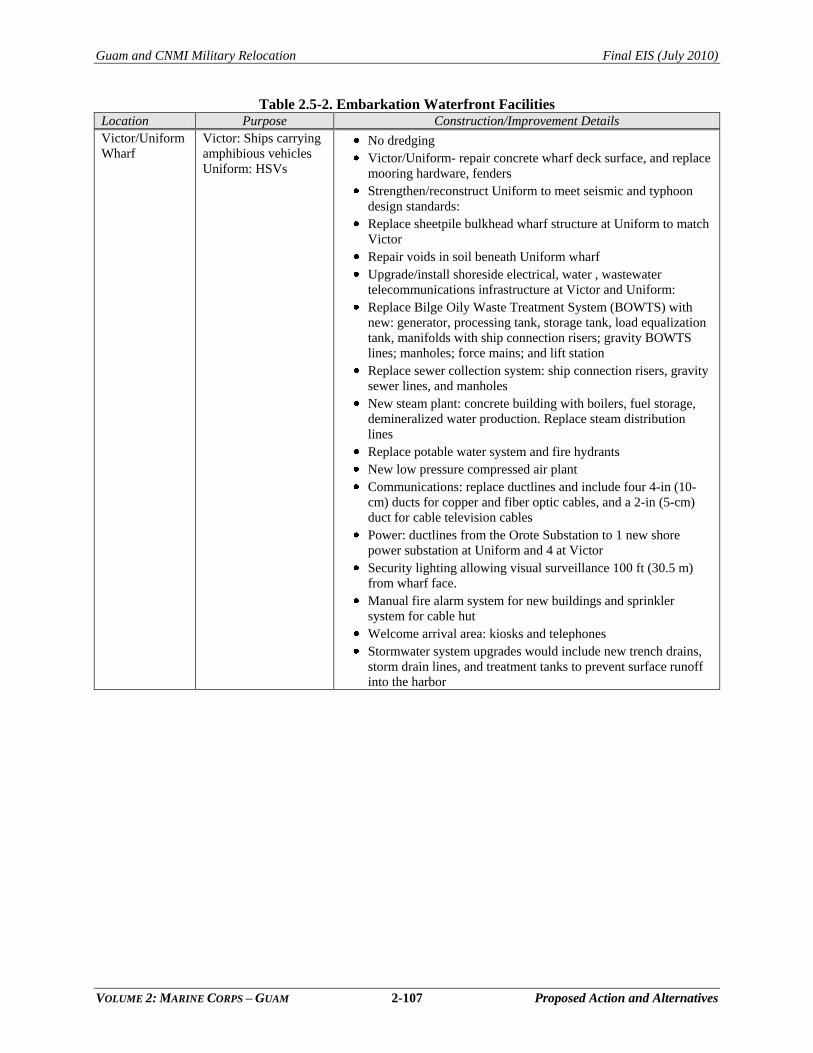
Guam and CNMI Military Relocation Final EIS (July 2010)
VOLUME 2: MARINE CORPS – GUAM 2-107 Proposed Action and Alternatives
Table 2.5-2. Embarkation Waterfront Facilities Location Purpose Construction/Improvement Details
Victor/Uniform
Wharf
Victor: Ships carrying
amphibious vehicles
Uniform: HSVs
No dredging
Victor/Uniform- repair concrete wharf deck surface, and replace
mooring hardware, fenders
Strengthen/reconstruct Uniform to meet seismic and typhoon
design standards:
Replace sheetpile bulkhead wharf structure at Uniform to match
Victor
Repair voids in soil beneath Uniform wharf
Upgrade/install shoreside electrical, water , wastewater
telecommunications infrastructure at Victor and Uniform:
Replace Bilge Oily Waste Treatment System (BOWTS) with
new: generator, processing tank, storage tank, load equalization
tank, manifolds with ship connection risers; gravity BOWTS
lines; manholes; force mains; and lift station
Replace sewer collection system: ship connection risers, gravity
sewer lines, and manholes
New steam plant: concrete building with boilers, fuel storage,
demineralized water production. Replace steam distribution
lines
Replace potable water system and fire hydrants
New low pressure compressed air plant
Communications: replace ductlines and include four 4-in (10-
cm) ducts for copper and fiber optic cables, and a 2-in (5-cm)
duct for cable television cables
Power: ductlines from the Orote Substation to 1 new shore
power substation at Uniform and 4 at Victor
Security lighting allowing visual surveillance 100 ft (30.5 m)
from wharf face.
Manual fire alarm system for new buildings and sprinkler
system for cable hut
Welcome arrival area: kiosks and telephones
Stormwater system upgrades would include new trench drains,
storm drain lines, and treatment tanks to prevent surface runoff
into the harbor
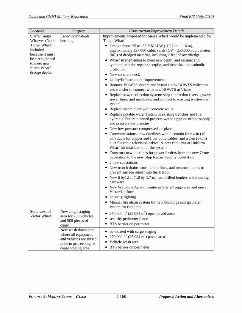
Guam and CNMI Military Relocation Final EIS (July 2010)
VOLUME 2: MARINE CORPS – GUAM 2-108 Proposed Action and Alternatives
Location Purpose Construction/Improvement Details
Sierra/Tango
Wharves (Note:
Tango Wharf
included
because it must
be strengthened
to meet new
Sierra Wharf
dredge depth.
Escort combatants‘
berthing
Improvements proposed for Sierra Wharf would be implemented for
Tango Wharf:
Dredge from -35 to -38 ft MLLW (-10.7 to -11.6 m),
approximately 327,000 cubic yards (CY) (250,000 cubic meters
(m3)) of dredged material, including 2 feet of overdredge
Wharf strengthening to meet new depth, and seismic and
typhoon criteria: repair sheetpile, and tiebacks, and cathodic
protection
New concrete deck
Utility/Infrastructure Improvements:
Remove BOWTS system and install a new BOWTS collection
and transfer to connect with new BOWTS at Victor
Replace sewer collection system: ship connection risers, gravity
sewer lines, and manholes; and connect to existing wastewater
system
Replace steam plant with concrete walls
Replace potable water system in existing trenches and fire
hydrants. Future planned projects would upgrade offsite supply
and pressure deficiencies
New low pressure compressed air plant
Communications: new ductlines would contain four 4-in (10-
cm) ducts for copper and fiber optic cables, and a 2-in (5-cm)
duct for cable television cables. A new cable hut at Uniform
Wharf for distribution of the system
Construct new ductlines for power feeders from the new Orote
Substation to the new Ship Repair Facility Substation
2 new substations
New trench drains, storm drain lines, and treatment tanks to
prevent surface runoff into the Harbor
New 6 by12-ft (1.8 by 3.7-m) foam filled fenders and mooring
hardware
New Welcome Arrival Center in Sierra/Tango area and one at
Victor/Uniform
Security lighting
Manual fire alarm system for new buildings and sprinkler
system for cable hut
Southwest of
Victor Wharf
New cargo staging
area for 230 vehicles
and 500 pieces of
cargo
270,000 ft2 (25,084 m2) open paved areas
security perimeter fence
BTS barrier on perimeter
New wash down area
where all equipment
and vehicles are rinsed
prior to proceeding to
cargo staging area
co-located with cargo staging
270,000 ft2 (25,084 m2) paved area
Vehicle wash area
BTS barrier on perimeter
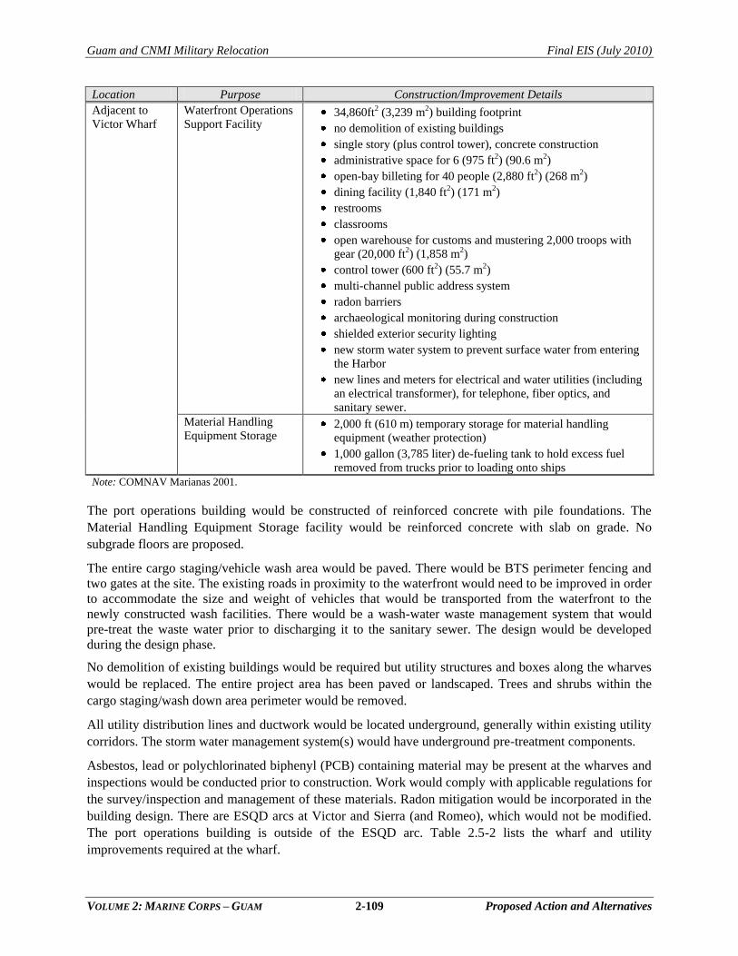
Guam and CNMI Military Relocation Final EIS (July 2010)
VOLUME 2: MARINE CORPS – GUAM 2-109 Proposed Action and Alternatives
Location Purpose Construction/Improvement Details
Adjacent to
Victor Wharf
Waterfront Operations
Support Facility 34,860ft2 (3,239 m2) building footprint
no demolition of existing buildings
single story (plus control tower), concrete construction
administrative space for 6 (975 ft2) (90.6 m2)
open-bay billeting for 40 people (2,880 ft2) (268 m2)
dining facility (1,840 ft2) (171 m2)
restrooms
classrooms
open warehouse for customs and mustering 2,000 troops with
gear (20,000 ft2) (1,858 m2)
control tower (600 ft2) (55.7 m2)
multi-channel public address system
radon barriers
archaeological monitoring during construction
shielded exterior security lighting
new storm water system to prevent surface water from entering
the Harbor
new lines and meters for electrical and water utilities (including
an electrical transformer), for telephone, fiber optics, and
sanitary sewer.
Material Handling
Equipment Storage 2,000 ft (610 m) temporary storage for material handling
equipment (weather protection)
1,000 gallon (3,785 liter) de-fueling tank to hold excess fuel
removed from trucks prior to loading onto ships
Note: COMNAV Marianas 2001.
The port operations building would be constructed of reinforced concrete with pile foundations. The
Material Handling Equipment Storage facility would be reinforced concrete with slab on grade. No
subgrade floors are proposed.
The entire cargo staging/vehicle wash area would be paved. There would be BTS perimeter fencing and
two gates at the site. The existing roads in proximity to the waterfront would need to be improved in order
to accommodate the size and weight of vehicles that would be transported from the waterfront to the
newly constructed wash facilities. There would be a wash-water waste management system that would
pre-treat the waste water prior to discharging it to the sanitary sewer. The design would be developed
during the design phase.
No demolition of existing buildings would be required but utility structures and boxes along the wharves
would be replaced. The entire project area has been paved or landscaped. Trees and shrubs within the
cargo staging/wash down area perimeter would be removed.
All utility distribution lines and ductwork would be located underground, generally within existing utility
corridors. The storm water management system(s) would have underground pre-treatment components.
Asbestos, lead or polychlorinated biphenyl (PCB) containing material may be present at the wharves and
inspections would be conducted prior to construction. Work would comply with applicable regulations for
the survey/inspection and management of these materials. Radon mitigation would be incorporated in the
building design. There are ESQD arcs at Victor and Sierra (and Romeo), which would not be modified.
The port operations building is outside of the ESQD arc. Table 2.5-2 lists the wharf and utility
improvements required at the wharf.
Guam and CNMI Military Relocation Final EIS (July 2010)
VOLUME 2: MARINE CORPS – GUAM 2-110 Proposed Action and Alternatives
Victor, Sierra, and Tango Wharves. Existing wharves are steel sheet pile bulkhead constructed of MZ-38
section steel sheet piles that are laterally supported by 2-3/8 in-diameter (6 cm) tie rods. The bulkhead has
a concrete cap/seawall, which extends 2 ft (0.6 m) below the MLLW elevation and encases the internal
wale. There is a utility trench in the asphalt. The condition of these wharves is similar. There are
sinkholes/depressions in the wharf deck that would be repaired. The sinkholes in the deck would be back
filled and paved with asphalt as a safety consideration. Concrete spalling and cracks in the concrete
seawall would be repaired. The spalls in the concrete cap could be repaired by removing any loose
concrete, installing forms over the spalls, and pumping them with concrete to ensure the long-term
durability of the structure. Where there is no cathodic protection the sheet pile is subject to corrosion.
Cathodic protection would be installed where it is missing and depleted sacrificial nodes replaced. Steel
plates would be welded over holes in the sheet pile grout. The term tremie concrete refers to the pipe used
to transfer concrete underwater, in this case, to fill voids near piers and/or abutments. The tremie typically
consists of a vertical steel pipe, the lower end of which is designed to remain immersed in the concrete or
grout (a mixture of cementitious material and water, with or without aggregate, proportioned to produce a
pourable consistency) that is being pumped into the void so that a minimum amount of material comes in
contact with the surrounding water. The repair methodology has not been determined, but this is one
option for repairing the voids. Mooring hardware, fenders and utility covers would be replaced.
Wharf Repairs. All of the wharves in Apra Harbor have sustained earthquake damage in the past (e.g., the
1993 earthquake) and Uniform Wharf is in the worst condition compared to Victor, Sierra and Tango
Wharves. The top of the deck is generally in poor condition, with two areas of continuous depressions and
one large sinkhole, up to several feet deep, located along the entire top of the deck. There are vertical
stress cracks and the north end of the bulkhead is displaced. There are holes in the sheet pile bulkhead.
Further investigations of the tie-back system are required to determine the extent of the repair. The repairs
to Victor and Sierra (and Tango) are listed in Table 2.5-2. The proposed action does not require the
additional wharf length of Tango Wharf; however, structural improvements are required to avoid
structural failure when the adjacent area fronting Sierra Wharf is dredged. Utility upgrades and other
improvements would be implemented concurrently with Sierra Wharf improvements for maximum cost
effectiveness. These improvements are addressed in this EIS.
Wharf improvement contractors would ensure that construction debris does not enter or impact navigable
waters. All applicable local, state and federal certifications and permits would be obtained prior to
construction, including: Department of Army permit under Section 10 of the Rivers and Harbors Act,
Section 404 of the Clean Water Act and Guam Environmental Protection Agency Section 401 Water
Quality Certification.
Wharf restoration would likely be conducted using a barge. Demolition waste would consist primarily of
concrete or asphalt. Metal would be segregated from the waste for recycling. Demolition debris would be
retained on the construction platform and prevented from dropping into the bay. The debris would be
offloaded by crane at Romeo or Uniform Wharf into trucks. To the extent possible, and consistent with
Navy guidance, construction debris would be recycled.
Dredging. The proposed dredging footprint at Sierra Wharf is shown on Figure 2.5-3. The dredge volume
is in Table 2.5-2. Appendix D in Volume 9 of this EIS has additional information on dredging. The
inverted angular shape of the dredge area shown on the northern boundary is the delineation of the
recently completed (2008) Alpha/Bravo dredging to a new construction depth of -40 ft (-12.2 m). There
are two general types of dredging operations that could be implemented: mechanical dredging operations
and hydraulic dredging operations. The operations vary by the method used to loosen the material from its
Guam and CNMI Military Relocation Final EIS (July 2010)
VOLUME 2: MARINE CORPS – GUAM 2-111 Proposed Action and Alternatives
in situ state and transport the material from the seafloor to the water surface. The type of dredging
equipment that is used would affect the characteristics of the dredged material. Differences in dredged
material characteristics resulting from dredging methods as well as logistical considerations relevant to
the use of mechanical and hydraulic dredges are described in Appendix D in Volume 9 of this EIS. The
dredging method historically used in Guam is mechanical dredging with a barge-mounted crane attached
to clamshell buckets to retrieve the sediment and deposit it on a scow (barge). It is likely that this method
would be used for the proposed dredging; however, the decision would not be made until the final design.
The project would likely be a design/build contract that would not be awarded until this EIS process has
been completed with an approved, signed and published Record of Decision. Mechanical dredging is
assessed as the maximum adverse environmental impact method of dredging in this EIS. The method of
dredging would be determined from the final design; however, the one minimizing impacts would be
chosen if practicable. Informal consultation with agencies and approval by USACE would be required for
either dredging method. The construction tempo is assumed to be 24 hours per day for dredging activity
for a construction duration of 8 to 12 months.
A Rivers and Harbors Act, Section 10 (33 USC 403), Clean Water Act (CWA), Section 404 (33 USC
1344), and Marine Protection Research and Sanctuaries Act Section 103 (USC 1413) permit application
would be submitted to the USACE for approval and would be reviewed by other regulatory agencies.
USACE Section 10/404/103 permit is the abbreviated reference for the three permits that are reviewed
under one application. Site-specific Best Management Practices would also be developed in coordination
with federal agencies and incorporated in this EIS as they become available and included in the USACE
permit application.
Sediment Characterization. Sediment characterization data for the Sierra Wharf (and the two alternative
aircraft carrier wharf locations described in Volume 4) site suggest most, if not all, of the material would
meet the testing criteria and be suitable for upland placement, or Ocean Dredged Material Disposal Site
(ODMDS) (NAVFAC Pacific 2006). Chapter 4, Water Resources, summarizes the sediment
characterization data. No Navy dredging project on Guam has required designation of an upland site for
the treatment or remediation of sediment. None is anticipated for this proposed action. This EIS relies on
the existing sediment characterization results to assess impacts. Laboratory data are generally considered
valid for a three-year period and additional analysis per 40 Code of Federal Regulations (CFR) Part 227
would be the basis of a dredged material management plan that would be included in the USACE Section
404/10/103 permit application. It is possible that multiple disposal methods would be appropriate for the
project.
Dredged Material Disposal. This EIS considers five potential disposal scenarios: 100% ODMDS
disposal, 100% upland placement, 100% beneficial reuse, 50% beneficial reuse/50% ocean disposal, and
20-25% beneficial reuse/75-80% ocean disposal, which are discussed further below.
Under the 100% upland placement scenario, five upland placement sites on Navy land were identified in
the Draft EIS for potential use in support of the proposed dredging action. These sites are referred to as
Field 3, Field 4, Field 5, Public Works Center (PWC) Compound and Polaris Point and are described in
Appendix D (Volume 9). Fields 3 and 5 and Polaris Point have been proposed for other dredging projects
and have been addressed in other NEPA documents. Field 4 and PWC Compound sites are addressed in
this EIS. Two of the alternative sites, Polaris Point and Field 5, were noted in the Draft EIS to have
sufficient capacity to accommodate all of the anticipated dredged material from the proposed action with
modification of existing berms at the sites. Thus, used in combination with ODMDS and beneficial reuse,
only a portion of the candidate sites would be required to accommodate the dredged material. Recent
Guam and CNMI Military Relocation Final EIS (July 2010)
VOLUME 2: MARINE CORPS – GUAM 2-112 Proposed Action and Alternatives
preliminary information from the upland placement study supplemental review has indicated that there
may be substantially less upland capacity available on the five confined disposal facilities on Navy lands.
Due to land use changes, Field 4, the PWC Compound, and the Polaris Point CDFs may not be available
for upland placement. Capacity may be reduced in Field 5 due to cell construction to separate different
types of materials. Field 3 remains a suitable option for upland placement
Beneficial reuse is the preferred disposal option for clean dredged material when practical. The material
must meet engineering specifications for the specific beneficial reuse. A number of opportunities for
beneficial use have been identified, including beach re-nourishment, backfill for a commercial port
expansion, construction material for roads, or daily landfill cover. Prior to beneficial use, the dredged
material must be tested to ensure it meets the engineering specifications for the proposed reuse. If a
beneficial reuse is not identified for this dry material it would occupy valuable space that could otherwise
be available for more dredged material.
Between 1 to 1.1 million cubic yards (CY) (765 to 841 million cubic meters {m3}) of dredged material
would be excavated from the Inner and Outer Apra Harbor for the proposed Marine Corps and Navy
actions. The dredged material is expected to consist of a mixture of sediments including sand from the
outer harbor and silts/clays from the inner harbor. Additionally, there would be coral fragments and other
submerged rubble that would be included in the volume of dredged material from the outer harbor
dredging.
Beneficial reuse of portions of this total volume would be possible and several local projects have been
identified. These local projects include:
Support shoreline stabilization below Aircraft Carrier Wharf: As part of the construction
process, some fill would be used with the rip rap stone that would be placed along the
shoreline and under the wharf to support the piles. Approximately 40,000 cy of quarry stone
in addition to an estimated 20,000 cy of rip rap stone is envisioned for this stabilization
purpose. It is possible that some of the rubble or some other suitable material from the
dredged material could be used and mixed in below the quarry stone layer. Therefore, it is
estimated that approximately 50% of the quarry stone amount or 20,000 cy of the dredged
material could be used.
Fill of berms and backstops at proposed military firing ranges on Guam: There are a number
of berms and backstops that would be constructed as part of the development of new military
firing ranges on Guam. The berms range in length from 35 to 255 ft (11 to 78 m); 7 to 56 ft
(2 to 17 m) in width; and 3 to 7 ft (1 to 2 m) in height. Fill would be used to create these
earthen mound structures. The volume within these berms and backstops has been calculated
and equals an estimated 160,000 cy.
Port Authority of Guam (PAG) modernization program: Phase 2 of PAG‘s modernization
program includes construction of a new berth (F7) and additional terminal capacity to the east
to meet long-term organic growth. Creation of the new berth would require dredging and may
entail land reclamation (i.e., placement of fill in Apra Harbor), removal of existing derelict
vessels, and the addition of 900 ft (300 m) of berthing/wharf space. The project is not funded
and 2030 is the estimated year of construction. The Navy has a memorandum of agreement
with PAG to provide fill from proposed dredging projects should the material be deemed
suitable and the timing and logistics of both projects work out.
Guam and CNMI Military Relocation Final EIS (July 2010)
VOLUME 2: MARINE CORPS – GUAM 2-113 Proposed Action and Alternatives
Given the potential availability of these upland beneficial use projects on Guam, the following five
scenarios are possible for the disposal or placement of the proposed dredging projects in the inner and
outer Apra Harbor:
100% beneficial use with all dredged material being used as artificial fill for the PAG
expansion program (either direct waterfront placement or following placement at PAG upland
placement site);
20-25% beneficial use of dredged material in berm construction and under wharf for shore
and pile stabilization (assumes no PAG need and/or logistics/approval problems for use of
fill) and 75 to 80% ODMDS placement;
100% upland placement on existing Navy confined disposal facilities on base on Apra
Harbor;
100% placement in the Guam ODMDS; and
50% placement in the Guam ODMDS and 50% beneficial reuse.
The U.S. Environmental Protection Agency (USEPA) is pursuing the designation of an ODMDS
approximately 11 to 14 nm (20 to 26 km) from the west coast of Apra Harbor. The designation is
anticipated in 2010 and an ODMDS EIS is being prepared concurrent with this EIS. Ocean disposal is
regulated under Title 1 of the Marine Protection, Research, and Sanctuaries Act (33 USC 1401 et seq).
Formal designation of an ODMDS does not constitute approval of dredged material for ocean disposal.
Results from additional analysis and testing would be required to develop a dredged material management
plan and the USACE Section 404/10/103 permit application. Ocean disposal is only allowed when
USEPA and USACE determine that the project dredged material: 1) is environmentally suitable according
to testing criteria, as determined from the results of physical, chemical, and bioassay/ bioaccumulation
testing that is briefly described in Section 2.7 (USEPA and USACE 1991); 2) does not have a viable
beneficial reuse; and 3) there are no practical land placement options available. Any dredged material
deemed not suitable for ocean disposal would need to be placed on land as the method of disposal.
Volume 9, Appendix D contains additional detail about dredging issues related to the proposed action,
including potential dredging methods that could be used, Alternatives for reusing or disposing of dredged
material, and specific assumptions made in the EIS analysis.
Proposed Operations
This section provides more detail on the specific proposed projects on the western side of Inner Apra
Harbor. The duration of each amphibious task force visit would range between 6 and 21 days. A typical
schedule on Guam is shown in Table 2.5-3. Distribution throughout the year may vary, due to the
subjective and mission-dependent nature of MEU-level events. Inclement weather may also impact event
schedules.
Table 2.5-3. Approximate MEU Administrative/Non-Tactical Event Schedule 2–3 Days 2 Days 5 Days 2 Days 2–3
Agricultural
Inspections Debarkation/Set-up
Active Firing
Range Use Clean-Up
Agricultural
Inspections
The MEU training would bring approximately 2,000 additional military personnel to Guam as a transient
(i.e., visiting) population. They would not be provided housing or be using on- or off-base amenities
(except during periods of leave and liberty). They would be camping and training 24-hours per day. The
MEU may train on Guam or continue to Tinian after a Guam port call. The amphibious task force ships
would continue to occupy a majority of the wharves in western Inner Apra Harbor. The ships carrying
Guam and CNMI Military Relocation Final EIS (July 2010)
VOLUME 2: MARINE CORPS – GUAM 2-114 Proposed Action and Alternatives
amphibious vessels would berth near the embarkation facilities. The combatant escort ships would berth
at other Inner Harbor Wharves. Specific wharf assignments are determined by operational requirements
by Naval Base Port Operations.
The Port Operations Group is part of the on-island Marine Logistics Group (CLR-37). They work closely
with Base Operations to provide logistics support at the waterfront before, during and after amphibious
task force visits. They are provided administrative space and a port control tower in a stand-alone
building at the waterfront. They would support other training events when the amphibious task force is
not in port.
Cargo arrives in Guam preloaded on trucks (or LCACs) that are transported by the amphibious task force
ships. If there is a training mission on Guam, the trucks drive off the ships‘ stern ramps. Other cargo may
be offloaded by mobile crane. Large 50,000-pound-capable forklifts, assigned to the CLR-37, would be
used to move the cargo and would be stored temporarily in a material handling equipment building at the
waterfront. No maintenance of equipment or vehicles is anticipated in the support buildings.
Biennial Reporting System inspections would be conducted with significant involvement of USDA
personnel based on procedures developed in the Biosecurity Plan. Wash racks are raised platforms with
ramps at either end that facilitate cleaning of undercarriages. The design system assumptions are based on
a description of a similar facility on Guam that was never built (COMNAV Marianas 2001). Vacuum,
high pressure water and steam would be provided in addition to a wash water waste treatment system. The
facility would include sedimentation, oil/water separation/filter pressure booster pumps and pressure, and
filters. The filtered water would be stored on site and fresh water would be added to make up losses from
recycling. When washing is complete, wastewater from the systems would drain to the sanitary sewer.
Final design of wash system is pending.
Shipboard solid waste would be steam-cleaned prior to disposal in the Navy landfill or other on-island
landfill, such as the GovGuam proposed landfill in Dandan. Any regulated or hazardous waste would be
managed in accordance with base Standard Operating Procedures.
Personnel, cargo, and equipment would travel in trucks, buses, and HMMWV or Humvee on civilian
roads to a bivouac/expeditionary camp site at Andersen South or other training venue. It is anticipated
that these transport events would occur during evening hours or other non-peak travel hours to avoid peak
traffic periods. Approximately 15 trucks would travel as a group, with distance and time between
caravans to minimize interruptions to civilian traffic flow. The number of trips varies with the mission.
On return to the wharf, the vehicles and equipment would be inspected and washed prior to being loaded
onto the ships carrying amphibious vehicles. The amphibious task force would arrive fully supplied to
meet all training requirements or would be replenished, as needed, prior to training on Tinian.
Prior to being loaded on the ships, trucks may be required to offload fuel and there would be a 1,000
gallon above ground storage tank at the wharf for holding this fuel.
During embarkation events, the amount of noise generated would be typical of large congregations of
people, buses, and trucks. There would be diesel equipment (i.e., forklifts) to move cargo.
When there are no Marine Corps operations at the site, other transient ships would be berthed at Victor
Wharf at Port Operations Department discretion. Transient vessels may be permitted to use port
operations facilities.
All facilities would have security lights mounted on either buildings or steel poles. Lighting along the
wharves would consist of 1,000 watt high pressure sodium floodlights mounted on new or existing poles.
Guam and CNMI Military Relocation Final EIS (July 2010)
VOLUME 2: MARINE CORPS – GUAM 2-115 Proposed Action and Alternatives
The lighting would be shielded and aimed such that the majority of the illumination would be directed
towards the wharf deck and extend over water about 100 ft (30.5 m) to satisfy security requirements. No
other aerial structures are proposed.
Due to the frequency and duration of the amphibious task force visits, the ships require more shoreside
utility support than is currently provided. The requirement for transient ship support, as described in
Volume 4, is that ships should be provided full service utility infrastructure support to enable them to turn
off their shipboard systems and rely on shoreside utilities for maintenance and repair activities. Under the
proposed action, there would be utility, infrastructure and wharf improvements at Victor, Uniform and
Sierra Wharves to allow the ships to turn-off all onboard utility systems and rely entirely on shoreside
systems for communications, cable, wastewater, water, BOWTS, fire protection, compressed air and
steam. The specific improvements are listed in Table 2.5-2. The new BOWTS facility would be
constructed at Victor Wharf but serve other wharves including Sierra and Uniform Wharves.
Stormwater would be pre-treated to remove contaminants prior to discharge into the Harbor. The design
would be developed during the design phase. There would likely be multiple systems to cover the entire
project area. The system would be designed to a typical Guam storm event, not a 100-year storm.
The wharves were constructed in 1946 and all sustained damage in a severe earthquake in 1993. Uniform
Wharf is not in use because of the extent of the damage. It would be reconstructed to accommodate a
depth of -32 ft (-10 m) to match Victor Wharf‘s structure. Cathodic protection would be provided and the
design would meet seismic and typhoon resistance standards. Soil voids beneath the deck would be
repaired.
Waterfront Project: LCAC/AAV Laydown Area
Proposed Facilities and Construction
The LCAC/AAV laydown needs to be remote from other operations because of the noise and spray
associated with the LCACs. An alternatives analysis was conducted as described below. The only site that
is retained for this EIS analysis is in the northeast corner of Inner Apra Harbor southeast of Alpha Wharf.
The site plan is shown on Figure 2.5-5.
The proposed site is on DoD land, vacant, within a man-made fill area. No land use constraints were
identified. A new asphalt access road is required that connects with Marine Drive. No traffic signal is
proposed, but standard traffic management practices would be followed. Utilities (wastewater, potable
water, communications, and power) would be extended to the site from Marine Drive.
The entire site (468,000 ft2 [43478.6 m2]) would be developed. Four buildings proposed at the site are
listed in Table 2.5-4.
Table 2.5-4. LCAC/AAV Laydown Area Buildings Facility Area ft2/m2
AAV Maintenance Shop 2,131/198
AAV Communications/Electrical Shop 4,080/379
Hazardous materials/flammables Storage 40/3.7
Reconnaissance Boat Shop 8,670/805
Source: NAVFAC Pacific 2009.
LCAC/AAV LaydownFigure 2.5-5
Former Former SRFSRF
Polaris Polaris PointPoint
LCAC/AAVLCAC/AAVProjectProject
Alpha
Bravo
Lim
aLi
ma
Osc
ar
Papa
rrarra Escorts
BayBay
Big Blue ReefBig Blue Reef
Outer Apra HarborOuter Apra Harbor
Inner Inner Apra Apra
HarborHarbor
Dry Dock
AAVAAVLaydownLaydownDismissedDismissed
LCACLCACLaydownLaydownDismissedDismissed
FutureFutureGEDCAGEDCALease AreaLease Area
ALTERNATIVE SITESALTERNATIVE SITES
0 170 340Meters
0 1,200600Feet
Naval BaseNaval BaseGuamGuam
AreaEnlarged
InnerInnerApraApra
HarborHarbor AAV MaintenanceAAV Maintenance(4,080 ft(4,080 ft 22))
LCAC LaydownLCAC Laydown(152,640 ft(152,640 ft 22 ))
Open SpaceOpen Space(86,500 ft(86,500 ft 22 ))
Small Boat RampSmall Boat Ramp(1,510 ft(1,510 ft 22 ))
MEU Vehicle StagingMEU Vehicle Staging(60,550 ft(60,550 ft 22 ))
New Access RoadNew Access Road(1,047 ft)(1,047 ft)
TaxiwayTaxiway(18,820 ft(18,820 ft 22 ))
AAV LaydownAAV Laydown(28,300 ft(28,300 ft 22 ))
ParkingParking(10,600 ft(10,600 ft 22 ))
LCAC Ramp LCAC Ramp 2% Slope2% Slope(22,370 ft(22,370 ft 22 ))
AAV Boat ShopAAV Boat Shop(8,670 ft(8,670 ft 22 ))
New Electric LineNew Electric Line
SITE PLANSITE PLAN
0 50 100Meters
0 375187.5Feet
Prin
ting
Dat
e: J
ul 8
, 200
9, M
:\pro
ject
s\G
IS\8
806_
Gua
m_B
uild
up_E
IS\fi
gure
s\C
urre
nt_D
eliv
erab
le\V
ol_2
\2.5
-5.m
xd
Legend
ProposedElectric Line
ProposedLandscaping
ProposedPavement
ProposedBuilding
Legend
Project Footprint
FutureGEDCA Lease Area
IBD ESQD Arc
2-116
Guam and CNMI Military Relocation Final EIS (July 2010)
VOLUME 2: MARINE CORPS – GUAM 2-117 Proposed Action and Alternatives
The majority of the site would be paved for use as an LCAC parking apron, taxiway and landing ramp,
and AAV ramp and parking area. There would also be parking (10,600 ft2 [984.8 m2]) provided for
personal vehicles and a MEU vehicle staging area (60,550 ft2 [5,625.3 m2]). A vehicle wash facility,
which has not yet been sited, would be provided to rinse the salt water from the vessels. A 2,500 gallon
(9,464 liter) tank for fresh water would be at the site and the washrack design may include recycling and
pre-treatment. Washwater runoff treatment and reuse would be incorporated into the final design. The
design of this wash facility would be smaller and less complex than the wash facility proposed at the
cargo laydown area near Victor Wharf.
The facility perimeter would be a concrete BTS barrier except the 30 ft (9 m) gate, which would have
BTS-deterrent mesh fabric. The fence would be dual purpose: BTS deterrence and security.
The buildings would be reinforced concrete slab on grade and designed to resist 170 mph winds and meet
Guam seismic standards. The design would meet LEED silver criteria. Stormwater would be pre-treated
prior to discharge into the harbor.
The site is undeveloped and no demolition would be required. Vegetation including trees and shrubs
would be removed from the site. The entire project area (468,000 ft2 [43478.7 m2]) would be graded and
grubbed. The construction staging area would be located within the development area. The area is within
the wildlife Overlay Refuge. There are no mangroves/wetlands identified at the laydown site or access
road area.
In-water work would consist of two new concrete ramps, which are similar to recreational boat ramps
observed at marinas. The slope of the AAV ramp would range between 12 and 15%. Ramp surface would
be paved down to an elevation of 3 ft (0.91 m) below extreme low water. The top would be rounded over
on a 20 ft (6.1 m) vertical curve until it becomes nearly level at about 2 ft (0.6 m) above extreme high
water. The single lane AAV ramp would be approximately 15-ft (4.57-m) wide. Any part of the ramp that
must be placed underwater would be of precast sections. The LCAC ramp has a 2% slope requirement
and construction would be similar to the AAV ramp. Construction would likely be during daylight hours
only, Monday through Friday, but there is potential for a 7-day work week.
Proposed Operations
On average, four LCACs and 12 to 15 AAVs would participate in the MEU activities on Guam. In Apra
Harbor, the LCACs and AAVs would launch from the ship in Inner or Outer Apra Harbor and travel to a
proposed laydown area near Alpha Wharf at Polaris Point.
The AAV and LCAC could be berthed at a wharf but it is easier to unload cargo and vehicles from the
vessels on land. With the proposed project, the LCAC and the AAV would each have a dedicated ramp to
access their respective laydown areas, which are adjacent to each other in the same BTS ―safe‖ zone. The
ramps are designed for one vessel at a time. Each vehicle would be rinsed on arrival to remove sand and
salt spray. The vehicles may be carrying cargo to the laydown area and conversely cargo might be loaded
onto the vehicles at the laydown area. With each MEU event, an estimated 15-20 LCAC loads (including
personnel, equipment, and cargo) would be transited sea to shore from the LHD, LSD, and/or LPDs in
Outer Apra Harbor to the proposed LCAC/AAV laydown area upon the arrival and departure and of the
visiting amphibious task force ships. These transits would occur in tandem between the hours of 0700 and
1900 and would adhere to speeds consistent with the Inner Apra Harbor no wake zone. If cargo is loaded
or unloaded at the LCAC/AAV laydown area, agricultural inspection is required as described for the
embarkation cargo staging area at Victor Wharf.
Guam and CNMI Military Relocation Final EIS (July 2010)
VOLUME 2: MARINE CORPS – GUAM 2-118 Proposed Action and Alternatives
Each vehicle would be rinsed on arrival to remove sand and salt spray, which deters corrosion and
increases vessel efficiency.
AAVs produce noise comparable to a diesel powered boat on water. On land, the AAV tracks generate
noise when moving on hard surfaces.
LCACs are powered by gas turbines using two large shrouded propellers at the stern for forward
propulsion. The thrust from the propellers is up to 32,000 lb in forward mode. Two bow thrusters are
rotated as a pair with 360 degree capability. During forward movement the thrusters are pointed aft. The
bow thrusters are fed by the lift system; therefore, sand, gravel or other debris on the ground that gets
sucked into the intake points would be thrust out of the bow thrusters at high velocity (5,050 lb is the
maximum thrust in forward motion). Impacts 100 yd (91.44 m) away have been noted (anecdotal
observation). LCACs generate a significant amount of noise that is generated primarily by the fans and
propellers, not the engines that power these systems. The number of personnel on the laydown area during
LCAC operations is restricted to minimum number of trained personnel to maximize safety. The
following assumptions are made regarding LCAC operations in Apra Harbor:
Departure: LCACs would be at idle power for 4 minutes in the parking stall, depart the stall
and taxi at 5 knots to the ramp, and accelerate at the ramp hitting the ocean at 20 knots before
decelerating and operating at a speed that does not impact berthing at Polaris Point or on the
main side.
Arrival: LCACs would decelerate to ramp approach power, then taxi to the washdown area.
LCACs would be at the wash rack for 5 minutes at idle power and then taxi to the parking
stall and idle for 2 minutes before shutting down.
Although no amphibious training or maneuvers conducted in Inner Apra Harbor are analyzed in this EIS,
any amphibious training or maneuvers that would be conducted in Apra Harbor are described in the
MIRC EIS/OEIS (e.g., at Reserve Craft Beach).
Waterfront Project: USCG Berthing and Crew Support Building Relocation (Military Construction
[MILCON] P-1002)
Proposed Facilities and Construction
A site plan is shown on Figure 2.5-6. The entire length of Oscar and Papa Wharves (1,079 ft [328.88 m])
are required to berth the USCG vessels (Table 2.5-5). The rescue boats (small inflatable‘s) are kept on the
cutter unless they are deployed for operations or undergoing maintenance.
Table 2.5-5. USCG Ships
Vessel Vessel Length
(ft)/m
Feet of Berthing per Vessel
(includes tie down) (ft)/m
Number of
Vessels
Cutter 110/34 320/98 2
Buoy tender (WPB, WLB) 225/69 270/82 2 -WPB, 1- WLB
Response Boat-S (RB-S) 25/8 90/27 3
0 30 60Meters
0 250125Feet
USCG Site PlanFigure 2.5-6
PAPAPAPA
OSCA
ROS
CAR
Open SpaceOpen Space(213,000 ft(213,000 ft 22 ))
Paving and ParkingPaving and Parking(10,900 ft(10,900 ft 22 ))
Future Site of USCG HQFuture Site of USCG HQ(30,900 ft(30,900 ft 22 ))
Patrol Boat BuildingPatrol Boat Building(4,700 ft(4,700 ft 22 ))
Cutter Support BuildingCutter Support Building(2,600 ft(2,600 ft 22 ))
2020
2109210920572057 20562056
2626
4th
St
4th
St
Inner ApraInner ApraHarborHarbor
SITE PLANSITE PLAN
PAPAPAPA
OSCA
ROS
CAR
Proposed Project Proposed Project FootprintFootprint
2626
2020
21092109
43434242
2727
2060206020562056
2828
20572057
20782078
4040
2424
59615961
20622062
2929
20762076
4th
St
4th
St
Inner ApraInner ApraHarborHarbor
EXISTING CONDITIONSEXISTING CONDITIONS
Naval BaseNaval BaseGuamGuam
AreaEnlarged
Legend
Demolish
Project Footprint
Legend
ProposedBuilding
ProposedRepairs
ProposedLandscaping
ProposedPavement
Prin
ting
Dat
e: O
ct 2
1, 2
009,
M:\p
roje
cts\
GIS
\880
6_G
uam
_Bui
ldup
_EIS
\figu
res\
Cur
rent
_Del
iver
able
\Vol
_2\2
.5-6
.mxd
2-119
Guam and CNMI Military Relocation Final EIS (July 2010)
VOLUME 2: MARINE CORPS – GUAM 2-120 Proposed Action and Alternatives
The primary facilities required are as follows:
2 single-story Fleet Landing Support Buildings for:
o Patrol boats (5,576 ft2 [518.02 m2] )
o Cutter (9,558 ft2 [888 m2])
Hazardous material storage locker (215 ft2 [20 m
2])
Utilities/infrastructure:
o Pole mounted lights security lights
o Power: emergency generator, electrical substation, underground secondary power
distribution and manhole duct system and utility mounds to support the wharf use
o Storm water management: a new system would provide pre-treatment prior to discharge
into the Harbor
o Water and wastewater systems
o BOWTS
o Fire protection water supply
o Communications
Parking: personal vehicles and bicycles
Perimeter security fencing/gate
The Fleet Landing Support Buildings contain administrative spaces, male/female bathrooms, laundry
facilities, shop spaces, storage, mechanical and janitorial spaces. Munitions and weapons are stored on the
cutter. The armory would be an existing facility off site.
There are existing access roads (4th Street) to the site as shown on the aerial (refer to Figure 2.5-6). There
may be a need to redirect non-USCG traffic that currently goes through the site to another existing route
for security reasons. Traffic in the area is primarily ship repair workers and Navy personnel.
Wharf upgrades include repair of the concrete bulkhead, a new fender system, and mooring hardware. No
dredging is required. There would be repairs to the concrete bulkhead, but the repairs would not require
demolition or replacement of the support structure. Portions of the work may have to be conducted from
the water on a barge moored at the wharf. Precautions would be required to prevent construction material
or waste from entering the harbor. Conditions imposed at the recently completed Alpha /Bravo Wharves
Improvement project would be similar to those for the USCG project and include:
The Contractor would install a moveable containment shield/platform mounted along the face
of the existing wharves during concrete chipping, roughening, and core drilling work to
prevent debris from falling into the water during work at the existing and new concrete
bulkheads.
No contamination from trash, debris disposal, and alien species introductions would be
permitted. Equipment operated at the wharves would be adequately maintained and
periodically checked to ensure no leakage of fuel, hydraulic fluids, or other lubrication
product into the water.
The site has been extensively developed, and there are seven buildings (Buildings 24, 27, 29, 40, 42, 43,
and 2078) (refer to Figure 2.5-6), as well as utility structures at the site. All facilities would be
demolished. Some of these structures are in use by the civilian shipyard and those operations would have
to be relocated to the proposed consolidated ship repair compound, pending lease renegotiation. The
construction staging area would likely be within the site boundary or possibly in adjacent graded areas.
There is documentation of environmental contamination at the former shipyard repair facility (Building
27, near Oscar wharf) and soil remediation may be required prior to construction, pending soil analysis.
Guam and CNMI Military Relocation Final EIS (July 2010)
VOLUME 2: MARINE CORPS – GUAM 2-121 Proposed Action and Alternatives
The existing cluster of trees would be retained in the area designated for open space. Assume the
remainder of the site would be re-graded.
All buildings would be reinforced concrete slab on grade. No basements or subfloors are proposed. There
would likely be excavation for soil remediation and there would be subgrade ducts for utilities and
stormwater control components. Any contaminated soil would be managed in accordance with the project
environmental management plan. Stormwater runoff control would be implemented in accordance with
the National Pollutant Discharge Elimination System (NPDES) permit and the Stormwater Pollution
Prevention Plan.
Grading may require approximately 9,809 CY (7,500 m3) of fill. Grading and grubbing is required over
approximately 80,700 ft2 (7,500 m2). Facility design would meet LEED Silver criteria and comply with
Energy Policy Act 2005.
Proposed Operations
The USCG conducted a relocation feasibility study in anticipation of Marine Corps embarkation
requirements at Victor Wharf. Three candidate sites were identified and the preferred site is 9.2 ac (3.72
ha) in the vicinity of Oscar and Papa Wharves, which are located in the northwest corner of Inner Apra
Harbor (refer to Figure 2.5-6). The land is Navy-owned and has historically been used as a Navy Ship
repair facility until it was closed as a result of the 1995 DoD Base Realignment and Closure (BRAC)
Commission decisions. The area was requested for civilian reuse by GovGuam following closure. Use of
the facility assets was transferred through leasehold to the private sector through the Guam Economic
Development Authority (GEDA), although the Navy retains title to the property. The term of the lease
ends in 2012 and there is an opportunity to reduce the footprint of the ship repair facilities, which are
dispersed through the lease area, during contract renegotiation.
The relocation and consolidation would occur in phases as funding becomes available. The first phase
addresses the Marine Corps requirement for the use of Victor Wharf, in its entirety, to berth the
amphibious task force ships. USCG owns a 200 ft (61 m) length of Victor Wharf and holds a license
agreement on an additional 250 ft (76 m). USCG floating assets and support facilities are a priority for
relocation to the Oscar/Papa Wharves site and are covered in this EIS. The existing USCG HQ facility
would remain in the vicinity of Victor Wharf, pending funding for Phase 2 of the relocation.
Approximately 110 personnel would drive their own vehicles to work at the Oscar/Papa Wharves during
the standard Monday through Friday work week. Twenty of these personnel are administrative and
remain at the site during the day. The presence of the other personnel is mission-dependent. Weekend
personnel (approximately 16 to 20) work on the ships. There is no shift or evening work; however,
emergency response and ships returning from missions would occur during evening hours.
Supplies for the cutter are delivered to the wharves from Navy supply warehouses. No agricultural
inspection is anticipated. Supplies would not be delivered to the wharf from other locations by USCG
ships.
No land use constraints were identified at the site that would interfere with USCG operations. The
proximity of commercial ship repair facilities requires a anti-terrorism force protection stand-off distance
from access routes and non-Navy buildings.
The units relocating during the first phase of relocation would include:
Electronic Support Detachment, which provides electronic, telephone, and computer support
to Sector Guam, Coast Guard Cutter (CGC) Galveston Island, Far East Activities Japan, Far
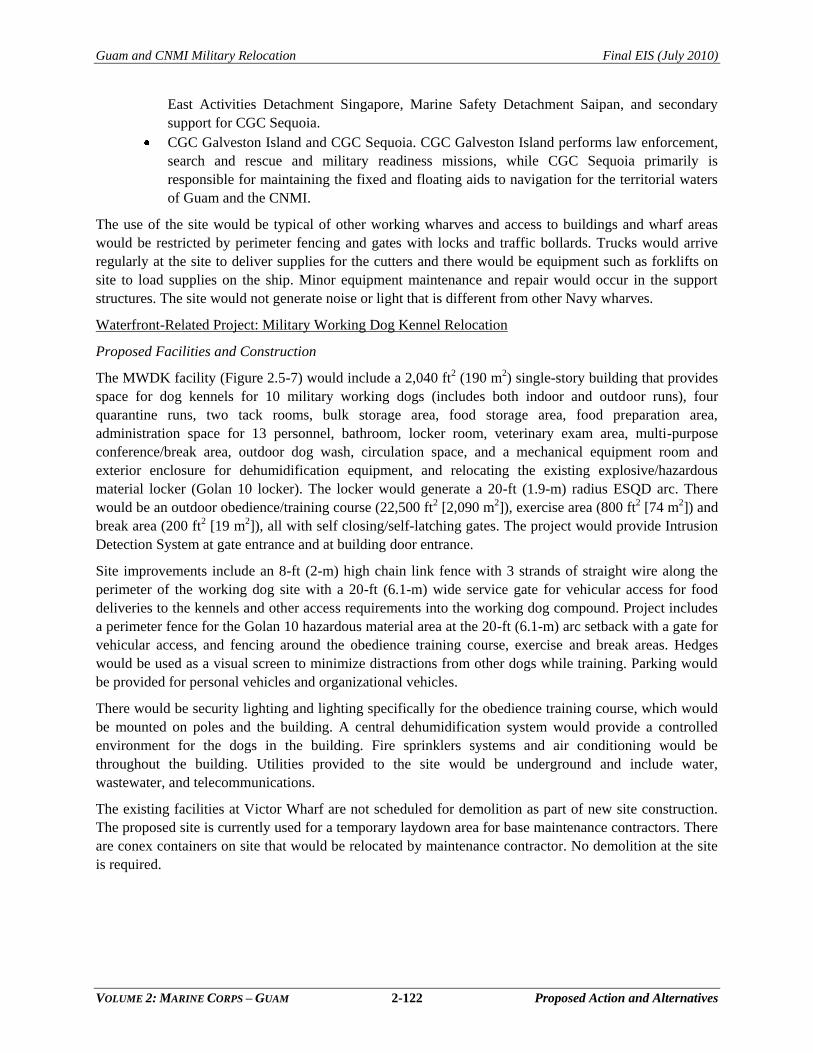
Guam and CNMI Military Relocation Final EIS (July 2010)
VOLUME 2: MARINE CORPS – GUAM 2-122 Proposed Action and Alternatives
East Activities Detachment Singapore, Marine Safety Detachment Saipan, and secondary
support for CGC Sequoia.
CGC Galveston Island and CGC Sequoia. CGC Galveston Island performs law enforcement,
search and rescue and military readiness missions, while CGC Sequoia primarily is
responsible for maintaining the fixed and floating aids to navigation for the territorial waters
of Guam and the CNMI.
The use of the site would be typical of other working wharves and access to buildings and wharf areas
would be restricted by perimeter fencing and gates with locks and traffic bollards. Trucks would arrive
regularly at the site to deliver supplies for the cutters and there would be equipment such as forklifts on
site to load supplies on the ship. Minor equipment maintenance and repair would occur in the support
structures. The site would not generate noise or light that is different from other Navy wharves.
Waterfront-Related Project: Military Working Dog Kennel Relocation
Proposed Facilities and Construction
The MWDK facility (Figure 2.5-7) would include a 2,040 ft2 (190 m2) single-story building that provides
space for dog kennels for 10 military working dogs (includes both indoor and outdoor runs), four
quarantine runs, two tack rooms, bulk storage area, food storage area, food preparation area,
administration space for 13 personnel, bathroom, locker room, veterinary exam area, multi-purpose
conference/break area, outdoor dog wash, circulation space, and a mechanical equipment room and
exterior enclosure for dehumidification equipment, and relocating the existing explosive/hazardous
material locker (Golan 10 locker). The locker would generate a 20-ft (1.9-m) radius ESQD arc. There
would be an outdoor obedience/training course (22,500 ft2 [2,090 m2]), exercise area (800 ft2 [74 m2]) and
break area (200 ft2 [19 m2]), all with self closing/self-latching gates. The project would provide Intrusion
Detection System at gate entrance and at building door entrance.
Site improvements include an 8-ft (2-m) high chain link fence with 3 strands of straight wire along the
perimeter of the working dog site with a 20-ft (6.1-m) wide service gate for vehicular access for food
deliveries to the kennels and other access requirements into the working dog compound. Project includes
a perimeter fence for the Golan 10 hazardous material area at the 20-ft (6.1-m) arc setback with a gate for
vehicular access, and fencing around the obedience training course, exercise and break areas. Hedges
would be used as a visual screen to minimize distractions from other dogs while training. Parking would
be provided for personal vehicles and organizational vehicles.
There would be security lighting and lighting specifically for the obedience training course, which would
be mounted on poles and the building. A central dehumidification system would provide a controlled
environment for the dogs in the building. Fire sprinklers systems and air conditioning would be
throughout the building. Utilities provided to the site would be underground and include water,
wastewater, and telecommunications.
The existing facilities at Victor Wharf are not scheduled for demolition as part of new site construction.
The proposed site is currently used for a temporary laydown area for base maintenance contractors. There
are conex containers on site that would be relocated by maintenance contractor. No demolition at the site
is required.
Printing Date: Jul 8, 2009, M:\projects\GIS\8806_Guam_Buildup_EIS\figures\Current_Deliverable\Vol_2\2.5-7.mxd
Shorel
ine D
r
Pro
pose
d U
tiliti
es:
Pro
pose
d U
tiliti
es:
-Ele
ctric
-Ele
ctric
-Com
mun
icat
ion
-Com
mun
icat
ion
-Sew
er-S
ewer
-Wat
er-W
ater
Gol
an L
ocke
rG
olan
Loc
ker
ES
QD
Arc
ES
QD
Arc
(20
ft)(2
0 ft)
Ope
n S
pace
Ope
n S
pace
(195
,903
ft(1
95,9
03 ft
22))
Obe
dien
ce C
ours
eO
bedi
ence
Cou
rse
(22,
500
ft(2
2,50
0 ft
22))
Kenn
elKe
nnel
(2,0
00 ft
(2,0
00 ft
22))
Side
wal
ksSi
dew
alks
(800
ft(8
00 ft
22))
Park
ing/
Roa
dsPa
rkin
g/R
oads
(21,
200
ft(2
1,20
0 ft
22))
Futu
re A
dmin
Futu
re A
dmin
(4,7
00 ft
(4,7
00 ft
22))
Tras
hTr
ash
Exer
cise
Are
aEx
erci
se A
rea
(800
ft(8
00 ft
22))
Brea
k A
rea
Brea
k A
rea
(200
ft(2
00 ft
22))
Milit
ary
Wor
king
Dog
Kenn
el S
ite P
lan
Figu
re 2
.5-7
010
20M
eter
s
011
055Fe
et
Nav
al B
ase
Nav
al B
ase
Gua
mG
uam
Are
aE
nlar
ged
Lege
nd Mili
tary
Inst
alla
tion
Pro
pose
d U
tiliti
es
IBD
ES
QD
Arc
Pro
pose
dB
uild
ing
Land
scap
ing
Futu
re
Con
stru
ctio
n
Pro
pose
dP
avem
ent
2-123
Guam and CNMI Military Relocation Final EIS (July 2010)
VOLUME 2: MARINE CORPS – GUAM 2-124 Proposed Action and Alternatives
No land use constraints were identified at the site except radon. Radon mitigation is included in the
inhabited building design. Low levels of PCB contaminants have been identified approximately 400 ft
(121.92 m) north of the site. Soil testing would be conducted prior to construction. No trees would be
cleared. Access to the site would be from existing roads and utilities would tie into the utilities along the
roadways. Area of grading/grubbing is approximately 85,301.84 ft2 (26,000 m2) and landscaping would
be required for 65,617 ft2 (20,000 m2).
The single story buildings would be constructed of reinforced concrete and/or concrete masonry unit with
seismic upgrades, pile foundation, and with all components such as exterior walls, windows, roofing,
mechanical and electrical systems compatible with the Guam environment and COMNAV Marianas
design standards.
The project provides for electrical and mechanical systems including fire alarm and fire monitoring/
control panels, information systems, telephone, Energy Management Control Systems, plumbing, fire
protection systems, and heating, ventilation, and air conditioning systems. Information systems include
telephone and data. Utilities at the site would include power, emergency generator, water, and
wastewater. Utility tie-in would be at Shoreline Drive. There is a trash enclosure on site.
The kennels would have a central dehumidification system that controls indoor environment to meet 9
Code of Federal Regulations Chapter 1 Part 3 ―Animal and Animal Products Standards‖ regarding
temperature and humidity.
Project includes AT/FP building and site measures in compliance with UFC 4-010-01, dated October 8,
2003, including Change 1, January 22, 2007. AT/FP protection measures include the required standoff
distances from parking, roadways, and existing inhabited buildings in the area. Physical security
equipment includes intrusion detection system for the GOLAN 10 hazardous material locker and the drug
storage area.
The total area of ground disturbance during construction would be 209,100 ft2 (19,426 m3) The building
would be constructed of reinforced concrete with slab on grade foundations, meet current design seismic
standards, and be able to withstand 170 mph winds. The facility would meet LEED silver standards and
comply with Energy Policy Act 2005 requirements. The specific LEED design features would be
developed with final design but would include battery storage photovoltaic systems, high efficiency
windows (low-e coated glazing), and water conserving plumbing fixtures with electronic controls where
possible.
Construction duration is estimated at 1 year, with a Monday through Friday work week during daylight
hours. Construction skills and equipment are typical of Navy base construction. Solid waste would be
transported to the Navy Landfill.
Proposed Operations
A new MWDK is proposed to replace the one within the Security Compound at Victor Wharf (refer to
Figure 2.5-7). The noise generated by the Marine Corps during embarkation operations at Victor Wharf
and at the proposed adjacent cargo staging area would likely disturb and distract the military working
dogs. Relocation of the facility is proposed.
The military dogs are required for explosive/narcotic detection, antiterrorism force protection, and are
deployed. The dogs live and train at the kennel. There is one handler assigned to each dog. They train and
deploy as a team. There are typically nine teams in residence at the kennel, but the schedule is mission
driven and unpredictable. The dogs are provided indoor and outdoor runs.
Guam and CNMI Military Relocation Final EIS (July 2010)
VOLUME 2: MARINE CORPS – GUAM 2-125 Proposed Action and Alternatives
The facility is staffed by a kennel master and a kennel support person. There are frequent visits by
organized groups of students and youth groups. Access to the site is generally by car. Training is done on
site during the day and at night in outdoor obedience training courses. Working hours for the staff are
generally 8:00 a.m. to 5:00 p.m.; however, evening missions would require staff. Evening training is a
routine event. The dogs also train at other training facilities on-island and the frequency is dependent on
the use of the other facilities. There are six patrol cars on site for transporting the dogs. Training aids
include narcotics and explosives which are stored and handled in accordance with DoD regulations.
The proposed facility does not provide for USDA inspection dogs. The missions, characteristics, and
needs of the USDA BTS dogs are different from the Military Working Dogs; therefore, separate areas are
required for the agency-unique management and specialized training requirements of the two types of
dogs and their handlers.
There is room for expansion at the proposed site to accommodate future expansion. No heavy equipment
is used at the site. There are minor amounts of hazardous materials (oxidizers) stored in a suitable cabinet.
Explosives (1.1 CD) are kept in a hazardous material locker (Golan Locker) that generates an ESQD arc
(20-ft [6.1-m] radius) on the premises.
The dog wastes would be washed into the sanitary sewer system.
Waterfront-Related Project: Apra Harbor Medical Clinic (MCH-006)
Proposed Facilities and Construction
The proposed site is centrally located on the installation on Marine Drive, near existing family and
bachelor housing areas. The clinic (Figure 2.5-8) would include administrative spaces, medical, mental
health and dental clinic spaces, urgent care clinic, preventive medicine, ancillary services, and parking for
personal and emergency vehicles (approximately 290 spaces) (see Figure 2.5-8). The space allocation and
designs are provided by Bureau of Medicine and Surgery (BUMED). Apra Branch Health Clinic (medical
and dental) would be a single-story concrete facility of 43,091 ft2 (4,003.28 m2).
The total project area within the perimeter of the facility equals 334,000 ft2 (31,029.62 m2). Security
lighting would be mounted to the building and poles in the parking area. An emergency generator would
be provided to provide back-up power.
The site is vacant. A portion of the area was used for base maintenance activities and there are remnants
of large paving areas where buildings were previously located. There are no known land use constraints in
the vicinity, except radon is a concern in Guam soils. Radon mitigation is proposed in the floor design.
No tree removal or wetland disturbance is expected.
The project consists of constructing one single-level outpatient facility. Assume the entire site
(334,000 ft2 [31029.62 m2]) would be graded during construction. The facility would be constructed of
reinforced concrete with slab on grade foundations, and with all components such as exterior walls,
windows, roofing, mechanical and electrical systems compatible with the Guam environment and
appropriate design standards.
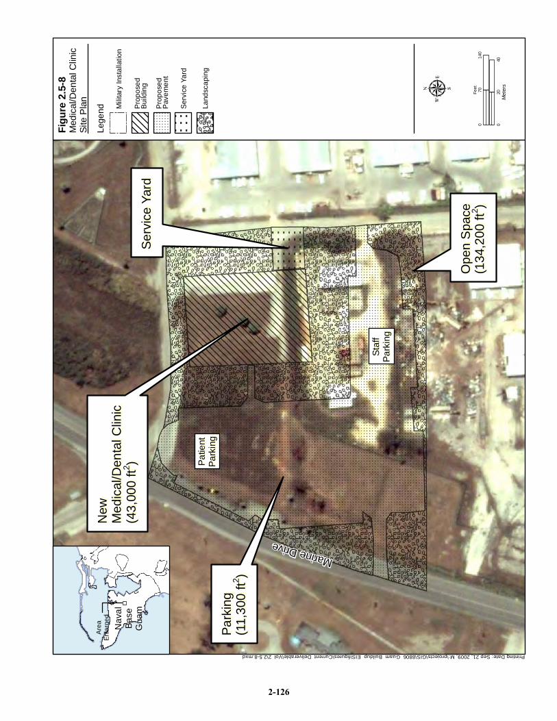
Printing Date: Sep 21, 2009, M:\projects\GIS\8806_Guam_Buildup_EIS\figures\Current_Deliverable\Vol_2\2.5-8.mxd
Patie
ntPa
tient
Park
ing
Park
ing
Staf
fSt
aff
Park
ing
Park
ing
Marine Drive
Ope
n S
pace
Ope
n S
pace
(134
,200
ft(1
34,2
00 ft
22))
Park
ing
Park
ing
(11,
300
ft(1
1,30
0 ft
22))
New
N
ew
Med
ical
/Den
tal C
linic
Med
ical
/Den
tal C
linic
(43,
000
ft(4
3,00
0 ft
22))
Serv
ice
Yard
Serv
ice
Yard
Med
ical
/Den
tal C
linic
Site
Pla
n
Figu
re 2
.5-8
020
40M
eter
s
014
070Fe
et
Nav
alN
aval
Base
Base
Gua
mG
uam
Are
aE
nlar
ged
Lege
nd Mili
tary
Inst
alla
tion
Ser
vice
Yar
d
Pro
pose
dP
avem
ent
Pro
pose
dB
uild
ing
Land
scap
ing
2-126
Guam and CNMI Military Relocation Final EIS (July 2010)
VOLUME 2: MARINE CORPS – GUAM 2-127 Proposed Action and Alternatives
Facilities include administrative spaces, medical, mental health and dental clinic space, urgent care clinic,
preventive medicine, ancillary services, and required support spaces. There would be parking for an
approximately 36 staff vehicles. Site improvements include landscaping, sidewalks (with nonslip surface),
curbs, and gutters. Subgrade construction would include utility lines and possible stormwater
management systems. Project costs would include new lines and meters for electrical, water and gas
utilities. Facilities would be fully equipped with sprinkler and air conditioning systems.
Facilities would be designed to Zone 4 seismic requirements, to withstand 170 mph winds, and to include
appropriate AT/FP distance setbacks. All design and construction would comply with the Energy Policy
Act 2005 (106th Congress 2005) requirements and UFC 4-510-01, Design: Medical Military Facilities.
Various tools and design features would be used to achieve LEED Silver certification for various
development areas of the base and/or for specific buildings.
The construction staging area would be within the site boundaries. Construction waste would be disposed
of at the Navy landfill. The duration of construction is estimated at 18 months and the work would occur
in daylight hours Monday through Friday. Typical construction equipment would be used including
bulldozers, backhoes and cement trucks.
Proposed Operations and Existing Conditions
Medical services on Guam are managed under the Navy BUMED. A ―Medical Facilities Master Planning
Study Update for the DoD Healthcare Beneficiaries, Guam, and Mariana Islands‖ was prepared in April
2007 by NAVFAC Pacific and most of the information in this section was derived from that study. The
purpose was to revisit the planned new Naval Hospital construction plans with consideration of the
Marine Corps relocation requirements.
Two similarly-sized new clinics are proposed to meet the Marine Corps relocation requirements, one at
Naval Base Guam and the other at the main cantonment. In an effort to maintain the footprint of the
programmed new hospital (inpatient and outpatient facilities) on the Naval Hospital site and to place
primary care/dental services proximate to Navy beneficiaries, the majority of the primary care, preventive
medicine and occupational medicine was moved from the hospital construction project and placed in the
two separate and similar medical clinic projects with Dental Services. The new Naval Base Guam clinic
would replace an existing clinic that is in poor physical condition, and does not meet the future medical
service requirement of the proposed increased population on Guam. The second medical clinic is
proposed in the Main Cantonment area and described under that section of this EIS.
The current Naval Hospital provides outpatient services in addition to emergency and critical care
services. If outpatient services are relocated to medical clinics, sufficient space would be available at the
new Naval Hospital to expand critical care medical specialties and meet the military population
requirements on island. Specialty clinics and a limited family practice clinic would remain in the new
Naval Hospital.
The existing Navy Branch Medical Clinic is located in a two story facility designed and built for use as a
dormitory (barracks). The size and shape of the building is not conducive to the operation of an efficient
and functional medical clinic, and are inadequate for the required medical activities. The projected
population increases would add more stress on the ability of these facilities to function effectively. For
example, the x-ray room is much smaller than that required by current DoD space planning criteria, and it
also serves as the x-ray film files room. The treatment room is smaller than that required by criteria, and
the narrow width of the room severely restricts functionality. Building access and circulation on the first
Guam and CNMI Military Relocation Final EIS (July 2010)
VOLUME 2: MARINE CORPS – GUAM 2-128 Proposed Action and Alternatives
floor for handicapped persons is adequate; however, the lack of an elevator in this building does not allow
compliant access to the second floor. The overall condition of the roof requires near term replacement.
The existing Branch Dental Clinic was built in 1955 and is significantly ―out-of-date‖ with current Dental
Clinic procedures and design criteria. The main corridor is used as a return air plenum, which is a
violation of codes and criteria. With no urgent care capability, patients must be transported to the Naval
Hospital (approximately 30 minutes), and there are no intervening accredited civilian medical facilities
available on the island in the event a patient's condition worsens during transit. The Dental Clinic is not
handicap accessible; however, there is an accessible entrance in one end of the facility. There are smoke
detectors in the corridor, but the building is not equipped with a sprinkler system.
The proposed Apra Medical/Dental Clinic would be an outpatient medical facility. The preferred project
location at Apra Main Base is a vacant 13-ac (5.26 ha) site on Marine Drive (see Figure 2.5-8), near
existing family and bachelor housing areas. The medical facility would be open 7 days a week, and it is
assumed that it would operate during normal business hours. The clinic would be staffed by 32
individuals, with 345 visitors expected per day. Clinic staff and patients would be transported to and from
the facility by personal or government vehicle, bus, or walking. It is expected that human sensitive
receptors would be present on site during operating hours including children, infirm, and elderly persons.
No heavy equipment, vehicles, or machinery would be used during facility operations. It is assumed that
outdoor lighting of the facility would consist of security lighting. It is also assumed that the facility would
produce human biowaste, typical of any medical facility, which would be treated and disposed of in
accordance with BUMED requirements. The fire risks associated with the medical clinic would be typical
of concrete buildings. It would be equipped with a fire protection system, including a sprinkler system.
2.5.2 Alternatives Analysis: Waterfront Functions
2.5.2.1 Waterfront Project: Amphibious Task Force Ship Berthing and Embarkation
The rationale for siting all proposed waterfront facilities at Apra Harbor is it is the only on-island DoD
harbor. The Navy‘s general purpose wharves that are suitable for meeting amphibious task force
requirements are on the western side of Inner Apra Harbor (see Figure 2.5-3). Victor, Uniform, Romeo,
and Sierra were the candidate wharves for berthing the ships. They have been used before by the
amphibious task force. There are other general purpose wharves that are not suitable. Tango Wharf‘s
availability for general ship berthing is limited by the space reserved for the Navy dive locker and access
to the decompression facilities in Building 3169. Alpha/Bravo Wharves at Polaris Point east of the
channel entrance are designated for the nuclear submarines and the submarine tender. X-Ray Wharf, in
the southern portion of the Harbor, is designated as the supply wharf with large warehouses, including
frozen and cold storage, conveniently located adjacent to the wharf to support these operations. The
northwest area and associated wharves (Lima, Mike, Oscar, and Papa) are leased to GEDA for ship repair.
The combatant escort ships are more difficult to site than the amphibious ships, because of their water
depth requirement (referred to as draft), the largest being 34 ft (10 m). An additional 4 ft (1.2 m) of water
depth is required by Navy specifications, resulting in a total dredge depth required of -38 ft MLLW
(-12 m). The water depth in Inner Apra Harbor is -32 ft MLLW (-10 m) in the south, -35 ft MLLW (-11
m) in the area of Sierra/Tango Wharves and -42 ft MLLW (-13 m) in the area of Alpha/Bravo Wharves.
Berthing the combatant escort ships in the deeper water near Sierra and Romeo Wharves would result in
less dredging and was the logical choice for the combatant ships. Maintenance dredging for the entire
Inner Apra Harbor was recently (within the last 5 years) completed; therefore, the original construction
Guam and CNMI Military Relocation Final EIS (July 2010)
VOLUME 2: MARINE CORPS – GUAM 2-129 Proposed Action and Alternatives
depths are restored. This provided adequate depth for amphibious shipping at Victor and Uniform
wharves.
The alternatives analysis was a systematic, flexible and iterative process focusing on the most efficient
and cost effective way to berth all the ships while minimizing the impact on existing operations. The other
facilities were sited based on proximity to the ships that carry amphibious vehicles.
There were no existing buildings that were underutilized and that could meet the requirements for the Port
Operations building. That building needed to be sited on the waterfront and in proximity to the ships
carrying amphibious vehicles (Victor Wharf). The site selected was the only space available. The nearest
available land for staging was selected for cargo staging/wash area. No reasonable alternative sites for
these functions were identified.
The Navy planned to improve the structure and utilities at the general purpose wharves. Ships that arrive
in port are berthed at the general purpose wharves, except Uniform Wharf is too degraded for use.
Although berthing plans are developed for planning purposes, the fact is that ships are assigned berths
based on availability and water depth. Alternative berthing plans were developed but they have less to do
with wharf improvements than with wharf shoreside requirements, such as lay down area. The land
available for embarkation and cargo staging was generally in the area of Victor Wharf. Based on
operational considerations the site presented above was selected.
2.5.2.2 Amphibious Craft Laydown Area
Siting facilities at a busy waterfront is largely a function of space availability. In the case of the
LCAC/AAV laydown area, there is the additional consideration of noise impacts and water spray damage
to adjacent land uses. Base planners identified two available areas for the facilities that would be
consistent with waterfront land use plans and operations. Construction of LCAC and amphibious
operations facilities on Polaris Point provides the best solution for reducing impacts from noise on
surrounding operations. The area is a sufficient distance from the Alpha/Bravo Wharves and CSS-15
personnel do not anticipate any impacts on submarine berthing operations around the Tender.
Construction of a new road from Marine Drive directly to the compound on Polaris Point would mitigate
potential congestion with Navy traffic on the peninsula.
The other alternative considered is located in the inlet where the Dry Dock is moored (see Figure 2.5-5).
The AAV laydown would be located adjacent to EOD facilities on Navy land and the LCAC laydown
area would be on land currently leased by GEDA. The reasons for dismissal of this site alternative were
noise interference with EOD operations and the need for dredging at the entrance to the inlet. In addition,
proximity to Big Blue Reef and the desire to avoid any potential impacts to coral ecosystems was a
consideration for dismissal.
2.5.2.3 USCG Berthing and Crew Support Buildings
The USCG Maintenance and Logistics Command Pacific prepared the Sector Guam – Relocation
Feasibility Study (June 2007) to assess the feasibility and potential for relocating Sector Guam facilities
from their current location on Victor Wharf to other suitable waterfront property controlled by the Navy.
This EIS addresses the relocation of only a portion of the total USCG facilities and personnel that were
addressed in the feasibility study. The portion that is addressed herein is that directly related to the Marine
Corps Victor wharf requirements, namely wharf frontage and crew support facilities. The assumption is
that the remaining facilities and personnel would relocate when funding became available.
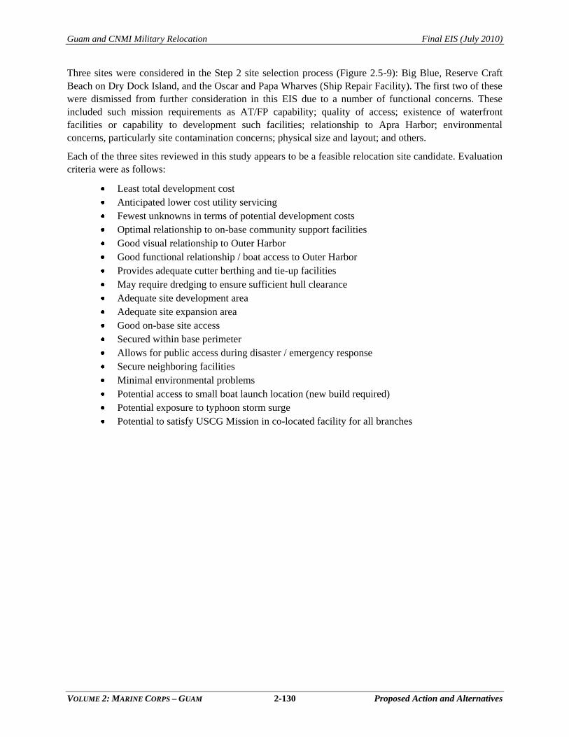
Guam and CNMI Military Relocation Final EIS (July 2010)
VOLUME 2: MARINE CORPS – GUAM 2-130 Proposed Action and Alternatives
Three sites were considered in the Step 2 site selection process (Figure 2.5-9): Big Blue, Reserve Craft
Beach on Dry Dock Island, and the Oscar and Papa Wharves (Ship Repair Facility). The first two of these
were dismissed from further consideration in this EIS due to a number of functional concerns. These
included such mission requirements as AT/FP capability; quality of access; existence of waterfront
facilities or capability to development such facilities; relationship to Apra Harbor; environmental
concerns, particularly site contamination concerns; physical size and layout; and others.
Each of the three sites reviewed in this study appears to be a feasible relocation site candidate. Evaluation
criteria were as follows:
Least total development cost
Anticipated lower cost utility servicing
Fewest unknowns in terms of potential development costs
Optimal relationship to on-base community support facilities
Good visual relationship to Outer Harbor
Good functional relationship / boat access to Outer Harbor
Provides adequate cutter berthing and tie-up facilities
May require dredging to ensure sufficient hull clearance
Adequate site development area
Adequate site expansion area
Good on-base site access
Secured within base perimeter
Allows for public access during disaster / emergency response
Secure neighboring facilities
Minimal environmental problems
Potential access to small boat launch location (new build required)
Potential exposure to typhoon storm surge
Potential to satisfy USCG Mission in co-located facility for all branches
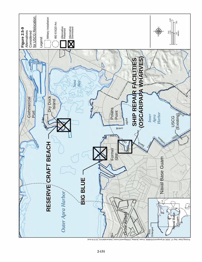
Nav
al B
ase
Gua
mN
aval
Bas
e G
uamFo
rmer
Fo
rmer
SR
FSR
FPo
laris
Po
laris
Po
int
Poin
t
Com
mer
cial
Com
mer
cial
Port
Port
Alph
aAl
pha
BravoBravoLima Lima
OscarOscar
Papa
Papa Ta
ngo
Tang
o
SierraSierra Unif
orm
Uniform Victor
Victor
X-rayX-ray
Delta
Delta
Ech
oE
cho
Out
er A
pra
Har
bor
Out
er A
pra
Har
bor
Inne
rIn
ner
Apra
Ap
ra
Har
bor
Har
bor
Oro
te A
irfie
ldO
rote
Airf
ield
Sasa
Sasa
Bay
Bay
Dry
Doc
kD
ry D
ock
Isla
ndIs
land
USC
GU
SCG
(Exi
stin
g)(E
xist
ing)
BIG
BLU
EB
IG B
LUE
RES
ERVE
CR
AFT
BEA
CH
RES
ERVE
CR
AFT
BEA
CH
SHIP
REP
AIR
FA
CIL
ITIE
SSH
IP R
EPA
IR F
AC
ILIT
IES
(OSC
AR
/PA
PA W
HA
RVE
S)(O
SCA
R/P
APA
WH
AR
VES)
Printing Date: Sep 17, 2009, M:\projects\GIS\8806_Guam_Buildup_EIS\figures\Current_Deliverable\Vol_2\2.5-9.mxd
Alte
rnat
ives
Con
side
red
for U
SC
G R
eloc
atio
n
Figu
re 2
.5-9
032
064
0M
eter
s
02,
300
1,15
0Fe
et
Nav
al B
ase
Nav
al B
ase
Gua
mG
uam
Are
aE
nlar
ged
Lege
nd Mili
tary
Inst
alla
tion
IBD
ES
QD
Arc
Alte
rnat
ive
Dis
mis
sed
Alte
rnat
ive
Ret
aine
d
2-131
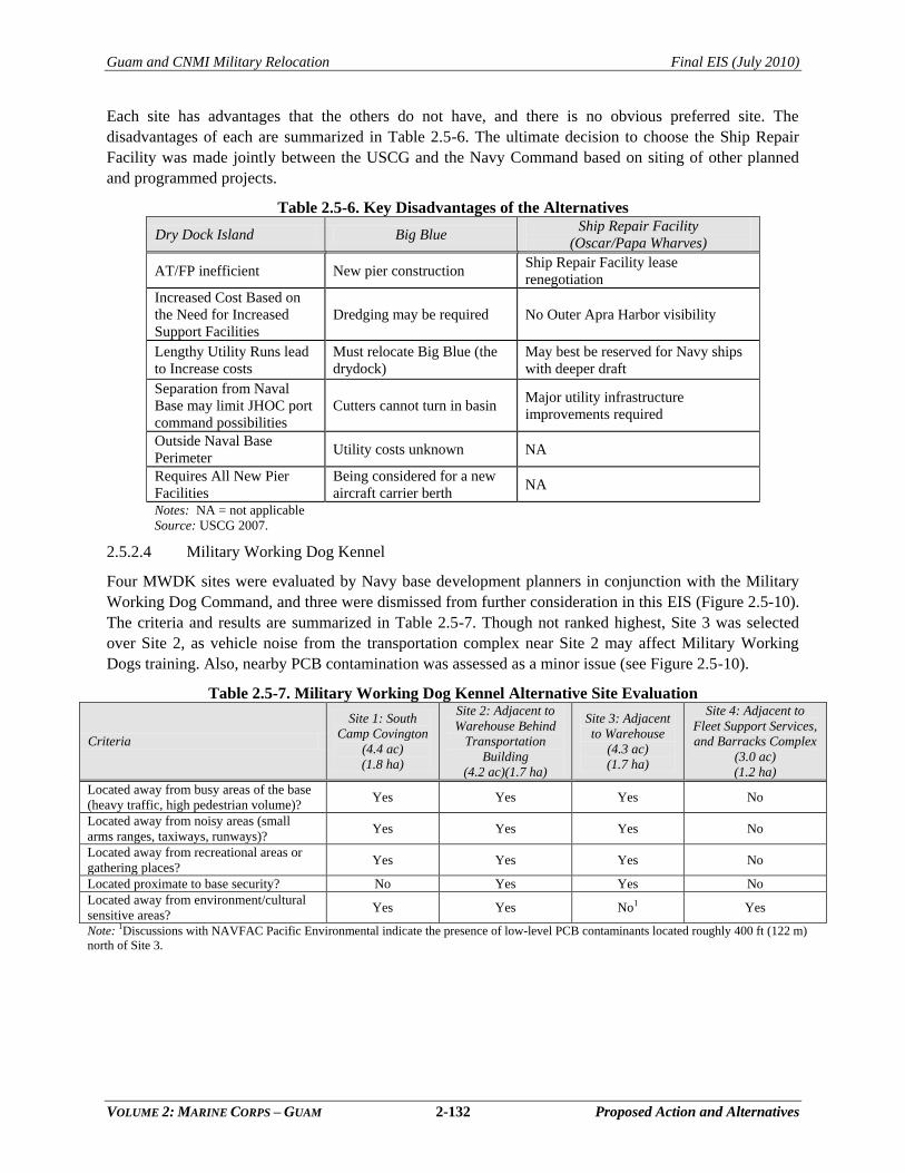
Guam and CNMI Military Relocation Final EIS (July 2010)
VOLUME 2: MARINE CORPS – GUAM 2-132 Proposed Action and Alternatives
Each site has advantages that the others do not have, and there is no obvious preferred site. The
disadvantages of each are summarized in Table 2.5-6. The ultimate decision to choose the Ship Repair
Facility was made jointly between the USCG and the Navy Command based on siting of other planned
and programmed projects.
Table 2.5-6. Key Disadvantages of the Alternatives
Dry Dock Island Big Blue Ship Repair Facility
(Oscar/Papa Wharves)
AT/FP inefficient New pier construction Ship Repair Facility lease
renegotiation
Increased Cost Based on
the Need for Increased
Support Facilities
Dredging may be required No Outer Apra Harbor visibility
Lengthy Utility Runs lead
to Increase costs
Must relocate Big Blue (the
drydock)
May best be reserved for Navy ships
with deeper draft
Separation from Naval
Base may limit JHOC port
command possibilities
Cutters cannot turn in basin Major utility infrastructure
improvements required
Outside Naval Base
Perimeter Utility costs unknown NA
Requires All New Pier
Facilities
Being considered for a new
aircraft carrier berth NA
Notes: NA = not applicable
Source: USCG 2007.
2.5.2.4 Military Working Dog Kennel
Four MWDK sites were evaluated by Navy base development planners in conjunction with the Military
Working Dog Command, and three were dismissed from further consideration in this EIS (Figure 2.5-10).
The criteria and results are summarized in Table 2.5-7. Though not ranked highest, Site 3 was selected
over Site 2, as vehicle noise from the transportation complex near Site 2 may affect Military Working
Dogs training. Also, nearby PCB contamination was assessed as a minor issue (see Figure 2.5-10).
Table 2.5-7. Military Working Dog Kennel Alternative Site Evaluation
Criteria
Site 1: South
Camp Covington
(4.4 ac)
(1.8 ha)
Site 2: Adjacent to
Warehouse Behind
Transportation
Building
(4.2 ac)(1.7 ha)
Site 3: Adjacent
to Warehouse
(4.3 ac)
(1.7 ha)
Site 4: Adjacent to
Fleet Support Services,
and Barracks Complex
(3.0 ac)
(1.2 ha)
Located away from busy areas of the base
(heavy traffic, high pedestrian volume)? Yes Yes Yes No
Located away from noisy areas (small
arms ranges, taxiways, runways)? Yes Yes Yes No
Located away from recreational areas or
gathering places? Yes Yes Yes No
Located proximate to base security? No Yes Yes No
Located away from environment/cultural
sensitive areas? Yes Yes No1 Yes
Note: 1Discussions with NAVFAC Pacific Environmental indicate the presence of low-level PCB contaminants located roughly 400 ft (122 m)
north of Site 3.
Nav
al B
ase
Gua
mN
aval
Bas
e G
uam
Tang
oTa
ngoSierra
Sierra Uniform
Uniform Victor
Victor
X-rayX-ray
Inne
rIn
ner
Apra
Ap
ra
Har
bor
Har
bor
DDaadd
ii BBeeaa
cchh
Tipa
lao
Tipa
lao
Cove
Cove
US
CG
US
CG
(Exi
stin
g)(E
xist
ing)
SITE
1:
SITE
1:
SOU
TH C
AM
P SO
UTH
CA
MP
CO
VIN
GTO
N R
DC
OVI
NG
TON
RD
SITE
3:
SITE
3:
AD
JAC
ENT
TO
AD
JAC
ENT
TO
WA
REH
OU
SE B
UIL
DIN
G 3
65W
AR
EHO
USE
BU
ILD
ING
365
SITE
4:
SITE
4:
AD
JAC
ENT
TO
AD
JAC
ENT
TO
FLEE
T SU
PPO
RT
& B
QFL
EET
SUPP
OR
T &
BQ
SITE
2:
SITE
2:
AD
JAC
ENT
TO
AD
JAC
ENT
TO
TRA
NSP
OR
TATI
ON
BU
ILD
ING
TRA
NSP
OR
TATI
ON
BU
ILD
ING
Printing Date: Sep 17, 2009, M:\projects\GIS\8806_Guam_Buildup_EIS\figures\Current_Deliverable\Vol_2\2.5-10.mxd
Alte
rnat
ives
Con
side
red
for M
WD
K R
eloc
atio
n
Figu
re 2
.5-1
0
023
046
0M
eter
s
01,
600
800
Feet
Nav
al B
ase
Nav
al B
ase
Gua
mG
uam
Are
aE
nlar
ged
Lege
nd Mili
tary
Inst
alla
tion
IBD
ES
QD
Arc
Alte
rnat
ive
Dis
mis
sed
Alte
rnat
ive
Ret
aine
d
2-133
Guam and CNMI Military Relocation Final EIS (July 2010)
VOLUME 2: MARINE CORPS – GUAM 2-134 Proposed Action and Alternatives
2.5.2.5 Apra Medical/Dental Clinic
An alternatives analysis was conducted and is described in detail in the Medical Facilities Master
Planning Study Update (2007), Volume II. Five alternatives were considered and Site 1, Former Public
Works Center site, is the one site that is being carried through for impact assessment in this EIS. The site
provides convenient access for on-base personnel from Marine Drive and for beneficiaries living in the
southern portion of Guam. It is also located in close proximity to the barracks and family housing areas.
Four other Naval Base Guam candidate sites for the medical/dental clinic that were considered and
dismissed are shown on Figure 2.5-11. These are described below.
Site 2. This 18-ac (7.3-ha) site is located near the back entrance to the base in proximity to the
existing Exchange and Commissary. The site is vacant with only remnants of past use.
Site 3. This 15-ac (6.07-ha) site is located between the barracks and family housing units and
adjacent to MWR activities. The site is vacant, but a portion of the area is impacted by the ESQD
from Navy Construction Battalion quarry operations to the west.
Site 4. This 20-ac (8.09-ha) site is centrally located along Marine Drive. The area is largely
vacant, although a portion is used as a DoD ball field. The base wastewater treatment facility is
located across Marine Drive. Two alternatives were considered at this site.
Site 5. This 15-ac (6.07-ha) site is located to the west of the barracks housing area, and south of
the furniture storage warehouse. The area is vacant, but ESQD from Kilo Wharf and the quarry
area impact the site.
Nav
al B
ase
Gua
mN
aval
Bas
e G
uam
Tang
oTa
ngoSierra
Sierra Uniform
Uniform Victor
Victor
X-rayX-ray
Inne
rIn
ner
Apra
Ap
ra
Har
bor
Har
bor
Tipa
lao
Tipa
lao
Cove
Cove
US
CG
US
CG
(Exi
stin
g)(E
xist
ing)
DDaadd
ii BBeeaa
cchh
SITE
2:
SITE
2:
18 a
cres
18 a
cres
SITE
4:
SITE
4:
20 a
cres
20 a
cres
SITE
5:
SITE
5:
15 a
cres
15 a
cres
SITE
I:
SITE
I:
13 a
cres
13 a
cres
SITE
3:
SITE
3:
15 a
cres
15 a
cres
Printing Date: Sep 17, 2009, M:\projects\GIS\8806_Guam_Buildup_EIS\figures\Current_Deliverable\Vol_2\2.5-11.mxd
Alte
rnat
ives
Con
side
red
for
Med
ical
/Den
tal C
linic
Rel
ocat
ion
Figu
re 2
.5-1
1
023
046
0M
eter
s
01,
600
800
Feet
Nav
al B
ase
Nav
al B
ase
Gua
mG
uam
Are
aE
nlar
ged
Lege
nd Mili
tary
Inst
alla
tion
IBD
ES
QD
Arc
Alte
rnat
ive
Dis
mis
sed
Alte
rnat
ive
Ret
aine
d
2-135
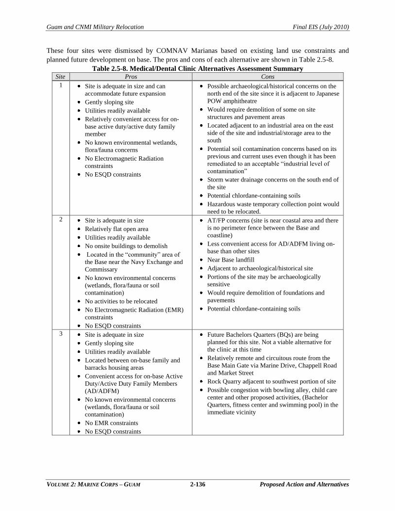
Guam and CNMI Military Relocation Final EIS (July 2010)
VOLUME 2: MARINE CORPS – GUAM 2-136 Proposed Action and Alternatives
These four sites were dismissed by COMNAV Marianas based on existing land use constraints and
planned future development on base. The pros and cons of each alternative are shown in Table 2.5-8.
Table 2.5-8. Medical/Dental Clinic Alternatives Assessment Summary Site Pros Cons
1 Site is adequate in size and can
accommodate future expansion
Gently sloping site
Utilities readily available
Relatively convenient access for on-
base active duty/active duty family
member
No known environmental wetlands,
flora/fauna concerns
No Electromagnetic Radiation
constraints
No ESQD constraints
Possible archaeological/historical concerns on the
north end of the site since it is adjacent to Japanese
POW amphitheatre
Would require demolition of some on site
structures and pavement areas
Located adjacent to an industrial area on the east
side of the site and industrial/storage area to the
south
Potential soil contamination concerns based on its
previous and current uses even though it has been
remediated to an acceptable ―industrial level of
contamination‖
Storm water drainage concerns on the south end of
the site
Potential chlordane-containing soils
Hazardous waste temporary collection point would
need to be relocated.
2 Site is adequate in size
Relatively flat open area
Utilities readily available
No onsite buildings to demolish
Located in the ―community‖ area of
the Base near the Navy Exchange and
Commissary
No known environmental concerns
(wetlands, flora/fauna or soil
contamination)
No activities to be relocated
No Electromagnetic Radiation (EMR)
constraints
No ESQD constraints
AT/FP concerns (site is near coastal area and there
is no perimeter fence between the Base and
coastline)
Less convenient access for AD/ADFM living on-
base than other sites
Near Base landfill
Adjacent to archaeological/historical site
Portions of the site may be archaeologically
sensitive
Would require demolition of foundations and
pavements
Potential chlordane-containing soils
3 Site is adequate in size
Gently sloping site
Utilities readily available
Located between on-base family and
barracks housing areas
Convenient access for on-base Active
Duty/Active Duty Family Members
(AD/ADFM)
No known environmental concerns
(wetlands, flora/fauna or soil
contamination)
No EMR constraints
No ESQD constraints
Future Bachelors Quarters (BQs) are being
planned for this site. Not a viable alternative for
the clinic at this time
Relatively remote and circuitous route from the
Base Main Gate via Marine Drive, Chappell Road
and Market Street
Rock Quarry adjacent to southwest portion of site
Possible congestion with bowling alley, child care
center and other proposed activities, (Bachelor
Quarters, fitness center and swimming pool) in the
immediate vicinity
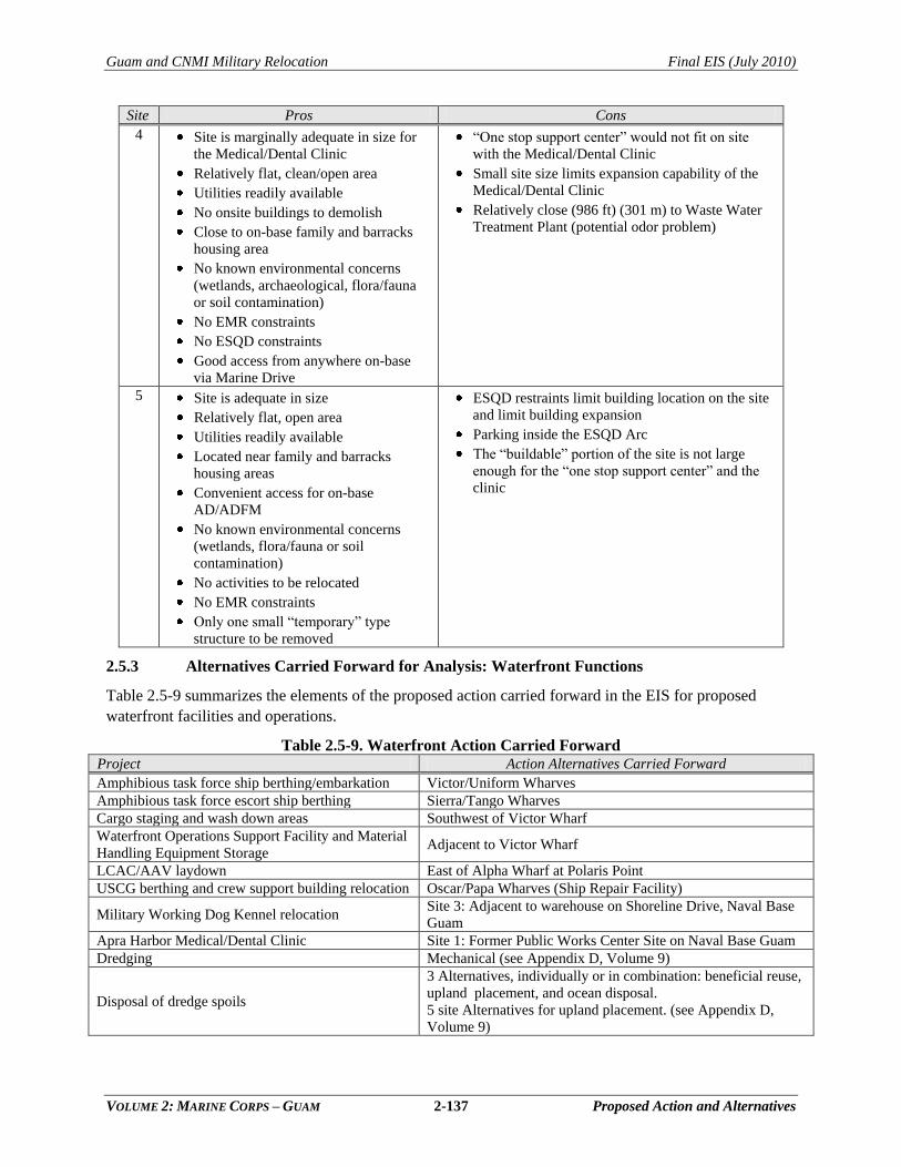
Guam and CNMI Military Relocation Final EIS (July 2010)
VOLUME 2: MARINE CORPS – GUAM 2-137 Proposed Action and Alternatives
Site Pros Cons
4 Site is marginally adequate in size for
the Medical/Dental Clinic
Relatively flat, clean/open area
Utilities readily available
No onsite buildings to demolish
Close to on-base family and barracks
housing area
No known environmental concerns
(wetlands, archaeological, flora/fauna
or soil contamination)
No EMR constraints
No ESQD constraints
Good access from anywhere on-base
via Marine Drive
―One stop support center‖ would not fit on site
with the Medical/Dental Clinic
Small site size limits expansion capability of the
Medical/Dental Clinic
Relatively close (986 ft) (301 m) to Waste Water
Treatment Plant (potential odor problem)
5 Site is adequate in size
Relatively flat, open area
Utilities readily available
Located near family and barracks
housing areas
Convenient access for on-base
AD/ADFM
No known environmental concerns
(wetlands, flora/fauna or soil
contamination)
No activities to be relocated
No EMR constraints
Only one small ―temporary‖ type
structure to be removed
ESQD restraints limit building location on the site
and limit building expansion
Parking inside the ESQD Arc
The ―buildable‖ portion of the site is not large
enough for the ―one stop support center‖ and the
clinic
2.5.3 Alternatives Carried Forward for Analysis: Waterfront Functions
Table 2.5-9 summarizes the elements of the proposed action carried forward in the EIS for proposed
waterfront facilities and operations.
Table 2.5-9. Waterfront Action Carried Forward Project Action Alternatives Carried Forward
Amphibious task force ship berthing/embarkation Victor/Uniform Wharves
Amphibious task force escort ship berthing Sierra/Tango Wharves
Cargo staging and wash down areas Southwest of Victor Wharf
Waterfront Operations Support Facility and Material
Handling Equipment Storage Adjacent to Victor Wharf
LCAC/AAV laydown East of Alpha Wharf at Polaris Point
USCG berthing and crew support building relocation Oscar/Papa Wharves (Ship Repair Facility)
Military Working Dog Kennel relocation Site 3: Adjacent to warehouse on Shoreline Drive, Naval Base
Guam
Apra Harbor Medical/Dental Clinic Site 1: Former Public Works Center Site on Naval Base Guam
Dredging Mechanical (see Appendix D, Volume 9)
Disposal of dredge spoils
3 Alternatives, individually or in combination: beneficial reuse,
upland placement, and ocean disposal.
5 site Alternatives for upland placement. (see Appendix D,
Volume 9)
Guam and CNMI Military Relocation Final EIS (July 2010)
VOLUME 2: MARINE CORPS – GUAM 2-138 Proposed Action and Alternatives
2.6 SUMMARY OF ALTERNATIVES
2.6.1 Proposed Action Alternatives
As described in previous subsections of this chapter, the Marine
Corps conducted a comprehensive screening and planning
process to identify reasonable alternatives for the proposed
development of a Marine Corps base of operations on Guam.
The proposed action was organized into four categories of
requirements (main cantonment/housing, training functions,
airfield functions, and waterfront functions) and a four-step
process was implemented to evaluate the facility and
operational requirements of each category (see Section 2.1).
Screening criteria were developed to identify alternative sites
for specific functions and site-specific planning considerations
were applied to identify alternative alignments within particular
candidate sites.
In some cases, several alternatives were carried forward for analysis in this EIS, and in other cases only
one reasonable alternative was identified. Each set of alternatives carried forward (e.g., an munitions
storage facility or a particular training range) represents a choice that would need to be made by decision-
makers in the Record of Decision, provided that the action proceeds to implementation (see Figure 2.1-2).
The remainder of this subsection summarizes the major project elements that comprise the proposed
action, including all alternatives carried forward for analysis in this EIS. Figure 2.1-2 illustrates the set of
choices that would need to be made in the Record of Decision to yield a selected alternative for the
proposed action should the action be implemented. The proposed action would also include the relocation
of 8,600 Marines, 1,700 civilian personnel, 2,000 transient Marines, and an estimated 9,000 dependents to
Guam. An alternative to the proposed action is the no-action alternative, which is also described below in
Section 2.6.2. Per the requirements of the NEPA, the no-action alternative is also carried forward for
analysis in this EIS.
2.6.1.1 Least Environmentally Damaging Practicable Alternative (LEDPA)
Chapter 4 of this Volume contains an analysis of the LEDPA, which is required under the Section
404(b)(1) guidelines of the CWA. Specifically, Section 404(b)(1) of the CWA stipulates that no discharge
of dredged or fill material into waters of the United States, which include wetlands, shall be permitted if
there is a practicable alternative (LEDPA) which would have less adverse impact on the aquatic
ecosystem, so long as the alternative does not have other significant environmental consequences.
Furthermore, an alternative is considered practicable if it is available and capable of being implemented
after taking into consideration cost, existing technology, and logistics in light of overall project purposes.
The Section 404 (b)(1) guidelines are applicable to proposed action that is analyzed in this Volume.
2.6.1.2 Preferred Alternative
The preferred alternative in this EIS was evaluated to ensure it met the purpose and need as outlined in
Chapter 1. The Department of the Navy would not make its decision of which alternative it would
implement until the Record of Decision is signed at the conclusion of the NEPA process. For each of the
major decisions to be made (Cantonment, Ammunition Storage, Live Fire Training Range, Access Road),
there is a preferred alternative.
Chapter 2:
2.1 Overview
2.2 Main Cantonment Area
Functions
2.3 Training Functions
2.4 Airfield Functions
2.5 Waterfront Functions
2.6 Summary of Alternatives
Guam and CNMI Military Relocation Final EIS (July 2010)
VOLUME 2: MARINE CORPS – GUAM 2-139 Proposed Action and Alternatives
2.6.1.3 Alternatives Carried Forward for Cantonment Area/Housing Functions
As was described in more detail in Section 2.2.3, four action alternatives (out of eight initially considered
in detail) were carried forward for the proposed development of Marine Corps Main Cantonment Area.
All four of these alternatives also include areas to accommodate certain selected training functions
(Section 2.3.1) that present mission advantages when co-located with the cantonment and housing
functions.
Alternative 1
Alternative 1 represents one contiguous location (total of 2,388 ac [966 ha]) for cantonment area
functions and family housing/community support functions. It would include portions of NCTS
Finegayan (1,090 ac [441 ha]) and South Finegayan (290 ac [117 ha]), as well as acquisition of non-DoD
lands at the Former FAA parcel (680 ac [275 ha]) and the Harmon Annex parcel (328 ac [133 ha]). Of the
total Overlay Refuge (2,095 ac [848 ha] in the Finegayan area, this alternative would develop
approximately 25% (599 ac [242 ha]). Details of the proposed Alternative 1 layout are shown in Figure
2.2-4 in Section 2.2.
Alternative 2 (Preferred Alternative)
Alternative 2 also represents one contiguous land area (a total of 2,580 ac [1,044 ha]) for the cantonment
and family housing/community support functions. It would include portions of NCTS Finegayan
(1,610 ac [652 ha]), portions of South Finegayan (290 ac [117 ha]), and the acquisition of 680 ac (275 ha)
of privately-held lands in the Former FAA parcel. Of the total Overlay Refuge (2,095 ac [848 ha] in the
Finegayan area, this alternative would develop approximately 41% (1,106 ac [448 ha]). Details of the
proposed Alternative 2 layout are shown in Figure 2.2-5 in Section 2.2. Alternative 2 is the preferred
alternative for development of the cantonment area and housing proposed action.
Alternative 3
Alternative 3 would require a total of 2,707 ac (1,096 ha) for the main cantonment and family
housing/community support areas. The main cantonment would include portions of NCTS Finegayan
(1,610 ac [652 ha]), and housing would be located on three geographically separated DoD parcels,
including South Finegayan (290 ac [117 ha]), Air Force Barrigada (430 ac [174 ha]), and Navy Barrigada
377 ac [153 ha]). No privately-held lands would be acquired under Alternative 3. Of the total Overlay
Refuge (2,095 ac [848 ha] in the Finegayan area, this alternative would develop approximately 41%
(1,106 ac [448 ha]). Details of the proposed Alternative 3 layout are shown in Figure 2.2-6 in Section 2.2.
Under this alternative, the housing would be located non-contiguous to the main cantonment. The
proposed housing area at South Finegayan is located south of the former FAA parcel area. Navy and Air
Force Barrigada are located approximately 9 m (14 km) from the proposed Main Cantonment Area, on
the eastern side of Guam. Navy Barrigada and Air Force Barrigada are currently connected by the
existing Navy Golf Course. The golf course would need to be removed if it was determined that the two
parcels should be connected.
Alternative 8
Alternative 8 would require a total of 2,409 ac (1,008 ha) for the main cantonment and family
housing/community support areas. Alternative 8 would include portions of NCTS Finegayan (1,090 ac
[441 ha], a portion of South Finegayan (290 ac [117 ha]), the Former FAA parcel (680 ac [275 ha]), and a
portion of the housing would be located on the geographically separated Air Force Barrigada parcel
(430 ac [174 ha]). A total of 680 ac (275 ha) of privately held lands would be acquired by purchase under
Guam and CNMI Military Relocation Final EIS (July 2010)
VOLUME 2: MARINE CORPS – GUAM 2-140 Proposed Action and Alternatives
Alternative 8. Of the total Overlay Refuge (2,095 ac [848 ha] in the Finegayan area, this alternative would
develop approximately 25% (599 ac [242 ha]). Under Alternative 8, a portion of the required housing
would be non-contiguous to the Main Cantonment Area. Details of the proposed Alternative 8 layout are
shown in Figure 2.2-7 in Section 2.2.
2.6.1.4 Alternatives Carried Forward for Training Functions
Training requirements associated with relocating Marines from Okinawa to Guam are described in detail
in Section 2.3. Individual training facilities, ranges, and areas that comprise the required training
functions on Guam have been organized into the following six training types or categories:
Ammunition Storage
Command, Control, and Simulation
Non-Firing General Military Skills Training
Firing General Military Skills Training
Aviation Training
Airspace
Ammunition Storage
As summarized in Table 2.6-1, the alternatives analysis identified one alternative for the high explosive
ECM at the existing NMS, two alternatives at NMS for construction of 10 standard ECMs, and one
alternative for 12 standard ECMs and associated support facilities at the existing Andersen AFB MSA1.
All of these alternatives are carried forward for analysis in this EIS. Details of the construction and
operation of each of the proposed facilities were described in Section 2.3.1.
Table 2.6-1. Alternatives Carried Forward for Analysis: Ammunition Storage Facilities Requirement Alternatives Carried Forward Figure Reference
High Explosive ECM NMS: High 12 Group Area Figure 2.3-11
10 standard ECMs
NMS Alternative 1: Parson‘s Road Area
(Preferred Alternative) Figure 2.3-11
NMS Alternative 2: High Road Area
12 standard ECMs and
related support facilities Andersen AFB MSA1 Figure 2.3-12
Command, Control, and Simulation
All three of the proposed Command, Control, and Simulation facilities would be sited as a function of the
master planning conducted for the Main Cantonment Area. Accordingly, action alternatives for
Command, Control, and Simulation facilities that are carried forward for analysis in this EIS are
incorporated within Alternatives 1, 2, 3, and 8 for the Main Cantonment Area.
Non-Firing General Military Skills Training
Table 2.6-2 summarizes the alternatives carried forward for analysis with regard to non-fire general
military skills training. Under this proposed action, the smaller non-fire range facilities that support
physical fitness and unit-level training would be constructed in conjunction with the Main Cantonment
Area facilities in order to encourage frequency and efficiency of use. Specific placement and orientation
of such facilities within the Main Cantonment Area is a function of master planning efforts for those
functions (see Figures 2.2-4 to 2.2-7 in Section 2.2). No other alternative sites for such facilities and
training activities were identified.
Guam and CNMI Military Relocation Final EIS (July 2010)
VOLUME 2: MARINE CORPS – GUAM 2-141 Proposed Action and Alternatives
Table 2.6-2. Alternatives Carried Forward for Analysis: Non-Fire General Skills Training Facility/Type of Training Alternatives Carried Forward Figure Reference
Obstacle Courses Part of Main Cantonment Alternatives 1, 2, 3, and 8 Figures 2.2-4 to 2.2-7
Confidence Course Part of Main Cantonment Alternatives 1, 2, 3, and 8 Figures 2.2-4 to 2.2-7
Hand-to-Hand Combat Pit Part of Main Cantonment Alternatives 1, 2, 3, and 8 Figures 2.2-4 to 2.2-7
Rappelling Tower Part of Main Cantonment Alternatives 1, 2, 3, and 8 Figures 2.2-4 to 2.2-7
Gas Chamber Part of Main Cantonment Alternatives 1, 2, 3, and 8 Figures 2.2-4 to 2.2-7
Combat Training Tank Part of Main Cantonment Alternatives 1, 2, 3, and 8 Figures 2.2-4 to 2.2-7
General Purpose
Auditorium Part of Main Cantonment Alternatives 1, 2, 3, and 8 Figures 2.2-4 to 2.2-7
Maneuver Training Area 1 Andersen South Figures 2.3-6 and 2.3-7
Maneuver Training Area 2 Southern half of NMS with Access Road Alternative A
Figure 2.3-4 Southern half of NMS with Access Road Alternative B
MOUT Complexes
Andersen South: part of Training Range Complex
AlternativeAlternativeAlternative A Figure 2.3-6
Andersen South: part of Training Range Complex
AlternativeAlternativeAlternative B Figure 2.3-7
AMVOC Andersen South Figure 2.3-6 and 2.3-7
Engineer Equipment and
Decontamination Training Part of Main Cantonment Alternatives 1, 2, 3, and 8 Figures 2.2-4 to 2.2-7
The two MOUT complexes and the tactical vehicle course would be developed at Andersen South.
Andersen South is the largest existing MOUT facility on Guam and the only existing MOUT facility large
enough to support the required company level training. It is the only location identified for the required
MOUT improvements. Two alternative site plans have been developed for the MOUT and supporting
facilities at Andersen South, reflecting slight differences in configuration that would occur with the
Training Range Complex Alternatives A and B (discussed below). The overall site plans for Andersen
South also include the AMVOC, a maneuver area, and a convoy course.
Large-scale maneuver areas would be developed under the proposed action at Andersen South and NMS,
since there is no single area on Guam that provides sufficient space for large-scale maneuvers. No other
reasonable alternatives have been identified on Guam for either area. Development and use of the
maneuver area at NMS would also require a supply route, for which two reasonable alternatives have
been identified. Alternative B, limited improvement of the existing hiking trail, is the preferred
alternative.
Firing General Military Skills Training
Marine Corps requirements for live-fire training facilities include a composite Training Range Complex
(consisting of eight distinct training facilities and range control/maintenance facilities), a breacher and
shooting house, and an indoor small arms range. There are two potential action alternatives for the range
complex:
Training Range Complex Alternative A (Preferred Alternative) includes all required ranges at
a location east of Andersen South on non-DoD land to the east of Route 15 and would require
the realignment of a portion of Route 15. The ranges would be tightly configured and
overlapping SDZs would result in a smaller combined SDZ area. Land acquisition would be
required for development of the ranges and control of lands associated with the SDZs.
Training Range Complex Alternative B is at the same general location as Alternative A, and
varies from Alternative A only in that 1) the Machine Gun Range (which contains the largest
SDZ) would be located in non-DoD land in the valley area farther to the south and 2)
relocation of Route 15 would not be required. This range configuration would be more
Guam and CNMI Military Relocation Final EIS (July 2010)
VOLUME 2: MARINE CORPS – GUAM 2-142 Proposed Action and Alternatives
dispersed as compared to Alternative A and, as a result, there is less overlap and a larger area
encompassed in the composite SDZ.
The proposed breacher and shooting house operations would be integrated into the MOUT facility, the
alternatives for which include Alternatives A and B associated with the Training Range Complex. The
proposed indoor small arms range would be integrated into the Main Cantonment Area. Accordingly,
alternatives associated with the potential location of this facility would be a function of master planning
for the Main Cantonment Area, as reflected in Alternatives 1, 2, 3, and 8.
The requirement for a demolition range could be met by the use of the existing demolition range on NWF
that supports Air Force Rapid Engineer Deployable Heavy Operations (REDHORSE).
Aviation Training
Aviation training requirements of the proposed Marine Corps relocation would include improved airfield
training at NWF and North Ramp at Andersen AFB along with ATC Detachment Training and TAOC
trainng and facilities at the same locations (see Figure 2.1-4). Twelve new LZs (improved and
unimproved) would be established at Orote Field (1), NWF (4), Andersen South (2), and NMS (5) (see
Figure 2.3-9). Under the proposed action, such training would also involve flight activity in any existing
designated military airspace, including military flight corridors, routes, and tactical navigation areas.
Airspace
Since no additional SUA is needed over Guam to support aviation training requirements, the only action
alternative associated with aviation training is the use of existing airspace.
Under the proposed action a Restricted Area would be established to satisfy range safety requirements
associated with the machine gun range component of the proposed Training Range Complex; the
alternatives for this type of airspace are therefore integrated into Alternatives A and B for the Training
Range Complex.
2.6.1.5 Alternatives Carried Forward for Airfield Functions
The Marine Corps requirements for airfield functions would be accommodated at the existing airfield at
Andersen AFB. Other airfields on Guam were eliminated in Step 2 of the alternatives analysis.
2.6.1.6 Alternatives Carried Forward for Waterfront Functions
Table 2.6-3 summarizes the action alternatives carried forward in the EIS for proposed waterfront
facilities and operations.
Guam and CNMI Military Relocation Final EIS (July 2010)
VOLUME 2: MARINE CORPS – GUAM 2-143 Proposed Action and Alternatives
Table 2.6-3. Waterfront Action Alternatives Carried Forward Project Action Alternatives Carried Forward
Amphibious task force ship
berthing/embarkation Victor/Uniform Wharves
Amphibious task force escort ship berthing Sierra/Tango Wharves
Cargo staging and wash down areas Southwest of Victor Wharf
Waterfront Operations Support Facility and
Material Handling Equipment Storage Adjacent to Victor Wharf
LCAC/AAV laydown East of Alpha Wharf at Polaris Point
USCG berthing and crew support building
relocation Oscar/Papa Wharves (Ship Repair Facility)
Military Working Dog Kennel relocation Site 3: Adjacent to warehouse on Shoreline Drive, Naval Base
Guam
Apra Harbor Medical/Dental Clinic Site 1: Former Public Works Center Site on Naval Base Guam
Dredging Mechanical (see Appendix D, Volume 9)
Disposal of dredge spoils
3 alternatives, individually or in combination: beneficial reuse,
upland placement, and ocean disposal.
5 site Alternatives for upland placement. (see Appendix D,
Volume 9)
2.6.2 No-Action Alternative
Under the no-action alternative, Marine Corps units would remain in Japan and would not relocate to
Guam, though they may continue to train on Guam as they currently do. No additional training
capabilities (beyond what is proposed in the MIRC EIS/OEIS [Navy 2010]) would be implemented for
Guam to support the proposed action. The project objectives, including U.S./GoJ agreements, would not
be met. There would be no land acquisition, dredging, new construction or infrastructure upgrades
associated with Marine Corps forces stationed on Guam. There would be no construction costs associated
with this alternative.
2.6.2.1 Main Cantonment/Family Housing
Without the Main Cantonment facilities, NCTS Finegayan would continue to be used for critical
communications facilities and possibly proposed air and missile defense facilities. There would be a large
area with no specified use and buildings proposed for demolition would be demolished. South Finegayan
would continue to be used for Navy family housing and projects would be proposed to upgrade these
units. No land would be acquired for Main Cantonment.
All the areas proposed for family housing would continue current operations. Guam Army National
Guard would construct new facilities at Navy Barrigada. The communications facilities and golf course in
the area would remain in operation. These activities would occur with the Marine Corps relocation. Air
Force Barrigada would continue to be used as a NEXRAD site.
2.6.2.2 Training Functions
Training activities to support all military services, including transient Marine Corps forces, would
continue as described in the MIRC EIS/OEIS (Navy 2010). Projects proposed in the MIRC EIS/OEIS
would be completed pending funding. There would be no land acquisition to support training. The firing
range complex would not be constructed. The MOUT facility at Andersen South would likely be
improved, pending funding. No construction would occur at NWF except to support other military service
mission requirements.
Guam and CNMI Military Relocation Final EIS (July 2010)
VOLUME 2: MARINE CORPS – GUAM 2-144 Proposed Action and Alternatives
2.6.2.3 Airfield Functions
Under the no-action alternative, no new facilities to support the Marine Corps would be constructed at
North or South Ramp. The project area at North Ramp would likely be developed with future Air Force
mission facilities. The South Ramp embarkation facility would be constructed to meet Air Force
requirements only. The North Gate and Access Road project would likely be constructed by the Air Force
depending on funding.
2.6.2.4 Waterfront Functions
Though the Navy has identified these projects for funding, the capitalization schedule for these projects is
being established as a result of the proposed actions analyzed in this EIS. The Carrier Vessel Nuclear
(CVN) is accompanied by a group of escort vessels and collectively they form the Carrier Strike Group
(CSG). The CSG escort vessels are similar to the amphibious task force escort vessels and the wharf
requirements are the same. The fact that these projects had already been identified partially explains why
only one alternative set of wharf improvements is proposed. Under the no-action alternative, assuming no
Navy or Marine Corps funding, the CSG escort vessels and the visiting amphibious task force vessels
would continue to be accommodated at Apra Harbor at inadequate wharf facilities. Uniform Wharf would
not be used because it is not structurally sound, but the other wharves in Apra Harbor could be used.
Under the no-action alternative, the embarkation areas and the LCAC/AAV laydown area would not be
constructed. The USCG would not relocate facilities from Victor to Oscar and Papa Wharves, and the
MWDK would not be relocated.
Development of the new clinic under the proposed action was largely stimulated by the need to expand
hospital services at the Navy Hospital to meet increased populations, which meant that outpatient services
would need to be provided at the installations. The Apra Medical/Dental Clinic under the proposed action
would not be built at the same size with the same services; however, the existing medical and dental
clinics are substandard facilities and eventually a new clinic would be built.
The Air Force military population would grow as projected for Intelligence, Surveillance, and
Reconnaissance Strike (see cumulative projects). The Army population would increase by 630 soldiers
and an additional 950 dependents and the Navy by 1,250 active duty and 50 dependents.
2.6.2.5 Summary
The no-action alternative does not meet the purpose and need of the proposed action. U.S. military forces
would not be relocated to meet international agreement and treaty requirements and fulfill U.S. national
security policy requirements in the Western Pacific Region. For purposes of this EIS, the no-action
alternative serves as a baseline, representative of the ―status quo,‖ against which the action alternatives
can be compared when assessing potential environmental impacts.


![ch06.ppt [Read-Only] - IJSbio.ijs.si/brigita/faculty/pdf/biokemija/Raziskovanje genov.pdf · base n — 1 base n 3' resin base n — 1 o base n 3' DMT—o Activated monomer base n](https://img.pdfslide.net/doc/110x75/606c6ba80322546d8607d732/ch06ppt-read-only-genovpdf-base-n-a-1-base-n-3-resin-base-n-a-1-o-base.jpg)