Embed Size (px)
Citation preview
Chapter 4 Logistics-related Facilities
and Operation: Land Transport
THE STUDY ON MULTIMODAL TRANSPORT AND LOGISTICS SYSTEM OF
THE EASTERN MEDITERRANEAN REGION AND MASTER PLAN FINAL REPORT
4-1
Chapter 4 Logistics-related Facilities and Operation: Land Transport
4.1 Introduction
This chapter explores the current conditions of land transportation modes and facilities. Transport modes including roads, railways, and inland waterways in Egypt are assessed, focusing on their roles in the logistics system. Inland transport facilities including dry ports (facilities adopted primarily to decongest sea ports from containers) and to less extent, border crossing ports, are also investigated based on the data available.
In order to enhance the logistics system, the role of private stakeholders and the main governmental organizations whose functions have impact on logistics are considered. Finally, the bottlenecks are identified and countermeasures are recommended to realize an efficient logistics system.
4.1.1 Current Trend of Different Transport Modes Sharing
The trends and developments shaping the freight transport industry have great impact on the assigned freight volumes carried on the different inland transport modes. A trend that can be commonly observed in several countries around the world is the continuous increase in the share of road freight transport rather than other modes. Such a trend creates tremendous pressure on the road network.
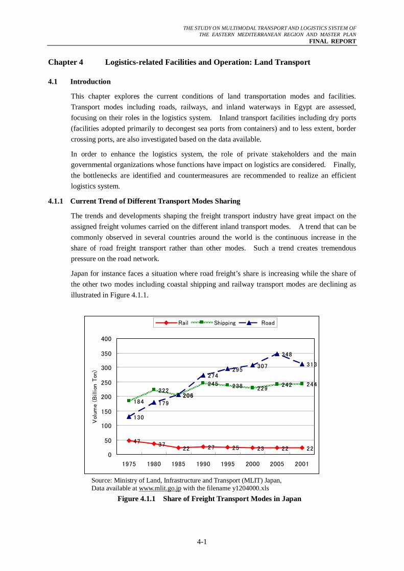
Japan for instance faces a situation where road freight’s share is increasing while the share of the other two modes including coastal shipping and railway transport modes are declining as illustrated in Figure 4.1.1.
4737 27 25 23 22 22
184
222206
245229
242 244
130
179
206
274295
307
348
313
22
238
0
50
100
150
200
250
300
350
400
1975 1980 1985 1990 1995 2000 2005 2001
Vol
ume
(Billion
Ton
)
Rail Shipping Road
Source: Ministry of Land, Infrastructure and Transport (MLIT) Japan, Data available at www.mlit.go.jp with the filename y1204000.xls
Figure 4.1.1 Share of Freight Transport Modes in Japan
THE STUDY ON MULTIMODAL TRANSPORT AND LOGISTICS SYSTEM OF
THE EASTERN MEDITERRANEAN REGION AND MASTER PLAN FINAL REPORT
4-2
Although, Figure 4.1.1 shows the situation in Japan, this trend is true in many other countries including Egypt. For instance, in Europe, the growth rate of freight transport overtook the growth rate of the European Union’s GDP and in the United State, the rail and IWT’s share continues declining while the share of road freight transport rises every year.
Ideally, there is a need to transfer some of the freight transport by roads to other modes to reduce reliance on the road network, and in turn mitigate road traffic congestion.
However, this transfer is very difficult to realize because the road network provides door-to-door connections that cannot be provided by other modes. In response to customer demand and due to other factors, road transport normally has preference in terms of development over the other modes due to the issues of inter-connectivity and infrastructure required for other modes. For instance, IWT and railway transport require among others, well functioning inter-modal stations in order to have a chance to compete with road transport.
In Egypt, recent data shows (just like in Japan) that road transport overwhelmingly dominates the market. For instance, the share of road transport for freight in 2003 reached as high as 97% when expressed in tons as shown in Table 4.1.1.
The Government, represented by the Ministry of Transport, is aiming to shift some freight volume to railway transport and IWT. To achieve this target, the key strategy is the introduction of a multimodal transportation concept that integrates rail and truck or river and truck. This trend is reflected in the last ‘Five-Year Plan for Socio-Economic Development, 2002-2007" where LE 8.2 billion out of the LE 11 billion budget for the transport sector is allocated for railway development.
Table 4.1.1 Mode Share of Freight Transport in Egypt
Transported Volume of Freight in 2003 Mode
Million Ton year % of Total Road 312.0 96.9 % Railway 12.0 2.8 % IWT 2.3 0.3 % Total 326.3 100.0 %
Source: Survey of Transport & Logistics System in Egypt, ENIT, 2004 4.1.2 Logistics Stakeholders
Generally, there are four (4) stakeholders involved in the logistics system: shippers, residents, logistics service providers and governmental authorities as shown in Table 4.1.2. Functionally, each stakeholder has a fundamental role to play in the logistics system. Moreover, there is a continuous interaction among these stakeholders responding to the needs of each one of them.
The governmental authorities are the regulators whose role is to ensure that the market is equitable for all the stakeholders. It is also expected that the governmental authorities provide a platform (for instance provision of infrastructure such as port, distribution center, etc) for each sector to operate.
THE STUDY ON MULTIMODAL TRANSPORT AND LOGISTICS SYSTEM OF
THE EASTERN MEDITERRANEAN REGION AND MASTER PLAN FINAL REPORT
4-3
Shippers are the most important stakeholders for logistics service providers. They want their goods to arrive on time with the cheapest cost and in the best condition. Residents become one of the logistics stakeholders when their community is affected by the negative impact of trucks or other modes transporting freight.
On the other hand, the logistics service providers want to maximize their profits for every transaction they have. Therefore, they are applying several strategies to attain their objectives such as consolidation of cargoes, utilization of information and communication technology (ICT). The list of possible members composing each group of stakeholders is shown in Table 4.1.2:
Table 4.1.2 Major Stakeholders and Members in the Logistics System Stakeholders Members
• Raw Material Suppliers, • Distributors, • Manufacturers, • Wholesalers and Retailers, and
1. Shippers
• Others. 2. Residents • Residents.
• Railway Companies, • Trucking Companies, • Freight forwarders, • Maritime Transport Companies, • Air Transport Companies, • Terminal Companies, • Warehouse Companies, and
3. Logistic Service Providers
• Others. • Ministry of Transport, • Ministry of Finance, • Ministry of Trade and Industry, • Ministry of Health,
4. Governmental Authorities
• Ministry of Agriculture, and • Ministry of Investment.
Source: JICA Study Team 4.1.3 Governmental Organization Related to Logistics
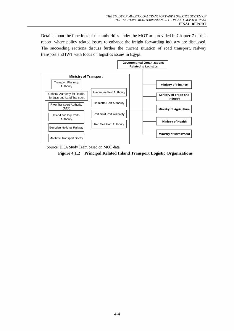
The Ministry of Transport (MOT) is responsible for planning, constructing, maintaining, and operating the national road, railway, and the inland waterway networks through its affiliated agencies (Figure 4.1.2).
The main institutions in the inland freight transport belonging to the Ministry of Transportation (MOT) are the Transport Planning Authority (TPA), General Authority for Roads, Bridges and Land Transport (GARBLT), Egyptian National Railway (ENR), River Transport Authority (RTA), Inland and Dry Ports Authority, Maritime Transport Sector, and Port Authorities.
Other governmental organizations that are related to the logistics system are the Customs Authority under the Ministry of Finance, General Organization for Export and Import under the Ministry of Trade and Industry, and some other agencies concerned with quarantine under the Ministries of Agriculture and Health.
THE STUDY ON MULTIMODAL TRANSPORT AND LOGISTICS SYSTEM OF
THE EASTERN MEDITERRANEAN REGION AND MASTER PLAN FINAL REPORT
4-4
Details about the functions of the authorities under the MOT are provided in Chapter 7 of this report, where policy related issues to enhance the freight forwarding industry are discussed. The succeeding sections discuss further the current situation of road transport, railway transport and IWT with focus on logistics issues in Egypt.
Ministry of TransportTransport Planning
Authority
General Authority for Roads,Bridges and Land Transport
River Transport Authority(RTA)
Inland and Dry PortsAuthority
Egyptian National Railway
Maritime Transport Sector
Alexandria Port Authority
Damietta Port Authority
Port Said Port Authority
Red Sea Port Authority
Ministry of Finance
Ministry of Trade andIndustry
Ministry of Agriculture
Ministry of Health
Ministry of Investment
Governmental Organizations Related to Logistics
Source: JICA Study Team based on MOT data
Figure 4.1.2 Principal Related Inland Transport Logistic Organizations
THE STUDY ON MULTIMODAL TRANSPORT AND LOGISTICS SYSTEM OF
THE EASTERN MEDITERRANEAN REGION AND MASTER PLAN FINAL REPORT
4-5
4.2 Road System
This section reviews the situation of the road logistics system in Egypt. The review focuses on structure and performance of truck operation in relation to freight movements. Firstly, existing issues are assessed to highlight the bottlenecks and shortcomings in existing facilities. Thereafter, the recommended potential countermeasures are presented and evaluated.
4.2.1 Truck Operators
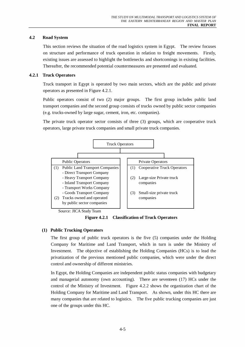
Truck transport in Egypt is operated by two main sectors, which are the public and private operators as presented in Figure 4.2.1.
Public operators consist of two (2) major groups. The first group includes public land transport companies and the second group consists of trucks owned by public sector companies (e.g. trucks-owned by large sugar, cement, iron, etc. companies).
The private truck operator sector consists of three (3) groups, which are cooperative truck operators, large private truck companies and small private truck companies.
Truck Operators
Public Operators Private Operators(1) Public Land Transport Companies (1) Cooperative Truck Operators
- Direct Transport Company- Heavy Transport Company (2) Large-size Private truck- Inland Transport Company companies- Transport Works Company- Goods Transport Company (3) Small-size private truck
(2) Tracks owned and operated companiesby public sector companies
Source: JICA Study Team
Figure 4.2.1 Classification of Truck Operators
(1) Public Trucking Operators
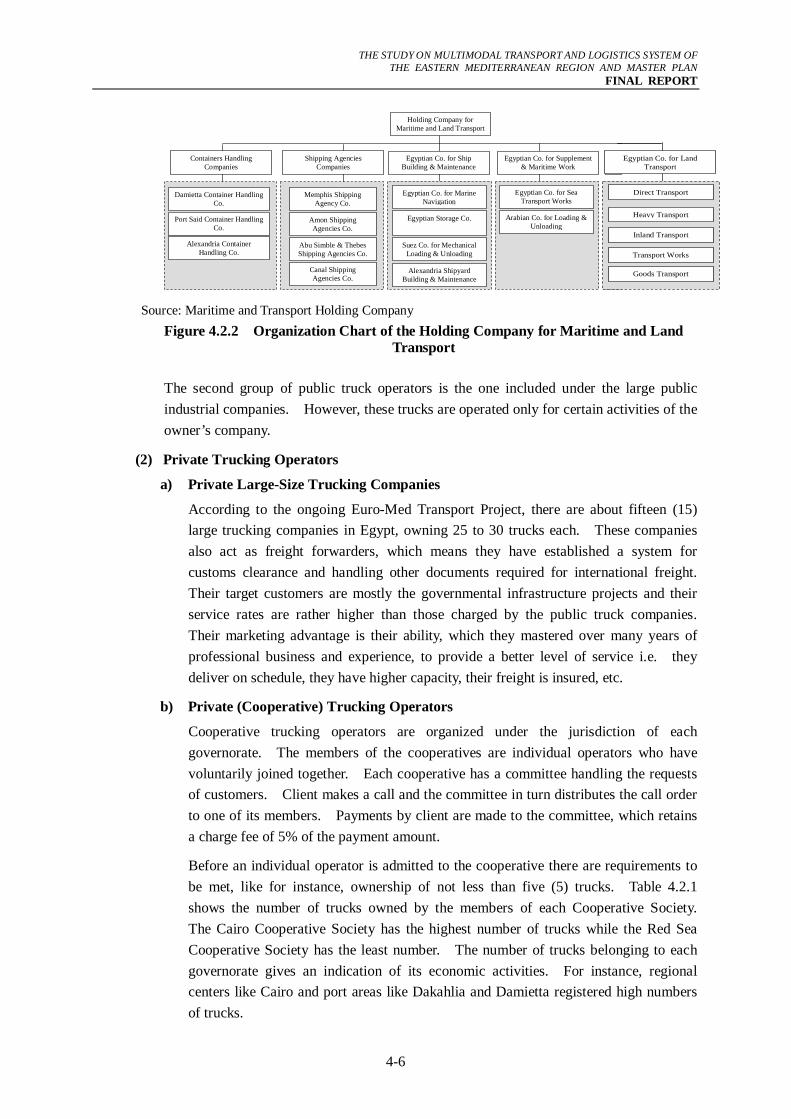
The first group of public truck operators is the five (5) companies under the Holding Company for Maritime and Land Transport, which in turn is under the Ministry of Investment. The objective of establishing the Holding Companies (HCs) is to lead the privatization of the previous mentioned public companies, which were under the direct control and ownership of different ministries.
In Egypt, the Holding Companies are independent public status companies with budgetary and managerial autonomy (own accounting). There are seventeen (17) HCs under the control of the Ministry of Investment. Figure 4.2.2 shows the organization chart of the Holding Company for Maritime and Land Transport. As shown, under this HC there are many companies that are related to logistics. The five public trucking companies are just one of the groups under this HC.
THE STUDY ON MULTIMODAL TRANSPORT AND LOGISTICS SYSTEM OF
THE EASTERN MEDITERRANEAN REGION AND MASTER PLAN FINAL REPORT
4-6
Containers Handling Companies
Shipping Agencies Companies
Amon Shipping Agencies Co.
Memphis Shipping Agency Co.
Abu Simble & Thebes Shipping Agencies Co.
Canal Shipping Agencies Co.
Damietta Container Handling Co.
Port Said Container Handling Co.
Alexandria Container Handling Co.
Egyptian Co. for Marine Navigation
Egyptian Co. for Sea Transport Works
Egyptian Storage Co.
Arabian Co. for Loading & Unloading
Suez Co. for Mechanical Loading & Unloading
Egyptian Co. for Ship Building & Maintenance
Egyptian Co. for Supplement & Maritime Work
Alexandria Shipyard Building & Maintenance
E
Holding Company for Maritime and Land Transport
Egyptian Co. for Land
Transport
Direct Transport
Heavy Transport
Inland Transport
Transport Works
Goods Transport
Source: Maritime and Transport Holding Company Figure 4.2.2 Organization Chart of the Holding Company for Maritime and Land
Transport
The second group of public truck operators is the one included under the large public industrial companies. However, these trucks are operated only for certain activities of the owner’s company.
(2) Private Trucking Operators
a) Private Large-Size Trucking Companies
According to the ongoing Euro-Med Transport Project, there are about fifteen (15) large trucking companies in Egypt, owning 25 to 30 trucks each. These companies also act as freight forwarders, which means they have established a system for customs clearance and handling other documents required for international freight. Their target customers are mostly the governmental infrastructure projects and their service rates are rather higher than those charged by the public truck companies. Their marketing advantage is their ability, which they mastered over many years of professional business and experience, to provide a better level of service i.e. they deliver on schedule, they have higher capacity, their freight is insured, etc.
b) Private (Cooperative) Trucking Operators
Cooperative trucking operators are organized under the jurisdiction of each governorate. The members of the cooperatives are individual operators who have voluntarily joined together. Each cooperative has a committee handling the requests of customers. Client makes a call and the committee in turn distributes the call order to one of its members. Payments by client are made to the committee, which retains a charge fee of 5% of the payment amount.
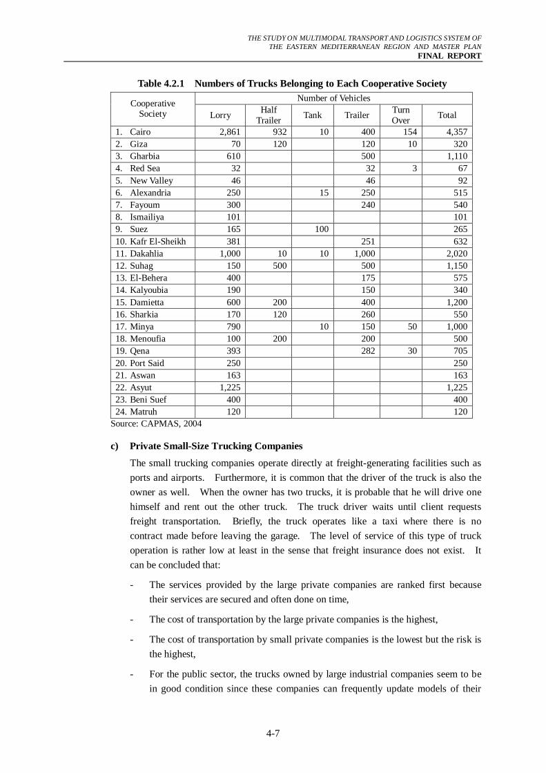
Before an individual operator is admitted to the cooperative there are requirements to be met, like for instance, ownership of not less than five (5) trucks. Table 4.2.1 shows the number of trucks owned by the members of each Cooperative Society. The Cairo Cooperative Society has the highest number of trucks while the Red Sea Cooperative Society has the least number. The number of trucks belonging to each governorate gives an indication of its economic activities. For instance, regional centers like Cairo and port areas like Dakahlia and Damietta registered high numbers of trucks.
THE STUDY ON MULTIMODAL TRANSPORT AND LOGISTICS SYSTEM OF
THE EASTERN MEDITERRANEAN REGION AND MASTER PLAN FINAL REPORT
4-7
Table 4.2.1 Numbers of Trucks Belonging to Each Cooperative Society Number of Vehicles Cooperative
Society Lorry Half Trailer Tank Trailer Turn
Over Total
1. Cairo 2,861 932 10 400 154 4,3572. Giza 70 120 120 10 3203. Gharbia 610 500 1,1104. Red Sea 32 32 3 675. New Valley 46 46 926. Alexandria 250 15 250 5157. Fayoum 300 240 5408. Ismailiya 101 1019. Suez 165 100 26510. Kafr El-Sheikh 381 251 63211. Dakahlia 1,000 10 10 1,000 2,02012. Suhag 150 500 500 1,15013. El-Behera 400 175 57514. Kalyoubia 190 150 34015. Damietta 600 200 400 1,20016. Sharkia 170 120 260 55017. Minya 790 10 150 50 1,00018. Menoufia 100 200 200 50019. Qena 393 282 30 70520. Port Said 250 25021. Aswan 163 16322. Asyut 1,225 1,22523. Beni Suef 400 40024. Matruh 120 120
Source: CAPMAS, 2004
c) Private Small-Size Trucking Companies
The small trucking companies operate directly at freight-generating facilities such as ports and airports. Furthermore, it is common that the driver of the truck is also the owner as well. When the owner has two trucks, it is probable that he will drive one himself and rent out the other truck. The truck driver waits until client requests freight transportation. Briefly, the truck operates like a taxi where there is no contract made before leaving the garage. The level of service of this type of truck operation is rather low at least in the sense that freight insurance does not exist. It can be concluded that:
- The services provided by the large private companies are ranked first because their services are secured and often done on time,
- The cost of transportation by the large private companies is the highest,
- The cost of transportation by small private companies is the lowest but the risk is the highest,
- For the public sector, the trucks owned by large industrial companies seem to be in good condition since these companies can frequently update models of their
THE STUDY ON MULTIMODAL TRANSPORT AND LOGISTICS SYSTEM OF
THE EASTERN MEDITERRANEAN REGION AND MASTER PLAN FINAL REPORT
4-8
trucks,
- In the case of the holding company, the fleet of trucks seems to suffer from a high percentage of old models. The efficiency of the holding company truck fleet is recognizably limited due to the high maintenance cost of the old trucks, and
- In future, encouragement of large private truck operators companies could have a significant effect on the improvement of facilities. Due to the competition among those companies, the high transportation cost mentioned is one disadvantage that this sector will need to rectify.
4.2.2 Major Freight Routes and Current Facilities
(1) Road Network Condition
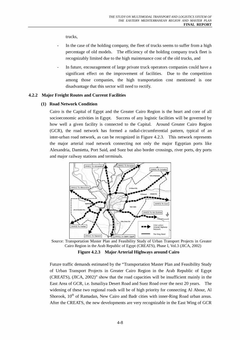
Cairo is the Capital of Egypt and the Greater Cairo Region is the heart and core of all socioeconomic activities in Egypt. Success of any logistic facilities will be governed by how well a given facility is connected to the Capital. Around Greater Cairo Region (GCR), the road network has formed a radial-circumferential pattern, typical of an inter-urban road network, as can be recognized in Figure 4.2.3. This network represents the major arterial road network connecting not only the major Egyptian ports like Alexandria, Damietta, Port Said, and Suez but also border crossings, river ports, dry ports and major railway stations and terminals.
Source: Transportation Master Plan and Feasibility Study of Urban Transport Projects in Greater
Cairo Region in the Arab Republic of Egypt (CREATS), Phase I, Vol.3 (JICA, 2002) Figure 4.2.3 Major Arterial Highways around Cairo
Future traffic demands estimated by the “Transportation Master Plan and Feasibility Study of Urban Transport Projects in Greater Cairo Region in the Arab Republic of Egypt (CREATS), (JICA, 2002)” show that the road capacities will be insufficient mainly in the East Area of GCR, i.e. Ismailiya Desert Road and Suez Road over the next 20 years. The widening of these two regional roads will be of high priority for connecting Al Abour, Al Shorook, 10th of Ramadan, New Cairo and Badr cities with inner-Ring Road urban areas. After the CREATS, the new developments are very recognizable in the East Wing of GCR
THE STUDY ON MULTIMODAL TRANSPORT AND LOGISTICS SYSTEM OF
THE EASTERN MEDITERRANEAN REGION AND MASTER PLAN FINAL REPORT
4-9
especially in New Cairo area.
The Cairo-Alexandria Desert Road has been almost completely widened to 4-lanes in each direction except some sections especially at bridge crossings. This road is classified as a toll road with a maximum allowable speed of 100 km/hr for passenger cars and where the user has to pay fee to use the road, as shown hereunder. It may be difficult to implement any further widening of this road in future due to existing adjacent land uses. The ADT count in year 2006 along this road was 27,551 veh/day. It was announced by the General Authority for Roads, Bridges and Land Transport (GARBLT) in the beginning of July 2007 that this road would be upgraded to become free highway with 120 km/hr maximum speed limit.
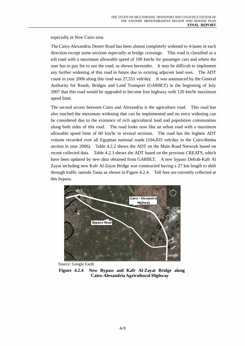
The second access between Cairo and Alexandria is the agriculture road. This road has also reached the maximum widening that can be implemented and no extra widening can be considered due to the existence of rich agricultural land and population communities along both sides of this road. The road looks now like an urban road with a maximum allowable speed limit of 60 km/hr in several sections. The road has the highest ADT volume recorded over all Egyptian national roads (104,835 veh/day in the Cairo-Benha section in year 2006). Table 4.2.2 shows the ADT on the Main Road Network based on recent collected data. Table 4.2.3 shows the ADT based on the previous CREATS, which have been updated by new data obtained from GARBLT. A new bypass Defrah-Kafr Al Zayat including new Kafr Al-Zayat Bridge was constructed having a 27 km length to shift through traffic outside Tanta as shown in Figure 4.2.4. Toll fees are currently collected at this bypass.
Cairo - Alexandria Highway
Bypass Road
Source: Google Earth Figure 4.2.4 New Bypass and Kafr Al-Zayat Bridge along
Cairo-Alexandria Agricultural Highway
THE STUDY ON MULTIMODAL TRANSPORT AND LOGISTICS SYSTEM OF
THE EASTERN MEDITERRANEAN REGION AND MASTER PLAN FINAL REPORT
4-10
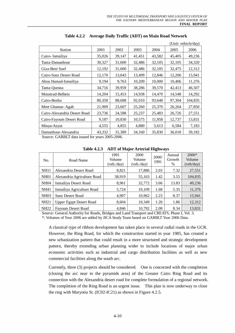
Table 4.2.2 Average Daily Traffic (ADT) on Main Road Network
(Unit: vehicle/day)Station 2001 2002 2003 2004 2005 2006
Cairo- Ismailiya 35,026 39,147 41,451 43,582 45,405 49,236Tanta-Damanhour 30,327 31,600 32,486 32,105 32,105 34,320Giza-Beni Suef 12,192 31,600 32,486 32,105 32,475 12,312Cairo-Suez Desert Road 12,170 13,043 13,499 12,846 12,206 15,941Abou Hamad-Ismailiya 9,194 9,763 10,209 10,000 10,406 11,376Tanta-Quesna 34,716 39,959 38,286 39,570 42,413 46,507Moustrad-Belbeis 14,204 15,453 14,938 14,470 14,548 14,292Cairo-Benha 80,358 88,688 92,010 93,648 97,304 104,835Meet Ghamar- Agah 21,909 23,607 25,260 25,370 26,264 27,850Cairo-Alexandria Desert Road 23,736 24,588 25,237 25,483 26,726 27,551Cairo-Fayoum Desert Road 9,187 10,830 10,575 11,958 12,737 13,831Minya-Asyut 4,555 4,855 4,880 5,613 6,584 7,183Damanhour-Alexandria 43,332 31,389 34,160 35,830 36,018 39,182Source: GARBLT data issued for years 2005-2006.
Table 4.2.3 ADT of Major Arterial Highways
No. Road Name 1991
Volume (veh./day)
2000 Volume
(veh./day)
2000/1991
Annual Growth
%
2006* Volume
(veh/day)NH11 Alexandria Desert Road 8,821 17,886 2.03 7.32 27,551NH01 Alexandria Agriculture Road 38,919 55,163 1.42 3.55 104,835NH04 Ismailiya Desert Road 8,961 32,772 3.66 13.83 49,236NH41 Ismailiya Agriculture Road 5,724 10,109 1.68 5.35 11,376NH03 Suez Desert Road 4,907 10,962 2.23 8.37 15,941NH21 Upper Egypt Desert Road 8,604 10,349 1.20 1.86 12,312NH22 Fayoum Desert Road 4,846 10,792 2.08 8.34 13,831Source: General Authority for Roads, Bridges and Land Transport and CREATS, Phase I, Vol. 3. *: Volumes of Year 2006 are added by JICA Study Team based on GARBLT Year 2006 Data.
A classical type of ribbon development has taken place in several radial roads in the GCR. However, the Ring Road, for which the construction started in year 1985, has created a new urbanization pattern that could result in a more structured and strategic development pattern, thereby extending urban planning wider to include locations of major urban economic activities such as industrial and cargo distribution facilities as well as new commercial facilities along the south arc.
Currently, three (3) projects should be considered. One is concerned with the completion (closing the arc near to the pyramids area) of the Greater Cairo Ring Road and its connection with the Alexandria desert road for complete formulation of a regional network. The completion of the Ring Road is an urgent issue. This plan is now underway to close the ring with Maryotia St. (IC02-IC21) as shown in Figure 4.2.5.
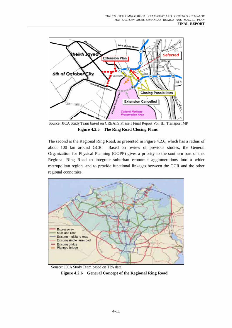
THE STUDY ON MULTIMODAL TRANSPORT AND LOGISTICS SYSTEM OF
THE EASTERN MEDITERRANEAN REGION AND MASTER PLAN FINAL REPORT
4-11
Source: JICA Study Team based on CREATS Phase I Final Report Vol. III: Transport MP
Figure 4.2.5 The Ring Road Closing Plans
The second is the Regional Ring Road, as presented in Figure 4.2.6, which has a radius of about 100 km around GCR. Based on review of previous studies, the General Organization for Physical Planning (GOPP) gives a priority to the southern part of this Regional Ring Road to integrate suburban economic agglomerations into a wider metropolitan region, and to provide functional linkages between the GCR and the other regional economies.
Source: JICA Study Team based on TPA data.
Figure 4.2.6 General Concept of the Regional Ring Road
Expressway Multilane road Existing multilane road Existing single lane road Existing bridge Planned bridge
Selected
THE STUDY ON MULTIMODAL TRANSPORT AND LOGISTICS SYSTEM OF
THE EASTERN MEDITERRANEAN REGION AND MASTER PLAN FINAL REPORT
4-12
The third project presented is the proposed expressway network based on "Public-Private Partnership (PPP) Program for Cairo Urban Toll Expressway Network Development (JICA, 2006)".
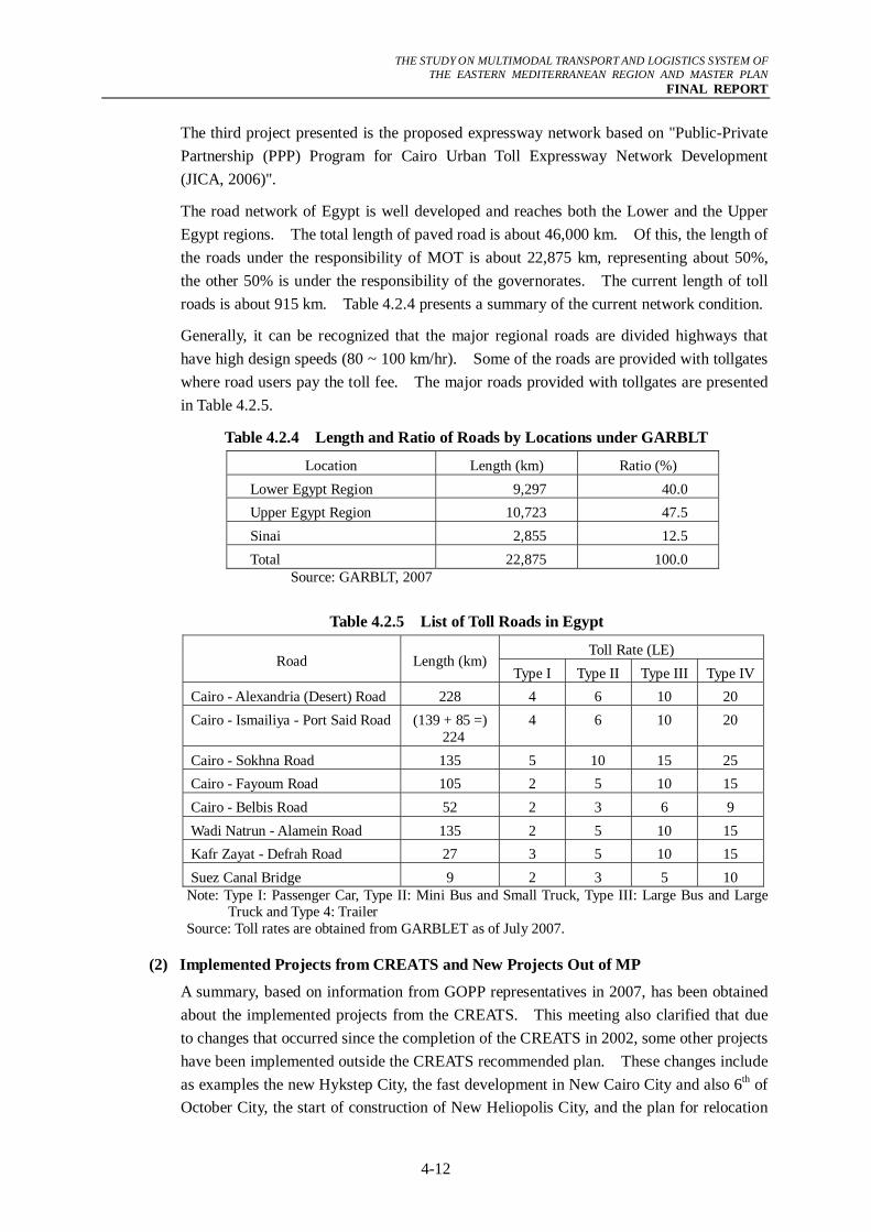
The road network of Egypt is well developed and reaches both the Lower and the Upper Egypt regions. The total length of paved road is about 46,000 km. Of this, the length of the roads under the responsibility of MOT is about 22,875 km, representing about 50%, the other 50% is under the responsibility of the governorates. The current length of toll roads is about 915 km. Table 4.2.4 presents a summary of the current network condition.
Generally, it can be recognized that the major regional roads are divided highways that have high design speeds (80 ~ 100 km/hr). Some of the roads are provided with tollgates where road users pay the toll fee. The major roads provided with tollgates are presented in Table 4.2.5.
Table 4.2.4 Length and Ratio of Roads by Locations under GARBLT
Location Length (km) Ratio (%) Lower Egypt Region 9,297 40.0 Upper Egypt Region 10,723 47.5 Sinai 2,855 12.5 Total 22,875 100.0
Source: GARBLT, 2007
Table 4.2.5 List of Toll Roads in Egypt
Toll Rate (LE) Road Length (km)
Type I Type II Type III Type IVCairo - Alexandria (Desert) Road 228 4 6 10 20 Cairo - Ismailiya - Port Said Road (139 + 85 =)
224 4 6 10 20
Cairo - Sokhna Road 135 5 10 15 25 Cairo - Fayoum Road 105 2 5 10 15 Cairo - Belbis Road 52 2 3 6 9 Wadi Natrun - Alamein Road 135 2 5 10 15 Kafr Zayat - Defrah Road 27 3 5 10 15 Suez Canal Bridge 9 2 3 5 10
Note: Type I: Passenger Car, Type II: Mini Bus and Small Truck, Type III: Large Bus and Large Truck and Type 4: Trailer
Source: Toll rates are obtained from GARBLET as of July 2007.
(2) Implemented Projects from CREATS and New Projects Out of MP
A summary, based on information from GOPP representatives in 2007, has been obtained about the implemented projects from the CREATS. This meeting also clarified that due to changes that occurred since the completion of the CREATS in 2002, some other projects have been implemented outside the CREATS recommended plan. These changes include as examples the new Hykstep City, the fast development in New Cairo City and also 6th of October City, the start of construction of New Heliopolis City, and the plan for relocation
THE STUDY ON MULTIMODAL TRANSPORT AND LOGISTICS SYSTEM OF
THE EASTERN MEDITERRANEAN REGION AND MASTER PLAN FINAL REPORT
4-13
of some ministries outside the Cairo Central Business District (CBD). The CREATS implemented projects are highlighted in the Table 4.2.6 and the new added projects are listed hereunder:
a) Arterial Roads
- An interchange to connect Badr City with the Cairo-Ismailiya Primary Arterial Highway. This Project has been approved by the Cabinet of Ministries.
- An interchange to connect Al Shoruq City with the Cairo-Ismailiya Arterial Highway. This Project has been approved by the Cabinet of Ministries.
- An interchange to connect the Ring Road with (Ismailiya, Balbis and El-Salam City). This project is in the bidding stage.
b) Primary Roads
GOPP recommended extending HP-6 to connect Balibs, Ring Road, Tarat, El-Ismailiya, Corniche El Nil.
c) Railway Sector
- GOPP recommended extending Subway line 2 to Kalyoubia and this project is within the CREATS Project PTM3.
- Construct of Subway Line 4 from King Fisal Street to Imbabah.
- GOPP is supporting the quick implementation of a railway line connecting Cairo University with Zayed and 6th of October Cities with a length of about 41 km. This project is included in the CREATS.
- GOPP is supporting the quick implementation of a railway line connecting Ain Shams Station to 10th of Ramadan City. This project is included in the CREATS.
- GOPP recommended out of the CREATS a new railway line to connect 6th of October/Al Rimyah Squar/El-Fayoum and Al Wahat highway with a length of about 34 km.
THE STUDY ON MULTIMODAL TRANSPORT AND LOGISTICS SYSTEM OF
THE EASTERN MEDITERRANEAN REGION AND MASTER PLAN FINAL REPORT
4-14
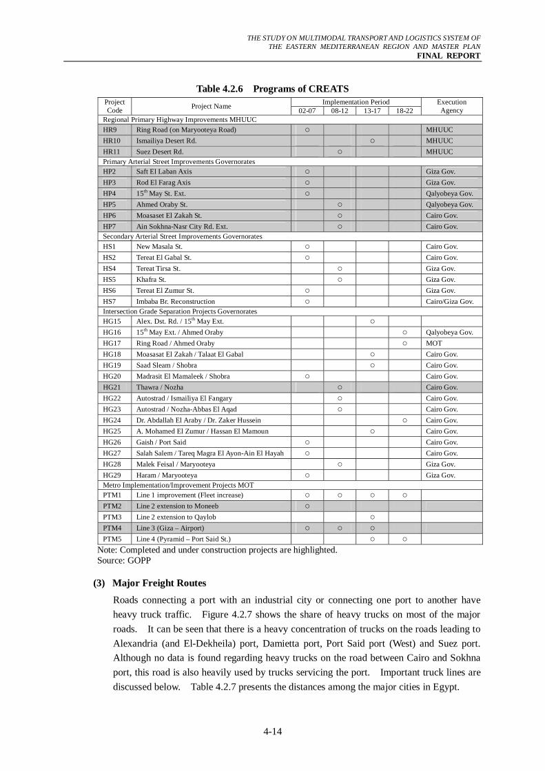
Table 4.2.6 Programs of CREATS Implementation Period Project
Code Project Name 02-07 08-12 13-17 18-22 Execution Agency
Regional Primary Highway Improvements MHUUC HR9 Ring Road (on Maryooteya Road) ○ MHUUC HR10 Ismailiya Desert Rd. ○ MHUUC HR11 Suez Desert Rd. ○ MHUUC Primary Arterial Street Improvements Governorates HP2 Saft El Laban Axis ○ Giza Gov. HP3 Rod El Farag Axis ○ Giza Gov. HP4 15th May St. Ext. ○ Qalyobeya Gov. HP5 Ahmed Oraby St. ○ Qalyobeya Gov. HP6 Moasaset El Zakah St. ○ Cairo Gov. HP7 Ain Sokhna-Nasr City Rd. Ext. ○ Cairo Gov. Secondary Arterial Street Improvements Governorates HS1 New Masala St. ○ Cairo Gov. HS2 Tereat El Gabal St. ○ Cairo Gov. HS4 Tereat Tirsa St. ○ Giza Gov. HS5 Khafra St. ○ Giza Gov. HS6 Tereat El Zumur St. ○ Giza Gov. HS7 Imbaba Br. Reconstruction ○ Cairo/Giza Gov. Intersection Grade Separation Projects Governorates HG15 Alex. Dst. Rd. / 15th May Ext. ○ HG16 15th May Ext. / Ahmed Oraby ○ Qalyobeya Gov. HG17 Ring Road / Ahmed Oraby ○ MOT HG18 Moasasat El Zakah / Talaat El Gabal ○ Cairo Gov. HG19 Saad Sleam / Shobra ○ Cairo Gov. HG20 Madrasit El Mamaleek / Shobra ○ Cairo Gov. HG21 Thawra / Nozha ○ Cairo Gov. HG22 Autostrad / Ismailiya El Fangary ○ Cairo Gov. HG23 Autostrad / Nozha-Abbas El Aqad ○ Cairo Gov. HG24 Dr. Abdallah El Araby / Dr. Zaker Hussein ○ Cairo Gov. HG25 A. Mohamed El Zumur / Hassan El Mamoun ○ Cairo Gov. HG26 Gaish / Port Said ○ Cairo Gov. HG27 Salah Salem / Tareq Magra El Ayon-Ain El Hayah ○ Cairo Gov. HG28 Malek Feisal / Maryooteya ○ Giza Gov. HG29 Haram / Maryooteya ○ Giza Gov. Metro Implementation/Improvement Projects MOT PTM1 Line 1 improvement (Fleet increase) ○ ○ ○ ○ PTM2 Line 2 extension to Moneeb ○ PTM3 Line 2 extension to Qaylob ○ PTM4 Line 3 (Giza – Airport) ○ ○ ○ PTM5 Line 4 (Pyramid – Port Said St.) ○ ○
Note: Completed and under construction projects are highlighted. Source: GOPP
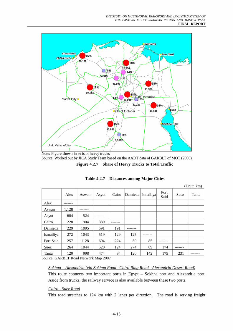
(3) Major Freight Routes
Roads connecting a port with an industrial city or connecting one port to another have heavy truck traffic. Figure 4.2.7 shows the share of heavy trucks on most of the major roads. It can be seen that there is a heavy concentration of trucks on the roads leading to Alexandria (and El-Dekheila) port, Damietta port, Port Said port (West) and Suez port. Although no data is found regarding heavy trucks on the road between Cairo and Sokhna port, this road is also heavily used by trucks servicing the port. Important truck lines are discussed below. Table 4.2.7 presents the distances among the major cities in Egypt.
THE STUDY ON MULTIMODAL TRANSPORT AND LOGISTICS SYSTEM OF
THE EASTERN MEDITERRANEAN REGION AND MASTER PLAN FINAL REPORT
4-15
Note: Figure shown in % is of heavy trucks Source: Worked out by JICA Study Team based on the AADT data of GARBLT of MOT (2006)
Figure 4.2.7 Share of Heavy Trucks to Total Traffic
Table 4.2.7 Distances among Major Cities
(Unit: km)
Alex Aswan Asyut Cairo Damietta Ismailiya Port Said Suez Tanta
Alex ------- Aswan 1,128 ------- Asyut 604 524 ------- Cairo 228 904 380 ------- Damietta 229 1095 591 191 ------- Ismailiya 272 1043 519 129 125 ------- Port Said 257 1128 604 224 50 85 ------- Suez 264 1044 520 124 274 89 174 ------- Tanta 120 998 474 94 120 142 175 231 -------
Source: GARBLT Road Network Map 2007
Sokhna – Alexandria (via Sokhna Road –Cairo Ring Road –Alexandria Desert Road) This route connects two important ports in Egypt – Sokhna port and Alexandria port. Aside from trucks, the railway service is also available between these two ports.
Cairo - Suez Road This road stretches to 124 km with 2 lanes per direction. The road is serving freight
14%14%14%14%14%14%14%14%14%
13%13%13%13%13%13%13%13%13%
AlexandriaAlexandriaAlexandriaAlexandriaAlexandriaAlexandriaAlexandriaAlexandriaAlexandria
El-DekheilaEl-DekheilaEl-DekheilaEl-DekheilaEl-DekheilaEl-DekheilaEl-DekheilaEl-DekheilaEl-Dekheila
49,23649,23649,23649,23649,23649,23649,23649,23649,236
34,31934,31934,31934,31934,31934,31934,31934,31934,319
12,31212,31212,31212,31212,31212,31212,31212,31212,312
15,94115,94115,94115,94115,94115,94115,94115,94115,941
11,37611,37611,37611,37611,37611,37611,37611,37611,376
46,50646,50646,50646,50646,50646,50646,50646,50646,506
14,29114,29114,29114,29114,29114,29114,29114,29114,291
20,85420,85420,85420,85420,85420,85420,85420,85420,854
27,55127,55127,55127,55127,55127,55127,55127,55127,551
13,83113,83113,83113,83113,83113,83113,83113,83113,831
39,18239,18239,18239,18239,18239,18239,18239,18239,182
6%6%6%6%6%6%6%6%6%
8%8%8%8%8%8%8%8%8%
8%8%8%8%8%8%8%8%8%
16%16%16%16%16%16%16%16%16%
18%18%18%18%18%18%18%18%18%
18%18%18%18%18%18%18%18%18%
18%18%18%18%18%18%18%18%18%
14%14%14%14%14%14%14%14%14%
19%19%19%19%19%19%19%19%19%
16%16%16%16%16%16%16%16%16%
16%16%16%16%16%16%16%16%16%
DamiettaDamiettaDamiettaDamiettaDamiettaDamiettaDamiettaDamiettaDamietta
Port SaidPort SaidPort SaidPort SaidPort SaidPort SaidPort SaidPort SaidPort Said
SuezSuezSuezSuezSuezSuezSuezSuezSuez
Sokhna PortSokhna PortSokhna PortSokhna PortSokhna PortSokhna PortSokhna PortSokhna PortSokhna Port
Sadat City
6th of October
10th of Ramadan
Unit: Vehicle/day
THE STUDY ON MULTIMODAL TRANSPORT AND LOGISTICS SYSTEM OF
THE EASTERN MEDITERRANEAN REGION AND MASTER PLAN FINAL REPORT
4-16
between Suez and Sokhna ports and several industrial cities such as 10th of Ramadan, 6th of October and also GCR.
Port Said – Ismailiya Road The length of this road is 85 km with 2 lanes per direction. This road is absorbing truck traffic coming from both Damietta port and Port Said port moving into the direction of 10th of Ramadan and GCR. Trucks coming from Damietta port are observed to prefer to use this road to avoid being caught by local traffic along the Damietta-Tanta-Cairo route.
Port Said – Damietta Road This road connects Port Said port (West) located at the mouth of Suez Canal and the Damietta port. The length of the road is just 50 km with 2 lanes per direction. Due to the closeness of the two ports, shippers sometimes request to have their containers at Damietta port even though the ship docked at Port Said port. The opposite can also happen where containers are moved to Port Said after they arrived at Damietta port. The reason for such shipper behavior is that they want to have their container where they have an established system for easy clearance through their business relationships.
Cairo-Damietta – Road This road has a length of 191 km and some sections are 2 lanes and others are 3 lanes. Freight is destined for GCR and mostly follows the agricultural road that connects Damietta- Mahalla-Tanta-Cairo. For freight that has its destination in 10th of Ramadan, most trucks are reported to prefer the Damietta-Port Said-Ismailiya-10th of Ramadan to avoid local traffic of towns along the Damietta-Mahalla-Zagazig-10th of Ramadan route. This road has many road humps aimed to enforce speed reduction because the road passes through populated areas. Such humps have significant effect on truck speed.
Cairo – Alexandria through Desert Road This road provides a strong connection between the two key cities of Egypt. The road has a length of 220 km with 3 lanes (some sections have 2 lanes) per direction. Traffic in this road is smooth although traffic congestion is experienced on the approach road at both ends of the road.
Cairo - Alexandria through Agricultural Road The agricultural road is another alternative road linking Cairo and Alexandria. This road has a total length of 228 km with some sections having 2 lanes and some having 3 lanes per direction. There are several cities along this road, making it one of the roads with the heaviest traffic flow.
Cairo - Upper Egypt Agricultural Road This road is traditionally the most important road link to Upper Egypt although the long-term development strategy of the government is to divert traffic to the desert part to protect the arable land along the River Nile.
Cairo - Upper Egypt Desert Road This road passes Fayoum Governorate and runs parallel to Upper Egypt Agricultural Road. These two roads are serving highly productive agricultural land producing crops such as
THE STUDY ON MULTIMODAL TRANSPORT AND LOGISTICS SYSTEM OF
THE EASTERN MEDITERRANEAN REGION AND MASTER PLAN FINAL REPORT
4-17
onion, vegetables, rice, maize, sugar cane, banana, and apples among others.
4.2.3 Operation Performance and Efficiency
(1) Number of Registered Trucks
The growth of freight vehicle numbers is rather moderate and hasn’t exceeded 2% since 2001. Table 4.2.8 shows the total registered number of vehicles in year 2006. It is apparent that the economic hubs of the country such as Cairo, Alexandria, and Giza governorates have the highest number of registered trucks.
Table 4.2.8 Total Number of Registered Heavy Vehicles in Year 2006 Unit: vehicle
Governorate Trucks Trailer Cairo 99,418 8,871 Alexandria 75,163 15,314 Port Said 5,010 936 Suez 5,342 709 Al Ismailiya 13,854 735 Damietta 12,887 1,034 Al-Sharkia 50,843 3,930 Dekheila 50,013 6,162 Behera 46,171 4,984 El Gharbia 41,762 4,125 El Menoufia 23,239 1,472 Kafr El-Shiekh 26,970 970 Al Qalyubiyah 29,750 1,200 Giza 61,851 3,906 Fayoum 12,929 1,975 Beni Suef 17,446 330 Minya 22,408 826 Asyut 25,327 1,203 Suhag 16,718 1,003 Qena 12,473 676 Aswan 9,424 166 Matrouh 9,338 319 Red Sea 5,148 437 El-Wadi El-Gaded 1,992 198 North Sinai 6,609 197 South Sinai 3,547 70 Luxor 1,990 16
Total 687,622 61,764 Note : Total figures for Truck and Trailer in an original sheet
provided by GARBLT were 685,273 and 60,857 respectively. These are revised by the JICA Study Team.
Source: GARBLT, MOT
The total number of trucks owned by the five trucking companies under the Holding Company for Maritime and Land Transport is 1,238. Breakdown of this number among the companies is given in Table 4.2.9. These companies are responsible for 1.2% (5 million tons) of freight via road transport.
THE STUDY ON MULTIMODAL TRANSPORT AND LOGISTICS SYSTEM OF
THE EASTERN MEDITERRANEAN REGION AND MASTER PLAN FINAL REPORT
4-18
Table 4.2.9 Truck Fleet of the Maritime and Land Transport Holding Company
Company name No. of Trucks 1. Nile Company for Goods 230 2. Nile Company for Land Transport 235 3. Nile Company for Direct Transport 277 4. Nile Company for Transport Works 258 5. Nile Company for Heavy Transport 238
Source : JICA Study Team Interview
(2) Volume of Freight Transported by Trucks
As earlier indicated, road transport is dominating the market and in 2002, trucks captured 97% leaving just 3% for the other two modes of railway and inland water transport. The 24 cooperative societies transported around 6% while the public trucking companies managed about 1.2% as shown in Table 4.2.10. The remaining is captured by private companies. Even though this data is not so recent, this trend is still applicable especially under the reported shortage in the number of ENR locomotives as will be shown hereafter.
Table 4.2.10 Volume of Freight Handled by Trucks (2002)
Freight Carried Item
Million ton per year % of total 5 Public Trucking Companies 5.0 1.2 24 Cooperative Societies 24.4 5.8 Other Private companies 392.0 93.0 Total 421.4 100
Source: Sustainable Transport (Project Document), UNDP (2006)
(3) Freight Volume at International Border Crossings
Egypt has five (5) international border crossings one with Palestine, one with Israel, one with Libya and two with Sudan as shown in Table 4.2.11.
Table 4.2.11 Type of Services at International Border Crossings
Country Type of Service No. of Border Libya Passengers and freight 1 Palestine Passengers and freight 1 Israel Passengers and freight 1 Sudan Passengers and freight 2
Source: Inland and Dry Ports Authority, MOT
The volume of freight recorded at the border between Egypt and Libya at El-Saloum is presented in Table 4.2.12. The freight from Egypt to Libya is significantly larger than incoming freight to Egypt. At the other borders, the volume of handled freights could not be obtained since at these borders data are accumulated about the financial issues rather than the freight volumes.
THE STUDY ON MULTIMODAL TRANSPORT AND LOGISTICS SYSTEM OF
THE EASTERN MEDITERRANEAN REGION AND MASTER PLAN FINAL REPORT
4-19
Table 4.2.12 Import & Export Freight Volumes at El-Saloum Port
Import (Ton) Month Export (Ton)
Food Industrial Materials
Jan 7,043 0.1 45.3 Feb 9,932 1.1 132.0 March 7,870 1.7 130.0 April 7,887 2.0 45.0 May 7,899 4.6 31.0 June 10,930 13.3 128.0 Total 51,561 22.5 511.3 Source: Inland and Dry Ports Authority, MOT, 2006.
4.2.4 Ongoing Road Projects
There are many ongoing and committed projects by the government aimed at improving traffic flow as well as making strong linkages between regional centers. The central factor for this effort has been improvement of the road network through widening and promotion of traffic safety. The ongoing and committed projects are compiled in Chapter 10.
THE STUDY ON MULTIMODAL TRANSPORT AND LOGISTICS SYSTEM OF
THE EASTERN MEDITERRANEAN REGION AND MASTER PLAN FINAL REPORT
4-20
4.3 Railway System
This section assesses the existing conditions of the railway transport sector focusing on its role within logistic facilities. Most of the information was collected from several discussions with concerned officials in ENR and other governmental organizations. Information received from these interviews is complemented by other available data from previous studies and Statistical Yearbooks.
4.3.1 Major Freight Routes and Current Facilities
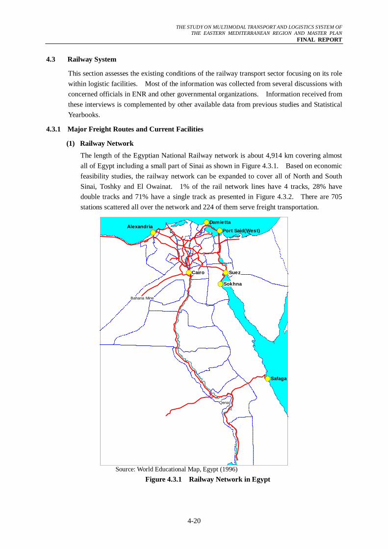
(1) Railway Network
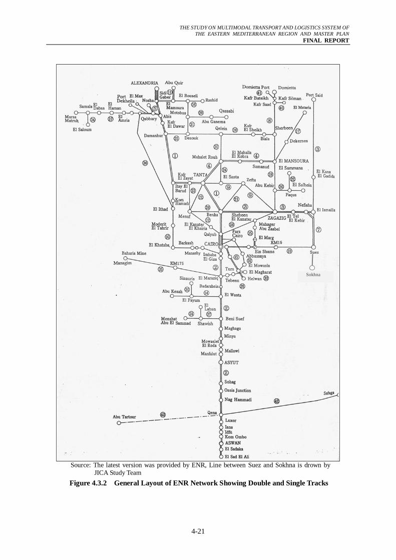
The length of the Egyptian National Railway network is about 4,914 km covering almost all of Egypt including a small part of Sinai as shown in Figure 4.3.1. Based on economic feasibility studies, the railway network can be expanded to cover all of North and South Sinai, Toshky and El Owainat. 1% of the rail network lines have 4 tracks, 28% have double tracks and 71% have a single track as presented in Figure 4.3.2. There are 705 stations scattered all over the network and 224 of them serve freight transportation.
Qena
Baharia Mine
Suez
Sokhna
Cairo
AlexandriaDamietta
Port Said(West)
Safaga
Source: World Educational Map, Egypt (1996)
Figure 4.3.1 Railway Network in Egypt
THE STUDY ON MULTIMODAL TRANSPORT AND LOGISTICS SYSTEM OF
THE EASTERN MEDITERRANEAN REGION AND MASTER PLAN FINAL REPORT
4-21
Source: The latest version was provided by ENR, Line between Suez and Sokhna is drown by
JICA Study Team Figure 4.3.2 General Layout of ENR Network Showing Double and Single Tracks
Sokhna
THE STUDY ON MULTIMODAL TRANSPORT AND LOGISTICS SYSTEM OF
THE EASTERN MEDITERRANEAN REGION AND MASTER PLAN FINAL REPORT
4-22
(2) Major Railway Freight Lines
Although the freight rail network covers a substantial part of Egypt, only a few lines are of high importance in terms of the volume carried. These lines are described below:
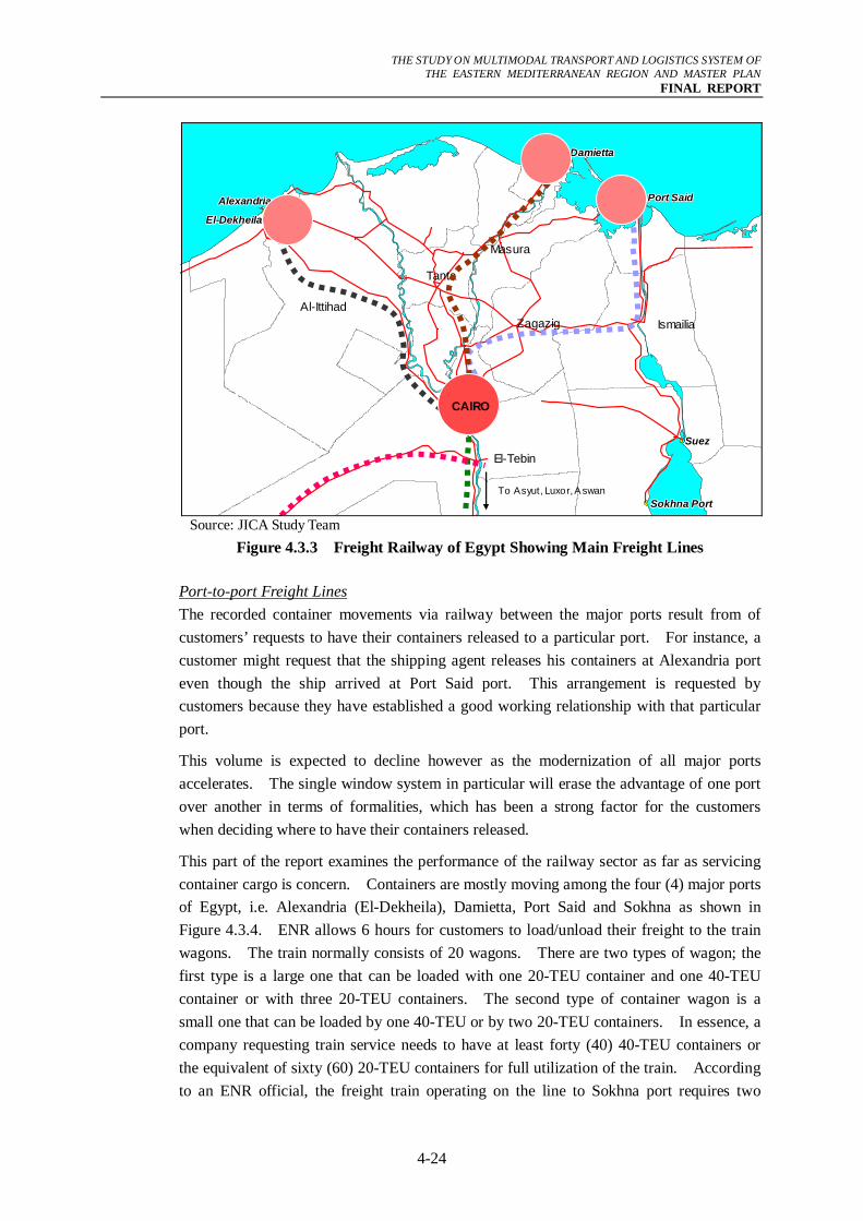
Main Freight Lines The main freight lines depend on train speed and/or volume of freight carry over a particular line. The main freight lines of ENR are presented in Figure 4.3.3 and include:
- Cairo – Ismailiya – Port Said Port (West) Line,
- Cairo – Asyut – Luxor – Aswan – High Dam Line,
- Alexandria Port - Al-Ittihad –Imbaba Line (freight line), and
- El Wahat – El Tebeen Line.
Alexandria Port - Al-Ittihad –Imbaba Line is a freight line that starts from the port of Alexandria and runs to Giza. It has a single-track line between Alexandria Port and Al-Ittihad station with a length of 122 kilometers. This line is connected at All-Ittihad station to the double-track line from Ityai El-Barud to Imbaba. It goes next to Cairo and Helwan. The line handles about 2.5 million ton/year of coal from Dekheila Port (near Alexandria) to El-Tebeen (near Helwan). On the way back, it transports the coke produced at the El-Tebin Plant.
The line has a maximum daily capacity of 40 freight trains, while it has a schedule for 24 trains. The actual number of freight trains using the line at present is only eight freight trains for coal and coke either loaded or unloaded. Each train is composed on average of 30 freight wagons. In addition, there are 2 trains for petroleum products and one train for basalt transport every week.
At present, the line has a mechanical signaling system that can be electrified to double the capacity of the line from 40 to 80 freight trains per day.
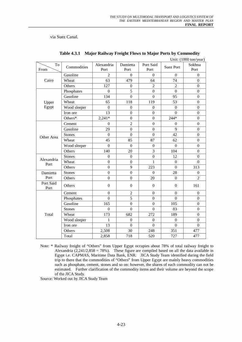
Origin and Destination of Freight Transportation Table 4.3.1 shows the gate ports and the domestic origins and destinations of major export/import commodities that use railway services at these ports. It is clear that wheat delivered to Cairo mostly comes from Damietta port with participation of Alexandria, Port Said (West), and Suez ports. For Upper Egypt (i.e. from zone 18-24; refer to Appendix 3 for the zoning system), the incoming wheat is mainly transported by railway from Damietta port and Port Said port (West) while gasoline for export is delivered to Alexandria port.
The large volumes of railway freight moving between Alexandria port and Port Said port (West)/Sokhna port are mostly transit containers. These railway services are more convenient than shipping services via Suez Canal for some transit freights that go to the final destination ports in/around the Mediterranean Sea. This is because Alexandria port offers the more frequent shipping services to those foreign ports. It is estimated that this kind of frequent services can shorten the total transportation time and can offset a higher cost of domestic railway transport between the ports in Egypt than the transportation cost
THE STUDY ON MULTIMODAL TRANSPORT AND LOGISTICS SYSTEM OF
THE EASTERN MEDITERRANEAN REGION AND MASTER PLAN FINAL REPORT
4-23
via Suez Canal.
Table 4.3.1 Major Railway Freight Flows to Major Ports by Commodity Unit: (1000 ton/year)
To From Commodities Alexandria
Port Damietta
Port Port Said
Port Suez Port Sokhna Port
Gasoline 2 0 0 0 0 Wheat 63 479 64 74 0 Cairo Others 127 0 2 2 0 Phosphates 0 5 0 0 0 Gasoline 134 0 0 95 0 Wheat 65 118 119 53 0 Wood sleeper 0 0 0 0 0 Iron ore 13 0 0 0 0
Upper Egypt
Others* 2,241* 0 0 244* 0 Cement 0 2 0 0 0 Gasoline 29 0 0 9 0 Stones 0 0 0 42 0 Wheat 45 85 87 62 0 Wood sleeper 0 0 0 0 0
Other Area
Others 140 20 3 104 0 Stones 0 0 0 12 0 Wheat 0 0 1 0 0 Alexandria
Port Others 0 9 223 0 313 Stones 0 0 0 28 0 Damietta
Port Others 0 0 20 0 2 Port Said
Port Others 0 0 0 0 161
Cement 0 2 0 0 0 Phosphates 0 5 0 0 0 Gasoline 165 0 0 105 0 Stones 0 0 0 83 0 Wheat 173 682 272 189 0 Wood sleeper 1 0 0 0 0 Iron ore 13 0 0 0 0 Others 2,508 30 248 351 477
Total
Total 2,858 718 520 727 477 Note: * Railway freight of “Others” from Upper Egypt occupies about 78% of total railway freight to
Alexandria (2,241/2,858 = 78%). These figure are compiled based on all the data available in Egypt i.e. CAPMAS, Maritime Data Bank, ENR. JICA Study Team identified during the field trip to there that the commodities of “Others” from Upper Egypt are mainly heavy commodities such as phosphate, cement, stones and so on: however, the shares of each commodity can not be estimated. Further clarification of the commodity items and their volume are beyond the scope of the JICA Study.
Source: Worked out by JICA Study Team
THE STUDY ON MULTIMODAL TRANSPORT AND LOGISTICS SYSTEM OF
THE EASTERN MEDITERRANEAN REGION AND MASTER PLAN FINAL REPORT
4-24
El-DekheilaEl-DekheilaEl-DekheilaEl-DekheilaEl-DekheilaEl-DekheilaEl-DekheilaEl-DekheilaEl-Dekheila
AlexandriaAlexandriaAlexandriaAlexandriaAlexandriaAlexandriaAlexandriaAlexandriaAlexandria
DamiettaDamiettaDamiettaDamiettaDamiettaDamiettaDamiettaDamiettaDamietta
Port SaidPort SaidPort SaidPort SaidPort SaidPort SaidPort SaidPort SaidPort Said
SuezSuezSuezSuezSuezSuezSuezSuezSuez
Sokhna PortSokhna PortSokhna PortSokhna PortSokhna PortSokhna PortSokhna PortSokhna PortSokhna Port
IsmailiaZagazig
Masura
Tanta
To Asyut, Luxor, Aswan
CAIRO
Al-Ittihad
El-Tebin
Source: JICA Study Team
Figure 4.3.3 Freight Railway of Egypt Showing Main Freight Lines
Port-to-port Freight Lines The recorded container movements via railway between the major ports result from of customers’ requests to have their containers released to a particular port. For instance, a customer might request that the shipping agent releases his containers at Alexandria port even though the ship arrived at Port Said port. This arrangement is requested by customers because they have established a good working relationship with that particular port.
This volume is expected to decline however as the modernization of all major ports accelerates. The single window system in particular will erase the advantage of one port over another in terms of formalities, which has been a strong factor for the customers when deciding where to have their containers released.
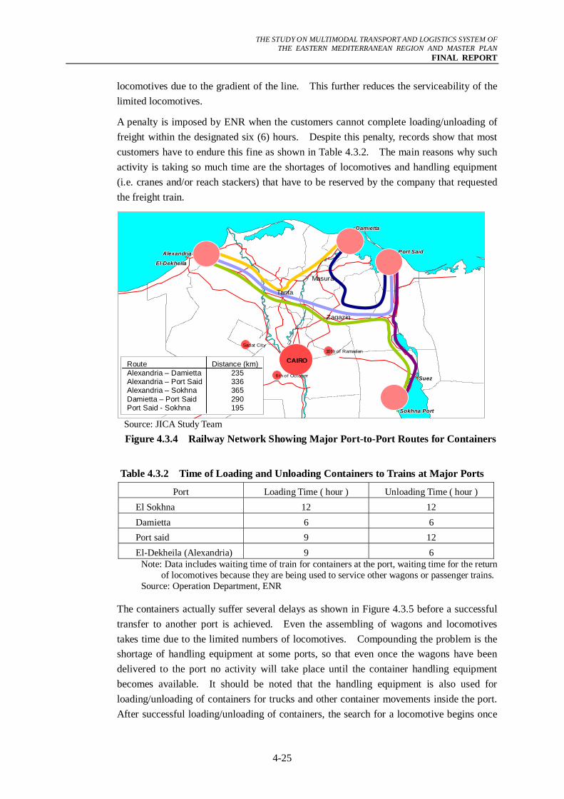
This part of the report examines the performance of the railway sector as far as servicing container cargo is concern. Containers are mostly moving among the four (4) major ports of Egypt, i.e. Alexandria (El-Dekheila), Damietta, Port Said and Sokhna as shown in Figure 4.3.4. ENR allows 6 hours for customers to load/unload their freight to the train wagons. The train normally consists of 20 wagons. There are two types of wagon; the first type is a large one that can be loaded with one 20-TEU container and one 40-TEU container or with three 20-TEU containers. The second type of container wagon is a small one that can be loaded by one 40-TEU or by two 20-TEU containers. In essence, a company requesting train service needs to have at least forty (40) 40-TEU containers or the equivalent of sixty (60) 20-TEU containers for full utilization of the train. According to an ENR official, the freight train operating on the line to Sokhna port requires two
THE STUDY ON MULTIMODAL TRANSPORT AND LOGISTICS SYSTEM OF
THE EASTERN MEDITERRANEAN REGION AND MASTER PLAN FINAL REPORT
4-25
locomotives due to the gradient of the line. This further reduces the serviceability of the limited locomotives.
A penalty is imposed by ENR when the customers cannot complete loading/unloading of freight within the designated six (6) hours. Despite this penalty, records show that most customers have to endure this fine as shown in Table 4.3.2. The main reasons why such activity is taking so much time are the shortages of locomotives and handling equipment (i.e. cranes and/or reach stackers) that have to be reserved by the company that requested the freight train.
Source: JICA Study Team Figure 4.3.4 Railway Network Showing Major Port-to-Port Routes for Containers
Table 4.3.2 Time of Loading and Unloading Containers to Trains at Major Ports
Port Loading Time ( hour ) Unloading Time ( hour ) El Sokhna 12 12 Damietta 6 6 Port said 9 12 El-Dekheila (Alexandria) 9 6
Note: Data includes waiting time of train for containers at the port, waiting time for the return of locomotives because they are being used to service other wagons or passenger trains.
Source: Operation Department, ENR
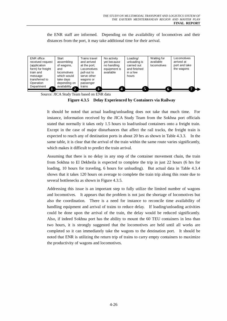
The containers actually suffer several delays as shown in Figure 4.3.5 before a successful transfer to another port is achieved. Even the assembling of wagons and locomotives takes time due to the limited numbers of locomotives. Compounding the problem is the shortage of handling equipment at some ports, so that even once the wagons have been delivered to the port no activity will take place until the container handling equipment becomes available. It should be noted that the handling equipment is also used for loading/unloading of containers for trucks and other container movements inside the port. After successful loading/unloading of containers, the search for a locomotive begins once
El-DekheilaEl-DekheilaEl-DekheilaEl-DekheilaEl-DekheilaEl-DekheilaEl-DekheilaEl-DekheilaEl-Dekheila
AlexandriaAlexandriaAlexandriaAlexandriaAlexandriaAlexandriaAlexandriaAlexandriaAlexandria
DamiettaDamiettaDamiettaDamiettaDamiettaDamiettaDamiettaDamiettaDamietta
Port SaidPort SaidPort SaidPort SaidPort SaidPort SaidPort SaidPort SaidPort Said
SuezSuezSuezSuezSuezSuezSuezSuezSuez
Sokhna PortSokhna PortSokhna PortSokhna PortSokhna PortSokhna PortSokhna PortSokhna PortSokhna Port
CAIRO
Zagazig
Masura
Tanta
10th of RamadanSadat City
6th of October
Route Alexandria – Damietta Alexandria – Port Said Alexandria – Sokhna Damietta – Port Said Port Said - Sokhna
Distance (km)235 336 365 290 195
THE STUDY ON MULTIMODAL TRANSPORT AND LOGISTICS SYSTEM OF
THE EASTERN MEDITERRANEAN REGION AND MASTER PLAN FINAL REPORT
4-26
the ENR staff are informed. Depending on the availability of locomotives and their distances from the port, it may take additional time for their arrival.
Source: JICA Study Team based on ENR data
Figure 4.3.5 Delay Experienced by Containers via Railway
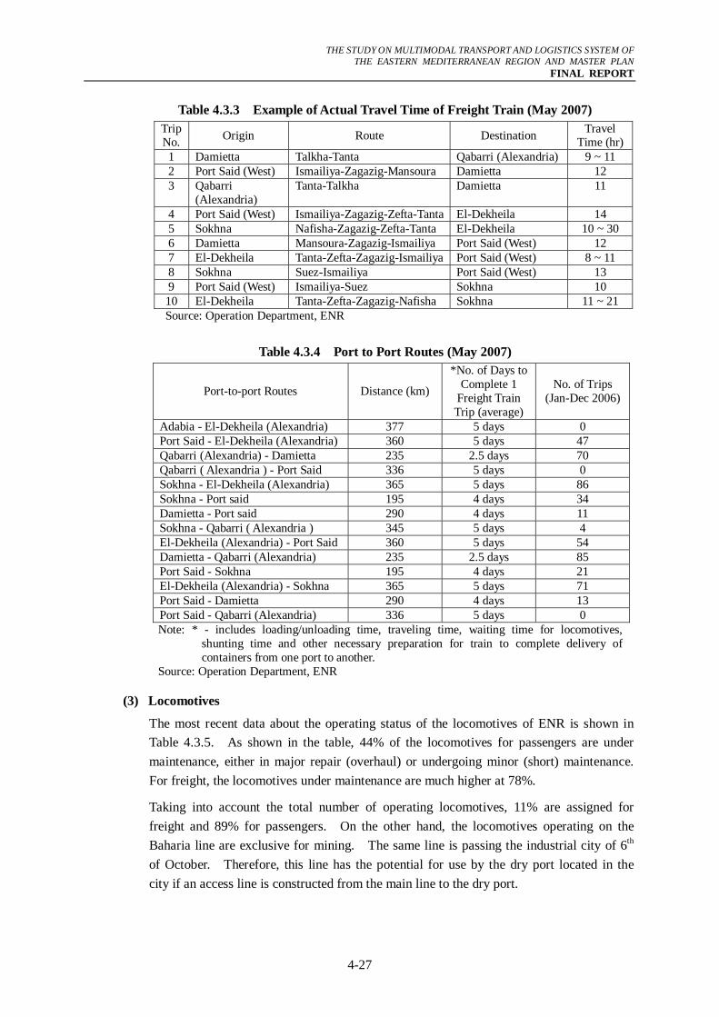
It should be noted that actual loading/unloading does not take that much time. For instance, information received by the JICA Study Team from the Sokhna port officials stated that normally it takes only 1.5 hours to load/unload containers onto a freight train. Except in the case of major disturbances that affect the rail tracks, the freight train is expected to reach any of destination ports in about 20 hrs as shown in Table 4.3.3. In the same table, it is clear that the arrival of the train within the same route varies significantly, which makes it difficult to predict the train arrival.
Assuming that there is no delay in any step of the container movement chain, the train from Sokhna to El Dekheila is expected to complete the trip in just 22 hours (6 hrs for loading, 10 hours for traveling, 6 hours for unloading). But actual data in Table 4.3.4 shows that it takes 120 hours on average to complete the train trip along this route due to several bottlenecks as shown in Figure 4.3.5.
Addressing this issue is an important step to fully utilize the limited number of wagons and locomotives. It appears that the problem is not just the shortage of locomotives but also the coordination. There is a need for instance to reconcile time availability of handling equipment and arrival of trains to reduce delay. If loading/unloading activities could be done upon the arrival of the train, the delay would be reduced significantly. Also, if indeed Sokhna port has the ability to mount the 60 TEU containers in less than two hours, it is strongly suggested that the locomotives are held until all works are completed so it can immediately take the wagons to the destination port. It should be noted that ENR is utilizing the return trip of trains to carry empty containers to maximize the productivity of wagons and locomotives.
Start assembling of wagons, and locomotives which would take days depending on availability
No activity yet because no handling equipment is available
Loading/ unloading is carried out and finished in a few hours
Waiting for available locomotives
Locomotives arrived at port and take the wagons 1 2 3 4 5
Trains travel and arrived at the port; Locomotives pull-out to serve other wagons or passenger trains
ENR office received request (application form) for freight train and message transferred to Operation Department
6 7
THE STUDY ON MULTIMODAL TRANSPORT AND LOGISTICS SYSTEM OF
THE EASTERN MEDITERRANEAN REGION AND MASTER PLAN FINAL REPORT
4-27
Table 4.3.3 Example of Actual Travel Time of Freight Train (May 2007) Trip No. Origin Route Destination Travel
Time (hr)1 Damietta Talkha-Tanta Qabarri (Alexandria) 9 ~ 11 2 Port Said (West) Ismailiya-Zagazig-Mansoura Damietta 12 3 Qabarri
(Alexandria) Tanta-Talkha Damietta 11
4 Port Said (West) Ismailiya-Zagazig-Zefta-Tanta El-Dekheila 14 5 Sokhna Nafisha-Zagazig-Zefta-Tanta El-Dekheila 10 ~ 30 6 Damietta Mansoura-Zagazig-Ismailiya Port Said (West) 12 7 El-Dekheila Tanta-Zefta-Zagazig-Ismailiya Port Said (West) 8 ~ 11 8 Sokhna Suez-Ismailiya Port Said (West) 13 9 Port Said (West) Ismailiya-Suez Sokhna 10 10 El-Dekheila Tanta-Zefta-Zagazig-Nafisha Sokhna 11 ~ 21 Source: Operation Department, ENR
Table 4.3.4 Port to Port Routes (May 2007)
Port-to-port Routes Distance (km)
*No. of Days to Complete 1
Freight Train Trip (average)
No. of Trips (Jan-Dec 2006)
Adabia - El-Dekheila (Alexandria) 377 5 days 0 Port Said - El-Dekheila (Alexandria) 360 5 days 47 Qabarri (Alexandria) - Damietta 235 2.5 days 70 Qabarri ( Alexandria ) - Port Said 336 5 days 0 Sokhna - El-Dekheila (Alexandria) 365 5 days 86 Sokhna - Port said 195 4 days 34 Damietta - Port said 290 4 days 11 Sokhna - Qabarri ( Alexandria ) 345 5 days 4 El-Dekheila (Alexandria) - Port Said 360 5 days 54 Damietta - Qabarri (Alexandria) 235 2.5 days 85 Port Said - Sokhna 195 4 days 21 El-Dekheila (Alexandria) - Sokhna 365 5 days 71 Port Said - Damietta 290 4 days 13 Port Said - Qabarri (Alexandria) 336 5 days 0 Note: * - includes loading/unloading time, traveling time, waiting time for locomotives,
shunting time and other necessary preparation for train to complete delivery of containers from one port to another.
Source: Operation Department, ENR
(3) Locomotives
The most recent data about the operating status of the locomotives of ENR is shown in Table 4.3.5. As shown in the table, 44% of the locomotives for passengers are under maintenance, either in major repair (overhaul) or undergoing minor (short) maintenance. For freight, the locomotives under maintenance are much higher at 78%.
Taking into account the total number of operating locomotives, 11% are assigned for freight and 89% for passengers. On the other hand, the locomotives operating on the Baharia line are exclusive for mining. The same line is passing the industrial city of 6th of October. Therefore, this line has the potential for use by the dry port located in the city if an access line is constructed from the main line to the dry port.
THE STUDY ON MULTIMODAL TRANSPORT AND LOGISTICS SYSTEM OF
THE EASTERN MEDITERRANEAN REGION AND MASTER PLAN FINAL REPORT
4-28
Table 4.3.5 Number of Locomotives (September 2006) Total No. of Locomotives
Service Type Operating
Under Maintenance
Total
Passenger 271 215 486 Freight 34 118 152 Baharia line (Iron Ore) 10 21 31
Source: Rolling Stock Department and Operation Department, ENR (4) Freight Wagons
Table 4.3.6 shows that ENR has a total of 10,660 wagons of different types to serve wide variations of freight. Out of this number, 28% are under maintenance. It is worth noting that aside from the wagons under maintenance, ENR has a total of 1,318 wagons taken out of service due to the severity of damage incurred on them.
Table 4.3.6 Characteristics of Freight Wagons (October 2006)
Model Total No. of Wagons
No. of Operating Wagons
No. of Under Maintenance
Wagons
% of Operating Wagons
Capacity (ton)
Box Wagons 2,059 1,333 726 64.7 40~65 Open Wagons 1,735 1,223 512 70.5 40~50 Flat Wagons 2,267 1,969 298 86.6 50~60 Tanks 1,820 1,287 533 70.7 40 Iron Ore Wagons 764 272 492 35.6 65 Others 2,015 1,621 394 80.0 10~65 Total 10,660 7,705 2,955 72.0
Source: Operation Department, ENR 4.3.2 Operation Performance and Efficiency
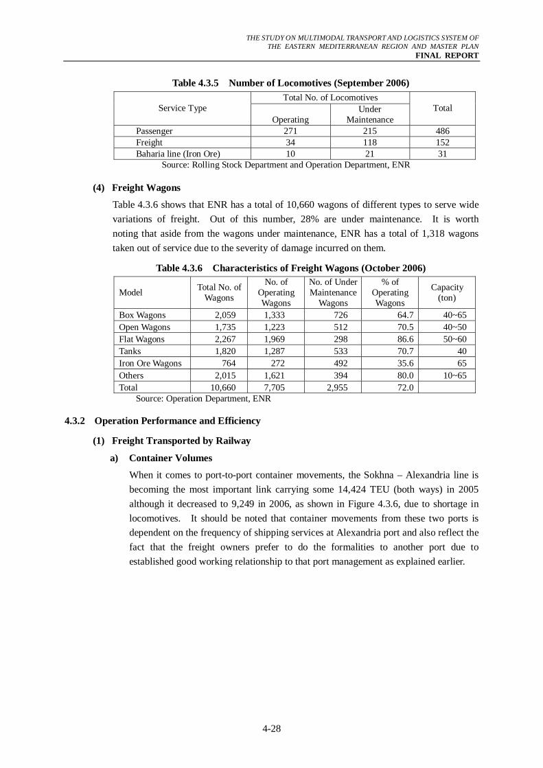
(1) Freight Transported by Railway
a) Container Volumes
When it comes to port-to-port container movements, the Sokhna – Alexandria line is becoming the most important link carrying some 14,424 TEU (both ways) in 2005 although it decreased to 9,249 in 2006, as shown in Figure 4.3.6, due to shortage in locomotives. It should be noted that container movements from these two ports is dependent on the frequency of shipping services at Alexandria port and also reflect the fact that the freight owners prefer to do the formalities to another port due to established good working relationship to that port management as explained earlier.
THE STUDY ON MULTIMODAL TRANSPORT AND LOGISTICS SYSTEM OF
THE EASTERN MEDITERRANEAN REGION AND MASTER PLAN FINAL REPORT
4-29
0
1000
2000
3000
4000
5000
6000
7000
8000
Adab
ia /
El-D
ikhe
ila (A
lexa
ndria
)
Port
said
/ El
-Dik
heila
(Ale
xand
ria)
El-D
ikhe
ila (A
lexa
ndria
) / P
ort s
aid
Qab
arri
(Ale
xand
ria) /
Dam
ietta
Qab
arri
(Ale
xand
ria) /
Por
t Sai
d
El-S
okhn
a / E
l-Dik
heila
(Ale
xand
ria)
El-S
okhn
a / P
ort s
aid
Port
Said
/ Q
abar
ri (A
lexa
ndria
)
Dam
ietta
/ Po
rt sa
id
Dam
ietta
/ Q
abar
ri (A
lexa
ndria
)
Port
said
/ El
-Sok
hna
El-D
ikhe
ila (A
lexa
ndria
) / E
l-Sok
hna
El-S
okhn
a / Q
abar
ri (A
lexa
ndria
)
Port
Said
/ D
amie
tta
Volu
me
(TEU
)
2005
2006
Source: Commercial Department, ENR
Figure 4.3.6 Railway Port-to-Port Container Volumes
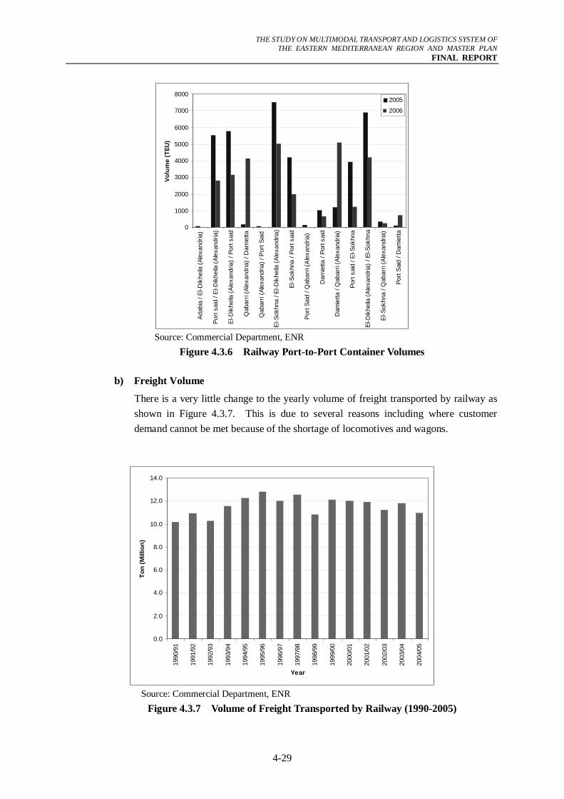
b) Freight Volume
There is a very little change to the yearly volume of freight transported by railway as shown in Figure 4.3.7. This is due to several reasons including where customer demand cannot be met because of the shortage of locomotives and wagons.
0.0
2.0
4.0
6.0
8.0
10.0
12.0
14.0
1990
/91
1991
/92
1992
/93
1993
/94
1994
/95
1995
/96
1996
/97
1997
/98
1998
/99
1999
/00
2000
/01
2001
/02
2002
/03
2003
/04
2004
/05
Year
Ton
(Mill
ion)
Source: Commercial Department, ENR
Figure 4.3.7 Volume of Freight Transported by Railway (1990-2005)
THE STUDY ON MULTIMODAL TRANSPORT AND LOGISTICS SYSTEM OF
THE EASTERN MEDITERRANEAN REGION AND MASTER PLAN FINAL REPORT
4-30
The plan of ENR to modernize the railway infrastructure as well as operation is expected to increase the railway’s freight capacity. For more than 10 years, the total freight volume transported by the railway has been between 10 ~ 13 million ton. (deleted one sentence)
4.3.3 Ongoing Railway Projects
As mentioned, in the five (5) year development plan of the country, a total of LE 11.2 billion is allocated to the transport sector of which 8.2 billion is allocated to the railways. This budget allotment is reflected in the current modernization project as shown below:
(1) Improve the Power of Locomotives
- Rehabilitation of 120 locomotives, and
- Buying 120 locomotives.
(2) Modernization of Signaling on Some Lines
- Damietta – Mansoura Line, and - Beni Suef – Alminia – Asyut Line.
(3) Construct new Lines to Connect Industrial Cities
- Manuf – Sadat, - Al-Robeki – Al-Asher, and - Alexandria – Burg El-Arab.
THE STUDY ON MULTIMODAL TRANSPORT AND LOGISTICS SYSTEM OF
THE EASTERN MEDITERRANEAN REGION AND MASTER PLAN FINAL REPORT
4-31
4.4 Inland Waterway Transport System
This section assesses the role of the River Nile in the transport system of Egypt. Information was mainly gathered through site visits and interviews by the JICA Study Team with concerned officials from the public and private sectors. After the analysis of the current situation of the Inland Water Transport (IWT), some recommendations were introduced.
4.4.1 Major Freight Waterways and Current Facilities
(1) Inland Waterway Network
River Transport Authority (RTA) classifies the inland waterway network into three classes as shown in Table 4.4.1. It should be noted that the mentioned minimum water depth of 2.5 m is adopted for barges.
Table 4.4.1 Classification of Inland Waterways
Class Waterway Air Clearness (m)
Min. Width
(m)
Max. Draft (m)
Min. Water
Depth (m)(1) The River Nile mainstream and its Damietta branch
≥ 13.0
1 (2) The navigational waterways El Beheiry/El Nobaria Canal (Cairo to Alexandria)
≥ 6.0 (excluding movable bridges)
≥ 35 two-way ≥ 12
one-way
1.80 2.50
2 ≥ 3.5 ≥ 12.0 1.50 1.50 3 ≥ 3.5 ≥ 8.0 1.00 1.25
Source: The Development Study on the Inland Waterway System in the Arab Republic of Egypt (JICA, 2003) and confirmed by JICA Study Team in meeting with RTA Official.
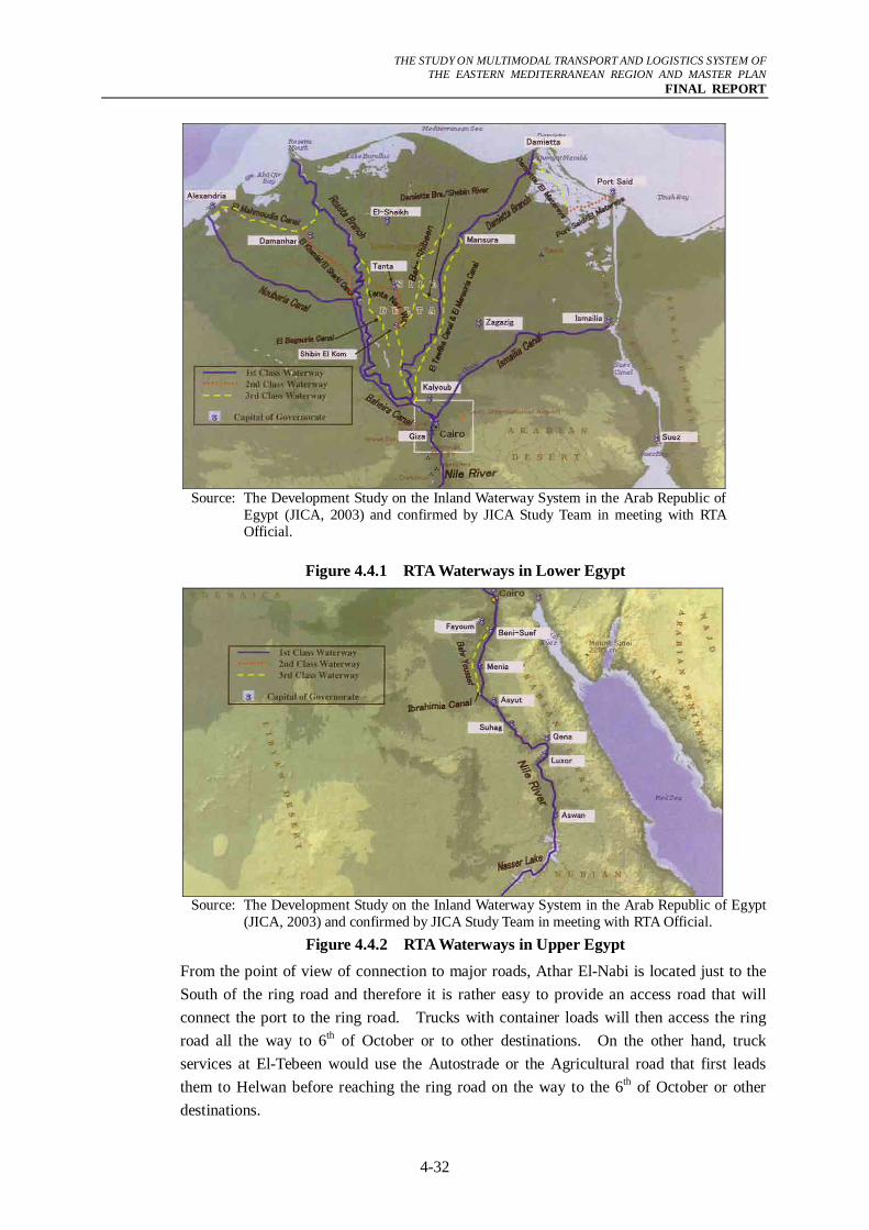
The lengths of the first class waterway in the Nile Delta and Nile Valley are about 852 km and 980 km, respectively, a total of 1,832 km. In addition, a 350-km long waterway exists along the Naser Lake making the total length approximately 2,182 km. However, only 1,562 km are navigable for commercial twin-type vessels, comprising of the Nile mainstream (Sudan/Aswan and Aswan/Cairo) and the Beheiry/Nobaria Canal (Cairo/Alexandria). The remainder - consisting of the Damietta Branch, Rosetta Branch and Ismailiya Canal - is almost never used because of its unsuitability for navigation, although RTA classifies it as 1st class. Figure 4.4.1 and Figure 4.4.2 presents the Inland Waterway Network as confirmed by the RTA Officials.
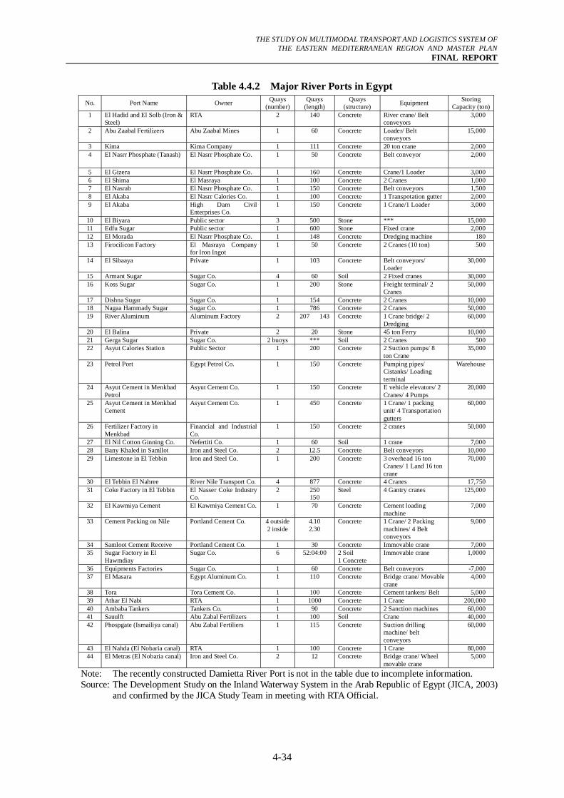
(2) River Ports Location
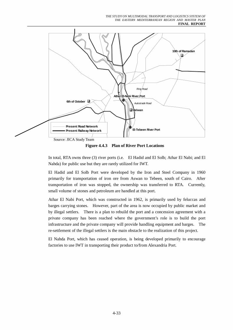
River ports have been developed to serve the factories located near the River Nile. RTA reports that there are 44 ports along the River Nile and canals in the Nile Delta as shown in Table 4.4.2. Thirty five (35) ports are owned by industrial companies involved in sugar, cement, fertilizer, aluminum, iron/steel, coke and petroleum products. Thirty one (31) of these ports are located in Upper Egypt and only four (4) are located in the Nile Delta. Since the number of ports in the Nile Delta is too small and the existing ports belong to factories, there is a plan to construct or upgrade the river ports. The candidate locations are Athar El-Nabi and/or El-Tebeen as shown in Figure 4.4.3.
THE STUDY ON MULTIMODAL TRANSPORT AND LOGISTICS SYSTEM OF
THE EASTERN MEDITERRANEAN REGION AND MASTER PLAN FINAL REPORT
4-32
Source: The Development Study on the Inland Waterway System in the Arab Republic of
Egypt (JICA, 2003) and confirmed by JICA Study Team in meeting with RTA Official.
Figure 4.4.1 RTA Waterways in Lower Egypt
Source: The Development Study on the Inland Waterway System in the Arab Republic of Egypt
(JICA, 2003) and confirmed by JICA Study Team in meeting with RTA Official. Figure 4.4.2 RTA Waterways in Upper Egypt
From the point of view of connection to major roads, Athar El-Nabi is located just to the South of the ring road and therefore it is rather easy to provide an access road that will connect the port to the ring road. Trucks with container loads will then access the ring road all the way to 6th of October or to other destinations. On the other hand, truck services at El-Tebeen would use the Autostrade or the Agricultural road that first leads them to Helwan before reaching the ring road on the way to the 6th of October or other destinations.
THE STUDY ON MULTIMODAL TRANSPORT AND LOGISTICS SYSTEM OF
THE EASTERN MEDITERRANEAN REGION AND MASTER PLAN FINAL REPORT
4-33
Source: JICA Study Team
Figure 4.4.3 Plan of River Port Locations
In total, RTA owns three (3) river ports (i.e. El Hadid and El Solb; Athar El Nabi; and El Nahda) for public use but they are rarely utilized for IWT.
El Hadid and El Solb Port were developed by the Iron and Steel Company in 1960 primarily for transportation of iron ore from Aswan to Tebeen, south of Cairo. After transportation of iron was stopped, the ownership was transferred to RTA. Currently, small volume of stones and petroleum are handled at this port.
Athar El Nabi Port, which was constructed in 1962, is primarily used by feluccas and barges carrying stones. However, part of the area is now occupied by public market and by illegal settlers. There is a plan to rebuild the port and a concession agreement with a private company has been reached where the government’s role is to build the port infrastructure and the private company will provide handling equipment and barges. The re-settlement of the illegal settlers is the main obstacle to the realization of this project.
El Nahda Port, which has ceased operation, is being developed primarily to encourage factories to use IWT in transporting their product to/from Alexandria Port.
Ring Road
Autostrade Road
10th of Ramadan10th of Ramadan10th of Ramadan10th of Ramadan10th of Ramadan10th of Ramadan10th of Ramadan10th of Ramadan10th of Ramadan
6th of October6th of October6th of October6th of October6th of October6th of October6th of October6th of October6th of October
El-Tebeen River PortEl-Tebeen River PortEl-Tebeen River PortEl-Tebeen River PortEl-Tebeen River PortEl-Tebeen River PortEl-Tebeen River PortEl-Tebeen River PortEl-Tebeen River Port
Athar El-Nabi River PortAthar El-Nabi River PortAthar El-Nabi River PortAthar El-Nabi River PortAthar El-Nabi River PortAthar El-Nabi River PortAthar El-Nabi River PortAthar El-Nabi River PortAthar El-Nabi River Port
HelwanHelwanHelwanHelwanHelwanHelwanHelwanHelwanHelwan
Present Road NetworkPresent Railway Network
THE STUDY ON MULTIMODAL TRANSPORT AND LOGISTICS SYSTEM OF
THE EASTERN MEDITERRANEAN REGION AND MASTER PLAN FINAL REPORT
4-34
Table 4.4.2 Major River Ports in Egypt No. Port Name Owner Quays
(number)Quays
(length) Quays
(structure) Equipment Storing Capacity (ton)
1 El Hadid and El Solb (Iron & Steel)
RTA 2 140 Concrete River crane/ Belt conveyors
3,000
2 Abu Zaabal Fertilizers Abu Zaabal Mines 1 60 Concrete Loader/ Belt conveyors
15,000
3 Kima Kima Company 1 111 Concrete 20 ton crane 2,000 4 El Nasrr Phosphate (Tanash) El Nasrr Phosphate Co. 1 50 Concrete Belt conveyor 2,000
5 El Gizera El Nasrr Phosphate Co. 1 160 Concrete Crane/1 Loader 3,000 6 El Shima El Masraya 1 100 Concrete 2 Cranes 1,000 7 El Nasrab El Nasrr Phosphate Co. 1 150 Concrete Belt conveyors 1,500 8 El Akaba El Nasrr Calories Co. 1 100 Concrete 1 Transpotation gutter 2,000 9 El Akaba High Dam Civil
Enterprises Co. 1 150 Concrete 1 Crane/1 Loader 3,000
10 El Biyara Public sector 3 500 Stone *** 15,000 11 Edfu Sugar Public sector 1 600 Stone Fixed crane 2,000 12 El Morada El Nasrr Phosphate Co. 1 148 Concrete Dredging machine 180 13 Firocilicon Factory El Masraya Company
for Iron Ingot 1 50 Concrete 2 Cranes (10 ton) 500
14 El Sibaaya Private 1 103 Concrete Belt conveyors/ Loader
30,000
15 Armant Sugar Sugar Co. 4 60 Soil 2 Fixed cranes 30,000 16 Koss Sugar Sugar Co. 1 200 Stone Freight terminal/ 2
Cranes 50,000
17 Dishna Sugar Sugar Co. 1 154 Concrete 2 Cranes 10,000 18 Nagaa Hammady Sugar Sugar Co. 1 786 Concrete 2 Cranes 50,000 19 River Aluminum Aluminum Factory 2 207 143 Concrete 1 Crane bridge/ 2
Dredging 60,000
20 El Balina Private 2 20 Stone 45 ton Ferry 10,000 21 Gerga Sugar Sugar Co. 2 buoys *** Soil 2 Cranes 500 22 Asyut Calories Station Public Sector 1 200 Concrete 2 Suction pumps/ 8
ton Crane 35,000
23 Petrol Port Egypt Petrol Co. 1 150 Concrete Pumping pipes/ Cistanks/ Loading terminal
Warehouse
24 Asyut Cement in Menkbad Petrol
Asyut Cement Co. 1 150 Concrete E vehicle elevators/ 2 Cranes/ 4 Pumps
20,000
25 Asyut Cement in Menkbad Cement
Asyut Cement Co. 1 450 Concrete 1 Crane/ 1 packing unit/ 4 Transportation gutters
60,000
26 Fertilizer Factory in Menkbad
Financial and Industrial Co.
1 150 Concrete 2 cranes 50,000
27 El Nil Cotton Ginning Co. Nefertiti Co. 1 60 Soil 1 crane 7,000 28 Bany Khaled in Samllot Iron and Steel Co. 2 12.5 Concrete Belt conveyors 10,000 29 Limestone in El Tebbin Iron and Steel Co. 1 200 Concrete 3 overhead 16 ton
Cranes/ 1 Land 16 ton crane
70,000
30 El Tebbin El Nahree River Nile Transport Co. 4 877 Concrete 4 Cranes 17,750 31 Coke Factory in El Tebbin El Nasser Coke Industry
Co. 2 250
150 Steel 4 Gantry cranes 125,000
32 El Kawmiya Cement El Kawmiya Cement Co. 1 70 Concrete Cement loading machine
7,000
33 Cement Packing on Nile Portland Cement Co. 4 outside2 inside
4.10 2.30
Concrete 1 Crane/ 2 Packing machines/ 4 Belt conveyors
9,000
34 Samloot Cement Receive Portland Cement Co. 1 30 Concrete Immovable crane 7,000 35 Sugar Factory in El
Hawmdiay Sugar Co. 6 52:04:00 2 Soil
1 Concrete Immovable crane 1,0000
36 Equipments Factories Sugar Co. 1 60 Concrete Belt conveyors -7,000 37 El Masara Egypt Aluminum Co. 1 110 Concrete Bridge crane/ Movable
crane 4,000
38 Tora Tora Cement Co. 1 100 Concrete Cement tankers/ Belt 5,000 39 Athar El Nabi RTA 1 1000 Concrete 1 Crane 200,000 40 Ambaba Tankers Tankers Co. 1 90 Concrete 2 Sanction machines 60,000 41 Sauulft Abu Zabal Fertilizers 1 100 Soil Crane 40,000 42 Phospgate (Ismailiya canal) Abu Zabal Fertiliers 1 115 Concrete Suction drilling
machine/ belt conveyors
60,000
43 El Nahda (El Nobaria canal) RTA 1 100 Concrete 1 Crane 80,000 44 El Metras (El Nobaria canal) Iron and Steel Co. 2 12 Concrete Bridge crane/ Wheel
movable crane 5,000
Note: The recently constructed Damietta River Port is not in the table due to incomplete information. Source: The Development Study on the Inland Waterway System in the Arab Republic of Egypt (JICA, 2003)
and confirmed by the JICA Study Team in meeting with RTA Official.
THE STUDY ON MULTIMODAL TRANSPORT AND LOGISTICS SYSTEM OF
THE EASTERN MEDITERRANEAN REGION AND MASTER PLAN FINAL REPORT
4-35
(3) Vessels Operating the IWT
“The Development Study on the Inland Waterway System in the Arab Republic of Egypt (JICA, 2003)” reported that the total number of barges operating in the River Nile is 2,530. However; the latest RTA data of year 2006 shows that this number declined to 1,344 which implies that a total of 1,186 barges were taken out of service as shown in Table 4.4.3. Comparing the number of barges in 2003 and 2006 reveals the following:
- General Nile Company for River Transport’s barges decreased by 46%,
- Barges of Public Business decreased by 75%,
- Barges of Sugar Company decreased by 19%,
- Barges of Private Companies decreased by 44%, and
- Barges of Government Companies decreased by 86%.
Based on discussions the JICA Study Team had with several officials who are familiar with operation of barges on the River Nile, there are two reasons for the decreasing number of barges. First is due to demand declining due to the attraction of other transport modes and the second is due to the high cost required to repair the old barges, some of which have been operating for more than 30 years.
Table 4.4.3 Number of Barges Operating in the River Nile (2006) Item Propeller Barge Twin Total
1. General Nile Company for River Transport (Public Sector) 133 109 242
2. Public Business 59 - 59 3. Sugar Company 146 - 146 4. Private Sector 883 2 885 5. Government 2 10 12
Total 1223 121 1344 Source: River Transport Authority, MOT
(4) Major Freight Waterways
In Figure 4.4.4, the locations of planned river ports such as Nobariya, El Tebeen, Athar El-Nabi and Qena are indicated. Except for Qena port whose main purpose is to serve shipping lines for tourists, these ports are designed mainly for freight transport. If and when those river ports are developed, there is a high chance that IWT will become a major player in logistics.
The currently navigable waterways as well future waterways for operation are discussed below and summarized in Table 4.4.4. It is noted that services for container freight are not active at the River Nile. This is because there is no river port that has handling equipment for containers and current barges are not suitable for containers. However, the RTA is working on making the River Nile capable of handling containers through the development of new river ports and dredging of sections of the river that have shallow depths.
THE STUDY ON MULTIMODAL TRANSPORT AND LOGISTICS SYSTEM OF
THE EASTERN MEDITERRANEAN REGION AND MASTER PLAN FINAL REPORT
4-36
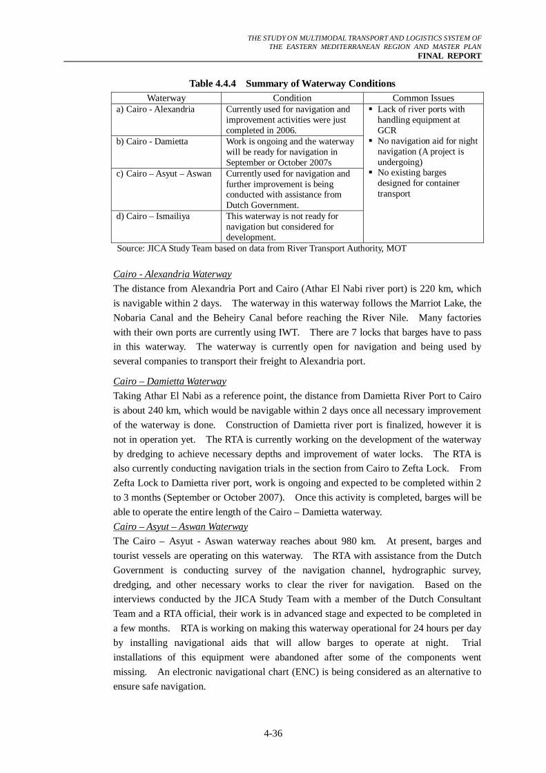
Table 4.4.4 Summary of Waterway Conditions Waterway Condition Common Issues
a) Cairo - Alexandria Currently used for navigation and improvement activities were just completed in 2006.
b) Cairo - Damietta Work is ongoing and the waterway will be ready for navigation in September or October 2007s
c) Cairo – Asyut – Aswan Currently used for navigation and further improvement is being conducted with assistance from Dutch Government.
d) Cairo – Ismailiya This waterway is not ready for navigation but considered for development.
Lack of river ports with handling equipment at GCR
No navigation aid for night navigation (A project is undergoing)
No existing barges designed for container transport
Source: JICA Study Team based on data from River Transport Authority, MOT Cairo - Alexandria Waterway The distance from Alexandria Port and Cairo (Athar El Nabi river port) is 220 km, which is navigable within 2 days. The waterway in this waterway follows the Marriot Lake, the Nobaria Canal and the Beheiry Canal before reaching the River Nile. Many factories with their own ports are currently using IWT. There are 7 locks that barges have to pass in this waterway. The waterway is currently open for navigation and being used by several companies to transport their freight to Alexandria port.
Cairo – Damietta Waterway Taking Athar El Nabi as a reference point, the distance from Damietta River Port to Cairo is about 240 km, which would be navigable within 2 days once all necessary improvement of the waterway is done. Construction of Damietta river port is finalized, however it is not in operation yet. The RTA is currently working on the development of the waterway by dredging to achieve necessary depths and improvement of water locks. The RTA is also currently conducting navigation trials in the section from Cairo to Zefta Lock. From Zefta Lock to Damietta river port, work is ongoing and expected to be completed within 2 to 3 months (September or October 2007). Once this activity is completed, barges will be able to operate the entire length of the Cairo – Damietta waterway. Cairo – Asyut – Aswan Waterway The Cairo – Asyut - Aswan waterway reaches about 980 km. At present, barges and tourist vessels are operating on this waterway. The RTA with assistance from the Dutch Government is conducting survey of the navigation channel, hydrographic survey, dredging, and other necessary works to clear the river for navigation. Based on the interviews conducted by the JICA Study Team with a member of the Dutch Consultant Team and a RTA official, their work is in advanced stage and expected to be completed in a few months. RTA is working on making this waterway operational for 24 hours per day by installing navigational aids that will allow barges to operate at night. Trial installations of this equipment were abandoned after some of the components went missing. An electronic navigational chart (ENC) is being considered as an alternative to ensure safe navigation.
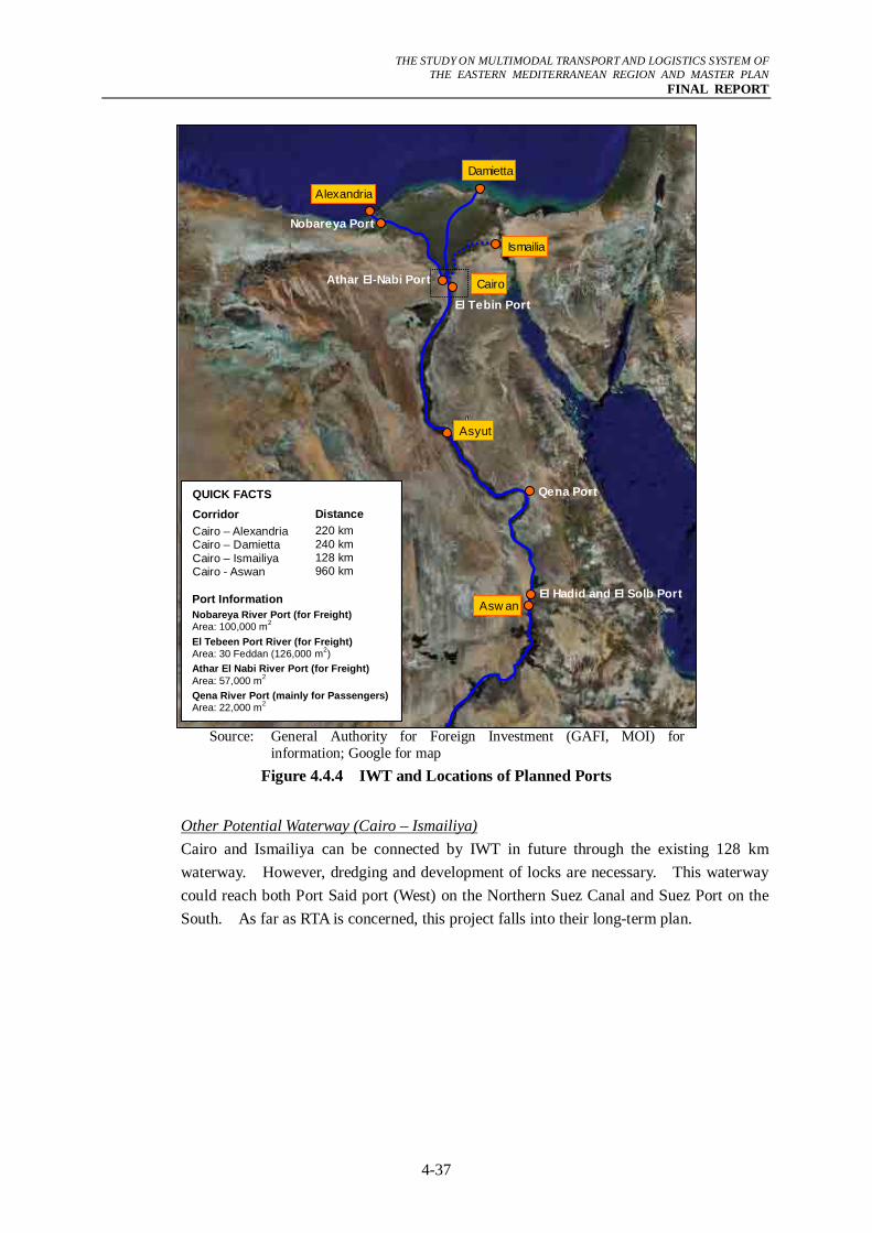
THE STUDY ON MULTIMODAL TRANSPORT AND LOGISTICS SYSTEM OF
THE EASTERN MEDITERRANEAN REGION AND MASTER PLAN FINAL REPORT
4-37
Source: General Authority for Foreign Investment (GAFI, MOI) for
information; Google for map Figure 4.4.4 IWT and Locations of Planned Ports
Other Potential Waterway (Cairo – Ismailiya) Cairo and Ismailiya can be connected by IWT in future through the existing 128 km waterway. However, dredging and development of locks are necessary. This waterway could reach both Port Said port (West) on the Northern Suez Canal and Suez Port on the South. As far as RTA is concerned, this project falls into their long-term plan.
Cairo
Alexandria
Damietta
Ismailia
Asyut
Asw an
El Tebin Port
Athar El-Nabi Port
Nobareya Port
Qena Port
El Hadid and El Solb Port
QUICK FACTS
Corridor
Cairo – Alexandria Cairo – Damietta Cairo – Ismailiya Cairo - Aswan
Distance
220 km 240 km 128 km 960 km
Port Information
Nobareya River Port (for Freight) Area: 100,000 m2
El Tebeen Port River (for Freight) Area: 30 Feddan (126,000 m2)
Athar El Nabi River Port (for Freight) Area: 57,000 m2
Qena River Port (mainly for Passengers)Area: 22,000 m2
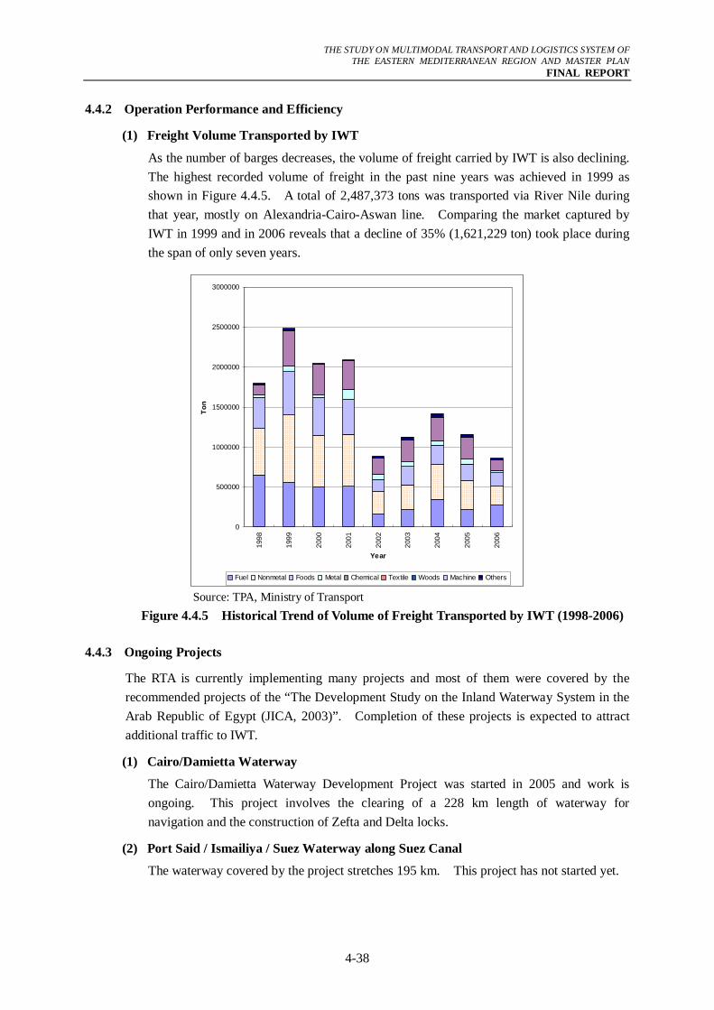
THE STUDY ON MULTIMODAL TRANSPORT AND LOGISTICS SYSTEM OF
THE EASTERN MEDITERRANEAN REGION AND MASTER PLAN FINAL REPORT
4-38
4.4.2 Operation Performance and Efficiency
(1) Freight Volume Transported by IWT
As the number of barges decreases, the volume of freight carried by IWT is also declining. The highest recorded volume of freight in the past nine years was achieved in 1999 as shown in Figure 4.4.5. A total of 2,487,373 tons was transported via River Nile during that year, mostly on Alexandria-Cairo-Aswan line. Comparing the market captured by IWT in 1999 and in 2006 reveals that a decline of 35% (1,621,229 ton) took place during the span of only seven years.
0
500000
1000000
1500000
2000000
2500000
3000000
1998
1999
2000
2001
2002
2003
2004
2005
2006
Year
Ton
Fuel Nonmetal Foods Metal Chemical Textile Woods Machine Others
Source: TPA, Ministry of Transport Figure 4.4.5 Historical Trend of Volume of Freight Transported by IWT (1998-2006)
4.4.3 Ongoing Projects
The RTA is currently implementing many projects and most of them were covered by the recommended projects of the “The Development Study on the Inland Waterway System in the Arab Republic of Egypt (JICA, 2003)”. Completion of these projects is expected to attract additional traffic to IWT.
(1) Cairo/Damietta Waterway
The Cairo/Damietta Waterway Development Project was started in 2005 and work is ongoing. This project involves the clearing of a 228 km length of waterway for navigation and the construction of Zefta and Delta locks.
(2) Port Said / Ismailiya / Suez Waterway along Suez Canal
The waterway covered by the project stretches 195 km. This project has not started yet.
THE STUDY ON MULTIMODAL TRANSPORT AND LOGISTICS SYSTEM OF
THE EASTERN MEDITERRANEAN REGION AND MASTER PLAN FINAL REPORT
4-39
(3) Ismailiya Canal
This project aims to develop Ismailiya Canal for navigation to link both Suez and Port Said ports by an inland waterway along the Suez Canal having a 3 meter depth. This project has not started yet.
(4) Cairo/Aswan Waterway
The project aims at revitalizing the IWT and to extend the length suited for navigation to 960 km. It is hoped that once the project is completed, the IWT can be operated for 24-hours per day. The following steps are being taken to meet the above objectives:
- Dredging a length of some 518 km,
- Installation of navigation aids (suspended after some components went missing),
- Development of para-symmetric maps to identify navigational waterway depths,
- Development of navigation maps from Kanater Khaireya to Aswan, and
At present, work is ongoing and dredging is almost completed.
(5) Cairo / Alexandria Waterway
This project started in 2005 and was completed in 2006. The major works involved improvement of the canal locks, which was recommended by “The Development Study on the Inland Waterway System in the Arab Republic of Egypt (JICA, 2003)”. Installation of navigation aids to allow night navigation is also being considered.
(6) Aswan / Wady Halpha Waterway
The project aims at securing the navigational waterway and installation of navigational aids so that it is suitable for navigation.
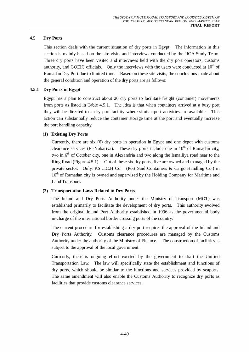
THE STUDY ON MULTIMODAL TRANSPORT AND LOGISTICS SYSTEM OF
THE EASTERN MEDITERRANEAN REGION AND MASTER PLAN FINAL REPORT
4-40
4.5 Dry Ports
This section deals with the current situation of dry ports in Egypt. The information in this section is mainly based on the site visits and interviews conducted by the JICA Study Team. Three dry ports have been visited and interviews held with the dry port operators, customs authority, and GOEIC officials. Only the interviews with the users were conducted at 10th of Ramadan Dry Port due to limited time. Based on these site visits, the conclusions made about the general condition and operation of the dry ports are as follows:
4.5.1 Dry Ports in Egypt
Egypt has a plan to construct about 20 dry ports to facilitate freight (container) movements from ports as listed in Table 4.5.1. The idea is that when containers arrived at a busy port they will be directed to a dry port facility where similar port activities are available. This action can substantially reduce the container storage time at the port and eventually increase the port handling capacity.
(1) Existing Dry Ports
Currently, there are six (6) dry ports in operation in Egypt and one depot with customs clearance services (El-Nobariya). These dry ports include one in 10th of Ramadan city, two in 6th of October city, one in Alexandria and two along the Ismailiya road near to the Ring Road (Figure 4.5.1). Out of these six dry ports, five are owned and managed by the private sector. Only, P.S.C.C.H Co. (Port Said Containers & Cargo Handling Co.) in 10th of Ramadan city is owned and supervised by the Holding Company for Maritime and Land Transport.
(2) Transportation Laws Related to Dry Ports
The Inland and Dry Ports Authority under the Ministry of Transport (MOT) was established primarily to facilitate the development of dry ports. This authority evolved from the original Inland Port Authority established in 1996 as the governmental body in-charge of the international border crossing ports of the country.
The current procedure for establishing a dry port requires the approval of the Inland and Dry Ports Authority. Customs clearance procedures are managed by the Customs Authority under the authority of the Ministry of Finance. The construction of facilities is subject to the approval of the local government.
Currently, there is ongoing effort exerted by the government to draft the Unified Transportation Law. The law will specifically state the establishment and functions of dry ports, which should be similar to the functions and services provided by seaports. The same amendment will also enable the Customs Authority to recognize dry ports as facilities that provide customs clearance services.
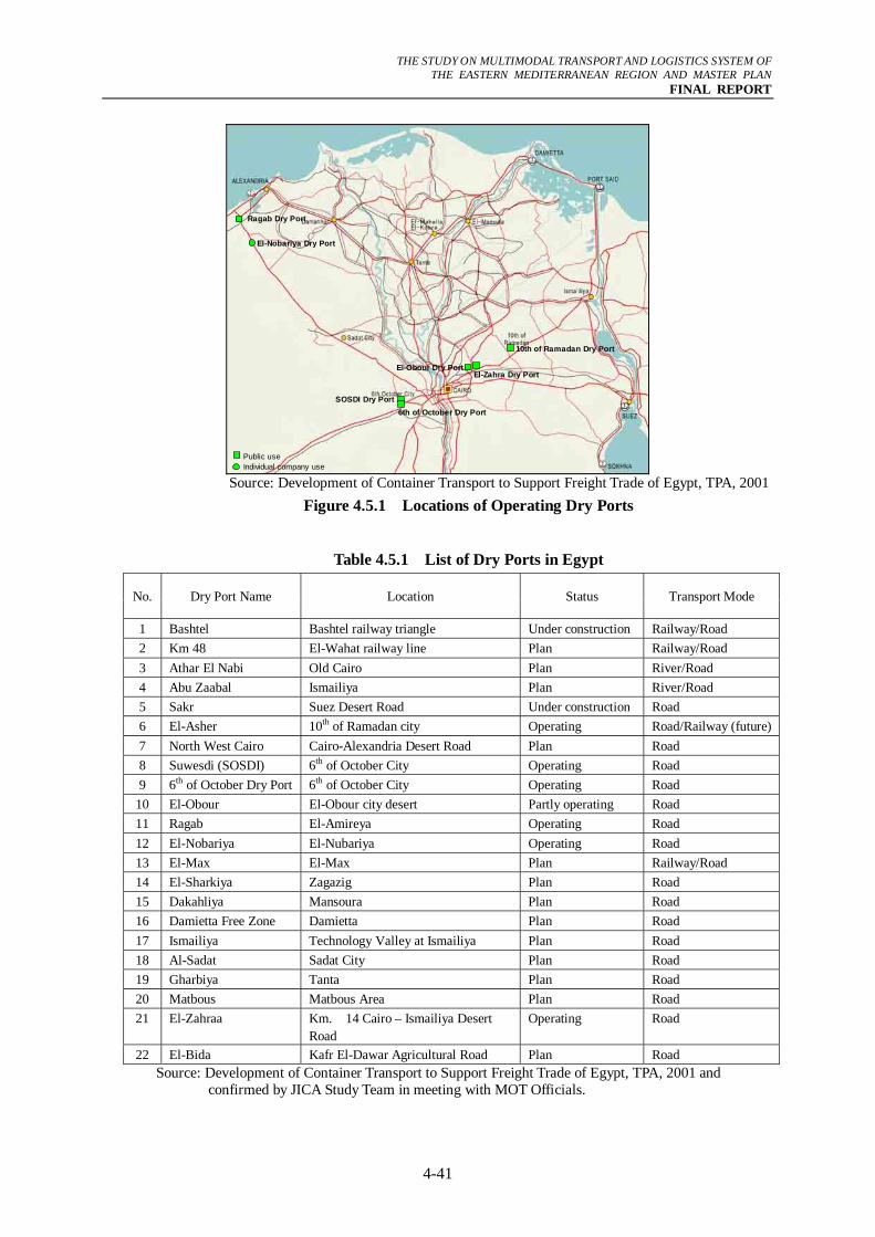
THE STUDY ON MULTIMODAL TRANSPORT AND LOGISTICS SYSTEM OF
THE EASTERN MEDITERRANEAN REGION AND MASTER PLAN FINAL REPORT
4-41
SOSDI Dry Port
El-Obour Dry Port
Ragab Dry Port
10th of Ramadan Dry Port
El-Zahra Dry Port
6th of October Dry Port
Public useIndividual company use
El-Nobariya Dry Port
Source: Development of Container Transport to Support Freight Trade of Egypt, TPA, 2001
Figure 4.5.1 Locations of Operating Dry Ports
Table 4.5.1 List of Dry Ports in Egypt
No. Dry Port Name Location Status Transport Mode
1 Bashtel Bashtel railway triangle Under construction Railway/Road 2 Km 48 El-Wahat railway line Plan Railway/Road 3 Athar El Nabi Old Cairo Plan River/Road 4 Abu Zaabal Ismailiya Plan River/Road 5 Sakr Suez Desert Road Under construction Road 6 El-Asher 10th of Ramadan city Operating Road/Railway (future)7 North West Cairo Cairo-Alexandria Desert Road Plan Road 8 Suwesdi (SOSDI) 6th of October City Operating Road 9 6th of October Dry Port 6th of October City Operating Road
10 El-Obour El-Obour city desert Partly operating Road 11 Ragab El-Amireya Operating Road 12 El-Nobariya El-Nubariya Operating Road 13 El-Max El-Max Plan Railway/Road 14 El-Sharkiya Zagazig Plan Road 15 Dakahliya Mansoura Plan Road 16 Damietta Free Zone Damietta Plan Road 17 Ismailiya Technology Valley at Ismailiya Plan Road 18 Al-Sadat Sadat City Plan Road 19 Gharbiya Tanta Plan Road 20 Matbous Matbous Area Plan Road 21 El-Zahraa Km. 14 Cairo – Ismailiya Desert
Road Operating Road
22 El-Bida Kafr El-Dawar Agricultural Road Plan Road Source: Development of Container Transport to Support Freight Trade of Egypt, TPA, 2001 and
confirmed by JICA Study Team in meeting with MOT Officials.

THE STUDY ON MULTIMODAL TRANSPORT AND LOGISTICS SYSTEM OF
THE EASTERN MEDITERRANEAN REGION AND MASTER PLAN FINAL REPORT
4-42
(3) SOSDI Dry Port at 6th of October City
a) Dry Port Area
The SOSDI Dry Port is located at the industrial city of 6th of October City and it started operation in 2001. It has a total land area of 120,000 m2 (12 Hectares). It is a private sector initiative conceived to capture import and export goods produced at manufacturing industries in the 6th of October industrial area. The port’s truck gates as well as the container storage area are shown in the following photo.
Photo SOSDI Dry Port (Gate and Container Storage)
b) Access
The facility has good road connections to most of the ports in Egypt. It is also supposed to be accessible by railway but due to the lack of a track connecting between the existing nearby railway track and the dry port, the railway service has not yet been realized. The nearest station is on the Al Wahat line at Km. 48 and less than one kilometer from the dry port.
c) Services and Facilities (Equipment)
The dry port possesses two reach stackers and two forklifts. It has also storage for both of bonded and non-bonded containers. Also available are reefers, which are a type of container that includes a built-in refrigeration unit to keep perishable goods cold or frozen. Also, customers are able to check the status of their containers through an online tracking system. The same system makes it possible for customers to trace the location of containers at any time, day or night. The following photo shows one of the reach stackers at the dry port as well as the office of the relevant government agencies.
Photo Handling Equipment , Office of Customs Authority and GOEIC
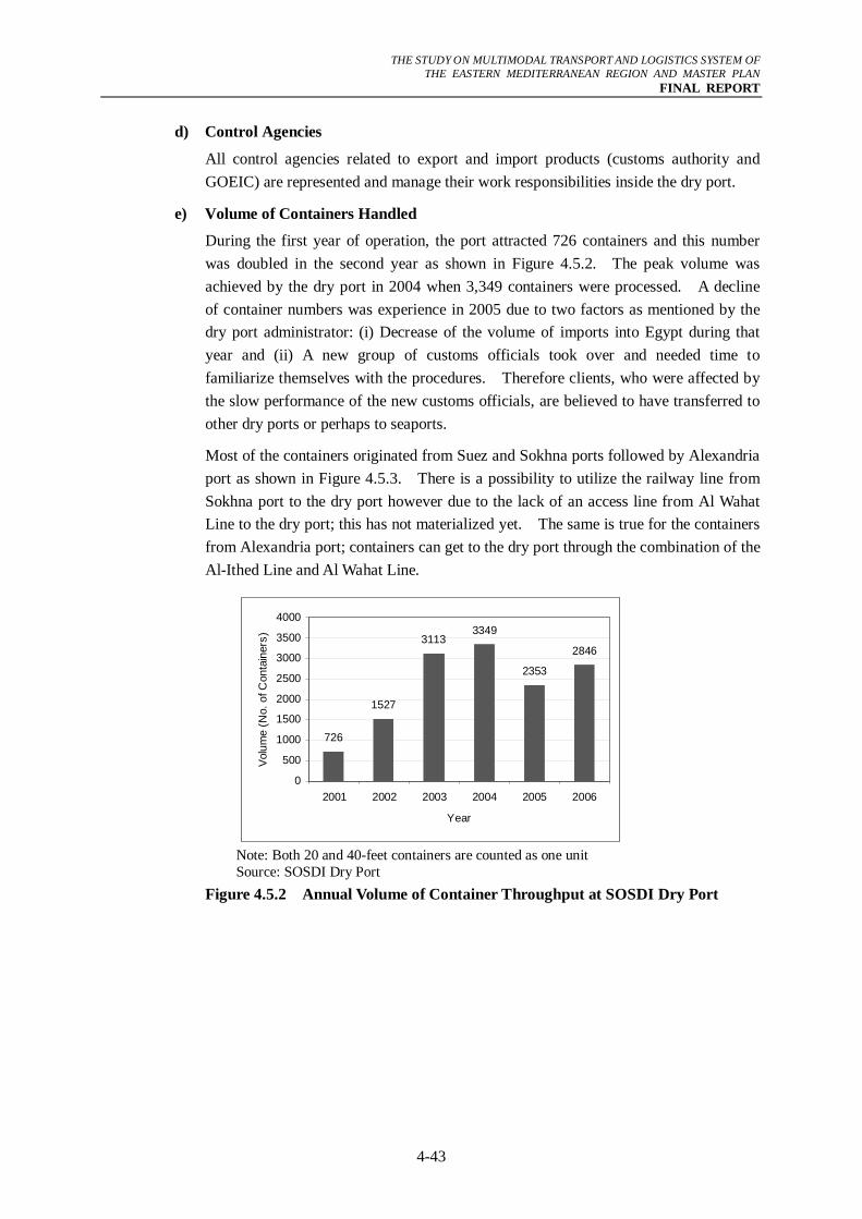
THE STUDY ON MULTIMODAL TRANSPORT AND LOGISTICS SYSTEM OF
THE EASTERN MEDITERRANEAN REGION AND MASTER PLAN FINAL REPORT
4-43
d) Control Agencies
All control agencies related to export and import products (customs authority and GOEIC) are represented and manage their work responsibilities inside the dry port.
e) Volume of Containers Handled
During the first year of operation, the port attracted 726 containers and this number was doubled in the second year as shown in Figure 4.5.2. The peak volume was achieved by the dry port in 2004 when 3,349 containers were processed. A decline of container numbers was experience in 2005 due to two factors as mentioned by the dry port administrator: (i) Decrease of the volume of imports into Egypt during that year and (ii) A new group of customs officials took over and needed time to familiarize themselves with the procedures. Therefore clients, who were affected by the slow performance of the new customs officials, are believed to have transferred to other dry ports or perhaps to seaports.
Most of the containers originated from Suez and Sokhna ports followed by Alexandria port as shown in Figure 4.5.3. There is a possibility to utilize the railway line from Sokhna port to the dry port however due to the lack of an access line from Al Wahat Line to the dry port; this has not materialized yet. The same is true for the containers from Alexandria port; containers can get to the dry port through the combination of the Al-Ithed Line and Al Wahat Line.
726
1527
31133349
2353
2846
0
500
1000
1500
2000
2500
3000
3500
4000
2001 2002 2003 2004 2005 2006
Year
Volu
me
(No.
of C
onta
iner
s)
Note: Both 20 and 40-feet containers are counted as one unit Source: SOSDI Dry Port
Figure 4.5.2 Annual Volume of Container Throughput at SOSDI Dry Port
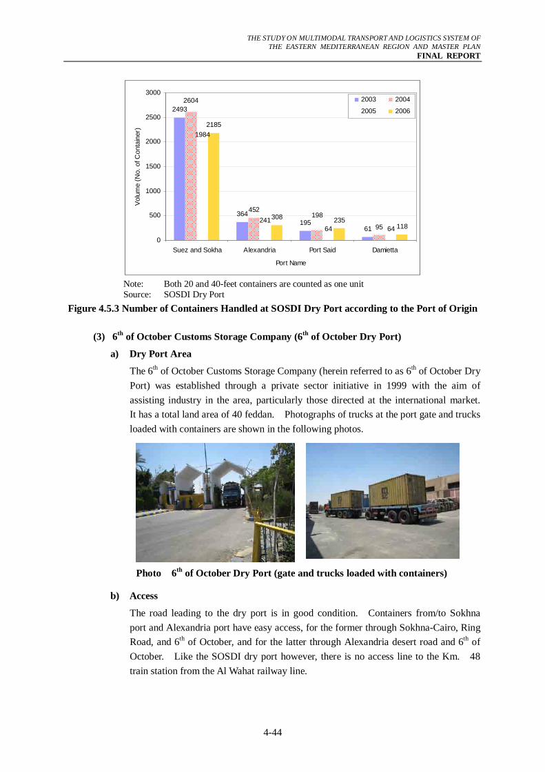
THE STUDY ON MULTIMODAL TRANSPORT AND LOGISTICS SYSTEM OF
THE EASTERN MEDITERRANEAN REGION AND MASTER PLAN FINAL REPORT
4-44
2493
364195
61
452
95
1984
24164 64
2185
308 235118
198
2604
0
500
1000
1500
2000
2500
3000
Suez and Sokha Alexandria Port Said Damietta
Port Name
Volu
me
(No.
of C
onta
iner
)
2003 2004
2005 2006
Note: Both 20 and 40-feet containers are counted as one unit Source: SOSDI Dry Port
Figure 4.5.3 Number of Containers Handled at SOSDI Dry Port according to the Port of Origin
(3) 6th of October Customs Storage Company (6th of October Dry Port)
a) Dry Port Area
The 6th of October Customs Storage Company (herein referred to as 6th of October Dry Port) was established through a private sector initiative in 1999 with the aim of assisting industry in the area, particularly those directed at the international market. It has a total land area of 40 feddan. Photographs of trucks at the port gate and trucks loaded with containers are shown in the following photos.
Photo 6th of October Dry Port (gate and trucks loaded with containers)
b) Access
The road leading to the dry port is in good condition. Containers from/to Sokhna port and Alexandria port have easy access, for the former through Sokhna-Cairo, Ring Road, and 6th of October, and for the latter through Alexandria desert road and 6th of October. Like the SOSDI dry port however, there is no access line to the Km. 48 train station from the Al Wahat railway line.
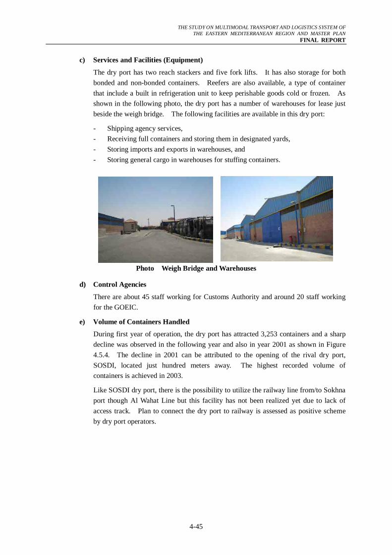
THE STUDY ON MULTIMODAL TRANSPORT AND LOGISTICS SYSTEM OF
THE EASTERN MEDITERRANEAN REGION AND MASTER PLAN FINAL REPORT
4-45
c) Services and Facilities (Equipment)
The dry port has two reach stackers and five fork lifts. It has also storage for both bonded and non-bonded containers. Reefers are also available, a type of container that include a built in refrigeration unit to keep perishable goods cold or frozen. As shown in the following photo, the dry port has a number of warehouses for lease just beside the weigh bridge. The following facilities are available in this dry port:
- Shipping agency services, - Receiving full containers and storing them in designated yards, - Storing imports and exports in warehouses, and - Storing general cargo in warehouses for stuffing containers.
Photo Weigh Bridge and Warehouses
d) Control Agencies
There are about 45 staff working for Customs Authority and around 20 staff working for the GOEIC.
e) Volume of Containers Handled
During first year of operation, the dry port has attracted 3,253 containers and a sharp decline was observed in the following year and also in year 2001 as shown in Figure 4.5.4. The decline in 2001 can be attributed to the opening of the rival dry port, SOSDI, located just hundred meters away. The highest recorded volume of containers is achieved in 2003.
Like SOSDI dry port, there is the possibility to utilize the railway line from/to Sokhna port though Al Wahat Line but this facility has not been realized yet due to lack of access track. Plan to connect the dry port to railway is assessed as positive scheme by dry port operators.
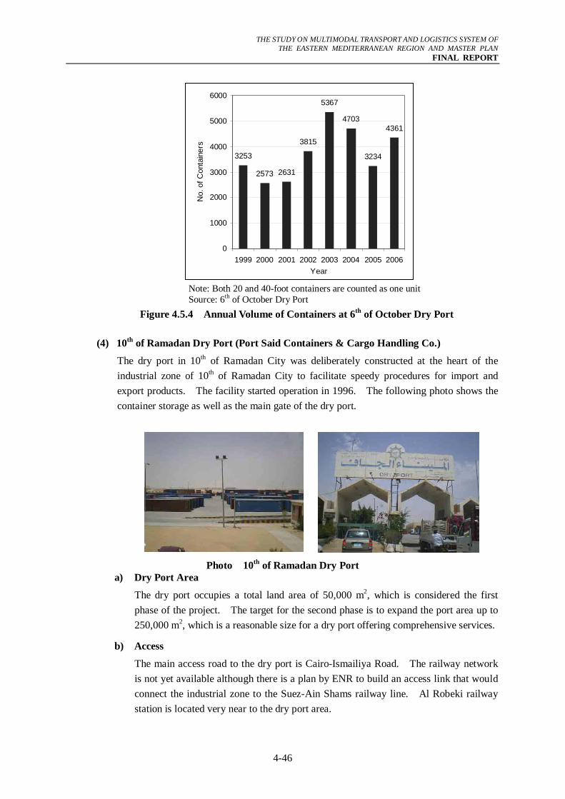
THE STUDY ON MULTIMODAL TRANSPORT AND LOGISTICS SYSTEM OF
THE EASTERN MEDITERRANEAN REGION AND MASTER PLAN FINAL REPORT
4-46
3253
2573 2631
3815
5367
4703
3234
4361
0
1000
2000
3000
4000
5000
6000
1999 2000 2001 2002 2003 2004 2005 2006Year
No.
of C
onta
iner
s
Note: Both 20 and 40-foot containers are counted as one unit Source: 6th of October Dry Port
Figure 4.5.4 Annual Volume of Containers at 6th of October Dry Port
(4) 10th of Ramadan Dry Port (Port Said Containers & Cargo Handling Co.)
The dry port in 10th of Ramadan City was deliberately constructed at the heart of the industrial zone of 10th of Ramadan City to facilitate speedy procedures for import and export products. The facility started operation in 1996. The following photo shows the container storage as well as the main gate of the dry port.
Photo 10th of Ramadan Dry Port a) Dry Port Area
The dry port occupies a total land area of 50,000 m2, which is considered the first phase of the project. The target for the second phase is to expand the port area up to 250,000 m2, which is a reasonable size for a dry port offering comprehensive services.
b) Access
The main access road to the dry port is Cairo-Ismailiya Road. The railway network is not yet available although there is a plan by ENR to build an access link that would connect the industrial zone to the Suez-Ain Shams railway line. Al Robeki railway station is located very near to the dry port area.
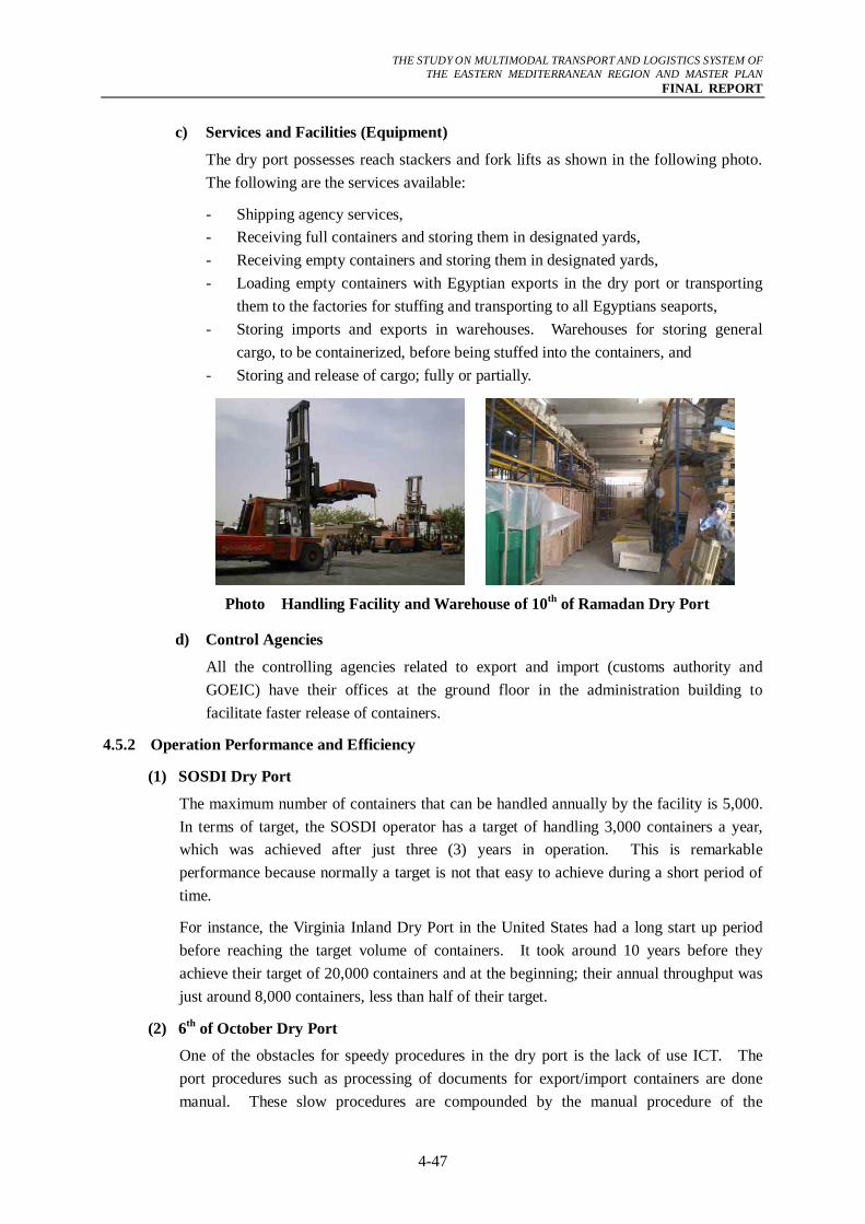
THE STUDY ON MULTIMODAL TRANSPORT AND LOGISTICS SYSTEM OF
THE EASTERN MEDITERRANEAN REGION AND MASTER PLAN FINAL REPORT
4-47
c) Services and Facilities (Equipment)
The dry port possesses reach stackers and fork lifts as shown in the following photo. The following are the services available:
- Shipping agency services, - Receiving full containers and storing them in designated yards, - Receiving empty containers and storing them in designated yards, - Loading empty containers with Egyptian exports in the dry port or transporting
them to the factories for stuffing and transporting to all Egyptians seaports, - Storing imports and exports in warehouses. Warehouses for storing general
cargo, to be containerized, before being stuffed into the containers, and - Storing and release of cargo; fully or partially.
Photo Handling Facility and Warehouse of 10th of Ramadan Dry Port
d) Control Agencies
All the controlling agencies related to export and import (customs authority and GOEIC) have their offices at the ground floor in the administration building to facilitate faster release of containers.
4.5.2 Operation Performance and Efficiency
(1) SOSDI Dry Port
The maximum number of containers that can be handled annually by the facility is 5,000. In terms of target, the SOSDI operator has a target of handling 3,000 containers a year, which was achieved after just three (3) years in operation. This is remarkable performance because normally a target is not that easy to achieve during a short period of time.
For instance, the Virginia Inland Dry Port in the United States had a long start up period before reaching the target volume of containers. It took around 10 years before they achieve their target of 20,000 containers and at the beginning; their annual throughput was just around 8,000 containers, less than half of their target.
(2) 6th of October Dry Port
One of the obstacles for speedy procedures in the dry port is the lack of use ICT. The port procedures such as processing of documents for export/import containers are done manual. These slow procedures are compounded by the manual procedure of the
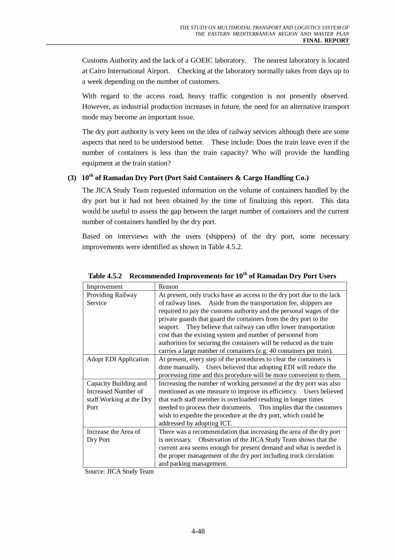
THE STUDY ON MULTIMODAL TRANSPORT AND LOGISTICS SYSTEM OF
THE EASTERN MEDITERRANEAN REGION AND MASTER PLAN FINAL REPORT
4-48
Customs Authority and the lack of a GOEIC laboratory. The nearest laboratory is located at Cairo International Airport. Checking at the laboratory normally takes from days up to a week depending on the number of customers.
With regard to the access road, heavy traffic congestion is not presently observed. However, as industrial production increases in future, the need for an alternative transport mode may become an important issue.
The dry port authority is very keen on the idea of railway services although there are some aspects that need to be understood better. These include: Does the train leave even if the number of containers is less than the train capacity? Who will provide the handling equipment at the train station?
(3) 10th of Ramadan Dry Port (Port Said Containers & Cargo Handling Co.)
The JICA Study Team requested information on the volume of containers handled by the dry port but it had not been obtained by the time of finalizing this report. This data would be useful to assess the gap between the target number of containers and the current number of containers handled by the dry port.
Based on interviews with the users (shippers) of the dry port, some necessary improvements were identified as shown in Table 4.5.2.
Table 4.5.2 Recommended Improvements for 10th of Ramadan Dry Port Users Improvement Reason Providing Railway Service
At present, only trucks have an access to the dry port due to the lack of railway lines. Aside from the transportation fee, shippers are required to pay the customs authority and the personal wages of the private guards that guard the containers from the dry port to the seaport. They believe that railway can offer lower transportation cost than the existing system and number of personnel from authorities for securing the containers will be reduced as the train carries a large number of containers (e.g. 40 containers per train).
Adopt EDI Application At present, every step of the procedures to clear the containers is done manually. Users believed that adopting EDI will reduce the processing time and this procedure will be more convenient to them.
Capacity Building and Increased Number of staff Working at the Dry Port
Increasing the number of working personnel at the dry port was also mentioned as one measure to improve its efficiency. Users believed that each staff member is overloaded resulting in longer times needed to process their documents. This implies that the customers wish to expedite the procedure at the dry port, which could be addressed by adopting ICT.
Increase the Area of Dry Port
There was a recommendation that increasing the area of the dry port is necessary. Observation of the JICA Study Team shows that the current area seems enough for present demand and what is needed is the proper management of the dry port including truck circulation and parking management.
Source: JICA Study Team
THE STUDY ON MULTIMODAL TRANSPORT AND LOGISTICS SYSTEM OF
THE EASTERN MEDITERRANEAN REGION AND MASTER PLAN FINAL REPORT
4-49
4.6 Logistics Issues
In the previous sections, the infrastructure and operation of the three major modes of transport and dry ports were assessed. In the succeeding sections, the issues that need to be addressed for improvement of the logistics system in Egypt are enumerated.
4.6.1 Issues related to the Road System
(1) Lack of Distribution Center for GCR
The truck ban prohibits large trucks from having access to several major links within GCR except at nighttime from 11 PM to 6 AM. Under this truck ban regulation system, it becomes difficult for large trucks to deliver freight inside the city. A helpful way to organize freight traffic flow into the city would be to have a distribution center, which could serve as an area for large trucks to unload their freight enabling small trucks to make deliveries to the city after consolidation.
(2) Overloading by Trucks
Highway regulations such as maximum allowable gross vehicle weight/axle weight, width, wheel base arrangement, etc. of vehicles are well defined in Egypt. These regulations are primarily aimed to protect roads from premature damage. Efforts by road authorities are made to ensure that drivers observe these regulations to protect the large investments allocated to construct important infrastructures such as roads and bridges.
(3) Road Network Upgrading/Improvement
Generally, the arterial road network in Egypt seems in reasonable condition. However, some major bottlenecks are recognized and some links have been identified where upgrading or improvement is recommended to improve the road related transport facilities. Through the investigation of the existing road network there are four main routes where future upgrading/improvement should be considered. These four routes are:
i) Cairo – Alexandria,
ii) Cairo – Ismailiya,
iii) Cairo – Suez, and
iv) Cairo - Upper Egypt.
Attention should be paid to the connection between these four routes. In this regard the ongoing plan for closing of existing Ring Road will bring great improvement in the land logistics facilities. Construction of the Regional Ring Road is another good plan for improvement of inland facilities.

THE STUDY ON MULTIMODAL TRANSPORT AND LOGISTICS SYSTEM OF
THE EASTERN MEDITERRANEAN REGION AND MASTER PLAN FINAL REPORT
4-50
4.6.2 Issues related to the Railway System
This section provides issues that need to be addressed to make railway a major component of the logistics system.
(1) Infrastructure Related Issues
a) Shortage of Locomotives
The shortage of locomotives often causes delay to the customers’ freight as mentioned by both ENR officials and users. Sometimes, when passenger trains are short of locomotives, freight locomotives are pulled-out and used for passenger trains.
b) Shortage of Some Types of Freight Wagons
According to the government officials interviewed by the JICA Study Team, the demand for some types of wagons is high while there is surplus for other types of wagons. This condition creates a situation where sometimes ENR has to reject a request due to shortage of particular wagons. Consequently, this situation creates an unnecessary impression among the customers that the ENR service is unreliable.
c) Shortage of Handling Equipment at Stations Inside and Outside the Ports
Freight stations inside the ports are served by the available handling equipment at the port. Therefore, as the volume of arriving containers increases, shortages of equipment occur and freight handling becomes difficult. This problem is serious and concern about it from both ENR officials and private companies is reported in the interviews done by the JICA Study Team. The shortage of handling equipment like cranes and reach stackers is becoming a source of delay. Based on the assessment of the results of the interviews undertaken by the JICA Study Team, it seems that the reservation of handling equipments should be done at least one week prior to the actual date of loading/unloading of containers on the train.
Regarding the freight stations that are located outside the ports, ENR has the policy of not handling freight and this responsibility is given to customers. Therefore, no handling facilities are made available at stations and customers tend to load/unload their freight without proper handling facilities. This practice has some implications: first, it damages the freight due to improper handling; second, sometimes it causes delay to freight train due to inefficiency of handling equipment.
d) Wagons without Brakes
The lack of brakes on each wagon limits the speed of the train, which significantly affects line capacity and safety. If all wagons are equipped with breaks, the train can achieve higher speed thus increasing the number of trains that can be served by the line. Currently, there are ongoing efforts by ENR to install brakes to all wagons and 40% of wagons now have been equipped with brakes.
(2) Operational Issues
There are operational issues that have to be addressed by ENR to improve its performance and marketing appeal to customers. For instance, the practice that locomotives for
THE STUDY ON MULTIMODAL TRANSPORT AND LOGISTICS SYSTEM OF
THE EASTERN MEDITERRANEAN REGION AND MASTER PLAN FINAL REPORT
4-51
freight trains are withdrawn to drive passenger trains has significant impact on the time-schedule of freight and creates dissatisfaction among customers. Other operational problems that compound the delay to freight involves the situation where the freight train has to wait at an junction until a passenger train has passed. This can be avoided with regular schedules of all trains.
(3) Missing Railway Connections to Major Industrial/Port Areas like Sadat, 10th of Ramadan and Port Said Port (East)
Industrial cities are expected to receive/discharge significant volume of freight. In the absence of freight train services, all freight will be transported by trucks which will increase pressure on the road network. Therefore, it is important for industrial areas located in new urban communities to be served by freight trains to reduce reliance on the truck services. In this regard, 6th of October City is located close to the railway station along Al Wahat line. Also, 10th of Ramadan City is located close to Al-Robeki railway station.
(4) Potential Services for Upper Egypt Development
Economic development of the Upper Egypt region is now a pressing matter and the agricultural development has been in the spotlight. In considering a long distance to the potential markets, the reefer container services can be a possible solution to this constrain, and an commencement of reefer container transport service should be fully investigated in its cost and feasibility. If the reefer container can be exported from Safaga Port to the Middle East and Asia, it can be worth gaining new market since new agricultural project has already commenced by foreign company and it proves the financial feasibility of this project. Support of this economic development effort is required in terms of logistics improvement in this region.
4.6.3 Issues related to the IWT System
This section clarified some of the critical issues that have to be addressed in order to increase the attractiveness of IWT.
(1) Lack of River Ports in the Greater Cairo Region
The GCR is the main destination of freight arriving at the ports of Egypt. However no ideal port is available to serve arriving barges from Alexandria and Damietta ports. The waterway linking the GCR and Damietta is being cleared so that it can be opened for navigation. However, utilization of this link will mainly depend on the capability of river ports in the GCR. Therefore, continuous efforts to construct practical river ports within the GCR are highly recommended. In this regard two locations are under consideration, which are Athar El-Nabi and El-Tebeen.
(2) Lack of Navigation Aid Equipment
At present, barges are operating only during daytime and they have to stop sailing by the nighttime. The travel time can be reduced if barges can travel at night. If this level of operation is achieved, this will increase the attractiveness of IWT as an inland mode of transport. It can be concluded that night sailing is impossible due to the absence of
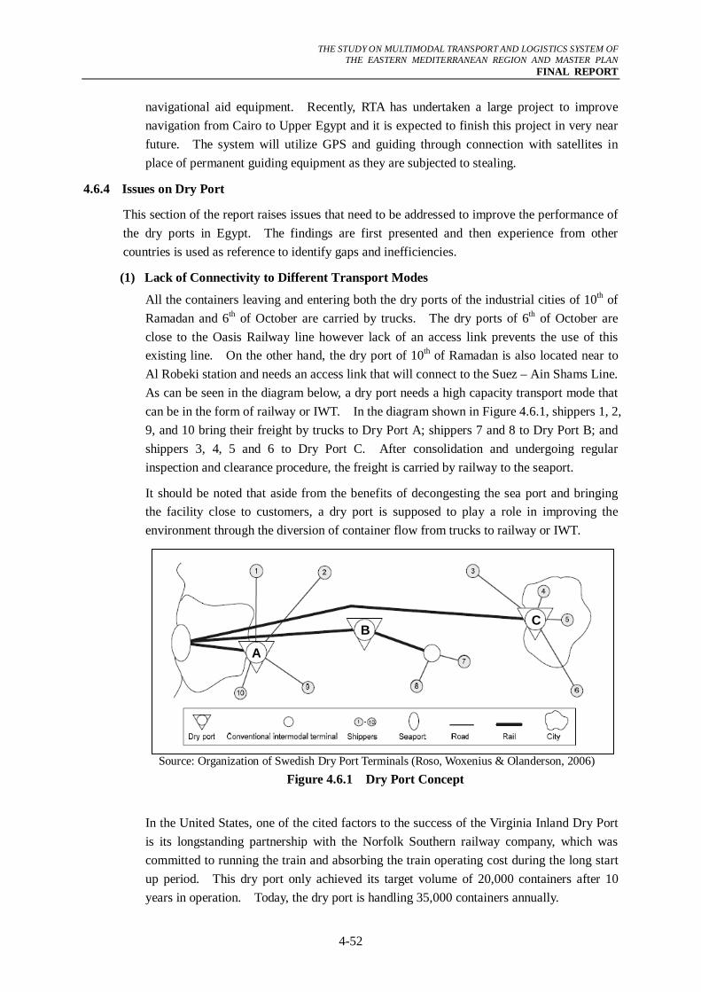
THE STUDY ON MULTIMODAL TRANSPORT AND LOGISTICS SYSTEM OF
THE EASTERN MEDITERRANEAN REGION AND MASTER PLAN FINAL REPORT
4-52
navigational aid equipment. Recently, RTA has undertaken a large project to improve navigation from Cairo to Upper Egypt and it is expected to finish this project in very near future. The system will utilize GPS and guiding through connection with satellites in place of permanent guiding equipment as they are subjected to stealing.
4.6.4 Issues on Dry Port
This section of the report raises issues that need to be addressed to improve the performance of the dry ports in Egypt. The findings are first presented and then experience from other countries is used as reference to identify gaps and inefficiencies.
(1) Lack of Connectivity to Different Transport Modes
All the containers leaving and entering both the dry ports of the industrial cities of 10th of Ramadan and 6th of October are carried by trucks. The dry ports of 6th of October are close to the Oasis Railway line however lack of an access link prevents the use of this existing line. On the other hand, the dry port of 10th of Ramadan is also located near to Al Robeki station and needs an access link that will connect to the Suez – Ain Shams Line. As can be seen in the diagram below, a dry port needs a high capacity transport mode that can be in the form of railway or IWT. In the diagram shown in Figure 4.6.1, shippers 1, 2, 9, and 10 bring their freight by trucks to Dry Port A; shippers 7 and 8 to Dry Port B; and shippers 3, 4, 5 and 6 to Dry Port C. After consolidation and undergoing regular inspection and clearance procedure, the freight is carried by railway to the seaport.
It should be noted that aside from the benefits of decongesting the sea port and bringing the facility close to customers, a dry port is supposed to play a role in improving the environment through the diversion of container flow from trucks to railway or IWT.
Source: Organization of Swedish Dry Port Terminals (Roso, Woxenius & Olanderson, 2006)
Figure 4.6.1 Dry Port Concept
In the United States, one of the cited factors to the success of the Virginia Inland Dry Port is its longstanding partnership with the Norfolk Southern railway company, which was committed to running the train and absorbing the train operating cost during the long start up period. This dry port only achieved its target volume of 20,000 containers after 10 years in operation. Today, the dry port is handling 35,000 containers annually.
C B
A
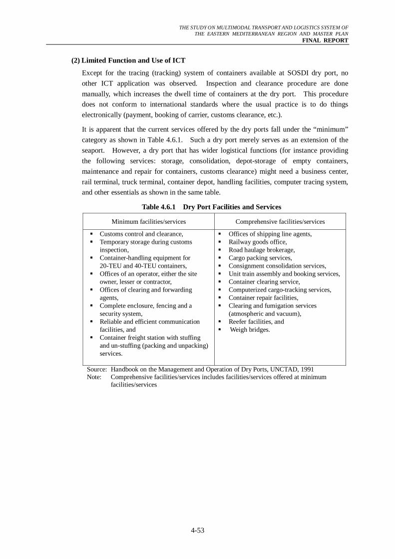
THE STUDY ON MULTIMODAL TRANSPORT AND LOGISTICS SYSTEM OF
THE EASTERN MEDITERRANEAN REGION AND MASTER PLAN FINAL REPORT
4-53
(2) Limited Function and Use of ICT
Except for the tracing (tracking) system of containers available at SOSDI dry port, no other ICT application was observed. Inspection and clearance procedure are done manually, which increases the dwell time of containers at the dry port. This procedure does not conform to international standards where the usual practice is to do things electronically (payment, booking of carrier, customs clearance, etc.).
It is apparent that the current services offered by the dry ports fall under the “minimum” category as shown in Table 4.6.1. Such a dry port merely serves as an extension of the seaport. However, a dry port that has wider logistical functions (for instance providing the following services: storage, consolidation, depot-storage of empty containers, maintenance and repair for containers, customs clearance) might need a business center, rail terminal, truck terminal, container depot, handling facilities, computer tracing system, and other essentials as shown in the same table.
Table 4.6.1 Dry Port Facilities and Services
Minimum facilities/services Comprehensive facilities/services
Customs control and clearance, Temporary storage during customs
inspection, Container-handling equipment for
20-TEU and 40-TEU containers, Offices of an operator, either the site
owner, lesser or contractor, Offices of clearing and forwarding
agents, Complete enclosure, fencing and a
security system, Reliable and efficient communication
facilities, and Container freight station with stuffing
and un-stuffing (packing and unpacking) services.
Offices of shipping line agents, Railway goods office, Road haulage brokerage, Cargo packing services, Consignment consolidation services, Unit train assembly and booking services, Container clearing service, Computerized cargo-tracking services, Container repair facilities, Clearing and fumigation services
(atmospheric and vacuum), Reefer facilities, and Weigh bridges.
Source: Handbook on the Management and Operation of Dry Ports, UNCTAD, 1991 Note: Comprehensive facilities/services includes facilities/services offered at minimum
facilities/services
THE STUDY ON MULTIMODAL TRANSPORT AND LOGISTICS SYSTEM OF
THE EASTERN MEDITERRANEAN REGION AND MASTER PLAN FINAL REPORT
4-54
4.7 Countermeasures and Recommendations
The analyses have revealed bottlenecks of the three transport modes that having significant negative impact in the logistics flow. The levels of development of the three modes are at varying degrees and the seamless flow of freight from one mode to another is not yet realized. The development advantages of road transport resulted in a higher captured market for trucks while the presence of the other two modes is barely felt. With that consideration, the following general principles are recommended:
Development of Logistics Centers to assist Logistics Activities This strategy aims to supply logistics centers that combine the function of dry port and distribution center at different strategic locations. These facilities are indispensable to advance Egypt’s logistics system, which currently is experiencing several bottlenecks. Each Logistics Centre will serve as a hub where all the activities relating to transport, logistics and goods distribution – both for local and international transit – will be undertaken by various operators.
Reduce the Infrastructure Development gap among the three Modes of Transport This strategy calls for reducing the development gap among the modes of transport by bringing the development level of railway and IWT up to that of road transport. It is recommended to balance the attractiveness of all modes by supplying necessary infrastructure to the other two modes of transport. In this way, promotion of modal shift can be realistically introduced.
Focus on Operational/Institutional Management of Road Transport Except for the construction and upgrading of some crucial sections there are no immediate needs to heavily invest in a particular road project. Instead, attention should focus on road management issues such as protection of roads through discouragement of overloading; promotion of safe driving through looking after drivers’ welfare; restructuring of small trucking companies by provision of incentives; and other soft measures to enhance the efficiency of road transport. Refer to Chapter 7 for the recommended strategies to enhance the freight forwarding industry.
4.7.1 Development of Logistics Centers
(1) Introduction
Logistics Centers (LC) should be established at different strategic locations to enhance import/export promotion and to support the logistics system as a whole. These facilities would have value-added services such as repacking, labeling, bar-coding, light assembly and other high-value activities.
To get acquainted with concept of this logistics facility, a list of the common features that define this facility is provided. According to the paper “Analysis of Institutional and Organizational Solutions in the Development of Transport and Logistics Centers (the European Commission, April 2007)”, the most common characteristics of a logistics center are the following:
- Usually logistics centers are built on a private-public partnership basis, initiated by national and/or local authorities. The reason for this is that experience shows that
THE STUDY ON MULTIMODAL TRANSPORT AND LOGISTICS SYSTEM OF
THE EASTERN MEDITERRANEAN REGION AND MASTER PLAN FINAL REPORT
4-55
the Logistics Centers make a significant contribution to the territorial and economic development of the area where they are located.
- Logistics Centers unite all activities related to transport and logistics.
- Based on competition principles, logistics centers are open for private and public transport as well as enterprises and companies.
- Consolidation of different companies serving and/or using transport services through synergy effects increases the economic and productive performance of the companies and at the same time increases their economy of scale.
- Logistics Centers supply with the most advanced IT infrastructure and solutions, which usually are exorbitant barriers for an individual company. A logistics center utilizes intelligent transport systems, where services are provided based on advanced technologies, i.e. EDI, communication and information system.
- Normally, logistics centers are located in a 100-150 ha area, however, depending on the activities the size can reach 400-500 ha.
- An important feature is the tendency for logistics centers to cooperate nationally and internationally, and thereby create efficient transport chains and network solutions for optimum cargo flow and distribution.
From the above, it can be noted that a vast area of undeveloped land is necessary to build the infrastructure requirements for a logistics center and sophisticated IT applications are indispensable to facilitate seamless flow of information.
(2) Different Types of Freight Terminals
There are several types of freight terminals and different terminologies are used to mean them. In this report, some freight terminals will be defined for clarity.
- Logistics Center – there is no standard definition of a logistics center, for instance, in Europe; this may be called freight village, interporto, logistics park, etc. Europlatform (2004) define it as a hub where all the activities relating to transport, logistics and goods distribution – both for national and international transit – are carried-out, on a commercial basis, by various operations.
- Distribution Center – this is sometimes referred to as a city terminal, urban consolidation center thus its focus is on distribution efficiency. This facility normally serves as a place of transhipment from long distance traffic to short distance (urban) traffic where the consignments can be sorted and bundled. It can be a stand-alone platform as a single forwarder or an element in the logistics chain of a huge company. More common however is the integration into urban logistics network – this means that it is connected to a logistics center in the outskirts wherein it is used as a central urban, multi-company consolidation center.
- Truck Terminal – a truck terminal is a facility where goods are transferred between trucks, or trucks and railroads.
THE STUDY ON MULTIMODAL TRANSPORT AND LOGISTICS SYSTEM OF
THE EASTERN MEDITERRANEAN REGION AND MASTER PLAN FINAL REPORT
4-56
- Dry Port – bonded inland logistics facility site (with customs office) distant from seaports and borders (in some countries including Japan, it is called an inland depot).
- Depot – is mostly a private warehouse or facility where commodities are stored and distributed from.
(3) Rationalization in Location of Logistics Centers
Location is a key factor for all the transport operators whose main activity is moving freight from one place to another using different modes of transport. Therefore, selecting the location is very crucial indeed. It should be noted also that assuring fluidity between all the transport connections and coordinating all the transport modes are some of the tasks of a logistics center.
In Egypt, the industrial areas of 6th of October and 10th of Ramadan are two good candidates for location of logistics centers. The existence of industrial area in both cities is guaranteed to generate freight traffic. In addition, these industrial areas are close to the GCR, which means that a LC in these areas could serve the incoming/outgoing freight.
The demand forecast in Chapter 3 illustrates that the most important routes in the future will be (i) Alexandria – Cairo – Upper Egypt and (ii) Damietta – Cairo – Upper Egypt. In addition, the GCR, which includes 6th of October City and 10th of Ramadan City is the central attraction of freight and the success of logistics facilities will largely depend on how they will be useful for moving freight to/from the capital. Normally, the logistics center is put at the heart of main freight traffic and 6th of October is an ideal location to capture the Alexandra – Cairo – Upper Egypt freight traffic while 10th of Ramadan is a good candidate to serve Damietta – Cairo – Upper Egypt and other freight traffic coming from other major ports on the east delta. Table 4.7.1 summarizes the advantages of the two candidate locations.
Table 4.7.1 Major advantages of 6th of October and 10th of Ramadan as Location of LC Location Advantages
1. 6th of October (i) existing industry in the area or in close proximity of existing market
(ii) close to GCR (iii) strategic location where freight traffic cross from Upper to
Lower Egypt (west delta) and vice versa (iv) good access to all ports particularly Alexandria port 2. 10th of Ramadan (i) existing industry in the area or in close proximity of existing
market (ii) close to GCR (iii) strategic location where freight traffic cross from Upper to
Lower Egypt (east delta) and vice versa (iv) strategic location being close to major ports such as Sokhna Port,
Port Said Port and Damietta Port Source: JICA Study Team
To prepare the ports of Egypt for the emerging changes in port operation and in order to further generate port traffic, logistic centers should also be considered at hub ports. These days, the commercial success of a port could stem from a productivity advantage in traditional cargo-handling service, from value-added services, or from combination of the
THE STUDY ON MULTIMODAL TRANSPORT AND LOGISTICS SYSTEM OF
THE EASTERN MEDITERRANEAN REGION AND MASTER PLAN FINAL REPORT
4-57
two. Shippers and carriers select individual ports not only based on their cargo handling service capabilities, but also on the benefits they are capable of “delivering”. It is believed that the most successful ports are those that not only have productivity in cargo-handling services, but that also offer value-added services, which can be achieved by the logistics center.
Port Said Port is the strategic location for manufacturers, forwarders and other logistics service providers because of the zero deviation from the international trade route. However, Port Said Port (West) does not have enough space for a logistics center. Port Said Port (East) has the necessary space to accommodate such facility. Also, Port Said Port (East) has a good business environment because it has been designed to be a Special Economic Zone. The idea of a logistics center in this port is to prepare a space where all companies involved in logistics related business could be located. The concept of the logistics center of the Port of Barcelona (called Logistics Activity Zone) might be adopted wherein sophisticated logistics warehouses with easy access to different transport modes are constructed for rental. Of course, it should also be promoted that companies can build their own LC within the designated area.
(4) Relationships of Dry Port, Logistics Center and Truck Terminal
It is necessary to distinguish the functions of the different logistics terminals recommended by other studies. For the purpose of review, the CREATS has recommended the construction of three (3) truck terminals near the ring road as shown in Figure 4.7.1. The first location is near Alexandria Agricultural Road. This terminal targets heavy trucks from Alexandria Agricultural Road and the road to Qanater. The second is near Upper Egypt Desert Road to service heavy trucks from that road and from Upper Egypt Agricultural Road, which could access the terminal via the regional secondary road. The third and final terminal is proposed near Suez Desert Road to accommodate the large number of heavy trucks on that road. Moreover, the CREATS recommended that detailed studies should be conducted to identify the optimal locations in terms of maximizing access possibilities and minimizing the negative impact on the environment.
The immediate purpose of the terminal is to serve as a simple truck-stop to accommodate heavy trucks that wait to access central Cairo. Most of these vehicles at present are parked randomly along the inter-city access roads, which creates a nuisance to other traffic. However, it is recommended that the function of each terminal should evolve to handle a cargo transfer function where cargo is transferred between heavy trucks and light trucks. The terminals would target domestic freight to the GCR.
The dry ports, as well as three (3) truck terminals around the ring road, planned by the CREATS have different functions to fulfill to improve the logistics efficiency in Egypt. Dry ports for instance are of prime importance to promotion of import and export by absorbing some containers that would otherwise be processed at the seaports. On the other hand, the truck terminals are designed to assist trucks having difficulty accessing inner Cairo due to the truck ban.
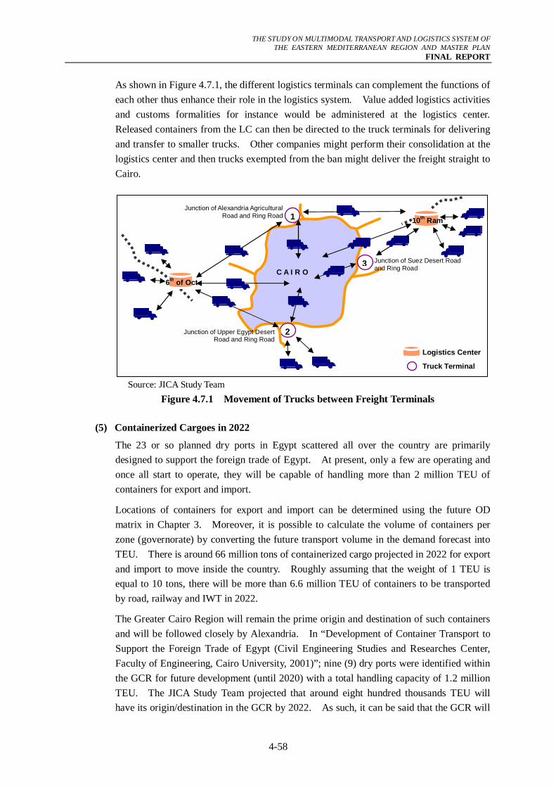
THE STUDY ON MULTIMODAL TRANSPORT AND LOGISTICS SYSTEM OF
THE EASTERN MEDITERRANEAN REGION AND MASTER PLAN FINAL REPORT
4-58
As shown in Figure 4.7.1, the different logistics terminals can complement the functions of each other thus enhance their role in the logistics system. Value added logistics activities and customs formalities for instance would be administered at the logistics center. Released containers from the LC can then be directed to the truck terminals for delivering and transfer to smaller trucks. Other companies might perform their consolidation at the logistics center and then trucks exempted from the ban might deliver the freight straight to Cairo.
Source: JICA Study Team
Figure 4.7.1 Movement of Trucks between Freight Terminals
(5) Containerized Cargoes in 2022
The 23 or so planned dry ports in Egypt scattered all over the country are primarily designed to support the foreign trade of Egypt. At present, only a few are operating and once all start to operate, they will be capable of handling more than 2 million TEU of containers for export and import.
Locations of containers for export and import can be determined using the future OD matrix in Chapter 3. Moreover, it is possible to calculate the volume of containers per zone (governorate) by converting the future transport volume in the demand forecast into TEU. There is around 66 million tons of containerized cargo projected in 2022 for export and import to move inside the country. Roughly assuming that the weight of 1 TEU is equal to 10 tons, there will be more than 6.6 million TEU of containers to be transported by road, railway and IWT in 2022.
The Greater Cairo Region will remain the prime origin and destination of such containers and will be followed closely by Alexandria. In “Development of Container Transport to Support the Foreign Trade of Egypt (Civil Engineering Studies and Researches Center, Faculty of Engineering, Cairo University, 2001)”; nine (9) dry ports were identified within the GCR for future development (until 2020) with a total handling capacity of 1.2 million TEU. The JICA Study Team projected that around eight hundred thousands TEU will have its origin/destination in the GCR by 2022. As such, it can be said that the GCR will
Junction of Alexandria Agricultural Road and Ring Road
Logistics Center
Truck Terminal
C A I R O
2
3
1
6th of Oct
10th Ram
Junction of Suez Desert Road and Ring Road
Junction of Upper Egypt Desert Road and Ring Road
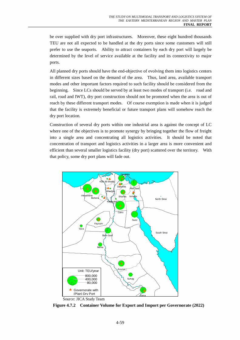
THE STUDY ON MULTIMODAL TRANSPORT AND LOGISTICS SYSTEM OF
THE EASTERN MEDITERRANEAN REGION AND MASTER PLAN FINAL REPORT
4-59
be over supplied with dry port infrastructures. Moreover, these eight hundred thousands TEU are not all expected to be handled at the dry ports since some customers will still prefer to use the seaports. Ability to attract containers by each dry port will largely be determined by the level of service available at the facility and its connectivity to major ports.
All planned dry ports should have the end-objective of evolving them into logistics centers in different sizes based on the demand of the area. Thus, land area, available transport modes and other important factors required to such facility should be considered from the beginning. Since LCs should be served by at least two modes of transport (i.e. road and rail, road and IWT), dry port construction should not be promoted when the area is out of reach by these different transport modes. Of course exemption is made when it is judged that the facility is extremely beneficial or future transport plans will somehow reach the dry port location.
Construction of several dry ports within one industrial area is against the concept of LC where one of the objectives is to promote synergy by bringing together the flow of freight into a single area and concentrating all logistics activities. It should be noted that concentration of transport and logistics activities in a larger area is more convenient and efficient than several smaller logistics facility (dry port) scattered over the territory. With that policy, some dry port plans will fade out.
Source: JICA Study Team
Figure 4.7.2 Container Volume for Export and Import per Governorate (2022)
Beni-Suef
Fayoum
Giza
Suez
Cairo
Asyout
Kalyoubia
SharkiaBeheraAlexandria
Suhag
Qena
Port Said
Damietta
Kafr-El-Sheikh
Gharbia
Ismailia
Menia
North Sinai
South Sinai
Dakahlia
Unit: TEU/year
Governorate with (Plan) Dry Port
800,000400,00080,000
THE STUDY ON MULTIMODAL TRANSPORT AND LOGISTICS SYSTEM OF
THE EASTERN MEDITERRANEAN REGION AND MASTER PLAN FINAL REPORT
4-60
From the figure above, it is obvious that in the future there will be some governorates that need to have dry port because of growing volume of freight and to assist logistics activities. These governorates are Beni Suef and Aswan. Table 4.7.2 shows the list of governorates with plans to build dry ports as well as a list of governorates where dry ports are deemed necessary.
Table 4.7.2 Governorates with Dry Port Plans (Unit: TEU) No. Governorate Name Dry Port Capacity (2020) Governorate with Dry Port Plan
1 Greater Cairo (Cairo,Giza,Kalyoubia) 1,238,010 2 Alexandria and Matrouh 1,373,239 3 Sharkia 65,908 4 Dakahlia 83,890 5 Damietta 30,418 6 Ismailiya 61,318 7 Menoufia 48,402 8 Gharbia 89,440 9 Kafr-El-Sheikh 33,192 10 Behera (South) 53,472 11 Fayoum 55,768 12 Asyut 91,731 13 Qena 58,451
Governorate needing a dry port in the future 14 Beni-Suef 367,000* 15 Aswan 183,000*
Note* Total generation/attraction of the two governorates based on JICA Study Team’s estimate for year 2022
Source: Dry port capacity is based on the “Development of Container Transport to Support Freight Trade of Egypt, TPA, 2001
(6) Functions of 6th of October Logistics Center and 10th of Ramadan Logistics Center
As mentioned, the 6th of October City is a good candidate location for a LC and its size will be determined by demand. Currently there are two existing dry ports, SOSDI and the 6th of October Dry Ports. Both are of medium size with the former having a size of 12 hectares while the later a size of 29.4 hectares. LCs in Europe for instance have an average of 100 hectares according to a study entitled “State of Freight (the UK Department of Transport, 2003)”. This vast land is occupied by customs infrastructure, postal/bank/insurance services, offices, multimodal terminals and different types of warehouses. These warehouses can be general warehouses for storage, large warehouses for logistics activities, warehouses with railroad interchange, warehouses with raised docking bays, and air-conditioned warehouses.
The 10th of Ramadan city also has a dry port and unlike the two dry ports of 6th of October, space is available for expansion. Therefore, expanding the existing one into a logistics center is preferable so that the existing infrastructure can be used to reduce the cost of building.
The envisioned function of the LC in both cities is shown in Table 4.7.3. Complete functions of an LC depending on the categories which are based on the scope and
THE STUDY ON MULTIMODAL TRANSPORT AND LOGISTICS SYSTEM OF
THE EASTERN MEDITERRANEAN REGION AND MASTER PLAN FINAL REPORT
4-61
extension of logistics activities is shown in Table 4.7.4.
Table 4.7.3 Proposed Function of Logistics Centers Logistics Center
Item (1) Distribution Center (2) Dry Port
Objectives Optimization of logistics operation, traffic reduction of GCR
Modal shift, decongestion of containers at sea ports
Function Warehousing, distribution, truck terminal
Customs clearance, import/export control
Source: JICA Study Team
Table 4.7.4 Logistics Center Evolution
1960s-1970s 1980s-early 1990s Mid 1990s –present
Materials management, Distribution Services, and (national/global). Bonding Import clearance, Bonding, and Inbound transportation. Receiving Receiving Receiving, and Cross-docking Cross-docking, Storage Storage Storage, Inventory management and control, and Shipment scheduling. Order processing Order processing Orders processing, Reporting EDI Reporting EDI Reporting, and Picking Picking Picking. Order assembly Order assembly (Product)subassembly, (Re)packaging (Re)packaging Order assembly, Stretch-shrink- (Re)packaging, and wrapping Stretch-shrink-wrapping. Palletizing/unitizing Palletizing/unitizing Palletizing/unitizing, and Label/mark/stencil Label/mark/stencil Label/mark/stencil. Shipping Shipping Shipping, Documentation Documentation Documentation, Outbound Outbound transportation, transportation Export documentation, FTZ operation, JIT/ECR/QR services, Freight rate negotiation, Carriers/route selection, Freight claims handling, Freight audit/payment, Safety audits/reviews, Regulatory compliance review, Performance measurement, Returns from customers, and Customer invoicing. Source: Ernst F. Bolten, Managing time and space in the modern warehousing, Amacom,
1997
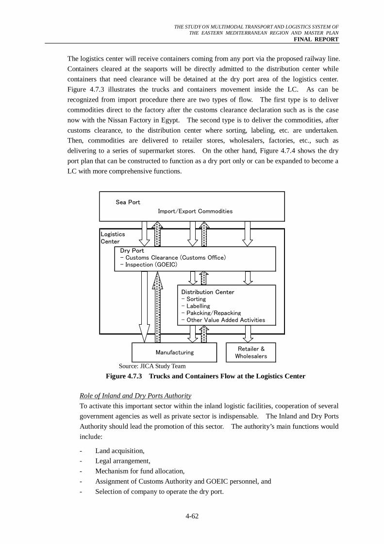
THE STUDY ON MULTIMODAL TRANSPORT AND LOGISTICS SYSTEM OF
THE EASTERN MEDITERRANEAN REGION AND MASTER PLAN FINAL REPORT
4-62
The logistics center will receive containers coming from any port via the proposed railway line. Containers cleared at the seaports will be directly admitted to the distribution center while containers that need clearance will be detained at the dry port area of the logistics center. Figure 4.7.3 illustrates the trucks and containers movement inside the LC. As can be recognized from import procedure there are two types of flow. The first type is to deliver commodities direct to the factory after the customs clearance declaration such as is the case now with the Nissan Factory in Egypt. The second type is to deliver the commodities, after customs clearance, to the distribution center where sorting, labeling, etc. are undertaken. Then, commodities are delivered to retailer stores, wholesalers, factories, etc., such as delivering to a series of supermarket stores. On the other hand, Figure 4.7.4 shows the dry port plan that can be constructed to function as a dry port only or can be expanded to become a LC with more comprehensive functions.
Sea Port
Import/Export Commodities
Dry Port- Customs Clearance (Customs Office)- Inspection (GOEIC)
Distribution Center- Sorting- Labelling- Pakcking/Repacking- Other Value Added Activities
Retailer &Wholesalers
Manufacturing
LogisticsCenter
zz
Source: JICA Study Team
Figure 4.7.3 Trucks and Containers Flow at the Logistics Center
Role of Inland and Dry Ports Authority To activate this important sector within the inland logistic facilities, cooperation of several government agencies as well as private sector is indispensable. The Inland and Dry Ports Authority should lead the promotion of this sector. The authority’s main functions would include:
- Land acquisition, - Legal arrangement, - Mechanism for fund allocation, - Assignment of Customs Authority and GOEIC personnel, and - Selection of company to operate the dry port.
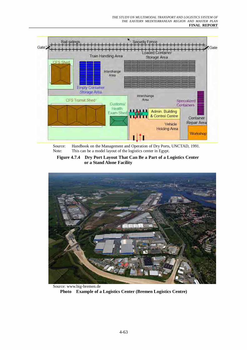
THE STUDY ON MULTIMODAL TRANSPORT AND LOGISTICS SYSTEM OF
THE EASTERN MEDITERRANEAN REGION AND MASTER PLAN FINAL REPORT
4-63
Source: Handbook on the Management and Operation of Dry Ports, UNCTAD, 1991. Note: This can be a model layout of the logistics center in Egypt.
Figure 4.7.4 Dry Port Layout That Can Be a Part of a Logistics Center or a Stand Alone Facility
Source: www.big-bremen.de
Photo Example of a Logistics Center (Bremen Logistics Centre)
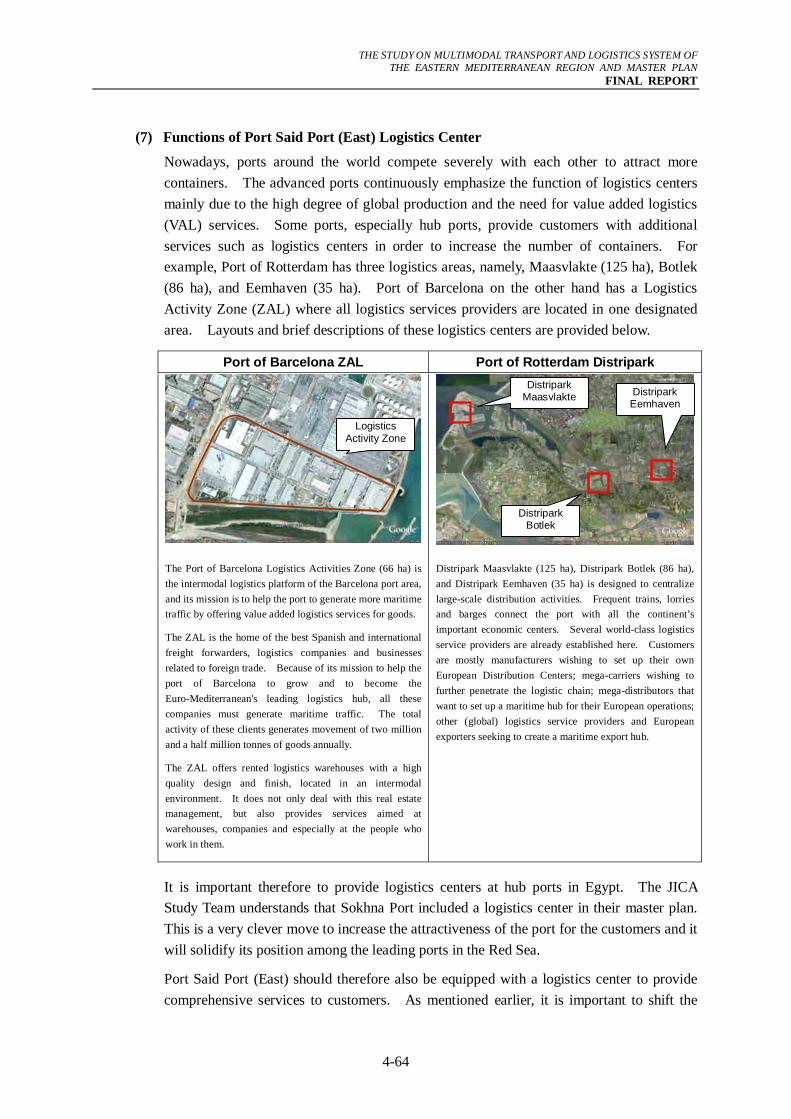
THE STUDY ON MULTIMODAL TRANSPORT AND LOGISTICS SYSTEM OF
THE EASTERN MEDITERRANEAN REGION AND MASTER PLAN FINAL REPORT
4-64
(7) Functions of Port Said Port (East) Logistics Center
Nowadays, ports around the world compete severely with each other to attract more containers. The advanced ports continuously emphasize the function of logistics centers mainly due to the high degree of global production and the need for value added logistics (VAL) services. Some ports, especially hub ports, provide customers with additional services such as logistics centers in order to increase the number of containers. For example, Port of Rotterdam has three logistics areas, namely, Maasvlakte (125 ha), Botlek (86 ha), and Eemhaven (35 ha). Port of Barcelona on the other hand has a Logistics Activity Zone (ZAL) where all logistics services providers are located in one designated area. Layouts and brief descriptions of these logistics centers are provided below.
Port of Barcelona ZAL Port of Rotterdam Distripark
The Port of Barcelona Logistics Activities Zone (66 ha) is the intermodal logistics platform of the Barcelona port area, and its mission is to help the port to generate more maritime traffic by offering value added logistics services for goods.
The ZAL is the home of the best Spanish and international freight forwarders, logistics companies and businesses related to foreign trade. Because of its mission to help the port of Barcelona to grow and to become the Euro-Mediterranean's leading logistics hub, all these companies must generate maritime traffic. The total activity of these clients generates movement of two million and a half million tonnes of goods annually.
The ZAL offers rented logistics warehouses with a high quality design and finish, located in an intermodal environment. It does not only deal with this real estate management, but also provides services aimed at warehouses, companies and especially at the people who work in them.
Distripark Maasvlakte (125 ha), Distripark Botlek (86 ha), and Distripark Eemhaven (35 ha) is designed to centralize large-scale distribution activities. Frequent trains, lorries and barges connect the port with all the continent’s important economic centers. Several world-class logistics service providers are already established here. Customers are mostly manufacturers wishing to set up their own European Distribution Centers; mega-carriers wishing to further penetrate the logistic chain; mega-distributors that want to set up a maritime hub for their European operations; other (global) logistics service providers and European exporters seeking to create a maritime export hub.
It is important therefore to provide logistics centers at hub ports in Egypt. The JICA Study Team understands that Sokhna Port included a logistics center in their master plan. This is a very clever move to increase the attractiveness of the port for the customers and it will solidify its position among the leading ports in the Red Sea.
Port Said Port (East) should therefore also be equipped with a logistics center to provide comprehensive services to customers. As mentioned earlier, it is important to shift the
Logistics Activity Zone
Distripark Maasvlakte
Distripark Botlek
Distripark Eemhaven
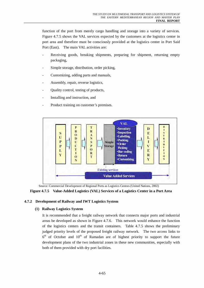
THE STUDY ON MULTIMODAL TRANSPORT AND LOGISTICS SYSTEM OF
THE EASTERN MEDITERRANEAN REGION AND MASTER PLAN FINAL REPORT
4-65
function of the port from merely cargo handling and storage into a variety of services. Figure 4.7.5 shows the VAL services expected by the customers at the logistics center in port area and therefore must be consciously provided at the logistics center in Port Said Port (East). The main VAL activities are:
- Receiving goods, breaking shipments, preparing for shipment, returning empty packaging,
- Simple storage, distribution, order picking,
- Customizing, adding parts and manuals,
- Assembly, repair, reverse logistics,
- Quality control, testing of products,
- Installing and instruction, and
- Product training on customer’s premises.
Source: Commercial Development of Regional Ports as Logistics Centres (United Nations, 2002)
Figure 4.7.5 Value-Added Logistics (VAL) Services of a Logistics Center in a Port Area 4.7.2 Development of Railway and IWT Logistics System
(1) Railway Logistics System
It is recommended that a freight railway network that connects major ports and industrial areas be developed as shown in Figure 4.7.6. This network would enhance the function of the logistics centers and the transit containers. Table 4.7.5 shows the preliminary judged priority levels of the proposed freight railway network. The two access links to 6th of October and 10th of Ramadan are of highest priority to support the future development plans of the two industrial zones in these new communities, especially with both of them provided with dry port facilities.
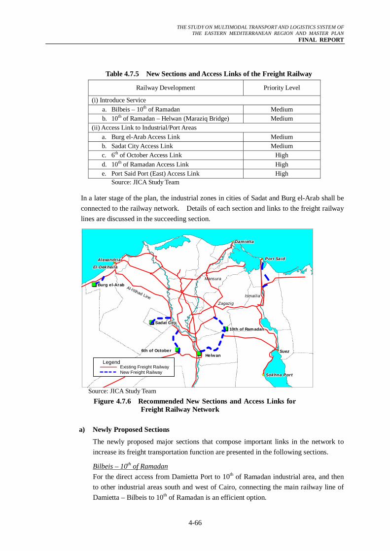
THE STUDY ON MULTIMODAL TRANSPORT AND LOGISTICS SYSTEM OF
THE EASTERN MEDITERRANEAN REGION AND MASTER PLAN FINAL REPORT
4-66
Table 4.7.5 New Sections and Access Links of the Freight Railway
Railway Development Priority Level
(i) Introduce Service a. Bilbeis – 10th of Ramadan Medium b. 10th of Ramadan – Helwan (Maraziq Bridge) Medium (ii) Access Link to Industrial/Port Areas a. Burg el-Arab Access Link Medium b. Sadat City Access Link Medium c. 6th of October Access Link High d. 10th of Ramadan Access Link High e. Port Said Port (East) Access Link High
Source: JICA Study Team
In a later stage of the plan, the industrial zones in cities of Sadat and Burg el-Arab shall be connected to the railway network. Details of each section and links to the freight railway lines are discussed in the succeeding section.
Source: JICA Study Team
Figure 4.7.6 Recommended New Sections and Access Links for Freight Railway Network
a) Newly Proposed Sections
The newly proposed major sections that compose important links in the network to increase its freight transportation function are presented in the following sections.
Bilbeis – 10th of Ramadan For the direct access from Damietta Port to 10th of Ramadan industrial area, and then to other industrial areas south and west of Cairo, connecting the main railway line of Damietta – Bilbeis to 10th of Ramadan is an efficient option.
Al-I ttihad LineZagazig
Ismailia
Mansura
El-DekheilaEl-DekheilaEl-DekheilaEl-DekheilaEl-DekheilaEl-DekheilaEl-DekheilaEl-DekheilaEl-Dekheila
AlexandriaAlexandriaAlexandriaAlexandriaAlexandriaAlexandriaAlexandriaAlexandriaAlexandria
Helw anHelw anHelw anHelwanHelwanHelw anHelw anHelw anHelwan6th of October6th of October6th of October6th of October6th of October6th of October6th of October6th of October6th of October
DamiettaDamiettaDamiettaDamiettaDamiettaDamiettaDamiettaDamiettaDamietta
Port SaidPort SaidPort SaidPort Sa idPort Sa idPort SaidPort SaidPort SaidPort Sa id
SuezSuezSuezSuezSuezSuezSuezSuezSuez
Sokhna PortSokhna PortSokhna PortSokhna PortSokhna PortSokhna PortSokhna PortSokhna PortSokhna Port
Burg e l-ArabBurg e l-ArabBurg e l-ArabBurg el-ArabBurg el-ArabBurg e l-ArabBurg e l-ArabBurg e l-ArabBurg el-Arab
Sadat CitySadat CitySadat CitySadat CitySadat CitySadat CitySadat CitySadat CitySadat City10th of Ramadan10th of Ramadan10th of Ramadan10th of Ramadan10th of Ramadan10th of Ramadan10th of Ramadan10th of Ramadan10th of Ramadan
Legend Existing Freight RailwayNew Freight Railway
THE STUDY ON MULTIMODAL TRANSPORT AND LOGISTICS SYSTEM OF
THE EASTERN MEDITERRANEAN REGION AND MASTER PLAN FINAL REPORT
4-67
ENR has a preliminary plan in this regard to construct this section with a length of about 22 km to the city and another 8 km to the industrial area. A bridge over Ismailiya Canal is required in addition to a grade-separation structure at Cairo – Ismailiya Desert Highway.
10th of Ramadan – Helwan (Maraziq Bridge) Providing this railway section will give easy movement for freight from East to West providing a major section in the proposed railway lines. Western areas of the River Nile include the major ports of Alexandria and Dekheila in addition to the industrial areas of Burg el-Arab, Sadat and 6th of October.
On the east of the River Nile, the freight railway serves mainly the Sokhna Port and the industrial area at 10th of Ramadan. It may serve also the freight movement from the Port Said and Damietta ports.
The alignment of this line is adjacent to the Regional Ring Road (some sections are under construction). Crossing the River Nile is achieved through the existing single-track line on Maraziq Bridge.
b) Newly Proposed Access Links to Industrial Areas and Port
Burg el-Arab Access Link In order to integrate the existing and new urban, industrial and agricultural areas in the national socioeconomic infrastructure, ENR has a preliminary conceptual plan to connect the industrial area of Burg el-Arab to the national railway network for passengers. This new link has the objective of connecting the city of Burg el-Arab to Alexandria through the Matrouh Line.
This single-track section will be dualized for a length of 7.5 km; and extended for another 22.5 km to the industrial area south of New Burg El-Arab City. In addition, the signalization and communication system of the line will be developed, and the maximum speed will be 120 km/hr. The total preliminary cost is estimated about LE 750 million.
Sadat City Access Link Being an industrial area, services of railway is indispensable to support the industrial production and easy movement of materials. To connect the industrial area of Sadat City to the railway network, ENR has a preliminary conceptual plan for a 35 kilometer railway access link that branches from Eitai El-Baroud – Imbaba Line at KM 66+700. It will cost about LE 120 million excluding the cost of land acquisition (mostly desert land). It may be extended, for another 13 km in agricultural land, in the future to cross the River Nile to Minuf City in Delta.
6th of October Access Link The industrial area of 6th of October City is located on the northern side of the Oasis Highway, while the Oasis Railway line is running on the other side of the highway without direct access. Oasis Railway may provide good access to major ports and industrial areas East of Cairo after the construction of the section between 10th of
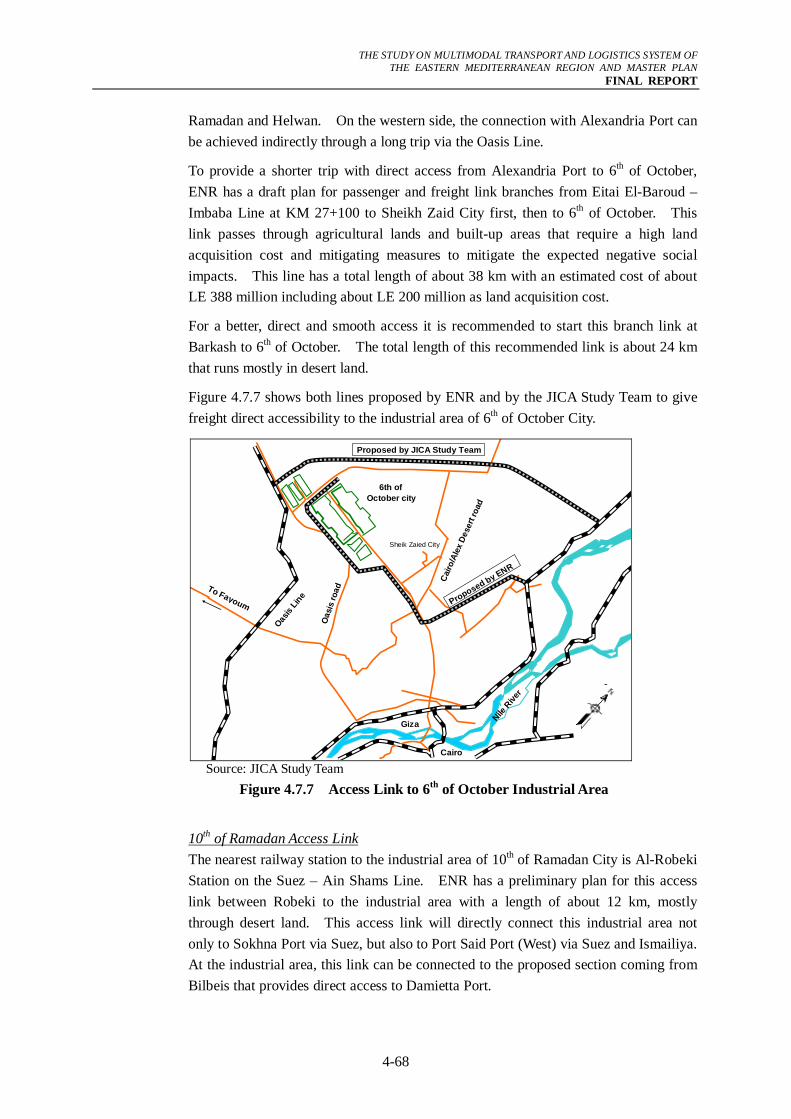
THE STUDY ON MULTIMODAL TRANSPORT AND LOGISTICS SYSTEM OF
THE EASTERN MEDITERRANEAN REGION AND MASTER PLAN FINAL REPORT
4-68
Ramadan and Helwan. On the western side, the connection with Alexandria Port can be achieved indirectly through a long trip via the Oasis Line.
To provide a shorter trip with direct access from Alexandria Port to 6th of October, ENR has a draft plan for passenger and freight link branches from Eitai El-Baroud – Imbaba Line at KM 27+100 to Sheikh Zaid City first, then to 6th of October. This link passes through agricultural lands and built-up areas that require a high land acquisition cost and mitigating measures to mitigate the expected negative social impacts. This line has a total length of about 38 km with an estimated cost of about LE 388 million including about LE 200 million as land acquisition cost.
For a better, direct and smooth access it is recommended to start this branch link at Barkash to 6th of October. The total length of this recommended link is about 24 km that runs mostly in desert land.
Figure 4.7.7 shows both lines proposed by ENR and by the JICA Study Team to give freight direct accessibility to the industrial area of 6th of October City.
6th of October city
Sheik Zaied City
Oasis
Line
Cairo
/Ale
x De
sert
road
Oas
is ro
adTo Fayoum
Nile R
iver
Proposed by JICA Study Team
Proposed by ENR
Giza
Cairo Source: JICA Study Team
Figure 4.7.7 Access Link to 6th of October Industrial Area
10th of Ramadan Access Link The nearest railway station to the industrial area of 10th of Ramadan City is Al-Robeki Station on the Suez – Ain Shams Line. ENR has a preliminary plan for this access link between Robeki to the industrial area with a length of about 12 km, mostly through desert land. This access link will directly connect this industrial area not only to Sokhna Port via Suez, but also to Port Said Port (West) via Suez and Ismailiya. At the industrial area, this link can be connected to the proposed section coming from Bilbeis that provides direct access to Damietta Port.
THE STUDY ON MULTIMODAL TRANSPORT AND LOGISTICS SYSTEM OF
THE EASTERN MEDITERRANEAN REGION AND MASTER PLAN FINAL REPORT
4-69
Port Said Port (East) Access Link
Lately, Port Said Port (East) container handling volume has been increasing significantly (7,000 TEU in 2005 and 1.6 million TEU in 2006) and therefore there is an increasing need to provide an efficient rail connection from the port to the main railway network.
ENR has made initial efforts to connect this port by constructing a new railway line. This line is not yet operational due to some remaining works such as installation of the communication system. Moreover the line assumes to use the Ferdan Swing Bridge, which is maintained and controlled by the Suez Canal Authority, and therefore prior arrangement between ENR and the said authority is necessary to harmonize operation. At present, the bridge is open daily, once in the morning and once in the evening with three hours for each opening.
Due to its increasing importance Port Said Port (East) should be provided with a railway service and the line should be extended from Balooza station up to the port yard. As mentioned the line, which would cost around LE 900 million and would run mostly on a desert land, would have a total length of 60 km.
(2) IWT Logistics System
Currently, the RTA is working on developing the river transport infrastructure which includes improving the efficiency of navigable waterways, connecting river ports with sea ports, improving canal locks, and making the river transport navigable for 24-hrs per day. Promotion of the construction of river ports through participation of the private sector is also being introduced as a policy to make IWT an active logistics player. Two locations as shown in Figure 4.7.8 are being endorsed for construction of river ports.
As far as containerized freight cargo is concerned, the GCR remains the ultimate destination of most of containers arriving at the seaports and it is also the main origin of containerized export freight. However, at present, there is no practical river port along the River Nile with the ability to handle container cargo. Therefore, it is necessary to provide such a logistics facility within the GCR to shift some freight traffic from trucks. Based on this background, the following recommendations are considered:
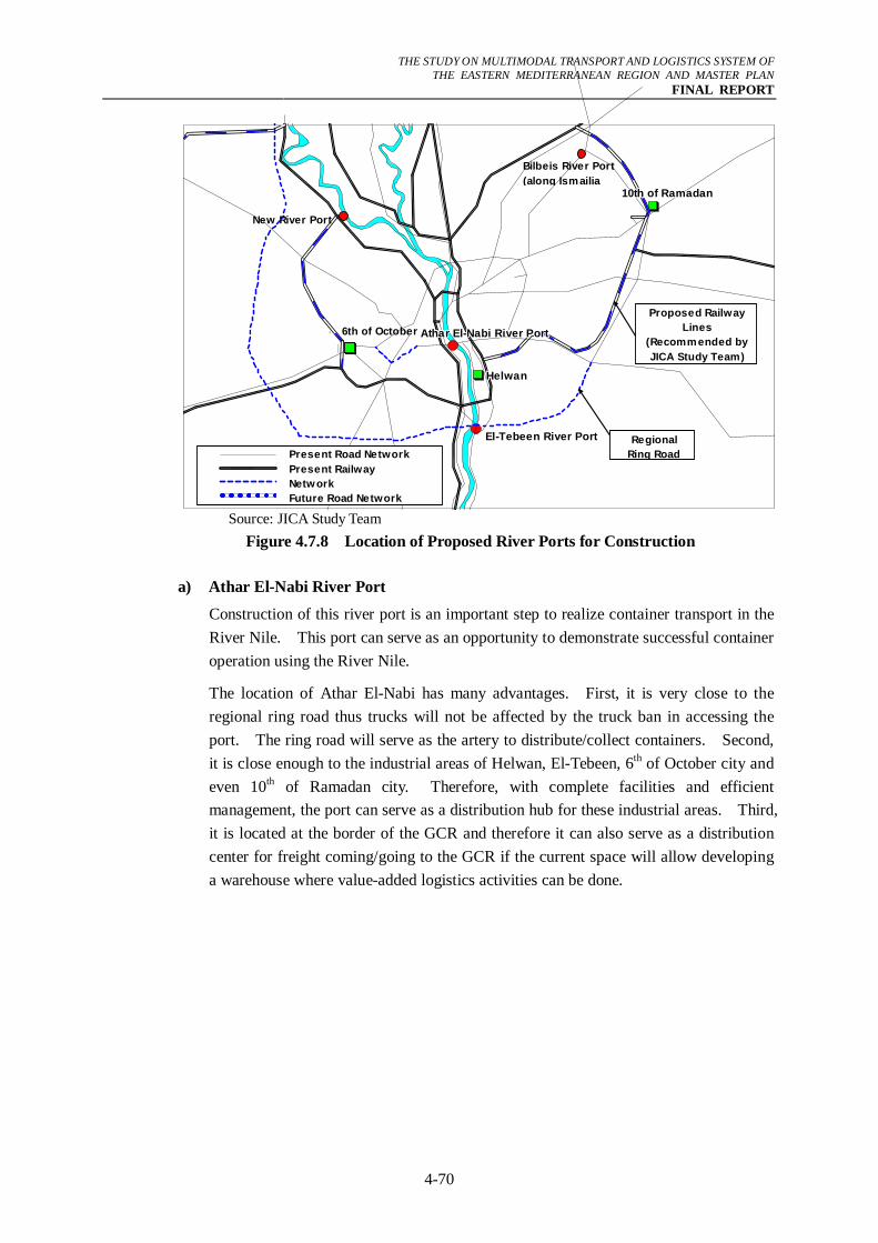
THE STUDY ON MULTIMODAL TRANSPORT AND LOGISTICS SYSTEM OF
THE EASTERN MEDITERRANEAN REGION AND MASTER PLAN FINAL REPORT
4-70
6th of October6th of October6th of October6th of October6th of October6th of October6th of October6th of October6th of October
10th of Ramadan10th of Ramadan10th of Ramadan10th of Ramadan10th of Ramadan10th of Ramadan10th of Ramadan10th of Ramadan10th of Ramadan
Athar El-Nabi River PortAthar El-Nabi River PortAthar El-Nabi River PortAthar El-Nabi River PortAthar El-Nabi River PortAthar El-Nabi River PortAthar El-Nabi River PortAthar El-Nabi River PortAthar El-Nabi River Port
El-Tebeen River PortEl-Tebeen River PortEl-Tebeen River PortEl-Tebeen River PortEl-Tebeen River PortEl-Tebeen River PortEl-Tebeen River PortEl-Tebeen River PortEl-Tebeen River Port
HelwanHelwanHelwanHelwanHelwanHelwanHelwanHelwanHelwan
Present Road NetworkPresent RailwayNetw orkFuture Road Network
Proposed RailwayLines
(Recommended byJICA Study Team)
RegionalRing Road
Bilbeis River Port(along Ismailia
New River Port
6th of October
Source: JICA Study Team Figure 4.7.8 Location of Proposed River Ports for Construction
a) Athar El-Nabi River Port
Construction of this river port is an important step to realize container transport in the River Nile. This port can serve as an opportunity to demonstrate successful container operation using the River Nile.
The location of Athar El-Nabi has many advantages. First, it is very close to the regional ring road thus trucks will not be affected by the truck ban in accessing the port. The ring road will serve as the artery to distribute/collect containers. Second, it is close enough to the industrial areas of Helwan, El-Tebeen, 6th of October city and even 10th of Ramadan city. Therefore, with complete facilities and efficient management, the port can serve as a distribution hub for these industrial areas. Third, it is located at the border of the GCR and therefore it can also serve as a distribution center for freight coming/going to the GCR if the current space will allow developing a warehouse where value-added logistics activities can be done.
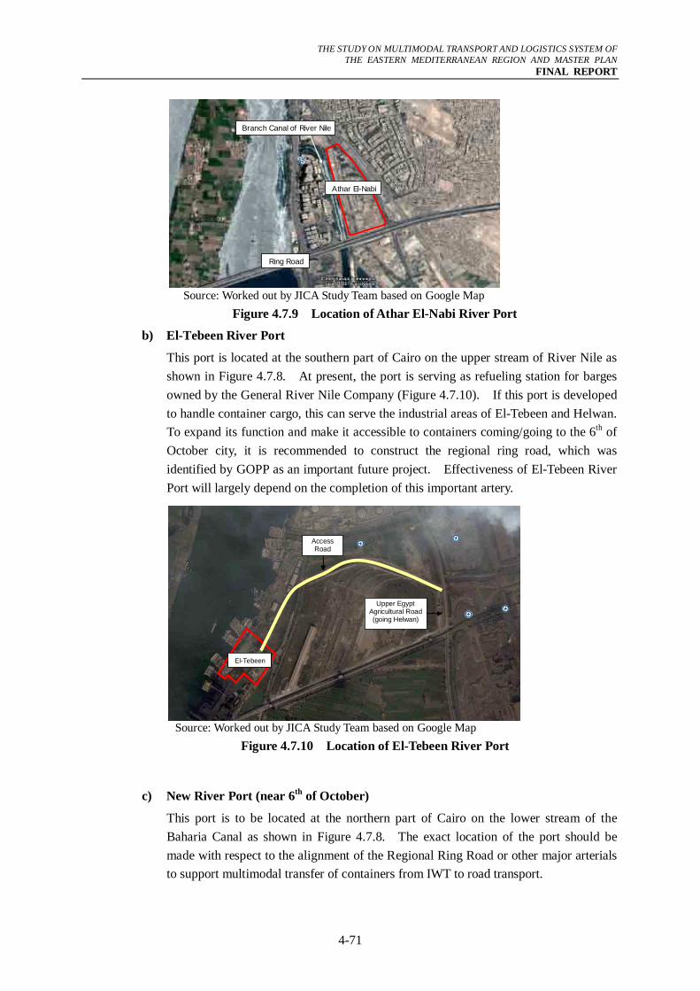
THE STUDY ON MULTIMODAL TRANSPORT AND LOGISTICS SYSTEM OF
THE EASTERN MEDITERRANEAN REGION AND MASTER PLAN FINAL REPORT
4-71
Ring Road
Athar El-Nabi
Branch Canal of River Nile
Source: Worked out by JICA Study Team based on Google Map
Figure 4.7.9 Location of Athar El-Nabi River Port
b) El-Tebeen River Port
This port is located at the southern part of Cairo on the upper stream of River Nile as shown in Figure 4.7.8. At present, the port is serving as refueling station for barges owned by the General River Nile Company (Figure 4.7.10). If this port is developed to handle container cargo, this can serve the industrial areas of El-Tebeen and Helwan. To expand its function and make it accessible to containers coming/going to the 6th of October city, it is recommended to construct the regional ring road, which was identified by GOPP as an important future project. Effectiveness of El-Tebeen River Port will largely depend on the completion of this important artery.
Upper Egypt Agricultural Road (going Helwan)
El-Tebin
Access Road
El-Tebeen
Source: Worked out by JICA Study Team based on Google Map
Figure 4.7.10 Location of El-Tebeen River Port
c) New River Port (near 6th of October)
This port is to be located at the northern part of Cairo on the lower stream of the Baharia Canal as shown in Figure 4.7.8. The exact location of the port should be made with respect to the alignment of the Regional Ring Road or other major arterials to support multimodal transfer of containers from IWT to road transport.
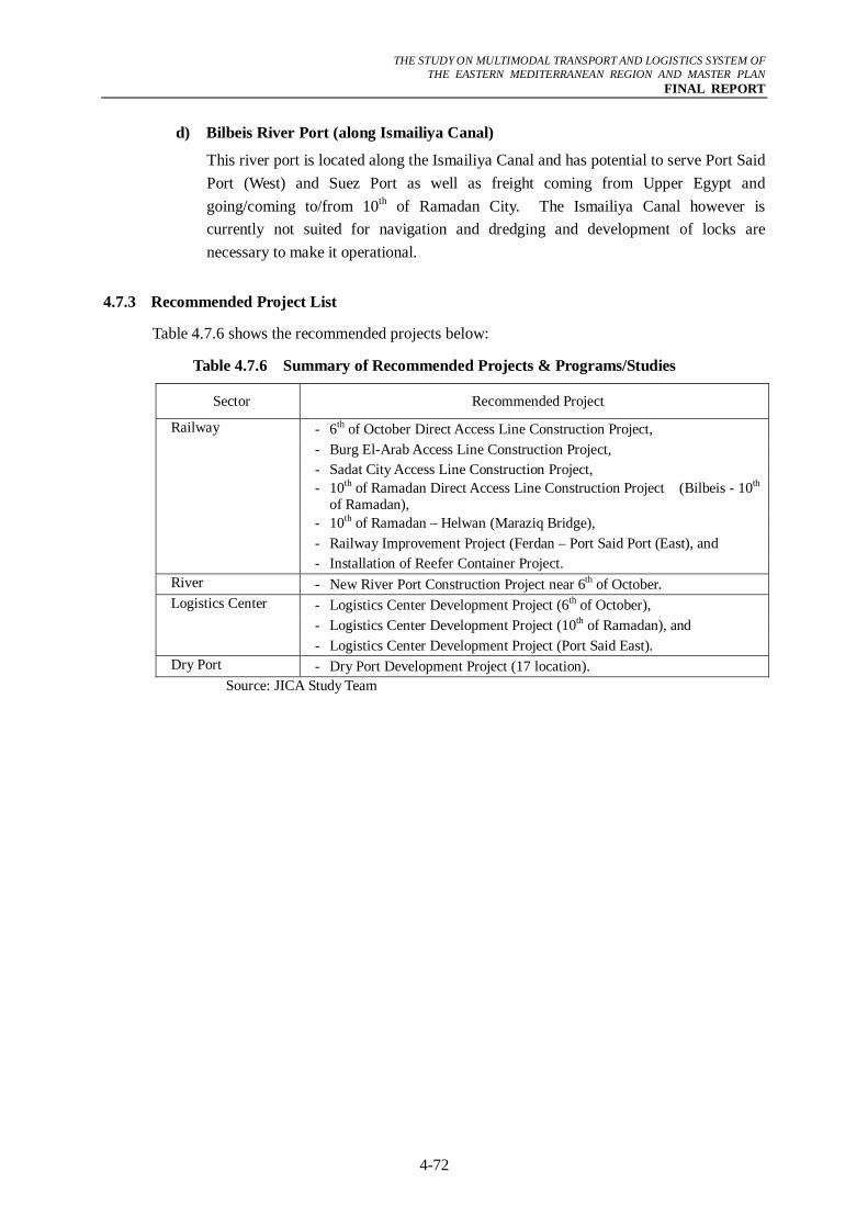
THE STUDY ON MULTIMODAL TRANSPORT AND LOGISTICS SYSTEM OF
THE EASTERN MEDITERRANEAN REGION AND MASTER PLAN FINAL REPORT
4-72
d) Bilbeis River Port (along Ismailiya Canal)
This river port is located along the Ismailiya Canal and has potential to serve Port Said Port (West) and Suez Port as well as freight coming from Upper Egypt and going/coming to/from 10th of Ramadan City. The Ismailiya Canal however is currently not suited for navigation and dredging and development of locks are necessary to make it operational.
4.7.3 Recommended Project List
Table 4.7.6 shows the recommended projects below:
Table 4.7.6 Summary of Recommended Projects & Programs/Studies
Sector Recommended Project
Railway - 6th of October Direct Access Line Construction Project, - Burg El-Arab Access Line Construction Project, - Sadat City Access Line Construction Project, - 10th of Ramadan Direct Access Line Construction Project (Bilbeis - 10th
of Ramadan), - 10th of Ramadan – Helwan (Maraziq Bridge), - Railway Improvement Project (Ferdan – Port Said Port (East), and - Installation of Reefer Container Project. River - New River Port Construction Project near 6th of October. Logistics Center - Logistics Center Development Project (6th of October), - Logistics Center Development Project (10th of Ramadan), and - Logistics Center Development Project (Port Said East). Dry Port - Dry Port Development Project (17 location).
Source: JICA Study Team